


Abstract
Understanding the spatiotemporal evolution of runoff and its driving mechanisms is of great significance for water resources development, utilization, and sustainable management in mid- to high-latitude river basins under climate change. However, runoff variability is jointly influenced by multiple meteorological factors, and a comprehensive understanding of its multi-scale response characteristics and the relative contributions of different drivers remains limited. In this study, runoff data from three hydrological stations in the Songhua River Basin during 1980–2022 were analyzed. A set of statistical and time-series methods, including the Mann–Kendall test, Pettitt change-point test, Hurst exponent, wavelet analysis, and wavelet coherence, was applied, and a random forest model was used to quantify the influence of key climatic factors such as precipitation, air temperature, and evapotranspiration. The results show that air temperature exhibits significant increasing trends in all four seasons, with the strongest warming occurring in spring (Sen’s slope ≈ 0.06 °C a−1). Precipitation displays pronounced spatial heterogeneity and interannual variability, while evapotranspiration shows an overall increasing trend. Both runoff and major meteorological variables exhibit significant spatial heterogeneity across the basin. Hydro-meteorological variables also show distinct periodic variations among seasons, with temperature, precipitation, and evapotranspiration exhibiting stronger seasonal fluctuations during summer. Wavelet coherence analysis indicates that short-term runoff variability is mainly driven by temperature and precipitation. Temperature exhibits significant coherence with runoff across multiple time scales ranging from approximately 2 to 20 years, whereas precipitation shows stronger coherence at medium- to long-term scales (approximately 10–35 years), with evident seasonal differences. Random forest results indicate that evapotranspiration is the most important contributor to runoff variability at all three stations, accounting for 33.5%, 28.6%, and 26.2% of the total importance at Jiamusi, Fuyu, and Jiangqiao stations, respectively. Temperature and sunshine duration rank second, while precipitation and relative humidity contribute comparatively less. These findings indicate that evapotranspiration plays a key regulatory role in long-term water balance. In addition, runoff exhibits multi-scale variability and a transition from gradual changes to stage-like abrupt shifts. The findings provide a scientific basis for water resources management, flood mitigation, and climate change adaptation in the Songhua River Basin.
1. Introduction
Water resources are essential for socio-economic development and ecological security [1,2]. Runoff, a key component of the hydrological cycle, reflects the transport and redistribution of water within a river basin [3,4]. It serves as an important indicator of regional water resource conditions and is essential for water resources management, ecosystem maintenance, and human water use [5]. Precipitation is the primary source of runoff. Variations in its intensity, frequency, spatial and temporal distribution, and seasonality directly influence runoff generation and consequently affect water resources allocation and management [4]. Air temperature also plays an important role in runoff variability. Rising temperatures generally increase evapotranspiration, thereby reducing the proportion of precipitation converted into runoff, particularly in arid and semi-arid regions [6]. In high-latitude and mountainous regions, rising temperatures can accelerate snowmelt and reduce snow storage. These changes alter the timing and magnitude of spring and summer runoff and may lead to temporal mismatches in water availability [7,8]. Therefore, understanding the influences of climatic factors on runoff is essential for interpreting hydrological responses to climate change, improving hydrological simulations, and supporting effective water resources management.
Numerous studies have investigated the impacts of climate variability on runoff in different regions. For example, Yang et al. [9] examined runoff variations and their driving factors in the headwaters of the Manas River, Northwest China, during 1954–2016. Their results indicated that regional environmental factors exerted a stronger influence on runoff than large-scale climatic factors, and that natural drivers played a more important role than human activities. Tan et al. [10] investigated 96 river basins across Canada and evaluated the relative contributions of climate change and human activities to streamflow variability. Their findings indicated that runoff responses to climate variability differed substantially among basins in both temporal scale and magnitude. Luo et al. [11] found that precipitation was the dominant driver of runoff variability in karst basins, accounting for an average contribution of 53.03%. Although previous studies have improved our understanding of the relationships between runoff and climatic factors, several limitations remain. Therefore, a multi-scale analysis integrating both basin-wide and local perspectives is needed to better understand runoff variability and its driving mechanisms.
Accordingly, understanding the effects of precipitation and temperature on runoff is essential for effective water resources management and ecosystem conservation. The identification of runoff drivers typically relies on a combination of statistical and data-driven approaches. Trend and change-point detection methods, including the Mann–Kendall test, Sen’s slope estimator, and Pettitt test, are widely used to identify long-term trends and abrupt changes in runoff series. Wavelet analysis and wavelet coherence analysis can reveal periodic variations and interactions between runoff and climatic factors across multiple time scales. In addition, multivariate statistical methods and machine learning approaches can be used to quantify the relative contributions of climatic drivers to runoff variability. Zhao et al. [12] investigated the spatiotemporal variability and driving factors of runoff and sediment in the Yellow River Basin using multiple methods, including the Pettitt change-point test, Mann–Kendall trend test, Sen’s slope estimator, and wavelet analysis. Their study emphasized the importance of combining multiple approaches to better capture spatial heterogeneity. Similarly, Zuo et al. [13] showed that the combination of Mann–Kendall and Pettitt tests for detecting trends and change points, together with wavelet analysis for identifying periodic patterns and multi-variable coherence analysis, can effectively quantify the spatial differences in dominant runoff drivers across river sections. This study focuses on the Songhua River Basin and its three representative sub-basins, and develops a combined basin–sub-basin multi-scale analysis framework. And captures the overall runoff variation characteristics of the basin and further examines spatial differences in runoff responses across regions. Meteorological factors, including air temperature (TMP), precipitation (PCP), and evapotranspiration (ET), are used to identify the dominant drivers of runoff changes in different river sections. At the same time, traditional statistical methods are combined with machine learning attribution approaches. By comparing wavelet coherence analysis and Random Forest attribution results, this study explores the mechanisms by which meteorological factors influence runoff evolution from both long-term variability and short-term nonlinear responses, providing a new perspective for understanding runoff dynamics and their driving mechanisms in the Songhua River Basin. The Songhua River Basin is one of the key ecological and agricultural regions in China [14]. It is characterized by a temperate monsoon climate with pronounced seasonal variations in precipitation and air temperature, as well as clear spatial heterogeneity [15]. Water resources in the basin are strongly influenced by uneven seasonal and spatial distribution, often resulting in alternating spring droughts and summer floods. As a result, runoff shows pronounced seasonal patterns and strong interannual variability [15,16]. The complexity of these hydrological responses provides an ideal context for investigating the influence of climatic factors on runoff processes [17].
This study selects the Songhua River Basin as the study area and systematically investigates runoff variability and the impacts of meteorological factors on runoff processes. A combination of the Mann–Kendall (MK) trend test, Sen’s slope estimator, Pettitt change-point test, Hurst exponent analysis, wavelet analysis, wavelet coherence analysis, and random forest methods is used to examine trends and relationships between meteorological variables and runoff. The main objectives of this study are as follows: (1) to identify long-term trends, change points, and spatial patterns of key climatic variables in the Songhua River Basin; (2) to analyze trends, abrupt changes, and periodic characteristics of runoff; (3) to examine the relationships between seasonal climatic factors and runoff, and identify the dominant drivers and their mechanisms; (4) to provide scientific support for regional water resources management under climate change.
By integrating statistical tests and multi-scale analysis, this study provides a basis for understanding hydrological responses to climate change in the Songhua River Basin.
2. Materials and Methods
2.1. Study Area
The Songhua River Basin is one of the seven major river basins in China [18]. It is located in northeastern China, between 42–52° N and 120–133° E, with an east–west length of about 920 km and a north–south width of approximately 1070 km. The basin covers an area of about 556,800 km2 [16]. It covers most parts of Heilongjiang and Jilin Provinces, as well as portions of Liaoning Province and the Inner Mongolia Autonomous Region [19]. The geographic location of the basin is shown in Figure 1 (left). The basin originates from the Changbai Mountains in the south and the Greater Khingan Mountains in the north [18,20]. The topographic features are illustrated in Figure 1 (right). The overall terrain slopes from southwest to northeast, transitioning from mountainous and hilly areas in the southwest to low-lying wetlands in the northeast. Elevation ranges from 44 to 2583 m, with pronounced topographic variation. The river network is well developed, forming a dendritic pattern [21]. The Songhua River Basin is located in the temperate monsoon climate zone and is strongly influenced by the East Asian monsoon [22]. The climate exhibits pronounced seasonality, with a mean annual temperature of approximately −2 to 6 °C and a decreasing trend from south to north. Precipitation is mainly concentrated in summer (June–August), accounting for about 60–80% of the annual total, and shows a decreasing spatial gradient from southeast to northwest [23]. Due to the uneven temporal distribution of precipitation and cold-climate conditions, streamflow exhibits distinct seasonal variability, with high flows during the summer wet season and low flows during the winter freezing period [24].
Figure 1.
Geographical location of the Songhua River Basin.
In this study, the basin is divided into three sub-basins: the main stream of the Songhua River, the Second Songhua River Basin, and the Nen River Basin. The Jiamusi, Jiangqiao, and Fuyu stations, shown in Figure 1, are located in the middle and lower reaches of these sub-basins and serve as representative control stations.
2.2. Data Sources and Processing
The data used in this study consist of meteorological and hydrological datasets. The meteorological data were obtained from the National Tibetan Plateau Data Center and the European Centre for Medium-Range Weather Forecasts (ECMWF). The main climatic variables include mean air temperature, precipitation, and evapotranspiration. In addition, sunshine duration and relative humidity were included in the random forest analysis to better capture the combined effects of multiple factors. Hydrological data were collected from three representative stations within the basin, namely Jiamusi, Fuyu, and Jiangqiao, where observed runoff records were used for analysis. Detailed information on the temporal resolution, study period, and spatial coverage of all datasets is provided in Table 1.
Table 1.
Temporal and spatial scales and data sources.
2.2.1. Meteorological Data
The meteorological data used in this study can be divided into two parts:
(1) Data for analyzing the relationship between climatic factors and runoff. This dataset includes mean air temperature, precipitation, and evapotranspiration. The air temperature dataset was developed by Fang et al. [25], who evaluated the strengths and limitations of multiple data sources, including reanalysis, remote sensing, and ground observations. Based on different weather types, near-surface air temperature (Ta) reconstruction models were developed and further improved using regional correction schemes, producing a daily gridded temperature dataset for China covering the period 1979–2018. The precipitation dataset was developed by Hu et al. [26], based on long-term daily observations from 3476 meteorological stations across China since 1960. In addition, 11 precipitation-related variables were included to account for spatial dependence. An improved inverse distance weighting (IDW) method was combined with a machine learning approach, namely Light Gradient Boosting Machine (LightGBM), to produce a high-accuracy precipitation dataset. Evapotranspiration data were obtained from the ERA5-Land reanalysis product provided by the European Centre for Medium-Range Weather Forecasts (ECMWF) [27]. This dataset has a spatial resolution of approximately 0.1° (~9 km) and an hourly temporal resolution, making it suitable for regional hydrological and climatic analyses.
(2) Data for random forest attribution analysis. In addition to the variables used in the relationship analysis, sunshine duration and relative humidity were included in the random forest model. These variables were also derived from the ERA5-Land reanalysis dataset provided by the European Centre for Medium-Range Weather Forecasts (ECMWF).
2.2.2. Hydrological Data
The hydrological data used in this study consist of daily runoff records from three representative stations in the basin: Jiamusi, Fuyu, and Jiangqiao. The data were further divided into four seasons: spring (March–May), summer (June–August), autumn (September–November), and winter (December–February), to facilitate the analysis of seasonal runoff variability and its response to climatic factors.
Details on the temporal scale and spatial coverage are provided in Table 1.
2.3. Research Methods
2.3.1. Mann–Kendall (MK) Test
The Mann–Kendall (MK) test is a non-parametric method that does not require data to follow a specific distribution and is insensitive to outliers. It is widely used to detect significant monotonic trends in time series. Due to its robustness, it has been recommended by the World Meteorological Organization (WMO) as a standard approach for climate trend analysis and has been extensively applied in hydrological and climatic studies [28].
In this study, the Mann–Kendall (MK) test was implemented in MATLAB R2023b to analyze trends and potential change points in air temperature, precipitation, evapotranspiration, and runoff series. For a time series with sample size n, denoted as (where ), the rank sequence is constructed as follows:
of which,
Thus, represents the cumulative number of times that the value at time is greater than that at time (where ). Under the assumption that the time series is independent and randomly ordered, the test statistic is defined as follows:
where , and and denote the expectation and variance of , respectively. When the time series is independent and follows the same continuous distribution, and can be calculated as follows:
The sequence is the statistic calculated in the forward direction based on the original time series . A significance level is selected. At α = 0.05, (the theoretical critical value is ±1.96. In this study, ±2 was used as an approximate threshold for visual interpretation). When , a significant trend is indicated in the time series. The sequence is obtained by applying the same procedure to the reversed time series, with . The intersection points between the and curves are used as preliminary indicators of potential change points in the time series. These points are further validated using the Pettitt test to determine the exact timing of abrupt changes.
2.3.2. Pettitt Test
The Pettitt test is a non-parametric method similar to the Mann–Kendall test and is particularly effective for detecting the timing of abrupt changes in time series.
In this study, the Pettitt test was also implemented in MATLAB to further identify change points in air temperature, precipitation, evapotranspiration, and runoff series. For a time series with sample size n, denoted as (where ), a rank-based sequence, similar to that defined in Equation (1), is constructed as follows:
However, unlike the Mann–Kendall test, in the Pettitt test the statistic is defined as follows:
In this case, represents the cumulative number of times that the value at time is greater than or less than that at time ().
Compared with the Mann–Kendall test, which identifies potential change points based on the intersection of the forward () and backward () statistic curves, the Pettitt test directly detects change points using a rank-based sequence. If a time point satisfies the following condition:
then is identified as the change point of the time series.
where exp denotes the natural exponential function, i.e., . If , the detected change point is considered statistically significant.
2.3.3. R/S Analysis for the Hurst Exponent
The Hurst exponent (H) is a statistical measure used in time series analysis to characterize long-term memory and persistence. It was first proposed by the hydrologist Harold E. Hurst in 1951. This index is widely used to evaluate whether a time series exhibits persistent behavior and to provide insights into the stability of its future evolution [29].
In this study, the Hurst exponent was calculated for runoff and major climatic variables. Combined with the results of the Mann–Kendall test, it was used to infer potential future trends of precipitation, air temperature, and other variables in the Songhua River Basin.
The Hurst exponent can be estimated using the rescaled range (R/S) analysis method, with values typically ranging from 0 to 1. Different ranges of H indicate distinct characteristics of the time series [30]:
(1) When , the series exhibits anti-persistence, meaning that past trends are more likely to reverse in the future.
(2) When , the series behaves like a random walk, showing no clear directional trend.
(3) When , the series exhibits persistence, indicating that past trends are likely to continue in the future.
The detailed calculation procedure can be found in Ref. [30].
2.3.4. Wavelet Analysis
Wavelet analysis is a mathematical tool for analyzing non-stationary time series, providing information in both the time and frequency domains. It has been widely applied in hydrology, meteorology, geology, and signal processing. Common wavelet transform methods include the continuous wavelet transform (CWT) and the discrete wavelet transform (DWT). The CWT performs a continuous scan of the signal across all time points and scales, making it more suitable for scientific analysis and for revealing local features and variations at different time scales. In contrast, the DWT is computationally more efficient and is commonly used for data compression and signal reconstruction [31]. It should be noted that the choice of the mother wavelet function can significantly influence the results of wavelet analysis. Orthogonal wavelets (e.g., Haar and Daubechies) are typically used in the DWT due to their good reconstruction properties and compact support, and are often applied in signal denoising and compression. In contrast, non-orthogonal wavelets (e.g., Morlet and Paul) are more commonly used in the CWT, as they provide better time–frequency localization and are more suitable for identifying periodic features and analyzing non-stationary signals [32].
In this study, wavelet analysis was conducted in MATLAB to investigate the periodic characteristics of climatic and hydrological variables, including air temperature, precipitation, and runoff. The continuous wavelet transform (CWT) with the non-orthogonal Morlet wavelet was applied to decompose the time series at multiple scales. This approach allows the identification of periodic variations and their distribution across different time scales.
2.3.5. Wavelet Coherence Analysis
Wavelet coherence (WTC) is a method used to quantify the strength of the relationship between two time series in the time–frequency domain. It is particularly useful for identifying whether two variables exhibit significant correlation or synchronous variability at specific times and scales (periods). In this study, the Morlet wavelet was adopted as the basis function. The detailed formulation of wavelet coherence can be found in Ref. [33].
2.3.6. Random Forest Model
The Random Forest (RF) model is a non-parametric ensemble learning method. It is based on generating multiple subsets from the original dataset using bootstrap resampling and constructing a large number of decision trees. For regression tasks, the final prediction is obtained by averaging the outputs of all individual trees. This method is widely used due to its clear structure, strong robustness, and low sensitivity to data distribution and parameter settings [34].
Specifically, multiple training subsets are generated from the original samples through bootstrap resampling, and B regression trees are constructed. The overall prediction of the random forest is given by the average of the predictions from all trees:
where denotes the -th decision tree, represents the corresponding model parameters (e.g., splitting variables and thresholds), and is the total number of trees. In this study, the Tree Bagger function in MATLAB was used to construct 500 regression trees. Model performance was evaluated using the out-of-bag (OOB) error, which is defined as follows:
To characterize the lagged response of runoff to climatic variables, lag terms ranging from 0 to 7 days were constructed for air temperature, precipitation, evapotranspiration, sunshine duration, and relative humidity. Model performance was evaluated using the coefficient of determination () and the root mean square error (RMSE). Variable importance was assessed using the permutation importance method, which quantifies the increase in out-of-bag (OOB) error after randomly permuting a given variable :
After normalization, variable importance values were aggregated by variable category, allowing the identification of dominant climatic drivers of runoff variability and enabling a multi-factor attribution analysis of runoff changes.
The overall framework of this study is illustrated in Figure 2.
Figure 2.
Methodological framework of the study.
3. Results
3.1. Trends and Change Points
3.1.1. Trend Analysis
Figure 3 and Figure 4 show the spatiotemporal variations in mean air temperature (1979–2018), precipitation (1961–2022), and evapotranspiration (1980–2023) in the Songhua River Basin. Seasonal air temperature exhibits increasing trends of approximately 0.06 °C·a−1 in spring, 0.03 °C·a−1 in summer, 0.05 °C·a−1 in autumn, and 0.03 °C·a−1 in winter, indicating a consistent warming trend throughout the year. Among the four seasons, warming trends are more pronounced in spring and autumn, both of which are statistically significant at the 0.05 level. The warming rate in autumn is slightly lower than that in spring. Although slight warming is observed in summer and winter, these trends do not reach statistical significance. Spatially, the increase in air temperature during spring and summer is mainly concentrated in the northeastern and western parts of the basin. In autumn and winter, the warming trend is more evident in the western region, while a moderate increase is also observed in the northeastern area.
Figure 3.
Variations in climatic variables in the Songhua River Basin and results of the Mann–Kendall (MK) test (UFk; and UBk denote the forward and backward test statistics, respectively).
Figure 4.
Spatial distribution of linear trends in climatic factors in the Songhua River Basin.
Figure 3 shows that spring precipitation exhibits an increasing trend, with a slope of 0.05 mm·a−1. In contrast, summer precipitation shows a slight decreasing trend, with a slope of −0.31 mm·a−1, and is characterized by strong interannual variability. Compared with the other seasons, precipitation in autumn and winter remains relatively stable, with slopes of 0.11 mm·a−1 and 0.05 mm·a−1, respectively. As shown in Figure 4, the spatial distribution of precipitation is strongly influenced by geographical location and the monsoon climate. In summer, precipitation increases significantly in the southeastern and central parts of the basin, with a maximum trend of 1.5 mm·a−1. In contrast, the western and northern regions exhibit relatively stable or slightly decreasing precipitation, with values around −1.3 mm·a−1.
In addition, evapotranspiration in the basin generally shows an increasing trend in spring, with a slope of approximately 1.2 mm·a−1, which is statistically significant at the 0.05 level based on the MK test. Larger increases are observed in the southeastern and central regions, with local maxima reaching 2.86 mm·a−1. In summer, evapotranspiration exhibits an overall decreasing trend, with a slope of approximately −2.56 mm·a−1, and shows pronounced interannual variability. In some areas, the decrease reaches up to −6.93 mm·a−1. By contrast, evapotranspiration in autumn remains relatively stable, with a slight increasing trend (approximately 0.10 mm·a−1), although certain regions, such as the warmer central areas, still show noticeable increases. In winter, evapotranspiration is generally low but displays a gradual increasing trend. The spatial distribution indicates significant increases in parts of the eastern and southern regions, with a maximum of 1.315 mm·a−1, while slight decreases are observed in some northwestern areas.
Overall, the trends of air temperature, precipitation, and evapotranspiration in the Songhua River Basin exhibit clear seasonal and spatial differences. Among these variables, the increase in air temperature is most pronounced, particularly in spring and autumn. In contrast, changes in precipitation and evapotranspiration show stronger spatial heterogeneity.
3.1.2. Change-Point Analysis
In this study, the Mann–Kendall (MK) test and the Pettitt test were applied to detect change points in meteorological and hydrological variables within the basin. The MK test was first used to identify potential change points. When multiple change signals were detected within a short period, the Pettitt test was further employed to determine the exact timing of these changes. The results of the Pettitt test (Figure 5), together with the MK test results (Figure 3), provide a comprehensive assessment of the change points in the selected climatic variables.
Figure 5.
Variations in meteorological variables in the Songhua River Basin and Pettitt test results for detecting change points.
Based on the preliminary results of the Mann–Kendall (MK) test, significant change points were already identified for mean air temperature in spring, summer, and autumn, as well as for evapotranspiration in the same seasons. Therefore, no further analysis using the Pettitt test was required for these variables. As shown in Table 2, changes in mean air temperature mainly occurred during the period from 1988 to 1996, whereas changes in precipitation and evapotranspiration were primarily concentrated in the 1990s and 2000s.
Table 2.
Change-point timing of climatic variables across seasons in the Songhua River Basin.
3.2. Hurst Exponent
The Hurst exponent (H) of climatic variables in the Songhua River Basin was estimated using rescaled range (R/S) analysis. The results are presented in Figure 6. The analysis shows that higher values are observed in the southern and southeastern regions across all seasons, particularly for air temperature and precipitation, indicating strong persistence. In contrast, lower values are found in the northern region during spring and summer. The minimum values are 0.23 for temperature and 0.18 for precipitation, suggesting strong randomness and a higher likelihood of trend reversal in the future.
Figure 6.
Spatial distribution of Hurst exponent values of climatic factors in the Songhua River Basin.
For autumn and winter, precipitation exhibits values generally greater than 0.5 across the basin, indicating relatively stable behavior. Evapotranspiration shows higher values in the southern region during spring, autumn, and winter, while in summer, exceeds 0.5 across most of the basin, indicating pronounced persistence. These results indicate that regions with > 0.5 exhibit pronounced long-term memory effects, suggesting that climatic variables are influenced by persistent hydroclimatic processes, which impart temporal continuity. In contrast, regions with < 0.5 show anti-persistent behavior, indicating stronger fluctuations in hydroclimatic processes and a higher likelihood of directional reversals. These spatial differences suggest significant variability in the predictability of climatic variables across the Songhua River Basin, as well as distinct response mechanisms of runoff to climate variability.
3.3. Periodicity
The continuous wavelet transform (CWT) results of seasonal time series for climatic variables in the basin are shown in Figure 7, revealing distinct periodic patterns across different seasons. In spring, the wavelet spectra of precipitation and evapotranspiration indicate strong variability within the 5–10 year band, with in-phase behavior over this period, suggesting a consistent increasing tendency at this time scale. The temperature series exhibits a clear periodic fluctuation within the 10–25 year range. In summer, the temperature series shows variability at longer time scales, mainly within the 15–20 year band, with relatively stable fluctuations. Precipitation and evapotranspiration also display pronounced periodicity within the 5–10 year range, which appears more stable compared with that in spring.
Figure 7.
Wavelet real-part contour plots and wavelet variance of climatic variables in the Songhua River Basin.
In autumn and winter, most climatic variables show evident periodic fluctuations within the 5–10 year band, except for winter temperature. The periodicity of winter temperature is mainly concentrated in the 10–20 year range, indicating relatively stable variations at this scale. Overall, the climatic variables in the basin, including temperature, precipitation, and evapotranspiration, exhibit clear seasonal differences in their periodic behavior.
3.4. Runoff Variation Characteristics
Figure 8, Figure 9 and Figure 10 present the runoff variation characteristics of the main stream of the Songhua River Basin, the Second Songhua River Basin, and the Nen River Basin, respectively. The detected change points for runoff in each sub-basin are further summarized in Table 3.
Figure 8.
Results of the Mann–Kendall trend test for seasonal runoff in the Songhua River Basin, Second Songhua River Basin, and Nen River Basin.
Figure 9.
Results of the Pettitt change-point test for seasonal runoff in the Songhua River Basin, Second Songhua River Basin, and Nen River Basin.
Figure 10.
Continuous wavelet transform and wavelet variance analysis results of seasonal runoff in the Songhua River Basin, Second Songhua River Basin, and Nen River Basin.
Table 3.
Seasonal change-point timing of runoff in the Songhua River Basin.
As shown in Figure 8, seasonal runoff in the main stream basin exhibits distinct temporal patterns. In spring and autumn, runoff shows a V-shaped trend, characterized by an initial decrease followed by an increase. Summer runoff also presents a slight decline followed by a weak recovery trend. In winter, although runoff is the lowest among all seasons, it remains relatively stable and shows an overall increasing trend. Notably, the increasing trend in winter runoff is the most pronounced among the four seasons. As shown in Figure 9, Further change-point analysis indicates that winter runoff experienced a shift in 2015, while spring, summer, and autumn runoff showed abrupt changes in 2009, 2010, and 2012, respectively. As shown in Figure 10, Continuous wavelet transform (CWT) was further applied to the seasonal runoff series in the main stream basin. The wavelet variance spectra and real-part contour plots were used to identify dominant periodic features. The results indicate that runoff exhibits significant periodicity at both interannual and decadal scales, with certain similarities and differences among seasons. In spring, the dominant periodicity is approximately 6 years, mainly concentrated during 2002–2015, showing moderate and relatively stable oscillations. In summer, a dominant 4-year cycle is observed throughout 1995–2020, appearing repeatedly but discontinuously, indicating strong interannual variability associated with precipitation and extreme rainfall events. In winter, a 3-year cycle dominates, characterized by frequent short-period fluctuations with relatively stable behavior. Overall, all three seasons share a common interannual-scale periodicity of 3–6 years. In contrast, autumn runoff exhibits a distinctly different periodic pattern. The dominant cycle is approximately 16 years, with energy concentrated during 2005–2020, appearing as a broad high-period peak in the wavelet spectrum and becoming more pronounced in the later period of the record. This long-period component is unique to autumn and is not observed in other seasons, suggesting that autumn runoff is influenced by more complex mechanisms and may be affected by cross-seasonal regulation or lagged hydrological responses.
As shown in Figure 8, runoff in the Second Songhua River Basin exhibits an increasing trend in spring, summer, and autumn, with more pronounced increases in summer and autumn, while winter runoff shows a slight decreasing trend. As shown in Figure 9, Further change-point analysis using the Pettitt test indicates that the detected abrupt changes across all seasons are mainly concentrated between 2002 and 2018, suggesting a stepwise evolution of runoff processes. As shown in Figure 10, Wavelet analysis results reveal that runoff variability is primarily controlled by inter-annual oscillations at the 3–7 year scale. In addition, summer runoff also exhibits a relatively strong decadal signal at the 10–15 year scale, indicating more complex multi-scale variability during the warm season.
As shown in Figure 8, runoff in the Nen River Basin generally exhibits an increasing trend across all four seasons, although the magnitude of increase varies significantly among seasons. Summer and autumn show the most pronounced increases and serve as the main contributors to runoff variability, while spring and winter also display increasing trends but with relatively smaller magnitudes. As shown in Figure 9, Pettitt test results indicate that runoff change points are mainly concentrated between 2009 and 2019. Although the timing of abrupt changes varies slightly among seasons, an overall consistent pattern of stepwise change is observed across the basin. As shown in Figure 10, Wavelet analysis further reveals that runoff in the Nen River Basin exhibits pronounced multi-scale variability across all seasons. A dominant periodicity of 3–6 years is consistently observed, indicating that runoff variability is primarily controlled by interannual climate oscillations. In addition, spring and winter show additional variability at the 10–20 year scale, while autumn exhibits the most pronounced decadal signal at approximately 12–15 years, suggesting higher sensitivity to long-term climatic variability. In contrast, summer runoff shows a relatively simpler periodic structure, dominated mainly by stable short-term oscillations.
Based on the integrated results from the three sub-basins, runoff variation in the Songhua River Basin is characterized by an overall increasing trend, pronounced seasonal differences, and evident multi-scale variability. In terms of long-term trends, runoff generally shows an upward tendency across the basin; however, significant seasonal heterogeneity is observed, with the most pronounced increases occurring in summer and autumn. Change points in runoff are mainly concentrated after 2000, particularly around 2005–2015, during which all sub-basins exhibit varying degrees of abrupt responses. From a periodic perspective, runoff variability in the Songhua River Basin is primarily dominated by a 3–6 year interannual cycle. In addition, summer and autumn runoff in certain regions also display decadal-scale variability of 10–15 years or longer. Notably, autumn runoff consistently exhibits a significant mid- to long-term periodic signal across multiple sub-basins.
3.5. Correlation Analysis Between Runoff and Climatic Variables
To investigate the periodic regulation mechanisms of climatic factors on runoff variability in the Songhua River Basin, wavelet coherence (WTC) analysis was applied to examine the relationships between runoff and air temperature (TMP), precipitation (PCP), and evapotranspiration (ET). The results for the Songhua River Basin are presented in Figure 11, whereas the detailed results for the Second Songhua River Basin and Nen River Basin are provided in Appendix A (Figure A1 and Figure A2).
Figure 11.
Wavelet coherence of runoff and climatic variables in the main stream of the Songhua River Basin. The horizontal axis represents year, and the vertical axis represents time scale. Arrows indicate the phase relationship between runoff and climatic variables, where arrows pointing right/left denote in-phase/anti-phase relationships, and arrows pointing upward/downward indicate that the climatic variable leads/lags runoff.
As shown in Figure 11, runoff in the main stream basin exhibits significant coherence with climatic variables across different seasons and time scales, with clear seasonal differences. In spring, a strong coherence is observed between runoff and air temperature in the 8–16 year band, with mean coherence values of approximately 0.7–0.8, where temperature changes lead runoff variability. Precipitation also shows a synchronous relationship with runoff in the 10–15 year band, with coherence values around 0.7. In contrast, evapotranspiration exhibits a relatively weak influence on spring runoff, with only sporadic coherence appearing in the 5–8 year band. In summer, precipitation is identified as the dominant controlling factor of runoff. A significant leading relationship is observed in the 6–10 year band, with coherence values ranging from 0.7 to 0.9, indicating that precipitation variability precedes runoff response and highlighting the strong impact of short-term heavy rainfall events. The influences of air temperature and evapotranspiration on summer runoff are relatively weak, with no significant coherent regions detected. In autumn, runoff shows distinctly different characteristics compared with other seasons. Air temperature exhibits a stable leading relationship with runoff in the 5–10 year band, with coherence values of approximately 0.6–0.7. Precipitation shows a significant leading relationship in the 10–20 year band, with coherence values around 0.7. Combined with the dominant 16-year cycle identified in the wavelet analysis, these results suggest that autumn runoff is strongly influenced by long-term climatic variability. Evapotranspiration again shows a weak and non-significant relationship with runoff. In winter, air temperature shows synchronous or leading relationships with runoff in the 3–5 year band, with coherence values of approximately 0.6–0.7, indicating that short-term temperature fluctuations influence runoff variability. Precipitation also exhibits a weak synchronous relationship with runoff in the 10–12 year band (coherence ≈ 0.6). Although winter precipitation is limited in magnitude, its cumulative multi-year effect still contributes to runoff variability. Evapotranspiration shows no significant influence on winter runoff.
As shown in Figure A1, the coherence between runoff and climatic variables in the Second Songhua River Basin exhibits clear seasonal differences. In spring, runoff shows a relatively stable positive coherence with air temperature in the 2–4 year band, with parts of the region passing the significance test and coherence values of approximately 0.6–0.7, indicating that rising temperature may promote runoff generation. Precipitation exhibits strong coherence with runoff in the 5–10 year band, with more concentrated significant regions and coherence values exceeding 0.8, suggesting that it is a key driver of spring runoff variability. In addition, evapotranspiration shows synchronous behavior with runoff at the 20–30 year scale, although its significance is relatively weak, indicating that its influence is mainly expressed at decadal to multi-decadal scales. In summer, precipitation shows the strongest coherence with runoff, mainly concentrated in the 3–8 year band and passing the significance test in several regions, indicating that short-term precipitation variability plays a dominant role in controlling runoff. Although some coherence is also observed at longer time scales (approximately 15–25 years), its significance and stability are relatively weak. Evapotranspiration shows moderate coherence with runoff in the 10–15 year band, but its overall influence remains weaker than that of precipitation. In autumn, coherence between runoff and climatic variables is generally weak, with only localized coherence structures appearing in limited time–frequency regions. Evapotranspiration shows a weak in-phase relationship with runoff in the 20–30 year band. However, most regions fail the significance test, suggesting that autumn runoff is not dominated by a single climatic factor and is likely influenced by multiple drivers and lagged hydrological responses. In winter, both precipitation and evapotranspiration show moderate coherence with runoff in the 20–30 year band, with locally significant regions, indicating that climatic factors exert some influence on runoff variability at decadal scales. However, coherence is weak at shorter time scales, suggesting that winter runoff is more strongly controlled by baseflow processes or non-climatic factors.
As shown in Figure A2, runoff in the Nen River Basin exhibits significant coherence with air temperature during spring at the 10–20 year scale, with coherence values of approximately 0.8–0.9 and passing the significance test, indicating that temperature variations play an important regulatory role in spring runoff. Precipitation shows a moderate to strong coherence with runoff in the 15–35 year band, with coherence values of 0.7–0.8 and a relatively continuous distribution of significant regions, suggesting a persistent influence of precipitation on runoff at multi-decadal scales. Evapotranspiration also exhibits strong coherence with runoff in spring, mainly concentrated in the 20–35 year band, with coherence values of approximately 0.8–0.9, reflecting its regulatory role in runoff variability at decadal to multi-decadal scales. In summer, precipitation shows the most pronounced coherence with runoff, particularly in the 20–30 year band, where a stable high-coherence structure is observed with values reaching 0.8–0.9. Most regions pass the significance test, indicating that summer precipitation is the dominant driver of runoff variability. Evapotranspiration also shows moderate coherence with runoff in the 10–25 year band, with most regions reaching statistical significance. In autumn, runoff shows moderate coherence with air temperature in the 15–20 year band, with local regions passing the significance test. Evapotranspiration also exhibits relatively strong coherence within the same time scale, suggesting a coupled regulatory effect of temperature and evapotranspiration on runoff variability. In winter, both air temperature and evapotranspiration show generally weak coherence with runoff, with coherence values around 0.6–0.7. Significant coherent structures appear only in limited time–frequency regions, with air temperature showing relatively stronger localized coherence compared to evapotranspiration.
Based on the coherence analysis of the main stream of the Songhua River Basin, the Second Songhua River Basin, and the Nen River Basin, runoff responses to climatic variables exhibit pronounced seasonal differences and clear scale-dependent characteristics. From a seasonal perspective, spring runoff is jointly influenced by air temperature and precipitation. Across the three sub-basins, air temperature generally shows a relatively stable coherence with runoff at short- to medium-term scales (approximately 2–20 years), often exhibiting a leading role. Precipitation also shows notable coherence at medium- to long-term scales (approximately 10–35 years), indicating a persistent contribution to spring runoff generation. Evapotranspiration exerts a weaker influence overall, although a certain effect is observed at decadal scales in specific basins such as the Nen River Basin. Summer runoff is primarily dominated by precipitation, and this pattern is highly consistent across all three sub-basins. Precipitation shows significant coherence with runoff across short- to medium-term scales (approximately 3–30 years), generally exhibiting leading or synchronous behavior. In contrast, air temperature and evapotranspiration play relatively minor roles during summer, with only limited and localized influences observed. The mechanisms controlling autumn runoff are more complex, with no single dominant factor identified. Both air temperature and precipitation show coherence with runoff across multiple time scales, although their controlling effects vary among basins. In contrast, air temperature and evapotranspiration play relatively minor roles during summer, with only limited and localized influences observed. The mechanisms controlling autumn runoff are more complex, with no single dominant factor identified. Both air temperature and precipitation show coherence with runoff across multiple time scales, although their controlling effects vary among basins. Air temperature and precipitation show occasional synchronous or leading relationships with runoff, but both significance and stability remain low. Evapotranspiration shows no significant influence on winter runoff.
Overall, runoff responses to climatic variables in the Songhua River Basin are characterized by a clear pattern of “summer precipitation dominance, combined effects of air temperature and precipitation in spring, multi-factor regulation in autumn, and weak climatic forcing in winter.” In addition, the roles of different climatic variables vary significantly across time scales, with short-term variability primarily reflecting the rapid response of runoff to precipitation.
3.6. Random Forest Attribution Analysis
To further quantify the influence of climatic variables on runoff variability, the Random Forest (RF) machine learning method was applied to evaluate the relationship between climatic factors and runoff in the Songhua River Basin. The relative importance of each climatic variable is shown in Figure 12.
Figure 12.
Random Forest attribution analysis of climatic factors influencing runoff.
The results present a decomposition of variable importance based on the Random Forest model. Overall, the contributions of climatic variables vary significantly among stations, indicating pronounced spatial heterogeneity.
Evapotranspiration is identified as the most important factor at both the Jiamusi Station (33.5%) and Fuyu Station (28.6%), suggesting that runoff variability in these regions is highly sensitive to energy-related conditions. However, at the Jiangqiao Station, relative humidity shows the highest contribution (approximately 22.9%), slightly higher than evapotranspiration (approximately 26.3%) and sunshine duration.
At the basin scale, evapotranspiration remains one of the dominant influencing factors, with an average contribution of about 29% across the three stations, generally higher than that of precipitation and air temperature. This indicates that runoff variability in the basin is, to some extent, controlled by energy-driven processes.
Air temperature and sunshine duration show moderate contributions, with average importance values of approximately 15–17% and 20–22%, respectively, and relatively stable spatial variation among stations. Relative humidity contributes about 16–23%, with a more pronounced role observed in certain areas such as Jiangqiao Station.
In contrast, precipitation shows a generally lower contribution (approximately 10–24%). Although it contributes more significantly at Fuyu Station, its overall influence is weaker than that of evapotranspiration, indicating that its effect on runoff is relatively unstable and may act indirectly through soil moisture and evapotranspiration processes.
It should be noted that variable importance derived from the Random Forest model reflects the relative contribution of each factor to the explained variance of runoff under a multivariate framework, rather than simple time-series correlation [35]. This distinction suggests that the influence of evapotranspiration on runoff is indirect, nonlinear, and time-lagged, for example through cumulative water loss or changes in soil moisture conditions. As a result, evapotranspiration may appear weakly coupled in wavelet coherence analysis, while still showing high importance in the Random Forest results [36].
These two methods provide complementary perspectives on the driving mechanisms of runoff variability. Their combined use helps to better reveal the water–energy coupling processes in hydrological systems.
4. Discussion
Unlike traditional studies, this work integrates both temporal trends and spatial distribution characteristics of key climatic variables, including precipitation, air temperature, and evapotranspiration. In addition, the interactions between climatic factors and runoff were systematically examined under a multivariate framework, with particular emphasis on spatial heterogeneity. The results indicate that air temperature exhibits a significant increasing trend over the study period. In the context of global warming, this suggests that temperature change has a non-negligible influence on runoff processes. Precipitation, as the primary source of runoff, directly controls the magnitude and variability of runoff through its amount and spatiotemporal distribution patterns. Therefore, a detailed characterization of climatic variables such as precipitation and temperature is essential for understanding runoff responses and for improving predictions of future hydrological changes, which is of practical importance for regional water resource allocation and management. In this study, seasonal trends, abrupt changes, persistence, periodicity, and spatial patterns of the main climatic variables were first systematically analyzed. Subsequently, runoff variability was examined in a similar framework to ensure consistency in interpretation. Furthermore, wavelet coherence analysis was employed to link runoff with key climatic variables, allowing the identification of dominant driving factors and their modes of influence. Finally, Random Forest-based attribution analysis was used to quantify the relative contributions of multiple climatic variables, further complementing the correlation-based and time–frequency analyses. The combined results provide important insights into the mechanisms of hydrological variability in the basin. Overall, the findings of this study contribute to a deeper understanding of regional hydrological processes and improve the accuracy of runoff interpretation and prediction. They also provide a scientific basis for the rational utilization and optimization of water resources, flood risk management, and sustainable adaptation strategies under climate change.
4.1. Analysis of Climatic Variable Variability Characteristics
Based on trend analysis of air temperature from 1979 to 2018, the results indicate that mean air temperature exhibits an overall increasing trend across the basin. The warming trend is most pronounced in spring and summer, with summer showing the strongest increase. Autumn warming is relatively moderate, while winter also shows a slight but consistent upward trend. These findings are consistent with previous studies reporting an increasing frequency of extreme weather events in the region [37]. Spatially, the warming trend is more evident in the northeastern and western parts of the basin. In particular, summer warming is most significant in the northeastern region. This may be attributed to lower vegetation coverage and smaller surface heat capacity, which make these areas more sensitive to temperature changes. In addition, accelerated urbanization has likely intensified the urban heat island effect, further enhancing local warming. These results are broadly consistent with those reported by Liu et al. for the Songhua River Basin [38]. By integrating climatic variables with the Hurst exponent, this study suggests that spring precipitation is likely to show an overall increasing trend in the future, while summer precipitation may decline in the long term with strong interannual variability. This behavior is closely related to the instability of the monsoon system. In contrast, precipitation during autumn and winter remains relatively stable, with no obvious long-term trend. It is also noteworthy that spring and summer precipitation in the northern region shows high variability and potential reversals, whereas increasing precipitation in the southeastern and central regions may be associated with proximity to monsoon moisture transport pathways and the influence of the subtropical high and oceanic moisture fluxes. In addition, evapotranspiration is projected to increase in spring and summer, remain relatively stable in autumn, and show a slight increase in winter. These results are consistent with previous findings indicating an overall upward trend in evapotranspiration [39]. The increase in evapotranspiration is closely related to human activities. Urbanization and industrial development enhance the urban heat island effect, while agricultural expansion and irrigation increase water consumption, all of which contribute to rising evapotranspiration levels [3,40].
Climatic variables in the Songhua River Basin exhibit pronounced periodic characteristics across different seasons. Precipitation and evapotranspiration mainly show quasi-periodic oscillations at the 5–10 year scale, which are more evident and stable in spring and summer. Air temperature, in contrast, exhibits variability at longer time scales (10–25 years), indicating lower-frequency oscillations. These periodic signals are primarily driven by large-scale natural climate variability, including the El Niño–Southern Oscillation (ENSO), the Pacific Decadal Oscillation (PDO), and fluctuations in the East Asian monsoon system, and are further modulated by regional cryospheric processes and surface conditions [41]. In particular, the 5–10 year variability in precipitation and evapotranspiration is closely associated with ENSO events and monsoon variability, while the 10–20 year and longer cycles in air temperature reflect the influence of decadal to interdecadal climate oscillations such as the PDO [9,42]. The interaction among these climatic drivers jointly shapes the multi-scale periodic behavior of temperature, precipitation, and evapotranspiration across different seasons in the basin [41].
4.2. Analysis of Runoff Variation Characteristics
Trend analysis of runoff in the main stream of the Songhua River Basin indicates that seasonal runoff exhibits distinct temporal patterns. Spring and autumn runoff generally show a V-shaped pattern characterized by an initial decrease followed by an increase. In contrast, summer runoff displays a gradual declining trend, although a slight recovery has been observed in recent years [43]. Although winter runoff remains relatively low in magnitude, it shows an overall increasing trend. Combined with the earlier analysis of climatic variables, it is evident that air temperature has increased during winter. This suggests that rising temperatures may have contributed to earlier permafrost thawing and increased snowmelt runoff, which is one of the key factors driving the observed increase in winter runoff [44,45]. The results of abrupt change detection reveal multiple key change points in runoff variability. A sharp shift occurred in spring runoff in 2009, followed by abrupt changes in summer (2010), autumn (2012), and winter (2015). Notably, the period from 2009 to 2015 coincides with frequent drought–flood transitions in Northeast China [46,47], which is highly consistent with the detected change points. Wavelet analysis further reveals that the dominant periodicities of spring, summer, and winter runoff are mainly concentrated in the 3–6 year band, which is primarily driven by ENSO and the monsoon system, reflecting the regulation of interannual climate variability [48]. In contrast, autumn runoff exhibits significant multi-decadal periodic characteristics across several sub-basins, which are associated with large-scale climate oscillations such as the Pacific Decadal Oscillation (PDO) [49]. In addition, these patterns are further influenced by cross-seasonal hydrological feedbacks and human activities, highlighting the complex multi-scale nature of runoff variability in the basin.
Trend analysis of runoff in the Second Songhua River Basin indicates that runoff shows an increasing trend in spring, summer, and autumn, while a slight decreasing trend is observed in winter. This pronounced seasonal difference suggests that runoff responses to climate change are strongly season-dependent. The increase in spring runoff is consistent with the main stream of the Songhua River Basin and is mainly attributed to rising air temperature, which leads to earlier snowmelt and increased meltwater input [44,45]. As a result, spring runoff recharge is enhanced. The significant increases in summer and autumn runoff are primarily controlled by precipitation variability. Under a warming and humidifying climate background, the increased frequency and intensity of extreme precipitation events have significantly strengthened flood-season runoff and may have contributed to an extension of high-flow conditions into autumn. In contrast, the decrease in winter runoff indicates increasing pressure on dry-season water availability. This may be related to reduced surface runoff under low-temperature conditions, decreased groundwater recharge, and prolonged river freezing periods [50]. Abrupt change detection results show that runoff transitions are mainly concentrated between 2002 and 2018. Previous studies by Yu et al. have indicated that the Songhua River Basin has experienced a warming and humidifying climate trend [51], and this climatic transition period is consistent with the timing of detected runoff shifts. Wavelet analysis further reveals that runoff variability is dominated by interannual oscillations at the 3–7 year scale, which are closely linked to large-scale climate systems such as ENSO, indicating a strong response of runoff to global climate variability [48]. In addition, a distinct decadal-scale signal (10–15 years) is observed in summer runoff, which may be associated with low-frequency climate modes such as the Pacific Decadal Oscillation (PDO) or the Arctic Oscillation (AO) [49].
Trend analysis of runoff in the Nen River Basin shows that runoff exhibits an overall increasing trend across all four seasons, although the magnitude of increase varies significantly among seasons. This feature is primarily driven by the combined effects of climate change and basin-scale hydrological processes.
The most pronounced increases occur in summer and autumn, indicating that the intra-annual distribution of precipitation has likely shifted. This may be manifested as enhanced precipitation or a delayed precipitation pattern, leading to sustained increases in runoff during the flood season and into the post-flood period. In comparison, although spring runoff also shows an increasing trend, the magnitude is relatively small, which may be associated with earlier snowmelt processes and changes in snowpack storage. Winter runoff shows only weak variation and is mainly controlled by freezing conditions and baseflow contributions under low-temperature environments. Abrupt change analysis indicates that runoff transitions are mainly concentrated between 2009 and 2019, suggesting that the basin experienced a stage-wise adjustment in hydrological processes over the past decade. This period corresponds to a phase of pronounced regional warming and changes in precipitation patterns [52]. Wavelet analysis further reveals that runoff in the Nen River Basin exhibits clear multi-scale characteristics. The dominant periodicity is concentrated in the 3–6 year band, indicating that runoff variability is primarily controlled by interannual climate oscillations. This periodic range is typically associated with large-scale climate modes such as ENSO, reflecting the strong sensitivity of basin hydrological processes to global climate variability [48].
Through the trend analysis of runoff in the three sub-basins, it can be inferred that the Songhua River Basin is experiencing a warming–humidifying climate regime. On one hand, rising air temperature accelerates snowmelt and alters its timing, thereby enhancing spring runoff recharge. On the other hand, precipitation shows a tendency toward increased magnitude and intra-annual redistribution, with a shift toward later occurrence, making summer and autumn the dominant periods of runoff increase. This “warming–wetting” climatic background is consistently observed across all three sub-basins and represents the common driving factor behind the overall increase in runoff. At the same time, the inconsistent behavior of winter runoff suggests that the dominant roles of freezing processes and groundwater contributions vary among regions, thereby weakening the direct imprint of climatic signals. The concentration of runoff abrupt changes after 2000, particularly around 2009–2015, corresponds well with the transition in Northeast China from relatively dry conditions to a warmer and wetter climate regime, as well as frequent drought–flood alternations. This indicates that stepwise adjustments in the climate system are key triggers of runoff regime shifts [47]. In addition, reservoir regulation and human water use may further modify the timing and distribution of runoff, amplifying or delaying the observed abrupt responses. The widespread presence of a 3–6 year periodicity suggests that runoff variability is primarily controlled by interannual climate oscillations such as ENSO, while the 10–15 year signal reflects modulation by decadal climate modes such as the Pacific Decadal Oscillation (PDO) and the Arctic Oscillation (AO). This structure, characterized by short-period dominance superimposed with long-period modulation, is consistent across all three sub-basins, indicating that runoff variability in the Songhua River Basin is not only governed by local hydrological processes but is also strongly influenced by large-scale climate systems.
4.3. Influence of Climatic Variables on Runoff
Wavelet coherence analysis between climatic variables and runoff in the main stream of the Songhua River Basin indicates that runoff generally shows positive relationships with air temperature and precipitation. In spring, a strong connection is observed between air temperature and runoff. This is mainly because spring runoff is largely derived from snow and frozen soil melt. Rising temperatures accelerate snow and ice melting, thereby significantly increasing runoff [53], and the temperature signal typically leads runoff response. In summer, precipitation shows the strongest relationship with runoff. This is because summer represents the main flood season in the basin [54], during which annual precipitation is highly concentrated and runoff is primarily controlled by rainfall input. Part of the precipitation directly contributes to surface runoff, while another part infiltrates the soil and later enters river channels as interflow or groundwater flow, resulting in a delayed runoff response [55]. Meanwhile, initial soil moisture conditions, evapotranspiration intensity, and groundwater recharge further increase the complexity and time lag of the hydrological response to climatic forcing. In autumn, both air temperature and precipitation show leading relationships with runoff. This is due to the transitional nature of the season, during which runoff is jointly influenced by the cumulative effect of previous precipitation and changes in temperature. In winter, air temperature shows short-term synchronous or leading relationships with runoff, while precipitation is weakly correlated. This is because winter runoff is mainly controlled by frozen river conditions and temperature-dependent snowmelt processes. Precipitation during winter is limited and mostly stored in the form of snow [56], resulting in a weak immediate impact on runoff generation.
In spring, runoff in the Second Songhua River Basin shows a strong response to both air temperature and precipitation, which is closely related to snowmelt processes. Under a warming background, earlier snowmelt enhances surface runoff recharge, making air temperature a direct driver of runoff variability at short time scales [53]. Evapotranspiration shows correlation mainly at longer time scales, indicating that it influences runoff indirectly through soil moisture storage and antecedent wetness conditions. In summer, the high sensitivity of runoff to precipitation indicates that this period is dominated by rainfall control. Precipitation affects runoff through both surface runoff generation and groundwater recharge processes. In contrast, although evapotranspiration shows some coherence at certain scales, its influence is mainly reflected in water redistribution processes, and its direct control on runoff is relatively limited. In autumn, the coherence between runoff and climatic variables is generally weak. This finding is consistent with the results of Li et al. [41]. This is mainly due to reduced precipitation and relatively high evapotranspiration, which leads to a more balanced basin water budget. At the same time, the effects of soil moisture storage, groundwater recharge, and lagged hydrological conditions become more pronounced, thereby weakening the direct response of runoff to individual climatic variables. In winter, the response of runoff to precipitation and evapotranspiration at longer time scales is mainly associated with baseflow contribution and freeze–thaw processes.
The coherence between runoff and climatic variables in the Nen River Basin exhibits clear scale-dependent characteristics. In spring, the significant coherence between air temperature and runoff at the 10–20 year scale is mainly associated with the accumulation and melting of snow, which strongly controls runoff generation. Variations in air temperature influence the timing and intensity of snowmelt, thereby enhancing runoff response. The coherence between precipitation, evapotranspiration, and runoff at scales longer than 20 years reflects adjustments in the basin water balance under long-term climate variability. In particular, evapotranspiration regulates runoff indirectly by affecting soil moisture conditions and surface water storage capacity. In summer, the strong coherence between precipitation and runoff at medium- to long-term scales indicates that precipitation remains the dominant controlling factor during this period. This is consistent with hydrological response mechanisms under a monsoon-dominated climate regime. Meanwhile, evapotranspiration shows coherence at the 10–25 year scale, reflecting feedback effects of enhanced evaporative demand under a warming climate, although its influence remains weaker than that of precipitation. In autumn, the coherence between runoff and air temperature and evapotranspiration at decadal scales suggests that runoff variability is not only controlled by concurrent precipitation but is also influenced by antecedent moisture conditions and land surface processes. Soil water storage and groundwater recharge generated during summer precipitation are gradually released in autumn, leading to a lagged hydrological response of runoff to changes in temperature and evapotranspiration. In winter, overall coherence between runoff and climatic variables is weak. This is mainly due to river freezing and limited surface runoff under low-temperature conditions. During this period, runoff is primarily sustained by groundwater discharge and baseflow processes, which weakens the direct influence of climatic variables on runoff variability.
Overall, the positive relationships between precipitation, air temperature, and runoff in the Songhua River Basin are most pronounced in spring and summer, which is consistent with the findings of Su and Lu et al. [43]. The influence of evapotranspiration on runoff is relatively weak. Although evapotranspiration plays an important role in long-term water balance regulation, it is less sensitive to seasonal runoff variations. In particular, during autumn, vegetation gradually declines, leading to reduced evapotranspiration effects, while in winter, low temperatures largely suppress evapotranspiration processes. In general, runoff shows stronger coherence with air temperature and precipitation at the seasonal scale, indicating that short-term runoff variability is primarily driven by these two climatic factors.
To further investigate the primary drivers of long-term runoff variability, this study applies a Random Forest machine learning approach to quantify the relative importance of climatic factors. The results indicate that evapotranspiration is the most influential driving factor. This is primarily because the Songhua River Basin is located in a cold region, where evapotranspiration processes are strongly controlled by energy-related factors such as air temperature and radiation. Consequently, its interannual variability can significantly affect basin-scale water balance, which is consistent with the findings of Su and Lu et al. [43]. When energy input increases, evapotranspiration intensifies, leading to reduced soil moisture and surface runoff. As a result, the model identifies evapotranspiration as the variable with the highest explanatory power for runoff variability [57]. In addition, air temperature and sunshine duration play key roles in regulating both evapotranspiration and snowmelt processes. In snowmelt-dominated regions, rising temperature and enhanced radiation accelerate snowmelt and advance the timing of meltwater peaks, thereby altering runoff regimes [58]. In contrast, precipitation and relative humidity contribute less directly to runoff variability. On one hand, interannual precipitation variability is relatively limited in some sub-basins, and its influence on runoff is often weakened by the regulating effects of evapotranspiration and infiltration processes [59]. On the other hand, although relative humidity reflects atmospheric moisture conditions, its impact on surface hydrological processes is mainly indirect, operating through its influence on evapotranspiration potential [60]. Overall, evapotranspiration and related energy-driven factors dominate long-term runoff variability, while water-related variables play a more indirect or secondary role, largely modulated by energy processes.
In addition, under a multivariate nonlinear framework, the Random Forest model can comprehensively account for interactions among different climatic variables. Therefore, the identified “evapotranspiration-dominant” result should not be interpreted as a simple statistical correlation, but rather as a reflection of the integrated effects of land surface energy–water processes [35]. This finding does not contradict the weak time–frequency correlation between evapotranspiration and runoff observed in the wavelet coherence analysis. Instead, the two approaches reveal runoff control mechanisms from different perspectives: the former represents the overall variance-explaining capability of each variable, while the latter reflects time-varying response strength in the time–frequency domain. Together, these results indicate that although evapotranspiration is not strongly synchronized with runoff variations in the short term, it plays a crucial controlling role in long-term basin water balance.
4.4. Recommendations
Based on the analysis of climatic characteristics and their impacts on runoff in the Songhua River Basin, precipitation and air temperature are identified as the most influential factors affecting runoff variability. At the hydrological process level, uneven spatial and temporal distribution of precipitation leads to alternating conditions of runoff surplus and deficit, resulting in frequent coexistence of droughts and floods [61]. Rising temperatures accelerate snow and ice melt, advance runoff timing, strengthen seasonal variability, and increase the risk of extreme hydrological events such as river drying and landslides [56]. From the perspective of water resources utilization, reduced runoff may intensify water shortages in agricultural, industrial, and domestic sectors [62]. Low utilization efficiency during flood periods and increased storage regulation pressure further challenge water management systems [63]. In addition, runoff instability complicates reservoir operation and may lead to over-extraction of groundwater, contributing to issues such as land subsidence. In terms of ecological environment, reductions or fluctuations in runoff can disrupt riverine ecosystems, leading to wetland degradation and increased pollutant concentrations. Moreover, extreme precipitation events may trigger soil erosion and land degradation, further threatening ecological stability. Based on these findings, corresponding recommendations are proposed from three aspects: hydrological processes, water resources utilization and management, and ecological environment protection.
From the perspective of hydrological processes, the results indicate that air temperature shows a significant increasing trend in spring and summer, with particularly pronounced warming in the northeastern and western regions of the basin. This intensification further enhances evapotranspiration and increases irrigation water demand. Therefore, it is necessary to establish integrated meteorological monitoring and hydrological early-warning systems in these key regions, with a focus on the dynamic variation in agricultural and ecological water demands, so as to prevent water shortages caused by excessive evaporative losses. For the northern and western regions, where precipitation exhibits strong fluctuations in spring and summer and shows a long-term decreasing trend in summer, rainstorm flood resources should be more effectively utilized. This includes improving storage, regulation, and utilization infrastructure for floodwater resources, as well as strengthening emergency response mechanisms for drought–flood transitions. Such measures can help reduce the sensitivity of runoff to climatic variability and mitigate the hydrological impacts of climate fluctuations [43].
From the perspective of water resources utilization and management, summer precipitation is mainly concentrated in the southeastern and central parts of the basin, where water availability during the flood season is relatively sufficient. In contrast, the western and northern regions tend to remain stable or show slight decreases in precipitation. To address this spatial heterogeneity, it is necessary to strengthen inter-basin water transfer and joint regulation mechanisms, enabling a “surplus-to-deficit” redistribution pattern. Based on the identified periodic variability of runoff, water storage and regulation should be enhanced during high-flow periods, while rational allocation should be implemented during low-flow periods to alleviate supply–demand imbalances. For cross-regional water diversion and allocation, a scientifically designed transfer mechanism should be established between water-rich and water-scarce regions, ensuring both equity and efficiency in water distribution [64]. In addition, cooperation between meteorological and hydrological agencies within and beyond the basin should be strengthened. The establishment of integrated cross-regional water resources management and information-sharing systems is essential to improve overall regulatory capacity and decision-making efficiency.
From an ecological perspective, although precipitation and evapotranspiration remain relatively stable during autumn and winter, the overall rising temperature trend leads to insufficient water replenishment in wetlands and increased pressure on ecosystem stability. Therefore, in reservoir operation and water resources allocation, a minimum ecological flow should always be guaranteed to maintain the fundamental health and functionality of riverine ecosystems [65]. In the southeastern and central regions, where summer precipitation and evapotranspiration are relatively high, water quality management and wastewater treatment capacity should be strengthened to prevent deterioration of water quality caused by concentrated pollutant discharge during the flood season. In upstream areas, vegetation restoration and soil and water conservation measures should be further enhanced to reduce soil erosion risks induced by extreme precipitation events, thereby improving watershed ecological resilience and overall environmental stability.
4.5. Scientific Robustness, Uncertainty Analysis and Future Perspectives
Investigating the impacts of climatic characteristics on runoff is a key component for achieving rational allocation and efficient utilization of water resources. In order to accurately capture runoff evolution trends and formulate scientifically sound water resource regulation strategies, it is necessary to conduct long-term trend analyses and integrate the role of climatic drivers to improve runoff prediction. In this study, the Mann–Kendall (MK) test was used to verify the significance of temporal trends. In addition, multiple methods, including wavelet analysis and Random Forest attribution analysis, were employed to comprehensively consider the spatial heterogeneity of climatic variables and their influence on runoff processes, thereby enhancing the robustness and reliability of the results. Furthermore, comparisons with previous studies and consistency checks with the actual conditions of the Songhua River Basin further validate the credibility of the findings, demonstrating the scientific applicability of the adopted methodologies. However, the projected results are still subject to uncertainties arising from future climate change, variations in human activities, and limitations in data accuracy. Therefore, the conclusions should be further validated through long-term observations and multi-scenario analyses.
Although this study provides valuable insights into the impacts of meteorological characteristics on runoff variability in the Songhua River Basin, several limitations should be acknowledged. (1) Inconsistencies in temporal coverage between runoff data and some meteorological variables may introduce uncertainties in trend analysis and periodicity identification. (2) Uncertainties associated with the ERA5-Land reanalysis dataset may affect the quantitative assessment of relationships between meteorological factors and runoff. (3) Located in Northeast China, this study does not fully account for cryospheric hydrological processes such as permafrost thawing and snowmelt. Human activities, including land-use change, water resources exploitation, urbanization-induced thermal effects, and agricultural alterations of land surface conditions, are also not fully considered. (4) The random forest model used in this study captures nonlinear relationships between meteorological factors and runoff, but its ability to explicitly interpret the underlying driving mechanisms remains limited.
Future research could benefit from using hydrological and meteorological datasets with consistent temporal coverage and higher spatial resolution to reduce uncertainties arising from data mismatch and data source limitations. The integration of multi-source observational data with physically based hydrological models is recommended to further investigate the mechanisms by which cryospheric processes, such as freeze–thaw cycles and snowmelt, influence runoff variability. In addition, the impacts of human activities, including land-use change, water resources exploitation, and socio-economic activities, should be further examined. In terms of machine learning-based attribution analysis, advanced methods such as Gradient Boosting Decision Trees (GBDT) and SHAP (Shapley Additive Explanations) could be further introduced to improve model interpretability and reveal finer-scale nonlinear driving mechanisms. These improvements are expected to provide a more comprehensive framework for understanding the combined impacts of meteorological characteristics and human activities on runoff variability, thereby enhancing scientific support for watershed water resources management and regulation.
5. Conclusions
Based on multiple statistical approaches, this study systematically investigated the seasonal variations in climatic and hydrological variables in the Songhua River Basin. The main conclusions are as follows:
(1) During the study period, air temperature in the Songhua River Basin showed a significant increasing trend across all seasons, indicating a basin-wide warming signal. Precipitation and evapotranspiration exhibited marked seasonal variability with alternating positive and negative trends, reflecting strong heterogeneity in basin-scale hydrological processes.
(2) At short time scales, summer precipitation dominates runoff variability, showing a clear leading relationship during the flood season. In contrast, runoff in spring, autumn, and winter is primarily controlled by air temperature, which generally acts as a leading or synchronous factor. Overall, evapotranspiration shows weak correlations with runoff across all seasons.
(3) At long time scales, evapotranspiration dominates runoff variability, followed by air temperature and sunshine duration, whereas precipitation and relative humidity exert weaker influences. This suggests that long-term runoff variability is primarily controlled by energy-related climatic factors.
(4) Runoff in the Songhua River Basin shows strong coherence with climatic variables across multiple seasons and time scales, exhibiting pronounced scale-dependent characteristics and highlighting the multi-scale nature of climate–hydrology interactions in the basin.
Author Contributions
Conceptualization, R.Z., C.D. and X.W.; methodology, R.Z., X.W., X.Y., W.X. and C.D.; Investigation, R.Z., X.W., X.Y. and W.X.; writing—original draft, R.Z.; writing—review & editing, R.Z., X.W. and C.D.; funding acquisition, C.D.; resources, C.D.; supervision, X.W., X.Y., W.X. and C.D. All authors have read and agreed to the published version of the manuscript.
Funding
This research received no external funding.
Data Availability Statement
https://data.tpdc.ac.cn/zh-hans/data/daa58689-a6d2-46cf-90fc-b73014ecef9d (accessed on 1 September 2025); https://data.tpdc.ac.cn/zh-hans/data/e5c335d9-cbb9-48a6-ba35-d67dd614bb8c (accessed on 1 September 2025); https://cds.climate.copernicus.eu (accessed on 1 September 2025).
Conflicts of Interest
The authors declare no conflicts of interest.
Appendix A
Figure A1.
Wavelet coherence between runoff and climatic variables in the Second Songhua River Basin. The horizontal axis represents year, and the vertical axis represents time scale. Arrows indicate the phase relationship between runoff and climatic variables, where arrows pointing right/left denote in-phase/anti-phase relationships, and arrows pointing upward/downward indicate that the climatic variable leads/lags runoff.
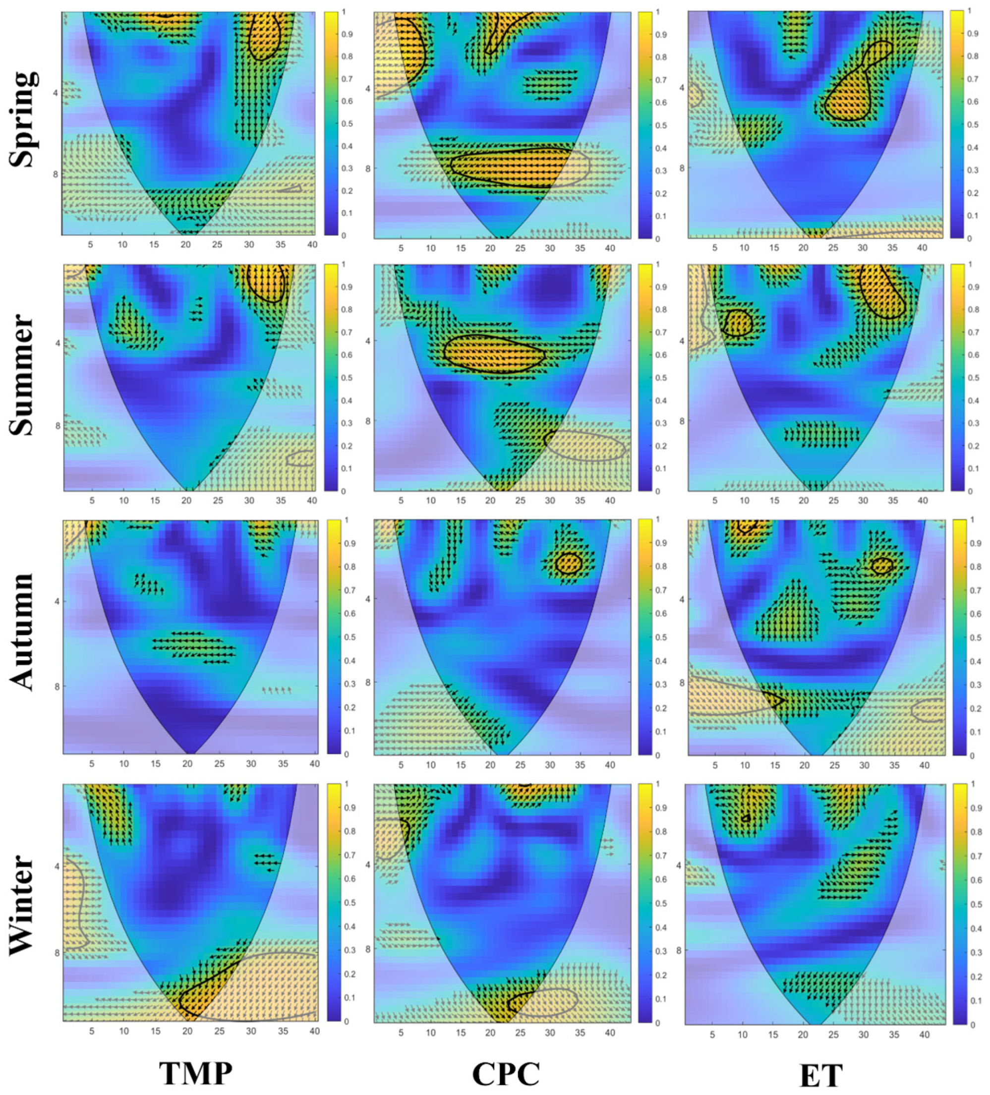
Figure A2.
Wavelet coherence between runoff and climatic variables in the Nen River Basin. The horizontal axis represents year, and the vertical axis represents time scale. Arrows indicate the phase relationship between runoff and climatic variables, where arrows pointing right/left denote in-phase/anti-phase relationships, and arrows pointing upward/downward indicate that the climatic variable leads/lags runoff.
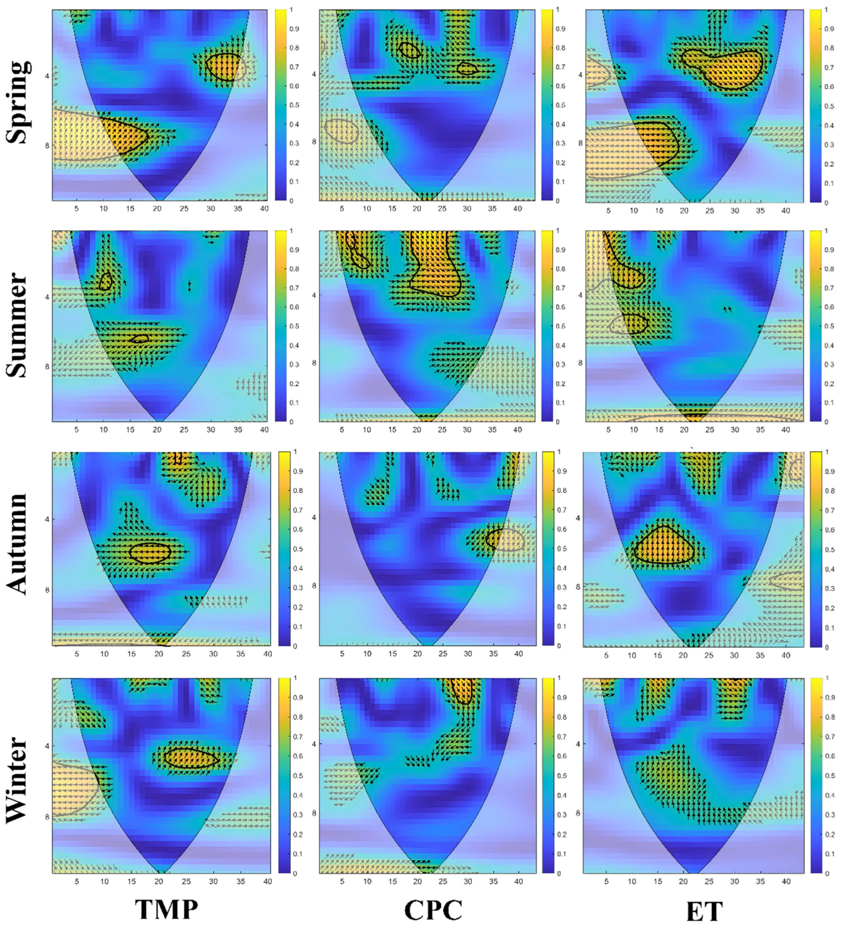
References
- Gomez-Jaramillo, Y.; Berrouet, L.; Villegas-Palacio, C.; Berrio-Giraldo, L. Navigating water security: A sustainability evaluation in basin socio-ecological systems. The Grande River basin case study, Antioquia-Colombia. Sci. Total Environ. 2025, 959, 178354. [Google Scholar] [CrossRef] [Scilit] [PubMed]
- Ministry of Water Resources of the People’s Republic of China. China Water Resources Bulletin, 1st ed.; China Water & Power Press: Beijing, China, 2024; p. 38. [Google Scholar]
- Bai, X.; Zhao, W. Impacts of climate change and anthropogenic stressors on runoff variations in major river basins in China since 1950. Sci. Total Environ. 2023, 898, 165349. [Google Scholar] [CrossRef] [Scilit] [PubMed]
- Dingman, S.L. Physical Hydrology; Waveland Press, Inc.: Long Grove, IL, USA, 2015; p. 643. [Google Scholar]
- Huo, J.; Liu, C.; Yu, X.; Jia, G.; Chen, L. Effects of watershed char and climate variables on annual runoff in different climatic zones in China. Sci. Total Environ. 2021, 754, 142157. [Google Scholar] [CrossRef] [Scilit] [PubMed]
- Guan, X.; Zhang, J.; Bao, Z.; Liu, C.; Jin, J.; Wang, G. Past variations and future projection of runoff in typical basins in 10 water zones, China. Sci. Total Environ. 2021, 798, 149277. [Google Scholar] [CrossRef] [Scilit] [PubMed]
- Wang, Y.; Ye, A.; Zhang, Y.; Yang, F. The quantitative attribution of climate change to runoff increase over the Qinghai-Tibetan Plateau. Sci. Total Environ. 2023, 897, 165326. [Google Scholar] [CrossRef] [Scilit] [PubMed]
- Li, M.; Wang, H.; Gu, H.; Chi, B. Analyzing river disruption factors and ecological flow in China’s Liu River Basin amid environmental changes. Environ. Sci. Pollut. Res. Int. 2024, 31, 26282–26299. [Google Scholar] [CrossRef] [Scilit] [PubMed]
- Yang, W.; Jin, F.; Si, Y.; Li, Z. Runoff change controlled by combined effects of multiple environmental factors in a headwater catchment with cold and arid climate in northwest China. Sci. Total Environ. 2021, 756, 143995. [Google Scholar] [CrossRef] [Scilit] [PubMed]
- Tan, X.; Gan, T.Y. Contribution of human and climate change impacts to changes in streamflow of Canada. Sci. Rep. 2015, 5, 17767. [Google Scholar] [CrossRef] [Scilit] [PubMed]
- Luo, W.; Liu, M.; Yao, Z.; Tu, X.; Lin, K. Uncovering the impact of climate and vegetation changes on runoff in karstic regions of southwest China. J. Environ. Manag. 2024, 370, 122617. [Google Scholar] [CrossRef] [Scilit] [PubMed]
- Zhao, G.; Tian, S.; Jing, Y.; Liang, S.; Wang, W.; Chen, R.; Zhang, Y. Spatiotemporal variations in runoff and sediment load of the mainstem and major tributaries of the Yellow River Basin from the headwater to the estuary (1960–2023). J. Environ. Manag. 2025, 380, 124723. [Google Scholar] [CrossRef] [Scilit] [PubMed]
- Zuo, Y.; Chen, J.; Lin, S.; He, K. The runoff changes are controlled by combined effects of multiple regional environmental factors in the alpine hilly region of Northwest China. Sci. Total Environ. 2023, 862, 160835. [Google Scholar] [CrossRef] [Scilit] [PubMed]
- Zhang, Z.Y.; Zhao, Y.H.; Zhen, Z. Dynamic monitoring of terrestrial ecosystem carbon storage in the Songhua River Basin from 1986 to 2022 based on LUCC. J. Plant Ecol. 2024, 48, 1274–1290. [Google Scholar]
- Li, F.; Zhang, G.; Xu, Y.J. Spatiotemporal variability of climate and streamflow in the Songhua River Basin, northeast China. J. Hydrol. 2014, 514, 53–64. [Google Scholar] [CrossRef] [Scilit]
- Feng, B.; Zhang, G.; Li, F. Characteristics and risk zoning of seasonal meteorological drought in the Songhua River Basin. Sci. Geogr. Sin. 2016, 36, 466–474. [Google Scholar] [CrossRef]
- Song, X.; Jing, L.; Cudennec, C. Annual Observations of Climatic Impacts in the Songhua River Basin, China. Adv. Meteorol. 2015, 2015, 46–57. [Google Scholar] [CrossRef] [Scilit]
- Hou, L.; Wang, Y. Analysis of the third water resources survey and assessment in the Songhua River Basin. Northeast. Water Resour. Hydropower 2022, 40, 14–17. [Google Scholar] [CrossRef]
- Hou, L.; Wang, Y. Analysis of water resources evolution and development utilization in the Songhua River Basin. Northeast. Water Resour. Hydropower 2024, 42, 19–22. [Google Scholar] [CrossRef]
- Wang, S.; Tian, L.; Li, F.; Kang, X.; Xu, Y. Spatiotemporal variation characteristics and influencing factors of terrestrial water storage in the Songhua River Basin. China Rural. Water Hydropower 2024, 47–58. [Google Scholar]
- Zhao, J.; Zhou, M. Study on eco-hydrological zoning of the Songhua River Basin. Resour. Econ. Environ. Prot. 2015, 177. [Google Scholar] [CrossRef]
- Lv, R.D.X. Spatio-temporal characteristics of drought and its relationship with el niño-southern oscillation in the songhua river basin from 1960 to 2019. Water 2022, 14, 866. [Google Scholar] [CrossRef] [Scilit]
- Li, F.; Zhang, G.; Xu, Y. Assessing Climate Change Impacts on Water Resources in the Songhua River Basin. Water 2016, 8, 420. [Google Scholar] [CrossRef] [Scilit]
- Wang, X.; Dai, C.; Liu, G.; Meng, X.; Lu, P.; Pang, B. Climate Trends and Attribution Analysis of Runoff Changes in the Songhua River Basin from 1980 to 2022 Based on the Budyko Hypothesis. Sustainability 2025, 17, 8459. [Google Scholar] [CrossRef] [Scilit]
- Fang, S.; Mao, K.; Xia, X.; Wang, P.; Shi, J.; Bateni, S.M.; Xu, T.; Cao, M.; Heggy, E.; Qin, Z. Dataset of daily near-surface air temperature in China from 1979 to 2018. Earth Syst. Sci. Data 2022, 14, 1413–1432. [Google Scholar] [CrossRef] [Scilit]
- Han, J.; Miao, C.; Gou, J.; Zheng, H.; Zhang, Q.; Guo, X. A new daily gridded precipitation dataset for the Chinese mainland based on gauge observations. Earth Syst. Sci. Data 2023, 15, 3147–3161. [Google Scholar] [CrossRef] [Scilit]
- Muñoz-Sabater, J.; Dutra, E.; Agustí-Panareda, A.; Albergel, C.; Arduini, G.; Balsamo, G.; Boussetta, S.; Choulga, M.; Harrigan, S.; Hersbach, H.; et al. ERA5-Land: A state-of-the-art global reanalysis dataset for land applications. Earth Syst. Sci. Data 2021, 13, 4349–4383. [Google Scholar] [CrossRef] [Scilit]
- Hamed, K.H.; Ramachandra Rao, A. A modified Mann-Kendall trend test for autocorrelated data. J. Hydrol. 1998, 204, 182–196. [Google Scholar] [CrossRef] [Scilit]
- Connell, E.O.; Donnell, G.O.; Koutsoyiannis, D. The Spatial Scale Dependence of The Hurst Coefficient in Global Annual Precipitation Data, and Its Role in Characterising Regional Precipitation Deficits within a Naturally Changing Climate. Hydrology 2022, 9, 199. [Google Scholar] [CrossRef] [Scilit]
- Pan, Y.; Wang, Y.; Peng, J.; Shen, H.; Liu, X. Time series analysis of precipitation in the middle and lower reaches of the Hanjiang River Basin based on wavelet and R/S methods. Geogr. Res. 2012, 31, 811–820. [Google Scholar]
- Rhif, M.; Ben Abbes, A.; Farah, I.R.; Martínez, B.; Sang, Y. Wavelet Transform Application for/in Non-Stationary Time-Series Analysis: A Review. Appl. Sci. 2019, 9, 1345. [Google Scholar] [CrossRef] [Scilit]
- Torrence, C.; Compo, G.P. A Practical Guide to Wavelet Analysis. Bull. Am. Meteorol. Soc. 1998, 79, 61–78. [Google Scholar] [CrossRef]
- Si, W.H.A.B. Technical note: Improved partial wavelet coherency for understanding scale-specific and localized bivariate relationships in geosciences. Hydrol. Earth Syst. Sci. 2021, 25, 321–331. [Google Scholar] [CrossRef] [Scilit]
- Liang, L.; Song, Z.; Zhang, Z.; Wang, Y. Simulation and attribution analysis of water and sediment in the Zuli River Basin based on a random forest model. Yellow River 2025, 47, 90–95. [Google Scholar]
- Breiman, L. Random Forests. Mach. Learn. 2001, 45, 5–32. [Google Scholar] [CrossRef] [Scilit]
- Cheng, Q.; Zhong, F.; Wang, P. Baseflow dynamics and multivariate analysis using bivariate and multiple wavelet coherence in an alpine endorheic river basin (Northwest China). Sci. Total Environ. 2021, 772, 145013. [Google Scholar] [CrossRef] [Scilit] [PubMed]
- Kong, F. Spatiotemporal variation characteristics of different extreme temperature indices in China from 1961 to 2018. Water Resour. Hydropower Eng. 2020, 51, 67–80. [Google Scholar] [CrossRef]
- Liu, S.; Hu, K.; Xie, Z.; Wang, Y. Spatial-temporal change of river thermal environment and anthropogenic impact in China. Sci. Total Environ. 2024, 929, 172697. [Google Scholar] [CrossRef] [Scilit] [PubMed]
- Zhao, H.; Wang, Z.; Li, X.; Chu, Z.; Zhao, C.; Zhao, F. Research on the evolution characteristics of future climate change in West Liao River Basin. Environ. Sci. Pollut. Res. Int. 2022, 29, 509–517. [Google Scholar] [CrossRef] [Scilit] [PubMed]
- Xing, W.; Feng, Z.; Cao, X.; Fu, J.; Wang, W. Urbanization impacts on evapotranspiration change across seven typical urban agglomerations in China. Sci. Total Environ. 2024, 950, 175399. [Google Scholar] [CrossRef] [Scilit] [PubMed]
- Li, W.; Xiong, L.; Yin, J.; Chen, J.; Chen, H.; Liu, D.; Li, R. Impacts of changing environments on seasonal propagation from precipitation to streamflow. J. Environ. Manag. 2025, 392, 126907. [Google Scholar] [CrossRef] [Scilit] [PubMed]
- Hau, N.X.; Sano, M.; Nakatsuka, T.; Chen, S.H.; Chen, I.C. The modulation of Pacific Decadal Oscillation on ENSO-East Asian summer monsoon relationship over the past half-millennium. Sci. Total Environ. 2023, 857, 159437. [Google Scholar] [CrossRef] [Scilit] [PubMed]
- Su, L.; Miao, C.; Gou, J. Long-term trends in Songhua River Basin streamflow and its multivariate relationships with meteorological factors. Environ. Sci. Pollut. Res. 2021, 28, 64206–64219. [Google Scholar] [CrossRef] [Scilit] [PubMed]
- Liu, J.; Hayakawa, N.; Lu, M.; Dong, S.; Yuan, J. Hydrological and geocryological response of winter streamflow to climate warming in Northeast China. Cold Reg. Sci. Technol. 2003, 37, 15–24. [Google Scholar] [CrossRef] [Scilit]
- Walvoord, M.A.; Kurylyk, B.L. Hydrologic Impacts of Thawing Permafrost—A Review. Vadose Zone J. 2016, 15, vzj2016-01. [Google Scholar] [CrossRef] [Scilit]
- Gao, J.; Gao, H. Influence of the Northeast Cold Vortex on Flooding in Northeast China in Summer 2013. J. Meteorol. Res. 2018, 32, 172–180. [Google Scholar] [CrossRef] [Scilit]
- Ye, T.; Shi, P.; Wang, J.A.; Liu, L.; Fan, Y.; Hu, J. China’s drought disaster risk management: Perspective of severe droughts in 2009–2010. Int. J. Disaster Risk Sci. 2012, 3, 84–97. [Google Scholar] [CrossRef] [Scilit]
- Fei, W.; Zheng, H.; Xu, Z.; Li, K.; Wang, S.; Liu, Y.; Li, R.; Yang, Z. Climatic aridity modulates the spatial variations in the responses of terrestrial water budget terms to El Niño–Southern Oscillation. Geosci. Lett. 2026, 13, 10. [Google Scholar] [CrossRef] [Scilit]
- Amarasekera, K.N.; Lee, R.F.; Williams, E.R.; Eltahir, E.A.B. ENSO and the natural variability in the flow of tropical rivers. J. Hydrol. 1997, 200, 24–39. [Google Scholar] [CrossRef] [Scilit]
- Yanjun, W. Contributions of Precipitation and Human Activities to Runoff Change in the Songhua River Basin. J. Nat. Resour. 2015, 30, 304–314. [Google Scholar] [CrossRef]
- Yu, S.; Zhang, X.; Liu, Z.; Wang, Y.; Shen, Y. Spatiotemporal variation characteristics of extreme climate indices in the Songhua River Basin from 1961 to 2020. Chin. J. Appl. Ecol. 2023, 34, 1091–1101. [Google Scholar] [CrossRef] [Scilit] [PubMed]
- Lu, Z.; Xia, Z.; Yu, L.; Wang, J. Spatiotemporal variation characteristics of air temperature in the Songhua River Basin over the past 51 years. J. Hohai Univ. (Nat. Sci.) 2012, 40, 629–635. [Google Scholar]
- Higashino, M.; Aso, D.; Stefan, H.G. Acceleration of rises in the level of rivers induced by rising air temperatures in a cold climate. Sci. Total Environ. 2021, 794, 148553. [Google Scholar] [CrossRef] [Scilit] [PubMed]
- Lu, Z.; Xia, Z.; Yu, L.; Wang, J. Spatiotemporal variation characteristics of precipitation in the Songhua River Basin from 1958 to 2009. J. Nat. Resour. 2012, 27, 990–1000. [Google Scholar]
- Meng, B. Study on the Relationship Between Surface Water and Groundwater Transformation in Seasonally Frozen Soil Regions. Ph.D. Thesis, Jilin University, Changchun, China, 2022. [Google Scholar]
- Han, J.; Liu, Z.; Woods, R.; McVicar, T.R.; Yang, D.; Wang, T.; Hou, Y.; Guo, Y.; Li, C.; Yang, Y. Streamflow seasonality in a snow-dwindling world. Nature 2024, 629, 1075–1081. [Google Scholar] [CrossRef] [Scilit] [PubMed]
- Gaertner, B. Geospatial patterns in runoff projections using random forest based forecasting of time-series data for the mid-Atlantic region of the United States. Sci. Total Environ. 2024, 912, 169211. [Google Scholar] [CrossRef] [Scilit] [PubMed]
- Guo, Y.; Yang, Y.; Yang, D.; Zhang, L.; Zheng, H.; Xiong, J.; Ruan, F.; Han, J.; Liu, Z. Warming leads to both earlier and later snowmelt floods over the past 70 years. Nat. Commun. 2025, 16, 3663. [Google Scholar] [CrossRef] [Scilit] [PubMed]
- Liu, J.; Zhang, Q.; Singh, V.P.; Song, C.; Zhang, Y.; Sun, P.; Gu, X. Hydrological effects of climate variability and vegetation dynamics on annual fluvial water balance in global large river basins. Hydrol. Earth Syst. Sci. 2018, 22, 4047–4060. [Google Scholar] [CrossRef] [Scilit]
- Wang, H.; Zheng, J. Assessing the Effects of Surface Conditions on Potential Evapotranspiration in a Humid Subtropical Region of China. Front. Clim. 2022, 4, 813787. [Google Scholar] [CrossRef] [Scilit]
- Wu, Y.; Yin, X.; Zhou, G.; Bruijnzeel, L.A.; Dai, A.; Wang, F.; Gentine, P.; Zhang, G.; Song, Y.; Zhou, D. Rising rainfall intensity induces spatially divergent hydrological changes within a large river basin. Nat. Commun. 2024, 15, 823. [Google Scholar] [CrossRef] [Scilit] [PubMed]
- Wang, W.; Hu, P.; Wang, J.; Zhao, J.; Liu, H.; Yang, Z. Scenario analysis for the sustainable development of agricultural water in the Wuyuer River basin based on the WEP model with a reservoir and diversion engineering module. Sci. Total Environ. 2021, 758, 143668. [Google Scholar] [CrossRef] [Scilit] [PubMed]
- Mei, J.; Yong, B.; Lyu, Y.; Qi, W.; Wen, Y.; Wang, G.; Zhang, J. Runoff evolution responses to climate change: A case study in the headwater area of Yellow River, China. J. Environ. Manag. 2025, 384, 125512. [Google Scholar] [CrossRef] [Scilit] [PubMed]
- Sun, S.; Zhou, X.; Liu, H.; Jiang, Y.; Zhou, H.; Zhang, C.; Fu, G. Unraveling the effect of inter-basin water transfer on reducing water scarcity and its inequality in China. Water Res. 2021, 194, 116931. [Google Scholar] [CrossRef] [Scilit] [PubMed]
- Qiu, R.; Wang, D.; Singh, V.P.; Wang, Y.; Wu, J. Integration of deep learning and improved multi-objective algorithm to optimize reservoir operation for balancing human and downstream ecological needs. Water Res. 2024, 253, 121314. [Google Scholar] [CrossRef] [Scilit] [PubMed]
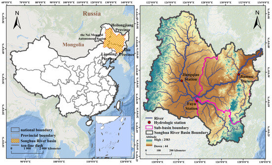
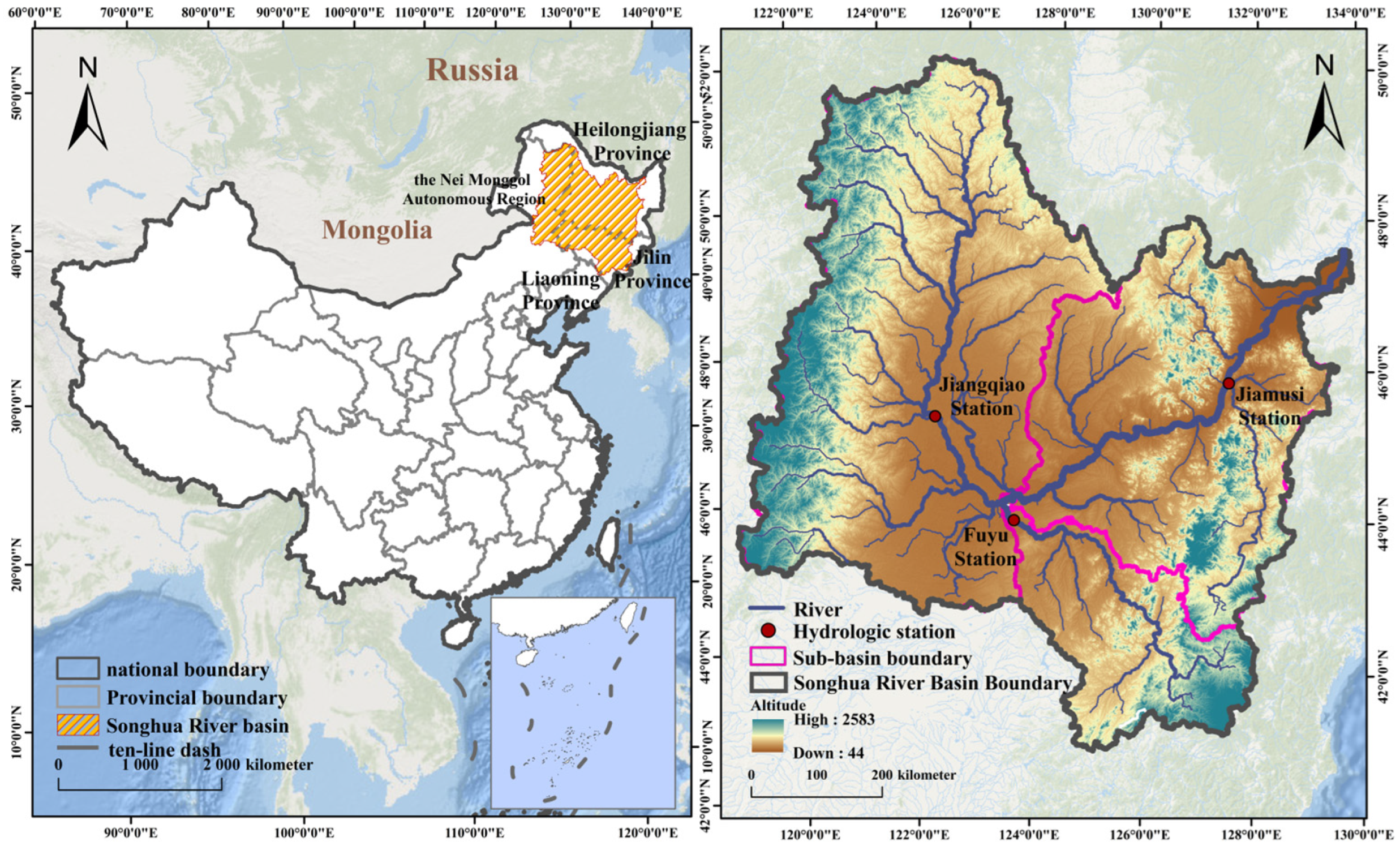
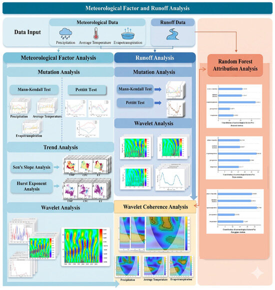
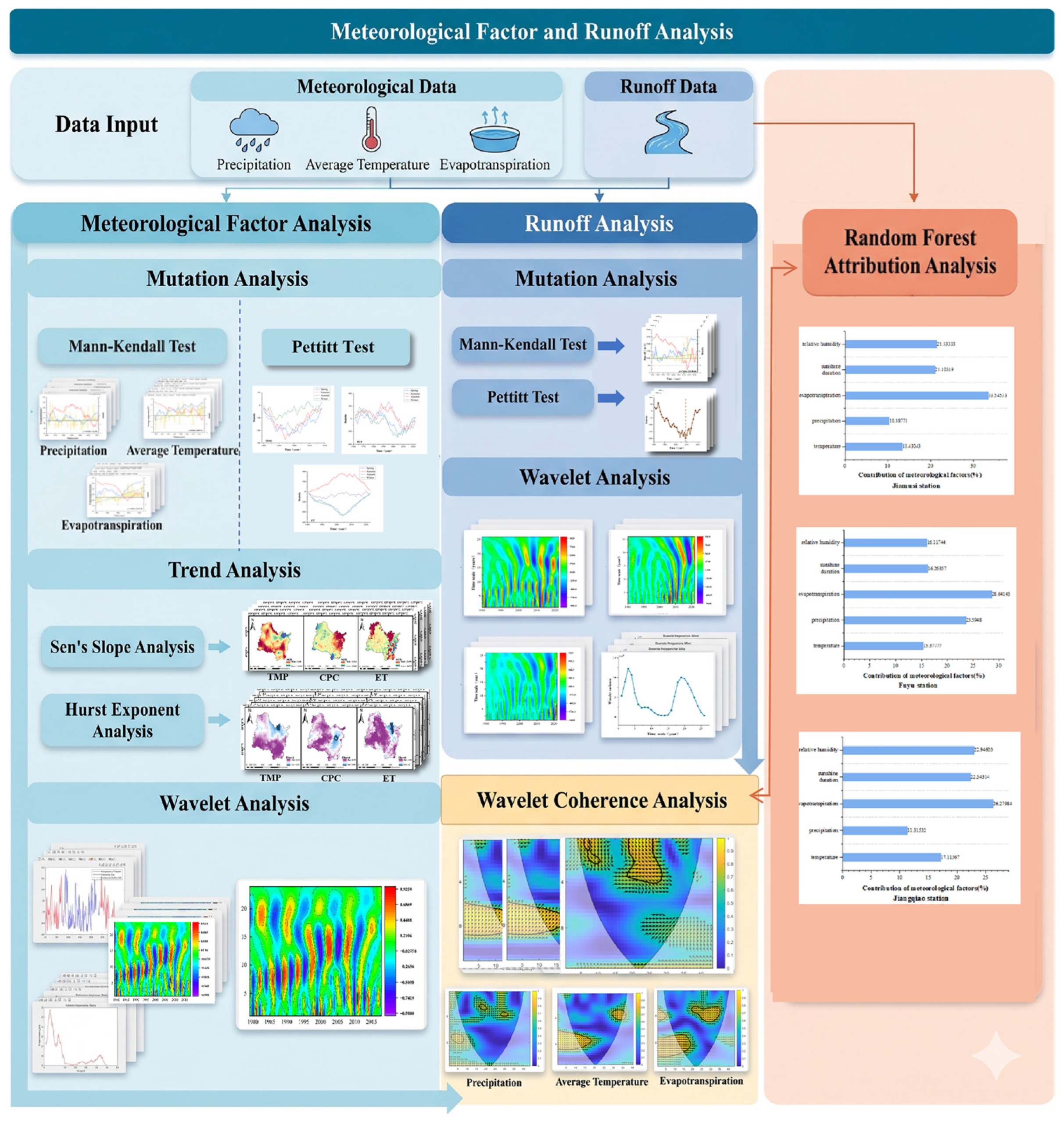
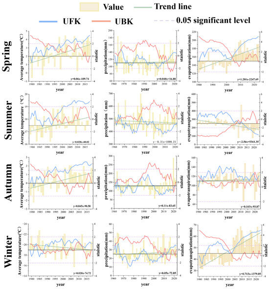
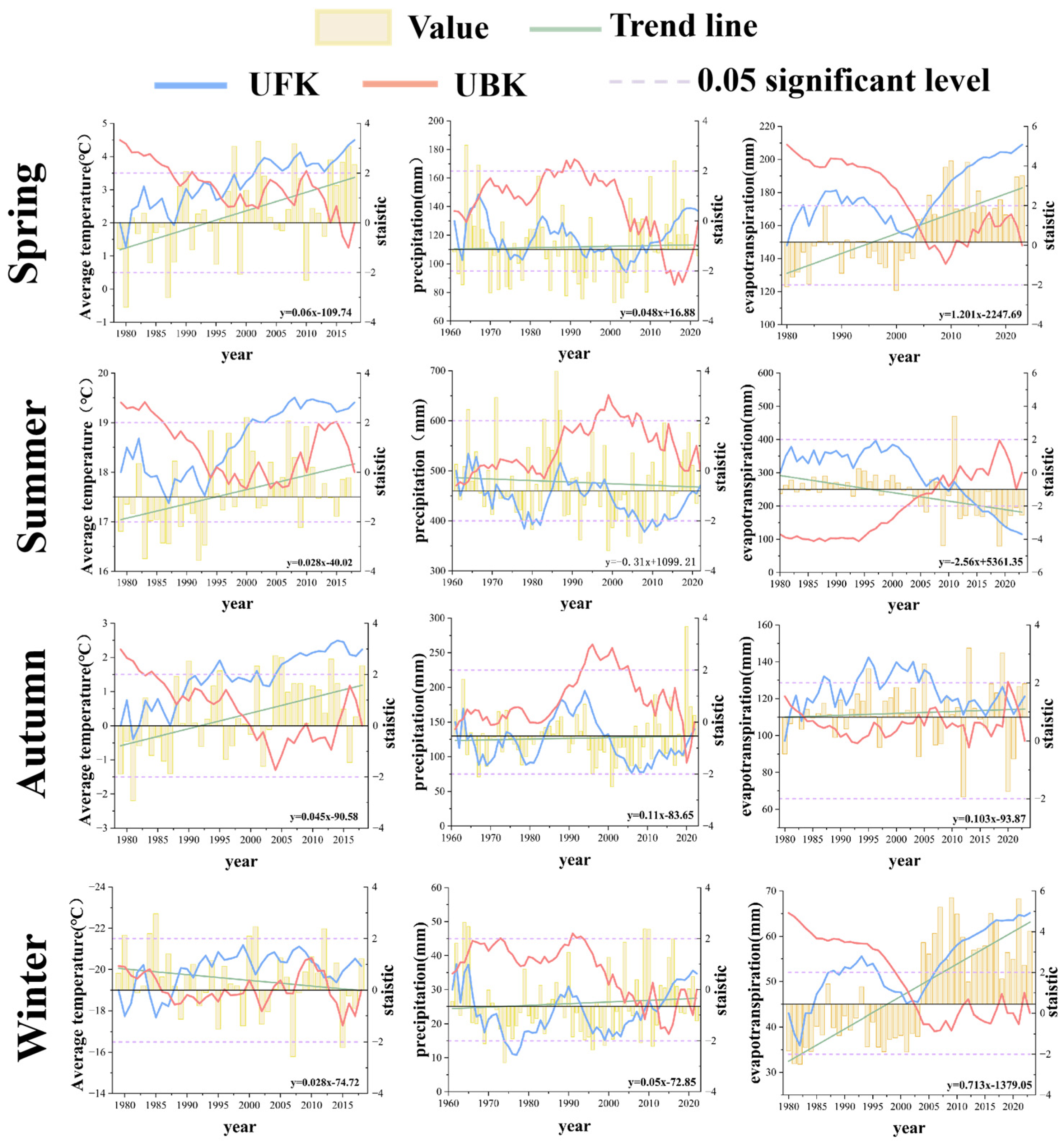
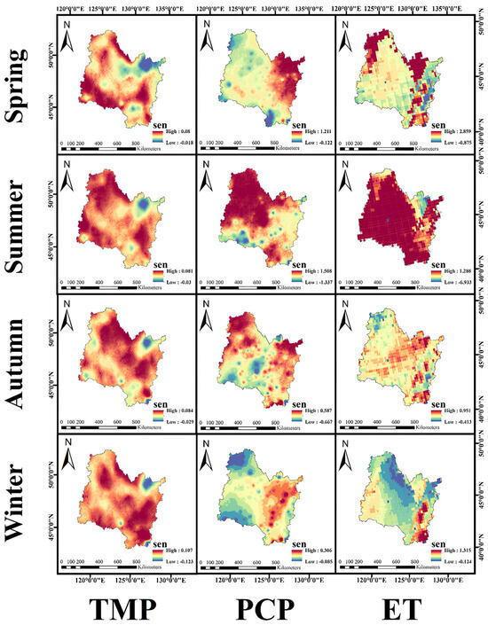
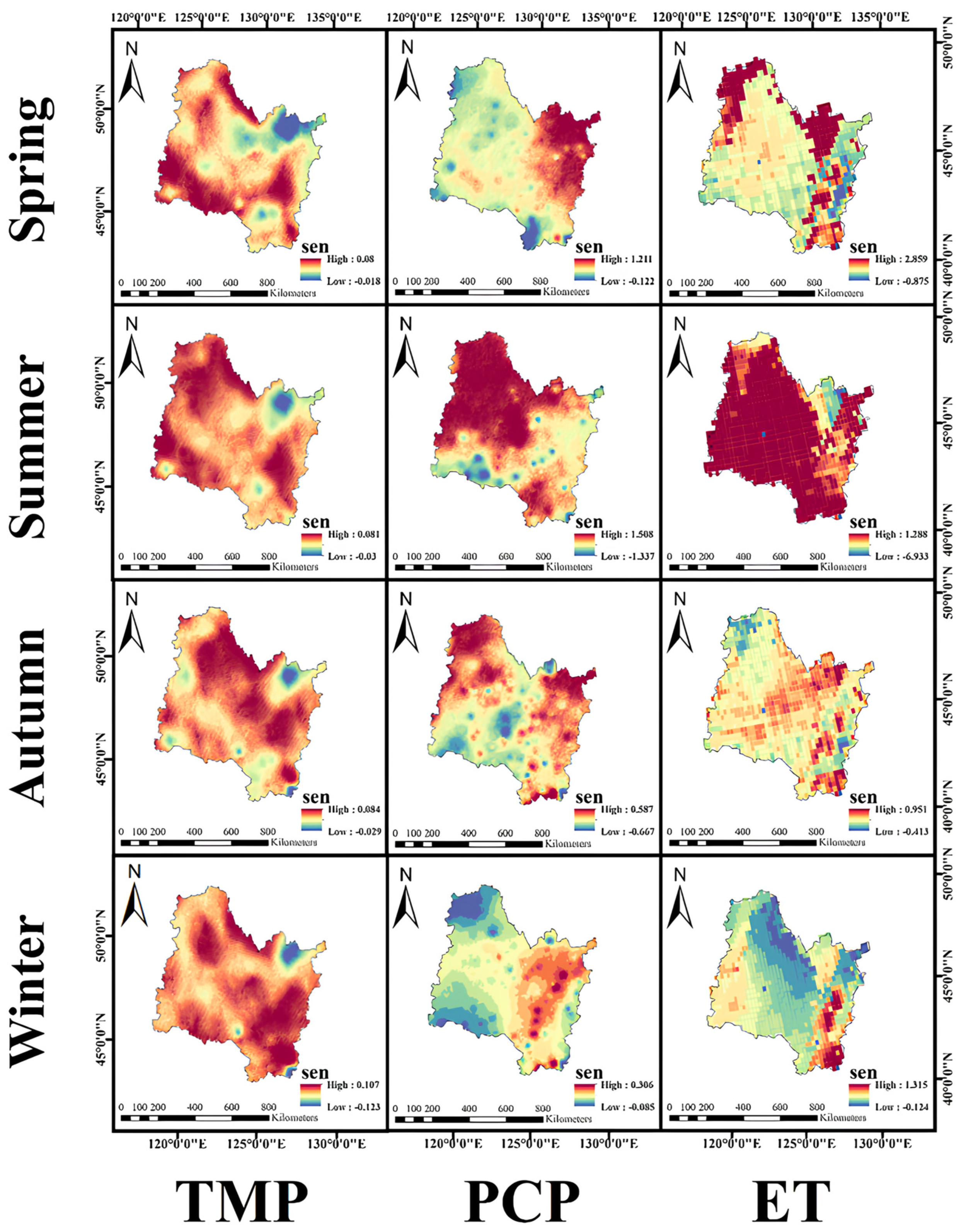
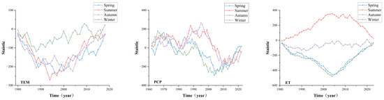
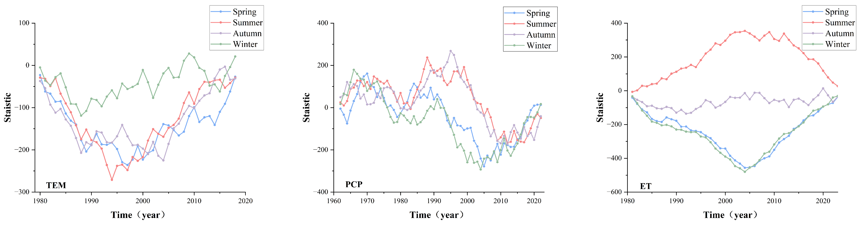
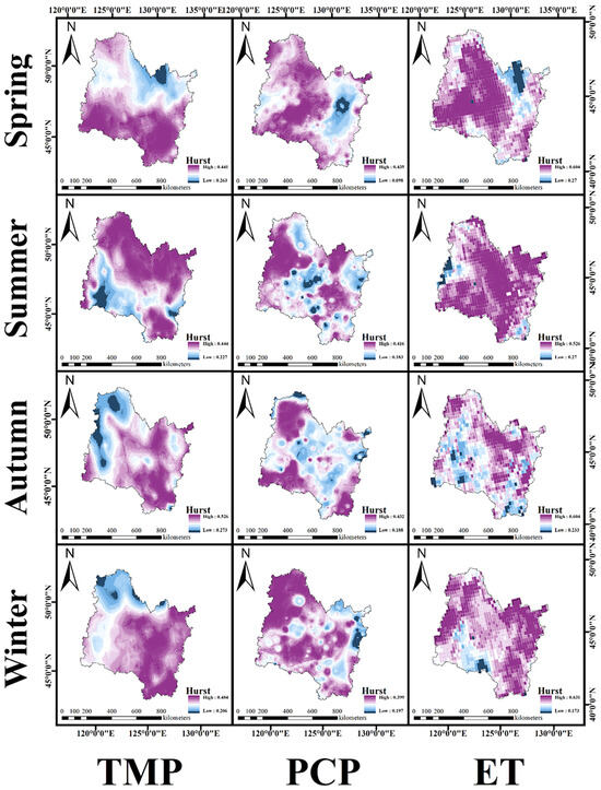
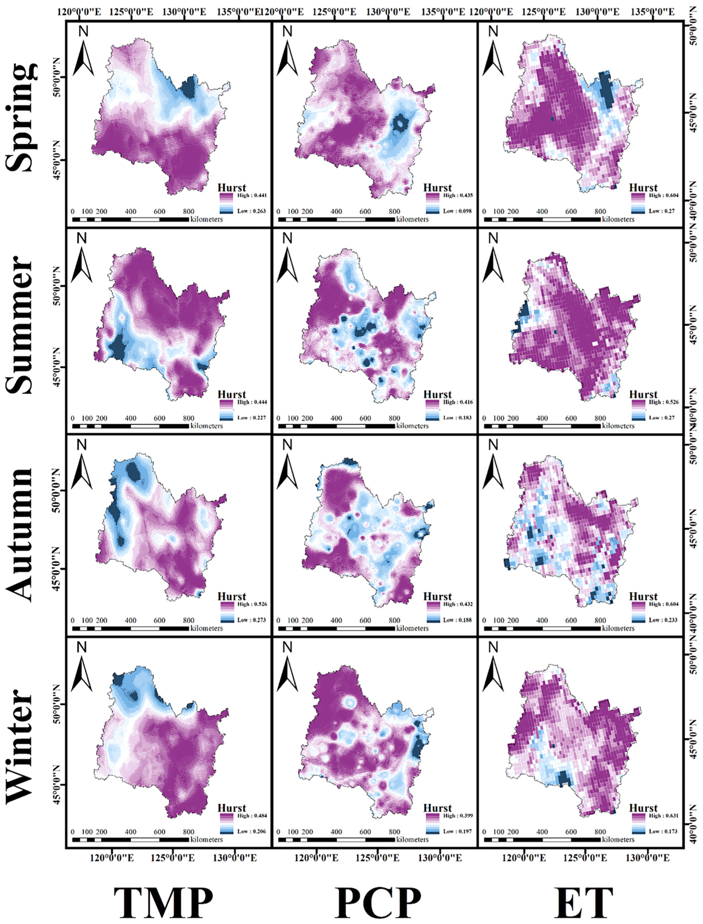
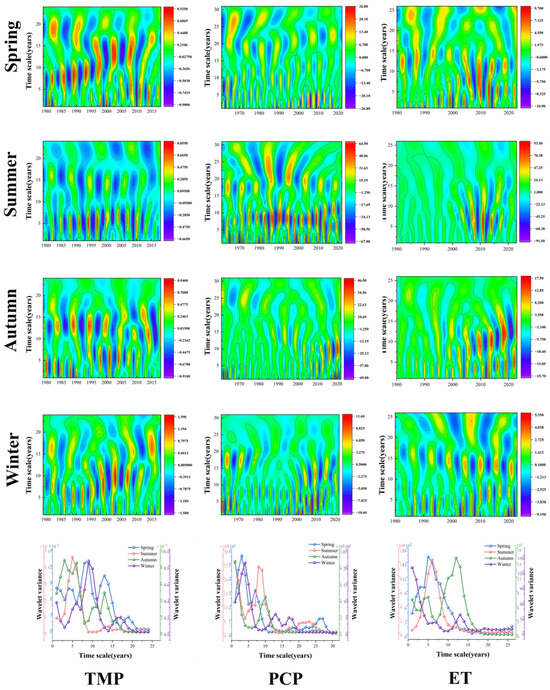
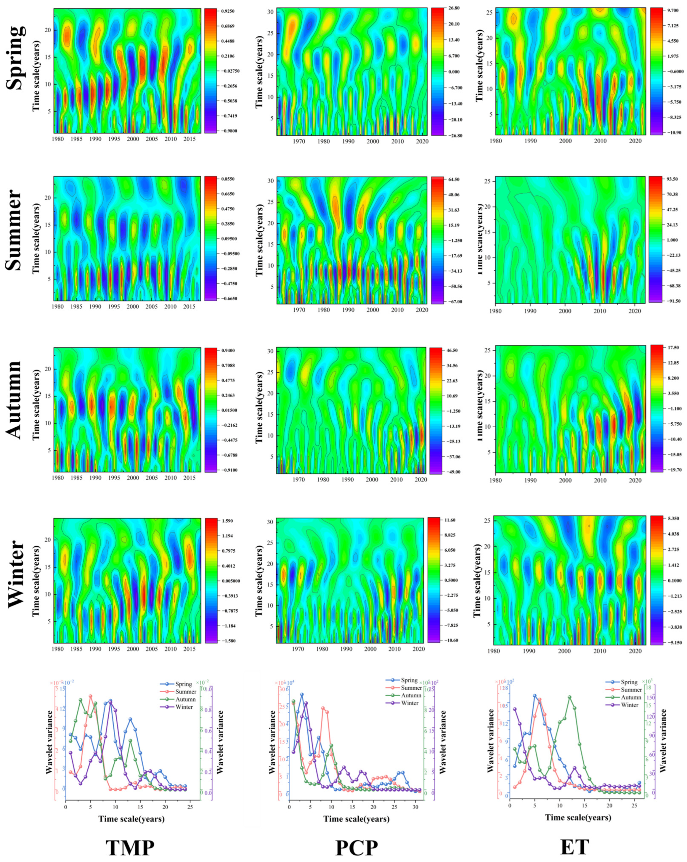
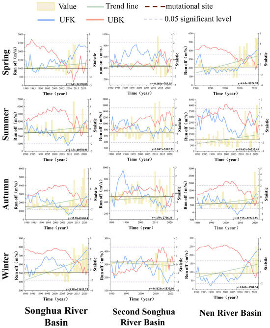
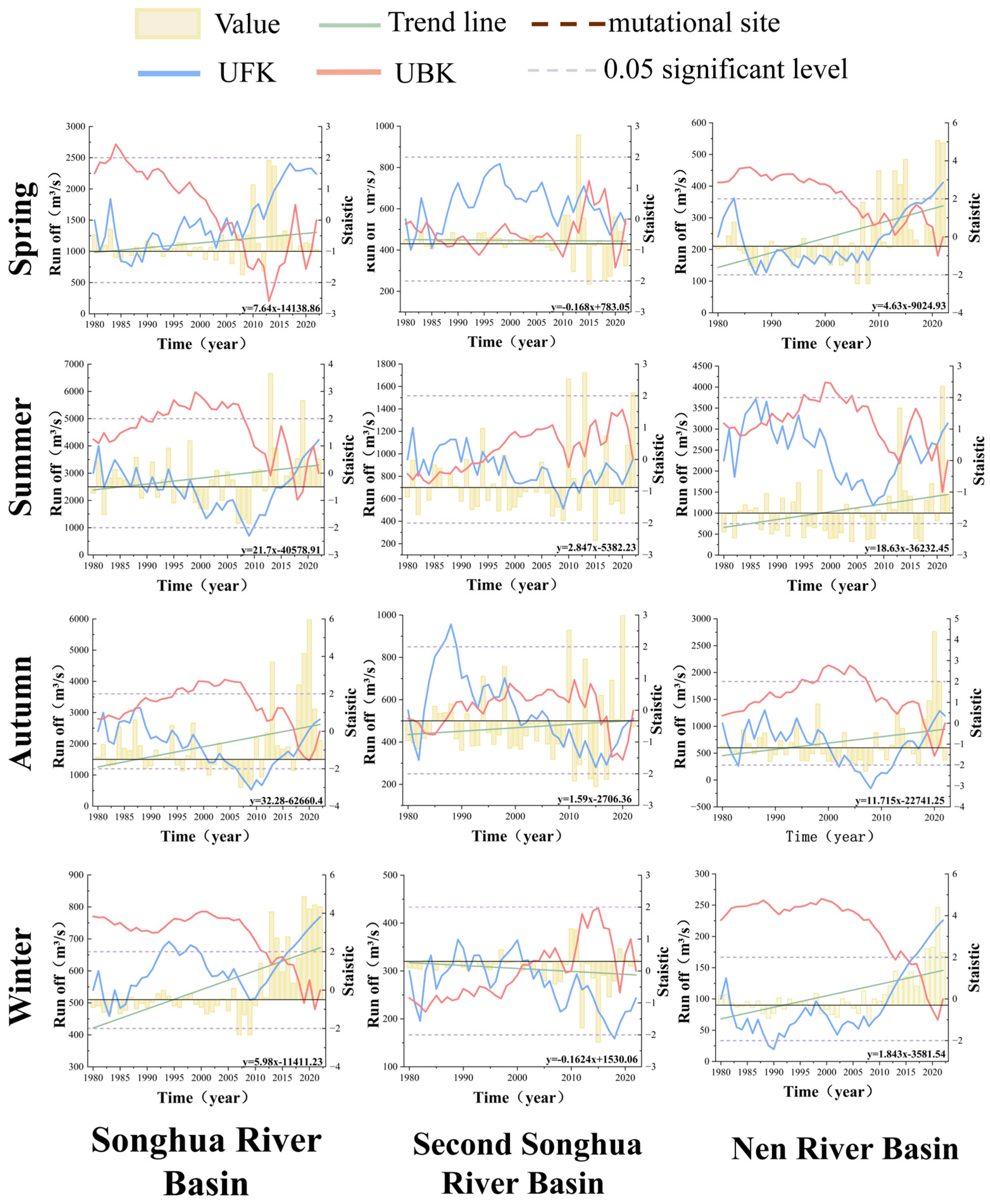
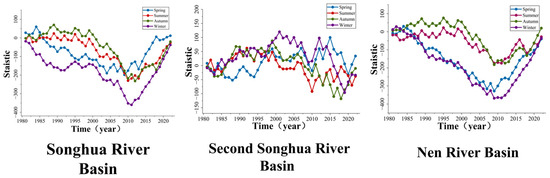
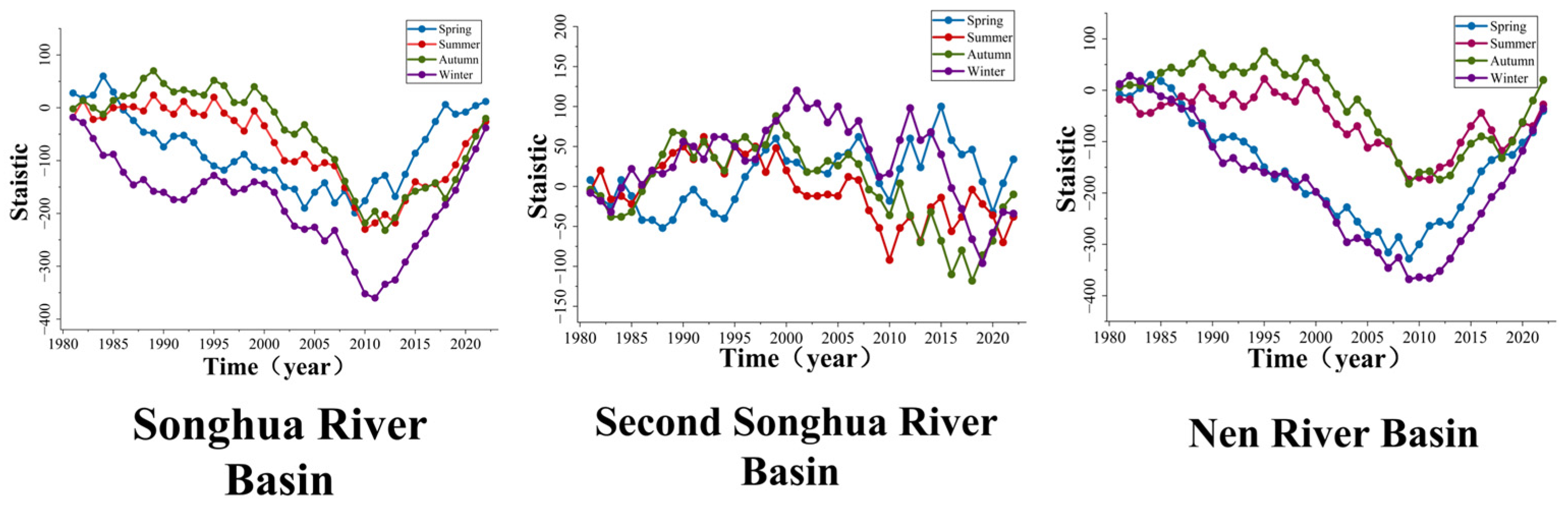
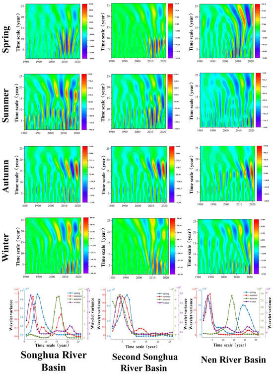
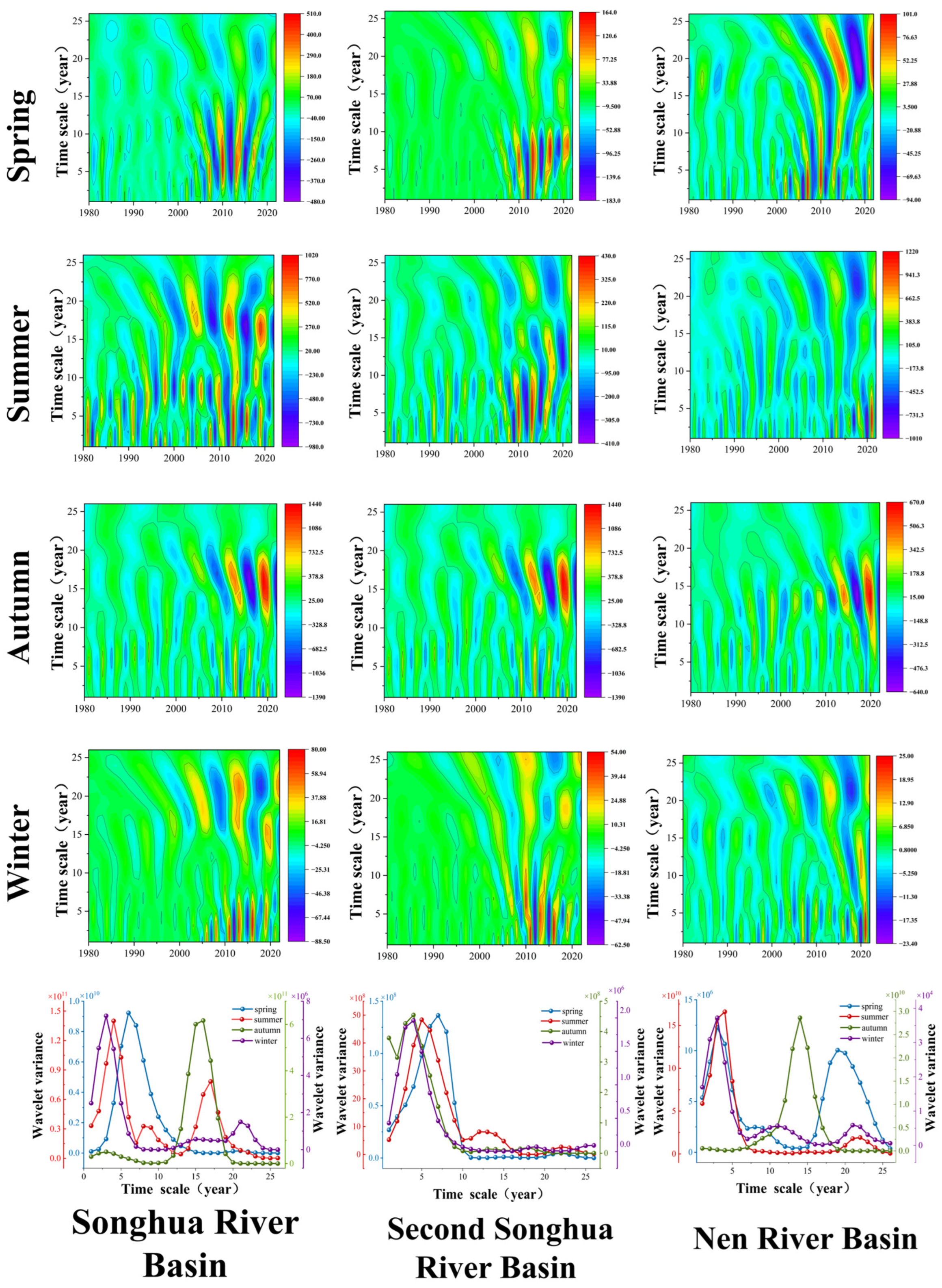
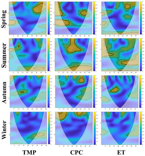
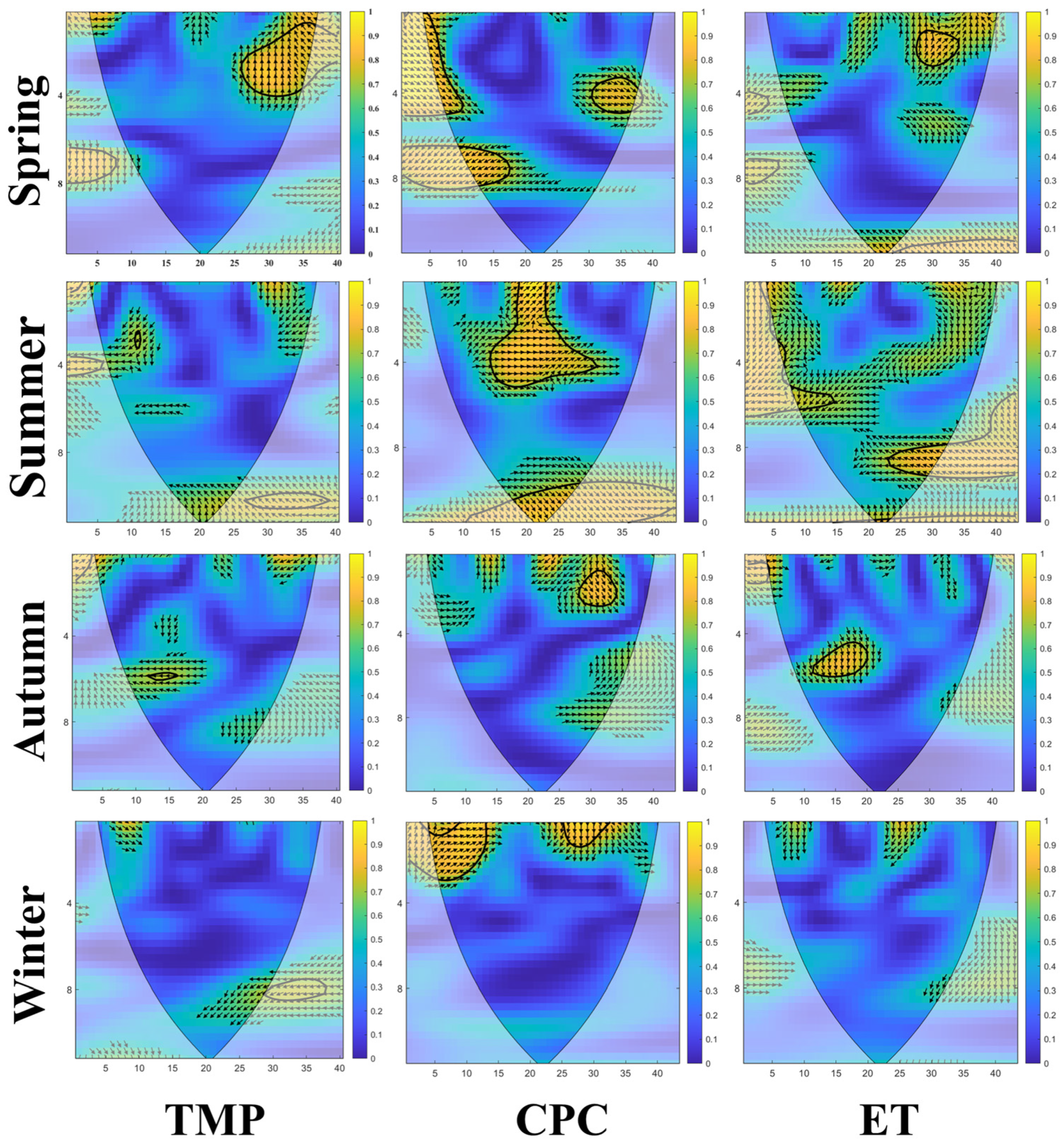
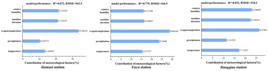

Disclaimer/Publisher’s Note: The statements, opinions and data contained in all publications are solely those of the individual author(s) and contributor(s) and not of MDPI and/or the editor(s). MDPI and/or the editor(s) disclaim responsibility for any injury to people or property resulting from any ideas, methods, instructions or products referred to in the content. |
© 2026 by the authors. Licensee MDPI, Basel, Switzerland. This article is an open access article distributed under the terms and conditions of the Creative Commons Attribution (CC BY) license.