


Abstract
With global warming continuously worsening drought hazards, the Fuhe River Basin urgently requires insight into drought evolution laws to support resilient water resources management. However, traditional univariate indices such as the Standardized Precipitation Index (SPI) and Standardized Soil Moisture Index (SSI) are limited by their inability to capture the coupled meteorological-agricultural drought process and the time-lag effects between precipitation and soil moisture response. Therefore, a multivariate drought index—which integrates both precipitation and soil moisture information—is needed as a core tool for drought early warning and precise regulation. In this study, the calibrated SWAT model was used to simulate monthly soil moisture content in the Fuhe River Basin over the past 60 years. On a 3-month time scale, a Multivariate Standardized Drought Index (MSDI) was established by coupling the Standardized Precipitation Index (SPI) and Standardized Soil Moisture Index (SSI) using the Copula function. The main findings are as follows: (1) The Nash–Sutcliffe efficiency coefficient (NS) of the SWAT (Soil and Water Assessment Tool) model during the validation period reached above 0.70, indicating favorable performance in monthly runoff simulation. (2) The MSDI revealed frequent drought events in two periods, namely 1960–1979 and 2000–2019, demonstrating the periodic fluctuation pattern of droughts in the basin. (3) Wavelet analysis showed that compared with the previous two periods, the frequency of droughts in the basin increased significantly after 2000, with weakened periodic characteristics, intensified extreme drought events, and a further rise in drought risks. This study deepens the understanding of drought dynamics in the Fuhe River Basin and provides a scientific basis for regional sustainable water resource management and the formulation of climate adaptation strategies.
1. Introduction
In recent years, the global climate system has been undergoing unprecedented drastic changes, with extreme weather events showing a significant trend of increasing frequency and intensity [1]. As a direct manifestation of these climate changes, seasonal drought has emerged as a major and escalating threat to global food and aquatic ecological security. This threat is driven by a dual mechanism: precipitation anomalies (e.g., deficits or failed rainy seasons) act as the primary trigger for drought onset, while concurrently elevated temperatures serve as a critical amplifier, intensifying moisture loss and extending drought impacts. This synergistic dynamic has been documented in various regions worldwide, such as the Horn of Africa, the Lower Mekong Basin, and the Amazon, where compound effects of rainfall deficits and heat have led to severe agricultural, hydrological, and even global systemic risks [2,3,4].
The case of Poyang Lake in China’s Yangtze River Basin exemplifies these intensifying “trigger–amplifier” dynamics in a monsoon-affected region. Persistent precipitation deficits—such as the 40% rainfall reduction during the critical 2003 rice-growing season—directly trigger severe hydrological and agricultural droughts [5]. These conditions are critically amplified by rising temperatures, which accelerate evaporation and further reduce rainfall efficiency, as evidenced by a 70% precipitation drop during the 2013 heatwave [6]. This synergy fundamentally alters the regional hydrological regime, leading to more frequent and severe crises like the 2022 historic drought, which affected over 5.4 million people, damaged 701,300 hectares of crops, and caused significant socioeconomic losses [7,8]. The Poyang Lake case thus demonstrates how converging climatic forces turn seasonal drought into a persistent, multi-system threat to water, food, and ecological security on a regional scale. The Fuhe River Basin, a major tributary of Poyang Lake in the humid southeastern region of China, exemplifies this transformation. With an average annual precipitation of 1760 mm, the Fuhe River Basin nonetheless experiences an extremely uneven seasonal distribution, where roughly 70% of the annual runoff is concentrated in the April-September rainy season [9]. This hydrological characteristic of uneven water resource distribution, combined with the increased evaporation demand caused by global warming, makes the droughts in the basin exhibit new characteristics of “high frequency, long duration, and strong complexity” [10,11]. Historical monitoring shows that after 2000, the frequency of extreme drought events in the basin increased by 39.5% compared with the second half of the 20th century [12].
A variety of indices have been developed to assess drought. Among them, the SPI, which compares precipitation to the long-term climatic average, is widely used for meteorological drought [13]. Similarly, the Standardized Runoff Index (SRI) quantifies hydrological drought from streamflow or runoff data, derived by fitting a probability distribution to long-term monthly runoff and standardizing it [14,15]. Likewise, the SSI, based solely on soil water content, has also been used for drought assessment. However, these univariate indices have inherent limitations: SPI fails to account for the critical time-lag effects in soil moisture response and subsequent hydrological processes, while SSI provides limited insight into the climatic drivers or propagation dynamics that initiate and sustain drought conditions [16]. Consequently, univariate indices focusing solely on rainfall, streamflow, or soil water content cannot evaluate overall regional drought, prompting the development of the MSDI for a more comprehensive assessment [17,18,19,20]. For instance, Dash et al. (2019) and Zhang et al. (2018) successfully applied MSDI (based on SPI/SSI or SPI/SRI) in Indian and Chinese river basins [14,19], demonstrating its ability to detect drought occurrence, frequency, and duration. Nevertheless, the existing drought assessment system in the Fuhe River Basin still relies predominantly on univariate indices (SPI, SRI, or SSI) [21,22,23], and MSDI has not yet been applied to assess seasonal drought risks in this basin. To fill this gap, we establish a physically based distributed hydrological model (SWAT) using high-precision DEM, soil, and land use data to simulate a 60-year monthly soil moisture series. Furthermore, the Copula function is adopted to construct an MSDI that integrates meteorological and agricultural drought characteristics, thereby improving the reliability of drought assessment in the Fuhe River Basin.
Despite the well-recognized “trigger–amplifier” mechanism and the increasing drought risk in the Fuhe River Basin, existing drought assessments in this region rely almost exclusively on univariate indices. These univariate indices fail to capture the joint evolution of meteorological and agricultural drought, nor do they account for the coupled effects of precipitation deficits and soil moisture depletion under rising temperatures. Moreover, no study has yet developed a multivariate drought index that integrates both precipitation and soil moisture dynamics within a physically based hydrological modeling framework for the Fuhe River Basin. To fill this gap, this study mainly carried out research in the following three aspects: (1) Based on high-precision DEM (Digital Elevation Model), soil properties, and land use data, the SWAT model was applied to accurately simulate the spatiotemporal variations in monthly soil moisture. This established a reliable baseline of soil moisture dynamics, providing basic data support for drought diagnosis; (2) The Copula function was used to couple SPI and SSI to construct an MSDI drought index, systematically revealing the periodic fluctuation patterns and evolution characteristics of drought events from 1960 to 2019; (3) Wavelet analysis was applied to reveal multi-scale drought periodicity, and adaptive regional water resources management was an adaptive water resources management framework was established to guide future drought risk planning. This integrated SWAT-Copula-MSDI framework provides a more reliable and process-sensitive tool for drought assessment in the Fuhe River Basin, with potential applicability to other monsoon-affected basins facing similar data and methodological limitations.
2. Materials and Methods
2.1. Study Area Overview
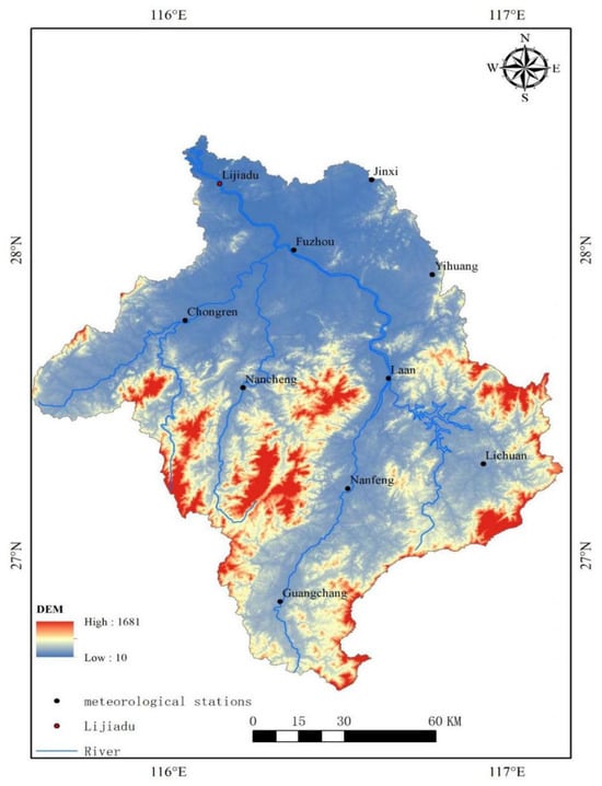
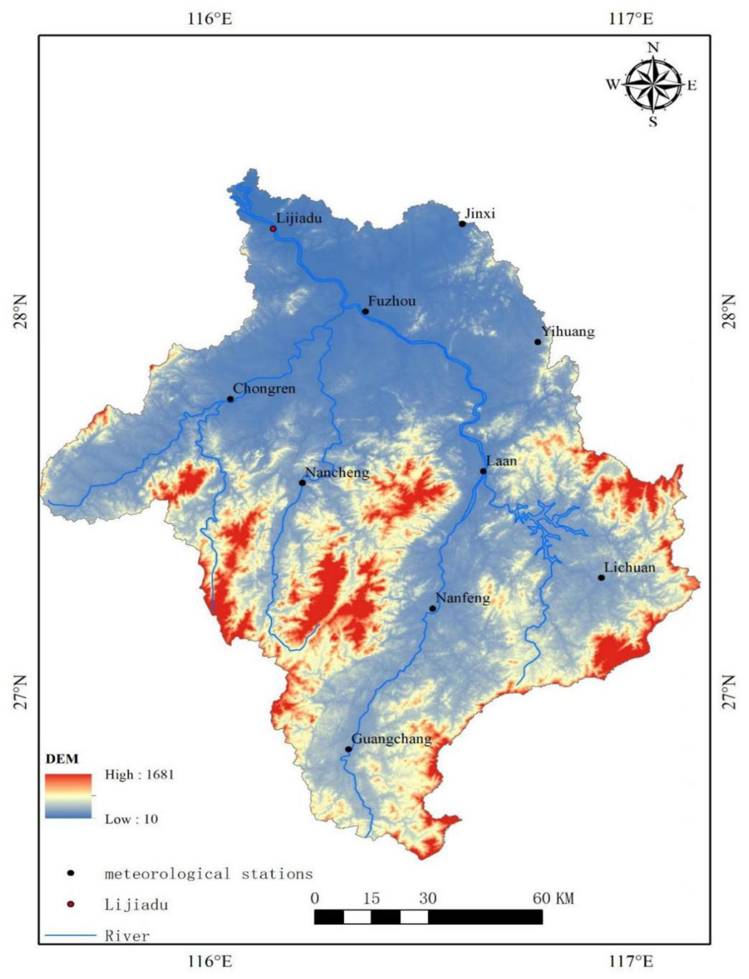
The Fuhe River Basin (115°35′–117°09′ E, 26°30′–28°50′ N) is located in southeastern Jiangxi Province, belonging to the subtropical humid monsoon climate zone. It is adjacent to the Minjiang River water system of Fujian Province in the east, the Meijiang River in the south, the Yi River and Wu River in the west, and flows into Poyang Lake in the north, with a basin area of 15,800 km2 [24]. The Fuhe River is 349 km long, and is divided into upper, middle, and lower reaches by the Wannian Bridge in Nancheng County and Fuzhou City. The upper reaches flow through hilly areas, while the middle and lower reaches flow through plain areas (Figure 1). The average annual precipitation in the Fuhe River Basin is 1763 mm, with an uneven temporal distribution of precipitation, mainly concentrated in April–June each year. The spatial distribution pattern of precipitation shows more in the southeast and less in the northwest [25].
Figure 1.
Distribution of the Fuhe River Basin and its hydro-meteorological stations.
2.2. Data Sources
2.2.1. Hydrological and Meteorological Data
In this study, the Lijiadu Hydrological Station, a representative monitoring station in the Fuhe River Basin, was selected for model calibration. The daily rainfall and runoff data of the hydrological station were obtained from the Jiangxi Provincial Hydrological Bureau, covering the time span from 1960 to 2019. In addition, daily climate data from 10 meteorological stations in the Fuhe River Basin from 1960 to 2019 were used, which were obtained from the National Meteorological Information Center of the China Meteorological Administration (https://data.cma.cn/ (accessed on 8 June 2026)). Maximum and minimum temperature (TMP), precipitation (PCP), solar radiation (SLR), relative humidity (HMD), and wind speed (WND) are the key climatic variables considered in this study. The specific geographical locations of the above hydrological and meteorological stations are shown in Figure 1.
2.2.2. Land Use and Soil Data
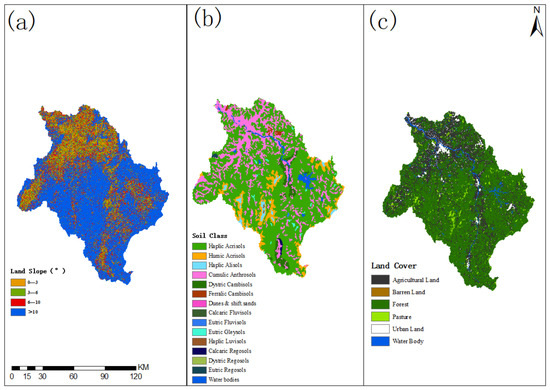
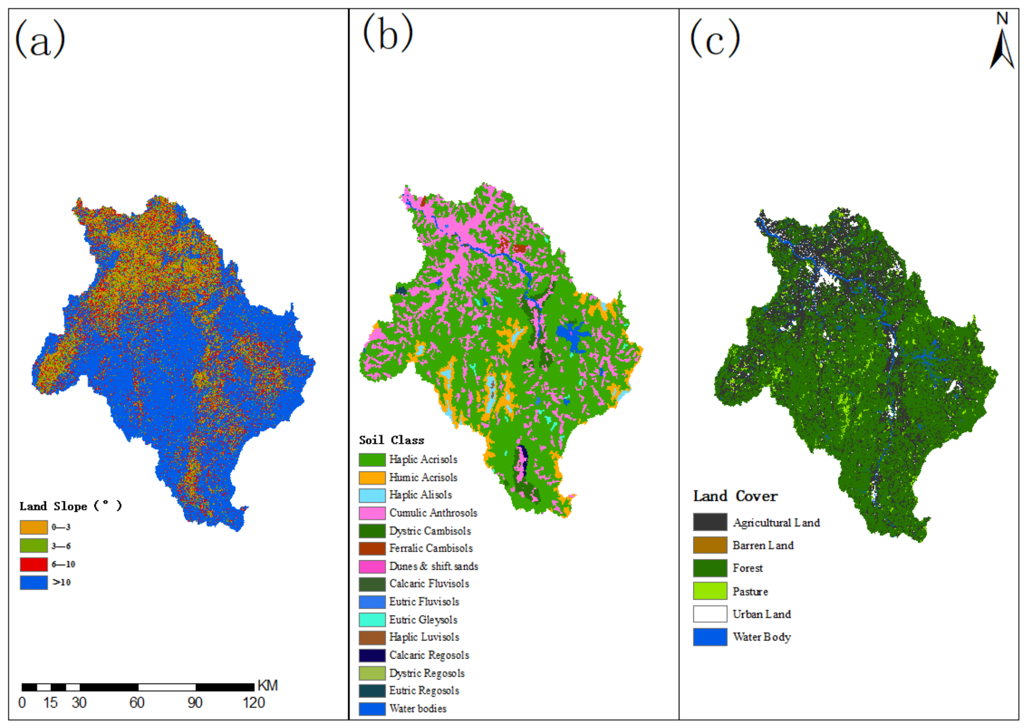
Digital Elevation Model (DEM) data with a resolution of 30 m were obtained from the Geospatial Data Cloud (https://www.gscloud.cn/ (accessed on 8 June 2026)). The land slopes were divided into four categories: 0–3°, 3–6°, 6–10°, and >10° (Figure 2a). Soil data were obtained from the Chinese soil dataset (v1.1) in the Harmonized World Soil Database (HWSD) managed by the Nanjing Institute of Soil Science. Using the FAO-90 system, the properties of each soil type were determined, and 25 soil categories were identified in the study basin. The main soil types in this area are Haplic Acrisols (ACh) and Cumulic Anthrosols (ATc), accounting for 63.53% and 22.24% of the total, respectively. Other soil types include Umbric Acrisols (ACu) accounting for 6.67%, Haplic Alisols (ALh) accounting for 1.40%, and small proportions of various other soil types (Figure 2b). The original Land Use and Land Cover (LULC) data include 19 types, downloaded from the Resource and Environmental Science Data Center. Subsequently, they were reclassified into six categories according to the SWAT model. The land cover in the basin is mainly composed of forest (64.67%), agricultural land (27.78%), and pasture (2.81%) (Figure 2c).
Figure 2.
Spatial distribution of land slope (a), soil class (b), and land cover (c) in the Fuhe River Basin.
2.3. Research Methods
2.3.1. SWAT Model Construction and Calibration
Based on 30 m DEM data, the river network extraction and subbasin division were completed by setting the minimum flow accumulation threshold. A total of 27 subbasins and 386 Hydrological Response Units (HRUs) were delineated in the study area.
Tools such as ArcMap, SWAT, SWAT-CUP, and SWAT Weather Database were used to construct the SWAT model for the Fuhe River Basin, and the model was verified by calibrating monthly runoff. Based on the calibrated SWAT model, monthly soil moisture data in the basin over the past 60 years were simulated to provide basic data support for drought characteristic analysis. In this study, the SUFI-2 calibration method was adopted in the SWAT-CUP tool, and 16 model parameters were selected for each subbasin for model calibration. The parameters for model validation are shown in Table 1. For model calibration details: sixteen parameters were calibrated for each subbasin. The years 1980–1981 were set as the warm-up period, 1982–2019 for model calibration, and 1960–1979 for validation. Based on the sensitivity ranks, the three most influential parameters are ALPHA_BF (rank 1), CN2 (rank 2), and SOL_AWC (rank 3). The low-fitted ALPHA_BF value (0.09) suggests a slow baseflow recession, characteristic of permeable soils with sustained groundwater discharge. The moderate reduction in CN2 (r_CN2 = 40.22) reflects the humid conditions with high antecedent soil moisture. The relatively low SOL_AWC (0.19) indicates limited plant-available water, which increases the basin’s susceptibility to agricultural drought. These parameter settings collectively reproduce the observed streamflow and soil moisture dynamics.
Table 1.
Parameters Used for Calibration and Validation of the SWAT Model in the Fuhe River Basin.
2.3.2. Drought Index Calculation
Based on the soil moisture data simulated by the SWAT model and the measured precipitation data, the Standardized Drought Analysis Toolbox (SDAT) software package on the MATLAB (2017) platform was used to calculate the SSI and SPI, respectively; a standardized calculation process was adopted to ensure the scientific reliability of the drought indices, providing data support for subsequent drought characteristic identification and risk assessment.
2.3.3. MSDI Construction
The Copula function was used to combine SSI and SPI to construct the MSDI for a more comprehensive assessment of drought conditions. The Multivariate Copula Analysis Toolbox (MvCAT) in MATLAB was used to complete the construction of MSDI, revealing the nonlinear relationship between meteorological drought and agricultural drought.
P(SPI ≤ X, SSI ≤ Y) = C(F(SPI), G(SSI))
In the formula, X and Y represent specific values of SPI and SSI, respectively, which are used to combine SSI and SPI.
H(SPI, SSI) = C[F(SPI), G(SSI)]
F and G represent the marginal distributions of the variables SPI and SSI, respectively, and H represents the marginal distribution of these two related variables. C is the cumulative distribution function of the Copula.
MSDI is derived from the joint distribution function as follows:
where φ represents the standard normal distribution.
MSDIp = φ−1(p)
2.3.4. Drought Characteristic Analysis
Based on the determined drought thresholds, drought characteristics such as drought frequency, duration, severity, and intensity were obtained. First, according to the monthly drought data of each subbasin from 1960 to 2019, the drought frequency of the five subbasins was determined. Drought duration (DD) is defined as three or more consecutive months, described as “a single three-month drought period within three months” according to Cavus and Aksoy [13]. In addition, drought severity (DS) was evaluated based on the cumulative MSDI during drought events.
DS = ∑ni = 1|MSDIi|
Drought intensity (DI) was calculated by dividing drought severity (DS) by drought duration:
DI = DS/D
In addition, since the continuous periodic Morlet wavelet function is widely used in identifying periodic oscillations in real-world signals, it was selected as the main tool for identifying drought cycles. This method uses a set of wavelet functions to analyze signals. The main characteristics of the Morlet wavelet are as follows:
where t is time in years, φ(t) represents a wavelet function that can generate a set of functions on the time axis. φₐ,ᵦ(t) is a sub-wavelet, a is a scale factor representing the wavelet length, and b is a translation factor representing the time offset. In addition, j represents the imaginary unit, ω represents the frequency parameter, and t represents the time parameter in the Morlet wavelet function [26,27].
φa,b(t) = |a|1/2φ[(t − b)/a]
φ(t) = ejwte−t2/2
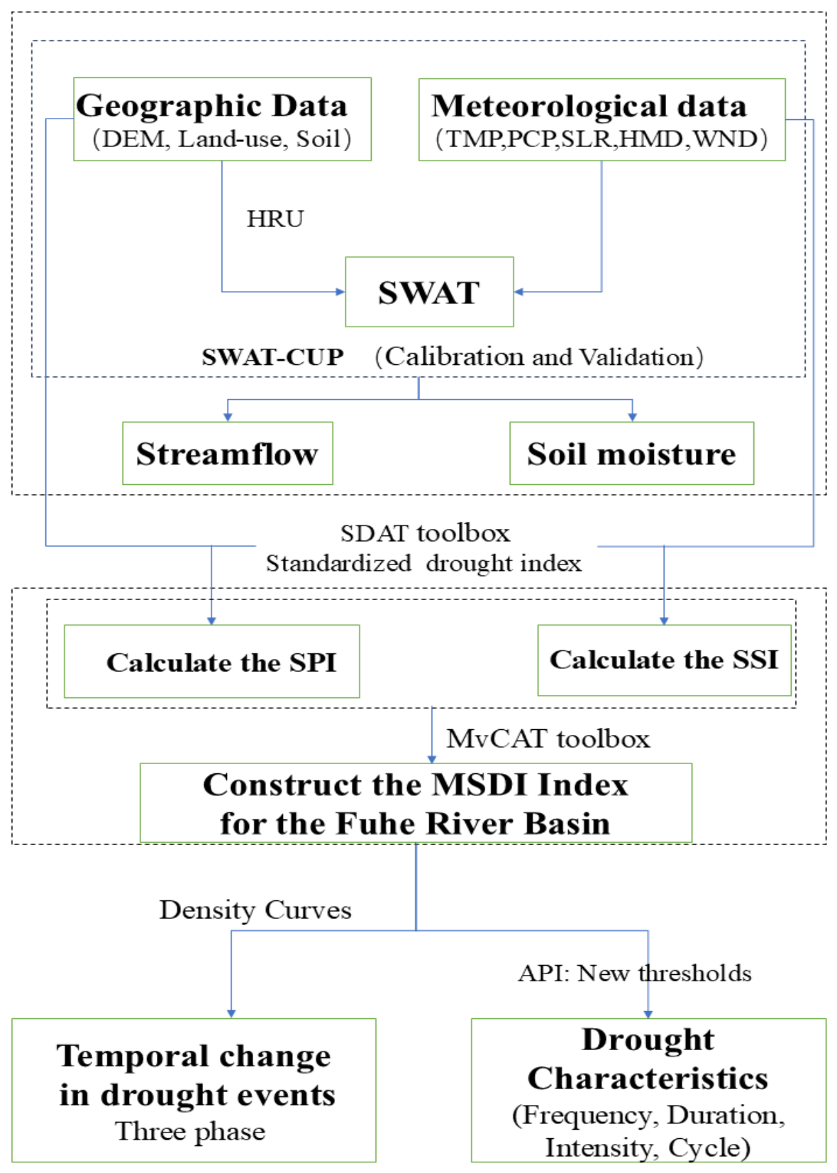
A variety of tools and models, including ArcMap, SWAT Weather Database, SWAT, SWAT-CUP, SPAW, and MATLAB, were used for data calculation and visualization. The main steps of the simulation process are shown in Figure 3.
Figure 3.
Research Flowchart. Note: New API threshold: By setting the MSDI threshold in line with the actual situation of the study basin (e.g., MSDI ≤ −1.0 for drought, ≤−2.0 for extreme drought) to replace the general threshold, “drought misjudgment” caused by regional differences can be reduced, ensuring that the drought frequency, duration, and other characteristics counted in the follow-up are more in line with the actual situation of the basin.
3. Results and Analysis
3.1. Calibration, Validation and Uncertainty Analysis of the SWAT Model Using Observed Streamflow Data
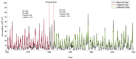
The SWAT-CUP tool provides four verification methods: SUFI-2, GLUE, PARASOL, and PSO. Among them, the SUFI-2 method has the least number of runs and high efficiency [28], so this method was selected in this study. The SUFI-2 method calibrates the model through P-factor and r-factor. The closer the P-factor is to 1 and the closer the r-factor is to 0, the better the simulation result. The coefficient of determination (R2) and Nash–Sutcliffe efficiency coefficient were used as evaluation indicators to measure the consistency between the simulated values and the measured values. The closer the values of R2 and NSE are to 1, the better the simulation effect [29]. In our study, the simulation results show that the SWAT model has good performance in simulating the measured streamflow of the Poyang Lake Basin. In terms of simulation effect, the R2 values of the hydrological station during the calibration and validation periods were 0.71 and 0.92, respectively (Figure 4), indicating good consistency between the simulated and measured streamflow. The NS values of the hydrological station were 0.54 during the calibration phase and 0.84 during the validation phase (Figure 4), indicating that the simulation accuracy reached a satisfactory level. In addition, the R-factor was observed to be lower than 1.5 throughout the study, indicating positive and favorable results in terms of model uncertainty. The p-factor exceeded the threshold of 0.5, indicating that the reliability was at an acceptable level. Overall, the simulation uncertainty assessment results during the calibration period (1982–2019) and validation period (1960–1979) were within the acceptable range.
Figure 4.
Observed and simulated monthly streamflow at Lijiadu Hydrological Station during the observation and validation periods.
3.2. Temporal Variability of Drought Index in the Fuhe River Basin
Nine Copula functions with preferable fitting performance were first screened out from 25 Copula families, namely Gaussian, Ali–Mikhail–Haq (AMH), Frank, Gumbel, Joe, Marshall–Olkin, Fischer–Hinzmann, Independent, and Burr Copula. The Bayesian Information Criterion (BIC) was taken as the primary criterion for optimal model selection, while the Nash–Sutcliffe efficiency coefficient (NSE) and root mean square error (RMSE) served as auxiliary indicators to quantify fitting accuracy (Table 2). Based on the statistical analysis of goodness-of-fit indicators, the Gaussian Copula was proven to be the best fit, with a maximum Nash–Sutcliffe efficiency coefficient (NSE) of 0.9996 and a minimum root mean square error (RMSE) of 0.1508. Therefore, the Gaussian Copula was selected to develop MSDI for the Fuhe River Basin, and the corresponding MSDI values were obtained through Copula inversion.
Table 2.
Ranking of nine Copula functions and their corresponding parameter values of SPI3-SSI3 in the Fuhe River Basin.
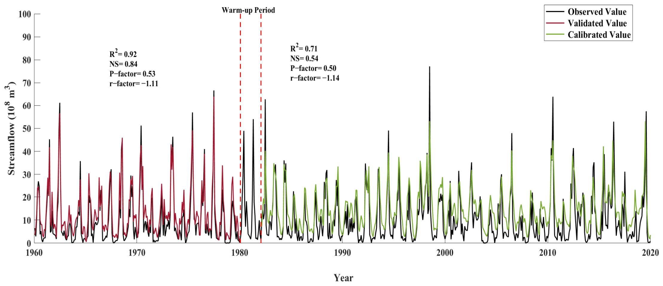
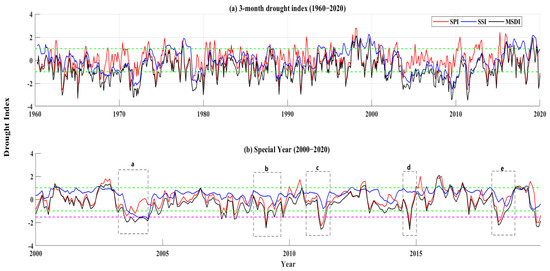
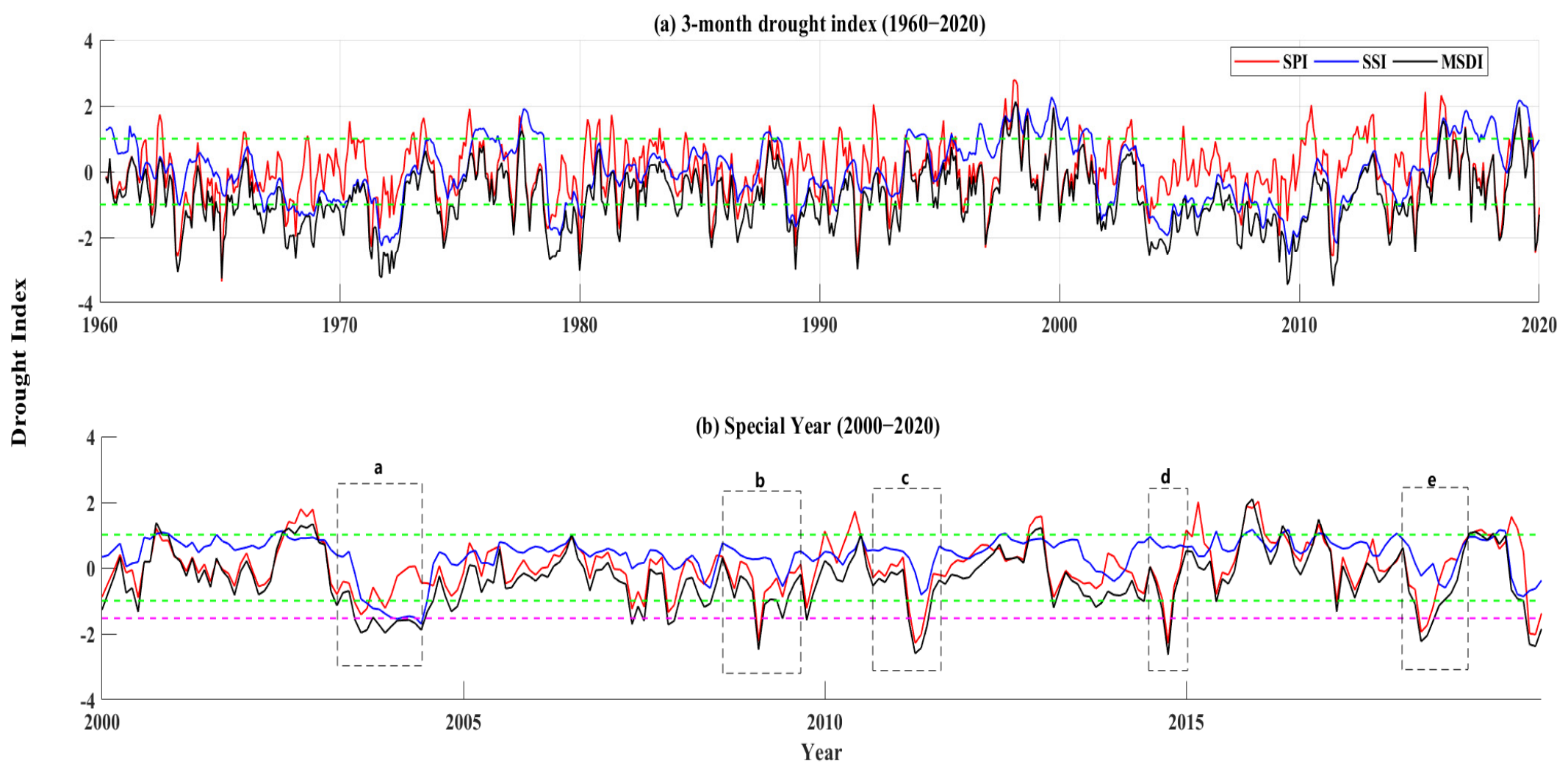
Figure 5a shows the temporal variability of SPI, SSI, and MSDI at the 3-month scale in the Fuhe River Basin from 1960 to 2020. The trend of MSDI showed a moderate Spearman correlation with the trends of SPI and SSI, which was significant at the 5% level (p < 0.05). By integrating the characteristics of SPI and SSI, MSDI comprehensively reflects the interannual fluctuations. Overall, over the past 60 years, there have been significant transitions between dry and wet phases. From 1960 to 1979, the Fuhe River Basin experienced a long period of dry weather. The subsequent period from 1980 to 1999 was mainly characterized by normal to wet conditions. From 2000 to 2019, dry (2003–2009) and wet (2010–2018) phases alternated, and the climate was more balanced compared with previous decades.
Figure 5.
Interannual variation in SPI (Standardized Precipitation Index), SSI (Standardized Soil Moisture Index), and MSDI (Multivariate Standardized Drought Index) at the 3-month time scale in the Fuhe River Basin from 1960 to 2019, and Comparison of SPI, SSI, and MSDI in the Fuhe River Basin from 2000 to 2019 (the Third Period).
For a clearer and more direct comparison, the fluctuations of SPI, SSI, and MSDI in the Fuhe River Basin from 2000 to 2019 were analyzed (Table 2). Generally, droughts are mainly related to reduced precipitation, which makes SPI particularly effective in identifying the occurrence of droughts. However, due to complex hydrological processes, there is a delay in the development from meteorological drought to hydrological drought, which enables SSI to describe the duration and end of droughts. It is worth noting that during the early 2003 and mid-2004, droughts were detected by SPI, SSI, and MSDI, as shown in the rectangular box in Figure 5b. In addition, around early 2008 and mid-2009, although SPI dropped below the threshold (−1), SSI remained above the threshold, indicating that only meteorological droughts existed during these periods. In contrast, MSDI accurately identified the start of these drought events, as shown in the rectangular boxes b, c, d, and e in Figure 5.
3.3. Drought Characteristics of MSDI
3.3.1. Drought Frequency
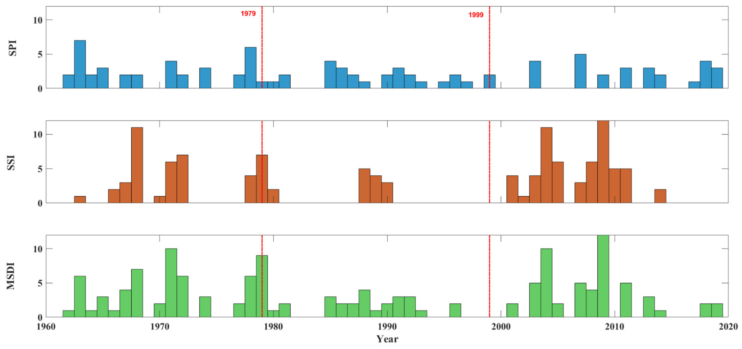
In this section, the monthly drought frequencies related to SPI-SSI-MSDI in the Fuhe River Basin over the past 60 years were calculated (Figure 6). The results show that significant changes have occurred in the drought situation throughout the basin. Generally, the MSDI frequency is higher than or equal to that of SPI and SSI and can effectively capture the start (the starting month of SPI) and end (the ending month of SSI) of drought conditions. By effectively integrating the start of SPI and the end of the SSI index, MSDI shows higher sensitivity in detecting drought conditions. The drought frequency in the Fuhe River Basin was similar in the first period and the third period, but compared with the first period, the years with high-frequency droughts in the third period were more concentrated. The use of the MSDI index, which is more sensitive to drought event detection, is crucial for mitigating the impact of droughts on production and daily life.
Figure 6.
Comparison of drought frequencies identified by the 3-month-scale SPI, SSI, and MSDI in the Fuhe River Basin.
3.3.2. Drought Duration
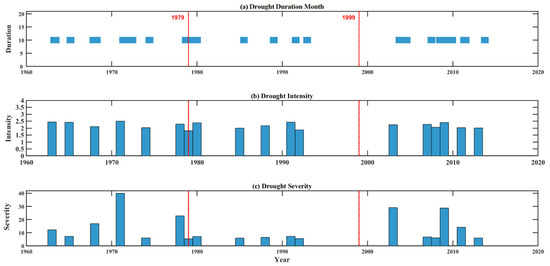
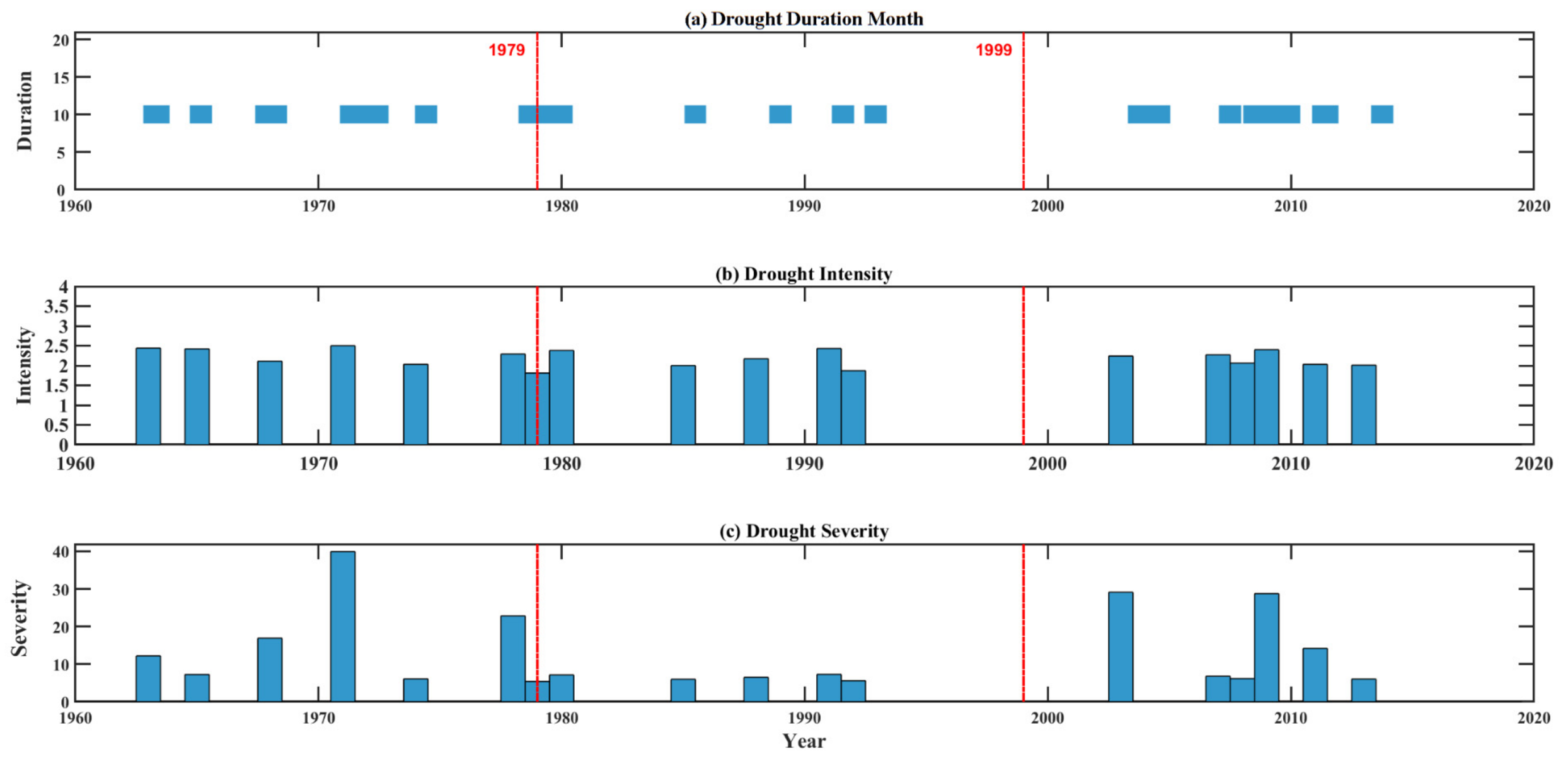
This section presents the drought duration in the Fuhe River Basin over the past 60 years based on MSDI analysis, as shown in Figure 7a and Table S1. The Fuhe River Basin has experienced 18 droughts, totaling 102 months. In the first period, the Fuhe River Basin experienced 7 drought events, the longest of which lasted from March 1971 to June 1972, for 16 months. In the second period, the Fuhe River Basin experienced 5 drought events, all of which had short durations. In the third period, the basin experienced a total of 6 drought events, with two long-duration drought events in 2003 and 2009, for 13 and 12 months, respectively (Table S1). It is noteworthy that drought events occurring in the flood season tend to exhibit a longer duration. Overall, the analysis highlights the significant differences in the occurrence and duration of droughts in the basin during different periods, emphasizing the need for targeted water resource management strategies to mitigate the impact of droughts in the Fuhe River Basin.
Figure 7.
Diagrams of drought duration, drought intensity, and drought severity.
3.3.3. Drought Intensity
The total drought intensity and average drought intensity of the Fuhe River Basin were the highest in the first period (DI = 18.0), followed by the third period (DI = 8.5), and the lowest in the second period (DI = 13.0) (Table S2). During these three periods, the drought intensity fluctuated slightly, and the drought events occurring in the Fuhe River Basin were accompanied by high drought intensity. Among the 18 continuous drought events, the average drought intensity of most events exceeded 2.0 (Figure 7b), further emphasizing the vulnerability of the basin to severe drought conditions.
3.3.4. Drought Severity
The total drought severity and average drought severity of the Fuhe River Basin in the first period and the third period were much higher than those in the second period (Figure 7c and Table S2). It can be seen from Figure 7c that in the first period, the drought severity values were low in most years, but the drought severity (DS) index reached 40 in 1971, indicating that the drought severity in the Basin was low in most of the first period, but occasional severe drought events occurred. In the second period, the overall drought severity was at a low level with small variations, indicating that the drought severity was relatively low and stable over these 20 years. In the third period, the drought severity increased compared with the second period, and reached a high level in some years, indicating that the drought severity and drought duration in the Basin increased during this period, and the frequency of severe drought events increased. A comparative analysis across different periods reveals that drought severity is significantly influenced by event duration, with longer-lasting events tending to correspond to higher severity. In Interval 1, a prolonged drought lasting 16 months (March 1971–June 1972) exhibited a severity of 39.9. In Interval 3, a 13-month drought event (August 2003–August 2004) recorded a severity of 29.1. In contrast, drought events in Interval 2 had durations of less than three months, with a maximum severity of only 7.3 (Table S2). These comparative results clearly demonstrate that long-duration drought events tend to correspond to higher severity, underscoring their critical importance in drought risk assessment. There are significant differences in drought severity over the years, which indicates that the Fuhe River Basin needs to formulate more reasonable drought resistance decisions and water resource allocation plans.
3.3.5. Drought Cycle
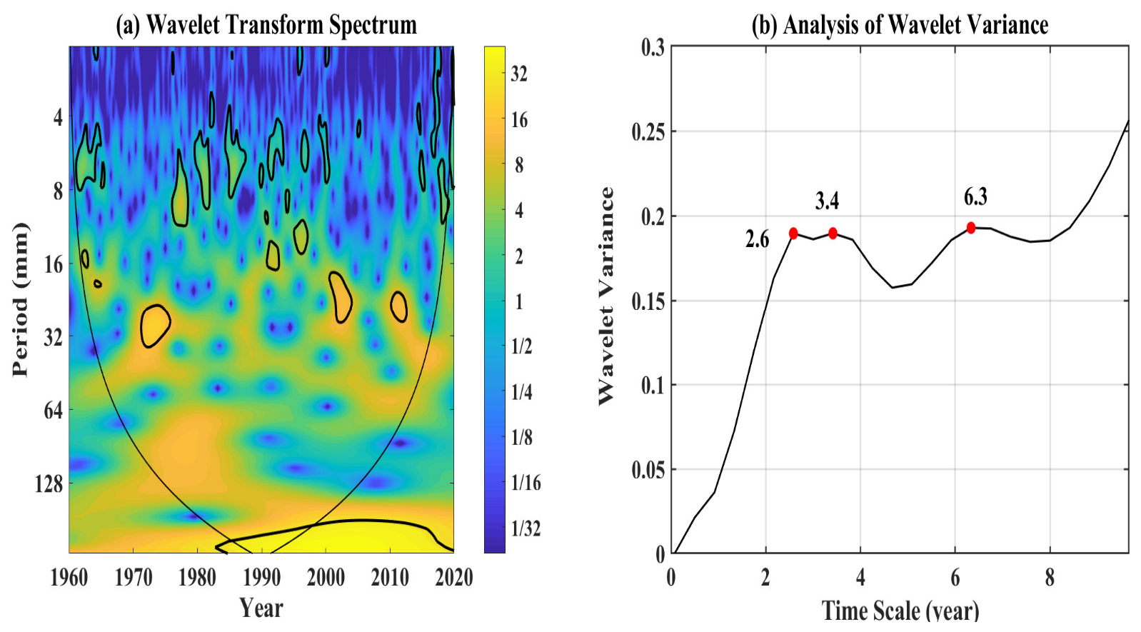
To further study the drought patterns in the Fuhe River Basin over the past 60 years, Morlet wavelet transform analysis was conducted on the MSDI. The results show that the wavelet power spectrum passed the red noise standard spectrum test at the 0.05 significance level within the cone of influence curve (Figure 8a), which implies that the wavelet periodicity of the MSDI index in the Basin is good. The wavelet variance diagram can reflect the distribution of the fluctuation energy of the drought time series with scale and can be used to analyze and determine the main cycle in the drought change process [30]. In the MSDI wavelet variance curve (Figure 8b), there are 3 peaks corresponding to time scales of 2.58 years, 3.42 years, and 6.33 years, indicating that the cycle energy at these three time scales is the strongest, which are the main cycles of droughts in the Basin. The revelation that droughts in the Basin have a multi-scale law of “short cycles nested in medium and long cycles” can provide a basis for drought early warning and long-term regulation of water resources in the Fuhe River Basin.
Figure 8.
Wavelet transform and variance spectrum of MSDI at the 3-month scale in the Fuhe River Basin. Note: The black solid line represents the cone of influence, and the thick solid line represents the 95% confidence level. The yellow and blue areas represent the peaks and valleys of the wavelet energy density, respectively. The color bar represents the oscillation intensity.
4. Discussion
4.1. Performance of the SWAT Model in the Fuhe River Basin
The SWAT model is a distributed basin-scale hydrological model with a strong physical mechanism, continuous and long-term [31]. A large number of studies have shown that the SWAT model has good performance in streamflow model construction and drought research [32,33]. Esmali et al. (2021) compared the performance of SWAT and IHACRES in simulating streamflow in different climate regions of Iran and found that the SWAT model had high effectiveness in humid areas (R2 > 0.8) [34], which emphasizes the strong applicability of the SWAT model in humid areas. In addition, Liu et al. (2023) successfully proved that the SWAT model is suitable for areas with annual rainfall exceeding 1500 mm, such as the Fuhe River Basin [35]. In this study, the SWAT model was used to simulate the monthly streamflow in the Fuhe River Basin. The model showed strong performance, with an R2 of 0.92 during the validation period and an R2 of 0.71 during the calibration period for simulated monthly streamflow. The NSE value was 0.84 during the validation period and 0.54 during the calibration period (Figure 4), indicating good model performance.
4.2. Advantages of the Constructed MSDI in the Assessment of Seasonal Drought
The SSI is used to reflect the hydrological drought status, and the SPI usually characterizes meteorological drought. The start and end of meteorological drought are usually earlier than those of hydrological drought, and a single SSI or SPI index cannot timely and accurately capture multiple types of droughts simultaneously [36]. We used the Copula-based joint distribution function, combined with the drought indices SPI and SSI, to establish a 3-month-scale MSDI. Based on the BIC evaluation criteria in this study, the Gaussian function selected by Varol et al. was also found to be the best Copula function [37]. Similar to the study by Şen and Almazroui, we also found that the adaptive threshold for drought assessment shifted to the left [38]. Specifically, we observed that the drought threshold for MSDI values in the Fuhe River Basin was approximately −1.84 (Figure S1). This leftward shift of the threshold allows for earlier and more timely identification of drought conditions, improving the efficiency of assessing and understanding drought events, and thus enabling earlier implementation of drought response measures. As a result, this newly established MSDI index has the advantages of both SPI and SSI indices [39], can more accurately capture the start and end of droughts, and shows higher sensitivity in detecting drought conditions. As shown in the rectangular box a in Figure 5b, MSDI detected the start of the drought simultaneously with SPI and the end of the drought simultaneously with SSI.
Furthermore, the construction of the MSDI enables probabilistic assessment of drought events in the Fuhe River Basin, offering particular advantages in preparedness, early warning, and evaluation of seasonal drought. By integrating multiple hydro-meteorological variables—such as precipitation and soil moisture—into a unified probabilistic framework, MSDI overcomes the limitations of traditional univariate indices like SPI and SSI, which often yield conflicting signals due to time-lagged relationships between rainfall deficits and their hydrological impacts [40]. Further analysis reveals that MSDI is more sensitive to SSI than SPI, which mirrors the lagged response of soil moisture to precipitation. In the Fuhe River Basin, meteorological drought indicated by SPI occurs 1–3 months ahead of agricultural drought reflected by SSI. Benefiting from the joint probability construction of Copula, MSDI can well capture such time-lag feature and performs better than individual indices for delayed agricultural drought identification. Using a copula-based multivariate approach, MSDI provides a more holistic and physically consistent representation of drought conditions [41], thereby improving the accuracy and timeliness of detecting drought onset, persistence, and cessation at seasonal scales. In the drought-vulnerable Fuhe River Basin, MSDI supports data-driven early warning systems, guides targeted resource allocation, and informs adaptive actions—such as optimized irrigation, soil moisture conservation, and use of drought-resistant crops—across sectors. Ultimately, MSDI offers a coherent scientific framework for enhancing seasonal drought preparedness, supporting sustainable water management, and mitigating socioeconomic risks in the region.
4.3. Drought Characteristics of the Fuhe River Basin in the Past 60 Years
By analyzing the fluctuation characteristics of SPI, SSI, and MSDI over the past 60 years in the Fuhe River Basin, it is found that severe drought events in the basin were mainly concentrated in two periods: 1960–1979 and 2000–2019, while drought severity was relatively mild during 1980–1999. Typical severe drought years include 2003, 2004, 2009, and 2013.
Spatial calculation of drought frequency reveals that the overall drought risk across the Fuhe River Basin presents a spatial pattern of high in the southeast and low in the northwest. The hilly southeastern region is prone to frequent and intense droughts due to high variability in precipitation, thin soil layers, and low soil water retention capacity; by contrast, drought impacts are less severe in the northwestern plain area. This spatial differentiation verifies the advantages of the distributed SWAT model in quantifying the spatial heterogeneity of drought.
Wavelet analysis was adopted to identify periodic oscillations for further exploration of drought evolution laws. The results indicate that the MSDI series has three prominent primary cycles of 2.58a, 3.42a, and 6.33a. Notably, the periodicity of basin drought has weakened after 2000, accompanied by marked rises in drought occurrence frequency and severity. Such aggravating drought trends are predominantly driven by climate change (uneven precipitation distribution, rising air temperature and intensified evapotranspiration) and land-use change (expansion of cultivated land and construction land alongside reduced basin water storage and conservation capacity). Historical observational records further confirm that successive droughts and persistent high temperatures after 2000 have aggravated soil moisture deficit and prolonged drought duration. It is concluded that the drought risk of the Fuhe River Basin will remain at a high level in the future, calling for enhanced adaptive management of regional water resources.
In contrast to existing drought studies on the Fuhe River Basin, Long et al. (2024) employed runoff-derived SRI and the Frank Copula to investigate hydrological drought, with an emphasis on runoff-controlled drought features [22]. Instead, the present study integrates precipitation-based SPI and SWAT-simulated SSI to develop the MSDI, which simultaneously characterizes meteorological and agricultural drought instead of focusing solely on hydrological drought. Their finding of intensified drought risk along the mainstream agrees with our spatial result of higher drought frequency across the southeastern hilly zone. Moreover, our detected upward trend in drought risk after 2000 is consistent with the growing frequency of extreme drought documented in regional studies. Distinct from earlier basin assessments relying merely on SPI or SRI, the proposed MSDI can efficiently capture latent agricultural drought without evident rainfall shortage and pseudo-drought induced only by precipitation deficit, remedying the drawbacks of current drought evaluation frameworks for the Fuhe River Basin.
4.4. Analysis of Research Uncertainties and Limitations
The established SWAT-Copula-MSDI framework in this study has several uncertainties and limitations. First, the spatial distribution of meteorological stations, resolution of input data, and spatial heterogeneity of soil properties affect the simulation accuracy of soil moisture. Second, the selection of Copula function types and the determination of drought thresholds involve artificial subjectivity. Third, this study only focuses on the 3-month time scale and does not incorporate runoff indicators to characterize hydrological drought; moreover, drought projections under future climate scenarios are not conducted. Consequently, the MSDI derived in this study is based solely on historical data, relies on a single hydrological model, and suffers from sparse in situ validation.
Despite these constraints, the MSDI offers distinct methodological advantages over univariate indices. It does not simply superimpose or replicate the drought signals of SPI and SSI. Instead, it describes the nonlinear dependence between meteorological drought and agricultural drought through a joint probability distribution. This allows the MSDI to effectively identify “pseudo-drought” (insufficient precipitation without actual soil moisture stress) and to capture latent agricultural drought (insignificant precipitation anomalies but persistent soil water deficits). Therefore, compared with univariate indices, the MSDI is superior in judging drought onset, tracking drought duration, and identifying extreme drought events.
Several limitations related to anthropogenic activities should be acknowledged within the proposed SWAT-Copula-MSDI framework. The Fuhe River Basin contains dams and pumping stations that regulate streamflow and redistribute water resources. Owing to the absence of detailed reservoir operation rules and pumping records, the current SWAT model does not explicitly simulate these human interventions. It is worth noting that such activities primarily affect streamflow and shallow groundwater dynamics, whereas their direct impact on root-zone (0–50 cm) soil moisture is limited, given that soil moisture variability is predominantly controlled by precipitation, evapotranspiration, and soil physical properties. Nonetheless, neglecting dams and pumping stations may introduce uncertainty in hydrological drought simulations. Furthermore, the SSI used in this study is derived solely from SWAT-simulated soil moisture without accounting for anthropogenic irrigation. Fortunately, agriculture in the study area is largely rain-fed with limited irrigated land; therefore, this limitation does not substantially affect our main conclusions regarding agricultural drought identification. Future studies should incorporate reservoir operation data, irrigation records, and remote-sensing evapotranspiration products to enhance model applicability under intensively human-influenced conditions.
5. Conclusions
In this study, the calibrated SWAT model was used to simulate monthly soil moisture data in the Fuhe River Basin; on this basis, the SSI and SPI were calculated, and finally, the two were coupled based on the Copula function to construct an MSDI suitable for the basin. The main findings of this study can be summarized in the following three aspects:
1. The SWAT model showed reliable applicability in streamflow simulation in the Fuhe River Basin. The NSE during the validation period exceeded 0.70, indicating that the model has good accuracy in monthly streamflow simulation, providing a credible hydrological process simulation basis for subsequent drought assessment.
2. Based on the MSDI, the basin had a high frequency of drought events in two periods, 1960–1979 and 2000–2019, showing an obvious periodic fluctuation characteristic overall. Moreover, drought severity exhibits a marked increase with event duration.
3. It is worth noting that the drought situation in the basin further deteriorated after 2000, with not only intensified extreme droughts but also a significant increase in drought risks. Wavelet cycle analysis further revealed that during this period, while the drought frequency increased, its periodic characteristics weakened, suggesting that the drought driving mechanism may tend to be complex.
The above findings collectively indicate that the Fuhe River Basin has experienced a clear seasonal pattern of increasing drought frequency and intensity over the past 60 years. Against this background, the formulation of a systematic management framework targeting seasonal droughts is particularly urgent, especially for the agricultural ecosystems which is highly sensitive to hydrological variations. It is recommended that the following adaptive measures be prioritized: establishing a dynamic water regulation mechanism driven by seasonal forecasts, promoting water-saving irrigation suited to dry-wet cycles, and developing crop varieties resilient to seasonal water stress. These steps will strengthen seasonal water management and agricultural resilience, enhancing drought resistance amid climate uncertainty and supporting sustainable food and water security.
Furthermore, the proposed SWAT-Copula-MSDI framework possesses good generalization potential. Based on universal physical hydrological mechanisms and probabilistic coupling principles, this method can be extended to other subtropical humid monsoon watersheds worldwide with similar hydroclimatic features and seasonal drought patterns. By overcoming the limitations of traditional univariate indices, the MSDI provides a robust tool for integrated meteorological–agricultural drought monitoring in humid regions.
Supplementary Materials
The following supporting information can be downloaded at: https://www.mdpi.com/article/10.3390/hydrology13060157/s1, Figure S1: Drought Probability Index (API) Values of the Standard Normal Cumulative Distribution Function (CDF) under Drought Thresholds; Figure S2: Comparison of observed and simulated monthly soil moisture (0–50 cm) at two nearby stations for the period 2002–2005; Table S1: The duration of drought in the Fuhe River Basin at three intervals; Table S2: The drought severity and intensity for MSDI3 within the Poyang Lake Basin.
Author Contributions
Conceptualization, G.D., L.G. and X.C.; Methodology, L.G., Q.Y., Y.Z. (Yongfen Zhang), Y.W., Z.X., H.Z. and Y.L.; Software, L.G., Y.W., Z.X., H.Z., Y.Z. (Yue Zhong) and Y.L.; Validation, Q.Y., Y.Z. (Yongfen Zhang), Y.W., H.Z. and X.C.; Formal analysis, L.G., Y.W., H.Z. and Z.X.; Investigation, L.G., Z.X., H.Z., Y.Z. (Yue Zhong) and Y.L.; Resources, Y.Z. (Yongfen Zhang) and Y.L.; Data curation, L.G., Y.Z. (Yongfen Zhang), Z.X., H.Z., Y.Z. (Yue Zhong) and Y.L.; Writing—original draft preparation, L.G.; Writing—review and editing, G.D., L.G., Q.Y., Y.Z. (Yongfen Zhang), Y.W. and X.C.; Visualization, L.G., Y.W., Z.X., H.Z., Y.Z. (Yue Zhong) and Y.L.; Supervision, G.D. and X.C.; Project administration, G.D.; Funding acquisition, L.G. All authors have read and agreed to the published version of the manuscript.
Funding
Open Research Fund of the Key Laboratory of Protection and Restoration of Yangtze River-connected Lake (Poyang Lake), Ministry of Ecology and Environment (PYHBX-Y-2025-07) and the National Natural Science Foundation of China (41905104), College Students’ Innovation and Entrepreneurship Training Program (No. S202510410055).
Data Availability Statement
Data sharing is not applicable to this article as no new data were created or analyzed.
Conflicts of Interest
The authors declare no conflict of interest.
References
- IPCC. Sections. In Climate Change 2023: Synthesis Report. Contribution of Working Groups I, II and III to the Sixth Assessment Report of the Intergovernmental Panel on Climate Change; Core Writing Team, Lee, H., Romero, J., Eds.; IPCC: Geneva, Switzerland, 2023; pp. 35–115. [Google Scholar]
- Kimutai, J.; Barnes, C.; Zachariah, M.; Philip, S.Y.; Kew, S.F.; Pinto, I.; Wolski, P.; Koren, G.; Vecchi, G.; Yang, W.; et al. Human-induced climate change increased 2021–2022 drought severity in horn of Africa. Weather Clim. Extrem. 2025, 47, 100745. [Google Scholar] [CrossRef] [Scilit]
- Abhijeet, A.; Das, N.N.; Ines, A.V.M.; Andreadis, K.M.; Jayasinghe, S.; Granger, S.; Ellenburg, W.L.; Dutta, R.; Quyen, N.H.; Markert, A.M.; et al. Evaluating the impacts of drought on rice productivity over Cambodia in the Lower Mekong Basin. J. Hydrol. 2021, 599, 126291. [Google Scholar] [CrossRef] [Scilit]
- Lou, W.; Sun, C.; Kucharski, F.; Li, J.; Liu, Y. Amazon drought amplifies SST warming in the North Tropical Atlantic. Clim. Dyn. 2024, 62, 9377–9390. [Google Scholar] [CrossRef] [Scilit]
- Zhang, Q.; Xue, C.Y.; Xia, J. Impacts, causes and countermeasures of extreme drought in Poyang Lake. Bull. Chin. Acad. Sci. 2023, 38, 1894–1902. [Google Scholar] [CrossRef]
- Li, L.; Shi, X.P. Review of drought relief work in Jiangxi Province in 2013. China Flood Drought Manag. 2013, 23, 1–3. [Google Scholar] [CrossRef]
- Liu, Y.S.; Liu, R.Z.; Liu, J.Y. Response to and enlightenment from the extreme drought in Jiangxi in 2022. Jiangxi Hydraul. Sci. Technol. 2023, 49, 219–222+230. [Google Scholar]
- Xu, X.H.; Zhang, X.P.; Shi, Y.P.; Wang, G.B.; Liu, Y.W.; Chen, Z.Y.; Yao, L.Q.; Huang, S.F.; Zhu, J.P. Study on the construction of drought disaster risk prevention and control system in the Poyang Lake Basin. Jiangxi Hydraul. Sci. Technol. 2024, 50, 275–281. [Google Scholar]
- Liu, J.T.; Yang, Y.S.; Xu, X.F. Analysis of trend and mutation characteristics of precipitation series in the Fuhe River Basin. J. Anhui Agric. Univ. 2011, 38, 569–574. [Google Scholar] [CrossRef]
- Zheng, J.L.; Zhou, Z.H.; Liu, J.J.; Liu, R.H.; Wang, X.Y.; Jia, Y. Study on the influence mechanism of meteorological drought propagation to hydrological drought in the Fuhe River Basin. J. Water Resour. Water Eng. 2023, 34, 27–34. [Google Scholar]
- Wang, Y.; Su, B.D.; Wang, Y.J.; Zhan, M.J.; Yang, C.H.; Jiang, T. Characteristics of runoff changes in the Fuhe River Basin under the “double carbon” scenario. J. Yangtze River Sci. Res. Inst. 2023, 40, 44–51. [Google Scholar]
- Xue, C.Y.; Zhang, Q.; Jia, Y.X.; Yuan, S.Y. Intensifying drought of Poyang Lake and potential recovery approaches in the dammed middle Yangtze River catchment. J. Hydrol. Regul. Dev. 2023, 50, 101548. [Google Scholar] [CrossRef] [Scilit]
- Cavus, Y.; Aksoy, H. Criticaldrought severity/intensity-duration-frequency curves based on precipitation deficit. J. Hydrol. 2020, 584, 124312. [Google Scholar] [CrossRef] [Scilit]
- Zhang, Z.; Zhang, Q.; Singh, V.P. Univariate streamflow forecasting using commonly used data-driven models: Literature review and case study. Hydrol. Sci. J. 2018, 63, 1091–1111. [Google Scholar] [CrossRef] [Scilit]
- Guo, L.; Chen, F.; Wang, B.; Liu, D.L.; Chen, X.; Huang, H.; Bai, H.; Liao, K.; Xia, Z.; Xiang, K.; et al. Developing a multivariate drought index to assess drought characteristics based on the SWAT-Copula method in the Poyang Lake basin, China. Ecol. Indic. 2025, 170, 113123. [Google Scholar] [CrossRef] [Scilit]
- Zhen, N.; Yao, R.; Sun, P.; Zhang, Q.; Ge, C.; Shen, H. Triggering thresholds and influential factors in the propagation of meteorological drought to hydrological drought. J. Hydrol. Reg. Stud. 2025, 57, 102184. [Google Scholar] [CrossRef] [Scilit]
- Huang, S.; Huang, Q.; Chang, J.; Zhu, Y.; Leng, G.; Xing, L. Drought structure based on a nonparametric multivariate standardized drought index across the Yellow River basin, China. J. Hydrol. 2015, 530, 127–136. [Google Scholar] [CrossRef] [Scilit]
- Zhang, D.; Chen, P.; Zhang, Q.; Li, X. Copula-based probability of concurrent hydrological drought in the Poyang lake-catchment-river system (China) from 1960 to 2013. J. Hydrol. 2017, 553, 773–784. [Google Scholar] [CrossRef] [Scilit]
- Dash, S.S.; Sahoo, B.; Raghuwanshi, N.S. A SWAT-Copula based approach for monitoring and assessment of drought propagation in an irrigation command. Ecol. Eng. 2019, 127, 417–430. [Google Scholar] [CrossRef] [Scilit]
- Luo, Y.; Liu, Y.; Dong, Z.; Li, Q.; Zhang, X.; Dong, X. Development of multivariate standardized drought index for large lake basins based on the copula function: A case study of Hongze Lake Basin, China. J. Hydrol. Reg. Stud. 2023, 50, 101586. [Google Scholar] [CrossRef] [Scilit]
- Jin, L.; Peng, T.; Fan, T.; Singh, V.P.; Lin, Q.; Dong, X.; Liu, J.; Guo, J.; Yu, D.; Wang, G. Modified drought propagation under a changing environment: A case study in the Dongting Lake basin, China. J. Hydrol. Reg. Stud. 2024, 56, 101986. [Google Scholar] [CrossRef] [Scilit]
- Long, P.; Jian, H.F.; Han, H.M.; Liu, M.C. Analysis of hydrological drought characteristics in Fuhe River Basin based on Copula function. Pearl River 2024, 45, 67–76. [Google Scholar]
- Hu, Z.N. Mechanism of Climate and Land Use Change Impacts on Hydrological and Agricultural Drought in Fuhe River Basin. Master’s Thesis, Zhengzhou University, Zhengzhou, China, 2025. [Google Scholar] [CrossRef]
- Liu, M.C.; Jian, H.F.; Han, H.M.; Long, P. Analysis of agricultural drought characteristics and their driving factors in the Fuhe River Basin. J. Irrig. Drain. 2024, 43, 114–120. [Google Scholar]
- Hu, Z.N.; Xu, X.H.; Lin, R.C.; Zhang, X.P.; Wang, G.B.; Shi, Y.P. Study on the Influence Mechanism of Climate and Land Use Change on Hydrological and Agricultural Drought in the Fuhe River Basin. China Rural. Water Hydropower 2025, 8, 84–93. [Google Scholar]
- Yi, H.; Shu, H. The improvement of the Morlet wavelet for multi-period analysis of climate data. Comptes Rendus Geosci. 2012, 344, 483–497. [Google Scholar] [CrossRef] [Scilit]
- Li, L.C.; Yao, N.; Li, Y.; Liu, D.L.; Wang, B.; Ayantobo, O.O. Future projections of extreme temperature events in different sub-regions of China. Atmos. Res. 2019, 217, 150–164. [Google Scholar] [CrossRef] [Scilit]
- Chen, Z.A.; Sun, Y.N.; Zhang, L.N. Parameter calibration and applicability analysis of the SWAT model in the Hulan River Basin based on different algorithms. J. Heilongjiang Univ. (Eng. Ed.) 2024, 15, 93–99. [Google Scholar]
- Li, Q.N.; Zhang, J.; Gong, H.L. Comparison of multi-site uncertainty evaluation methods based on the SWAT model. Yellow River 2017, 39, 24–29. [Google Scholar]
- Zhang, X.H.; Wang, L.D.; Liu, Y.H. Analysis of precipitation cycle law in Weifang City based on Morlet wavelet analysis. Shaanxi Water Resour. 2023, 264, 43–44+47. [Google Scholar] [CrossRef]
- Xu, J.; Li, B.Q.; Xu, G.D. Application of the SWAT model in a typical humid basin. Gov. Manag. Water Resour. 2015, 446, 66–67. [Google Scholar]
- Yu, L.Q.; Zheng, M.L.; Chen, J.; Chen, X.W. Comparison of SWAT runoff model construction methods and simulation efficiency at different time scales. Water Conserv. Sci. Technol. 2025, 187, 1–6. [Google Scholar]
- Zhao, Y.S.; Sun, Y.N.; Meng, F.X.; Liu, T.; Huang, X.H. Study on Runoff and Hydrological Drought in the Lower Reaches of the Songhua River Basin under CMIP6 Scenarios Based on the SWAT Model. Water Resour. Hydropower Eng. 2026; in press.
- Esmali, A.; Golshan, M.; Kavian, A. Investigating the performance of SWAT and IHACRES in simulation streamflow under different climatic regions in Iran. Atmosfera 2021, 34, 79–96. [Google Scholar] [CrossRef] [Scilit]
- Liu, M.Y.; Zhang, P.P.; Cai, Y.P.; Chu, J.; Li, Y.; Wang, X.; Li, C.; Liu, Q. Spatial-temporal heterogeneity analysis of blue and green water resources for Poyang Lake basin, China. J. Hydrol. 2023, 617, 128983. [Google Scholar] [CrossRef] [Scilit]
- Yue, Y. Analysis of Drought Evolution Characteristics and Risk in the Shaying River Basin Based on the SWAT Model. Master’s Thesis, North China University of Water Resources and Electric Power, Zhengzhou, China, 2021. [Google Scholar] [CrossRef]
- Varol, T.; Atesoglu, A.; Ozel, H.B.; Cetin, M. Copula-based multivariate standardized drought index (MSDI) and length, severity, and frequency of hydrological drought in the Upper Sakarya Basin, Turkey. Nat. Hazards 2023, 116, 3669–3683. [Google Scholar] [CrossRef] [Scilit]
- Şen, Z.; Almazroui, M. Actual precipitation index (API) for drought classification. Earth Syst. Environ. 2021, 5, 59–70. [Google Scholar] [CrossRef] [Scilit]
- Tian, Q.; Wang, F.; Tian, Y.; Jiang, Y.; Weng, P.; Li, J. Copula-based comprehensive drought identification and evaluation over the Xijiang River Basin in South China. Ecol. Indic. 2023, 154, 110503. [Google Scholar] [CrossRef] [Scilit]
- Xu, K.; Yang, D.; Xu, X.; Lei, H. Copula based drought frequency analysis considering the spatio-temporal variability in Southwest China. J. Hydrol. 2015, 527, 630–640. [Google Scholar] [CrossRef] [Scilit]
- Sharma, T.C.; Panu, U.S. Modeling of hydrological drought durations and magnitudes: Experiences on Canadian streamflows. J. Hydrol. Reg. Stud. 2014, 1, 92–106. [Google Scholar] [CrossRef] [Scilit]


Disclaimer/Publisher’s Note: The statements, opinions and data contained in all publications are solely those of the individual author(s) and contributor(s) and not of MDPI and/or the editor(s). MDPI and/or the editor(s) disclaim responsibility for any injury to people or property resulting from any ideas, methods, instructions or products referred to in the content. |
© 2026 by the authors. Licensee MDPI, Basel, Switzerland. This article is an open access article distributed under the terms and conditions of the Creative Commons Attribution (CC BY) license.