


Abstract
Mining-induced subsidence remains a critical concern for mine safety, issues related to surface and underground infrastructure, mine planning and environmental risk. This paper presents a focused critical review that is specifically devoted to mining-induced subsidence prediction using 3D numerical modeling techniques, with its advancements, applications, challenges, and opportunities. It first traces the evolution from empirical, graphical, and influence function approaches to analytical approaches, which include numerical methods and probabilistic methods, and then to statistical and deep-learning-based models for subsidence predictions, highlighting their capabilities and limitations in complex geological conditions. These methods are included to establish the historical and comparative context, while the central focus of the review remains the development, application, calibration, validation, limitations and future use of 3D numerical modeling for mining-induced subsidence prediction. The review then concentrates on 3D numerical frameworks, including continuum (FDM, FEM, and BEM), discontinuum (DEM and DFN-based) and hybrid methods (FEM–DEM/BEM–FEM), covering their historical development, application in coal and metal mines, and strengths for simulating caving, time-dependent behavior and multi-seam conditions. Particular attention is given to geotechnical inputs (in situ tests, inverse analysis, and rock-mass classification); constitutive modeling, including creep and damage; and data assimilation, calibration and validation, using InSAR/MTInSAR, GNSS, and levelling data. The review synthesizes key challenges like geological heterogeneity, uncertainty regarding rock-mass parameters and discontinuities, scale effects, computational demands and human/operational factors and outlines opportunities where 3D numerical models, coupled with probabilistic tools and machine learning techniques which can enhance hazard prediction, infrastructure and water-management planning, regulatory compliance, and community land-use decisions, can be deployed. Overall, the paper concludes that InSAR-calibrated 3D numerical modeling, embedded in transparent calibration/validation workflows, currently provides the most robust foundation for safer and more sustainable mining operations.
1. Introduction
Land-surface deformation refers to measurable changes in the Earth’s surface from its original position, expressed as either sideways shifting or vertical movement in the form of sinking (subsidence) or rising (uplift). Such changes are driven by both natural processes and human activities [1]. Natural causes include the slow pressing down of loose sediments, melting of frozen ground in cold regions, dissolving of limestone and similar rocks, and movements of the Earth’s crust. Although these processes generally proceed slowly, there is no doubt that they can reshape landscapes and disrupt water systems and ecosystems. Human actions, on the other hand, cause such alterations more quickly and more severely. Pumping out groundwater, oil and gas exploitation, use of geothermal energy, large-scale construction and, most significantly, underground mining are among the leading causes of subsidence. Mining-induced subsidence happens when underground material is removed and the rocks above lose support, leading them to bend, crack, or collapse into empty spaces (see Figure 1). This movement is manifested on the surface as hollows, cracks, scarps or bowl-shaped depressions [2]. Subsidence may happen all of a sudden after a roof or pillar has failed, or slowly over years as stresses continually shift [3]. Its consequences are serious: it can damage buildings, roads and pipelines, disrupt transport, change the flow of ground water, cause flooding or waterlogging, affect the yield of the farms and harm the environment. Although it is often considered an unavoidable result of underground mining, better prediction and monitoring can reduce its impacts [4].
In many underground mining districts, particularly where the extraction is deep, multi-level, and geologically heterogeneous, the deformation pattern is often not uniform. Instead, there may be an apparent strong spatial variation in subsidence caused by abrupt contrasts in stiffness, fault/fracture–controlled rock-mass behavior, irregular mine geometries, and time-dependent closure/compaction of caved zones. This increases the necessity of hazard assessment and protection of critical surface assets and reinforces the need for approaches that are able to capture three-dimensional stress redistribution and progressive damage rather than relying on simplified assumptions about surface profiles only [2,4,5].
At the same time, subsidence monitoring has changed from point-based ground surveying to spatially continuous deformation mapping. Conventional methods such as levelling, total station networks and GNSS provide high accuracy but remain limited in spatial coverage and can miss the full geometry of a subsidence trough. Satellite InSAR and time-series methods (e.g., PSI/SBAS) fill this void by providing wide-area and millimeter-scale estimates of deformation and long-term histories of displacement, making these methods especially useful in the mining environment for detection and trend analysis, as well as in post-mining [6,7,8]. More importantly, InSAR outputs become more reliable for engineering interpretation when cross-checked with ground observations (total station/GNSS observations), allowing consistent validation of deformation rates and cumulative displacement.
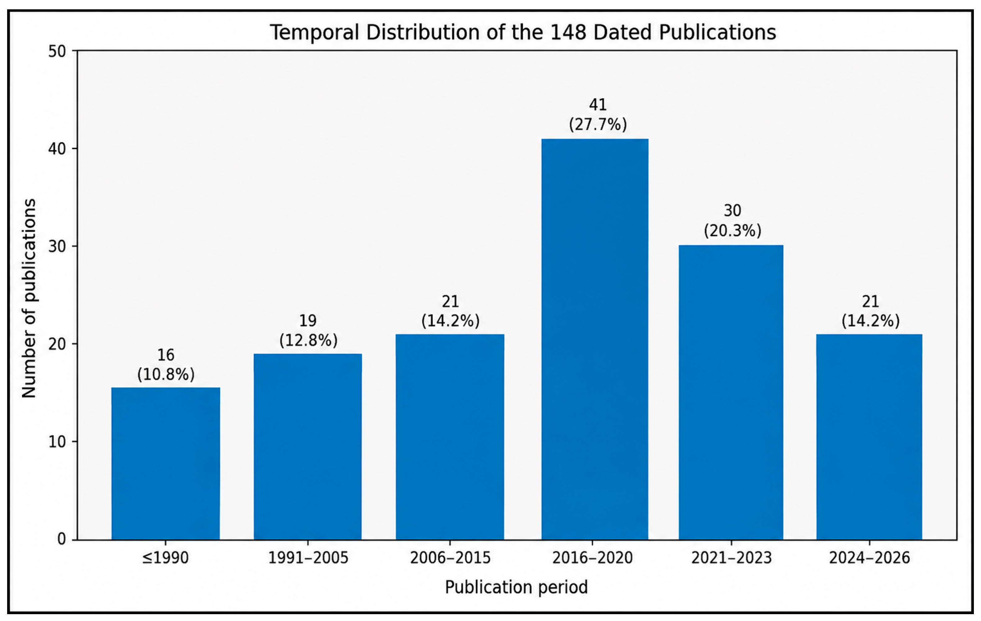
In order to assess the thematic input and the progression of the literature over time, a structured descriptive analysis was carried out using the final reference database compiled for this review. The analysis was conducted on terms and concepts related to mining-induced subsidence: surface deformation; 3D numerical modeling; finite element, finite-difference, boundary element and discrete element methods; hybrid modeling; influence function and probability integration methods; InSAR and GNSS monitoring; geotechnical parameterization; calibration and validation; statistical and machine learning; and deep learning. Publications were included in the review when their main contribution was focused on the prediction of subsidence and numerical, analytical or empirical approaches to the prediction of subsidence; model calibration or validation with monitoring data or geotechnical or constitutive inputs; or mining applications associated with subsidence. A final database of 158 unique publications was formed, covering the time period 1968–2026. Each publication was assigned to only one of the thematic categories according to its dominant contribution. A total of 148 publications were identified, and the year of publication was noted (10 publications were not dated but were included in the thematic analysis and excluded from the year-wise distribution), as shown in Figure 2 and Figure 3.
Figure 1.
Schematic view of bending and caving of overlying strata (adopted and modified from [9]).
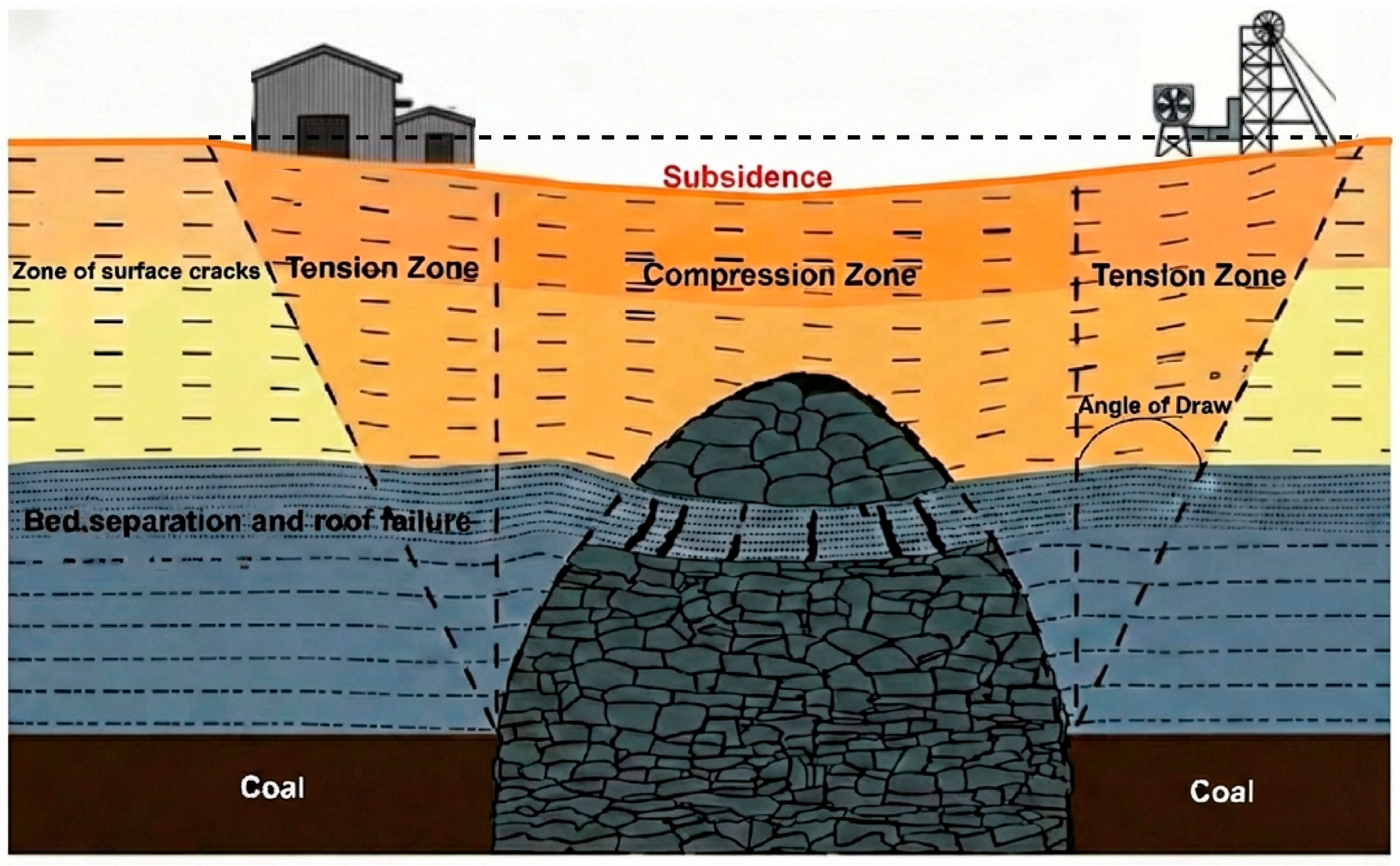
Figure 2.
Thematic sorting of the 158 publications used in the final reference database, based on their contribution, whether primarily methodological or purely application based.
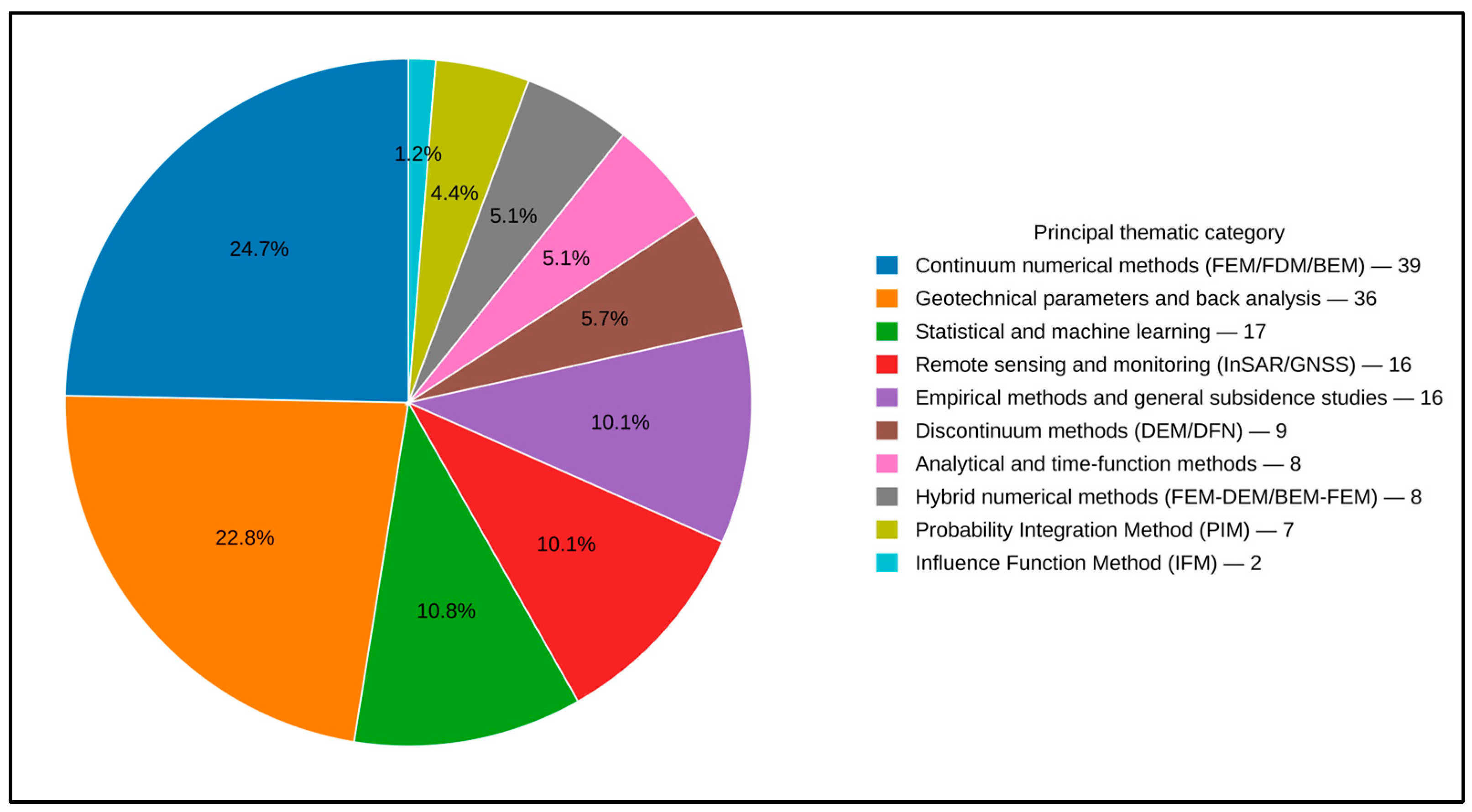
Figure 3.
Distribution of the 148 dated publications used in the final reference database with respect to time. Ten of the undated publications were ruled out for purposes of the temporal analysis.
Although numerical modeling in rock mechanics and rock engineering has been comprehensively reviewed from a broad methodological viewpoint, including major developments in continuum, discontinuum, hybrid, constitutive, and inverse modeling frameworks [5], the scholarship comprising critical reviews specifically devoted to mining-induced subsidence prediction remains comparatively limited [10]. Such a review is increasingly needed because recent progress in the field is not restricted to 3D numerical modeling alone, but also involves improved site-specific geotechnical characterization, calibration and validation using field and monitoring datasets, InSAR/GNSS-based deformation analysis, and emerging hybrid numerical–machine-learning workflows. Against this background, the present review aims to provide a targeted synthesis of the advancements, applicability, calibration strategies, validation practices, challenges, and future opportunities relating to subsidence prediction methods in mining environments.
In this context, the present review emphasizes the advancement, application and limitations of 3D numerical modeling for subsidence prediction, and highlights opportunities for model calibration/validation using modern deformation-monitoring datasets. To address these issues, this review-based article is organized into the following sections. Section 1 briefly introduces the overall concept of land surface deformation. Section 2 provides a concise overview of the non-numerical prediction methods that form the historical and comparative context for this review, covering empirical and graphical approaches, influence function and probability integration formulations, and more recent statistical and deep-learning developments; the emphasis is on their underlying assumptions, input data requirements, typical application contexts and main limitations, and on why each is insufficient for the three-dimensional problems addressed in Section 3. Section 3, the analytical core of this review, focuses on three-dimensional numerical modeling. It examines numerical frameworks and their historical development, sets out the formulation, implementation, strengths and limitations of the continuum (FDM, FEM, and BEM), discontinuum (DEM, DFNM) and hybrid method families, synthesizes major application-based studies in coal and metal mines, and reviews geotechnical aspects, including the role of rock-mass properties, available methods for deriving rock-mass parameters (in situ tests, inverse analysis and rock-mass classification), constitutive behavior and time-dependent response, data assimilation, calibration and validation procedures, and the emerging use of machine-learning emulators in subsidence analysis. Section 4 analyzes key sources of uncertainty and limitations in subsidence prediction, including geological and geotechnical complexity (heterogeneity, anisotropy and uncertainty in discontinuity properties), time-dependent rock behavior, data quality and model-input issues (dependence on accurate geotechnical parameters and scale effects in parameter testing), challenges in calibration and validation, computational constraints, and human and operational factors such as interpretation bias and operational variability. Section 5 explores emerging opportunities for applying advanced numerical and hybrid model data approaches, highlighting their potential for mine safety and environmental protection, more accurate hazard prediction, protection of surface structures and critical infrastructure, water management and ecosystem preservation, mine planning and design, and long-term mine-life and infrastructure planning. Section 6 gives an integrated discussion, structured according to cross-cutting themes such as the development of prediction methods for subsidence, comparative performance evaluation of numerical prediction methods, geotechnical and constitutive considerations, model calibration, validation and data assimilation, and combination of machine learning with numerical models, and concludes with a summary of the main findings of the work, the identification of challenges still to be addressed, and guidance as to future research. Section 7 concludes the review by pointing out important conclusions from the review. Section 8 gives the major outlook of the paper, ranging from numerical approaches to challenges and opportunities. By bringing these themes together, this review provides a comprehensive view of the current understanding, new challenges and possibilities for making subsidence prediction more accurate in various mining circumstances.
The area of interest in this review is 3D numerical modeling of mining-induced subsidence. The most common methods discussed include empirical, graphical, influence function, probability integration, statistical and deep-learning methods, with the primary aim being describing how the subsidence-prediction methods have developed over time and offering a comparative foundation to assess the numerical models. In a similar manner, InSAR as well as GNSS, among other monitoring systems, are regarded as data providers to be utilized in numerical model construction, calibration, and validation, as well as for updating. Infrastructure protection, water management, environmental assessment and land-use planning are practical application areas of 3D numerical model predictions as opposed to independent methodological themes.
2. Review on Advancement of Mine Subsidence Prediction Methods
The following section gives the historical and comparative background that is necessary to understand the next section, and is designed to provide a brief review of all the methods of subsidence prediction.
2.1. Empirical Method
Empirical methods rely on experience in the form of several actual measurements in the field [11], as well as on the analysis of field measurements [12]. Recent improvements have made these methods more accurate predictors. Beyond conventional empirical approaches, ref. [13] developed an object-oriented probability integration model for mining-induced subsidence, illustrating the progression toward more structured and computational prediction frameworks. A study described in [14] showed a combination of field measurements with numerical modelling to investigate mining-induced subsidence under site-specific geological and mining conditions, demonstrating the value of integrating observed deformation with numerical analysis. Despite all these developments, researchers agree that empirical methods are often constrained. They rely on historical data and assumptions that may not account for unique site conditions. These methods are site-specific and inflexible in dealing with variations in geological and mining conditions. As a result, researchers increasingly resort to numerical and hybrid modeling techniques to guarantee more accurate prediction of subsidence.
Empirical methods fall into two categories: graphical techniques and profile function techniques. Graphical methods depend on the compilation and summary of available case histories in a graphical form from which predictions of subsidence in areas of similar geological conditions and geometry can be made. The best-known graphical method is the Subsidence Engineers’ Handbook, developed [4] by the National Coal Board, United Kingdom; the handbook is based on a survey of 165 longwall panels in various coalfields of the United Kingdom. This book has graphs and tables which provide quick and simple methods of predicting surface subsidence caused by underground mining [11,15]. The accuracy in this case is found to be within 10%, although the conditions to which this approach is applied must be similar to those from which the handbook data were collected [15]. A major disadvantage of this method is that it is developed for a specific context and cannot be used accurately in other contexts. Although they are easy to understand, such methodologies have not explicitly considered the effects of geological structures, geo-mechanical properties and in situ stress of the rock masses at the mine site for subsidence prediction.
The empirical profile function methods are based on curve-fitting techniques for matching the predicted profiles with measured profiles to obtain a mathematical formula for estimating the profile of subsidence. The method of profile functions involves matching the observed subsidence profile with a mathematical function. This technique has been used successfully in different places. A number of different types of profile functions representing the profiles found over the critical areas are shown in Table 1; all are of the following general form:
where:
s = Subsidence at a point;
S = Subsidence at the center of the profile;
B = Critical radius;
x = Horizontal distance from inflection point;
c = Either a function or a constant.
Table 1.
Empirical profile functions for mine subsidence prediction.
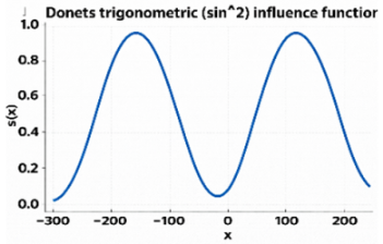
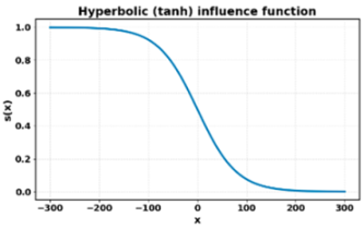
A major drawback of this method is its inability to handle excavations with complicated shapes or geometries and notable changes in mining parameters such as the percentage of extraction and the depth of mining [19]. Furthermore, mining and rock engineers might not be able to determine the coefficients in some of the empirical formulations. It is also observed that several field observations are needed to derive and validate a profile function, as with graphical charts [11,16].
2.2. Influence Function Method (IFM)
Influence function methods (IFMs) were developed by [20] and are extensively used for predicting mine-induced subsidence [21]. The IFMs are among the most convenient approaches used for estimating the shape and magnitude of subsidence [22]. They are based on the principle of superposition and consider the displacements induced by subsidence at a given point as the sum of the displacements induced by elementary mining units.
Mathematically, the IFM computes vertical surface subsidence W at any point (x, y) by integrating the influence contributions from all elementary extraction elements over the mined-out panel area [20,21]:
where W(x, y) = vertical surface subsidence (m) at surface point (x, y); f(x − ξ, y − η) = influence function giving the elementary subsidence contribution from unit dA at (ξ, η); and A = total plan area of the extracted panel (m2).
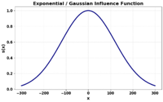
The Knothe–Gaussian influence function, adopted in Chinese, Polish, and UK coalfield practice, expresses the influence weight as [16]:
The influence radius r controls the lateral spread of the subsidence trough: a smaller φ (shallow draw angle) yields a wider, flatter trough at depth, which is typical of competent, jointed sandstone overburden. The primary limitation of the classic IFM is its assumption of a single, spatially uniform influence angle for all panel edges, an idealization that rarely holds in heterogeneous, multi-lithology overburden sequences [21,23].
IFMs have several advantages compared to other methods for the 3D prediction of subsidence. Firstly, these methods can be used with any type of mine geometry, whereas empirical methods are restricted to only simple geometries [24]. Secondly, these methods are used to simultaneously assess vertical and horizontal ground movements induced by subsidence at each point on the surface. However, IFMs are developed by considering the same influence angle for all edges of a mine panel, while the incidence of several influence angles is often observed in mining engineering [21,23].
2.3. Theoretical Method/Analytical Method
The analytical method of mine subsidence prediction employs mathematical and mechanical models to estimate ground movements induced by underground mining. This method is based on the principles of elasticity and plasticity and makes it possible to simulate rock and soil deformation over mined-out areas. Based on parameter analysis, analytical models often include seam depth, thickness, inclination, geologic conditions, and subsidence influencing parameters such as time lag and overburden properties.
Research studies, such as those by the authors of [16] in their comprehensive analysis of subsidence prediction models and [21] in their work on empirical rock failure criteria, have refined these models by incorporating advancements in stress–strain behavior and finite element analysis to enhance accuracy. Subsidence prediction equations that are derived from the theoretical framework and calibrated to field data provide flexibility for site-specific situations. These advances allow the incorporation of variables such as mine geometry, overburden material properties, and stress distribution in making predictions more adaptable to varying conditions.
However, the analytical method also has its limitations. Its reliance on idealized assumptions about material properties and geological homogeneity can lead to inaccuracies in complex terrains with discontinuities, faults, or layered overburden [2]. Furthermore, the method requires detailed geological and geotechnical input data, which may not be available or reliable. In such situations, analytical models may have to be complemented by empirical or other models to make robust predictions. Additionally, the computational complexity and resource demands of analytical models, particularly when integrated with advanced simulations, can pose practical challenges for the widespread application of these models in field scenarios [25].
Within this family, two branches are distinguished. Closed-form analytical solutions of the kind described above remain limited to idealized geometries and homogeneous, isotropic ground. Numerical methods—finite difference, finite element, boundary element, discrete element, and hybrid formulations—relax those restrictions by discretizing the rock mass and solving the governing equations incrementally, and they therefore constitute the principal theoretical route to three-dimensional subsidence prediction. Because these methods are the subject of this review, they are not treated here; their formulation, implementation, calibration, application and limitations are examined in detail in Section 3. The remainder of the present section covers the probability integration method, the other branch of the theoretical/analytical family.
Probability Integration Method
The probability integration method (PIM) has been popular in the prediction of mine subsidence because it is able to integrate uncertainty and variability in ground conditions; thus, it is a more holistic approach than the conventional deterministic methods of prediction such as the finite element method (FEM) and discrete element method (DEM). Compared to FEM, in which one deterministic solution is found for the problem with known input parameters, PIM seeks to utilize the probabilistic distributions in determining the main factors of the problem, namely, material properties, mining depth, and geological conditions, so that possible outcomes of the problem are predicted with predictable probabilities [26]. This makes it possible to perform a more efficient risk evaluation by estimating the probability of extreme subsidence events, including surface damage or infrastructure failure, which are paramount in mine planning and safety [27].
The probability integration method (PIM), rooted in stochastic medium theory, predicts the maximum vertical surface subsidence W0 as a product of the extracted seam geometry and a site-specific subsidence coefficient:
where W0 = maximum vertical surface subsidence at the panel center (m); q = subsidence coefficient (dimensionless; typically 0.1 to 0.9), representing the fraction of seam thickness expressed at the surface, depending on overburden lithology, panel width-to-depth ratio, and extraction method; m = extracted seam thickness (m); and α = seam dip angle (degrees), for horizontal seams cos α = 1.
The full 1D subsidence profile W(x) along the main cross-section of a fully extracted panel is expressed using the Gaussian error function, applied for InSAR-based parameter estimation of PIM [28]:
where x = horizontal distance from the inflection point of the subsidence trough (m); r = main influence radius (m); r = H · tan β; H = depth to the seam (m); tan β = tangent of the main influence angle, a site-calibration parameter; and erf(·) = Gaussian error function.
Beyond vertical displacement, PIM also yields horizontal surface displacement as U(x) = B · (dW/dx), where B is the horizontal movement coefficient (typically 0.2–0.4). PIM parameters (q, tan β, propagation angle θ0, and inflection-point offsets s1–s4) can be inverted directly from InSAR line-of-sight deformation time series [28], and this approach has been combined with optimization algorithms such as the grey wolf optimizer [29] and applied to dynamic, time-resolved subsidence prediction using D-InSAR-derived parameter inversion [30], offering a cost-effective substitute for dense ground-survey networks.
In addition, the probability integration method has been widely used for mine subsidence prediction because of its relatively mature theoretical basis, convenient calculation procedure, and limited parameter requirements. The authors of [13] developed an object-oriented probability integration prediction model for mining-induced subsidence and implemented it using MATLAB 2019. Their model was verified through engineering cases and showed reasonable consistency with numerical simulation results [31]. However, the accuracy of PIM remains strongly dependent on the proper selection of prediction parameters such as mining thickness, dip angle and subsidence coefficient. The research described in [13] also noted that PIM has limitations in analyzing the dynamic mining process and the structural support effects formed by overlying strata damage. Therefore, although PIM is useful for rapid and practical subsidence prediction, its reliability in complex mining conditions depends on parameter calibration and, where necessary, comparison with numerical methods such as DEM or FEM.
2.4. Statistical Method
The statistical approach to mine subsidence prediction involves the application of statistical models that determine the parameters of subsidence on the basis of available data, including surface movement, rock characteristics, and mining methods. The method is based on regression, machine learning, and data-driven models, and aims to find relationships between different mining parameters and the surface deformations produced. The ability to work with large amounts of data to discover regularities in complex mining conditions without modeling and simulation of the geological processes is one of the key benefits of the statistical approach, unlike the 3D discontinuum modeling approach [32]. It does not require an accurate set of input parameters, as is the case with deterministic models such as the finite element method (FEM) or discrete element method (DEM).
Statistical techniques can be used with limited or imperfect information, particularly in areas with limited geological information. Moreover, statistical techniques are comparatively computationally efficient, i.e., they do not require sophisticated numerical simulations. However, the most significant disadvantage of the statistical approaches is that they are highly dependent on the quality and representativeness of the data available [33]. The model could also give unreliable predictions if the training data are not complete or accurate enough. Also, statistical techniques are not sensitive to the underlying physical processes responsible for subsidence; thus, they may be less predictive of more complicated phenomena, including localized failures or fracture propagation, which can be better modeled using FEM or DEM. In addition, statistical models, being rapid and approximate solutions, may not be able to model the interaction of a number of physical variables in sufficient detail, which may be important in the case of large-scale mining operations. Nevertheless, in spite of these limitations, the statistical approach is a valuable tool of mine subsidence prediction in situations when immediate judgments are required, and the geological information required is not completely available.
2.5. Deep-Learning Method
The emergence of deep-learning algorithms to predict mine subsidence has become a popular topic recently because they can learn intricate patterns from massive amounts of data, both geological and mining activity data, and surface displacement data. Deep-learning methods, such as Convolutional Neural Networks (CNNs), Long Short-Term Memory (LSTM) or Gated Recurrent Units (GRU), do not rely on physical assumptions, unlike conventional methods, such as the finite element method (FEM) and discrete element method (DEM), which rely heavily on physical modeling and parameter assumptions [33,34,35]. Such models are especially appropriate for representing temporal and spatial patterns of deformation and have been found to be highly accurate in short-term prediction of subsidence when trained on time-series InSAR measurements [36,37]. They also provide flexibility to incorporate heterogeneous input sources (remote sensing, GPS, and geology surveys) [34,38].
Dependence on a large and high-quality training set and the interpretability challenge associated with their black-box nature are major limitations, though [37]. Traditional techniques, such as FEM and DEM, are more transparent and more physics-based in their representation of subsidence processes but are frequently computationally costly and less capable of responding to time-varying mining conditions [35]. In general, deep learning is a strong and information-driven solution for predicting subsidence in complicated mining settings, particularly when extensive datasets are accessible and when nonlinear behavior should be identified quickly.
2.6. Chronological Development of Mine Subsidence Prediction Methods
The history of subsidence prediction methods is an evolutionary one, in that it began with simple, empirically determined methods, which evolved to more sophisticated and computational models as shown in Figure 4; a comparative summary of the major mining-induced subsidence prediction methods, along with their underlying principles, advantages, and limitations, is presented in Table 2. The use of empirical methods in predicting subsidence started with the use of field data and the historical experience from mining activities to predict subsidence behavior. Such techniques proved useful because they were easy and inexpensive; however, with time, they were found to be constrained because they made use of past data and assumptions and could not be applied to complex geological situations. Consequently, developments in the field of statistics began to improve these empirical models. It is worth mentioning that, in the 2010s, empirical methods were complemented by machine learning and statistical methods, which enhanced the predictive accuracy of the empirical methods significantly, particularly in complicated geological environments [14,39]. The empirical models had some difficulties, though, with different site-specific situations, leading to the creation of more generalized approaches.
Figure 4.
Chronological development of subsidence prediction methods.
Table 2.
Comparison of principal mine-subsidence prediction methods, including their principles, advantages, limitations, typical applicability, and calibration requirements.
Graphical methods came second, as an extension of empirical methods, in which real-life case studies were represented as graphs. One of the most significant ones in this category is the Subsidence Engineers’ Handbook, created by the National Coal Board of the UK, which contains fast-prediction charts constructed on the basis of past field surveys. But these techniques were simple to use and gave rapid predictions; they were unable to explain the complex geological features and, in most cases, were only applicable to certain types of mining [11]. With these restrictions, a subsequent method was introduced in the late 1980s called the influence function method (IFM). The superposition principle of IFM enabled the prediction of subsidence due to the joint influence of elementary mining units. The benefit of this approach was that it could deal with more complicated mine geometries, and as such, it was quite an advance in subsidence prediction, but it nonetheless possessed the problem of similar influence angles as well as assumptions of mine geometry [20,21].
With the growth in computing power during the 1990s, the development of analytical methods began. By applying mathematical models of elasticity and plasticity, these methods would simulate the behavior of subsidence more accurately by accounting for different geological and mining factors. Nevertheless, although the analytical models might have given theoretical understanding, they tended to be restricted by their use of idealized assumptions regarding material properties and geologic homogeneity [2]. Numerical techniques to overcome these shortcomings were developed in the late 1990s and early 2000s, including the finite element method (FEM) and finite-difference method (FDM). Complex geological aspects such as faults and discontinuities could be modeled using these methods, and a more detailed picture of subsidence behavior was possible. Computational procedures were flexible, allowing a range of heterogeneous materials to be used, and complex geological situations to be addressed, which represented a marked improvement in empirical and analytical procedures. Nevertheless, these approaches required massive computing power and complete input, which were not always available [34,40].
The hybrid models constructed on the strengths of numerical methods, which emerged in the mid-2000s, combine various approaches such as the boundary element method (BEM), FEM, or DEM (discrete element method) to address the far-field as well as near-field subsidence behaviors. Hybrid models were developed to represent interacting continuum and discontinuum behavior within the same analysis, although their potential benefits are case-specific and are accompanied by greater computational and calibration requirements [41].
Simultaneously, the probability integration method (PIM) was developed to deal with the uncertainty of subsurface conditions. With the help of probabilistic distributions of most of the significant factors, PIM provided a set of potential outcomes and it was more complete in its consideration of risk evaluation than deterministic techniques, such as FEM or DEM [42].
Statistical techniques became popular in the 2010s, and offered regression analysis as well as machine learning and data-based models as predictors of subsidence, without detailed geological modeling. Such approaches worked well particularly in areas with limited data, but could not represent the more complex physical processes, for example, the propagation of failure or fractures at a local scale.
The deep-learning approach is the new frontier in predicting subsidence, using the power of neural networks such as CNNs and RNNs to extract complex patterns from large amounts of data. Deep-learning models are very versatile and are able to predict temporal changes in surface deformations and are also capable of handling dynamic changes in mining conditions. Nevertheless, issues of training such models using quality datasets and understanding the black-box character of such models still pose a major challenge [33].
In summary, the development of subsidence prediction systems is associated with a growing level of advancement in the methods used to simulate the changes that occur at the surface due to mining. From the initial use of empirical and graphical techniques, to the incorporation of sophisticated statistical, probabilistic and deep-learning tools, the science of subsidence prediction has become highly specialized, as it is capable of delivering precise and detailed predictions in the case of complex mining operations. Such developments are making mining activities much safer and environmentally responsible despite the remaining challenges, particularly those regarding the quality of data and the computing requirements.
3. Review of Numerical Approaches for Subsidence Analysis: From Classical Models to Data-Driven Integration
Numerical methods form the branch of the theoretical/analytical family introduced in Section 2.3, and they are the subject of this review. This section therefore constitutes its principal analytical core, critically examining the development, formulation, application, calibration, validation and limitations of 3D numerical models for mining-induced subsidence prediction.
3.1. Numerical Framework and Historical Development
The evolution of subsidence-prediction methods has been introduced in Section 2. The formulation and implementation of the main numerical tools used for the analysis of mine subsidence are therefore examined in this section. Table 3 summarizes representative continuum, discontinuum, and hybrid software platforms based on their numerical formulation, rock-mass representation, and representation of deformation and failure.
Table 3.
Characteristics of the main numerical models and approaches.
3.2. Numerical Modeling Approaches
The development of information technology (IT) and computer equipment, including supercomputers and cloud computing, has made it possible to analyze complex issues in the field of rock mechanics and engineering. Researchers and engineers who want to solve rock mechanics problems with the help of numerical modeling must find alternative solutions and codes [58,59]. The shift from the use of empirical and IFM approaches towards numerical methods of predicting mine subsidence is a significant step to more accurate and versatile modeling approaches. Empirical techniques are based on past data and oversimplification. Conversely, numerical methods entail the use of computational algorithms to solve stress–strain equations, which aids better comprehension of issues relating to the conduction of the subsurface [60].
Analytical techniques, although useful for providing theoretical understanding of subsidence using simple mathematical models, tend to make assumptions about the homogeneity of the material. These constraints are addressed by numerical methods that take into account the variability and anisotropy of rock-mass properties. As an example, the authors of [61] conducted a study of multi-coal seam goafs, using numerical simulations. The research revealed that numerical models are capable of taking into account geographical considerations such as mining geometry, grouting plan, and rock-mass behavior. Nevertheless, the predictive performance achieved is still influenced by the assumptions used, input parameters, calibration data, and validation parameters. Computational techniques also enable the simulation of dynamic processes and time-dependent processes such as delayed subsidence and gradual failure that are hard to predict by using empirical and analytical models. Numerical methods are broadly classified into continuum and discontinuum methods.
3.2.1. Continuum Numerical Methods
In the context of numerical modeling, the continuum method is typically used for the prediction of mine subsidence. It assumes that the geological medium is uniform and continuous. In such a technique, sophisticated methods such as FEM and FDM are used to assess changes in stress, deformation, and fracture development as a result of mining. It is suitable for both localized and large-scale subsidence processes as it takes into consideration material anisotropy and complex boundaries [61,62].
Prediction of the surface subsidence of a coal mine was performed using a continuum model by [40], which demonstrated that it was able to simulate surface subsidence under different geological conditions. On the same note, researchers employed continuum numerical modeling to determine the impacts of grouting treatment in multi-coal seam goafs, which proved to be useful in enhancing mitigation measures. Recent developments in software such as FLAC3D have allowed researchers to simulate time-dependent material behavior such as delayed subsidence and progressive failure. However, the precision of this approach strongly depends on proper input data such as the rock’s mechanical characteristics and the mining plan.
In spite of such issues, the continuum method is among the most important approaches to subsidence modeling, as it provides site-specific and detailed predictions when dealing with complicated mining situations. The three major techniques incorporated in the continuum method are the finite-difference method (FDM), the finite element method (FEM) and the boundary element method (BEM).
Finite-Difference Method (FDM)
Governing equations of motion, stress and strain are discretized into finite-difference equations by FDM. By solving these equations for specific points in space and time, one can simulate subsidence with time. This has been useful for modeling subsidence in both coal and metal mines, and offers information on surface deformation over time. Complex boundaries and geological variations are easier to handle using FDM.
Through the continuum models of FLAC3D, collapse due to mining is typically modeled by the gradual deterioration and deformation of a continuous rock mass as opposed to the free movement of separately detached blocks. This representation can include plastic yielding, strain or tensile weakening, reduction in stiffness, interface slip, and a compaction law attributed to the caved or goaf material, depending on the geological and mining conditions. A tension-weakening model of the fractured zone and a double-yield model of the caved material can be employed to model fracture weakening caused by mining and compaction of goafs. A caving algorithm was added by the researchers, using the IMASS constitutive model to model progressive caving and strata-fracture response. Field-scale applications like the Wutong Mine investigation further indicate that the estimated subsidence is highly reliant on the estimation of rock-mass parameters, mining geometry, numerical discretization, and calibration using observed ground movement. Thus, FLAC3D cannot be deemed to be inherently accurate merely due to the use of a finite-difference formulation; rather, the determination involves the entire model development, calibration, and validation process [18,63,64].
The continuum numerical methods (FDM, FEM) solve the quasi-static momentum–balance (equilibrium) equation at every grid node. In index notation, this reads [14]
where σij = components of the Cauchy stress tensor (Pa); xj = spatial coordinate in the j-th direction (m); ρ = bulk density of the rock mass (kg/m3); and gi = gravitational acceleration component in the i-th direction (m/s2).
The FLAC3D system of equilibrium equations is solved with an explicit time-marching scheme, whereby stresses, yielding, and deformation can be incrementally advanced as one excavation stage is performed and followed by another. By choosing suitable constitutive formulations, such as elastoplastic, strain-softening, creep, viscoelastic, and goaf-compaction, immediate and delayed deformation may be modeled. However, the ability of a continuum model to recreate a collapse depends on the manner in which the caved and fractured areas are modeled. The overall subsidence trough can be recreated by treating the whole rock mass as a continuous elasto-plastic medium, which, however, cannot adequately model joint opening, contact loss, block rotation and large discontinuous movement. Where the response is dictated by persistent faults, joints, or bedding separations, interface elements or some other explicit description of discontinuities should be included. Inadequate grid refinement and an inappropriate constitutive representation of the goaf may also smooth localized failure and distort the predicted magnitude or spatial extent of subsidence [18,64,65].
Finite Element Method (FEM)
FEM is also a powerful method for mine subsidence prediction, and it has special strengths relative to FDM. FEM can be used to subdivide complex geological structures into smaller, interconnected structures, and this has been useful in simulating the heterogeneous and anisotropic materials used in mining. Indicatively, ref. [66] used FEM to model surface subsidence in a multi-seam coal mine, and the approach showed the ability to reflect intricate rock deformations and changes in stress.
The finite element method, with implementations such as STRAND7 and ABAQUS, offers a great amount of flexibility in the representation of the irregular geometry of the excavation, the heterogeneous nature of the geological units, the anisotropic nature of the materials, the representation of backfilled openings, and the representation of complex boundary conditions. The ground movement associated with collapse in continuum-based FEM models is typically described by stress redistribution, elastoplastic yielding, strain softening, degradation of stiffness, and the constitutive behavior of the rock mass, caved material, and backfill. Therefore, the loss of support and progressive deformation are calculated based on changes in the stress–strain response and not by any explicit separation and unrestricted movement of rock blocks. The resulting collapse pattern is very sensitive to the choice of the constitutive model, the mesh resolution, geological modeling, boundary conditions, excavation sequence, and calibration data. Therefore, FEM should not be considered a more accurate method than FDM or DEM, but rather be judged according to the specific geological setting and specific modeling purpose [44,67].
FEM discretizes the rock-mass domain into finite elements and solves the global system of equilibrium equations in matrix form. The assembled stiffness equation for the full mesh at each load increment is [68]
where [K] = global stiffness matrix (N/m), which is assembled from element stiffness matrices [ke] = ∫v [B]T [D] [B] dV, where [B] is the strain-displacement matrix and [D] is the constitutive (stress–strain) matrix; {u} = global nodal displacement vector (m), which contains vertical and horizontal displacements at every node, and surface subsidence is extracted from the vertical components of {u} at surface nodes; and {F} = global nodal force vector (N), which includes body forces (gravity), in situ stress releases at excavated boundaries, and any applied loads.
For non-linear material behavior (plasticity, softening), Equation (7) is solved incrementally: the stiffness matrix [K] is updated at each load step based on the current stress state and constitutive model (e.g., Mohr–Coulomb, Hoek–Brown). Modern FEM codes such as ABAQUS, ANSYS, and PLAXIS implement an automatic mesh refinement near excavation boundaries to capture localized stress concentrations without excessive computational cost [68,69]. Compared with FDM, FEM handles complex irregular geometries and material heterogeneity more naturally but requires a well-structured mesh and is generally more computationally intensive for large 3D mining domains.
Sepehri [44] reported a field-scale example of a FEM application with ABAQUS for a Canadian diamond mine. The three-dimensional elastoplastic model was used to simulate the successive excavation and backfilling stages and a mesh convergence analysis was performed. Two extensometers in the ground were used to calibrate the model, and monitoring-prism data were used independently to evaluate the model predictions on the surface. The authors reported an average relative error of 7.95% between the predicted and measured movement. This result does not claim to prove that ABAQUS or FEM is generally more accurate than FDM or DEM, but rather suggests that for the investigated mine, the parameter set, calibration procedure, and validation data set are satisfactory.
Boundary Element Method (BEM)
The boundary element method (BEM) is one of the calculation techniques; it examines only the edge of the domain and consequently, the dimension of the problem is lowered, and thereby, fewer equations are taken into account compared with other calculation techniques. This makes BEM especially effective in those areas where the domains are infinite or semi-infinite. However, BEM has difficulties in working with the complicated shapes and non-linear material responses that frequently arise in the modeling of mine subsidence. BEM has been found to be efficient in the analysis of mine subsidence, particularly for large problems with infinite or semi-infinite domains. In contrast to FEM and FDM, BEM reduces the amount of computation required because it concentrates only on the boundary and simplifies the problem [70,71].
BEM reduces the 3D volume problem to a 2D boundary problem by applying the reciprocal theorem and Green’s functions. The boundary integral equation for displacements ui at an interior point, arising from traction tj on the boundary Γ, is [70,71]:
where cij(ξ) = free-term coefficient (=0.5δij for a smooth boundary point ξ); uj(x) = displacement component at boundary point x (m); tj(x) = traction (stress vector) at boundary point x (Pa); Uij*(x,ξ) = Kelvin fundamental solution for displacements (Green’s function); Tij*(x,ξ) = Kelvin fundamental solution for tractions; and Γ = problem boundary (excavation walls, free surface, material interfaces).
Because only the boundary Γ is discretized, not the entire rock-mass volume, BEM requires far fewer unknowns than FEM or FDM for the same domain size, making it computationally efficient for deep mining problems with simple geometries and linear-elastic far-field rock [71]. However, the requirement for a known Green’s function limits BEM to homogeneous or piecewise-homogeneous media; strongly heterogeneous or non-linear rock masses (softening, plastic flow) require BEM–FEM or BEM–DEM hybrid coupling to capture near-field non-linearity [70].
BEM must not be viewed as being inherently more accurate than FEM or FDM. The primary computational benefit is in the fact that only the boundary of the problem is discretized, in which case it can be computed with a reduced number of unknowns for appropriate linear-elastic infinite or semi-infinite domains. Its accuracy, however, depends on the samples of the boundary, the fundamental solution, the treatment of singular and near-singular integrals, the material assumptions, and the choice of the validation or error criteria.
This approach is particularly useful when examining subsidence on a large scale with a limited computing capacity. It can be successfully applied to linear-elastic materials, and it is useful when gradual changes in mine surfaces are to be modeled. BEM is, however, limited compared to FEM and FDM. FEM works more effectively with complicated shapes and non-linear problems, but must be fully domain-discretized and can be expensive in large subsidence evaluations [72].
3.2.2. Discontinuum Numerical Methods
Discontinuum approaches treat the rock mass as a collection of blocks, particles and/or fracture-bounded regions instead of as a continuously deforming medium. This representation is especially applicable when faults, joints, bedding planes and block-scale separation control caving and subsidence. Discontinuum models can explicitly model opening, sliding, rotation, contact loss and recontact along prescribed discontinuities. Their primary benefit is thus that they represent discontinuous movement explicitly and not that they are inherently superior in terms of predictive accuracy. They are reliable only if the structural mapping is appropriate, the block or particle geometry is adequate, the contact constitutive laws are applicable, good mechanical parameters are used, appropriate boundary conditions are used, the field is properly calibrated, and the numerical resolution is appropriate. Discontinuum approaches for subsidence analysis include the discrete element method (DEM) and the discrete fracture network (DFN)-based formulations [5,67,73].
Discrete Element Method (DEM)
The discrete element method is well applied to rock masses where the collapse mechanism is dominated by large displacement and discontinuity-controlled deformation. For equivalent discontinuous modeling, complex natural joint systems can be simplified to a representative network to simulate movement in the mine within reasonable computational constraints. This simplification makes the computation more tractable but adds uncertainty regarding whether the modeled discontinuity geometry adequately represents all field-scale discontinuities, such as joints, bedding planes, and faults. Therefore, it will be important to see whether the block structure and contact properties used in the reliability of the DEM predictions are representative of the most important processes that govern caving and subsidence [32,65,73].
DEM models the rock mass as an assembly of discrete blocks or particles that interact through deformable contact interfaces. At each time step, Newton’s second law is applied to each block i to update its translational and rotational motions [74]:
where mi = mass of block i (kg); üi = translational acceleration of block i (m/s2); Fij(contact) = contact force from neighboring block j on block i (N), which is computed from relative displacement and contact stiffness: Fn = kn · δn (normal), Fs = ks · δs (shear); Fi(gravity) = gravitational body force on block i (N); Ii = moment of inertia of block i (kg·m2); = angular acceleration of block i (rad/s2); and Mij(contact) = moment from contact force of block j on block i (N·m).
The explicit time-stepping scheme is used to integrate Equation (9). The rock mass in 3DEC is modeled as an assembly of blocks linked by contacts defined as joints, faults, bedding planes, or lithological interfaces. Contact opening, sliding, rotation, separation, large displacement, and re-contact or interaction between blocks can therefore cause collapses. In addition to discretizing the blocks by finite-difference zones, deformable blocks can also be internally discretized so that stress and deformation in individual blocks can be calculated. For the analysis of an open-pit final slope, Xu et al. employed an equivalent jointed rock-mass representation in 3DEC to simulate the caving and large-displacement movement under the final slope. Huang et al. presented a three-dimensional discontinuum model that included faults, lithological interfaces, extraction stages, and backfilling operations. These are particularly applicable where collapse is controlled by persistent discontinuities and large block movements, such as in the problem discussed herein. However, its performance still relies on the block geometry, discontinuity distribution, constitutive laws of contact, stiffness and strength of the joints, boundary conditions, time-step size selection, and field calibration. This means that block movement is a mechanical advantage in 3DEC and does not necessarily imply predictive superiority [32,65].
There is not enough evidence to justify a ranking in terms of the accuracy of FLAC3D, ABAQUS, and 3DEC. In general, the FLAC3D and ABAQUS continuum models can be used to calculate the stress redistribution, progressive yielding, degradation of materials, and overall shape of the subsidence trough at the mine scale. ABAQUS has good capabilities for irregular geometry, assignment of heterogeneous materials, staged excavation, and representation of backfill, while FLAC3D is an efficient explicit solution framework for incremental excavation and nonlinear geomechanical response. 3DEC, on the other hand, provides a more explicit representation of joint-controlled separation, sliding, rotation, and large block separation. Benchmark studies show that these two approaches (continuum and discontinuum) can capture different aspects of caving-zone development, fracture initiation, and surface deformation, as the modeled response evolves from small-strain subsidence to complete collapse. Therefore, performance should be evaluated on a case-by-case basis, using common criteria such as the measured maximum subsidence, width of the trough, tilt, curvature, horizontal displacement, extent of propagation to the caverns, failure-zone geometry, and temporal deformations. The predictive credibility is not only dependent on the solver used, but also on geological representation, constitutive assumptions, mesh or block resolution, calibration procedure, and independent validation [5,67].
Discrete Fracture Network Methods (DFNM)
The discrete fracture network method attempts to better capture the discontinuous character of subsidence by representing the subsurface as a network of individual fractures, not a continuous medium. This approach improves the realism of subsidence modeling where fracture systems dominate rock-mass behavior.
In DFNM, each fracture is modeled as a planar conduit whose hydraulic aperture e and mechanical stiffness govern both fluid flow and deformation. Flow through a single fracture under a hydraulic gradient ∇h follows the cubic law [75]:
where Q = volumetric flow rate through the fracture (m3/s); e = hydraulic aperture of the fracture (m), which decreases under normal stress: e = e0 − δn/knn, where e0 is the initial aperture and knn is normal stiffness; w = fracture width perpendicular to flow direction (m); μ = dynamic viscosity of the pore fluid (Pa·s); μ = 10−3 Pa·s for water at 20 °C; and ∇h = hydraulic head gradient along the fracture (m/m).
The cubic law, Equation (10), shows that fracture transmissivity scales with e3, meaning even small changes in aperture caused by mining-induced stress redistribution or goaf subsidence produce large changes in groundwater flow paths and pore pressure distributions. Coupling DFNM flow, Equation (10), with the DEM mechanical relations, Equation (9), produces a fully coupled hydro-mechanical model, enabling prediction of water inrush, surface ponding, and aquifer dewatering associated with subsidence [75]. The primary challenge is the characterization of the fracture network geometry from borehole logs and geophysical surveys at sufficient resolution for panel-scale models.
Finally, the decision between the continuum and discontinuum approaches to mine subsidence prediction depends on the local geological and mining conditions of the region and the resources and abilities of the modelers [32,62].
3.2.3. Hybrid Numerical Methods
Hybrid models are currently common in rock engineering, especially in stress/deformation problems of fractured rocks. BEM–FEM and DEM–BEM models are the most common types of hybrid models. There is also development in hybrid DEM–FEM. The BEM is most commonly applied to simulate far-field rocks as an equivalent elastic continuum, whereas FEM and DEM are used to simulate non-linear or fractured near-fields that explicitly describe fractures or non-linear mechanical behavior, including plasticity. This matches the required problem resolution to the numerical methods at hand, and an effective representation of the effects of the far-field on the near-field rocks is obtained. An even more complex way of modeling subsidence is the combination of FEM and DEM techniques. This method involves the combination of a continuum domain and discrete fractures, and fracturing may take place in future upon the action of variable stresses and strains. In this method, though, more computation is required. These techniques have been described in great detail, along with the ways they are applied [41,76].
In hybrid BEM–FEM or FEM–DEM models, the total domain Ω is partitioned into a near-field sub-domain Ωn (modeled by FEM or DEM to capture non-linearity and discontinuities) and a far-field sub-domain Ωe (modeled by BEM or elastic FEM). Compatibility and equilibrium are enforced at the shared interface Γi through the domain decomposition conditions [77]:
where un, ue = displacement fields in the near-field and far-field sub-domains, respectively (m); tn, te = traction vectors on the near-field and far-field sides of the interface (Pa); and Γi = coupling interface between the two sub-domains, typically located at a distance of 2–3 excavation diameters from the opening boundary.
Equation (11) is enforced iteratively: displacements from the near-field solution are imposed as boundary conditions on the far-field model, and the resulting far-field tractions are fed back as loads on the near-field model until convergence. This allows the computationally expensive DEM or non-linear FEM to be confined to the region where it is most needed (around the excavation and goaf), while the more efficient BEM or elastic FEM handles the large far-field volume. Hybrid FEM–DEM models such as ELFEN and Y-Geo have achieved better replication of observed subsidence profiles above longwall panels in weak sedimentary overburden, compared with purely continuum or purely discontinuum approaches [77,78].
It has been demonstrated that this hybrid approach can be used to improve subsidence prediction and provide a more precise picture of surface deformations and the causes of damage to infrastructure [78]. Indicatively, it has been demonstrated that the FEM/DEM model is capable of simulating the development of surface cracks and the consequent settlement of the ground, which cannot be captured by traditional FEM alone. The FEM/DEM technique also enables risk assessment and mitigation plans used to consider macroscopic and microscopic behaviors of subsidence. The characteristics of numerical methods for mine subsidence prediction are summarized in Table 4.
Table 4.
Characteristics of numerical methods for mine subsidence prediction.
The main differences between FLAC3D, ABAQUS, and 3DEC are the ways collapse is represented, rather than the general level of accuracy. FLAC3D models collapse through progressive continuum yielding, weakening, and goaf compaction processes; ABAQUS models collapse-related deformation through elastoplastic response, stiffness degradation, and/or staged excavation or backfilling. Conversely, 3DEC explicitly models opening, sliding, rotation, and discontinuity-controlled block movement. It is therefore generally appropriate to use FLAC3D and ABAQUS for stress redistribution analysis and overall subsidence profiles at the mine scale, while 3DEC is more appropriate for situations where persistent joints dominate caving and large block movements are present. No solver is necessarily more accurate, though. Predictive performance is related to the geological representation, constitutive and contact parameters, mesh or block resolution, and calibration, as well as independent validation against measured subsidence, horizontal displacement, cave propagation, or extent of the failure zone [5,67]. Accordingly, comparisons in this review refer to the representational suitability of each method under specified geological and mining conditions rather than a universal ranking of predictive accuracy.
3.3. Application-Based Review of Numerical Modeling
Table 5 synthesizes field applications of numerical subsidence modeling for coal and metal mines. The case studies are compared according to mining method, numerical software, calibration information, validation dataset, and principal practical finding. The emphasis is therefore placed on field implementation and predictive evidence rather than on repeating the numerical formulations described in Section 3.2.
From Table 5, it can be observed that numerical modeling of the Palabora mine was earlier performed using the 3DEC code and later using the FLAC3D code and it was found that to accurately account for the interactions between geology, cave propagation, surface topography and caving-induced subsidence, advanced 3D numerical modeling techniques must be used along with InSAR techniques, as done in [49,54]. The research conducted in [61] at the Fangezhuang coal mine, China, shows that the study emphasized the usefulness of 3D continuum analyses performed with software such as FLAC3D for investigating mining-induced ground movement in a faulted geological setting. Several simplifications of the mine-site geology were necessary for the FLAC3D analysis, in particular, the simplification of the representation of geological structures. InSAR measurements, taken individually, offer spatially distributed measurements of surface displacement that can be used to contribute to the calibration and validation of a numerical model and to detect movements outside the large open-pit [80]. However, InSAR observations cannot directly correct omitted faults, simplified stratigraphy, or inaccurate mining geometry in the numerical model.
This table characterizes both metal and coal mining, together with their mining methods, such that the developed methodology will be applicable to all kinds of mining conditions. These FLAC3D applications for the Wutong and Fangezhuang coal-mining regions illustrate that it is possible to simulate key aspects of ground deformation caused by mining activity with a 3D continuum model when suitable geological structures, mining geometry, rock-mass parameters, mining stages, and observations are used. The agreement reported is, however, confined to the assumptions, calibration data, validation criteria, and geological conditions used in the respective case studies, and must not be considered a proof of the general validity of the model [18,61]. Accordingly, the case studies in Table 5 are interpreted primarily in terms of geological applicability, calibration, validation, and field-scale performance.
Table 5.
Characteristics of major application-based research work in mine subsidence prediction using numerical models.
None of the reviewed case studies provides a one-size-fits-all numerical code. Continuum models are generally appropriate for applications where the major issues are mine-scale stress redistribution, staged excavation, and overall subsidence/trough development; discontinuum/hybrid approaches are appropriate for applications where faulting, block separation and/or jointing and cave propagation control the deformation mechanism. In both coal and metal mines, the predictive credibility is essentially related to the geological representation, the selection of the field-scale parameters, the calibration data, and the independent validation, and not only to the software selected. While InSAR and ground-monitoring observations can help improve the calibration and validation of any numerical prediction, they cannot substitute for the lack of geological structures and/or simplified stratigraphy or for inaccurate mining geometry. Hence, the choice of models and the process of validation need to be correlated with the main deformation mechanism and the available site-specific data.
3.4. Role of Geotechnical Parameters and Rock-Mass Conditions
Numerical methods are widely used in mining subsidence estimation. The geological condition and geotechnical parameters of the site play an important role in numerical modeling subsidence analysis, and the estimation of the rock-mass mechanical parameters is of great significance for such cases [86,87]. Although many methods/approaches have been suggested for estimating rock-mass properties, this topic remains a difficult and controversial subject in the field of rock mechanics engineering. Further, the accurate estimation of rock-mass characteristics is of utmost important for subsidence prediction modeling and needs some special considerations [88]. Misinterpretations or miscalculations of the mechanical behaviors of rock masses have been a main problem involving failure and subsequent catastrophic incidents in several mining industry and rock engineering projects [89]. Such cases could result in major problems, highlighting the importance of precise geological and geotechnical data in the analysis and design of underground excavations in rock masses.
3.4.1. Influence of Rock-Mass Properties on Subsidence Behavior
The bending and sagging of the overlying strata and the fragmentation and caving of blocks are controlled by the properties of the rock masses. In particular, the strength and deformational properties of rock masses play a major role in surface movement and formation of subsidence. For example, the angle of draw is mainly controlled by the strength and stiffness of rock strata and the ratio of mining height and depth. When we increase the strength of rock mass, the angle of draw gets reduced. In contrast, weak rocks tend to increase the magnitude of subsidence at the surface. In summary, we can say that a strong bed in the overburden leads to a reduction in the extent of subsidence at the surface, while a weak bed in the overburden leads to an increase in the extent of subsidence. In addition, a weak bed in the overburden materials may have a greater impact on the limits of subsidence compared to strong beds [90,91].
3.4.2. Available Methods for Deriving Rock-Mass Parameters
A proper knowledge or understanding of the mechanical behavior of the rock mass is required for proper design or the development of a methodology for rock excavation. Many valid attempts have been made to accurately estimate rock-mass properties [89,92,93,94,95]. These properties are used as the input parameters for subsidence prediction modelling; therefore, these results are strongly affected by the input parameters. Also, excessive dependence on the results of numerical simulation and ignoring the accuracy of input parameters may cause major disruptions in mining operations [89]. Hence, this section of our review aims to review the available methods/processes for estimating the mechanical parameters of a rock mass.
In Situ Tests
Laboratory tests on intact cores do not directly represent field-scale rock-mass behavior, because an increase in the investigated volume introduces more joints, bedding planes, defects, and geological heterogeneity. Consequently, laboratory strength and stiffness commonly exceed field-scale values, while the failure mechanism may also change with specimen size. Laboratory results should therefore be used to define intact-material properties and parameter bounds, whereas field-scale model inputs should be derived using rock-mass classification, Hoek–Brown or equivalent upscaling relationships, in situ testing, and calibration against monitored deformation [96,97,98,99].
One of the best methods of extracting a rock-mass deformation modulus and strength is by conducting in situ tests. These tests are mainly grouped into direct tests and indirect tests. For example, there are several in situ tests for determining the static rock-mass deformation modulus, but the major and commonly accepted tests are the Borehole and Gallery Tests, Plate Bearing Test, and Radial and Flat Jacking Tests. In indirect tests, the properties of the rock mass under consideration are determined using the wave-propagation characteristics of the considered medium [100].
Further, the results of in situ tests are normally accurate enough for engineering purposes; however, such tests are rarely carried out for engineering projects where the size of the rock is small. The reason for this is that it is normally expensive, cumbersome, and time-consuming to perform in situ tests. Moreover, the analysis of the obtained results is usually difficult and requires special attention and experience [89]. The direct in situ measurement of the strength and deformational characteristics of rock masses, especially anisotropic sedimentary rocks, is extremely difficult because the mechanical behaviors of rocks are controlled by their cleated and stratified structures [92]. Furthermore, as they are significantly affected by scale effects, laboratory test results are not accurate enough to be applied to engineering designs. In addition, the size and orientation of discontinuities have a significant effect on the results of in situ tests. The transition from intact rock to a heavily jointed rock mass, illustrating the increasing influence of discontinuities with increasing scale, is shown in Figure 5.
Figure 5.
Transition from an intact to a heavily jointed rock mass.
Therefore, it is risky to rely solely on the results of only one in situ test, as performance tests, even in relatively homogeneous and satisfactory rocks, may yield different results [101]. Applied load magnitude and direction are also important factors in the mechanical behavior of an anisotropic rock mass.
Inverse Analysis Technique
The problems associated with in situ tests have encouraged researchers in rock mechanics to seek other convenient and practical alternatives to make correct estimations of the mechanical properties of a rock mass. To this end, the development of numerical methods and the extension of their application to geotechnical problems has led to an innovative solution for the evaluation of the mechanical properties of a rock mass. This new method, which is known as the “Inverse or Back Analysis Technique”, is used to calculate the mechanical parameters of rock mass based on a comparison of the results of the numerical simulations and the field-measured data. The inverse analysis method has been well-discussed in the relevant literature [102,103]. Field monitoring data are a key factor for back-analysis and are mainly conducted to measure stress, strain, and displacement [104].
In classical back-analysis, the initial values of the rock-mass parameters may be estimated based on engineering judgement. These initial values are used as input parameters for the numerical simulation to be carried out. The method of least squares is generally used to minimize the differences between measured data and the results of the numerical simulation. This strategy is adopted to optimize the initial values of the input parameters and to obtain the correct values of the rock-mass parameters. Back-analysis can be a computationally costly process and is often non-unique due to similar displacement responses from correlated input parameters. To solve this problem, the parameters need to be constrained to physically realistic values and influential parameters need to be determined by sensitivity analysis; regularization or multi-objective optimization can be used, and the calibrated model should be tested against independent field observations [102,104,105].
It is also notable that although this method is widely used in many mining and civil projects (such as tunnels, caverns and slopes), there are some restrictions on the application of this technique. The mine excavation geometry is very irregular and complex; implementing back-analysis for such excavation is difficult. In short, we can say that its application is limited to small-scale problems.
Rock-Mass Classification
Rock-mass classification is an important technique in geotechnical engineering used to measure the mechanical behavior of rock masses, particularly with regard to underground mining and excavation procedures. There are several systems that are used to categorize rock masses, including the Rock Mass Rating (RMR) system designed in [101], which evaluates the quality of rock using parameters that include uniaxial compressive strength, rock quality designation (RQD), and discontinuity condition. The other commonly used classification is the Q-system [106], which measures rock-mass strength using the ratio between the intact rock strength and the strength of discontinuities, which is also an important source of information in terms of tunnel design.
The Geological Strength Index (GSI) proposed by [107] considers geological and structural properties of the rock mass, including weathering grade and joint properties, and includes a more in-depth evaluation. Rock Quality Designation (RQD) (another necessary index) is a measure of the continuity of the rock mass, for which a higher value is better. Moreover, the Modified GSI created in [108] provides better results in measuring weathered and complex rock masses, and is especially applicable to mining and tunnelling. Such classification systems play a key role in forecasting mine subsidence in that they offer the necessary information on the strength and behavior of rocks under mining conditions that affect the surface displacement and deformation. The integration of rock-mass classification and numerical modeling, including FEM and DEM, will increase the accuracy of subsidence prediction, which can be used for risk evaluation and planning to mitigate risks associated with mining activities.
Rock-mass strength, a fundamental input for the FEM and FDM subsidence models, is most rigorously estimated using the generalized Hoek–Brown (H-B) failure criterion [109]:
where σ1 and σ3 are the major and minor effective principal stresses at failure (MPa), respectively; σci = uniaxial compressive strength of the intact rock (MPa); mb = reduced H-B constant for the rock mass: mb = mi · exp[(GSI−100)/(28−14D)]; s = dimensionless cohesion constant: s = exp[(GSI−100)/(9−3D)]; a = exponent: a = 0.5 + (1/6) · [exp(−GSI/15) − exp(−20/3)]; GSI = Geological Strength Index; and D = disturbance factor (0 = undisturbed, 1 = fully blast-damaged).
The deformation modulus Em (GPa) is estimated within the H-B framework, using the relation in [98]: Em = Ei · (0.02 + (1−D/2)/(1 + exp[(60 + 15D−GSI)/11])), where Ei is the intact-rock Young’s modulus.
The Rock Mass Rating (RMR) system provides an empirical basis for screening subsidence risk zones and deriving GSI from RMR90 [110] prior to numerical modeling. RMR is the weighted sum of six geomechanical parameter ratings:
where R1 = rating for intact-rock UCS (0–15 points); R2 = rating for Rock Quality Designation, RQD (0–20 points); R3 = rating for discontinuity spacing (0–20 points); R4 = rating for discontinuity condition, roughness, infill, and persistence (0–30 points); R5 = rating for groundwater conditions (0–15 points); and R6 = joint orientation adjustment rating (−60 to −5 points for unfavorably oriented joints).
The total RMR ranges from 0 (extremely poor) to 100 (very good). Rock masses with lower RMR typically produce larger subsidence coefficients and broader trough geometries, while those with higher RMR confine deformation closer to the panel boundary and reduce the risk of surface curvature damage.
3.5. Constitutive Behavior (Including Time Dependence)
Time-dependent phenomena are fundamental to mining-induced subsidence prediction because ground deformation continues to evolve after extraction through viscoelastic/viscoplastic creep and progressive damage, which jointly control both the rate and the duration of surface displacement. A rheological basis for this behavior is provided by viscoelastic formulations that relate the “time factor” of subsidence to measurable rock-mass properties via correspondence principles, explaining delayed settlement and rate effects [111]. Mining-induced stress redistribution and excavation geometry can also significantly influence surrounding-rock deformation and stability, as demonstrated by field-validated numerical analysis of underground roadway behavior [112]. In practice, constitutive models implemented in three-dimensional simulators that partition total strain into elastic, viscoelastic and viscoplastic components allow calibration of time constants against monitoring data and thereby improve forward predictions of when and how deformation will stabilize [108].
It is not recommended to directly transfer the constitutive parameters obtained by testing intact specimens to mine-scale models. Elastic modulus, strength, dilation, softening, creep constants and goaf-compaction parameters should be considered as effective rock-mass properties, with the parameters adjusted for discontinuities and disturbance and calibrated to observations at successive stages of excavation. The resulting sets of parameters then need to be validated against an independent stage-of-mining or monitoring dataset to ensure that the model will reproduce the magnitude and time history of the field subsidence [44,98].
On the phenomenological side, time-function approaches derived for underground mining, particularly the Knothe formulation and its context-specific extensions, provide practical descriptors of temporal evolution; the time parameter governs the time required to approach the final state and must be adapted when engineering controls (e.g., grout injection) alter fracture development and effective rheology [113]. After production ceases, residual subsidence may persist for years to decades as the caved zone compacts; combining a classical time function with a Gauss–Markov estimator improves the estimation of both the duration and ultimate deformation, which is essential for closure planning and long-horizon risk management [114]. Time dependence is further amplified where rock properties deteriorate with weathering, because progressive weakening of roofs and pillars increases delayed movement hazards unless such deterioration is explicitly incorporated into long-term stability assessments [23]. At the element scale, remnant coal pillars exhibit three-stage creep with damage and stress redistribution toward the pillar core, producing widening failure zones and reduced bearing capacity over time; such mechanisms directly modulate the temporal evolution of subsidence over goafs and therefore must be represented in predictive workflows [115]. Collectively, these studies show that decision-useful subsidence prediction requires constitutive representations of creep and damage in 3D simulators, calibrated time-function models for operational scenarios, and explicit forecasting of post-mining, time-dependent deformation with quantified uncertainty.
The time function in [116] is the most widely applied dynamic descriptor for mining-induced surface subsidence. It expresses the time-varying subsidence W(t) as an exponential approach to the ultimate static subsidence W0 predicted by PIM (Equation (14)) [113,116].
where W(t) = surface subsidence at time t after commencement of extraction (m); W0 = ultimate static subsidence (m), from Equation (14); c = time consolidation coefficient (day−1 or yr−1); which controls the rate of stabilization; and t = elapsed time since mining began (days or years).
A larger c value indicates faster stabilization. For weak argillaceous overburden (shales, mudstones), c is typically 10 to 50 times smaller than that for competent sandstone sequences, reflecting prolonged creep-driven deformation [117]. Recent numerical investigations have further demonstrated the importance of time-dependent rock-mass behavior in underground openings and its influence on long-term deformation and stability [118]. Viscoelastic theoretical models have also been developed to describe the dynamic evolution of ground subsidence associated with deep underground mining [119]. When backfill or grouting is applied to goaf zones, c increases significantly as fracture development is suppressed [113]. Post-mining residual subsidence can persist for years to decades in swelling or weathering lithologies, making accurate estimation of c essential for long-term closure planning and infrastructure risk management [22,114].
In 3D constitutive modeling, time-dependent rock-mass behavior is represented by additively decomposing the total strain tensor into three physically distinct components, as shown in Equation (15) [118]:
where = instantaneous elastic strain: time-independent and fully recoverable upon unloading; = viscoelastic (creep) strain: time-dependent but recoverable; modeled by a Kelvin–Voigt spring-dashpot element; and = viscoplastic strain: time-dependent and irrecoverable; activated when the deviatoric stress exceeds the yield threshold.
Collectively, the dynamic Knothe function and the viscoelastic–viscoplastic constitutive decomposition represent the current best practice for capturing both the rate and ultimate magnitude of mining-induced surface deformation in 3D numerical models.
3.6. Data Assimilation, Calibration and Validation
Data assimilation links numerical models with observations by combining MTInSAR/PSI/SBAS displacement time series with GNSS/levelling and mine-production records to constrain geometry, boundary stresses, and initial elastic properties [8]. Calibration is then staged: elastic properties are adjusted to match broad deformation, and this is followed by refinement of strength/softening and joint/contact parameters to reproduce strain, tilt, and curvature [44]. When remote-sensing products are used, time-series processing and noise treatment must be managed carefully so that inputs to calibration are robust [120]. Mine-scale studies show that integrating InSAR with 3D numerical models improves agreement with observed surface deformation when the model is calibrated against monitoring [18,49]. Where key inputs are uncertain, inverse approaches can estimate probability-integral or geomechanical parameters directly from InSAR, which tightens forecasts without prohibitive cost [121]. Validations should be performed using observations not used in the calibration time window or mining phase and should report errors in vertical and horizontal displacement, tilt, curvature, and subsidence-trough geometry. A displacement fit is not sufficient to ensure the uniqueness of the parameters, since combinations of elastic modulus, strength, dilation, interface properties, goaf-compaction parameters, and in situ stress can produce similar displacement profiles. Equifinality should be addressed by parameter sensitivity screening, physically justified parameter bounds, regularized multi-objective calibration based on several response variables, and uncertainty analysis. Rather than reporting only a single optimum set of parameter values, studies should explore the range of parameter combinations that are acceptable and ultimately demonstrate the predictive power of their study with an independent monitoring dataset not used in the calibration [44,102,105,122].
The workflow shown in Figure 6 distinguishes model calibration from validation. Calibration uses selected observations to adjust uncertain model inputs, whereas validation evaluates the calibrated model against monitoring data that were not used during parameter adjustment. Sensitivity and uncertainty assessments should be undertaken before validation so that alternative parameter combinations producing similar calibration results are identified and the resulting predictive uncertainty is reported.
Figure 6.
Integrated observation-supported workflow for three-dimensional numerical modeling, staged calibration, sensitivity and uncertainty assessment, independent validation, and iterative updating of mining-induced subsidence predictions. Monitoring observations used for validation should be independent of the data employed during calibration.
3.7. Model-Based Inference with Machine-Learning Emulators in Subsidence Analysis
The introduction of machine learning methods in numerical modeling has transformed many fields of science and engineering, and mine subsidence prediction is no exception. Conventional numerical tools, though powerful, have been known to struggle with computational constraints and the complexities of geological structures and different working conditions [123]. Instead, machine learning algorithms can serve as an effective and efficient approach for extracting patterns, generalizing information, and making predictions; they can be extremely accurate in their forecasts. The impact of this paradigm shift provided new opportunities for improving the accuracy, validity and effectiveness of mine subsidence prediction that would eventually be used to make the mining processes more secure and sustainable. Through machine learning, the drawbacks of the traditional approaches can be overcome, and more precise and timely predictions of mine subsidence can be made.
Machine learning has made the process of predicting the vulnerability of certain regions to landslides, in the context of geotechnical engineering, more data-driven [124]. The application of predictive machine learning application to rockburst events has proven the potential of this new approach in managing complex mining conditions, which are traditionally challenging since the interrelationships among geological, mechanical, and geometrical parameters are complex [125]. In this light, machine learning approaches have been proposed in various fields of science and technology, such as geotechnical engineering [126]. The use of machine learning in geoscience has been proliferating rapidly, with the increasing availability of digital data and enhanced computing infrastructure [127]. Machine learning provides geoscientists with a set of advanced tools to solve complex problems such as prediction, classification, and pattern recognition, radically changing how they look at research and study.
A major field of interest is the incorporation of multiple geological and geophysical data on a 3D level to minimize ambiguity and uncertainty in the exploration of potential resources; machine learning and large-scale data technologies are spurring significant technological changes in the geosciences. Conventional approaches may be constrained by cost, limited efficiency, and subjectivity in geological hazard susceptibility assessment, but machine learning can enhance the precision and effectiveness of such assessment [128]. Before applying machine learning models, it is necessary to become familiar with the nature of the geosystems and geoscience information [129]. Machine learning methods can analyze remote sensing data to estimate ecosystem variables like forest cover, vegetation health, water quality, and surface water availability at fine spatial and regular temporal scales [130]. The fusion of machine learning with numerical modeling offers a synergistic approach to mine subsidence prediction, where the strengths of both methodologies are harnessed to overcome their individual limitations.
4. Challenges in Mine Subsidence Prediction
Major challenges in mine subsidence prediction using 3D numerical modeling techniques are discussed in the following sections and subsections.
4.1. Geological and Geotechnical Complexity
4.1.1. Heterogeneity and Anisotropy of Rock Mass
Rock masses are inherently heterogeneous across scales, and many exhibit pronounced anisotropy from bedding, foliation and oriented joint sets, so continuum properties and failure envelopes vary with sample size and direction [5,131,132]. Early numerical studies highlighted the role of heterogeneity in creating scale-linking problems for design, as parameters calibrated on cores or small-scale models may not upscale to the excavation scale without bias [5]. Subsequent work showed that assuming homogeneity can mischaracterize geomechanical responses [133]. Later, DFN-based mechanical–hydraulic coupling demonstrated that anisotropy and heterogeneity jointly control deformation, permeability and damage evolution under changing stress [131]. Most recently, numerical upscaling approaches illustrated how anisotropic failure criteria can be extended to reservoir-scale heterogeneous media [132].
4.1.2. Uncertainty in Discontinuous Properties
Discontinuity sets are spatially variable and often censored by sampling, so measured spacing, persistence, roughness and intensity carry epistemic uncertainty that propagates into stability predictions. Early studies comparing real fracture maps and DFN realizations showed that DFNs calibrated only to static geometry may diverge when stress changes occur, underscoring the uncertainty in representing joint slip, coalescence and aperture evolution [134]. Subsequent research demonstrated that uncertainty in joint network geometry and strength strongly affects EDZ development and deformability at the excavation scale [135]. Most recently, parametric studies revealed that finite and folded discontinuities can render classical indices (e.g., RQD) unreliable in complex terrains, and advocated DFN-based characterization and Monte Carlo sampling of fracture statistics [136].
4.1.3. Time-Dependent Rock Behavior
Even at constant load, brittle rocks undergo subcritical crack growth and creep, producing incidents of delayed damage, stiffness loss and time-dependent failure that interact with fluids and temperature [137]. Later, field-calibrated hybrid FEM/DEM–DFN workflows demonstrated how time-progressive subsidence and damage can be captured in mining contexts [138]. Subsequent studies highlighted that the rheology of weak or swelling strata and the degradation of support lead to progressive lining distress, reinforcing the need to include creep in long-term design checks [139]. Most recently, case and model-based analyses have shown that coupled creep of weak rocks and groundwater fluctuations can materially shorten the service life or increase lining loads in tunnels [140].
4.2. Data Quality and Model Inputs
4.2.1. Dependency on Accurate Geotechnical Parameters
Subsidence predictions are strongly conditioned by the fidelity of input parameters (e.g., intact/mass strength, deformability, in situ stress, and GSI), and modest biases in parameterization propagate into significant errors in settlement magnitude and trough geometry. Reviews emphasize that model reliability is ultimately limited by data uncertainty and model-form error [5,122]. Back-analysis can help calibrate representative properties but is non-unique and sensitive to measurement noise and constitutive choices [105]. Empirical frameworks (Hoek–Brown/GSI, RMR, and Q) remain powerful, yet misuse or sparse or biased site data often yield inconsistent rock-mass properties and design demands [86,94]. Displacement-based inverse methods improve constraints when supported by high-quality monitoring and appropriate rheology [141].
4.2.2. Scale Effects in Parameter Testing
Mechanical parameters measured on cores or small specimens are not directly applicable to field behavior. Laboratory strengths and stiffnesses are typically higher than field-scale values, since larger volumes of rock tend to have more defects, discontinuities and heterogeneity, and the dimensions and length-to-diameter ratio of the rock specimen also affect the failure mode observed. In numerical applications, intact properties should first be converted to effective rock-mass properties by applying relationships derived from rock-mass classifications, Hoek–Brown scaling, in situ testing, or numerical upscaling. These parameters should then be calibrated in the field, followed by sensitivity analysis of the mesh size/block size and validation of the model using an independent monitoring dataset [96,97,98,99,142].
4.3. Calibration and Validation
A subsidence-prediction workflow should (i) calibrate constitutive and geometric parameters against rich, physics-relevant observations and (ii) validate forward predictions on truly independent data, while reporting uncertainty and guarding against overfitting. In practice, calibration should proceed in tiers, first checking geometry, boundary conditions and stress regime, then tuning elastic–plastic/softening or joint parameters using multi-sensor evidence such as precise levelling/GNSS, extensometers, microseismicity, and especially InSAR time-series that deliver spatially continuous bowls over caving/longwall panels.
Early 3D geomechanical applications showed that integrating such observations can constrain FEM/FDM models so predicted depth, tilt and curvature reproduce observed patterns [18,49]. Inverse approaches then emerged in which InSAR/SBAS/PSI fields drive estimation of probability-integral and geomechanical parameters, tightening forecasts and often reaching centimetric agreement with ground truth [26]. Subsequent case studies extended tiered calibration and forward checking with independent monitoring, e.g., using elastoplastic 3D FEM at Canadian diamond operations, where validation data not used in tuning were withheld to test predictions [44]. Later, InSAR-assisted inversions and hybrid workflows further improved the recovery of parameters and deformation trajectories in mining settings [121], while integrated DInSAR/PSI products provided external spatiotemporal surfaces to diagnose systematic bias [143]. Because subsurface models are prone to equifinality (distinct parameter sets fitting the same data), routine sensitivity/uncertainty analysis, regularization, and the use of independent validation datasets are strongly recommended to control non-uniqueness, measurement noise and model-form error [105,122]. Confidence is further strengthened by model inter-comparison (e.g., FEM/FDM vs. PIM vs. hybrid DEM–FEM) and by phase-wise cross-checks against monitored deformation fields, as demonstrated in panel-scale applications [18].
4.4. Computational Limitations
High-fidelity subsidence modeling is computationally demanding. Three-dimensional FEM/FDEM runs need fine meshes, small time steps, contact detection, and non-linear constitutive laws; calibration and mesh-convergence checks add further cost, so operational updates are infrequent [44,138]. Even with advanced solvers, the reliance on GPU-parallel implementations (e.g., SPFEM or hybrid FDEM) shows that the baseline load is high; access to suitable hardware and licenses often limits the number of scenarios and sensitivity studies a mine can run [14,144,145]. Coupled processes such as fracture propagation with large deformation further increase computational costs because contact algorithms and crack tracking force small stable time steps and frequent matrix updates [138,144]. Uncertainty and risk analyses are also limited, because each model evaluation is expensive, making global sensitivity or probabilistic studies hard to complete on production timelines [14,44]. On the monitoring side, turning many SAR acquisitions into reliable deformation time series requires heavy I/O, storage and processing for co-registration, interferogram formation, and unwrapping and noise correction; these burdens, and the need for careful workflow design, can slow the assimilation of observations into mine-scale models [8,146]. Overall, these constraints reduce update frequency, practical model resolution, and the number of scenarios that can be examined before decisions.
4.5. Human and Operational Factors
4.5.1. Interpretation Bias
Subsidence models involve many choices (e.g., constitutive law, boundary conditions, priors for rock-mass properties, and weighting of monitoring datasets), and these choices can introduce interpretation bias. In rock-mechanics back-analysis, non-uniqueness means multiple parameter sets can fit the same data; without split-sample validation and sensitivity analysis, analysts may inadvertently select parameters that confirm expectations [105]. More broadly, geotechnical decision-making research shows that epistemic uncertainty and subjective judgement often dominate prediction error unless uncertainty is treated explicitly (e.g., via reliability methods and formal model-selection), which helps counter cognitive pitfalls such as confirmation bias [122]. Most recently, misuse or extrapolation of empirical tools (e.g., RMR/Q/GSI or Hoek–Brown) beyond data support has been shown to bias inputs for numerical models and, ultimately, bias predicted subsidence bowls [86]. Together, these works argue for predefined calibration/validation protocols, hold-out testing, and transparent reporting of parameter uncertainty to reduce human-driven bias in surface subsidence forecasts.
4.5.2. Operational Variability
Even with careful modeling, operational variability in panel geometry, extraction ratio, face-advance rate, sequencing/pauses, and backfill or dewatering practices introduces real dispersion in surface-subsidence depth, tilt, and curvature. Early integrations of mine-production records with InSAR and 3D numerical models showed that time-varying extraction schedules materially affect the shape and timing of subsidence bowls [18,49]. Subsequent work in heterogeneous or weak strata demonstrated that changes in operational conditions (e.g., extraction width/sequence under weak overburden) further modulate subsidence magnitude and extent [147]. In planning contexts using analytic surrogates (e.g., PIM/IFM), parameter inversion with InSAR offers a practical way to absorb operational differences and still reproduce horizontal/vertical displacements for scenario testing [28]. More recently, longwall studies have shown that face-advance rate governs ground response and the development of subsidence and weighting cycles, underscoring the need to represent realistic advance histories in prediction workflows [148]. Incorporating operational logs, monitoring cadence, and uncertainty bands around production parameters is therefore essential to keep forecasts decision-useful.
5. Opportunities in Mine-Subsidence Prediction
Major opportunities in mine subsidence prediction using 3D numerical modeling techniques are enumerated and discussed in the following sections and subsections.
5.1. Mine Safety and Environment Protection
5.1.1. Accurate Hazard Prediction
Regular interferometric synthetic aperture radar (InSAR) time series over active panels can resolve millimeter-scale motion and identify zones where subsidence is accelerating. Incorporating these observations into probability-integral formulations or 3D numerical models enables rolling updates of predicted maximum settlement, tilt, and curvature across the surface subsidence zone, and supports alert thresholds that trigger targeted field inspections before damage occurs [28,49,121]. For short-lead decision-making, data-driven approaches such as LSTM and Transformer models trained on InSAR stacks can provide near-term deformation forecasts useful for operational planning [149,150].
5.1.2. Protection of Surface Structures
Model outputs should be translated into maps of vertical settlement, horizontal strain, and tilt for assets including pipelines, transport corridors, and foundations. These products inform interventions such as adjustments to panel layout or sequencing, setback optimization, face-advance control, and selective grouting or ground improvement where criteria are exceeded within the subsidence footprint. Mechanics-based assessments document how mining-related strains load buried pipelines, while InSAR-calibrated probability-integral or 3D models provide a basis for corridor-level design and monitoring plans [18,28,151].
5.1.3. Water Management
The subsidence footprint modifies surface drainage and surface–groundwater exchange (e.g., ponding, leakage to goaf, and baseflow changes). Coupled hydrologic modeling and paired-catchment analyses quantify these responses so that pumps, diversion channels, detention ponds, or managed wetlands can be sized proactively to protect workings and downstream users. Mapping predicted subsidence extents alongside hydrologic risk layers also supports the placement of gauges and the scheduling of seasonal operations [150,152].
5.2. Mine Planning and Design
5.2.1. Optimized Panel and Pillar Layout
Subsidence prediction allows planners to choose panel width/length, chain-pillar size, and panel spacing so that maximum settlement, surface gradient, and horizontal strain at ground level remain within agreed limits. Time-function approaches are effective for rapid layout screening [116]. Where site conditions are complex or layering is strong, 3D numerical modeling provides detailed checks of expected ground deformation [18]. When local parameters for analytical methods are uncertain, InSAR-constrained inversion improves estimation of influence parameters before layouts are fixed [28]. In cases of weak overburden, field evidence shows that thoughtful sequencing and geometry selection are needed to limit surface effects [147].
5.2.2. Infrastructure Placement
Predicted deformation should be converted into maps of vertical settlement, horizontal strain, and surface gradient for pipelines, transport corridors, and foundations. Pipeline studies quantify how mining-related settlement and horizontal strain affect stress states and hence integrity [151]. For routing and protection, corridors can be steered through lower-strain zones and setbacks or reinforcement can be applied where assets must cross the subsidence footprint; these decisions are supported by InSAR-calibrated numerical/analytical models and by production-linked monitoring [28,49].
5.2.3. Long-Term Mine Life Planning
Schedules should anticipate progressive and delayed subsidence during production and after closure. Time-series InSAR combined with probability-integral or 3D models enables phase-by-phase updates and early identification of areas where controls may be required [121]. Where subsidence modifies drainage or aquifer interactions, coupled hydrologic modeling informs dewatering, diversion, and storage sized to the subsidence footprint [113,152]. In shallow room-and-pillar settings, gradual deterioration of pillars and roofs can drive post-mining settlement, so closure plans should include long-horizon monitoring with clear trigger levels [23].
5.3. Mine Production and Efficiency
5.3.1. Higher Recovery with Safety
Calibrated subsidence models allow extraction to proceed closer to infrastructure and lease boundaries while keeping maximum settlement, surface gradient, and horizontal strain within agreed limits; this calibration has been demonstrated by integrating InSAR with production data to constrain 3D models in active caving operations [49]. Where analytical layouts depend on influence parameters, InSAR-based inversion improves the estimation of those parameters so day-to-day extraction is planned with better control of surface effects [28]. Forward predictions from elastoplastic 3D models have been shown to agree with independent monitoring at operating mines, supporting safe recovery decisions during production [44].
5.3.2. Reduced Downtime
InSAR monitoring detects changes in deformation rate over active panels and along access routes, enabling planned interventions (e.g., sequencing adjustments) rather than reactive stoppages. When probability-integral methods guide daily operations, parameters constrained by InSAR sharpen short-term estimates of settlement and horizontal strain, which helps schedule face-advance changes or temporary holds before limits are exceeded [121]. In parallel, production-linked calibration of 3D models reduces sequencing surprises and supports continuity of operations [49].
5.3.3. Cost Optimization
For network-scale screening of alternatives, time function/influence function formulations are computationally efficient, allowing many layout scenarios to be evaluated before detailed modeling [116]. Their parameter sets can be estimated directly from InSAR, keeping results site-specific without the expense of repeated full-physics simulations [153]. Where geology is complex or layered, targeted 3D analyses are then reserved for shortlisted options, concentrating high-cost simulations where they add the most value [44].
5.4. Research and Technology Development
Advancing research and technology for mining-induced surface subsidence now centers on strengthening physics, data, validation, efficiency and knowledge sharing in one coherent workflow: hybrid continuum–discontinuum formulations that represent fracture and caving more faithfully can improve forecasts of settlement, surface gradient and horizontal strain in complex strata [138]; influence-/probability-integral methods should be kept site-specific by estimating parameters from InSAR and by refining boundary behavior, so analytical predictions remain reliable near critical assets [28,121]; sensing pipelines that fuse operational InSAR with UAV photogrammetry and ground surveys provide frequent, auditable deformation inputs for models and independent checks [8,38]; production-linked calibration that combines monitoring with mine records can keep 3D geomechanical models aligned with observations during extraction, improving decision confidence [49]; uncertainty should be addressed through robust/probabilistic inversion of model parameters and by translating deformation metrics to structure-level vulnerability so risk is explicit in planning [69,154]; computational bottlenecks can be reduced with physics-informed surrogate models for rapid screening alongside GPU-accelerated solvers for the few high-fidelity 3D studies that matter [14,144,155] and knowledge transfer can be accelerated by formal subsidence-management systems and FAIR data practices so that monitoring, models and reporting are comparable and independently verifiable across sites [156,157].
6. Results and Discussion
6.1. Evolution of Subsidence Prediction Methods
The prediction of mining-induced subsidence has advanced substantially, reflecting the advances in computational power and the understanding of rock mechanics. Early studies mainly used empirical approaches, which were based on measured field data and geometrical correlations between mining geometry and surface deformation [16]. These methods were often limited to the geological and mining conditions under which they were developed. With the development of rock mechanics, theoretical/analytical approaches were devised for interpreting the mechanical response of overburden strata in terms of elasticity, plasticity and plate theory [2]. However, such methods usually assumed homogeneous and isotropic conditions, which restricted the accuracy of these methods in complex geological settings. The introduction of influence function and probability integration methods provides semi-empirical flexibility, enabling subsidence to be determined as the cumulative effect of multiple extraction units [28,121]. Although these models achieved better adaptability, they still required site-specific calibration. Subsequently, the introduction of numerical methods such as FEM, FDM, DEM, and BEM, represented a paradigm shift and enabled realistic simulation of rock behavior and stress redistribution under variable boundary conditions [44,49]. Current research shows that the integration of satellite-based InSAR, GNSS, and data-driven or hybrid machine learning approaches has enhanced both the accuracy and adaptability of predictive frameworks [37].
6.2. Comparative Analysis of Numerical Approaches
Among the numerical methods, the finite element method (FEM) and the finite-difference method (FDM) have become the most widely applied methods for modeling deformation in mining subsidence studies. FEM splits large, complex geological structures into interconnected finite elements, and heterogeneous and anisotropic materials can be represented. This capability makes it ideal for simulating multi-seam and irregular mining geometries [44]. FDM, on the other hand, is based on the iterative solution of partial differential equations and provides computational efficiency for large-scale or time-dependent problems [49]. The boundary element method (BEM) simplifies the computation by discretizing only the boundary surfaces, thereby reducing the dimensionality and computation effort of the analysis, while preserving accuracy in the stress analysis [76]. In contrast, the discrete element method (DEM) treats the rock mass as an assembly of discrete blocks or particles, making it possible to simulate discontinuous deformation, caving and fracturing processes [53,134]. Hybrid approaches like FEM/DEM coupling use a combination of continuum and discontinuum modeling to provide better insight into the stress distribution as well as movement of the blocks [55]. Comparative studies have stated that even though FEM and DEM allow high-fidelity modeling of strata behavior, their success relies heavily on the availability of accurate geotechnical data and calibration of the results with field observations [18,49].
6.3. Application-Based Findings and Observations
The reviewed applications indicate that 3D numerical models are particularly useful where complex mining geometry, geological heterogeneity and spatially variable deformation must be represented explicitly. However, their predictive reliability remains case-specific and depends on the geological model, parameter selection, calibration observations and independent validation data. Case studies on both metal and coal mines indicate that 2D numerical analyses are often insufficient to represent real subsidence behavior, especially where complex geology, multi-seam extraction, and complex mine geometries are involved, while 3D models can successfully represent the interaction between excavation geometry, overburden stratification, cave propagation and surface deformation [18,49,54].
Application-based investigations at the Palabora, Fangezhuang and Wutong mines further show that model accuracy becomes much more significant when the numerical simulations are constrained by InSAR-derived displacement data, showing the importance of combining satellite monitoring with geomechanical models [18,49,61]. These studies also indicate that simplified geological representations can lead to underestimation of subsidence extent, especially where structural discontinuities and weak strata dominate the overburden response [55,138]. Overall, application-based evidence validates the fact that InSAR-calibrated 3D continuum or hybrid numerical models provide a more practical and defensible framework for predicting surface subsidence under real mining conditions, for mine planning, infrastructure protection and regulatory compliance, than empirical and uncalibrated numerical models.
6.4. Geotechnical and Constitutive Findings
The reliability of prediction models for subsidence is controlled to a large extent by the accuracy of the input geotechnical parameters and constitutive relationships. Variations in rock strength, stiffness and joint orientation have a major effect on the extent and profile of subsidence. The constitutive models, whether elastic, elasto-plastic or strain-softening, control the initiation of failure followed by caving of the roof in overburden [89,94]. Time-dependent deformations such as creep or delayed settlement occur in softer strata, leading to prolonged surface subsidence [115]. These aspects illustrate the more general representational power of numerical techniques to model nonlinear, heterogeneous and time-dependent behavior. This capability does not necessarily translate into inherent model predictive capability; the nature of the model predictions is still dependent on the geological representation, constitutive assumptions, numerical resolution, calibration procedure and validation data set. The review shows that when mechanical anisotropy and layered heterogeneity are appropriately depicted, numerical predictions are in good agreement with observed ground movements [44,49].
6.5. Findings on Model Calibration, Validation and Data Assimilation
Calibration and validation are also important aspects of the credibility of any predictive model. Numerical and hybrid frameworks involve a rigorous tuning of input parameters, using iterative methods such as inverse analysis and back-calculation [44]. Validation involves comparing predicted subsidence, tilt, and curvature with field observations or InSAR-derived displacements. The combination of remote-sensing technologies, especially InSAR and GNSS, has revolutionized surface-deformation monitoring, and dense spatial datasets are available for model calibration [18,49]. Studies have shown that dynamic data assimilation, in which the results of monitoring are continually fed into models, can significantly improve the accuracy of predictions. However, calibration is computationally expensive and is very sensitive to the quality of geotechnical and structural data. Best practices involve a tiered calibration process starting with geometry and stress field verification, followed by mechanical parameter adjustment and final validation against multi-temporal observations [44].
6.6. Current Integration of Machine Learning with Numerical Models
Recent developments have seen the combination of machine learning (ML) with traditional numerical models to overcome the challenges of computation and data. ML algorithms can serve as surrogates, i.e., they can replicate numerical simulations at a fraction of the computational cost or optimize input parameters to achieve better model calibration [123,124]. When integrated with InSAR and GNSS datasets, ML can identify nonlinear dependencies between mining geometry, geological parameters, and observed deformation patterns [36,37]. These hybrid systems increase the adaptability of the models and their predictive accuracy, especially in dynamic mining conditions. Nonetheless, these data-driven frameworks require extensive, high-quality datasets and careful model interpretation to avoid overfitting and ensure physical consistency. Despite these challenges, the integration of ML with physics-based numerical methods represents a major step toward intelligent, real-time subsidence prediction systems [158].
6.7. Challenges in Subsidence Prediction
Although much progress has been made, there are still several challenges associated with the accuracy and universality of subsidence prediction models. Geological heterogeneity and uncertainty in rock-mass parameters are the greatest barriers. Empirical and influence function approaches, although practical, cannot represent complex geomechanical interactions in deep or multi-seam mines [121]. Numerical models, while robust, demand extensive input data and computational resources, and errors in parameterization can lead to substantial deviations from observed behavior [122]. Furthermore, most prediction models are not adaptable to changing mining conditions or to long-term time-dependent deformations. Limited monitoring infrastructure and inconsistent datasets in developing regions also hinder model validation. Overcoming such issues requires integrated modeling approaches that combine geotechnical, numerical, and remote-sensing datasets to capture spatial and temporal variability [18,49].
6.8. Opportunities in Subsidence Prediction
Despite such limitations, considerable opportunities exist for the further development of subsidence prediction through technological and methodological innovation. The combination of remote sensing, numerical modeling, and artificial intelligence makes it possible to accurately assess deformation at a spatially continuous resolution. High-performance computers and GPU-based solvers have enabled large-scale three-dimensional simulations to be performed with higher efficiency and resolution [49]. Moreover, adopting FAIR data principles (Findable, Accessible, Interoperable, and Reusable) enhances collaboration and reproducibility across research groups [157]. Integrating subsidence prediction with mine planning and environmental monitoring frameworks supports sustainable resource extraction and risk mitigation. Future work should prioritize hybrid, physics-informed machine learning models that combine the interpretability of numerical methods with the predictive power of AI, ensuring both scientific robustness and practical applicability in diverse mining environments.
7. Conclusions
Mining-induced subsidence prediction has matured into an integrated, observation-driven modeling workflow. Traditional empirical and analytical methods still provide fast, first-order estimates, but the most reliable practice now combines (i) InSAR-supported parameter estimation for rapid influence/probability models, (ii) phase-calibrated 3D numerical analyses (continuum, discontinuum or hybrid) for site-specific checks under complex geology, and (iii) transparent calibration/validation protocols with independent datasets and uncertainty reporting. Across metal and coal operations, this approach improves agreement with observed subsidence profiles, supports safer extraction close to constraints, and informs practical measures for infrastructure protection, water management and closure [18,44,49,152]. The remaining gaps are well-defined; better treatment of input uncertainty and scale effects, wider adoption of probabilistic or surrogate techniques to enable sensitivity studies within operational timelines, and stronger standards for data/knowledge sharing [94,122,157].
8. Outlook
The following outlook may be drawn from the present study on the use of 3D numerical modeling in mine subsidence prediction.
8.1. Numerical Approaches: Comparative Development
Advances will emphasize scalable mine-scale models with embedded high-resolution zones for panels and critical infrastructure, and continuum–discontinuum coupling to resolve caving, joint opening, and surface cracking. Efficiency gains (GPU/parallel solvers, adaptive meshing, and robust contact detection) should reduce runtimes to match the operational cadence.
8.2. Geotechnical and Constitutive Insights
Routine adoption of time-dependent laws (creep/viscoplasticity) and damage/softening models is needed to capture delayed settlement. Site models should encode anisotropy (bedding, cleat/joint sets) with calibrated parameters rather than homogenized proxies and explicitly represent support, ground, and backfill behavior to improve delayed forecasts and infrastructure risk assessments.
8.3. Model Calibration, Validation, and Data Assimilation
Adopt tiered calibration (geometry–elastic-response–strength/softening-time-dependence) with held-out validation windows. Automate the assimilation of multi-temporal InSAR and GNSS/levelling for rolling parameter updates. Report errors and uncertainty bands for settlement, tilt, and curvature rather than reporting only single best-fit profiles, and maintain a parameter register with provenance, ranges, and justifications.
8.4. Integration of Machine Learning with Numerical Models
Develop hybrid workflows where ML surrogates/reduced-order models accelerate scenario sweeps and sensitivity analysis, while numerical checks preserve interpretability. Fuse mining plans, litho-geotechnical attributes, and remote-sensing time series for short-term forecasts (days to weeks) around face advance and sequencing. Apply explainability diagnostics so ML-assisted outputs remain reviewable for engineering and regulatory decisions.
8.5. Challenges: Targeted Resolution
Priorities include improving input-data quality (consistent lab programs, in situ tests, DFN-grade fracture mapping, and upscaling protocols), managing equifinality via multi-objective calibration and cross-method checks, and planning compute budgets (licenses and hardware) to make uncertainty studies routine. Transparent model inter-comparisons (influence vs. continuum vs. hybrid) on shared datasets should be instituted.
8.6. Opportunities: Practice and Sustainability
Deploy decision-ready products (exceedance maps for settlement/strain/tilt) in operational dashboards to trigger sequencing changes, setbacks, or ground treatments. For linear infrastructure, translate modeled strain criteria into design and maintenance plans supported by continuous InSAR checks. Couple subsidence forecasts with water management and landform rehabilitation, and standardize FAIR-compliant deliverables (inputs, calibration logs, error metrics, and uncertainty summaries) to streamline approvals and liability management.
Taken together, these directions point to subsidence prediction that is faster, better validated, and easier to defend, with direct benefits for mine safety, environmental protection and long-term land-use planning.
Author Contributions
Conceptualization, A.S. and M.S.A.; methodology, A.S. and M.S.A.; software, A.S.; validation, A.S. and M.S.A.; formal analysis, A.S.; investigation, A.S. and M.S.A.; resources, M.S.A.; data curation, A.S. and M.S.A.; writing—original draft preparation, A.S.; writing—review and editing, A.S.; visualization, A.S.; supervision, M.S.A. All authors have read and agreed to the published version of the manuscript.
Funding
This research received no external funding.
Data Availability Statement
Data sharing is not applicable. No new data were created or analyzed in this study.
Acknowledgments
The authors sincerely acknowledge Mohammad Soyeb Alam, Dheeraj Kumar, and U.K. Singh, Department of Mining Engineering, IIT (ISM) Dhanbad, for their valuable guidance, support, and constructive suggestions during this research.
Conflicts of Interest
The authors declare no conflicts of interest.
References
- Zhao, X.; Zhu, Q. Analysis of the Surface Subsidence Induced by Sublevel Caving Based on GPS Monitoring and Numerical Simulation. Nat. Hazards 2020, 103, 3063–3083. [Google Scholar] [CrossRef] [Scilit]
- Kratzsch, H. Mining Subsidence Engineering; Springer: Berlin/Heidelberg, Germany, 1983; ISBN 978-3-642-81925-4. [Google Scholar]
- Clayton, M.; Dugie, M.; LeRiche, A.; McKane, C.; Davies, A. Development of a Monitoring Network for Surface Subsidence at New Gold’s New Afton Block Cave Operation. In Proceedings of the Fourth International Symposium on Block and Sublevel Caving; Australian Centre for Geomechanics: Perth, Australia, 2018; pp. 689–704. [Google Scholar]
- SME. Mining Reference Handbook, 2nd ed.; Schissler, A.P., Dougherty, H.N., Society for Mining, Metallurgy, and Exploration (U.S.), Eds.; Society for Mining, Metallurgy & Exploration (SME): Englewood, CO, USA, 2020; ISBN 978-0-87335-435-6. [Google Scholar]
- Jing, L. A Review of Techniques, Advances and Outstanding Issues in Numerical Modelling for Rock Mechanics and Rock Engineering. Int. J. Rock Mech. Min. Sci. 2003, 40, 283–353. [Google Scholar] [CrossRef] [Scilit]
- Ferretti, A.; Prati, C.; Rocca, F. Permanent Scatterers in SAR Interferometry. IEEE Trans. Geosci. Remote Sens. 2001, 39, 8–20. [Google Scholar] [CrossRef] [Scilit]
- Hooper, A.; Zebker, H.; Segall, P.; Kampes, B. A New Method for Measuring Deformation on Volcanoes and Other Natural Terrains Using InSAR Persistent Scatterers. Geophys. Res. Lett. 2004, 31, L23611. [Google Scholar] [CrossRef] [Scilit]
- Raspini, F.; Caleca, F.; Del Soldato, M.; Festa, D.; Confuorto, P.; Bianchini, S. Review of Satellite Radar Interferometry for Subsidence Analysis. Earth-Sci. Rev. 2022, 235, 104239. [Google Scholar] [CrossRef] [Scilit]
- Turney, J.E.; Amundson, A.; Greenman, C.; Stover, B.K. SP-26 Subsidence Above Inactive Coal Mines: Information for the Homeowner; Colorado Geological Survey: Golden, CO, USA, 1985.
- Arif, A.; Zhang, C.; Feng, M.; Sajib, M.H.; Habibullah, M.; Hasan, S.; Rana, M.S.; Mohammadamini, K.; Alip, M.; Zhang, Y. Mining-Induced Subsidence Predicting and Monitoring: A Comprehensive Review of Methods and Technologies. Geotech. Geol. Eng. 2025, 43, 314. [Google Scholar] [CrossRef] [Scilit]
- Bahuguna, P.P.; Srivastava, A.M.C.; Saxena, N.C. A Critical Review of Mine Subsidence Prediction Methods. Min. Sci. Technol. 1991, 13, 369–382. [Google Scholar] [CrossRef] [Scilit]
- Barbato, J.; Hebblewhite, B.; Mitra, R.; Mills, K.; Waddington, A. Development of Predictive Methods for Strain at the Surface Due to Longwall Coal Mining. Min. Technol. 2018, 127, 103–114. [Google Scholar] [CrossRef] [Scilit]
- Gu, Z.; Zhao, Y.; Gao, R.; Wu, L. Research on the Prediction Model of Mine Subsidence Based on Object-Oriented and Probability Integration Method. Geofluids 2022, 2022, 8107024. [Google Scholar] [CrossRef] [Scilit]
- Zhang, K.; Bai, L.; Wang, P.; Zhu, Z. Field Measurement and Numerical Modelling Study on Mining-Induced Subsidence in a Typical Underground Mining Area of Northwestern China. Adv. Civ. Eng. 2021, 2021, 5599925. [Google Scholar] [CrossRef] [Scilit]
- Aston, T.R.C.; Tammemagi, H.Y.; Poon, A.W. A Review and Evaluation of Empirical and Analytical Subsidence Prediction Techniques. Min. Sci. Technol. 1987, 5, 59–69. [Google Scholar] [CrossRef] [Scilit]
- Whittaker, B.N.; Reddish, D.J. Subsidence: Occurrence, Prediction and Control; Elsevier: Amsterdam, The Netherlands, 2012. [Google Scholar]
- Tandanand, S.; Powell, L.R. Determining Horizontal Displacement and Strains Due to Subsidence; Bureau of the Mines, United States Department of the Interior: Washington, DC, USA, 1991.
- Xu, N.; Kulatilake, P.H.S.W.; Tian, H.; Wu, X.; Nan, Y.; Wei, T. Surface Subsidence Prediction for the WUTONG Mine Using a 3-D Finite Difference Method. Comput. Geotech. 2013, 48, 134–145. [Google Scholar] [CrossRef] [Scilit]
- Saeidi, A.; Deck, O.; Seifaddini, M.; Heib, M.A.L.; Verdel, T. An Improved Methodology for Applying the Influence Function for Subsidence Hazard Prediction. Georisk Assess. Manag. Risk Eng. Syst. Geohazards 2022, 16, 347–359. [Google Scholar] [CrossRef] [Scilit]
- Ren, G.; Reddish, D.J.; Whittaker, B.N. Mining Subsidence and Displacement Prediction Using Influence Function Methods. Min. Sci. Technol. 1987, 5, 89–104. [Google Scholar] [CrossRef] [Scilit]
- Sheorey, P.R.; Loui, J.P.; Singh, K.B.; Singh, S.K. Ground Subsidence Observations and a Modified Influence Function Method for Complete Subsidence Prediction. Int. J. Rock Mech. Min. Sci. 2000, 37, 801–818. [Google Scholar] [CrossRef] [Scilit]
- Salmi, E.F.; Nazem, M.; Karakus, M. The Effect of Rock Mass Gradual Deterioration on the Mechanism of Post-Mining Subsidence over Shallow Abandoned Coal Mines. Int. J. Rock Mech. Min. Sci. 2017, 91, 59–71. [Google Scholar] [CrossRef] [Scilit]
- Fathi Salmi, E.; Nazem, M.; Karakus, M. Numerical Analysis of a Large Landslide Induced by Coal Mining Subsidence. Eng. Geol. 2017, 217, 141–152. [Google Scholar] [CrossRef] [Scilit]
- Luo, Y. An Improved Influence Function Method for Predicting Subsidence Caused by Longwall Mining Operations in Inclined Coal Seams. Int. J. Coal Sci. Technol. 2015, 2, 163–169. [Google Scholar] [CrossRef] [Scilit]
- Commonwealth of Australia. Monitoring and Management of Subsidence Induced by Longwall Coal Mining Activity; Jacobs Group (Australia) for the Department of the Environment: Canberra, Australia, 2015. [Google Scholar]
- Yang, J. Solutions to Some Mine Subsidence Research Challenges. Ph.D. Thesis, West Virginia University Libraries, Morgantown, WV, USA, 2020. [Google Scholar]
- Chen, S.; Yin, D.; Cao, F.; Liu, Y.; Ren, K. An Overview of Integrated Surface Subsidence-Reducing Technology in Mining Areas of China. Nat. Hazards 2016, 81, 1129–1145. [Google Scholar] [CrossRef] [Scilit]
- Yang, Z.F.; Li, Z.W.; Zhu, J.J.; Hu, J.; Wang, Y.J.; Chen, G.L. InSAR-Based Model Parameter Estimation of Probability Integral Method and Its Application for Predicting Mining-Induced Horizontal and Vertical Displacements. IEEE Trans. Geosci. Remote Sens. 2016, 54, 4818–4832. [Google Scholar] [CrossRef] [Scilit]
- Liu, T.; Zhang, T.; Chen, L.; Liao, W.; Shi, Y.; Xu, D. Probability Integral Method Parameter Determination by SBAS-InSAR Technology and GWO Algorithm. J. Sens. 2021, 2021, 9376711. [Google Scholar] [CrossRef] [Scilit]
- Hou, Z.; Yang, K.; Li, Y.; Gao, W.; Wang, S.; Ding, X.; Li, Y. Dynamic Prediction Model of Mining Subsidence Combined with D-InSAR Technical Parameter Inversion. Environ. Earth Sci. 2022, 81, 307. [Google Scholar] [CrossRef] [Scilit]
- Yin, H.; Guo, G.; Li, H.; Wang, T. A Prediction Model of Mining Subsidence Based on an Unskewed Continuous Probability Distribution over an Infinite Interval. Environ. Earth Sci. 2024, 83, 467. [Google Scholar] [CrossRef] [Scilit]
- Huang, G.; Kulatilake, P.H.S.W.; Shreedharan, S.; Cai, S.; Song, H. 3-D Discontinuum Numerical Modeling of Subsidence Incorporating Ore Extraction and Backfilling Operations in an Underground Iron Mine in China. Int. J. Min. Sci. Technol. 2017, 27, 191–201. [Google Scholar] [CrossRef] [Scilit]
- Zhu, L.; Han, R.; Zhang, Y.; Fu, H.; Luo, J.; Luo, Y. Enhancing Prospecting Target Prediction Precision: A Multi-Source Data Mining Approach in Gansu’s Beishan Area. Appl. Sci. 2025, 15, 5430. [Google Scholar] [CrossRef] [Scilit]
- Liu, X.; Wei, F.; Tan, Z.; Jiang, Z.; Wang, Y.; Zhang, J. Study on the Law of Surface Subsidence in Layered Mining of Thick Coal Seam with Medium Hard Roof. Sci. Rep. 2023, 13, 14735. [Google Scholar] [CrossRef] [Scilit] [PubMed]
- Soni, R.; Alam, M.S.; Vishwakarma, G.K. Prediction of InSAR Deformation Time-Series Using Improved LSTM Deep Learning Model. Sci. Rep. 2025, 15, 5333. [Google Scholar] [CrossRef] [Scilit] [PubMed]
- Ma, F.; Sui, L.; Lian, W. Prediction of Mine Subsidence Based on InSAR Technology and the LSTM Algorithm: A Case Study of the Shigouyi Coalfield, Ningxia (China). Remote Sens. 2023, 15, 2755. [Google Scholar] [CrossRef] [Scilit]
- Xiao, Y.; Tao, Q.; Hu, L.; Liu, R.; Li, X. A Deep Learning-Based Combination Method of Spatio-Temporal Prediction for Regional Mining Surface Subsidence. Sci. Rep. 2024, 14, 19139. [Google Scholar] [CrossRef] [Scilit] [PubMed]
- Zhu, M.; Yu, X.; Tan, H.; Yuan, J. Integrated High-Precision Monitoring Method for Surface Subsidence in Mining Areas Using D-InSAR, SBAS, and UAV Technologies. Sci. Rep. 2024, 14, 12445. [Google Scholar] [CrossRef] [Scilit] [PubMed]
- Wang, J.; Lu, C.; Sun, Q.; Xiao, W.; Cao, G.; Li, H.; Yan, L.; Zhang, B. Simulating the Hydrologic Cycle in Coal Mining Subsidence Areas with a Distributed Hydrologic Model. Sci. Rep. 2017, 7, 39983. [Google Scholar] [CrossRef] [Scilit] [PubMed]
- Zhang, Y.; He, F.; Kong, J.; Zhu, Y.; Wang, L. Relationship between Surface Subsidence Range and Geological Mining Conditions Using Numerical Simulation and Machine Learning. Sci. Program. 2022, 2022, 8720831. [Google Scholar] [CrossRef] [Scilit]
- Stead, D.; Eberhardt, E.; Coggan, J.S. Developments in the Characterization of Complex Rock Slope Deformation and Failure Using Numerical Modelling Techniques. Eng. Geol. 2006, 83, 217–235. [Google Scholar] [CrossRef] [Scilit]
- Yang, G.; Leung, A.K.; Xu, N.; Zhang, K.; Gao, K. Three-Dimensional Physical and Numerical Modelling of Fracturing and Deformation Behaviour of Mining-Induced Rock Slopes. Appl. Sci. 2019, 9, 1360. [Google Scholar] [CrossRef] [Scilit]
- Elashiry, A.A.; Gomma, W.A.; Imbaby, S.S. NUMERICAL MODELLING OF SURFACE SUBSIDENCE INDUCED BY UNDERGROUND PHOSPHATE MINES AT ABU-TATUR AREA. JES J. Eng. Sci. 2009, 37, 699–709. [Google Scholar] [CrossRef] [Scilit]
- Sepehri, M.; Apel, D.B.; Hall, R.A. Prediction of Mining-Induced Surface Subsidence and Ground Movements at a Canadian Diamond Mine Using an Elastoplastic Finite Element Model. Int. J. Rock Mech. Min. Sci. 2017, 100, 73–82. [Google Scholar] [CrossRef] [Scilit]
- Alber, M.; Fritschen, R. Rock Mechanical Analysis of a M1 = 4.0 Seismic Event Induced by Mining in the Saar District, Germany. Geophys. J. Int. 2011, 186, 359–372. [Google Scholar] [CrossRef] [Scilit]
- Uhl, J. A Formal Definition of Diana. In Ada Software Tools Interfaces; Wallis, P.J.L., Ed.; Lecture Notes in Computer Science; Springer: Berlin/Heidelberg, Germany, 1984; Volume 180, pp. 35–47. ISBN 978-3-540-13878-5. [Google Scholar]
- Rocscience Inc. Phase2 Model Program Reference Manual; Rocscience Inc.: Toronto, ON, Canada, 2001. [Google Scholar]
- Schiavinato, L. Itasca Flac3D SWS Experiences; SWS Engineering S.p.A.: Trento, Italy, 2018. [Google Scholar] [CrossRef]
- Woo, K.S.; Eberhardt, E.; Rabus, B.; Stead, D.; Vyazmensky, A. Integration of Field Characterisation, Mine Production and InSAR Monitoring Data to Constrain and Calibrate 3-D Numerical Modelling of Block Caving-Induced Subsidence. Int. J. Rock Mech. Min. Sci. 2012, 53, 166–178. [Google Scholar] [CrossRef] [Scilit]
- Brady, B.H.G.; Bray, J.W. The Boundary Element Method for Elastic Analysis of Tabular Orebody Extraction, Assuming Complete Plane Strain. Int. J. Rock Mech. Min. Sci. Geomech. Abstr. 1978, 15, 29–37. [Google Scholar] [CrossRef] [Scilit]
- Vakili, A.; Albrecht, J.; Gibson, W. Mine-Scale Numerical Modelling of Longwall Operations. In Proceedings of the 10th Underground Coal Operators’ Conference, Wollongong, Australia, 11–12 February 2010. [Google Scholar]
- Cao, S.; Song, W.; Deng, D.; Lei, Y.; Lan, J. Numerical Simulation of Land Subsidence and Verification of Its Character for an Iron Mine Using Sublevel Caving. Int. J. Min. Sci. Technol. 2016, 26, 327–332. [Google Scholar] [CrossRef] [Scilit]
- Coulthard, M.A.; Dutton, A.J. Numerical Modelling of Subsidence Induced by Underground Coal Mining. In Proceedings of the 29th U.S. Symposium on Rock Mechanics, Minneapolis, MN, USA, 13–15 June 1988; Balkema: Rotterdam, The Netherlands, 1988; pp. 529–536. [Google Scholar]
- Brummer, R.K.; Li, H.; Moss, A. The Transition from Open Pit to Underground Mining an Unusual Slope Failure Mechanism at Palabora. In International Symposium on Stability of Rock Slopes in Open Pit Mining and Civil Engineering; The South African Institute of Mining and Metallurgy: Johannesburg, South Africa, 2004; pp. 411–420. [Google Scholar]
- Elmo, D.; Rogers, S.; Beddoes, R.; Catalan, A. An Integrated Finite/Discrete Element Method – Discrete Fracture Network Synthetic Rock Mass Approach for the Modelling of Surface Subsidence Associated with Panel Cave Mining at the Cadia East Underground Project. In Proceedings of the Second International Symposium on Block and Sublevel Caving; Australian Centre for Geomechanics: Perth, Australia, 2010; pp. 167–179. [Google Scholar]
- Mahabadi, O.K.; Grasselli, G.; Munjiza, A. Y-GUI: A Graphical User Interface and Pre-Processor for the Combined Finite-Discrete Element Code, Y2D, Incorporating Material Heterogeneity. Comput. Geosci. 2010, 36, 241–252. [Google Scholar] [CrossRef] [Scilit]
- Pine, R.J.; Coggan, J.S.; Flynn, Z.N.; Elmo, D. The Development of a New Numerical Modelling Approach for Naturally Fractured Rock Masses. Rock Mech. Rock Eng. 2006, 39, 395–419. [Google Scholar] [CrossRef] [Scilit]
- Li, L. Special Issue on Numerical Modeling in Civil and Mining Geotechnical Engineering. Processes 2022, 10, 1571. [Google Scholar] [CrossRef] [Scilit]
- Wagner, H. Deep Mining: A Rock Engineering Challenge. Rock Mech. Rock Eng. 2019, 52, 1417–1446. [Google Scholar] [CrossRef] [Scilit]
- Li, Z.; Hou, K.; Li, T.; Tang, J.; Lu, G. Numerical Simulation of Surface Subsidence and Fracture Evolution Caused by Pulang Copper Mine Mining. Appl. Sci. 2024, 14, 2416. [Google Scholar] [CrossRef] [Scilit]
- Qin, Z.; Agarwal, V.; Gee, D.; Marsh, S.; Grebby, S.; Chen, Y.; Meng, N. Study of Ground Movement in a Mining Area with Geological Faults Using FDM Analysis and a Stacking InSAR Method. Front. Environ. Sci. 2021, 9, 787053. [Google Scholar] [CrossRef] [Scilit]
- Li, X.; Wang, D.; Li, C.; Liu, Z. Numerical Simulation of Surface Subsidence and Backfill Material Movement Induced by Underground Mining. Adv. Civ. Eng. 2019, 2019, 2724370. [Google Scholar] [CrossRef] [Scilit]
- Saadat, M.; Khishvand, M.; Seccombe, A. FLAC3D Simulation of Caving Mechanism and Strata Fracture Response in Underground Mining. Mining 2024, 4, 818–840. [Google Scholar] [CrossRef] [Scilit]
- Weng, L.; Luan, H.; Luan, Y. A Numerical Approach Considering Mining-Induced Fracture Weakening and Goaf Compaction on Surface Subsidence. Geotech. Geol. Eng. 2019, 37, 283–294. [Google Scholar] [CrossRef] [Scilit]
- Xu, N.; Zhang, J.; Tian, H.; Mei, G.; Ge, Q. Discrete Element Modeling of Strata and Surface Movement Induced by Mining under Open-Pit Final Slope. Int. J. Rock Mech. Min. Sci. 2016, 88, 61–76. [Google Scholar] [CrossRef] [Scilit]
- Ghabraie, B.; Ghabraie, K.; Ren, G.; Smith, J.V. Numerical Modelling of Multistage Caving Processes: Insights from Multi-seam Longwall Mining-induced Subsidence. Int. J. Numer. Anal. Methods Geomech. 2017, 41, 959–975. [Google Scholar] [CrossRef] [Scilit]
- Woo, K.-S.; Eberhardt, E.; Elmo, D.; Stead, D.; Kaiser, P.K. Benchmark Testing of Numerical Approaches for Modelling the Influence of Undercut Depth on Caving, Fracture Initiation and Subsidence Angles Associated with Block Cave Mining. Min. Technol. 2014, 123, 128–139. [Google Scholar] [CrossRef] [Scilit]
- Zienkiewicz, O.C.; Taylor, R.L. The Finite Element Method, 5th ed.; Butterworth-Heinemann: Oxford, UK; Boston, UK, 2000; ISBN 978-0-7506-5049-6. [Google Scholar]
- Saeidi, A.; Deck, O.; Al Heib, M.; Verdel, T. Development of a Damage Simulator for the Probabilistic Assessment of Building Vulnerability in Subsidence Areas. Int. J. Rock Mech. Min. Sci. 2015, 73, 42–53. [Google Scholar] [CrossRef] [Scilit]
- Brebbia, C.A.; Telles, J.C.F.; Wrobel, L.C. Boundary Element Techniques: Theory and Applications in Engineering; Softcover reprint of the original 1st ed. 1984; Springer: Berlin/Heidelberg, Germany, 1984; ISBN 978-3-642-48862-7. [Google Scholar]
- Crouch, S.L.; Starfield, A.M. Boundary Element Methods in Solid Mechanics: With Applications in Rock Mechanics and Geological Engineering; Allen & Unwin: London, UK; Boston, UK, 1983; ISBN 978-0-04-620010-7. [Google Scholar]
- Chen, Z. The Finite Element Method: Its Fundamentals and Applications in Engineering; World Scientific: Singapore, 2011; ISBN 978-981-4350-56-3. [Google Scholar]
- Regassa, B.; Xu, N.; Mei, G. An Equivalent Discontinuous Modeling Method of Jointed Rock Masses for DEM Simulation of Mining-Induced Rock Movements. Int. J. Rock Mech. Min. Sci. 2018, 108, 1–14. [Google Scholar] [CrossRef] [Scilit]
- Cundall, P.A.; Strack, O.D.L. A Discrete Numerical Model for Granular Assemblies. Géotechnique 1979, 29, 47–65. [Google Scholar] [CrossRef] [Scilit]
- Min, K.-B.; Rutqvist, J.; Tsang, C.-F.; Jing, L. Stress-Dependent Permeability of Fractured Rock Masses: A Numerical Study. Int. J. Rock Mech. Min. Sci. 2004, 41, 1191–1210. [Google Scholar] [CrossRef] [Scilit]
- Mirsalari, S.E.; Fatehi Marji, M.; Gholamnejad, J.; Najafi, M. A Boundary Element/Finite Difference Analysis of Subsidence Phenomenon Due to Underground Structures. J. Min. Environ. 2017, 8, 237–253. [Google Scholar] [CrossRef] [Scilit]
- Beer, G.; Watson, J.O. Introduction to Finite and Boundary Element Methods for Engineers; J. Wiley & Sons: Hoboken, NJ, USA, 1992; ISBN 978-0-471-92813-3. [Google Scholar]
- Vyazmensky, A. Numerical Modelling of Surface Subsidence Associated with Block Cave Mining Using a Finite Element/Discrete Element Approach. Ph.D. Thesis, Fraser University, Burnaby, BC, Canada, 2008. [Google Scholar]
- Upadhyaya, S.K.; Rosa, U.A.; Wulfsohn, D. Application of the Finite Element Method in Agricultural Soil Mechanics. In Advances in Soil Dynamics Volume 2; American Society of Agricultural and Biological Engineers: St. Joseph, MI, USA, 2002; pp. 117–153. ISBN 978-1-892769-82-4. [Google Scholar]
- Mäkitaavola, K.; Stöckel, B.-M.; Savilahti, T.; Sjöberg, J.; Dudley, J.; McParland, M.A.; Morin, R. InSAR as a Practical Tool to Monitor and Understand Large-Scale Mining-Induced Ground Deformations in a Caving Environment. In Proceedings of the Fourth International Symposium on Block and Sublevel Caving; Australian Centre for Geomechanics: Perth, Australia, 2018; pp. 661–674. [Google Scholar]
- Hamdi, P.; Stead, D.; Elmo, D.; Töyrä, J. The Use of Numerical Methods in Simulating the Influence of Geological Structure on the Surface Subsidence Associated with Sub-Level Caving. In Proceedings of the 49th U.S. Rock Mechanics/Geomechanics Symposium, San Francisco, CA, USA; Volume ARMA 15-0571, pp. 1026–1036.
- Zhao, X.; Yu, W.; Zhao, Y.; Fu, S. Numerical Estimation of Shaft Stability and Surface Deformation Induced by Underground Mining Transferred from Open-Pit Mining in Jinfeng Gold Mine. Minerals 2023, 13, 196. [Google Scholar] [CrossRef] [Scilit]
- Zhao, J.; Konietzky, H. Numerical Analysis and Prediction of Ground Surface Movement Induced by Coal Mining and Subsequent Groundwater Flooding. Int. J. Coal Geol. 2020, 229, 103565. [Google Scholar] [CrossRef] [Scilit]
- Alam, A.K.M.B.; Fujii, Y.; Eidee, S.J.; Boeut, S.; Rahim, A.B. Prediction of Mining-Induced Subsidence at Barapukuria Longwall Coal Mine, Bangladesh. Sci. Rep. 2022, 12, 14800. [Google Scholar] [CrossRef] [Scilit] [PubMed]
- Cheng, G.; Liu, H.; Li, F.; Nie, T.; Wang, Q.; Peng, C. Study on Subsidence Evolution Induced by Coal Mining under Highway Based on Finite Element Simulation. Energy Explor. Exploit. 2025, 43, 1180–1205. [Google Scholar] [CrossRef] [Scilit]
- Alejano, L.R. Rock Mass Classification Systems: A Useful Rock Mechanics Tool, Often Misused. Rock Mech. Rock Eng. 2024, 58, 11147–11167. [Google Scholar] [CrossRef] [Scilit]
- Siriwardane, H.J.; Amanat, J. Analysis of Subsidence Caused by Underground Mining. Int. J. Min. Eng. 1984, 2, 271–290. [Google Scholar] [CrossRef] [Scilit]
- Palmström, A. RMi-ø System for Chøracterizing Rock Mass Strength for Use in Rock Engineering. J. Rock Mech. Tunn. Technol. 1995, 1, 69–108. [Google Scholar]
- Bieniawski, Z.T. The Effect of Specimen Size on Compressive Strength of Coal. Int. J. Rock Mech. Min. Sci. Geomech. Abstr. 1968, 5, 325–335. [Google Scholar] [CrossRef] [Scilit]
- Yao, X.L.; Whittaker, B.N.; Reddish, D.J. Influence of Overburden Mass Behavioural Properties on Subsidence Limit Characteristics. Min. Sci. Technol. 1991, 13, 167–173. [Google Scholar] [CrossRef] [Scilit]
- Yao, X.L.; Reddish, D.J.; Whittaker, B.N. Non-Linear Finite Element Analysis of Surface Subsidence Arising from Inclined Seam Extraction. Int. J. Rock Mech. Min. Sci. Geomech. Abstr. 1993, 30, 431–441. [Google Scholar] [CrossRef] [Scilit]
- Aydan, Ö.; Ulusay, R.; Tokashiki, N. A New Rock Mass Quality Rating System: Rock Mass Quality Rating (RMQR) and Its Application to the Estimation of Geomechanical Characteristics of Rock Masses. Rock Mech. Rock Eng. 2014, 47, 1255–1276. [Google Scholar] [CrossRef] [Scilit]
- Brown, E. Estimating the Mechanical Properties of Rock Masses. In Proceedings of the First Southern Hemisphere International Rock Mechanics Symposium; Australian Centre for Geomechanics: Perth, Australia, 2008; pp. 3–22. [Google Scholar]
- Hoek, E. PRACTICAL ROCK ENGINEERING. Environ. Eng. Geosci. 2008, 14, 55–58. [Google Scholar] [CrossRef] [Scilit]
- Nicholson, G.A.; Bieniawski, Z.T. A Nonlinear Deformation Modulus Based on Rock Mass Classification. Int. J. Min. Geol. Eng. 1990, 8, 181–202. [Google Scholar] [CrossRef] [Scilit]
- Darlington, W.J.; Ranjith, P.G.; Choi, S.K. The Effect of Specimen Size on Strength and Other Properties in Laboratory Testing of Rock and Rock-Like Cementitious Brittle Materials. Rock Mech. Rock Eng. 2011, 44, 513–529. [Google Scholar] [CrossRef] [Scilit]
- Heuze, F.E. Scale Effects in the Determination of Rock Mass Strength and Deformability. Rock Mech. 1980, 12, 167–192. [Google Scholar] [CrossRef] [Scilit]
- Hoek, E.; Diederichs, M.S. Empirical Estimation of Rock Mass Modulus. Int. J. Rock Mech. Min. Sci. 2006, 43, 203–215. [Google Scholar] [CrossRef] [Scilit]
- Zhang, Q.; Zhu, H.; Zhang, L.; Ding, X. Study of Scale Effect on Intact Rock Strength Using Particle Flow Modeling. Int. J. Rock Mech. Min. Sci. 2011, 48, 1320–1328. [Google Scholar] [CrossRef] [Scilit]
- Harrison, J.P.; Hudson, J.A. Engineering Rock Mechanics; Pergamon: London, UK, 1997. [Google Scholar]
- Bieniawski, Z.T.; Van Heerden, W.L. The Significance of in Situ Tests on Large Rock Specimens. Int. J. Rock Mech. Min. Sci. Geomech. Abstr. 1975, 12, 101–113. [Google Scholar] [CrossRef] [Scilit]
- Gioda, G.; Sakurai, S. Back Analysis Procedures for the Interpretation of Field Measurements in Geomechanics. Int. J. Numer. Anal. Methods Geomech. 1987, 11, 555–583. [Google Scholar] [CrossRef] [Scilit]
- Sakurai, S.; Akutagawa, S.; Takeuchi, K.; Shinji, M.; Shimizu, N. Back Analysis for Tunnel Engineering as a Modern Observational Method. Tunn. Undergr. Space Technol. 2003, 18, 185–196. [Google Scholar] [CrossRef] [Scilit]
- Sakurai, S. Lessons Learned from Field Measurements in Tunnelling. Tunn. Undergr. Space Technol. 1997, 12, 453–460. [Google Scholar] [CrossRef] [Scilit]
- Walton, G.; Sinha, S. Challenges Associated with Numerical Back Analysis in Rock Mechanics. J. Rock Mech. Geotech. Eng. 2022, 14, 2058–2071. [Google Scholar] [CrossRef] [Scilit]
- Barton, N.; Lien, R.; Lunde, J. Engineering Classification of Rock Masses for the Design of Tunnel Support. Rock Mech. 1974, 6, 189–236. [Google Scholar] [CrossRef] [Scilit]
- Marinos, P.; Hoek, E. GSI: A geologically friendly tool for rock mass strength estimation. In ISRM International Symposium; ISRM: Lisbon, Portugal, 2000. [Google Scholar]
- Fang, H. Foundation Engineering Handbook, 2nd ed.; Springer Science+Business Media, LLC: New York, NY, USA, 1991; ISBN 978-1-4615-3928-5. [Google Scholar]
- Hoek, E.; Carranza-Torres, C.; Corkum, B. Hoek-Brown Failure Criterion-2002 Edition. Proc. NARMS-Tac 2002, 1, 267–273. [Google Scholar]
- Hoek, E.; Brown, E.T. Practical Estimates of Rock Mass Strength. Int. J. Rock Mech. Min. Sci. 1997, 34, 1165–1186. [Google Scholar] [CrossRef]
- Zeng, Z.; Kou, X. Application of Viscoelasticity to Study the Time-Dependent Surface Subsidence Caused by Underground Mining. Eng. Geol. 1992, 32, 279–284. [Google Scholar] [CrossRef] [Scilit]
- Yang, G.; Zuo, J.; Yang, X.; He, M. Stability Analysis of Surrounding Rock in Novel Mining-Induced Self-Forming Roadway without Advance Tunnelling. Int. J. Min. Sci. Technol. 2026, 36, 1275–1291. [Google Scholar] [CrossRef] [Scilit]
- Wang, B.; Xu, J.; Xuan, D. Time Function Model of Dynamic Surface Subsidence Assessment of Grout-Injected Overburden of a Coal Mine. Int. J. Rock Mech. Min. Sci. 2018, 104, 1–8. [Google Scholar] [CrossRef] [Scilit]
- Dudek, M.; Sroka, A.; Tajduś, K.; Misa, R.; Mrocheń, D. Assessment and Duration of the Surface Subsidence after the End of Mining Operations. Energies 2022, 15, 8711. [Google Scholar] [CrossRef] [Scilit]
- Guo, J.; Ma, L.; Zong, D. Creep Damage Evolution Law and Stability Analysis of Remnant Coal Pillars in Longwall Goafs. Int. J. Geomech. 2024, 24, 04024116. [Google Scholar] [CrossRef] [Scilit]
- Cui, X.; Wang, J.; Liu, Y. Prediction of Progressive Surface Subsidence above Longwall Coal Mining Using a Time Function. Int. J. Rock Mech. Min. Sci. 2001, 38, 1057–1063. [Google Scholar] [CrossRef] [Scilit]
- Piao, C.; Zhu, B.; Jiang, J.; Dong, Q. Research on Prediction Method of Coal Mining Surface Subsidence Based on MMF Optimization Model. Sci. Rep. 2024, 14, 20316. [Google Scholar] [CrossRef] [Scilit] [PubMed]
- Khoshmagham, A.; Hosseini Alaee, N.; Shirinabadi, R.; Bangian Tabrizi, A.H.; Gholinejad, M.; Kianoush, P. Exploring the Time-Dependent Behaviors of the Rock Mass Roof of Tunnels in Open Underground Spaces of Coal Mines through Numerical Investigation. Sci. Rep. 2025, 15, 8703. [Google Scholar] [CrossRef] [Scilit] [PubMed]
- Li, W.-X.; Gao, C.-Y.; Yin, X.; Li, J.-F.; Qi, D.-L.; Ren, J.-C. A Visco-Elastic Theoretical Model for Analysis of Dynamic Ground Subsidence Due to Deep Underground Mining. Appl. Math. Model. 2015, 39, 5495–5506. [Google Scholar] [CrossRef] [Scilit]
- Yunjun, Z.; Fattahi, H.; Amelung, F. Small Baseline InSAR Time Series Analysis: Unwrapping Error Correction and Noise Reduction. Comput. Geosci. 2019, 133, 104331. [Google Scholar] [CrossRef] [Scilit]
- Shi, M.; Yang, H.; Wang, B.; Peng, J.; Gao, Z.; Zhang, B. Improving Boundary Constraint of Probability Integral Method in SBAS-InSAR for Deformation Monitoring in Mining Areas. Remote Sens. 2021, 13, 1497. [Google Scholar] [CrossRef] [Scilit]
- Phoon, K.-K.; Cao, Z.-J.; Ji, J.; Leung, Y.F.; Najjar, S.; Shuku, T.; Tang, C.; Yin, Z.-Y.; Ikumasa, Y.; Ching, J. Geotechnical Uncertainty, Modeling, and Decision Making. Soils Found. 2022, 62, 101189. [Google Scholar] [CrossRef] [Scilit]
- Sharma, A. Geotechnical Predictions in Soft Ground Using Mechanised Shield Tunnelling. Geotech. Geol. Eng. 2024, 42, 2185–2203. [Google Scholar] [CrossRef] [Scilit]
- Yu, H.; Pei, W.; Zhang, J.; Chen, G. Landslide Susceptibility Mapping and Driving Mechanisms in a Vulnerable Region Based on Multiple Machine Learning Models. Remote Sens. 2023, 15, 1886. [Google Scholar] [CrossRef] [Scilit]
- Pu, Y.; Apel, D.B.; Liu, V.; Mitri, H. Machine Learning Methods for Rockburst Prediction-State-of-the-Art Review. Int. J. Min. Sci. Technol. 2019, 29, 565–570. [Google Scholar] [CrossRef] [Scilit]
- Marcher, T.; Erharter, G.H.; Winkler, M. Machine Learning in tunnelling – Capabilities and challenges. Geomech. Tunn. 2020, 13, 191–198. [Google Scholar] [CrossRef] [Scilit]
- Prakash, N.; Manconi, A.; Loew, S. Mapping Landslides on EO Data: Performance of Deep Learning Models vs. Traditional Machine Learning Models. Remote Sens. 2020, 12, 346. [Google Scholar] [CrossRef] [Scilit]
- Qi, T.; Zhao, Y.; Meng, X.; Chen, G.; Dijkstra, T. AI-Based Susceptibility Analysis of Shallow Landslides Induced by Heavy Rainfall in Tianshui, China. Remote Sens. 2021, 13, 1819. [Google Scholar] [CrossRef] [Scilit]
- Talebi, H.; Peeters, L.J.M.; Otto, A.; Tolosana-Delgado, R. A Truly Spatial Random Forests Algorithm for Geoscience Data Analysis and Modelling. Math. Geosci. 2022, 54, 1–22. [Google Scholar] [CrossRef] [Scilit]
- Karpatne, A.; Ebert-Uphoff, I.; Ravela, S.; Babaie, H.A.; Kumar, V. Machine Learning for the Geosciences: Challenges and Opportunities. IEEE Trans. Knowl. Data Eng. 2019, 31, 1544–1554. [Google Scholar] [CrossRef] [Scilit]
- Lei, Q.; Latham, J.-P.; Tsang, C.-F. The Use of Discrete Fracture Networks for Modelling Coupled Geomechanical and Hydrological Behaviour of Fractured Rocks. Comput. Geotech. 2017, 85, 151–176. [Google Scholar] [CrossRef] [Scilit]
- Zhang, B.; Deisman, N.; Chalaturnyk, R.; Boisvert, J. Numerical Upscaling of Anisotropic Failure Criteria in Heterogeneous Reservoirs. Eng. Geol. 2024, 331, 107455. [Google Scholar] [CrossRef] [Scilit]
- Zoccarato, C.; Baù, D.; Bottazzi, F.; Ferronato, M.; Gambolati, G.; Mantica, S.; Teatini, P. On the Importance of the Heterogeneity Assumption in the Characterization of Reservoir Geomechanical Properties. Geophys. J. Int. 2016, 207, 47–58. [Google Scholar] [CrossRef] [Scilit]
- Lei, Q.; Latham, J.-P.; Xiang, J.; Tsang, C.-F.; Lang, P.; Guo, L. Effects of Geomechanical Changes on the Validity of a Discrete Fracture Network Representation of a Realistic Two-Dimensional Fractured Rock. Int. J. Rock Mech. Min. Sci. 2014, 70, 507–523. [Google Scholar] [CrossRef] [Scilit]
- Vazaios, I.; Vlachopoulos, N.; Diederichs, M.S. Assessing Fracturing Mechanisms and Evolution of Excavation Damaged Zone of Tunnels in Interlocked Rock Masses at High Stresses Using a Finite-Discrete Element Approach. J. Rock Mech. Geotech. Eng. 2019, 11, 701–722. [Google Scholar] [CrossRef] [Scilit]
- Erharter, G.H. Rock Mass Structure Characterization Considering Finite and Folded Discontinuities: A Parametric Study. Rock Mech. Rock Eng. 2024, 57, 5229–5249. [Google Scholar] [CrossRef] [Scilit]
- Brantut, N.; Heap, M.J.; Meredith, P.G.; Baud, P. Time-Dependent Cracking and Brittle Creep in Crustal Rocks: A Review. J. Struct. Geol. 2013, 52, 17–43. [Google Scholar] [CrossRef] [Scilit]
- Hamdi, P.; Stead, D.; Elmo, D.; Töyrä, J. Use of an Integrated Finite/Discrete Element Method-Discrete Fracture Network Approach to Characterize Surface Subsidence Associated with Sub-Level Caving. Int. J. Rock Mech. Min. Sci. 2018, 103, 55–67. [Google Scholar] [CrossRef] [Scilit]
- Yu, J.; Liu, G.; Cai, Y.; Zhou, J.; Liu, S.; Tu, B. Time-Dependent Deformation Mechanism for Swelling Soft-Rock Tunnels in Coal Mines and Its Mathematical Deduction. Int. J. Geomech. 2020, 20, 04019186. [Google Scholar] [CrossRef] [Scilit]
- Tarifard, A.; Görög, P.; Török, Á. Long-Term Assessment of Creep and Water Effects on Tunnel Lining Loads in Weak Rocks Using Displacement-Based Direct Back Analysis: An Example from Northwest of Iran. Geomech. Geophys. Geo-Energy Geo-Resour. 2022, 8, 31. [Google Scholar] [CrossRef] [Scilit]
- Yan, H.; Liu, K.; Xu, C.; Zheng, W. A Novel Method for Identifying Geomechanical Parameters of Rock Masses Based on a PSO and Improved GPR Hybrid Algorithm. Sci. Rep. 2022, 12, 5670. [Google Scholar] [CrossRef] [Scilit] [PubMed]
- Bewick, R.P.; Elmo, D. Size Effect and Rock Mass Strength. Can. Geotech. J. 2025, 62, 1–18. [Google Scholar] [CrossRef] [Scilit]
- Alam, M.S.; Kumar, D.; Chatterjee, R.S. Improving the Capability of Integrated DInSAR and PSI Approach for Better Detection, Monitoring, and Analysis of Land Surface Deformation in Underground Mining Environment. Geocarto Int. 2022, 37, 3607–3641. [Google Scholar] [CrossRef] [Scilit]
- Fukuda, D.; Mohammadnejad, M.; Liu, H.; Zhang, Q.; Zhao, J.; Dehkhoda, S.; Chan, A.; Kodama, J.; Fujii, Y. Development of a 3D Hybrid Finite-Discrete Element Simulator Based on GPGPU-Parallelized Computation for Modelling Rock Fracturing Under Quasi-Static and Dynamic Loading Conditions. Rock Mech. Rock Eng. 2020, 53, 1079–1112. [Google Scholar] [CrossRef] [Scilit]
- Mohammadnejad, M.; Liu, H.; Chan, A.; Dehkhoda, S.; Fukuda, D. An Overview on Advances in Computational Fracture Mechanics of Rock. Geosystem Eng. 2021, 24, 206–229. [Google Scholar] [CrossRef] [Scilit]
- Smittarello, D.; d’Oreye, N.; Jaspard, M.; Derauw, D.; Samsonov, S. Pair Selection Optimization for InSAR Time Series Processing. JGR Solid Earth 2022, 127, e2021JB022825. [Google Scholar] [CrossRef] [Scilit]
- Sasaoka, T.; Takamoto, H.; Shimada, H.; Oya, J.; Hamanaka, A.; Matsui, K. Surface Subsidence Due to Underground Mining Operation under Weak Geological Condition in Indonesia. J. Rock Mech. Geotech. Eng. 2015, 7, 337–344. [Google Scholar] [CrossRef] [Scilit]
- Song, G.; Wang, Z.; Ding, K. Evaluation of the Face Advance Rate on Ground Control in the Open Face Area Associated with Mining Operations in Western China. J. Geophys. Eng. 2020, 17, 390–398. [Google Scholar] [CrossRef] [Scilit]
- Peng, M.; Motagh, M.; Lu, Z.; Xia, Z.; Guo, Z.; Zhao, C.; Liu, Q. Characterization and Prediction of InSAR-Derived Ground Motion with ICA-Assisted LSTM Model. Remote Sens. Environ. 2024, 301, 113923. [Google Scholar] [CrossRef] [Scilit]
- Wang, J.; Li, C.; Li, L.; Huang, Z.; Wang, C.; Zhang, H.; Zhang, Z. InSAR Time-Series Deformation Forecasting Surrounding Salt Lake Using Deep Transformer Models. Sci. Total Environ. 2023, 858, 159744. [Google Scholar] [CrossRef] [Scilit] [PubMed]
- Bazaluk, O.; Kuchyn, O.; Saik, P.; Soltabayeva, S.; Brui, H.; Lozynskyi, V.; Cherniaiev, O. Impact of Ground Surface Subsidence Caused by Underground Coal Mining on Natural Gas Pipeline. Sci. Rep. 2023, 13, 19327. [Google Scholar] [CrossRef] [Scilit] [PubMed]
- Sun, W.; Song, X.; Zhang, Y.; Chiew, F.; Post, D.; Zheng, H.; Song, S. Coal Mining Impacts on Baseflow Detected Using Paired Catchments. Water Resour. Res. 2020, 56, e2019WR025770. [Google Scholar] [CrossRef] [Scilit]
- Yang, X.; Lei, S.; Shi, Y.; Wang, W. Effects of Ground Subsidence on Vegetation Chlorophyll Content in Semi-Arid Mining Area: From Leaf Scale to Canopy Scale. IJERPH 2022, 20, 493. [Google Scholar] [CrossRef] [Scilit] [PubMed]
- Lou, J. A Parameter Inversion Method for the Probability Integral Method Based on Robust Ridge Estimation. Front. Earth Sci. 2024, 11, 1330163. [Google Scholar] [CrossRef] [Scilit]
- Li, K.-Q.; Yin, Z.-Y.; Zhang, N.; Li, J. A PINN-Based Modelling Approach for Hydromechanical Behaviour of Unsaturated Expansive Soils. Comput. Geotech. 2024, 169, 106174. [Google Scholar] [CrossRef] [Scilit]
- Sanmiquel, L.; Bascompta, M.; Vintró, C.; Yubero, T. Subsidence Management System for Underground Mining. Minerals 2018, 8, 243. [Google Scholar] [CrossRef] [Scilit]
- Wilkinson, M.D.; Dumontier, M.; Aalbersberg, I.J.J.; Appleton, G.; Axton, M.; Baak, A.; Blomberg, N.; Boiten, J.-W.; Da Silva Santos, L.B.; Bourne, P.E.; et al. The FAIR Guiding Principles for Scientific Data Management and Stewardship. Sci. Data 2016, 3, 160018. [Google Scholar] [CrossRef] [Scilit] [PubMed]
- Liu, H.; Su, H.; Sun, L.; Dias-da-Costa, D. State-of-the-Art Review on the Use of AI-Enhanced Computational Mechanics in Geotechnical Engineering. Artif. Intell. Rev. 2024, 57, 196. [Google Scholar] [CrossRef] [Scilit]
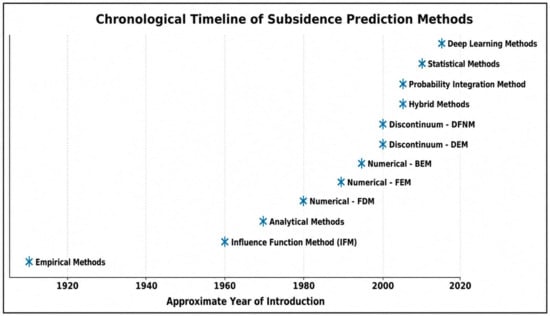
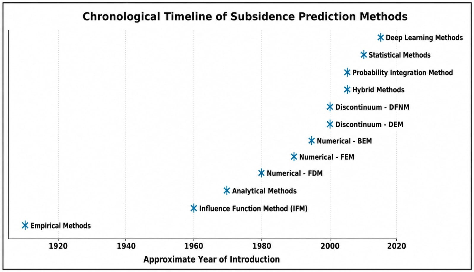
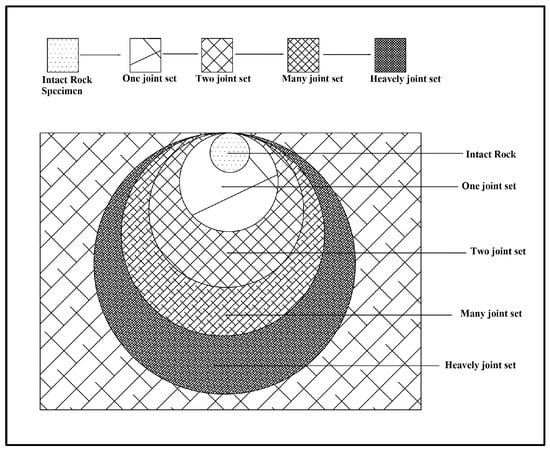
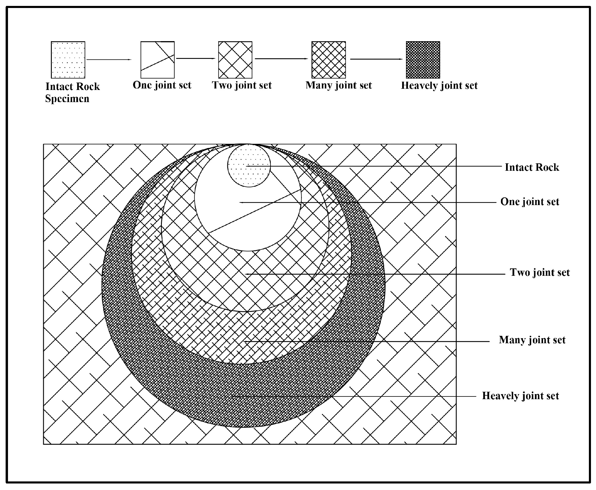
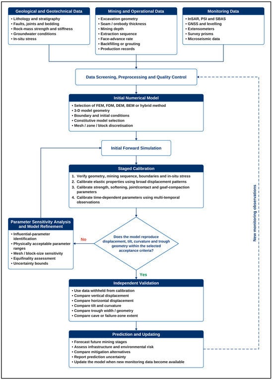
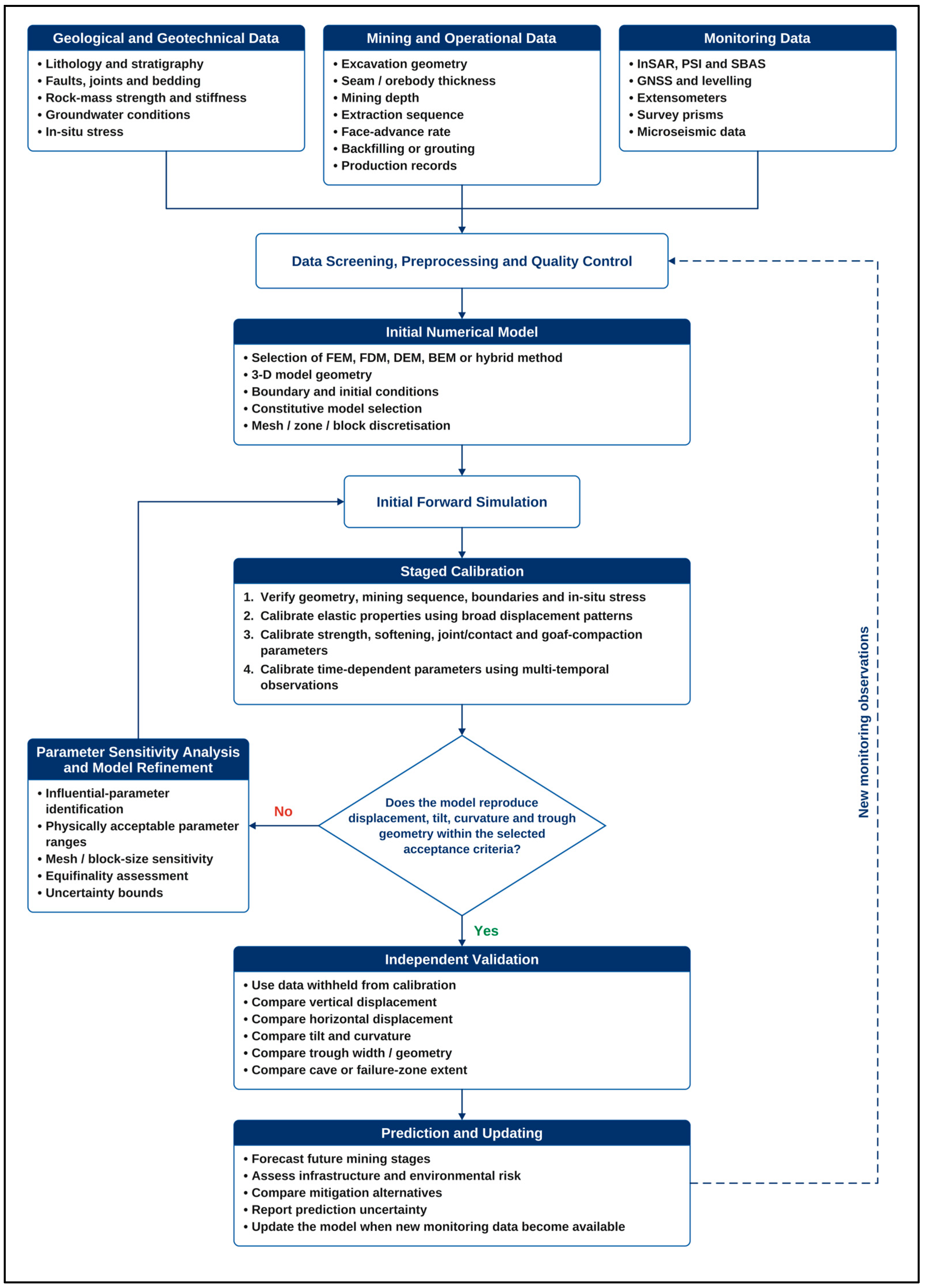

Disclaimer/Publisher’s Note: The statements, opinions and data contained in all publications are solely those of the individual author(s) and contributor(s) and not of MDPI and/or the editor(s). MDPI and/or the editor(s) disclaim responsibility for any injury to people or property resulting from any ideas, methods, instructions or products referred to in the content. |
© 2026 by the authors. Licensee MDPI, Basel, Switzerland. This article is an open access article distributed under the terms and conditions of the Creative Commons Attribution (CC BY) license.