


Abstract
As artificial intelligence (AI) becomes increasingly integrated into spatial planning and governance, a central challenge is translating AI-enabled technical capabilities into institutionally usable spatial decision-making capacity. Taking territorial spatial governance (TSG) in China as a context-specific governance setting, this study combines bibliometric analysis and structured review to examine its knowledge evolution, technical pathways, and spatial decision-making constraints. The results show that: (1) research has progressively shifted from digital support and spatial monitoring toward intelligent analysis and governance-oriented applications; (2) four recurrent pathways of AI embedding are synthesized from the literature—sensing and identification, analytical simulation, decision support, and platform coordination; (3) the translation of these technical capabilities into spatial decision-making capacity is constrained by heterogeneous data foundations, limited model interpretability and transferability, institutional misalignment, and uneven organizational implementation; and (4) spatial decision-making capacity emerges through the interaction of technical pathways and constraint mechanisms under the multi-scale, differentiated, and rule-bound spatial logic of TSG. These findings provide an analytical basis for understanding how AI-enabled technical capabilities are translated from technical feasibility into governance usability under institutionally and spatially specific conditions.
1. Introduction
1.1. Conceptual Context
Territorial spatial governance (TSG) is closely related to the broader international discussion on spatial planning and territorial governance, although its institutional meaning is particularly shaped by the Chinese context. International planning research increasingly treats spatial planning and territorial governance as interrelated institutional processes through which spatial development is coordinated across policy sectors, governance levels, and territorial contexts [1,2]. Recent comparative research further emphasizes that territorial governance concerns the political and institutional processes through which spatial decisions are made, while spatial planning provides the institutional arrangements and technical knowledge supporting such processes; both remain highly context-dependent across national planning systems [3]. In China, TSG has developed into a more integrated governance framework concerned with the development, use, protection, and regulation of territorial space, with increasing emphasis on governance coordination and capacity modernization [4,5,6]. Compared with regional planning, which primarily addresses planning at a particular territorial scale, and land governance, which focuses more specifically on institutions governing land rights, use, and management, TSG encompasses cross-scale planning, regulation, implementation, and coordination. Regional science, by contrast, provides analytical foundations for understanding spatial processes rather than constituting a governance framework itself. Accordingly, TSG is treated here not as a universally standardized international concept, but as a context-specific manifestation of the broader planning–governance nexus.
The term digital-intelligent transformation likewise has no fully standardized equivalent in international scholarship [7,8]. International research generally conceptualizes digital transformation as extending beyond digitization and process digitalization to substantial changes in organizational structures, processes, relationships, and capabilities enabled by digital technologies [9,10,11]. Recent digital-government research further stresses that such transformation emerges from the co-evolution of technology, data, institutions, organizational practices, and governance contexts rather than from technology adoption alone [12,13]. Chinese scholarship increasingly uses digital intelligence and digital-intelligent governance to emphasize the integration of data resources, intelligent algorithms, governance empowerment, and human–machine collaboration [8,14,15]. In this study, digital-intelligent transformation therefore refers to the integration of digital infrastructures and data-driven governance with AI-enabled analytical and decision-support capabilities. An AI perspective does not imply that conventional GIS, remote sensing, or spatial decision-support technologies are themselves AI; rather, it focuses on how AI-related capabilities are incorporated into existing digital governance arrangements and translated into spatial decision-making capacity.
1.2. Research Progress
Research on the digital transformation of TSG in China has progressively moved beyond data infrastructure and platform construction toward integrated spatial representation, continuous monitoring, analytical modeling, and governance-process coordination. Studies on digital territorial space and spatial coding have sought to connect heterogeneous spatial objects, temporal states, and administrative processes through unified digital representations [7,12]. Meanwhile, the China Spatial Planning Observation Network (CSPON), a monitoring and implementation-support framework designed to support territorial spatial planning supervision, dynamic evaluation, and implementation feedback, has promoted the integration of multi-source data, algorithmic models, and monitoring functions into spatial governance [16,17,18,19]. More recent research has shifted attention from technical enablement itself to the reorganization of governance processes, emphasizing data governance, differentiated governance demands, interdepartmental coordination, and the alignment of technical rationality with institutional and societal values [5,20]. This trajectory indicates a gradual broadening of research from digital representation and technical support toward the institutional embedding of digital and intelligent capabilities in TSG.
International research is not generally organized under the label of TSG, but closely related work has developed across spatial planning, planning support systems (PSSs), spatial decision support systems (SDSSs), geospatial artificial intelligence (GeoAI), and AI-enabled public governance. Digital technologies in planning have evolved through successive and overlapping applications of remote sensing, GIS, spatial modeling, PSS/SDSS, and, increasingly, machine learning and other AI techniques [21,22]. Recent reviews show that AI is extending planning support through predictive analytics, scenario generation, optimization, and more adaptive forms of decision support, while its practical uptake remains uneven [23,24]. The emerging integration of GeoAI with advanced cyberinfrastructure further enables scalable analytics, real-time scenario generation, and more complex spatial decision workflows [25]. At the same time, studies increasingly emphasize that improved technical performance does not ensure effective governance application: data quality, model interpretability, institutional capacity, human oversight, public trust, and user adoption remain persistent concerns [25,26,27].
1.3. Research Gaps and Contributions
Despite these advances, three gaps remain. First, research spans heterogeneous conceptual and disciplinary domains, while the interdisciplinary knowledge structure of AI-related TSG research and its relationship with adjacent fields such as digital planning, GeoAI, and AI-enabled governance remain insufficiently clarified. Second, although numerous studies examine individual technologies or applications, limited attention has been given to synthesizing the principal pathways through which AI capabilities become embedded in spatial governance processes. Third, existing studies increasingly recognize technical, institutional, and organizational barriers, yet rarely examine systematically how these constraints condition the translation of technological capability into spatial decision-making capacity [23,24,25]. Accordingly, this study asks the following: Through what technical pathways does AI become embedded in TSG, and under what constraints can these pathways be translated into spatial decision-making capacity? These gaps define three sequential analytical tasks: mapping the knowledge structure and evolution of the field, synthesizing recurrent pathways of AI embedding, and identifying the constraints that condition their translation into spatial decision-making capacity. Building on these analyses, the study further develops an integrative framework linking technical pathways, constraint mechanisms, and spatial decision-making capacity.
2. Materials and Methods
2.1. Data Sources and Search Strategy
A systematic literature search was conducted in the Web of Science Core Collection (WoS) and China National Knowledge Infrastructure (CNKI) to identify studies related to the digital-intelligent transformation of TSG from an AI perspective. Considering the differences between Chinese and English databases in keyword systems, indexing rules, and knowledge organization, WoS was used as the primary database for analyzing knowledge structures, thematic clustering, and hotspot evolution. CNKI data were mainly used to supplement publication trends and reflect the development trajectory of the field in the Chinese context.
The WoS search covered the Science Citation Index Expanded (SCIE) and Social Sciences Citation Index (SSCI) and followed a two-part conjunctive structure, requiring at least one term from each of the two search-term groups shown below in the topic field (TS) (Table 1). The retrieval period covered 1 January 1980 to 31 December 2025, with the final search conducted in February 2026. A small number of records with Early Access dates in 2025 were formally published in 2026 and were treated according to their formal publication year. For CNKI, an equivalent search strategy was applied using corresponding Chinese terms, with journal sources restricted to China Academic Journals Full-text Database (CAJC), Chinese Social Sciences Citation Index (CSSCI), or Chinese Science Citation Database (CSCD) journals. After screening and preprocessing, 527 valid publications were retained, including 409 WoS-indexed publications and 118 CNKI-indexed Chinese core-journal publications. The year 1980 was adopted as a deliberately broad lower bound to avoid truncating potential early antecedents of digital spatial analysis and intelligent decision support; no eligible records were ultimately identified before 2008.
Table 1.
Two-part conjunctive search strategy used for the WoS Core Collection.
2.2. Bibliometric Analysis
Bibliometric analysis was conducted using CiteSpace v. 7.0.R0. CiteSpace constructs temporal co-occurrence networks from bibliographic records and uses clustering and burst detection to identify major knowledge domains, evolutionary trajectories, and emerging research fronts. A one-year time slice was adopted, with keywords selected as the primary node type. The g-index was used for node selection (k = 20), and cluster labels were generated primarily using the log-likelihood ratio algorithm. Modularity (Q) and weighted mean silhouette (S) were used to evaluate the structural differentiation and internal consistency of keyword clusters. For keyword burst detection, γ was set to 0.4, with the remaining parameters retained at their default settings (minimum duration = 2 years). The bibliometric results were subsequently used to identify major thematic domains, research fronts, and representative studies for the structured review described in Section 2.3.
2.3. Structured Review and Synthesis
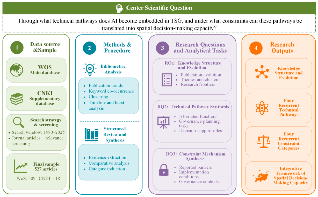
Following the bibliometric mapping, a structured review was conducted to examine how AI-related capabilities are represented in spatial governance research and under what conditions they are translated into decision support (Figure 1). The review was organized around the three analytical tasks derived from Section 1.3: knowledge-structure interpretation, technical-pathway synthesis, and constraint-mechanism synthesis. Representative studies were identified from major thematic clusters, research fronts, and highly relevant studies retrieved through the literature search.
For the technical-pathway synthesis, the reviewed studies were compared in terms of the AI-related function involved, the governance or planning task addressed, and the role performed in spatial decision-making. For the constraint synthesis, reported barriers and implementation conditions were extracted and compared across studies, with attention to their effects on the translation of technological capabilities into governance practice. Similar concepts were progressively grouped into higher-order categories through comparative synthesis. The specific technical pathways and constraint categories were therefore not predefined in the research design; they emerged from the structured review and are reported as findings in Section 3.2 and Section 3.3. These synthesized findings were subsequently integrated in Section 4 to develop the conceptual framework of spatial decision-making capacity.
Figure 1.
Research design and analytical workflow. Note: The three analytical tasks are derived from the research gaps identified in Section 1.3. The specific technical pathways and constraint categories are outputs of the structured review rather than predefined analytical categories.
3. Results
Throughout the results, the AI perspective is used as an analytical lens rather than as a claim that all technologies in the corpus are AI; conventional digital and geospatial technologies are considered insofar as they provide the infrastructural and functional context for AI-enabled spatial governance.
3.1. Knowledge Structure and Research Evolution
3.1.1. Evolutionary Characteristics and Stage Division
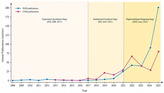
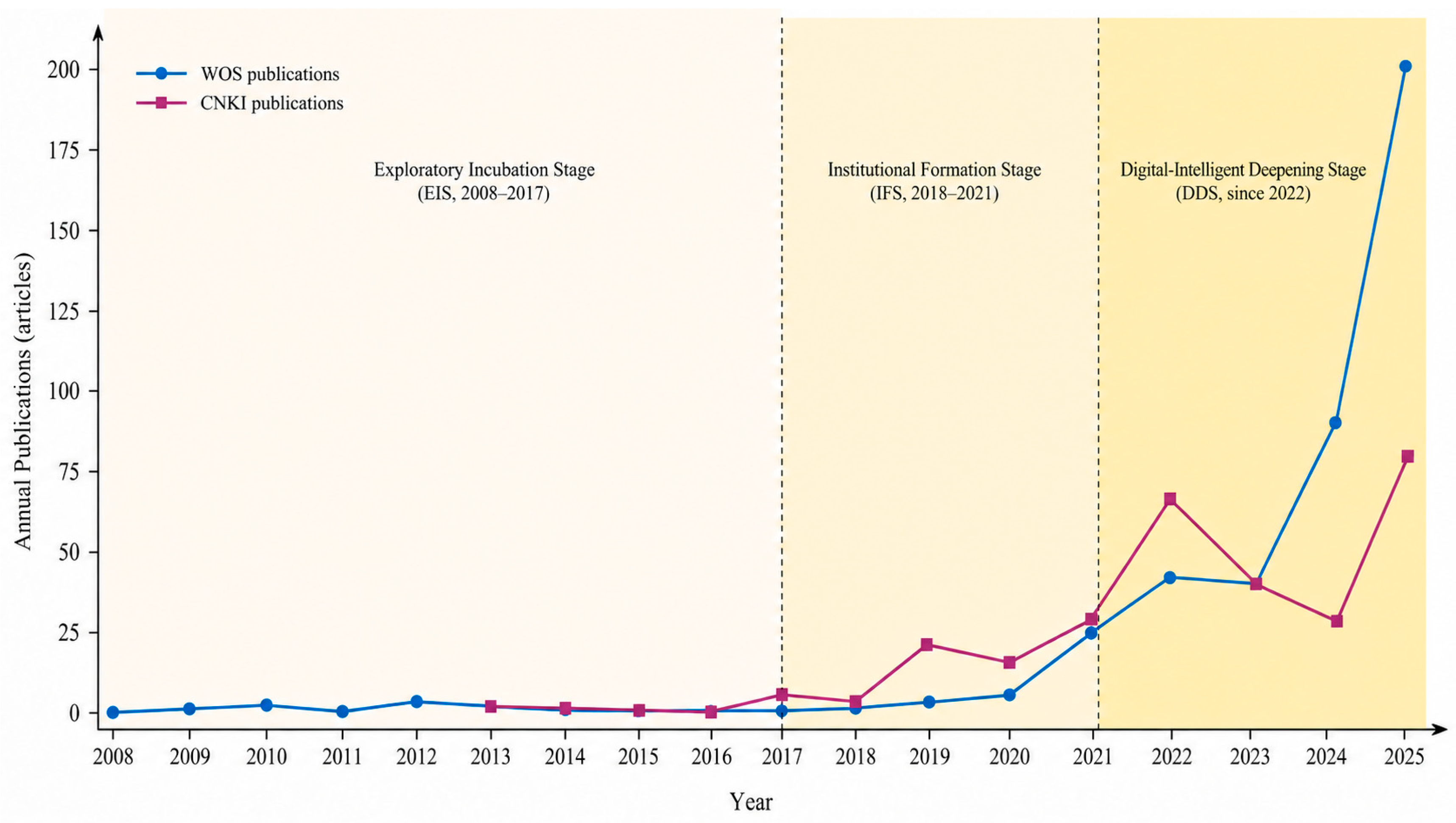
According to the publication trends (Figure 2), the literature has generally evolved from technological exploration toward governance deepening. Before 2017, the field remained at a relatively low and fluctuating level. Annual publication volume was limited, and related topics were largely scattered across adjacent fields such as digital cities, smart planning, and land-use monitoring. During this period, AI had not yet entered TSG research in a systematic manner. After 2018, publication growth coincided with the institutional restructuring of natural-resource management and the gradual establishment of China’s territorial spatial planning system. Research attention shifted from isolated technological applications to planning governance, platform construction, land-use regulation, and implementation supervision. Since 2022, publication growth has accelerated alongside the implementation of territorial spatial planning, broader digitalization initiatives, and rapid advances in AI technologies. The research focus has further shifted from “digital support” toward “digital-intelligent governance” with increasing attention to intelligent identification, scenario simulation, dynamic monitoring, platform coordination, and governance restructuring.
Figure 2.
Publication trends and stage division. Note: The blue line represents the annual number of WoS-indexed publications, whereas the purple line represents the annual number of CNKI-indexed Chinese publications. Shaded bands indicate the three developmental stages. No eligible publications were identified before 2008; therefore, the publication series is displayed for 2008–2025, while the broader search window covered 1980–2025. The three stages were delineated by jointly considering changes in publication trends, major institutional and policy milestones, and thematic evolution. The 2025 observation represents a complete publication year in the analytical corpus.
Based on changes in publication scale, institutional turning points, and technological evolution, research in this field is divided into three stages: the exploratory incubation stage (EIS; 2008–2017), the institutional formation stage (IFS; 2018–2021), and the digital-intelligent deepening stage (DDS; since 2022). Overall, the evolution of this field reflects a structural progression from technological exploration to institutional embedding and then to the deepening of intelligent governance. From the perspective of language distribution, CNKI-indexed publications grew more rapidly during the institutional formation stage, whereas WoS-indexed publications increased more significantly during the digital-intelligent deepening stage. This pattern indicates increasing visibility of the topic in WoS-indexed literature during the latest stage.
3.1.2. Research Themes and Thematic Domains
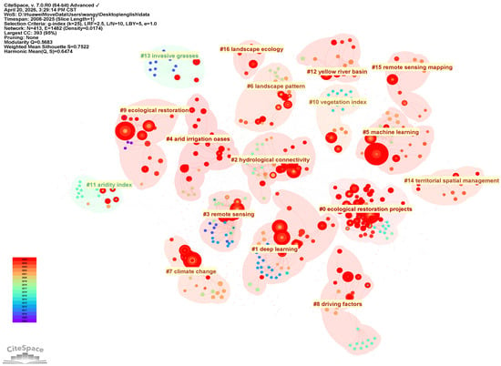
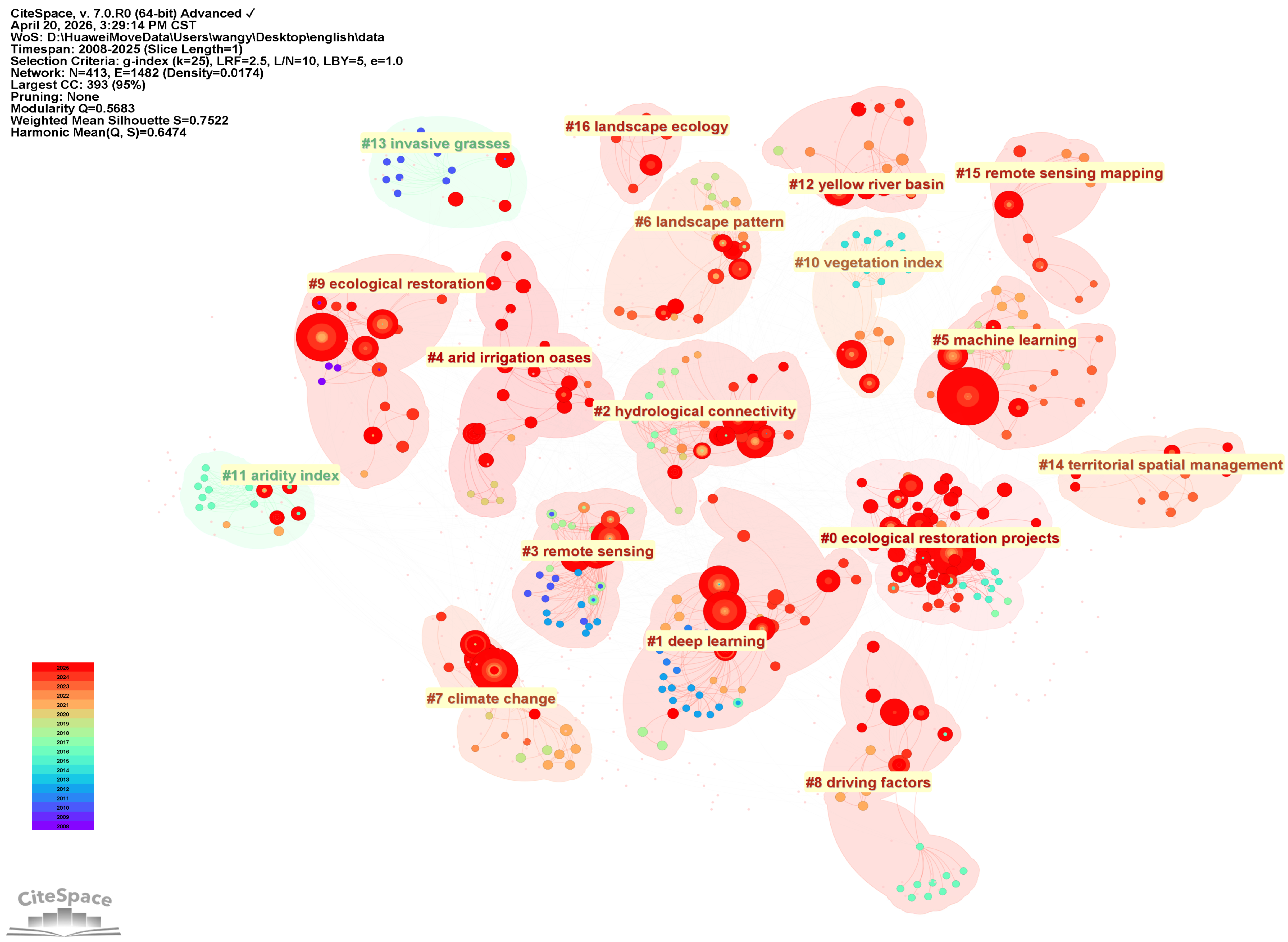
Based on the keyword clustering results from the WoS dataset (Figure 3), the algorithmically identified clusters were further consolidated, based on semantic similarity and comparative interpretation, into four higher-order thematic domains. The first concerns spatial sensing and remote sensing-based identification, including remote sensing, remote sensing mapping, and vegetation index. This cluster reflects sustained attention to spatial object identification, surface-process monitoring, and geospatial information extraction. The second concerns machine learning and intelligent analytical methods, including machine learning and deep learning. These studies indicate that AI is being increasingly embedded in spatial classification, pattern recognition, predictive analysis, and optimization-based decision processes. The third concerns ecological restoration and resource–environment governance, including ecological restoration projects, ecological restoration, landscape ecology, hydrological connectivity, climate change, and aridity index. This cluster shows that AI has been widely applied to ecological restoration, landscape pattern analysis, environmental monitoring, and climate adaptation. The fourth concerns spatial management and regional application contexts, including territorial spatial management, the Yellow River Basin, and arid irrigation oases. This cluster indicates that research has gradually become connected with specific regional contexts and spatial governance issues. Therefore, WoS-indexed research has formed a composite knowledge structure characterized by the interweaving of intelligent methods, ecological applications, and spatial management.
Figure 3.
Keyword clustering and thematic structure of WoS-indexed literature. Note: CiteSpace-generated keyword clusters were further consolidated into four higher-order thematic domains based on semantic similarity and comparative interpretation.
3.1.3. Research Frontiers and Overall Characteristics
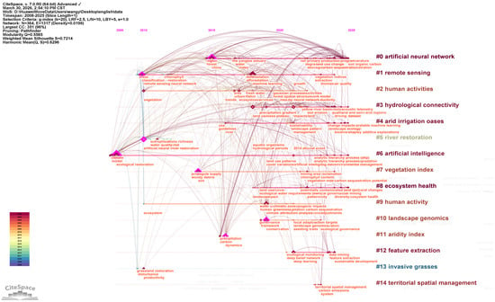
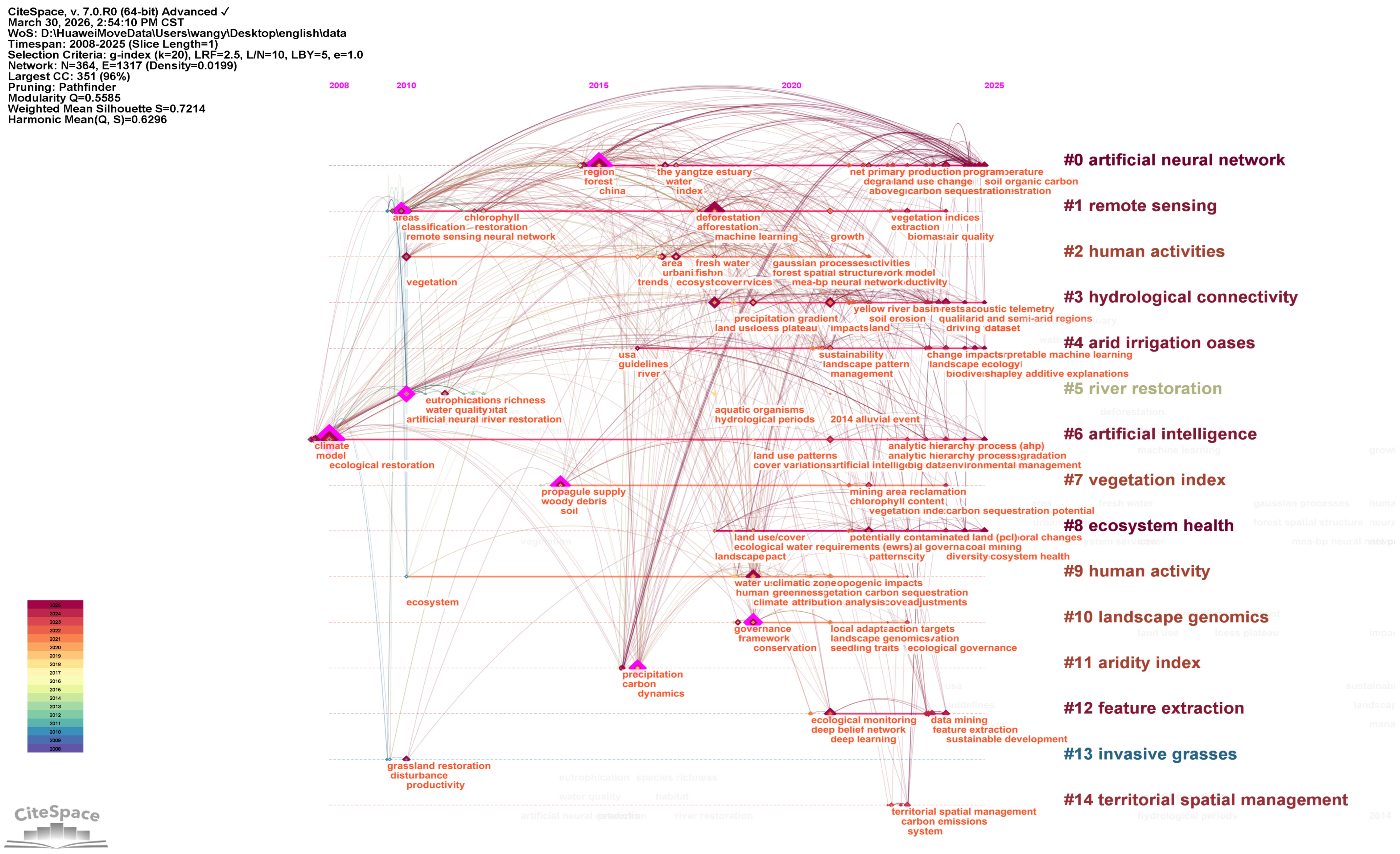
The keyword timeline (Figure 4) indicates a gradual shift in research frontiers from remote sensing-based identification and ecological monitoring toward machine learning-driven spatial analysis and governance-oriented applications. Early studies concentrated on remote sensing, vegetation indices, ecological restoration, and river restoration, primarily addressing spatial identification, environmental monitoring, and restoration assessment. Subsequent research increasingly incorporated machine learning, human-activity analysis, hydrological connectivity, and regional process modeling, extending the analytical focus from observation toward inference and simulation. More recently, deep learning, feature extraction, interpretable machine learning, ecological governance, and territorial spatial management have gained prominence, suggesting a further extension toward intelligent analysis and governance-related applications.
Figure 4.
Keyword timeline and evolution of research frontiers in WoS-indexed literature.
Keyword burst detection provides complementary evidence for this trajectory. Sustained earlier bursts in artificial neural networks (2010–2021) and river restoration (2012–2018), together with recent bursts in artificial intelligence and land-use change (both 2023–2025), suggest a transition from earlier emphases on computational modeling and ecological restoration toward more explicit AI-enabled spatial analysis and land-use applications.
Overall, three characteristics emerge from the WoS-indexed literature. First, the field remains strongly method-oriented, with remote sensing and machine learning constituting major technical foundations. Second, ecological restoration and resource–environment governance remain prominent application domains, while land-use and territorial-management issues have gained increasing attention. Third, interdisciplinary integration has intensified through the convergence of geographic information science, remote sensing, landscape ecology, environmental science, and spatial governance. Collectively, these patterns indicate an evolution from “spatial identification and environmental monitoring” toward a composite trajectory integrating “intelligent analysis, governance application, and spatial management.”
3.2. Technical Pathways
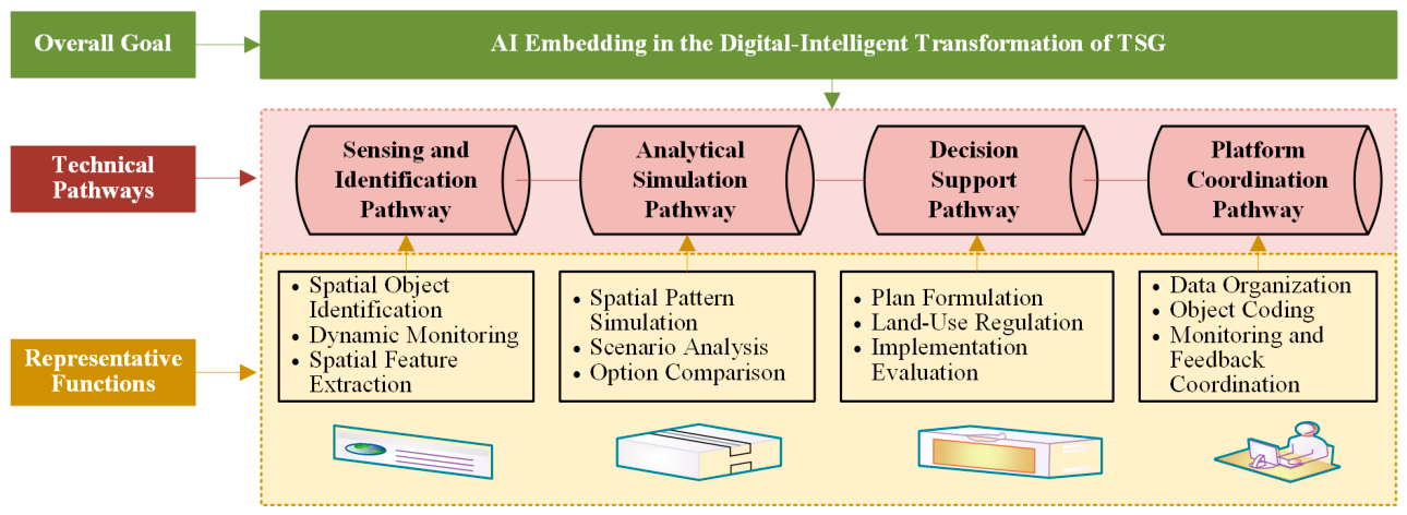
The preceding analysis indicates that related research has gradually shifted from method-driven inquiry to governance-oriented application. However, bibliometric mapping alone cannot directly reveal the specific mechanisms through which AI is embedded in TSG. Therefore, on the basis of knowledge structure identification and representative literature analysis, the structured review identified four recurrent technical pathways through which the reviewed literature conceptualizes or applies AI-related capabilities in TSG: sensing and identification, analytical simulation, decision support, and platform coordination (Figure 5). These categories were derived by comparing the technical functions of AI-related methods, the governance tasks they address, and their roles in spatial decision-making. These pathways should not be interpreted as functions unique to AI; rather, they represent recurrent governance functions through which AI-related capabilities are layered onto and interact with pre-existing digital spatial infrastructures and decision-support practices.
Figure 5.
Four recurrent technical pathways of AI embedding synthesized from the reviewed literature. Note: The pathways are analytically distinguished but functionally interrelated rather than strictly sequential. They were derived through comparative synthesis of AI-related functions, governance tasks, and decision-support roles rather than predefined as analytical categories.
3.2.1. Sensing and Identification Pathway: Spatial Object Identification and Dynamic Monitoring
The sensing and identification pathway forms the foundation of AI embedding in TSG. It focuses on the continuous identification and representation of spatial objects, spatial states, and spatial changes through multi-source information such as remote sensing, IoT, and operational data. Existing studies indicate that digital TSG depends on a unified spatiotemporal foundation and an object-based representation system. Only when spatial objects can be identified, associated, and tracked can subsequent analysis, transmission, and governance proceed on a stable basis [28,29,30]. In recent years, multi-source remote sensing, geospatial big data, and multimodal data fusion have been widely applied to urban growth boundary delineation, functional zone identification, and spatial change monitoring, thereby improving both recognition accuracy and update timeliness [31,32,33,34]. Moreover, digital twins and cross-city semantic segmentation have extended spatial sensing from “identifying current conditions” to “detecting change” and “discovering deviation” [35,36]. With the continued advancement of CSPON, spatial sensing has begun to directly support planning implementation supervision and dynamic feedback [16,37,38,39]. Its significance lies in providing a unified representational basis for planning units, regulatory units, ecological restoration units, and implementation supervision objects, thereby supporting cross-level planning transmission and differentiated spatial governance.
3.2.2. Analytical Simulation Pathway: Multi-Scale Spatial Inference and Scenario Analysis
Analytical simulation deepens the sensing and identification pathway by shifting the focus from object recognition to the inference of spatial change and the analysis of pattern evolution. TSG requires models and algorithms to conduct integrated analysis and forward-looking judgment on spatial pattern evolution, resource–environment constraints, and development boundaries [40,41,42]. One line of research has applied ANN-CA, random forests, multi-source geospatial big data, and graph neural networks to simulate urban growth boundaries, development boundaries, and construction land expansion [43,44,45]. Another has extended simulation toward scenario analysis and multi-objective optimization by introducing ecological protection, cultivated land constraints, and economic efficiency [46,47,48]. At the same time, intelligent planning technologies oriented toward urban–rural integration, climate adaptation, and resilience governance are promoting a shift from “result prediction” to “option comparison” and “strategy preview” [42,49,50]. Unlike predictive models in general urban governance, analytical simulation in TSG must respond to scale effects, regional differentiation, and boundary constraints, thereby transforming static spatial information into governance knowledge for future-oriented decision-making.
3.2.3. Decision Support Pathway: Plan Formulation, Land-Use Regulation, and Implementation Evaluation
The decision support pathway represents the key stage through which AI moves from technological embedding into actual governance operation. Its core lies in incorporating data, rules, and models generated through identification and simulation into plan formulation, land-use regulation, and implementation evaluation. As a result, decision-making gradually shifts from experience dependence to data support, rule constraints, and intelligent assistance. Digital TSG involves the full process of basic analysis and evaluation, plan formulation, land-use regulation, implementation supervision, and performance assessment [16,17,19]. In plan formulation, AI can enhance the analytical rigor and responsiveness through rule matching, knowledge association, scheme simulation, and boundary identification [51,52]. In land-use regulation, digital-intelligent technologies have expanded into planning transmission, zoning-based control, and supervision and enforcement [53,54]. In implementation evaluation, research on CSPON, algorithmic model systems, and AI agents has promoted a shift from outcome evaluation to process feedback [16,19,37,52]. Compared with general administrative decision-making, decision support in TSG is more strongly governed by spatial rules, especially in relation to hierarchical planning transmission, land-use access control, rigid boundary verification, and spatial deviation correction.
3.2.4. Platform Coordination Pathway: Spatial Infrastructure, Rule Embedding, and Collaborative Governance
The platform coordination pathway provides the infrastructural basis for the digital-intelligent transformation of TSG. Its key function is to connect different governance levels, sectors, and operational scenarios through the coordinated construction of digital foundations, spatial coding, and monitoring networks. Digital TSG relies on a unified foundation for the integration of data organization, rule expression, and business coordination [29,55]. Within this system, the digital foundation supports the unified organization of multi-source heterogeneous data, spatial coding ensures the unique identification and continuous association of spatial objects, and the monitoring network promotes governance operation from static support to dynamic feedback [28,55,56]. More broadly, research on digital-intelligent governance and intelligent governance suggests that platform coordination is not limited to system interconnection. It also involves the closed-loop integration of data, algorithms, services, and feedback under conditions of human–machine collaboration and rule embedding [15,57]. In TSG, such coordination forms a cross-level and cross-departmental collaborative environment based on spatial objects, spatial rules, and spatial processes, thereby supporting multi-scale governance tasks.
Overall, the technical pathways of the field have gradually extended from localized application to key links of cognition, inference, decision, and coordination. However, whether these pathways can be further transformed into spatial decision-making capacity still depends on data structures, model adaptation, institutional articulation, and organizational absorption. Therefore, the major constraints affecting the transformation from technical pathways to spatial decision-making capacity require further analysis.
3.3. Constraints on Spatial Decision-Making Capacity
The reviewed literature suggests that advances in AI and related digital technologies have created new possibilities for enhancing TSG capacity, while recurrently reporting difficulties in translating these capabilities into governance practice. Comparative synthesis of the reviewed studies identified four recurrent categories of constraints affecting the translation of AI-related technical capabilities into spatial decision-making capacity: data foundations, model application, institutional articulation, and organizational implementation. These categories reflect recurring barriers reported across the reviewed literature rather than predefined analytical dimensions.
3.3.1. Data Foundation Constraints: Multi-Source Heterogeneity and Sharing Barriers
The digital-intelligent transformation of TSG is first constrained by the structure of its data foundations. Territorial spatial data are highly diverse. They include government data such as remote sensing imagery, survey and monitoring records, planning outcomes, and approval and supervision data, as well as Internet, IoT, and socioeconomic data. These sources differ significantly in type, scale, precision, and update frequency, thus exhibiting typical multi-source heterogeneity [29,55]. In the context of TSG, such heterogeneity is reflected not only in the technical difficulty of data integration but also in the inconsistency among spatial units, administrative units, and statistical units. Consequently, the common basis for cross-scale analysis and spatial transmission is weakened. Over time, different departments have formed their own classification systems, coding rules, and standards. This has constrained the deep coordination of the “One Map” system (a unified digital framework for integrating territorial spatial planning data and implementation information), digital foundations, and intelligent models [28]. Meanwhile, territorial spatial data possess both administrative and governance attributes. Their sharing processes remain subject to departmental authority structures and approval procedures, and institutional friction remains substantial [30,52,58]. More generally, the difficulties of data governance lie not only in limited integration capacity but also in the lack of stable coupling among data ownership definition, sharing incentive mechanisms, and standards systems [52,59]. Therefore, data constraints essentially reflect the structural segmentation of spatial governance boundaries and directly affect the continuity and logical consistency of the information on which spatial decision-making depends.
3.3.2. Model Application Constraints: Algorithmic Black Boxes and Scenario Adaptation
AI models have substantially enhanced computational capacity in spatial identification, pattern simulation, and scenario analysis. However, their capacity to be embedded into governance remains constrained by both interpretability and transferability. On the one hand, methods such as deep learning, graph networks, and ensemble models perform well in tasks such as boundary delineation and functional identification, yet their internal mechanisms are often highly complex, which produces a strong “algorithmic black-box” effect and makes model outputs difficult to apply directly [46]. This issue becomes especially critical when rigid spatial constraints are involved, such as ecological protection red lines, permanent basic farmland, and urban development boundaries. In such contexts, model outputs must satisfy requirements of interpretability and traceability; otherwise, they cannot be translated into institutional decision-making bases. On the other hand, most existing models are built on specific regional samples, spatial scales, and contextual conditions, and their cross-regional transferability remains limited. When spatial scale changes occur, such as shifts from national to regional, urban, or rural contexts, or when governance objectives change, parameter instability, structural mismatch, and output deviation often emerge [31,48,60]. Therefore, no universally applicable technical shortcut exists for the digital-intelligent transformation of TSG. More importantly, TSG itself is strongly institutional, region-specific, and public in nature. Consequently, technological logic cannot automatically substitute for governance logic. Many current applications still remain at the levels of identification, visualization, and localized early warning, and their integration with practical governance tasks, such as planning formulation, remains limited. This suggests a persistent mismatch between technological supply and governance demand [6,61,62,63]. Hence, the key constraint in technological application lies not merely in algorithmic performance but in the absence of stable support across interpretability, transferability, and governance-scenario adaptation.
3.3.3. Institutional Articulation Constraints: Misalignment Among Planning Transmission, Land-Use Regulation, and Approval Supervision
A deeper challenge in the digital-intelligent transformation of TSG lies in the failure to achieve genuine institutional integration across departments. Although territorial spatial planning, land-use regulation, and approval supervision have gradually been integrated under the framework of “multiple plans into one” reform, which integrates previously separate sectoral spatial plans into a unified territorial spatial planning framework, misalignments remain in their objective logic, rule systems, and implementation procedures. Territorial spatial planning emphasizes spatial arrangement and structural optimization. Land-use regulation emphasizes zoning-based constraints and permission rules. Approval supervision, by contrast, focuses on project implementation and process control. Consequently, the articulation among these components remains insufficient. Studies on the land-use regulation system have shown that current reforms still face problems such as fragmented rule systems, insufficient linkage among regulatory elements, and approval integration that remains at the level of “physical integration” [53,64]. Research on the digitalization of special planning also indicates that digital outputs do not necessarily imply integrated implementation mechanisms. Without unified rule expression and transmission mechanisms, platform systems can hardly realize institutional coordination automatically. Moreover, although CSPON proposes full-process online management covering planning formulation, approval, implementation, and supervision, its effective operation still depends on the synchronous adjustment of planning output forms, approval item settings, and supervisory responsibilities [16,18,19]. From a governance perspective, digital-intelligent transformation does not simply require existing institutional procedures to be digitized and transferred online. Rather, it requires planning transmission, land-use regulation, and approval supervision to form a closed loop equipped with rule expression, responsibility allocation, and feedback-response mechanisms.
3.3.4. Organizational Implementation Constraints: Organizational Capacity and Local Differentiation
The digital-intelligent transformation of TSG must ultimately be realized through organizational implementation. Its effectiveness depends not only on technical schemes but also on whether governance actors can form stable coordination mechanisms and sustained implementation capacity. The reviewed studies frequently report fragmented departmental responsibilities, dispersed data responsibilities, and insufficient coordination incentives across departments. Many cross-departmental matters still rely on offline coordination and experience-based promotion. At the same time, the reviewed literature also highlights substantial regional differences in funding, technical foundations, professional or staff capacity, and organizational readiness. As a result, digital-intelligent transformation displays clear local differentiation. Some regions have moved from system construction to process reengineering and scenario application, whereas others remain at the stage of platform display and informatization layering. Existing studies indicate that knowledge and skills, value norms, and dynamic learning capacity are critical to the outcomes of digital transformation in TSG, and insufficient core capacity directly constrains both technological implementation and institutional operation [6,52,65,66]. In the Chinese governance context, organizational constraints affect not only implementation efficiency, but also the depth of technological embedding within governance systems, thereby constraining the formation of spatial decision-making capacity. The digital-intelligent transformation of TSG from an AI perspective should therefore be understood as a systemic transformation involving organizational restructuring, capacity building, and governance-mode adjustment.
Overall, the digital-intelligent transformation of TSG is constrained by a multidimensional system formed through the interaction of data, models, institutions, and organizations. Data foundations affect the consistency of spatial cognition; model capacity constrains interpretability and transferability; institutional systems determine whether technology can enter planning transmission and implementation supervision; and organizational capacity shapes the continuity of technological embedding and local adaptation. Together, these factors indicate that the key issue in AI-enabled TSG lies in whether technology can be effectively embedded into institutional systems and transformed into stable spatial decision-making capacity. Table 2 consolidates the four constraint categories synthesized from the reviewed literature and summarizes their manifestations, direct implications, and underlying mechanisms.
Table 2.
Synthesized constraint categories and their implications for spatial decision-making capacity.
4. Conceptual Framework and Capacity Formation
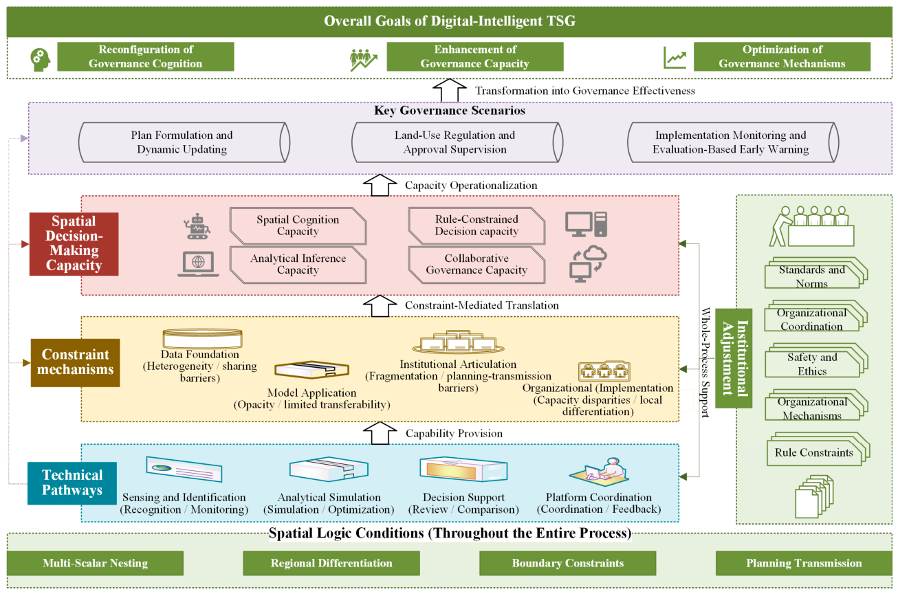
Building on the findings synthesized in Section 3.2 and Section 3.3, this section integrates the recurrent technical pathways and constraint mechanisms identified in the reviewed literature into a higher-order conceptual framework of spatial decision-making capacity (Figure 6). The framework is therefore not an a priori model used to classify the literature; rather, it is a second-order synthesis developed from the empirical patterns identified through the structured review.
4.1. Analytical Framework and Capacity Dimensions
The synthesis in Section 3.2 and Section 3.3 indicates that the reviewed literature converges around recurrent pathways of AI embedding and corresponding constraints on their translation into spatial decision-making capacity. The central analytical issue is therefore not whether AI-related technologies can be applied to spatial governance, but how technical capabilities become institutionally embedded and spatially calibrated.
On this basis, an analytical framework of “technical pathways–constraint mechanisms–spatial decision-making capacity” is constructed. Its core logic is as follows: Technical pathways provide TSG with capability foundations for sensing, simulation, decision-making, and coordination. Constraint mechanisms determine whether these capabilities can enter key governance links such as planning transmission, land-use regulation, implementation supervision, and cross-level coordination. Spatial decision-making capacity is produced through the coupling of these two dimensions. The relationships among them are not linear, but nested and dynamically interactive. Technical pathways extend the boundaries of governance tools, but their effects remain constrained by data structures, rule systems, and organizational capacity. Constraint mechanisms function not only as limiting conditions but also as structuring conditions for technological embedding through standards, responsibility arrangements, and coordination mechanisms. Spatial decision-making capacity is gradually generated within this nested relationship and in turn tests the degree of fit between technological configurations and institutional arrangements. In TSG, characteristics such as multi-scale nesting, regional differentiation, and rigid boundary constraints require technical pathways to undergo institutional filtering and spatial–logical calibration. Therefore, the core of digital-intelligent transformation lies not in the mere adoption or accumulation of technologies but in the stable coupling among technical pathways, constraint mechanisms, and spatial decision-making capacity, thereby promoting the overall optimization of governance cognition and governance mechanisms.
Within this framework, spatial decision-making capacity is treated as a higher-order governance capacity rather than a single technical output. Functionally, the four technical pathways correspond to four interrelated capacity dimensions: spatial cognition capacity, analytical inference capacity, rule-constrained decision capacity, and collaborative governance capacity. These dimensions are not additional inductively coded categories; rather, they are conceptual translations of the functions represented by sensing and identification, analytical simulation, decision support, and platform coordination, respectively. Their formation depends on how pathway-specific technical functions are mediated by the data, model, institutional, and organizational conditions identified in Section 3.3 and are calibrated to the multi-scale and rule-bound spatial logic of TSG.
Figure 6.
Integrative conceptual framework linking technical pathways, constraint mechanisms, and spatial decision-making capacity. Note: The framework represents a second-order synthesis of the technical pathways and constraint categories identified in Section 3.2 and Section 3.3.
4.2. Capacity Formation Mechanisms
Spatial decision-making capacity does not emerge as a natural spillover of technical capacity. Rather, it is gradually formed through the sustained coupling of data, models, rules, organizations, and scenarios. These capacity dimensions are not generated through one-to-one mechanisms; rather, they are jointly formed through three interrelated processes: cognitive foundation reconstruction, analytical inference transformation, and institutional embedding. The first is the cognitive foundation reconstruction mechanism. Through multi-source sensing, object identification, and dynamic monitoring, AI improves the representation of spatial objects, the identification of spatial states, and the capture of spatial change. In this way, a unified cognitive foundation is provided for the identification of planning units, the delineation of regulatory objects, and implementation supervision. A unification and dynamization of the cognitive system therefore constitute the precondition for the formation of spatial decision-making capacity. The second is the analytical inference transformation mechanism. Through spatial simulation, scenario analysis, and option comparison, AI transforms static spatial information into comparative knowledge oriented toward the future, thereby shifting spatial governance from simple experience-based judgment to decision-making jointly supported by data, models, and rules. The third is the institutional embedding and process transformation mechanism. Technical capacity can only be transformed into spatial decision-making capacity when it enters institutionalized processes such as plan formulation, land-use regulation, implementation evaluation, and cross-departmental coordination, and when it is stably absorbed through rule expression, responsibility allocation, and feedback-correction mechanisms.
Spatial decision-making capacity in TSG exhibits pronounced multi-scale and differentiated characteristics. Governance objects, rule structures, and decision tasks differ across scales, and complex transmission relationships exist among national, regional, urban, county, and parcel levels. At the same time, different regions show substantial variation in natural endowments, resource–environment carrying capacity, development intensity, and functional positioning. Accordingly, the formation of spatial decision-making capacity does not depend on a single model or a unified platform. Rather, it depends on whether the technical system can incorporate spatial logics such as scale effects, regional differentiation, and boundary constraints, and further generate operational institutional expressions under zoning-based and category-based governance. In this sense, spatial decision-making capacity is essentially a comprehensive governance capacity generated through technical support, institutional uptake, and spatial–logical calibration.
4.3. Capacity Operationalization in Governance Scenarios
The proposed framework can be further interpreted through three representative governance scenarios in which such spatial decision-making capacity becomes operational: plan formulation and updating, land-use regulation and approval supervision, and implementation monitoring and evaluation. The first is the scenario of plan formulation and dynamic updating. This scenario reflects a shift from static planning schemes to dynamic optimization. Continuous sensing and scenario simulation can support rolling plan updates. Its core lies in enhancing the responsiveness of the planning system to spatial change and uncertainty. The second is the scenario of land-use regulation and approval supervision. This scenario emphasizes rule expression and boundary verification by embedding spatial zoning and regulatory rules into approval processes, thereby materializing decision-making capacity as compliance review and dynamic supervision. The third is the scenario of implementation monitoring and evaluation-based early warning. Through a closed loop of “sensing–evaluation–feedback–correction,” this scenario shifts governance from result-based judgment toward process-based regulation and strengthens the capacity for implementation deviation identification and risk early warning.
Together, these three scenarios constitute the principal operational contexts for the generation of spatial decision-making capacity. Planning provides the directional framework, regulation ensures rule implementation, and monitoring forms the feedback mechanism, thereby constructing an integrated governance loop. Only when technical pathways achieve stable embedding within these scenarios and form a consistent operational logic with spatial rules, organizational coordination, and institutional support can AI-enabled TSG move from localized experimentation to stable operation. Its essence lies in promoting the continuous generation of spatial decision-making capacity and the structural optimization of governance systems through technological embedding and institutional uptake.
5. Discussion
5.1. Theoretical Implications
The principal theoretical implication of this study is that the digital-intelligent transformation of TSG should be understood as a process of capability translation rather than technology adoption. Digital transformation research has long emphasized that technological change becomes consequential only when accompanied by changes in organizational structures, institutional arrangements, and working practices [10,13]. A similar logic is evident in spatial planning, where the longstanding implementation gap of planning support systems shows that analytical sophistication alone does not ensure practical uptake [67,68]. In TSG, this translation is further conditioned by spatially specific requirements, including multi-level planning transmission, territorial differentiation, statutory zoning, and rigid boundary constraints. Chinese scholarship likewise increasingly frames digital transformation as a reorganization of governance processes rather than a simple extension of information infrastructure [5,16,20].
Accordingly, the constraints identified in this study should not be treated merely as external barriers to technological diffusion. Data standards, model interpretability, institutional articulation, and organizational capacity function as mediating conditions that determine whether technical outputs become reviewable, rule-compatible, and operationally usable. Spatial decision-making capacity therefore emerges only when analytical capability is coupled with institutional uptake and spatial–logical calibration. This interpretation extends generic digital-transformation theory by foregrounding the institutional specificity of spatial decision-making and reframes AI-enabled TSG as a socio-technical process in which technical performance and governance usability must be jointly achieved [25].
5.2. International Relevance and Transferability
Although TSG is institutionally specific to China, the underlying problem addressed by this study—how digital and AI-enabled capabilities are translated into legitimate and operational spatial decision-making—is not China-specific. What is transferable is therefore not China’s institutional configuration itself, such as the unified territorial spatial planning system or CSPON, but the analytical relationship among technical capabilities, governance constraints, and decision-making capacity [5,16].
Evidence from other regions suggests that the relative importance of these constraints varies markedly by institutional and developmental context. In Africa, spatial-data infrastructures remain uneven, and the effectiveness of digital land administration is strongly conditioned by data quality, interoperability, technical skills, institutional coordination, and locally specific tenure arrangements [69,70,71]. In Brazil, recent studies demonstrate the growing capacity of AI and geospatial data to support land-suitability assessment and urban risk analysis, while also showing that technical and strategic risks remain intertwined with governance performance [72,73]. In Asia, Singapore represents a highly data-intensive urban-governance context, whereas South Korean research illustrates how XAI can make spatially relevant AI outputs more interpretable for planning and policy use [74,75]. These differences suggest that the framework is transferable primarily at the level of analytical relationships: similar capability-translation problems recur internationally, but the binding constraints and appropriate institutional responses remain context-dependent.
5.3. Explainable and Agentic AI
Explainable AI (XAI) and agentic AI represent two complementary directions for advancing the institutional embedding of AI in spatial governance. XAI addresses a central weakness of current AI applications: high predictive performance does not necessarily make model outputs reviewable, traceable, or acceptable in formal decision processes. Studies combining machine-learning models with explanatory methods such as SHAP demonstrate how model outputs can be linked to interpretable spatial factors and thereby better support planning and policy assessment [74]. Human-centered AI research further emphasizes that explainability must be combined with transparency, stakeholder understanding, and human oversight rather than treated as a purely technical add-on [25,76,77]. For TSG, XAI is particularly important where AI outputs interact with statutory boundaries, land-use rules, or public-interest trade-offs.
Agentic AI extends this agenda from model interpretation toward multi-step decision workflows. Emerging studies suggest that large models and AI agents may support rule retrieval, spatial-data querying, scenario generation, compliance checking, alternative comparison, and iterative interaction with planners [50,52,68]. However, agentic AI should not be equated with autonomous governance. Its value in TSG depends on authoritative knowledge bases, rule-bounded operation, provenance tracking, access control, and explicit human authorization. Future systems should therefore combine XAI with human-in-the-loop agentic workflows so that AI can expand analytical and coordination capacity without displacing institutional accountability.
5.4. Limitations and Future Research
Several limitations should be acknowledged. First, knowledge-structure analysis relies primarily on WoS records, while CNKI is used mainly to supplement Chinese publication trends; this may underrepresent institutionally specific domestic practices. Second, the technical pathways and constraint categories are derived from structured literature synthesis and remain interpretive rather than empirically causal. Third, the proposed framework has not yet been tested across concrete planning or land-governance cases. Future research should therefore combine comparative case studies, project-level evidence, and longitudinal analysis to examine how pathway–constraint relationships vary across institutional contexts. Particular attention should also be given to XAI, human-in-the-loop evaluation, and rule-constrained agentic AI in scenarios such as plan formulation, land-use regulation, and implementation monitoring.
6. Conclusions
This study examined the knowledge structure, technical pathways, and constraint mechanisms underlying the digital-intelligent transformation of territorial spatial governance (TSG) from an AI perspective through bibliometric analysis and structured review. Four main conclusions can be drawn. First, the field has evolved through three stages—the exploratory incubation stage (2008–2017), the institutional formation stage (2018–2021), and the digital-intelligent deepening stage (since 2022)—with research shifting from remote sensing-based identification and ecological monitoring toward machine learning-driven spatial analysis and governance-oriented applications. Second, the structured review identified four recurrent pathways through which the literature conceptualizes or applies AI-related capabilities in TSG: sensing and identification, analytical simulation, decision support, and platform coordination. Third, these technical capabilities do not automatically translate into spatial decision-making capacity. Their governance uptake is recurrently constrained by heterogeneous data foundations, limited model interpretability and transferability, institutional misalignment, and uneven organizational implementation. Fourth, spatial decision-making capacity emerges through the interaction of technical pathways and constraint mechanisms under the multi-scale, differentiated, and rule-bound spatial logic of TSG and becomes operational only when technical capabilities are institutionally embedded in processes such as plan formulation, land-use regulation, and implementation monitoring.
Overall, the digital-intelligent transformation of TSG is better understood as a process of capability translation rather than mere technology adoption. Its central challenge is to convert AI-enabled analytical capabilities into institutionally legitimate, spatially calibrated, and operationally sustainable decision-making capacity. The proposed “technical pathways–constraint mechanisms–spatial decision-making capacity” framework therefore provides a conceptual basis for explaining the transition from technical feasibility to governance usability in AI-enabled spatial governance.
Author Contributions
Wei Shan: Writing—review and editing, Writing—original draft, Visualization, Software, Methodology, Funding acquisition, Data curation, Conceptualization. Xiaobin Jin: Conceptualization, Supervision, Writing—review and editing. Honghui Zhang: Conceptualization, Supervision, Writing—review and editing. Hanbing Li: Writing—review and editing, Visualization, Methodology. Yuhua Wang: Software, Methodology, Data curation. Bo Han: Writing—review and editing, Visualization, Conceptualization. Yinkang Zhou: Writing—review and editing, Supervision, Conceptualization. All authors have read and agreed to the published version of the manuscript.
Funding
This work was supported by the Ministry of Education Fund for Humanities and Social Sciences Research (Grant No. 21YJCZH018); National Natural Science Foundation of China (Grant No. 42301298); Natural Science Foundation of Jiangsu Higher Education Institutions (Grant No. 21KJB170016); Philosophy and Social Sciences Research Fund of Jiangsu Higher Education Institutions (Grant No. 2021SJA0089); Nanjing University of Posts and Telecommunications Fund for Humanities and Social Sciences Research (Grant No. NYY221007); and Jiangsu Province “Double Innovation” PhD Program (Grant No. JSSCBS20220614).
Data Availability Statement
The data supporting the findings of this study are available from the corresponding author upon reasonable request. The original bibliographic records were obtained from the Web of Science Core Collection and CNKI and are subject to database licensing restrictions.
Conflicts of Interest
Author Honghui Zhang was employed by the company Guangdong Guodi Technology Co., Ltd. Author Yuhua Wang was employed by the company Qingdao Haier Multimedia Co., Ltd. The remaining authors declare that the research was conducted in the absence of any commercial or financial relationships that could be construed as a potential conflict of interest.
References
- Schmitt, P.; Danielzyk, R. Exploring the Planning-Governance Nexus: Introduction to the Special Issue. disP Plan. Rev. 2018, 54, 16–20. [Google Scholar] [CrossRef] [Scilit]
- Nadin, V.; Fernández-Maldonado, A.M. Spatial Planning Systems in Europe: Multiple Trajectories. Plan. Pract. Res. 2023, 38, 625–638. [Google Scholar] [CrossRef] [Scilit]
- Cotella, G. Breaking out of the Box—Towards Functional Spatial Planning. disP Plan. Rev. 2023, 59, 4–5. [Google Scholar] [CrossRef] [Scilit]
- Yan, J.M.; Feng, S.Y.; Xia, F.Z. Reflections on the modernization of the territorial spatial governance system and governance capacity. Chin. Public Adm. 2024, 4, 129–140. (In Chinese) [Google Scholar]
- Yue, W.Z.; Hou, L.; Wei, J.X. Digital transformation of territorial space governance: Basic connotation, model evolution and key challenges. China Land Sci. 2024, 38, 36–44. (In Chinese) [Google Scholar]
- Zhen, F.; Zhang, S.-Q.; Qin, X.; Xi, G.-L. From informational empowerment to comprehensive empowerment: Exploring the ideas of smart territorial spatial planning. J. Nat. Resour. 2019, 34, 2060–2072. (In Chinese) [Google Scholar] [CrossRef] [Scilit]
- Wang, B. What is Data-Intelligence: Multiple Meanings of Data-Intelligence. J. Intell. 2023, 42, 71–76. (In Chinese) [Google Scholar] [CrossRef]
- Xu, M.Y.; An, X.M. Construction of Conceptual System of Smart Digital Governance: Elements, Characteristics and Relationships. Chin. Sci. Technol. Terms 2024, 26, 47. (In Chinese) [Google Scholar] [CrossRef]
- Vial, G. Understanding Digital Transformation: A Review and a Research Agenda. J. Strateg. Inf. Syst. 2019, 28, 118–144. [Google Scholar] [CrossRef] [Scilit]
- Mergel, I.; Edelmann, N.; Haug, N. Defining Digital Transformation: Results from Expert Interviews. Gov. Inf. Q. 2019, 36, 101385. [Google Scholar] [CrossRef] [Scilit]
- Verhoef, P.C.; Broekhuizen, T.; Bart, Y.; Bhattacharya, A.; Qi Dong, J.; Fabian, N.; Haenlein, M. Digital Transformation: A Multidisciplinary Reflection and Research Agenda. J. Bus. Res. 2021, 122, 889–901. [Google Scholar] [CrossRef] [Scilit]
- Yang, C.; Gu, M.; Albitar, K. Government in the Digital Age: Exploring the Impact of Digital Transformation on Governmental Efficiency. Technol. Forecast. Soc. Change 2024, 208, 123722. [Google Scholar] [CrossRef] [Scilit]
- Janssen, M.; Zhang, H.; Ojo, A.; Nikiforova, A.; Loukis, E.; Pereira, G.V.; Scholl, H.J.; Liu, H.K.; Durkiewicz, J.; Hughes, L.; et al. Reflections on the Nature of Digital Government Research: Marking the 50th Anniversary of Government Information Quarterly. Gov. Inf. Q. 2025, 42, 102086. [Google Scholar] [CrossRef] [Scilit]
- Chen, G. Digital-Intelligence Empowerment: A New Leap in Information Systems Research. Manag. World 2022, 38, 180–195. (In Chinese) [Google Scholar] [CrossRef]
- An, X.M.; Long, Z.Q. Essence, challenges, and strategies digital-intelligence governance in the “AI + Government” scenario. Libr. Dev. 2026, 1–16. Available online: https://link.cnki.net/urlid/23.1331.G2.20260225.0945.002 (accessed on 31 May 2026).
- Luo, W.J.; Xiong, W.; Wang, X. Developing the application framework of the China Spatial Planning Observation Network (CSPON). J. Nat. Resour. 2025, 40, 2118–2133. (In Chinese) [Google Scholar] [CrossRef] [Scilit]
- Luo, Y.; Wu, H.T.; Zhang, Y.Y.; Yu, T.Q. Establishing China Spatial Planning Observation Network with digital governance. Planners 2024, 40, 7–13. (In Chinese) [Google Scholar]
- Luo, J. A Systems Engineering Approach Leading the Digital-Intelligent Transformation of Territorial Spatial Governance: Exploring the Methodological Path for Building the National Territorial Spatial Planning Implementation Monitoring Network. China Land 2024, 4–8. (In Chinese) [Google Scholar]
- Zhang, H.-H.; Zhong, Z.-T.; Yang, L.-Y.; Cui, X.-S.; Xu, H.-J.; Li, W.-J. Construction and application of algorithm model system for China Spatial Planning Observation Network (CSPON). J. Nat. Resour. 2024, 39, 2853–2868. (In Chinese) [Google Scholar] [CrossRef] [Scilit]
- Shen, J.; Wang, Y.F.; Tan, C.; Zhai, D. Research progress, realistic demands, and logical transformation in digital governance of national territory space. J. Hum. Settl. West China 2026, 41, 157–165. (In Chinese) [Google Scholar] [CrossRef]
- Sanchez, T.W.; Shumway, H.; Gordner, T.; Lim, T. The Prospects of Artificial Intelligence in Urban Planning. Int. J. Urban Sci. 2023, 27, 179–194. [Google Scholar] [CrossRef] [Scilit]
- Dreksler, B.; Rędzińska, K.; Rędziński, P.; Nalbandian, S. The Diffusion of Digital Technologies in Landscape Planning—A Scoping Literature Review. Land Use Policy 2025, 154, 107549. [Google Scholar] [CrossRef] [Scilit]
- Son, T.H.; Weedon, Z.; Yigitcanlar, T.; Sanchez, T.; Corchado, J.M.; Mehmood, R. Algorithmic Urban Planning for Smart and Sustainable Development: Systematic Review of the Literature. Sustain. Cities Soc. 2023, 94, 104562. [Google Scholar] [CrossRef] [Scilit]
- Lartey, D.; Law, K.M.Y. Artificial Intelligence Adoption in Urban Planning Governance: A Systematic Review of Advancements in Decision-Making, and Policy Making. Landsc. Urban Plan. 2025, 258, 105337. [Google Scholar] [CrossRef] [Scilit]
- Zhang, Z.; Huang, X.; Ye, X.; Yuan, M.; Jain, D.; Li, W.; Gao, S.; Shekhar, S.; He, Z.; Liu, H.; et al. CyberGeoAI For Intelligent Spatial Decision Support. Trans. GIS 2026, 30, e70362. [Google Scholar] [CrossRef] [Scilit]
- Zuiderwijk, A.; Chen, Y.-C.; Salem, F. Implications of the Use of Artificial Intelligence in Public Governance: A Systematic Literature Review and a Research Agenda. Gov. Inf. Q. 2021, 38, 101577. [Google Scholar] [CrossRef] [Scilit]
- Wen, R.; Li, S. Spatial Decision Support Systems with Automated Machine Learning: A Review. ISPRS Int. J. Geo-Inf. 2022, 12, 12. [Google Scholar] [CrossRef] [Scilit]
- Yang, J.Y.; Shao, D.; Cheng, Y.; Zhang, C. The theory and technology of space code in digital territorial space governance. Planners 2023, 39, 13–19. (In Chinese) [Google Scholar]
- He, Z.G.; Mao, H.Y.; Huang, S.; Cheng, Z.; Li, S.; Zhang, H. The overall framework and method of digital territorial space construction, Guangzhou. Planners 2023, 39, 36–43. (In Chinese) [Google Scholar]
- Luo, Y.; Song, Y.N.; Yu, T.Q. Research on the digital governance logic of territorial space under digital transition. Planners 2022, 38, 111–114, 120. (In Chinese) [Google Scholar]
- Gao, X.; Xia, N.; Zhuang, S.; Zhao, X.; Liang, J.; Wang, Z.; Li, M. Integrating Multisource Geographic Big Data to Delineate Urban Growth Boundary: A Case Study of Changsha. IEEE J. Sel. Top. Appl. Earth Obs. Remote. Sens. 2024, 17, 9018–9036. [Google Scholar] [CrossRef] [Scilit]
- Tao, Y.; Liu, W.; Chen, J.; Gao, J.; Li, R.; Wang, X.; Zhang, Y.; Ren, J.; Yin, S.; Zhu, X.; et al. A Graph-Based Multimodal Data Fusion Framework for Identifying Urban Functional Zone. Int. J. Appl. Earth Obs. Geoinf. 2025, 136, 104353. [Google Scholar] [CrossRef] [Scilit]
- Ji, J.; Huang, A.; Liu, C.; Dai, L. The Application of the SOFM Neural Network and Internet of Things in Rural Revitalization. IEEE Access 2023, 11, 119427–119435. [Google Scholar] [CrossRef] [Scilit]
- Liu, Q.; Jiang, H.; Li, J.; Song, J.; Zhang, X. Antidote or Poison? Digital Economy and Land-Use. Land Use Policy 2024, 139, 107083. [Google Scholar] [CrossRef] [Scilit]
- Li, X.; Liu, H.; Wang, W.; Zheng, Y.; Lv, H.; Lv, Z. Big Data Analysis of the Internet of Things in the Digital Twins of Smart City Based on Deep Learning. Future Gener. Comput. Syst. 2022, 128, 167–177. [Google Scholar] [CrossRef] [Scilit]
- Hong, D.; Zhang, B.; Li, H.; Li, Y.; Yao, J.; Li, C.; Werner, M.; Chanussot, J.; Zipf, A.; Zhu, X.X. Cross-City Matters: A Multimodal Remote Sensing Benchmark Dataset for Cross-City Semantic Segmentation Using High-Resolution Domain Adaptation Networks. Remote Sens. Environ. 2023, 299, 113856. [Google Scholar] [CrossRef] [Scilit]
- Hou, J.X.; Pan, H.X.; Luo, J. Analysis and prospects of the construction of the China Spatial Planning Observation Network. Planners 2024, 40, 1–6. (In Chinese) [Google Scholar]
- Li, M.C.; Chen, Z.J.; Zhou, C.; Zhang, H.H.; Huang, Q.H. “One Map” oriented database investigation for territorial space planning. China Land Sci. 2020, 34, 69–75. (In Chinese) [Google Scholar]
- Zhao, Y.; Wei, S.; Zheng, J. Exploring the development path of multi-source data fusion for China Spatial Planning Observation Network: Using the application of high-speed railway network development evaluation as an example. J. Nat. Resour. 2024, 39, 2912–2923. (In Chinese) [Google Scholar] [CrossRef] [Scilit]
- Zhang, Y.Y.; Luo, Y. Discussion on a General Framework for Holistic and Intelligent Governance of Digital Territorial Space Under the Guidance of Spatial Planning. Planners 2021, 37, 60–65. (In Chinese) [Google Scholar]
- Bao, H.J.; Cao, W.; Ye, Y.P.; Zhu, Z.J. Data-driven territorial space planning: Theory, paradigm and trends. China Land Sci. 2024, 38, 53–63. (In Chinese) [Google Scholar]
- Zhang, X.C.; Qi, J.; Chen, Y.; Liu, F.; Yi, Y.Q.; Zhang, Y.M.; Ruan, Y.J.; Yuan, Y.L.; Zhao, Y. Key Technologies and Applications of Intelligent Planning for Urban–Rural Integration. J. Geo-Inf. Sci. 2026, 28, 15–27. (In Chinese) [Google Scholar]
- Zhang, M.; Kafy, A.-A.; Xiao, P.; Han, S.; Zou, S.; Saha, M.; Zhang, C.; Tan, S. Impact of Urban Expansion on Land Surface Temperature and Carbon Emissions Using Machine Learning Algorithms in Wuhan, China. Urban Clim. 2023, 47, 101347. [Google Scholar] [CrossRef] [Scilit]
- Zhou, L.; Dang, X.; Sun, Q.; Wang, S. Multi-Scenario Simulation of Urban Land Change in Shanghai by Random Forest and CA-Markov Model. Sustain. Cities Soc. 2020, 55, 102045. [Google Scholar] [CrossRef] [Scilit]
- Song, Y.; Chen, B.; Ho, H.C.; Kwan, M.-P.; Liu, D.; Wang, F.; Wang, J.; Cai, J.; Li, X.; Xu, Y.; et al. Observed Inequality in Urban Greenspace Exposure in China. Environ. Int. 2021, 156, 106778. [Google Scholar] [CrossRef] [Scilit] [PubMed]
- Ding, X.; Wang, Y.; Wang, H.; Jiang, Y.; Wu, Y. Adaptive and Differentiated Land Governance for Sustainability: The Spatiotemporal Dynamics and Explainable Machine Learning Analysis of Land Use Intensity in the Guanzhong Plain Urban Agglomeration. Land 2025, 14, 1883. [Google Scholar] [CrossRef] [Scilit]
- Wang, Z.P.; Wang, Q.N.; Zhou, Y.N.; Xu, Q.H. Identification and Prioritization of Climate-Adaptive Types for Territorial Ecological Restoration Zone in the Chengdu-Chongqing Urban Agglomeration. Landsc. Archit. 2026, 33, 12–22. (In Chinese) [Google Scholar] [CrossRef] [Scilit]
- Fang, R.; Liu, Y.; Lan, Z.; Jin, B.; Xu, C.; Chen, Y.; Zheng, S. An Intelligent Decision-Making Framework for Territorial Spatial Layout Coupling Simulation and Optimization: A Case Study of Hui’an County. Front. Environ. Sci. 2025, 13, 1705832. [Google Scholar] [CrossRef] [Scilit]
- Leng, H.; Qi, J.X. Resilient territorial space governance for climate adaptation in the digital-intelligent era: Opportunities, challenges, and implementation path. Planners 2025, 41, 1–9. (In Chinese) [Google Scholar]
- Han, X.H.; Zhang, X.D.; Zhang, W.J.; Zhang, M.; Wang, L.; Xu, D. Large artificial intelligence models in territorial spatial planning: Application scenarios, technical paths, and case studies. J. Urban Reg. Plan. 2025, 17, 15–30. (In Chinese) [Google Scholar]
- Chai, X.; Zhang, S.Q.; Hou, J.X.; Lei, Q.Y.; Liu, H.T. The technical framework and practical applications for AI-enabled smart territorial spatial planning. Planners 2025, 41, 1–9. (In Chinese) [Google Scholar]
- Chen, Z.Y.; Wu, H.T.; Luo, Y.; Yu, T.Q.; Li, H.Y. Key path for ai to enable smart territorial spatial planning: Construction of AI agent. Planners 2025, 41, 28–36. (In Chinese) [Google Scholar]
- Yu, H.T.; Lin, J.; Peng, Z.W.; Ye, B.; Wu, C.F.; Zhou, Q.; Chen, S.Q.; Hu, X.Z.; Tian, L.; Wu, H.T.; et al. Academic Discussion on Improving the Territorial Spatial Use Regulation System. Urban Plan. Forum 2023, 1–11. (In Chinese) [Google Scholar]
- Yang, B.; Sun, X.; Wang, L. Research on the “integration of planning compilation and examination” of the indicator system for city and county level territorial spatial planning: A case study of the capital’s core functional area of Beijing. Planners 2025, 41, 86–92. (In Chinese) [Google Scholar]
- Zuo, W.; Liu, J.Q.; Zeng, P. One Digital Blueprint: A unified framework for organizing territorial space. Urban Plan. Forum 2025, 3, 79–86. (In Chinese) [Google Scholar]
- Li, J.W.; Gao, H.; Li, Z.S.; Bao, S.T. Digital and Intellectual System Construction for Regulatory Planning Technical Review in Guangzhou. Planners 2024, 40, 103–109. (In Chinese) [Google Scholar]
- Mi, J.N.; Liu, R.Z. Intelligent Governance: Paradigm Transformation of Public Governance Driven by Artificial Intelligence and Action. J. Tianjin Adm. Inst. 2026, 28, 17–28. (In Chinese) [Google Scholar]
- Jiang, J.L.; Chen, J.; Xi, G.L.; Sun, D.Q. Discussion on the Application of New Technology in Data-driven Territory Spatial Planning. Shanghai Urban Plan. Rev. 2022, 108–113. (In Chinese) [Google Scholar]
- Dang, A.R.; Tian, Y.; Li, J.; Wu, G. Development process and prospects of China’s smart territorial planning and management. Sci. Technol. Rev. 2022, 40, 75–85. (In Chinese) [Google Scholar]
- He, F.; Yang, J.; Zhang, Y.; Sun, D.; Wang, L.; Xiao, X.; Xia, J. (Cecilia) Offshore Island Connection Line: A New Perspective of Coastal Urban Development Boundary Simulation and Multi-Scenario Prediction. GI Sci. Remote Sens. 2022, 59, 801–821. [Google Scholar] [CrossRef] [Scilit]
- Xi, G.L.; Zhen, F.; Qian, X.T.; Xu, J. Review of hot topics on construction and research of smart cities in 2021. Sci. Technol. Rev. 2022, 40, 196–203. (In Chinese) [Google Scholar]
- Cao, C.H.; Lu, T.; Li, P. Monitoring, Evaluation, and Early Warning of Territorial Spatial Planning: Concepts, Tasks, and the Technical Framework. Urban Plan. Forum 2022, 6, 88–94. (In Chinese) [Google Scholar]
- Zhou, X. Informational Transition of Planning Compilation in the Context of National Land and Space Plan Reform. Planners 2020, 36, 65–70. (In Chinese) [Google Scholar]
- Qin, X.; Zhen, F.; Li, Y.Q.; Chen, H. Discussion on the application framework of big data in territorial spatial planning. J. Nat. Resour. 2019, 34, 2134–2149. (In Chinese) [Google Scholar] [CrossRef] [Scilit]
- Feng, W.L.; Zhang, H.; Chen, M.J.; Tian, Z.Q.; Zhang, J. Transformation of Territorial Space Planning in the Era of Digital Ecological Civilization. China Land Sci. 2024, 38, 1–9. (In Chinese) [Google Scholar]
- Team of the Technological Innovation Center for Intelligent Human Settlements and Spatial Planning; Tian, L.; Yang, T.; Lai, Y.; Liu, C.; Liang, Y.L.; Yang, X. Research fields and prospects of intelligent human settlements planning and governance. City Plan. Rev. 2023, 47, 4–11. (In Chinese) [Google Scholar] [CrossRef]
- Song, M.; Lu, X.; Pan, F. A Geodesign framework for smart territory spatial planning: A case study for county-level comprehensive territory spatial planning. J. Nat. Resour. 2022, 37, 2990. [Google Scholar] [CrossRef] [Scilit]
- Jiang, H.; Li, M.; Witte, P.; Geertman, S.; Pan, H. Urban Chatter: Exploring the Potential of ChatGPT-like and Generative AI in Enhancing Planning Support. Cities 2025, 158, 105701. [Google Scholar] [CrossRef] [Scilit]
- Guigoz, Y.; Giuliani, G.; Nonguierma, A.; Lehmann, A.; Mlisa, A.; Ray, N. Spatial Data Infrastructures in Africa: A Gap Analysis. J. Environ. Inform. 2015, 30, 53. [Google Scholar] [CrossRef] [Scilit]
- Okembo, C.; Lemmen, C.; Kuria, D.; Zevenbergen, J. Developing an Adapted Land Administration Domain Model Profile for Kenya. Land Use Policy 2022, 117, 106087. [Google Scholar] [CrossRef] [Scilit]
- Getie, A.M. Assessing the Quality of Land Information Management Systems for Sustainable Land Administration in Ethiopia’s Amhara Region. Surv. Rev. 2025, 57, 1–19. [Google Scholar] [CrossRef] [Scilit]
- Sperandio, H.V.; De Morais, M.S.; De Jesus França, L.C.; Mucida, D.P.; Santana, R.C.; Da Silva, R.S.; Rodrigues, C.R.; De Faria, B.L.; De Azevedo, M.L.; Gorgens, E.B. Land Suitability Modeling Integrating Geospatial Data and Artificial Intelligence. Agric. Syst. 2025, 223, 104197. [Google Scholar] [CrossRef] [Scilit]
- Freitas, A.C.; Oliveira, C.R.S.D.; Gomes, P.F.D.O.; Chiroli, D.M.D.G.; Gerônimo, B.M.; Zola, F.C.; Aragão, F.V. Risk Management in Smart Cities: Influence Analysis Using DEMATEL. Environ. Hazards 2026, 25, 247–273. [Google Scholar] [CrossRef] [Scilit]
- Kim, M.; Kim, D.; Kim, G. Examining the Relationship between Land Use/Land Cover (LULC) and Land Surface Temperature (LST) Using Explainable Artificial Intelligence (XAI) Models: A Case Study of Seoul, South Korea. Int. J. Environ. Res. Public Health 2022, 19, 15926. [Google Scholar] [CrossRef] [Scilit] [PubMed]
- Das, D.; Kwek, B. AI and Data-Driven Urbanism: The Singapore Experience. Digit. Geogr. Soc. 2024, 7, 100104. [Google Scholar] [CrossRef] [Scilit]
- Nizamani, M.M.; Qureshi, S.; Tarashkar, M.; Zhang, H.-L.; Zhou, Q.; Lai, Z. Ethical AI: Human-Centered Approaches for Adaptive and Sustainable Urban Planning and Policy. Land Use Policy 2025, 157, 107650. [Google Scholar] [CrossRef] [Scilit]
- Lu, J.; Liu, X.; Zhu, D.; Zhang, S. Unveiling Multiscale and Nonlinear Effects of Land Use Change Drivers through Interpretable Machine Learning Model: Insights from “Ecological-Cost and Economic-Benefit” Trade-off Perspective. Environ. Impact Assess. Rev. 2026, 118, 108254. [Google Scholar] [CrossRef] [Scilit]

Disclaimer/Publisher’s Note: The statements, opinions and data contained in all publications are solely those of the individual author(s) and contributor(s) and not of MDPI and/or the editor(s). MDPI and/or the editor(s) disclaim responsibility for any injury to people or property resulting from any ideas, methods, instructions or products referred to in the content. |
© 2026 by the authors. Published by MDPI on behalf of the International Society for Photogrammetry and Remote Sensing. Licensee MDPI, Basel, Switzerland. This article is an open access article distributed under the terms and conditions of the Creative Commons Attribution (CC BY) license.