


Abstract
With the widespread application of Global Navigation Satellite Systems (GNSS) in critical industries such as transportation, aviation, maritime, communications, and finance, the increasing incidence of GNSS interference has become a global threat to the security of Positioning, Navigation, and Timing (PNT) services. Constrained by limited coverage and deployment density, traditional ground-based interference monitoring systems cannot provide continuous global-scale monitoring capability. Low Earth Orbit (LEO) satellite constellations offer the advantages of global coverage, wide-area monitoring capability, and continuous monitoring, providing a new solution for global GNSS interference monitoring. This paper provides a comprehensive review of the development history, key methods, system architectures, and future challenges of GNSS interference monitoring technology using LEO satellite constellations. First, the paper traces the evolution of space-based GNSS interference monitoring from scientific exploration and technical validation to commercial operation. Second, it presents interference detection technologies based on the observation-domain, frequency-domain, and correlation-domain methods, with increasing integration of artificial intelligence (AI)-based approaches. Furthermore, it analyzes interference source localization methods based on time-difference-of-arrival (TDOA), frequency-difference-of-arrival (FDOA), Doppler-based localization, GNSS radio occultation (GNSS-RO), and GNSS reflectometry (GNSS-R). Finally, the paper proposes a space-based GNSS interference monitoring architecture, comprising the space sensing layer, intelligent processing layer, and application service layer. It also analyzes key technical challenges and future development directions, providing support for the construction of an intelligent space-based monitoring system for global PNT security assurance.
1. Introduction
Global Navigation Satellite Systems (GNSS) provide continuous, stable, and high-precision positioning, navigation, and timing (PNT) services, and are widely used in transportation, logistics, aviation, railways, communications, maritime navigation, power, finance, agriculture, forestry, and other fields [1,2,3]. However, as the application of GNSS becomes increasingly widespread, the vulnerability of GNSS signals has gradually become apparent. On the one hand, GNSS signals arrive at the ground with very low power and are susceptible to interference; on the other hand, the GNSS signal format is open, making it vulnerable to spoofing attacks [4,5].
In recent years, as the cost and technical difficulty of GNSS interference have continuously decreased, the number of GNSS interference incidents has continued to increase [6,7]. GNSS interference includes jamming and spoofing. Jamming causes GNSS receivers to lose signal lock or fail to acquire GNSS signals, while spoofing causes GNSS receivers to calculate false position information [8]. Both jamming and spoofing seriously compromise the security of GNSS services. According to OPSGROUP’s 2024 report [6], large-scale GNSS interference incidents have been continuously occurring in regions such as the Red Sea, the Eastern Mediterranean, and the Baltic Sea, severely impacting civil aviation and maritime safety. The European Aviation Safety Agency has also issued safety bulletins warning of the potential risks of GNSS interference to aviation navigation [7]. In addition, recent studies have found that GNSS jamming interference can originate not only from the ground but also from satellites in space [9,10].
Existing ground-based GNSS interference monitoring relies on dedicated monitoring equipment or Continuously Operating Reference Station (CORS), which suffer from limited coverage and are difficult to meet global monitoring requirements [11]. With the rapid development of the commercial space industry in recent years, Low-Earth Orbit (LEO) satellites, with their low orbital altitude, high orbital velocity, flexible constellation deployment, and rapid revisit capability, have become an attractive platform for space-based GNSS interference monitoring [12,13,14]. Compared with Geostationary Earth Orbit (GEO) and Highly Elliptical Orbit (HEO) satellites, LEO satellites can receive weaker interference signals and exploit significant Doppler variations for single-satellite and multi-satellite localization.
To review the development and current research status of space-based GNSS interference monitoring technologies, the literature review initially focused on relevant studies conducted by the Radionavigation Laboratory at the University of Texas at Austin and was subsequently expanded to related research on Global Navigation Satellite System Radio Occultation (GNSS-RO), Global Navigation Satellite System Reflectometry (GNSS-R), interference detection and localization, intelligent processing, and LEO satellite constellations. The literature selected for this review primarily includes peer-reviewed publications, technical reports, and publicly available information on representative satellite missions and commercial constellations directly relevant to space-based GNSS interference monitoring. This paper first introduces the concept of GNSS interference monitoring and traces the development history of space-based GNSS interference monitoring; it then examines space-based interference monitoring technologies from the perspectives of interference signal detection and interference source localization; finally, it proposes a future-oriented architecture and key technologies for space-based GNSS interference monitoring.
2. Overview and Development History of Space-Based GNSS Interference Monitoring
2.1. The Concept of GNSS Interference Monitoring
GNSS interference monitoring initially emerged from the requirements of civil aviation safety and radio frequency (RF) spectrum management. In the late 1990s, in response to the potential threat posed by radio interference to flight safety, the U.S. Federal Aviation Administration (FAA) initiated the development of radio frequency interference monitoring systems (such as RFIMS) [15], which were capable of monitoring the Global Positioning System (GPS) frequency band. In 2001, the U.S. National Transportation Systems Center identified the serious risks posed by intentional and unintentional interference with GPS signals to critical sectors such as aviation, maritime operations, and communications, and defined the concept of GNSS interference monitoring technology [5].
GNSS interference refers to any intentional or unintentional electromagnetic disturbance that degrades, disrupts, or prevents the reception or processing of GNSS signals, thereby adversely affecting GNSS-based PNT services. Such interference includes intentional jamming and spoofing, as well as unintentional radio frequency interference (RFI).
GNSS interference monitoring refers to a technical framework that detects, senses, and analyzes radio frequency interference that may affect the performance of GNSS services through ground-based, airborne, or space-based platforms. The primary functions of GNSS interference monitoring include [11,12]:
- (1)
- Interference signal detection: Determining whether interference exists, as well as identifying and classifying the interference—that is, determining its type and characteristics (such as jamming or spoofing);
- (2)
- Interference source localization: Determining the geographic location of the interference source and tracking its movement trajectory.
Space-based GNSS interference monitoring refers to a technology that utilizes satellite platforms equipped with relevant payloads to continuously observe the GNSS signal environment and service status on a global scale, and to detect, identify, and localize interference sources through signal feature analysis. A schematic diagram of space-based GNSS interference monitoring is shown in Figure 1.
Figure 1.
Schematic diagram of space-based GNSS interference monitoring.
2.2. Development History of Space-Based GNSS Interference Monitoring
GNSS interference monitoring technology based on LEO satellite platforms originated as a byproduct of space science. With the advancement of commercial space technologies in recent years, LEO satellite-based GNSS interference monitoring has gradually matured. The development history of space-based interference monitoring can be divided into the following three phases, as detailed in Table 1.
Table 1.
Development History of Space-Based GNSS Interference Monitoring.
2.2.1. Scientific Exploration Phase
GNSS space-based interference monitoring was discovered incidentally through the accumulation of long-term observational data from GNSS-RO missions. GNSS-RO satellites, such as CHAMP and COSMIC, were originally designed to retrieve atmospheric physical parameters by observing GNSS-RO measurement events [16,17]. GNSS-RO observation data include carrier-to-noise density ratio (C/N0), signal tracking status, and loss-of-lock information. In early research, degraded C/N0 and loss of lock were typically attributed to natural space environment effects such as ionospheric scintillation and plasma irregularities. As research progressed, anomalous observational data in specific geographic regions could no longer be explained by ionospheric scintillation alone and were ultimately attributed to ground-based GNSS interference sources [18]. Consequently, research on interference detection methods based on GNSS-RO data demonstrated the feasibility of using space-based platforms to monitor ground-based interference.
2.2.2. Technical Validation Phase
With the surge in global GNSS interference events and the development of microsatellite technologies, GNSS interference monitoring by LEO satellites has transitioned from a “scientific byproduct” to the “technical validation” phase. Development in this phase primarily follows two approaches: one involves using software-defined receivers (SDRs) for interference detection and localization; the other involves using dedicated electromagnetic spectrum monitoring satellites to detect and localize interference signals through multi-satellite collaboration.
- (1)
- Software-Defined Receiver (SDR) Applications
Adding SDR functionality to existing GNSS-RO receivers enables the sampling of raw Intermediate Frequency (IF) data. In 2017, the (Fast, Orbital, TEC, Observables, and Navigation) FOTON software receiver, developed by the University of Texas at Austin, was deployed on the International Space Station (ISS) [19]. Leveraging a three-year dataset (2017–2019) from the FOTON software receiver, researchers developed a single-satellite Doppler localization method to perform signal acquisition and feature analysis of a persistent, high-power interference source in Syria. Combined with the joint processing of multi-orbit data, this approach achieved a localization accuracy of approximately 1 km for the ground-based GNSS interference source [13,20].
- (2)
- Dedicated Electromagnetic Spectrum Monitoring Constellation Applications
The HawkEye 360 constellation, as a representative example, enables real-time monitoring of GNSS interference signals through the design of dedicated electromagnetic spectrum monitoring payloads designed to cover GNSS frequency bands [21,22]. Initiated in 2017, the HawkEye 360 Pathfinder Mission demonstrated ground-based interference geolocation using three LEO satellites. The mission’s frequency range, spanning 70 MHz to 6 GHz, covered the major GNSS signal bands [22]. HawkEye 360 employed three satellites to simultaneously receive the same signal, utilizing a geolocation mechanism based on TDOA and FDOA (including the Doppler effect) to verify the commercial feasibility of global spectrum monitoring using a dedicated small-satellite constellation.
2.2.3. Commercial Operation Phase
With the rapid development of commercial space and microsatellite technologies, LEO satellite-based GNSS interference monitoring has gradually matured and entered the commercial operation phase. Currently, commercial space-based GNSS interference monitoring is undergoing a transition from technical validation toward operational services. LEO-based GNSS interference monitoring constellations are primarily developing in two directions: first, multi-mission meteorological and Earth observation satellite constellations that integrate GNSS interference monitoring with GNSS-RO and GNSS-R meteorological observations; second, dedicated electromagnetic spectrum monitoring constellations that achieve GNSS interference signal detection and interference localization through wideband electromagnetic sensing.
- (1)
- Multi-mission Meteorological Satellite Constellations
- ➢
- Spire Constellation
The Spire constellation is a commercial constellation operated by U.S. Spire Global, Spire’s satellite platform provides space-based data services for maritime, aviation, and weather monitoring applications [23,24]. The Spire constellation consists of more than 100 CubeSats in orbit, including 3U–6U platforms, with orbital altitudes primarily ranging from 500 to 600 km. Spire’s core payload is the Low Earth Multi-Use Receiver (LEMUR), capable of GNSS-RO, GNSS-R, and Automatic Identification System (AIS)/Automatic Dependent Surveillance–Broadcast (ADS-B) data acquisition [25].
- ➢
- Yunyao Constellation
The Yunyao Constellation is a commercial meteorological constellation operated by China’s Yunyao Aerospace Co., Ltd. (Tianjin, China), primarily designed for ionospheric monitoring, atmospheric sounding, and space weather observation. The Yunyao constellation plans to deploy approximately 90 satellites at an orbital altitude of approximately 525 km, with large-scale constellation deployment achieved by 2026. Yunyao satellites are equipped with GNSS-RO receivers for atmospheric and ionospheric parameter retrieval [26].
These multi-mission constellations do not rely on GNSS interference monitoring as their primary mission but provide valuable opportunities for global-scale interference detection by exploiting existing GNSS observation capabilities.
- (2)
- Dedicated Electromagnetic Spectrum Monitoring Constellations
- ➢
- HawkEye 360 Constellation
The HawkEye 360 constellation is a commercial constellation operated by the U.S. company HawkEye 360, primarily designed for detecting, analyzing, and geolocating RF signals. As of 2026, the constellation comprises more than 30 in-orbit satellites operating at an altitude of about 550 km. The constellation consists of multiple three-satellite clusters. Leveraging collaborative high-precision TDOA and FDOA techniques, the constellation achieves global monitoring across the 70 MHz to 18 GHz spectrum (covering all major GNSS frequency bands), with geolocation accuracy for ground-based GNSS jammers reaching the kilometer level [21,22].
In addition, SpaceX’s Starlink constellation has initiated the Starshield program [27], which is expected to expand electromagnetic spectrum monitoring capabilities with potential coverage of GNSS frequency bands. The European Space Agency (ESA) has launched the Radio Frequency Interference Monitoring from LEO (RFI-LEOM) initiative [14]. This project aims to establish an autonomous spectrum protection system using a LEO constellation, which will monitor the RF environment from 1 GHz to 40 GHz by carrying ultra-wideband digital receiver payloads. Detailed characteristics of these constellations are summarized in Table 2.
Table 2.
Representative Space-Based Platforms Relevant to GNSS Interference Monitoring.
3. Space-Based GNSS Interference Monitoring Technologies
3.1. Technical Principles
Space-based GNSS interference monitoring exploits the space-based observation advantages of LEO satellites. By equipping satellites with dedicated electromagnetic monitoring payloads, GNSS-RO payloads, and GNSS-R payloads, ground-based GNSS interference signals can be monitored. According to the sources of observed signals and corresponding processing approaches, space-based GNSS interference monitoring can be classified into the following three technical approaches.
- (1)
- Dedicated Electromagnetic Monitoring Payloads
As shown in Figure 2, the method based on dedicated electromagnetic monitoring payloads deploys broadband RF receivers on LEO satellites to directly detect ground-based GNSS interference signals. By analyzing the spectral characteristics, power characteristics, and spatial propagation characteristics of interference signals, this method enables the estimation of ground interference source locations. Since it can directly acquire the characteristics of interference signals, this approach has become the primary technical route for current commercial space-based GNSS interference monitoring systems.
Figure 2.
Method based on dedicated electromagnetic monitoring payloads.
- (2)
- GNSS-RO Payloads
The GNSS-RO-based method utilizes LEO satellites to receive GNSS signals transmitted by GNSS satellites when they pass through the Earth’s atmosphere. Interference monitoring is achieved by analyzing abnormal variations during the propagation of occultation signals. When ground-based GNSS interference exists, the interference signals increase the receiver noise level, causing abnormal phenomena such as decreased C/N0, enhanced signal attenuation, or even loss of lock. Therefore, the affected regions of GNSS interference can be identified through statistical analysis of occultation observations. GNSS-RO-based method is shown in Figure 3.
Figure 3.
GNSS-RO-based method.
- (3)
- GNSS-R Payloads
The GNSS-R-based method utilizes LEO satellites to receive GNSS signals reflected from the Earth’s surface and detects interference by analyzing the delay, Doppler shift, and power distribution characteristics of the reflected signals. When ground-based GNSS interference exists, interference signals may affect the correlation processing of GNSS-R receivers, causing abnormal changes in the correlation peak position, amplitude, and noise level in the DDM. GNSS interference can be detected by exploiting the characteristics of GNSS-R DDMs. GNSS-R-based method is shown in Figure 4.
Figure 4.
GNSS-R-based method.
Overall, space-based GNSS interference monitoring technologies focus on two fundamental tasks: interference signal detection and interference source localization.
3.2. Interference Signal Detection Techniques
Space-Based GNSS interference signal detection aims to identify artificial perturbations within the GNSS signals received by LEO satellites. Depending on the signal processing level and detection principles, space-based detection techniques can be categorized into observation-domain, frequency-domain, and correlation-domain methods, while increasing integration of artificial intelligence (AI)-based approaches.
3.2.1. Observation-Domain Detection Methods
Observation-domain detection methods utilize signal power, pseudorange, and carrier phase observations output by GNSS receivers or GNSS-RO receivers to detect interference. Among these, signal power anomalies are the most direct indicator of GNSS interference. Power-based detection methods determine the presence of interference by monitoring abnormal changes in power observations, such as C/N0 and signal-to-noise ratio (SNR) output by GNSS receivers. In principle, when GNSS jamming occurs, the C/N0 drops significantly or the receiver may even lose lock; when GNSS spoofing occurs, the C/N0 may increase [8,30]. Unlike jamming, spoofing signals can closely resemble authentic GNSS signals, and therefore may not cause an obvious decrease in C/N0 or loss of lock. As a result, spoofing detection generally requires monitoring the consistency of multiple observables, such as pseudorange, carrier phase, Doppler, signal power, and navigation data. A comparison of observation-domain detection methods is provided in Table 3.
Table 3.
Comparison of Observation-Domain GNSS Interference Detection Methods.
- (1)
- Power-Based Detection
(a) Direct C/N0 and SNR Analysis
C/N0 and SNR are fundamental output parameters of GNSS receivers that directly characterize the received signal power. When interference occurs, the interference power is equivalent to an increase in the background noise floor, leading to a significant degradation in C/N0 and SNR [31]. Based on this principle, interference can be detected by setting a C/N0 threshold (typically based on several standard deviations of the normal value derived from historical statistical data) [32]. In the analysis of GNSS-RO data from CHAMP and COSMIC, an anomalous C/N0 drop exceeding the normal value by 3–6 dB is typically considered an indicator of suspected interference [17,33]. The advantage of this method is computationally simple and easy to implement; the disadvantage is that a drop in C/N0 may also be caused by non-interference factors such as ionospheric scintillation.
(b) Multi-Channel SNR Detection Algorithm
Building upon the direct use of C/N0 and SNR, this algorithm operates on the premise that when jamming occurs, multi-channel SNR will simultaneously exhibit power anomalies, enabling the distinction between jamming and elevation-dependent ionospheric scintillation. An RFI metric is derived from the extracted onboard multi-channel SNR time series. When the RFI metric exceeds a specified threshold, GNSS interference is confirmed. This algorithm has been widely applied in multi-satellite LEO radio occultation missions, such as COSMIC-2 [32].
(c) AGC Detection Method
Automatic Gain Control (AGC) is a key module in the RF front end of a GNSS receiver, which dynamically adjusts the IF amplifier gain according to the total input signal power to maximize the dynamic range utilization of the analog-to-digital converter (ADC).
Under high-power wideband interference, the AGC gain drops to prevent ADC saturation. Based on AGC data from GPS receivers on the Swarm satellite constellation, previous studies have investigated anomalous AGC reductions in specific geographic regions, revealing clear correlations with both ionospheric plasma bubbles (IPBs) and ground-based interference [33].
- (2)
- Pseudorange/Carrier Phase Detection Methods
When LEO satellites encounter GNSS spoofing, in addition to potential changes in power (which typically increase), detection can be performed by utilizing the high-dynamic operational characteristics of LEO satellites and the raw observation data from GNSS receivers [34,35].
(a) Code Minus Carrier (CMC) Detection
Currently, GNSS spoofing sources are located on the ground and are used to spoof ground-based or low-altitude GNSS users. LEO satellites receive GNSS spoofing signals from the ground in a lateral direction, and the trajectory of these spoofing signals does not coincide with that of the LEO satellites. Therefore, in space-based GNSS interference monitoring, CMC is employed to detect spoofing interference [35,36]. In an interference-free electromagnetic environment, the rate of change in pseudorange (i.e., code velocity) measured by a LEO GNSS receiver is, in terms of physical mechanisms, highly consistent with the rate of change in carrier phase (i.e., carrier velocity) obtained by integrating Doppler shifts. However, when a LEO GNSS receiver is subjected to spoofing, because the trajectory synthesized by the spoofing source fails to match the actual kilometer-per-second motion of the LEO satellite, abrupt anomalies occur in the pseudorange measurements. Consequently, the CMC residuals deviate sharply from their zero-mean state and exhibit a linear divergence trend.
(b) Receiver Autonomous Integrity Monitoring (RAIM)
The RAIM algorithm on LEO GNSS receivers is used to verify the spatial geometric redundancy after Position Velocity and Time (PVT) solution calculation [37]. Under nominal conditions, the a posteriori sum of squared errors (SSE) statistic of the pseudorange residuals from the GNSS positioning solution strictly obeys a chi-square distribution. Under spoofing conditions, the SSE statistic will far exceed the chi-square decision threshold [8].
(c) Astrodynamic Orbit Consistency Check
Space-based monitoring platforms have advantages over traditional ground-based receivers, as the orbital trajectories of LEO satellites are highly predictable and strictly governed by astrodynamic perturbation models. Currently, LEO GNSS receivers typically possess both GNSS positioning and dynamic orbit determination capabilities [34,36]. Under normal conditions, the three-dimensional spatial position of a GNSS receiver, calculated in real time from GNSS signals, maintains absolute continuity and geometric consistency at the meter level with the orbit predicted by the dynamical model. Under spoofing conditions, significant deviations may arise between the position determined from GNSS positioning and that obtained through dynamic orbit determination.
3.2.2. Frequency-Domain Detection Methods
Frequency-domain detection methods directly utilize satellite payloads to perform raw IF sampling of GNSS signals. By applying time-frequency transforms to map the signals from the time domain to the frequency domain, interference signals can be detected by analyzing their frequency-domain characteristics [38,39]. Depending on the dimensions of the frequency-domain features used and the level of analysis, these methods can be classified into two main categories: kurtosis-based statistical detection and GNSS-R DDM noise-floor analysis. A technical comparison between the two methods is provided in Table 4.
Table 4.
Comparison of Frequency-Domain GNSS Interference Detection Methods.
- (1)
- Kurtosis-Based Statistical Detection
Kurtosis-based statistical detection exploits differences in the non-Gaussian characteristics of the probability distributions of interference signals and Gaussian white noise. The probability density function of Gaussian white noise follows a bell-shaped, symmetric distribution, and its statistical characteristics exhibit good stability in both the time and frequency domains. In contrast, interference signals such as artificially generated continuous waves, frequency-swept signals, and periodic pulses typically exhibit non-Gaussian characteristics, and their probability density functions often deviate from the ideal Gaussian distribution [40,41].
In terms of technical characteristics, the kurtosis-based statistical detection does not rely on the demodulation or tracking of navigation spread-spectrum codes. Even when GNSS loses lock due to strong jamming, it can still maintain an extremely high dynamic range and achieve composite interference detection [38]. The main limitations lie in the onboard computational resources required to process large amounts of data, and the fact that the antenna gain pattern introduces detection variance. Al-Khaldi et al. were the first to apply this detection method to the processing of raw intermediate-frequency data from the CYGNSS satellite constellation. By calculating the kurtosis offset of the I/Q components at each frequency point, they experimentally identified that approximately 10% of the time intervals contained significant man-made interference [38].
- (2)
- GNSS-R DDM Noise Floor Analysis
GNSS-R payloads receive navigation signals scattered from the Earth’s surface through onboard wide-beam antennas and generate a DDM through two-dimensional correlation with the locally generated replica code. Under normal conditions, the DDM exhibits a characteristic horseshoe-shaped power distribution, with a low and stable noise floor. When signals from ground-based interference sources are scattered by the Earth’s surface and enter the LEO nadir-looking antenna, the additional received scattered power causes an abnormal elevation of the DDM noise floor throughout the glistening zone [42,43].
In terms of technical characteristics, GNSS-R DDM noise-floor analysis has the advantage of covering a glistening zone with a radius of approximately 200 km centered on the specular reflection point in a single observation, providing much higher spatial coverage efficiency than RO measurements. Its main limitations are that the interference source needs to be located within the effective scattering region of the observation, and that the large volume of DDM data is typically beyond the onboard processing capability of satellites and therefore needs to be downlinked to ground stations for post-processing [42,44].
3.2.3. Correlation-Domain Detection Methods
Correlation-domain detection methods monitor interference signals from the perspective of GNSS receiver baseband signal processing. Unlike frequency-domain detection methods, correlation-domain detection fully leverages the cross-correlation characteristics of GNSS spread-spectrum signals and the intrinsic structural features of specific interference sources. Its technical advantage lies in the ability to detect interference sources under low SNR conditions by utilizing the cross-correlation of PRN codes [45]. These methods primarily include three categories: anomaly detection based on the cross-correlation function and the DDM; spectral correlation function (SCF) and cyclostationary feature detection; and spoofing detection based on cross-correlation peak symmetry and multiple correlation points (SQM). The Correlation-domain detection methods are summarized in Table 5.
Table 5.
Comparison of Correlation-Domain GNSS Interference Detection Methods.
- (1)
- Cross-Correlation Function and DDM
Anomaly detection using the cross-correlation function and the DDM is the most direct application in the correlation domain. A GNSS-R receiver performs a sliding correlation operation between the received RF signal and the locally generated replica of the PRN code, generating a correlation power distribution map in the two-dimensional delay-time plane () and the Doppler frequency domain (). The DDM provides a two-dimensional representation of the correlation characteristics, which can be used to identify abnormal signal structures caused by interference [42,43].
- (2)
- Spectral Correlation Function (SCF) and Cyclostationary Feature Detection
SCF and cyclostationary feature detection are based on statistical characteristics in the correlation domain. Artificially modulated signals (such as CW, linear frequency-modulated chirp, periodic pulses, etc.) exhibit periodic variations in their statistical characteristics, whereas pure Gaussian white noise exhibits no phase or temporal correlation at any frequency point. The SCF is defined as the Fourier transform of the cyclic autocorrelation function; its normalized form, the spectral coherence function (COH), can be used for GNSS baseband interference detection [41].
The FAM algorithm [38] was incorporated into the CYGNSS satellite; the Fourier Accumulation Method (FAM) was employed to construct a two-dimensional SCF matrix that evolves interactively with frequency f and cyclic frequency α through a three-step process (time-domain sliding rearrangement → windowed FFT → second Fourier transform). Detection statistics are accumulated along a specific cyclic-frequency axis, with the coherence index variable Δζ ∈ [0.05, 0.1] serving as the decision threshold [38]. The core advantage of this method lies in its ability to detect covert jamming at extremely low SNR; its limitation is the extreme complexity of calculating two-dimensional time-frequency correlations, which is currently performed primarily through offline processing at ground stations.
- (3)
- SQM (Signal Quality Monitoring) Spoofing Detection
SQM is commonly used for ground-based spoofing detection. When an authentic signal is superimposed with a spoofing signal, the correlation peak becomes distorted, changing from its original symmetric shape to a flattened or asymmetric peak. The core mechanism of SQM technology lies in deploying multiple groups of symmetric correlator sampling points along the correlation function, in addition to the conventional receiver code tracking loops (Early, Prompt, and Late). These sampling points, such as extremely narrow correlator pairs, are placed closer to the prompt peak. Signal integrity is assessed by calculating and monitoring multidimensional geometric metrics of the correlation peak, including symmetry, kurtosis ratio, and mean values. Among them, the Delta metric (the difference between the outputs of the left and right asymmetric correlators) and the Ratio metric (the ratio of the Early and Late correlator outputs) are the two most commonly used SQM statistics [8,46].
Psiaki and Humphreys systematically summarized the application of SQM in GNSS spoofing detection [8], demonstrating that joint decisions based on multidimensional SQM metrics can effectively distinguish between matched-code spoofing and generative spoofing signals. For space-based platforms, O’Hanlon et al. extended the SQM concept to LEO orbits, utilizing multiple correlator outputs from onboard receivers to achieve reliable detection and localization of space-based spoofing sources [47]. The core advantage of this method is that it naturally exploits receiver baseband processing capabilities and requires no additional RF hardware support. However, its detection sensitivity is limited by the relative power difference between the spoofing signal and the authentic signal.
3.2.4. AI-Based Detection Methods
With the rapid development of AI technology in recent years, AI has demonstrated significant potential in the field of GNSS interference signal detection. Traditional decision mechanisms based on fixed statistical moments or manually defined thresholds exhibit significant limitations when dealing with unknown composite interference and strong natural clutter. The introduction of AI and machine learning approaches focuses on exploiting the powerful nonlinear fitting capability and adaptive feature extraction mechanisms of neural networks to automatically extract interference characteristics from large-scale observations. Based on differences in model architectures and dependence on labeled data, space-based intelligent detection methods can be classified into the following four categories, as presented in Table 6.
Table 6.
Comparison of AI-Based Detection Methods.
- (1)
- Neural Network-Based Detection Method
This method directly takes multidimensional features, including receiver correlator outputs, C/N0, and multi-frequency observations, as inputs. Through layer-by-layer nonlinear transformations, neural networks decouple macroscopic energy distortions in the time or frequency domain into microscopic modulation fingerprint features. In terms of network topology, Convolutional Neural Networks (CNNs) utilize the local receptive fields of convolution kernels to highly sensitively capture local energy hotspots and abrupt spectral line changes in time-frequency spectrograms. Recurrent Neural Networks (RNNs) and their variants, meanwhile, exploit the recurrent feedback mechanism of internal hidden states to better capture long- and short-term nonlinear dynamic dependencies of time-varying interference, chirp, or pulse signals along the time axis [48].
The core advantage of this method lies in end-to-end automatic feature extraction, avoiding the subjective bias of manual feature engineering in traditional methods. Its main limitations are the requirement for large amounts of labeled training data, the difficulty of obtaining real labels for space-based interference, and the need for further validation of model transferability across different satellite platforms.
- (2)
- Unsupervised Autoencoder-Based Detection Method
The unsupervised autoencoder-based detection method directly processes raw GNSS receiver observations. An autoencoder consists of symmetric encoder and decoder networks. Its core mechanism is to establish a low-dimensional latent representation through a “bottleneck” layer, forcing the input data to be compressed and reconstructed. By learning the distribution of reconstruction errors from large-scale interference-free data, the method detects interference events during the inference stage by identifying abnormal increases in reconstruction errors. When a low-Earth-orbit satellite passes through an interference region, interference signals disrupt the intrinsic correlations within the input observations, resulting in a significant increase in the reconstruction error of the decoder output. Therefore, interference events can be detected without requiring prior knowledge of interference characteristics [49].
The major advantage of unsupervised autoencoder-based detection methods is that they do not require predefined labels of interference types and can adaptively detect unknown interference signals, making them particularly suitable for space-based platforms where labeled interference data are scarce. However, a major technical challenge is that the model is highly sensitive to the definition of normal data distributions, which may lead to increased false alarm rates during periods of strong ionospheric activity.
- (3)
- Hybrid Deep Learning Methods
Hybrid deep learning methods aim to integrate the complementary strengths of different network architectures and are among the high-performing deep learning frameworks for space-based interference detection. Taking the representative CNN-BiLSTM-Attention hybrid model as an example, this architecture is mainly designed to process multi-channel, long-term SNR time-series data generated by low-Earth-orbit satellite constellations such as COSMIC-2. The model first employs CNN layers to efficiently extract local time-frequency features from the input sequences. The extracted features are then fed into a bidirectional long short-term memory network (BiLSTM) to capture temporal dependencies in both forward and backward directions. Its core mechanism incorporates a self-attention mechanism into the neural network architecture, enabling the model to adaptively calculate attention weights and assign higher importance to time-series features embedded in stable waveforms that are strongly correlated with RFI [50].
Recent studies have increasingly applied deep learning models to GNSS-R DDMs to extract high-dimensional features for sea ice detection and geophysical parameter retrieval [51,52]. Although these methods have not yet been directly applied to interference monitoring, their demonstrated capability to automatically learn spatial and morphological features from DDMs provides a methodological basis for extending deep learning to DDM-based RFI anomaly detection and space-based GNSS interference monitoring.
The major advantage of this method is that it cannot only detect the presence of interference but also perform continuous estimation of interference intensity, providing the potential for real-time threat assessment and early warning. However, its main limitation is the high computational cost associated with model training and inference, which currently restricts its application primarily to offline processing at ground stations.
- (4)
- Traditional Machine Learning-Based Detection Methods
Traditional machine learning methods remain important in space-based interference detection due to their relatively low computational complexity and strong interpretability. The core idea is to manually construct feature vectors, such as power spectral density (PSD) from occultation payloads, SNR statistics, and correlator outputs, and then perform classification using classical machine learning models, including support vector machines (SVM), random forests, and XGBoost. For distinguishing ionospheric scintillation from man-made interference, ML methods can effectively discriminate between the two through joint decisions based on multidimensional features, achieving classification accuracies above 90%.
In real-time onboard processing scenarios, traditional ML models are more suitable for onboard implementation due to their relatively low memory and computational requirements. However, their detection performance relies heavily on the quality of feature engineering, and their generalization capability remains limited when dealing with unknown interference types and complex electromagnetic environments [53].
3.3. Interference Source Localization
Space-based GNSS interference source localization utilizes LEO satellites as spatial observation nodes. By receiving RF signals emitted from interference sources and combining them with satellite position, velocity, and orbital information, observation models can be established to estimate the locations of interference sources. This technology represents a typical passive geolocation approach [54]. Unlike ground-based localization systems, LEO platforms feature high orbital velocity, short observation durations, and rapidly varying observation geometries, making the localization problem a typical nonlinear parameter estimation problem [55,56].
According to the types of observations exploited for localization, existing space-based GNSS interference source localization methods can be divided into two major categories. The first category consists of direct localization methods that utilize propagation time and Doppler measurements, including TDOA, FDOA, and Doppler-based localization. The second category includes indirect localization methods that exploit abnormal propagation or reflection characteristics of GNSS signals, such as GNSS occultation-based localization and GNSS-R-based localization. These approaches exhibit different trade-offs among localization accuracy, system complexity, and global coverage capability.
3.3.1. Localization Methods Based on Propagation Time and Doppler Measurements
Localization methods based on propagation time and Doppler measurements estimate the location of interference sources by measuring the TDOA, FDOA, or Doppler shift in interference signals received at different satellites. These measurements are used to construct nonlinear observation models and solve for the interference source location. Such methods represent some of the most accurate space-based interference source localization approaches [57]. They constitute the core technical approach of commercial spectrum monitoring constellations such as HawkEye 360 [58] and space-based GNSS interference monitoring research conducted by the University of Texas at Austin (UT Austin) [35].
According to the observation information utilized, these methods can be further divided into four categories: TDOA localization, single-satellite Doppler localization, FDOA localization, and joint TDOA/FDOA localization.
(1) TDOA Localization
The basic principle of TDOA localization is to determine the location of an interference source by exploiting the TDOA of the same interference signal at different satellites. When an interference source transmits a signal into space, the signal reaches different satellites at slightly different times due to the different propagation distances between each satellite and the interference source. For a pair of satellites, the arrival time difference corresponds to a hyperboloid constraint in space; when multiple satellites provide multiple time-difference measurements, the intersection of these hyperboloid constraints determines the location of the interference source [59]. For space-based GNSS interference monitoring, TDOA localization typically requires multiple low-Earth-orbit satellites to simultaneously observe the same interference signal.
Overall, the TDOA method offers advantages including a well-established theoretical foundation, high localization accuracy, and no requirement for prior knowledge of the signal modulation scheme, making it one of the most widely used approaches for space-based interference source localization. However, this method relies on simultaneous observations from multiple satellites and imposes stringent requirements on inter-satellite time synchronization and signal correlation processing capabilities [55]. In recent years, HawkEye 360 has demonstrated global TDOA localization capability based on three-satellite formations, achieving kilometer-level localization accuracy [58].
(2) Single-Satellite Doppler Localization
Single-Satellite Doppler Localization utilizes the Doppler shift generated by the high-speed relative motion between a LEO satellite and a ground-based interference source to estimate the location of the source [57]. Unlike TDOA-based localization, this approach requires only a single satellite to perform localization. The basic principle is that when an interference signal reaches a LEO satellite, the relative radial velocity between the satellite and the interference source causes the received signal frequency to exhibit a time-varying Doppler shift. For a stationary ground-based interference source, the Doppler frequency forms a continuous variation curve over time, while different geographic locations correspond to different Doppler evolution trajectories. Therefore, by establishing a satellite orbital dynamics model, calculating theoretical Doppler curves for different candidate locations, and matching them with the measured Doppler observations, the location of the interference source can be determined [13,60].
In recent years, the University of Texas at Austin utilized long-term observation data acquired by the FOTON Software-Defined Radio (FOTON SDR) onboard the ISS and proposed a GNSS interference source localization method based on single-satellite Doppler curve fitting. The method successfully localized a persistent interference source in the Syrian region, achieving kilometer-level localization accuracy [13,35]. Subsequently, Clements et al. further investigated GNSS spoofing source localization based on single-satellite Doppler observations, extending the application of this technique from jamming source localization to spoofing source localization [36,61].
Since it does not require multi-satellite cooperative observations, single-satellite Doppler localization offers advantages including low system cost and wide-area coverage. It is considered one of the promising technical approaches for future global GNSS interference monitoring using existing commercial LEO satellite constellations.
(3) FDOA Localization
FDOA localization determines the location of an interference source by exploiting the differences in Doppler frequency shifts in the same interference signal received by different satellites [11]. Unlike TDOA, which utilizes differences in signal propagation distances, FDOA mainly exploits the relative motion between satellites and the interference source, transforming the frequency variation relationship among different observation platforms into localization constraints. For a group of satellites, each FDOA measurement corresponds to an FDOA constraint surface, and multiple constraints jointly restrict the possible location of the interference source. As the satellite orbital geometry changes, the velocity-related constraints become increasingly effective, and the interference source location can be estimated through the intersection and convergence of multiple constraint regions. Therefore, FDOA does not require strict inter-satellite time synchronization; as long as the frequency differences in the received signals among different satellites can be accurately measured, the interference source location can be estimated [57,62].
In recent years, research on space-based interference source localization using FDOA has gradually increased. Studies have shown that FDOA can achieve kilometer-level localization accuracy under conditions of high orbital determination accuracy and precise frequency measurements [63].
Overall, compared with TDOA, FDOA reduces the dependence on high-precision time synchronization but imposes more stringent requirements on frequency measurement accuracy, onboard frequency reference stability, and orbital velocity determination accuracy. When used independently, FDOA generally provides lower localization performance than TDOA. Therefore, in space-based GNSS interference monitoring systems, FDOA is more suitable as a complementary localization technique and is often combined with other observation methods.
(4) Hybrid TDOA/FDOA Localization
Both TDOA and FDOA have certain limitations when used independently. Hybrid TDOA/FDOA-based localization improves localization accuracy and robustness by jointly exploiting propagation time and frequency information [55,57]. The basic concept is to simultaneously utilize TDOA and FDOA constraints within a unified parameter estimation framework to estimate the location of an interference source. Its localization performance is mainly affected by time synchronization errors, frequency measurement errors, orbital errors, and observation geometry. Related studies have shown that when time and frequency measurement errors are at comparable levels, hybrid localization can generally achieve higher accuracy than using TDOA or FDOA alone [64].
Currently, hybrid TDOA/FDOA localization has become a mainstream technical approach in commercial space-based RF spectrum monitoring systems. The HawkEye 360 three-satellite formation employs high-precision time synchronization and inter-satellite cooperative observations to simultaneously extract TDOA and FDOA measurements, enabling high-precision global localization of radio-frequency emission sources. Its monitored frequency bands include those of GNSS signals, making it one of the most mature publicly reported space-based RF localization systems [58]. With the continuous expansion of commercial LEO constellations and advances in inter-satellite time synchronization technologies, hybrid TDOA/FDOA localization is expected to remain a key technology for high-precision space-based GNSS interference source localization.
3.3.2. GNSS-RO-Based Localization Methods
Radio occultation-based localization methods are a class of indirect localization techniques that utilize GNSS RO observations to estimate the location or affected region of interference sources. Unlike direct localization methods such as TDOA and FDOA, which rely on signal propagation parameters, radio occultation-based localization does not directly measure the time delay, frequency shift, or direction-of-arrival information of interference signals. Instead, it exploits the abnormal effects introduced by ground-based interference on GNSS signal propagation paths and establishes the relationship between satellite observation anomalies and the spatial distribution of interference sources, thereby enabling interference source localization through inversion approaches [65].
Radio occultation-based localization methods can be mainly divided into two categories: localization based on individual occultation anomaly events and statistical occultation-based localization.
(1) Localization Based on Occultation Anomalies
Localization based on occultation anomalies is one of the earliest methods applied to space-based GNSS interference monitoring. Its concept originates from long-term observations of ionospheric and atmospheric refraction using GNSS-RO missions [13]. Under normal conditions, GNSS signals propagate tangentially along the occultation path to low-Earth-orbit satellites, and the onboard receiver can continuously track carrier signals and provide stable C/N0 and phase observations. When the occultation propagation path passes through a strong interference region, the receiver may experience a rapid decrease in C/N0, loss of signal lock, or even observation interruption, resulting in an interference-induced “shadow region” along the occultation path. By analyzing anomalous propagation paths from multiple occultation events, the potential area of the interference source can be progressively narrowed down [18].
The major advantage of occultation anomaly-based localization is that it does not require direct reception of interference signals. Instead, it only relies on GNSS receiver observations under normal operating conditions to estimate the location or affected region of interference sources. Therefore, this method can be directly applied to existing GNSS-RO constellations, including CHAMP, COSMIC, COSMIC-2, Spire, and YunRao. However, its localization performance strongly depends on the number of occultation events and orbital coverage density. When the satellite revisit period is long or the interference duration is short, the number of available anomalous paths is limited, and the resulting localization region may extend to hundreds of kilometers [18]. In addition, natural factors such as ionospheric scintillation, solar activity, and low-elevation signal propagation can also cause GNSS signal loss of lock. Therefore, additional observations are required for discrimination to reduce false alarms [66].
With the rapid growth of commercial radio occultation constellations, occultation anomaly-based localization has gradually evolved from single-event analysis toward multi-satellite joint localization. Wu et al. analyzed continuous GNSS loss-of-lock events caused by interference using occultation observations and demonstrated the feasibility of regional localization based on multiple anomalous propagation paths [18].
(2) Statistical Occultation-Based Localization
Statistical occultation-based localization is a method that identifies interference regions by exploiting statistical characteristics derived from long-term radio occultation observations. Its basic principle is to analyze GNSS-RO observations accumulated over a certain period, calculate the spatial probability distributions of C/N0 degradation, signal loss of lock, and other observation anomalies in different regions, and then estimate the spatial distribution of interference sources by incorporating low-Earth-orbit satellite coverage models [65,67,68].
This method assumes that stationary ground-based interference sources usually operate continuously or periodically. Therefore, during long-term observations, they repeatedly affect occultation events passing through the corresponding regions. As the number of observations increases, anomalous events gradually form stable spatial clusters, enabling the generation of interference hotspot maps [65].
Compared with single-occultation anomaly-based localization, statistical occultation localization provides stronger robustness against random errors and is more suitable for long-term global interference monitoring [65]. Meanwhile, it can exploit multi-year accumulated observations to identify persistent interference regions, providing valuable information for interference source investigation and risk assessment. However, since this method relies on a large amount of historical observation data, its real-time response capability is limited, making it less effective for transient interference events or rapidly moving interference sources. In addition, variations in satellite coverage density among different regions may introduce statistical biases, which require compensation based on orbital sampling characteristics.
3.3.3. GNSS-R-Based Localization Methods
GNSS-R was originally developed as a novel remote sensing technology that exploits GNSS signals for Earth observation. Its basic principle is that low-Earth-orbit satellites receive GNSS signals scattered from the ocean, land, or ice surfaces and retrieve geophysical parameters, such as sea surface wind fields, soil moisture, and sea ice coverage, from the reflected signals. In recent years, studies have revealed that signals emitted by ground-based GNSS interference sources can also reach GNSS-R receivers after surface scattering, altering the power distribution and correlation characteristics of reflected signals and introducing significant anomalies in GNSS-R observations. This discovery has extended GNSS-R from a conventional environmental remote sensing technology to a space-based GNSS interference monitoring approach with global coverage capability [44,69].
GNSS-R-based localization methods do not directly measure the propagation parameters of interference signals. Instead, they establish localization constraints by exploiting anomalies in received signal strength (RSS) [70] and the two-dimensional delay, Doppler, and scattering power information contained in delay–Doppler maps (DDMs) [44]. DDMs can not only characterize the power enhancement induced by interference signals but also describe the spatial distribution of interference energy within the glistening zone.
Overall, GNSS-R-based localization methods combine global coverage capability with relatively high spatial resolution. By utilizing existing GNSS-R satellite constellations, these methods enable continuous global GNSS interference monitoring and have become an active research direction in recent years.
(1) RSS Anomaly-Based Localization
The Received Signal Strength (RSS) anomaly-based localization approach is one of the fundamental techniques for localizing GNSS interference sources using GNSS-R observations. Its core concept is to estimate interference regions by exploiting anomalous enhancements in reflected signal power caused by surface scattering of interference signals [42]. Under normal conditions, GNSS-R received power is mainly determined by scattering within the specular reflection region, resulting in a relatively smooth spatial distribution. When high-power GNSS jamming signals exist on the ground, the scattered interference energy introduces additional power contributions, leading to an overall increase in received power within the specular reflection region [71]. Since different orbital periods correspond to different specular reflection point locations, multiple satellite overpasses can provide independent spatial constraints. When multiple high-power anomaly regions overlap, their intersection indicates a high-probability region containing the interference source [42].
RSS-based localization is essentially a spatial coverage-based inversion approach. Unlike TDOA and FDOA, which directly exploit signal propagation parameters for localization, this method first establishes the spatial relationship between specular reflection points and ground-based interference sources, and then estimates possible interference source locations based on received power anomalies [44]. Therefore, its localization accuracy is affected not only by satellite orbital coverage density but also by the size of the specular reflection region, the surface scattering model, and antenna gain patterns. When the specular reflection region is large, a single RSS anomaly can generally constrain the interference source only within a region ranging from tens to hundreds of kilometers. Therefore, observations from multiple orbital passes or multiple satellites are required to further reduce the localization uncertainty [42,43].
In recent years, GNSS-R constellations such as NASA CYGNSS and Spire have provided abundant observational data for RSS-based localization [25]. Ruf et al. were the first to utilize long-term CYGNSS observations to construct a global GNSS interference hotspot map, revealing persistent received power anomalies in regions such as the Middle East, the Black Sea, and Eastern Europe, and providing direct evidence for the feasibility of GNSS-R-based global interference monitoring [42]. Subsequently, Wang et al. analyzed the impact mechanism of interference on GNSS-R received power and demonstrated that RSS anomalies can be used not only for interference detection but also for regional localization when combined with orbital coverage information [72]. Morton et al. further proposed a global interference probability mapping approach based on joint observations from multiple orbital passes and multiple specular reflection points, extending the capability from single-event anomaly detection to continuous spatial localization [43].
Overall, RSS-based localization provides significantly lower accuracy than dedicated RF geolocation methods, and its capability for locating transient or moving interference sources is limited. Therefore, it is more suitable as an auxiliary approach for global interference situation awareness and hotspot screening, rather than as an independent solution for high-precision interference source localization.
(2) DDM Noise Floor-Based Localization
The core concept of DDM noise floor-based localization is to estimate the location of interference sources by exploiting the overall elevation of the DDM noise floor induced by interference signals. Under normal conditions, a GNSS-R receiver performs a two-dimensional correlation operation between received reflected signals and locally generated replica codes to produce a DDM. The central region of the DDM corresponds to the specular reflection signal, while the surrounding areas are mainly composed of thermal noise and weak scattered signals; therefore, the noise floor remains relatively stable. When ground-based GNSS jamming interference occurs, part of the interference energy is scattered by the Earth’s surface and enters the nadir-looking antenna, introducing additional background power across the entire DDM and causing an overall increase in the noise floor rather than an enhancement confined to a specific delay or Doppler bin. This noise-floor enhancement exhibits clear spatial continuity and can therefore serve as an important indicator for identifying interference regions [73,74].
Compared with RSS-based localization, DDM noise-floor-based localization not only retains received power information but also incorporates delay and Doppler dimensions, thereby providing richer spatial constraints [74]. When a satellite repeatedly overflies the same region, different orbital passes generate different specular reflection geometries. The overlap of anomalous regions derived from multiple DDM observations can gradually reduce the uncertainty of the interference source location. In recent studies, parameters such as DDM noise floor offset, noise mean, noise variance, and peak signal-to-noise ratio have been widely used to construct detection statistics, which are combined with satellite orbit information to estimate the spatial distribution of interference hotspots [73].
3.3.4. Localization Error Analysis
Different space-based GNSS interference source localization methods utilize different types of observations, resulting in significant differences in localization accuracy, system complexity, and applicable scenarios. Overall, TDOA/FDOA methods, which directly exploit interference signal propagation parameters, generally achieve higher localization accuracy but require multi-satellite cooperation and high-precision time and frequency synchronization. Single-satellite Doppler methods reduce system complexity but are strongly affected by orbital geometry and observation duration. Occultation- and GNSS-R-based methods provide global coverage capability; however, due to their indirect observation characteristics, their localization accuracy for individual events is relatively limited. Table 7 summarizes the typical localization capabilities and major error sources of representative space-based GNSS interference source localization methods.
Table 7.
Comparison of Space-Based GNSS Interference Source Localization Methods.
4. Future-Oriented Space-Based GNSS Interference Monitoring Architecture and Key Technologies
With the rapid development of LEO satellite constellations, space-based electromagnetic sensing payloads, and AI technologies, space-based GNSS interference monitoring is evolving from single-source signal observation toward multi-source sensing, intelligent analysis, and integrated monitoring. Existing approaches mainly focus on interference detection, classification, and localization, enabling the capabilities of “interference discovery” and “source localization”; however, their ability to achieve comprehensive awareness of interference impact range, affected users or systems, and risk levels remains limited.
Future monitoring architectures will utilize LEO satellite constellations as the core observation platform and integrate multiple information sources, including RF monitoring, GNSS-R, GNSS-RO, ADS-B, and AIS, to achieve comprehensive situational awareness of GNSS interference. Meanwhile, AI techniques will be employed for multi-source data fusion and intelligent analysis, enabling automatic interference event identification, impact assessment, and trend prediction. These developments will promote the evolution of space-based GNSS monitoring from “detection–localization” toward “perception–understanding–prediction”, ultimately establishing an intelligent space-air-ground integrated monitoring system for global GNSS security assurance.
4.1. GNSS Interference Monitoring Architecture
To address future global GNSS security requirements, LEO satellites need to evolve from single-function payload platforms toward multi-mission collaborative observation platforms. Based on existing research progress, the future air–space–ground integrated GNSS interference monitoring architecture can be organized into three layers: the space sensing layer, the intelligent processing layer, and the application service layer. Figure 5 illustrates the architecture of the future space-based GNSS interference monitoring framework.
Figure 5.
The architecture of the future space-based GNSS interference monitoring framework.
- (1)
- Space Sensing Layer
The space sensing layer serves as the foundation for information acquisition in the space-based GNSS interference monitoring framework and mainly consists of LEO satellite constellations and their multi-type mission payloads. With the increasing complexity of GNSS interference environments, future space-based monitoring platforms need to move beyond single GNSS signal observation and comprehensively exploit multidimensional information, including RF characteristics, electromagnetic environment parameters, navigation observations, and target operational status information, to achieve comprehensive sensing of abnormal GNSS environments. The main observation approaches include RF monitoring payloads, GNSS-RO payloads, GNSS-R payloads, and ADS-B/AIS receiver payloads.
RF monitoring payloads utilize software-defined radio (SDR) technology to acquire raw RF data in GNSS frequency bands. By analyzing signal power, spectral characteristics, modulation features, and temporal/frequency variations during signal propagation, these payloads enable interference detection, interference classification, and interference source localization. GNSS-RO payloads achieve wide-area GNSS anomaly detection by exploiting abnormal attenuation, phase variations, and SNR degradation during GNSS signal propagation. GNSS-R payloads receive GNSS signals reflected from the Earth’s surface and analyze regional electromagnetic environment anomalies through variations in DDM characteristics, providing complementary information for wide-area GNSS interference monitoring.
Furthermore, future LEO satellites can carry ADS-B and AIS receiver payloads to obtain operational status information of GNSS-dependent targets, such as aircraft and vessels, providing auxiliary information for interference event correlation and impact assessment in complex interference environments. Since aircraft position, velocity, and trajectory information, as well as vessel position, speed, and heading information, are highly dependent on GNSS services, these targets may provide application-level indications of potential navigation anomalies, such as position jumps, trajectory deviations, and collective navigation anomalies, when interference or spoofing occurs within a region. By integrating RF observations with target operational information, the space sensing layer can establish comprehensive observation capabilities covering electromagnetic environments, GNSS signal propagation conditions, and navigation application-level behaviors. This capability provides essential data support for subsequent multi-source information fusion, intelligent analysis, and risk assessment in the intelligent processing layer.
- (2)
- Intelligent Processing Layer
The intelligent processing layer is the core component that enables future space-based GNSS interference monitoring frameworks to evolve from “signal detection” toward “intelligent awareness.” It is mainly responsible for processing, fusing, and intelligently analyzing the multi-source observation data acquired by the space sensing layer.
Currently, research on space-based GNSS interference monitoring mainly focuses on the detection and localization of jamming interference. By analyzing parameters such as signal power, spectral characteristics, and C/N0 variations, existing approaches can effectively identify interference events. However, with the increasing threat posed by spoofing, RF signal anomalies alone are insufficient for determining the trustworthiness of navigation information. Spoofing attacks typically generate erroneous position, velocity, and time (PVT) outputs by forging or replaying GNSS signals, while their signal characteristics may remain highly similar to those of authentic signals. Therefore, future monitoring frameworks need to evolve from “detecting signal anomalies” toward “identifying anomalies in navigation information.”
The intelligent processing layer needs to integrate multiple types of data, including RF spectral data, GNSS observations, GNSS-RO data, GNSS-R data, ADS-B flight tracks, and AIS vessel information, to develop intelligent analysis models for GNSS interference events. Through spatiotemporal correlation and feature fusion across heterogeneous data sources, the complementary advantages of different observation modalities can be fully exploited. For example, RF monitoring data can characterize interference signal features, GNSS observations can reveal anomalies in positioning results, while target operational information from ADS-B and AIS can identify application-level phenomena such as position drift and trajectory deviations, providing important evidence for the identification of complex spoofing interference.
AI technologies will play a key role in the intelligent processing layer. By employing approaches such as deep learning, multimodal fusion, and time-series analysis, the system can automatically identify unknown interference patterns in complex electromagnetic environments and further perform interference classification, impact range assessment, and risk trend prediction. In the future, the intelligent processing layer will overcome traditional analysis approaches based on fixed rules and expert knowledge, enabling intelligent decision-making capabilities with autonomous learning and environmental adaptability. This evolution will promote space-based GNSS interference monitoring from “interference detection and localization” toward “interference understanding and risk assessment.”
- (3)
- Application Service Layer
The application service layer serves as the comprehensive service component of the space-based GNSS interference monitoring system, addressing practical application requirements. It is mainly responsible for aggregating and analyzing the interference detection, localization, identification, and risk assessment results generated by the intelligent processing layer, thereby providing users with global GNSS interference situational awareness and navigation security assurance services. Unlike traditional monitoring systems that primarily provide basic parameters such as interference frequency, power level, and location, future space-based GNSS interference monitoring systems should further support mission-oriented applications by providing higher-level information, including interference impact range, affected targets, threat levels, and evolution trends. This will enable a transition from “interference parameter monitoring” to “navigation security assurance.
For typical application scenarios such as aviation, maritime navigation, and critical infrastructure, the application service layer can assess interference impacts by integrating interference localization results, GNSS anomaly information, and target operational data from sources such as ADS-B and AIS. For example, by analyzing variations in aircraft trajectories, the impact of interference areas on aviation safety can be evaluated. Similarly, by incorporating vessel movement information, the potential risks of maritime GNSS anomalies to shipping activities can be assessed. Furthermore, for spoofing and jamming scenarios, the application service layer can utilize multi-source consistency analysis results to provide users with navigation information credibility assessment and risk early-warning services.
With the large-scale deployment of LEO satellite constellations and the continuous advancement of AI technologies, the application service layer will further evolve toward global coverage, real-time operation, and intelligent decision-making. By constructing global GNSS interference situational awareness maps, dynamic risk assessment models, and intelligent early-warning mechanisms, the system can achieve continuous interference event tracking, impact prediction, and decision support. This will provide reliable GNSS security assurance capabilities for civil aviation, maritime operations, emergency response, and critical infrastructure, driving the evolution of space-based GNSS interference monitoring from traditional navigation signal protection technologies toward a space electromagnetic security assurance framework.
4.2. Key Technologies and Challenges
- (1)
- GNSS Spoofing Detection and Localization Technologies
In recent years, with the widespread adoption of GNSS in aviation, maritime navigation, unmanned systems, and critical infrastructure, spoofing attacks have become an increasingly significant threat to navigation security. Existing space-based GNSS interference monitoring technologies have achieved relatively mature capabilities for jamming detection. However, spoofing attacks are characterized by low power levels, strong concealment, and high similarity to authentic GNSS signals, making them considerably more difficult to detect. In addition, the lack of representative spoofing datasets limits the development and validation of space-based spoofing detection and localization methods. Therefore, enhancing spoofing detection and localization capabilities will become one of the key technical challenges for future space-based GNSS monitoring systems.
Future research should focus on developing integrated spoofing detection and localization technologies. On the one hand, GNSS observation data, ADS-B trajectories, and AIS vessel information can be jointly utilized to improve spoofing detection capabilities through multi-source consistency analysis. On the other hand, the rapidly changing observation geometry introduced by high-speed LEO satellite motion can be exploited to enhance the localization capability of GNSS spoofing sources. Furthermore, with the development of navigation signal authentication technologies such as Galileo OSNMA, authentication information can be incorporated as an additional criterion to improve the detection and localization of spoofing attacks.
- (2)
- Intelligent Processing Technologies for Multimodal Data
With the expansion of low-Earth-orbit satellite constellations and the development of multi-mission payloads, future space-based GNSS interference monitoring systems will generate large-scale and heterogeneous data, including RF spectrum data, GNSS observations, GNSS-RO data, GNSS-R data, as well as ADS-B and AIS target information. Traditional approaches based on handcrafted feature extraction and fixed decision rules are difficult to adapt to the requirements of unknown interference pattern recognition and real-time processing in complex electromagnetic environments. Meanwhile, different data sources exhibit significant differences in observation mechanisms, temporal resolutions, and error characteristics. Extracting effective information from massive heterogeneous data and establishing cross-domain correlations among multiple information sources represent major challenges for future intelligent monitoring systems.
To address these challenges, AI technologies for multimodal data processing need to be developed. On the one hand, intelligent models such as deep learning and Transformer-based architectures can be employed to automatically extract interference-related features from spectral-domain characteristics, correlation-domain features, and time-series observations, enabling interference detection, classification, and anomaly identification. On the other hand, GNSS signal propagation models, satellite motion characteristics, and expert knowledge should be incorporated to develop data-driven and physics-constrained intelligent analysis approaches, thereby improving model generalization capability under complex scenarios and unknown interference conditions. However, the scarcity of large-scale, representative, and well-labeled datasets covering diverse interference types and operating scenarios remains a major obstacle to training and validating such intelligent models. Furthermore, multimodal intelligent fusion techniques can exploit the complementary relationships among heterogeneous information sources, enabling the transition from single-signal anomaly detection toward interference behavior understanding and risk assessment.
- (3)
- Multi-Source and Multi-Domain Data Fusion and Real-Time Satellite Processing Technologies
In the future, space-based GNSS interference monitoring will evolve from single-type RF signal observations toward the fusion of multi-source and multi-domain information. Low-Earth-orbit satellites can acquire diverse information sources, including RF spectrum data, GNSS observations, GNSS-R data, radio occultation data, as well as ADS-B and AIS information. Different data sources provide complementary information on interference signal characteristics, propagation conditions, and operational behavior changes in GNSS-dependent users. By establishing unified spatiotemporal correlation models and performing multi-source information fusion, the capabilities of interference detection, spoofing identification, and impact assessment in complex environments can be significantly enhanced.
To achieve this goal, multi-source and multi-domain data fusion and real-time onboard processing technologies need to be developed. On the one hand, unified spatiotemporal reference frameworks and data association models should be established to enable the coordinated utilization of heterogeneous information sources, including RF monitoring, GNSS-R, radio occultation, ADS-B, and AIS data, thereby improving interference event detection, impact assessment, and target association capabilities. On the other hand, onboard computing platforms should be utilized to develop intelligent processing capabilities, transferring data screening, feature extraction, and preliminary anomaly detection tasks from ground systems to satellite platforms. This approach can reduce the burden of data downlink and improve response efficiency. However, the limited onboard computing capability, power and thermal budgets, storage capacity, and data downlink bandwidth of LEO satellites constrain the complexity and real-time performance of onboard processing. In the future, through space–ground cooperation, multi-satellite collaboration, and intelligent mission planning, the real-time performance and autonomous operation capability of space-based GNSS interference monitoring systems can be further enhanced.
- (4)
- GNSS Interference Situational Awareness and Prediction Technologies
Currently, space-based GNSS interference monitoring primarily focuses on interference detection, identification, and localization. However, comprehensive analysis of the evolution patterns, impact ranges, and future trends of interference activities remains insufficient, limiting the ability to meet future global GNSS security requirements. Since GNSS interference events exhibit significant spatiotemporal variations and are closely associated with regional environments, target activities, and interference behavior patterns, achieving interference situational understanding and risk prediction based on existing monitoring data represents a major challenge for future monitoring systems.
To address these challenges, GNSS interference situational awareness and prediction technologies need to be developed. On the one hand, long-term accumulated space-based monitoring data, interference source localization results, geographic environmental information, and user impact data should be integrated to establish spatiotemporal distribution models of interference events and reveal the evolution patterns of interference activities. On the other hand, AI-based prediction approaches can be employed to dynamically evaluate interference occurrence probability, impact range, and risk levels, enabling a transition from post-event detection toward proactive early warning. However, reliable prediction remains challenging because long-term and continuous space-based monitoring data are still limited. Furthermore, by integrating operational information from GNSS-dependent targets such as aircraft and vessels, the impact of interference events on critical users can be further assessed, providing support for navigation security assurance and emergency decision-making. This will drive the evolution of space-based GNSS monitoring from a system focused primarily on interference detection toward a navigation security situational awareness and forecasting framework.
5. Conclusions
As the scope of GNSS applications continues to expand and the threat posed by GNSS interference becomes increasingly significant, the utilization of LEO satellites for GNSS interference monitoring has gradually emerged as an important technological approach for enhancing navigation security assurance capabilities. This paper has reviewed the evolution of space-based GNSS interference monitoring technologies, including interference detection methods, interference source localization techniques, and future development trends. The main conclusions are summarized as follows:
- (1)
- Space-based GNSS interference monitoring technologies have evolved from early scientific exploration and technology validation to commercial operation. Currently, commercial constellations such as Spire Lemur and HawkEye 360 have demonstrated the technical and commercial feasibility of large-scale space-based interference monitoring. In the future, LEO satellites are expected to become an important component of global GNSS security monitoring systems.
- (2)
- In terms of interference detection, existing research has established a multi-level technical framework covering observation-domain, frequency-domain, correlation-domain, and data-driven approaches. Methods based on GNSS observations such as C/N0, AGC, pseudorange, and carrier phase observations can detect signal anomalies; frequency-domain analysis methods identify interference types by extracting spectral characteristics; and correlation-domain approaches improve detection performance by exploiting code correlation characteristics and DDM information. However, current technologies mainly focus on jamming detection, while spoofing detection remains a major challenge requiring further investigation.
- (3)
- Regarding interference source localization, multi-satellite cooperative localization based on TDOA/FDOA joint processing has achieved kilometer-level to hundreds-of-meters accuracy, while single-satellite Doppler localization provides an alternative solution for interference source localization using a single satellite. However, due to weak signal characteristics and complex propagation mechanisms, spoofing source localization remains a significant challenge.
- (4)
- In the future, space-based GNSS interference monitoring will evolve from a single-signal observation mode toward multi-source sensing, intelligent processing, and comprehensive understanding. By integrating multi-source information, including RF spectrum data, GNSS observations, GNSS-R, GNSS RO, ADS-B, and AIS, and incorporating AI techniques for multimodal data processing, anomaly identification, impact assessment, and situation prediction, future monitoring systems will evolve beyond the traditional “detection–localization” paradigm toward a “sensing–understanding–prediction” framework.
Author Contributions
Conceptualization, L.C. and Y.C.; methodology, L.C. and Z.Z.; investigation, Y.D. and Y.Z.; resources, Y.C. and K.W.; writing—original draft preparation, L.C.; writing—review and editing, L.C., K.W., H.W. and Z.Z.; visualization, L.C.; supervision, Y.C. and K.W. All authors have read and agreed to the published version of the manuscript.
Funding
This research received no external funding.
Data Availability Statement
No new data were created or analyzed in this study. Data sharing is not applicable to this article.
Conflicts of Interest
Authors Lijun Cao, Yufu Cui, Haiming Wang, Zhi Zhang, Yibing Ding, and Yumei Zhang were employed by DFH Satellite Co., Ltd. The remaining author (Kai Wang) declares that the research was conducted in the absence of any commercial or financial relationships that could be construed as a potential conflict of interest.
Abbreviations
The following abbreviations are used in this manuscript:
| ADC | Analog-to-Digital Converter |
| ADS-B | Automatic Dependent Surveillance–Broadcast |
| AGC | Automatic Gain Control |
| AI | Artificial Intelligence |
| AIS | Automatic Identification System |
| C/N0 | Carrier-to-Noise Density Ratio |
| CHAMP | Challenging Minisatellite Payload |
| COSMIC | Constellation Observing System for Meteorology, Ionosphere, and Climate |
| CMC | Code Minus Carrier |
| DDM | Delay-Doppler Map |
| ESA | European Space Agency |
| FAA | Federal Aviation Administration |
| FDOA | Frequency Difference in Arrival |
| GNSS | Global Navigation Satellite System |
| GNSS-R | Global Navigation Satellite System Reflectometry |
| GNSS-RO | Global Navigation Satellite System Radio Occultation |
| IF | Intermediate Frequency |
| IPB | Ionospheric Plasma Bubble |
| ISS | International Space Station |
| LEO | Low Earth Orbit |
| LEMUR | Low Earth Multi-Use Receiver |
| PNT | Positioning, Navigation, and Timing |
| RAIM | Receiver Autonomous Integrity Monitoring |
| RF | Radio Frequency |
| RFI | Radio Frequency Interference |
| RFI-LEOM | Radio Frequency Interference Monitoring from LEO |
| RFIMS | Radio Frequency Interference Monitoring System |
| SDR | Software-Defined Receiver |
| SNR | Signal-to-Noise Ratio |
| SQM | Signal Quality Monitoring |
| TDOA | Time Difference in Arrival |
References
- Liu, J.; Cao, C. Development status and trend of global navigation satellite system. J. Navig. Position. 2020, 8, 1–8. (In Chinese) [Google Scholar] [CrossRef]
- Chen, G. Progress and Overall Considerations on the Industrialization Development of BeiDou Applications. Satell. Appl. 2021, 4, 8–11. (In Chinese) [Google Scholar]
- European Union Agency for the Space Programme (EUSPA). EUSPA EO and GNSS Market Report 2022; Publications Office of the European Union: Luxembourg, 2022. [Google Scholar]
- Humphreys, T.E.; Ledvina, B.M.; Psiaki, M.L. Assessing the spoofing threat: Development of a portable GPS civilian spoofer. In Proceedings of the ION GNSS 2008, Savannah, GA, USA, 16–19 September 2008; pp. 2314–2325. [Google Scholar]
- Volpe, J.A. Vulnerability Assessment of the Transportation Infrastructure Relying on the Global Positioning System; U.S. Department of Transportation: Washington, DC, USA, 2001.
- OPSGROUP. GPS Spoofing and Jamming in Conflict Zones: 2024 Report; OPSGROUP International: New York, NY, USA, 2024. [Google Scholar]
- European Union Aviation Safety Agency (EASA). Global Navigation Satellite System (GNSS) Outages and Alterations Leading to Communication/Navigation/Surveillance Degradation. In Safety Information Bulletin (SIB) No. 2022-02R3; European Union Aviation Safety Agency (EASA): Cologne, Germany, 2024. [Google Scholar]
- Psiaki, M.L.; Humphreys, T.E. GNSS spoofing and detection. In Proceedings of the IEEE; IEEE: New York, NY, USA, 2016; Volume 104, pp. 1258–1270. [Google Scholar] [CrossRef] [Scilit]
- Clements, Z.L.; Humphreys, T.E. Transient Space-Based GNSS Interference: Observations and Analysis. In Proceedings of the ION GNSS+ 2025, Baltimore, MD, USA, 8–12 September 2025; pp. 71–81. [Google Scholar] [CrossRef] [Scilit]
- Clements, Z.L.; Humphreys, T.E. Orbital Outlaw: GNSS Interference from Space. Navig. News 2026, 10–16. [Google Scholar]
- Qiao, J.; Lu, Z.; Lin, B.; Song, J.; Xiao, Z.; Wang, Z.; Li, B. A Survey of GNSS Interference Monitoring Technologies. Front. Phys. 2023, 11, 1133316. [Google Scholar] [CrossRef] [Scilit]
- He, Y.; Li, B.; Chen, J.; Wang, Z.; Xiao, W.; Lu, Z. Overview of the Development of Satellite Navigation Blanket Interference Monitoring. Front. Phys. 2024, 12, 1487384. [Google Scholar] [CrossRef] [Scilit]
- Murrian, M.J.; Narula, L.; Iannucci, P.A.; Bhatti, J.A.; Humphreys, T.E. First Results from Three Years of GNSS Interference Monitoring from Low Earth Orbit. Navigation 2021, 68, 673–685. [Google Scholar] [CrossRef] [Scilit]
- Amarillo Fernandez, F. GNSS Interference Monitoring from Space; United Nations Office for Outer Space Affairs (UNOOSA): Vienna, Austria, 2021; Available online: https://www.unoosa.org/documents/pdf/icg/IDM/IDM9/2021_IDM_workshop_02.pdf (accessed on 19 September 2026).
- Rauch, P.; Kub, J.; Bedford, B.; Sparkman, T.; Davidson, S.; Gray, E. The radio frequency interference monitoring system (RFIMS). In Proceedings of the IEEE International Symposium on Electromagnetic Compatibility, Denver, CO, USA, 24–28 August 1998; pp. 679–684. [Google Scholar]
- Wickert, J.; Reigber, C.; Beyerle, G.; König, R.; Marquardt, C.; Schmidt, T.; Grunwaldt, L.; Galas, R.; Meehan, T.K.; Melbourne, W.G.; et al. Atmosphere sounding by GPS radio occultation: First results from CHAMP. Geophys. Res. Lett. 2001, 28, 3263–3266. [Google Scholar] [CrossRef] [Scilit]
- Reigber, C.; Lühr, H.; Schwintzer, P.; Wickert, J. (Eds.) Earth Observation with CHAMP: Results from Three Years in Orbit; Springer: Berlin/Heidelberg, Germany, 2005. [Google Scholar] [CrossRef] [Scilit]
- Wu, D.L. GNSS Signal Jamming as Observed from Radio Occultation. IEEE J. Sel. Top. Appl. Earth Obs. Remote Sens. (JSTARS) 2024, 17, 8642–8645. [Google Scholar] [CrossRef] [Scilit]
- Iannucci, P.A.; Humphreys, T.E.; Bhatti, J.A. FOTON: A software-defined GNSS receiver for space applications. In Proceedings of the 2017 International Technical Meeting of The Institute of Navigation (ION ITM), Monterey, CA, USA, 30 January–2 February 2017; pp. 129–143. [Google Scholar]
- Murrian, M.J.; Narula, L.; Humphreys, T.E. Characterizing Terrestrial GNSS Interference from Low Earth Orbit. In Proceedings of the ION GNSS+ 2019, Miami, FL, USA, 16–20 September 2019; pp. 3239–3253. [Google Scholar] [CrossRef] [Scilit]
- CaJacob, D.; McCarthy, N.; O’Shea, T.; McGwier, R. Geolocation of RF Emitters with a Formation-Flying Cluster of Three Microsatellites. In Proceedings of the 30th Annual AIAA/USU Conference on Small Satellites, Logan, UT, USA, 6–11 August 2016. [Google Scholar]
- Sarda, K.; CaJacob, D.; Orr, N.; Zee, R. Making the Invisible Visible: Precision RF-Emitter Geolocation from Space by the HawkEye 360 Pathfinder Mission. In Proceedings of the 32nd Annual AIAA/USU Conference on Small Satellites, Logan, UT, USA, 4–9 August 2018. [Google Scholar]
- Bowler, N.E. An assessment of GNSS radio occultation data produced by Spire. Q. J. R. Meteorol. Soc. 2020, 146, 3772–3788. [Google Scholar] [CrossRef] [Scilit]
- Spire Global Subsidiary. Commercial (Comm) Radio Occultation (RO) Raw Data Record (RDR) from Spire Global Subsidiary; NOAA National Centers for Environmental Information: Boulder, CO, USA, 2021. [CrossRef]
- National Aeronautics and Space Administration (NASA). CSDA Vendor—Spire. 2026. Available online: https://science.nasa.gov/earth-science/csda/vendor-spire/ (accessed on 13 September 2026).
- Yue, H.; Fu, N.; Li, F.; Cheng, Y.; Wu, M.; Guo, P.; Dong, W.; Hu, X.; Wang, F. The Yunyao LEO Satellite Constellation: Occultation Results of the Neutral Atmosphere Using Multi-System Global Navigation Satellites. Remote Sens. 2025, 17, 2851. [Google Scholar] [CrossRef] [Scilit]
- SpaceX. Starshield. 2026. Available online: https://www.spacex.com/starshield (accessed on 19 September 2026).
- Wang, Q.; Bu, J.; Yang, H.; He, X.; Wang, Z. Performance validation of soil moisture products from the Chinese Tianmu-1 constellation multi-GNSS reflectometry. GNSS World China 2025, 50, 89–108. (In Chinese) [Google Scholar] [CrossRef]
- Li, M.; Zhang, W.Y.; Wang, N.B.; Zhang, T.; Liu, A.; Yuan, Y.B. Performance Analysis of Multi-GNSS Occultation Electron Density Profiles from the Tianmu-1 Constellation. Chin. J. Space Sci. 2025. (In Chinese) [Google Scholar]
- Humphreys, T.E. Interference. In Springer Handbook of Global Navigation Satellite Systems; Teunissen, P.J.G., Montenbruck, O., Eds.; Springer: Cham, Switzerland, 2017; pp. 469–503. [Google Scholar] [CrossRef] [Scilit]
- Borio, D.; Dovis, F.; Kuusniemi, H.; Lo Presti, L. Impact and detection of GNSS jammers on consumer grade satellite navigation receivers. Proc. IEEE 2016, 104, 1233–1245. [Google Scholar] [CrossRef] [Scilit]
- Roberts, T.M.; Meehan, T.K.; Tien, J.Y.; Young, L.E. Detection and localization of terrestrial L-band RFI with GNSS receivers. IEEE Trans. Geosci. Remote Sens. 2022, 60, 5801311. [Google Scholar] [CrossRef] [Scilit]
- Xiong, C.; Stolle, C.; Lühr, H. The Swarm satellite loss of GPS signal and its relation to ionospheric plasma irregularities. Space Weather 2016, 14, 563–577. [Google Scholar] [CrossRef] [Scilit]
- Juang, J.-C. Characterization and Localization of GNSS Spoofing Based on Space Observation Data. IEEE Trans. Aerosp. Electron. Syst. 2025, 61, 17445–17457. [Google Scholar] [CrossRef] [Scilit]
- Clements, Z.; Ellis, P.; Psiaki, M.; Humphreys, T.E. Geolocation of Terrestrial GNSS Spoofing Signals from Low Earth Orbit. In Proceedings of the ION GNSS+ 2022, Denver, CO, USA, 19–23 September 2022; pp. 3418–3431. [Google Scholar] [CrossRef] [Scilit]
- Clements, Z.; Goodridge, I.; Ellis, P.; Murrian, M.J.; Humphreys, T.E. Demonstration of Single-Satellite GNSS Spoofer Geolocation. In Proceedings of the 2024 International Technical Meeting of The Institute of Navigation (ION ITM), Long Beach, CA, USA, 23–25 January 2024. [Google Scholar] [CrossRef] [Scilit]
- Ghribi, A.; Stucke, M.; Hobiger, T.; Winkler, S. Receiver Autonomous Integrity Monitoring for LEO Satellites: Outlier Detection and Exclusion. IFAC-PapersOnLine 2025, 59, 49–54. [Google Scholar] [CrossRef] [Scilit]
- Al-Khaldi, M.M.; Johnson, J.T.; McKague, D.S.; Gleason, S.; Policelli, F.S.; Bindlish, R.; Twigg, D.; Russel, A. Detection and analysis of GPS L1-band radio frequency interference using spaceborne global navigation satellite system reflectometry receivers. IEEE Trans. Geosci. Remote Sens. 2025, 63, 1–14. [Google Scholar] [CrossRef] [Scilit]
- Troglia Gamba, M.; Polidori, D.; Minetto, A.; Dovis, F.; Banfi, E.; Dominici, F. GNSS radio frequency interference monitoring from LEO satellites: An in-laboratory prototype. Sensors 2024, 24, 508. [Google Scholar] [CrossRef] [Scilit] [PubMed]
- Patil, A.; Phelts, R.E.; Chen, Y.-H.; Lo, S.; Walter, T. Detecting space based interference on GNSS signals. In Proceedings of the ION GNSS+ 2023, Denver, CO, USA, 11–15 September 2023; pp. 1232–1244. [Google Scholar] [CrossRef] [Scilit]
- Napolitano, A.; Perna, I. Cyclic spectral analysis of the GPS signal. Digit. Signal Process. 2014, 33, 13–33. [Google Scholar] [CrossRef] [Scilit]
- Chew, C.; Roberts, T.M.; Lowe, S. RFI mapped by spaceborne GNSS-R data. Navigation 2023, 70, navi.618. [Google Scholar] [CrossRef] [Scilit]
- Wu, K.B.; Morton, Y.J.; Chew, C. Detection and mitigation of radio frequency interference in GNSS-R data. In Proceedings of the ION GNSS+ 2022, Denver, CO, USA, 19–23 September 2022; pp. 3677–3688. [Google Scholar] [CrossRef] [Scilit]
- Al-Khaldi, M.M.; Johnson, J.T.; Gleason, S. Global Detection, Geolocation, and Analysis of Terrestrial GPS RFI Using Spaceborne GNSS-R Receivers. IEEE Trans. Geosci. Remote Sens. 2025, 63, 1–15. [Google Scholar] [CrossRef] [Scilit]
- Tohidi, S.; Mosavi, M.R. GNSS spoofing detection using a fuzzy classifier based on time–frequency analysis of the autocorrelation function. GPS Solut. 2024, 28, 146. [Google Scholar] [CrossRef] [Scilit]
- Phelts, R.E. Multicorrelator Techniques for Robust Mitigation of Threats to GPS Signal Quality. Ph.D. Thesis, Stanford University, Stanford, CA, USA, 2001. Available online: http://web.stanford.edu/group/scpnt/gpslab/pubs/theses/EricPheltsThesis01.pdf (accessed on 19 September 2026).
- O’Hanlon, B.W.; Psiaki, M.L.; Humphreys, T.E.; Bhatti, J.A. Real-Time Spoofing Detection Using Correlation Between Two Civil GPS Receiver. In Proceedings of the 25th International Technical Meeting of the Satellite Division of the Institute of Navigation (ION GNSS 2012), Nashville, TN, USA, 17–21 September 2012; pp. 3584–3590. [Google Scholar]
- Ebrahimi Mehr, I.; Dovis, F. A Deep Neural Network Approach for Classification of GNSS Interference and Jamming. IEEE Trans. Aerosp. Electron. Syst. 2025, 61, 1660–1676. [Google Scholar] [CrossRef] [Scilit]
- Mascher, K.; Laller, S.; Berglez, P. Hybrid Autoencoder for Interference Detection in Raw GNSS Observations. In Proceedings of the 36th International Technical Meeting of the Satellite Division of the Institute of Navigation (ION GNSS+ 2023), Denver, CO, USA, 11–15 September 2023; pp. 3744–3758. [Google Scholar] [CrossRef] [Scilit]
- Song, C.-L.; Jin, R.-M.; Han, C.; Wang, D.-D.; Guo, Y.-P.; Cui, X.; Wang, X.-N.; Bai, P.-R.; Zhen, W.-M. COSMIC-2 RFI Prediction Model Based on CNN-BiLSTM-Attention for Interference Detection and Location. Sensors 2024, 24, 7745. [Google Scholar] [CrossRef] [Scilit] [PubMed]
- Yan, Q.; Huang, W.; Moloney, C. Neural Networks Based Sea Ice Detection and Concentration Retrieval From GNSS-R Delay-Doppler Maps. IEEE J. Sel. Top. Appl. Earth Obs. Remote Sens. 2017, 10, 3789–3798. [Google Scholar] [CrossRef] [Scilit]
- Qiao, X.; Huang, W. Ocean Surface Wind Speed Estimation From GNSS-R Data Using Physics-Informed Attention-Aided Convolutional Neural Network. IEEE Trans. Geosci. Remote Sens. 2025, 63, 4210116. [Google Scholar] [CrossRef] [Scilit]
- Morales Ferre, R.; de la Fuente, A.; Lohan, E.S. Jammer Classification in GNSS Bands via Machine Learning Algorithms. Sensors 2019, 19, 4841. [Google Scholar] [CrossRef] [Scilit] [PubMed]
- Dempster, A.G.; Cetin, E. Interference Localization for Satellite Navigation Systems. Proc. IEEE 2016, 104, 1318–1326. [Google Scholar] [CrossRef] [Scilit]
- Duetsch, N.; Ernest, H.; Pany, T.; Campello, A.P.; Borheck, D.; Speidel, J.; Sunay, H. GNSS Interference Detection and Geolocation from LEO Satellites—Satellite Formation and Payload Design Specific Considerations and Their Impact on the Detection Sensitivity and Geolocation Accuracy. In Proceedings of the 37th International Technical Meeting of the Satellite Division of the Institute of Navigation (ION GNSS+ 2024), Baltimore, MD, USA, 16–20 September 2024; pp. 737–768. [Google Scholar] [CrossRef] [Scilit]
- Cui, Z.; Zhang, J.; Dai, W.; Cheng, J.; Li, G. Simultaneous Localization for Multi-GNSS Interference Source Based on a Single LEO Satellite. In Proceedings of the 2024 IEEE 24th International Conference on Communication Technology (ICCT), Chengdu, China, 18–20 October 2024; pp. 781–785. [Google Scholar] [CrossRef] [Scilit]
- Mao, P.; Yuan, H.; Feng, F.; Huang, C.; Chen, X.; Chen, Z.; Yuan, X.; Zhu, X. GNSS interference monitoring based on LEO: Suitability study of single-satellite and triple-satellite formation systems. GPS Solut. 2026, 30, 44. [Google Scholar] [CrossRef] [Scilit]
- HawkEye 360 Technology|RF Geolocation via Satellite Constellation. Available online: https://www.he360.com/technology/ (accessed on 5 August 2026).
- Fan, Z.; Guo, K.; Cheng, J.; Lin, Z.; Zhong, X.; Nauman, A. Mitigating Ephemeris Uncertainty in LEO Geolocation: An Uncertainty-Aware Weighted Least Squares Method via Dual-Satellite Cumulative TDOA/FDOA Fusion. IEEE Open J. Commun. Soc. 2026, 7, 6240–6249. [Google Scholar] [CrossRef] [Scilit]
- Murrian, M.; Narula, L.; Humphreys, T.; O’Hanlon, B.; Budzien, S. Characterizing GNSS Interference from Low-Earth Orbit. Inside GNSS. 2020. Available online: https://insidegnss.com/characterizing-gnss-interference/ (accessed on 5 August 2026).
- Clements, Z.L.; Ellis, P.B.; Goodridge, I.; Murrian, M.J.; Psiaki, M.L.; Humphreys, T.E. Single-Satellite-Based Geolocation of Broadcast GNSS Spoofers from a Low Earth Orbit. Navigation 2026, 73, navi.750. [Google Scholar] [CrossRef] [Scilit]
- Menzione, F.; Picchi, O.M.; Senni, T.; Zelenevskiy, V.; Cucchi, L.; Piccolo, A.; Fortuny-Guasch, J. Interference Monitoring from Low Earth Orbit: The OPS-SAT Experiment. Eng. Proc. 2025, 88, 8. [Google Scholar] [CrossRef] [Scilit]
- Zhang, W.; Zhang, G. Geolocation Algorithm of Interference Sources from FDOA Measurements Using Satellites Based on Taylor Series Expansion. In Proceedings of the 2016 IEEE 83rd Vehicular Technology Conference (VTC Spring), Nanjing, China, 15–18 May 2016; pp. 1–5. [Google Scholar] [CrossRef] [Scilit]
- Amishima, T. Accuracy improvement of cumulative TDOA/FDOA-based geolocation for unknown radio sources using dual LEO satellites. IEICE Commun. Express 2026, 15, 152–155. [Google Scholar] [CrossRef] [Scilit]
- Wu, D.L.; Csar, C.; Salinas, J.H. GPS jamming: A historical record from global radio occultation (RO) observations. In Proceedings of the 37th International Technical Meeting of the Satellite Division of The Institute of Navigation (ION GNSS+ 2024), Baltimore, MD, USA, 16–20 September 2024; pp. 781–795. [Google Scholar] [CrossRef] [Scilit]
- Li, J.; Chang, H.; Dittmann, T.; Morton, Y.J. Machine Learning Detection and Classification of Internal Radio Frequency Interference in Spire Global GNSS-RO Signals. In Proceedings of the 2025 IEEE/ION Position, Location and Navigation Symposium (PLANS), Salt Lake City, UT, USA, 28 April–1 May 2025; pp. 288–293. [Google Scholar] [CrossRef] [Scilit]
- Dittmann, T.; Morton, Y.J.; Chang, H. Machine learning classification of ionosphere and RFI disturbances in spaceborne GNSS radio occultation measurements. In Proceedings of the 2025 International Technical Meeting of the Institute of Navigation (ION ITM), Long Beach, CA, USA, 27–30 January 2025; pp. 161–176. [Google Scholar] [CrossRef] [Scilit]
- Parra Ortega, M.J.; Marquardt, C.; Von Engeln, A.; Sancho, F. Assessing the impact of Radio Frequency Interference on GNSS Radio Occultation Measurements. In Proceedings of the COSMIC/JCSDA Workshop and IROWG-10 Meeting, Boulder, CO, USA, 18 September 2024; Available online: https://www.cosmic.ucar.edu/sites/default/files/2024-09/11%20-%20ParraOrtega_M_2024.09.13.pdf (accessed on 19 September 2026).
- Querol, J.; Onrubia, R.; Pascual, D.; Park, H.; Camps, A. A radio-frequency interference detector for GNSS navigation and GNSS-reflectometry applications. In Proceedings of the 2017 IEEE International Geoscience and Remote Sensing Symposium (IGARSS), Fort Worth, TX, USA, 23–28 July 2017; pp. 1266–1269. [Google Scholar] [CrossRef] [Scilit]
- Liu, R.; Yang, Z.; Chen, Q.; Liao, G.; Zhen, W. Centroid localization method of GNSS jamming source based on signal propagation correction. Syst. Eng. Electron. 2021, 43, 2083–2089. (In Chinese) [Google Scholar] [CrossRef]
- Rodriguez-Alvarez, N.; Bosch-Lluis, X.; Oudrhiri, K. A Decade of GNSS Signal Disruptions in SMAP-R Full-Polarimetric Observations Worldwide. IEEE J. Sel. Top. Appl. Earth Obs. Remote Sens. 2026, 19, 4228–4241. [Google Scholar] [CrossRef] [Scilit]
- Wang, P.; Morton, Y.T. Efficient weighted centroid technique for crowdsourcing GNSS RFI localization using differential RSS. IEEE Trans. Aerosp. Electron. Syst. 2020, 56, 2471–2477. [Google Scholar] [CrossRef] [Scilit]
- Shin, J.-H.; Son, P.-W. Wide-Area GNSS Interference Monitoring with CYGNSS GNSS-R Delay-Doppler Noise Floor Observations. arXiv 2026, arXiv:2603.04813. [Google Scholar] [CrossRef] [Scilit]
- Gleason, S.; Ruf, C. Overview of the delay Doppler mapping instrument (DDMI) for the cyclone global navigation satellite systems mission (CYGNSS). In Proceedings of the 2015 IEEE MTT-S International Microwave Symposium, Phoenix, AZ, USA, 17–22 May 2015. [Google Scholar] [CrossRef] [Scilit]
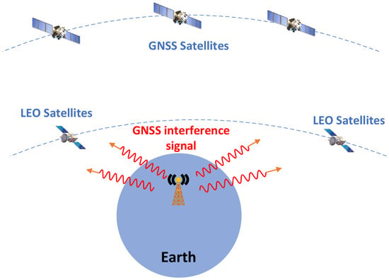
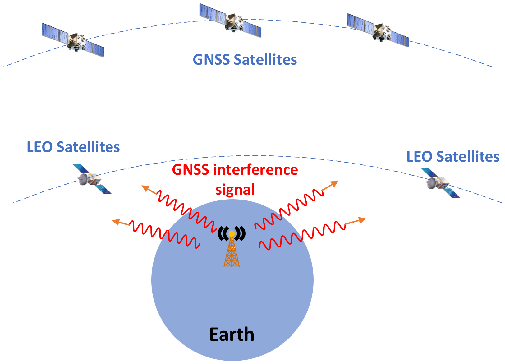
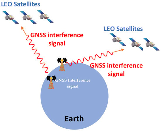
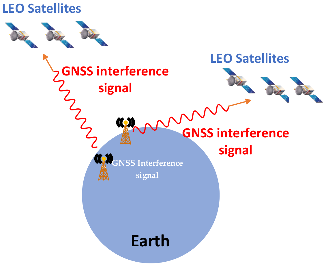
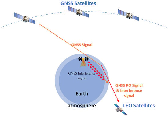
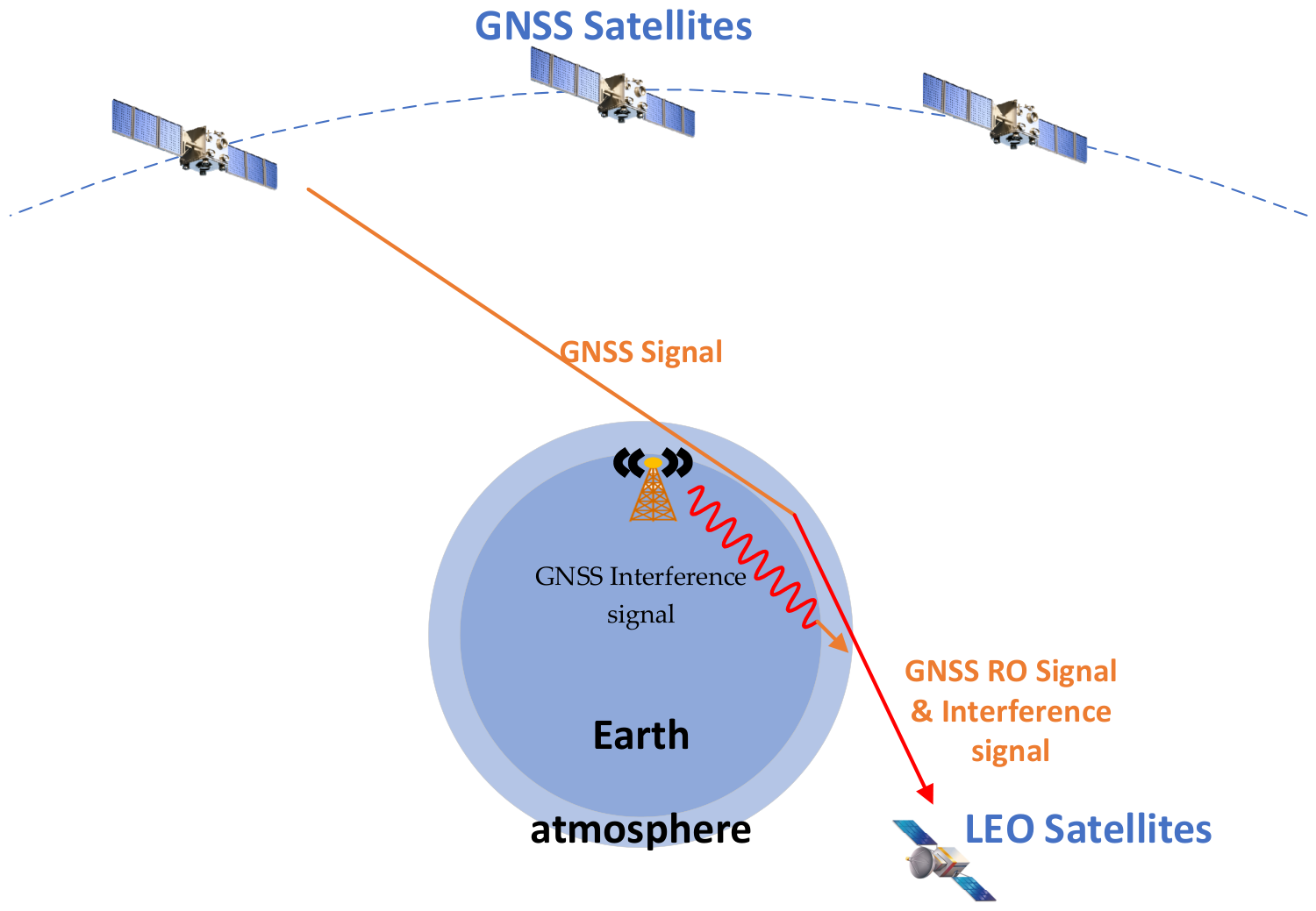
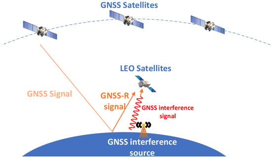
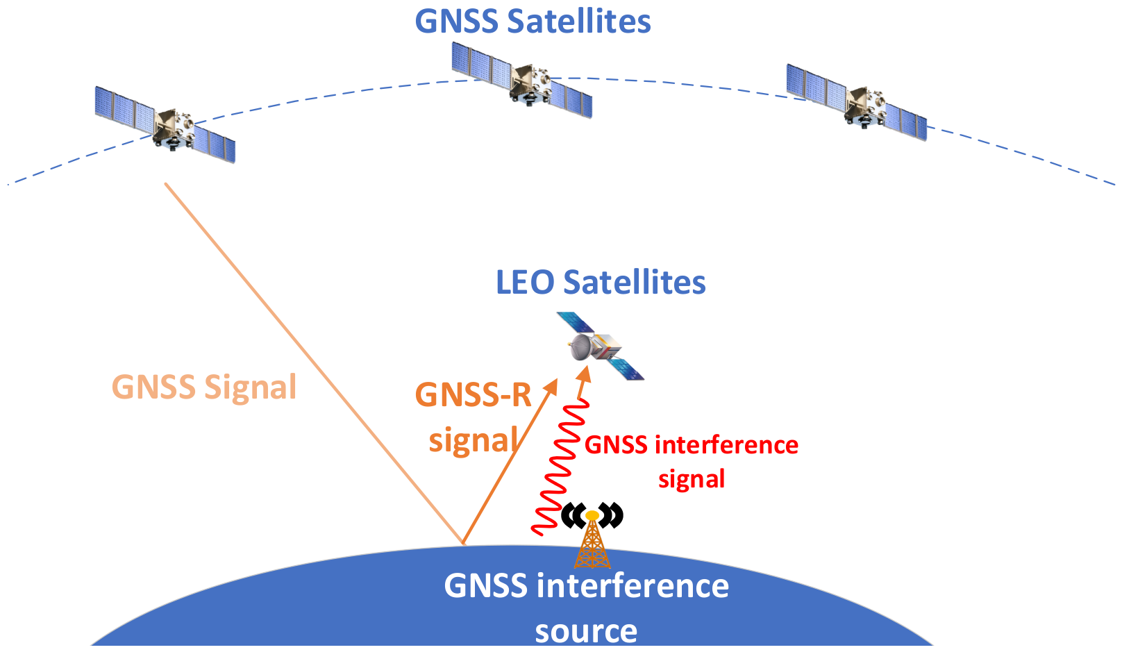
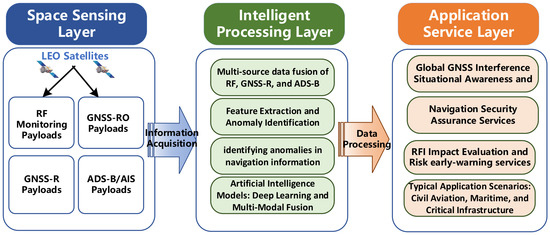

Disclaimer/Publisher’s Note: The statements, opinions and data contained in all publications are solely those of the individual author(s) and contributor(s) and not of MDPI and/or the editor(s). MDPI and/or the editor(s) disclaim responsibility for any injury to people or property resulting from any ideas, methods, instructions or products referred to in the content. |
© 2026 by the authors. Licensee MDPI, Basel, Switzerland. This article is an open access article distributed under the terms and conditions of the Creative Commons Attribution (CC BY) license.