


Abstract
This paper investigates the trajectory planning problem for multiple unmanned aerial vehicles (UAVs) tasked with monitoring ground targets in complex, uneven terrains. The key challenge lies in maintaining continuous Line-of-Sight (LoS) while satisfying non-holonomic motion constraints and handling terrain-induced occlusions. To address this problem, we propose a Beam-search Model Predictive Control (BMPC) framework. The method integrates a first-order kinematic predictor for target motion estimation and a proactive safety altitude margin to guide UAVs toward favorable viewpoints before occlusions occur. The proposed approach is validated through extensive simulations based on high-resolution Digital Elevation Models (DEMs). Monte Carlo results demonstrate a significant reduction in LoS occlusion, decreasing the average occlusion rate from to near zero in the noise-free case, compared with conventional reactive MPC methods. Under perception noise with a standard deviation of m, the LoS retention rate remains above , indicating strong robustness to sensing uncertainty. In addition, the algorithm maintains stable computational performance, with an average execution time of approximately s per step in a non-optimized simulation environment. The proposed framework provides an effective solution for autonomous aerial surveillance in environments with substantial elevation variations, such as mountainous regions and urban canyons, by achieving a balance between tracking continuity and computational tractability.
1. Introduction
In recent years, unmanned aerial vehicles (UAVs) have garnered significant attention within both industry and academia. UAV swarms have achieved numerous successful applications across civil and military domains. These applications include, but are not limited to, cellular network communications, environmental monitoring, emergency communications, target tracking, and last-mile delivery [1,2,3,4,5,6,7,8,9,10]. A challenging and significant application domain for UAV swarms is the surveillance of ground targets, encompassing diverse problems including but not limited to ground traffic monitoring, disaster perimeter surveillance, agricultural field monitoring, and target tracking for policing and military purposes [11,12,13,14,15,16,17]. A primary common scenario within these surveillance tasks involves a swarm of video-equipped UAVs monitoring multiple moving ground targets. One typical challenge of this kind of video surveillance problem is to ensure that all the targets of interest or all the points within the expected area can be observed by at least one drone at a sufficiently frequent rate. A further generalization of this problem is that the unmanned aerial vehicle needs to conduct tracking and monitoring above uneven terrains. Uneven terrain denotes ground areas that cannot be modeled with sufficient accuracy using a single ideal plane. In such an environment, the line of sight of the video camera carried by the UAV is often blocked by the terrains due to its relative position to the intended target, thus causing the surveillance to fail. Complex uneven terrain is particularly prevalent in real-world settings such as urban and mountainous areas, which feature numerous high-rise buildings, hills, and narrow roads. These regions also constitute the primary operational environments for surveillance missions. As smaller, low-altitude drones continue to advance and proliferate, such scenarios are anticipated to grow increasingly significant.
A large number of recent studies have explored various issues related to the monitoring of ground targets and areas by UAVs. The authors of [18,19] proposed multiple UAV video surveillance strategies based on Voronoi partitioning. They divided the moving ground targets into Voronoi cells and navigated the UAVs to the centers of the cells. The authors of [20] presented an intelligent fusion-based optimized Model Predictive Control(MPC) method to enable a group of UAVs to track moving targets in an uncertain and obstacle-filled environment. To address the Line of Sight (LoS) loss problem, a navigation algorithm for safe flight corridors and shared Field of View (FoV) was proposed in [21]. When a single UAV loses LoS due to obstacles, it can plan its route using the information reported by other UAVs that can still see the target. The authors of [22] introduced the concept of safety margin to quantify the urgency and sensitivity of LoS loss. However, the above studies have not fully addressed the issue of multiple drones working in uneven terrains with multiple targets: in such scenarios, the line of sight between the drones and the desired targets is often blocked by walls, buildings, hills, and other obstacles.
The problem studied in this paper is the coordination of a group of UAVs to conduct video surveillance on multiple ground vehicles moving arbitrarily on uneven terrains. The primary objective of this study is to develop a proactive navigation framework that maintains continuous LoS by anticipating both target movements and topographic occlusions, rather than merely reacting to them.
The design of our navigation framework is motivated by several critical practical considerations in aerial surveillance. First, while target tracking can be performed from various angles, vertical surveillance () is prioritized in this study because it minimizes the slant range and maximizes the ground-projected resolution, thereby ensuring superior video quality and reducing the probability of terrain-induced occlusions. Second, we recognize that in complex topographies, target climbing is a major cause of surveillance failure. When a target ascends a steep slope, its relative altitude to the UAV decreases rapidly, causing it to quickly exit the camera’s FoV. This necessitates a proactive altitude margin to preemptively elevate the UAV. Third, to ensure real-time feasibility on onboard computers, we adopt a normalized control-intensity proxy for energy consumption. This approach avoids the prohibitive computational cost of high-fidelity aerodynamic power models while still guiding the UAV toward smoother, more power-efficient trajectories. Finally, to prevent the “local minima” problem where a UAV might get stuck in a zero-gradient region during total LoS occlusion, our occlusion cost is specifically designed to provide a continuous attractive force toward the target’s zenith. To enhance the monitoring quality, we abandon the previous approach of minimizing the distance between the UAVs and the targets and adopt the expected monitoring distance method. Meanwhile, to ensure the sustainability of the monitoring, we also control the energy consumption of the UAVs. To address the limitations of previous studies that ignored target maneuvers in complex environments, we integrate a first-order kinematic predictor and a proactive safety altitude margin. This allows the UAVs to preemptively adjust their positions to handle the climbing and descending behavior of targets, which can otherwise quickly cause LoS loss.
The main contributions of this paper are summarized as follows:
- We propose an integrated navigation algorithm that specifically addresses LoS occlusions in uneven terrains by transitioning from reactive tracking to proactive vantage-point acquisition.
- The proposed algorithm adopts the MPC framework [23], conducting short-term beam search on candidate control sequences (BMPC). This method ensures strong real-time performance and provides approximately optimal solutions within the prediction horizon, which is essential for practical UAV applications.
- We introduce a target-climbing-aware prediction scheme. By utilizing a first-order kinematic extrapolator, the algorithm mitigates the tracking delay and LoS loss caused by the vertical and horizontal maneuvers of ground targets, improving surveillance continuity.
2. Investigated Problem
We are considering deploying N UAVs to monitor K moving ground targets in uneven terrains, which may block the line of sight (LoS), where (a larger number of UAVs is not realistic). We denote as the position of UAV i at time t, where is its horizontal coordinate and is its flight altitude. The motion of the UAV i can be modeled as follows:
where is the heading angle of UAV i; , , denote the horizontal speed, angular rate and vertical speed of the UAV, respectively; bound the corresponding inputs. We modeled the uneven terrains as , where is the horizontal coordinates and is the altitude. The uneven terrain is modeled as a Digital Elevation Model (DEM), where the altitude is defined over a discrete grid with a specific spatial resolution. In this study, we represent the terrain as a sampled scalar field , which is consistent with the standard GIS data formats used in real-world UAV mission planning. To ensure the representativeness of the complex environment, the terrain is characterized by its surface roughness and geomorphological gradients, which directly influence the Line-of-Sight (LoS) availability between the UAV and ground targets.
In practical deployment, the target positions obtained via GPS or other pre-deployed sensors are inherently corrupted by noise and measurement errors. To account for these uncertainties, the observed position of target j at time t, denoted as , is modeled as follows:
where is the ground truth, represents zero-mean Gaussian measurement noise, and accounts for potential sensing latency. By incorporating this stochastic component, the navigation algorithm must demonstrate robustness against imperfect information, ensuring that the BMPC’s receding horizon mechanism can compensate for transient state estimation errors.
In real-world deployments, UAV-assisted surveillance networks are inevitably subjected to environmental disturbances, most notably wind gusts and variations in ambient lighting. To strengthen the theoretical robustness of the proposed framework, these physical phenomena are implicitly accommodated within our dynamic modeling and simulation setup as stochastic noise and bounded margins.
(1) Visual degradation: Fluctuations in lighting conditions, shadows from rough terrain, or sensor glare degrade the quality of the video surveillance payload, resulting in target-tracking uncertainties. To theoretically model this, we introduce an Additive White Gaussian Noise (AWGN) model to the perception module, where the perceived target state is , with . Our simulations demonstrate that by maintaining a conservative Line-of-Sight (LoS) buffer and utilizing the BMPC’s replanning capabilities, the UAV maintains stable tracking even when lighting-induced perception errors are comparable to the UAV’s per-step displacement.
(2) Aerodynamic disturbances: Wind gusts exert unmodeled external forces on the UAV, momentarily displacing it from the BMPC’s planned trajectory. Rather than explicitly solving complex stochastic differential equations, the system robustly absorbs these disturbances via a dual-layer approach. First, the high-frequency receding horizon control (>50 Hz execution rate) continuously acts as a feedback mechanism to correct wind-induced drift. Second, the conservative kinematic limits ( m/s, m/s) intentionally leave a significant fraction of the propulsion system’s thrust-to-weight margin available. This ensures the low-level flight controller always retains sufficient actuator authority to reject sudden wind gusts without violating the BMPC’s safety or kinematic constraints.
Considering the ground target is known by the UAV, we can obtain its position by GPS or other pre-deployed sensors. Therefore, we focus on the surveillance after the UAV has already built the LoS connection for the assigned target. The minimum distance from the UAV i to the terrain’s surface is defined as follows:
This paper investigates the navigating algorithm for UAVs that maintains the uninterrupted LoS and optimizes surveillance quality under the following constrains:
These constraints represent the minimum distance between the UAV and terrains, the minimum distance among UAVs, and the maximum absolute flight altitudes for the UAV. These hard constraints are employed to ensure the safety of the flight path.
To address potential simultaneous occupation of the safety space, the decentralized BMPC incorporates a deterministic, ID-based hierarchical priority scheme to prevent deadlocks. In purely symmetric decentralized setups, two UAVs might continuously attempt mirroring avoidance maneuvers, leading to a deadlock. To break this symmetry, each UAV is assigned a unique identifier index . When evaluating the inter-UAV collision penalty in the prediction horizon, a strict hierarchy is enforced: a UAV with a higher index (e.g., UAV j) must yield to a UAV with a lower index (e.g., UAV i, where ). Specifically, UAV j treats the broadcasted predictive trajectory of UAV i as a dynamic but unyielding obstacle within its beam search tree. Consequently, UAV j is forced to select an alternative sub-optimal branch to ensure , while UAV i maintains its optimal path. This lightweight hierarchical protocol guarantees deadlock-free coordination without requiring a centralized collision manager.
2.1. Available Information
We introduce a binary function to represent the LoS condition. Each UAV is equipped with a downward-facing camera. The visibility cone is determined by the viewing angle . Thus, a UAV at can observe ground points inside a circle of radius r, where:
and denotes the UAV altitude above the terrains.
Furthermore, we acknowledge that LoS detection is subject to sensor reliability and signal intermittent loss. The available information for the UAV includes the noisy estimate and its estimated velocity . Within the BMPC framework, the inherent feedback loop of the receding-horizon control acts as a low-pass filter, allowing the UAV to mitigate the impact of high-frequency sensor noise. In cases of temporary signal loss, the first-order predictor provides a dead-reckoning estimate to maintain tracking until the LoS is re-established.
We determine the value of by examining whether any terrain elevation exceeds the line segment connecting the UAV and its monitored target. (1) : and LoS from to is not occluded by any terrain part; (2) , otherwise.
Moreover, to extend the effective monitoring duration of the UAV, we have introduced energy consumption control. We categorize the UAV’s energy consumption into three components: forward flight, ascent, and turning. As the UAV remains in continuous-tracking-and-surveillance mode, we do not distinguish between acceleration, deceleration, and hovering states in the two-dimensional plane. Instead, we summarize the UAV’s planar motion as a single forward flight. And we consider only the energy consumption during ascent, with descent energy consumption excluded from consideration.
We can model the position of the ground targets as , where . Furthermore, the motion of the UAV and the target is considered at instants ; here, is a known sampling time.
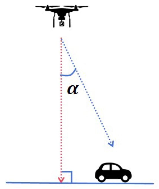
We define the angle as the angle between the UAV and the target it is assigned to, as shown in Figure 1.
where:
Figure 1.
Angle between the UAV and the target.
When , the UAV is positioned directly above the target, which in most instances represents the optimal surveillance location. Vertical surveillance minimizes the distance between the UAV and the surveillance target, thereby enhancing video surveillance quality. Concurrently, it ensures LoS safety by eliminating potential obstructions caused by terrains or obstacles.
We introduce the safety margin cost . It comprises two components: the angular component and the obstruction component. When the angle is zero, there is no obstruction of the line of sight. However, in reality, UAVs cannot perfectly track targets, meaning the angle will typically be small but not zero in most scenarios. This results in situations where the UAV’s line of sight may be obstructed by terrains during surveillance operations. Therefore, we have introduced the obstruction component, which, together with the angular component, constitutes the safety margin for the line of sight. We first introduce the angle term.
where , is the boundary angle we have selected as an acceptable and safe monitoring angle, and are four constant coefficients used to control the penalty level of the function. It is worth noting that the occlusion penalty is intentionally designed not to be a flat constant. By superimposing the distance and angle-dependent tracking terms onto the substantial base penalty, the cost function maintains a non-zero gradient even when the UAV is deep within an occluded region. Mathematically, this formulation shapes the occlusion penalty space into a sloped basin rather than a flat plateau, ensuring that a clear downward gradient pointing towards the target’s vicinity is always preserved in the objective function landscape. This piecewise function categorizes the angle between the UAV and the target into three scenarios. When , the UAV is directly overhead the target, yielding optimal surveillance quality and safety margin. We define an acceptable threshold angle ; values below are tolerable, though smaller values are preferable. The function’s aversion to boundary values can be modulated by adjusting parameter p. When exceeds , surveillance becomes unreliable, necessitating rapid UAV repositioning to reduce . When exceeds , the target falls outside the UAV’s visual cone, signifying loss of sight. This scenario is unacceptable; hence, a substantial penalty is applied. Additionally, the gradient term is retained to guide the UAV towards a direction that restores surveillance. Considering a common scenario, where the terrain is very steep like a building, even if the angle between the UAV and the target is a very small value, the LoS is still likely to be blocked. Therefore, we introduce the occlusion term.
where are constant coefficients used to control the severity of the penalty; denotes the horizontal distance between the UAV and the target; and is a reference distance used to normalize the actual horizontal distance. This term is only triggered when LoS is lost, i.e., when angle . Critically, the occlusion penalty is mathematically formulated to ensure a strictly convex surface rather than a constant numerical plateau. When the LoS is completely blocked, the isolated application of a massive constant penalty would result in a zero-gradient space, trapping the solver in local minima. To prevent this, the inclusion of the angle and horizontal distance terms generates a continuous negative gradient. This gradient acts as a deterministic attractive force, reliably pulling the UAV out of occluded regions and guiding it directly toward the target’s zenith () to rapidly re-establish LoS.
Our modeling objective concerns ground targets moving arbitrarily across uneven terrains. Beyond flat-ground movement, this encompasses both descent and ascent. While descent typically does not impact surveillance, ascent causes the target to rapidly exit the UAV’s cone of vision. The core reason lies in the target’s altitude increasing rapidly. To address this issue, we introduce an altitude margin term .
where is the safety altitude differential we have established, and is the actual altitude difference between the UAV and the target. By setting an appropriate , we can propel the UAV higher earlier and faster to ensure LoS with the ground target currently ascending.
To address the resolution and FoV balance, we have introduced an expected distance term .
where is the three-dimensional distance between the UAV and the target; is an expected distance that we can adjust.
Our primary cost function comprises the aforementioned four components:
To control energy consumption while avoiding complex aerodynamic models, we define the intensity terms:
It is important to note that the coefficients and are not arbitrary penalty weights but are derived directly from the UAV’s physical power consumption profiles. Specifically, represents the power-to-climb rate coefficient, and represents the power-to-yaw rate coefficient. By normalizing these terms into , we maintain a physically consistent objective that penalizes high-power flight regimes while ensuring numerical stability for the BMPC solver. This formulation implicitly accounts for the dominant aerodynamic work required to overcome gravity and rotational inertia, providing a computationally efficient surrogate for high-fidelity aerodynamic models. This normalized energy proxy strikes an optimal balance between physical consistency and the strict real-time execution constraints of UAV onboard computers by penalizing high-power maneuvers. However, as a linear kinematic approximation, it deliberately abstracts away complex non-linear aerodynamic drag and instantaneous inertial acceleration penalties. Consequently, while this model is highly effective for relative cost penalization, its impact on extended missions is that it may underestimate the absolute energy consumed. Therefore, this proxy cannot be directly used for accurate absolute battery life prognostics. For precise mission-level endurance estimates, the generated trajectories would need to be evaluated post-optimization using a high-fidelity non-linear aerodynamic model.
2.2. Optimization Framework
The problem is decomposed into an assignment layer and an optimization layer. For UAV i, the assignment produces a mapping , which indicates the target served by UAV i at time t. The assignment aims to maximize the worst-case surveillance quality among all targets (max–min fairness), where the surveillance quality is evaluated using a distance-based metric. The resulting mapping is then used in the MPC stage.
We define the stage main cost of UAV i at time t as follows:
where the UAV state and control input are defined by:
We define the discounted cumulative main cost and energy cost over a prediction horizon H and adopt a lexicographical optimization criterion:
subject to the system dynamics (1) and constraints (4).
Instead of the conventional zero-order hold (ZOH) assumption, our prediction horizon incorporates a first-order kinematic extrapolator to mitigate tracking lag. By utilizing the instantaneous velocity vector of the assigned target, future states are propagated as follows:
where is the sampling time. This allows the UAV to proactively anticipate dynamic maneuvers rather than reactively responding to outdated data, significantly improving the LoS retention rate over uneven terrains.
3. Path Planning Algorithm
Let be a given time horizon, and consider the time interval . The UAVs know the positions of all ground targets at . Take any integer C and divide into C subintervals, each of length . Control inputs are sampled and updated only at times , .
3.1. Methodology Framework
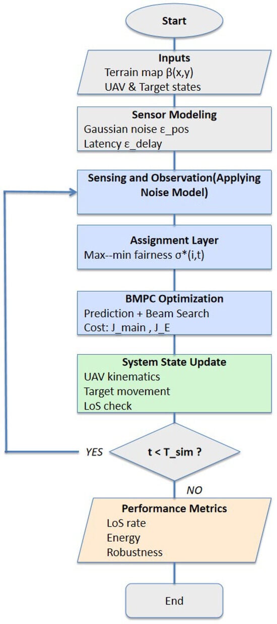
The research methodology of this study is structured as a closed-loop navigation framework, as illustrated in the flowchart in Figure 2. The process integrates environmental modeling, a dual-layered decision mechanism (Assignment and BMPC Optimization), and post-simulation performance metrics. This systematic approach ensures that the UAVs can proactively adapt to sensing uncertainties while maintaining high surveillance persistence over complex terrains.
Figure 2.
The flowchart of the research methodology.
3.2. Computational Complexity and Optimality Analysis
The total computational complexity of the proposed framework per decision step, , is characterized by the following expression:
where is the number of UAVs, and represents the task assignment overhead, which is computationally marginal for the fleet sizes considered. The second term reflects the decentralized BMPC optimization, where represents the search space complexity per agent (with horizon H, beam width B, and action space ). The term denotes the cost of a single node evaluation, primarily determined by the LoS checks for targets.
The scalability of the algorithm is analyzed across two key dimensions:
- Impact of UAV population (): Due to the decentralized execution of the BMPC, the primary computational burden is distributed among the agents. The system complexity exhibits a linear growth relative to the number of UAVs, effectively avoiding the exponential state-space explosion typical of centralized multi-agent systems.
- Impact of environment size: The node evaluation cost depends on the local sensing range and the sampling frequency , rather than global map dimensions. By employing a “sliding window” approach for terrain processing, the execution time remains invariant to the total environment size, ensuring operational viability in vast mountainous areas.
3.3. Justification for Beamwidth Selection
To ensure real-time applicability while preserving high-quality trajectory generation, the beamwidth B is selected by analyzing the trade-off between computational cost and solution quality.
(1) Computational gain:
For a prediction horizon H and an action space , the exhaustive search explores
nodes. In contrast, beam search limits the evaluated nodes to:
In our implementation (, ), this reduces the number of evaluated nodes from 20,439 to 3267, corresponding to a reduction of approximately . This substantial reduction directly improves the feasibility of high-frequency online replanning.
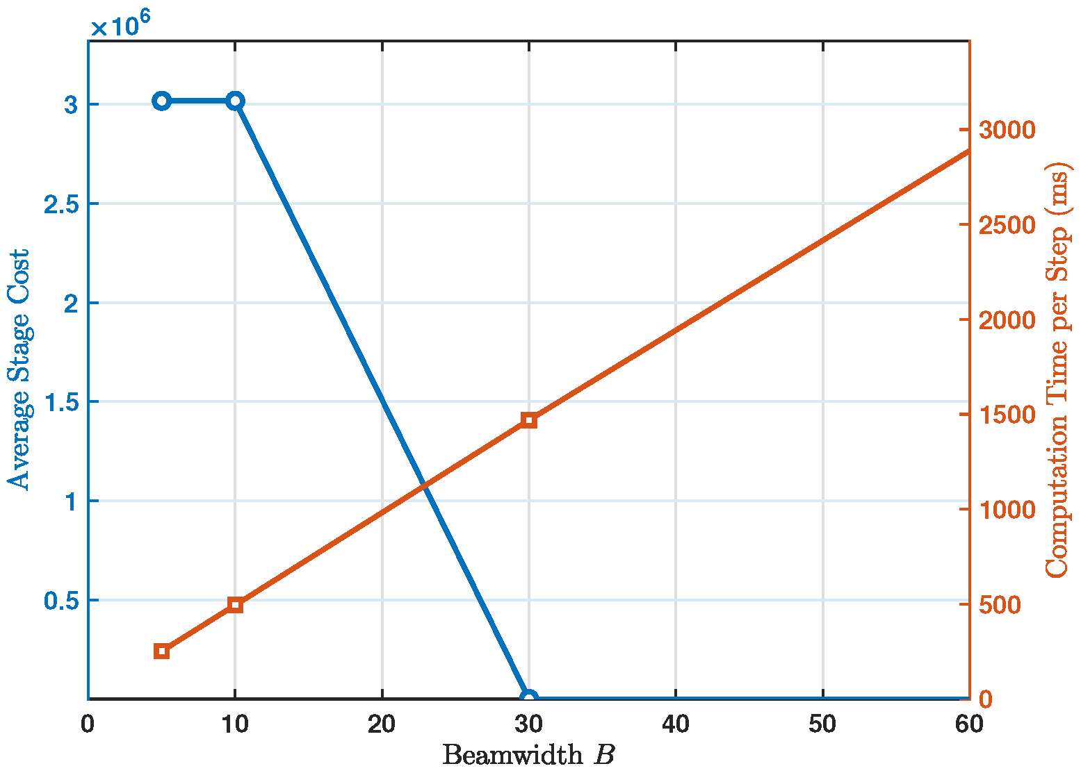
(2) Solution-quality trade-off: Although beam search does not guarantee the globally optimal solution of exhaustive search, its approximation quality remains high in the present problem because many control sequences generate spatially similar trajectories with comparable costs under UAV kinematic constraints. In practice, retaining the top candidates is sufficient to preserve representative path alternatives, such as trajectories passing to the left, right, or above terrain obstacles. Empirical tuning further shows that increasing B beyond 60 leads to only marginal improvement in the final cost () while noticeably increasing execution latency. Therefore, provides a favorable balance between computational efficiency and trajectory quality.
3.4. Study Site and Simulation Setup
To evaluate the performance of the BMPC algorithm, we conducted comprehensive simulations in a customized 3D topographic environment. The study site is a Digital Elevation Model (DEM) representing a complex uneven terrain, with altitudes ranging from 0 to . This environment provides challenging occlusion scenarios to test the robustness of the LoS maintenance.
The simulation was implemented in MATLAB R2024a. The technical specifications and research conditions considered in this study are summarized in Table 1. These parameters are selected to reflect the operational constraints of commercial multi-rotor UAVs.
Table 1.
Summary of simulation conditions and UAV parameters.
- A.
- Assignment layer (max–min fairness)
At each update time , we allocate UAVs to targets such that each target is followed by one or two UAVs and each UAV serves only one target. We assume that all current distances between UAV i and target j are available.
For any correct allocation (assignment) , the surveillance quality of target j at time is defined as follows:
where each target is served by one or two UAVs. The quality measure is defined as follows:
A correct allocation is said to be optimal if it delivers the maximum value of over all correct allocations. We find an optimal allocation by complete search. The total number of all correct allocations is . Upon completion of the assignment, we obtain the mapping , which constitutes the assignment result.
- B.
- Optimization layer (distributed MPC/beam search)
Given , each UAV i solves a local finite-horizon optimization problem with horizon H under dynamics and constraints (1), (4) in a distributed manner. Within each prediction horizon, the future states of the assigned target are estimated using the first-order kinematic model:
i.e., while the target’s position is dynamically propagated, the target assignment is kept fixed within the horizon and is re-evaluated only at the next receding-horizon step. Instead of using traditional continuous nonlinear optimizers, we discretize the input and approximately solve this optimal problem via beam search.
For the candidate controls of each UAV, horizontal velocity, vertical velocity and angular velocity, at each step within the prediction horizon, there are three choices (balancing computational complexity, control smoothness and search effectiveness) for each control quantity; thus, there are a total of 27 candidates at each step. The optimization problem then becomes finding the optimal path among totally control sequences. We construct a search tree in which the depth equals the prediction steps H. Each node in the tree retains the predicted state, the cumulative cost and the control input of the previous step. Each path represents the corresponding candidate control sequence from the root to the node at depth H. The original number of nodes is , the computational complexity of which is too high. We adopt beam search to retain only B best nodes at each layer within the horizon.
The resulting scheme is MPC strategy because only the first input of the best trajectory is executed to achieve receding horizon optimization. Beam search is used as a tractable approximation of the underlying finite-horizon optimal control problem.
Since inter-UAV safety constraints are hard constraints, each UAV enforces them during node expansion using the most recently shared predicted trajectories of other UAVs (from the previous update). Specifically, when expanding candidate nodes, UAV i discards any candidate that violates the inter-UAV constraints with respect to these predicted trajectories, together with the system dynamics and constraints. After each update, each UAV broadcasts its predicted trajectory (or predicted states) to support constraint checking in the next update.
During each prediction update, each UAV conducts a safety check for each candidate successor state in the node expansion stage of the beam search. If any candidate state violates the minimum safety distance constraint between UAVs or the minimum safety height constraint between UAVs and the terrains at any prediction step, the node is immediately classified as infeasible and removed from the candidate set, and the expansion is not continued. The collision detection between UAVs is based on the latest predicted trajectories broadcast by other UAVs in the previous update. Since these safety conditions are embedded as hard constraints in the candidate node screening process, the trajectories that are ultimately retained meet the collision avoidance requirements at the planning level. That is, at each prediction update step, the candidate set is pruned for safety using (4), in order to avoid inter-UAV collisions, UAV–terrain collisions, and violations of flight altitude safety constraints.
- C.
- Candidate input generation with acceleration caps
Let the previous control input at the current node be:
We employ acceleration caps to confine the control variation within each step:
We generate three candidates for each control component:
To satisfy input bounds, infeasible candidates are clipped (or equivalently discarded) according to:
where denotes clipping to the admissible interval imposed by system constraints.
Regarding the discretization of control inputs, it is important to clarify how these piecewise constant commands are executed without inducing mechanical vibrations. The proposed BMPC operates as a high-level kinematic planner within a cascaded control architecture. The discretized outputs (velocity and yaw rate) serve merely as reference setpoints for the UAV’s low-level flight controller, rather than direct PWM signals for the rotor actuators. In practice, the inner-loop attitude controllers and the inherent mechanical inertia of the propulsion system naturally act as a low-pass filter, effectively smoothing these step-like reference commands into continuous, executable aerodynamic responses. Explicitly applying additional smoothing filters at the high-level planning stage is deliberately avoided, as such filters would introduce unwanted phase lag (delay) into the control loop, critically degrading the UAV’s responsiveness during high-speed collision avoidance maneuvers.
- D.
- Prediction unfolding and lexicographic cost accumulation
For prediction layers , UAV i enumerates all candidate controls at each node (within its beam), propagates the state using the system dynamics, and computes the stage costs:
The discounted accumulated costs are updated as follows:
Here, is the discount factor: when , larger weights are assigned to costs closer to the present, improving robustness; when , each step is weighted equally.
We denote the cost of each node as an ordered pair . Nodes are ranked in lexicographic order: we first compare ; if the values are within a small tolerance , we then compare . After sorting nodes within the same layer in ascending lexicographic order, we retain only the first B nodes to expand the next prediction layer.
- Beam-MPC (BMPC)
BMPC1 (Assignment): At time , maximize over all correct allocations to obtain the mapping .
BMPC2 (Forecast unfolding): Root node: , with . For each layer : enumerate all candidate controls for each retained node, propagate to obtain , update using (30), discard any candidate node using (4), that violates the system dynamics, terrain-clearance, altitude-safety, or inter-UAV minimum-separation constraints, and retain only the top B nodes according to the lexicographic order of .
BMPC3 (Selection and execution): Select the best node at depth H according to lexicographic order and execute its first control input .
BMPC4 (Receding horizon): Set and return to BMPC1–BMPC3.
4. Simulation Results
To ensure replicability and geospatial validity, the simulation terrain is characterized by the following geomorphological metrics:
- Spatial resolution: The DEM grid size is set to , representing high-fidelity topographic features.
- Surface roughness (): The standard deviation of the terrain elevation is calculated as , indicating a highly rugged environment.
- Max elevation gradient: The maximum slope within the study site is restricted to to simulate steep mountainous or urban canyon scenarios.
This rigorous characterization ensures that the simulation scenarios are representative of real-world challenging topographies where LoS occlusion is prevalent.
We constructed some mountain-like environments and placed multiple ground vehicles in them. We set up movement trajectories for these vehicles to ensure that their movements included typical behaviors we needed to test, such as climbing, descending, and circling around hills.
The simulation parameters listed in Table 1 are selected to be consistent with typical commercial quadrotor platforms. The velocity limits are conservatively set below the maximum capabilities to ensure feasible control execution and sufficient thrust margin under disturbances. The sensing and FoV parameters are chosen to reflect practical onboard camera systems used in aerial surveillance.
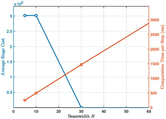
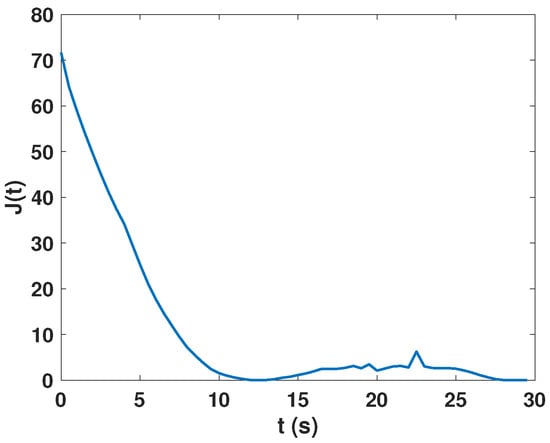
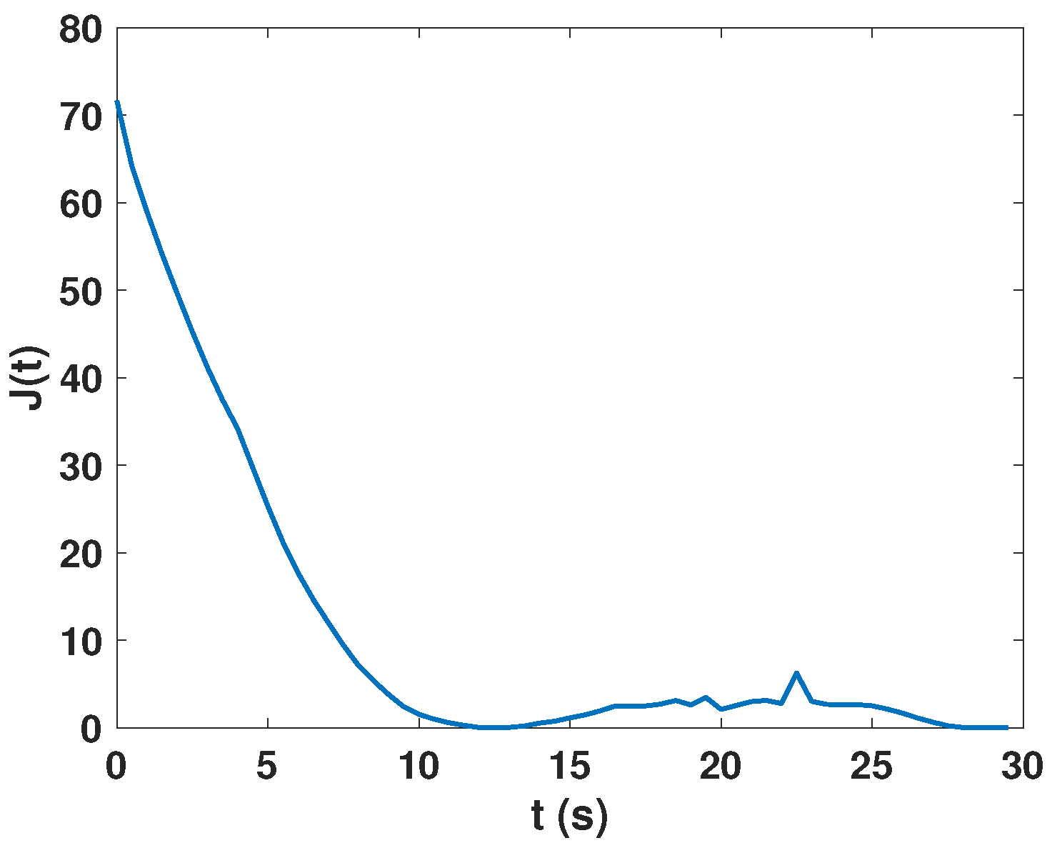
We conducted multiple experiments to determine an appropriate beam width B. As shown in Figure 3, when , both the average per-step computation time and the mean value of the cost function reach a desirable balance. Therefore, in the subsequent experiments, the beam width is set to .
Figure 3.
Trade-off analysis between planning optimality and computational.
It should be noted that the reported average computation time for the proposed BMPC and other benchmarks represents a pessimistic bound within the interpreted MATLAB simulation environment. Profiling indicates that the latency is predominantly consumed by recursive topographical queries (i.e., the interp2 function) and structural memory allocations during the tree expansion. In practical field deployments, translating the algorithm into a compiled language such as C/C++ and executing it on an onboard companion computer eliminates interpreter overhead and transforms grid queries into constant-time memory accesses. Leveraging the inherent parallelizability of the beam search branches, this transition is projected to yield a standard to computational speedup, reducing the latency to under 50 ms and comfortably guaranteeing real-time execution at over 20 Hz.
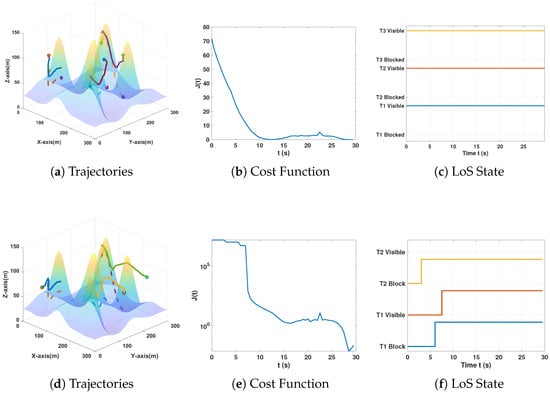
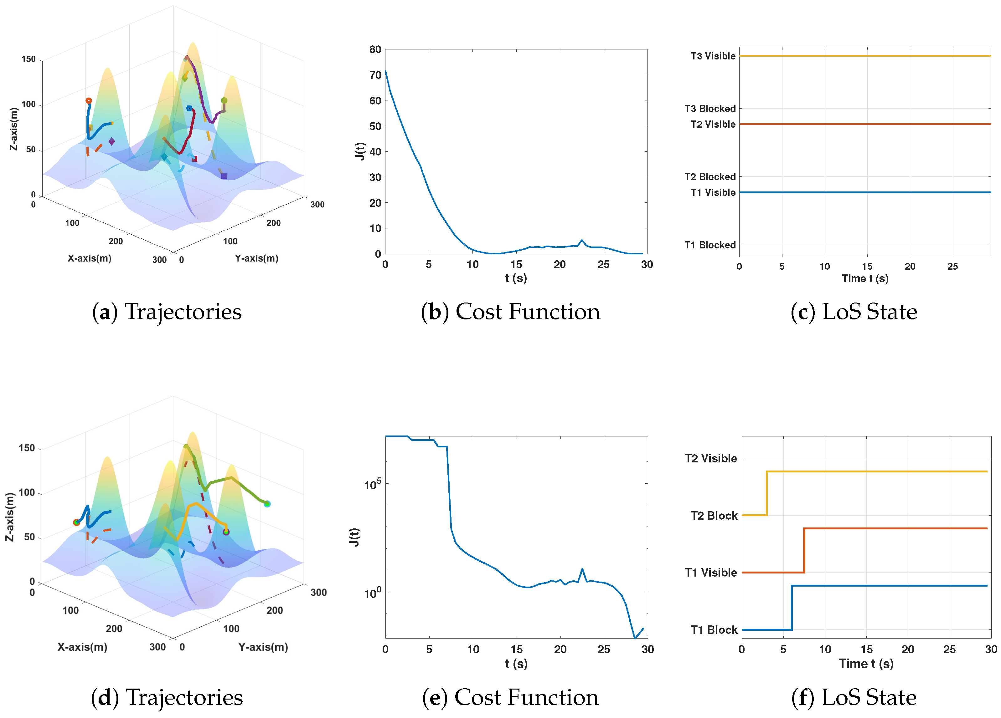
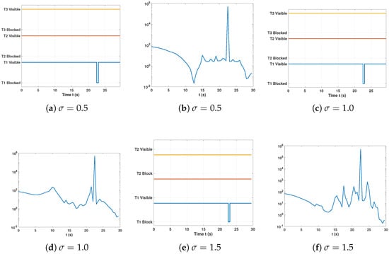
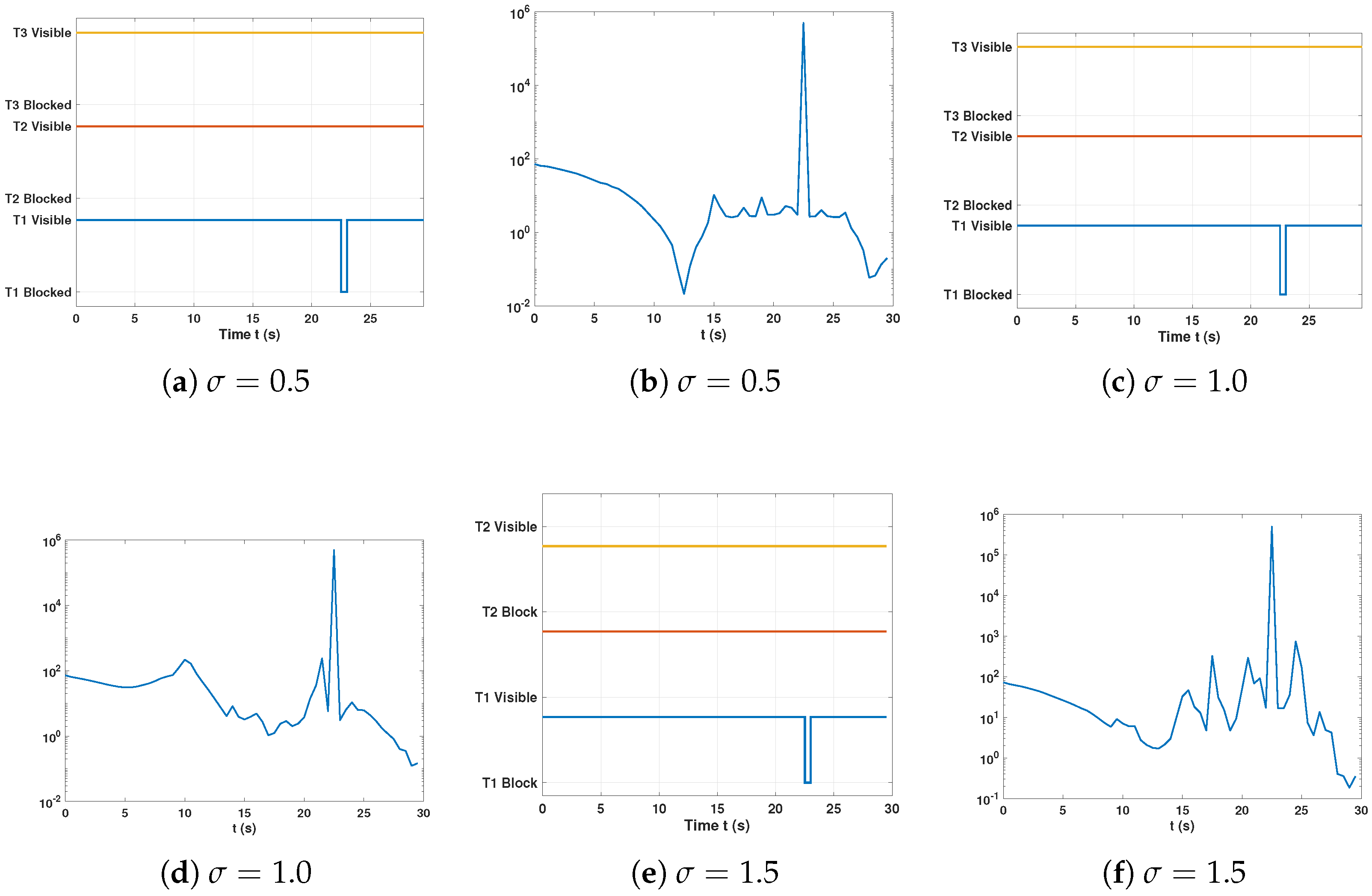
We first examined the monitoring performance of the algorithm, that is, when the UAV had already established a LoS with the expected target at time , we observed the changes in the LoS status through a 30 s simulation, which reflected the monitoring performance of the UAV. In a simulated environment shown in Figure 4, there are three UAVs and three vehicles, and the parameters are set as , , , , , , , , , , , , , . To quantitatively analyze the performance of the proposed algorithm, we introduce two key metrics: (i) LoS retention rate, which represents the LoS state of the target being monitored by the UAV; (ii) the value of the cost function defined in (19), which reflects the overall surveillance quality, including the LoS state, the monitoring quality affected by the relative distance, and the energy consumption. These metrics enable a direct comparison between the proposed algorithm and the benchmark algorithm. First, we observe the situation where the UAV has already established the LoS with the expected target at time . It can be seen that during the 30 s simulations process, the LoS is maintained continuously and the cost function converges rapidly to a local minimum. We refer to this set of results as the baseline case. As a comparison, we changed the initial position of the UAV so that it did not establish LoS at the beginning. Since the penalty term in the cost function contains a maximum value, we took the logarithm of the cost function’s value. From Figure 4, it can be clearly observed that the UAV will quickly catch up with the target and establish LoS and maintain it by following the descent gradient of the cost function.
Figure 4.
Simulation results. (a–c) The LoS connection had already been established at the initial moment. (d–f) LoS had not been established at the initial moment.
We next evaluate the impact of noise on the system. To account for imperfect perception, the observed target position is modeled as the true position corrupted by additive white Gaussian noise. We consider three cases with standard deviations m, m and m, respectively. From Figure 5, it can be observed that, compared with the baseline case, the LoS retention rate decreases slightly from to . However, as the noise level increases, the LoS performance does not deteriorate further, and the evolution of the cost function remains largely similar. These results indicate that the proposed algorithm exhibits strong robustness against noise.
Figure 5.
LoS states and cost function under varying noise levels.
In addition, compared with the baseline case, we evaluate the impact of a smaller on system performance. As shown in Figure 6, when , the evolution of the cost function closely resembles that of the baseline case with . Similarly, we also tested the case of , and obtained comparable results. These observations indicate that the proposed system exhibits strong robustness with respect to the choice of the parameter .
Figure 6.
The cost function with .
In addition, we conducted an ablation study to evaluate the contribution of the proactive altitude safety margin (). To explicitly highlight its impact, we designed a stress-test scenario by imposing stricter kinematic constraints to make LoS maintenance more challenging; specifically, the maximum vertical velocity of the UAV was restricted to 1 m/s, while the ground target speed was maintained at 6 m/s. The results demonstrate that the inclusion of the term improves the average LoS retention rate by across four heterogeneous terrains. While the baseline framework inherently exhibits strong robustness to various target maneuvers owing to its angle-based monitoring mechanism, the ablation study confirms that the term serves as a critical fail-safe. It effectively rescues visual frames and reinforces LoS preservation under extreme topographical conditions where kinematic bottlenecks would otherwise cause tracking failure.
To better demonstrate the performance, we consider comparing the proposed algorithm with four benchmark algorithms to better showcase the performance of the proposed algorithm. The first benchmark algorithm is implemented based on the Optimal Search Model Predictive Control (OS-MPC) [12], and the second benchmark algorithm adopts the same cost function as the proposed one but introduces a local greedy strategy, that is, set for cost function (19); at each time step t, it only conducts a local search within the kinematically feasible control space based on the current state of the UAV and the target state. The third one is based on Voronoi partitioning [18,19], and the last one is the standoff tracking method [24]. The Voronoi method divides the target group into multiple cells according to the current positions of multiple UAVs, and then navigates each UAV to the geometric center of the cell it is responsible for. The standoff method, on the other hand, maintains a fixed expected radius from the centroid of the target group and hovers above the targets.
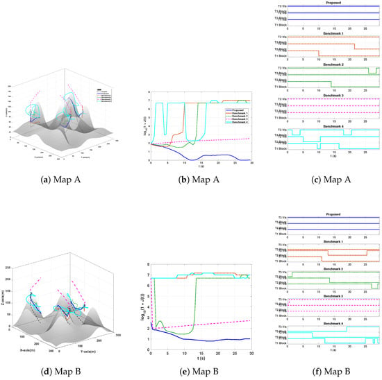
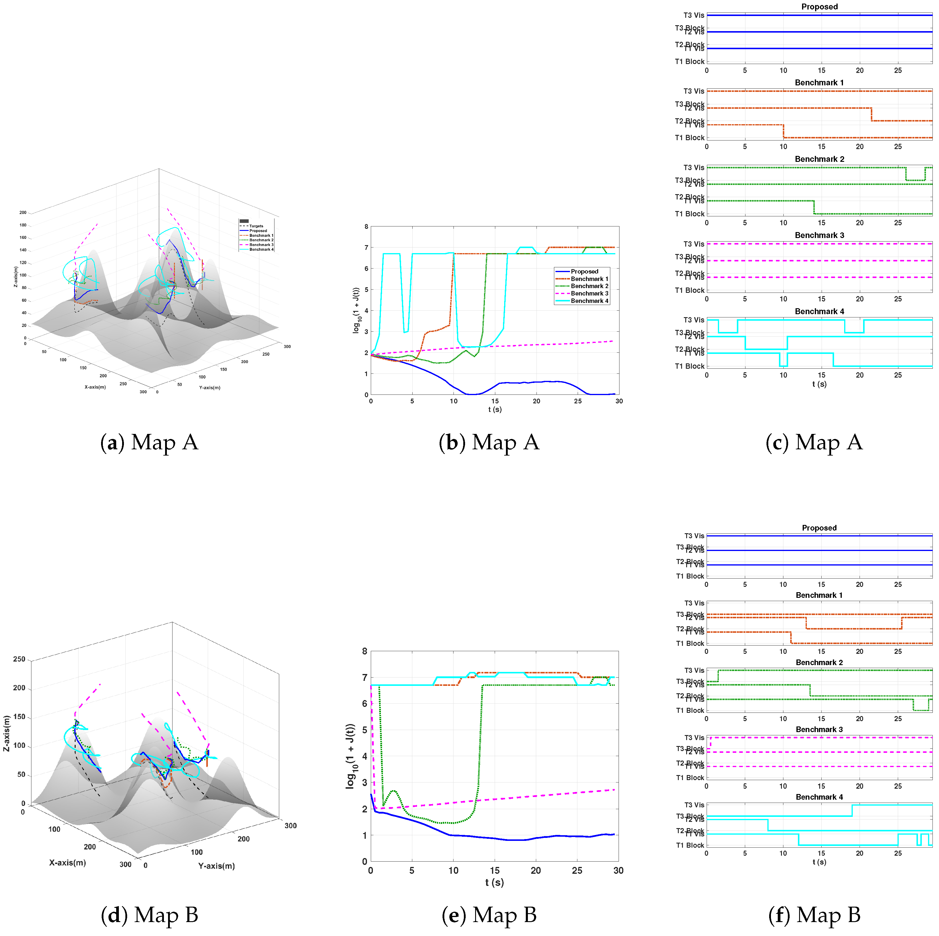
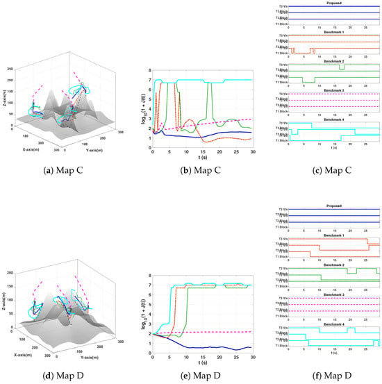
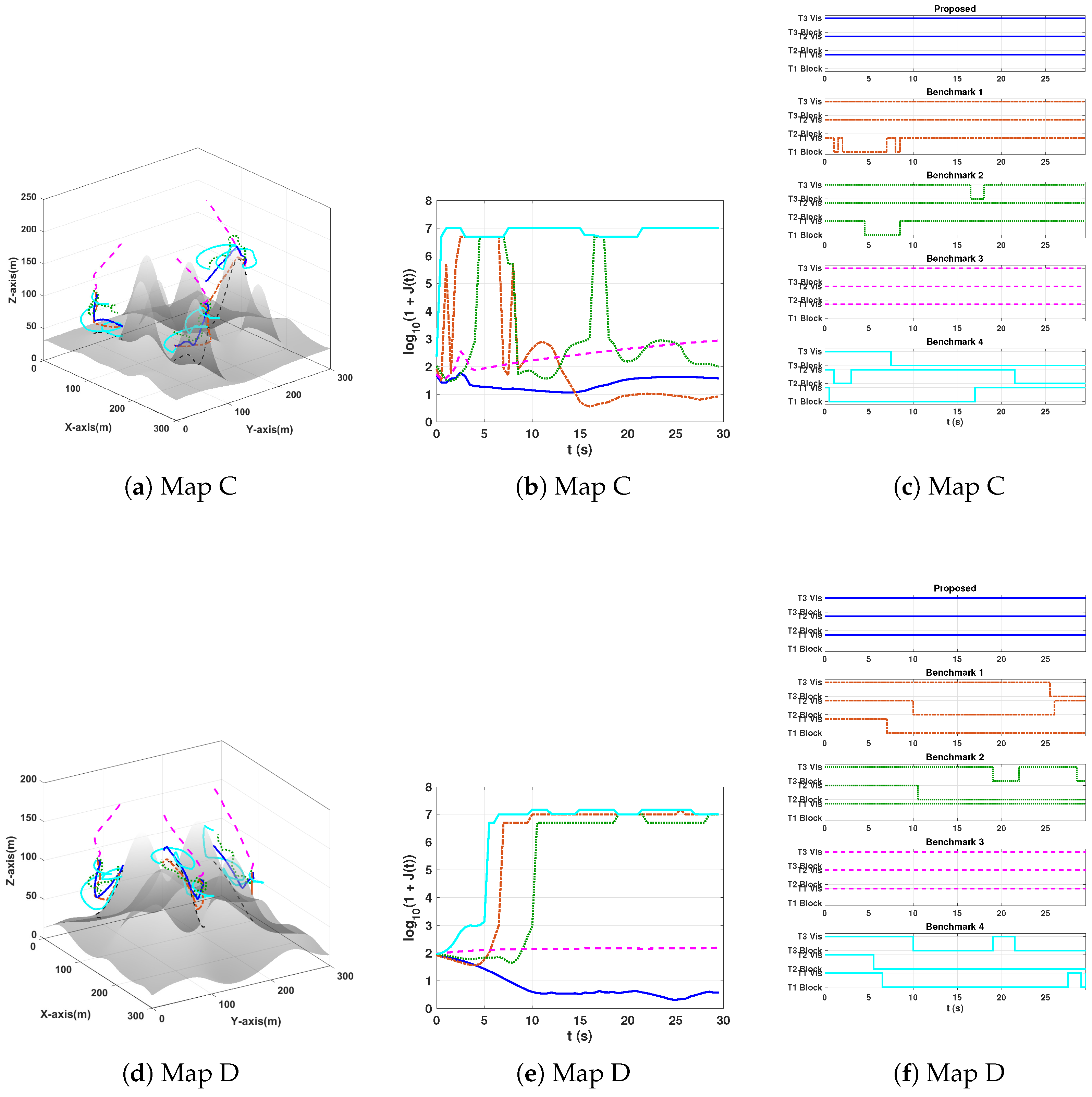
As can be seen from Figure 7 and Figure 8, we conducted a total of four sets of comparison simulations. The target moved freely in four different uneven terrains. In the first three scenarios, the target’s movement trajectory was more complex, involving climbing and moving around hilly terrains. We can observe that the performance of the proposed algorithm is significantly better than that of the benchmark algorithms. The trajectory is smooth and the cost function is relatively flat. Moreover, in all four scenarios, the proposed algorithm can maintain LoS without loss. In the fourth scenario, the target mostly moved in a relatively flat area. Through the changes in the cost function, we can observe that the cost functions of the benchmark 1, 2, 3 can also converge to a lower value after experiencing initial large fluctuations. Among them, the algorithm based on OSMPC even achieved better performance in the later stage, but its performance was the worst in the first three scenarios. This is because OSMPC suffers from severe blind spots in steep terrains due to the highly discrete action space and linear penalty agent. When all forward paths are pruned due to potential collisions within the prediction period, the algorithm degrades to hovering in place or unnatural vertical climbing to minimize the Euclidean distance. Our proposed BMPC fundamentally alleviates this problem. The Voronoi algorithm is optimal in 2D plane distribution, but in complex 3D mountainous terrains, it needs to climb to bypass high-altitude terrains to track the centroid. Although this can prevent the UAV’s LoS from being lost, it sacrifices monitoring quality and energy consumption. In contrast, our BMPC can intelligently bypass mountains, ensuring LoS while maintaining monitoring quality and optimizing energy consumption. The Standoff algorithm strictly requires the UAV to maintain a rigid circular orbit. When the orbit happens to pass through a large mountain, the UAV will be forced to ascend to avoid obstacles and lose the target. In contrast, the proposed algorithm considers the terrain’s influence on the next H steps, and its trajectory is highly adaptive.
Figure 7.
Simulation results comparing the proposed method with the benchmarks: (a,d) trajectories, (b,e) cost function, and (c,f) LoS state.
Figure 8.
Simulation results comparing the proposed method with the benchmarks: (a,d) trajectories, (b,e) cost function, and (c,f) LoS state.
As shown in Table 2 and Table 3, we provide a quantitative evaluation of the performance of different algorithms, including the LoS retention rate, average per-step computation time, average per-step energy consumption, and average monitoring distance. These metrics allow for a direct and intuitive comparison of the performance of the proposed algorithm. Specifically, the proposed BMPC framework consistently achieves a LoS retention rate across all tested terrains, representing a relative improvement of over the average performance of the baseline algorithms. While strictly maintaining continuous tracking, the BMPC successfully tightens the monitoring distance to an average of m, keeping the UAVs approximately closer to the targets than the benchmarks, thereby ensuring higher resolution for potential optical sensors. In terms of physical efficiency, the proposed method reduces energy consumption by and compared to the Voronoi and Standoff heuristics, respectively, while remaining highly competitive with the reactive OS-MPC. Most notably, despite its rigorous multi-step predictive horizon, the BMPC significantly reduces the average per-step computation time by (from ms to ms) when directly compared to the OS-MPC, thoroughly demonstrating its superior balance between planning optimality, trajectory safety, and algorithmic complexity.
Table 2.
Performance comparison across different maps.
Table 3.
Computation time comparison per step across different maps.
The results show that the proposed algorithm can always ensure that the LoS to the monitored target is not lost on various non-flat terrains. Compared with the Voronoi based algorithm, which can also maintain LoS all the time, the proposed algorithm achieves better energy consumption control and monitoring quality. That is, in terms of the overall monitoring quality, the proposed algorithm outperforms all the benchmark algorithms.
The loss of LoS will trigger a large penalty term in the cost function; so, we have processed the cost function with to facilitate the observation of numerical changes. The algorithm proposed in this paper can make the cost function converge rapidly to a local minimum. We use the cost function and LoS state proposed in this paper as comparison standards. The LoS state is used as a universal evaluation criterion to visually demonstrate the performance of the proposed algorithm. On the other hand, due to the different task orientations of different algorithms, we choose the cost function proposed in this paper as one of the comparison standards. The core issue this paper focuses on is the monitoring of freely moving ground targets in uneven terrains, with the goal of ensuring LoS and optimizing monitoring quality. To the best of our knowledge, there is currently no similar research that has proposed a universal standard or function that can reflect the core requirements of monitoring quality.
In-Depth Discussion and Performance Comparison
To provide a deeper understanding of the observed performance gains, we further compare the proposed BMPC with several representative baseline paradigms from the literature, focusing not only on quantitative results but also on their underlying mechanisms.
Compared with OS-MPC [12], which relies on local gradient-based optimization, the proposed BMPC adopts a discrete beam-search strategy to explore multiple candidate trajectories. While OS-MPC performs well in smooth and convex settings, it may struggle when the cost function becomes non-convex or non-differentiable due to terrain-induced occlusions. In contrast, the BMPC can effectively bypass local minima by evaluating multiple trajectory branches, leading to improved LoS retention. This advantage, however, comes at the expense of increased per-step computational cost due to the evaluation of multiple candidates.
In comparison with greedy gradient-based methods, which are computationally efficient and suitable for real-time execution, the limitation lies in their myopic nature. As illustrated in Figure 7 and Figure 8, these approaches tend to become trapped in terrain-induced local minima, as they do not explicitly account for future occlusions. By incorporating a finite prediction horizon H, the BMPC is able to anticipate terrain interactions and generate more stable trajectories, although this predictive capability introduces additional computational overhead.
Voronoi-based approaches [18,19], on the other hand, are primarily designed for spatial coverage and load balancing. While they achieve a uniform distribution of agents, they do not explicitly consider LoS constraints or target-specific tracking objectives. As a result, UAVs may be positioned in regions with poor visibility, such as valleys or occluded areas. The proposed BMPC addresses this limitation by integrating LoS-aware cost terms, thereby prioritizing visibility-critical regions over purely geometric coverage, which highlights a trade-off between coverage uniformity and task-oriented performance.
Finally, standoff tracking strategies maintain a fixed-radius surveillance configuration around the target [24], which is effective in relatively flat environments. However, in complex three-dimensional terrains, such rigid geometric constraints may conflict with terrain features, resulting in occlusions or infeasible trajectories. The BMPC overcomes this limitation through adaptive trajectory optimization, allowing for flexible adjustment of both altitude and horizontal positioning to maintain LoS under complex terrain conditions.
Beyond the above benchmark paradigms, these benefits become even more evident in the scenario of monitoring multiple targets over complex non-flat terrains considered in this paper. Zhang et al. [16] investigated the distributed time-varying optimization problem for cooperative multi-UAV target tracking, with a focus on fixed-time consensus, local communication, and formation maintenance around the target; however, terrain-induced occlusion was not explicitly considered as a primary factor. Sun et al. [25] focused on the efficient joint deployment problem in dynamic traffic environments with no-fly zones and target reappearances, with an emphasis on task allocation and deployment efficiency rather than tracking tasks that are highly sensitive to continuous LoS links in complex three-dimensional terrains. Hu et al. [26] proposed a learning-based visual tracking scheme for solar-powered fixed-wing UAVs, which performed well in distance maintenance and energy consumption awareness, but their scenario mainly targeted single-target visual tracking rather than cooperative surveillance of multiple ground targets under terrain occlusion conditions. Sun et al. [27] studied the finite-time target tracking problem under FOV constraints, with the main goal of ensuring a preset visual performance boundary, but did not explicitly address the issues of multi-UAV cooperation or terrain-aware trajectory generation. In contrast, the results of this paper show that the proposed BMPC method is particularly effective when the quality of continuous surveillance is simultaneously constrained by target movement, complex undulating terrain, and LoS blockage. This also explains why this method can consistently achieve an LoS retention rate of over in all tested scenarios while maintaining shorter surveillance distances and lower energy consumption compared to the baseline method. The key reason lies in the predictive nature of BMPC. It not only responds to the current target state, but also evaluates future terrain interactions through LoS-aware cost function design, active altitude adjustment mechanisms, and short-term prediction search, making it more suitable for continuous surveillance tasks in complex undulating terrains.
5. Conclusions
This paper proposes a proactive and decentralized navigation framework for multiple UAVs to monitor moving ground targets in complex, uneven terrains. The key idea is an angle-based LoS preservation mechanism, which converts discrete occlusion risks into a continuous cost structure and enables a practical balance between tracking proximity and occlusion avoidance. The framework is implemented using a Beam-search Model Predictive Control (BMPC) scheme. It combines target motion prediction with proactive viewpoint adjustment. The simulation results on high-resolution terrain models show that the proposed method significantly improves LoS continuity. In noise-free scenarios, the LoS retention rate reaches nearly , while the average occlusion rate is reduced from to close to . The method also shows strong robustness to sensing uncertainty. Under additive white Gaussian noise with a standard deviation of m, the LoS retention rate remains above . In addition, the proactive trajectory design improves energy efficiency by avoiding abrupt maneuvers. Compared with the Voronoi and Standoff strategies, the energy consumption is reduced by and , respectively. The beam-search strategy also reduces computational overhead by about compared with conventional predictive control methods.
Overall, the proposed framework provides a practical and robust solution for UAV-based surveillance and communication tasks in complex environments.
Limitations and Future Work
Despite the promising results, several limitations of the current study should be acknowledged, providing a clear roadmap for future research: First, while the current validation utilizes high-fidelity simulations, the “sim-to-real” gap, particularly regarding complex aerodynamic disturbances and the specific constraints of onboard hardware, remains an open issue. Future work will focus on Hardware-in-the-Loop (HIL) testing and field experiments to bridge this gap.
Second, the present framework assumes near-instantaneous information exchange for decentralized coordination. In practical deployments, communication imperfections such as limited bandwidth, packet loss, and latency may affect system stability. Incorporating asynchronous coordination mechanisms and realistic communication models is a priority for further development.
Finally, a key limitation is that our study currently operates in a static mountainous environment without considering uncoordinated dynamic obstacles. Real-world low-altitude airspace often contains stochastic hazards such as birds or other non-cooperative drones. Future research will investigate the integration of reactive avoidance layers to handle these dynamic entities. Extending the BMPC framework to incorporate such stochastic obstacles will be a critical step toward robust Unmanned Aerial Traffic Management in shared and cluttered airspaces.
Author Contributions
Conceptualization, Y.L. and A.V.S.; methodology, Y.L. and A.V.S.; software, Y.L.; validation, Y.L.; formal analysis, Y.L.; investigation, Y.L.; resources, Y.L.; data curation, Y.L.; writing—original draft preparation, Y.L.; writing—review and editing, Y.L. and A.V.S.; visualization, Y.L.; supervision, A.V.S.; project administration, Y.L. and A.V.S.; funding acquisition, A.V.S. All authors have read and agreed to the published version of the manuscript.
Funding
This research received no external funding.
Data Availability Statement
The data supporting this study are available from the corresponding author upon reasonable request, as they are not publicly accessible due to privacy restrictions.
Conflicts of Interest
The authors declare no conflicts of interest.
Abbreviations
The following abbreviations are used in this manuscript:
| UAV | Unmanned Aerial Vehicle |
| LoS | Line of Sight |
| MPC | Model Predictive Control |
| BMPC | Beam-Search Model Predictive Control |
| FOV | Field of View |
| DEM | Digital Elevation Model |
| AWGN | Additive White Gaussian Noise |
| PWN | Pulse Width Modulation |
| HIL | Hardware-in-the-Loop |
| GIS | Geographic Information System |
References
- Savkin, A.V.; Huang, C. Joint Communication and Safe 3D Path Optimization for Multi-UAV Assisted Mobile Internet of Vehicles on an Uneven Terrain. IEEE Trans. Autom. Sci. Eng. 2025, 22, 17464–17473. [Google Scholar] [CrossRef] [Scilit]
- Yang, W.; Li, B. Connectivity-aware UAV mobility in cellular networks: DRL path planning and predictive handover. Ad Hoc Netw. 2025, 179, 103999. [Google Scholar] [CrossRef] [Scilit]
- Song, M.; Zhang, W.; Bai, J. Resource Allocation and Trajectory Planning in Integrated Sensing and Communication Enabled UAV-Assisted Vehicular Network. Sensors 2025, 25, 7295. [Google Scholar] [CrossRef] [Scilit] [PubMed]
- van Essen, R.; van Henten, E.; Kooistra, L.; Kootstra, G. Adaptive path planning for efficient object search by UAVs in agricultural fields. Smart Agric. Technol. 2025, 12, 101075. [Google Scholar] [CrossRef] [Scilit]
- Li, Y.; Chen, W.; Fu, B.; Wu, Z.; Hao, L. A Global Coverage Path Planning Method for Multi-UAV Maritime Surveillance in Complex Obstacle Environments. Drones 2024, 8, 764. [Google Scholar] [CrossRef] [Scilit]
- Zhang, N.; Yue, L.; Zhang, Q.; Gao, C.; Zhang, B.; Wang, Y. A UAV Coverage Path Planning Method Based on a Diameter–Height Model for Mountainous Terrain. Appl. Sci. 2025, 15, 1988. [Google Scholar] [CrossRef] [Scilit]
- López-Villegas, I.; Martínez-Rios, E.A.; Izquierdo-Reyes, J.; Bustamante-Bello, R.; Falcone, F. A systematic literature review of emergency communications assisted by unnamed aerial vehicles. Ad Hoc Netw. 2026, 182, 104063. [Google Scholar] [CrossRef] [Scilit]
- Bozorgi, S.F.; Razavizadeh, S.M.; Rezaee, M. Enhancing connectivity for emergency vehicles through UAV trajectory and resource allocation optimization. Phys. Commun. 2025, 73, 102826. [Google Scholar] [CrossRef] [Scilit]
- Feng, Z.; Na, X.; Hai, S.; Sun, Q.; Shi, J. Deep Reinforcement Learning for UAV Target Search and Continuous Tracking in Complex Environments with Gaussian Process Regression and Prior Policy Embedding. Electronics 2025, 14, 1330. [Google Scholar] [CrossRef] [Scilit]
- Mohamed, A.; Mohamed, M. Unmanned Aerial Vehicles in Last-Mile Parcel Delivery: A State-of-the-Art Review. Drones 2025, 9, 413. [Google Scholar] [CrossRef] [Scilit]
- Kong, X.; Ni, C.H.; Duan, G.; Shen, G.; Yao, Y.; Das, S.K. Energy Consumption Optimization of UAV-Assisted Traffic Monitoring Scheme with Tiny Reinforcement Learning. IEEE Internet Things J. 2024, 11, 21135–21145. [Google Scholar] [CrossRef] [Scilit]
- Savkin, A.V.; Huang, H. Multi-UAV Navigation for Optimized Video Surveillance of Ground Vehicles on Uneven Terrains. IEEE Trans. Intell. Transp. Syst. 2023, 24, 10238–10242. [Google Scholar] [CrossRef] [Scilit]
- Raoufi, M.; Telikani, A.; Zhang, T.; Shen, J. Fire front path planning and tracking control of Uncrewed Aerial Vehicles using deep reinforcement learning. Robot. Auton. Syst. 2025, 193, 105076. [Google Scholar] [CrossRef] [Scilit]
- Yan, X.; Chen, R. Application Strategy of Unmanned Aerial Vehicle Swarms in Forest Fire Detection Based on the Fusion of Particle Swarm Optimization and Artificial Bee Colony Algorithm. Appl. Sci. 2024, 14, 4937. [Google Scholar] [CrossRef] [Scilit]
- Fan, X.; Li, H.; Wang, Y.; Zhao, M.; Shen, L. Hierarchical Spatial–Temporal UAV Tracking with Three-Dimensional Wavelets for Road Traffic Surveillance. IEEE Trans. Intell. Transp. Syst. 2025, 26, 20723–20736. [Google Scholar] [CrossRef] [Scilit]
- Zhang, B.; Hou, Y.; Yin, H.; Lv, M.; Yang, A.; Wu, L. Cooperative Dynamic Target Tracking: Distributed Time-Varying Optimization for Multi-UAV System. IEEE Trans. Aerosp. Electron. Syst. 2025, 61, 12245–12257. [Google Scholar] [CrossRef] [Scilit]
- Li, Y.; Chen, W.; Fu, B.; Wu, Z.; Hao, L.; Yang, G. Research on Dynamic Target Search for Multi-UAV Based on Cooperative Coevolution Motion-Encoded Particle Swarm Optimization. Appl. Sci. 2024, 14, 1326. [Google Scholar] [CrossRef] [Scilit]
- Huang, H.; Savkin, A. Navigating UAVs for Optimal Monitoring of Groups of Moving Pedestrians or Vehicles. IEEE Trans. Veh. Technol. 2021, 70, 3891–3896. [Google Scholar] [CrossRef] [Scilit]
- Savkin, A.V.; Huang, H. Navigation of a UAV Network for Optimal Surveillance of a Group of Ground Targets Moving Along a Road. IEEE Trans. Intell. Transp. Syst. 2022, 23, 9281–9285. [Google Scholar] [CrossRef] [Scilit]
- Song, C.; Zhang, X.; She, Y.; Li, B.; Zhang, Q. Trajectory Planning for UAV Swarm Tracking Moving Target Based on an Improved Model Predictive Control Fusion Algorithm. IEEE Internet Things J. 2025, 12, 19354–19369. [Google Scholar] [CrossRef] [Scilit]
- Rao, K.; Yan, H.; Yang, P.; Wang, M.; Lv, Y. Multi-UAV trajectory planning with field-of-view sharing mechanism in cluttered environments: Application to target tracking. Sci. China Inf. Sci. 2025, 68, 150206. [Google Scholar] [CrossRef] [Scilit]
- Bai, R.; Yuan, S.; Li, K.; Guo, H.; Yau, W.Y.; Xie, L. Realm: Real-Time Line-of-Sight Maintenance in Multi-Robot Navigation with Unknown Obstacles. arXiv 2025, arXiv:2502.15162. [Google Scholar] [CrossRef] [Scilit]
- Camacho, E.F.; Bordons, C. Model Predictive Control, 2nd ed.; Springer Science & Business Media: London, UK, 2013. [Google Scholar]
- Oh, H.; Kim, S.; Shin, H.S.; Tsourdos, A.; White, B. Coordinated standoff tracking of groups of moving targets using multiple UAVs. In Proceedings of the 21st Mediterranean Conference on Control and Automation, Platanias, Greece, 25–28 June 2013; pp. 969–977. [Google Scholar] [CrossRef] [Scilit]
- Sun, L.; Wang, J.; Wang, J.; Lin, L.; Gen, M. Efficient Joint Deployment of Multi-UAVs for Target Tracking in Traffic Big Data. IEEE Trans. Intell. Transp. Syst. 2024, 25, 7780–7791. [Google Scholar] [CrossRef] [Scilit]
- Hu, S.; Yuan, X.; Ni, W.; Wang, X.; Jamalipour, A. Visual-Based Moving Target Tracking with Solar-Powered Fixed-Wing UAV: A New Learning-Based Approach. IEEE Trans. Intell. Transp. Syst. 2024, 25, 9115–9129. [Google Scholar] [CrossRef] [Scilit]
- Sun, P.; Li, S.; Zhu, B.; Zheng, Z.; Zuo, Z. Vision-based finite-time prescribed performance control for uncooperative UAV target-tracking subject to field of view constraints. ISA Trans. 2024, 149, 168–177. [Google Scholar] [CrossRef] [Scilit]

Disclaimer/Publisher’s Note: The statements, opinions and data contained in all publications are solely those of the individual author(s) and contributor(s) and not of MDPI and/or the editor(s). MDPI and/or the editor(s) disclaim responsibility for any injury to people or property resulting from any ideas, methods, instructions or products referred to in the content. |
© 2026 by the authors. Licensee MDPI, Basel, Switzerland. This article is an open access article distributed under the terms and conditions of the Creative Commons Attribution (CC BY) license.