


Abstract
Water accumulation in goafs in Chinese coal mines is a major hidden hazard that can trigger water inrush accidents and may also affect aquifer integrity and regional water security. Reliable delineation of goaf water distribution and identification of water-source types are therefore essential for mine water-hazard control and groundwater protection. This paper reviews the main technical routes for goaf groundwater investigation, including geophysical prospecting, hydrogeochemical and isotopic identification, direct inspection tools, and data-driven intelligent workflows. For geophysical detection, the mechanisms, engineering applicability, and key constraints of the Transient Electromagnetic Method (TEM), Surface Nuclear Magnetic Resonance (NMR), the High-Density Resistivity Method (HDRM), and the Coherent Frequency Component (CFC) electromagnetic wave reflection coherence method are synthesized, with emphasis on interpretation boundaries and uncertainty sources under complex geological conditions. For source identification, conventional hydrochemistry, stable isotopes, and laser-induced fluorescence are summarized, and intelligent recognition models such as neural networks and support vector machines are discussed in terms of workflow positioning and practical performance limits. A unified evaluation rationale is established and a semi-quantitative method–metric matrix is constructed to compare techniques in terms of reliability, deployability, cost level, environmental adaptability, and information value, thereby clarifying their functional roles and complementarities within staged engineering workflows. The synthesis indicates that major bottlenecks include limited deep capability under strong interference, pronounced interpretational non-uniqueness caused by complex geology and irregular goaf geometries, and constrained timeliness and generalization for mixed-source identification. Future directions are summarized as multi-method integration with fusion-driven interpretation, intelligent and quantitative decision support with quality control, and sensor–platform advances enabling more practical three-dimensional investigation, aiming to improve the reliability and engineering usability of goaf groundwater hazard assessment.
1. Introduction
As a crucial component of China’s primary energy mix, the safe and efficient mining of coal is vital for national energy security and stable economic operation. However, mine water hazards have long been one of the major disasters in coal mines, posing a serious threat to the lives of underground personnel and the normal production order of mines [1]. Among various water hazards, the issue of water accumulation in goafs—formed by historical mining activities, abandoned roadways, and geological structures—is particularly prominent due to its high degree of concealment and suddenness [2,3]. These hidden water bodies act like “time bombs” placed underground; when unexpectedly encountered during excavation, high-pressure water can instantly inundate the roadway, causing catastrophic water inrush accidents. Such incidents can not only lead to significant casualties and equipment damage but also disrupt the normal mine production system, resulting in substantial economic losses. Statistics indicate that water hazards account for a considerable proportion of both the number of occurrences and fatalities in major and extraordinarily serious accidents in Chinese coal mines, with goaf water accumulation being one of the primary water sources triggering such accidents [4].
With the continuous increase in the depth and intensity of coal resource extraction in China, the hydrogeological conditions of coal mines have become increasingly complex, presenting unprecedented challenges for the detection of water accumulation in goafs. On the one hand, the gradual depletion of shallow resources has shifted mining operations to greater depths, where ground pressure, geothermal conditions, and hydrogeological settings are more intricate. The legacy of complex goaf networks left by overlying coal seams makes the extent, volume, and connectivity of accumulated water difficult to ascertain [5]. On the other hand, in coal bases located in regions like Northern Shaanxi and Shendong within the middle and upper reaches of the Yellow River Basin, the contradiction between high-intensity coal mining and the fragile ecological environment has become increasingly prominent. Mining-induced disturbances may affect key aquifers, leading to regional groundwater level decline and triggering a series of ecological and environmental issues such as surface vegetation degradation and river flow interruption [6,7,8]. Therefore, the accurate detection and effective management of groundwater in goafs are not only an urgent requirement for water hazard prevention and control but also a critical component for achieving water resource protection and sustainable ecological development in mining areas.
Groundwater in coal mine goafs may originate from various sources, including atmospheric precipitation, surface water bodies, Quaternary pore water, bedrock fissure water, and Ordovician limestone karst water, or may accumulate from mine production water [9,10,11]. Different water sources exhibit distinct chemical characteristics, recharge-discharge relationships, and dynamic conditions. Once connected to mining excavations through water-conducting channels, they pose a risk of water inrush. Therefore, the detection of goaf groundwater not only requires determining the spatial location and extent of water-bearing bodies but also involves identifying the water source type and assessing its water abundance and potential threat. This provides a comprehensive geological basis for formulating scientific and effective water prevention and control measures [12].
In recent years, to address the aforementioned challenges in Chinese coal mines, researchers and engineers have conducted extensive and in-depth studies on groundwater detection and source-identification technologies for coal mine goafs, achieving significant progress. These technologies can broadly be categorized into two main systems. The first is geophysical detection technology, which primarily utilizes the differences in electrical, magnetic, elastic, and other physical properties between water-bearing bodies and surrounding rock for indirect detection. Key methods include the Transient Electromagnetic Method (TEM) [13], the High-Density Resistivity Method [14], the Nuclear Magnetic Resonance (NMR) method [15], and the emerging CFC electromagnetic wave reflection coherence method [16]. The second is hydrogeochemical identification technology, which analyzes the unique chemical compositions, isotopes, or fluorescence characteristics of water from different aquifers to “fingerprint” and identify the source of water inrushes. This approach is increasingly combined with mature intelligent algorithmic models to enhance the speed and accuracy of discrimination [17,18]. Additionally, related technologies such as underwater television [19], integrated geophysical exploration [20], and water-preserving coal mining [21] provide new perspectives and means for addressing groundwater issues from different angles.
Technological advancements have catalyzed a profound transformation in detection practices, shifting from single-method approaches to multi-method integration, from qualitative interpretation to semi-quantitative/quantitative evaluation, and from reliance on manual expertise to intelligent analysis. However, challenges such as signal attenuation in deep detection, the interpretational ambiguity of geophysical methods under complex geological conditions, and the identification accuracy in scenarios with mixed water sources remain critical technical hurdles that require focused efforts to overcome [22]. Based on relevant research and practices both domestically and internationally, this paper aims to systematically review the current state of goaf water detection and source identification technologies for coal mine goafs. It provides an analysis of the methodological principles, technical characteristics, applicability, and practical effectiveness of representative technologies, and further establishes a unified evaluation rationale and a semi-quantitative method–metric matrix to compare methods in terms of reliability, deployability, cost level, environmental adaptability, and information value, thereby supporting staged engineering workflows for screening, verification, and decision-making. The goal is to offer a comprehensive and insightful literature reference that contributes to advancing technological progress in this field, ensuring coal mine safety, and promoting the construction of green mines.
2. Geophysical Prospecting Technologies
Geophysical methods represent a primary approach for detecting groundwater in coal mine goafs. As illustrated in Table 1, these techniques infer the existence and characteristics of water-bearing structures by measuring variations in the physical responses of subsurface media, such as electrical conductivity, magnetic properties, and seismic wave velocities [23]. For instance, water-saturated zones exhibit enhanced conductivity and reduced resistivity due to the presence of water, often manifesting as low-resistivity anomalies in electromagnetic surveys. In contrast, dry goafs, filled with air or loose materials, typically show relatively higher resistivity, presenting as high-resistivity anomalies. Leveraging these physical property differences, various geophysical techniques—including electrical, electromagnetic, and seismic methods—are widely employed for detecting goafs and concealed cavities.
Table 1.
Comparison of Major Geophysical Detection Technologies.
2.1. Transient Electromagnetic Method
The transient electromagnetic method (TEM) is a time-domain electromagnetic exploration technique that images subsurface conductivity by analyzing the transient response following a rapid current turn-off in a transmitter loop. In a typical configuration, a pulsed current injected into the transmitter loop generates the primary electromagnetic field. When the current is rapidly switched off, eddy currents are induced within conductive bodies, which in turn generate a decaying secondary field. The receiving coil senses this secondary response, and the receiver system outputs the measured transient signal in the form of transient voltage V(t) or dB/dt, from which the conductivity distribution can be inferred through forward modeling and inversion. Figure 1 provides a schematic illustration of the TEM measurement principle, showing the excitation, the induced eddy currents in a conductive body, and the resulting secondary-field response recorded at the receiver. Because electromagnetic diffusion dominates field propagation in conductive media, TEM responses exhibit a characteristic time–depth sensitivity relationship: early-time gates primarily reflect shallow structures, whereas late-time gates progressively capture deeper responses. Consequently, the stability and quality of late-time measurements largely determine the reliability of deep interpretation.
Figure 1.
TEM acquisition principle and time-gate response. The red, yellow, white, and black arrows indicate the primary EM field, eddy currents in the conductive body, the secondary EM field/transient response path, and the received signal, respectively.
TEM has been widely applied in mine water-hazard investigations because water-bearing bodies often exhibit enhanced conductivity and therefore generate stronger and more persistent transients. In contrast, dry and intact rock typically has higher resistivity and produces weaker induced responses with faster decay. In engineering practice, large-loop surface TEM is commonly used for regional screening of conductive anomalies associated with goaf water accumulation, water-bearing faults, or karst water. Small-loop configurations deployed in underground roadways are more frequently adopted for advance water prospecting and local refinement [24]. Continuous developments of TEM have been driven by deployment constraints and depth requirements. Small-loop TEM improves operability in rugged terrain or space-limited conditions and is less dependent on well-coupled electrodes, which reduces constraints imposed by topography compared with electrical methods [25,26]. For deep-seated targets, long-offset TEM (LOTEM) has been explored to enhance sensitivity at depth by increasing transmitter–receiver offsets [27]. In addition, variants such as semi-airborne TEM and borehole–surface TEM have been proposed for specialized half-space or access-limited scenarios, expanding the available options for complex detection tasks [28]. These developments indicate that field performance is strongly influenced by survey geometry, time-gate design, and the stability of late-time signal extraction.
In underground mines, TEM interpretation accuracy is commonly constrained by electromagnetic interference and inversion uncertainty. Power-frequency harmonics, switching transients, and coupling with metallic supports, cables, and machinery can suppress the signal-to-noise ratio and distort decay curves, with more pronounced effects in late-time gates that carry deep information. To improve stability, repeat stacking is often used to enhance repeatability, accompanied by robust suppression of transient outliers and signal conditioning strategies such as harmonic attenuation and time–frequency denoising to stabilize late-time responses. On the inversion side, the problem is inherently ill-posed, and recovered conductivity models depend on the assumed regularization. Smoothness-constrained inversion is typically stable for reconnaissance mapping, but it may smear sharp boundaries associated with localized water bodies. In contrast, sparsity-promoting constraints or total-variation style regularization tends to preserve blocky structures and abrupt interfaces, which can be more consistent with discrete targets or sharp boundaries. Data quality and inversion performance are commonly characterized using quantitative descriptors such as gate-wise SNR, repeatability error across stacks, and normalized RMS misfit after inversion, which help indicate where anomalies are well supported by the data and where uncertainty remains high.
A short-range blind zone can also occur in underground forward detection. Due to geometric layout and coupling constraints of the transmitting loop and receiving coil, anomalies located within a limited distance ahead of a measurement station may be poorly resolved, often on the order of tens of meters. This zone is particularly critical in advance water prospecting for tunnels and roadways [29,30]. In addition, low-resistivity anomalies are not uniquely attributable to water because conductive responses may also arise from clay-rich layers, conductive backfill, or other geological features. Independent constraints are therefore necessary to reduce interpretation ambiguity. Overall, TEM offers high efficiency and broad coverage for rapid delineation of conductive anomalies, but its engineering reliability is primarily controlled by interference mitigation, late-time stability, and inversion assumptions. Using TEM for early-stage zoning and target selection, followed by boundary refinement and verification with complementary methods and geological information, can improve the reliability of goaf water identification and risk assessment.
2.2. High-Density Resistivity Method
The high-density resistivity method (HDRM) is a multi-electrode direct-current resistivity imaging technique that integrates electrical profiling and sounding through automated switching among multiple electrode configurations. Its principle is to establish a stable current field in the subsurface and infer resistivity structure from measured potential differences. In field practice, a series of electrodes are deployed along a survey line. A programmable switching unit automatically selects different current and potential electrode pairs to acquire apparent resistivity data with varying investigation depths and lateral sensitivities, as illustrated in Figure 2. Because the method collects densely sampled observations along a profile, HDRM provides a practical basis for inversion-based imaging of subsurface electrical properties.
Figure 2.
Schematic diagram of a high-density detection system. Red squares and curved red lines indicate the current electrodes and current flow paths, blue squares indicate the potential electrodes, and yellow lines/arrows indicate the measured potential difference. The black arrows show the survey line and depth direction. The lower panel shows the inverted apparent resistivity image.
Compared with conventional resistivity surveys, HDRM improves operational efficiency through one-time electrode deployment and automated acquisition of multiple arrays and electrode spacings. The resulting high data density enhances spatial sampling and increases the ability to resolve lateral heterogeneity, which is important for delineating concealed cavities, water-conducting structures, and other engineering geological anomalies. In coal mine investigations, HDRM has been used as an effective means for goaf investigation and subsidence area evaluation, where resistivity contrasts can indicate voids, disturbed zones, or water-related conductive anomalies [31,32]. The value of HDRM in these applications lies in its capability to generate continuous resistivity images through inversion, which supports boundary delineation and morphological interpretation.
In goaf water-abundance investigations, HDRM is often positioned as a refinement method following rapid screening. Reconnaissance methods such as TEM can first identify suspicious conductive zones, after which HDRM is deployed with denser lines in key areas to obtain higher-resolution resistivity distributions. This approach is commonly used to constrain the boundaries and geometry of low-resistivity anomalies associated with water accumulation [33]. Under favorable conditions, dense sampling improves the clarity of resistivity interfaces and enhances the interpretability of anomaly shapes, which is useful for large-area scanning and target prioritization.
The reliability of HDRM results is strongly controlled by the inversion formulation and data error characteristics. Resistivity imaging is an ill-posed problem, and the recovered model depends on regularization assumptions. Smoothness-constrained inversion commonly yields stable and continuous sections, but it can smear sharp boundaries that are relevant to discrete conductive bodies. Blocky inversion based on sparsity-promoting constraints or total-variation style regularization tends to preserve abrupt interfaces and discrete features, which can be advantageous when the expected targets are localized water bodies or cavity boundaries. In addition, goaf structures are often strongly three-dimensional. In such cases, 2D inversion may introduce artifacts or geometric bias, while three-dimensional resistivity inversion can provide a more defensible representation of anomaly geometry and support the transition from 2D profiling to 3D visualization as instrumentation and algorithms mature.
Field data quality is another key factor that determines imaging fidelity. HDRM measurements are sensitive to electrode contact resistance, stray currents, and industrial interference, all of which can lead to unstable apparent resistivity values and inversion artifacts if not controlled. Practical surveys often rely on contact-resistance management, repeated measurements for unstable readings, and error-aware weighting during inversion. Reciprocal measurements, when available, provide an empirical estimate of data uncertainty and support data-driven weighting that suppresses the influence of outliers. Data quality and inversion performance are commonly characterized using indicators such as reciprocal error, normalized RMS misfit, model roughness, and sensitivity-based depth of investigation. Overall, HDRM offers high-resolution imaging and intuitive spatial delineation of resistivity anomalies with mature equipment and relatively low cost, while its engineering reliability depends on robust error control, appropriate inversion assumptions, and careful consideration of 2D versus 3D effects.
2.3. Surface Nuclear Magnetic Resonance Method
Surface nuclear magnetic resonance (NMR) is a geophysical technique that detects groundwater by measuring the resonance response of hydrogen protons under the ambient geomagnetic field. As shown in Figure 3, a surface loop antenna transmits an oscillating electromagnetic field tuned to the local Larmor frequency. This excitation perturbs proton magnetization in pore and fracture water. After the transmit pulse, the magnetization relaxes toward equilibrium and produces measurable decaying signals recorded by the receiver, including free induction decay and echo responses. These signals carry information that can be used to infer the presence and distribution of water-bearing formations and to estimate water-related parameters through model-based interpretation [34].
Figure 3.
Schematic diagram of magnetic resonance detection signal measurement. The orange loop represents the transmitter loop, the multicolored waveform denotes the RF pulse at the Larmor frequency, the blue regions indicate water in pores and fractures, the dashed horizontal lines represent the oscillating electromagnetic field, and the curves in the right panel show the FID, echo, and relaxation decay signals.
A key technical advantage of surface NMR is its physical specificity to mobile fluids. In contrast to electrical or electromagnetic methods that infer water indirectly from conductivity anomalies, the NMR response is tied to hydrogen protons in liquid water and is therefore less ambiguous with respect to “water versus non-water” causes of an anomaly. Quantitative use of surface NMR typically involves two coupled layers of interpretation. The first focuses on signal amplitude, which is proportional to the volumetric water content within the sensitivity volume defined by loop geometry, pulse moment, and the local magnetic field conditions. With an appropriate forward response kernel, amplitude data can be inverted to obtain a depth distribution of water content, although the achievable resolution depends on acquisition design and signal-to-noise conditions. The second layer exploits relaxation behavior. The decay characteristics reflect pore-scale environments, and relaxation distributions are widely used to characterize hydrogeological media because they provide sensitivity to pore-size-related properties. With site-specific calibration and lithological constraints, relaxation information has been used to support water abundance evaluation and to derive permeability-related indicators in hydrogeological practice [35]. These interpretations remain conditional on calibration quality and noise control, especially when moving from water-content estimation to hydraulic-property proxies.
In mining and tunnel environments, the performance of surface NMR is strongly constrained by field noise and acquisition stability because the target signal is intrinsically weak. Cultural electromagnetic interference, power-frequency components, and transient disturbances can distort decay curves and reduce the interpretability of relaxation information. Robust measurements therefore rely on repeat stacking, stable timing control, and coherent noise suppression strategies to stabilize decays and preserve relaxation features. Magnetic disturbances and metallic infrastructure near mine sites can further degrade data quality by complicating effective field conditions and coupling behavior. For these reasons, surface NMR is commonly positioned as a verification and quantification step rather than a primary screening tool in coal mine goaf investigations. A practical workflow is to delineate suspected conductive anomalies using electrical or electromagnetic surveys and then apply surface NMR to confirm whether a groundwater response is present and to constrain water content in the target zone. A reported case from a shallow coal seam working face in Ningxia used high-density resistivity imaging to identify a suspected low-resistivity anomaly associated with goaf water, and subsequent surface NMR detected a clear groundwater response that supported interpretation of a water-rich zone [36]. Surface NMR has also been used to evaluate water-content variations in altered strata where resistivity contrasts alone may not provide a unique interpretation.
The depth capability of surface NMR is limited by the weak proton signal, geomagnetic field conditions, and site noise. Effective investigation depths are commonly around 100 m and may approach roughly 150 m under favorable conditions, which can be insufficient for deeply buried goaf targets. Accordingly, surface NMR is particularly valuable for shallow to moderately deep hydrogeological investigations, for identifying water-bearing layers above goafs, and for providing an independent constraint in staged hazard assessment when reducing interpretation ambiguity is critical.
2.4. CFC Electromagnetic Wave Reflection Coherence Method
The CFC (Coherent Frequency Component) electromagnetic wave reflection coherence method is a forward-looking prospecting technique developed for tunnels and mine roadways, aiming to identify impedance-contrast structures associated with water-bearing zones ahead of the excavation face. The method is grounded in the complex electromagnetic response of rock media, where electrical conductivity and dielectric permittivity jointly control wave propagation and attenuation. When water occupies pores or fractures, both effective conductivity and permittivity generally increase. This alters the propagation behavior and reduces the intrinsic electromagnetic impedance of the medium, so an interface between a water-rich zone and relatively dry surrounding rock tends to exhibit a stronger impedance contrast. Such contrasts provide the physical basis for generating detectable reflected components.
In practical operation, CFC typically uses mid-frequency electromagnetic waves on the order of 100 kHz to 10 MHz. Reflections occur when forward-propagating fields encounter impedance-contrast boundaries, and the measurability of the return is determined by the combined effects of interface contrast, propagation loss in conductive media, and coupling conditions between the transmitting and receiving arrays and the surrounding rock. This mechanism explains why operating at a lower frequency band than conventional ground-penetrating radar can improve penetration in high-loss, water-bearing rock, where high-frequency components attenuate rapidly. At the same time, longer wavelengths imply a reduced capability to resolve small-scale features. Consequently, detection performance is governed by the selected frequency band, target scale, and the strength of impedance contrast, and interpretation should be aligned with the achievable spatial resolution and signal-to-noise conditions under the site-specific electromagnetic environment.
A defining technical feature of CFC is that it emphasizes coherence-based attributes rather than single-trace amplitude picking. In implementation, a transmitted reference is used to evaluate the frequency components of received signals that remain phase-consistent with the source. Coherence metrics derived from cross-spectral analysis highlight components that maintain stable phase relationships across time and channels, while suppressing incoherent noise and transient disturbances that are not correlated with the transmitted waveform. This strategy is particularly relevant in underground roadways where power-frequency harmonics, switching transients, and non-stationary electromagnetic interference are prevalent. By constraining interpretation to coherent components, the method can improve the robustness and repeatability of weak-reflection extraction compared with approaches that rely primarily on raw amplitude attributes in similarly noisy conditions.
Field deployment in tunnels commonly adopts an electrode-based transmit–receive array mounted on the sidewalls. A transmitting pair injects the mid-frequency probing waveform, while multiple parallel receiver groups record complex responses that contain both amplitude and phase information. Multi-channel observations enable directional processing and spatial focusing. Reported CFC imaging workflows often employ concepts analogous to synthetic aperture processing or array beamforming, in which coherent components are aligned and accumulated to enhance forward-looking sensitivity and suppress lateral clutter [37]. The “one-transmitter, multiple-receiver” configuration improves effective directivity toward the excavation direction and reduces ambiguity from off-axis scattering, which is a persistent challenge in constrained underground geometries. Engineering applications have reported that CFC can provide advance indications of fractured zones and water-rich structures ahead of the face, particularly in sites where conventional electromagnetic measurements are degraded by strong interference or coupling with metallic infrastructure [38].
The applicability of CFC remains conditional on electromagnetic attenuation, coupling stability, and the clarity of impedance interfaces. When attenuation is severe, when impedance contrasts are weak, or when the received field is dominated by clutter and metal-related scattering, coherent components may be insufficient to yield stable images. Because coherence-based processing relies on phase-consistent information, acquisition stability and channel calibration are also important for consistent interpretation. Continued validation through accumulated case histories under diverse lithologies, standardized parameter settings for coherence estimation and imaging, and cross-verification with complementary methods can help establish reproducible engineering workflows for different underground environments.
3. Hydrogeochemical Identification Techniques
Hydrogeochemical identification techniques, shown in Table 2, constitute another crucial technical approach for detecting groundwater in coal mine goafs. These methods identify the sources of water inrushes by analyzing the “fingerprint” characteristics of groundwater, such as its chemical composition, stable isotopes, and fluorescence. The theoretical foundation lies in the fact that different aquifers, due to variations in lithology, flow paths, residence times, and water–rock interactions, impart unique chemical and isotopic signatures to the water they contain [16,39]. By extracting and comparing these characteristic indicators, the source of mine water inrushes can be determined rapidly and accurately, providing critical decision-making support for the prevention and control of water hazards in coal mines.
Table 2.
Comparison of Major Hydrogeochemical Identification Methods.
3.1. Conventional Hydrochemical and Isotope Analysis Techniques
Conventional hydrochemical analysis is a foundational approach for identifying mine water sources because it uses measurable ionic compositions as diagnostic fingerprints of aquifers. The method is based on the fact that different water-bearing systems often exhibit distinct major-ion assemblages and characteristic ion ratios controlled by host lithology, water–rock interaction, and residence time. By determining the concentrations of major cations and anions, a preliminary attribution of water origin can be established, and the plausibility of hydraulic connectivity among aquifers can be assessed through compositional consistency [40]. For example, karst water hosted in Ordovician limestone is often associated with higher sulfate content and higher total dissolved solids, whereas Quaternary pore water in unconsolidated deposits commonly shows lower salinity and a bicarbonate-dominated composition.
In practice, interpretation is strengthened when hydrochemical signatures are treated as a classification problem constrained by geochemical processes rather than as a simple visual comparison. Graphical representations such as Piper and Gibbs diagrams are frequently used to summarize hydrochemical facies and to diagnose the dominant controls on salinity evolution, but robust source identification depends on evaluating whether observed compositions can be explained by mixing, mineral dissolution or precipitation, ion exchange, and other reactions along flow paths. These processes can cause convergence of ionic signatures and reduce uniqueness, particularly in mining settings where drainage, grouting, or disturbance-induced flow may alter geochemical conditions. Therefore, major-ion chemistry is often most effective for rapid screening and for establishing candidate source groups, while acknowledging that compositional overlap can occur when water sources mix or react.
Environmental isotope analysis provides an independent constraint that can improve source discrimination when major-ion signatures are ambiguous. Stable isotopes of hydrogen and oxygen reflect recharge conditions and water history, and waters of different origins often show distinguishable δ2H and δ18O compositions. For instance, precipitation-recharged groundwater can differ from deeper, older groundwater in δ2H–δ18O characteristics, and auxiliary tracers such as tritium may further constrain modern versus older components when needed [41]. Because isotopic compositions are less sensitive than major ions to short-term water–rock reaction pathways, they function as natural tracers that can corroborate or challenge hydrochemical attribution, particularly in mixed-source scenarios.
When hydrochemistry and isotopes are integrated, the combined dataset supports more defensible identification and, under appropriate assumptions, quantitative mixing analysis. Mixing relationships can be evaluated by mass-balance constraints across conservative tracers and by consistency checks between ionic and isotopic end-member patterns. Lian Huiqing et al. constructed a hydrochemical–isotopic identification model that traced hydraulic connections between mine water inrushes and surface subsidence pits or old shafts, revealing complex recharge–flow–discharge linkages [42]. In engineering terms, this integration is most valuable for confirming suspected hydraulic connections, distinguishing similar electrical anomalies with different origins, and estimating relative contributions of end members where mixed inflows are expected. At the same time, isotope analysis typically requires laboratory testing with longer turnaround time and depends on establishing baseline isotopic characteristics for each aquifer. These constraints make it less suitable as a sole rapid-response tool, but highly effective as a verification and source-apportionment step within staged mine water hazard assessment.
3.2. Laser-Induced Fluorescence Technology
Laser-induced fluorescence (LIF) has emerged as a rapid source-identification technique for mine water because it converts waterborne chemical signatures into measurable spectral features with high sensitivity. As shown in Figure 4, the method irradiates a water sample using laser excitation at a selected wavelength [43]. Dissolved organic matter and certain fluorescent or fluorescence-quenching species respond with characteristic emission spectra, producing spectral patterns that can function as “fingerprints” of water bodies with different origins. In mining hydrogeology, these differences are often linked to contrasting organic matter composition, redox conditions, and water–rock interaction histories among aquifers, which motivates the use of fluorescence features for source discrimination.
Figure 4.
Schematic diagram of the Laser-Induced Fluorescence (LIF) system. Adapted from Ref. [43].
From a technical standpoint, practical LIF-based identification is not based on qualitative visual comparison of spectra but on feature extraction and classification. Commonly used discriminative descriptors include peak positions, relative intensities, band ratios, and spectral-shape indices. When excitation–emission information is available, the resulting spectral matrix provides richer separability, allowing statistical decomposition or multivariate pattern recognition to distinguish sources with overlapping major-ion chemistry. Zhou Mengran et al. introduced LIF into mine water inrush source identification and designed a portable LIF system suitable for underground deployment. Their tests reported distinct fluorescence responses for typical mine water types such as limestone aquifer water, sandstone fissure water, and goaf water, enabling rapid differentiation in a field-oriented setting [44]. Such results highlight the value of LIF as a high-throughput front-end discriminator, especially when time constraints make laboratory-based isotope analysis impractical.
The reliability of LIF in underground use is controlled by measurement standardization and interference management. Instrument drift, laser power fluctuation, and detector sensitivity changes can shift intensities and distort spectral shapes, requiring routine calibration and consistent optical geometry. In addition, fluorescence signals are affected by turbidity and suspended solids through scattering and absorption, which reduce excitation penetration and attenuate emission. This effect can be significant in turbid mine water, where the recorded spectrum may reflect optical attenuation rather than intrinsic fluorophore composition. Matrix effects, including pH, salinity, and the presence of metal ions, can also modify fluorescence intensity through quenching or complexation, potentially introducing variability within the same nominal water source. For this reason, robust application typically depends on constructing a representative spectral fingerprint database for local aquifers under controlled sampling and measurement protocols, and on using classification rules that account for within-class variability rather than assuming a single deterministic fingerprint.
In engineering workflows, LIF is well suited for rapid screening and near-real-time discrimination of candidate water sources, and it can support on-site monitoring when integrated with portable instrumentation. Its role is complementary to conventional hydrochemistry and isotope tracers. LIF can provide fast pattern-level separation and early warning cues, while laboratory analyses provide higher-confidence attribution and source apportionment. Combining LIF with hydrochemical indicators is therefore a practical strategy to improve response speed without sacrificing interpretability, and it provides structured inputs for subsequent data fusion.
3.3. Intelligent Recognition Models
With the rapid progress of computing and artificial intelligence, intelligent recognition models have been increasingly adopted for mine water source identification to improve automation, decision consistency, and response speed. In practice, the task is a supervised multi-class classification problem: a feature vector derived from hydrochemical measurements (and, when available, fluorescence or contextual descriptors) is mapped to predefined source labels. The credibility of “intelligent identification” in engineering applications does not rely on the choice of algorithm alone, but on a complete technical chain that includes data curation, feature engineering, model training and validation, uncertainty control, and deployment maintenance. The main stages of this workflow are summarized in Figure 5 [45].
Figure 5.
Workflow of intelligent recognition for mine water source identification. Adapted from Ref. [45].
Data representation and preprocessing are the first determinants of model reliability. Hydrochemical inputs are typically compositional and scale-heterogeneous, and raw concentrations may be affected by dilution, mixing, and measurement noise. Standard practice therefore includes consistent unit handling, outlier screening, normalization, and, when appropriate, transformation of ion concentrations and ratios to reduce scale dominance and improve class separability. Because mine water samples are often collected across seasons and operational states, dataset design should preserve temporal and spatial representativeness, while the label system must reflect hydrogeological end members and mixed-source conditions. In engineering datasets, class imbalance is common, and training objectives should account for the higher cost of misclassifying high-risk water sources by using stratified sampling, class-weighting, or cost-sensitive decision rules.
Artificial neural networks (ANN) are widely used because they can approximate nonlinear decision boundaries between hydrochemical signatures and source categories. Xu Xing et al. trained a feedforward backpropagation (BP) network and an Elman recurrent network using labeled hydrochemical samples from multiple aquifers in the Jiaozuo mining area, reporting effective discrimination performance and improved convergence behavior for the Elman model in their study [46]. From a methodological standpoint, recurrent structures introduce a state mechanism that can be useful when identification is embedded in monitoring sequences or when sequential sampling is available. However, neural models are prone to overfitting when sample sizes are limited or when within-class variability is high due to mixing and reaction processes. For this reason, reliable ANN deployment depends on disciplined validation, including strict separation of training and testing sets, stratified cross-validation, and reporting of class-wise metrics rather than only overall accuracy.
Support vector machines (SVM) and related kernel-based learners remain attractive in mine water discrimination because they often generalize well under small-sample conditions. Their practical performance is controlled by the kernel choice, the regularization strength, and the sensitivity to feature redundancy. Wen Tingxin et al. reduced indicator redundancy by extracting independent factors using factor analysis and then optimized a least-squares SVM through a quantum genetic algorithm, forming a QGA–LSSVM model that improved computational efficiency while maintaining discrimination accuracy [47]. Other studies combined principal component analysis with distance discriminant analysis to build regional discrimination models with favorable performance [48]. In engineering use, the key technical requirement is that hyperparameters be selected through objective procedures (such as stratified cross-validation with nested tuning when possible) and that results be reported with diagnostic transparency. Confusion matrices and class-wise precision, recall, and F1-score are especially important for mine safety decisions, because false negatives for high-risk sources are typically more costly than false positives. Where probability-like outputs are used for decision thresholds, calibration checks and threshold selection based on risk preference provide a more defensible notion of accuracy than a single fixed cut-off.
It should be noted that more complex deep learning models are not always ideal for goaf-water source identification at the current stage. A major bottleneck is that large, consistently labeled datasets are difficult to obtain in hydrogeological practice, because reliable labels often depend on costly and time-consuming ground-truth verification. Moreover, hydrochemical and field conditions can vary substantially across mines and time periods, leading to dataset shift and reduced cross-site generalization for high-capacity models. In contrast, SVM/ANN-type models are often more practical under limited samples, as they are less data-hungry, easier to tune and validate with stratified cross-validation, and more compatible with conservative, risk-asymmetric decision thresholds in safety-critical applications. Therefore, this review emphasizes SVM/ANN-centric workflows while acknowledging that deep learning may become more competitive as larger standardized databases and transferable modeling schemes mature.
In mine water source classification, model precision is strongly influenced by architecture and hyperparameter settings because hydrochemical features are noisy, correlated, and often collected under heterogeneous operating conditions. For ANN-based models, the network capacity (number of hidden layers and neurons), activation functions, and regularization strategy directly control the bias–variance trade-off. Shallow feedforward networks are commonly used for static sample classification, whereas recurrent variants (e.g., Elman-type structures) can be introduced when sequential sampling or monitoring streams are available, because their state mechanism can capture temporal consistency. In practice, learning rate schedules, batch size, and the choice of optimizer affect convergence stability, while early stopping and dropout or weight decay are frequently used to suppress overfitting under limited sample sizes. Because class imbalance is typical in mine datasets, class-weighted loss functions or cost-sensitive thresholds are often necessary to prevent high-risk source classes from being under-identified. A defensible report of ANN performance should therefore specify the input dimensionality, hidden-layer configuration (depth and width), activation type, regularization settings (e.g., dropout rate or weight decay), training epochs with early-stopping criteria, and the validation scheme used to select these settings.
For SVM-based models, the kernel form and its associated parameters are dominant determinants of generalization. Linear kernels are appropriate only when classes are near-linearly separable in the chosen feature space, while radial basis function kernels are commonly preferred for nonlinear hydrochemical boundaries. The penalty parameter CCC controls the tolerance to misclassification and therefore the margin–fit balance, and kernel parameters (e.g., the RBF width) determine the locality of decision boundaries; both must be tuned jointly. Least-squares SVM variants introduce additional regularization terms that also require tuning. In engineering practice, hyperparameters are typically selected using stratified cross-validation (and preferably nested tuning to avoid optimistic bias), and results should be accompanied by class-wise metrics and confusion matrices rather than a single overall accuracy. Where the decision is safety-critical, threshold selection should reflect asymmetric costs, with emphasis on recall for water-rich or high-risk source classes. These specifications make “accuracy” traceable to reproducible modeling choices rather than to qualitative claims.
Beyond ANN and SVM, interpretable statistical and optimization-based models have also been employed to balance transparency and performance. Grey relational analysis can be implemented with weak distributional assumptions and a relatively direct computation, but it is sensitive to indicator scaling and weight selection. Projection pursuit discriminant analysis and logistic regression have also been explored. Qian Jiazhong et al. reported that a projection pursuit discriminant model effectively classified mine water sources by projecting high-dimensional hydrochemical data into a low-dimensional space that emphasizes inter-class differences, and achieved competitive performance relative to several alternative methods in their case study [49]. Such models can be advantageous when explicit decision structure is desired, but their stability should be examined under changing hydrogeological conditions and under mixed-source scenarios where class boundaries shift.
For engineering deployment, intelligent recognition is most effective when treated as a multi-evidence workflow rather than a stand-alone classifier. Hydrochemical features can drift over time due to mixing, oxidation–reduction reactions, and operational disturbance, which makes periodic database updating and drift monitoring necessary. In addition, because different sensing modalities capture complementary aspects of water origin, fusion strategies can substantially reduce non-uniqueness. For instance, rapid LIF-based spectral features can provide near-real-time pattern separation, while isotopes provide slower but more definitive source constraints. At the model level, fusion can be implemented by feature-level concatenation, stacked classifiers, or probability-level integration that combines outputs under consistency constraints.
3.4. Workflow-Oriented Framework for Near-Real-Time Mixed-Source Identification
Although intelligent recognition models have shown considerable potential in water-source discrimination, related studies have already made progress in mixed-source tracing [50], end-member mixing analysis [51], online identification [52], and comprehensive discrimination [53]. However, a unified stepwise framework for near-real-time identification under mixed-source conditions remains relatively rare, especially when goaf water interacts with fissure-aquifer water. Under such circumstances, the observed hydrochemical or spectral characteristics often deviate from typical end-member patterns, which may cause one-step classification results to become unstable or even misleading. To address this issue, this paper synthesizes a workflow-oriented conceptual framework by integrating the functional roles, advantages, and limitations of different methods, so as to organize the existing technical routes into a staged engineering identification logic.
Specifically, to achieve near-real-time identification under mixed-source conditions, the following staged workflow can be constructed. First, a local end-member and dynamic baseline database should be established for the main potential water sources in the mining area, integrating basic information such as hydrochemical indicators, isotopic characteristics, and rapid spectral features. Second, rapid front-end screening should be carried out using field-accessible indicators such as conductivity, pH, temperature, total dissolved solids, and rapid fluorescence responses, so as to promptly identify abnormal samples and flag possible mixed-source conditions. Third, suspected samples should undergo probability-oriented preliminary discrimination using intelligent models or rule-based methods, so that they can be classified into single-source samples, suspected mixed-source samples, and abnormal samples. Fourth, for samples suspected to be of mixed origin, multi-indicator fusion interpretation should be further conducted by combining conservative tracer component analysis, isotope-assisted discrimination, fluorescence-feature comparison, and multi-feature intelligent models, in order to constrain the relative contribution and engineering significance of different source components. Fifth, for high-risk or low-confidence samples, targeted verification should be performed through repeat sampling, laboratory testing, cross-checking with geophysical anomalies, and comprehensive review of engineering background information. Finally, as new samples and engineering observations continue to accumulate, the system should be dynamically updated through database supplementation, model drift monitoring, threshold recalibration, and revision of the discrimination model.
4. Innovative Detection and Monitoring Technologies
In addition to the two major mainstream technology systems—geophysical exploration and hydrogeochemical identification—several emerging, interdisciplinary, or application-specific technical approaches also play significant roles in the detection, monitoring, and prevention of groundwater in coal mine goafs. These technologies include underwater television technology for direct visual observation, the water-preserving coal mining technology system oriented towards ecological protection, and integrated geophysical exploration technology that enhances interpretation reliability through multi-method fusion. Their principles, application progress, and scope of applicability are introduced separately below.
4.1. Underwater Television Technology
Underwater television refers to an electronic observation system that acquires real-time imagery in water-filled environments and provides direct visual evidence for underwater conditions that are otherwise difficult to verify. According to the imaging medium, underwater video systems used in mining practice can be broadly categorized into visible-light imaging and sonar (acoustic) imaging. Visible-light systems typically consist of an underwater HD camera and auxiliary dive lights integrated into a sealed, pressure-resistant housing, and they are commonly deployed using practical platforms such as an ROV, a towed unit, or a push-pole assembly to transmit images in real time [54]. Sonar imaging systems, in contrast, rely on an acoustic transducer and a receiving/processing unit to reconstruct sonar-like images from reflected signals, enabling observation when optical visibility is limited.
The practical performance of visible-light imaging is primarily controlled by optical attenuation and scattering in water. In turbid mine water, suspended particles and slurry cause strong backscatter, which reduces contrast and rapidly limits the effective viewing distance even when the camera has high sensitivity. In such conditions, image quality is governed not only by camera resolution but also by illumination geometry and power, camera–light separation, and the balance between forward lighting and backscatter suppression. Consequently, visible-light underwater television is most effective when water clarity is moderate and when the target is within short range, where it can deliver intuitive imagery for direct interpretation and documentation. Its limitation is inherent: when turbidity dominates, visibility collapses and optical images may provide only partial outlines or near-field textures, which constrains its value for quantitative judgment unless supplementary measures are used.
Sonar-based underwater television addresses this limitation by replacing optical imaging with acoustic imaging. In this approach, the transducer transmits high-frequency acoustic pulses toward the target, and the reflected echoes are received and processed to reconstruct a sonar-like image representing target contours and relative reflectivity. Because acoustic attenuation in water is generally weaker than optical attenuation under turbid conditions, sonar imaging can maintain useful detection range in low-visibility environments, making it suitable for slurry water or high suspended-solid content commonly encountered in coal mines. However, sonar images are not optical photographs. Their interpretability depends on frequency selection and processing: higher frequencies improve spatial resolution but reduce effective range, while lower frequencies extend range at the cost of detail. Acoustic images are also sensitive to multipath reflections and specular surfaces, and therefore require operator experience and, where possible, reference targets or repeat passes to confirm geometry.
In coal mining applications, underwater television functions as a direct verification tool that complements indirect detection methods. It is particularly useful for inspecting underwater topography and sediment deposition in large water-accumulation areas, observing suspected entrances of water-conducting channels such as fissures or karst cavities, and assessing the condition of underwater structures including sumps and water-blocking walls. The engineering value lies in converting uncertain inferences into observable evidence at specific locations, thereby improving the targeting of mitigation measures and reducing ambiguity in hazard management. At the same time, underwater television is inherently a point-to-local inspection method: its coverage is constrained by access, field of view, and deployment safety, and it does not replace geophysical surveying for regional screening. A staged workflow that uses geophysics to delineate suspicious zones and underwater television for focused verification and condition assessment provides a more reliable basis for decision-making in water inrush risk control.
4.2. Integrated Geophysical Exploration Technology
Integrated geophysical exploration refers to observing the same target using two or more geophysical methods and interpreting the results in a coupled manner rather than as independent conclusions. The engineering motivation is that single-method interpretation is often non-unique: a low-resistivity anomaly may represent water, clay-rich strata, or conductive backfill, and a velocity anomaly may reflect fracturing, lithological change, or stress redistribution. By combining measurements that respond to different physical properties—such as resistivity, seismic velocity, and NMR water response—integrated exploration constrains the admissible solution space and improves the credibility of hydrogeological interpretation, particularly under complex mining disturbances.
From a technical standpoint, “integration” requires more than juxtaposing multiple maps. Effective integration usually includes consistent spatial referencing, unified quality control, and constraint transfer across methods. In practice, this can be implemented through staged screening and verification, or through inversion strategies that impose structural consistency among models. A representative example is structure-coupled joint inversion using cross-gradient constraints, which promotes spatially consistent interfaces between models by penalizing structural mismatch while allowing each dataset to honor its own physics and noise characteristics [55]. Resistivity imaging can define the spatial framework of anomalous zones, NMR can provide direct evidence for water occurrence and support quantitative constraints on water content, and microtremor-derived shear-wave velocity can delineate mining-induced damage zones that control permeability and water pathways. When these outputs are interpreted on a common grid with explicit uncertainty awareness, agreement among methods increases confidence, while contradictions become actionable diagnostics that trigger re-survey, parameter adjustment, or additional verification.
A representative engineering workflow was reported for a shallow-buried thick coal seam working face in Ningxia, where Yan Jianbo and colleagues integrated high-density resistivity imaging, surface NMR, and microtremor survey. In that application, high-density resistivity was first used for rapid, large-area scanning to delineate lithological interfaces and identify suspected low-resistivity anomalies associated with goaf-related structures. Surface NMR was then applied as a targeted constraint to evaluate whether these conductive anomalies actually contained groundwater, thereby reducing ambiguity inherent in resistivity-only interpretation. Finally, microtremor survey was used to obtain a shear-wave velocity structure, and velocity contrasts were interpreted to characterize the spatial development of the caved zone and fractured zone induced by mining [12]. Synthesizing these results enabled a more defensible characterization of both water-bearing conditions and overburden failure states above the working face, providing an improved geological basis for safety assessment under water-bearing conditions.
Integrated geophysical exploration has been applied in multiple mining areas for goaf water detection and is particularly valuable where hazards are coupled and single-method results are prone to misinterpretation [53]. In high-reliability scenarios—such as mining beneath large water bodies, under reservoirs, or when evaluating water-filled faults—integrated schemes often outperform single-method surveys because they provide complementary constraints on both water occurrence and the controlling structural pathways. At the same time, integration increases requirements for field logistics and expertise. Data fusion must account for differences in resolution, depth sensitivity, noise characteristics, and the physical meaning of each method’s response. Current research efforts therefore focus on multi-physics data fusion and joint inversion strategies that enhance quantitative consistency, including constraint-based coupling (e.g., using velocity-derived damage zones as structural priors for resistivity inversion), uncertainty-aware weighting, and standardized workflows for decision-making. With ongoing advances in sensors and computation, integrated exploration is expected to play an increasingly important role in reducing interpretation ambiguity and improving the reliability of mine water hazard assessment [56].
5. Results and Discussion
5.1. Evaluation Rationale and Comparison Criteria
Goaf water detection and source identification are essentially engineering decision problems. In practice, rapid delineation of suspected high-risk zones must be achieved under strong interference conditions, while false equivalence between “conductive anomalies,” “damage zones,” and actual water bodies must be avoided to prevent mitigation measures from targeting the wrong mechanism. The available technical routes span geophysical imaging, hydrochemical and isotopic tracing, direct inspection, and data-driven intelligent models. Because these approaches respond to different physical properties or chemical signatures and produce heterogeneous outputs, a narrative limited to principles and case descriptions is often insufficient to answer the more operational question: which methods should be prioritized for rapid screening, which are necessary for verification to reduce ambiguity, which can provide decisive point-scale confirmation, and how multi-source evidence should be organized into an actionable decision.
Given the substantial variations in geological settings, interference intensity, and operational resources across mining areas, constructing universal absolute quantitative indicators (e.g., cross-study error statistics or precise cost comparisons) is difficult to justify at the review scale. To avoid “quantification for its own sake,” this study adopts a decision-oriented semi-quantitative comparison framework. A small set of dimensions is selected because they are both highly sensitive in field practice and have clear engineering meaning, enabling a traceable comparison that reflects method physics and site constraints.
Five evaluation dimensions are used: Reliability (R), Deployability (D), Cost level (C), Environmental adaptability (E), and Information value (I). In addition, two productivity metrics—deployment time (DT) and power requirement (PR)—are included in Table 3. Reliability reflects the degree of interpretational non-uniqueness, stability under typical mine interference, and the availability of independent corroboration paths. Deployability captures the time-to-result and organizational complexity from field deployment to decision-ready outputs. Cost level is expressed as a relative grade that reflects equipment, manpower, and testing resources. Environmental adaptability describes sensitivity to common mine factors such as electromagnetic noise, coupling with metallic infrastructure, turbidity, and deployment constraints. Information value emphasizes whether the outputs can be directly used in risk control decisions, for example, whether they constrain water presence, spatial extent and boundaries, likely pathways, overburden failure states, or water source attribution.
Table 3.
Semi-quantitative performance matrix for goaf-water detection and source identification methods. (Score: 1 = weakest/least favorable, 5 = strongest/most favorable; for cost C: 5 = low cost, 1 = high cost.).
To ensure readability, auditability, and scoring transparency, each dimension is rated on a five-level scale (1–5) that represents typical relative performance under mine conditions. Higher scores indicate more favorable performance on that dimension. DT and PR are rated using the same five-level scale (1–5), where higher scores indicate faster deployment and lower power demand. To reduce subjectivity and improve traceability, the score assigned to each indicator follows the predefined scoring rules listed in Table 4, rather than intuitive overall judgment. The scores in Table 3 are therefore derived from a qualitative review of the cited literature in combination with the scoring rules in Table 4, rather than from an original quantitative experiment in this study. For the cost dimension, the scoring direction is kept consistent with the other dimensions, where 5 indicates lower cost and 1 indicates higher cost, to prevent misinterpretation during table reading. In addition, because methods naturally serve different functions within an engineering workflow, a recommended role is assigned to each method (screening, verification/quantification, direct inspection, and fusion/intelligent identification). This role-based organization prevents unnecessary single-league ranking and supports workflow construction in subsequent sections.
Table 4.
Scoring rules for the semi-quantitative evaluation matrix.
5.2. Method–Metric Matrix and Synthesis Discussion
Under the above comparison criteria, Table 3 summarizes the principal techniques using a unified method–metric matrix, including DT and PR as productivity-oriented metrics. The table presents the rating dimensions (R–D–C–E–I) and the productivity metrics (DT and PR) alongside each method’s decision-relevant outputs, recommended role, and dominant constraints. This format allows the reader to understand why a method performs well for certain tasks, under what conditions it is prone to failure, and how it should be combined with other techniques. Importantly, the purpose of the matrix is not to select a single “best method,” but to highlight a workflow-consistent conclusion: a staged strategy of screening–verification–point confirmation–fusion output is generally more reliable and traceable than simply stacking multiple screening methods.
The matrix indicates that regional-scale delineation still relies on high-throughput electromagnetic and electrical imaging because of their coverage and speed, but their responses are largely anomaly indicators rather than definitive water confirmation, making verification indispensable in key zones. Evidence chains with stronger water specificity—such as NMR water response and isotopic constraints—can substantially reduce ambiguity in targeted areas, even though they are typically slower and more resource-intensive. For roadway advance warning, coherence extraction and array observation can enhance robustness under strong interference, supporting the task-specific value of CFC-based approaches. Direct inspection methods convert indirect inference into observable evidence for critical locations, yet their limited coverage and deployment boundaries constrain them to confirmation rather than regional screening. Finally, integrated geophysics and intelligent recognition provide system-level reliability gains: the former compresses the admissible solution space through multi-physics constraints, while the latter is most valuable when multi-source outputs are transformed into decision-ready results with confidence interpretation and conservative rules for high-risk classes under cost-asymmetric errors.
5.3. Challenges and Development Directions
The comparative matrix highlights that the current technical system achieves high efficiency in regional screening, yet still exhibits systematic constraints that directly affect reliability and decision traceability. Specifically, high-throughput electromagnetic and electrical imaging methods perform well in deployability but their responses are largely anomaly indicators, and their reliability is limited by interpretational non-uniqueness, particularly in complex structures and irregular goaf geometries. Moreover, underground electromagnetic and mechanical noise reduces data quality for methods such as TEM, which lowers the signal-to-noise ratio and increases the dependence on instrument immunity and robust denoising [57]. For water-attribute confirmation, methods with higher specificity—such as surface NMR and hydrogeochemical/isotopic tracing—provide stronger constraints, yet they are restricted by effective depth, acquisition complexity, or laboratory turnaround. In emergency scenarios, the sampling-to-result cycle and the difficulty of resolving mixed-source proportions further weaken timeliness and actionable value. These limitations collectively explain why improvements in depth capability, anti-interference performance, and interpretation reliability remain central, together with faster and more accurate source identification.
Against this background, the most consistent development route is to enhance system-level reliability by multi-method integration. The purpose of integration is not to accumulate more datasets, but to reduce non-uniqueness by introducing complementary constraints and cross-consistency checks among different parameter domains. In practical terms, electrical imaging can provide rapid spatial zoning, NMR and hydrogeochemical/isotopic evidence can constrain water-bearing attributes and source connectivity, and seismic or microtremor-derived structural information can delineate damage zones that control pathways. Integrating these constraints within a coupled interpretation or joint/constraint-based inversion framework can narrow the admissible solution space and improve confidence in delineating goaf water extent and water-richness [58]. Such integration also aligns with the role-based workflow implied by the matrix, where screening outputs are systematically verified and refined rather than being interpreted as final evidence.
In parallel, intelligent and quantitative analysis is becoming indispensable for converting multi-source observations into decision-ready outputs. Machine learning and related approaches can support automatic feature extraction, noise suppression, anomaly recognition, and inversion assistance for large geophysical and hydrochemical datasets, thereby reducing operator dependency and improving reproducibility under variable interference conditions. Importantly, the objective is shifting from a qualitative judgement of “whether water exists” to quantitative or semi-quantitative characterization of “how much water exists and where it is stored,” and to risk-oriented outputs that include confidence interpretation. For hydrogeochemical identification, intelligent models are expected to improve timeliness when they are used as rapid classification tools at the site level, while database completeness and cross-site generalization remain decisive factors; therefore, standardized calibration and continual database updating are necessary to prevent model drift and overconfident decisions in mixed-source events.
Finally, advances in sensors and platforms provide the infrastructure that enables deeper, more robust, and more comprehensive observation. Distributed fiber-optic sensing (e.g., DTS/DAS) has been used for temperature and vibration monitoring in boreholes and mining-induced fracture zones [59], offering new channels for continuous perception of pathway evolution. Imaging concepts that combine borehole and surface observations are also being explored to strengthen three-dimensional characterization of water-bearing structures. Platform innovation further expands feasibility, including UAV-borne geophysical systems for rapid surveys in difficult terrain and intelligent underground robots for inspection and measurement in roadways or boreholes. With improved sensing, computation, and integration strategies, collaborative “air–ground–borehole” exploration is expected to enhance coverage, safety, and the practicality of three-dimensional groundwater hazard assessment in mining environments.
6. Conclusions
This paper summarizes the major technologies for groundwater detection and identification in coal mine goafs and provides an engineering-oriented synthesis. The main conclusions are as follows:
(1) Goaf water investigation is best organized as a staged workflow. Electromagnetic and electrical imaging methods are efficient for rapid screening and anomaly delineation, but their interpretations are often non-unique in complex structures and irregular goaf geometries, and underground interference can degrade data quality. Therefore, screening results require subsequent verification constraints.
(2) Methods with higher water specificity are critical for ambiguity reduction in key target zones. Surface NMR and hydrogeochemical/isotopic evidence provide more direct or stronger constraints on water-bearing attributes and source connectivity. However, their use is limited by effective depth, operational complexity, laboratory turnaround, and database completeness, making them most suitable for targeted verification and conditional quantification.
(3) Reliability is improved most effectively at the system level through multi-method integration and multi-source fusion. Cross-consistency constraints among complementary parameter domains can reduce the admissible solution space and increase confidence in delineating the extent and water-richness of goaf water.
(4) Intelligent identification should be positioned as a workflow capability. It supports automated processing, denoising, anomaly recognition, and inversion assistance, and facilitates a shift from qualitative judgement toward quantitative or semi-quantitative characterization, with confidence-aware risk outputs.
(5) Future efforts should focus on enhancing deep detection under strong interference, strengthening uncertainty-aware interpretation in complex conditions, improving the reliability and timeliness of mixed-source identification, and developing standardized integrated workflows for engineering practice, supported by advances in sensors and platforms.
Author Contributions
Conceptualization, W.W. and J.Z.; methodology, J.Z.; writing—original draft preparation, J.Z.; visualization, J.Z.; funding acquisition, W.W.; project administration, W.W. All authors have read and agreed to the published version of the manuscript.
Funding
This study was financially supported by the Major Scientific and Technological Project in the Xinjiang Uygur Autonomous Region (No. 2022A03014), the Science and Technology Program of Xinjiang Uygur Autonomous Region (No. 2023B03013-1) and Xinjiang University Excellent Graduate Student Innovation Project (XJDX2025YJS228).
Institutional Review Board Statement
Not applicable.
Informed Consent Statement
Not applicable.
Data Availability Statement
No new data were created or analyzed in this study. Data sharing is not applicable to this article.
Acknowledgments
We would like to express thanks to technical staffs for their supports during the preparation of tests.
Conflicts of Interest
Author Jianying Zhang was employed by the company China Coal Xinjiang Energy Co., Ltd. The remaining authors declare that the research was conducted in the absence of any commercial or financial relationships that could be construed as a potential conflict of interest.
References
- Zeng, Y.; Zhu, H.; Wu, Q.; Guo, X.; Pang, Z.; Liu, S.; Yang, W. Research Status and Prevention-Control Path of Coal Seam Roof Water Hazards in China. J. China Coal Soc. 2024, 49, 1539–1555. (In Chinese) [Google Scholar]
- Xu, F.; Qin, C. Research on Emergency Response Capability Evaluation of Coal Mine Water Hazard. Saf. Coal Mines 2012, 43, 26–29. (In Chinese) [Google Scholar]
- Fang, S. Research Status and Development Trend of Disaster Prevention and Control Technology in Chinese Coal Mines. Clean Coal Technol. 2012, 18, 90–94. (In Chinese) [Google Scholar]
- Dong, S.; Hu, W. Basic Characteristics and Main Influencing Factors of Water Hazards in Chinese Coal Mines. Coal Geol. Explor. 2007, 5, 34–38. (In Chinese) [Google Scholar]
- Li, W.; Cao, D.; Qiao, W.; Zhou, Z.; Chang, Q.; Zhang, S.; Liu, S.; Shen, Y.; Li, W.; Fu, X.; et al. Key Technologies for Deep Carbon Storage Space Detection and Geological Evaluation. J. China Coal Soc. 2025, 50, 2333–2354. (In Chinese) [Google Scholar]
- Wu, Q.; Gao, J.; Zeng, Y.; Cheng, Y.; Wang, Y. Strategic Research on Protection and Utilization of Coal Mine Water Resources in the Yellow River Basin. J. China Coal Soc. 2026, 51, 93–111. (In Chinese) [Google Scholar]
- Zhang, H. Preliminary Study on Ecological Mining Mode in Coal Enrichment Area of the Yellow River Basin. Coal Sci. Technol. 2021, 49, 233–242. (In Chinese) [Google Scholar]
- Bian, Z.; Yu, H.; Lei, S.; Yin, D.; Zhu, G.; Mou, S.; Yang, D. Strategic Judgment on Coal Resource Development and Thoughts on Ecological Restoration Strategies in the Yellow River Basin. J. China Coal Soc. 2021, 46, 1378–1391. (In Chinese) [Google Scholar]
- Fu, T.; Deng, Y. Simulation Analysis of Groundwater Source Tracing in Coal Goaf Based on PHREEQC. Henan Water Resour. South-North Water Divers. 2025, 54, 84–86. (In Chinese) [Google Scholar]
- Shi, X. Research Progress and Prospect of Underground Reservoir in Coal Mine. Coal Sci. Technol. 2022, 50, 216–225. (In Chinese) [Google Scholar]
- Wu, Y.; Zhao, Y.; Yang, Y. Impact of Coal Mining on Groundwater Resources. Energy Environ. Prot. 2004, 6, 1–3. (In Chinese) [Google Scholar]
- Yan, J.; Yu, Q.; Yang, Y.; Wang, J.; Tan, H.; Li, H. Application Research on Integrated Geophysical Prospecting for Groundwater Distribution Changes in Coal Mining Face. Coal Technol. 2024, 43, 96–101. (In Chinese) [Google Scholar]
- Xue, G.; Li, H.; Chen, W.; Yu, C.; Chang, J.; Yu, J. Research Progress of Transient Electromagnetic Detection Technology for Water-Bearing Bodies in Coal Mines. J. China Coal Soc. 2021, 46, 77–85. (In Chinese) [Google Scholar]
- Tong, X.; Jiang, Z.; Miao, B.; Li, M.; Zhu, J. Quantitative Detection Technology of Mine Water-Bearing Strata by Borehole-Surface Nuclear Magnetic Resonance. J. China Coal Soc. 2025, 50, 5268–5285. (In Chinese) [Google Scholar]
- Hou, E.; Fan, J.; Gao, L.; Wang, J.; Chen, D.; Chi, B.; Wang, H. Application of Surface Nuclear Magnetic Resonance Technology in Detecting Water Abundance in Concealed Burned Rock Areas. Coal Geol. Explor. 2021, 49, 230–237. (In Chinese) [Google Scholar]
- Shao, Y. Application of Mine Integrated Geophysical Prospecting Technology in Detecting Karst Water Inrush Channels in Southern Coal Mines. Coal Geol. China 2009, 21, 62–65. (In Chinese) [Google Scholar]
- Zhang, H.; Chen, X.; Xu, G.; Jin, Q.; Liu, L.; Li, X.; Wang, Z.; Wang, K.; Li, Z.; Zhao, A.; et al. Hydrogeochemical Characteristics and Thermal Indication Significance of Cambrian-Ordovician Karst Groundwater in Huainan Coalfield. J. China Coal Soc. 2026, 51, 1515–1531. (In Chinese) [Google Scholar]
- Yang, P. Study on Hydrogeochemical Characteristics and Water Source Identification in Kongjiagou Coal Mine. China Energy Environ. Prot. 2020, 42, 120–125. (In Chinese) [Google Scholar]
- Deng, G.; Li, Y.; Cai, A. Some Application Techniques of Underwater Television Systems. Video Eng. 1997, 11, 41–45. (In Chinese) [Google Scholar]
- Han, W. Application of Comprehensive Geophysical Prospecting Methods in Coal Mine Hydrogeological Exploration. Inn. Mong. Coal Econ. 2024, 24, 187–189. (In Chinese) [Google Scholar]
- Sun, Q.; Zhao, R.; Zhang, J.; Chen, L.; Li, P. Research on Overburden Failure Law and Water-Preserved Mining Method of Extremely Thick Coal Seam in Thick Soil Covered Area. J. Min. Saf. Eng. 2025, 42, 1129–1140. (In Chinese) [Google Scholar]
- Jia, J.; Jia, Q.; Sang, X.; Wu, Y. 30 Years of Construction of Coal Mine Geological Guarantee System in China: Review and Prospect. Coal Geol. Explor. 2023, 51, 86–106. (In Chinese) [Google Scholar]
- Yang, H. Application of Geophysical Exploration Technology in Detecting Coal Mine Goaf. Inn. Mong. Coal Econ. 2024, 2, 184–186. (In Chinese) [Google Scholar]
- Zhong, F. Application of Transient Electromagnetic Method in Exploration of Water Accumulation Areas in Coal Mine Goaf. Petrochem. Ind. Technol. 2024, 31, 343–344. (In Chinese) [Google Scholar]
- Liu, Y. Application of Transient Electromagnetic Method in Detecting Water Accumulation Areas of Coal Mine Goaf. West-China Explor. Eng. 2025, 37, 130–132+136. (In Chinese) [Google Scholar]
- Gao, S. Application of Small Loop Device of Transient Electromagnetic Method in Coal Mine Hydrogeological Exploration. Coal Geol. China 2022, 34, 84–89. (In Chinese) [Google Scholar]
- Tu, J. Research on Joint Inversion Method of Magnetotelluric Sounding and Long-Offset Transient Electromagnetic Method. Master’s Thesis, Chengdu University of Technology, Chengdu, China, 2019. (In Chinese) [Google Scholar]
- Wu, Q. Semi-Airborne Transient Electromagnetic Apparent Resistivity Imaging and Application in Tunnel Surveying in Complex Terrain Areas. Master’s Thesis, Shandong University, Jinan, China, 2019. (In Chinese) [Google Scholar]
- Hou, Y. Application of TEM in Detecting Water Accumulation Area of Tong’an Goaf. World Nonferrous Met. 2020, 15, 209–210. (In Chinese) [Google Scholar]
- Wei, H.; Yan, T. Application of Integrated Geophysical Prospecting and 3D Interpretation in Goaf Detection. Geotech. Investig. Surv. 2019, 47, 74–78. (In Chinese) [Google Scholar]
- Xu, L.; Yang, S.; Le, J.; Dai, X.; Jiang, Y. Research and Application of High-Density Resistivity Method in Detecting Goaf of Inclined Coal Seam. Coal Geol. China 2019, 31, 71–74. (In Chinese) [Google Scholar]
- Xu, Y. Study on Electromagnetic Detection of Concealed Coal Mine Goaf Constrained by Borehole Imaging in Jiangjiashan Mining Area. Energy Technol. Manag. 2022, 47, 150–152. (In Chinese) [Google Scholar]
- Feng, Z. Application of High-Density Resistivity Method in Hydrogeological Exploration of Jinfeng Coal Mine. Ningxia Eng. Technol. 2011, 10, 362–364. (In Chinese) [Google Scholar]
- Guo, F.; Hou, K.; Zhong, X.; Chen, J.; Wang, Y. Application of Nuclear Magnetic Resonance Technology in Groundwater Exploration of Open-Pit Mines. China Min. Mag. 2023, 32, 146–152+159. (In Chinese) [Google Scholar]
- Lin, J.; Jiang, C.; Lin, T.; Duan, Q.M.; Wang, Y.J.; Shang, X.L.; Fan, T.H.; Sun, S.Q.; Tian, B.F.; Zhao, J.; et al. Research on Magnetic Resonance Detection of Disaster Water Sources in Underground Engineering. Chin. J. Geophys. 2013, 56, 3619–3628. (In Chinese) [Google Scholar]
- Wang, Y.; Sun, S.; Li, W.; Wang, Z. Conception on the Application of Nuclear Magnetic Resonance Technology in Coal Mine Water Inrush Monitoring. Saf. Coal Mines 2007, 9, 66–69. (In Chinese) [Google Scholar]
- Jiang, H.; Hou, J.; Lu, P. Application of TST and CFC Integrated Technology in Advance Prediction of KS Tunnel. Mod. Tunn. Technol. 2018, 55, 758–763. (In Chinese) [Google Scholar]
- Mayrhofer, K. Oxygen Reduction and Carbon Monoxide Oxidation on Pt—From Model to Real Systems for Fuel Cell Electrocatalysis. Ph.D. Theiss, University of California, Los Angeles, CA, USA, 2006. [Google Scholar]
- Sun, Y.; Zhao, X.; Xu, Z.; Guo, J.; Zhang, L.; Chen, G.; Chen, T.; Zhu, L.; Gao, Y.; Chen, W. Simulation Experimental Study on Water-Rock Interaction in Coal Mine Goaf. Coal Geol. Explor. 2023, 51, 237–246. (In Chinese) [Google Scholar]
- Chang, H.; Gong, J.; Sun, Z.; Xu, W.; Shen, R. Application of Conventional Hydrochemical Method in Identifying Water Inrush Sources. J. North China Inst. Sci. Technol. 2018, 15, 21–26. (In Chinese) [Google Scholar]
- Gao, Z.; Duan, H.; Zou, J.; Yang, Z.; Zhang, C. Research on Mine Water Source Identification and Resource Management Optimization Based on Isotope Tracing. Min. Saf. Environ. Prot. 2025, 52, 153–160. (In Chinese) [Google Scholar]
- Lian, H.; Li, Q.; Wang, R.; Xia, X.; Zhang, Q. Research on Mine Water Inflow Prediction Method Based on Deep Learning LSTM-GRU Composite Model. Saf. Coal Mines 2024, 55, 166–172. (In Chinese) [Google Scholar]
- Du, R.; Yang, D.; Jiang, G.; Song, Y.; Yin, X. An Approach for In Situ Rapid Detection of Deep-Sea Aromatic Amino Acids Using Laser-Induced Fluorescence. Sensors 2020, 20, 1330. [Google Scholar] [CrossRef] [Scilit]
- Zhou, M.; Song, H.; Hu, F.; Lai, W.; Wang, J. Application of Spectral Clustering Combined with LIF in Identification of Mine Water Inrush Source Types. Spectrosc. Spectr. Anal. 2021, 41, 435–440. (In Chinese) [Google Scholar]
- Liu, W.; Ren, Y.; Meng, X.; Tian, B.; Lv, X. Analysis of Potential Water Inflow Rates at an Underground Coal Mine Using a WOA-CNN-SVM Approach. Water 2024, 16, 813. [Google Scholar] [CrossRef] [Scilit]
- Xu, X.; Guo, B.; Wang, G. Application of Artificial Neural Network in Multi-Water Source Identification in Mines. J. Saf. Sci. Technol. 2016, 12, 181–185. (In Chinese) [Google Scholar]
- Wen, T.; Kong, X. Mine Water Inrush Source Identification Model Based on KPCA-PSO-RBF-SVM. J. Liaoning Tech. Univ. (Nat. Sci.) 2020, 39, 6–11. (In Chinese) [Google Scholar]
- Qiu, X.; Wang, R.; Zhang, W.; Zhang, Z.; Zhang, J. Discrimination of Mine Water Inrush Sources Based on PCA-CRHJ Model. Ind. Mine Autom. 2020, 46, 65–71. (In Chinese) [Google Scholar]
- Qian, J.; Du, K.; Zhao, W.; Zhou, X.; Ma, L. Discrimination Model of Mine Water Inrush Source Based on Projection Pursuit Technology: Taking Xinzhuangzi Coal Mine as an Example. Geol. Rev. 2012, 58, 1175–1179. (In Chinese) [Google Scholar]
- Zeng, Y.; Mei, A.; Wu, Q.; Meng, S.; Zhao, D.; Hua, Z. Double Verification and Quantitative Traceability: A Solution for Mixed Mine Water Sources. J. Hydrol. 2024, 630, 130725. [Google Scholar] [CrossRef] [Scilit]
- Song, Y.; Guo, J.; Ma, F.; Liu, J.; Li, G. Interpreting Mine Water Sources and Determining Mixing Ratios Based on the Spatial and Chemical Characteristics of Bedrock Brines in a Coastal Mine. Water 2023, 15, 2105. [Google Scholar] [CrossRef] [Scilit]
- Yang, Y.; Li, J.; Tao, H.; Cheng, Y.; Zhao, L. Explainable Machine Learning Model for Source Type Identification of Mine Inrush Water. Information 2025, 16, 648. [Google Scholar] [CrossRef] [Scilit]
- Jiang, C.; An, Y.; Zheng, L.; Huang, W. Water Source Discrimination in a Multiaquifer Mine Using a Comprehensive Stepwise Discriminant Method. Mine Water Environ. 2021, 40, 442–455. [Google Scholar] [CrossRef] [Scilit]
- Bai, G.; Lu, J. Research Status Review on Equipment Development and Image Processing Methods of Underwater Television Systems. Heilongjiang Water Resour. 2016, 2, 1–5+10. (In Chinese) [Google Scholar]
- Gallardo, L.A.; Meju, M.A. Joint two-dimensional DC resistivity and seismic travel time inversion with cross-gradients constraints. J. Geophys. Res. Solid Earth 2004, 109, B03311. [Google Scholar] [CrossRef] [Scilit]
- Li, Y. Application Analysis of Geophysical Methods in Coal Mine Water Prevention and Control Technology. Value Eng. 2024, 43, 54–56. (In Chinese) [Google Scholar]
- Li, X.; Liu, W. Research on Acoustic Detection Technology for Geological Structures in Coal Mines. Shandong Coal Sci. Technol. 2025, 43, 114–118. (In Chinese) [Google Scholar]
- Li, W. Research on Optimization of Surface Integrated Geophysical Prospecting Methods for Coal Mine Goaf. Coal Sci. Technol. 2017, 45, 194–199. (In Chinese) [Google Scholar]
- Hou, G.; Hu, Z.; Li, Z.; Zhao, Q.; Feng, D.; Cheng, C.; Zhou, H. Application Status and Prospect of Distributed Optical Fiber and Fiber Grating Sensing Technology in Coal Mine Safety Monitoring. J. China Coal Soc. 2023, 48, 96–110. (In Chinese) [Google Scholar]
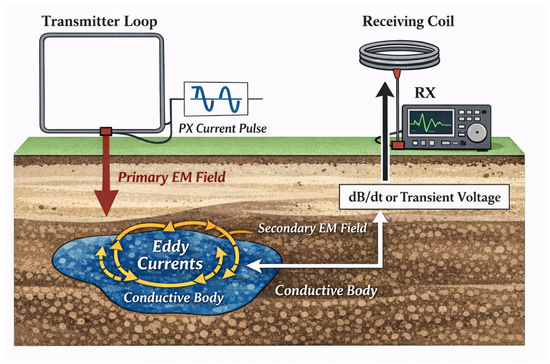
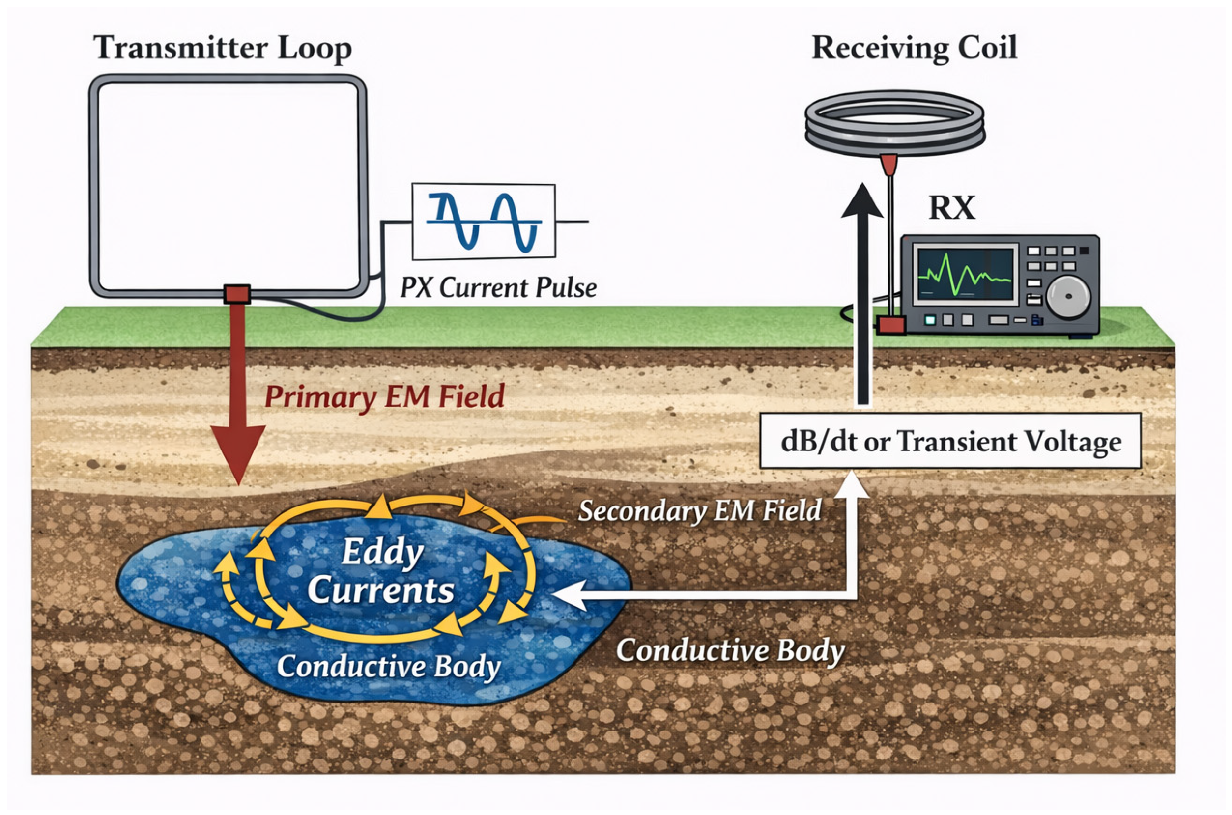
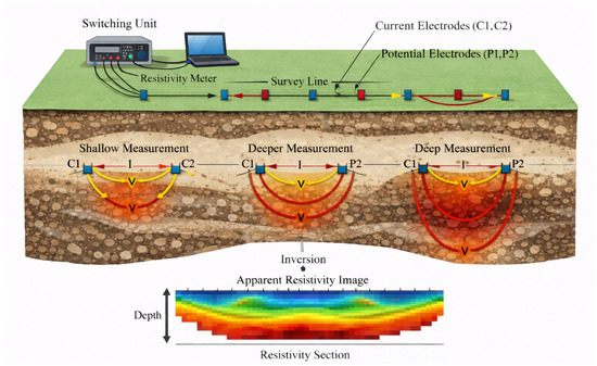
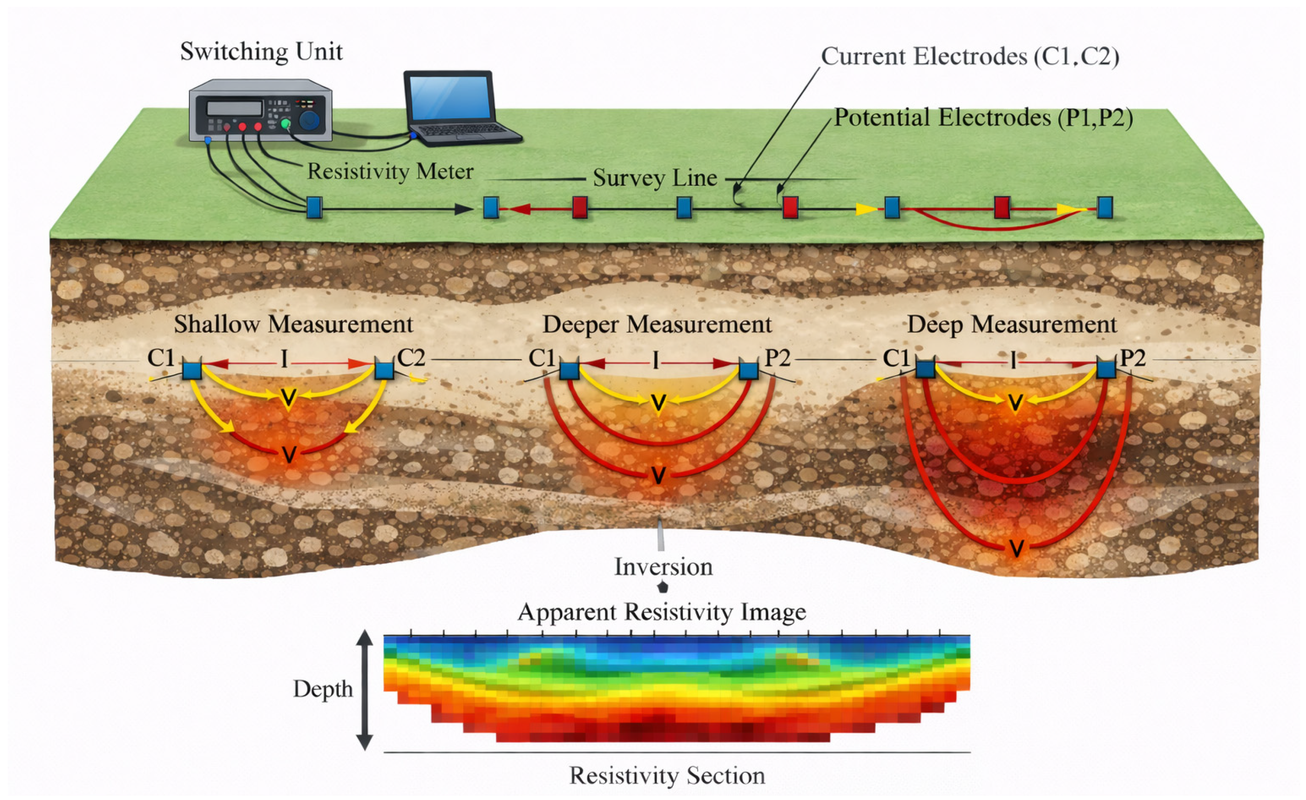
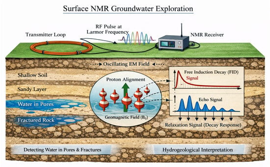
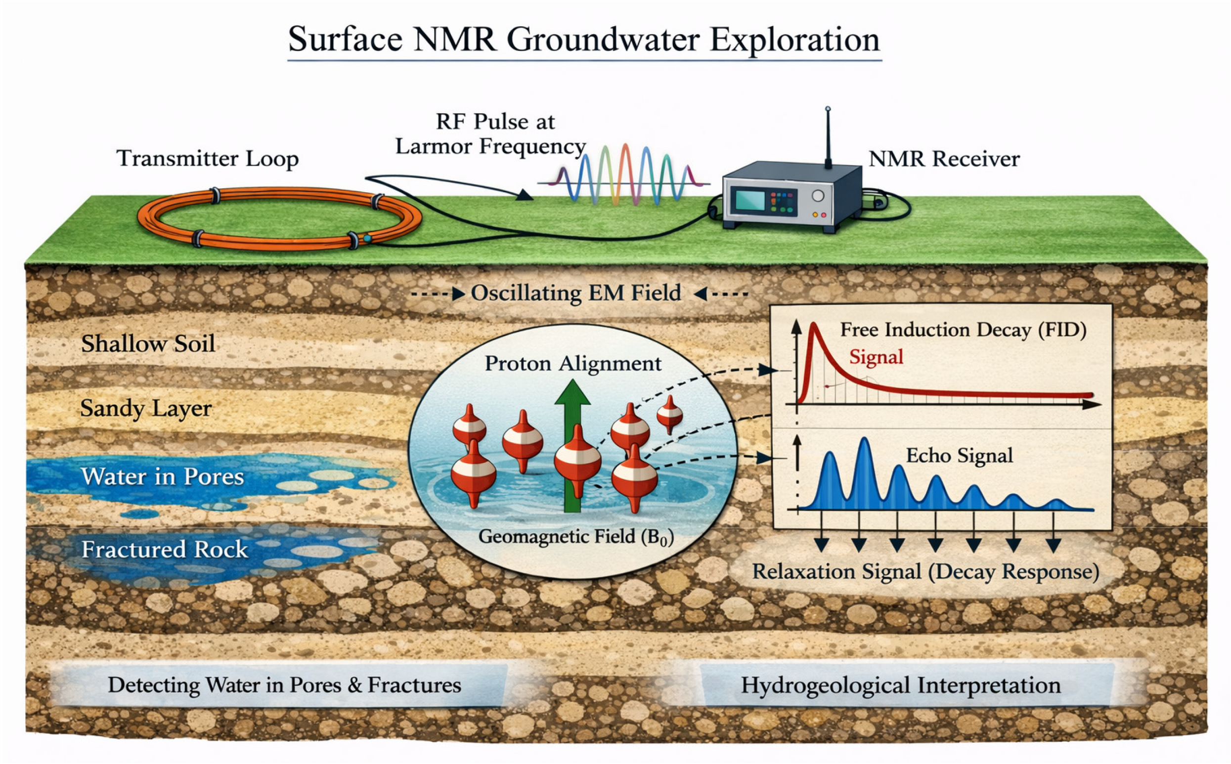
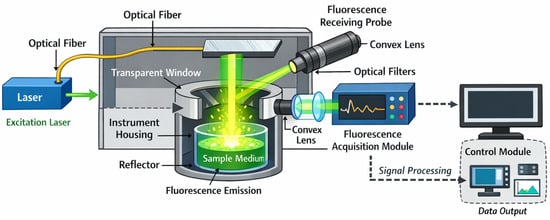
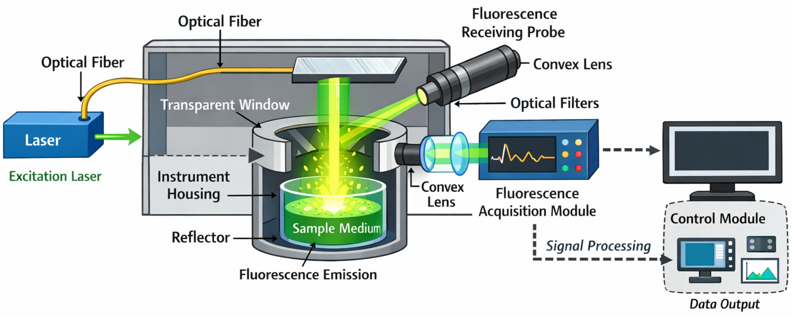
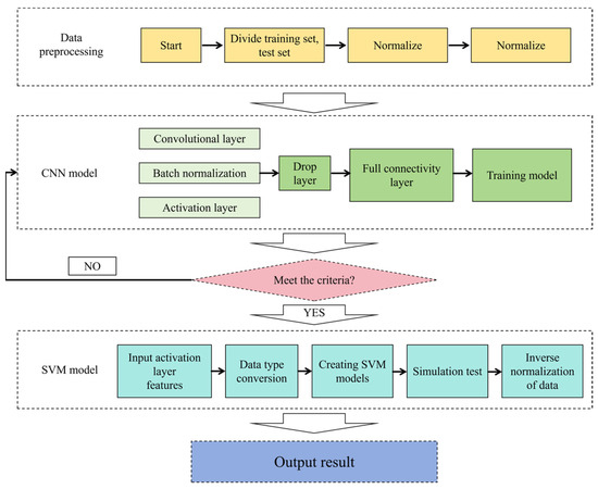
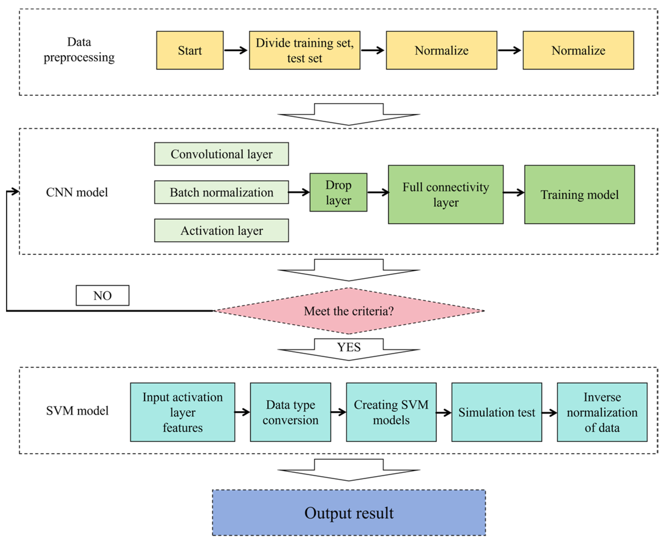

Disclaimer/Publisher’s Note: The statements, opinions and data contained in all publications are solely those of the individual author(s) and contributor(s) and not of MDPI and/or the editor(s). MDPI and/or the editor(s) disclaim responsibility for any injury to people or property resulting from any ideas, methods, instructions or products referred to in the content. |
© 2026 by the authors. Licensee MDPI, Basel, Switzerland. This article is an open access article distributed under the terms and conditions of the Creative Commons Attribution (CC BY) license.