


Abstract
In highway aerial imagery, complex weather conditions such as rain, fog, snow, and low illumination often lead to severe appearance degradation and feature loss of vehicle targets, posing significant challenges for vehicle detection. Existing research faces two major challenges: first, the lack of large-scale, high-quality annotated datasets tailored for complex weather scenarios; second, the difficulty traditional detectors encounter in effectively extracting feature information and performing multi-scale feature fusion under conditions of severe feature degradation and dense distribution of small objects. To address these issues, this paper investigates both data construction and algorithm design. Firstly, a Complex Weather Highway Vehicle Dataset (CWHVD) is established to provide a benchmark for related research. Secondly, a Feature-Enhanced Grid-Based Feature Fusion Complex-Weather Vehicle Detection Network (FGCV-Det) is proposed. A wavelet transform-based Feature Enhancement Module (FEWT) is introduced at the input stage to strengthen edge and texture representation. In the backbone, Adaptive Pinwheel Convolution (APConv) and a C3K2-HD module based on Hidden State Mixer-Based State Space Duality (HSM-SSD) are employed to enhance semantic modeling. Furthermore, a Complex Weather Grid Feature Pyramid Network (CWG-FPN) is designed to achieve weighted cross-scale fusion. The FGCV-Det significantly outperforms YOLO11s on CWHVD, achieving 63.4% precision, 48.6% recall, 51.7% mAP50, and 28.2% mAP50:95. It also generalizes well, reaching 47.1% and 49.6% mAP50 on VisDrone2019 and UAVDT, respectively, surpassing baseline and mainstream detectors, demonstrating strong robustness and generalization capability.
1. Introduction
The advent of intelligent transportation systems and smart highways has led to a surge of interest in vehicle target detection as a pivotal technology. Its applications include traffic monitoring [1], traffic flow statistics [2], accident early warning [3], and decision support [4]. In comparison with conventional fixed ground surveillance equipment, unmanned aerial vehicle (UAV) aerial photography platforms offer several advantages, including flexible viewing angles, wide coverage, and low deployment costs. These sensors facilitate comprehensive perception of highway scenarios and demonstrate promising application prospects in large-scale, all-weather traffic monitoring [5]. However, vehicle target detection in aerial photography on highways faces even greater challenges under complex weather conditions.
In practical applications, complex weather conditions and lighting variations have been shown to significantly degrade the imaging quality of aerial photographs [6], resulting in reduced contrast of vehicle targets, blurred edges, and loss of texture details. Concurrently, the background interference intensifies, resulting in an uneven noise distribution. These factors have been shown to significantly reduce the separability of vehicle targets in the feature space, thereby posing considerable challenges for feature extraction, target localization, and scale regression in object detection networks [7]. Despite the considerable progress made in recent years by deep learning-based object detection methods [8,9,10,11] in conventional weather conditions, there is still considerable scope for improvement in terms of the performance and robustness of these methods when it comes to complex weather, highway aerial photography scenarios.
From a data perspective, existing mainstream public drone aerial target detection datasets, such as VisDrone2019 [12] and UAVDT [13], still exhibit limitations in terms of scene complexity and weather diversity. Samples of highway aerial photography captured under complex weather conditions account for a low proportion of the dataset, and there is insufficient fine-grained annotation for vehicle targets. This has the effect of constraining the training effectiveness and generalisation capabilities of detection models in complex weather scenarios, with the result that it is difficult to fully reflect real-world detection requirements. Consequently, the construction of a specialised vehicle object detection dataset tailored for complex weather, highway aerial photography scenarios is of significant research value and practical importance.
At the methodological level, multi-threshold binarization as a classical feature extraction and data compression technique has demonstrated effective performance in spectral remote sensing image analysis [14]. However, in complex weather scenarios involving highway aerial photography, the superposition of degradation types and the presence of noise render segmentation strategies based on fixed or global thresholds highly sensitive to environmental changes. This results in limited stability and generalization capabilities. Consequently, data-driven deep learning models exhibit enhanced adaptive capabilities in complex weather conditions.
In addition, extant detection networks principally concentrate on modelling local features [15], with inadequate characterisation of global semantic relationships and multi-scale interactions. Conventional multi-scale fusion architectures are susceptible to false negatives and false positives. The extant research is principally concerned with image enhancement methods [16] and feature enhancement methods [17].
Image enhancement methods are widely employed as preprocessing techniques. The restoration of visual information lost due to weather factors is achieved through technologies such as dehazing [18], de-raining [19], de-snowing [20] and low-light enhancement [21]. The result is an improvement in input image quality. For instance, networks such as DehazeNet [22] and MF-MSCNN [23] address only single degradations and rely heavily on large-scale, high-quality paired datasets. In contrast, the latest image enhancement networks, such as AllWeather-Net [24], have the capacity to adaptively enhance multiple degradations simultaneously. However, it should be noted that the presence of artifacts or noise may be introduced in instances of complex weather conditions. GridFormer [25] introduces a grid attention mechanism to handle non-uniform degradation, but its generalization performance is significantly affected by the quality of the training data and incurs substantial computational overhead, posing deployment challenges in real-time systems.
In recent years, researchers have increasingly focused on directly enhancing feature expression capabilities within detection networks to address texture and structural degradation caused by complex weather conditions. By incorporating attention mechanisms [26] and multi-scale contextual modeling [27], models can better capture vehicle structural information under blurred and low-contrast conditions while improving perception capabilities in complex scenarios.
Huang [28] proposed DTRDNet, which enhances the interaction between restoration and detection information through a degradation type discriminator and multi-scale bidirectional feature fusion, thereby improving detection accuracy under various weather conditions. Song [29] designed a multi-scale hybrid attention network that establishes connections between objects of different sizes through foreground enhancement and channel attention modules, thereby effectively boosting object detection performance.
Furthermore, other methods such as wavelet convolution [30] and deformable convolution [31] are frequently employed to enhance target feature information. Due to its multiresolution image representation and feature extraction capabilities, the Discrete Wavelet Transform (DWT) is widely applied in the analysis of UAV aerial images. The DWT effectively enhances vehicle edges and texture information, improving target distinguishability. Previous studies have applied wavelet transforms to UAV image clustering and traffic infrastructure detection [32]. Overall, feature enhancement methods directly address detection tasks, reducing inconsistencies between enhancement and detection. This enables the effective construction of end-to-end integrated complex weather vehicle detection networks.
In order to address the aforementioned issues, the present paper conducts research at two levels: namely, dataset construction and detection method design. Firstly, an initiative was undertaken to construct the Complex Weather Highway Vehicle Dataset (CWHVD). To this end, a range of UAV platforms were utilised to capture aerial images of highways under various complex weather conditions. This dataset comprises meticulously annotated vehicle objects, providing reliable data support for research on vehicle object detection in complex weather scenarios.Secondly, for the task of detecting vehicles in aerial photographs on highways under complex weather conditions, a Feature-Enhanced Grid-Based Feature Fusion Complex-Weather Vehicle Detection Network (FGCV-Det) is proposed. This method introduces a Feature Enhancement Module Based on Wavelet Transform (FEWT) at the input stage. The application of multi-scale frequency domain decomposition has been demonstrated to enhance the edge and texture information of vehicle targets, thereby mitigating feature degradation under complex weather conditions. In the backbone network, Adaptive Pinwheel Convolution (APConv) is used and a C3K2-HD reinforcement feature extraction module based on Hidden State Mixer-Based State Space Duality (HSM-SSD) [33] has been designed to improve modelling of key semantic features in complex backgrounds. Concurrently, this paper proposes the Complex Weather Grid Feature Pyramid Network (CWG-FPN), a novel architecture designed to facilitate comprehensive interaction and fusion of cross-scale, multi-level features. The CWG-FPN aims to enhance the representation capability of vehicle targets at various scales. The primary contributions of this paper are as follows:
(1) To address the scarcity of datasets for highway aerial vehicle detection under complex weather conditions, this study constructs the CWHVD dataset. The dataset incorporates aerial images captured under diverse adverse weather scenarios, providing a dedicated data benchmark for research on complex-weather aerial vehicle detection.
(2) To address texture degradation and insufficient semantic representation of vehicle targets under complex weather conditions, the FEWT is introduced at the input stage. In the backbone network, APConv and the enhanced C3K2-HD feature extraction module are further incorporated. This dual-level design strengthens structural detail enhancement and global semantic modelling through input-level feature enhancement and deep feature extraction, thereby improving feature representation capability in complex backgrounds.
(3) Existing feature pyramid networks rely on fixed chain-like or hierarchical information paths. Under complex weather conditions, feature degradation varies across scales: shallow features lose details due to rain and snow, while deep features suffer from semantic contamination caused by haze and noise. These limited interaction paths hinder effective cross-scale compensation of degraded features, leading to poor detection of small and ambiguous targets. To address this issue, we propose the CWG-FPN, which organizes multi-scale features into a grid topology to enable dense, multi-path information exchange both vertically and horizontally. This design allows high-level semantics to refine low-level localization while low-level details enhance high-level representations. Furthermore, high-resolution P2 features are introduced to improve small-object detection, while noise-sensitive P5 features are restricted to fusion only.
2. Materials and Methods
Complex weather conditions such as rain, fog and snow, as well as varying light levels, can degrade aerial images of highways and blur vehicle features. This significantly impairs the performance of object detection. Current stage-based image enhancement and detection methods struggle to optimise the entire process, often resulting in information loss and cumulative errors.
In order to address the aforementioned challenges, this paper presents a complex weather highway aerial vehicle object detection dataset, as well as an end-to-end integrated detection network. The aim of this network is to enhance the accuracy and robustness of detection in complex weather scenarios. This section outlines the process of constructing the dataset and presents the overall framework and key components of the proposed detection network.
2.1. Complex Weather Highway Vehicle Dataset
Existing publicly available aerial vehicle datasets are primarily collected in clear weather, with limited coverage of complex weather scenarios such as rain, fog and night-time conditions. This hinders research into vehicle detection methods under challenging weather conditions. To address this issue, this paper presents the CWHVD dataset. The CWHVD covers a range of complex weather scenarios, including rain, fog, snow and night-time conditions, as well as night-time conditions with rain or fog. The dataset is enhanced by incorporating multi-dimensional settings such as vehicle categories, shooting height, ambient lighting and weather intensity, making it more representative and practical.
2.1.1. Data Collection and Processing
Data acquisition was performed using the DJI Matrice 350 RTK drone (manufactured by DJI, Shenzhen, China), which offers high flight stability and positioning accuracy. This meets the requirements for extended aerial photography missions along fixed flight paths in highway environments. The drone was equipped with the Zenmuse H30T multi-sensor camera (manufactured by DJI, Shenzhen, China) and conducted field data collection across various sections of the highway while ensuring flight safety and compliance. This configuration is illustrated in Figure 1.
Figure 1.
Image data acquisition device.
The data collection process encompasses a range of weather conditions, including clear days, foggy days, rainy days, and snowy days, and extends across different time periods such as morning, noon, evening, and night. This approach is adopted to ensure the diversity and authenticity of the data with respect to illumination variations and weather degradation. The flight altitude of the drone was meticulously calibrated within the range of 30 m to 120 m, a strategic decision aimed at optimising the balance between comprehensive scene coverage and the quality of captured images. Through the strategic planning of flight altitude, shooting angles, and flight paths, the scale distribution and density of vehicle targets within the images were optimised to meet the requirements for subsequent target detection and model training.
Following the completion of the raw data acquisition, the captured video data undergoes systematic preprocessing. Initially, a fixed-interval frame extraction strategy is employed to generate static image samples by extracting one frame every 60 frames. This approach has been demonstrated to reduce data redundancy while preserving temporal differences between samples. Subsequently, the extracted images undergo a quality screening process. This process involves the elimination of samples that exhibit severe blurring, significant occlusion, or abnormal exposure. The purpose of this process is to ensure the quality of the data. All images were uniformly adjusted to the same resolution while preserving their original aspect ratios. Pixel values underwent a process of normalisation in order to reduce distribution variations caused by differing shooting conditions, thereby enhancing the stability of the model during training. Figure 2 presents a selection of examples drawn from the CWHVD dataset.
Figure 2.
Sample images from the dataset. Row (a) presents scenes from different regions, including urban ring highways, suburban highways, mountain highways, and service areas. Row (b) shows images captured under various weather conditions, including foggy, nighttime, snowy, and rainy scenarios. Row (c) illustrates images acquired from different viewing angles.
2.1.2. Data Annotation and Statistics
Data annotation was conducted utilising the open-source tool LabelImg, in accordance with the uniform text annotation format stipulated by YOLO. Each image is associated with an annotation file of a similar name, with each line of the file representing a target instance. This encompasses the target category ID and the normalized bounding box parameters. It is imperative to note that all coordinate values are normalized to the range [0, 1], with the objective of enhancing the model’s adaptability to divergent input scales.
In the context of aerial highway scenes, this paper employs fine-grained annotation of four vehicle categories: car (0), truck (1), motor (2), and bus (3). In order to address the challenges posed by small object scales and frequent occlusions in aerial perspectives, a unified and rigorous annotation protocol has been established. This protocol requires that bounding boxes closely follow visible vehicle contours, that partially occluded objects are annotated only for their visible regions, and that small-scale vehicle targets receive prioritised annotation. The aim of this protocol is to ensure comprehensive coverage of numerous small-object instances that are prevalent in aerial datasets.
The final CWHVD dataset comprises 6700 valid complex weather highway aerial images, which have been divided into training, validation, and test sets in a 7:1:2 ratio. The training set contains 4690 images, the validation set contains 670 images, and the test set contains 1340 images. In terms of weather conditions, the CWHVD dataset covers foggy days, night-time scenes, rainy days and snowy days. Foggy and night-time scenes each account for around 30%, while rainy scenes account for around 25% and snowy scenes for around 15%. This distribution ensures the diversity of complex weather samples is reflected accurately, in line with the frequency of different weather conditions in real highway surveillance environments. Consequently, it provides a foundation of representative experimental data for research on vehicle object detection under complex weather conditions. In order to analyse the overall distribution characteristics of the dataset, this paper conducts statistical analysis of the CWHVD dataset from two perspectives: target category distribution and target scale distribution. The results are presented in Figure 3. The figures demonstrate that small-scale vehicle targets constitute a substantial proportion of the dataset, and the target scale exhibits significant variation. This finding is consistent with the actual conditions of highway aerial photography scenarios, where UAVs fly at high altitudes and vehicles appear as dense, small targets.
Figure 3.
Distribution of dataset categories: (a) Category annotation count. (b) Scatter plot of border frame width and height.
In summary, the CWHVD dataset exhibits distinctive characteristics in terms of complex weather coverage, small-scale target proportions, and target scale diversity. It imposes higher demands on the representation capabilities of features, multi-scale modelling capabilities, and the overall robustness of vehicle detection algorithms for highway aerial photography in complex degradation environments. The dataset provided herein is reliable and suitable for the training and validation of the methods proposed in this paper.
2.2. Overall Framework of FGCV-Det
In order to address severe feature degradation, drastic variations in target scale, and increased background interference in aerial vehicle target detection on highways under complex weather conditions, this paper proposes FGCV-Det, whose overall structure is shown in Figure 4. FGCV-Det is an end-to-end integrated detection framework that employs three primary components: an input feature enhancement module, a reinforcement feature extraction backbone network, and a grid-based multi-scale feature fusion network. The integration of feature enhancement, global semantic modelling, and cross-scale information interaction mechanisms at various stages has been shown to result in holistic optimisation, ranging from low-level texture enhancement to high-level semantic representation and multi-scale feature fusion.
Figure 4.
FGCV-Det network architecture diagram.
During the feature fusion stage, the CWG-FPN is constructed. The multi-path, multi-scale grid-based information exchange architecture of the system ensures comprehensive integration of features across different scales. This enhancement in detection capabilities is particularly beneficial in the context of vehicle targets at various scales, with a notable advantage in the identification of small-scale targets.
2.3. Feature Enhancement Module Based on Wavelet Transform
Under complex weather conditions, factors such as smog, rain, snow, and uneven lighting cause vehicle features in aerial images of highways to appear blurred and exhibit reduced contrast. Traditional convolutional neural networks tend to lose high-frequency detail during downsampling, thereby weakening their ability to represent vehicle edges and texture features.
In order to address the aforementioned issues, this paper proposes a feature enhancement module based on wavelet transform, whose structure is shown in Figure 5. The purpose of this module is to enhance the discriminative features required for vehicle target recognition and localization. The enhancement of separability between targets and background in the feature space serves to mitigate the impact of weather interference on detection performance at its source. Specifically, the FEWT module employs the multi-resolution analysis capabilities of the DWT to explicitly model different frequency subbands while maintaining downsampling efficiency, thereby counteracting information loss caused by weather interference. Additionally, the module design incorporates a subsampling residual path to ensure the stability of the feature enhancement process during the subsampling stage of the detection network. The FEWT module, operating as a front-end feature enhancer, collaborates with the subsequent backbone network and feature fusion architecture—specifically designed for multi-scale vehicle detection—to collectively form an end-to-end robust detection solution.
Figure 5.
FEWT structure diagram.
In wavelet decomposition, the input feature map , where denotes the number of channels, and H and W represent its height and width. FEWT decomposes the input feature using four fixed wavelet filters with a step size of 2, achieving a 2x downsampling. The filter coefficients are defined as shown in Equation (1).
Subsequent to wavelet decomposition, the input feature map is decomposed into four subband feature maps: , , , and each have a dimension of . These subbands are then concatenated along the channel dimension to form a multi-scale feature representation , calculated as shown in Equation (2).
In order to guarantee that the channel consistency between the wavelet-enhanced features and the subsequent backbone network architecture is maintained, a convolutional feature encoding layer is incorporated after feature concatenation. This layer is responsible for the compression of the channel dimension while executing a nonlinear mapping. The process in question has been demonstrated to reduce the number of channels from to the target channel count , while preserving spatial resolution. The output feature representation is denoted as , as described by Equation (3).
Furthermore, to enhance the stability and structural compatibility of the network training, FEWT introduces a parallel downsampling path alongside the wavelet branches. This pathway directly downsamples and performs channel mapping on the input feature through a convolution operation with a stride of 2, yielding the downsampled feature . The calculation method is delineated in Equation (4).
In conclusion, the wavelet branch output feature is integrated with the downsampling path output feature to derive the FEWT module’s output feature , as depicted in Equation (5). The wavelet enhancement structure, which introduces an additional sampling path, has two main functions. Firstly, it preserves the stability of the original convolution during the downsampling stage. Secondly, it enhances the robustness of the front-end feature representation by introducing additional high-frequency information compensation through the discrete wavelet transform.
2.4. Reinforced Feature Extraction Backbone
Under complex weather conditions, factors such as rain, fog, and snow degrade edge and texture features in aerial images. Combined with the small scale and high morphological variability of vehicles in aerial perspectives, these challenges make it difficult for traditional convolutional networks to effectively model complex spatial structures. To address this, this paper introduces APConv into the YOLOv11 backbone network. The original C3K2 module exhibited constrained global modelling capacity. In order to address this issue, the enhanced feature extraction module C3K2-HD is proposed. This approach draws inspiration from the HSM-SSD, with the objective of enhancing the representation of directional structures and long-range dependency features.
2.4.1. Adaptive Pinwheel Convolution
Convolutional operators are limited by fixed square receptive fields when modelling spatial features, which hinders the effective capture of the directional structure and non-uniform spatial distribution of vehicle targets in aerial scenes. In order to address this issue, the present paper introduces the concept of adaptive windmill convolutions into the backbone network. Through multi-directional asymmetric convolutions and dynamic padding strategies, it enhances the perception of features across different orientations and scales, as illustrated in Figure 6.
Figure 6.
APConv structure diagram. Gray represents input features, while colour represents feature maps after adaptive padding and convolution.
This module achieves direction-aware feature expansion by introducing learnable asymmetric padding offsets in the upper, lower, left, and right directions of the input feature map. This approach overcomes the limitations of traditional square receptive fields, thereby enhancing the representation capability for vehicle targets. The APConv module focuses on spatial structure modeling during the feature extraction phase. To address directional blurring and structural deformation issues that may arise under complex weather conditions, it employs a learnable asymmetric filling mechanism to achieve direction-adaptive receptive field adjustment, thereby enhancing the stability and robustness of structural representation. Furthermore, as a crucial component of the backbone network, APConv collaborates with the FEWT feature enhancement module and the C3K2-HD feature extraction module to jointly optimize and construct a hierarchical feature representation framework.
From a mathematical perspective, the APConv model replaces the fixed padding in the PConv [34] model with a learnable parameter matrix . This results in the following computational expression, as illustrated in Equation (6).
It is imperative that satisfies the constraints imposed by . In addition, is a learnable offset that can be optimised via gradient descent, thereby enhancing the stability and efficiency of the training process.
The input horizontal tensor and vertical tensor are denoted as and , respectively. The calculation methods correspond to Equations (7) and (8), where , , and represent the number of input channels, height, and width, respectively.
where ⊗ is the convolution operator, denotes the application of asymmetric padding to the i-th row parameter of following integer rounding. In this study, the symbols and are used to denote the convolution kernels of and .
The output feature map is characterised by a height of , a width of , and a channel count of . In this context, s denotes the stride of the convolution, and represents the number of channels in the final output feature map. The resulting concatenated output can be obtained, with its calculation formula shown in Equation (9).
In conclusion, the concatenated tensor is subjected to normalisation using the convolution kernel , thereby yielding the final output feature map . The calculation is demonstrated in Equation (10), with its height and width adjusted to and .
2.4.2. C3K2-HD Module Based on HSM-SSD
In order to address the challenges of sparse vehicle distribution, large-scale variations, and complex spatial relationships in highway aerial photography scenarios, this paper designs the enhanced feature extraction module C3K2-HD based on the C3K2 module of YOLO11. Its structural configuration is delineated in Figure 7. This module incorporates the HSM-SSD module to enable hidden state updates and cross-channel propagation, thereby effectively modelling long-range dependencies across spatial locations. The C3K2-HD model is underpinned by the principles of state-space duality theory, a foundational framework in the field. This model aims to enhance the global semantic modelling capabilities with linear time complexity. It does so by addressing the limitations of traditional convolutions in modelling long-range context under complex weather conditions.
Figure 7.
C3K2-HD structure diagram.
Specifically, given an input sequence , where LL denotes the sequence length and DD represents the number of channels. The initial parameters are generated through a linear projection layer, calculated as shown in Equation (11).
where denotes the input projection matrix, represents the output projection matrix, N signifies the state dimension, and indicates the discretization step size parameter.
Consequently, the discretization process yields importance weights and the state transition matrix, with the calculation method delineated in Equation (12).
where is the importance weight vector and is the discretized projection matrix.
The global shared hidden state h calculation method for the HSM-SSD module, as shown in Equation (13). Where represents a row vector of dimension , denotes the input projection matrix, and ⊙ denotes the Hadamard product.
Additionally, the HSM-SSD module incorporates a Hidden State Mixer (HSM). This mechanism significantly reduces computational complexity by shifting channel mixing operations from the high-dimensional feature space to a low-dimensional hidden state space, thereby enabling efficient modeling of global contextual information. The resulting approximate output is computed as shown in Equation (14).
where denotes the channel mixing function executed in the hidden state space, represents the learnable gated projection matrix, is the output projection matrix, and is the Sigmoid activation function. This approximation mechanism reduces the computational complexity of the output stage from to , which becomes negligible as N decreases.
2.5. Complex Weather Grid Feature Pyramid Network
In order to address the significant scale variation of vehicle targets and the high proportion of small-scale objects in highway aerial photography scenarios, this paper proposes the CWG-FPN, whose structure is shown in Figure 8. In contrast to multi-scale fusion methods such as PANet [35] and BiFPN [36], which employ chained or hierarchical topologies, CWG-FPN organises multi-scale features from the backbone network into a two-dimensional grid structure. This configuration establishes cross-scale connections vertically and enables intra-scale feature propagation horizontally, thereby forming a multi-path, iterative information interaction mechanism. This architecture facilitates the integration of feature information from diverse scales and paths, thereby enhancing the robustness of multi-scale feature interaction and fusion under complex weather conditions.
Figure 8.
Comparison of three fusion structures.
Through repeated fusion and iterative propagation between grid nodes, semantic information from high-level features can effectively descend to shallow-level features, while spatial details and edge information from shallow-level features can also be fed back to high-level feature representations. This process constructs a more robust multi-scale feature expression. In order to address the high proportion of small targets in aerial photography scenarios, this paper introduces a high-resolution P2 feature layer as a detection branch within the detector head. This enhancement in the system’s capacity to discern diminutive, remote, and indistinct vehicle targets is of significant importance. In addition, it is important to note that the most advanced P5 functionalities are vulnerable to interference from background noise when exposed to complex weather conditions. Consequently, this paper does not directly feed them into the detection head. Instead, they are incorporated into cross-scale fusion solely for the purpose of enhancing the semantic expression of mid-to-low-level features. This approach has been demonstrated to preserve semantic consistency while avoiding the direct introduction of noise.
It is acknowledged that features at different scales contribute significantly differently to detection tasks under complex weather conditions. The present paper introduces a weighted feature fusion mechanism at each grid fusion node within the CWG-FPN. The input features for a given fusion node may be represented as shown in Equation (15).
where denotes the number of channels in the k-th input feature map, while H and W represent the height and width of the input feature map after scale alignment.
In order to effectively fuse features from different sources and scales while adaptively suppressing noise introduced by complex weather conditions, CWG-FPN introduces a weighted feature fusion mechanism at each grid fusion node. The weight is computed as shown in Equation (16).
where is used to represent the learnable weight parameters that undergo adaptive optimisation through backpropagation during training. In addition, is used to denote the infinitesimal constant that is employed to prevent division-by-zero operations.
Subsequently, based on the index ranges of each input feature across the channel dimension, the features are weighted channel-by-channel using the calculation method shown in Equation (17).
where ⊙ denotes per-channel multiplication operations.
This process facilitates the modulation of features from disparate scales and sources prior to their fusion, thereby suppressing redundant channel responses and accentuating pivotal feature information that is particularly salient for the present detection task. In conclusion, the weighted multi-scale features are concatenated along the channel dimension to yield the weighted fusion output features Y, as demonstrated in Equation (18).
The integration of a weighted feature fusion strategy within the CWG-FPN’s grid-based architecture enables the model to adaptively balance the contribution ratios of high-resolution detail information and low-resolution semantic information, contingent on specific scenes and target characteristics. This enhancement of the quality of multi-scale feature fusion and detection robustness under complex weather conditions provides subsequent detection heads with more stable and discriminative feature representations.
3. Results
In order to validate the effectiveness of the proposed method, this paper conducts systematic experimental evaluations based on the self-built CWHVD dataset. The experiments commence with a delineation of the training environment and the parameter configurations that have been adopted, in conjunction with the evaluation metrics that have been utilised. Subsequent ablation studies analyse the performance contributions of each module, and the overall detection capability is assessed through quantitative results and visual examples. In addition, the practicality of the model and its ability to generalise to different scenarios were validated through cross-domain experiments conducted on the VisDrone2019 and UAVDT datasets.
3.1. Experimental Environment
The present experiment was conducted using the PyTorch 2.5.1 deep learning framework on an Ubuntu system. The specific experimental configurations are outlined in Table 1. The dimensions of the input image were set to 640 × 640. The training parameters adopted the default YOLOv11 settings, which entail a 200-epoch training process using a stochastic gradient descent optimiser with momentum of 0.937, weight decay of 0.0005, batch size of 16, and an initial learning rate of 0.01.
Table 1.
Experimental environment configuration.
3.2. Evaluation Metrics
In order to validate the model’s performance, this paper employs three evaluation metrics—Precision, Recall, and Mean Average Precision (mAP)—as assessment criteria. The calculation of these metrics is all based on the confusion matrix. As demonstrated in Table 2, TP signifies a positive sample in the original data that is also predicted as positive by the model. TN denotes cases where the original data is a negative sample and the model prediction also indicates a negative sample.
Table 2.
Confusion matrix.
Precision (P) is a metric that quantifies the accuracy of a model’s positive predictions. The term is defined as the proportion of true positives among the model’s positive predictions, calculated as shown in Equation (19).
The recall (R) metric is defined as the model’s capacity to accurately identify positive instances. The term is defined as the proportion of all true positive samples that are correctly detected by the model. This calculation is outlined in Equation (20).
mAP is the evaluation metric of choice for object detection tasks. The present paper employs mAP50 and mAP50:95 for the purpose of performance assessment. Specifically, mAP50 is computed at an IoU threshold of 0.5 in order to measure detection performance under relaxed localization constraints. mAP50:95 employs multi-threshold averaging across the IoU range 0.50–0.95 (with 0.05 increments), thereby providing a more comprehensive reflection of detection accuracy and robustness under stringent localization conditions. A valid match is defined as occurring when the intersection over union (IoU) between a predicted box and a ground truth box meets the corresponding threshold, calculated as shown in Equation (21).
3.3. Ablation Experiment
In order to validate the effectiveness of each proposed module, systematic ablation experiments were designed. Firstly, an ablation analysis was conducted on the FEWT module at varying embedding positions in order to evaluate its impact on feature enhancement and detection performance. Subsequently, the APConv module was subjected to a comparative analysis of its placement, with the objective of investigating its impact on feature expression capability, model parameter scale, and detection accuracy. Subsequent comparative experiments on feature fusion strategies validated the effectiveness of CWG-FPN in multi-scale feature modelling and information interaction. A joint ablation study of FEWT, APConv, C3K2-HD, and CWG-FPN was conducted to systematically analyse the independent contributions and synergistic gains of each module.
3.3.1. FEWT Module Position Comparison Ablation Experiment
The present study sought to evaluate the impact of embedding the FEWT module at different layers of the backbone network on detection performance. To this end, comparative ablation experiments were conducted on the addition position. The results of this study are presented in Table 3.
Table 3.
FEWT position ablation experiment.
The Baseline denotes the backbone network in which only the C3K2-HD module is introduced, without incorporating the FEWT module. It can be observed that the incorporation of the FEWT module into Layer 1 of the backbone network results in optimal performance, with mAP50 and mAP50:95 scores of 43.4% and 23.5%, respectively, representing improvements of 0.6% and 0.4% over the baseline. This finding suggests that the incorporation of wavelet feature enhancement at the shallow layers of the backbone network is effective in compensating for the loss of high-frequency detail information under complex weather conditions, thereby enhancing the performance of vehicle object detection.
Conversely, the incorporation of the FEWT module into the input layer or more advanced layers yields marginal performance enhancements, with certain metrics exhibiting a decline below the baseline. This finding suggests that the alignment of semantic features, particularly those of an extremely shallow or high-level nature, with the wavelet enhancement mechanism may be suboptimal. Furthermore, while introducing FEWT across multiple layers simultaneously improves recall, it leads to decreased accuracy and mAP50:95, suggesting that redundant enhancements may introduce feature interference. A thorough investigation has been conducted, the results of which indicate that the FEWT module functions at its most efficient when implemented within the shallow-to-mid layers (Layer 1) of the backbone network.
3.3.2. APConv Module Position Comparison Ablation Experiment
In order to validate the effectiveness of the APConv module, comparative ablation experiments were conducted by adding the APConv module to different layers of the backbone network based on the FEWT-enhanced base network. The results of the study are presented in Table 4. It has been demonstrated that the APConv module, when introduced concurrently at Layers 0, 3, 5, and 7, results in the model attaining optimal performance. Specifically, the precision rate P reaches 60.6%, while mAP50 and mAP50:95 attain 44.5% and 24.0%, respectively. A comparative analysis reveals that these metrics demonstrate enhancements of 2.2%, 1.1%, and 0.5%, respectively, when evaluated against the baseline model. Concurrently, the model’s parameter count diminished from 9.4M to 9.0M, signifying that APConv enhances detection performance while providing parameter compression capabilities.
Table 4.
APConv position ablation experiment.
A more thorough investigation of the experimental findings at varying insertion positions has been undertaken, which has led to the conclusion that the efficacy of the model is notably enhanced when APConv is incorporated exclusively into Layer 0. With the augmentation of insertion layers, both the recall R and mAP50:95 demonstrate a consistent progression, signifying that APConv facilitates the effective enhancement of feature expression across a range of scale features. It is evident that the optimal outcomes are attained when the APConv module is applied in a uniform manner across multiple layers of the backbone network. This validates its efficacy in the intricate task of vehicle detection in aerial images captured on highways under diverse weather conditions.
3.3.3. Feature Fusion Module Comparison Ablation Experiment
The present paper conducts comparative ablation experiments on multiple feature fusion modules for the purpose of validating the impact of different feature fusion structures and the introduction of a P2-layer detection branch on the performance of aerial vehicle object detection in complex weather conditions on highways. The experimental results are presented in Table 5.
Table 5.
Feature fusion ablation experiment.
The experimental results demonstrate that traditional PANet and BiFPN exhibit relatively limited overall detection performance under their original structural configurations, achieving mAP50 values of 41.6% and 42.8%, respectively. This finding suggests that reliance on features from layers P3–P5 alone is inadequate for adequate characterisation of the numerous small-scale vehicle targets present in complex weather aerial scenes. Following the incorporation of high-resolution features from layer P2, a substantial enhancement in the detection performance of all methods was observed. Specifically, PANet + P2 and BiFPN + P2 achieved mAP50 scores of 45.9% and 46.8%, respectively, thus validating the crucial role of high-resolution shallow-layer features in small object detection tasks.
The proposed CWG-FPN builds upon this foundation, integrating multi-scale features and introducing a weighted feature fusion mechanism, achieving optimal detection performance with mAP50 and mAP50:95 reaching 48.7% and 26.8%, respectively. The experimental results demonstrate the efficacy of the Complex Weather Gridded Feature Pyramid Network in distinguishing the importance of features at different scales. The suppression of redundant and noisy information, which is introduced by factors such as rain, fog, and low contrast, enhances the detection accuracy and robustness of the system under complex weather conditions.
3.3.4. Whole Module Ablation Experiment
To further validate the independent contributions of each improved module within the network and their synergistic effects, this paper designed a comprehensive module ablation experiment. Modules such as FEWT, APConv, C3K2-HD, and CWG-FPN were progressively embedded into the backbone network for comparative analysis. The experimental results are presented in Table 6.
Table 6.
Overall ablation study of different modules.
The experimental results demonstrate that the introduction of the C3K2-HD module alone can elevate the model’s mAP50 to 42.8%, representing a 1.2% improvement over the baseline model. This finding suggests that the module effectively enhances the structural and semantic representation capabilities of vehicle targets under complex weather conditions during the fundamental feature extraction stage. Following the introduction of the FEWT module, mAP50 and mAP50:95 improved to 43.4% and 23.5%, respectively, demonstrating strong synergistic effects between feature enhancement and backbone feature extraction. Further integration with the APConv module led to sustained performance gains, indicating that directional awareness and long-range dependency modeling enhance feature representation under complex weather conditions.
In conclusion, the model attained optimal performance following the collaborative integration of FEWT, APConv, C3K2-HD, and CWG-FPN, achieving mAP50 and mAP50:95 scores of 51.7% and 28.2%, respectively, while concurrently reducing the parameter count to 7.7M. This finding serves to substantiate the comprehensive advantages of the proposed module combination with regard to both detection accuracy and model efficiency.
3.4. Experimental Results Comparison and Analysis
3.4.1. Comparative Experiments of Different Network Models
The present chapter is concerned with a comprehensive evaluation of the performance of the proposed algorithms for detecting vehicles in aerial photographs on complex-weather highways. This is achieved by conducting comparative experiments against existing mainstream object detection methods using the CWHVD dataset. The experiments encompassed the two-stage detection network Faster RCNN [37] based on anchor boxes, the single-stage detection network SSD [38], the Transformer-based detection networks DETR [39] and RT-DETR [40], as well as the YOLO [41,42,43,44] series of networks. The experimental results are presented in Table 7. To ensure a fair comparison, all baseline models were retrained and evaluated using our proposed CWHVD dataset and with an identical input resolution and number of iterations. Training was conducted using the models’ default configurations.
Table 7.
Comparison of different detection models.
The results of the detection accuracy study demonstrate that the proposed method achieves significant advantages across all evaluation metrics. The precision rate, P, achieves 63.4%, while the recall rate, R, reaches 48.6%. The mAP50 and mAP50:95 rates are 51.7% and 28.2%, respectively. A comparative analysis with the baseline YOLO11s revealed enhancements of 6.8%, 7.9%, 10.1%, and 5.4%, respectively, in terms of object localization accuracy and category recognition capability. These findings signify substantial advancements in the field. These results fully validate the effectiveness of the proposed FGCV-Det network for detecting vehicles in complex weather conditions on highways using aerial imagery.
With regard to the intricacy of the model, FGCV-Det is characterised by a mere 7.7 M parameters. While maintaining lightweight characteristics, its detection performance significantly outperforms mainstream YOLO series models such as YOLOv9s, YOLOv10s, and YOLO12s. This emphasises the efficiency and rationality of the network architecture.
From the perspective of computational complexity measured in FLOPs, FGCV-Det achieves a computational cost of 34.6 GFLOPs. Although this represents a slight increase compared to lightweight YOLO variants of similar parameter scale, the computational overhead growth is justified and efficient when considering its significant detection performance gains, demonstrating high computational utilization. A comparison of FGCV-Det with transformer-based architectures such as DETR and RT-DETR reveals that FGCV-Det attains superior mAP50 metrics while concurrently reducing the computational load by approximately 42.8%. This outcome demonstrates a higher precision–efficiency ratio. The results demonstrate that the functional modules designed in this paper significantly enhance performance while incurring only limited computational overhead. This achieves an effective balance between computational complexity and detection accuracy, validating their adaptability and deployment efficiency in complex weather scenarios.
3.4.2. Performance Metrics Comparison Experiment
In order to further evaluate the training characteristics of the proposed method, this paper conducts a visual comparative analysis of the dynamic changes in key performance metrics during training. As demonstrated in Figure 9, under identical training configurations, the proposed method significantly outperforms the baseline model in terms of precision, recall, mAP50, and mAP50:95. In comparison with the baseline approach, the proposed model demonstrates faster convergence in the initial training stages and exhibits more stable performance improvements in the subsequent stages. As the number of training iterations increases, the performance disparity between the two approaches gradually widens and stabilises, indicating that the proposed improvement strategy enhances detection performance while maintaining robust training stability and sustained effectiveness.
Figure 9.
Model Performance Metrics Comparison Chart: (a) Comparison of Precision Metrics. (b) Comparison of Recall Metrics. (c) Comparison of mAP50. (d) Comparison of mAP50:95.
As illustrated in Table 8, employing mAP50 as the evaluation metric, the outcomes of the model stability test are demonstrated through multiple independent replicate experiments. The experimental results indicate that FGCV-Det and YOLO11s demonstrate highly consistent performance across five runs. FGCV-Det stabilises at 51.7%, while YOLO11s remains largely consistent at 41.6% with minimal fluctuation. This finding indicates that both models exhibit excellent reproducibility and robustness under varying random conditions.
Table 8.
Model stability experiment.
Furthermore, FGCV-Det consistently outperformed YOLO11s by approximately 10% across all trials. This gap persisted across multiple independent runs, further validating the reliability and consistency of the proposed method’s performance improvement. This confirms that the enhancement stems from structural optimization rather than random fluctuations.
In order to facilitate a more profound analysis of the detection performance across various categories of vehicles, Table 9 presents a comparison of the detection results between YOLO11s and the proposed method on the CWHVD dataset. The proposed method demonstrates a marked improvement in performance over the baseline model across all metrics, thus validating its superior detection capabilities in complex weather aerial photography scenarios.
Table 9.
Comparison results of different vehicle categories on the CWHVD dataset.
In the context of the car category, the proposed methodology attains an mAP50 of 75.6%, accompanied by a recall of 70.8%, marking a notable enhancement from the previous value of 61.1%. This enhancement signifies a more meticulous detection of targets exhibiting stable characteristics and a sufficient sample size. For medium-to-large vehicles such as trucks and buses, mAP50 demonstrated improvements of 8.2% and 11.1%, respectively, thus substantiating the hypothesis that multi-scale feature fusion is an effective method of enhancing the representational capabilities of objects with varying scales. For small-scale targets such as motors, mAP50 increased from 8.9% to 40.5%, significantly mitigating the issue of small object detection failures.
In summary, the proposed method achieves consistent performance improvements across various vehicle targets, demonstrating particularly strong advantages in detecting medium-to-large and small-scale objects. This outcome is indicative of the model’s superior generalisation and robustness capabilities.
3.4.3. Visual Comparison Experiment
The following section is dedicated to the presentation of aerial images of highways captured under various typical complex weather scenarios. The purpose of this presentation is to visually demonstrate the detection performance of the proposed FGCV-Det model under complex weather conditions. A visual comparison of these models with the YOLO11s baseline model is presented in Figure 10, Figure 11, Figure 12 and Figure 13, which also show the corresponding results.
Figure 10.
Visual comparison of rainy and snowy weather, where columns (a–c) correspond to the input image, the YOLO11s model, and the FGCV-DET model, respectively. Each row of images represents a different weather condition.
Figure 11.
Statistics on the number of detected targets in rainy and snowy weather. The slanted bar chart represents the FGCV-Det model, while the regular bar chart represents the YOLOv11s model.
Figure 12.
Model detection count statistics. The slanted bar chart represents the FGCV-Det model, while the regular bar chart represents the YOLOv11s model.
Figure 13.
Model visualization comparison chart. Columns (a–c) correspond to the input image, the YOLO11s model and the FGCV-DET model, respectively. Each row of images represents a different weather condition.
As demonstrated in Figure 10, in complex weather conditions, such as days with significant snowfall or precipitation, where visibility is considerably reduced, the YOLO11s system has been observed to produce false negative results for distant and small-scale vehicle targets. In contrast, the proposed FGCV-Det effectively enhances the representation of vehicle features across different scales by introducing a complex weather-adaptive feature pyramid network. This facilitates multi-path, cross-scale feature interaction, thereby enabling the model to reliably detect vehicle targets under occlusion or feature degradation conditions, thus significantly enhancing the overall completeness of detection.
Furthermore, in low-light scenarios such as nighttime rain or snow with strong background clutter, the detection bounding boxes predicted by FGCV-Det are more compact and closely follow the target contours. The performance of the proposed model surpasses that of the YOLO11s in both bounding box regression accuracy and detection stability. The findings indicate that the proposed grid-based feature fusion architecture ensures high detection accuracy and robustness in complex backgrounds and severe degradation conditions.
The conclusions drawn from the visual detection comparison and qualitative analysis are quantitatively supported by the detection count bar chart in Figure 11. Across four typical complex weather scenarios—namely, snowy days, rainy days, snowy nights, and rainy nights—the FGCV-Det model consistently outperformed the YOLO11s baseline model in terms of detection counts for various vehicle types, including cars, trucks, and buses. The findings demonstrate that the proposed method not only facilitates more comprehensive visual perception but also delivers higher recall rates at the statistical level of actual detection outputs, systematically enhancing overall vehicle detection performance under complex weather conditions.
As demonstrated in Figure 12 and Figure 13, the FGCV-Det model consistently demonstrates superior performance in complex weather vehicle detection tasks, as measured by quantitative statistical analysis and qualitative visualisation methods. At the quantitative level, the detection count bar chart in Figure 12 clearly demonstrates that across four typical scenarios—daytime, foggy conditions, nighttime, and nighttime with fog—the FGCV-Det model consistently outperforms the YOLO11s model in detecting all three target categories: passenger cars, trucks, and buses. This enhancement is especially evident in conditions characterised by significant fog, where the visibility of features is severely compromised.
As demonstrated in Figure 13, the FGCV-Det model exhibits notable advantages in terms of overall detection completeness, bounding box localization accuracy, and reasonable target confidence distribution when evaluated through the lens of qualitative analysis of visualization results. The system’s capabilities extend to the consistent coverage of vehicle targets across diverse scales and varying degrees of occlusion. Conversely, the baseline model demonstrates certain deficiencies in terms of overall detection robustness and stability. In conditions of reduced visibility, such as foggy days and nighttime conditions with haze, factors including significantly reduced contrast of vehicle targets, blurred detail information, and increased background interference can lead to issues such as missed detections, offset bounding box localization, or even false positives.
As demonstrated in Figure 14, to evaluate the object detection robustness of the FGCV-Det model under image degradation conditions, the experimental setup incorporates original clear images, detection results from the original images, and detection results from images subjected to artificial degradation. Degradation types include blurring and lighting changes.
Figure 14.
Model robustness test chart. Columns (a–c) represent the original images, detection results on the original images, and detection results after artificial degradation processing.
In blurred scenes, when the original image features clear vehicle outlines and a stable background, the model can detect multiple vehicles with medium confidence levels. After applying blur degradation to the image, despite reduced visual clarity, the model maintains a high detection rate. Only a few targets show a slight decrease in confidence, with no significant missed detections, indicating its adaptability to motion or defocus blur. In scenes with varying illumination, the model maintains a stable detection confidence of 0.77 on uniformly lit original images. After applying illumination enhancement, the overall brightness and contrast decrease, causing a slight drop in detection confidence. Nevertheless, all objects remain accurately identified without any missed or false detections, validating the model’s stability under low-light conditions.
The comprehensive visualisation results indicate that FGCV-Det exhibits superior detection stability and robustness under complex weather and lighting conditions, enabling more reliable vehicle detection across diverse real-world highway aerial scenarios.
3.4.4. Generalization Contrast Experiment
In order to validate the generalisation capability of the proposed method across different data distributions and application scenarios, this section conducts further comparative experiments on two publicly available aerial object detection datasets: VisDrone2019 and UAVDT. The experimental results are presented in Table 10.
Table 10.
Generalization performance comparison on different datasets.
The experimental findings derived from the VisDrone2019 dataset demonstrate that the proposed methodology significantly surpasses the baseline model, designated as YOLO11s, across all evaluation metrics. Specifically, the precision, recall, mAP50, and mAP50:95 metrics achieved 56.6%, 44.9%, 47.1%, and 28.9%, respectively. In addition, the proposed approach demonstrates superiority over mainstream YOLO models with respect to recall and overall accuracy metrics, thereby signifying an enhancement in the robustness of the system with regard to the detection of small objects in complex backgrounds.
The UAVDT dataset demonstrated a notable enhancement in the recall metric, with a substantial 9.4% increase observed when compared to YOLO11s. This improvement is evident in the recall metric, which increased from 36.0% to 45.4%. Additionally, the mAP50 and mAP50:95 metrics exhibited a 5.4% and 3.2% improvement, respectively, further underscoring the efficacy of the proposed approach. In comparison with other models in the YOLO series, our method continues to demonstrate significant advantages, further emphasising its comprehensive strengths in target coverage and localization accuracy.
In summary, the FGCV-Det model demonstrates significant improvements over the YOLO series baseline models across multiple aerial datasets, exhibiting stable and consistent performance advantages in diverse scenarios. This finding serves to substantiate the efficacy of the method, demonstrating its notable adaptability and practicality in complex real-world aerial detection scenarios.
As demonstrated in Figure 15, a comparative analysis of visual detection results between the YOLOv1 baseline model and the proposed method was conducted on the VisDrone2019 and UAVDT datasets under various meteorological conditions: nighttime, nighttime with fog, daytime with fog, and clear weather. The findings suggest that in low-visibility scenarios, such as nighttime and fog, the baseline model demonstrates a notable reduction in the detection of distant vehicle targets, while the proposed method exhibits an enhanced detection rate. In conditions of reduced visibility, the efficacy of the proposed methodology is evident in its substantial enhancement of bounding box localization accuracy, while concomitantly ensuring the effective suppression of false detections. In scenarios where atmospheric conditions are clear, both methods demonstrate comparable performance in the detection of large, proximate objects. However, our approach exhibits superior confidence scores and localization accuracy in the detection of small-scale vehicles at extended distances. In summary, the proposed methodology is shown to be more effective in detecting targets in a range of complex weather conditions and at multiple scales. This further validates the efficacy of the proposed improvement strategy.
Figure 15.
Visual Comparison Chart of Public Datasets. Columns (a–c) correspond to the input image, the YOLO11s model and the FGCV-DET model, respectively. Each row of images represents a different weather condition.
4. Discussion
The present chapter undertakes a systematic evaluation of the performance of the proposed FGCV-Det model for vehicle detection on highways under complex weather conditions. The evaluation utilises both the self-built CWHVD dataset and publicly available drone aerial photography datasets. The experimental results demonstrate that the proposed method significantly outperforms existing mainstream object detection methods in terms of precision, recall, mAP50, and mAP50:95 metrics.
4.1. Analysis of Experimental
Firstly, experimental evidence demonstrates that embedding the FEWT module in the shallow layers of the backbone network significantly enhances high-frequency texture information, thereby effectively mitigating the degradation of vehicle feature information under complex weather conditions. The multi-layer insertion of the APConv module has been demonstrated to improve feature representation capabilities while concomitantly effecting a reduction in the number of network parameters, thus manifesting dual advantages in terms of lightweight design and performance optimisation. CWG-FPN enhances the feature representation capability of multi-scale vehicle targets through bidirectional cross-scale information exchange, demonstrating significantly superior performance to traditional PANet and BiFPN, particularly in the detection of small objects. When deployed as an integrated module, the model achieves 51.7% mAP50 and 28.2% mAP50:95 while maintaining a lightweight 7.7 M parameters, validating the independent contributions and synergistic gains of each enhanced module in complex weather vehicle detection tasks.
The results of the visualisation process demonstrate the reliability of FGCV-Det in detecting vehicle targets that are partially obscured or feature-blurred, even in conditions characterised by fog, rain, and reduced visibility during nighttime hours. This reliability is accompanied by the enhanced accuracy of the bounding box localization.This finding is in stark contrast to the common issues of small-target false negatives and boundary shifts that have been previously observed in related studies. This outcome demonstrates the significant advantages of the grid-based multi-scale feature interaction strategy in complex environments. Cross-dataset experiments also demonstrate that FGCV-Det achieves performance improvements on both the VisDrone2019 and UAVDT datasets, indicating the model possesses strong generalisation capabilities and can adapt to variations in imaging conditions and target distributions.
4.2. Comparison with Existing Research
In comparison to conventional feature pyramid networks, such as PANet, and chain-based multi-scale fusion methods, including BiFPN, the proposed CWG-FPN employs multi-path fusion techniques both horizontally and vertically, thereby markedly enhancing cross-scale information exchange capabilities. This design has been demonstrated to effectively mitigate issues of feature attenuation under complex weather conditions, with notable improvements observed in the detection of small-scale and long-range targets. Furthermore, the integration of FEWT, C3K2-HD and APConv modules within the backbone network optimisation enables the model to maintain high discriminative capability even under conditions of low-resolution and degraded feature representation. This observation is consistent with the established fact that Transformer-based methods demonstrate deficiencies in local feature extraction.
5. Conclusions
The present paper addresses the practical research challenge of detecting vehicle targets in aerial footage captured on highways under complex weather conditions. The research is conducted systematically at two levels: dataset construction and detection method improvement. The aim is to provide a more reliable data foundation and technical support for drone traffic perception tasks in challenging environments.
Firstly, the construction of the CWHVD dataset is initiated. The dataset is centred on authentic highway aerial scenes, systematically covering a range of complex weather conditions, including rain, snow, fog, nighttime, and their combinations. It provides meticulously annotated vehicle categories, thus offering a more representative and challenging experimental foundation for training and evaluating vehicle object detection algorithms under complex weather conditions.
Subsequently, this paper proposes FGCV-Det to address the challenge of vehicle detection in highway aerial images under complex weather conditions. Specifically, the FEWT module is introduced at the input stage to enhance degraded textures and recover structural details under adverse weather. The C3K2-HD module is designed to strengthen deep feature extraction and improve global semantic representation, while the APConv module enhances the network’s ability to capture directional and spatial structural information. Furthermore, the proposed CWG-FPN organizes multi-scale features in a grid topology, enabling dense cross-scale interaction and weighted feature fusion. Through the collaborative effect of these components, the model significantly improves the detection capability for small and distant vehicles, thereby enhancing the overall detection performance in complex weather.
The experimental validation of FGCV-Det was conducted systematically, with the objective of assessing its performance on the self-built CWHVD dataset. The experimental results demonstrated significant performance improvements, with precision P and recall R achieving values of 63.4% and 48.6%, respectively. Furthermore, the mAP50 and mAP50:95 metrics were enhanced to 51.7% and 28.2%, respectively. This enhancement surpassed the performance of the baseline YOLO11s model across all metrics. Concurrently, the model maintains a compact parameter count of 7.7 million, thereby achieving an effective balance between performance and lightweight efficiency. The results of the visualisation process demonstrate that FGCV-Det is capable of reliably detecting vehicle targets that are partially occluded or feature-degraded, even in conditions of complex weather such as rain, snow, fog, and at night. Further cross-dataset experiments reveal that the model exhibits robust performance and adaptability on both the VisDrone2019 and UAVDT datasets, validating its versatility and practical value for multi-scenario aerial vehicle detection tasks.
Author Contributions
Conceptualization, N.Z.; methodology, N.Z.; software, N.Z.; validation, N.Z.; formal analysis, J.L.; investigation, J.L.; resources, J.L.; data curation, N.Z.; writing—original draft preparation, N.Z.; writing—review and editing, N.Z.; visualization, N.Z.; supervision, J.L.; project administration, J.L.; funding acquisition, J.L. All authors have read and agreed to the published version of the manuscript.
Funding
This research was funded by the National Natural Science Foundation of China (No. 62362017), Science and Technology Project of Xizang Autonomous Region (No. XZ202501YD0008).
Institutional Review Board Statement
Not applicable.
Informed Consent Statement
Not applicable.
Data Availability Statement
The original contributions presented in this study are included in the article. Further inquiries can be directed to the corresponding authors.
Acknowledgments
The authors would like to acknowledge the valuable comments by the editors and reviewers, which have greatly improved the quality of this work.
Conflicts of Interest
The authors declare no conflicts of interest.
References
- Singh, A.; Rahma, M.Z.U.; Rani, P.; Agrawal, N.K.; Sharma, R.; Kariri, E.; Aray, D.G. Smart traffic monitoring through real-time moving vehicle detection using deep learning via aerial images for consumer application. IEEE Trans. Consum. Electron. 2024, 70, 7302–7309. [Google Scholar] [CrossRef] [Scilit]
- Lashkov, I.; Yuan, R.; Zhang, G. Machine learning-based vehicle detection and tracking based on headlight extraction and GMM clustering under low illumination conditions. Expert Syst. Appl. 2025, 267, 126240. [Google Scholar] [CrossRef] [Scilit]
- Kong, X.; Wang, J.; Hu, Z.; He, Y.; Zhao, X.; Shen, G. Mobile trajectory anomaly detection: Taxonomy, methodology, challenges, and directions. IEEE Internet Things J. 2024, 11, 19210–19231. [Google Scholar] [CrossRef] [Scilit]
- Zakeri, S.; Konstantas, D.; Sorooshian, S.; Chatterjee, P. A novel ML-MCDM-based decision support system for evaluating autonomous vehicle integration scenarios in Geneva’s public transportation. Artif. Intell. Rev. 2024, 57, 310. [Google Scholar] [CrossRef] [Scilit]
- Bakirci, M. Enhancing vehicle detection in intelligent transportation systems via autonomous UAV platform and YOLOv8 integration. Appl. Soft Comput. 2024, 164, 112015. [Google Scholar] [CrossRef] [Scilit]
- Xie, J.; Zhou, K.; Han, L.; Guan, L.; Wang, M.; Zheng, Y.; Chen, H.; Mao, J. Enhancing multi-task learning-based Tornado identification using spatial and temporal information from weather radar images. Appl. Soft Comput. 2025, 184, 113834. [Google Scholar] [CrossRef] [Scilit]
- Chen, M.; Sun, J.; Aida, K.; Takefusa, A. Weather-aware object detection method for maritime surveillance systems. Future Gener. Comput. Syst. 2024, 151, 111–123. [Google Scholar] [CrossRef] [Scilit]
- Yuan, S.; Qin, H.; Yan, X.; Akhtar, N.; Mian, A. Sctransnet: Spatial-channel cross transformer network for infrared small target detection. IEEE Trans. Geosci. Remote Sens. 2024, 62, 5002615. [Google Scholar] [CrossRef] [Scilit]
- Qiu, X.; Chen, Y.; Cai, W.; Niu, M.; Li, J. LD-YOLOv10: A lightweight target detection algorithm for drone scenarios based on YOLOv10. Electronics 2024, 13, 3269. [Google Scholar] [CrossRef] [Scilit]
- Zhu, J.; Qin, C.; Choi, D. YOLO-SDLUWD: YOLOv7-based small target detection network for infrared images in complex backgrounds. Digit. Commun. Netw. 2025, 11, 269–279. [Google Scholar] [CrossRef] [Scilit]
- Zhang, F.; Lin, S.; Xiao, X.; Wang, Y.; Zhao, Y. Global attention network with multiscale feature fusion for infrared small target detection. Opt. Laser Technol. 2024, 168, 110012. [Google Scholar] [CrossRef] [Scilit]
- Du, D.; Zhu, P.; Wen, L.; Bian, X.; Lin, H.; Hu, Q.; Peng, T.; Zheng, J.; Wang, X.; Zhang, Y.; et al. VisDrone-DET2019: The vision meets drone object detection in image challenge results. In Proceedings of the IEEE/CVF International Conference on Computer Vision Workshops; IEEE: Piscataway, NJ, USA, 2019. [Google Scholar]
- Du, D.; Qi, Y.; Yu, H.; Yang, Y.; Duan, K.; Li, G.; Zhang, W.; Huang, Q.; Tian, Q. The unmanned aerial vehicle benchmark: Object detection and tracking. In Proceedings of the European Conference on Computer Vision (ECCV); Springer: Berlin/Heidelberg, Germany, 2018; pp. 370–386. [Google Scholar]
- Rusyn, B.; Lutsyk, O.; Kosarevych, R.; Maksymyuk, T.; Gazda, J. Features extraction from multi-spectral remote sensing images based on multi-threshold binarization. Sci. Rep. 2023, 13, 19655. [Google Scholar] [CrossRef] [Scilit]
- Feng, H.; Li, Q.; Wang, W.; Bashir, A.K.; Singh, A.K.; Xu, J.; Fang, K. Security of target recognition for UAV forestry remote sensing based on multi-source data fusion transformer framework. Inf. Fusion 2024, 112, 102555. [Google Scholar] [CrossRef] [Scilit]
- Zhang, M.; Wang, Y.; Guo, J.; Li, Y.; Gao, X.; Zhang, J. IRSAM: Advancing segment anything model for infrared small target detection. In Proceedings of the European Conference on Computer Vision; Springer: Berlin/Heidelberg, Germany, 2024; pp. 233–249. [Google Scholar]
- Pan, L.; Liu, T.; Cheng, J.; Cheng, B.; Cai, Y. AIMED-Net: An enhancing infrared small target detection net in UAVs with multi-layer feature enhancement for edge computing. Remote Sens. 2024, 16, 1776. [Google Scholar] [CrossRef] [Scilit]
- Wang, N.; Wang, Y.; Feng, Y.; Wei, Y. MDD-ShipNet: Math-data integrated defogging for fog-occlusion ship detection. IEEE Trans. Intell. Transp. Syst. 2024, 25, 15040–15052. [Google Scholar] [CrossRef] [Scilit]
- Zhang, J.; Tian, M.; Yang, Z.; Li, J.; Zhao, L. An improved target detection method based on YOLOv5 in natural orchard environments. Comput. Electron. Agric. 2024, 219, 108780. [Google Scholar] [CrossRef] [Scilit]
- Dai, X.; Zhou, Y.; Qiu, X.; Tang, H.; Tong, T. Parameter-efficient fine-tuning for single image snow removal. Expert Syst. Appl. 2025, 265, 125901. [Google Scholar] [CrossRef] [Scilit]
- Xu, X.; Wang, R.; Lu, J. Low-light image enhancement via structure modeling and guidance. In Proceedings of the IEEE/CVF Conference on Computer Vision and Pattern Recognition; Springer: Berlin/Heidelberg, Germany, 2023; pp. 9893–9903. [Google Scholar]
- Cai, B.; Xu, X.; Jia, K.; Qing, C.; Tao, D. Dehazenet: An end-to-end system for single image haze removal. IEEE Trans. Image Process. 2016, 25, 5187–5198. [Google Scholar] [CrossRef] [Scilit]
- Kumar, B.P.; Kumar, A.; Pandey, R. MF-MSCNN: Multi-Feature based Multi-Scale Convolutional Neural Network for Image Dehazing Via Input Transformation. IETE J. Res. 2025, 71, 1527–1546. [Google Scholar] [CrossRef] [Scilit]
- Qian, C.; Rezaei, M.; Anwar, S.; Li, W.; Hussain, T.; Azarmi, M.; Wang, W. Allweather-net: Unified image enhancement for autonomous driving under adverse weather and low-light conditions. In Proceedings of the International Conference on Pattern Recognition; Springer: Berlin/Heidelberg, Germany, 2024; pp. 151–166. [Google Scholar]
- Wang, T.; Zhang, K.; Shao, Z.; Luo, W.; Stenger, B.; Lu, T.; Kim, T.K.; Liu, W.; Li, H. Gridformer: Residual dense transformer with grid structure for image restoration in adverse weather conditions. Int. J. Comput. Vis. 2024, 132, 4541–4563. [Google Scholar] [CrossRef] [Scilit]
- Du, Z.; Liang, Y. Object detection of remote sensing image based on multi-scale feature fusion and attention mechanism. IEEE Access 2024, 12, 8619–8632. [Google Scholar] [CrossRef] [Scilit]
- Gao, T.; Xia, S.; Liu, M.; Zhang, J.; Chen, T.; Li, Z. MSNet: Multi-scale network for object detection in remote sensing images. Pattern Recognit. 2025, 158, 110983. [Google Scholar] [CrossRef] [Scilit]
- Huang, X.; Wang, X.; Teng, Q.; He, X.; Chen, H. Degradation type-aware image restoration for effective object detection in adverse weather. Sensors 2024, 24, 6330. [Google Scholar] [CrossRef] [Scilit]
- Song, G.; Du, H.; Zhang, X.; Bao, F.; Zhang, Y. Small object detection in unmanned aerial vehicle images using multi-scale hybrid attention. Eng. Appl. Artif. Intell. 2024, 128, 107455. [Google Scholar] [CrossRef] [Scilit]
- Su, Y.; Tan, W.; Dong, Y.; Xu, W.; Huang, P.; Zhang, J.; Zhang, D. Enhancing concealed object detection in Active Millimeter Wave Images using wavelet transform. Signal Process. 2024, 216, 109303. [Google Scholar] [CrossRef] [Scilit]
- Zhang, X.; Song, Y.; Song, T.; Yang, D.; Ye, Y.; Zhou, J.; Zhang, L. LDConv: Linear deformable convolution for improving convolutional neural networks. Image Vis. Comput. 2024, 149, 105190. [Google Scholar] [CrossRef] [Scilit]
- Zheng, Y.; Shcherbakova, G.; Rusyn, B.; Sachenko, A.; Volkova, N.; Kliushnikov, I.; Antoshchuk, S. Wavelet transform cluster analysis of UAV images for sustainable development of smart regions due to inspecting transport infrastructure. Sustainability 2025, 17, 927. [Google Scholar] [CrossRef] [Scilit]
- Lee, S.; Choi, J.; Kim, H.J. Efficientvim: Efficient vision mamba with hidden state mixer based state space duality. In Proceedings of the Computer Vision and Pattern Recognition Conference; IEEE: Piscataway, NJ, USA, 2025; pp. 14923–14933. [Google Scholar]
- Yang, J.; Liu, S.; Wu, J.; Su, X.; Hai, N.; Huang, X. Pinwheel-shaped convolution and scale-based dynamic loss for infrared small target detection. In Proceedings of the AAAI Conference on Artificial Intelligence; AAAI Press: Washington, DC, USA, 2025; Volume 39, pp. 9202–9210. [Google Scholar]
- Yu, H.; Li, X.; Feng, Y.; Han, S. Multiple attentional path aggregation network for marine object detection. Appl. Intell. 2023, 53, 2434–2451. [Google Scholar] [CrossRef] [Scilit]
- Gao, J.; Geng, X.; Zhang, Y.; Wang, R.; Shao, K. Augmented weighted bidirectional feature pyramid network for marine object detection. Expert Syst. Appl. 2024, 237, 121688. [Google Scholar] [CrossRef] [Scilit]
- Ren, S.; He, K.; Girshick, R.; Sun, J. Faster R-CNN: Towards real-time object detection with region proposal networks. IEEE Trans. Pattern Anal. Mach. Intell. 2016, 39, 1137–1149. [Google Scholar] [CrossRef] [Scilit] [PubMed]
- Lu, X.; Ji, J.; Xing, Z.; Miao, Q. Attention and feature fusion SSD for remote sensing object detection. IEEE Trans. Instrum. Meas. 2021, 70, 5501309. [Google Scholar] [CrossRef] [Scilit]
- Carion, N.; Massa, F.; Synnaeve, G.; Usunier, N.; Kirillov, A.; Zagoruyko, S. End-to-end object detection with transformers. In Proceedings of the European Conference on Computer Vision; Springer: Berlin/Heidelberg, Germany, 2020; pp. 213–229. [Google Scholar]
- Zhao, Y.; Lv, W.; Xu, S.; Wei, J.; Wang, G.; Dang, Q.; Liu, Y.; Chen, J. Detrs beat yolos on real-time object detection. In Proceedings of the IEEE/CVF Conference on Computer Vision and Pattern Recognition; IEEE: Piscataway, NJ, USA, 2024; pp. 16965–16974. [Google Scholar]
- Mahaur, B.; Mishra, K. Small-object detection based on YOLOv5 in autonomous driving systems. Pattern Recognit. Lett. 2023, 168, 115–122. [Google Scholar] [CrossRef] [Scilit]
- Varghese, R.; Sambath, M. Yolov8: A novel object detection algorithm with enhanced performance and robustness. In Proceedings of the 2024 International Conference on Advances in Data Engineering and Intelligent Computing Systems (ADICS); IEEE: Piscataway, NJ, USA, 2024; pp. 1–6. [Google Scholar]
- Wang, C.Y.; Yeh, I.H.; Mark Liao, H.Y. Yolov9: Learning what you want to learn using programmable gradient information. In Proceedings of the European Conference on Computer Vision; Springer: Berlin/Heidelberg, Germany, 2024; pp. 1–21. [Google Scholar]
- Wang, A.; Chen, H.; Liu, L.; Chen, K.; Lin, Z.; Han, J.; Ding, G. Yolov10: Real-time end-to-end object detection. Adv. Neural Inf. Process. Syst. 2024, 37, 107984–108011. [Google Scholar]
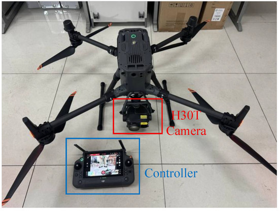
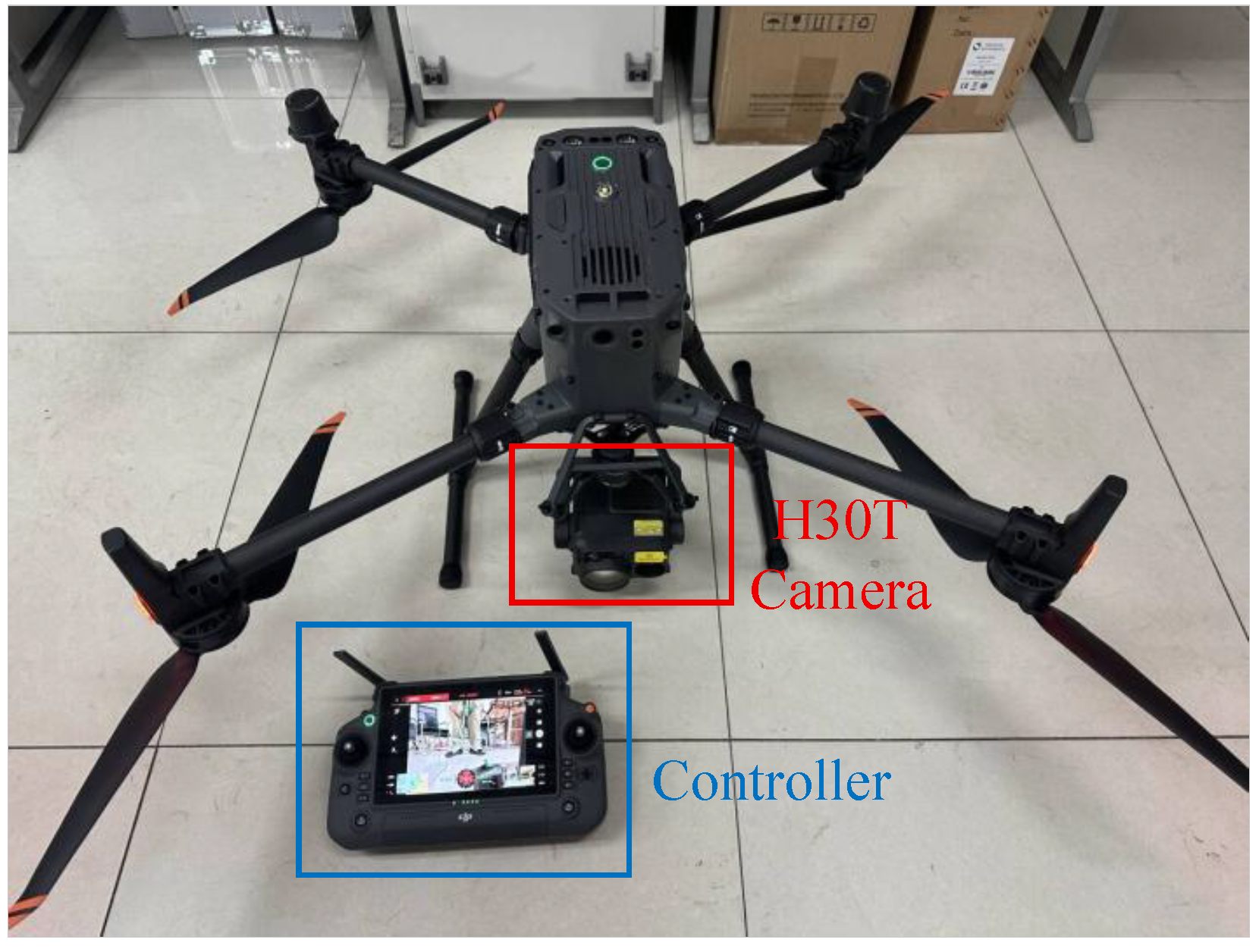
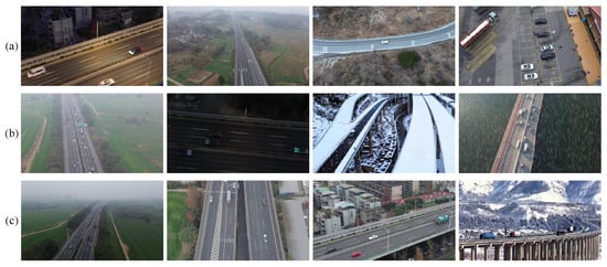
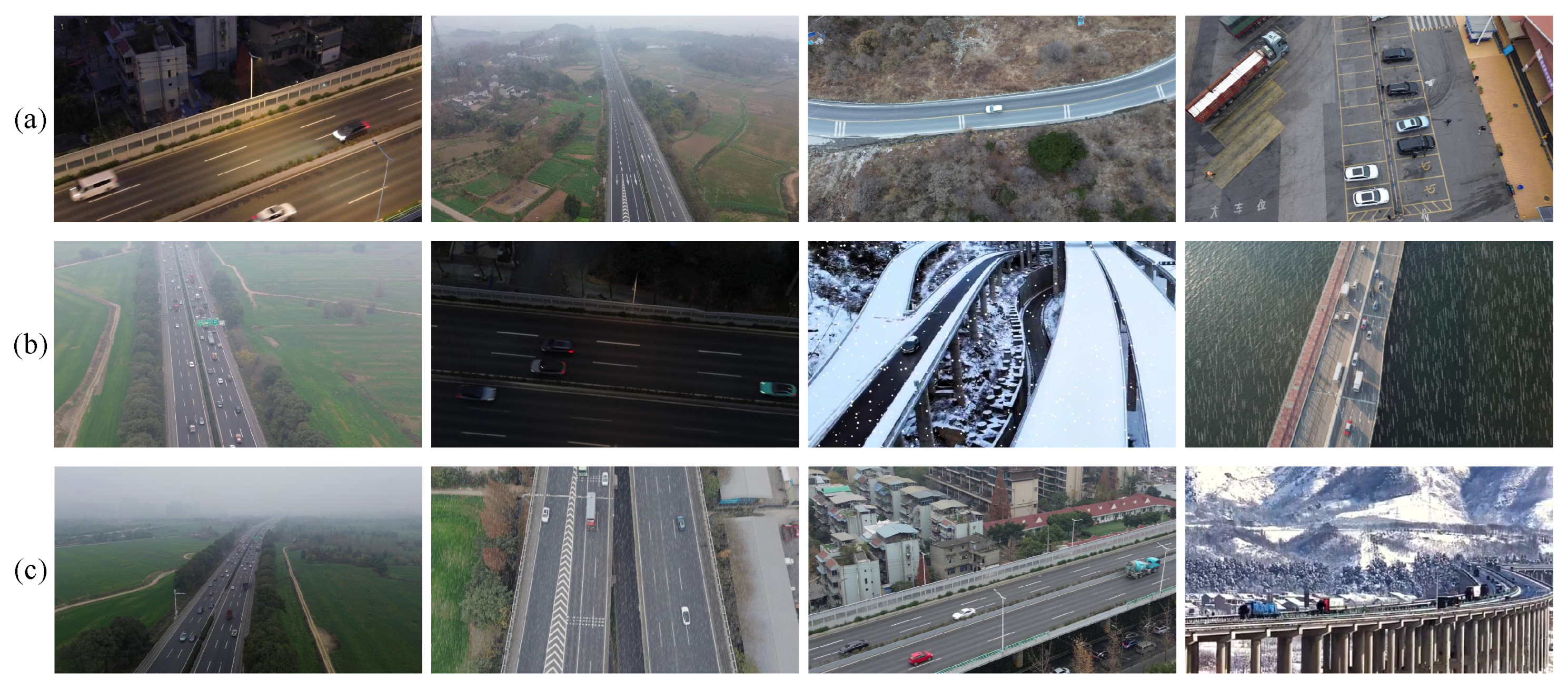
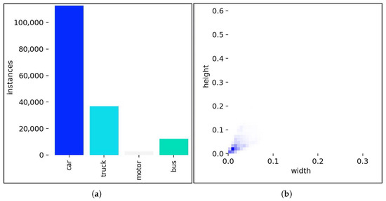
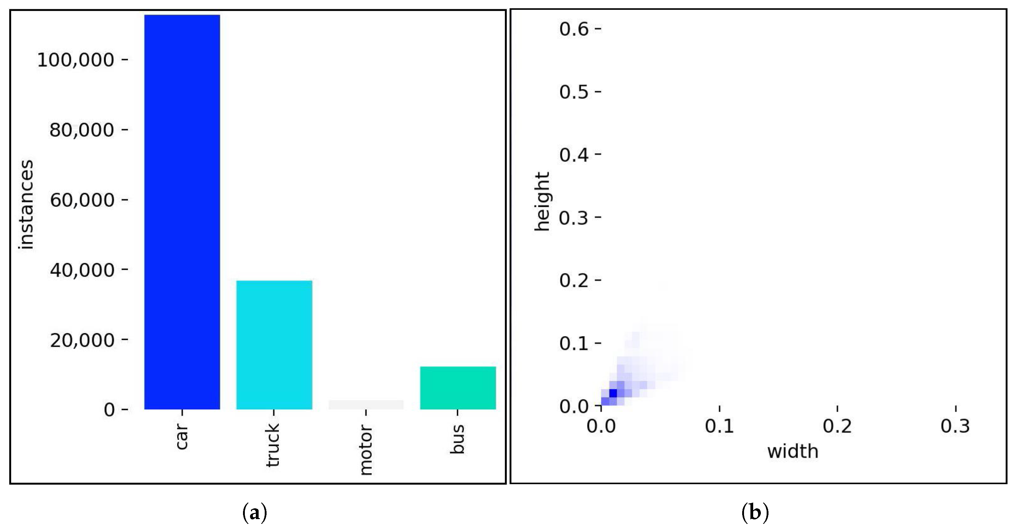
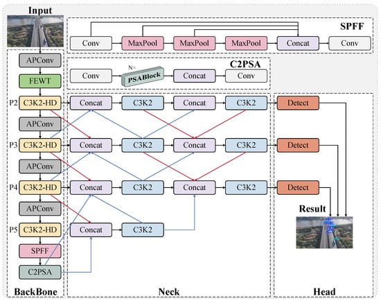
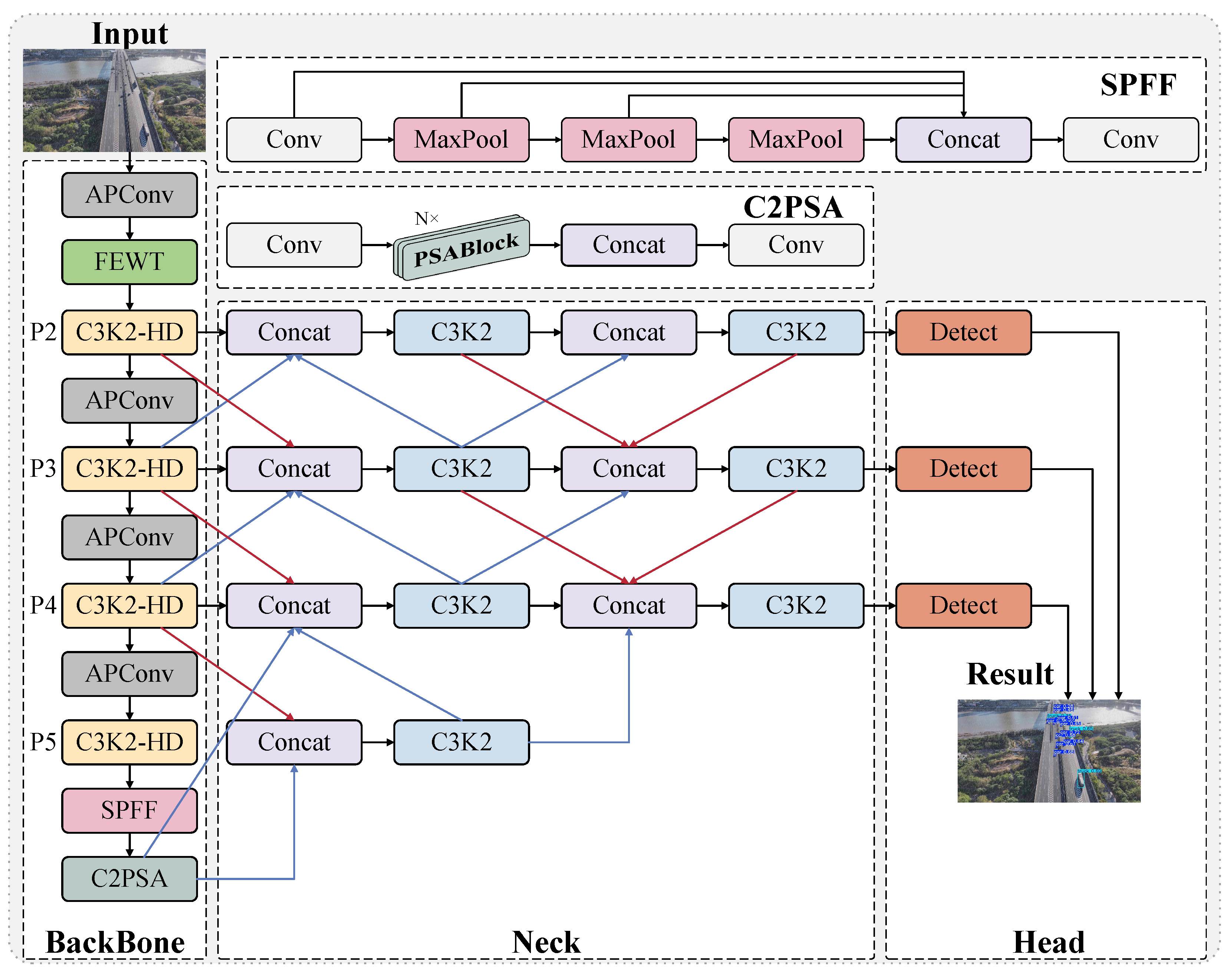
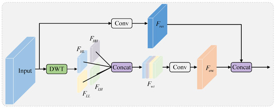
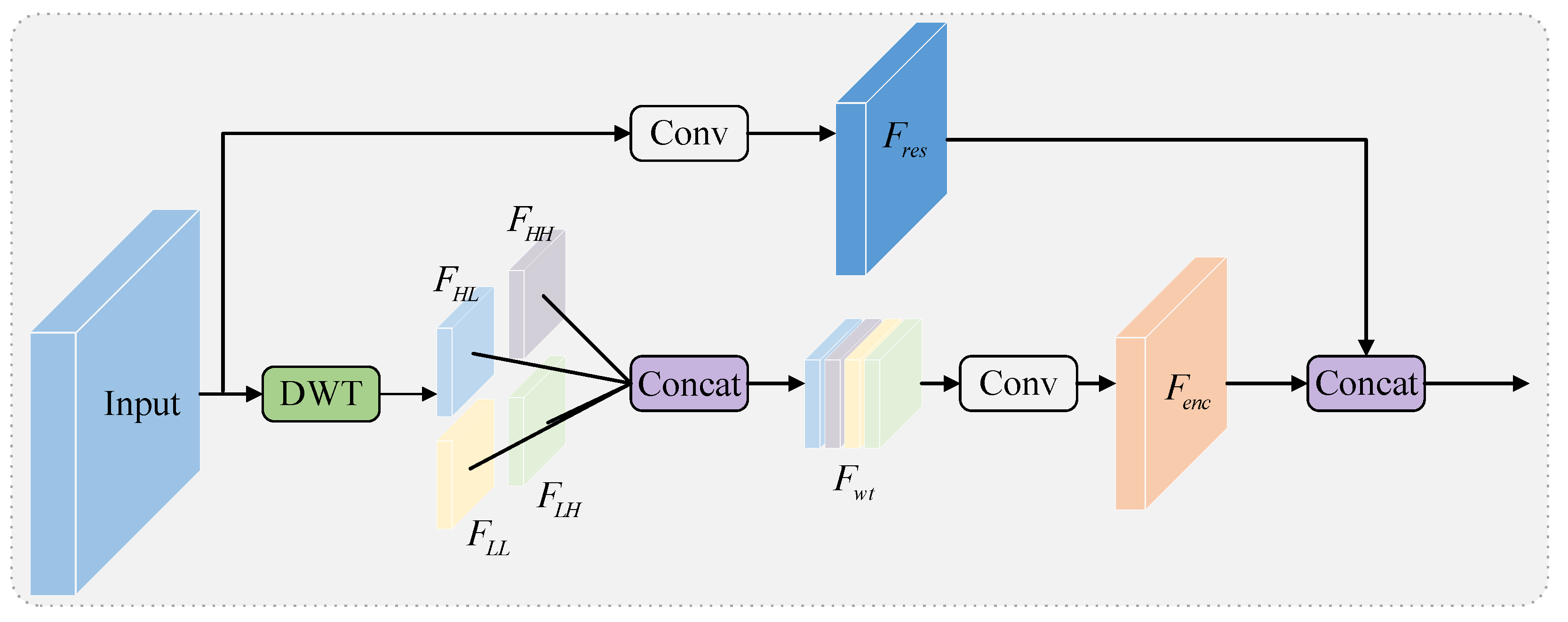
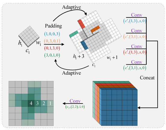
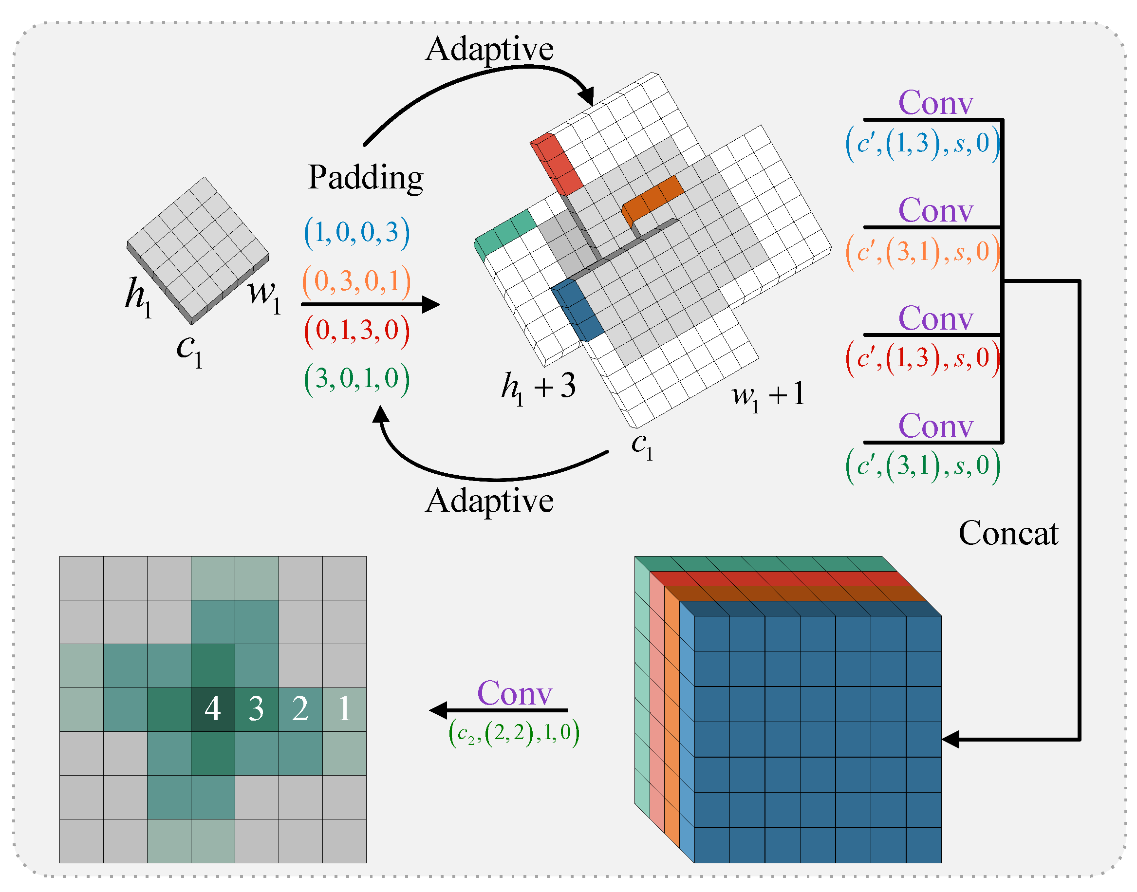
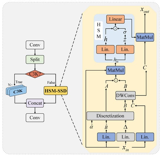
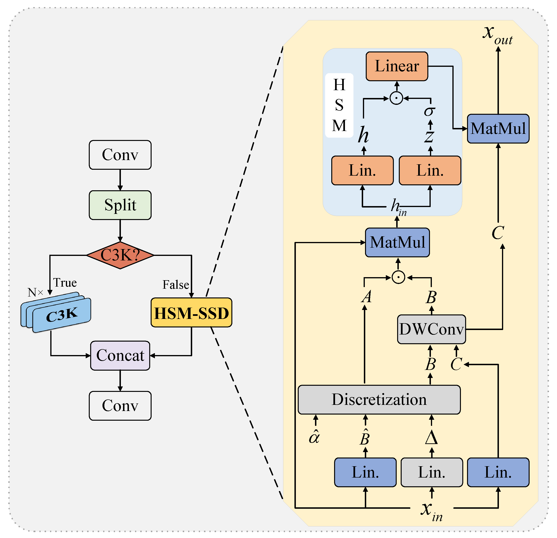
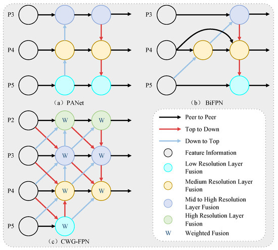
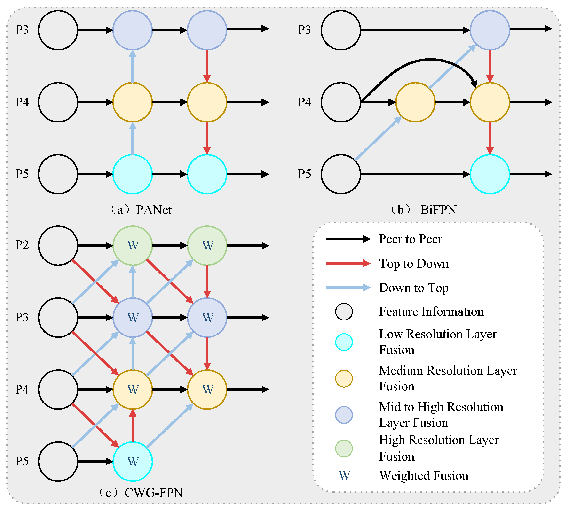
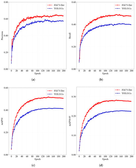
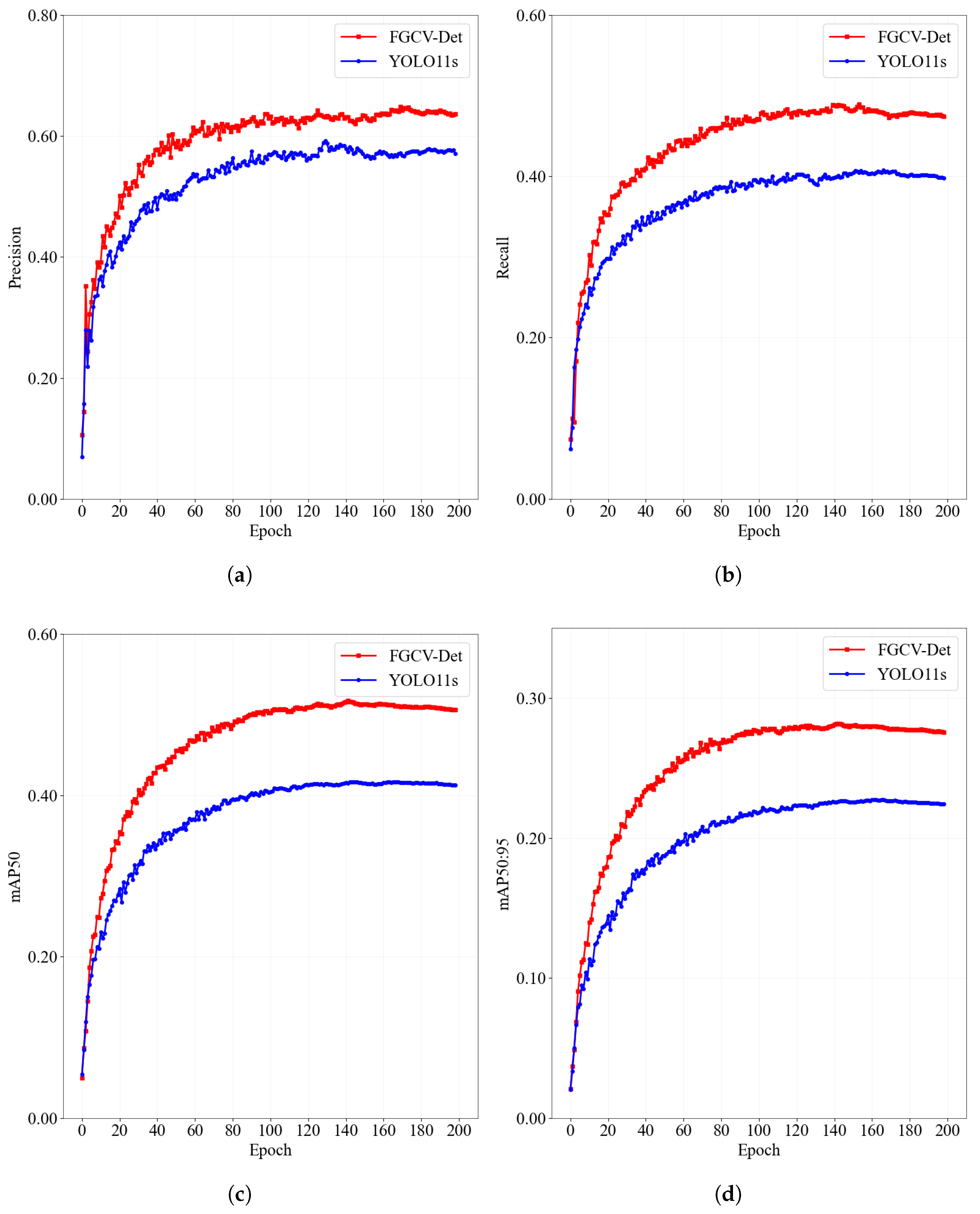
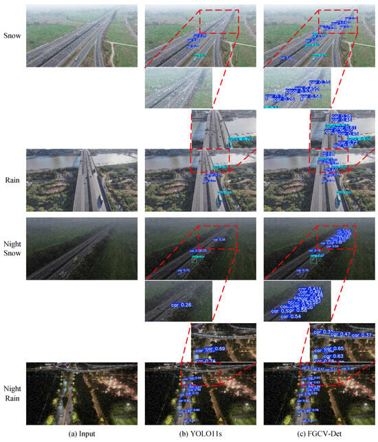
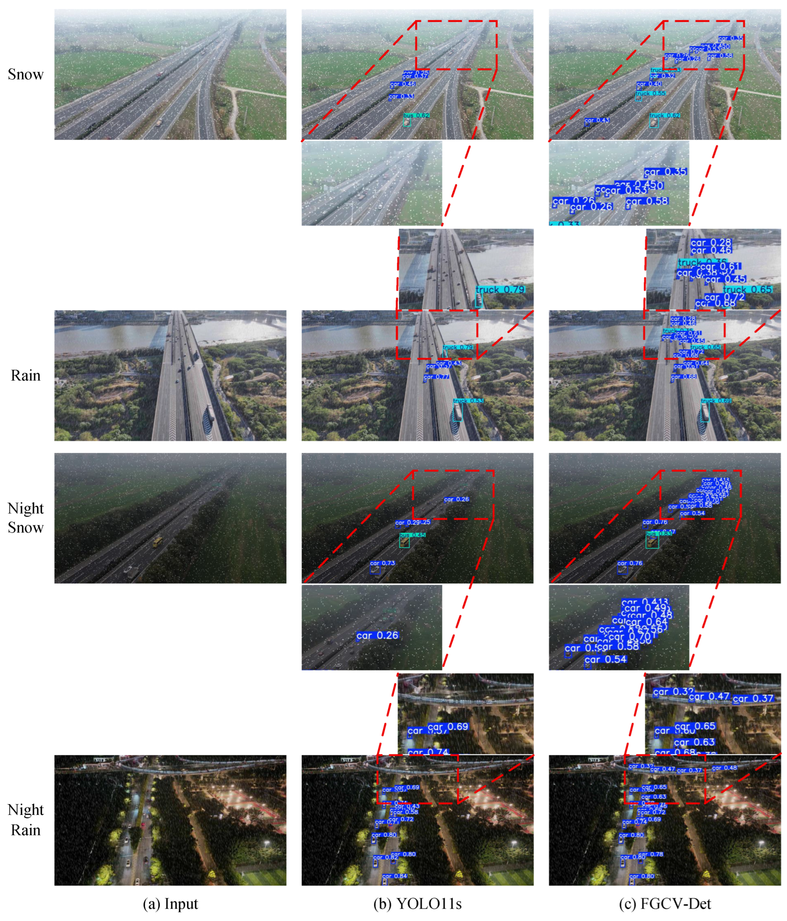
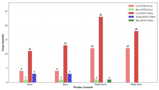
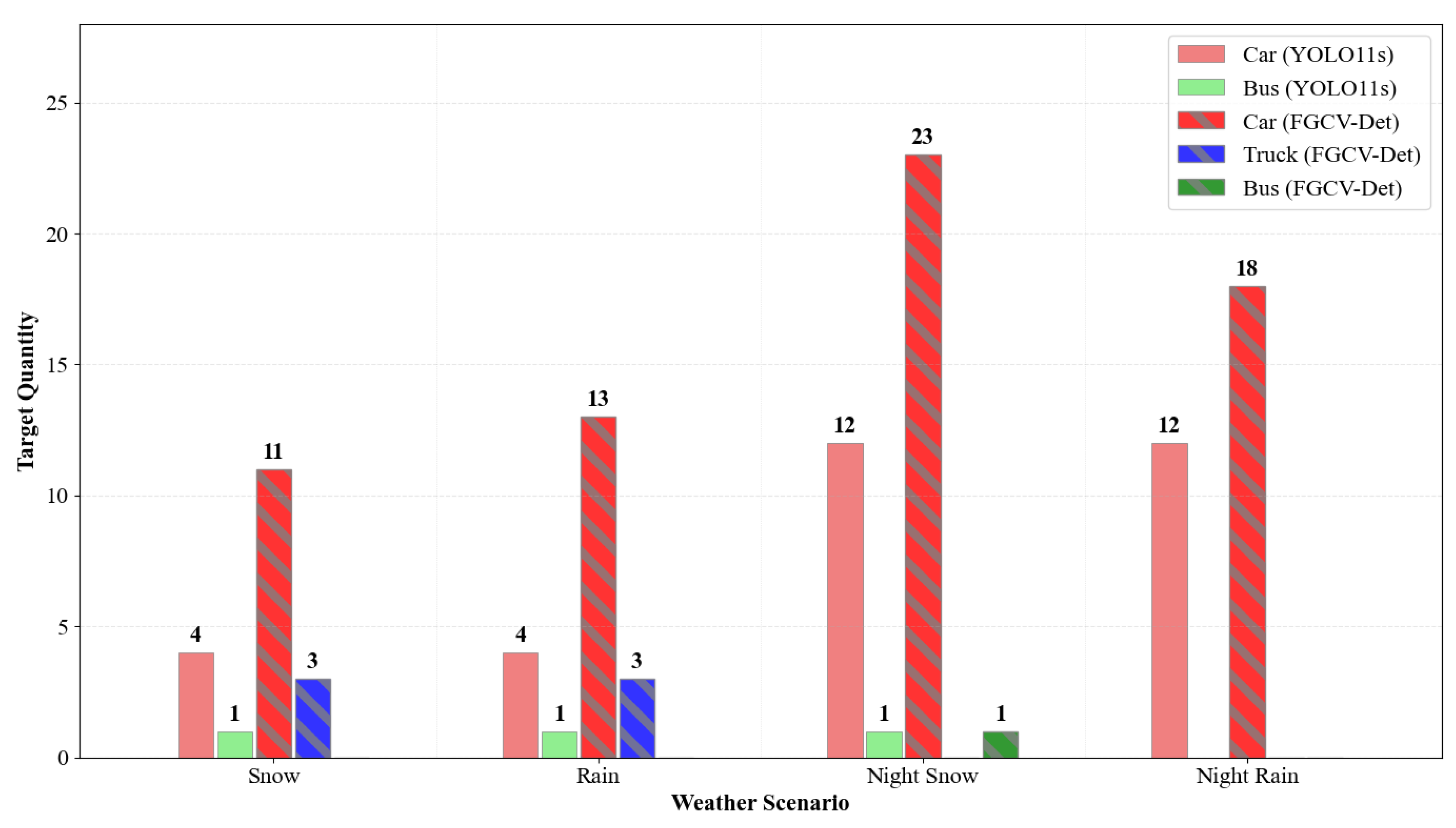
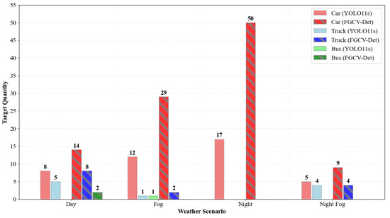
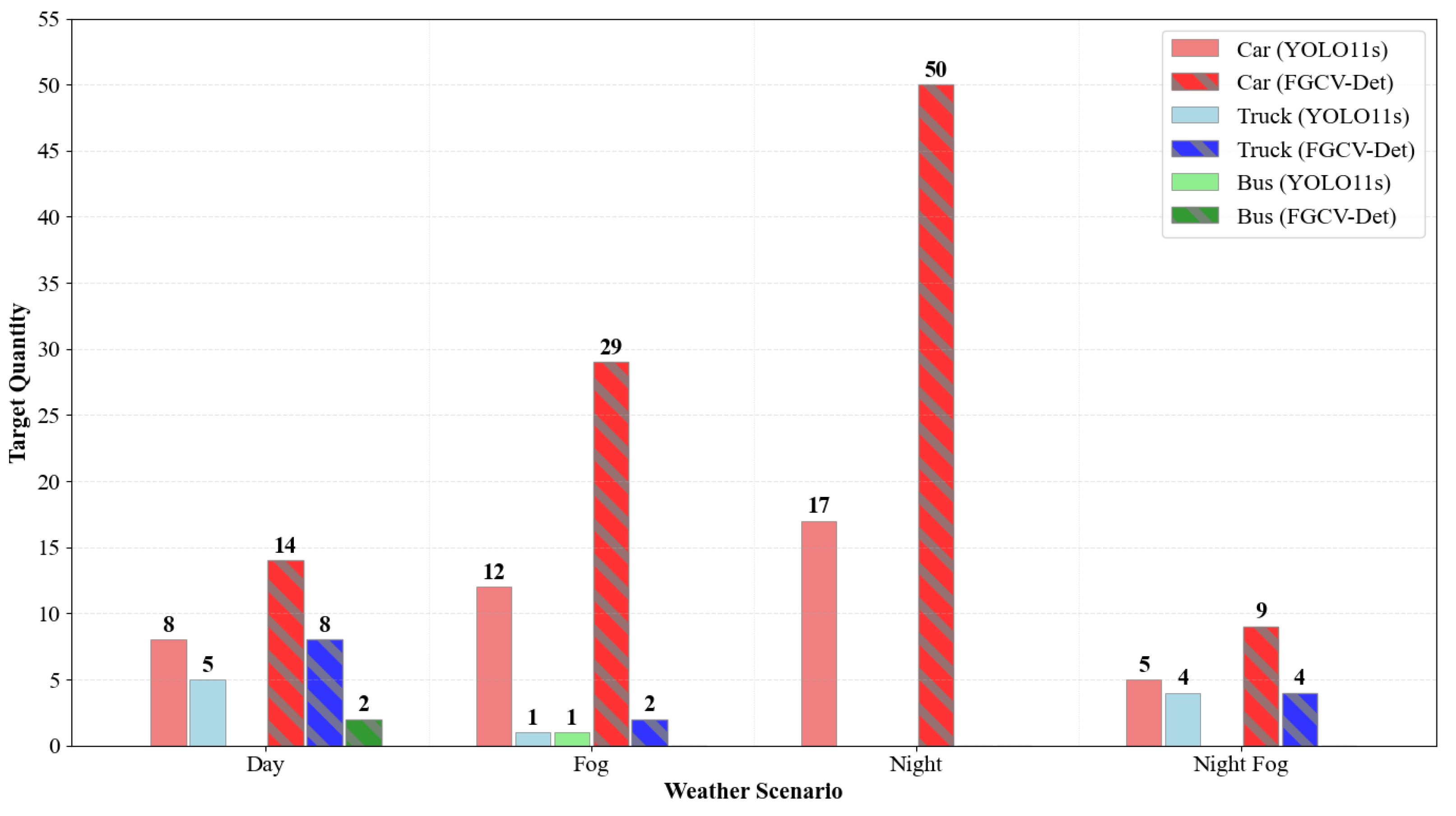
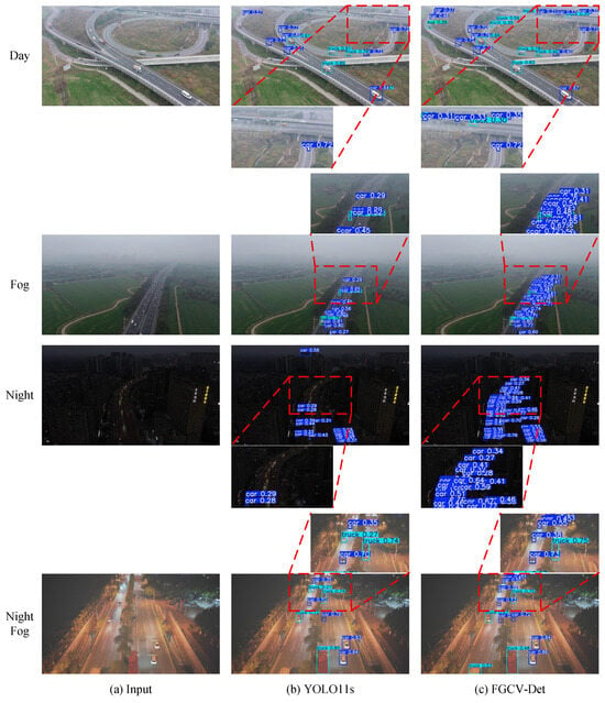
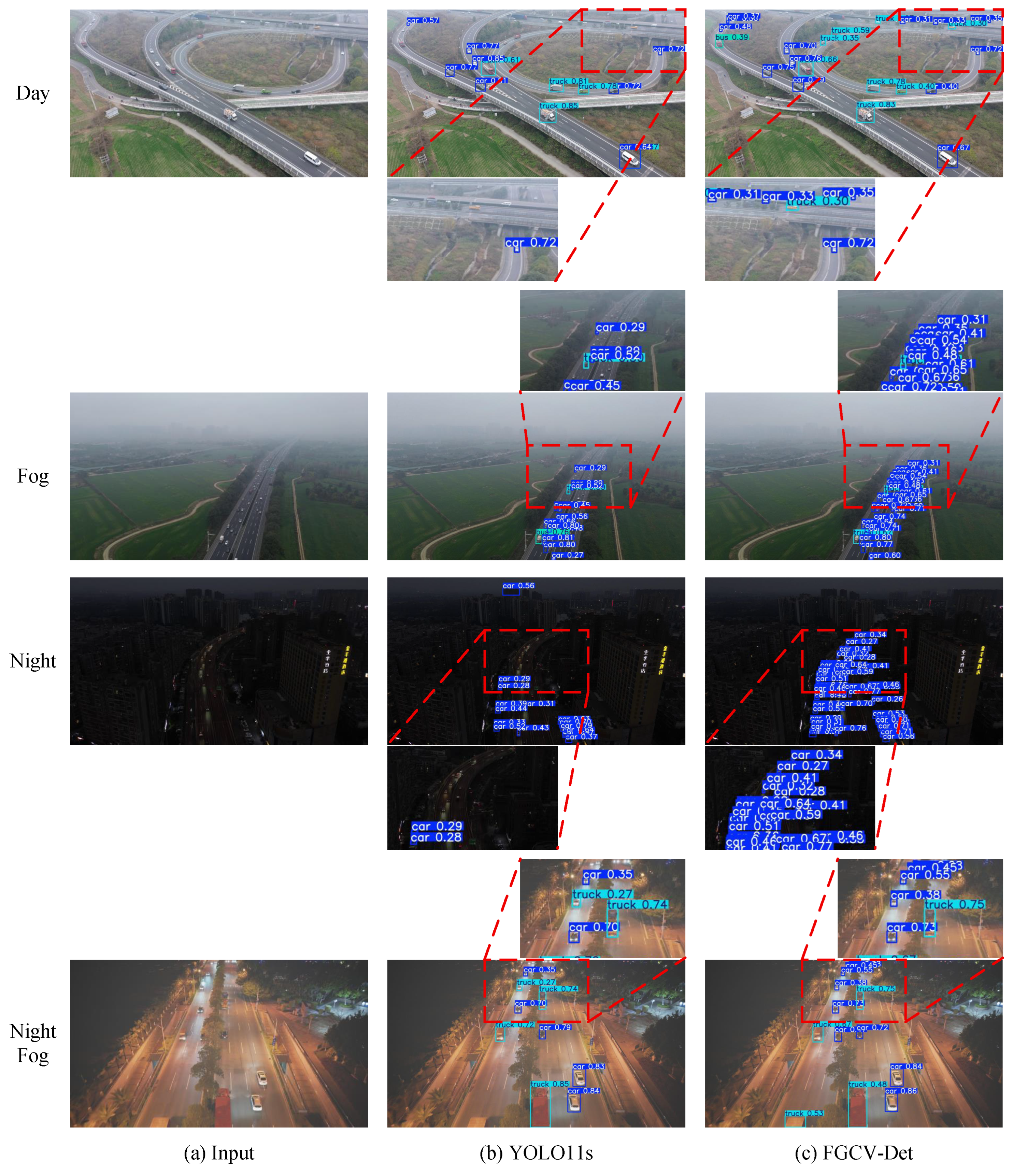
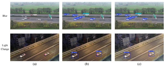
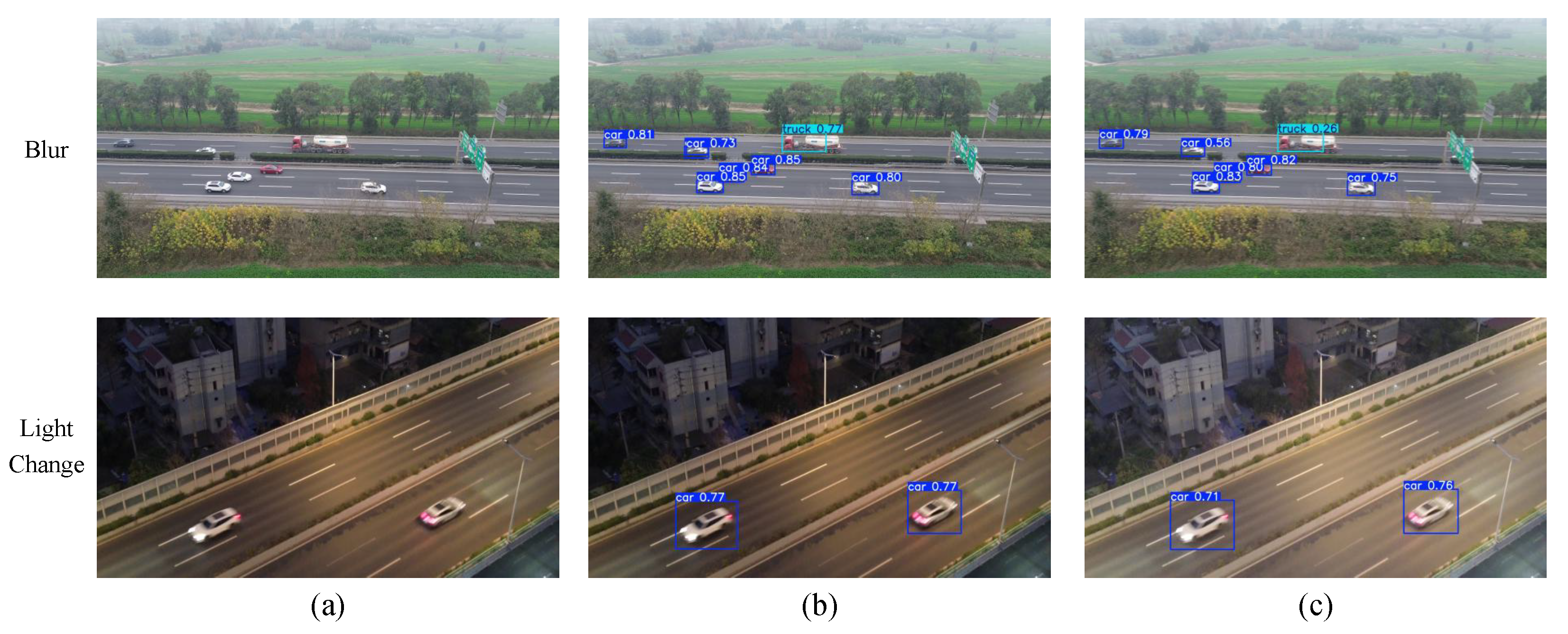
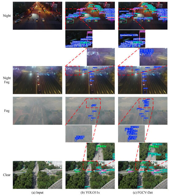
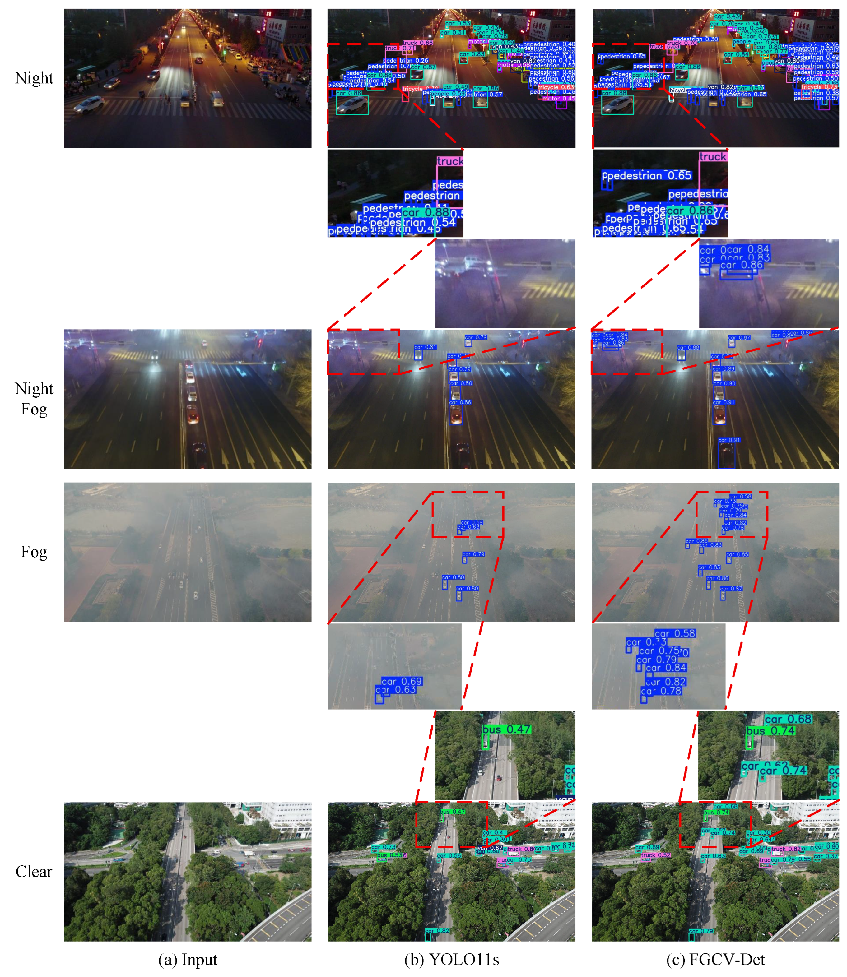

Disclaimer/Publisher’s Note: The statements, opinions and data contained in all publications are solely those of the individual author(s) and contributor(s) and not of MDPI and/or the editor(s). MDPI and/or the editor(s) disclaim responsibility for any injury to people or property resulting from any ideas, methods, instructions or products referred to in the content. |
© 2026 by the authors. Licensee MDPI, Basel, Switzerland. This article is an open access article distributed under the terms and conditions of the Creative Commons Attribution (CC BY) license.