


Abstract
The exploration of coastal placer deposits, often enriched in critical raw materials demanded by industry, is significantly challenged by the dynamic marine environment and by the limited research devoted to developing dedicated exploration methodologies. This study presents the first systematic integration of multi-source geospatial data in the Rías Baixas for placer mineral prediction in the initial exploratory stage of these deposits. The primary objective is to investigate the presence of Titanium (ilmenite, and rutile), Zirconium (zircon), and Rare Earth Element (REE)-bearing minerals (monazite, xenotime, allanite, and garnets) in Rías Baixas (NW Spain). The methodology includes a lithological reclassification and the generalization of coastal types. These features are then integrated with watershed, coastline dynamics, and mineral occurrence data. Validation includes existing semi-quantitative and qualitative mineral identification data, and new field observations of heavy mineral accumulations. This integration allowed us to identify nine potential and ten predictive areas with a high probability of hosting coastal placers. The validation process showed a 79% spatial correlation, confirming a significant heavy mineral accumulation in 15 areas. This work underscores the efficacy of integrated cartography in prioritizing potential and predictive areas during the crucial first stage of mineral exploration. The methodology can be further enhanced by incorporating additional data, such as stream sediment geochemistry and the application of remote sensing techniques.
1. Introduction
In the last years, the European Union (EU) and other regions have undertaken several projects to identify and update the list of critical raw materials (CRMs), aiming to reduce global warming, assess the material supply for energy transition, and enhance the health and comfort of people and the environment by technological development. In 2023, the EU updated its list of critical raw materials, which now includes 34 items [1]. These materials are essential for numerous technologies that are key to addressing environmental, defense, and technological challenges.
CRMs can be sourced from various mineral deposits, both onshore and offshore [2,3,4]. Marine placer deposits are a less conventional source of CRMs but have gained increasing attention. The responsible development and exploration–exploitation of heavy minerals like ilmenite, monazite, or cassiterite in marine placer deposits, found in coastal areas and shallow waters, could significantly contribute to securing the necessary raw materials for the energy transition, further supporting the global push toward sustainability and a reduced environmental impact [5,6].
Coastal placer deposits resulted from the accumulation of heavy minerals after erosion and transportation from land terrains to the shoreline areas, where marine (currents, waves, and tides) actions reworked the sediments and concentrated on the beaches [5,7,8]. Likewise, these heavy minerals, typically with a density greater than 2.9 g/cm3, are preserved due to the chemical and physical stability during the transporting to sedimentation in coastal areas. There is a documented presence of heavy mineral placers on the beaches of the NW Spain, known since the 1970s [9,10,11,12]. These studies indicate the presence of Ti, Sn, Li, REEs, Au, and Fe minerals in sands. Recently, remote sensing data and cartographic techniques have been increasingly applied as promising tools for mineral exploration in the area [13,14,15,16], as well as for enhancing geological and environmental knowledge of the coastal zone. The studies pursued different objectives and employed diverse methodologies to identify heavy minerals, incorporating sampling, mineralogical analysis, and preliminary dredging in shallow-water zones. Despite increasing interest in beach placer exploration, no previous work has offered a comprehensive cartographic integration of regional geological features. Recently, however, several Pan-European initiatives, such as EMODnet-Geology (https://emodnet.ec.europa.eu/en/geology, accessed on 18 March 2025), along with national efforts like the GEODE program from Instituto Geológico y Minero de España-IGME (https://info.igme.es/cartografiadigital/geologica/geode.aspx, accessed on 17 March 2025), have begun to provide accessible and detailed geospatial data. These datasets present new opportunities for applications in marine placer mineral exploration.
This work proposes an innovative methodological approach that combines regional geological and coastal cartographic datasets to assess the potential and predictivity for coastal placer deposits along current shorelines, particularly in regions underlain by intrusive and metamorphic rocks. The methodology evaluates key factors such as lithological suitability, the distribution of known mineral deposits and occurrences, watershed characteristics, drainage patterns, and coastal morphology and migration. In this context, our objectives are (1) to integrate multi-source geospatial data (lithological and structural), mineral resources, and coastal features to identify potential heavy mineral accumulation zones in the form of coastal placers, and (2) to produce predictive models and maps that directly support targeting and prioritization in critical raw material (CRM) exploration.
Semi-quantitative heavy mineral data, specifically for ilmenite, zircon, garnet, and monazite, collected during systematic coastal exploration campaigns [9], were used to validate our potential and predictive areas. Furthermore, we integrated legacy geological reports with new field observations carried out in 2024 and 2025 as part of the S34I European project (https://s34i.eu/), which confirmed the presence of heavy mineral concentrations in targeted beach areas.
2. Geological Setting and Coastal Placer Occurrences Background
2.1. Study Area
The Rías Baixas is located in the region of Galicia, NW Spain, and is composed of three estuaries: Arousa, Pontevedra, and Vigo (Figure 1). These estuaries follow a NE–SW orientation from their heads to their mouths. The estuaries are typically divided into inner and outer sections based on the dynamics between seawater and freshwater. Freshwater is predominant near the coast, while seawater dominates the outer sections closer to the Atlantic Ocean [16]. In the study area, tidal variations at sea level range from 2 to 4 m, classifying it as a mesotidal region [17]. Wind patterns, especially those from the north, create upwelling phenomena, particularly in spring and summer (from April to September), which cause seawater to be drawn into coastal areas. Upwelling also occurs in winter, though less frequently, under northerly wind conditions [18].
Rías Baixas generally has humid climate conditions (with an average humidity of 76%), where the Vigo climate station shows an average annual precipitation of 1298 mm and a mean temperature of 15.5 °C (https://www.meteogalicia.gal/web/clima/datos-climatoloxicos, accessed on 15 November 2025). The wet season rains typically run from October to January, although rainfall is present throughout the year. The hydrographic framework of the study area is largely defined by the Ulla, Lérez, and Verdugo rivers, all of which display a predominant NW–SE orientation and drain into the Arousa, Pontevedra, and Vigo estuaries, respectively. Further south, the Miño River acts as the principal drainage system, collecting runoff from both Spanish and Portuguese territories. At finer scales, a network of smaller, often ephemeral streams incises the central and outer zones of the estuaries.
This study extends beyond the three estuaries, encompassing the adjacent coastal stretch between the Vigo estuary and the Miño River, thereby enabling a holistic assessment of the marine and coastal dynamics in the region.
2.2. Geological Setting
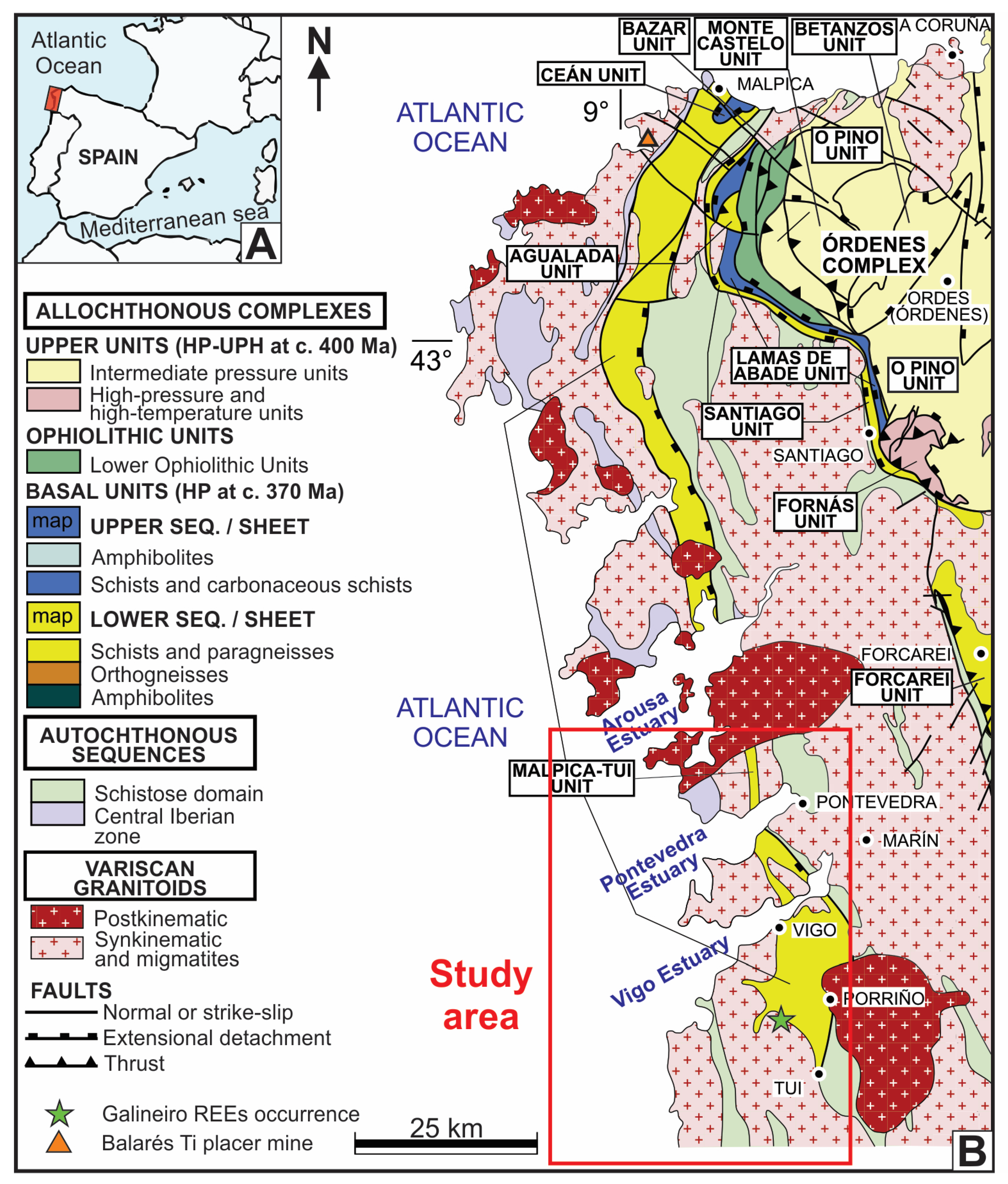
The study area (Figure 1) lies within the basement of the northwestern Iberian Massif, predominantly composed of plutonic and metamorphic rocks that range from very low-grade to catazonal metamorphism. This region features a clear distinction between autochthonous (native) and allochthonous (tectonically displaced) terranes [19]. Three major allochthonous complexes were identified in inland Galicia: Cabo Ortegal, Órdenes, and Malpica-Tui. The Rías Baixas region, located in the southern part of the NW Iberian basement, is primarily influenced by the Malpica–Tui complex, which displays a predominant N–S structural orientation. Regionally, this complex comprises a diverse suite of metamorphic rocks, including high-pressure metapelites (e.g., garnet–phengite–chlorite–chloritoid–quartz–albite–clinozoisite–rutile ± glaucophane), blueschists, lawsonite-bearing blueschists, typical and phengite/glaucophane-bearing eclogites, and jadeite-bearing orthogneisses [20]. The Malpica–Tui complex is surrounded by extensive Variscan granitoids, which dominate the geology of the Rías Baixas region (Figure 1). In addition, the study area includes outcrops of the Schistose Domain—characterized by metasedimentary sequences, as well as units of the Central Iberian Zone, which contains pre-orogenic sedimentary series.
Figure 1.
(A) Iberian location of the study area, and (B) map showing the spatial relationship between plutonic and metamorphic units and known/probable heavy mineral source rocks in the NW Iberian Peninsula, including the Rías Baixas region (modified from [20]). Balarés beach placer deposit (inactive mine) and Galineiro REE occurrence are included in (B).
2.3. Evidence of Surface Placer Minerals in Coastal Areas
A systematic and detailed investigation of marine placer occurrences was conducted by [9,10] approximately 50 years ago in the study area, covering both beach and shallow-water environments. This work produced a semi-quantitative dataset of the heavy mineral content from a total of 1545 samples, 1084 from shallow-water settings and 461 from beach environments. Subsequently, during 1981 and 1982, geological reports produced under the MAGNA project (geological maps 0184, 0185, 0222, 0223, 0260, 0261, 0298, and 0299; https://info.igme.es/cartografiadigital/geologica/Magna50.aspx, accessed on 17 March 2025) occasionally documented the presence of heavy minerals in beach deposits. These include zircon, apatite, tourmaline, metallic sulphides, magnetite, cassiterite, and wolframite, particularly in areas such as Montalvo beach [21,22]. Further exploration by [11] focused on both shallow-water and beach environments along the Galician coast. This work identified several beaches with notable concentrations of heavy minerals, both on the surface and within the subsurface sediment layers.
In recent years, several European initiatives have focused on harmonizing, updating, exploring, and reprocessing marine geological resources and related datasets. These efforts have significantly improved our understanding of marine minerals across Europe, including in the Rías Baixas region. Notable projects include the following:
- The GSEU project (Geological Service for Europe), which encompasses offshore and onshore evaluations in Galicia, such as the assessment of CRMs—https://www.geologicalservice.eu/areas-of-expertise/raw-materials [2,23] (accessed on 11 March 2025);
- The EMODnet-Geology initiative, which provides harmonized geological data across European seas, including a catalog of rock types, pegmatites, vein-hosted, and marine placer deposits in the Rías Baixas area—https://emodnet.ec.europa.eu/en/geology (accessed on 18 March 2025);
- The S34I project, which applies Earth Observation tools for mineral exploration in coastal zones, with a focus on identifying new sources of raw materials—https://s34i.eu/.
Together, these projects contribute to a more integrated and accessible geoscientific knowledge base, supporting sustainable mineral exploration and management in coastal and marine environments.
3. Materials and Methods
Although heavy mineral concentrations can develop along both contemporary and ancient shorelines, this paper focuses specifically on the modern shoreline. By analyzing regional cartographies and geoscientific databases, we aim to delineate potential and predictive areas for coastal placer deposits, identifying heavy mineral enrichment zones, especially where the coastal plain intersects with intrusive and metamorphic source rocks. In this way, we offer a significance guide for critical raw material exploration.
Following the methodology outlined by [7], we employed a combination of geological and geochemical approaches. These include (1) field-based observations and sampling supported by variable-scale geological GIS (Geographic Information System) datasets; and (2) surface geochemical surveys. These techniques represent surface-level data acquisition methods, characterized by low to medium–high costs and low to moderate effectiveness.
On the other hand, ref. [8] recommend the differentiation of unconsolidated Paleogene, Neogene, and Quaternary sediments deposited in coastal environments as a first-level exploration step. In the subsequent phase, they propose conducting detailed geological mapping, classifying sedimentary units by geological time period (e.g., by epoch), as a guideline for resource assessment.
As no detailed workflow had previously been presented, we developed a structured sequence of tasks (Figure 2) using geological and coastal features as exploration guidelines, building on the general frameworks proposed by [7,8]. Our approach is tailored to the geological context of intrusive and metamorphic terrains under current shoreline conditions in the Rías Baixas region.
Figure 2.
Chart flow of cartography integration for beach placer exploration considering geological and coastal attributes.
This analysis allows for the identification of several conditions favorable to the accumulation of heavy minerals and the potential formation of beach placer deposits. The workflow began with the generalization of lithological units to simplify the regional geological framework. Next, a detailed review of terrestrial and coastal cartographies, along with relevant geospatial datasets, was conducted to delineate potential and predictive areas for beach placers. The validation of the identified target areas was conducted using three key sources of evidence, (1) semi-quantitative data on heavy mineral content, (2) previously documented placer occurrences, and (3) recent field observations, all of which are based on data from beaches within the Rías Baixas.
Regarding potential areas, we consider lithological conditions in areas where land mineral occurrences are present, as well as the class of coastal migration. On the other hand, predictive areas of beach placer occurrences are locations where no land mineral occurrences were reported and/or exist, but which present the same lithological units as the potential areas and are in a stable coastal migration class (see Section 5.1 and Section 5.2 for further information). The areas were delineated manually using a simple overlay of layers for each type of map. According to their nature, potentiality does not require verification as it is conceptual, contrary to predictivity, where testing and validation are necessary.
3.1. Lithological Units as the Base Map
Onshore lithological and structural data were obtained from the GEODE project by IGME (Zone Z1200; https://info.igme.es/cartografiadigital/geologica/geode.aspx, accessed on 17 March 2025), which incorporates geological reports and maps at a 1:50,000 scale (MAGNA version 2) for the following sheets: 0184, 0185, 0222, 0223, 0260, 0261, 0298, and 0299 (https://info.igme.es/cartografiadigital/geologica/Magna50.aspx, accessed on 17 March 2025).
To generate a synthetic regional geological map, GEODE datasets were integrated, and similar rock units were grouped based on lithology, stratigraphic age, and orogenic context. This process resulted in the classification of 16 distinct rock group classes, as detailed in Table 1.
Table 1.
Lithology units from GEODE (https://info.igme.es/cartografiadigital/geologica/geode.aspx, accessed on 17 March 2025) and rock group classification for mineral placer occurrences.
A targeted review of potential source mineralogy for marine placer deposits was conducted, focusing on titanium minerals (ilmenite, rutile, and titanite), zirconium (zircon), and REE-bearing minerals, including allanite, monazite, xenotime, and garnet (Table 1). Garnet is considered both a possible REE source [24] and a valuable pathfinder mineral, given its occurrence in medium- to high-grade metamorphic lithologies commonly found within the study area.
3.2. Non-Lithological Features Related to Placer Deposit Genesis
3.2.1. Onshore Environment
- (a)
- Mineral Resources
The Mineral Resources Database (BDMIN; http://info.igme.es/catalogo/resource.aspx?portal=1&catalog=3&ctt=1&lang=spa&dlang=eng&llt=dropdown&master=infoigme&resource=23, accessed on 18 March 2025) from IGME-CSIC (© CN Instituto Geológico y Minero de España) is a comprehensive repository that integrates geological and mining information on mineral occurrences, deposits, and exploitation activities across Spain. Mineral occurrences within the database are classified based on deposit morphology, such as veins, alluvial, irregular, and undifferentiated types, as well as by geochemical associations, including Au-Ag-As, Sn-W-Mo-Bi, Be, Li-Be-Nb-Ta-Zr-Ti-REE, and Fe-Mn-Ti.
- (b)
- Watersheds and Drainages
Watersheds and drainage networks provide an overview of the provenance areas of heavy minerals, representing sediments eroded from both distant regions and proximal outcrops. The watershed data used (version: 17 December 2022) were obtained from MITECO (Ministerio para la Transición Ecológica y el Reto Demográfico) at a 1:25,000 scale (https://www.miteco.gob.es/es/cartografia-y-sig/ide/descargas/agua/cuencas-y-subcuencas.html, accessed 17 March 2025). The drainage classification follows the Pfafstetter system (version: 13 March 2018), also provided by MITECO (https://www.miteco.gob.es/es/cartografia-y-sig/ide/descargas/agua/red-hidrografica.html, accessed 17 March 2025). Most river catchments are classified as 4th- or 5th-order, with smaller streams ranging from 6th- to 10th-order. The Miño River is classified as 2nd-order.
For more detailed comparison and analysis, we also utilized the drainage network dataset from Xunta de Galicia (version: March 2021) at the same scale (1:25,000), which includes very small drainage systems and catchments less than 1 km2 (https://mapas.xunta.gal/visores/basico/, accessed on 18 March 2025).
3.2.2. Coastal Data
- (a)
- Coastal type classification
Coastal type data were obtained based on morphological classifications from EMODnet-Geology (https://emodnet.ec.europa.eu/en/geology, accessed on 18 March 2025), at a scale of up to 1:80,000 (version: May 2021). The dataset includes 10 original coastal classes regrouped in five new groups (Table 2).
Table 2.
Generalization of coastal type from EMODnet-Geology.
- (b)
- Coastal behavior (migration)
The EMODnet-Geology repository (https://emodnet.ec.europa.eu/en/geology, accessed on 17 March 2025) also provides coastal migration (via satellite data) at a scale of 1:25,000 (revision date: 15 July 2022). This dataset classifies coastline dynamics into three categories: (1) seaward migration (due to emergence or accretion), (2) stable coastline (defined as a net change of less than ±0.5 m per year over a 10-year period), and (3) landward migration (resulting from erosion or submergence).
3.3. Validation Procedures
3.3.1. Semi-Quantitative Data in Beach Areas
The S34I project (https://s34i.eu/) previously demonstrated that the semi-quantitative dataset from [9] remains useful for identifying placer deposit occurrences in the Vigo Estuary [11,16,24], despite being collected over 50 years ago. In this study, we used class 3 (10–50 g) and class 4 (>50 g) concentrations of ilmenite, zircon, garnet, and monazite from that dataset to support the validation of potential coastal areas for placer accumulation. For example, Vao Beach reported 220 g of garnets, and 5–50 g of ilmenite, zircon, and monazite [9]. To identify the heavy minerals, ref. [9] took 4–5 kg of sand samples. The samples were then dried and bromoform (density 2.89) was employed in the liquid separation process to obtain the heavy mineral fractions. Electromagnetic separation using a Frantz isodynamic separator was then employed on the heavy mineral fraction. Finally, a stereoscopic microscope was used to recognize the heavy minerals in the electromagnetic fractions.
3.3.2. Previous Work Reporting Beach Placer
Ref. [11] conducted a comprehensive evaluation of heavy mineral concentrations along the Rías Baixas coast, dividing the region into zones XVI, XVII, and XVIII. His study assessed a total of 28 beaches, providing valuable observational data that contribute to the validation of potential placer deposits in the area.
3.3.3. Beach Mineral Field Observations
Two field trips were conducted in November 2024 and August 2025 as part of the S34I European project. Site visits were carried out during low tide at each beach to facilitate the identification of surface and shallow subsoil patches of heavy mineral accumulations. The selected beaches correspond to areas previously reported by [9] as having heavy mineral anomalies. These field observations aimed to validate and complement historical data by identifying visible concentrations of minerals such as ilmenite, zircon, garnet, and monazite, particularly in zones where past exploration had indicated elevated levels.
4. Results
4.1. Regional Lithology and Rock Group Classification for Coastal Placer Exploration
According to GEODE data, a total of 64 lithological classes, ranging from the Neoproterozoic to the Holocene, were identified. These have been systematically regrouped into 16 lithological rock groups (see Table 1, Figure 3A,B), following the methodology described in Section 3.1.
Figure 3.
Lithological units and structural map from GEODE (https://info.igme.es/cartografiadigital/geologica/geode.aspx, accessed on 17 March 2025), showing (A) intrusive, metamorphic, dykes, and Quaternary rocks, and (B) rock group classification for mineral placer occurrences (see Table 1). Furthermore, the lithological units containing (C) garnets, and (D) REE (allanite, xenotime, and monazite) minerals are included. In addition, onshore mineral deposits (from BDMIN) are mapped in (D), where Galineiro REEs occurrence is showed in irregular morphology and blue color (see the symbology in (D) for more details).
As an initial overview, the Rías Baixas region is predominantly composed of intrusive and metamorphic rocks (Figure 3A), which are known to be highly favorable sources of heavy minerals. A detailed review of MAGNA 2 reports (https://info.igme.es/cartografiadigital/geologica/Magna50.aspx, accessed on 17 March 2025) confirms the occurrence of economically significant heavy minerals in the region, including titanium-bearing minerals (ilmenite, rutile, and anatase), zirconium minerals (zircon), REE minerals (allanite, monazite, and xenotime), and garnets (summarized in Table 1).
Rock groups 1 to 7 (Table 1) correspond to metamorphic units, predominantly composed of schists and gneisses associated with the pre-Variscan orogeny. These units are spatially distributed in two main N–S-oriented segments: Goián–Patos–Cabo Home–Noalla and Tuy–Vigo–Redondela–Pontevedra (Figure 3A). Lithologically, they are mainly composed of schists and paragneisses (Figure 3B; Table 1), and geochronologically range from the Neoproterozoic to the Carboniferous. Their accessory heavy mineral content is mainly ilmenite and zircon, with an appreciable presence of garnets and REE minerals (mainly allanite; Figure 3B–D) in the rock groups 1, 2, and 7. Likewise, ilmenite is the heavy mineral accessory in rock group 7 (Table 1).
In contrast, rock groups 8 to 12 (Table 1; Figure 3B) represent the intrusive units, where Variscan granites, emplaced during the Carboniferous to Early Permian, are dominant. These intrusive bodies also exhibit an N–S structural orientation, consistent with the regional tectonic framework. They show accessory heavy minerals like ilmenite and zircon, although garnets and REE minerals (mainly allanite) is present partially in the rock groups 9, 10b, and 12 (Figure 3B–D).
Rock groups 13 and 14 (Table 1, Figure 3B) correspond to dyke intrusions. Specifically, group 13 (Dykes 1) includes quartz diorite, diorite, gabbro, dolerite, and diabase dykes, whereas group 14 (Dykes 2) comprises acidic and felsic dykes, including undifferentiated acidic dykes, pegmoaplite, lithium pegmatite, aplite, and quartz dykes. Among these, the latter group (Dykes 2) presents a higher potential as a local source of heavy minerals, due to their mineralogical composition, particularly the presence of REE-bearing and accessory heavy minerals (e.g., monazite, allanite, and zircon, such as those showed in the compilation from [25]).
In general, these dykes occupy small surface areas and are primarily oriented north–south (N–S), intruding on both intrusive and metamorphic rocks. However, exceptions occur: to the west of Vigo (within rock group 12), some dykes exhibit a northeast–southwest (NE–SW) orientation; in the area west of Pontevedra, dykes show multiple orientations, including NE–SW, northwest–southeast (NW–SE), and east–west (E–W). Due to their limited areal extent, these dyke intrusions are not easily distinguishable in regional-scale figures, but they may still play a significant local role in heavy mineral enrichment.
Quaternary deposits are mainly in rock groups 15 (Rasa, marine terrace, littoral dune, and beach), and 16 (undifferentiated terraces, terraces 7/13/14/21, alluvial, colluvial, alluvial–colluvial, colluvial–eluvial, and marsh), from Pleistocene and Holocene periods, respectively (Figure 3A,B, Table 1).
Regarding the mineral accessories of the lithological unit, Table 2 compiles the heavy minerals of interest, showing that rock group 1, 2, and 7 contain titanium, zirconium, and REE minerals. On the other hand, the majority of intrusive rocks contain zirconium and titanium minerals, where garnets and REE minerals are restricted to some lithological units of rock group 9, 10b, and 12 (Table 2 and Figure 3C,D).
4.2. Land Features as Potential Provenance of Heavy Minerals
Using the geologic reclassification from the GEODE dataset as a base map, we analyzed the influence of various terrestrial, coastal, and marine features on the formation and distribution of coastal placer deposits. This integrated approach allows us to assess how geological source areas, sediment transport pathways, and depositional environments interact across the land–sea interface, contributing to the accumulation of heavy minerals in coastal and nearshore settings.
4.2.1. Mineral Occurrences
A total of 15 mineral occurrences have been identified across three main sectors: around Noalla, Goián–Patos, and the area between Vigo and Tuy (Figure 3D). These zones are geologically significant and represent potential source areas for heavy mineral concentrations observed in downstream or coastal environments.
In the Noalla sector, five notable occurrences have been documented: Four vein-type mineralizations (La Lanzada, Ayos, Boliche, and Arra) exhibit a Sn–W–Mo–Bi geochemical association (Figure 3D), hosted within schists interbedded with quartzite levels, micaceous schists, and paragneisses belonging to rock group 1 (Figure 3B). The ore mineral assemblage includes cassiterite, niobium–tantalum (Nb-Ta) minerals, and molybdenite, indicating a hydrothermal origin and a potential for heavy mineral sourcing from these lithologies. An additional occurrence at Punta Montalvo–Bascuas presents an Fe–Mn–Ti geochemical signature (Figure 3D). Here, ilmenite, cassiterite, and chalcopyrite have been identified. The mineralization is associated with a local pegmatitic dyke (Punta Montalvo) and a beach placer deposit (Bascuas Beach, listed in BDMIN), indicating both primary (bedrock) and secondary (placer) mineral sources in close proximity.
In the sector between Goián and Patos, a total of eight mineral occurrences have been identified (Figure 3D), distributed along a north–south elongated zone predominantly composed of schists belonging to rock group 6 (Figure 3B), which is dated to the Middle Ordovician–Late Silurian (Table 1). These occurrences include three vein-type mineralizations with a Sn–W–Mo–Bi geochemical association, featuring ore minerals such as cassiterite, wolframite, molybdenite, and bismuth minerals; three filonian-type occurrences with an Au–Ag–As association, characterized by the presence of pyrite, arsenopyrite, gold, and wolframite; one alluvial (aluvionar) occurrence of Au–Ag–As, where gold and pyrite are found within fluvial sediments, indicating a secondary dispersion from nearby lodes; and one additional occurrence with an undetermined mineral morphology, also showing an Au–Ag–As geochemical association (Figure 3D), with gold and arsenopyrite as the principal ore minerals.
The concentration of these occurrences within the metasedimentary schists of rock group 6 (Table 1) highlights this zone as a significant primary source of precious and strategic metals, particularly gold, tungsten, and tin, with the potential for downstream placer formation.
To the west of Patos Beach, two additional types of mineral occurrences have been documented, each associated with distinct lithological units: A vein-type occurrence related to beryl mineralization is hosted within granitic terrains, specifically within rock group 10b (as defined in Table 1, and showed in Figure 3B). This setting suggests a pegmatitic or late-stage magmatic origin, commonly associated with Be-rich mineral systems in felsic intrusive rocks. The second is an irregular, multi-element occurrence known as the Galineiro deposit (Figure 3D), characterized by an REE–Li–Be–Nb–Ta–Zr–Ti geochemical association. This complex mineralization is spatially related to the gneissic rocks of rock group 2, indicating a potential metasomatic or pegmatitic enrichment within high-grade metamorphic terrains.
These occurrences underscore the mineralogical diversity of the region and highlight the importance of both granitic intrusions and metamorphic basement rocks as potential sources of strategic and critical metals with a relevance to placer mineral exploration.
4.2.2. Drainage and Watershed as Provenience Areas
The hydrographic network in the study area is predominantly composed of small and ephemeral rivers, with a total of 77 delineated watersheds (Figure 4A,B). The majority of these rivers have limited catchment areas and short courses, characteristic of the region’s steep coastal topography. Among the permanent and principal rivers draining the landmass, the Lérez and Verdugo rivers are the most significant. These rivers transport water and sediment loads toward the Pontevedra and Vigo estuaries, respectively, acting as key conduits for the mobilization of heavy minerals from inland sources to the coastal and marine environments. To the south, the Miño River stands out as the main fluvial system and forms the natural boundary between the Spanish and Portuguese watersheds. This river represents the largest collector in the region, with a substantial discharge and potential for the long-distance transport of mineral particles. Additionally, a narrow and continuous coastal watershed—referred to as the North Atlantic Inter-Watershed Zone (Figure 4A)—extends along the coastline. This zone, typically less than 2 km wide, is not included in the 77 main watersheds and is characterized by very short, ephemeral drainage systems, which can still play a localized role in transporting heavy minerals directly into the marine environment.
Figure 4.
Land and coastal attributes showing (A) drainage and Pfafstetter system (MITECO), (B) detailed drainage network (IGN), (C) coastal type generalized (EMODnet-Geology), and (D) coastal behavior (EMODnet-Geology) of the study area.
Based on the Pfafstetter coding system, most of the identified river collectors are classified as fourth- and fifth-order streams, while the smaller tributaries range from sixth- to tenth-order, indicating a dense and complex drainage pattern. Interestingly, the Miño River is assigned a second-order classification within this system (Figure 4A), reflecting its status as a major regional fluvial corridor.
4.3. Coastal Features
4.3.1. Coastal Type
Based on coastal morphology classification, the region is characterized by a combination of erosion-resistant and erodible rocky coastlines and cliffs, which are predominant on the Sálvora, Ons, and Cíes islands, as well as along the mainland coast from Patos southward to A Guarda (Figure 4C). These rocky coastlines often exhibit high wave energy and limited sediment deposition. In contrast, discontinuous beaches, mudflats, estuaries, and artificial coastlines are primarily located around the major estuarine zones. Several inner estuarine areas are also classified as beaches (e.g., Vao, Samil, Santa Marta, Barra beaches, Montalvo, Do Santos, and Cesantes), highlighting their sedimentary nature and potential role as sediment traps or temporary storage zones for heavy minerals.
4.3.2. Coastal Behavior (Migration)
In terms of coastal dynamics, the northern part of the study area down to approximately the mid-section between Patos and A Guarda is predominantly classified as a stable coastline (Figure 4D). South of this area, the coast becomes erosive, extending down to the Portuguese border, indicating net sediment loss or retreat. However, five localized coastal sectors demonstrate accretional behavior (Figure 4D), characterized by sediment accumulation: north of Noalla (within the Arousa Estuary), near Pontevedra (Pontevedra Estuary), in the Bueu area, immediately before Cabo Home (Pontevedra Estuary), and adjacent to Redondela (Vigo Estuary). These accretion zones are of particular interest for placer exploration, as they represent favorable environments for the deposition and concentration of heavy minerals. Additionally, stable coasts also provide secondary zones of interest, where low-energy conditions may allow for the preservation of fine- to medium-grained sediments potentially enriched in heavy mineral fractions.
In addition, coastal dunes adjacent to beaches or estuarine mouths, especially in zones with known heavy minerals input from upstream lithologies, represent a secondary target for exploration, where wind-reworked sediments may host localized but enriched heavy mineral layers. These aeolian conditions and the accumulation of heavy minerals were identified in the Vao, Fontaiña, and Barra beaches in the Vigo Estuary (Figure 5).
Figure 5.
Reddish to brownish heavy mineral accumulation with aeolian influence in the base of coastal dunes (Vigo Estuary). (A) Vao, (B) Fontaiña, and (C) Barra areas. Pictures courtesy of IGME-CSIC and S34i European project.
5. Discussion
5.1. Potential Areas of Beach Placer Occurrences
The intrusive and metamorphic rocks in Rías Baixas have been exposed since the Variscan collisional stage [19] and have weathered for an extended period since the Jurassic epoch. The final maximum glaciation resulted in the formation of a paleo-shoreline (18,000 years BP) that is now submerged to the west of the Ons and Cíes Islands [16]. It is imperative to consider the long period of rocks being exposed to the weathering as the main factor playing a pivotal role in shaping the transportation of heavy minerals to coastal regions.
Therefore, in order to identify potential areas where beach placer may be present, three geographically distinguishable features were analyzed: source rock, coastal migration, and onshore mineral deposits and occurrences. These features are particularly useful in areas that have not been previously explored. As sediment transport constitutes the pathway through which heavy minerals are transferred from terrestrial to coastal regions, drainage networks were incorporated into each feature. The present analysis is focused on modern shorelines, with a particular emphasis on pocket beaches, where the presence of paleo-platforms has been demonstrated to be absent. The objective of this undertaking is twofold: firstly, to reduce extensive areas, and, secondly, to program the initial field trips and observations. Consequently, other exploration tools at the regional [7,8] and local scale [26,27,28] could not be applied in this initial stage of mineral exploration.
5.1.1. Source Rocks
As previously stated, the study area is predominantly composed of intrusive and metamorphic rocks, which provide a favorable geological setting for the generation of heavy minerals and the potential formation of placer deposits [7,8,29,30]. While the source of heavy minerals is clearly present, it is important to note that beach placer deposits will not uniformly distribute along the entire coastline of the Rías Baixas.
These lithologies not only represent excellent primary sources from land but also fulfill the first essential condition for the development of beach placer deposits—a consistent and mineral-rich sediment supply. From a mineralogical perspective, the main sources of titanium- and zirconium-bearing minerals (such as ilmenite, rutile, and zircon) are widely distributed throughout the region and are transported via the drainage network to the coast (Table 2, Figure 3B). In addition, garnet, an important heavy mineral as an abrasive component in the industry but also for the Sc and REE contents [24], is primarily derived from schists and orthogneisses (Table 2; Figure 3C), where it occurs as an accessory mineral, and, in some cases, as a major constituent of the rock matrix. Garnets can sometimes contain inclusions of other minerals, such as ilmenite. The sources of REE-bearing minerals—including monazite, allanite, and xenotime—are more spatially restricted, occurring mainly in association with specific orthogneisses and granitic bodies from rock groups 2, 7, 9, 10b, and 12 (Table 1; Figure 3D). For example, beach samples from the Santa Marta and Vao beaches (Vigo Estuary), of a medium-to-fine and medium-to-very-coarse grain size, have been reported to contain approximately 30% [15] and 46% [31] total heavy minerals, respectively, in the fine fraction. Almandine, staurolite, zircon, ilmenite, and other heavy minerals were identified by X-ray diffraction analysis in these deposits (after liquid dense separation using bromoform, in the fine fraction grain size) [15,31]. These values are consistent with heavy mineral concentrations reported for coastal placer deposits worldwide.
In this particular context, further research was conducted on placer deposits, and heavy minerals in beach sands were found in a somewhat similar geologic context. Ref. [32] showed beach placer with up to 72% heavy minerals in Mykonos and other islands in Greece, related to granitoids, schist, gneisses, and amphibolite rocks. Kavala beach placers (NW Greece; [33]) are located surrounding porphyritic gneissic granodiorite and gneisses rocks. There is reddish to dark heavy mineral accumulation (mainly garnets and magnetite) in the northern coastal areas of Namibia [34], in a complex terrain of metamorphic (including high-grade facies) and intrusive rocks.
This geological and mineralogical framework in Rías Baixas highlights the strong potential for placer mineral development in the coastal and nearshore environments, supported by a consistent and mineral-rich sediment supply from well-exposed intrusive and metamorphic source rocks inland.
5.1.2. Coastal Migration
Landward migration areas do not permit sediment preservation in the shoreline, in contrast to seaward migration areas, which permit the accumulation and preservation of beach sediments including heavy minerals. Moreover, accreting or migrating coastal sectors offer more favorable conditions for the concentration of heavy minerals compared to stable coastlines.
Based on our analysis, five key areas were identified as having a preferential tendency to accumulate sediments along the coast (Figure 6A), which enhances the potential for the formation of placer deposits. Areas 1 and 2 in the Vao Inlet (Arousa Estuary) look like a sheltered areas where beaches should have fewer marine actions than sea open areas. The small and very probable ephemeral drainage (Figure 6B) carries out sediments from intrusive rocks (Figure 6A) where Quaternary deposits could have pre-concentrated heavy minerals. Da Pinela Point (Area 3, Figure 6A) has four small watersheds where a small drainage network collects sediments from metamorphic rocks (mainly schists and gneisses). Area 4 (Bueu) is located in granitic terrains with small N–S outcrops of gneiss and schist rocks (Figure 6A). Similarly, four watersheds and a thin coastal band of inter-watershed-containing short drainages are the sediment collector from land to shoreline areas. Vilarino-Pintens is Area 5 (Figure 6A), where intrusive rocks are located, with short drainages as well from the thin coastal inter-watershed. Likewise, Area 6 (Cesantes, Figure 6A) is located in schist and gneisses rocks, where, apparently, no drainage occurs in the coastal inter-watershed (Figure 6B).
Figure 6.
Potential beach placer areas in Rías Baixas, using (A) lithology, coast migration, and mineral resources occurrences; and (B) watershed and drainage network related to proveniences areas. Areas 1 and 2: Vao Inlet, 3: Da Pinela Point, 4: Bueu, 5: Vilarino-Pintens, 6: Cesantes, 7: South Noalla, and 8: Patos. For lithological, mineral resources, and drainage network symbology, see Figure 3B,D and Figure 4B respectively. Additionally, to accreting coastal sectors, areas classified as a stable coast can also contain beach placers, such as the inner part of the Pontevedra Estuary and the outer part of the Vigo Estuary (Figure 6). These areas have small watersheds with short drainage systems in which garnets and REE minerals are found in the outcrops.
5.1.3. Land Mineral Deposits and Occurrences
In relation to mineral deposits and occurrences inland that could act as an additional source of heavy minerals, two priority zones were recognized: the areas south of Noalla and around Patos, potential Areas 7 and 8, respectively (Figure 6). These zones are characterized by small drainage basins and the presence of an inter-watershed coastal fringe, both of which facilitate direct sediment transport to the shoreline.
In the southern Noalla area, several vein-type occurrences with Sn–W–Mo–Bi geochemical associations are located in close proximity to the coast. Additionally, the Bascuas–Montalvo beach zone hosts a beach placer deposit rich in titanium and includes sites of pegmatite exploitation, further supporting the mineral potential of this area. Although classified as “unknown” in official databases, this site clearly indicates favorable mineral conditions.
In the Goián–Patos corridor, a series of N–S-aligned vein occurrences associated with Sn–W–Mo–Bi and Au–Ag–As mineralizations create a continuous mineralized belt. These occurrences, in combination with the regional drainage systems, support the transport and deposition of economic minerals from inland sources toward the coastal areas around Patos (Figure 6A,B). Likewise, both potential areas, southern Noalla and Patos, have a stable coast from the shoreline migration point of view.
In summary, by integrating geological features (rock types and mineral occurrences) and coastal dynamics (erosion/accretion patterns), a total of eight favorable areas were identified for potential heavy mineral accumulation. These zones represent priority targets for the future exploration and evaluation of beach placer deposits.
5.1.4. Windy Conditions in the Marine Area and Precipitation in Vigo
Six marine stations were selected to demonstrate the wind conditions in the study area (https://portus.puertos.es/, accessed 14 November 2025) in order to analyze their impact on the accumulation of heavy minerals in coastal areas. Between La Guardia and As Mariñas, the annual wind direction is to the south (SIMAR 3014000, Figure 7A). This behavior is conditioned by the N–S-oriented coastal orography. In the Vigo and Pontevedra estuaries, the annual wind direction varies depending on the location. The annual wind direction is to the south next to the Ons and Cíes Islands (SIMAR 223092068 and 3014008) and to the southwest in front of Noalla (SIMAR 3014010; Figure 7A). In the outer part of the Vigo Estuary, the wind direction is southwest and north at the SIMAR 223119039 station, and southwest at the SIMAR 223130050 station (Figure 7A). These wind directions in the outer part of the estuary favor the retention of heavy minerals brought to the coastal areas of Cabo Home–Cangas and Patos–Vigo, where previous studies have identified occurrences of coastal placers (e.g., Barra, Santa Marta, Vao, and Fuchiños beaches; see Section 5.3). Wind data also show seasonal differences at each station, with a predominant northward wind in the autumn and winter seasons and a predominant southward and easterly wind in the summer season (Figure 7B). Additionally, the heavy rainfall from autumn to winter provides the best conditions for identifying streams containing heavy minerals in the coastal areas. As previously mentioned, these heavy minerals come from upper areas of small, abrupt watersheds where rock sources are available.
Figure 7.
Wind direction in marine areas around Rías Baixas and climate conditions in Vigo station (modified from https://portus.puertos.es/, accessed on 14 November 2025). Annual wind direction and the average wind speed in seven sea stations (A), and their seasonal variation (B); in the study area. Furthermore, temperature and precipitation variation from Vigo station are included (B).
In summary, although the study area is represented by metamorphic and intrusive rocks, potential areas (six in accretion coasts zones, 1–6, and two with additional inputs from land mineral deposits and occurrences 7 and 8, Figure 6) have small watersheds and an inter-watershed with a restrained drainage network. These configurations suggest that the source of the heavy minerals is generated from the local outcrops, favored also by the Atlantic weather conditions. Regarding the predominance of heavy minerals, Figure 3B–D show that these potential areas should contain garnets, ilmenite, and zircon as the principal heavy minerals.
5.2. Predictive Areas of Beach Placer Occurrences
One of the main results of this study has been to define the areas where placer deposits could be located, that is, to create predictive maps. Based on our current understanding, such that practically all intrusive instances act as the source of ilmenite and zircon, we have used (1) stable coast zones, (2) specific rock-source heavy minerals containing garnets and REE minerals, and (3) the potential areas analyzed in the last section (Figure 3, Figure 4D and Figure 6), in order to identify predictive areas to generate beach placer occurrences around the Pontevedra and Vigo estuaries (Figure 8). This approach is applied to new exploration areas where heavy mineral occurrences were not explored.
Figure 8.
Predictive and potential areas to content coastal placer minerals in Rías Baixas.
A total of ten predictive areas were delineated: Portonovo-Sanxenxo (1), Raxó-Chancelas (2), Da Cova-Mogor (3), Cabo Home-Barra (4), Nerga-Balea (5), Domaio-Posada (6), Vao-Samil (7, around the mouth of Lagares River), Oia-Saians coast (8), Cíes Islands (9), and Ons Islands (10). The majority of these predictive areas should be dominated by garnets, ilmenite, and zircon, although predictive areas 5–8 (Figure 8) could include considerable REE minerals. The source of REE minerals is supported by the rock groups shown in Table 1, which are located in Figure 8 as low and high REE-mineral content. Another finding is that the Cies and Ons islands are dominated by garnet-bearing rocks, and, hence, are also classified as predictive areas despite a relatively small size. In addition, the short drainage system of all these predictive areas includes considerable outcrops of lithologies with a heavy mineral source, which translate to the shoreline.
5.3. Validation Using Marine Placer Occurrences
To validate potential and predictive areas containing beach placers, we used the laboratory results from sand samples and the field observations of heavy mineral accumulation carried out in the area between 1976 to 2025.
5.3.1. Spatial Distribution of Heavy Minerals
As previously noted, the Rías Baixas region has undergone a detailed exploration of marine placer occurrences, both in beach and shallow-water environments [9,10]. Our analysis identified 63 beaches exhibiting semi-quantitative classifications of heavy mineral concentrations, specifically in ilmenite, zircon, garnet, and monazite (Table 3). These beaches were classified into the Class 3 (5–50 g) and Class 4 (>50 g) categories based on the mineral abundance and distribution.
Table 3.
Predominance and secondary heavy minerals in beach and shallow water samples of Rías Baixas (NW, Spain) reanalyzed from [9].
Spatially, the distribution of these beaches is as follows: 23 beaches are located within the Vigo Estuary, 41 beaches fall within the Pontevedra Estuary, and 1 beach is situated near the La Guardia sector.
Among the heavy minerals, garnet is the most prevalent, appearing in 11 samples of Class 4 and 51 samples of Class 3 from beach sediments. Garnet occurrences often coexist with ilmenite, zircon, and/or monazite (Table 3). Regarding ilmenite, only 2 samples reach Class 4 status, while 31 samples are classified as Class 3. Neither zircon nor monazite is present in Class 4 samples, but they occur in 11 and 8 samples of Class 3, respectively (Table 3).
The spatial distribution of Class 4 heavy mineral concentrations reveals distinct zones of high accumulation (Figure 9): ilmenite shows significant enrichment offshore from Bueu (notably at Xiorto Beach); garnet concentrations are notably high at several locations, including south of Noalla (Montalvo Beach), east of Bueu (Do Santo Beach), near Cabo Home (Barra and Santa Marta beaches), between Vigo and Patos (Vao-Fontaiña and Fuchiños beaches), and at various beaches on the Ons and Cíes islands (Figure 9A,B). Most of these sites also contain ilmenite and/or zircon at Class 3 concentrations.
Figure 9.
Location of validation data showing semi-quantitative data for (A) ilmenite and zircon, (B) garnets, (C) monazite [9], and (D) field observations from [11,35] and S34i European project (https://s34i.eu/). In addition, dykes from rock group 14 are included as favorable lithology for contributing heavy minerals.
Regarding monazite at Class 3, its distribution is more restricted and primarily found on beaches with an N–S orientation between Patos and Vigo extending northwards to Bueu. These beaches generally contain garnet at Class 4 levels, alongside ilmenite and zircon at Class 3 (Figure 9C).
Additional economically significant heavy minerals, including rutile, spodumene, magnetite, gold, scheelite, and cassiterite, were also detected in these samples; detailed information is provided in the Supplementary Data. Moreover, accessory minerals such as staurolite, andalusite, and tourmaline are present in the majority of samples analyzed.
5.3.2. Previous Work
Ref. [11] conducted a detailed exploration of marine placer deposits along the Galician coast, including semi-quantitative assessments of the heavy mineral content in beach and shallow-water environments. Within the current study area, 28 beaches were surveyed, of which 7 were classified as having high and 11 as having moderate heavy mineral accumulation (Figure 9D). These enriched beaches are typically characterized by reddish, brown, or dark-colored sands, indicative of a heavy mineral presence. The remaining sites showed minor or no significant concentrations of heavy minerals. In this work, the author highlighted several key locations with a high heavy mineral content, including southern Noalla (Montalvo Beach); around Bueu, particularly Dos Santos Beach; Barra Beach, near Cabo Home; Fontaiña Beach, between Vigo and Patos; and Patos Beach (Figure 9D).
We note that the present-day configuration of sediment distribution and heavy mineral accumulation in the Rías Baixas likely reflects the combined influence of precipitation variability, fluvial discharge, daily-to-monthly sea-level changes, and human-induced alterations along the coastal zone over the past five decades (e.g., in the Cíes Islands and Samil Beach [36]). In addition, recent field observations confirm the presence of heavy mineral accumulations and placers at the same locations reported more than 40 years ago, suggesting that the mobility of these deposits is relatively low.
A further investigation was carried out at the Santa Marta and Vao–Fontaiña beaches as part of the S34i European project [14,15,37], which focused on the application of remote sensing techniques for the identification of surface beach placer deposits. During this project, field observations revealed the presence of numerous pegmatitic dykes that are not represented in the GEODE cartography, primarily due to scale limitations. These dykes, often associated with rock group 14, have favorable mineralogical characteristics for heavy mineral sourcing (e.g., ilmenite, zircon, monazite, and REE-bearing phases). The mapped distribution of these dykes includes a north–south (N–S) alignment between Goián and Patos, a north-northwest–south-southeast (NNW–SSE) trend from Tuy to Vigo, a northeast–southwest (NE–SW) orientation south of Vigo and Redondela, and various directions east of Pontevedra (Figure 9). These structurally controlled pegmatitic dykes, combined with the observed coastal sediment accumulation zones, reinforce the mineral potential of the study area and highlight key source-to-sink pathways for placer-forming heavy minerals.
5.3.3. Field Observations of Heavy Mineral Accumulation
Five beach placer occurrences have been identified and documented in this section. At Montalvo Beach, located within the Pontevedra Estuary, visual observations of multilayered heavy mineral deposits have been reported by [11,35], with accumulations reaching depths of up to 1 m (Figure 10A–C), including significant surface enrichments.
Figure 10.
Field observations showing placer accumulation (reddish to dark color) in (A–C) Montalvo, (D) Fuchiños, (E,F) Barra, (G,H) Patos, and (I–K) Do Santos beaches, in the study area. Pictures (A,B) from [35], (C) from [11], and (D–K) from IGME-CSIC and S34I European project (https://s34i.eu/).
In the Vigo Estuary, field tasks conducted as part of the S34i European project focused on the Fuchiños, Barra, Patos, and Dos Santos beaches (Figure 10D–K). All sites displayed accumulations of reddish, brown, and dark-colored heavy minerals, consistent with the presence of ilmenite, garnet, zircon, and other placer-associated phases. At Barra Beach, field evidence clearly demonstrated the active supply of heavy minerals from inland sources to the coastal zone (Figure 10E). These materials are subsequently reworked and redistributed by wave and tidal processes within the intertidal and backshore zones. Similar multilayered heavy mineral structures were observed at Fuchiños and Barra beaches (Figure 10D,F), indicating episodic or continuous sedimentation events rich in heavy minerals. In the other studied beaches, localized surface patches of heavy mineral concentrations were found, visually distinct from the surrounding lighter, barren sands, suggesting selective enrichment zones potentially related to local geomorphology and hydrodynamic conditions.
Following a thorough review of the validation data, we found that our potential and predictive areas exhibit a 79% spatial correlation (across 15 areas) with the high accumulation of heavy minerals in the Rías Baixas (Figure 8 and Figure 9). Two exceptions of this (10.5%) are the predictive areas 1 and 6, where no considerable accumulation of heavy minerals was found, considering the validation data. Additionally, two new potential areas (10.5%) were found where previous data were unavailable.
Regarding the heavy mineral predominance of potential areas (Figure 9), the validation data (Figure 9A–C) demonstrate the following:
- Garnets > ilmenite in Montalvo Beach (potential area 7 South Noalla);
- Garnets > ilmenite–zircon–monazite) in Do Santos Beach (potential area 4 Bueu);
- Garnets in Patos Beach (potential area 8 Patos).
Similarly, the predictive areas (Figure 8) show a higher presence of heavy minerals (Figure 9A–C), as follows:
- Ilmenite–zircon > monazite in Xiarto Beach (predictive area 2 Raxó-Chancelas);
- Garnet > ilmenite in Barra Beach (predictive area 4 Cabo Home-Barra) and Cíes Islands (predictive area 9);
- Garnet > ilmenite–monazite in Santa Marta Beach (predictive area 5 Nerga-Balea)
- Garnet > ilmenite–zircon–monazite in Vao and Fuchiños beaches (predictive areas 7 and 8, Vao-Samil and Oia-Saians coast, respectively);
- Garnet > ilmenite–zircon in Ons Islands (predictive areas 10).
5.4. Integration Insights and Challenges
A number of features were exposed by [7,8] in order to explore coastal placer deposits. The integration of these features has not been presented thus far due to its dependence on the type and level of information. The integration of regional data pertaining to lithology, land mineral occurrences, and coastal migration is a systematic process undertaken for the delineation of potential (Section 5.1) and predictive (Section 5.2) areas for coastal placer. In a similar manner, the delineation process takes into account the watershed boundaries and climate conditions. This provides insight into the morphological features and sedimentation inputs in the study area (see Section 5.1.4).
Through our cartographic integration, spatial analysis, and validation data, we identified eight potential and ten predictive areas for beach placer occurrences (Figure 6 and Figure 8, respectively). All of them have confirmed that terrains dominated by intrusive and metamorphic rocks host beach placer occurrences, but not all beaches can accumulate in economic conditions.
The application of the methodology presented requires care in order to consider the particularity of our study area:
- Geomorphic conditions: Rías Baixas presents elongated and narrow estuaries, with islands protecting them from direct marine action. A reduced work of research was shown in a similar context (e.g., South Australia, [38]). In contrast, several studies were performed in beach areas affected by direct marine actions (mainly by the longshore drift), such as northern Namibia [34]; northeastern Greece [32,33]; eastern and western India [28,39,40,41,42]; and southeastern Australia [43]. Similarly, beach placer occurrences in Rías Baixas are characterized by pocket beaches in the shoreline nowadays, and several studies were carried out at coastal plains, strandline, barriers, and paleo shorelines (e.g., [7]).
- Geological and structural conditions: This includes metamorphic and plutonic rocks, generally in N–S bands. Basically, sedimentary (detrital and carbonate) and volcanic rocks are absent in the Rías Baixas in contrast to other coastal placers (e.g., [33,34].
Our results also show some limitations. Integration using cartographic layers at different spatial scales (1:25,000 to 1:80,000) introduces a limitation: small pocket beaches or narrow coastal sectors may not be represented with the same level of detail as larger features. To improve this limitation, referred to as the coastal feature, we used the coastal migration (1:25,000 scale from the same project) to delineate the potential and predictive maps (Section 5.1 and Section 5.2). Despite these features at the 25,000 scale being generally included within the broader polygons, fine-scale variations in the morphology or sediment distribution may be underrepresented. Additionally, heavy mineral accumulations in shallow-water sediments adjacent to the coast may not be fully captured. Therefore, the results should be interpreted as indicative at a regional scale, and detailed local surveys are necessary in order to confirm the specific sites of mineral concentration. Regarding the delineation of the potential and predictive areas, further investigations applying spatial models such as weighted overlay or multi-criteria decision analysis are need. The validation offered good results because we have had a lot of previous marine placer data, and, for new areas, it is recommended that we program campaigns and review the satellite data [7,8]. One campaign for the identification or validation of heavy minerals in the field is not enough due to the season and the rain, marine, and wind conditions that conditionate the surface heavy mineral accumulations. For instance, ref. [14] showed heavy mineral accumulation in Santa Marta Beach, very conditionated by the temporal inputs of heavy minerals from land, and the erosion and reworking of heavy mineral layers on the beach itself. In the event of active input, the surface heavy minerals are enriched and cover larger surface areas than in the absence of input. On the other hand, the presented methodology offers a first approach to identifying areas of high potential for coastal placer exploration using previous data at low cost. The model can also be applied to other inaccessible, extensive, and poorly explored areas.
Regarding provenience areas, it is relatively easy to identify the metamorphic and intrusive rocks in each catchment, but the source input is not always clearly located. For instance, Vao-Fontaiña Beach does not have visible drainage inputs directly to the coast, and the heavy minerals (mainly fine-grain size; Figure 11A) should have moderate translations along the coast from Lavre River and from the ephemeral streams surrounding the coastal area. In addition, another source should come from outcrops rocks that demonstrate weathering in the shoreline, mainly if the heavy minerals in the beach have a very coarse to coarse granulometry, like Vao Beach (Figure 11B). Despite the input, the heavy mineral association of placers (Table 3) reaffirms the metamorphic source due to the garnet abundance and presence of staurolite and sillimanite [7,8]. Regarding REE-minerals, ref. [25] compiled the 12 favorable lithologies, and only peralkaline and peraluminic rocks (a lithological unit of rock group 2, in Table 1) are located mainly to the northeastern of Tuy in our study area (Figure 6A). In this area, the drainage network may carry out these REE-mineral sediments to the Miño River, up to the coastal areas. For this reason, no considerable accumulation of REE minerals were founded in the estuaries. Similarly, dykes, especially pegmatites, offer a local source in the coastal areas to generate economic deposits, as exploited in Montalvo (BDMIN database; http://info.igme.es/catalogo/resource.aspx?portal=1&catalog=3&ctt=1&lang=spa&dlang=eng&llt=dropdown&master=infoigme&resource=23, accessed on 18 March 2025), and as compiled by [25] in Mozambique (Moma, Moebase, and Angoche deposits) and Indian coastal areas (Chavarra and Manavalakurichi deposits) containing REE minerals. In summary, the provenance areas and source rocks identified in Section 4.2 and Section 5.1.1 emphasize the key role of granitic and gneissic lithologies, including garnet-bearing gneisses of the Malpica–Tui complex, as primary contributors of heavy minerals. The chemical weathering and mechanical erosion of these source rocks in the upper drainage basins release resistant heavy minerals such as garnet, zircon, and ilmenite. These minerals are subsequently transported fluvially toward estuarine and coastal environments, where marine processes (waves, tides, and currents) promote hydraulic sorting and concentration, leading to the formation of coastal placer deposits in the study area.
Figure 11.
(A) Fine sand in the backshore of Santa Marta Beach, and (B) very coarse sand in the intertidal zone of Vao Beach (Vigo Estuary, Spain). The dark and reddish color of the grains mainly represents the heavy minerals.
In addition, the finding of coastal placer is not restrictive to considerable land extensions. In Greek Islands (from 75 to 429 km2), ref. [32] showed significant heavy mineral accumulation, which reaffirms the potential of the coastal Cies and Ons islands in Rías Baixas (Figure 8).
Consequently, the cartography integration could be improved if a stream sediment analysis [44] and remote sensing applications (e.g., [13,15,40,45,46]) are added to the features proposed in our methodology. Similarly, the cartography integration is relatively easy and fast, and has a relatively low cost in comparison with other methodologies, employed mainly in the next steps of coastal placer exploration. Finally, for the application of this methodology, we should also include restrictive areas such as national parks, marine activities (e.g., mussel and fisheries), and the regional and local protected areas, in order to align with the marine management and environment preservation.
6. Conclusions
This study focused on the integration and analysis of geologic and marine cartographies, focusing on lithologic units and coastal features, in the first stage of coastal placer exploration in order to design predictive mapping.
Our results offer a new methodology to integrate previous data at different scales in order to identify potential and predictive areas for exploring coastal placer deposits in areas previously not explored. The data are usually free, and the integration is relatively easy and low-cost. The validation of this model exhibits a strong correlation with the previous data of coastal placer occurrences. In the same way, the validation showed that a stable coast has a favorable condition for heavy mineral accumulation.
The Rías Baixas has a particular lithological context because it does not contain siliciclastic (except Quaternary unconsolidated sediments), carbonate, or volcanic rocks. The plutonic and metamorphic rocks were exposed to weathering for a long time, especially before the last maximum glacial (18 ky BP), resulting in a source of heavy minerals that the short drainage system collects and carries out to the coastal areas.
In summary, the Galician coastal region of northwestern Spain, together with other areas exhibiting similar geological characteristics, presents strong potential for coastal placer exploration. The methodological tools proposed in this work can facilitate the low-cost, effective, and rapid exploration of such environments. Finally, this study also contributes to increasing knowledge of the transition zone deep beneath and across the coastline, which remains a very poorly studied frontier.
Supplementary Materials
The following supporting information can be downloaded at: https://www.mdpi.com/article/10.3390/app16041724/s1, Table S1: Heavy minerals in beach samples from the Rías Baixas coast (NW Spain).
Author Contributions
Conceptualization, W.L.N.-C., F.J.G. and A.L.; methodology, W.L.N.-C., F.J.G., A.L., T.M. and L.S.; validation, W.L.N.-C., F.J.G. and A.L.; formal analysis, W.L.N.-C., F.J.G., A.L., T.M., L.S., G.P.G., I.Z. and R.P.; investigation, W.L.N.-C., F.J.G., A.L., T.M., L.S., G.P.G., I.Z. and R.P.; data curation, W.L.N.-C.; writing—original draft preparation, W.L.N.-C., F.J.G. and A.L.; writing—review and editing, W.L.N.-C., F.J.G., A.L., T.M., L.S., E.B., G.P.G., I.Z., R.P. and A.C.T.; supervision, F.J.G., T.M., L.S. and R.P.; project administration, F.J.G. and A.C.T.; funding acquisition, A.C.T. All authors have read and agreed to the published version of the manuscript.
Funding
This study is funded by the European Union under grant agreement no. 101091616 (https://doi.org/10.3030/101091616 (accessed on 19 November 2024)) project S34I—Secure and Sustainable Supply of Raw Materials for EU Industry, under topic HORIZON-CL4-2022-RESILIENCE-01-08–Earth observation technologies for the mining life cycle in support of EU autonomy and transition to a climate neutral economy (RIA). This work is also supported by the IGME’s funds through INTRAMURAL program (Ref. Proyecto 20043M236), EMODnet-Geology project of European Commission (EASME/EMFF/2020/3.1.11/Lot2/SI2.853812) and Horizon Europe projects GSEU (HORIZON-CL5-2021-D3-02-14, Project 101075609).
Data Availability Statement
The data is available in the source and Supplementary Data of this article.
Acknowledgments
This work is a cooperation between the Instituto Geológico y Minero de España (IGME-CSIC), Universidad Complutense de Madrid (UCM), Hellenic Survey of Geology & Mineral Exploration (HSGME), and Institute of Earth Sciences, Faculty of Sciences of the University of Porto (UPorto). It has also been made possible as a result of the effort of the NGO’s Guías de Espeleología y Montaña (GEM) and Canal de Isabel II.
Conflicts of Interest
The authors declare that they have no conflicts of interest. The funders had no role in the design of the study; in the collection, analyses, or interpretation of the data; in the writing of the manuscript; or in the decision to publish the results. The views and opinions expressed are, however, those of the author(s) only and do not necessarily reflect those of the European Union, HADEA, or IGME-CSIC. Neither the European Union nor the granting authority can be held responsible for them.
References
- European Commission. Directorate General for Internal Market, Industry, Entrepreneurship and SMEs. In Study on the Critical Raw Materials for the EU 2023: Final Report; Publications Office: Luxembourg, 2023. [Google Scholar]
- Albert, C.; Bertrand, G. Map of Critical Raw Materials Hard Rock Deposits of Europe 2024; GSEU: Brussels, Belgium, 2025. [Google Scholar] [CrossRef]
- González, F.J.; Medialdea, T.; Schiellerup, H.; Zananiri, I.; Ferreira, P.; Somoza, L.; Monteys, X.; Alcorn, T.; Marino, E.; Lobato, A.B.; et al. MINDeSEA: Exploring Seabed Mineral Deposits in European Seas, Metallogeny and Geological Potential for Strategic and Critical Raw Materials. Geol. Soc. Lond. Spec. Publ. 2023, 526, 289–317. [Google Scholar] [CrossRef] [Scilit]
- Hein, J.R.; Mizell, K.; Koschinsky, A.; Conrad, T.A. Deep-Ocean Mineral Deposits as a Source of Critical Metals for High- and Green-Technology Applications: Comparison with Land-Based Resources. Ore Geol. Rev. 2013, 51, 1–14. [Google Scholar] [CrossRef] [Scilit]
- Rona, P.A. The Changing Vision of Marine Minerals. Ore Geol. Rev. 2008, 33, 618–666. [Google Scholar] [CrossRef] [Scilit]
- Sakellariadou, F.; Gonzalez, F.J.; Hein, J.R.; Rincón-Tomás, B.; Arvanitidis, N.; Kuhn, T. Seabed Mining and Blue Growth: Exploring the Potential of Marine Mineral Deposits as a Sustainable Source of Rare Earth Elements (MaREEs) (IUPAC Technical Report). Pure Appl. Chem. 2022, 94, 329–351. [Google Scholar] [CrossRef] [Scilit]
- Hou, B.; Keeling, J.; Van Gosen, B.S. Geological and Exploration Models of Beach Placer Deposits, Integrated from Case-Studies of Southern Australia. Ore Geol. Rev. 2017, 80, 437–459. [Google Scholar] [CrossRef] [Scilit]
- Van Gosen, B.S.; Fey, D.L.; Shah, A.K.; Verplanck, P.L.; Hoefen, T.M. Deposit Model for Heavy-Mineral Sands in Coastal Environments; Scientific Investigations Report; U.S. Geological Survey: Reston, VA, USA, 2014; p. 51.
- IGME. Investigación Minera Preliminar de la Plataforma Continental Submarina del Área sur de Pontevedra; Programa Sectorial de Estudio de Fondos Marinos (FOMAR); Programa Nacional Investigación Minera; Ministerio de Industria: Madrid, Spain; IGME: Madrid, Spain, 1976; p. 242.
- IGME. Investigación Minera de Detalle en los Fondos Submarinos de la Zona de las Rías de Pontevedra y Vigo (GALI-RIAS); Programa Sectorial de Estudio de Fondos Marinos (FOMAR); Programa Nacional Investigación Minera; Ministerio de Industria: Madrid, Spain; IGME: Madrid, Spain, 1979; p. 83.
- Manso, F. Exploración de Placeres Costeros de Minerales Pesados y su Génesis en la Costa de Galicia. Ph.D. Thesis, Universidad de Vigo, Vigo, Spain, 2001. [Google Scholar]
- Mendez, G.; Rey, D.; Bernabeu, A.M.; Manso, M.; Vilas, F. Recursos minerales marinos en las rías gallegas y en la plataforma continental adyacente (Mineral marine resources in the galician coast and its adjoining continental shelf). J. Iber. Geol. 2000, 26, 67–97. [Google Scholar]
- Carvalho, M.; Cardoso-Fernandes, J.; González, F.J.; Teodoro, A.C. Comparative Performance of Sentinel-2 and Landsat-9 Data for Raw Materials’ Exploration Onshore and in Coastal Areas. Remote Sens. 2025, 17, 305. [Google Scholar] [CrossRef] [Scilit]
- Ng-Cutipa, W.L.; Lobato, A.; González, F.J.; Georgalas, G.; Zananiri, I.; Cardoso-Fernandez, J.; Carvalho, M.; Azzalini, A.; Teodoro, A.C. Airborne Images Integration for a First Cartographic Approximation of Critical Raw Materials-Rich Placers on Santa Marta Beach (Ría de Vigo, NW Spain). In Proceedings of the Earth Resources and Environmental Remote Sensing/GIS Applications XV, Edinburgh, UK, 16–19 September 2024; p. 1319718. [Google Scholar]
- Ng-Cutipa, W.L.; Lobato, A.; González, F.J.; Georgalas, G.P.; Zananiri, I.; Carvalho, M.; Cardoso-Fernandes, J.; Somoza, L.; Piña, R.; Lunar, R.; et al. Spectral Angle Mapper Application Using Sentinel-2 in Coastal Placer Deposits in Vigo Estuary, Northwest Spain. Remote Sens. 2025, 17, 1824. [Google Scholar] [CrossRef] [Scilit]
- Vilas, F.; Bernabéu, A.; Rubio, B.; Rey, D. The Galician Rías. NW Coast of Spain. In The Spanish Coastal Systems: Dynamic Processes, Sediments and Management; Morales, J.A., Ed.; Springer International Publishing: Cham, Switzerland, 2019; pp. 387–414. [Google Scholar]
- Davies, J.L. A Morphogenic Approach to World Shorelines. Z. Geomorphol. 1964, 8, 127–142. [Google Scholar] [CrossRef] [Scilit]
- Gomez-Gesteira, M.; Beiras, R.; Presa, P.; Vilas, F. Coastal Processes in Northwestern Iberia, Spain. Cont. Shelf Res. 2011, 31, 367–375. [Google Scholar] [CrossRef] [Scilit]
- Catalán, J.R.M.; Arenas, R.; García, F.D.; Cuadra, P.G.; Gómez-Barreiro, J.; Abati, J.; Castiñeiras, P.; Fernández-Suárez, J.; Martínez, S.S.; Andonaegui, P.; et al. Space and Time in the Tectonic Evolution of the Northwestern Iberian Massif: Implications for the Variscan Belt. In 4-D Framework of Continental Crust; Geological Society of Amer: Boulder, CO, USA, 2007; pp. 403–423. [Google Scholar] [CrossRef] [Scilit]
- Arenas, R.; Martínez, S.S.; Fernández, R.D.; Gerdes, A.; Abati, J.; Fernández-Suárez, J.; Andonaegui, P.; Cuadra, P.G.; Carmona, A.L.; Albert, R.; et al. Allochthonous Terranes Involved in the Variscan Suture of NW Iberia: A Review of Their Origin and Tectonothermal Evolution. Earth-Sci. Rev. 2016, 161, 140–178. [Google Scholar] [CrossRef] [Scilit]
- Abril, H.; Abril, J.; Pliego, D.V.; Corretgé, L.G. Mapa Geológico de España. E.1:50.000-Hoja 185-Pontevedra; Carta Magna, Segunda Serie; IGME: Madrid, Spain, 1981; p. 45. [Google Scholar]
- Abril, J. Mapa Geológico de España. E.1:50.000-Hoja 184-El Grove; Carta Magna, Segunda Serie; IGME: Madrid, Spain, 1981; p. 33. [Google Scholar]
- Marino, E.; González Sanz, F.J.; Zananiri, I.; Brekke, H.; Sandsta, N.; Ferreira, P.; Magalhães, V.; Batista, L.; Decree, S.; Malyuk, B.; et al. Critical Raw Materials Offshore Occurrences and Deposits of Europe; GSEU: Brussels, Belgium, 2025. [Google Scholar] [CrossRef]
- Klimpel, F.; Bau, M.; Graupner, T. Potential of Garnet Sand as an Unconventional Resource of the Critical High-Technology Metals Scandium and Rare Earth Elements. Sci. Rep. 2021, 11, 5306. [Google Scholar] [CrossRef] [Scilit] [PubMed]
- Morin-Ka, S.; González-Álvarez, I.; Duuring, P.; Gonzalez, C.M. Understanding Rare Earth Elements in Heavy Mineral Sand Systems. J. Geochem. Explor. 2025, 274, 107705. [Google Scholar] [CrossRef] [Scilit]
- Ellefsen, K.; Van Gosen, B.; Fey, D.; Budahn, J.; Smith, S.; Shah, A. First Steps of Integrated Spatial Modeling of Titanium, Zirconium, and Rare Earth Element Resources within the Coastal Plain Sediments of the Southeastern United States; Open-File Report; U.S. Geological Survey: Reston, VA, USA, 2015; 40p.
- Ghosal, S.; Singh, A.; Agrahari, S.; Sengupta, D. Delineation of Heavy Mineral Bearing Placers by Electrical Resistivity and Radiometric Techniques Along Coastal Odisha, India. Pure Appl. Geophys. 2020, 177, 4913–4923. [Google Scholar] [CrossRef] [Scilit]
- Magesh, N.S.; Chandrasekar, N.; Kaliraj, S. Mapping of Heavy Mineral Placers through Marine GIS Expert System: A Case Study in Kalaignanapuram Coastal Stretch, Southeast Coast of Tamil Nadu, India. Arab. J. Geosci. 2015, 8, 195–206. [Google Scholar] [CrossRef] [Scilit]
- Force, E.R. Chapter 9 Placer Deposits in Shoreline-Related Sands of Quaternary Age. In Geology of Titanium-Mineral Deposits; Special Paper; Geological Society of America: Tucson, AZ, USA, 1991; pp. 73–96. [Google Scholar]
- Force, E.R.; Blake, M.C., Jr.; Morgan, B.A.; Herz, N. Geology and Resources of Titanium; U.S. Government Printing Office: Washington, DC, USA, 1976.
- Ng-Cutipa, W.L.; Lobato, A.; González, F.J.; Zananiri, I.; Georgalas, G.; Teodoro, A.C.; Støren, J.; Myrnes, I.; S34i Shallow Water Team. Marine Placer Occurrences and Associated Critical Raw Materials in Rias Baixas (NW Spain). Presented at the 37th International Geological Congress 2024, Busan, Republic of Korea, 25–31 August 2024. [Google Scholar]
- Papadopoulos, A.; Koroneos, A.; Christofides, G.; Papadopoulou, L.; Tzifas, I.; Stoulos, S. Assessment of Gamma Radiation Exposure of Beach Sands in Highly Touristic Areas Associated with Plutonic Rocks of the Atticocycladic Zone (Greece). J. Environ. Radioact. 2016, 162–163, 235–243. [Google Scholar] [CrossRef] [Scilit]
- Papadopoulos, A.; Koroneos, A.; Christofides, G.; Papadopoulou, L. Geochemistry of Beach Sands from Kavala, Northern Greece. Ital. J. Geosci. 2016, 135, 526–539. [Google Scholar] [CrossRef] [Scilit]
- Lohmeier, S.; Lottermoser, B.G.; Strauß, K.; Adolffs, T.; Sindern, S.; Gallhofer, D. Nearshore Marine Garnet and Magnetite Placers in the Erongo and S-Kunene Regions, Namibia. J. Afr. Earth Sci. 2021, 180, 104221. [Google Scholar] [CrossRef] [Scilit]
- Pérez, I.; Bernabeu, A.; Rey, D.; Vilas, F. Formación del placer de la playa de Montalvo (Pontevedra). Geogaceta 2008, 44, 231–234. [Google Scholar]
- Alejo, I.; Costas, S.; Vila-Concejo, A. Littoral Evolution as a Response to Human Action: The Case of Two Sedimentary Systems in a Galician Ría. J. Coast. Res. 2005, 49, 64–69. [Google Scholar]
- Ng-Cutipa, W.L.; Lobato, A.; González, F.J.; Georgalas, G.; Zananiri, I.; Cardoso-Fernandez, J.; Carvalho, M.; Azzalini, A.; Araújo, B.L.; Teodoro, A.C. Earth Observation Approach to Understand Coastal Morphology, Shoreline Dynamics, and Their Relationship with Mineral Placer Deposits: The Case of Santa Marta Beach (Ría de Vigo, NW Spain). In Proceedings of the IX International Symposium on Marine Sciences, Valencia, Spain, 10 July 2024. [Google Scholar] [CrossRef]
- Milnes, A.R. Notes on Heavy Mineral Sands on Gulf St Vincent and Encounter Bay Beaches, South Australia. Trans. R. Soc. South Aust. 2024, 148, 13–20. [Google Scholar] [CrossRef] [Scilit]
- Paltekar, M.; Hegde, V.S.; Hulaji, S.; Pratihari, A.R.; Korkoppa, M.M. Geochemistry of Heavy Minerals from Uttara Kannada Beach Sediments, West Coast of India: An Insight into Provenance Studies. J. Sediment. Environ. 2021, 6, 693–705. [Google Scholar] [CrossRef] [Scilit]
- Rejith, R.G.; Sundararajan, M.; Gnanappazham, L.; Loveson, V.J. Satellite-Based Spectral Mapping (ASTER and Landsat Data) of Mineralogical Signatures of Beach Sediments: A Precursor Insight. Geocarto Int. 2020, 37, 2580–2603. [Google Scholar] [CrossRef] [Scilit]
- Rejith, R.G.; Sundararajan, M.; Gnanappazham, L.; Kaliraj, S.; Chandrasekar, N. Exploring Beach Placer Minerals in the East Coast of Tamil Nadu, India, Using EO-1 Hyperion Data. J. Appl. Remote Sens. 2022, 16, 012017. [Google Scholar] [CrossRef] [Scilit]
- Singh, R.; Venkatesh, A.S.; Sudhakar, C.; Sethy, S.N.; Prasad Babu, K. Exploration for Strategic Placer Mineral Deposits in a Fluctuating Shoreline: Depositional Environment and Mineralogical Characterization of the NE Odisha Coast Placers, India. Ore Geol. Rev. 2020, 127, 103850. [Google Scholar] [CrossRef] [Scilit]
- Roy, P.S. Heavy Mineral Beach Placers in Southeastern Australia; Their Nature and Genesis. Econ. Geol. 1999, 94, 567–588. [Google Scholar] [CrossRef] [Scilit]
- Grosz, A.E.; Berquist, C.R., Jr.; Fischler, C.T. A Procedure for Assessing Heavy Mineral Resources Potential. In Heavy Mineral Studies-Virginia Inner Continental Shelf; Virginia Division of Mineral Resources: Charlottesville, VA, USA, 1990; Volume 103, pp. 13–30. [Google Scholar]
- Prates Hallal, G.; De Almeida Espinoza, J.M.; Veettil, B.K.; Porcher, C.C.; Oliveira Righi Da Silva, M.; Beatriz Alves Rolim, S. Mapping Heavy Mineral Deposits on the Coast of the State of Rio Grande Do Sul (Brazil) Using Orbital and Proximal Remote Sensing. PLoS ONE 2024, 19, e0309043. [Google Scholar] [CrossRef] [Scilit]
- Putra, I.D.; Abbas, R.; Masti, S.D.; Warmada, I.W. Remote Sensing Application in Exploration of Iron Mineral Placer Deposit: Case Study of Kulonprogo’s Iron Placer Deposit. In EAGE-HAGI 1st Asia Pacific Meeting on Near Surface Geoscience and Engineering, Yogyakarta, Indonesia, 9–13 April 2018; European Association of Geoscientists & Engineers: Bunnik, The Netherlands, 2018; Volume 2018, pp. 1–5. [Google Scholar]
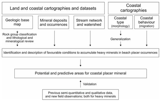
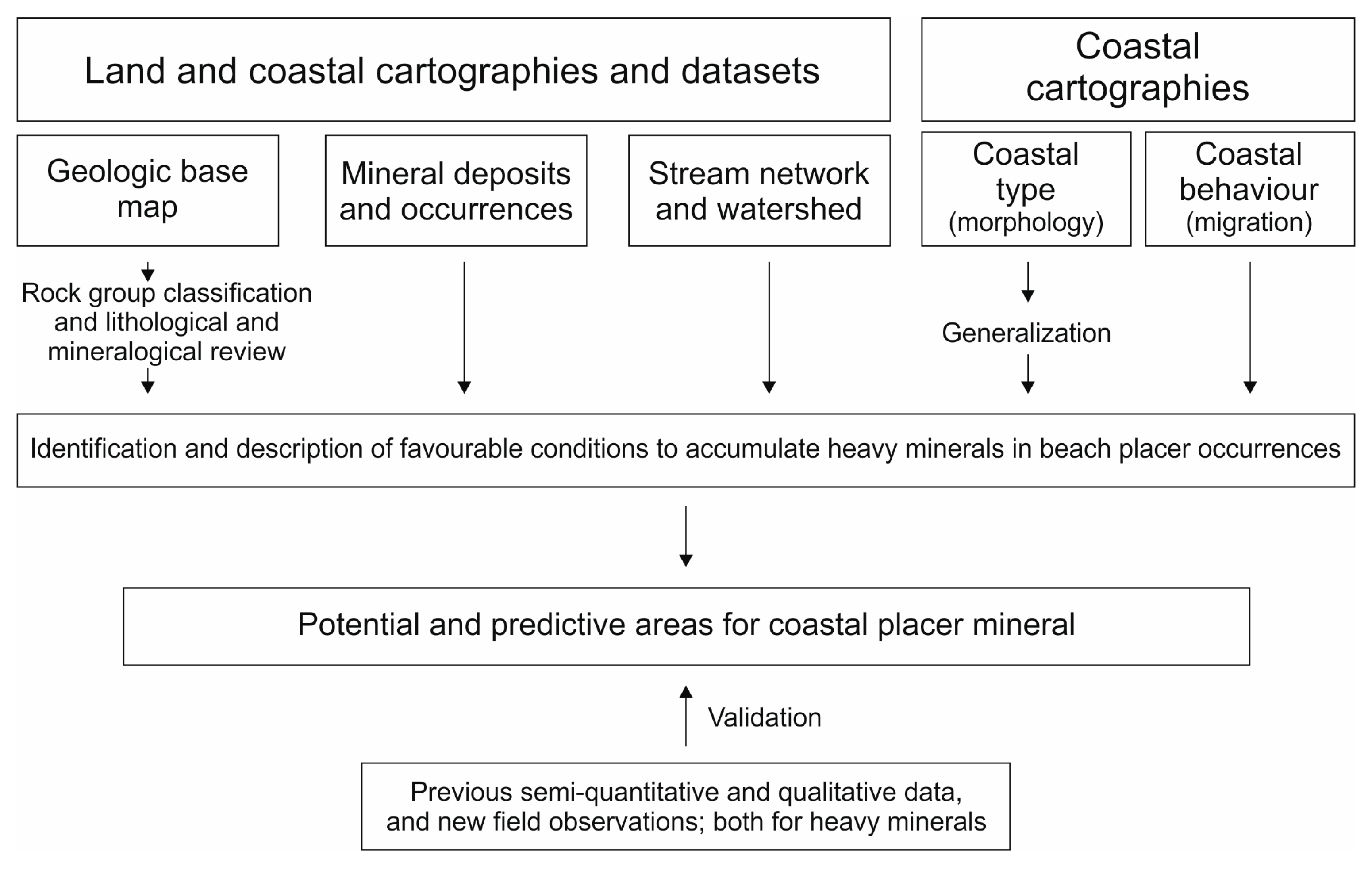
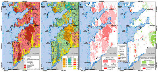
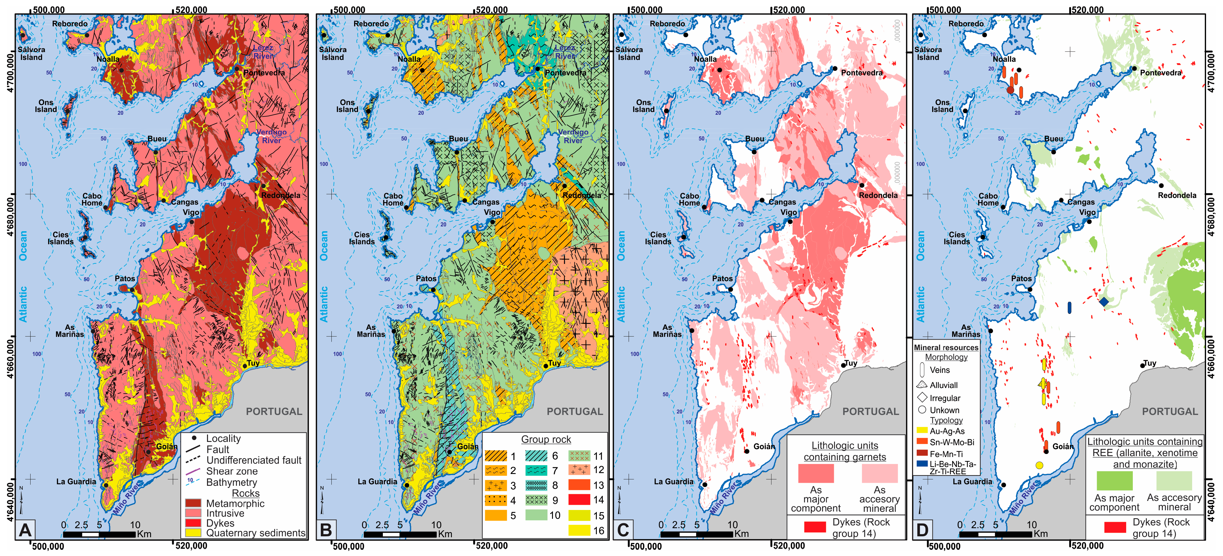
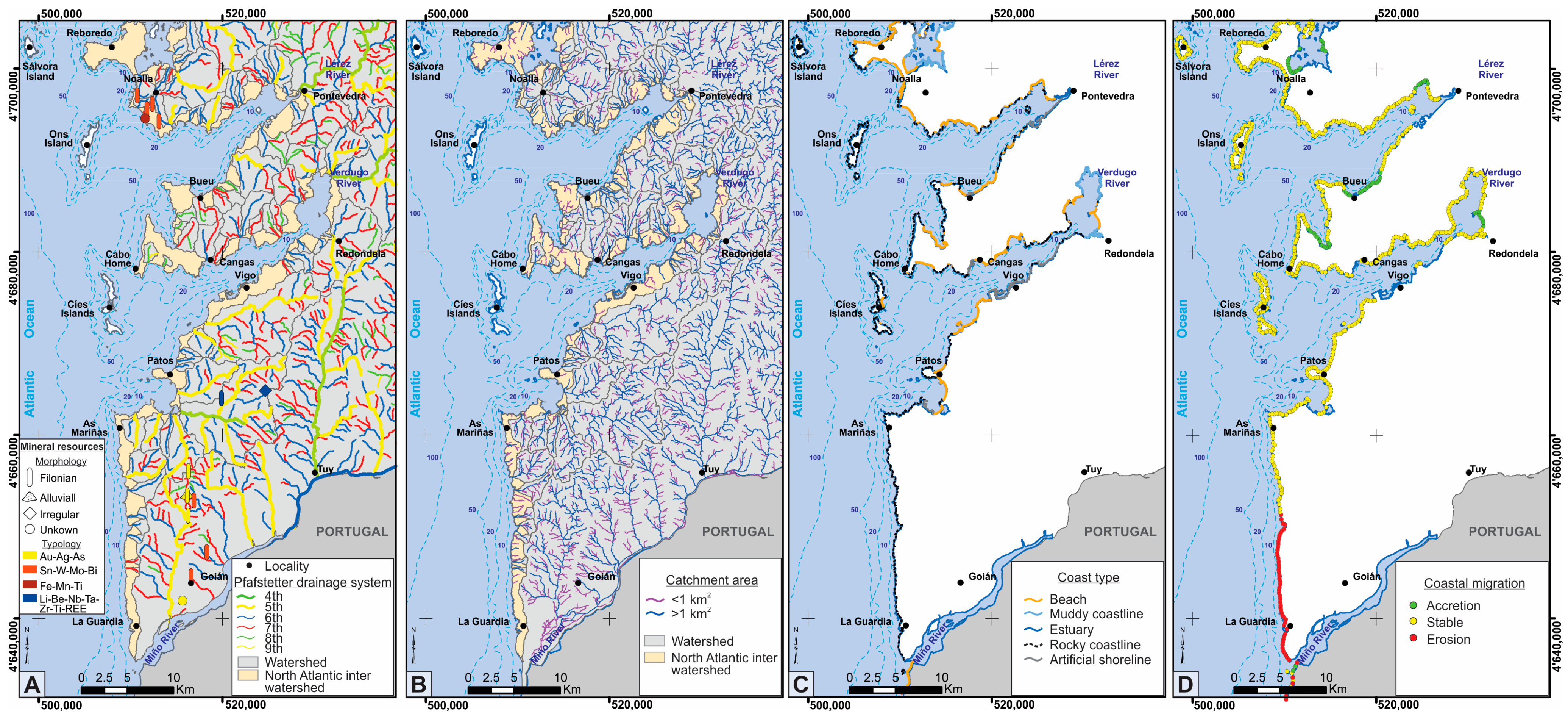
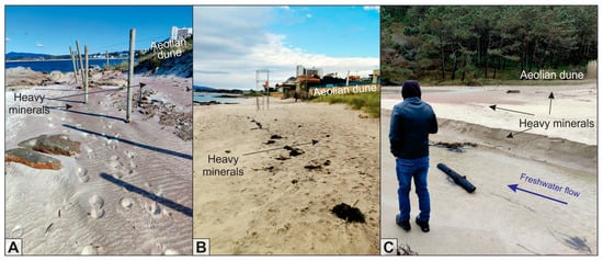
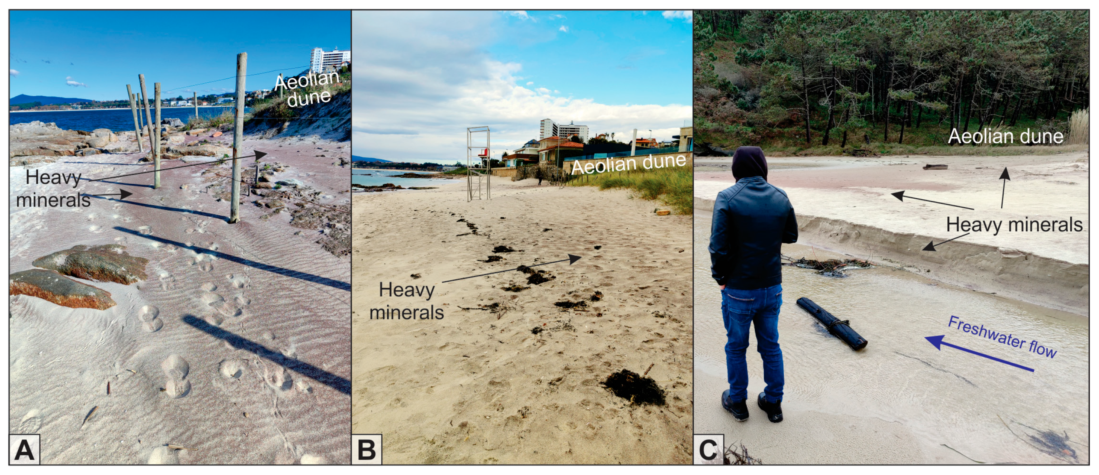
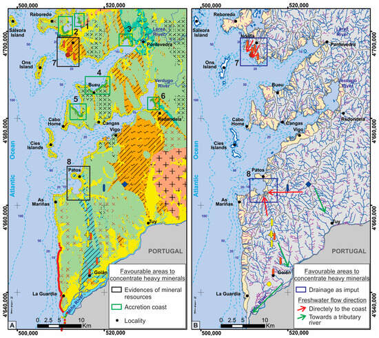
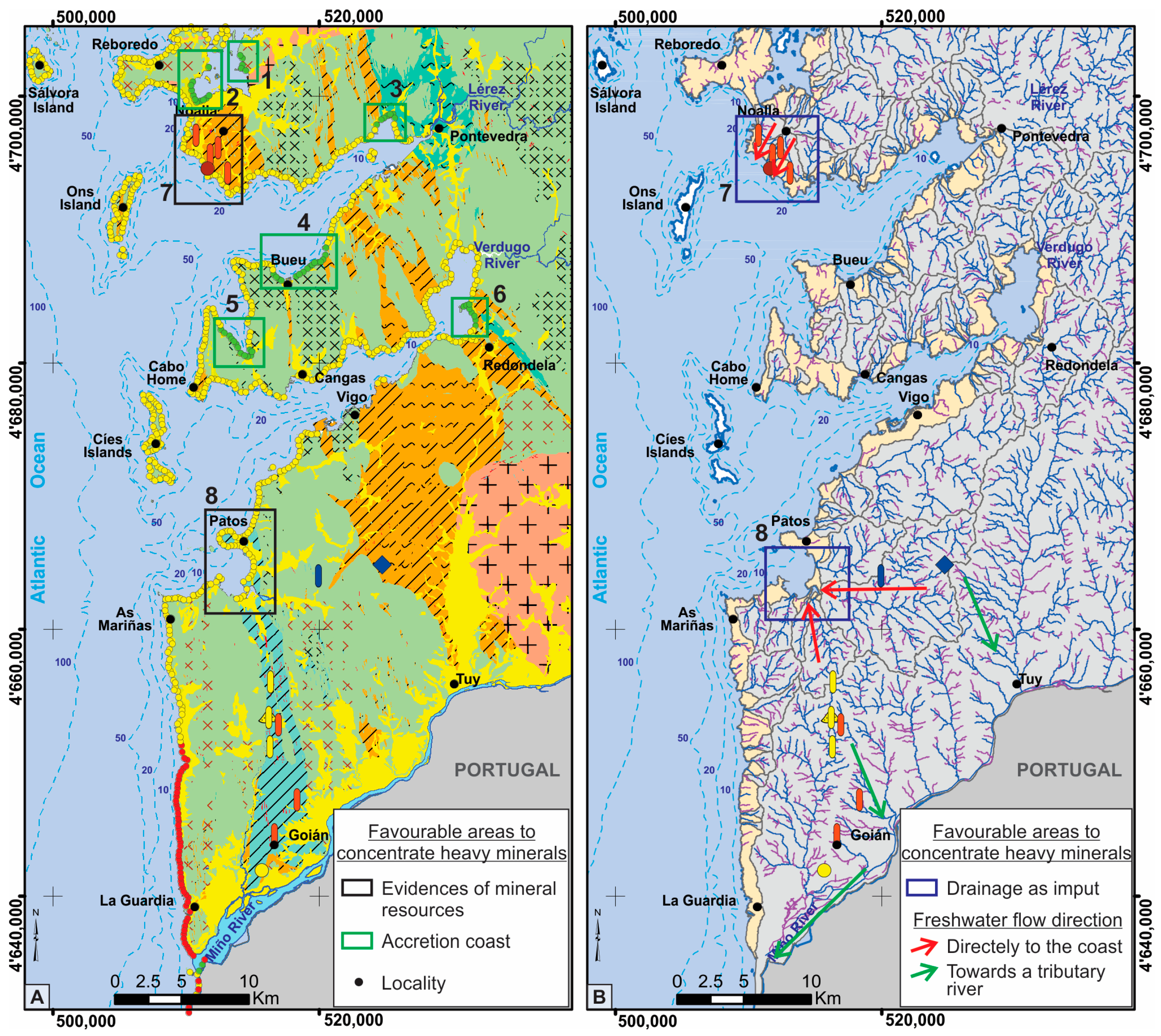
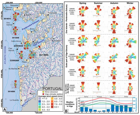
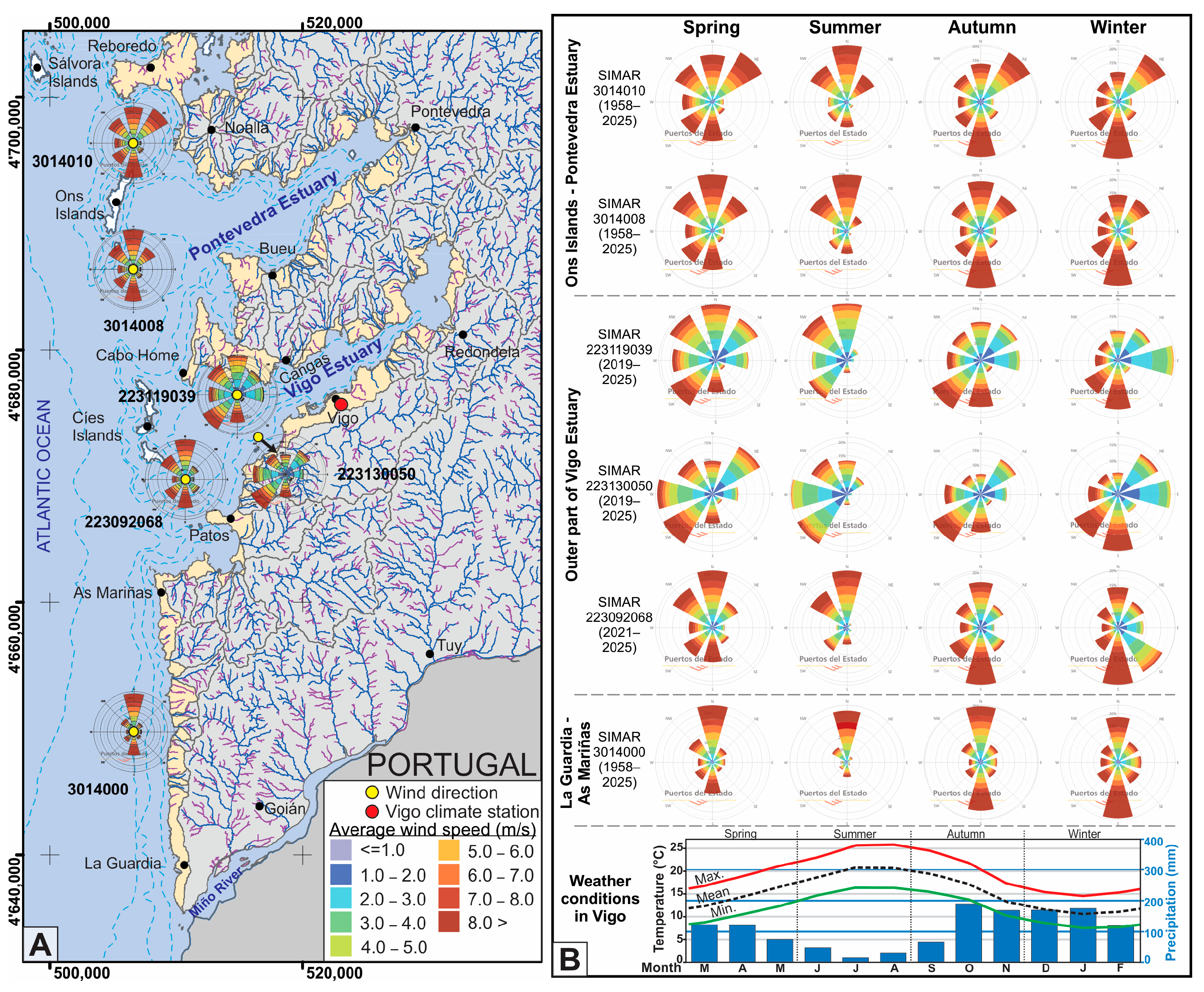
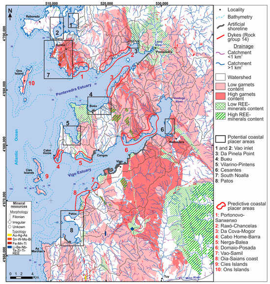
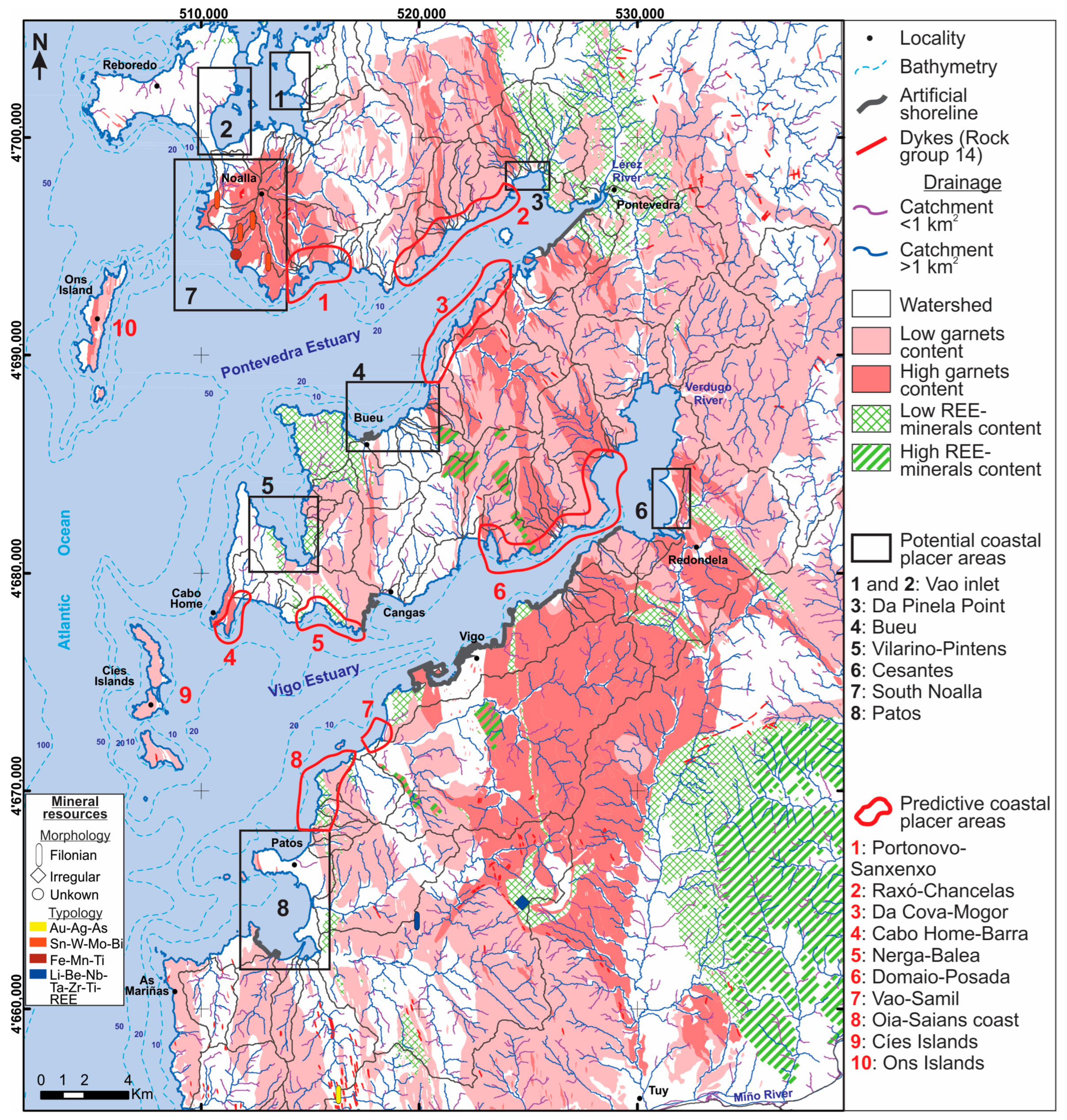
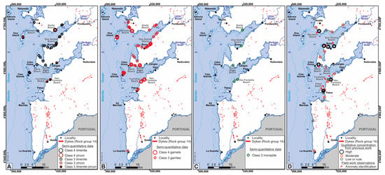
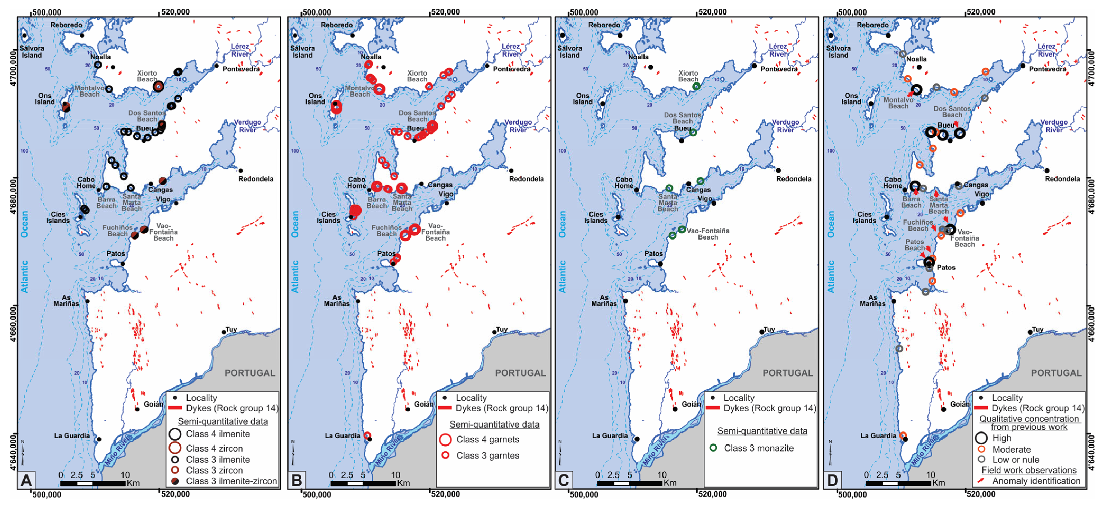
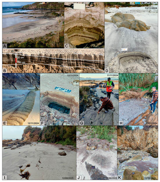
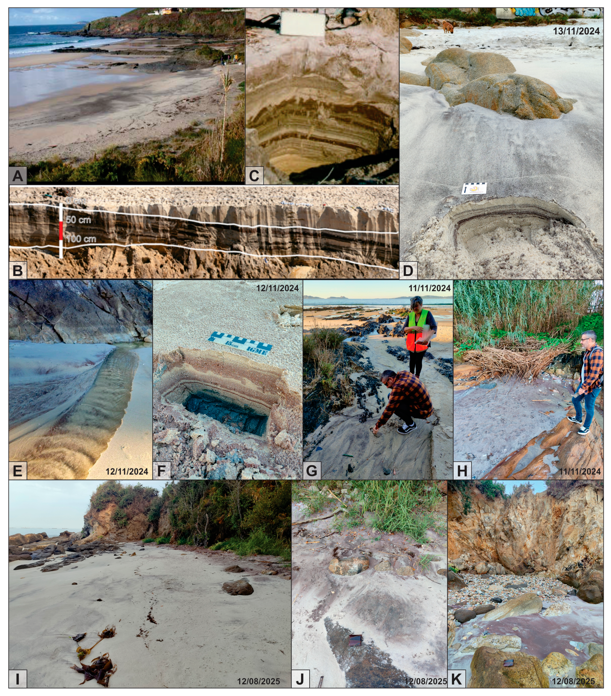
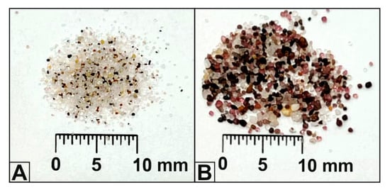
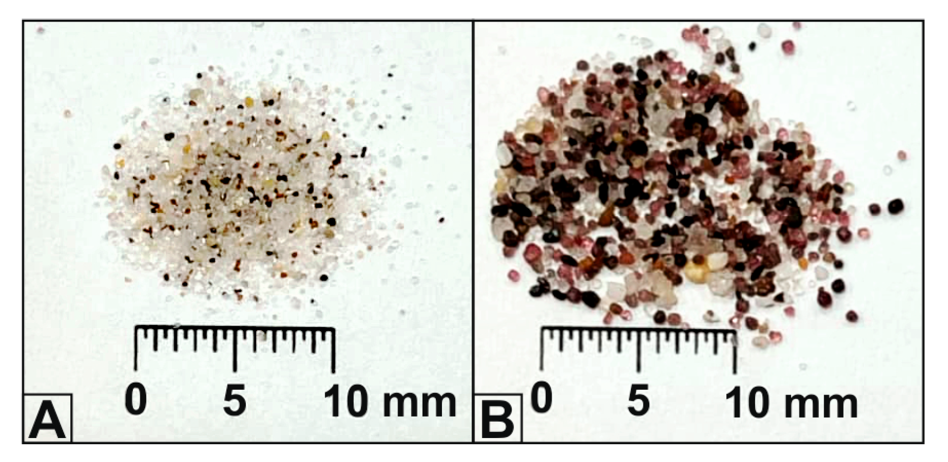

Disclaimer/Publisher’s Note: The statements, opinions and data contained in all publications are solely those of the individual author(s) and contributor(s) and not of MDPI and/or the editor(s). MDPI and/or the editor(s) disclaim responsibility for any injury to people or property resulting from any ideas, methods, instructions or products referred to in the content. |
© 2026 by the authors. Licensee MDPI, Basel, Switzerland. This article is an open access article distributed under the terms and conditions of the Creative Commons Attribution (CC BY) license.