


Abstract
The Ordovician platform margin belts in the Tarim Basin are key targets for deep carbonate hydrocarbon exploration. Their sequence architecture and spatial differences exert critical controls on the distribution of high-quality reservoirs. Taking the Early–Middle Ordovician platform margin belts in the Lunnan–Fuman–Gucheng area as the research object, this study systematically characterizes the sequence framework, sedimentary architecture, and segmented differential characteristics based on seismic, drilling, logging, and thin section data, using sequence stratigraphy, seismic facies analysis, and sedimentary mapping. The results show that five sequence boundaries are identified, dividing the Lower–Middle Ordovician into two second-order sequences and four third-order sequences. Seven types of mound-shoal seismic facies are developed, and three structural models are recognized from north to south: aggradation–weak retrogradation in the Lunnan section, weak aggradation–strong retrogradation in the Fuman section, and strong aggradation–weak retrogradation in the Gucheng section. It is revealed that differential subsidence caused by back-arc extension of the Altyn orogenic belt and the paleogeomorphic barrier effect of the Tadong Low Uplift collectively controlled the segmented architecture and migration evolution of the platform margin belts. The findings clarify the differential structural patterns of platform margins and provide a geological basis for hydrocarbon exploration in Ordovician platform margin reef-shoal complexes in the Tarim Basin.
1. Introduction
With the discoveries of the Tazhong oil field in the Tarim Basin and the giant Puguang, Yuanba, and Anyue platform margin reef-shoal gas fields in the Sichuan Basin, it has been widely recognized that the relatively high-energy platform margin belt, transitional from shallow-water platforms to deep-water basins, is the most favorable zone for the development of high-quality carbonate reservoirs [1,2,3,4]. The hydrocarbon exploration potential of such facies-controlled carbonate platform margins depends on platform type, as well as the scale, stacking pattern, and spatial distribution of platform-margin and intra-platform mound-shoal complexes [5]. The Ordovician platform margin belts constitute one of the most successful carbonate reef-shoal petroleum systems in the Tarim Basin, characterized by superior source–reservoir–seal assemblages and hydrocarbon accumulation conditions, representing a key domain for deep oil and gas exploration [6,7]. Recent drilling has confirmed that the Ordovician platform margins show significant regional differences in sedimentary architecture, stacking patterns, and distribution, which directly control the formation of high-quality reservoirs and hydrocarbon occurrence [8,9,10]. However, most previous studies focused on sedimentary facies, diagenesis, and reservoir prediction, lacking systematic analysis of sequence architecture, accommodation change, and differential subsidence mechanisms that govern platform margin development. The Early–Middle Ordovician was a critical period for platform transformation and platform margin stabilization in the Tarim Basin [11]. Regional tectonic setting, sea-level fluctuations, and differential subsidence collectively determined the sequence architecture and temporal-spatial distribution of platform margins. Moreover, the tectono-sedimentary framework of the southeastern basin was remotely influenced and dynamically constrained by early Paleozoic tectonic events of the southern Altyn orogenic belt [12,13]. Therefore, this study focuses on the Early–Middle Ordovician platform margin belts in the Tarim Basin, systematically delineates the sequence architecture and spatial differences in the Lunnan–Fuman–Gucheng segment, and analyzes the driving mechanisms for their differential development. The results aim to deepen the theoretical understanding of carbonate platform margin evolution and provide a geological reference for hydrocarbon exploration of Ordovician platform margin belts in the Tarim Basin.
2. Geological Background
The Tarim Basin, bounded by the Tianshan Mountains to the north, the Kunlun Mountains to the south, and the Altyn Tagh Fault to the east, covers an area of 56 × 104 km2. It is a large superimposed composite basin developed on a Precambrian paleocraton [14,15,16], subdivided into seven first-order tectonic units: three uplifts and four depressions, including the North Tarim Uplift, Central Uplift, Southeast Uplift, Kuqa Depression, North Depression, Southwest Depression, and Southeast Depression [17,18,19]. Since the Neoproterozoic, it has undergone three extension–convergence cycles related to the breakup and assembly of Rodinia, Gondwana, and Pangea supercontinents, with four sets of structural layers vertically: Neoproterozoic-Lower Paleozoic, Upper Paleozoic-Triassic, Jurassic-Paleogene, and Neogene-Quaternary [9,20]. Among them, the Neoproterozoic-Lower Paleozoic carbonate structural layer records sedimentary features from the breakup of Rodinia to the initial assembly of Gondwana, further subdivided into the Nanhua rifting stage, Sinian rift–depression transition stage, Cambrian craton construction–extension stage, Early Ordovician craton extension–convergence transition stage, and Middle–Late Ordovician–Silurian craton convergence–differentiation stage [21,22,23]. From the latest Sinian to the Cambrian, the Tarim Block drifted in the Proto-Tethys Ocean, showing typical characteristics of the craton construction–extension stage [24]. At the end of the Miaolingian, the Altyn and Kunlun terranes converged and subducted toward the Tarim Block and collided in the Early Ordovician. Regional tectonic stress shifted from extension to compression, causing rotation and migration of the southwestern Tarim paleo-uplift and initiation of the Tazhong and North Tarim uplifts. By the end of the Ordovician, large-scale uplift occurred in eastern Tarim, forming a west-dipping and east-steepening structural framework, with the Tadong paleo-uplift basically finalized [25].
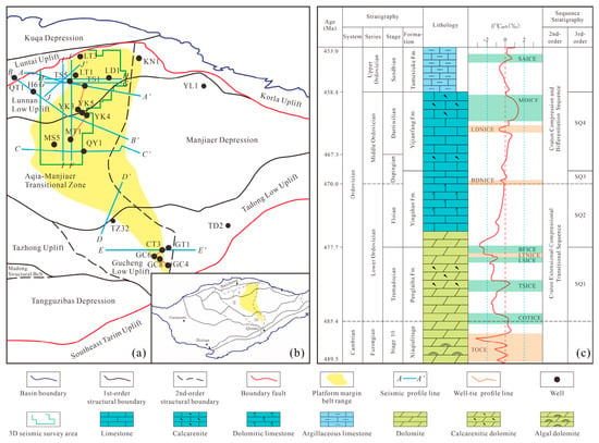
Episodic collisions between peripheral (micro) plates and the Tarim Block created a new uplift-depression framework and multiple unconformities in the Ordovician [10,11]. Combined with the overall rise in global sea level, these processes jointly controlled the synchronous differentiation of carbonate deposition, forming multiple sets of platform margin belts with distinct planar distribution characteristics [10,11]. The Early–Middle Ordovician platform margins in the basin are mainly developed in the Lunnan–Gucheng area across the North Tarim Uplift, North Depression, and Central Uplift, including five secondary tectonic units: Lunnan Low Uplift, Awati-Manjiaer Transition Zone, Manjiaer Sag, Gucheng Low Uplift, and Tadong Low Uplift (Figure 1a). In the Late Cambrian, the study area was dominated by rimmed carbonate platform deposits. By the latest Late Cambrian, influenced by subduction of the Central Kunlun Block, partial tectonic uplift occurred in the western Tarim platform, leading to exposure and erosion of platform-margin mound-shoals and intra-platform shoals [26,27]. In the Early Ordovician, a new transgression resulted in widespread dolomitized shoal reservoirs, which became the major Ordovician oil-producing intervals [6]. In the Middle Ordovician, regional compressive stress intensified, the Tazhong area uplifted strongly, and the western Tarim platform gradually evolved into a weakly rimmed carbonate platform [10]. In the Late Ordovician, rapid sea-level rise drowned the early carbonate platforms, and drowned platform facies and mixed shelf argillaceous deposits were developed, which, together with Middle Ordovician tight limestones, formed important cap rocks for the Lower Paleozoic petroleum system [28]. After the late Caledonian, secondary tectonic units in the study area became stable, with weakened tectonic reworking, favoring hydrocarbon accumulation and preservation in the Lunnan–Gucheng platform margins [11].
Figure 1.
Distribution of the Early–Middle Ordovician platform margin belts and comprehensive stratigraphic column of the study area. (a) Locations of 3D seismic survey area, 2D seismic profiles, wells, and well-tie profiles; (b) Distribution of the Early–Middle Ordovician platform margin belts in the Tarim Basin; I: Tabei Uplift; II: Northern Depression; III: Central Uplift; (c) Comprehensive stratigraphic column of the study area.
3. Methods
This study takes the Early–Middle Ordovician platform margin belt in the Lunnan–Fuman–Gucheng area of the Tarim Basin as the research object. Based on comprehensive data including 3D seismic, 2D seismic, drilling and logging, core, and cuttings thin sections, three technical systems—sequence stratigraphic division and correlation, seismic facies fine analysis, and sedimentary facies mapping—are adopted to systematically characterize the sequence framework, sedimentary architecture, and segmented differential characteristics of the platform margin belt, and to reveal its formative driving mechanism.
3.1. Data Basis and Preparation
- (1)
- Seismic data: The newly acquired and merged 3D seismic data volume covers an area of 15,000 km2 in the Lunnan–Fuman block. After high-resolution processing, fidelity- and amplitude-preserving processing, and merging, it is used for fine characterization of the platform margin belt and identification of mound-shoal complexes. More than 30 regional 2D seismic framework lines are deployed across the study area to realize continuous correlation from Lunnan to Fuman and Gucheng, constraining the spatial distribution of sequence boundaries and the platform margin belt.
- (2)
- Drilling and logging data: Nine key exploration wells are selected, and complete conventional logging curves (GR, RD, acoustic, density) and whole-well carbon and oxygen isotope data are collected for lithology identification, sequence boundary calibration, and cycle division. Cutting/core samples are systematically collected at a sampling interval of 2–5 m, with more than 2300 conventional and cast thin sections prepared for lithological identification, particle-type analysis, and biological assemblage observation to calibrate sedimentary microfacies.
3.2. Technical Methods
- (1)
- Sequence stratigraphic division and correlation: Based on Vail’s classic sequence stratigraphic theory, sequence boundaries are identified using multiple markers, including regional unconformities, global carbon isotope excursions, whole-well carbon and oxygen isotope curves, natural gamma ray characteristics, stacking patterns of mound-shoal complexes, seismic reflection termination features, and lithology-lithofacies transition surfaces. Second-order sequences, third-order sequences, and systems tracts are then classified. A three-level correlation framework (single-well sequence, cross-well sequence, seismic sequence) is established to achieve unified well-seismic calibration and full-area closed correlation.
- (2)
- Seismic facies analysis and architectural characterization: According to amplitude, frequency, continuity, reflection configuration, and internal structure, the seismic response differences in platform facies, platform margin facies, slope facies, and shelf facies are defined to identify typical seismic facies of platform margin mound-shoal complexes. The vertical stacking pattern and planar distribution range of the platform margin belt are delineated. The platform margin width, mound-shoal complex scale, and developmental location are counted to establish sequence architecture models of the platform margin belt in different blocks.
- (3)
- Sedimentary facies mapping: Thirteen seismic attributes covering amplitude, frequency, phase, coherence, and curvature are extracted. Through single-attribute sensitivity analysis, multi-attribute cross-validation, and quantitative ranking of matching degrees with sedimentary microfacies, the average geometric amplitude is determined as the optimal attribute for characterizing platform margin mound-shoal complexes and sedimentary microfacies differentiation. On the basis of fine tracking and interpretation of sequence boundaries and time-depth conversion, stratigraphic thickness maps for each third-order sequence/systems tract are compiled. Constrained by single-well sedimentary facies, seismic facies, and thickness maps, sedimentary facies maps are drawn to depict the migration and evolution of the platform margin belt.
4. Results
4.1. Sequence Stratigraphic Characteristics
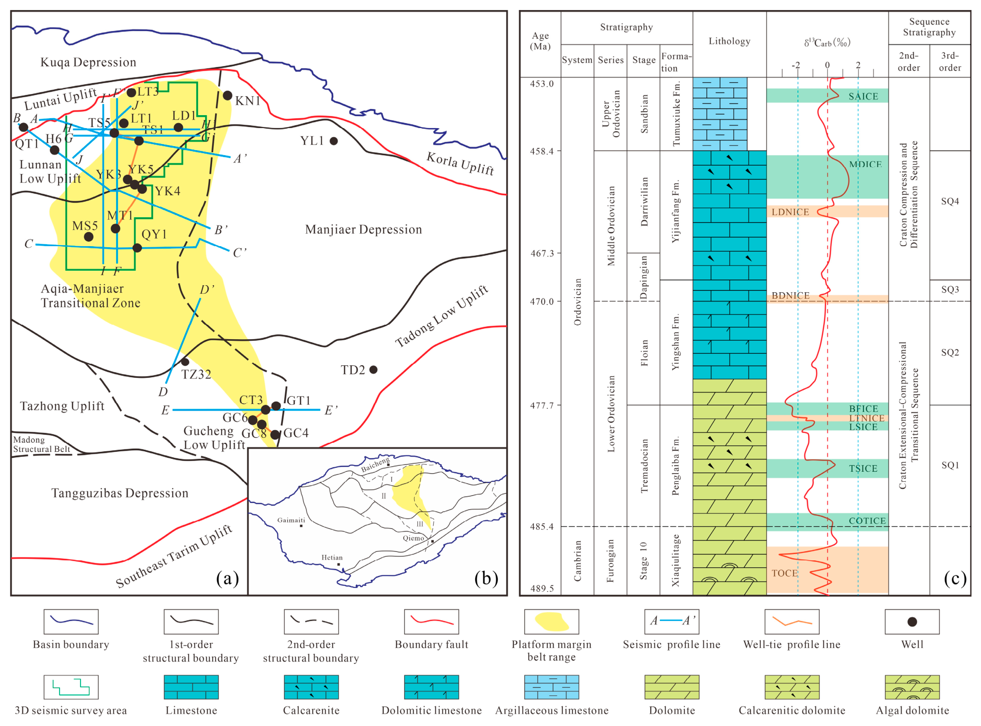
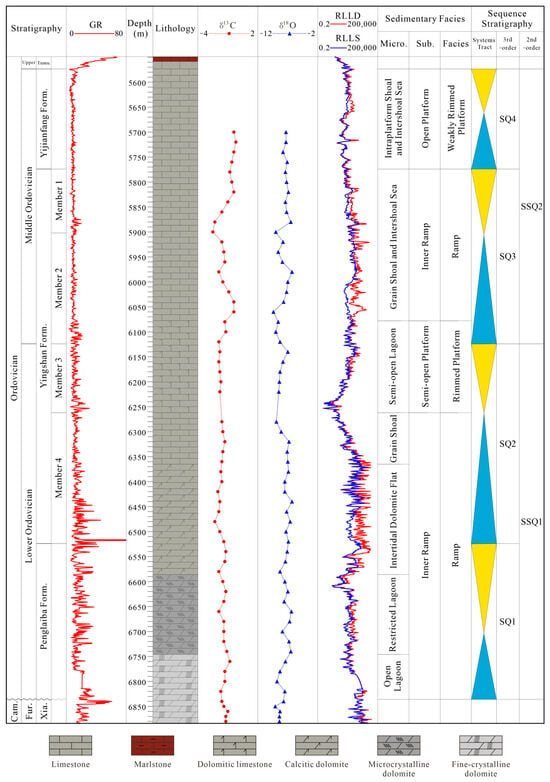
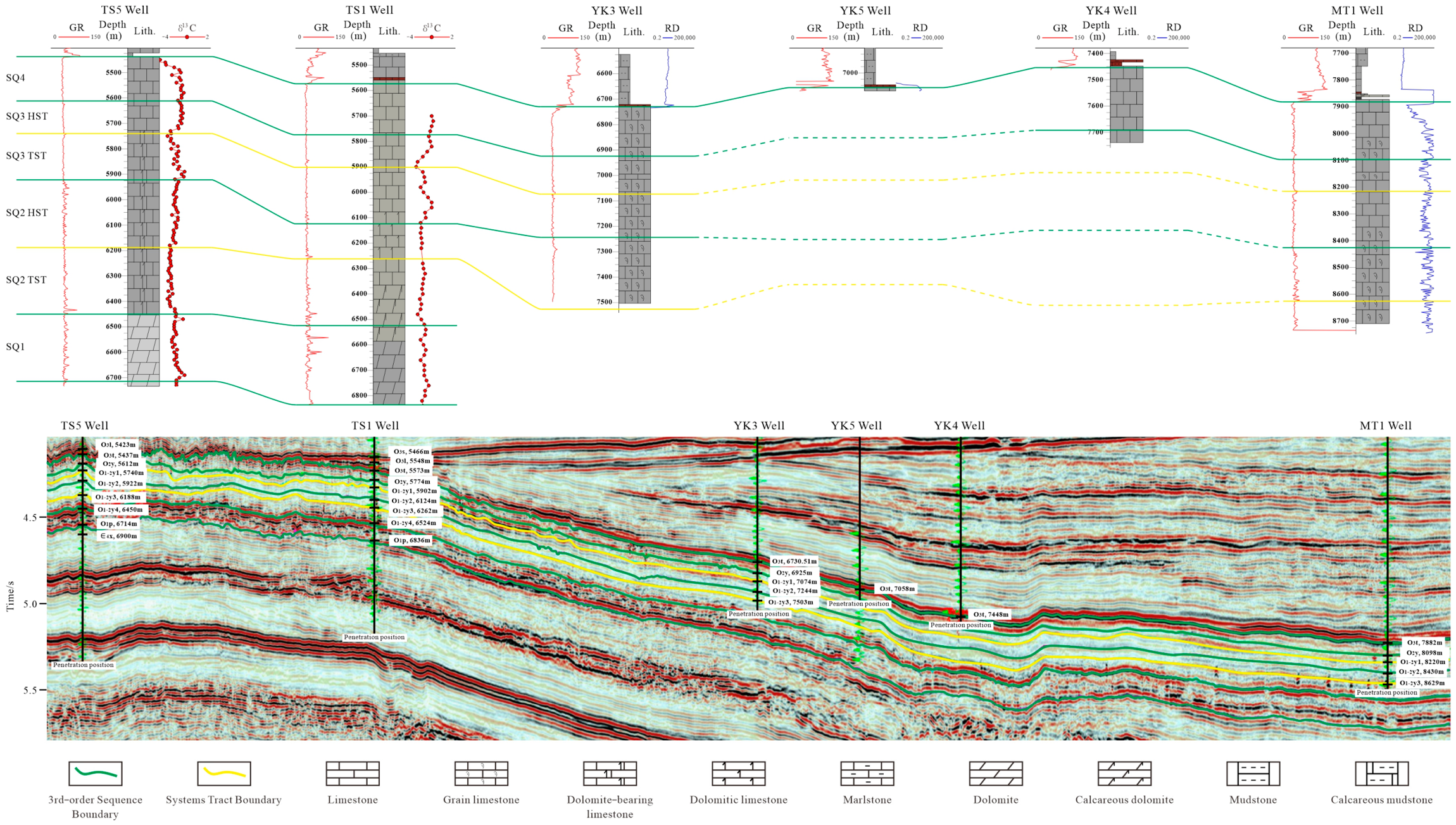
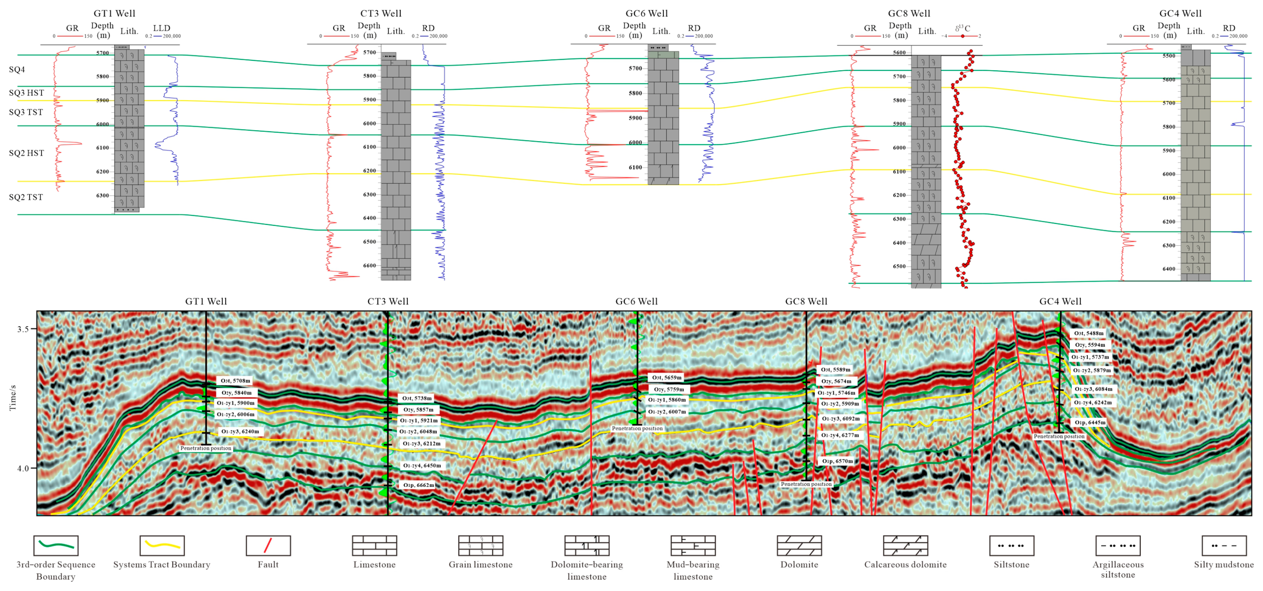
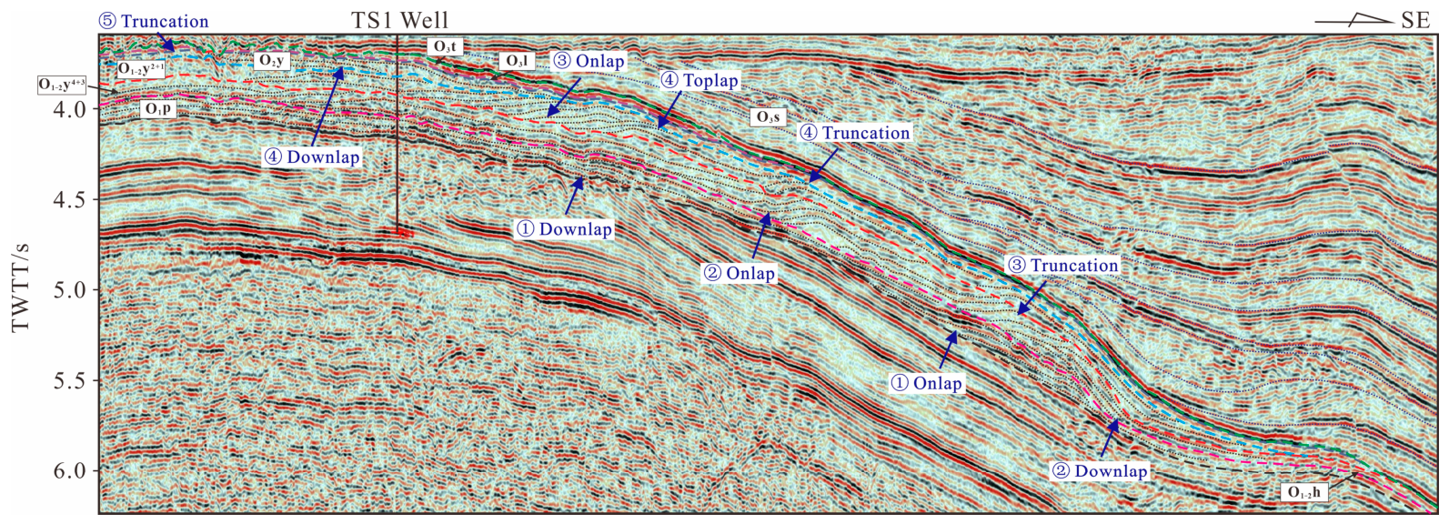
Two second-order sequences and four third-order sequences are identified within the Lower–Middle Ordovician platform margin belts in the Lunnan–Gucheng area (Figure 1c). The SSQ1 represents the Lower Ordovician extension–compression transition sequence of the Tarim Craton, including two third-order sequences: SQ1 corresponding to the Tremadocian Penglaiba Formation, SQ2 corresponding to the Floian 4th–3rd members of the Yingshan Formation. The SSQ2 represents the Middle–Upper Ordovician compression-differentiation sequence, with its top boundary being a regional unconformity between the Silurian and Upper Ordovician, coinciding with a first-order structural sequence boundary, recording intense differentiation of the Tarim Craton due to the progressive closure of the Kunlun and Altyn oceans [11]. The Middle Ordovician includes two third-order sequences: SQ3 corresponding to the lower Dapingian 2nd–1st members of the Yingshan Formation, SQ4 corresponding to the upper Dapingian–Darriwilian Yijianfang Formation (Figure 2). This division scheme has good traceability in the target strata of the study area, and the sequence development is relatively continuous (Figure 3 and Figure 4).
Figure 2.
Comprehensive stratigraphic characteristics of the sedimentary sequence of the Lower–Middle Ordovician in TS1 Well, Lunnan Low Uplift.
Figure 3.
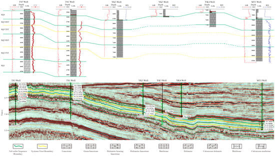
Well-seismic sequence correlation of Lower–Middle Ordovician in the Lunnan–Fuman area (see Figure 1a for section location).
Figure 4.
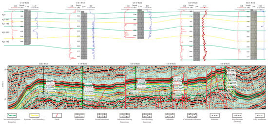
Well-seismic sequence correlation of Lower–Middle Ordovician in the Gucheng area (see Figure 1a for profile location).
4.1.1. Characteristics of Sequence Boundaries
- (1)
- Base boundary of SQ1 (Cambrian–Ordovician boundary/second-order sequence boundary)
This boundary is a regional unconformity between the Cambrian and Ordovician, marking the transition from the regional construction–extension sequence to the extension–compression transition sequence. The GR curve shows obvious abrupt changes near the interfaces, and has a good correspondence with carbon and oxygen isotope curves (Figure 2). On seismic profiles, it appears as a highly continuous, strong-amplitude event with onlap and downlap, showing medium-low angle truncation below and progradation above (Figure 5). This interface corresponds to the positive carbon isotope excursion of COTICE (Cambrian–Ordovician Transition Isotopic Carbon Excursion) on the global carbon isotope curve (Figure 1c), with an amplitude of ~2‰ and peak value >+0‰ [29,30].
Figure 5.
Characteristics of Ordovician sequence boundaries in platform margin belts, Lunnan area.
- (2)
- Base boundary of SQ2 (Tremadocian–Floian boundary)
Corresponding to the boundary between the Penglaiba and Yingshan formations. This boundary experienced 6–8 Ma of uplift and erosion in the Tazhong Uplift, with smaller uplift amplitude and shorter exposure duration in the study area. Missing conodont zones in the northern Kalpin cement factory profile and the Wushi Yingshan northern slope profile provide key evidence for an unconformity at the top of the Penglaiba Formation [31]. The GR curve exhibits abrupt variations near the interface (Figure 2); on seismic profiles, it is a continuous strong-amplitude peak reflection with recognizable onlap and downlap (Figure 5). The depositional system evolved from a carbonate ramp platform (Penglaiba Fm.) to a rimmed platform (lower Yingshan Fm.). This interface corresponds to the LTNICE (Late Tremadocian Negative Isotopic Carbon Excursion) negative excursion (amplitude ~3‰) and the BFICE (Basal Floian Isotopic Carbon Excursion) minor positive excursion (amplitude < 1‰, peak > −2‰) [32] (Figure 1c).
- (3)
- Base boundary of SQ3 (Lower–Middle Ordovician boundary/second-order sequence boundary)
This boundary separates the Lower Ordovician Floian lower Yingshan Formation from the Middle Ordovician Dapingian upper Yingshan Formation, an unconformity caused mainly by sea-level fall, marking the transition from the regional extension–compression transition sequence to the compression-differentiation sequence. Onlap, downlap, and truncation are recognizable on seismic profiles (Figure 5); “bead-like” reflections below the boundary in the Gucheng area may relate to karstification; Th and U enrichment on spectral gamma-ray logs indicates long-term exposure and weathering [33]. It corresponds to the BDNICE (Basal Dapingian Negative Isotopic Carbon Excursion) negative excursion with amplitude > 1‰ [32] (Figure 1c).
- (4)
- Base boundary of SQ4 (Yingshan–Yijianfang Formation boundary)
Toplap and truncation are recognizable on seismic profiles (Figure 5); an unnamed minor negative excursion is observed on carbon isotope curves (Figure 1c). The depositional system evolved from a retrogradational ramp platform (upper Yingshan Fm.) to a weakly rimmed platform (Yijianfang Fm.).
- (5)
- Top boundary of SQ4 (Middle–Upper Ordovician boundary)
Corresponding to the boundary between the Yijianfang and Tumuxiuke formations. At the end of the Middle Ordovician Darriwilian, the Kudi and Altyn arcs converged with the southern margin of the Tarim Block. Under regional compression, the Yijianfang Formation in the study area was uplifted and exposed [34], showing truncation on seismic profiles (Figure 5). A new flooding phase occurred above the boundary, with drowned platform deposits of the Tumuxiuke Formation.
4.1.2. Spatial Distribution of Sequences
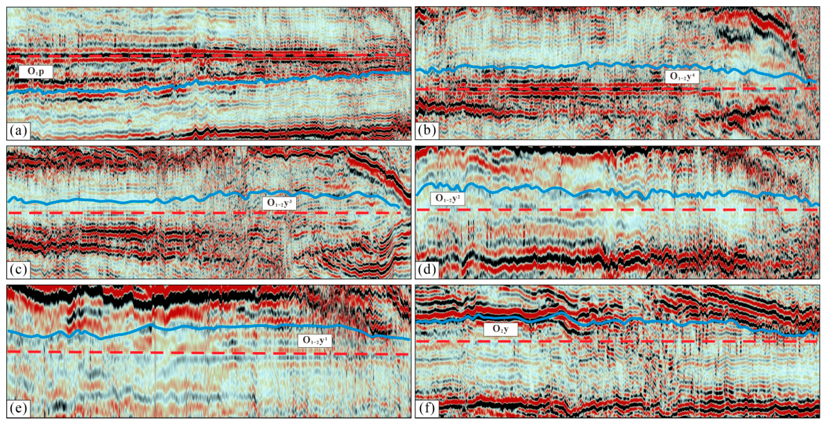
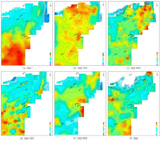
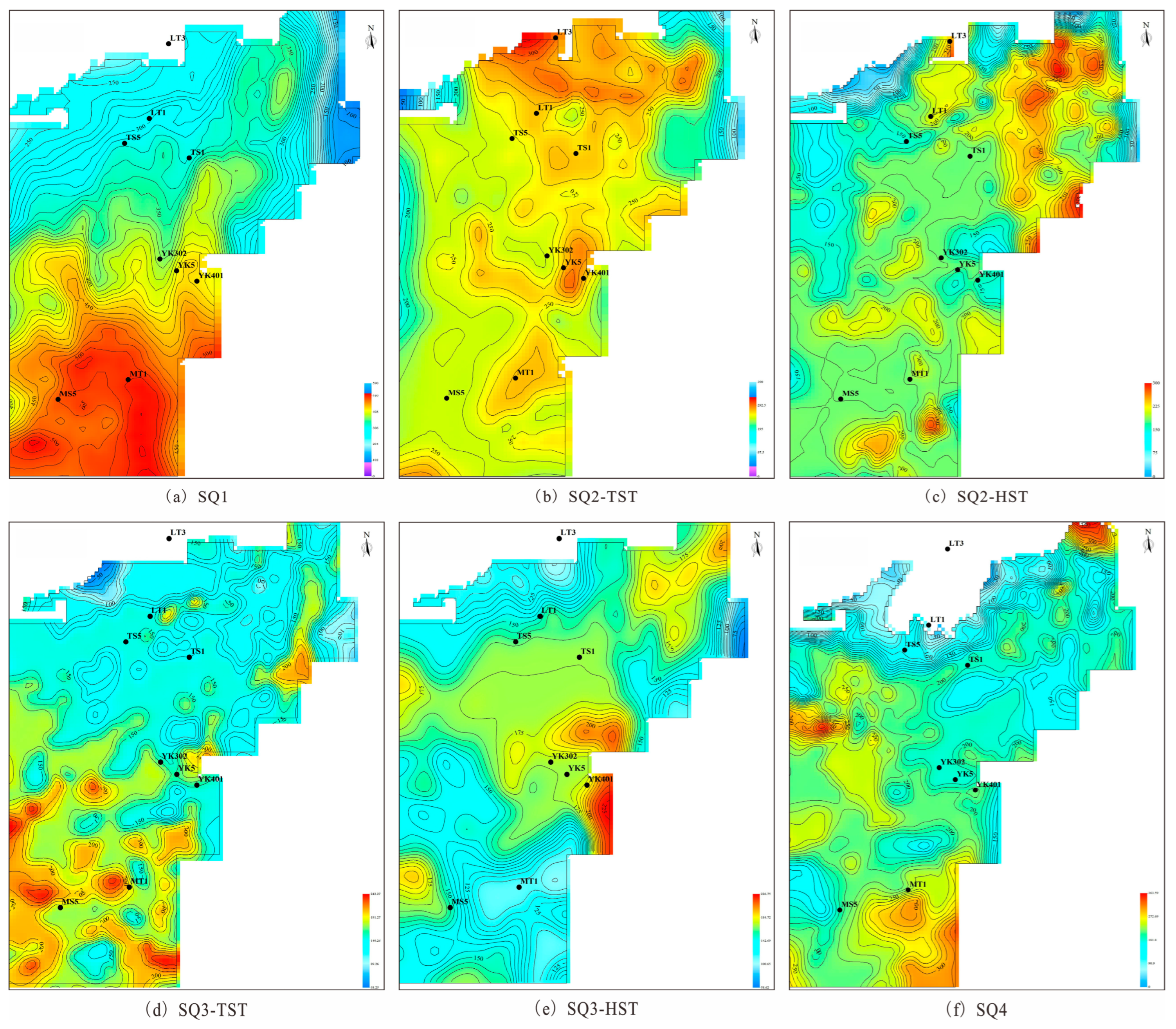
Isopach maps are compiled for the relatively complete Lunnan–Fuman platform margin. The thickness of SQ1 strata ranges from 100 to 530 m, showing an overall pattern of being thicker in the south and thinner in the north. SQ2-TST strata are 100 to 310 m thick, with greater thickness along the well lines of LT3, TS1, YK5, and MT1, thinning eastward and westward. The thickness of the SQ2-HST strata varies from 50 to 290 m, presenting a thickening trend from west to east. SQ3-TST strata range from 50 to 230 m in thickness and display the same south-thick and north-thin feature as SQ1. SQ3-HST strata are 50 to 235 m thick, with the maximum thickness occurring to the east of Well YK401 in the central study area. SQ4 strata have a thickness of 50 to 350 m and are generally thicker in the south and thinner in the north (Figure 6 and Figure 7). These thickness variations correlate strongly with tectonic dynamics, paleo-sea-level changes, and sedimentary distribution.
Figure 6.
Schematic diagram of sequence thickness variation. (a) SQ1, Profile F, flattened at the bottom of the Member 4 of the Yingshan Formation; (b) SQ2-TST, Profile G, flattened at the bottom of the Member 4 of the Yingshan Formation; (c) SQ2-HST, Profile H, flattened at the bottom of the Member 3 of the Yingshan Formation; (d) SQ3-TST, Profile I, flattened at the bottom of the Member 2 of the Yingshan Formation; (e) SQ3-HST, Profile F, flattened at the bottom of the Member 1 of the Yingshan Formation; (f) SQ4, Profile J, flattened at the bottom of the Yijianfang Formation; See Figure 1a for profile locations.
Figure 7.
Spatial distribution of sequence thicknesses in the Lunnan–Fuman platform margin belt.
4.2. Identification Characteristics of Platform Margin Belts
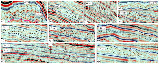
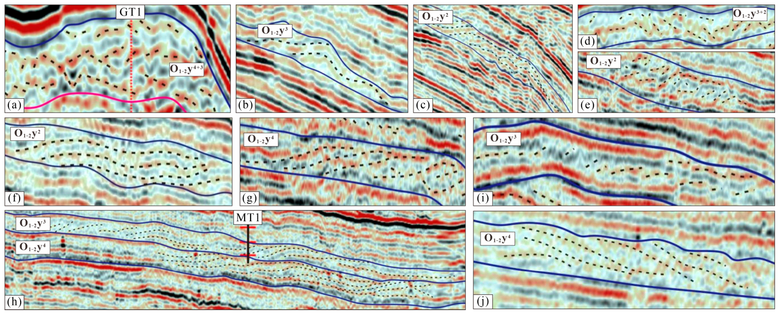
The seismic reflection characteristics of the Ordovician platform margins differ from adjacent platform and slope facies. Seven types of mound-shoal seismic facies are identified across the Lunnan–Gucheng platform margin: ① medium-weak amplitude, mounded chaotic aggradation–weak retrogradation (Figure 8a); ② medium-weak amplitude, moderately continuous, mounded reflection (Figure 8b); ③ medium-weak amplitude, continuous domal reflection (Figure 8c); ④ medium-weak amplitude, medium-high frequency, chaotic (retrogradational) reflection (Figure 8d,e); ⑤ medium-weak amplitude, medium-high frequency, moderately continuous, sigmoid-oblique composite retrogradation (Figure 8f–h); ⑥ medium-weak amplitude, medium frequency, imbricate retrogradation (Figure 8i); ⑦ medium-weak amplitude, medium-high frequency, moderately continuous, sigmoid–oblique progradation (Figure 8j). Platform facies show sub-parallel relatively continuous reflections; slope facies show oblique divergent and oblique progradational reflections; shelf facies show parallel high-continuous reflections.
Figure 8.
Typical seismic reflection configurations of mound-shoal complexes. (a) Medium-weak amplitude, mounded chaotic aggradational–weakly retrogradational reflection, Member 4 and Member 3 of the Yingshan Formation, Gucheng area; (b) Medium-weak amplitude, moderately continuous, mounded reflection, Member 3 of the Yingshan Formation, Lunnan area; (c) Medium-weak amplitude, continuous domal reflection, Member 2 of the Yingshan Formation, Lunnan area; (d,e) Medium-weak amplitude, medium-high frequency, chaotic (retrogradational) reflection, Member 3 and Member 2 of the Yingshan Formation in the Gucheng area, and Member 2 of the Yingshan Formation in Well TZ32 area; (f–h) Medium-weak amplitude, medium-high frequency, moderately continuous, sigmoidal-oblique composite retrogradational reflection, Member 2 of the Yingshan Formation in the Lunnan area, Member 4 of the Yingshan Formation in Well TZ32 area, Member 4 and Member 3 of the Yingshan Formation in the Fuman area; (i) Medium-weak amplitude, medium frequency, imbricate retrogradational reflection, Member 3 of the Yingshan Formation in Well TZ32 area; (j) Medium-weak amplitude, medium to medium-high frequency, moderately continuous, sigmoidal oblique progradational reflection, Member 4 of the Yingshan Formation in the Lunnan–Fuman transition area.
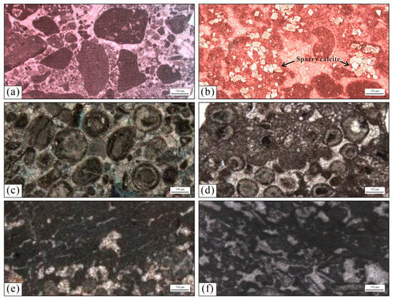
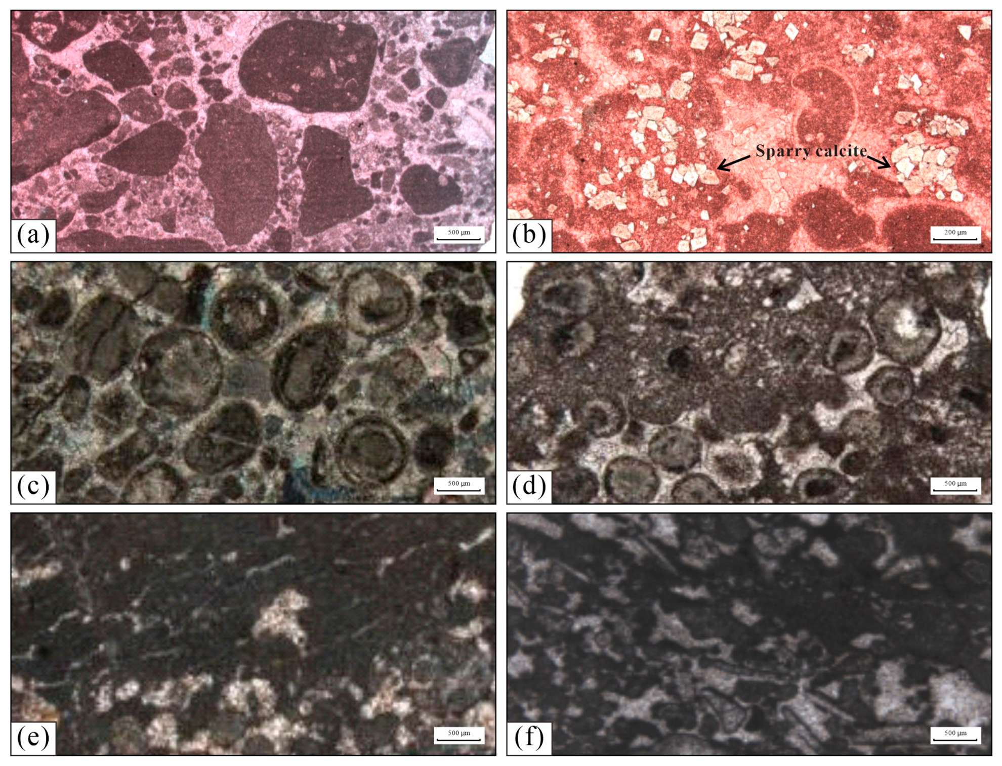
In addition, lithofacies characteristics differ between the southern and northern areas. Sparry calcarenite with occasional bioclasts and partial dolomitization is developed in the middle of the 4th Member and the bottom of Member 3 of the Yingshan Formation around MT1 Well in the Fuman area. At the bottom of Member 2 and top of Member 1 of the Yingshan Formation around QY1 Well, lithofacies are dominated by sparry oolitic limestone and sparry calcarenite, indicating higher hydrodynamic energy than that around MT1 Well. In the middle of Member 2 and the lower part of Member 3 of the Yingshan Formation around GT1 Well in the southern Gucheng area, biological fossils obviously increase, where microbial limestone and grain limestone are well developed (Figure 9).
Figure 9.
Lithofacies characteristics of platform-margin mound-shoal complexes. (a) Sparry calcarenite, MT1 Well, 8640 m (−), base of Member 3, Yingshan Formation; (b) Bioclastic-bearing sparry calcarenite, MT1 Well, 8680 m (−), middle part of Member 4, Yingshan Formation; (c) Sparry oolitic calcarenite, QY1 Well, 8410 m (+), top of Member 1, Yingshan Formation; (d) Sparry oolitic limestone, QY1 Well, 8688 m (−), base of Member 2, Yingshan Formation; (e) Microbialite and grainstone, GT1 Well, 5914 m (−), middle part of Member 2, Yingshan Formation; (f) Microbial (calcified cyanobacteria) calcarenite, GT1 Well, 6159 m (−), lower part of Member 3, Yingshan Formation.
4.3. Differential Structural Models of Platform Margin Belts
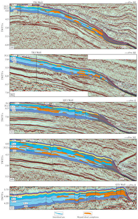
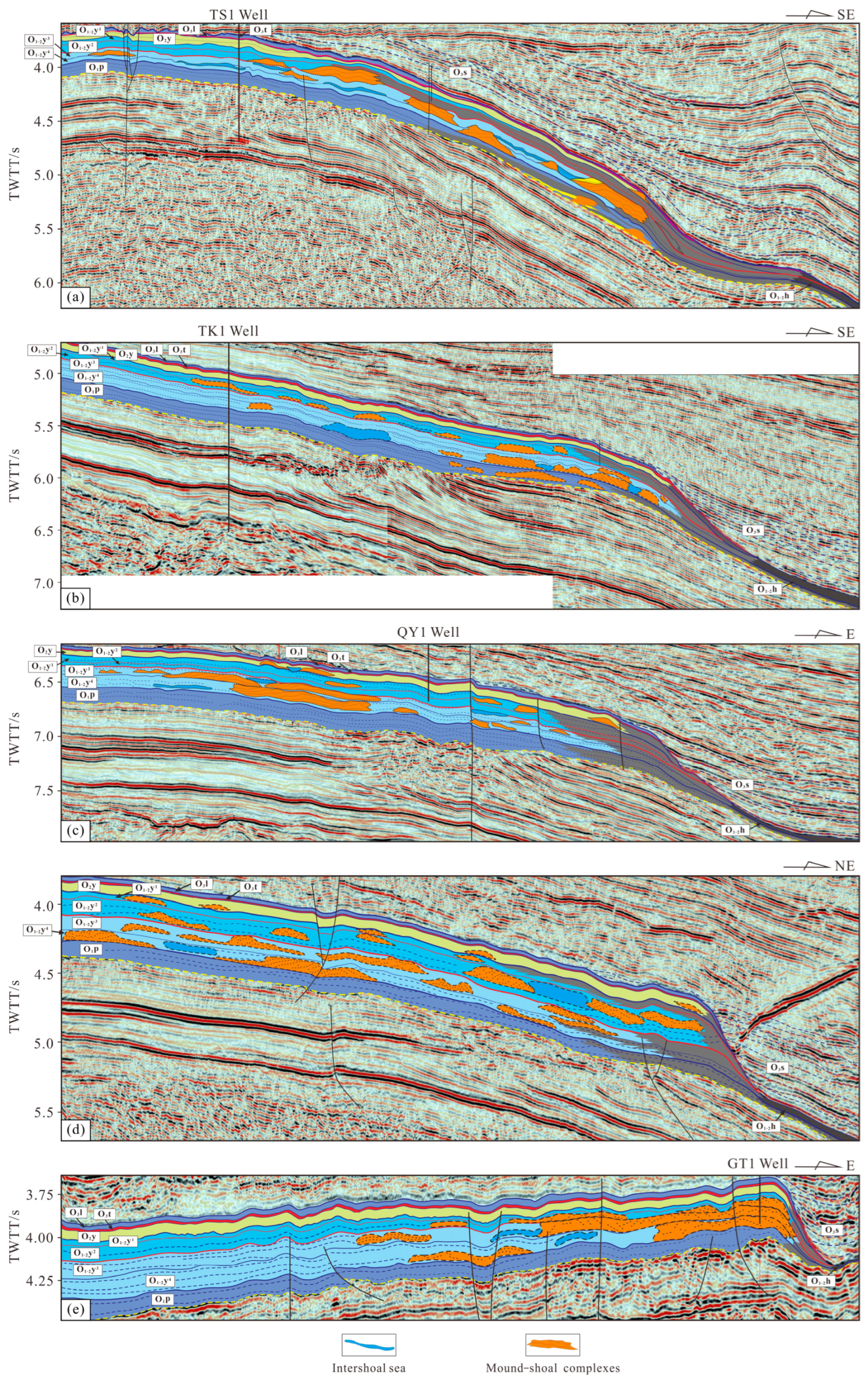
Laterally, the Lunnan–Gucheng platform margin narrows gradually from north to south (Figure 1) and shows distinct segmentation, with three structural models. Lunnan section: aggradation–weak retrogradation stacking, medium width; lithology: sandy shoal-mound-shoal-micritic limestone. Fuman section: weak aggradation–strong retrogradation stacking, wider distribution; the lithological association consists of calcarenite shoal, mound-shoal complex, and micritic limestone. Gucheng section: strong aggradation–weak retrogradation stacking, relatively narrow; the lithological association consists of thick-bedded oolitic limestone, sandy limestone, and algal limestone, with multiple high-frequency sequence exposure surfaces and dolomitized zones, locally showing syndepositional shoal-controlling features.
4.3.1. Lunnan Aggradation–Weak Retrogradation Platform (Profile A)
The platform types consist of: non-rimmed shelf platform (O1p, O2y1+2), weakly rimmed platform (O1y3+4, O2y), drowned platform (O3t), isolated rimmed platform (O3l), and drowned platform (O3s). Mound-shoal complexes show medium-weak amplitude, continuous/moderately continuous, sigmoid-oblique composite, mounded/domal reflections, mainly developed in SQ2 to SQ3, with limited distribution in SQ1 and SQ4. The mound-shoal complexes in SQ2 show obvious retrogradational growth and migration characteristics, with a scale ranging from 2 km to 16 km. Gravity flow slump deposits occur in SQ3 as wedge-shaped weak reflections, likely related to the extension–compression transition (Figure 10a).
Figure 10.
Architectural models of the platform margin in the Lunnan–Gucheng area. (a) Lunnan aggradation–weak retrogradation platform; (b) Lunnan–Fuman transition aggradation–weak retrogradation platform; (c) Fuman weak aggradation–strong retrogradation platform; (d) Northern Gucheng transition strong aggradation platform; (e) Gucheng strong aggradation–weak retrogradation platform.
4.3.2. Lunnan–Fuman Transition Aggradation–Weak Retrogradation Platform (Profile B)
The platform types include: aggradational–weakly retrogradational non-rimmed platform (O1p, O1y1+2), rimmed platform (O2y3+4), and drowned platform (O3t-O3l-O3s). The seismic reflection features of mound-shoal complexes are characterized by medium-low amplitude, moderate-to-poor continuity, mound-shaped chaotic reflection, and composite S-shaped and oblique reflection configurations. Mound-shoal complexes are mainly developed in SQ1–SQ3. Among them, progradational mound-shoal complexes occur in SQ2-TST, and retrogradational ones occur in SQ2-HST to SQ3. Clear progradational and retrogradational growth and migration patterns can be identified inside the complexes, with their scales ranging from 2 km to 14 km (Figure 10b).
4.3.3. Fuman Weak Aggradation–Strong Retrogradation Platform (Profile C)
The platform types are weakly aggradational (O1p) to strongly retrogradational (O1+2y-O3s), evolving from a non-rimmed platform (O1p-O1+2y) to a drowned platform (O3t-O3l-O3s). The mound-shoal complexes are featured by medium-low amplitude, moderate-to-weak continuity, mound-like chaotic reflection, and combined S-shaped and oblique reflection configurations. Such complexes are mainly developed in SQ2–SQ4, among which retrogradational mound-shoal complexes dominate in SQ2–SQ3, with indistinct retrogradational growth and migration characteristics visible locally inside. Their scale varies from 2 km to 21 km (Figure 10c).
4.3.4. Northern Gucheng Transition Strong Aggradation Platform (Profile D)
The platform evolution includes an aggradational stage (O1p-O1y3+4), a progradational stage (O2y2), a retrogradational stage (O2y1), a progradational stage (O2y), and a retrogradational/drowned platform stage (O3t-O3l-O3s). The mound-shoal complexes show seismic reflection characteristics of moderate-to-weak amplitude, combined S-shaped and oblique reflections, and mound-like chaotic retrogradational reflections. They are mainly developed in SQ2–SQ4, with prominent internal retrogradational growth and migration within the complexes of SQ2–SQ3, ranging from 3 km to 19 km in scale. Notably, the mound-shoal bodies in SQ2-HST exhibit typical progradational features, which are interpreted as migration caused by lateral syndepositional compression (Figure 10d).
4.3.5. Gucheng Strong Aggradation–Weak Retrogradation Platform (Profile E)
In the Gucheng area, the platform evolves from strongly aggradational to weakly retrogradational, changing from a non-rimmed shelf platform (O1p) to a rimmed platform (O1+2y-O3l) and finally to a drowned platform (O3s). The mound-shoal complexes display moderate-to-weak amplitude and mound-shaped chaotic seismic reflections, with a distribution range of 4–23 km, and are mainly developed in SQ2 to SQ3-TST (Figure 10e).
4.4. Spatial Evolution of Sedimentary Facies Belts
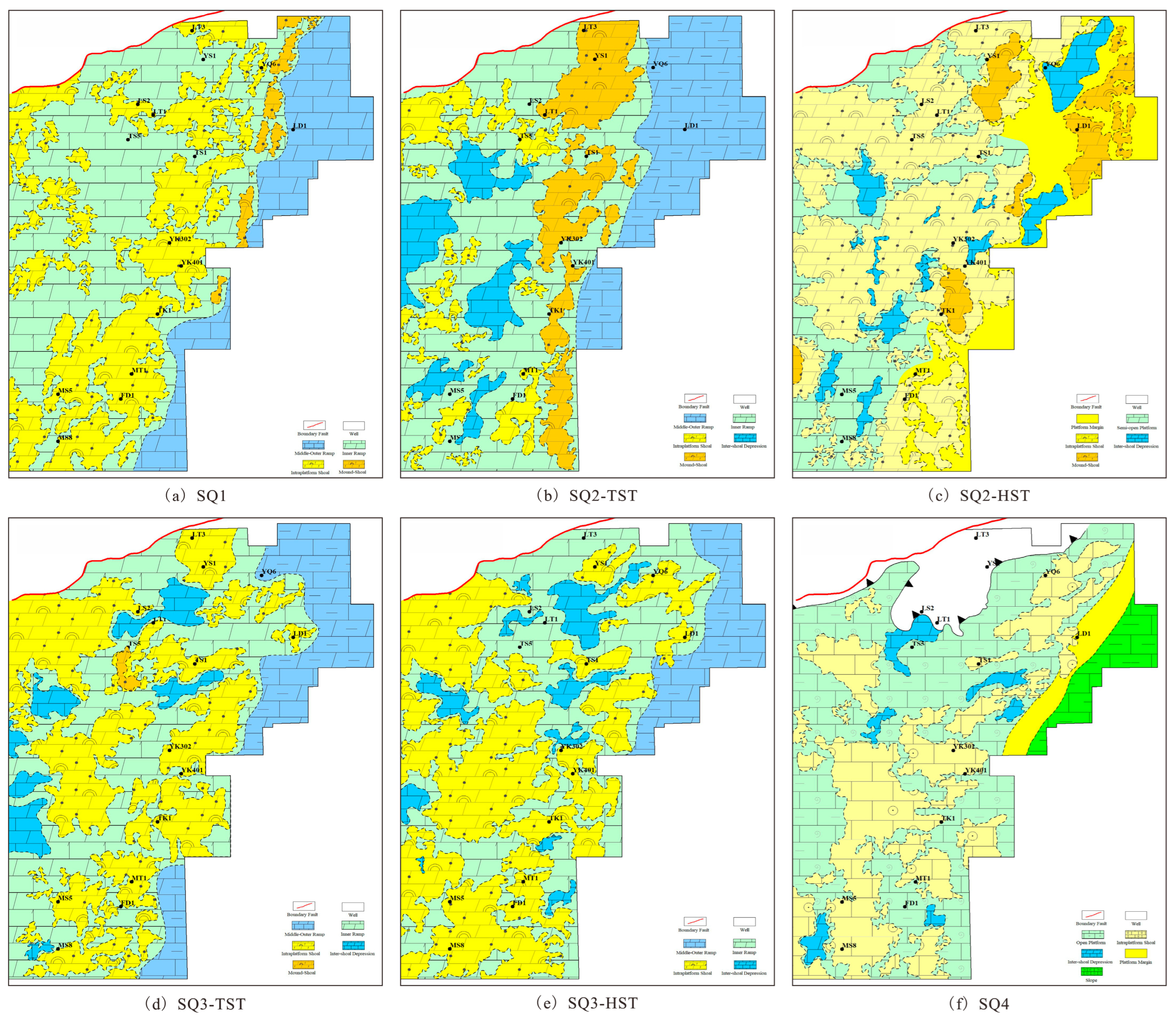
Controlled by paleo-sea-level changes and tilting of the western North Tarim Uplift, the study area shows alternating ramp and (weakly) rimmed platforms, with mound-shoals developing retrogradationally–progradationally with sea-level fluctuations.
4.4.1. Sedimentary Period of SQ1
During this period, sedimentary facies belts in the study area successively developed inner ramp and middle-outer ramp from west to east, with irregular boundaries between them. Mound-shoal bodies were distributed in the inner ramp. In the northwest, they occurred in isolated or sheet-like forms; locally isolated mound-shoals existed in the central area; those in the southeast were mainly sheet-like with nearly NNE-trending long axes consistent with the facies distribution trend, and lowstand mound-shoals were locally developed near facies boundaries. A total of 10 algal mound-shoals covering an area of 391 km2 and 27 grain shoals covering 5263 km2 were identified (Figure 11a).
Figure 11.
Spatial distribution of sedimentary facies under the sequence framework.
4.4.2. Sedimentary Period of SQ2–SQ3
- (1)
- During the SQ2-TST sedimentary stage, inner ramp and middle-outer ramp facies were developed successively from west to east. Shoal bodies were widely distributed in the inner ramp. Shoals in the central-western part showed isolated or sheet-like distribution and were more continuous in the north than in the south. Eastern mound-shoals were mostly sheet-shaped with nearly NNE or north–south trending long axes conforming to the facies extension direction. Seven algal mound-shoals with a total area of 2262 km2 and 23 grain shoals covering 1321 km2 were recognized (Figure 11b).
- (2)
- During the SQ2-HST sedimentary stage, semi-open platform and platform margin facies were developed from west to east. The semi-open platform was relatively wide with irregular facies boundaries and weak barrier effect along the platform margin. Intraplatform shoals were extensively developed and sheet-distributed within semi-open platform facies; in total, 16 shoals with an area of 8154 km2, and intershoal depressions occurred locally. Mound-shoals were well developed in platform margin facies, striking nearly NNE or north–south and showing an inward migration tendency towards the platform interior, including six identified mound-shoals covering 1256.7 km2 (Figure 11c).
- (3)
- In the SQ3-TST sedimentary period, inner ramp and middle-outer ramp facies developed from west to east with irregular boundaries. Shoal bodies were well developed in the inner ramp in isolated or sheet-like patterns and generally extended along the NNE direction. Twenty shoals with a total area of 6201 km2 were identified, accompanied by local intershoal depressions (Figure 11d).
- (4)
- During the SQ3-HST sedimentary stage, inner ramp and middle-outer ramp facies were formed from west to east. Inner ramp shoals generally trended NNE, with 13 identified shoals covering 7220 km2, alternating with intershoal depressions. Shoals in the southwest were larger in scale and more continuous than those in the northeast, and individual shoal area was larger than that in the Second Member of the Yingshan Formation (Figure 11e).
4.4.3. Sedimentary Period of SQ4
In this stage, open platform, platform margin and slope facies were successively developed from west to east with relatively regular facies boundaries and narrow platform margin zones. Sheet-like intraplatform shoals were widely distributed inside open platform facies, mostly striking nearly NNE or north–south, with local development of intershoal depressions (Figure 11f).
5. Discussion
The Altyn orogenic belt fully records the Paleozoic subduction–collision cycle of the Proto-Tethys Ocean, divided into five stages: early Cambrian initial subduction (>522–510 Ma), Late Cambrian–Early Ordovician deep subduction and exhumation of ultrahigh-pressure rocks (510–475 Ma), Middle Ordovician continuous oceanic subduction and arc/back-arc extension (475–450 Ma), Late Ordovician back-arc basin closure and continent-continent collision (450–420 Ma), and post-collisional extension (Silurian–Devonian, <420 Ma) [13,35,36].
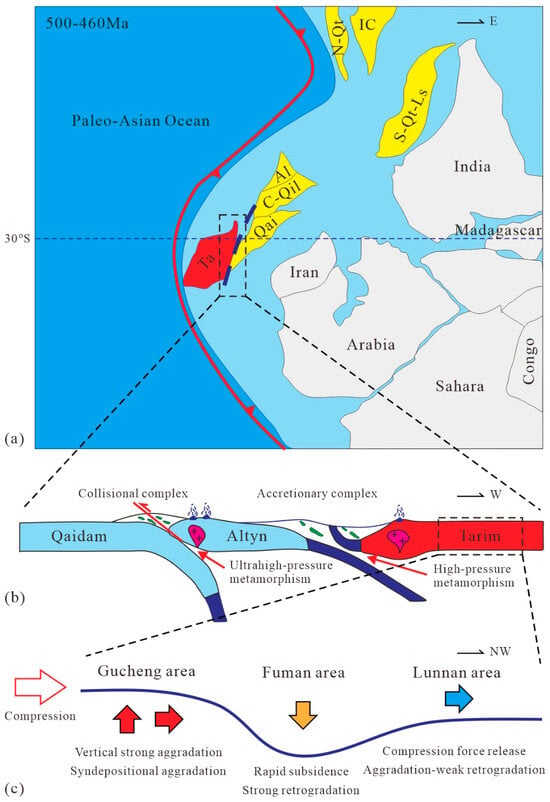
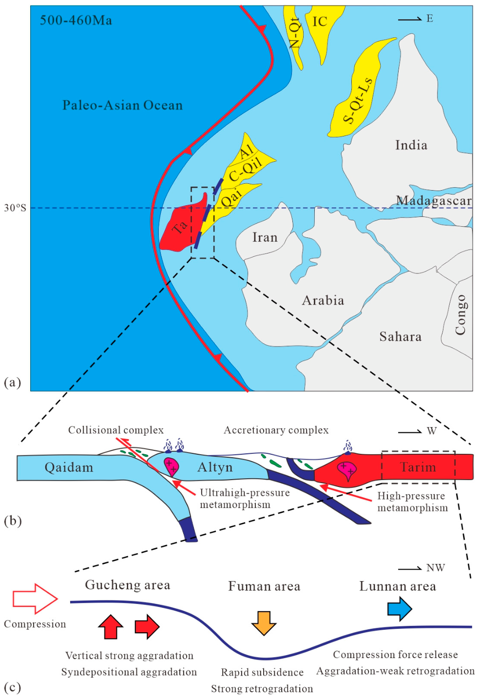
As the Paleozoic suture boundary on the southeastern margin of the Tarim Block, the Altyn orogenic belt confined the southeastern Tarim Craton and separated it from the Qaidam Block [37,38]. Multi-phase subduction–collision during the Cambrian–Ordovician transformed the southeastern Tarim margin from a passive to an active continental margin (Figure 12), forming the North Altyn tectonic belt and the southeastern Tarim foreland system, establishing the basic tectonic framework [39,40]. Episodic uplift of the orogen provided a key sediment source, directly controlling deposition in the southeastern Tarim Basin [41]. Meanwhile, multi-phase subduction–collision caused alternating crustal thickening and thinning, forming deep fault systems, represented by the embryonic Altyn Tagh Fault, constraining deep thermal structure and hydrocarbon accumulation [36,42]. Therefore, this study holds that the formation of differential structures of the Early–Middle Ordovician platform margin zones in the Tarim Basin is closely related to the tectonic activities of the Altyn Terrane during this period.
Figure 12.
Schematic diagram of the driving mechanism for the differential structure of the Early–Middle Ordovician platform margin belt in the Tarim Basin. (a) Reconstruction of the ancient block positions during the 500–460 Ma period (modified from [12]); (b) collision model of the Qaidam, Altyn, and Tarim Blocks (modified from [43]); (c) schematic diagram of the differential structure of the platform margin belt in the Lunnan–Gucheng area. Ta: Tarim Block; Qai: Qaidam Block; C-Qil: Central Qilian Block; Al: Altyn Block; S-Qt-Ls: South Qiangtang–Lhasa Block; N-Qt: North Qiangtang Block; IC: Indochina Block.
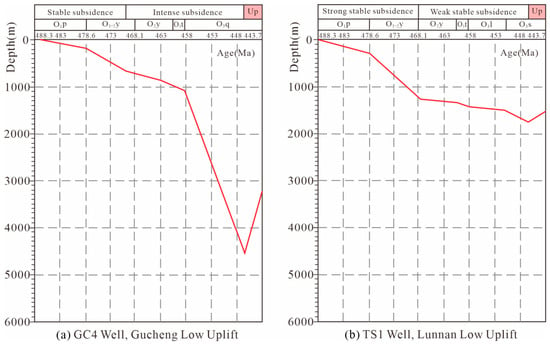
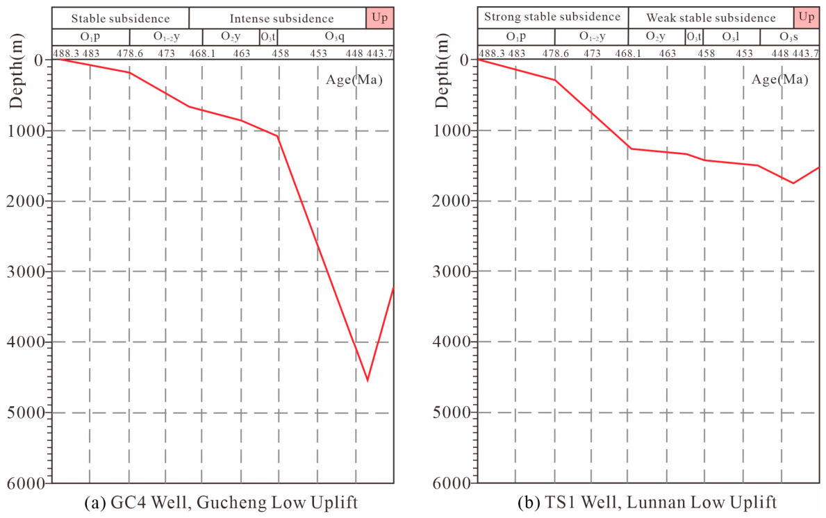
During the Early–Middle Ordovician, back-arc extension and basin-wide differential subsidence jointly controlled the segmented architecture and stacking patterns of the Lunnan–Fuman–Gucheng platform margins (Figure 12). The Gucheng area, proximal to the Altyn orogen, experienced intense compressional arching and low subsidence rates, showing strong aggradation–weak retrogradation dominated by vertical accretion with limited lateral migration (Figure 12c and Figure 13a). Additionally, the rising Tadong Low Uplift in an extensional setting restricted eastward expansion, resulting in a narrow platform margin. The Fuman area, a transitional zone between Gucheng and Lunnan, underwent rapid subsidence under bidirectional compression (Figure 12c), forming weak aggradation–strong retrogradation stacking with the widest mound-shoal distribution. The Lunnan area, shielded by the North Tarim paleo-uplift, experienced attenuated compression from the Altyn orogen, stable low-magnitude subsidence (Figure 12c and Figure 13b), and aggradation–weak retrogradation stacking with medium width. In summary, the Early–Middle Ordovician tectono-sedimentary differentiation of the Lunnan–Fuman–Gucheng platform margins is a direct product of back-arc extension, oceanic subduction, and differential subsidence of the Altyn orogenic belt, recording a significant remote response of the Proto-Tethys tectonic domain to the southeastern Tarim Basin.
Figure 13.
Ordovician tectonic subsidence rates in the Lunnan and Gucheng areas (modified from [44]).
6. Conclusions
- (1)
- The Lower–Middle Ordovician in the Lunnan–Fuman–Gucheng area, Tarim Basin, can be subdivided into two second-order sequences and four third-order sequences (SQ1–SQ4). Sequence boundaries are marked by regional unconformities, seismic terminations (truncation, onlap, downlap, toplap), and abrupt lithologic/logging changes, and are well correlated with global carbon isotope excursions.
- (2)
- The platform margin belts narrow gradually from north to south and display distinct segmentation, with three differential structural models: aggradation–weak retrogradation in the Lunnan section, weak aggradation–strong retrogradation in the Fuman section, and strong aggradation–weak retrogradation in the Gucheng section.
- (3)
- Differential subsidence induced by back-arc extension and oceanic subduction of the Altyn orogenic belt during the Early–Middle Ordovician is the major driver for the segmented architecture: the Gucheng section was dominated by compressional arching and slow subsidence; the Fuman section, as a transitional zone, underwent rapid subsidence; the Lunnan section was weakly tectonically disturbed with stable subsidence. This result can provide theoretical references for the study on differential sedimentary evolution mechanisms inside small cratons and for the exploration of reef-shoal reservoirs.
Author Contributions
Methodology, C.S. (Chunyan Sun); investigation, Y.Z.; resources, Y.Z.; data curation, J.Z.; writing—original draft preparation, C.S. (Chonghao Sun) and Y.Y.; writing—review and editing, G.Y. (Guang Yu) and Y.C.; visualization, G.Y. (Guo Yang) and Z.S.; supervision, Q.L.; project administration, C.S. (Chunyan Sun); funding acquisition, Y.Z. All authors have read and agreed to the published version of the manuscript.
Funding
This research was supported by the National Major Science and Technology Project for New Oil and Gas Exploration and Development (China National Petroleum Corporation, 2025ZD1400502), the Major Science and Technology Project of PetroChina Company Limited (China National Petroleum Corporation, 2023ZZ16YJ01), the CNPC Science and Technology Project (China National Petroleum Corporation, 2026DJ010), the National Oil and Gas Special Project (China National Petroleum Corporation, 2025ZD1400506) and the R&D Center Science and Technology Project of PetroChina Tarim Oilfield Company (PetroChina Tarim Oilfield Company, YF202503).
Institutional Review Board Statement
Not applicable.
Informed Consent Statement
Not applicable.
Data Availability Statement
The original contributions presented in this study are included in the article. Further inquiries can be directed toward the corresponding author.
Conflicts of Interest
Chunyan Sun, Chonghao Sun, Yan Yi, and Guo Yang were employed by the PetroChina Tarim Oilfield Company; Yongjin Zhu, Jianfeng Zheng, and Guang Yu were employed by the PetroChina Hangzhou Research Institute of Geology. The remaining authors declare that the research was conducted in the absence of any commercial or financial relationships that could be construed as a potential conflict of interest.
References
- Zhao, W.Z.; Shen, A.J.; Zhou, J.G.; Wang, X.F.; Lu, J.M. Types, characteristics, origin and exploration significance of reef-shoal reservoirs: A case study of Tarim Basin, NW China and Sichuan Basin, SW China. Pet. Explor. Dev. 2014, 41, 257–267. [Google Scholar] [CrossRef] [Scilit]
- Ma, X.H.; Yang, Y.; Wen, L.; Luo, B. Distribution and exploration direction of medium-and large-sized marine carbonate gas fields in Sichuan Basin, SW China. Pet. Explor. Dev. 2019, 46, 1–13. [Google Scholar]
- Sun, L.D.; Ma, F.; Jiang, H.; Jing, Z.H.; Yu, H.; Gao, B.; Dong, H.K.; Zeng, F.D.; Shan, Y.P.; Yang, Y.C. Progress and assessment of onshore oil and gas exploration and development in deep to ultra-deep formations. Deep Earth Energy Sci. Technol. 2025, 1, 14–26. [Google Scholar]
- Sun, Q.; Wang, J.X.; Li, J.Z.; Luo, S.H. AI enabling the oil and gas industry: Application progress, enabling mechanism, and development strategy. Deep Earth Energy Sci. Technol. 2026, 2, 38–49. [Google Scholar]
- Jin, M.D.; Li, B.S.; Zhu, X.; Dai, L.C.; Jiang, Z.L.; Wu, H.; Yang, P.Y. Characteristics and main controlling factors of reservoirs in the fourth member of Sinian Dengying Formation in Yuanba and its peripheral area, northeastern Sichuan Basin, SW China. Pet. Explor. Dev. 2020, 47, 1090–1099. [Google Scholar] [CrossRef] [Scilit]
- Feng, J.; Zhang, Y.J.; Zhang, Z.W.; Fu, X.F.; Wang, H.X.; Wang, Y.C.; Liu, Y.; Zhang, J.L.; Li, Q.; Feng, Z.H. Characteristics and main control factors of Ordovician shoal dolomite gas reservoir in Gucheng area, Tarim Basin, NW China. Pet. Explor. Dev. 2022, 49, 45–55. [Google Scholar] [CrossRef] [Scilit]
- Shen, C.G.; Li, J.J.; Jiao, W.; Wang, C.; Yang, Y.; Gong, Y.K.; Xie, Z.Y. Hydrocarbon accumulation pattern and petroleum exploration in the Ordovician platform marginal reef beach bodies in the eastern Tazhong Uplift, Tarim Basin. Deep Earth Energy Sci. Technol. 2026, 2, 21–37. [Google Scholar]
- He, F.; Lin, C.S.; Liu, J.Y.; Zhang, Z.L.; Zhang, J.L.; Yan, B.; Qu, T.L. Migration of the Cambrian and Middle-Lower Ordovician carbonate platform margin and its relation to relative sea level changes in southeastern Tarim Basin. Oil Gas Geol. 2017, 38, 711–721. [Google Scholar]
- He, D.F. Multi-cycle superimposed sedimentary basins in China: Formation, evolution, geologic framework and hydrocarbon occurrence. Earth Sci. Front. 2022, 29, 24–59. [Google Scholar]
- Liu, Y.N.; Hu, M.Y.; Zhang, S. Types, structural evolution difference and petroleum geological significance of Cambrian-Ordovician carbonate platforms in Gucheng-Xiaotang area, Tarim Basin, NW China. Pet. Explor. Dev. 2022, 49, 884–895. [Google Scholar]
- Zhu, Y.J.; Li, W.Z.; Yang, P.F.; Zheng, J.F.; Chen, Y.Q.; Yu, G.; Xiong, R.; Zhang, Y.; Wang, Y.S. Tectonic-sedimentary evolution characteristics of small cratons in the extension-convergence cycle: A case study of the Sinian-Ordovician in the Tarim Basin, NW China. Mar. Orig. Pet. Geol. 2026, 31, 1–16. [Google Scholar]
- Zhao, G.C.; Wang, Y.J.; Huang, B.C.; Dong, Y.P.; Li, S.Z.; Zhang, G.W.; Yu, S. Geological reconstructions of the East Asian blocks: From the breakup of Rodinia to the assembly of Pangea. Earth-Sci. Rev. 2018, 186, 262–286. [Google Scholar] [CrossRef] [Scilit]
- Dong, J.; Wei, C.J. Multi-episode metamorphism and magmatism in the Paleozoic Altyn Orogen, West China: Implications for the tectonic evolution of the Proto-Tethys Ocean. Earth-Sci. Rev. 2025, 262, 105067. [Google Scholar]
- Wu, G.H.; Li, H.W.; Xu, Y.L.; Su, W.; Chen, Z.Y.; Zhang, B.S. The tectonothermal events, architecture and evolution of Tarim craton basement palaeo-uplifts. Acta Petrol. Sin. 2012, 28, 2435–2452. [Google Scholar]
- Zhu, Y.J.; Ni, X.F.; Liu, L.L.; Qiao, Z.F.; Chen, Y.Q.; Zheng, J.F. Depositional Differentiation and Reservoir Potential and Distribution of Ramp Systems during Post⁃rift Period: An example from the Lower Cambrian Xiaoerbulake Formation in the Tarim Basin, NW China. Acta Sedimentol. Sin. 2019, 37, 1044–1057. [Google Scholar]
- Wang, Q.H.; Zhu, Y.F.; Tang, Y.G.; Yang, G.; Sun, C.H.; Chen, C. Oil and gas geological conditions and exploration potential in ultra-deep formations below ten thousand meters in Tarim Basin. Deep Earth Energy Sci. Technol. 2025, 1, 36–48. [Google Scholar]
- Lin, C.S.; Li, S.T.; Liu, J.Y.; Qian, Y.X.; Luo, H.; Chen, J.Q.; Peng, L.; Rui, Z.F. Tectonic framework and paleogeographic evolution of the Tarim Basin during the Paleozoic major evolutionary stages. Acta Petrol. Sin. 2011, 27, 210–218. [Google Scholar]
- Jiang, L.; Cai, C.F.; Worden, R.H.; Crowley, S.F.; Jia, L.Q.; Zhang, K.; Duncan, I.J. Multiphase dolomitization of deeply buried Cambrian petroleum reservoirs, Tarim Basin, north-west China. Sedimentology 2016, 63, 2130–2157. [Google Scholar] [CrossRef] [Scilit]
- Chen, Y.Q.; Wang, X.X.; He, H.; Yi, Y. Evolution of uplift and depression framework of Tarim craton in Nanhua-Cambrian. China Pet. Explor. 2022, 27, 30–46. [Google Scholar]
- Yang, H.J.; Chen, Y.Q.; Tian, J.; Du, J.H.; Zhu, Y.F.; Li, H.H.; Pan, W.Q.; Yang, P.F.; Li, Y.; An, H.T. Great discovery and its significance of ultra-deep oil and gas exploration in Well Luntan-1 of the Tarim Basin. China Pet. Explor. 2020, 25, 62–72. [Google Scholar]
- Li, Z.X.; Powell, C.M. An outline of the palaeogeographic evolution of the Australasian region since the beginning of the Neoproterozoic. Earth-Sci. Rev. 2001, 53, 237–277. [Google Scholar] [CrossRef] [Scilit]
- Turner, S.A. Sedimentary record of Late Neoproterozoic rifting in the NW Tarim Basin, China. Precambrian Res. 2010, 181, 85–96. [Google Scholar] [CrossRef] [Scilit]
- Wang, H.H.; Li, J.H.; Zhou, X.B.; Li, W.B.; Wang, J.Q. New opinion on the position of the Tarim block in the Rodinia supercontinent: Constraints from stratigraphic correlation and paleomagnetism. Chin. J. Geophys. 2015, 58, 589–600. [Google Scholar]
- Wei, G.Q.; Zhu, Y.J.; Zheng, J.F.; Yu, G.; Ni, X.F.; Yan, L.; Tian, L.; Huang, L.L. Tectonic-lithofacies paleogeography, large-scale source-reservoir distribution and exploration zones of Cambrian subsalt formation, Tarim Basin, NW China. Pet. Explor. Dev. 2021, 48, 1114–1126. [Google Scholar] [CrossRef] [Scilit]
- Yang, X.; Li, H.L.; Zhang, Z.P. Evolution of Neoproterozoic Tarim Basin in northwestern China and tectonic background of the Lower Cambrian hydrocarbon source rocks. Acta Geol. Sin. 2017, 91, 1706–1719. [Google Scholar]
- Hu, M.Y.; Ngia, N.R.; Gao, D. Dolomitization and hydrotectonic model of burial dolomitization of the Furongian-Lower Ordovician carbonates in the Tazhong Uplift, central Tarim Basin, NW China: Implications from petrography and geochemistry. Mar. Pet. Geol. 2019, 106, 88–115. [Google Scholar] [CrossRef] [Scilit]
- Zhang, Y.; Li, Q.; Zheng, X.P.; Li, Y.L.; Shen, A.J.; Zhu, M.; Xiong, R.; Zhu, K.D.; Wang, X.D.; An, J.S. Types, evolution and favorable reservoir facies belts in the Cambrian-Ordovician platform in Gucheng-Xiaotang area, eastern Tarim Basin. Acta Pet. Sin. 2021, 42, 447–465. [Google Scholar]
- Cao, Y.H.; Wang, S.; Zhang, Y.J.; Yang, M.; Yan, L.; Zhao, Y.M.; Zhang, J.L.; Wang, X.D.; Zhou, X.X.; Wang, H.J. Petroleum geological conditions and exploration potential of Lower Paleozoic carbonate rocks in Gucheng area, Tarim Basin, China. Pet. Explor. Dev. 2019, 46, 1099–1114. [Google Scholar] [CrossRef] [Scilit]
- Lehnert, O.; Meinhold, G.; Wu, R.C.; Calner, M.; Joachimski, M.M. δ¹³C chemostratigraphy in the upper Tremadocian through lower Katian (Ordovician) carbonate succession of the Siljan district, central Sweden. Est. J. Earth Sci. 2014, 63, 277–286. [Google Scholar] [CrossRef] [Scilit]
- Li, C.; Fan, J.X.; Sun, Z.Y. Review of Ordovician inorganic carbon isotope stratigraphy. J. Stratigr. 2018, 42, 408–428. [Google Scholar]
- Deng, S.H.; Huang, Z.B.; Jing, X.C.; Du, P.D.; Lu, Y.Z.; Zhang, S.B. Unconformities in the Ordovician of western Tarim Basin, NW China. Geol. Rev. 2008, 54, 741–747. [Google Scholar]
- Buggisch, W.; Keller, M.; Lehnert, O. Carbon isotope record of Late Cambrian to Early Ordovician carbonates of the Argentine Precordillera. Palaeogeogr. Palaeoclimatol. Palaeoecol. 2003, 195, 357–373. [Google Scholar] [CrossRef] [Scilit]
- Liu, Y.N. Types, Differential Evolution Process and Petroleum Geological Significance of Cambrian-Middle Ordovician Carbonate Platform in the Eastern Tarim Basin; Yangtze University: Wuhan, China, 2024. [Google Scholar]
- Zhang, J.L.; Hu, M.Y.; Wang, A.Y.; Zhang, B.; Yan, B.; He, X.X. Sedimentary configuration and reservoir distribution in the Cambrian mound-shoal complexes at platform margins of Gucheng area, Tarim Basin. Oil Gas Geol. 2021, 42, 557–569. [Google Scholar]
- Sobel, E.R.; Arnaud, N. A possible middle Paleozoic suture in the Altyn Tagh, NW China. Tectonics 1999, 18, 64–74. [Google Scholar] [CrossRef] [Scilit]
- Wu, C.L.; Chen, H.J.; Wu, D.; Ernst, W.G. Paleozoic granitic magmatism and tectonic evolution of the South Altun block, NW China: Constraints from zircon U-Pb dating and Lu-Hf isotope geochemistry. J. Asian Earth Sci. 2018, 160, 168–199. [Google Scholar] [CrossRef] [Scilit]
- Lu, S.N.; Li, H.K.; Zhang, C.L. Geological and geochronological evidence for the Precambrian evolution of the Tarim Craton and surrounding continental fragments. Precambrian Res. 2008, 160, 94–107. [Google Scholar] [CrossRef] [Scilit]
- Wu, H.; Zhu, W.; Ge, R. Late Paleoproterozoic granulite-facies metamorphism in the North Altyn Tagh area, southeastern Tarim craton: Pressure-temperature paths, zircon U-Pb ages, and tectonic implications. Geol. Soc. Am. Bull. 2019, 131, 1591–1606. [Google Scholar] [CrossRef] [Scilit]
- Gao, X.F.; Xiao, P.X.; Kang, L.; Xi, R.G.; Zha, X. Late Ordovician back-arc extension in the southeastern margin of the Tarim Craton, NW China: Elemental and Sr-Nd isotopic constraints from the Hongliugou basalts. Geochem. J. 2019, 53, 359–378. [Google Scholar]
- Liu, Q.; Tsunogae, T.; Zhao, G.; Uthup, S.; Takahashi, K.; Yao, J.; Wu, Y.; Han, Y.; Ikehata, K. Early Cambrian high pressure/low temperature metamorphism in the southeastern Tarim craton in response to circum-Gondwana cold subduction. Geosci. Front. 2023, 14, 101561. [Google Scholar] [CrossRef] [Scilit]
- Liu, Q.; Zhao, G.; Li, J.; Yao, J.; Han, Y.; Wang, P.; Tsunogae, T. Provenance of early Paleozoic sedimentary rocks in the Altyn Tagh orogen: Insights into the paleoposition of the Tarim craton in northern Gondwana associated with final closure of the Proto-Tethys Ocean. Geol. Soc. Am. Bull. 2021, 133, 505–522. [Google Scholar]
- Dong, J.; Wei, C.J. Multi-stage metamorphism of the South Altyn ultrahigh-pressure metamorphic belt, West China: Insights into tectonic evolution from continental subduction to arc–backarc extension. J. Petrol. 2021, 62, egab082. [Google Scholar] [CrossRef] [Scilit]
- Yang, Z.J. Early Palaeozoic Tectonic Evolution in Hongliugou, Altyn, Xinjiang; Chinese Academy of Geological Sciences: Beijing, China, 2012. [Google Scholar]
- Gao, H.H. Tectonic-Depositional Setting and Proto-Type Basin Evolution of the Cambrian and Ordovician in Tarim Area; China University of Geosciences: Beijing, China, 2015. [Google Scholar]
Disclaimer/Publisher’s Note: The statements, opinions and data contained in all publications are solely those of the individual author(s) and contributor(s) and not of MDPI and/or the editor(s). MDPI and/or the editor(s) disclaim responsibility for any injury to people or property resulting from any ideas, methods, instructions or products referred to in the content. |
© 2026 by the authors. Licensee MDPI, Basel, Switzerland. This article is an open access article distributed under the terms and conditions of the Creative Commons Attribution (CC BY) license.