


Abstract
Tsunami hazards in the Bay of Naples are primarily driven by submarine landslides, intense seismic activity, and volcanic phenomena from nearby systems like Vesuvius and the Campi Flegrei caldera. While localized historical tsunamis have occurred, they are generally rare events. Key tsunami sources include submarine landslides, volcanic eruptions, and seismicity. In this paper we provide a review of the tsunamis in Naples Bay within a general framework of Mediterranean tsunamis based on a literature review. Underwater avalanches, particularly around the steep slopes of the Dohrn Canyon and Ischia, are considered a primary localized threat. Scientific models indicate that a major collapse (like past events like the Ischia debris avalanche) could generate significant waves that could cross the bay in minutes. Explosive eruptions where magma meets seawater (such as PDCs—pyroclastic density currents) can displace water violently. This was famously documented during the AD 79 eruption of Mount Vesuvius, which created submarine ash fans and tsunami waves in the gulf. Earthquakes related to bradyseism in the Campi Flegrei or regional faults can also trigger sea level oscillations or localized tidal waves. Among the historical modeled events, we focus on the A.D. 79 eruption and on the 1343 Naples tsunami. The numerical simulations are revised. Depending on the source, the modeled waves vary from minor oscillations to heights of up to 6 m in canyon areas or over 20 m in nearby islands like Ischia.
1. Introduction
The Mediterranean Sea is a semi-enclosed sea that connects to the Atlantic Ocean through the Strait of Gibraltar and to the Indian Ocean through the Suez Canal. The basin is nestled between the coasts of southern Europe, northern Africa, and western Asia. Its current shape is the result of a long geological evolution linked to the convergence of the African and Arabian plates with the Eurasian plate, complicated by the presence of various crustal blocks or microplates, such as the Adriatic [1,2,3,4]. Deformation of the edges of these blocks manifests as earthquakes, most of which occur at sea or near the coast. The strongest of these have the potential to generate tsunamis.
The Mediterranean Sea is a high-risk basin for tsunamis due to intense seismic activity and the presence of numerous volcanoes. Although historical events have been less catastrophic than those in the Pacific Ocean, tsunamis remain a real threat to the coasts of Italy and neighboring countries.
Tsunami monitoring and artificial intelligence are important. Italy’s tsunami warning system is managed by CAT-INGV (National Institute of Geophysics and Volcanology, Italy), part of the UNESCO international network. Efforts are increasing to integrate artificial intelligence into predictive models: AI is being trained on centuries of oceanographic and seismic data to accelerate real-time analysis and more accurately predict where and when these events will occur. The tsunami warning system also includes the deployment of deep-sea buoys (like those installed in the Ionian Sea) capable of detecting water level anomalies before a wave reaches the shore (https://www.ingv.it/en/urp-press/Press-office/press-notes/tsunami%3A-first-buoys-installed; accessed on 11 August 2026) [5]. Robust and well-integrated early warning systems (TEWSs) are necessary for effective flood risk management (FRM) from these catastrophic events [5]. This essay examines the basic ideas and technological underpinnings of tsunami TEWSs, highlighting their crucial function in the larger framework of FRM. It looks at how contemporary systems combine satellite monitoring, wave detection buoys, and seismic sensor networks to deliver quick and precise alarms. The necessity of accurate propagation models and real-time data integration to reduce false alarms and boost system efficiency are among the technical and logistical difficulties that are covered [5]. To assess the lessons learned and opportunities for development, case studies are provided, such as of the Pacific Tsunami Warning System (PTWS) and the Indian Ocean Tsunami Warning System (IOTWS) [5].
Since 1600 BC, at least 290 tsunamis have occurred in the Mediterranean Sea, some of them destructive. The Greek and Italian coasts are the most exposed to the phenomenon and, throughout history, have suffered the greatest effects of tsunamis in the Mediterranean (https://cat.ingv.it/it/pericolosita-tsunami/tsunami-nel-mediterraneo; accessed on 11 August 2026).
The Euro-Mediterranean tsunami catalog shows that historical tsunamis have been generated in the Mediterranean Sea and in the surrounding European seas starting from the 6150 A.C. until recent times [6]. The 2014 edition of the Catalogue of Euro-Mediterranean Tsunamis (EMTC2.0), which was created in ArcGis online, includes 293 tsunamis. To incorporate the new database on tsunamis’ effects along the Italian coast (ITED), the database’s Italian part was updated [6]. All seismically caused tsunamis in Italy have been connected to the Parametric Catalogue of Italian Earthquakes (CPTI15), which has been designated as the reference earthquake catalogue, to enhance the quality of the data. Two new tsunami occurrences were added to the EMTC2.0, and additional information has improved our understanding of the tsunamis in Italy. As a result, various tsunami metrics, including reliability, intensity, generating cause, etc., have been altered.
Typical seismic-caused tsunami scenarios in the eastern Mediterranean have been modeled by employing advanced tsunami generation, propagation, and a coastal inundation 2-DH model (i.e., 2D Horizontal model) based on the higher-order Boussinesq equations [7]. After assessing the tsunamigenic zones and potential sources in the area, two locations of interest were chosen: one east of the Italian island of Sicily and one southwest of the Greek island of Crete. The results of the model are displayed as inundation maps of the low-lying coastal areas under study, sequences of snapshots of water elevation during tsunamis’ propagation, and extreme water elevation maps [7].
A sketch table is constructed to show the most significant tsunamis in the Mediterranean Sea (Table 1; https://storymaps.arcgis.com/stories/8e0065089fc7432ea70576e721c4d686; accessed on 11 August 2026), including the tsunami of Crete Island (365 D.C.), the Puglia tsunami (1627), the eastern Sicily tsunami (1693), the Lisbona tsunami (1755), the Calabria tsunami (1793), the Ligurian Sea tsunami (1887), the Calabria tsunami (1905), the Messina Straits tsunami (1908), the Amorgos tsunami (1956), the Montenegro tsunami (1979), the Stromboli tsunami (2002), the Boumerdes tsunami (2003), the Kos tsunami (2017), the Samos tsunami (2020), and the south of Ierapetra (Creta, Greece, 2020) tsunami. The triggers and the tsunami characteristics are reported in Table 1 [8,9,10,11,12,13,14,15,16,17,18,19,20,21,22,23,24,25,26,27,28,29,30].
Table 1.
Significant tsunamis in the Mediterranean Sea (constructed based on https://storymaps.arcgis.com/stories/8e0065089fc7432ea70576e721c4d686; accessed on 11 August 2026). The table is also constructed based on the articles listed in the references in the table itself: Pararas-Carayannis [8]; Patacca and Scandone [9]; Tinti and Piatanesi [10]; Schicchitano et al. [11]; Levret [12]; Zitellini et al. [13]; Jacques et al. [14]; Graziani et al. [15]; Larroque et al. [16]; Loreto et al. [17]; Barreca et al. [18]; Piatanesi et al. [19]; Lecrerc et al. [20]; Benetatos and Kiratzi [21]; Kapitanovic et al. [22]; Chiocci et al. [23]; Tinti et al. [24]; Deverchere et al. [25]; Sahal et al. [26]; Yalciner et al. [27]; Dogan et al. [28]; Sun et al. [29]; Wang et al. [30].
In this general framework of Mediterranean tsunamis, a revision of tsunamis in Naples Bay and the corresponding models is carried out, based on a literature review, to compare the Naples tsunamis with other significant tsunamis that have occurred in the Mediterranean Sea [8,9,10,11,12,13,14,15,16,17,18,19,20,21,22,23,24,25,26,27,28,29,30]. Historical tsunamis in Naples Bay are also reported (Table 1). As an example of the Mediterranean tsunamis reported in Table 1, we mention the tsunami that occurred on 2 May 2020, generated by an earthquake about 63 km south of Ierapetra in Crete, Greece [30]. The tsunami arrived at the deployed stations at around 5 min after the earthquake, whereas it arrived at the southern coast of Crete Island at around 15 min after the earthquake [30]. A sketch location map is constructed in order to show the location of the places mentioned in Table 1 (Figure 1).
Figure 1.
Sketch location map of the Mediterranean area, constructed to show the location places mentioned in Table 1 (modified after https://gisgeography.com/mediterranean-sea-map/#Detailed-Map; accessed on 11 August 2026). Key: 1: Naples Bay; 2: Creta Island; 3: Apulia; 4: eastern Sicily; 5: Portugal; 6: Calabria; 7: Ligurian Sea; 8: Messina Strait; 9: Aegean Sea; 10: Montenegro; 11: Stromboli Island; 12: Algeria; 13: Greece.
2. Geological Setting
The geological formation of the Bay of Naples and the Campania Plain is a widely studied phenomenon, fundamentally rooted in the subduction dynamics of the central Mediterranean. The Bay of Naples acts as an active peri-Tyrrhenian extensional basin located on the eastern margin of the Tyrrhenian Sea. It lies at the southern end of the Campania Plain, sharing a complex history of Plio-Quaternary volcanism and tectonic subsidence. This depression formed as a structural half-graben, heavily modified by volcano–tectonic downthrowing and localized faulting [31] (Figure 2).
Figure 2.
Geological sketch map of Naples Bay. Key: Green: shallow-water carbonate successions and basin units; yellow: siliciclastic synorogenic units of piggyback basins (Miocene); pink: pyroclastic deposits and lavas (Quaternary); white: marine and continental deposits (Quaternary).
The tectonic framework is the direct result of the convergence and subduction dynamics between the European and African plates. The subduction of the Ionian (African) lithosphere beneath the Calabrian arc and the southern Apennines triggered the retreat (roll-back) of the subducting foreland plate. This eastward migration of the Apennine orogenic belt created a relaxation zone behind the thrust front. The resulting back-arc spreading opened the Tyrrhenian Basin and led to widespread extensional tectonics along the Italian peninsula. The Apenninic thrust belt experienced a NE verging accretion, while the western margin simultaneously collapsed under regional extension.
The extension produced a system of normal faults and structural half-grabens (including the Bays of Naples and Salerno; Figure 2), which were further lowered by Quaternary faults. The crustal thinning and deep tectonic faults allowed magma to rise, fueling monumental volcanic complexes, such as Campi Flegrei and Somma–Vesuvius along the coast. Counter-Apenninic (NE-SW)-trending normal faults were prevalent in controlling the tectonic setting of the bay, including the Sarno–Sebeto and the Acerra–Dohrn canyon faults (Figure 2). The basin’s stratigraphy is highly complex, featuring marine sedimentary layers interbedded with large-volume pyroclastic deposits (e.g., Campanian ignimbrite) and submarine volcanic vents [32]. The crustal structure below the Campania region has been modeled recognizing the main interfaces, including the top of the Meso-Cenozoic carbonates [33].
The carbonate horst of the Sorrento Peninsula is characterized by an outcrop of the carbonate basement, dating to the Mesozoic, covered by Miocene arenites (Figure 2). Massive Triassic and Jurassic platform limestones, partly dolomitic, and massive and layered Cretaceous platform limestones form the carbonate basement. Both the Mesozoic platform limestones and the Miocene arenites are mantled by lenses of pyroclastic rocks of Vesuvian and Phlegrean origin. A major morpho-structural high (“Banco di Bocca Grande” or “Banco di Fuori”) separates the Dohrn from the Magnaghi canyon, and was presumably formed by a Mesozoic carbonate block that resulted from the regional uplift and tilting of the carbonate acoustic basement, cropping out in the Sorrento Peninsula–Capri Island structural high. The carbonate nature of the “Banco di Fuori” high is suggested by its location along the structural alignment of Capri Island–Sorrento Peninsula.
3. Materials and Methods
The method is a wide literature review, starting from the Mediterranean tsunami catalog of Maramai et al. [6].
The 2014 edition of the Catalogue of Euro-Mediterranean Tsunamis (EMTC2.0), which was created in ArcGis online, includes 293 tsunamis [34]. Campania is included in the M2 sub-region.
The Mediterranean coasts of France, Italy and Croatia are included in the M2 sub-region, with 81 tsunami events mainly concentrated along the Italian coasts. This region is one of the most tsunamigenic in the Mediterranean area, where most of tsunamis were triggered by earthquakes. M2 is the only region in which a relevant number of tsunamis were associated with volcanic activity, specifically eruptions and gravitational phenomena related to the Vesuvius and Aeolian volcanoes (Stromboli and Vulcano). To incorporate the new database on tsunami effects along the Italian coasts (ITED), the database’s Italian part was updated [6,35]. Two new tsunami occurrences were added to the previous catalog [6] and, as a result, various tsunami metrics, including reliability, intensity, generating cause, etc., have been altered.
Maramai et al. [35] highlighted that, regarding the geographical area affected by the Italian tsunamis, 14 tsunamis were recorded at a regional scale, indicating tsunami propagation across more than 100 km from the source. In addition to the tsunami that struck Messina in 1908, it is important to note the eastern Sicily incident that occurred on 11 January 1693, which affected the entire Ionian coast of Sicily, from Siracusa to Messina. Like that one, the Ligurian tsunami that struck on 23 February 1887 affected over 200 km of coastline, with local run-up surpassing one meter and notable sea withdrawals that left boats stranded in numerous locations. Except for the 2002 Stromboli Island tsunami, which was seen up to the shores of Campania (approximately 140 km north), all regional events were caused by earthquakes. Massive undersea and subaerial slides [24] occurred during a significant volcanic eruption on the steep face of the Stromboli volcano, the Sciara del Fuoco. A maximum run-up of 10.90 m was recorded in the island’s northern region.
We carefully examine the scientific literature, performing a wide bibliographic search of the tsunamis in Naples Bay and their sources used in this revision. Multibeam bathymetric data are integrated with bathymetric profiles to constrain the revision.
The review combines tsunami catalogues, historical accounts, and geological and stratigraphic evidence. The reliability of different types of evidence is assessed using a multidisciplinary approach. A final cross-verification of the evidence is also necessary. Reviews that synthesize historical and geological evidence, such as paleotsunami studies, rely on a multidisciplinary “multi-proxy” approach, but the complete performance of this complex task requires a further study.
The reliability of different evidence types is generally assessed using several parameters, divided into two categories—the tsunami catalogs and historical accounts and the geologic and stratigraphic evidence. In the first category, the considered parameters are verification and chronology, the validity index, and temporal and bias checks. For the last parameter, historical chronicles are checked for temporal gaps or biases (e.g., unreported tsunamis due to civil unrest or deep fault slips occurring without shaking near the coast) by comparing them directly to the geological record. For the second category, the considered parameters include the discrimination of forcing mechanisms, the micropaleontological and geochemical proxies, and the radiocarbon datings. The discrimination of the forcing mechanisms mainly focuses on distinguishing the tsunami deposits from storm deposits through the analysis of sediment cores. To confirm a marine origin and rule out normal storms or wind-blown dust, the samples undergo diatom, foraminifera, and geochemical analyses. Distinctive ratios of elements (such as higher calcium/iron ratios) or the presence of marine microfossils far inland are key indicators of tsunami backwash. To align the geological layers with historical accounts or prehistoric events, sediment chronology is established using methods like radiocarbon dating (14C). In the final cross-verification, the most reliable assessments are made when the historical documents and geological traces are mutually supporting. For example, if a large earthquake was documented in a historical catalogue, researchers look for an anomalous sediment layer or abrupt coastal subsidence that matches that date and location. If a geological layer is found without a corresponding historical record, researchers can conclude it represents a “paleotsunami” (an ancient, previously unrecorded event), effectively extending the hazard timeline. These methods are herein mentioned to clarify the reliability of tsunami studies, but they have still not been fully applied and require further studies.
4. Results: Tsunamis in Naples Bay
Submarine landslides, strong seismic activity, and volcanic eruptions from neighboring systems like Vesuvius and the Campi Flegrei caldera are the main causes of tsunami threats in the Bay of Naples. Localized historical tsunamis have happened; however, they are usually uncommon occurrences.
The key tsunami sources include submarine landslides, volcanic eruptions and bradyseism.
4.1. Submarine Landslides
Underwater avalanches, particularly around the steep slopes of the Dohrn Canyon and Ischia, are considered a primary localized threat. The scientific models indicate that a major collapse (like past events like the Ischia debris avalanche) could generate significant waves that could cross the bay in minutes.
The scientific studies and academic articles on submarine landslides in the Gulf of Naples (Naples Bay) focus primarily on the complex interaction between volcano–tectonic activity, submarine canyon systems, and tsunami hazards [36].
The Dohrn–Magnaghi system is characterized by high gradients and has been studied in detail through mathematical models and high-resolution bathymetry [37,38,39,40,41,42].
The instability areas are found at specific locations: the head of Dohrn Canyon, the slope around the western Dohrn branch, the slope south of Magnaghi Canyon, and the northeastern slope of Banco di Fuori [37]. Multibeam bathymetry reveals several features interpreted as slide scars on the continental slope north of the Capri structural high. Three rectilinear gullies converge into the canyon from Capri Island’s northern slope. An acoustic basement, likely made of Mesozoic–Cenozoic carbonate rocks, is close to the sea bottom under a thin layer of Holocene sediments, showing large scars not linked to the canyon’s thalweg. A DEM of the Naples canyons is constructed to show the bathymetric setting of the area, including submarine landslides (Figure 3).
Figure 3.
Digital elevation model (DEM) of the Dohrn–Magnaghi system, including several submarine landslides.
Since the system is actually inactive with respect to the sedimentary dynamics, it has been impacted by important instabilities at the canyon’s heads and boundaries. This is demonstrated by the bathymetric profiles (Figure 4), from which several slide scars are identified.
Figure 4.
Bathymetric profiles of the Dohrn–Magnaghi system. Note the occurrence of several slide scars.
Submarine landslides are considered one of the primary triggers of tsunamis in the bay. The recent literature focuses on three-dimensional (3D) models to simulate the impact of these events on densely populated coastlines [43]. The research indicates that unstable underwater masses—even when moving in considerable volumes—may not generate large-scale, catastrophic waves, yet they are still capable of damaging small vessels and creating resonance effects [43].
Four landslide–tsunami scenarios are recreated, including three undersea and one subaerial source (Figure 5). These are simulated using a series of numerical codes that take into consideration every stage of the tsunami process, offering insights into the distribution of tsunami energy and pinpointing the coastal areas most impacted. The study also examines the impact of dispersion effects on tsunami propagation and the existence of resonance effects in a few minor gulf inlets, highlighting the significance of taking into consideration intricate and non-linear coastal processes when managing tsunamis caused by landslides [43].
Figure 5.
(A) Maps of the initial sliding masses and related calculations for Cases 1, 2, 3, and 4, with the initial thickness shown by the yellow–red scale (modified after Zaniboni et al.) [43]. Red box indicates location areas.
From the standpoint of hazard assessment, the undersea scenarios discussed here could cause comparatively minor tsunamis in the Gulf of Pozzuoli. The greatest wave amplitudes in Cases 1 and 2 are about a few tens of centimeters. Although not disastrous, Case 3′s maximum amplitude of more than 50 cm along the coastline stretch between Bagnoli and Nisida could nonetheless destroy small boats and create currents in tiny sub-basins. Case 4, on the other hand, generates waves that are more substantial, particularly at a small scale. While Case 3 produces maximum amplitudes of more than 0.5 m between Pozzuoli and Nisida, Cases 1 and 2 exhibit restricted impacts on the coast. With a peak value of 5 m in Capo Miseno and local amplifications at Pozzuoli and Nisida, with amplitudes of nearly 2 m, Case 4 generates the most powerful tsunami [43].
Database inventories of landslides are also relevant. Extensive morphometric databases (such as the RISCHiA-Re project) have been compiled to map shallow-water landslides along the Campanian coast, including the Phlegraean Fields and the island of Ischia (https://zenodo.org/records/18864394; accessed on 11 August 2026). A regional-scale inventory of shallow-water submarine landslides (less than 100 m deep), the RISCHiA-Re database focuses on seafloor sectors that are typically thought to be morphologically stable and not especially vulnerable to slope failure. The dataset contains 27 morphometric parameters of 90 landslides along the continental border of Campania (eastern Tyrrhenian Sea, southern Italy), an area with strong seismic activity and volcanism.
The historical data and catalogs of onshore and coastal landslides give specific constraints [44]. Esposito and Matano’s [44] information about 2302 landslides that happened in the continental, coastal, and insular sectors of the research area between 1828 and 2017 may be found in the CAmpi Flegrei Landslide Geodatabase (CAFLAG) [44]. The characteristics of both the landslides and the affected sites are highlighted by the data. Rock falls that impacted rocky slopes made of lithified volcanic rocks, like tuff or ignimbrite, account for most of the mass motions that have been cataloged. Furthermore, like in other parts of the region, steep slopes covered by poorly welded pyroclastic airfall deposits have frequently experienced rain-induced earth and debris slides that have resulted in debris avalanches or swift flows. The coastline, where mass movements are causing the coastal cliffs to retreat, has had the highest number of landslides.
4.2. Volcanic Eruptions
Explosive eruptions where magma meets seawater (such as PDCs—pyroclastic density currents) can displace water violently. This was famously documented during the AD 79 eruption of Mount Vesuvius, which created submarine ash fans and tsunami waves in the gulf [45]. Using a multidisciplinary approach, a comprehensive review of the 79 CE Plinian eruption of Vesuvius is presented, utilizing the integration of historical, stratigraphic, sedimentological, petrological, geophysical, paleoclimatic, and modeling studies dedicated to this well-known and catastrophic natural event [45]. From proximal to ultra-distal observations of the 79 CE eruption products throughout the Mediterranean, all investigations are extensively reexamined and combined with the original data. In addition to combining several research methods (stratigraphic, petrological, geophysical, and modeling), the work tracks the eruptive and depositional events of 79 CE over time, from the magma chamber to the furthest tephra. This enables us to better evaluate the local and regional effects of the 79 CE eruption on the environment, first by creating a comprehensive database of all finds of those deposits, and then by connecting the products (the deposits) to the genetic thermomechanical processes (the eruption).
Tsunamis in the Bay of Naples are relatively rare but pose a severe threat, often triggered by distinct volcanic mechanisms, including pyroclastic flows and submarine explosions. Regarding the pyroclastic flows, explosive eruptions (like that of Vesuvius in AD 79 or 1631) can send superheated avalanches of gas and rock rushing into the sea. This rapid displacement of water creates pressure pulses and deadly tsunamis [46]. Regarding the submarine explosions, the underwater vents in Campi Flegrei can trigger subaqueous eruptions, potentially generating highly destructive waves that impact coastal communities [47].
The area affected by PDCs (pyroclastic density currents) at Somma–Vesuvius was defined by Gurioli et al. [48], who concentrated on the distribution, thickness, and size of the PDC deposits produced during seven Plinian and sub-Plinian eruptions (Pomici di Base, Greenish Pumice, Pomici di Mercato, Pomici di Avellino, Pompeii Pumice, AD 472 Pollena, and AD 1631 eruptions) [49]. Five of the seven eruptions had radially distributed PDCs, indicating a preferred orientation determined by the paleo-topography and vent locations. The most widely distributed deposits were found in the PDCs from the Pompeii Pumice and Pomici di Avellino eruptions. The severity of the eruptions, the vents’ locations in relation to the Somma caldera wall, and the pre-existing topography all influenced the PDCs’ dispersal, according to both the isopach maps and the deposits’ characteristics.
The Pomici di Avellino and Pomici di Pompei volcanic deposits are the most extensively distributed. The isopachs of the volcanic deposits on these maps, expressed in meters, show that they pushed eastward rather than toward the Bay of Naples.
The Pomici di Mercato eruption’s volcanic deposits are primarily found on the northern slopes of Mount Somma, according to the data from Gurioli et al. [48]. This indicates that the vent site was comparable to that of the modern Vesuvius.
The Pomici di Avellino deposits exhibit significant facies diversity and reach their maximum thickness in the western sector of Vesuvius. They can be identified up to 25 km away from the assumed vent, which was most likely eccentric in relation to the volcano. These findings suggest that the volcanic deposits from the oldest Plinian eruptions (Avellino, Mercato, and Pomici di Base) [49] were probably connected to the G unit in Aiello [32].
A stratigraphic unit comprising a voluminous debris avalanche that was covered by pyroclastic gravity current deposits after entering the sea is demonstrated by the interpretation of high-resolution seismic profiles and core data obtained for the western Somma–Vesuvius volcano [46].
This unit was connected to the approximately 3.5 ka old Avellino Plinian eruption, and was correlated to and mapped for both onshore and offshore regions based on the stratigraphic position and the dates of the Somma–Vesuvius Plinian eruptions. The physical landscape of the volcano’s western sector was significantly impacted by the thick Avellino unit deposition, which resulted in the creation of a morphological barrier in the alluvial plain and hundreds of meters of prograding coastline [46].
The remarkable depositional and erosional characteristics of the top of the Avellino unit along the coast imply that the tsunami that hit the Naples Bay shoreline was caused by the debris avalanche’s entrance into the sea. The Avellino Plinian eruption, which produced pumice fall and surge clouds, and the sea-facing flank failure of the volcano, which caused the debris avalanche and tsunami, were two dangerous geologic events that significantly impacted several human settlements within a 20 km radius of the volcano, leading to the decline of Bronze Age communities [46].
We propose that the seismo-stratigraphic unit G of Aiello [32] is genetically related to, but younger than the debris avalanche unit of Milia et al. [46] (Figure 6).
Figure 6.
Sketch diagram showing the possible correlation between the seismo-stratigraphic units in the Vesuvius offshore units (G unit in Aiello [32]; debris avalanche unit in Milia et al. [46]).
The seismic profiles GRNA01 and GRNA03 (Figure 7 and Figure 8) show the G unit [32]. The seismic reflectors that are wavy, undulating, and discontinuous define its seismic facies. The seismic unit also exhibits differences in thickness. Volcanic deposits older than AD 79 may make up the G unit, which appears to be covered by eruption deposits dated at their base.
Its location only offshore of Somma–Vesuvius and the irregular and undulating nature of the seismic reflectors indicates that the G unit contains pyroclastic flow deposits from Vesuvius. Although the thickness of the seismic unit is significantly greater than the thickness of the AD 79 deposits, this interpretation is reinforced by the qualitative correlation with earlier core sampling in the region that showed fallout deposits of the AD 79 eruption in the upper meters of the seismic unit [49]. PDCs from pre-AD 79 Plinian eruptions are therefore thought to make up the majority of the G unit.
The interpretation of seismic profiles offshore of the western sector of Vesuvius volcano indicates the presence of two superimposed, reflection-free, seismic units (DA2 and PS) bounded at the top by a non-conformity that displays an irregular morphology (Figure 6) [46]. Seaward, these units terminate abruptly with a steep scarp, which is onlapped by a prograding wedge (PW). Above, a seismic unit (H) with high-amplitude and low-continuity reflectors fill the erosional troughs overlying unit PS. The calibration of this seismic profile with a drill core located on a seawall indicates that the reflection-free seismic units DA2 and PS can be ascribed, respectively, to a volcaniclastic gravel and sand deposit and to a tuff deposit.
The thick underlying coarse-grained volcaniclastic deposit (debris avalanche) and the overlaying deposit associated with the pyroclastic gravity currents comprise the two main subunits of the Avellino unit offshore. Marine sediments encircle the 150 m deep products of the Avellino unit. The Avellino unit’s pyroclastic gravity current-related deposits end at a water depth of 40 m and correlate with a reflection-free seismic facies (PS, Figure 6), suggesting that the acoustic impedance has not changed [46].
Since the famous AD 79 eruption, Mount Vesuvius has erupted about 35 to 50 times over the past 1900+ years. This averages to roughly two to three eruptions per century, or 20 to 30 eruptions for every 1000-year span. However, its eruption history is not evenly spread out. Regarding the quiescent periods, Vesuvius can remain relatively quiet for hundreds of years (e.g., almost 900 years before AD 79). It experienced a highly active phase between 1631 and 1944, erupting multiple times a decade. The last eruption occurred in March 1944. It has been dormant since, which is one of its longest quiet periods in nearly 400 years [48,49].
The Campi Flegrei caldera is the subject of a probabilistic hazard analysis of tsunamis caused by subaqueous volcanic explosions [47]. The definition of possible explosion magnitude size classes is based on the historical volcanic activity in the Campi Flegrei caldera and locations in the underwater portion of the caldera; the simulation of the generation and propagation of the ensuing tsunami waves capable of reaching the coasts of the Campania region for all combinations of tsunami-generating vents and sizes; and the estimations of the tsunami likelihood and relative uncertainty, which are dependent upon the occurrence of a submerged eruption at Campi Flegrei [47].
Even while the likelihood of eruptions in the undersea portion of the caldera is undoubtedly low, the tsunami hazard caused by subaqueous volcanic explosions is regarded as critical due to its possible high impact on the densely populated coastal districts of Pozzuoli Bay and the Gulf of Naples [47].
Conditional hazard curves and maps are used to depict the tsunami hazard analysis, which determines the likelihood (and relative uncertainty) of surpassing specific tsunami strength thresholds (wave amplitudes at the shore) in the event of a subaqueous eruption. The findings show that several parts of the Bay of Naples are significantly at risk from tsunamis.
4.3. Bradyseism
Earthquakes related to bradyseism in the Campi Flegrei or regional faults can also trigger sea level oscillations or localized tidal waves. Since the Roman era, Campi Flegrei has experienced recurrent periods of bradyseism, or slow vertical ground movement. Since the nineteenth century, vertical ground movements have been noted, as evidenced by the sea level markings left on the remains of a Roman market called “Serapeo” in the town of Pozzuoli, which show the slow subsidence of the region [50,51,52,53,54,55,56,57].
The Pozzuoli area experienced two major episodes of soil rising (in relation to the earth’s surface) during the years 1970–1972 and 1982–1984 (previous bradyseismic crisis). The uplift, measured in relation to the prior leveling, was 170 and 182 cm at the point of maximum deformation, respectively [58]. With its maximum focus on the town of Pozzuoli and a steady reduction in deformation toward the caldera margins, the geometrical shape of the uplift produced an opposite consequence to that of the lowering seen since 1968. Either the draining of the underlying magma chamber or the typical compaction of the pyroclastic products filling the caldera depression should be linked to the downward movement [58].
Another important bradyseismic crisis that started in 2023 and is still active has produced a significant increase in the seismicity in the Naples area, according to burst swarms [59]. This bradyseismic crisis does not correspond to a tsunami in the Naples area. The ongoing bradyseism crisis in the Campi Flegrei caldera is driven by ground deformation and localized seismic swarms, not magma breaching the surface. Because there is no explosive volcanic eruption, this specific ground movement does not pose an immediate tsunami threat.
The bradyseism in Campi Flegrei has been explained by a variety of hypotheses. According to a strict mechanical concept, the uplift periods are caused by magma intrusion at shallow depths [60,61]. According to a different theory, the uplift is caused by the water’s pore expansion and warming [62,63]. According to other models, the fluid dynamic processes in a shallow-depth geothermal system are primarily responsible for the uplift [64,65]. Strong hydrothermal activity, focused at the Solfatara vent, where CO2 and H2O fluxes are high and likely indicate magmatic degassing, is linked to ground deformation and seismicity [66,67]. Also, if it represents an important parameter in Naples Bay, the bradyseism cannot be treated as an independent tsunami-source category. The bradyseism (the cyclic, slow uplift and subsidence of the ground caused by magma and hydrothermal fluids) acts as a compounding factor. While the slow ground deformation itself does not generate a tsunami, the intense shallow seismic swarms and hydrothermal pressures that characterize a bradyseism are what trigger the actual tsunamigenic sources, such as underwater landslides or sudden volcanic edifice failures.
Other models have been put forth [53,54], which explain the bradyseism using a new hydrothermal model based on the analogy between the geothermal system of Phlegrean Fields and the mineralized systems of “porphyry” type [68,69]. The fluid inclusions contained in the Phlegrean rocks’ crystals demonstrate the presence of distinct, non-mixable mineral phases throughout the volcanic complex’s magmatic history. For an extended period of geologic time, the fluids originating from a deep magma underwent intense lithostatic pressure during mixing. As a result, they created an overpressure that was contained by an impermeable layer, causing the rocks above to rise (positive bradyseism). The sinking phase (negative bradyseism) is argued to have begun with a pressure release following the highest uplift, which coincided with seismicity.
Carlino [57] notes that the cause of the decades of ongoing uplift is intensely debated by scientists. The two main competing theories are direct magma intrusion at a shallow depth (3–5 km) versus the thermo-mechanical elastic response of the hydrothermal system. Carlino points out that neither hypothesis fully accounts for all the geophysical and geochemical signals observed simultaneously, creating ongoing arguments among monitoring researchers. Regardless of whether the driving force is primarily magma or pressurized hydrothermal fluids, the caldera has entered an elevated state of crustal pressurization. While the unrest signals significant mid-term mid-crustal modifications, it does not imply an imminent eruption.
The bradyseism does not mean a tsunami is likely, both due to the nature of the crisis and tsunami mechanics. The current unrest is defined by ground uplift (which has raised the Rione Terra harbor in Pozzuoli by over 1.5 m) and frequent, localized earthquakes. It is primarily caused by gas and hydrothermal pressure, not magma moving to the surface. A burst model was proposed by Giudicepietro et al. [59] to explain the current seismic and volcanic situation. Since 2005, the volcanic region of Campi Flegrei has gradually increased its activity. There have been reports of increased overall seismicity, increased gas emissions, and accelerated ground deformation. The core portion of the caldera, which has risen by roughly 140 cm since 2005, corresponds with the zone of highest deformation. The deformation field has a typical bell shape because the quantity of uplift steadily diminishes from the caldera’s center outward. Moreover, tsunamis in the Gulf of Pozzuoli and the Bay of Naples are typically associated with catastrophic volcanic events (such as explosive submarine eruptions) or large-scale underwater gravitational landslides, and not slow ground deformation (see Section 4.1 and Figure 6) [43].
4.4. Historical and Modeled Events
Historical and modeled tsunami events in Naples Bay include the tsunami related to the AD 79 eruption and the one in 1343.
The eyewitness account of Pliny the Younger described the sea retreating (“sea animals got stuck on the dry sand”) and subsequently becoming hostile during the Vesuvius eruption, classic signs of a local tsunami. This event was the first volcanic eruption in human history described by an eyewitness, Pliny the Younger, who gave a detailed account of the eruptive phenomena in his famous letters (epistolae) to the Roman historian Tacitus. It is noteworthy that the Pliny letters report a tsunami in the Bay of Naples in the morning of the second day of eruption.
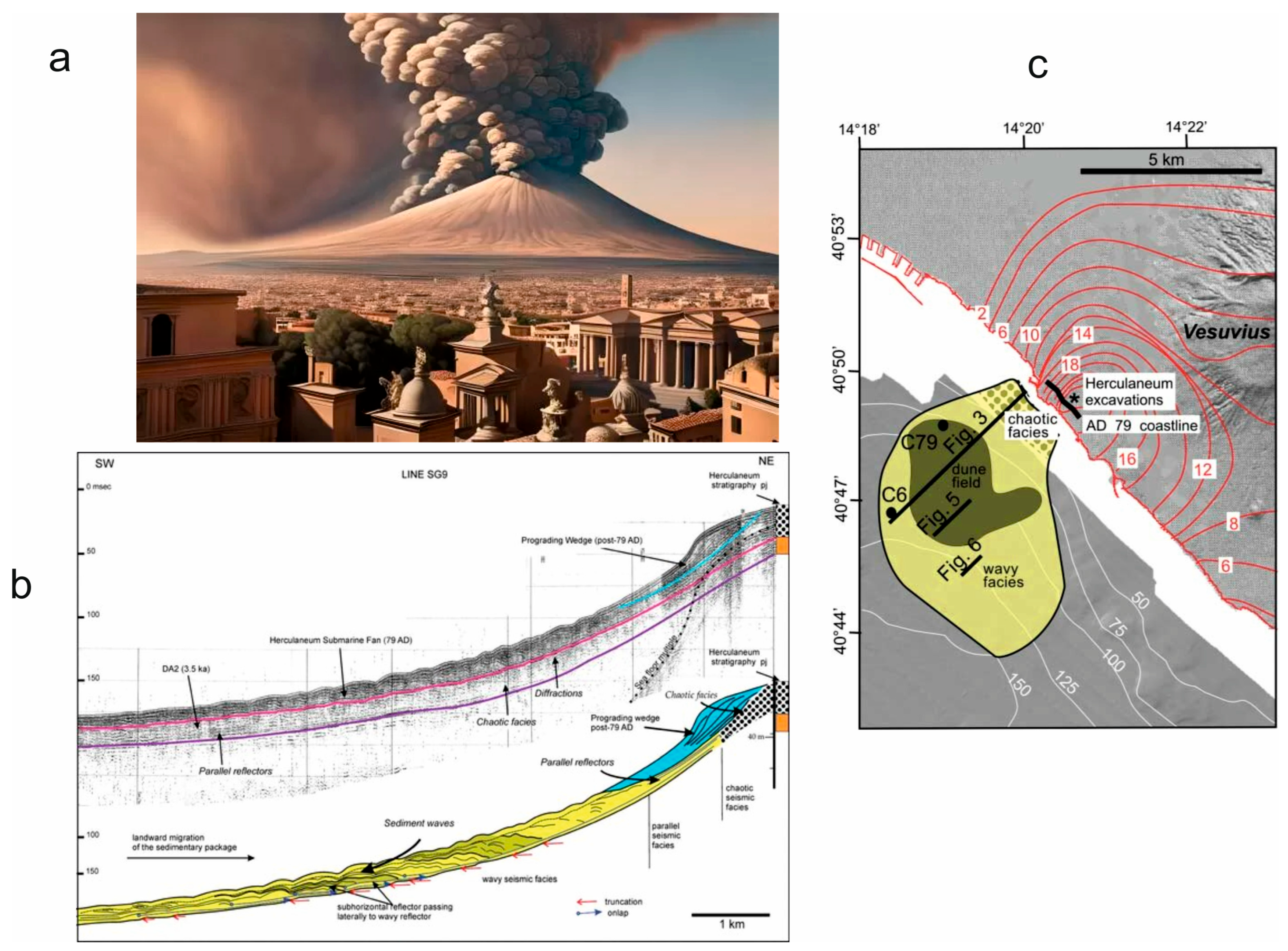
The eruption-related tsunami was controlled by the entrance into the sea of huge pyroclastic flows [70]. The study demonstrates how pyroclastic flows generated by Vesuvius rapidly entered the sea (particularly in the Herculaneum area), forming a large submarine deposit and triggering tsunami waves and density currents that altered the coastal stratigraphy (Figure 7; https://seepompeii.com/tutte-le-fasi-delleruzione-del-vesuvio-del-79-d-c-disastro-evitabile/; accessed on 11 August 2026) [70].
Vesuvius’s Plinian eruption in AD 79, which destroyed Pompeii and Herculaneum, started with pumice falls that were deposited to the volcano’s southeast, followed by pyroclastic currents that were driven to the southwest. These currents swiftly entered the sea after reaching Herculaneum, creating a fan (Figure 7) [70]. This fan, which had a volume of around 0.3 km3, exhibited chaotic seismic facies that alternated between parallel and wavy reflectors as it moved seaward. The gravity cores show a series of centimeter-thick sand- or silt-sized ash couplets, followed by a graded gravelly sand-sized bed up to 180 cm thick that contains pebbles and shell pieces from the beach, which is then covered by centimeter-thick graded and laminated sandy ash layers [70]. Moreover, the stratigraphic signature of this eruption offshore the Sarno river mouth has been studied in detail, and the stratigraphic anomalies have been attributed to the impact of the hot pyroclastic flows into the water and to the consequent tsunami, which reworked the sediments [71]. Historical, marine and stratigraphic data have been integrated into comprehensive reviews of the eruption [72].
Figure 7.
(a) Sketch diagram showing the AD 79 Vesuvius eruption (https://seepompeii.com/tutte-le-fasi-delleruzione-del-vesuvio-del-79-d-c-disastro-evitabile; accessed on 11 August 2026). (b) Sparker profile and line drawing off of Herculaneum displaying three main seismic units. From older to younger: Unit DA2, the Herculaneum Submarine Fan and upper prograding wedge (modified after Milia et al.) [70]. (c) Map of the seismic facies of the Herculaneum Submarine Fan and location of the seismic profiles (modified after Milia et al.) [70].
The 1343 tsunami struck the Tyrrhenian Sea and Bay of Naples on 25 November 1343. Underground shocks were felt in Naples and caused significant damage and loss of lives. Of major note is the tsunami created by the earthquake, which destroyed many ships in Naples and destroyed many ports along the Amalfi coast, including Amalfi itself. The effects of the tsunami were observed by the poet Petrarch, who was being hosted in Naples at that time. Little knowledge exists about the 1343 tsunami. Modern geoarchaeological studies have attributed it to a massive submarine landslide, potentially caused by a flank collapse of the Stromboli volcano [73]. These authors presented the discovery of three previously unheard-of, exceptionally well-preserved tsunami deposits linked to the Late Middle Ages flank collapses of the volcanic island of Stromboli in southern Italy. Contrary to what was previously believed, we connect the earliest, highest-magnitude tsunami under investigation to the subsequent swift abandonment of the island that was populated at that time based on carbon dating and the stratigraphic, volcanological, and archaeological evidence. The massive maritime storm that destroyed the port of Naples in 1343 (200 km north of Stromboli), as reported by renowned author Petrarch, may have also contributed to the event’s devastating impact. The destruction depicted may have been caused by several tsunami waves that were produced by a significant landslide on Stromboli Island, demonstrating the hypothetical risk of catastrophic events on a regional level [73].
To choose among the competing hypotheses, Rosi et al. [73] used a multi-proxy approach that cross-references historical accounts with physical field data to evaluate wave propagation and timelines. This methodology helps as it is based on specific criteria, including the stratigraphic and radiocarbon consistency, the archaeological evidence of tsunami run-up, the source proximity and long-distance physics, and the marine sediment signatures. For the 1343 event, the radiocarbon dating of charcoal found in these distinct sand layers aligns chronologically with the medieval timeline, ruling out unrelated historical earthquakes. Moreover, Rosi et al. [73] utilized archaeological evidence, such as the discovery of hastily dug graves and a collapsed medieval church on Stromboli’s San Vincenzo plateau. This provided physical proof of a massive sudden disaster rather than a standard coastal storm. For the 1343 event, they evaluated whether a tsunami propagated 200 km from the Aeolian Islands to Naples was hydrodynamically possible. They validated the Stromboli flank collapse hypothesis over localized Neapolitan marine storms by correlating the timing of the island’s devastation with the arrival of multiple large waves in the Bay of Naples that were described by Petrarch [73]. For the AD 79 event, researchers instead analyzed seismic reflection profiles and sediment cores from the Bay of Naples. The presence of graded sand–gravel beds and offshore fans with marine pebbles provided distinct sedimentological evidence that massive pyroclastic density currents from Vesuvius entered the sea, directly displacing the water and triggering the tsunami.
Several historical tsunamis have been singled out in the catalog of Maramai et al. [34], as reported in Table 2. Previously described events are included.
Table 2.
Historical tsunamis in Naples Bay based on Maramai et al. [34].
4.5. Modern Numerical Simulations
Scientific and hazard analyses, including specialized studies on underwater landslides in the Gulf of Naples, continuously map the potential wave heights and coastal vulnerabilities. Depending on the source, the modeled waves vary from minor oscillations to heights of up to 6 m in canyon areas or over 20 m in nearby islands like Ischia.
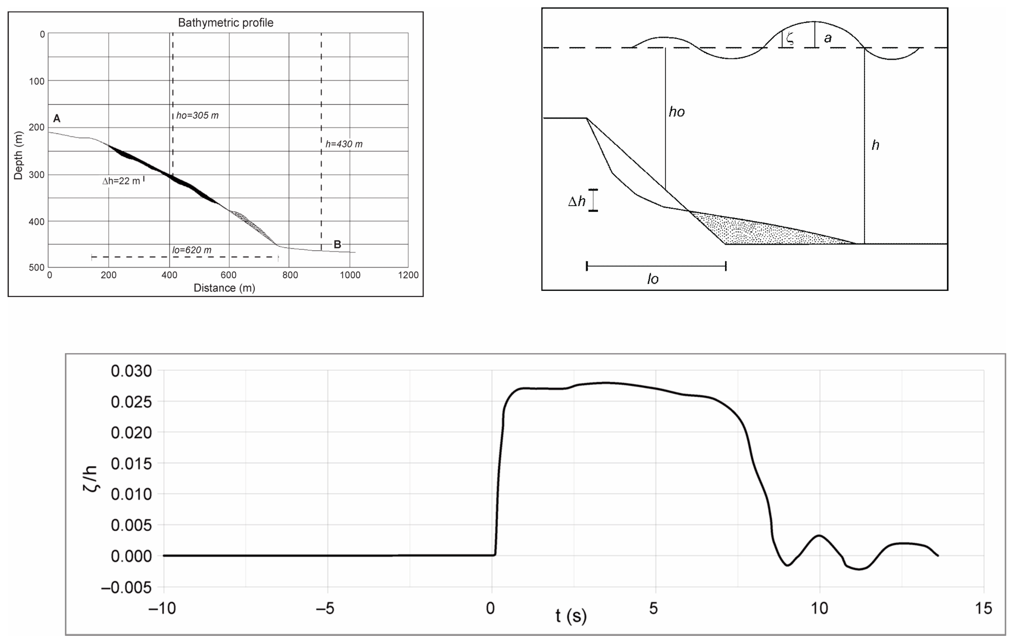
Modern simulations of Naples Bay and Ischia are numerous. To provide quantitative limits for numerical modeling, a bathymetric profile corresponding to the scars involving the Dohrn western branch was created. At sea depths between −250 m and −370 m, there is a detachment area that is roughly 415 m broad. Additionally, debris collection occurs in water depths between −380 and −450 m, whereas the intersection with the thalweg’s foot happens at water depths of roughly −430 m [37] (Figure 8).
The relative run-up was obtained by applying a numerical analysis to solve the two-dimensional Boussinesq equation. The water masses were forced vertically upward by the bottom movement, which had a length of l = 620 m. Since the depth variation for this experiment was approximately 0.1 (h/h), the non-linear effects should be minimal in the vicinity of the source region and 20 times the water depth at the source region’s boundary. The submarine landslide may advance quickly because it is close to the top of Dohrn canyon. In a numerical landslide model, the initial volume is determined by geometrically reconstructing the missing soil or rock mass. This is typically done by evaluating the area and depth of the unstable zone prior to failure, using either pre-event topographic data, empirical scaling relationships, or direct subsurface profiling. It should be noted that the amplitude wave run-up ranges from 0 to 2.5% when expressed in terms of seafloor depth percentage. The wave height amplitude is equivalent to 5–6 m in absolute terms [37] (Figure 8).
Figure 8.
Tsunami modeling in Naples Bay based on Di Fiore et al. [37].
Based on morpho-bathymetric data, Alberico et al. [74] highlight that in Naples Bay only four submarine landslides, located at water depths ranging between 15 m and 360 m, are potentially tsunamigenic, because their computed maximum wave amplitude ranges between 1.18 m and 1.71 m. Numerical modeling is not associated with this consideration. The empirical relationship between the depth and amplitude of tsunami waves offshore (above the landslide scar) and in the coastal sector (at −1 m) reported by Federici et al. [75] is used to approximate the first estimate of tsunami amplitude near the coast. The shoaling factor for the calculated tsunami amplitude above the slide in the research area should roughly fall between two and four.
Additional potential sources of tsunamis, which could affect the Neapolitan coast, are debris avalanches [76]. The consequences of an Ischia debris avalanche are explored as single scenarios by Tinti et al. [76]. In their 2011 study, they [76] numerically simulate the catastrophic tsunami that would be triggered by a massive submarine debris avalanche (IDA) off the northern coast of Ischia (Mt. Epomeo’s northwestern flank). The findings highlight the severe hazards for both the island and the entire Gulf of Naples.
The key takeaways from their research include: the landslide scenario, the wave impact in Ischia, and the barriers and flows. The study models a massive debris avalanche with a volume of 1.5 to 3 km3 (often associated with the historical Mt. Epomeo collapse). The highest and most destructive waves strike the northern and western shores of Ischia itself. The generated waves propagate across the Gulf, affecting the highly populated mainland coast of Campania. The study maps how offshore morphological highs act as natural barriers, but the densely populated coastal belts remain highly vulnerable to run-up (Figure 9).
Figure 9.
Tsunami modeling for Ischia Island based on Tinti et al. [76].
A few studies of long- and short-term tsunami hazards have been carried out in the region, including both submarine mass failures and submarine earthquakes [77,78,79]. Tsunamis generated at Ischia may develop during all phases of an eruption. There are no quantitative studies regarding the likelihood that tsunamis may occur in the future. Large tsunamis appear to be very uncommon overall (not historical observations), but if they did happen, they could be disastrous. Rock or debris avalanches, which are unusual but feasible, may be the primary cause of tsunamis during calm times. In addition to deforestation and local seismic activity typical of unrest and eruptive periods, regional seismic activity may be the cause of these events. Even though major offshore occurrences (Mw > 6.5) appear to be highly uncommon, earthquakes can still trigger tsunamis during instability. Dense pyroclastic flows and undersea explosions can also trigger tsunamis during eruptive stages. Even though the chances of a vent opening at sea are low, it is thought to be feasible. In the instance of Monte Nuovo, a tsunami would affect the western and, locally, the northern coast of Ischia with waves of tens of meters [77], as well as the coast to the north of the Gulf of Naples with waves of several meters. Grezio et al. [78] concluded that earthquakes appear to be the primary cause of potential regional tsunamis at Ischia, followed by landslides and submarine slumps, all of which have very small mean annual frequencies (<10–6/year). This conclusion was based on simplified propagation models.
The case history of Somma–Vesuvius has also been discussed. In the past, Somma–Vesuvius’s activity was linked to volcanic eruptions that caused tsunamis. The sea retreated during the catastrophic eruption that destroyed Pompeii and its environs, according to Pliny the Younger (79 CE). During the 1631 eruption, the Gulf of Naples saw unusual sea waves [34]. Scenarios with low-density (dilute) pyroclastic flows were proposed by Tinti et al. [80] and confirmed comparatively mild oscillations in the Gulf of Naples. A tentative probabilistic framework for tsunamis produced by underwater volcanic explosions in the subsurface portion of the Campi Flegrei caldera near Naples was just recently put into practice by Paris et al. [47].
Tinti et al. [80] provides a detailed hydrodynamic simulation of waves generated by activity at Vesuvius. It specifically examines the events of 1631 and 79 A.D., assessing wave heights and confirming that, while the event caused disturbances in the gulf and coastal damage, the “light” components of the pyroclastic flows generated waves that were limited in scale yet significant for the immediate vicinity. The driving pressure pulse is expected to advance at a constant velocity V while propagating radially outward over a sector that encompasses the whole Gulf of Naples. At any time, the force is restricted in space within an annulus centered on the Vesuvius crater. The entire Gulf of Naples is covered by the computational mesh. Figure 10 displays side by side the forcing pressure pulse and the water elevation fields at various times, with the pulse still moving in the innermost part of the gulf.
Figure 10.
Tsunami modeling of Naples Bay based on Tinti et al. [80].
The leading tsunami wave is a sea level depression because of the sea level dropping due to the overpressure created by the pyroclastic flow. The former travels at about the same speed in the nearshore strip, which is shallower, but it is quicker than the pyroclastic flow in the deeper middle portion of the gulf. The leading front and the pressure pulse nearly overlap in the upper and lower corners of the gulf, where the towns of Naples and Castellammare are located, but they are already clearly separated in the middle of the gulf [80].
Figure 10 shows the tide gauge data for the first 50 min following the start of the tsunami, calculated along the coastal stations using the numerical model. The first stations to be affected by the pyroclastic flow are Torre del Greco and Torre Annunziata, which are closer to the Vesuvius cone. The tsunami warning at Torre Annunziata consists of a train of three-to-four short-period (about three minutes) small-amplitude (approximately five centimeters) oscillations, followed by stronger waves (more than ten centimeters) at approximately fifteen to twenty minutes. Nearly simultaneously, the tsunami reaches Naples and Castellammare. At both locations, the largest waves come first, with peak-to-peak amplitudes of roughly 60 cm and 70 cm, respectively. The main period is slightly larger than the main era. Sorrento and Bagnoli are the final sites in Figure 10 that the tsunami will reach [80].
The various tsunami sources (submarine earthquakes, aerial/submarine slides, volcanic activity, meteorological events, and asteroid impacts), with differing probabilities of occurrence, are traced and weighted in the probabilistic tsunami hazard studies of Naples Bay by Grezio et al. [81]. Their methodology is based on a Bayesian approach that combines historical data with computational hazard quantification (based on source–tsunami simulations).
Three data sets of potential tsunami wave situations from the various sorts of sources are produced by the first set of modules (Source, Propagation, and Impact). Three different types of tsunamigenic sources are chosen for this hazard analysis: dense pyroclastic density currents from Somma–Vesuvius, submerged mass failures in the Tyrrhenian Sea, and submarine seismic sources in the North African Mediterranean Sea.
This study only looks at PDCs from Somma–Vesuvius as having volcanic origins. Due to the extensive PDCs encircling the sea, only the Somma–Vesuvius eruptions have left geological evidence of tsunamigenesis reaching the Gulf of Naples, among the numerous possible volcanic sources. Other volcanic sources include: the underwater explosions at Campi Flegrei [47]; the lahar flows entering the sea [46]; and possible submarine volcanic activity from other volcanoes, like Marsili, Palinuro, and Vavilov, and insular volcanoes, such as Ischia [79].
The second set of modules (Prior, Likelihood, and Posterior) examines the chance that the tsunami wave in a wide range of tsunami scenarios overcomes the preset threshold levels at the coast. In the Prior module, conditional hazard curves based on the simulation results are used to link the spatial, temporal, and frequency-size probabilities of the occurrence of the source events belonging to the various source types in the simulated tsunami waves scenarios. In the Likelihood module, the probabilistic analysis includes the historical information and the past tsunami data from the Italian Tsunami Catalogue and the background papers.
Most of the costal sites overcome the thresholds below 0.5 m with similar probabilities, apart from the isles, where the spatial differences depend mainly on the local factors (such as the bathymetry and morphology of the coast). The highest probabilities of overcoming levels of about 1–1.5 m in 50 years occur at the city of Naples, the Campi Flegrei area, and Ischia Island.
It is also worth noting that if the study presents values of approximately 5–6 m and 1.18–1.71 m in Naples Bay, and more than 20 m near Ischia, the numerical model results are not directly comparable, since different numerical modeling has been applied.
5. Discussion
Tsunamis in the Bay of Naples are framed in the broader context of Mediterranean tsunamis, as highly localized but potentially catastrophic events driven by volcanism and underwater landslides. While the Mediterranean is generally associated with massive tectonic fault line earthquakes (e.g., Greece or Sicily; Table 1) [8,9,10,11,12,13,14,15,16,17,18,19,20,21,22,23,24,25,26,27,28,29,30], Naples is categorized under a unique, localized hazard profile driven by its proximity to Campi Flegrei and Vesuvius [36].
A unique Mediterranean framework for Naples exists. Within the TSUMAPS-NEAM probabilistic tsunami models (https://cat.ingv.it/en/tsunami-hazard/tsunamis-in-italy; accessed on 11 August 2026), the Bay of Naples represents a high-risk, densely populated coastal stretch.
Naples-area tsunamis are framed uniquely in the following ways:
Volcanically Triggered Hazards: Unlike typical ocean basin tsunamis caused by tectonic plates, Naples-area waves are frequently modeled around volcanic eruptions and calderas. For example, studies have highlighted the tsunamigenic potential of the Campi Flegrei supervolcano, where underwater eruptions and ground subsidence (bradyseism) can displace massive volumes of water [43,56] (Figure 4).
Pyroclastic Flows: The interaction of red-hot pyroclastic currents plunging directly into the sea, such as during Vesuvius’s historically famous eruptions, acts as a massive, sudden pressure pulse that creates localized tsunamis [32,34,41,70,71].
Submarine Mass Failures: The continental margins of the Mediterranean, including the Dohrn and Magnaghi submarine canyons in the Gulf of Naples, are prone to underwater landslides. These can easily displace large bodies of water without warning [38,39,40,41].
In Naples Bay, the key historical and simulated events include the 79 A.D. Vesuvius eruption and tsunami and the 1343 tsunami. Regarding the first, one of the earliest documented tsunamis in the region occurred during the eruption that buried Pompeii and Herculaneum. Letters from the eyewitness Pliny the Younger noted a violent withdrawal of the sea as the earth’s shoreline advanced outward. The 1343 tsunami is the most famous event in the area’s history, during which waves destroyed much of the port of Naples and devastated the Amalfi Coast. Initially described as a “strange storm” by the famous poet Petrarch, modern studies attribute this event to a massive flank collapse and landslide of the Stromboli volcano located further south in the Tyrrhenian Sea [73]. Based on this evidence, tsunamis in Naples Bay can originate from volcanoes or landslides located miles away, and warning times can be extremely short (sometimes as little as 30 min for waves to reach the city from a Stromboli-related event).
Scientific studies on underwater landslides in the Gulf of Naples have focused on mapping potential wave heights and coastal vulnerabilities [37,74,75,76,77,78,79,80,81]. The modeled wave heights can range from small oscillations to significant heights, reaching up to 6 m in canyons and over 20 m near islands like Ischia. Researchers have created bathymetric profiles of Naples Bay and Ischia, particularly around the Dohrn western branch, where a detachment area exists at depths between −250 m and −370 m. Debris collection occurs at depths from −380 m to −450 m, affecting wave behavior [37].
Numerical analysis using the Boussinesq equation has produced relative run-up estimates, showing amplitudes from 0 to 2.5% of the seafloor depth, translating to about 5–6 m in height. Four submarine landslides in Naples Bay have been identified as potentially tsunamigenic, with maximum wave amplitudes ranging from 1.18 m to 1.71 m. A shoaling factor between two and four is expected to influence tsunami amplitudes near the coast, based on the existing empirical relationships.
Additional tsunami sources that could impact the Neapolitan coast include debris avalanches, a particularly significant one associated with Ischia. A study by Tinti et al. [76] simulated a tsunami resulting from a massive avalanche off Ischia, highlighting the severe risks to the island and the Gulf. The research estimated that the volume of debris could generate destructive waves that would impact Ischia’s shores and the mainland coast of Campania.
Studies on tsunami risks in the region have included both submarine mass movements and earthquakes. Tsunamis at Ischia may occur during eruptions, but large tsunamis are rare. Generally, rock or debris avalanches are potential tsunami triggers, along with regional seismic activity, despite the infrequent occurrences of significant offshore earthquakes. Historical volcanic activities, like those of Somma–Vesuvius, have also been linked to tsunami events.
Tinti et al. [80] analyzed the historical tsunamis caused by Vesuvius, assessing the wave impacts from past eruptions. Their modeling showed the leading tsunami wave could result from the overpressure of pyroclastic flows, creating disturbances in the Gulf of Naples. This research aimed to understand potential tsunami hazards as part of ongoing geological monitoring in the region.
One way to compare the Naples tsunamis with the Mediterranean tsunamis is the trigger of the tsunami. If we analyze the data in Table 1, we can see that most of the tsunamis have been controlled by earthquakes (Creta Island, Apulia, eastern Sicily, Lisbon in Portugal, Calabria, Ligurian Sea, Messinian Strait, Amorgos, Montenegro, Boumerdes, Kos, and Samos), while only the Stromboli tsunami was controlled by a volcanic eruption. For this reason, a comparison can be attempted only between the Naples tsunamis and the Stromboli tsunami, due to the common trigger of a volcanic eruption (Table 1). Nonetheless, only two of the three aforementioned control factors existing in Naples Bay (volcanically triggered hazards, pyroclastic flows and submarine mass failures) find a counterpart in Stromboli. These are pyroclastic flows and the submarine mass failures, while no evidence of bradyseism is known at Stromboli. As in Naples Bay, important pyroclastic flows exist at Stromboli, which are younger than the PDCs of Somma–Vesuvius [48,49].
The academic literature on pyroclastic flows at Stromboli has focused primarily on “pyroclastic density currents” (PDCs). Studies have concentrated on paroxysmal events (e.g., 1930; 1944; and the more recent ones in 2019, 2022, and 2024), the collapse of incandescent material along the Sciara del Fuoco, and the use of radar and sensors to predict these instabilities [82]. Neri et al. [82] showed that, during paroxysms, pyroclastic density currents triggered by the gravitational instability of hot pyroclastic deposits occurred. PDCs occurred at Sciara del Fuoco, representing a lava flow on the northwest flank of the volcano. Historical examples of Stromboli PDCs include those that occurred during the 1930 and 1944 paroxysms.
The key points are supported by the dynamics of the historical events, by the gravity fluxes derived from the deposits, by the monitoring and early warning, and by the generated tsunamis. The dynamics of the historical events include detailed analyses of the eruption and of the fluxes on September 1930, considered the most important paroxysm of the last century, to comprehend the depositional processes [82]. In the gravity fluxes derived from the deposit, volcanic deposits accumulated on the crater rim, controlled by gravity, creating rapid and hot fluxes apart from the Sciara del Fuoco. Monitoring and early warning consists of the use of interferometric radar (GBInSAR) and acoustic systems (DAS) along the flanks of a volcano to anticipate rock falls and to launch fast alerts. Finally, there are the generated tsunamis, which are case studies linking the pyroclastic fluxes reaching the sea with the generation of anomalous waves. Bonaccorso et al. [83] showed that on 30 December 2002, when the landslides and tsunami occurred: (i) ground deformation detected no landslide-triggering intrusion; (ii) there was no volcanic or tectonic seismicity before or during the failures; (iii) seismicity was not the trigger but the effect of the landslides, recording the vibrations caused by sliding under gravity along the SDF; and (iv) the seismic events at 13:15 and 13:22 marked the time when detachments from the surface occurred. The beach was eroded when both sliding surfaces reached the sea. This implies that the damage caused by the landslides extended below sea level as well [83].
6. Conclusions
Tsunami hazards in the Bay of Naples are primarily driven by submarine landslides, intense seismic activity, and volcanic phenomena from nearby systems like Vesuvius and the Campi Flegrei caldera. While localized historical tsunamis have occurred, they are generally rare events.
The key tsunami sources are discussed. They include submarine landslides, volcanic eruptions and seismicity. Underwater avalanches, particularly around the steep slopes of the Dohrn Canyon and Ischia, are considered a primary localized threat. The scientific models indicate that a major collapse (like past events like the Ischia debris avalanche) could generate significant waves that could cross the bay in minutes. Explosive eruptions where magma meets seawater (such as PDCs—pyroclastic density currents) can displace water violently. This was famously documented during the AD 79 eruption of Mount Vesuvius, which created submarine ash fans and tsunami waves in the gulf. Earthquakes related to bradyseism in the Campi Flegrei or regional faults can also trigger sea level oscillations or localized tidal waves.
The historical and modeled events include the AD 79 eruption and the 1343 Naples tsunami. The eyewitness account from Pliny the Younger described the sea retreating (“sea animals got stuck on the dry sand”) and subsequently becoming hostile during the Vesuvius eruption, classic signs of a local tsunami. A devastating event struck the Tyrrhenian coast on 25 November 1343. It destroyed ships in Naples and ruined ports along the Amalfi Coast. Modern geoarchaeological studies attribute this to a massive submarine landslide potentially caused by a flank collapse of the Stromboli volcano [73].
Modern simulations are revised and discussed. Scientific and hazard analyses, including specialized studies on underwater landslides in the Gulf of Naples, continuously map the potential wave heights and coastal vulnerabilities. Depending on the source, the modeled waves could vary from minor oscillations to heights of up to 6 m in canyon areas or over 20 m in nearby islands like Ischia.
Funding
This research received no external funding.
Data Availability Statement
No new data were created or analyzed in this study. Data sharing is not applicable to this article.
Conflicts of Interest
The author declares no conflicts of interest.
References
- Lo Bue, R.; Faccenda, M.; Yang, J. The role of Adria plate lithospheric structures on the recent dynamics of the Central Mediterranean region. J. Geophys. Res. Solid Earth 2021, 126, e2021JB022377. [Google Scholar] [CrossRef] [Scilit]
- Serpelloni, E.; Cavaliere, A.; Martelli, L.; Pintori, F.; Anderlini, L.; Borghi, A.; Randazzo, D.; Bruni, S.; Devoti, R.; Perfetti, P.; et al. Surface Velocities and Strain-Rates in the Euro-Mediterranean Region from Massive GPS Data Processing. Front. Earth Sci. 2022, 10, 907897. [Google Scholar] [CrossRef] [Scilit]
- Erman, C.; Yolsal-Çevikbilen, S.; Eken, T.; Huang, Z.; Taymaz, T. Seismic anisotropy variations in the Eastern Mediterranean Sea region revealed by Splitting Intensity tomography: Implications on mantle dynamics. J. Geophys. Res. Solid Earth 2025, 130, e2024JB030331. [Google Scholar] [CrossRef] [Scilit]
- Chizzini, N.; Artoni, A.; Torelli, L.; Polonia, A.; Qadir, A.; Gasperini, L. Accretionary wedge collision in the Ionian Sea: Timing and movement of the Calabrian arc and the Mediterranean ridge in the central Mediterranean Sea. Gondwana Res. 2025, 144, 212–238. [Google Scholar] [CrossRef] [Scilit]
- Perez-Rodriguez, F.-J.; Otero-Mateo, M.; Batista, M.; Ramirez-Peña, M. Tsunami Early Warning Systems: Enhancing Coastal Resilience Through Integrated Risk Management. Water 2025, 17, 3489. [Google Scholar] [CrossRef] [Scilit]
- Maramai, A.; Graziani, L.; Brizuela, B. Euro-Mediterranean Tsunami Catalogue (EMTC), Version 2.0; Istituto Nazionale di Geofisica e Vulcanologia (INGV): Rome, Italy, 2019. [Google Scholar] [CrossRef]
- Samaras, A.G.; Karambas, T.V.; Archetti, R. Simulation of tsunami generation, propagation and coastal inundation in the Eastern Mediterranean. Ocean Sci. 2015, 11, 643–655. [Google Scholar] [CrossRef] [Scilit]
- Pararas-Carayannis, G. The earthquake and tsunami of July 21, 365 AD in the Eastern Mediterranean Sea-Review of Impact on the Ancient World-Assessment of recurrence and future impact. Sci. Tsunami Hazards 2011, 30, 253–292. [Google Scholar]
- Patacca, E.; Scandone, P. The 1627 Gargano earthquake (Southern Italy): Identification and characterization of the causative fault. J. Seismol. 2004, 8, 259–273. [Google Scholar] [CrossRef] [Scilit]
- Tinti, S.; Piatanesi, A. Numerical simulations of the tsunami induced by the 1627 earthquake affecting Gargano, Southern Italy. J. Geodyn. 1996, 21, 141–160. [Google Scholar] [CrossRef] [Scilit]
- Scicchitano, G.; Gambino, S.; Scardino, G.; Barreca, G.; Gross, F.; Mastronuzzi, G.; Monaco, C. The enigmatic 1693 AD tsunami in the eastern Mediterranean Sea: New insights on the triggering mechanisms and propagation dynamics. In Proceedings of the 10th International Conference on Geomorphology (ICG2022-29), Coimbra, Portugal, 12–16 September 2022. [Google Scholar] [CrossRef] [Scilit]
- Levret, A. The effects of the November 1, 1755 “Lisbon” earthquake in Morocco. Tectonophysics 2001, 193, 83–94. [Google Scholar] [CrossRef] [Scilit]
- Zitellini, N.; Mendes, L.A.; Cordoba, D.; Danobeitia, J.; Nicolich, R.; Pellis, G.; Ribeiro, A.; Sartori, R.; Torelli, L.; Bartolome, R.; et al. Source of 1755 Lisbon earthquake and tsunami investigated. Eos Trans. Am. Geophys. Union 2001, 82, 285–291. [Google Scholar] [CrossRef] [Scilit]
- Jacques, E.; Monaco, C.; Tapponnier, P.; Tortorici, L.; Winter, T. Faulting and earthquake triggering during the 1783 Calabria seismic sequence. Geophys. J. Int. 2001, 147, 499–516. [Google Scholar] [CrossRef] [Scilit]
- Graziani, L.; Maramai, A.; Tinti, S. A revision of the 1783–1784 Calabrian (southern Italy) tsunamis. Nat. Hazards Earth Syst. Sci. 2006, 6, 1053–1060. [Google Scholar] [CrossRef] [Scilit]
- Larroque, C.; Scotti, O.; Ioualalen, M. Reappraisal of the 1887 Ligurian earthquake (western Mediterranean) from macroseismicity, active tectonics and tsunami modelling. Geophys. J. Int. 2012, 190, 87–104. [Google Scholar] [CrossRef] [Scilit]
- Loreto, M.F.; Pagnoni, G.; Pettenati, F.; Armigliato, A.; Tinti, S.; Sandron, D.; Brutto, F.; Muto, F.; Facchin, L.; Zgur, F. Reconstructed seismic and tsunami scenarios of the 1905 Calabria earthquake (SE Tyrrhenian sea) as a tool for geohazard assessment. Eng. Geol. 2017, 224, 1–14. [Google Scholar] [CrossRef] [Scilit]
- Barreca, G.; Gross, F.; Scarfì, L.; Aloisi, M.; Monaco, C.; Krastel, S. The Strait of Messina: Seismotectonics and the source of the 1908 earthquake. Earth-Sci. Rev. 2021, 218, 103685. [Google Scholar] [CrossRef] [Scilit]
- Piatanesi, A.; Lorito, S.; Romano, F. Il grande maremoto del 1908: Analisi e modellazione. In Il Terremoto e il Maremoto del 28 Dicembre 1908: Analisi Sismologica, Impatto, Prospettive; Bertolaso, G., Boschi, E., Guidoboni, E., Valensise, G., Eds.; DPC: Roma, Italy; INGV: Bologna, Italy, 2008; 813p. [Google Scholar]
- Leclerc, F.; Palagonia, S.; Feuillet, N.; Paraskevi, N.; Lampridou, P.; Barriere, P.; Dano, A.; Ochoa, E.; Gracias, N.; Escartin, J. Large seafloor rupture caused by the 1956 Amorgos tsunamigenic earthquake, Greece. Commun. Earth Environ. 2024, 5, 663. [Google Scholar] [CrossRef] [Scilit]
- Benetatos, C.; Kiratzi, A. Finite-fault slip models for the 15 April 1979 (Mw 7.1) Montenegro earthquake and its strongest aftershock of 24 May 1979 (Mw 6.2). Tectonophysics 2006, 421, 129–143. [Google Scholar] [CrossRef] [Scilit]
- Kapitanovic, V.; Sepic, J.; Pasaric, M.; Heidarzadeh, M. Numerical modelling of the Montenegro tsunami of 15 April 1979. In Proceedings of the EGU General Assembly 2024 (EGU24-14980), Vienna, Austria, 14–19 April 2024. [Google Scholar] [CrossRef] [Scilit]
- Chiocci, F.L.; Romagnoli, C.; Tommasi, P.; Bosman, A. The Stromboli 2002 tsunamigenic submarine slide: Characteristics and possible failure mechanisms. J. Geophys. Res. 2008, 113, B10102. [Google Scholar] [CrossRef] [Scilit]
- Tinti, S.; Armigliato, A.; Manucci, A.; Pagnoni, G.; Zaniboni, F. Landslides and tsunamis of December 30, 2002 at Stromboli, Italy: Numerical simulations. Boll. Di Geofis. Teor. Appl. 2005, 46, 153–168. [Google Scholar]
- Déverchère, J.; Yelles, K.; Domzig, A.; Mercier de Lépinay, B.; Bouillin, J.P.; Gaullier, V.; Bracène, R.; Calais, E.; Savoye, B.; Kherroubi, A.; et al. Active thrust faulting offshore Boumerdes, Algeria, and its relations to the 2003 Mw 6.9 earthquake. Geophys. Res. Lett. 2005, 32, L04311. [Google Scholar] [CrossRef] [Scilit]
- Sahal, A.; Roger, J.; Allgeyer, S.; Lemaire, B.; Hébert, H.; Schindelé, F.; Lavigne, F. The tsunami triggered by the 21 May 2003 Boumerdès-Zemmouri (Algeria) earthquake: Field investigations on the French Mediterranean coast and tsunami modelling. Nat. Hazards Earth Syst. Sci. 2009, 9, 1823–1834. [Google Scholar] [CrossRef] [Scilit]
- Yalciner, C.; Annunziato, A.; Papadopoulos, G.; Guney Dogan, G.; Gokhan Guler, H.; Eray Cakir, T.; Ozer Sozdinler, C.; Ulutas, E.; Arikawa, T.; Suzen, L.; et al. The 20th July 2017 (22:31 UTC) Bodrum/Kos Earthquake and Tsunami; Post Tsunami Field Survey Report; Middle East Technical University Report, JRC107827; Middle East Technical University: Ankara, Türkiye, 2017. [Google Scholar]
- Dogan, G.G.; Annunziato, A.; Papadopoulos, G.A.; Guler, H.; Yalciner, A.; Cakir, T.; Sozdinler, C.; Ulutas, E.; Arikawa, T.; Mehmet, S.; et al. The 20th July 2017 Bodrum–Kos Tsunami Field Survey. Pure Appl. Geophys. 2019, 176, 2925–2949. [Google Scholar] [CrossRef] [Scilit]
- Sun, Y.; Melgar, D.; Ruiz-Angulo, A.; Ganas, A.; Taymaz, T.; Crowell, B.; Xu, X.; Tsironi, V.; Karasante, I.; Yolsal-Çevikbilen, S.; et al. The 2020 Mw 7.0 Samos (Eastern Aegean Sea) Earthquake: Joint source inversion of multitype data, and tsunami modelling. Geophys. J. Int. 2024, 237, 1285–1300. [Google Scholar] [CrossRef] [Scilit]
- Wang, Y.; Heidarzadeh, M.; Satake, K.; Mulia, I.E.; Yamada, M. A tsunami warning system based on offshore bottom pressure gauges and data assimilation for Crete Island in the Eastern Mediterranean Basin. J. Geophys. Res. Solid Earth 2020, 125, e2020JB020293. [Google Scholar] [CrossRef] [Scilit]
- Milia, A.; Torrente, M.M. Tectono-stratigraphic evolution of the Campania margin (Tyrrhenian Sea). Rend. Online Della Soc. Geol. Ital. 2013, 29, 104–107. [Google Scholar]
- Aiello, G. Submarine Stratigraphy of the Eastern Bay of Naples: New Seismo-Stratigraphic Data and Implications for the Somma-Vesuvius and Campi Flegrei Volcanic Activity. J. Mar. Sci. Eng. 2022, 10, 1520. [Google Scholar] [CrossRef] [Scilit]
- Kelemework, Y.; Milano, M.; La Manna, M.; de Alteriis, G.; Iorio, M.; Fedi, M. Crustal structure in the Campanian region (Southern Apennines, Italy) from potential field modelling. Sci. Rep. 2021, 11, 14510. [Google Scholar] [CrossRef] [Scilit] [PubMed]
- Maramai, A.; Brizuela, B.; Graziani, L. The Euro-Mediterranean Tsunami Catalogue. Ann. Geophys. 2014, 57, S0435. [Google Scholar] [CrossRef] [Scilit]
- Maramai, A.; Graziani, L.; Brizuela, B. Italian Tsunami Effects Database (ITED): The First Database of Tsunami Effects Observed Along the Italian Coasts. Front. Earth Sci. 2021, 9, 596044. [Google Scholar] [CrossRef] [Scilit]
- Aiello, G.; Caccavale, M. Marine Geohazards of the Bay of Naples (Southern Tyrrhenian Sea, Italy): A Review Integrating Morpho-Bathymetric and Seismo-Stratigraphic Analysis. GeoHazards 2024, 5, 393–414. [Google Scholar] [CrossRef] [Scilit]
- Di Fiore, V.; Aiello, G.; D’Argenio, B. Gravity instabilities in the Dohrn Canyon (Bay of Naples, Southern Tyrrhenian Sea): Potential wave and run-up (tsunami) reconstruction from a fossil submarine landslide. Geol. Carpathica 2011, 62, 55–63. [Google Scholar] [CrossRef] [Scilit]
- Aiello, G.; Iorio, M.; Molisso, F.; Sacchi, M. Integrated Morpho-Bathymetric, Seismic-Stratigraphic, and Sedimentological Data on the Dohrn Canyon (Naples Bay, Southern Tyrrhenian Sea): Relationships with Volcanism and Tectonics. Geosciences 2020, 10, 319. [Google Scholar] [CrossRef] [Scilit]
- Aiello, G.; Caccavale, M. The Coastal Areas of the Bay of Naples: The Sedimentary Dynamics and Geological Evolution of the Naples Canyons. Geosciences 2023, 13, 226. [Google Scholar] [CrossRef] [Scilit]
- Budillon, F.; Martorelli, E.; Conforti, A.; De Falco, G.; Bosman, A.; Di Martino, G.; Firetto Carlino, M.; Innangi, S.; Pierdomenico, M.; Sposato, A.; et al. Geohazard features of the Gulf of Naples and Pontine Islands (Eastern Tyrrhenian Sea). J. Maps 2024, 20, 2378935. [Google Scholar] [CrossRef] [Scilit]
- Aiello, G. Submarine Instability Processes on the Continental Slope Offshore of Campania (Southern Italy). GeoHazards 2025, 6, 20. [Google Scholar] [CrossRef] [Scilit]
- Aiello, G. Morpho-Bathymetric and Seismo-Stratigraphic Analysis of the Bay of Naples (Southern Tyrrhenian Sea, Italy): Examples from the Naples, Sorrento, and Ischia Offshore. J. Mar. Sci. Eng. 2026, 14, 979. [Google Scholar] [CrossRef] [Scilit]
- Zaniboni, F.; Sabino, L.; Angeli, C.; Zanetti, M.; Armigliato, A. Tsunamigenic potential of unstable masses in the Gulf of Pozzuoli, Campi Flegrei, Italy. Nat. Hazards Earth Syst. Sci. 2026, 26, 631–649. [Google Scholar] [CrossRef] [Scilit]
- Esposito, G.; Matano, F. A geodatabase of historical landslide events occurring in the highly urbanized volcanic area of Campi Flegrei, Italy. Earth Syst. Sci. Data 2023, 15, 1133–1149. [Google Scholar] [CrossRef] [Scilit]
- Doronzo, D.M.; Di Vito, M.A.; Arienzo, I.; Bini, M.; Calusi, B.; Cerminara, M.; Corradini, S.; de Vita, S.; Giaccio, B.; Gurioli, L.; et al. The 79 CE eruption of Vesuvius: A lesson from the past and the need of a multidisciplinary approach for developments in volcanology. Earth-Sci. Rev. 2022, 231, 104072. [Google Scholar] [CrossRef] [Scilit]
- Milia, A.; Raspini, A.; Torrente, M.M. The dark nature of Somma-Vesuvius volcano: Evidence from the ∼3.5ka B.P. Avellino eruption. Quat. Int. 2007, 173–174, 57–66. [Google Scholar] [CrossRef] [Scilit]
- Paris, R.; Ulvrova, M.; Selva, J.; Brizuela, B.; Costa, A.; Grezio, A.; Lorito, S.; Tonini, R. Probabilistic hazard analysis for tsunamis generated by subaqueous volcanic explosions in the Campi Flegrei caldera, Italy. J. Volcanol. Geotherm. Res. 2019, 379, 106–116. [Google Scholar] [CrossRef] [Scilit]
- Gurioli, L.; Sulpizio, R.; Cioni, R.; Sbrana, A.; Santacroce, R.; Luperini, W.; Andronico, D. Pyroclastic flow hazard assessment at Somma-Vesuvius based on the geological record. Bull. Volcanol. 2010, 72, 1021–1038. [Google Scholar] [CrossRef] [Scilit]
- Sbrana, A.; Cioni, R.; Marianelli, P.; Sulpizio, R.; Andronico, D.; Pasquini, G. Volcanic evolution of the Somma-Vesuvius Complex (Italy). J. Maps 2020, 16, 137–147. [Google Scholar] [CrossRef] [Scilit]
- Insinga, D.; Molisso, F.; Lubritto, C.; Sacchi, M.; Passariello, I.; Morra, V. The proximal marine record of Somma–Vesuvius volcanic activity in the Naples and Salerno bays, Eastern Tyrrhenian Sea, during the last 3 kyrs. J. Volcanol. Geotherm. Res. 2008, 177, 170–186. [Google Scholar] [CrossRef] [Scilit]
- Dvorak, J.J.; Mastrolorenzo, G. The Mechanisms of Recent Vertical Crustal Movements in Campi Flegrei Caldera, Southern Italy; Geological Society of America Special Paper; Geological Society of America: Boulder, CO, USA, 1991; Volume 263, 47p. [Google Scholar]
- Morhange, C.; Marriner, N.; Laborel, J.; Todesco, M.; Oberlin, C. Rapid sea-level movements and non-eruptive crustal deformations in the Phlegrean Fields caldera, Italy. Geology 2005, 34, 93–96. [Google Scholar] [CrossRef] [Scilit]
- Bodnar, R.J.; Cannatelli, C.; De Vivo, B.; Lima, A.; Belkin, H.E.; Milia, A. Quantitative model for magma degassing and ground deformation (bradyseism) at Campi Flegrei, Italy: Implications for future eruptions. Geology 2007, 35, 791–794. [Google Scholar] [CrossRef] [Scilit]
- Lima, A.; Bodnar, R.J.; De Vivo, B.; Spera, F.J.; Belkin, H.E. Interpretation of Recent Unrest Events (Bradyseism) at Campi Flegrei, Napoli (Italy): Comparison of Models Based on Cyclical Hydrothermal Events versus Shallow Magmatic Intrusive Events. Geofluids 2021, 2021, 2000255. [Google Scholar] [CrossRef] [Scilit]
- Astort, A.; Trasatti, E.; Caricchi, L.; Polcari, M.; De Martino, P.; Acocella, V.; Di Vito, M.A. Tracking the 2007–2023 magma-driven unrest at Campi Flegrei caldera (Italy). Commun. Earth Environ. 2024, 5, 506. [Google Scholar] [CrossRef] [Scilit]
- Aiello, G. Seismo-Stratigraphic Data of the Gulf of Pozzuoli (Southern Tyrrhenian Sea, Italy): A Review and Their Relationships with the New Bradyseismic Crisis. GeoHazards 2025, 6, 46. [Google Scholar] [CrossRef] [Scilit]
- Carlino, S. The contradictions and debates around Bradyseism at Campi Flegrei caldera. Bull. Volcanol. 2026, 88, 58. [Google Scholar] [CrossRef] [Scilit]
- Berrino, G.; Corrado, G.; Luongo, G.; Toro, B. Ground deformation and gravity changes accompanying the 1982 Pozzuoli uplift. Bull. Volcanol. 1984, 44, 187–220. [Google Scholar] [CrossRef] [Scilit]
- Giudicepietro, F.; Avino, R.; Bellucci Sessa, E.; Bevilacqua, A.; Bonano, M.; Caliro, S.; Casu, F.; De Cesare, W.; De Luca, C.; De Martino, P.; et al. Burst-like swarms in the Campi Flegrei caldera accelerating unrest from 2021 to 2024. Nat. Commun. 2025, 16, 1548. [Google Scholar] [CrossRef] [Scilit] [PubMed]
- Corrado, G.; Guerra, I.; Lo Bascio, A.; Luongo, G.; Rampolli, F. Inflation and microearthquake activity of Phlegrean Fields, Italy. Bull. Volcanol. 1976, 40, 169–188. [Google Scholar] [CrossRef] [Scilit]
- Civetta, L.; Orsi, G.; Pappalardo, L.; Fisher, R.V.; Heiken, G.; Ort, M. Geochemical zoning, mingling, eruptive dynamics and depositional processes—The Campanian Ignimbrite, Campi Flegrei caldera, Italy. J. Volcanol. Geotherm. Res. 1997, 75, 183–219. [Google Scholar] [CrossRef] [Scilit]
- Oliveri Del Castillo, A.; Quagliariello, M.T. Sulla genesi del bradisismo flegreo. Atti Assoc. Geofis. 1969, 18, 557–594. [Google Scholar]
- Casertano, L.; Oliveri Del Castillo, A.; Quagliariello, M.T. Hydrodynamics and Geodynamics in the Phlegrean Fields area of Italy. Nature 1976, 264, 161–164. [Google Scholar] [CrossRef] [Scilit]
- Bonafede, M. Axi-symmetric deformation of a thermo-poroelastic half-space: Inflation of a magma chamber. Geophys. J. Int. 1990, 103, 289–299. [Google Scholar] [CrossRef] [Scilit]
- De Natale, G.; Pingue, F.; Allarde, P.; Zollo, A. Geophysical and geochemical modelling of the 1982-1984 unrest phenomena at Campi Flegrei caldera (Southern Italy). J. Volcanol. Geotherm. Res. 1991, 48, 199–222. [Google Scholar] [CrossRef] [Scilit]
- Chiodini, G.; Frondini, F.; Cardellini, C.; Granieri, D.; Marini, L.; Ventura, G. CO2 degassing and energy release at Solfatara volcano, Campi Flegrei, Italy. J. Geophys. Res. 2001, 106, 16213–16222. [Google Scholar] [CrossRef] [Scilit]
- Caliro, S.; Chiodini, G.; Moretti, R.; Avino, R.; Granieri, D.; Russo, M.; Fiebig, J. The origin of the fumaroles of La Solfatara (Campi Flegrei, South Italy). Geochim. Cosmochim. Acta 2007, 71, 3040–3055. [Google Scholar] [CrossRef] [Scilit]
- Burnham, C.W. Magmas and hydrothermal fluids. In Geochemistry of Hydrothermal Ore Deposits; Barnes, H.L., Ed.; Wiley: New York, NY, USA, 1979; pp. 71–136. [Google Scholar]
- Fournier, R.O. Hydrothermal processes related to movement of fluid from plastic into brittle rock in the magmatic-epithermal environment. Econ. Geol. 1999, 94, 1193–1211. [Google Scholar] [CrossRef] [Scilit]
- Milia, A.; Molisso, F.; Raspini, A.; Sacchi, M.; Torrente, M.M. Syneruptive features and sedimentary processes associated with pyroclastic currents entering the sea: The ad 79 eruption of Vesuvius, Bay of Naples, Italy. J. Geol. Soc. Lond. 2008, 165, 839–848. [Google Scholar] [CrossRef] [Scilit]
- Sacchi, M.; Insinga, D.; Milia, A.; Molisso, F.; Raspini, A.; Torrente, M.M.; Conforti, A. Stratigraphic signature of the Vesuvius 79 AD event off the Sarno prodelta system, Naples Bay. Mar. Geol. 2005, 222–223, 443–469. [Google Scholar] [CrossRef] [Scilit]
- Aiello, G.; Sacchi, M. New morpho-bathymetric data on marine hazard in the offshore of Gulf of Naples (Southern Italy). Nat. Hazards 2022, 111, 2881–2908. [Google Scholar] [CrossRef] [Scilit]
- Rosi, M.; Levi, S.T.; Pistolesi, M.; Bertagnini, A.; Brunelli, D.; Cannavò, V.; Di Renzoni, A.; Ferranti, F.; Renzulli, A.; Yoon, D. Geoarchaeological Evidence of Middle-Age Tsunamis at Stromboli and Consequences for the Tsunami Hazard in the Southern Tyrrhenian Sea. Sci. Rep. 2019, 9, 677. [Google Scholar] [CrossRef] [Scilit] [PubMed]
- Alberico, I.; Budillon, F.; Casalbore, D.; Di Fiore, V.; Iavarone, R. A critical review of potential tsunamigenic sources as first step towards the tsunami hazard assessment for the Napoli Gulf (Southern Italy) highly populated area. Nat. Hazards 2018, 92, 43–76. [Google Scholar] [CrossRef] [Scilit]
- Federici, B.; Bacino, F.; Cosso, T.; Poggi, P.; Rebaudengo Landó, L.; Sguerso, D. Analisi del rischio tsunami applicata ad un tratto della costa Ligure. Geomat. Workb. 2006, 6, 53–57. [Google Scholar]
- Tinti, S.; Chiocci, F.L.; Zaniboni, F.; Pagnoni, G.; de Alteriis, G. Numerical simulation of the tsunami generated by a past catastrophic landslide on the volcanic island of Ischia, Italy. Mar. Geophys. Res. 2011, 32, 287–297. [Google Scholar] [CrossRef] [Scilit]
- Zaniboni, F.; Pagnoni, G.; Tinti, S.; Della Seta, M.; Marotta, E.; Orsi, G. The potential failure of Monte Nuovo at Ischia Island (Southern Italy): Numerical assessment of a likely induced tsunami and its effects on a densely inhabited area. Bull. Volcanol. 2013, 75, 763. [Google Scholar] [CrossRef] [Scilit]
- Grezio, A.; Babeyko, A.; Baptista, M.A.; Behrens, J.; Costa, A.; Davies, G.; Thio, H.K. Probabilistic Tsunami Hazard Analysis: Multiple sources and global applications. Rev. Geophys. 2017, 55, 1158–1198. [Google Scholar] [CrossRef] [Scilit]
- Selva, J.; Acocella, V.; Bisson, M.; Caliro, S.; Costa, A.; Della Seta, M.; De Martino, P.; De Vita, S.; Federico, C.; Giordano, G.; et al. Multiple natural hazards at volcanic islands: A review for the Ischia volcano (Italy). J. Appl. Volcanol. 2019, 8, 5. [Google Scholar] [CrossRef] [Scilit]
- Tinti, S.; Pagnoni, G.; Piatanesi, A. Simulation of tsunamis induced by volcanic activity in the Gulf of Naples (Italy). Nat. Hazards Earth Syst. Sci. 2003, 3, 311–320. [Google Scholar] [CrossRef] [Scilit]
- Grezio, A.; Cinti, F.R.; Costa, A.; Faenza, L.; Perfetti, P.; Pierdominici, S.; Pondrelli, S.; Sandri, L.; Tierz, P.; Tonini, R.; et al. Multisource Bayesian probabilistic tsunami hazard analysis for the Gulf of Naples (Italy). J. Geophys. Res. Oceans 2020, 125, e2019JC015373. [Google Scholar] [CrossRef] [Scilit]
- Neri, A.; Bevilacqua, A.; Geddo, Z.; Corna, L.; de’ Michieli Vitturi, M.; Di Roberto, A.; Di Traglia, F.; Pompilio, M.; Bertagnini, A.; Flandoli, F.; et al. Assessing deposit-derived pyroclastic flow hazard at Stromboli (Italy): 1. Reconstruction of the dynamics of the 11 September 1930 event. J. Geophys. Res. Solid Earth 2026, 131, e2025JB032568. [Google Scholar] [CrossRef] [Scilit]
- Bonaccorso, A.; Calvari, S.; Garf, G.; Lodato, L.; Patané, D. Dynamics of the December 2002 flank failure and tsunami at Stromboli volcano inferred by volcanological and geophysical observations. Geophys. Res. Lett. 2003, 30, 1941. [Google Scholar] [CrossRef] [Scilit]
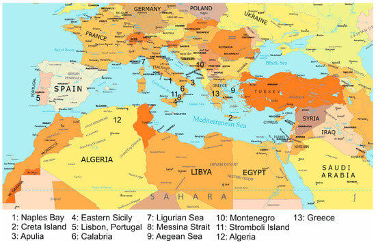
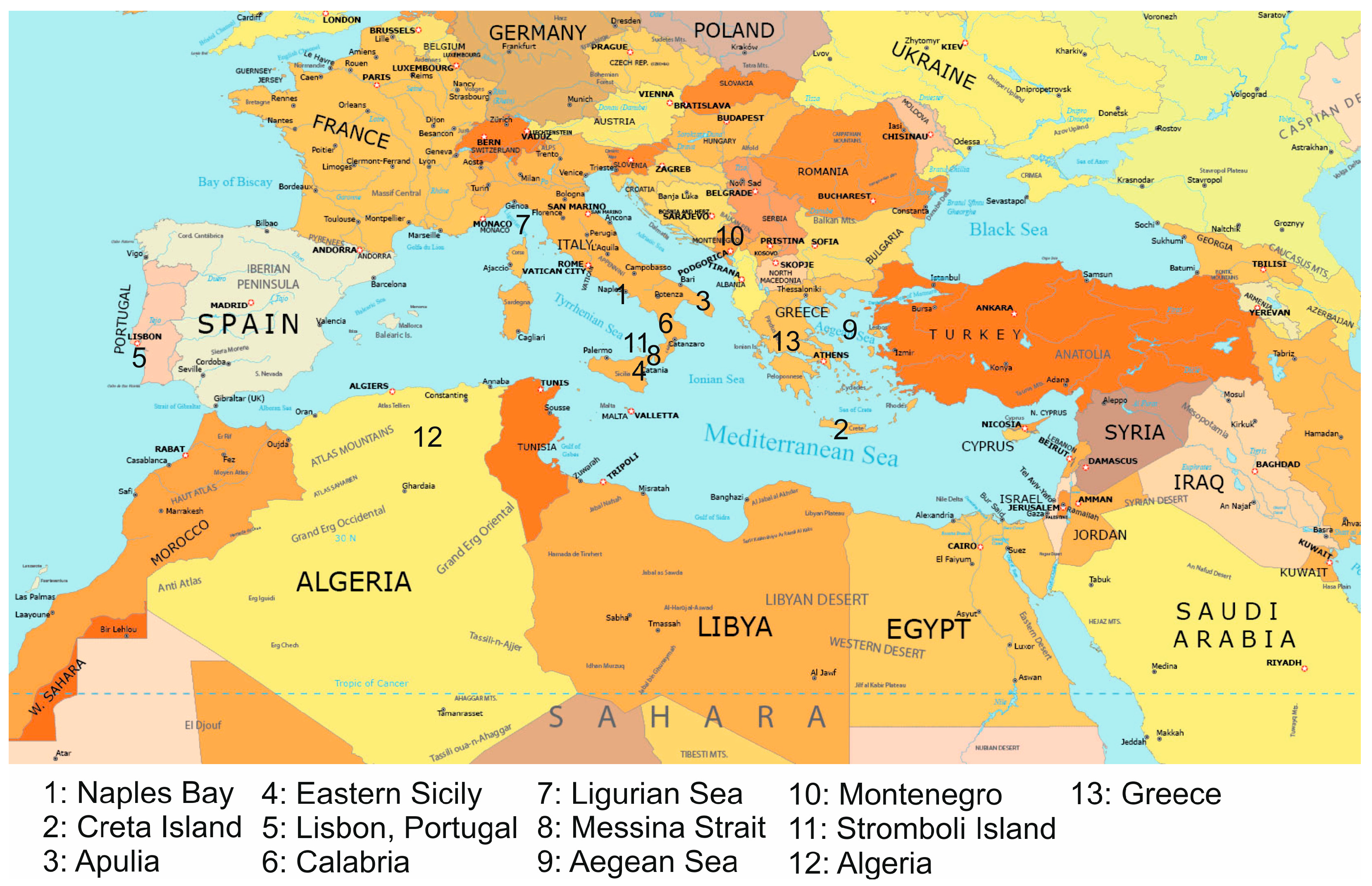
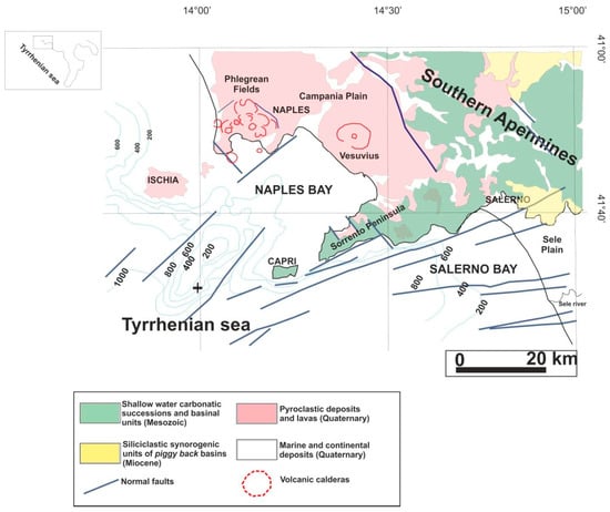
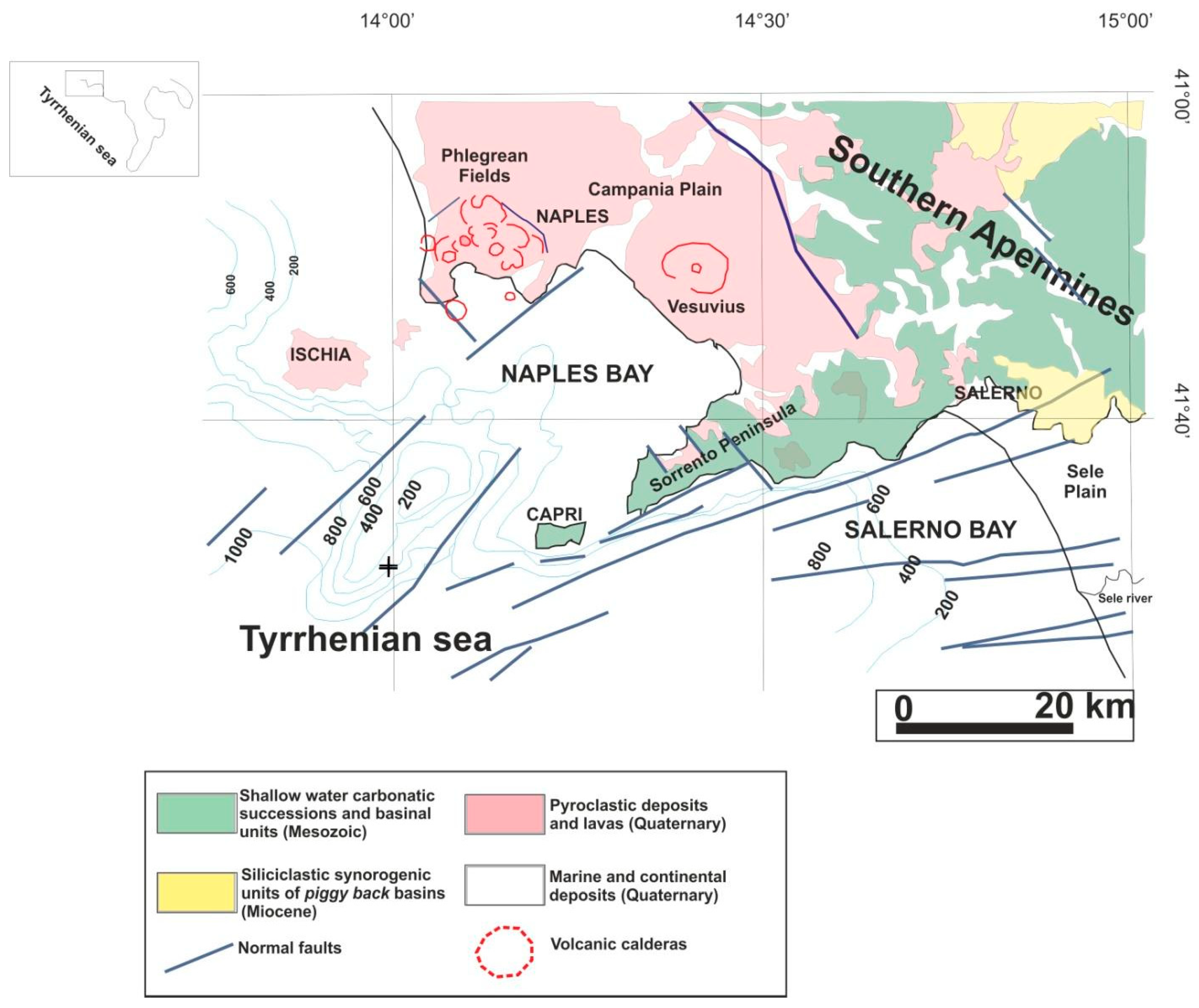
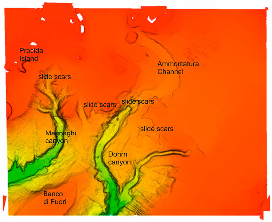
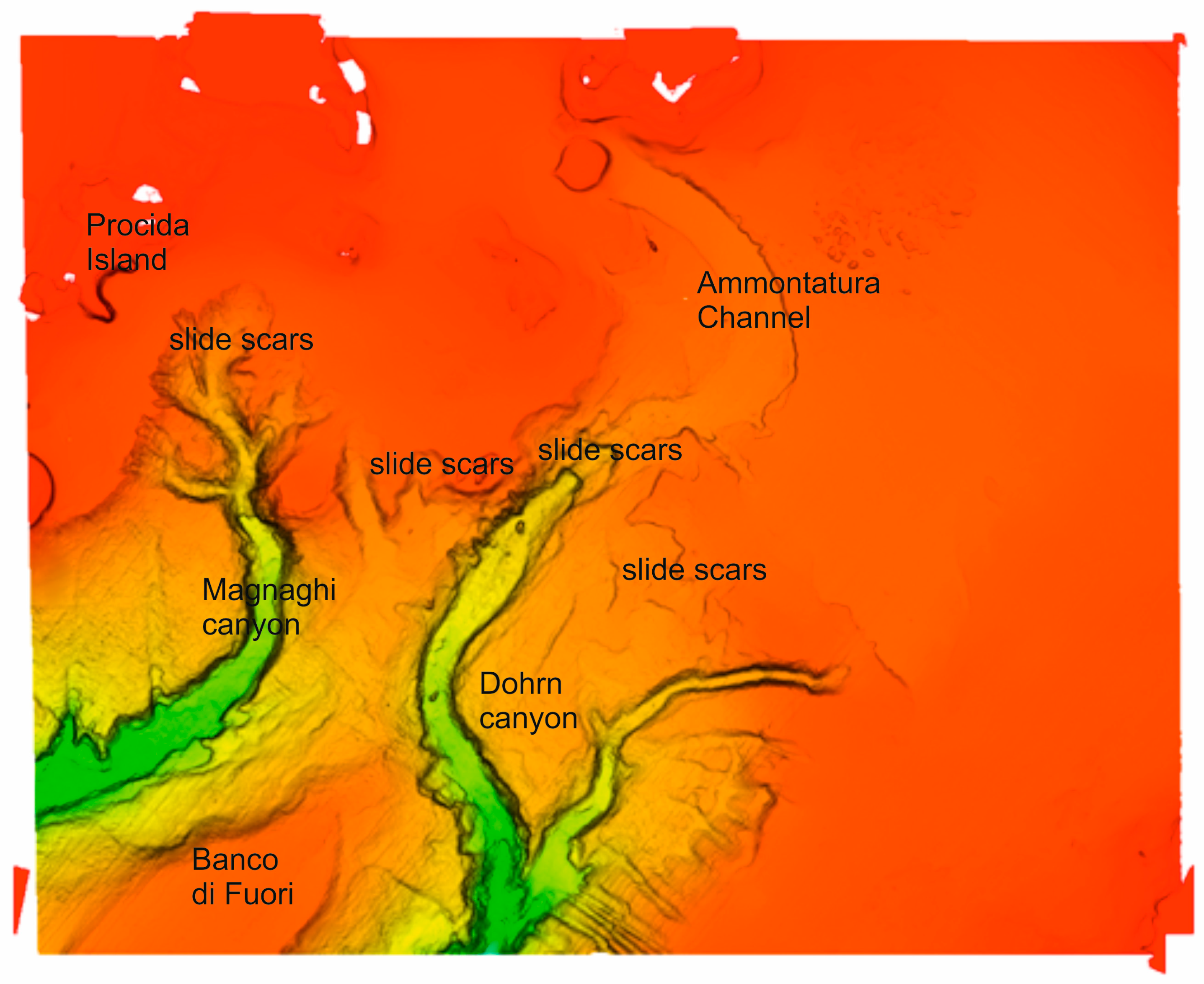
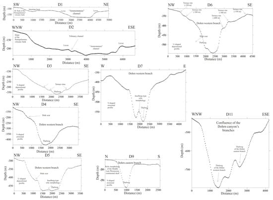
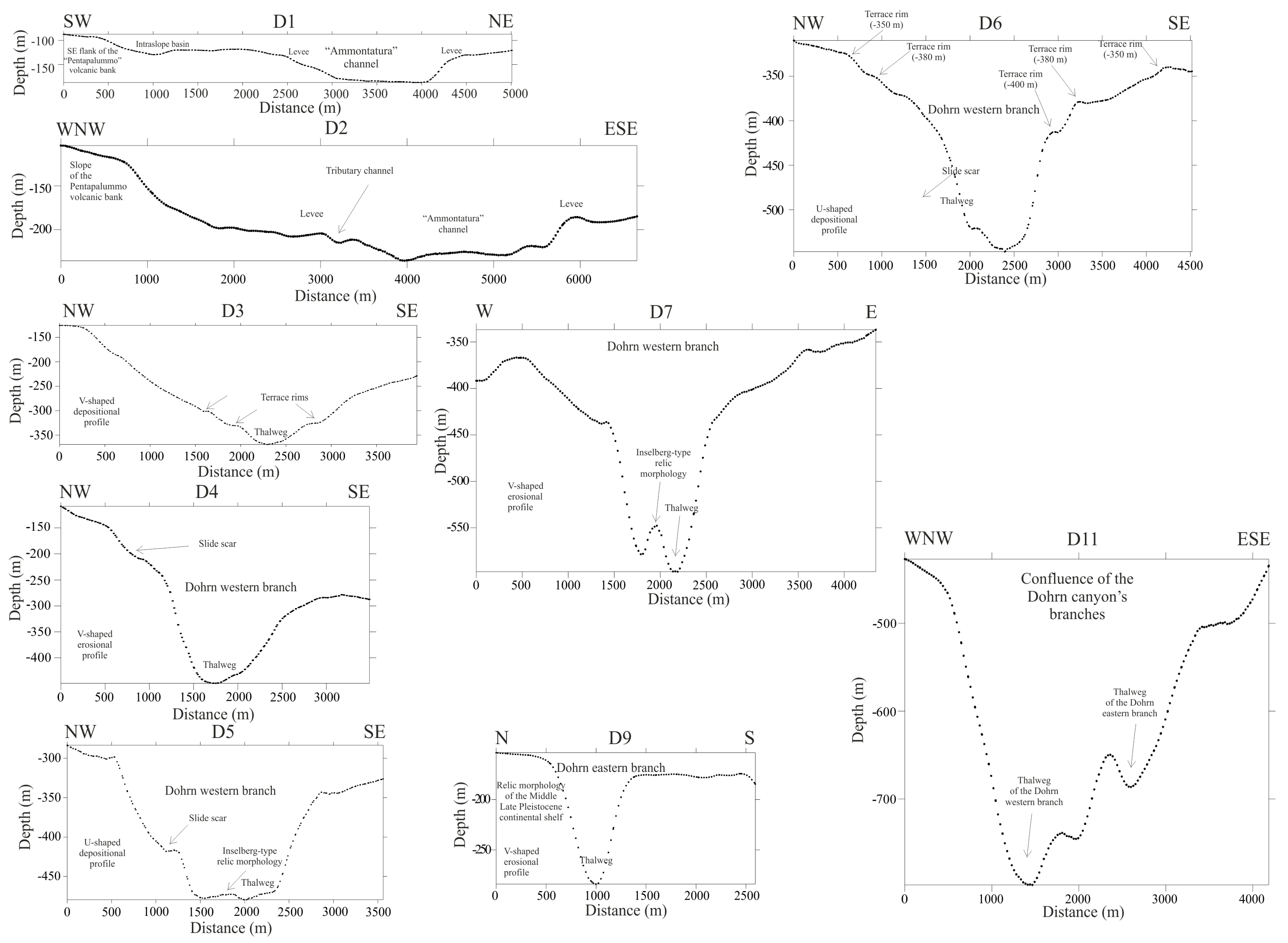
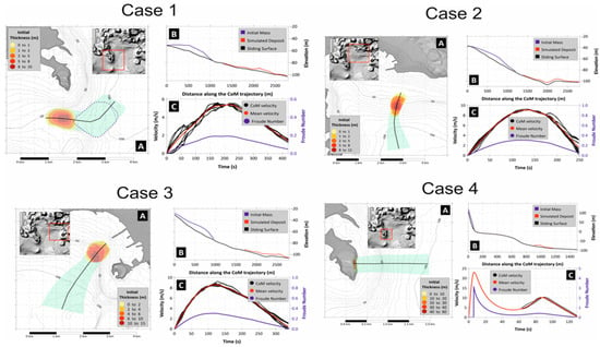
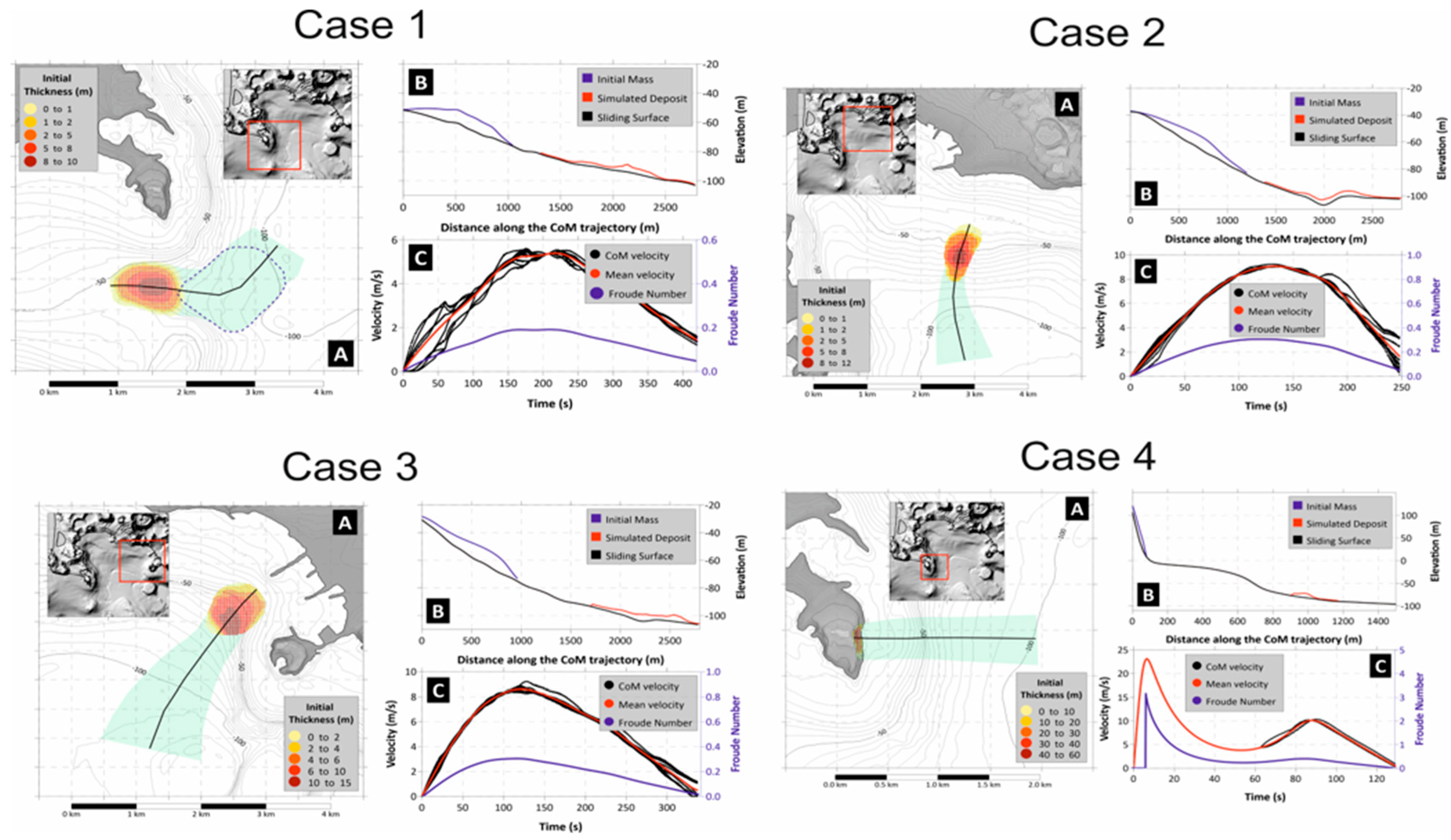
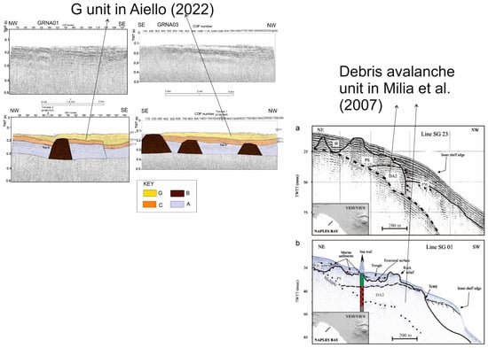
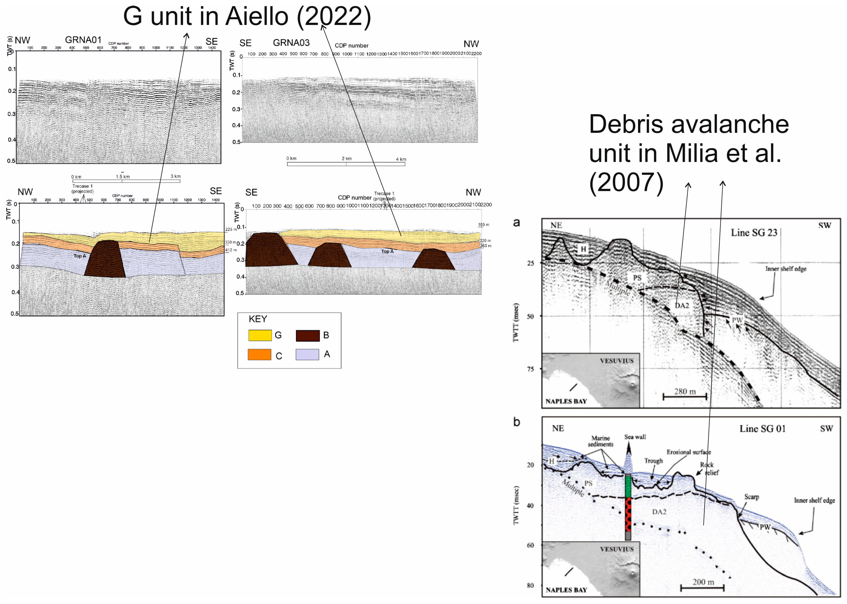
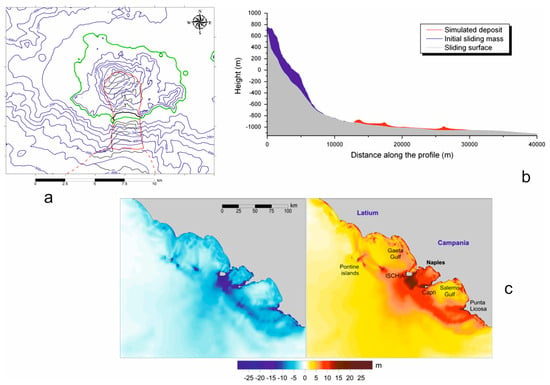
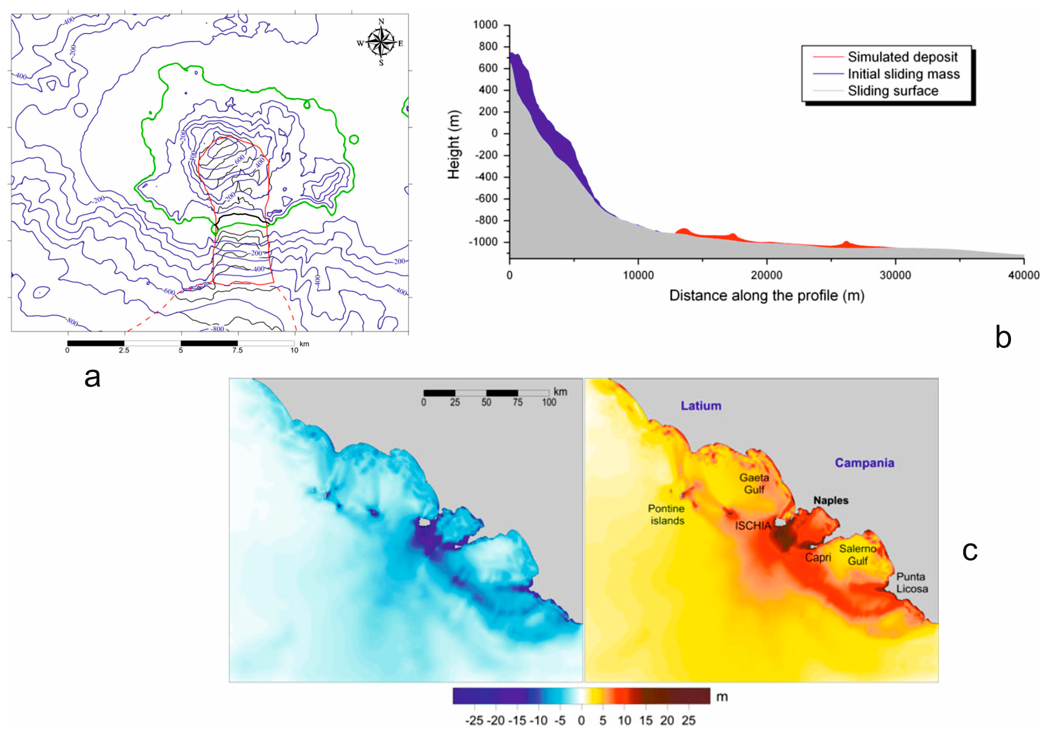
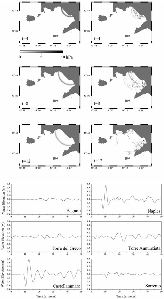
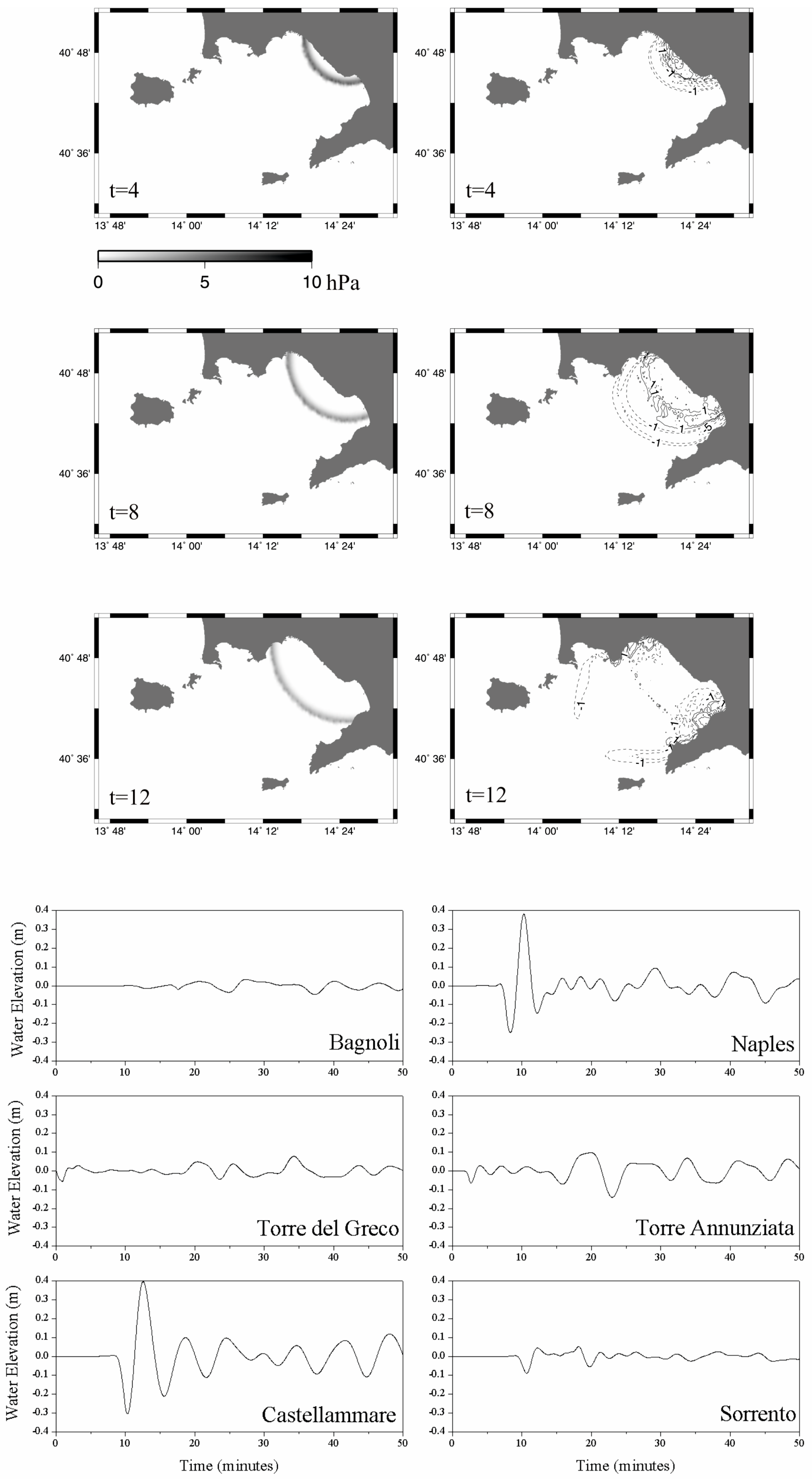

Disclaimer/Publisher’s Note: The statements, opinions and data contained in all publications are solely those of the individual author(s) and contributor(s) and not of MDPI and/or the editor(s). MDPI and/or the editor(s) disclaim responsibility for any injury to people or property resulting from any ideas, methods, instructions or products referred to in the content. |
© 2026 by the author. Licensee MDPI, Basel, Switzerland. This article is an open access article distributed under the terms and conditions of the Creative Commons Attribution (CC BY) license.