


Abstract
The Daliangshan Fault Zone (DLSFZ) constitutes a key segment of the Xianshuihe–Xiaojiang Fault System (XXFS) and exerts fundamental control on the eastward extrusion of the Sichuan–Yunnan Block (SYB). In this work, we present new slip rate determinations at three key sites (Tekoujiagu, Yeer, Damulo) along its middle-southern segments using UAV-based high-resolution topography and OSL dating. Results yield late Quaternary slip rates of 4.5 ± 1.4, 3.7 ± 1.1, and 5.5 ± 1.0 mm/a, respectively. Combined with previous data, the slip rate is 1.5–3.1 mm/a in the northern segment, 1.36–4.3 mm/a in the middle and 2.5–4.5 mm/a in the southern segment, which exhibits a spatial pattern of “higher in the south, lower in the north, with transition in the middle”. Temporal evolution suggests increased slip rates from the Late Pleistocene to Holocene. These characteristics indicate that the DLSFZ is a heterogeneous deformation system, where strain focusing on the southern segment reflects the block’s eastward escape constrained by the rigid Sichuan Basin (SB). Thus, the DLSFZ, especially its southern segment, serves as a key structure regulating crustal extrusion at the southeastern margin of the Tibetan Plateau (TP).
1. Introduction
The Xianshuihe–Xiaojiang Fault System (XXFS) stands out as one of the most tectonically and seismically active belts across the entire southeastern margin of the TP. It also serves as a first-order tectonic boundary that defines and confines the northeastern edge of the Sichuan–Yunnan Block (SYB) [1,2,3] (Figure 1). Tectonically, this extensive fault system formed and evolved during the Late Cenozoic era, driven by the continuous northward advancement of the Indian Plate and its ongoing and intense continental collision with the Eurasian Plate. This long-term convergence event has imposed strong compressional environments on the middle and lower crustal materials beneath the western Sichuan Plateau and further generated significant lateral crustal pressure gradients when compared with the neighboring rigid SB and SCB. As a result of the strong mechanical resistance produced by the high-strength lithosphere of the SB, a portion of the ductile lower crustal materials became trapped and accumulated within western Sichuan, while another portion was gradually channeled and extruded toward the southeast along the major left-lateral strike-slip faults of the XXFS, with an average long-term slip rate of approximately 10 mm/yr [4,5,6,7,8,9,10]. The deep crustal flow process, when coupled with the surficial strike-slip motion along the fault system, jointly constructed the unique and complex tectonic deformation mechanism in this region and formed a major crustal pathway that facilitates the eastward extrusion of materials from the interior of the TP [11,12,13,14]. Such intensive and long-lasting tectonic movements have resulted in the progressive accumulation and sudden release of tectonic strain along different structural segments of the fault system, which in turn provides extremely favorable conditions for the nucleation and occurrence of large and destructive earthquakes [15,16]. According to historical earthquake records that have been systematically compiled since 1500 AD, the XXFS has experienced as many as 14 earthquakes with moment magnitudes ranging from Mw 7.0 to Mw 7.9, and one event that reached Mw 8.0 [17,18,19]. Statistical analyses further show that a major earthquake of Mw 7.0 or larger occurs roughly every 34 years on average, clearly demonstrating an extraordinarily high level of regional seismic hazard.
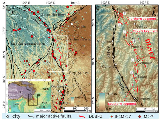
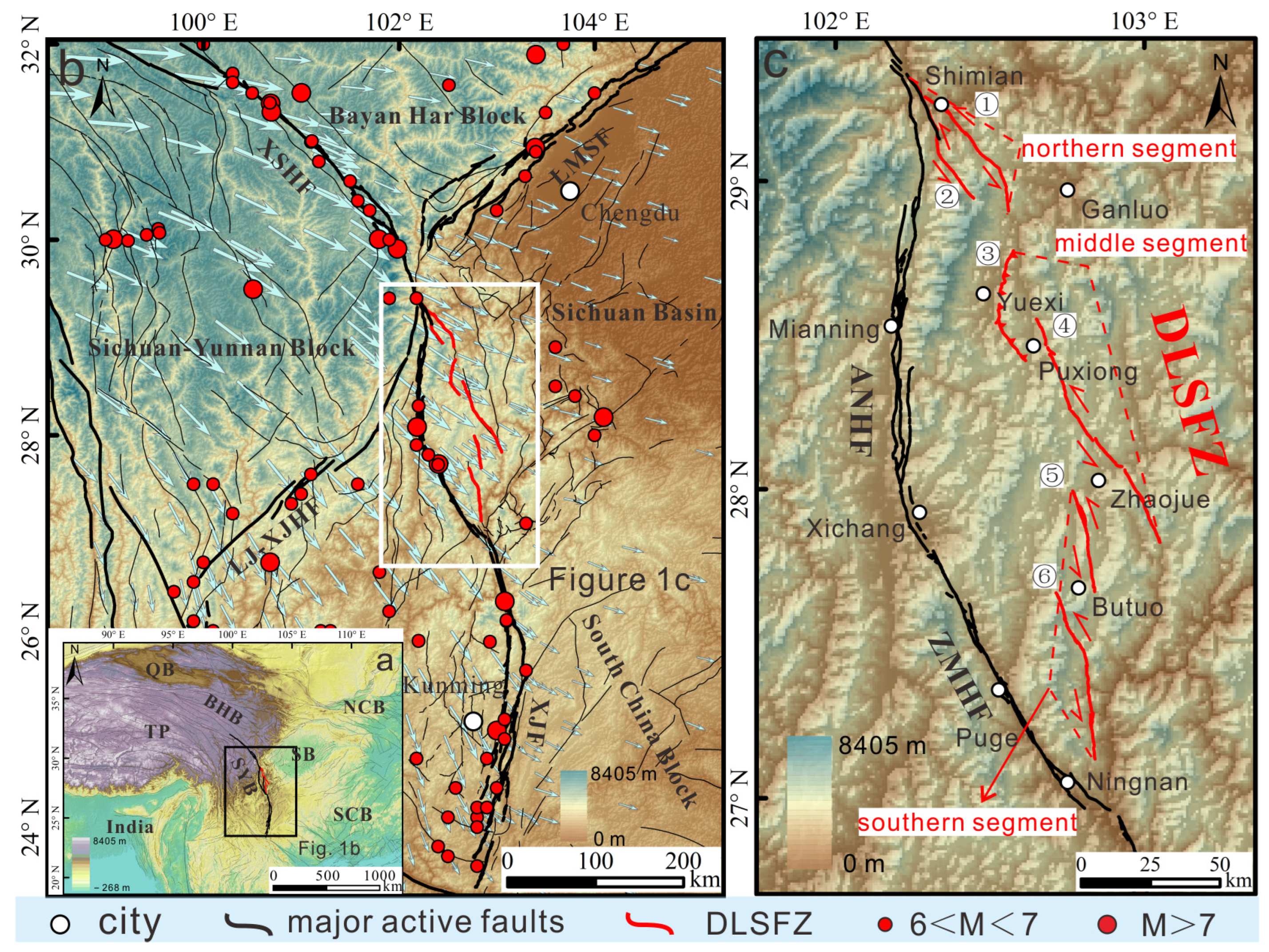
Figure 1.
Regional setting map showing the XXFS, SYB and the working area. (a) Overview map of research study related to the southeast margin of the TP. (b) Distribution map of DLSFZ and its surrounding active faults. Red circles show epicenters of historically recorded large earthquakes. (c) Detailed map of the distribution morphology of the DLSFZ. ① Zhuma Fault; ② Gongyihai Fault; ③ Yuexi Fault; ④ Puxiong Fault; ⑤ Butuo Fault; ⑥ Jiaojihe Fault. Abbreviation: TP: Tibetan Plateau; SYB: Sichuan–Yunnan Block; BHB: Bayan Har Block; QB: Qaidam Basin; NCB: North China Block; SCB: South China Block; SB: Sichuan Basin; XSHF: Xianshuihe Fault; XJF: Xiaojiang Fault; ANHF: Anninghe Fault; ZMHF: Zemuhe Fault; LJ-XJHF: Lijiang–Xiaojinhe Fault; LMSF: Longmenshan Fault.
In contrast, the DLSFZ, which constitutes an important structural part of the central part of the XXFS, exhibits significantly weaker seismic activity than other adjacent fault segments. Historical documents only recorded several moderate earthquakes between Mw 5.0 and Mw 6.0, with no reliable records of events exceeding Mw 6.0. This apparent seismic gap may be partially attributed to the remote and mountainous nature of the study area, which could lead to incomplete or missing historical records partially controlled by the inherent activity behavior of the fault zone itself [20,21]. He et al., [22] proposed that the DLSFZ represents a relatively young and newly formed structural system, which likely originated from the process of “bending and straightening” within the central part of the XXFS. Its overall activity level has been gradually increasing through time, and it may eventually replace the ANHF to become the dominant active structure in the region. Previous studies have accumulated abundant data and knowledge regarding the late Quaternary kinematic behaviors of the DLSFZ [21,22,23,24,25]. Based on detailed interpretations of offset geomorphic markers and reliable chronological constraints, the total late Quaternary left-lateral strike-slip rate of the DLSFZ has been estimated to be approximately 2–4 mm/a [18,21,22,23,24,25,26]. Among the different segments, the northern part shows relatively low slip rates, with horizontal rates of 1.5–3.1 mm/a since the late Pleistocene to Holocene [18,21,23]; the Puxiong Fault in the middle segment yields values of 3.1–4.3 mm/a [18,21,25]; and the southern segment shows relatively higher values of 2.5–4.5 mm/a [24].
Slip rate data of active fault zones are among the most critical parameters for understanding the long-term slip history and regional tectonic evolution of fault systems [27,28,29,30,31,32,33,34,35]. As a major boundary fault of the SYB, the spatial distribution pattern of slip rates along the DLSFZ provides key observational constraints for constructing and testing geodynamic models of the Tibetan Plateau. To better characterize the active behaviors and tectonic implications of the DLSFZ, we used high-resolution topographic data and newly acquired dating results to further refine the slip rate estimates along its middle and southern segments. By integrating our new results with all available previous data, we established a complete spatiotemporal distribution pattern of slip rates for the entire DLSFZ, which provides solid and reliable support for the theory that the activity of the DLSFZ is progressively increasing and its southern part is gradually becoming the dominant structure that regulates southeastward escape of crustal materials from the TP.
2. Geological Setting
The arcuate-shaped XXFS acts as the primary tectonic boundary zone that separates the SYB, the BHB, and the SCB from each other and displays a typical “narrow–wide–narrow” geometric architecture along its entire strike. Its northern and southern segments are typified by relatively narrow and linear structural belts, whereas the central segment shows a well-developed spindle-shaped geometric distribution [22,23,36,37,38,39,40,41,42] (Figure 1). The DLSFZ is situated along the eastern margin of this central spindle-shaped structural area. It starts in the north from the southern end of the XSHF in northern Shimian, Sichuan Province, and extends southward through areas such as Yuexi, Puxiong, Zhaojue, and Butuo, finally terminating at Qiaojia, Yunnan Province, where it connects with the XJF. The entire fault zone spans approximately 280 km in length [21,22].
Composed of six secondary faults, the DLSFZ forms a complex structural belt about 15 km wide [22]. It can be subdivided into three main geometric segments (Figure 1c). The northern segment, stretching from Shimian to Yuexi, consists of the Zhuma Fault and Gongyihai Fault, which cut through the northern part of the Xiaoxiangling Montain and form a curved diamond-shaped structure. The middle segment primarily comprises the nearly parallel Yuexi and Puxiong Faults. The southern segment features the Butuo Fault and XJF ranged in a right-step echelon pattern, typical of a strike-slip fault system [43,44,45]. The structural segmentation of this fault system can not only reflect differences in regional tectonic deformation but also provide important insights into the deformation mechanisms and seismic activity along the eastern boundary of the SYB.
Among all the secondary faults within the DLSFZ, all are dominated by left-lateral strike-slip motion except the Yuexi Fault of the middle segment, which is a thrust-dominated structure. In general, the horizontal slip rates are relatively lower in the northern segment and higher in the southern segment. Notably, the Puxiong Fault in the middle and the Butuo Fault and Jiaojihe Fault in the southern segment together form a typical left-lateral right-stepping echelon fault system (Figure 1c), which is why these three faults are selected as the main research targets in this study. The sustained left-lateral strike-slip motion has systematically displaced a variety of surficial landforms, including fluvial terraces, alluvial fans, gullies, and ridges, and preserved clear and measurable records of cumulative fault displacement. We selected three representative sites from north to south, namely Tekoujiagu, Yeer, and Damulo, to conduct quantitative slip rate determinations.
3. Data and Methods
The main goal in our work is to obtain high-precision topographic data and reliable chronological constraints to quantitatively constrain the late Quaternary slip rates of the DLSFZ. To achieve this purpose, we first carried out full-coverage UAV photogrammetric surveys over the entire middle and southern segments of the DLSFZ, which successfully provided us with high-quality topographic data at the sub-meter scale. Based on these high-resolution datasets, we used the ArcGIS 10.6 platform and LaDiCaoz_v2.2 software to systematically interpret and accurately measure the displacement amounts of various offset geomorphic markers distributed on both sides of the fault zone. To further constrain the temporal framework of fault movements, we adopted the OSL (optically stimulated luminescence) dating method to determine the formation ages of the displaced geomorphic surfaces. This integrated methodological framework allowed us to establish a robust chronological sequence for the displaced geomorphic units and further calculate reliable slip rates along the fault zone.
3.1. Fault Mapping
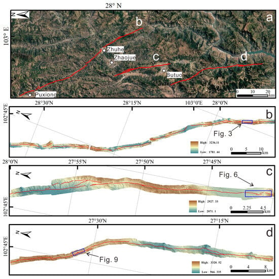
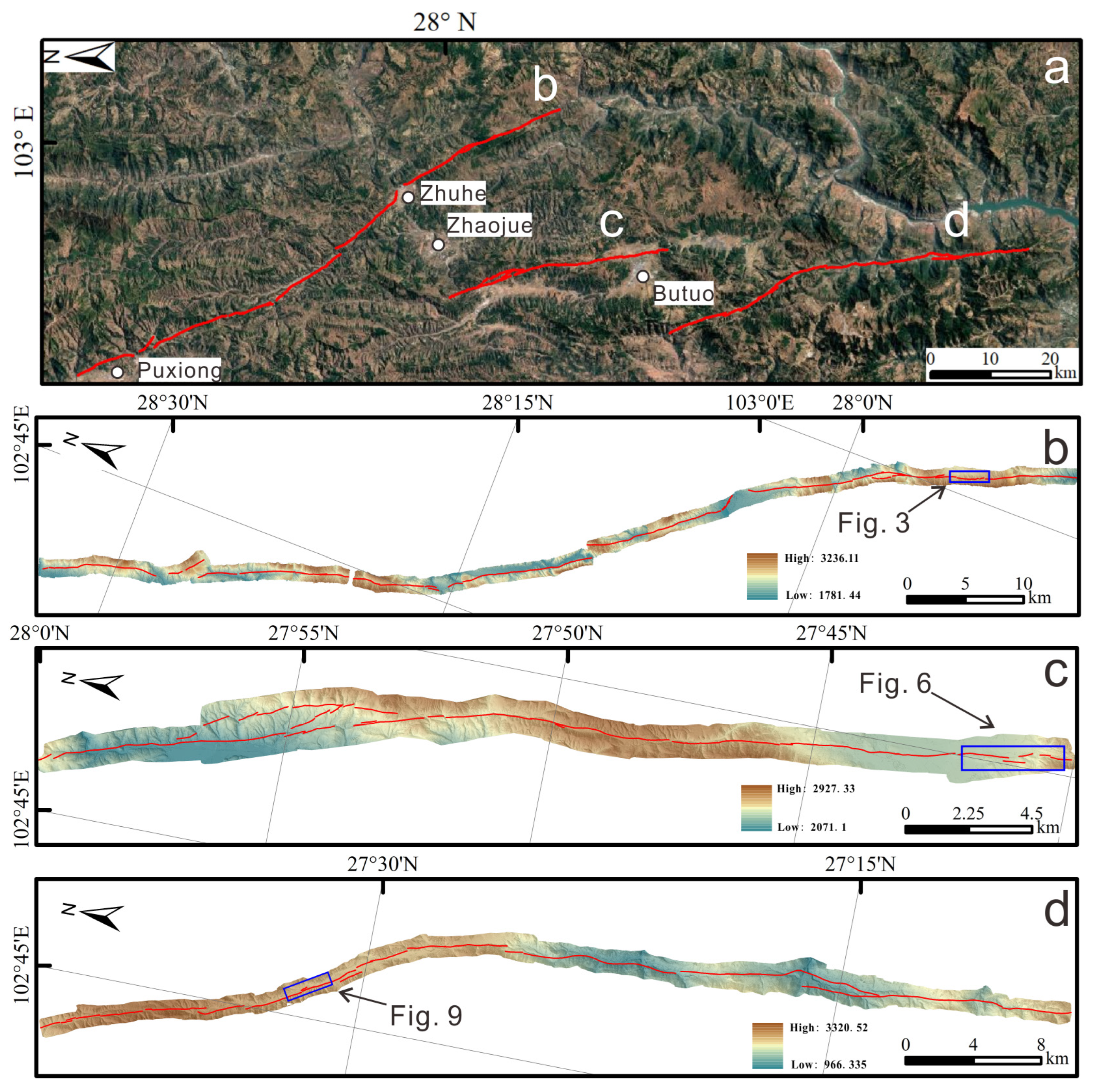
High-resolution topographic data are fundamentally important for accurately mapping detailed geomorphic markers, precisely tracing fault distributions, and conducting further quantitative tectonic analyses. Over the past few years, with the rapid and ongoing development of surveying and mapping technologies, the methods used to acquire high-precision topographic data have become increasingly convenient, efficient, and reliable [46,47,48]. In this study, we applied UAV aerial surveying integrated with the SfM (Structure from Motion) technique to collect high-quality orthophotos and DEM (Digital Elevation Model) data with a spatial resolution of 0.5 m, covering the entire middle and southern segments of the DLSFZ (Figure 2).
Figure 2.
(a) Distribution map of the middle and southern segments of the DLSFZ with Google Earth image as the base map. The white dots show the location and name of major towns. (b) Extended morphology map of the Puxiong Fault and the two locations of its slip rate research site (Tekoujiagu Site). (c) Extended morphology map of the Butuo Fault and the location of its slip rate research site (Yeer Site). (d) Extended morphology map of the Jiaojihe Fault and the location of its slip rate research site (Damuluo Site). The base map of (b–d) is the high-resolution DEM data obtained by UAV.
Based on the acquired DEM data, we used the data mosaic and spatial analysis modules embedded in the ArcGIS 10.6 platform to generate hill-shade maps with the same 0.5 m resolution. It is important to emphasize that, to clearly highlight the linear structural characteristics of fault traces, the illumination azimuth and altitude angles must be carefully and appropriately set during the hill-shade generation process. After numerous comparative tests, we found that using an illumination azimuth consistent with the dominant slope direction and an altitude angle of 45° can produce hill-shade maps with moderate brightness, clear surface textures, and prominently enhanced linear fault features [21]. From these optimized hill-shade maps, the exact positions of fault traces in the middle and southern segments can be accurately identified, and various geomorphic features can be clearly observed. On this basis, a series of typical offset geomorphic markers were further identified, including river channels, gullies, mountain ridges, and alluvial fans [21].
3.2. Displacement Measurement
In current studies focusing on the displacement measurements of strike-slip faults, two professional software tools are most commonly used, including 3D_Fault_Offsets and LaDiCaoz. The 3D_Fault_Offsets tool is well-known for its high performance in handling ultra-high-resolution images and its excellent capability in restoring the symmetrical morphology of river channels. However, its relatively complicated user interface and non-repetitive operating procedures have limited its wider application in practical research to a certain extent [49,50,51]. In our study area, most river channels show asymmetric morphologies, and many of them have experienced strong erosion processes caused by long-term fault dislocation. Therefore, LaDiCaoz_v2.2 is considered to be more suitable for the specific requirements of this study. This software is a visual analysis tool developed based on the MATLAB 2020 platform [49,52] and has experienced several rounds of optimization and upgrades since its early version 1.3; it has now been updated to version 2.2. The latest version has achieved significant improvements in visualization performance, operation logging functions, and overall user experience and has reached a high level of simplicity, convenience, and result repeatability. Its interface is intuitively designed and user-friendly, integrates multiple functional modules including vertical displacement extraction, two-dimensional and three-dimensional offset reconstruction (back-slip diagrams), and supports the export and storage of analytical results in standard image formats. The core working principle of the software relies on a series of data handling algorithms, such as horizontal shift, vertical lifting, and morphological extension of upstream and downstream gully segments, which grant it strong adaptability and applicability to displacement measurements under various complex topographic conditions [53]. In practical operation, the DEM data are first converted into ASCII format with the assistance of Global Mapper 17 and then imported into LaDiCaoz_v2.2 for further processing. Following the step-by-step guidance of the software interface, we completed the whole workflow including hill-shade map generation, fault trace drawing, upstream and downstream gully section positioning, geomorphic edge matching, displacement estimation, back-slip map building, and final result output. By conducting multiple measurements using different and independent geomorphic markers, we obtained the final displacement value and its average error range, which effectively ensures the reliability and accuracy of the analytical data.
3.3. Dating
Precisely determining the temporal constraints on fault activity is essential for reliably quantifying slip rates, which in turn are critical for assessing seismic hazards and understanding regional tectonic evolution [53]. Previous research has applied various geochronological techniques—including thermoluminescence (TL), cosmogenic nuclide dating, and radiocarbon dating—to determine the ages of Quaternary deposits associated with fault movements [33,54,55,56]. Considering the specific sampling environment and geological complexities in the study area, optically stimulated luminescence (OSL) dating was selected for this investigation due to its practical advantages in dating sedimentary sequences and its established reliability in similar tectonic settings.
During field surveys, three OSL samples were systematically collected from a fine-grained layer situated approximately 20 cm above a prominent gravel stratum. To ensure that the samples were representative of the intended depositional age and unaffected by recent surface exposure or bioturbation, the outcrop surface was cleaned back by at least 30 cm prior to sampling. Samples were obtained using light-tight stainless steel hollow pipes measuring around 30 cm long with a diameter of 5 cm. Immediately after extraction, each tube was securely sealed with aluminum foil and further wrapped in black plastic bags to prevent any light contamination. These procedures adhered strictly to the established protocols outlined by [57].
The OSL measurements were conducted at the State Key Laboratory of Earthquake Dynamics and Forecasting, IG, CEA. Depending on the grain-size characteristics of each sample, both coarse-grained and fine-grained quartz fractions were analyzed using appropriate single-aliquot regenerative-dose (SAR) protocols. The resulting ages, along with associated analytical details, are summarized in Table 1.
4. Results
We carried out field surveys at three research sites along the middle and southern segments of the DLSFZ. These included one site on the Puxiong Fault, one on the Butuo Fault, and another one on the Jiaojihe Fault. Using the LaDiCaoz_v2.2 software, we measured horizontal offset values of displaced landforms and, combined with the dating results of these landforms, calculated the late Quaternary left-lateral strike-slip rates for each of the three sites.
4.1. Tekoujiagu Site of Puxiong Fault
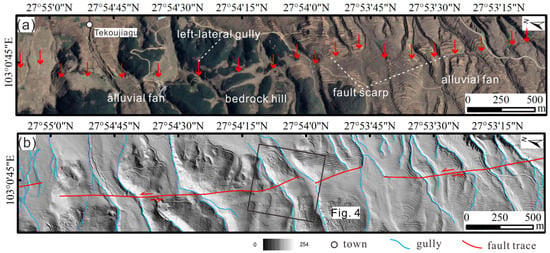
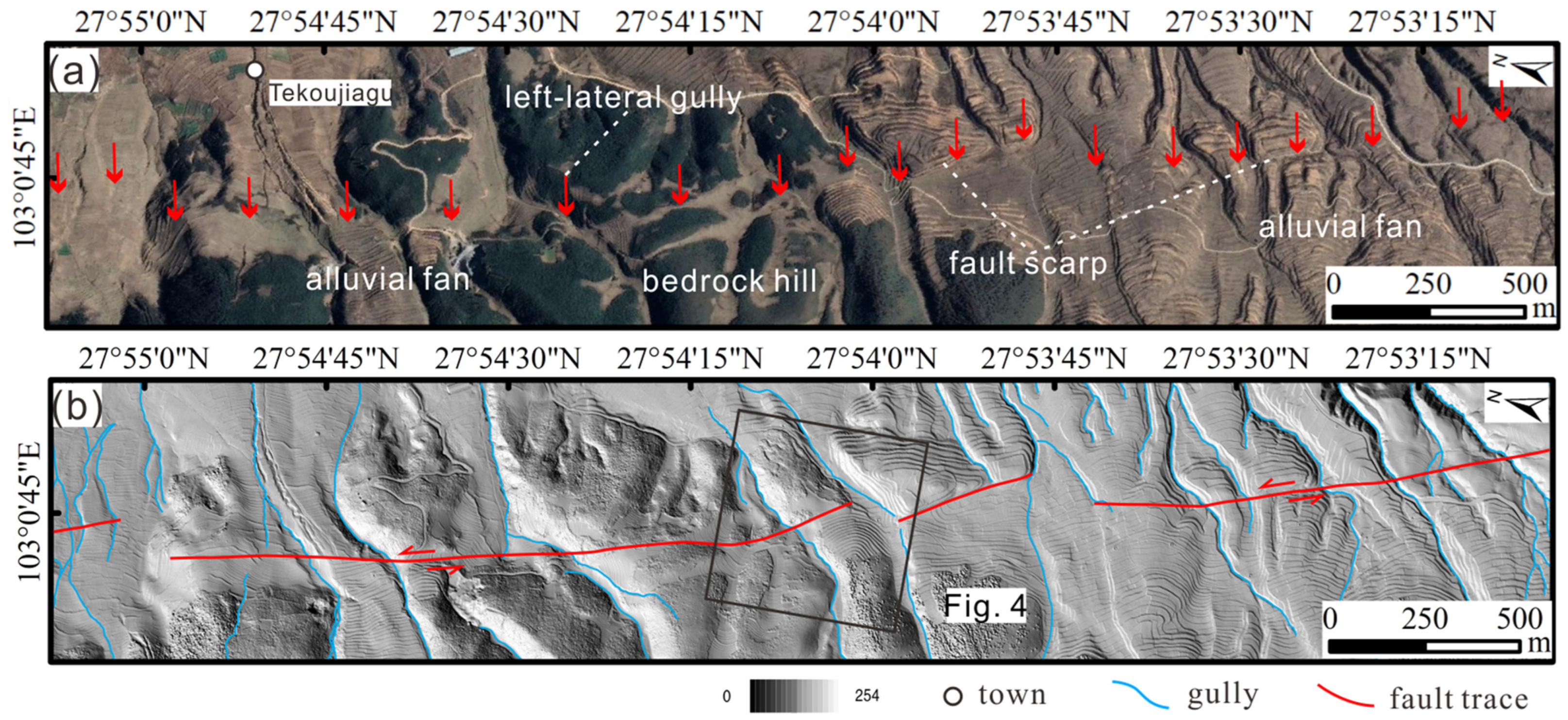
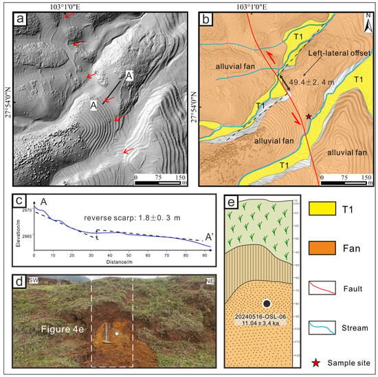
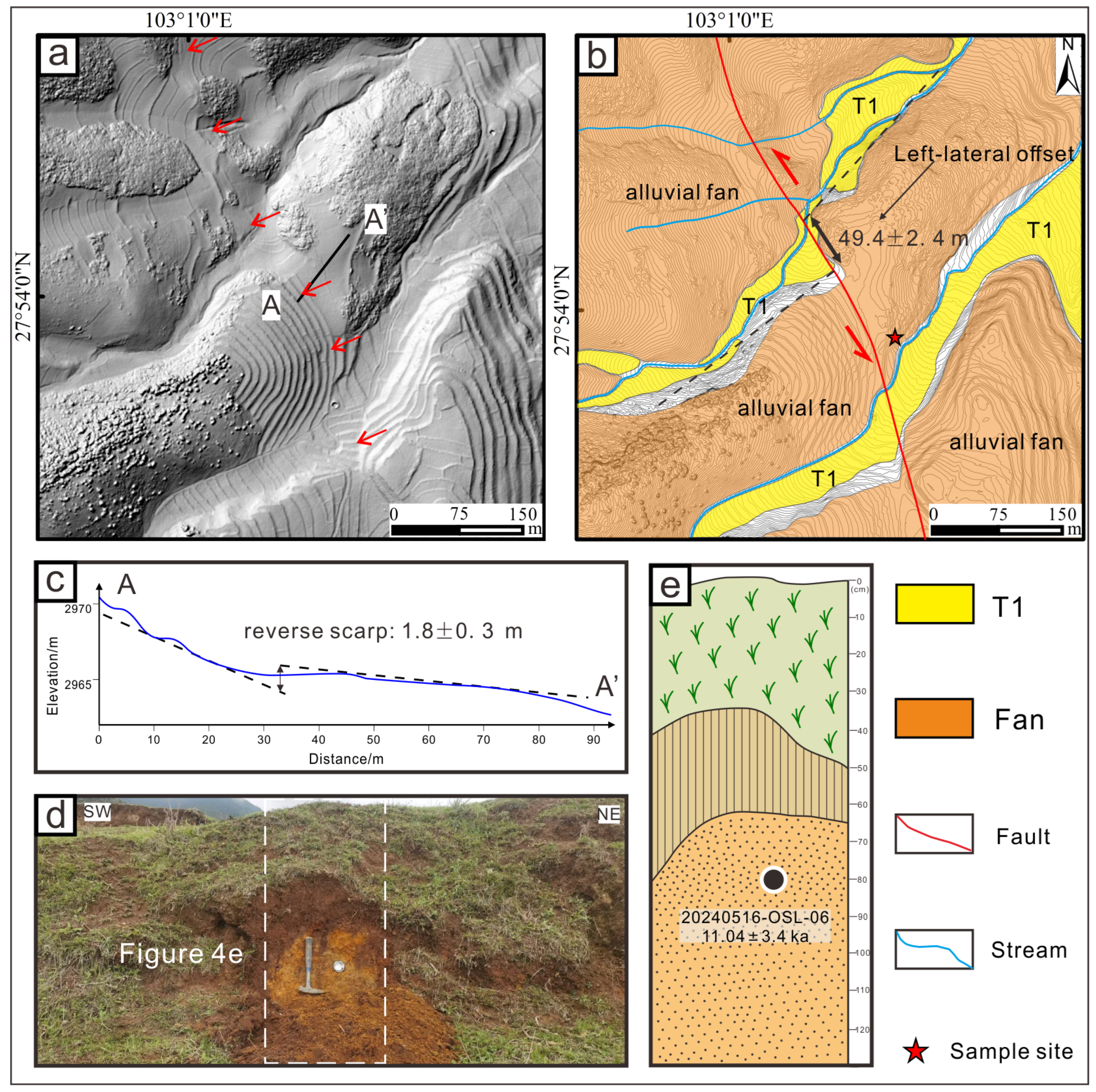
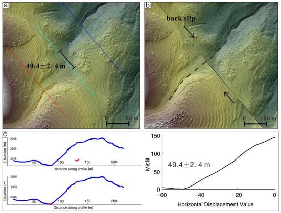
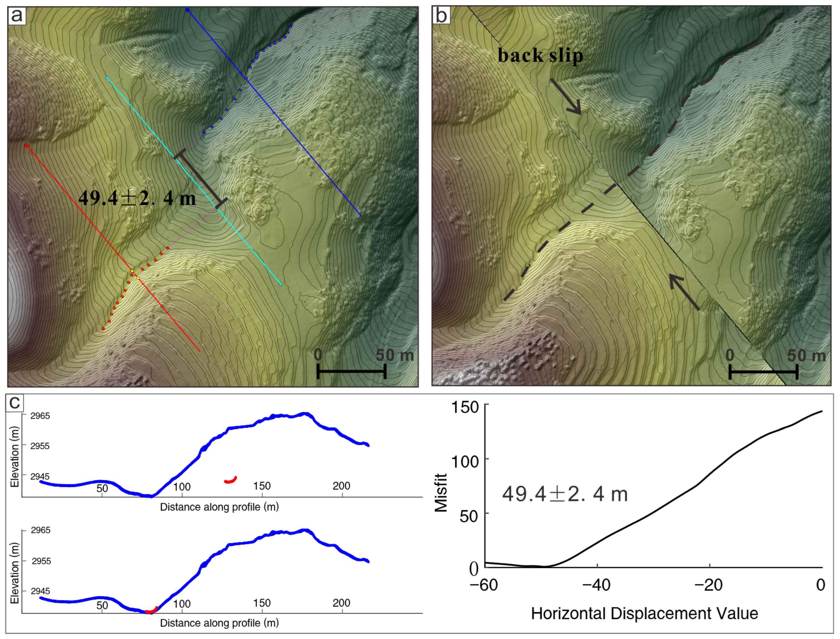
The Tekoujiagu site (103.02° E, 27.90° W; elevation 2992 m above sea level) is the northernmost research site in the study area, which is located about 750 m southwest to the Tekoujiagu Village, Zhaojue County. At this site, a series of prominent linear fault scarps and left-laterally offset gullies are clearly observable (Figure 3). Among these features, a well-preserved alluvial fan displaying distinct left-lateral displacement was selected for quantifying the strike-slip rate. Topographic profiling along section A-A′ reveals a reverse fault scarp showing 1.8 ± 0.3 m of vertical separation (Figure 4c). Using LaDiCaoz_v2.2 software for morphological analysis, the measured left-lateral offset of the alluvial fan was determined to be 49.4 ± 2.4 m (Figure 4b and Figure 5).
Figure 3.
(a) Displaced geomorphic features such as gullies and fans showing linear fault traces at Tekoujiagu Site of Puxiong Fault, with a Google Earth image as the base map. The red arrows indicate the position of fault trace which can be identified by offset gullies and fault scarps. The white dashed lines indicate fault–related landforms. (b) Preliminary interpretation of landforms near the Tekoujiagu Site, based on hill-shaded relief map generated from high-resolution DEM data obtained by UAV.
Figure 4.
Detailed interpretation of displaced geomorphic features at Tekoujiagu Site of Puxiong Fault. (a) Hill-shaded map derived from 0.5 m resolution DEM data. Red arrows indicate the fault trace. (b) Geomorphological interpretation map based on 1 m interval contours. The red line denotes the fault trace; red arrows show the relative fault-slip direction; black lines mark the alluvial fan margins; and the red pentagram represents the sampling site. (c) The topographic profile of the A-A′ in (a). (d,e) Field photo and interpretation map of the sample site of 20240516-OSL-06. The SW, NE in (d) indicate the orientation of the photograph. The black dot in (e) indicate the position of OSL sample and the colors in (e) represent the different strata.
Figure 5.
The left-lateral displacement measurement and restoration of the alluvial fan at Tekoujiagu site using LaDiCaoz_v2.2 software. (a) Shaded terrain map of the alluvial fan and gully with a contour interval of 1 m. The cyan line denotes the fault trace position, the bright yellow curves with red and blue dots represent the direction of extension of the river channels on both sides of the fault, and the red and blue lines indicate the positions of topographic cross-sections of the river channels. (b) The optimal 49.4 m back-slip map of the river channel. (c) The topographic profile of the original gully (top left), the topographic profile of the restored gully (bottom left), and the residual distribution map for displacement measurements (right). The red lines in (c) indicate the profile of the gully.
An optically stimulated luminescence (OSL) sample, labeled 20240516-OSL-06, was collected nearly from the margin of the alluvial fan at a depth of approximately 20 cm below the upper sedimentary layer (Figure 4d,e). The OSL dating result indicates an age of 11.04 ± 3.4 ka for the depositional event (Table 1, Figure 4e). Based on the offset magnitude and the depositional age of the alluvial surface, the horizontal slip rate at the Tekoujiagu site is calculated to be 4.5 ± 1.4 mm/a.
4.2. Yeer Site of Butuo Fault
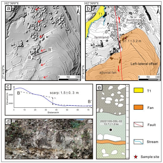
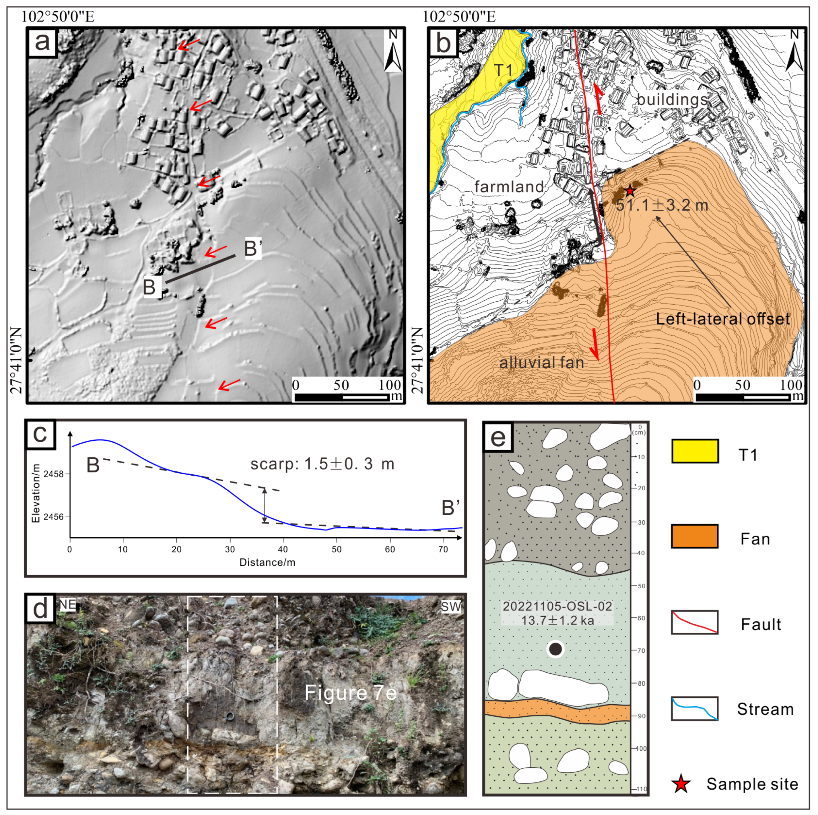
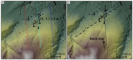
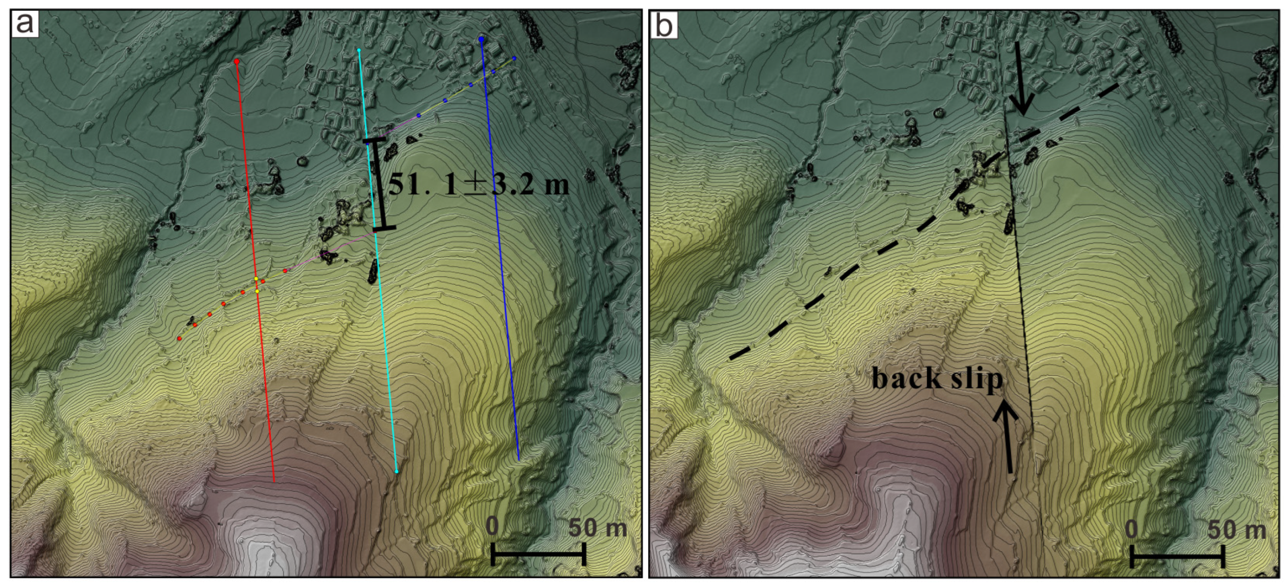
The Yeer study site (102.84° E, 27.68° N; elevation 2472 m above sea level) is situated at the southeastern margin of the Butuo Basin, adjacent to Yeer Village. In this area, Quaternary sediments are relatively thick, as illustrated in Figure 6. We selected a prominently left-laterally displaced alluvial fan at this location to determine the strike-slip rate along the fault. Topographic profiling along cross-section B-B′ reveals a well-defined fault scarp with a vertical offset of 1.5 ± 0.3 m (Figure 7c). Using LaDiCaoz_v2.2 software for morphometric analysis, the left-lateral offset of the alluvial fan was measured to be 51.1 ± 3.3 m (Figure 7b and Figure 8).
Figure 6.
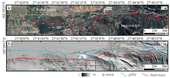
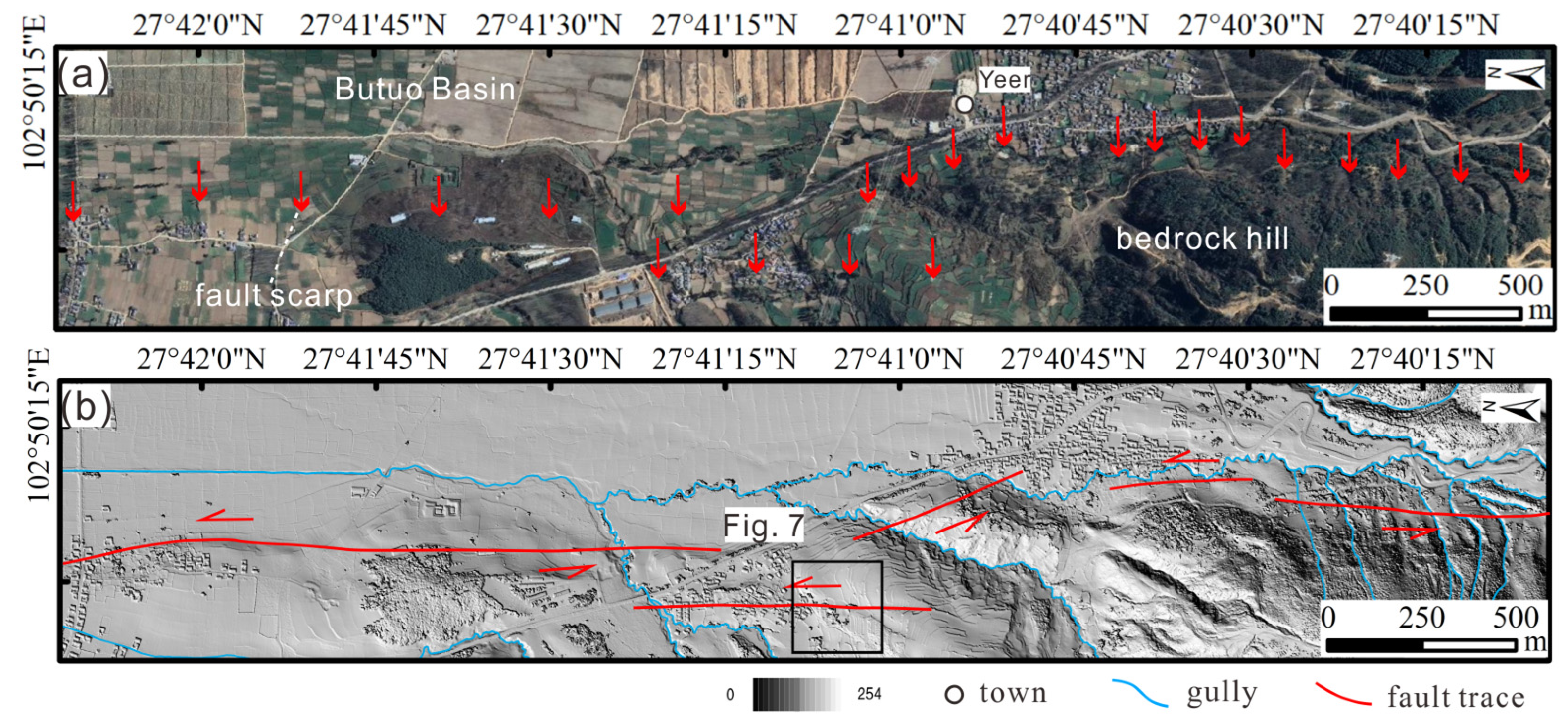
(a) Displaced geomorphic features such as gullies and fans showing linear fault traces at Yeer Site of Butuo Fault, with a Google Earth image as the base map. The red arrows indicate the position of fault trace which can be identified by offset gullies and fault scarps. The white dashed lines indicate fault–related landforms. (b) Preliminary interpretation of landforms near the Yeer Site, based on hill-shaded relief map generated from high-resolution DEM data obtained by UAV.
Figure 7.
Detailed interpretation of displaced geomorphic features at Yeer Site of Butuo Fault. (a) Hill-shaded map derived from 0.5 m resolution DEM data. Red arrows indicate the fault trace. (b) Geomorphological interpretation map based on 1 m interval contours. The red line denotes the fault trace; red arrows show the relative fault-slip direction; black lines mark the alluvial fan margins; and the red pentagram represents the sampling site. (c) The topographic profile of the B-B′ in (a). (d,e) Field photo and interpretation map of the sample site of 20221105-OSL-02. The SW, NE in (d) indicate the orientation of the photograph. The black dot in (e) indicate the position of OSL sample and the colors in (e) represent the different strata.
Figure 8.
The left-lateral displacement measurement and restoration of the alluvial fan at Yeer site grounded on LaDiCaoz_v2.2 software. (a) Shaded terrain map of the margin of the alluvial fan with a contour interval of 1 m. The cyan line denotes the fault trace position, the bright yellow curves with red and blue dots show the direction of extension of the alluvial fan’s margins on both sides of the fault, and the red and blue lines indicate the positions of topographic cross-sections of the margins. (b) The optimal 51.1 m back-slip map of the fan’s margin.
An optically stimulated luminescence (OSL) sample, labeled 20221105-OSL-02, was collected near the margin of the alluvial fan, approximately 20 cm below the upper sedimentary layer (Figure 7d,e). The OSL dating result indicates an age of 13.7 ± 1.2 ka for the deposit (Table 1, Figure 7e). Based on the measured offset and the OSL age, the horizontal slip rate at the Yeer site is calculated to be 3.7 ± 1.1 mm/a.
4.3. Damuluo Site of Jiaojihe Fault
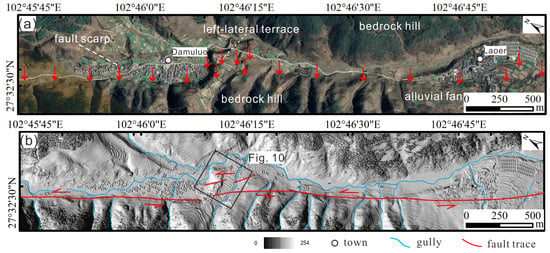
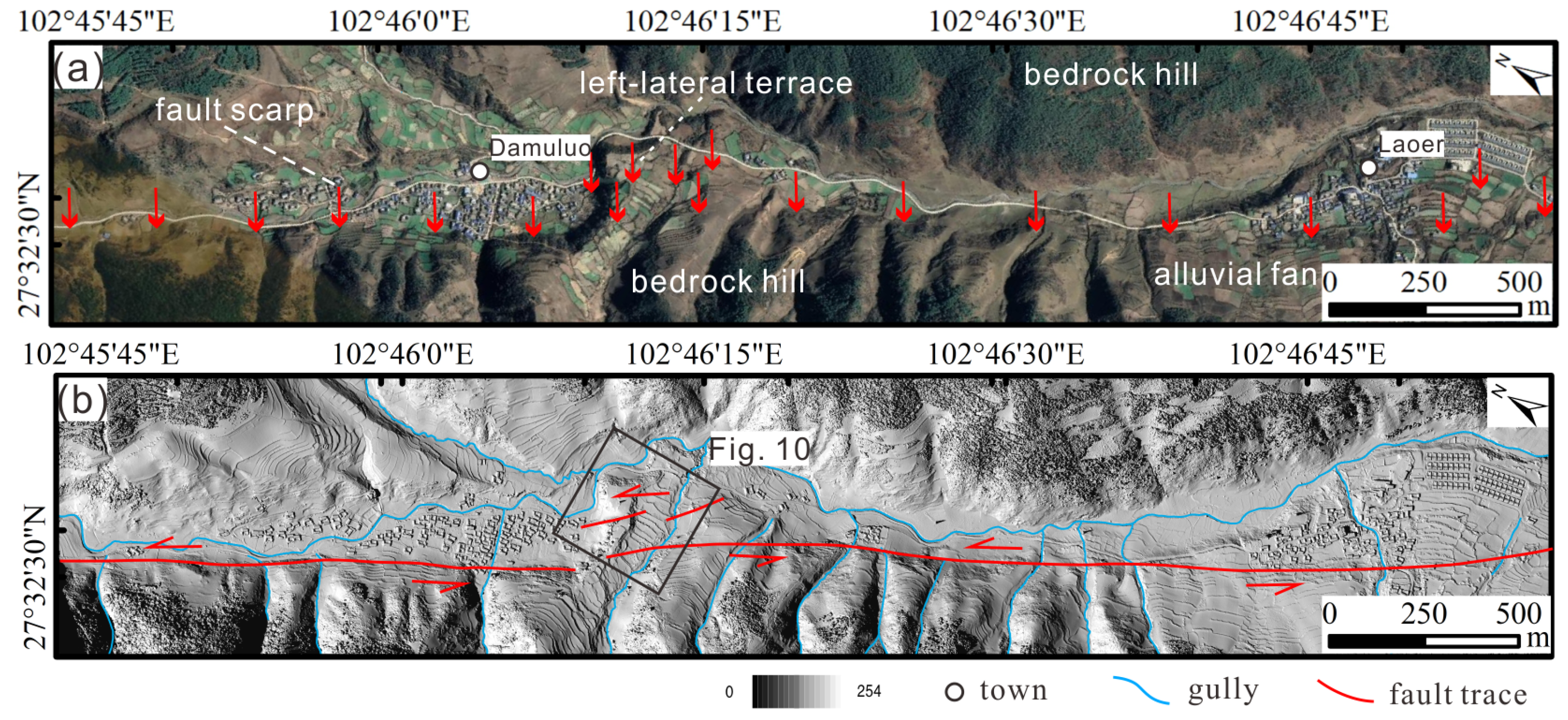
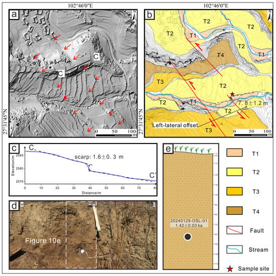
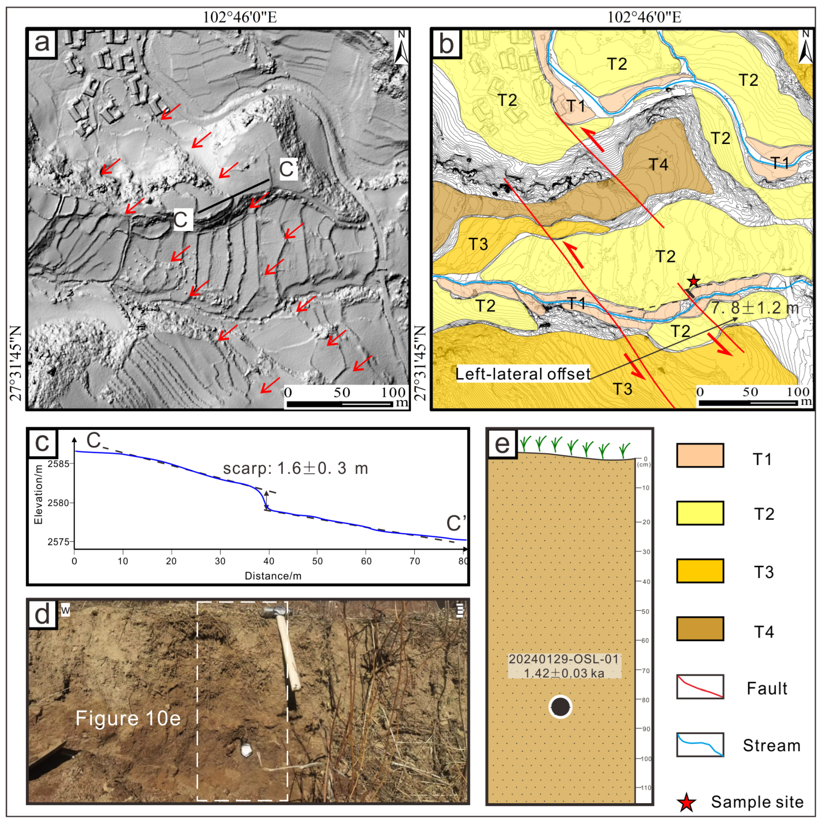
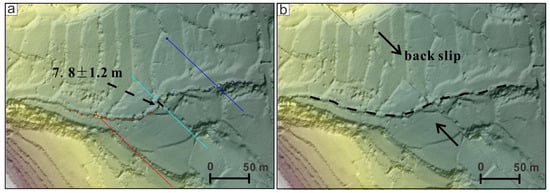
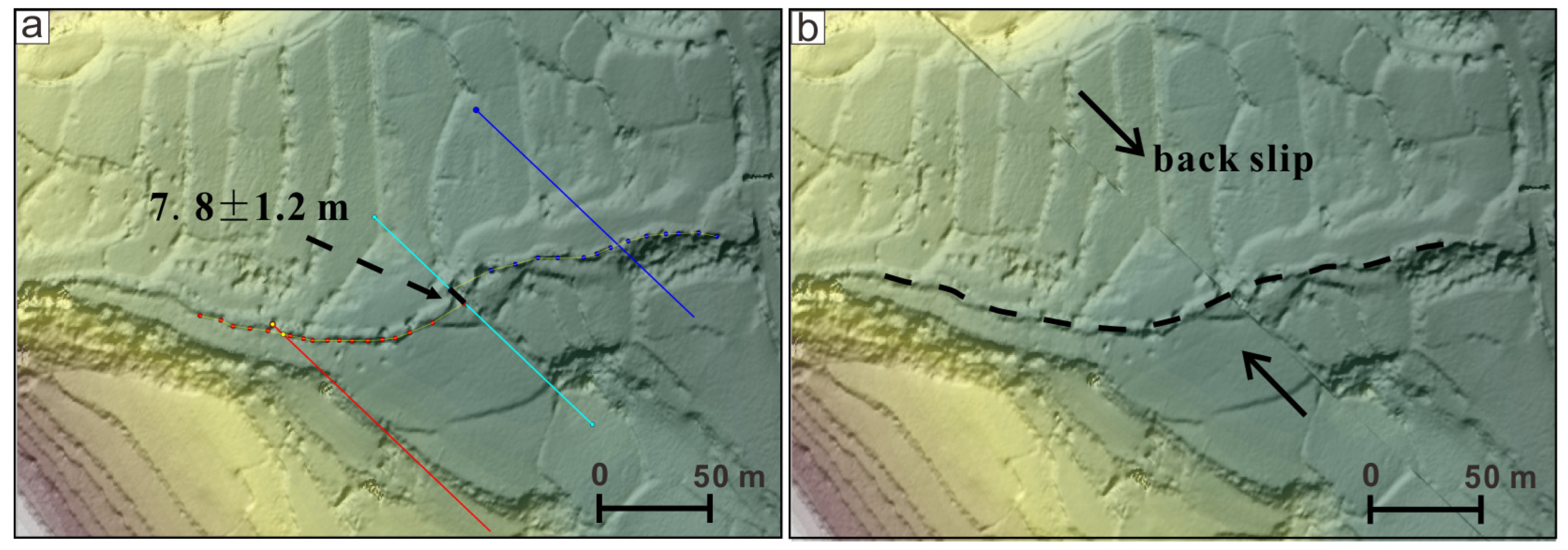
The Damuluo site (102.77° E, 27.53° W; elevation 2566 m above sea level), situated approximately 500 m southeast of Damuluo Village in Butuo County, represents the southernmost site within the study area. This site exhibits a series of well-developed linear fault scarps and fluvial terraces, as illustrated in Figure 9. Among these geomorphic features, the T2 terrace displays clear left-lateral displacement, which was selected for strike-slip rate calculation. Topographic profiling along the C-C′ transect reveals a distinct fault scarp with a vertical offset of 1.8 ± 0.3 m (Figure 10c). Using LaDiCaoz_v2.2 software, the left-lateral offset of the T2 terrace was measured to be 7.8 ± 1.2 m (Figure 10b and Figure 11).
Figure 9.
(a) Displaced geomorphic features such as gullies and fans showing linear fault traces at Damuluo Site of Jiaojihe Fault, with a Google Earth image as the base map. The red arrows indicate the position of fault trace which can be identified by offset gullies and fault scarps. The white dashed lines indicate fault–related landforms. (b) Preliminary interpretation of landforms near the Damuluo Site, based on hill-shaded relief map generated from high-resolution DEM data obtained by UAV.
Figure 10.
Detailed interpretation of displaced geomorphic features at Damuluo Site of Jiaojihe Fault. (a) Hill-shaded map derived from 0.5 m resolution DEM data. Red arrows indicate the fault trace. (b) Geomorphological interpretation map based on 1 m interval contours. The red line denotes the fault trace; red arrows show the relative fault-slip direction; black lines mark the terrace edge; and the red pentagram represents the sampling site. (c) The topographic profile of the C-C′ in (a). (d,e) Field photo and interpretation map of the sample site of 20240129-OSL-01. The SW, NE in (d) indicate the orientation of the photograph. The black dot in (e) indicate the position of OSL sample and the colors in (e) represent the different strata.
Figure 11.
The left-lateral displacement measurement and restoration of the alluvial fan at Damuluo site grounded on LaDiCaoz_v2.2 software. (a) Shaded terrain map of the margin of T2 and gully with a contour interval of 1 m. The cyan line denotes the fault trace position, the bright yellow curves with red and blue dots represent the direction of extension of the gully channels on both sides of the fault, and the red and blue lines indicate the positions of topographic cross-sections of the gully channels; (b) The optimal 7.8 m back-slip map of T2 and gully.
An optically stimulated luminescence (OSL) sample, labeled 20240129-OSL-01, was gathered from the edge of the T2 terrace at a depth of approximately 80 cm beneath the surface (Figure 10d,e). The OSL dating result yields an age of 1.42 ± 0.03 ka (Table 1, Figure 10e). Based on the measured offset and the age of the terrace, the strike-slip rate at the Damuluo site is calculated as 5.5 ± 1.0 mm/a.
Table 1.
Dating results of OSL samples along the DLSFZ.
5. Discussion
5.1. Slip Rates of the DLSFZ Since the Late Pleistocene
Due to the lack of clear historical records of large destructive earthquakes and its relatively young structural nature, research studies focusing on the fault activity behaviors of the DLSFZ have been relatively insufficient compared with adjacent fault zones [22]. Only a small number of previous studies have estimated the long-term slip rates of this fault zone based on the cumulative displacements recorded by offset geomorphic markers (Table 2). According to these published results, the slip rate is 1.5–3.1 mm/a in the northern segment [18,23], 1.36–4.3 mm/a in the middle segment [18,25,58], and 2.5–4.5 mm/a in the southern segment [24,25]. Independent GPS geodetic observations also show that the DLSFZ has an overall left-lateral slip rate of approximately 4 mm/a [59].
Table 2.
Late Quaternary slip rate data summary of the DLSFZ.
In most of these previous studies, measurements of displaced geomorphic markers mainly relied on traditional field investigations and visual interpretations of remote sensing images. At the Anshunchang site on the Zhuma Fault in the northern segment of the DLSFZ, a late Pleistocene slip rate of 1.5 mm/a (between 87.5 ka and 41 ka) was determined using the left-lateral offset amount of the T3 terrace and its corresponding depositional age [18]. In addition, at the Doukanzi site and Zhuma Basin site on the same Zhuma Fault, Holocene slip rates of 3.1 ± 0.3 mm/a and 1.6 ± 0.2 mm/a were respectively calculated based on left-lateral displacements of 30 ± 0.5 m and 16 ± 0.5 m measured at the margins of piedmont alluvial fans, combined with OSL sample ages of 9.9 ± 0.9 ka and 10.4 ± 1.3 ka [23].
For the middle segment of the DLSFZ, near Huayang Village on the Yuexi Fault, a left-lateral horizontal displacement of approximately 35.4 m was measured across the fault scarp that separates the P2 alluvial fan and the T2 fluvial terrace of a local gully. By using the carbon isotope age (~26 ka BP) of layer U8 in the footwall strata to represent the abandonment age of the P2 fan surface, a horizontal slip rate of approximately 1.36 mm/a since the late Pleistocene was obtained for the Yuexi Fault [58]. At the Qukedi site on the Puxiong Fault, horizontal slip rates since the late Pleistocene and Holocene were calculated to be 2.6 ± 0.2 mm/a and 3.1 ± 0.2 mm/a, respectively, based on left-lateral displacements of about 56 m and 28 m measured on a second-order alluvial fan surface and a nearby gully, combined with thermoluminescence (TL) ages of 24.98 ± 1.95 ka and 9.11 ± 0.7 ka [25]. According to one displaced geomorphic marker in the northern part of the Puxiong Fault, the fault has accumulated about 95 m of left-lateral horizontal displacement since around 22 ka, yielding a late Pleistocene slip rate of approximately 4.3 mm/a [18].
For the southern segment of the DLSFZ, near Tuodu Village on the Butuo Fault, two gullies show left-lateral displacements of about 40 m and 30 m, combined with a TL age of 25.81 ± 1.91 ka, resulting in a late Pleistocene slip rate range of 2.7–3.9 mm/a at this site [25]. In addition, at the Zezuoqing site and Luoda site on the Butuo Fault, Holocene and late Pleistocene slip rates of 2.9 ± 0.24 mm/a and 2.6 ± 0.24 mm/a were respectively calculated based on left-lateral displacements of 7.6 ± 0.2 m and 95 ± 0.5 m measured at fan margins, combined with OSL sample ages of 2.6 ± 0.2 ka and 37.1 ± 3.2 ka [24]. At the Wuke site, Juesa site, and Juesa south site on the Jiaojihe Fault, Holocene slip rates of 4.5 ± 0.13 mm/a, 2.5 ± 0.13 mm/a, and 3 ± 0.32 mm/a were respectively calculated based on measured displacements of 10.4 m for the T1 terrace, 20.4 ± 0.5 m for a fan margin, and 31 m for another fan margin, combined with OSL sample ages of 2.33 ± 0.5 ka, 8.1 ± 0.4 ka, and 9.9 ± 0.1 ka [24].
In this study, we selected three representative geomorphic markers for slip rate calculations: a left-lateral displacement of 49.4 ± 2.4 m measured at the fan margin of the Tekoujiagu site, 51.1 ± 3.2 m measured at the fan margin near the Yeer site, and 7.8 ± 1.2 m measured at the T2 terrace of the Damuluo site. Combined with the corresponding OSL sample ages of 11.04 ± 3.4 ka, 13.7 ± 1.2 ka, and 1.42 ± 0.03 ka, the calculated slip rates are as follows: 4.5 ± 1.4 mm/a since the Holocene at Tekoujiagu, 3.7 ± 1.1 mm/a since the late Pleistocene at Yeer, and 5.5 ± 1.0 mm/a since the Holocene at Damuluo. Our study presents new high-resolution topographic data and OSL geochronology results, which yield slip rates that are generally consistent with all previous studies. These new and independent datasets significantly improve the reliability and robustness of late Quaternary slip rate estimations for the entire DLSFZ.
5.2. Temporal and Spatial Variations in Late Quaternary Slip Rates Along the DLSFZ
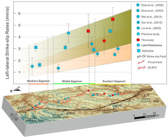
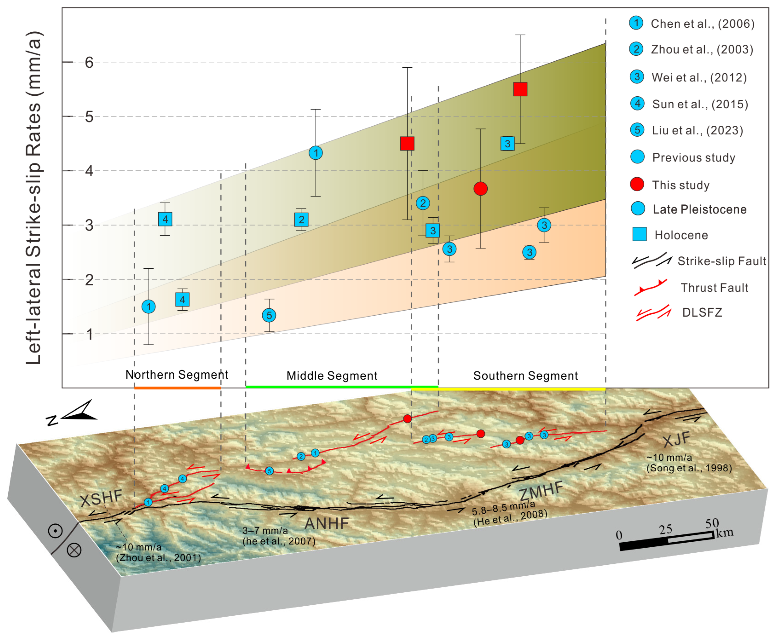
The temporal evolution patterns and spatial distribution characteristics of left-lateral slip rates along the DLSFZ, as comprehensively revealed by this study and all previous research, carry significant and far-reaching tectonic implications for understanding the regional geodynamic framework. First, from a temporal perspective, although slip rate values vary among different sites and time intervals, a comprehensive synthesis of data from multiple sites consistently suggests an overall increasing trend in the left-lateral slip rate of the fault zone from the Late Pleistocene to the Holocene (see the orange and green gradient boxes in Figure 12). For example, on the northern segment of the Puxiong Fault, the slip rate since the Late Pleistocene (since ~22 ka) is approximately 4.3 mm/a, while Holocene slip rates (e.g., ~3.1 mm/a since ~9.11 ka at the Qukedi site on the Puxiong Fault, up to 4.5 mm/a since ~2.33 ka at the Wuke site on the Jiaojihe Fault, and notably 5.5 mm/a since ~1.42 ka at the Damuluo site in this study) all indicate a higher level of tectonic activity. This apparent increasing trend observed over shorter time scales may indicate a continuous and sustained intensification of the regional tectonic stress field borne by the DLSFZ since the late Quaternary, especially during the Holocene epoch. Its structural role as a crucial channel that accommodates southeastward extrusion of the SYB has become increasingly important and prominent. This phenomenon is likely related to systematic adjustments in strain partitioning patterns within the XXFS, whereby a larger proportion of left-lateral shear strain has been gradually transferred to the relatively young DLSFZ, reflecting the non-steady state and phased intensification of overall regional tectonic activity. Naturally, such comparisons must be treated with sufficient caution because slip rates derived from shorter time scales may include strong fluctuations caused by the strain accumulation and release processes inherent to the earthquake cycle. Nevertheless, the consistent increasing trend observed across multiple independent sites strongly supports its real tectonic significance.
Figure 12.
The map showing the distribution of geological slip rates of the DLSFZ and its nearby faults. The blue circles and squares show the locations of slip rate research sites from previous studies, and the red circles and squares show the locations of slip rate research sites from this study [18,22,23,24,25,38,58,60,61]. The circles represent the slip rates of the late Pleistocene; the squares represent the slip rates of the Holocene. Abbreviations: DLSFZ: Daliangshan Fault Zone; XSHF: Xianshuihe Fault; ANHF: Anninghe Fault; ZMHF: Zemuhe Fault; XJF: Xiaojiang Fault.
Second, from a spatial distribution perspective, the left-lateral slip rates of the DLSFZ show strong and significant heterogeneity, which is closely related to the along-strike segmentation and structural complexity of the entire fault zone (Figure 12). The Zhuma Fault in the northern segment shows relatively low and highly variable slip rates (1.5–3.1 mm/a), which may reflect its structural position at the northward termination of the fault zone, where tectonic transformation is not fully concentrated, or the strong influence of strain partitioning with adjacent structures such as the ANHF. More importantly, the Yuexi Fault in the middle segment is characterized by dominant thrust motion with only a minor left-lateral strike-slip component (~1.36 mm/a), forming a key transition node in the spatial distribution of slip rates along the entire fault zone. This drastic transition in structural style (from strike-slip dominated to thrust-dominated) strongly suggests that the eastward extrusion of the SYB encounters significant mechanical resistance at this position, which is most likely related to the strong constraint imposed by the rigid crystalline basement of the SB, causing a large portion of horizontal motion to be converted into crustal shortening and vertical uplift. Such a profound kinematic transformation necessarily requires significant adjustments in the slip rates of strike-slip faults to the north and south to accommodate the overall block motion. As a direct consequence, we observe consistently higher slip rates, reaching 3–5.5 mm/a, along the entire southern segment, including the Butuo Fault, Jiaojihe Fault, and the three study sites measured in this work. This overall spatial pattern of “higher rates in the south, lower rates in the north, and a transitional zone in the middle” clearly demonstrates that the DLSFZ is not a simple and uniformly active structure but a dynamically evolving and complex deformation system. Within this system, the thrust-dominated structure of the Yuexi Fault acts as a vital strain regulator, which effectively converts horizontal slip motion into vertical crustal movement and further causes the southern segment of the fault zone to become the primary domain that absorbs and accommodates most of the sinistral shear strain. The strong strain localization in the southern segment can be directly attributed to the strong obstruction effect of the rigid SB, which significantly limits the eastward extrusion of the SYB. As a direct result, regional tectonic strain is gradually partitioned and transferred southward, leading to significantly higher slip rates and more concentrated crustal deformation along the southern segment of the DLSFZ.
The potential increasing trend of sinistral slip rates on the DLSFZ from the late Pleistocene to the Holocene, and its strongly heterogeneous spatial distribution characterized by higher rates in the south, lower rates in the north, and a central thrust-dominated transitional segment, together reveal its dynamic evolutionary history and critical structural role within the modern tectonic framework of the southeastern margin of the TP. The temporal and spatial variations in slip rates are not only a direct response to the progressive intensification of the regional stress field and continuous adjustments in strain partitioning, but also profoundly reflect the complex mechanical mechanism by which strain coordination is achieved through fault segmentation and strain localization under the strong obstruction of southeastward extrusion of the SYB, particularly across its middle segment. The DLSFZ, especially its highly active southern segment with high slip rates, is increasingly becoming an indispensable secondary structure that regulates southeastward extrusion of plateau materials. Its long-term activity is of paramount importance for understanding the coordinated deformation behavior of the entire XXFS and for assessing regional seismic hazards in southeastern Tibet.
6. Conclusions
In this study, UAV stereophotogrammetry was applied to generate high-resolution DEM spanning the middle and southern segments of the DLSFZ and LaDiCaoz_v2.2 software was used to measure the left-lateral strike-slip displacement. Based on this, we calculated the late Quaternary left-lateral strike-slip rates for three sites along the middle and southern segments of the DLSFZ. The main conclusions are thus summarized:
- The slip rates of these three sites are 4.5 ± 1.4 mm/a since the Holocene at Tekoujiagu, 3.7 ± 1.1 mm/a since the Late Pleistocene at Yeer, and 5.5 ± 1.0 mm/a since the Holocene at Damuluo, respectively.
- Integrating previous research with our findings, the slip rates of the DLSFZ exhibit a unique spatial pattern of “higher rates in the south, lower rates in the north, and a transitional segment in the central part”. The northern and southern segments are dominated by strike-slip motion, with the southern segment showing relatively higher rates (reaching 3–5.5 mm/a), while the Yuexi Fault in the middle segment acts as a tectonic transition node characterized mainly by thrust motion with a minor strike-slip component (~1.36 mm/a).
- Temporally, data from multiple sites suggest a potential increasing trend in slip rates from the Late Pleistocene to the Holocene. Collectively, these characteristics indicate that the DLSFZ is not a simple structure with uniform activity but rather a complex deforming system actively evolving and regulating key strain partitioning on the southeastern margin of the TP.
- The thrust-related structure in the middle segment indicates that the eastward extrusion of the SYB is obstructed by the rigid SB basement, resulting in strain partitioning and kinematic transformation. Most sinistral shear strain is thus transferred southward, leading to concentrated deformation and higher slip rates in the southern segment.
- These segmental differences in slip rate and faulting style demonstrate that the DLSFZ constitutes a key active deformation system that accommodates strain partitioning and regulates southeastward extrusion of the TP within the regional fault system.
Author Contributions
Conceptualization: S.G.; Data Curation: S.G.; Formal Analysis: S.G.; Funding Acquisition: Z.W. and H.H.; Investigation: S.G., Z.W., X.X., D.Z., Y.D., and C.M.; Methodology: S.G., D.Z., and Z.W.; Project Administration: Z.W.; Resources: S.G. and X.X.; Software: S.G., C.M., and Y.D.; Supervision: Z.W. and H.H.; Visualization: S.G., Z.W. and H.H.; Writing—Original Draft: S.G.; Writing—Review and Editing: S.G., Z.W. and H.H. All authors have read and agreed to the published version of the manuscript.
Funding
This study was funded by the National Natural Science Foundation of China (grant number 42472289) and the National Key Research and Development Program of China (grant number 2021YFC3000601).
Data Availability Statement
The original contributions presented in this study are included in the article. Further inquiries can be directed to the corresponding author.
Acknowledgments
The authors are grateful for the help provided by Wenxing Yi and Pengfei Niu of the Institute of Geology, China Earthquake Administration.
Conflicts of Interest
The authors declare no conflicts of interest.
Abbreviations
The following abbreviations are used in this manuscript:
| TP | Tibetan Plateau |
| SYB | Sichuan–Yunnan Block |
| BHB | Bayan Har Block |
| QB | Qaidam Basin |
| NCB | North China Block |
| SCB | South China Block |
| SB | Sichuan Basin |
| XSHF | Xianshuihe Fault |
| XJF | Xiaojiang Fault |
| ANHF | Anninghe Fault |
| ZMHF | Zemuhe Fault |
| DLSFZ | Daliangshan Fault Zone |
| XXFS | Xianshuihe–Xiaojiang Fault System |
References
- Li, P. The Xianshuihe-Xiaojiang Fault Zone; Seismological Press: Beijing, China, 1993. (In Chinese) [Google Scholar]
- Deng, Q.D.; Zhang, P.Z.; Ran, Y.K.; Yang, X.P.; Min, W.; Chu, Q.Z. Basic characteristics of active tectonics of China. Sci. China Ser. D Earth Sci. 2002, 46, 356–372. [Google Scholar] [CrossRef] [Scilit]
- Zhang, P.Z.; Deng, Q.D.; Zhang, G.M.; Ma, J.; Gan, W.J.; Min, W.; Mao, F.Y.; Wang, Q. Active tectonic blocks and strong earthquakes in the continent of China. Sci. China Ser. D Earth Sci. 2003, 46, 13–24. [Google Scholar] [CrossRef] [Scilit]
- Royden, L.H.; Burchfiel, B.C.; King, R.W.; Wang, E.; Chen, Z.; Shen, F.; Liu, Y. Surface deformation and lower crustal flow in eastern Tibet. Science 1997, 276, 788–790. [Google Scholar] [CrossRef] [Scilit] [PubMed]
- Clark, M.K.; Royden, L.H. Topographic ooze: Building the eastern margin of Tibet by lower crustal flow. Geology 2000, 28, 703–706. [Google Scholar] [CrossRef] [Scilit]
- Burchfiel, B.C. New technology; New geological challenges. GSA Today 2004, 14, 4–10. [Google Scholar] [CrossRef] [Scilit]
- Zhang, P.Z.; Shen, Z.K.; Wang, M.; Gan, W.J.; Burgmann, R.; Molnar, P.; Wang, Q.; Niu, Z.J.; Sun, J.Z.; Wu, J.C.; et al. Continuous deformation of the Tibetan Plateau from global positioning system data. Geology 2004, 32, 809–812. [Google Scholar] [CrossRef] [Scilit]
- Chen, G.H.; Xu, X.W.; Wen, X.Z.; Wang, Y.L. Kinematical transformation and slip partitioning of northern to eastern active boundary belt of Sichuan-Yunnan block. Seismol. Geol. 2008, 30, 58–85, (In Chinese with English abstract). [Google Scholar]
- Wang, Y.Z.; Wang, E.N.; Shen, Z.K.; Wang, M.; Gan, W.J.; Qiao, X.J.; Meng, G.J.; Li, T.M.; Tao, W.; Yang, Y.L. GPS-constrained inversion of present-day slip rates along major faults of the Sichuan-Yunnan region, China. Sci. China Ser. D-Earth Sci. 2008, 38, 582–597. [Google Scholar] [CrossRef] [Scilit]
- Zhang, P.Z. The tectonic deformation, strain distribution and deep dynamic processes in the eastern margin of Qinghai-Tibetan plateau. Sci. China Ser. D-Earth Sci. 2008, 38, 1041–1056. (In Chinese) [Google Scholar] [CrossRef]
- Gan, W.J.; Zhang, P.Z.; Shen, Z.K.; Niu, Z.J.; Wang, M.; Wan, Y.G.; Zhou, D.M.; Cheng, J. Present-day crustal motion within the Tibetan Plateau inferred from GPS measurements. J. Geophys. Res. 2007, 112, B08416. [Google Scholar] [CrossRef] [Scilit]
- Zhang, P.Z. A review on active tectonics and deep crustal processes of the Western Sichuan region, eastern margin of the Tibetan Plateau. Tectonophysics 2013, 584, 7–22. [Google Scholar] [CrossRef] [Scilit]
- He, H.L.; Ran, H.L.; Ikeda, Y. Uniform Strike-Slip Rate along the Xianshuihe-Xiaojiang Fault System and Its Implications for Active Tectonics in Southeastern Tibet. Acta Geol. Sin. 2006, 80, 376–386. [Google Scholar]
- Zhang, L.; Su, J.; Wang, W.L.; Fang, L.H.; Wu, J.P. Deep fault slip characteristics in the Xianshuihe-Anninghe-Daliangshan Fault junction region (eastern Tibet) revealed by repeating micro-earthquakes. J. Asian Earth Sci. 2022, 227, 105115. [Google Scholar] [CrossRef] [Scilit]
- Zhang, P.Z.; Deng, Q.D.; Zhang, Z.Q.; Li, H.B. Active faults, earthquake hazards and associated geodynamic processes in continental China. Sci. Sin. Terra 2013, 43, 1607–1620. (In Chinese) [Google Scholar] [CrossRef] [Scilit]
- Zhang, P.Z.; Engdahl, E.R. Great earthquakes in the 21st century and geodynamics of the Tibetan Plateau. Tectonophysics 2013, 584, 809–812. [Google Scholar] [CrossRef] [Scilit]
- Department of Earthquake Disaster Prevention, China Earthquake Administration. Catalogue of Chinese Earthquakes (1912–1990, Ms ≥ 4.7); China Science and Technology Press: Beijing, China, 1999; pp. 227–228. (In Chinese) [Google Scholar]
- Chen, G.H. Structural Transformation and Strain Partitioning Along the Northeast Boundary Belt of the Sichuan-Yunnan Block; Institute of Geology, CEA: Beijing, China, 2006. (In Chinese) [Google Scholar]
- Wen, X.Z.; Ma, S.L.; Xu, X.W.; He, Y.N. Historical pattern and behavior of earthquake ruptures along the eastern boundary of the Sichuan-Yunnan faulted-block, southwestern China. Phys. Earth Planet. Inter. 2008, 168, 16–36. [Google Scholar] [CrossRef] [Scilit]
- Feng, J.H.; Chen, L.C.; Wang, H.; Liu, J.; Han, M.M.; Li, Y.B.; Gao, S.P.; Lu, L.L. Paleoseismologic study on the Shimian Fault in the southern section of the Daliangshan Fault Zone. Seismol. Geol. 2021, 43, 53–71, (In Chinese with English abstract). [Google Scholar] [CrossRef]
- Geng, S.; Wei, Z.Y.; Xi, X.; Deng, Y.T.; He, H.L. Distribution of Strike-Slip Displacement in the Middle and Southern Segments of the Daliangshan Fault Zone and Its Implication for Fault Rupturing Behavior. Lithosphere 2025, 2025, lithosphere_2025_103. [Google Scholar] [CrossRef] [Scilit]
- He, H.L.; Ikeda, Y.; He, Y.L. Newly-generated Daliangshan fault zone-Shortcutting on the central section of Xianshuihe-Xiaojiang fault system. Sci. China Ser. D Earth Sci. 2008, 51, 1248–1258. [Google Scholar] [CrossRef] [Scilit]
- Sun, H.Y.; He, H.L.; Wei, Z.Y.; Gao, W. Late Quaternary activity of Zhuma Fault on the north segment of Daliangshan fault zone. Seismol. Geol. 2015, 37, 440–454, (In Chinese with English abstract). [Google Scholar] [CrossRef]
- Wei, Z.Y.; He, H.L.; Shi, F.; Xu, Y.R.; Bi, L.S.; Sun, H.Y. Slip rate on the south segment of Daliangshan fault zone. Seismol. Geol. 2012, 34, 282–293, (In Chinese with English abstract). [Google Scholar] [CrossRef]
- Zhou, R.J.; Li, X.G.Z.; Huang, Z.Z.; He, Y.L.; Ge, T.Y. Average slip rate of Daliang Mountain fault zone in Sichuan in late Quaternary period. J. Seismol. Res. 2003, 26, 191–196. (In Chinese) [Google Scholar] [CrossRef]
- Shen, X.H.; Chen, Z.W.; Xu, R.D.; Zhang, N. Deformation characteristics and displacement amount of the Liangshan active fault zone in late Cenozoic era. Seismol. Geol. 2000, 22, 232–238, (In Chinese with English abstract). [Google Scholar] [CrossRef]
- Deng, Q.D.; Wu, D.N.; Zhang, P.Z.; Chen, S.F. Structure and deformational character of strike-slip fault zones. Pure Appl. Geophys. 1986, 124, 203–223. [Google Scholar] [CrossRef] [Scilit]
- Diao, F.Q.; Xiong, X.; Wang, R.J.; Walter, T.R.; Wang, Y.B.; Wang, K. Slip rate variation along the Kunlun Fault (Tibet): Results from new GPS observations and a viscoelastic earthquake-cycle deformation Model. Geophys. Res. Lett. 2019, 46, 2524–2533. [Google Scholar] [CrossRef] [Scilit]
- Frankel, K.L.; Dolan, J.F.; Finkel, R.C.; Owen, L.A.; Hoeft, J.S. Spatial variations in slip rate along the Death Valley-Fish Lake Valley fault system determined from LiDAR topographic data and cosmogenic 10Be geochronology. Geophys. Res. Lett. 2007, 34, L18303. [Google Scholar] [CrossRef] [Scilit]
- Frankel, K.L.; Dolan, J.F.; Owen, L.A.; Ganev, P.; Finkel, R.C. Spatial and temporal constancy of seismic strain release along an evolving segment of the Pacific–North America plate boundary. Earth Planet. Sci. Lett. 2011, 304, 565–576. [Google Scholar] [CrossRef] [Scilit]
- Wesnousky, S.G. Seismological and structural evolution of strike-slip faults. Nature 1988, 335, 340–343. [Google Scholar] [CrossRef] [Scilit]
- Zhang, P. Beware of slowly slipping faults. Nat. Geosci. 2013, 6, 323–324. [Google Scholar] [CrossRef] [Scilit]
- Chevalier, M.L.; Leloup, P.H.; Replumaz, A.; Pan, J.W.; Métois, M.; Li, H.B. Temporally constant slip rate along the Ganzi fault, NW Xianshuihe fault system, eastern Tibet. GSA Bull. 2017, 130, 396–410. [Google Scholar] [CrossRef] [Scilit]
- Hu, Z.K.; Yang, X.P.; Yang, H.B.; Huang, W.L.; Wu, G.D.; Miao, S.Q.; Zhang, L. Slip rate and paleoseismology of the Bolokenu-Aqikekuduk (Dzhungarian) right-lateral strike-slip fault in the northern Tian Shan, NW China. Tectonics 2021, 40, e2020TC006604. [Google Scholar] [CrossRef] [Scilit]
- Bai, M.K.; Chevalier, M.L.; Leloup, P.H.; Li, H.B.; Pan, J.W.; Replumaz, A.; Wang, S.G.; Li, K.Y.; Wu, Q.; Liu, F.C.; et al. Spatial slip rate distribution along the SE Xianshuihe fault, eastern Tibet, and earthquake hazard assessment. Tectonics 2021, 40, e2021TC006985. [Google Scholar] [CrossRef] [Scilit]
- Wang, E.; Burchfiel, B.C.; Royden, L.H.; Chen, L.Z.; Chen, J.S.; Li, W.X.; Chen, Z.L. Late Cenozoic Xianshuihe-Xiaojiang, Red River, and Dali Fault Systems of Southwestern Sichuan and Central Yunnan, China; Geological Society of America: Boulder, CO, USA, 1998; Special Paper 327; pp. 1–108. [Google Scholar] [CrossRef] [Scilit]
- Song, F.M.; Li, R.C.; Xu, X.W. Preliminary results of the investigation of paleo-earthquakes along the Daliangshan Fault Zone, Sichuan Province, China. Seismol. Geol. 2002, 24, 27–34, (In Chinese with English abstract). [Google Scholar] [CrossRef]
- He, H.L.; Oguchi, T. Late Quaternary activity of the Zemuhe and Xiaojiang faults in southwest China from geomorphological mapping. Geomorphology 2007, 96, 62–85. [Google Scholar] [CrossRef] [Scilit]
- Feng, T.; Wang, R.J.; Fang, L.H.; Wu, J.P.; Yang, T. Microseismic constraints on the mechanical state of the Anninghe-Daliangshan fault zone, southeastern Tibetan Plateau. Earth Planet. Sci. Lett. 2024, 639, 118765. [Google Scholar] [CrossRef] [Scilit]
- Sun, H.Y.; He, H.L.; Ikeda, Y.; Wei, Z.Y.; Chen, C.Y.; Xu, Y.R.; Shi, F.; Bi, L.S.; Shirahama, Y.; Okada, S.; et al. Paleoearthquake history along the southern segment of the Daliangshan fault zone in the southeastern Tibetan plateau. Tectonics 2019, 38, 2208–2231. [Google Scholar] [CrossRef] [Scilit]
- Sun, W. Response of Tectono-Geomorphic Parameters to Time: A Case Study of the Northwest Segment of Xianshuihe Fault; Institute of Geology, CEA: Beijing, China, 2022. (In Chinese) [Google Scholar]
- Tan, X.; Liang, K.; Ma, B.Q. A summary of research on the late Quaternary activities of Xiaojiang fault zone. Technol. Earthq. Disaster Prev. 2023, 18, 757–772, (In Chinese with English abstract). [Google Scholar] [CrossRef]
- Rui, X.; Stamps, D.S. Strain accommodation in the Daliangshan Mountain area, southeastern margin of the Tibetan Plateau. J. Geophys. Res. Solid Earth 2019, 124, 9816–9832. [Google Scholar] [CrossRef] [Scilit]
- Feng, J.H. Study on the Paleoearthquake and Earthquake Risk in the Main Faults Near Shimian; Institute of Geology, CEA: Beijing, China, 2020. (In Chinese) [Google Scholar]
- Wang, H.; Li, D.M.; Li, K.J.; Deng, L.; Luo, P.S. Late Quaternary Fault Activity of the Southern Segment of the Daliangshan Fault along the Southeastern Margin of the Tibetan Plateau and Its Implications for Fault Rupture Behaviour at Stepovers. Lithosphere 2022, 2022, 9259647. [Google Scholar] [CrossRef] [Scilit]
- Chen, T.; Liu-Zeng, J.; Shao, Y.X.; Zhang, P.Z.; Oskin, M.E.; Lei, Q.Y.; Li, Z.F. Geomorphic offsets along the creeping Laohu Shan section of the Haiyuan fault, northern Tibetan Plateau. Geosphere 2018, 14, 1165–1186. [Google Scholar] [CrossRef] [Scilit]
- Ren, Z.K.; Zhang, P.Z.; Oguchi, T.; He, Z.T. Remote Sensing Perspectives on Geomorphology and Tectonic Processes. Remote Sens. 2023, 15, 2327. [Google Scholar] [CrossRef] [Scilit]
- Liu, J.R.; Ren, Z.K.; Min, W.; Ha, G.H.; Lei, J.H. The advance in obtaining fault slip rate of strike slip fault-A review. Earthq. Res. Adv. 2021, 1, 100032. [Google Scholar] [CrossRef] [Scilit]
- Zielke, O.; Arrowsmith, J.R.; Ludwig, L.G.; Akciz, S.O. High-Resolution Topography-Derived Offsets along the 1857 Fort Tejon Earthquake Rupture Trace, San Andreas Fault. Bull. Seismol. Soc. Am. 2012, 102, 1135–1154. [Google Scholar] [CrossRef] [Scilit]
- Kang, W.J.; Xu, X.W.; Oskin, M.E.; Yu, G.H.; Luo, J.H.; Chen, G.H.; Luo, H.; Sun, X.Z.; Wu, X.Y. Characteristic slip distribution and earthquake recurrence along the eastern Altyn Tagh fault revealed by high-resolution topographic data. Geosphere 2020, 16, 392–406. [Google Scholar] [CrossRef] [Scilit]
- Stewart, N.; Gaudemer, Y.; Manighetti, I.; Serreau, L.; Vincendeau, A.; Dominguez, S.; Mattéo, L.; Malavieille, J. “3D_Fault_Offsets”, a Matlab Code to Automatically Measure Lateral and Vertical Fault Offsets in Topographic Data: Application to San Andreas, Owens Valley, and Hope Faults. J. Geophys. Res. Solid Earth 2018, 123, 815–835. [Google Scholar] [CrossRef] [Scilit]
- Zielke, O.; Arrowsmith, J.R. LaDiCaoz and LiDAR imager-MATLAB GUIs for LiDAR data handling and lateral displacement measurement. Geosphere 2012, 8, 206–221. [Google Scholar] [CrossRef]
- Sun, K.; Li, C.Y.; Liang, M.I.; Li, X.N.; Luo, Q.X.; Ren, G.X.; Huang, F.P.; Li, J.J. Spatial Variations of Late Quaternary Slip Rates along the Ganzi–Xianshuihe Fault Zone in the Eastern Tibet. Remote Sens. 2024, 16, 2612. [Google Scholar] [CrossRef] [Scilit]
- Zhou, R.J.; Ma, S.H.; Cai, C.X. Late Quaternary Active Features of the Ganzi-Yushu Fault Zone. Earthq. Res. China 1996, 12, 250–260. (In Chinese) [Google Scholar]
- Chen, Y.W.; Li, S.H.; Sun, J.M.; Fu, B.H. OSL dating of offset streams across the Altyn Tagh Fault: Channel deflection, loess deposition and implication for the slip rate. Tectonophysics 2013, 594, 182–194. [Google Scholar] [CrossRef] [Scilit]
- Shi, F.; He, H.L.; Densmore, A.L.; Li, A.; Yang, X.P.; Xu, X.W. Active tectonics of the Ganzi–Yushu fault in the southeastern Tibetan Plateau. Tectonophysics 2016, 676, 112–124. [Google Scholar] [CrossRef] [Scilit]
- Zhang, K.Q.; Wu, Z.H.; Lv, T.Y.; Feng, H. Review and progress of OSL dating. Geol. Bull. China 2015, 34, 183–203. (In Chinese) [Google Scholar] [CrossRef]
- Liu, Q.; Liu, S.; Zhang, S.M. Paleoseismologic study on the Yuexi Fault in the midsection of the Daliangshan fault zone since the Late Quaternary. Seismol. Geol. 2023, 45, 321–337, (In Chinese with English abstract). [Google Scholar] [CrossRef]
- Shen, Z.K.; Lu, J.N.; Wang, M.; Bürgmann, R. Contemporary crustal deformation around the southeast borderland of the Tibetan Plateau. J. Geophys. Res. 2005, 110, B11409. [Google Scholar] [CrossRef] [Scilit]
- Song, F.M.; Wang, Y.P.; Yu, W.X. Xiaojiang Active Fault Zone; Seismological Press: Beijing, China, 1998. (In Chinese) [Google Scholar]
- Zhou, R.J.; He, Y.L.; Huang, Z.Z.; Li, X.G.; Yang, T. The slip rate and strong earthquake recurrence intervals of the Qianning-Kangding segment of the Xianshuihe Fault zone. Acta Seismol. Sin. 2001, 23, 250–261. (In Chinese) [Google Scholar] [CrossRef] [Scilit]

Disclaimer/Publisher’s Note: The statements, opinions and data contained in all publications are solely those of the individual author(s) and contributor(s) and not of MDPI and/or the editor(s). MDPI and/or the editor(s) disclaim responsibility for any injury to people or property resulting from any ideas, methods, instructions or products referred to in the content. |
© 2026 by the authors. Licensee MDPI, Basel, Switzerland. This article is an open access article distributed under the terms and conditions of the Creative Commons Attribution (CC BY) license.