


Abstract
Tusi settlements in the Gyalrong Tibetan region of China developed within complex high-mountain gorge environments, where settlement construction, territorial control, and military defense were closely intertwined. However, existing studies have largely examined individual Tusi manors, watchtowers, or geographical settings in isolation, leaving the relationships between environmental conditions, site selection, and defensive spatial organization insufficiently understood. To address this gap, this study develops an integrated multiscale analytical framework linking regional environmental context, local terrain selection, and settlement defensive spatial organization. Drawing on a historical and geographical database of 58 Tusi settlements from the Ming and Qing dynasties and detailed spatial investigations of 12 cases, this study combines regional environmental clustering, neighborhood-based terrain comparisons, and defensive-element mapping to examine how these three spatial levels are related. The results identify four regional site-selection types reflecting differentiated combinations of elevation, slope, and river proximity. Despite these environmental differences, 63.8% of the settlements occupy locally less rugged and gentler terrain, while 62.1% are situated in areas characterized by relatively high flow accumulation. These findings indicate that settlement locations generally balanced construction suitability with access to surrounding terrain features that could provide defensive advantages. At the settlement scale, four major defensive spatial patterns were identified in relation to site-selection environments, revealing how Tusi manors, watchtowers, access routes, and natural barriers were spatially integrated under different topographic conditions. The central finding is that defensive spatial organization did not rely solely on occupying strategically elevated terrain or constructing isolated fortifications, but emerged from the spatial integration of relatively suitable settlement cores, surrounding terrain barriers, and strategically positioned defensive elements. By connecting regional environmental constraints with local siting decisions and settlement-scale spatial organization, this study provides an integrated explanation of the defensive landscapes of Gyalrong Tusi settlements and a spatial basis for their holistic conservation.
1. Introduction
Settlements in historically contested mountain regions often combined residential and productive functions with administration and defense. Their spatial organization depended on both built defensive facilities, such as fortified compounds and watchtowers, and the strategic use of mountains, rivers, cliffs, and mountain passes [1]. The Gyalrong Tibetan region, located in the northern Hengduan Mountains between the Tibetan Plateau and the western Sichuan Basin, is characterized by deeply incised valleys, steep slopes, and fragmented mountain basins [2]. During the Ming and Qing dynasties, the Tusi system incorporated local hereditary rulers into the imperial administrative structure while allowing substantial autonomy in local governance. Under this political arrangement, Tusi settlements served as centers of residence, administration, taxation, resource organization, and military defense [3,4,5,6,7]. Accommodating these functions within a complex mountain environment required careful consideration of settlement location and spatial organization. Understanding Gyalrong Tusi settlements thus calls for examining the relationships among administrative centers, defensive structures, circulation routes, and the surrounding landscape.
A substantial body of scholarship has examined defensive settlements, traditional settlements in Tibetan regions, and Tusi heritage. This literature can be broadly grouped into three strands: (1) spatial research on ancient defensive settlements and military heritage; (2) research on traditional settlements in Tibetan and high-mountain regions, with particular attention to environmental adaptation and settlement morphology; (3) research on the Tusi system, Tusi architecture, and heritage conservation, which primarily addresses political order and its material manifestations.
First, research on ancient defensive settlements and military heritage has increasingly moved beyond the study of individual fortifications toward an understanding of defense as a spatial system composed of terrain, settlements, transport routes, and military facilities [1]. Existing studies have demonstrated this systemic character from several perspectives. Research on fortified settlements in the Fen River Basin showed that different geographical conditions were associated with differentiated defensive patterns [8], while studies of Tang-period military sites in Aksu highlighted the role of visibility and communication networks in organizing regional defense [9]. Investigations of fortified towns along the Ming Great Wall further linked settlement siting and hierarchy to resource supply, transport organization, and territorial control [10,11]. At a more localized scale, research on Moluo Watchtower Village revealed coordinated relationships among communal towers, household towers, and village space [12], whereas studies in Shaanxi and Qinghai demonstrated clustered and hierarchical defensive organization across broader regional networks [13,14], while recent research on Ming coastal defense garrisons in Wenzhou has extended quantitative analysis to the morphological transformation and integrated conservation of historical defensive settlements [15]. Together, these studies show that defensive settlements cannot be understood through individual structures alone, but must be interpreted through the spatial relationships among terrain, access, settlement organization, and defensive facilities. However, most of these cases concern defensive systems established through centralized state planning or coordinated across multiple settlements. The Gyalrong Tusi domains differed in that they were relatively autonomous political units, and defensive organization was typically centered on individual administrative seats and their immediate environments. It therefore remains unclear how settlement siting, local terrain, and constructed defenses were integrated under such politically fragmented conditions.
Second, studies of traditional settlements in Tibetan and high-mountain regions have extensively examined how natural environments, production systems, and regional cultures shape settlement distribution and morphology. Research on Tibetan cultural landscapes has identified clear spatial differentiation and regional typologies [16,17,18]. The growing use of GIS-based methods has further enabled quantitative analysis of the relationships between settlement patterns and factors such as elevation, slope, hydrology, roads, agricultural resources, and historical routes [19,20,21,22,23], while recent cross-scale research has further revealed how environmental adaptation operates across regional, settlement, and architectural scales [24]. Studies conducted across different regions of China also show that traditional village distribution reflects the combined influence of terrain, hydrology, production systems, population movement, and local culture [25,26,27,28]. Similar relationships with elevation, slope, water proximity, accessibility, and sociocultural conditions have been observed in the Gyalrong Tibetan region [4]. Most of this work, however, concerns ordinary mountain settlements and explains site selection mainly in terms of residential suitability, livelihood needs, hazard avoidance, and access to resources. Tusi settlements operated under a different set of spatial demands because they also served administrative, territorial, and military functions. In these settings, terrain shaped construction and subsistence conditions while also influencing surveillance, movement, access control, and the use of natural barriers. This makes it necessary to examine how local terrain selection responded to the combined demands of settlement construction, governance, and defense.
Third, studies of the Tusi system, Tusi architecture, and related heritage have mainly approached Gyalrong Tusi settlements from historical, institutional, architectural, and conservation perspectives. Historical and ethnological research has examined the evolution of the Tusi system, political and religious relations, administrative structures, and interactions between local Tusi authorities and the Qing state [5]. Historical ethnography and visual records have provided important evidence for reconstructing Tusi manors and associated settlement settings, while architectural studies have focused on the form, functional organization, and multifunctional character of Tusi manors [3]. Heritage surveys have documented the preservation status of Tusi sites and the need for integrated conservation, and recent inscription studies have further clarified issues of territorial demarcation and local political interaction [29]. These studies have substantially improved understanding of the institutional and material characteristics of the Tusi system. However, they have tended to examine political institutions, individual buildings, and heritage remains as separate subjects. The spatial expression of Tusi authority at the settlement level therefore remains insufficiently understood.
Overall, existing research has provided substantial knowledge of defensive systems, environmental adaptation in mountain settlements, and the institutional and architectural characteristics of the Tusi system. What remains insufficiently understood is how these dimensions were connected spatially in Gyalrong Tusi settlements. In particular, few studies have examined how broader environmental conditions shaped local terrain choices and how those choices, in turn, were reflected in the organization of settlement space and defensive elements. This gap limits a systematic understanding of Tusi settlements as integrated spatial systems rather than as separate manors, watchtowers, or terrain settings. Accordingly, this study develops a multiscale framework that links regional environmental context, local terrain selection, and settlement defensive organization.
Accordingly, this study defines a Gyalrong Tusi settlement as a settlement unit established or used by a Tusi polity during the Ming–Qing period and serving administrative, residential, resource-organizing, and territorial functions, with close spatial relationships to surrounding defensive facilities and natural terrain. To examine these settlements across multiple spatial scales, we compiled a historical and geographical database of 58 cases using official cultural-heritage records, local gazetteers, Tibetan-language archives, historical maps and photographs, remote-sensing imagery, and field-survey data. Twelve settlements with relatively complete remains and spatial information were selected for detailed analysis. At the regional scale, elevation, slope, and river proximity were used to identify major site-selection patterns. At the local scale, settlement areas were compared with their surrounding terrain to examine relative choices in relief, slope, and hydrological conditions. At the settlement scale, the spatial relationships among Tusi manors, watchtowers, roads, bridges, passes, and the surrounding landscape were analyzed to identify the principal morphological patterns of defensive spatial organization. Together, these three levels of analysis were used to trace how regional environmental conditions were translated into local terrain choices and, subsequently, into settlement-scale defensive organization.
This study addresses three interrelated questions: (1) What regional siting patterns characterized Gyalrong Tusi settlements in high-mountain gorge environments? (2) How did individual settlements select local terrain in relation to construction suitability and defensive needs? (3) How were natural terrain and constructed defensive elements organized into different settlement defensive patterns? By addressing these questions, the study conceptualizes Gyalrong Tusi settlements as integrated spatial systems rather than as isolated architectural or defensive remains. This perspective contributes to the comparative understanding of mountain defensive settlements and supports the integrated conservation of Tusi cultural landscapes.
2. Materials and Methods
2.1. Study Area
The study area is located in the Gyalrong Tibetan region of western Sichuan, China, on the northeastern margin of the Hengduan Mountains and within the upper reaches of the Dadu and Minjiang River systems (see Figure 1). It encompasses the high-mountain gorge areas of present-day Aba Tibetan and Qiang Autonomous Prefecture, Garzê Tibetan Autonomous Prefecture, and parts of Ya’an, including Barkam, Jinchuan, Xiaojin, Danba, Kangding, Luding, Wenchuan, Li County, Baoxing, and Heishui. Geomorphologically, the region is characterized by deeply incised river valleys, steep slopes, narrow valley floors and terraces, and fragmented intermontane basins. Mountains, gorges, river terraces, and small alluvial basins occur in close succession, creating highly differentiated conditions for settlement construction. The location and spatial organization of settlements were therefore closely conditioned by terrain, water availability, arable land, transport corridors, and requirements for spatial control and defense.
Figure 1.
Study area. The main map, including the boundary of the Gyalrong Tibetan region, rivers, and Tusi settlement locations, was compiled by the authors based on historical records and geospatial analysis. The inset map showing the location of the study area within Sichuan Province was based on the Sichuan Provincial Platform for Common Geospatial Information Services (Tianditu Sichuan, https://sichuan.tianditu.gov.cn/ (accessed on 8 May 2026); official map approval number: Chuan S (2021) 00065).
Historically, the Gyalrong Tibetan region formed an important frontier zone shaped by long-term interaction among imperial governance, local hereditary authority, Tibetan Buddhism, and mountain communities. During the Ming and Qing dynasties, the central state incorporated local hereditary rulers through the Tusi system, a form of indirect governance widely employed in frontier ethnic regions. In Gyalrong, this system gradually gave rise to the political configuration commonly known as the “Eighteen Gyalrong Tusi,” comprising the domains of Mingzheng, Muping (Dongbu Hanhu), Badi, Bawang, Suomo, Wasi, Chuosijia, Geshizha, Zanla, Songgang, Zagu (including Ganbao Tun, Shangmengdong Tun, Xiamengdong Tun, and Jiuzi Tun), Wori (Ekeshi), Yutong, Lengbian, Shenbian, Dangba, Zhuokeji, and Cuqin. These domains were distributed across separate river valleys, mountain corridors, and intermontane basins. Although incorporated into the imperial administrative order through investiture and tribute obligations, individual Tusi authorities retained considerable autonomy in everyday governance, military organization, and local social affairs.
Within these domains, a Tusi authority typically established multiple manors, also referred to as guanzhai. The manor serving as the principal administrative, residential, and political center is referred to in this study as the principal manor, while other establishments are termed subsidiary manors and could perform functions related to local governance, garrisoning, temporary residence, or secondary accommodation [30]. The settlements associated with these manors are defined here as Tusi settlements. Spatially, the core of a Tusi settlement comprises the Tusi manor or administrative residence together with its associated residential cluster and other built spaces. Defensive facilities, including watchtowers, enclosure walls, passes, gatehouses, and fortified sites (such as fortified villages), are included when historical, field, or spatial evidence indicates a direct functional or spatial relationship with this core. Roads, bridges, ferry crossings, gullies, and surrounding mountains are treated as associated spatial elements. Operationally, a Tusi settlement is thus defined as a settlement-centered spatial system consisting of a built core, associated defensive facilities, and its surrounding environmental setting. This definition establishes the spatial unit used in the subsequent multiscale analysis.
2.2. Data Sources and Database Construction
A historical-geographical database of Ming–Qing Tusi settlements in the Gyalrong Tibetan region was constructed by integrating official cultural-heritage surveys, historical textual and visual sources, field-survey data, remote-sensing imagery, and contemporary geospatial datasets. Given that the geographical locations, historical functions, and physical remains of some settlements have changed substantially over time, no single source is sufficient to identify settlements accurately. The study therefore employed multi-source evidence triangulation to determine settlement names, historical functions, geographical locations, spatial boundaries, and defensive elements.
2.2.1. Settlement Inventory and Historical Sources
The baseline inventory of Tusi settlements was compiled primarily from official cultural-heritage surveys and local heritage archives, including the Atlas of Chinese Cultural Relics (2009), the results of the Third National Survey of Cultural Relics (2011), local working records generated during the Cultural Relics Census (2025), provincial and local cultural-heritage gazetteers, and relevant survey reports. These sources were used to establish settlement names, administrative locations, historical periods, types of surviving remains, and states of preservation.
Historical evidence included Tusi archives in Chinese and Tibetan, local gazetteers, historical maps, and old photographs. These materials were used to verify the historical identity, functions, and domain affiliation of each settlement. Historical maps and photographs were catalogued according to their date, location, and the reliability of the features depicted. They were then compared with contemporary field photographs, topographic characteristics, and surviving architectural remains to clarify the spatial relationships between historical buildings and the surrounding settlement.
2.2.2. Field Verification and Sample Selection
The research team conducted multiple field surveys across the Gyalrong Tibetan region between 2021 and 2025. These surveys verified settlement locations, historical names, spatial boundaries, defensive elements, and relationships with surrounding terrain and hydrological systems. Information on settlement history and defensive features was further corroborated through interviews with cultural-heritage administrators, religious figures, community elders, and local residents familiar with regional history.
A settlement was included in the regional-scale sample when it met all of the following criteria: (1) it was historically and directly associated with a Tusi polity and served as a Tusi residence, administrative or political center, garrison node, or secondary residence within the domain; (2) its historical identity and geographical location could be verified through field evidence, remote-sensing imagery, or at least two mutually supporting types of historical source; and (3) its positional accuracy was sufficient for GIS-based terrain and hydrological analysis. A total of 58 Tusi settlements were ultimately identified and used as the primary sample for analyzing regional site selection characteristics and local terrain conditions.
In addition, to compare the defensive spatial organization of Tusi settlements under different regional terrain conditions, three cases were selected from each of the four site-selection types, yielding 12 settlements for settlement-scale analysis (see Table 1). Selection was based on two criteria: (1) the surviving remains were sufficiently legible to identify the Tusi manor, associated residential areas, and major defensive facilities, with these spatial relationships verified through field investigation; and (2) historical and spatial records were sufficiently complete to reconstruct the relationships among the settlement core, defensive facilities, and surrounding terrain using historical documents, local gazetteers, cultural heritage survey records, and historical imagery. Low-altitude UAV photogrammetric surveys were conducted for all 12 settlements using a DJI M300 RTK platform to acquire oblique aerial imagery of the settlements and surrounding terrain.
Table 1.
Basic information of the 12 Tusi settlements.
2.2.3. Environmental and Geospatial Data
Regional and local terrain analyses primarily used a digital elevation model (DEM), river-network data, and remote-sensing imagery. Terrain information was derived from the 12.5-m ALOS PALSAR DEM. A recent accuracy assessment of the Tibetan Plateau found that this dataset more closely approximates actual terrain than 30-m DEM products and more effectively captures the ridge-and-gully relief characteristic of the Hengduan Mountains [31]. The DEM-derived indicators were employed to compare regional geographical settings and local terrain relationships rather than to reconstruct the precise topography of the Ming–Qing period. River-network data were obtained from the China Third-Level Watershed Spatial Distribution Dataset. Historical satellite imagery consisted of declassified KeyHole (KH) images from the 1960s and 1970s released by the United States Geological Survey (USGS). After georeferencing and orthorectification, these images were used to cross-validate pre-urbanization settlement patterns and corroborate former settlement boundaries, roads, towers, walls, and other landscape features. All spatial and attribute data were integrated into an ArcGIS 10.6 geodatabase to establish the historical-geographical database of Ming–Qing Tusi settlements in the Gyalrong Tibetan region.
2.3. Analytical Framework and Methods
2.3.1. Regional-Scale Analysis of Geographical Setting
The regional-scale analysis aimed to characterize the broad topographic and hydrological settings of Gyalrong Tusi settlements and to identify recurrent combinations among key environmental factors. The locations of the 58 settlements were spatially overlaid with DEM data, slope rasters, and the river network to extract three indicators. Elevation, slope, and distance to the nearest river, representing vertical position, surface inclination, and hydrological proximity, respectively [32]. These indicators characterize the environmental conditions at representative settlement locations rather than the mean terrain conditions across entire settlement areas. Descriptive statistics were first used to summarize their overall distributions, followed by univariate and correlation analyses. Gower distance and partitioning around medoids (PAM) clustering were then employed to identify recurring environmental combinations and derive an exploratory regional site-selection typology. Because elevation, slope, and distance to the nearest river differ in measurement units and value ranges, each variable was normalized by its observed range within the Gower distance framework before environmental dissimilarities among settlements were calculated. For settlements i and j, the standardized difference in variable k was calculated as
where xik and xjk are the observed values of environmental variable k for settlements i and j, respectively, and max(xk) − min(xk) is the range of that variable across all 58 settlements.
Elevation, slope, and distance to the nearest river were assigned equal weights because there was no a priori basis for giving greater importance to any single variable. The composite Gower distance between settlements i and j was therefore calculated as
where dijᴱ, dijS, and dijᵂ represent the standardized differences in elevation, slope, and distance to the nearest river, respectively. Dij ranges from 0 to 1, with values closer to 0 indicating greater similarity in environmental conditions and values closer to 1 indicating greater overall dissimilarity.
The resulting Gower distance matrix was then used as the input for partitioning around medoids (PAM) clustering. PAM identifies K representative settlements as medoids and assigns each settlement to its nearest medoid by minimizing the total within-cluster dissimilarity:
where n is the number of settlements, M is the set of K medoids, and Dim is the Gower distance between settlement i and medoid m. To determine the appropriate number of clusters, K was varied from 2 to 6, and each solution was evaluated using the average silhouette coefficient. A larger coefficient indicates greater similarity within clusters and stronger separation between clusters.
2.3.2. Local-Scale Analysis of Relative Terrain Selection
At the local scale, geographic grids were established to compare settlements with their surrounding environments, thereby assessing the relative position of each settlement within its local topographic and hydrological context. Unlike the regional-scale analysis, which extracted environmental indicators at representative settlement points, the local-scale analysis characterized terrain conditions across spatial units surrounding each settlement. In ArcGIS 10.6, a 2000 m × 2000 m square Tusi Settlement Unit (TSU) was constructed around each Tusi settlement point, with the settlement point at its geometric center. The central unit was denoted as TSU_C. Given the 12.5-m DEM resolution, each unit contains 160 × 160 grid cells. The unit size was determined through sensitivity analysis across a series of grid sizes (500 m × 500 m, 1000 m × 1000 m, 1500 m × 1500 m, 2000 m × 2000 m, …, 4000 m × 4000 m) to balance the spatial representation of settlement site selection with the comparison of local terrain conditions. The 2000 m scale was retained because it provided a balance between capturing the settlement and its immediately associated slopes, gullies, and hydrological features, while avoiding excessive incorporation of nonlocal terrain. Eight neighborhood units (NUs) of equal area were then established to the north (N), northeast (NE), east (E), southeast (SE), south (S), southwest (SW), west (W), and northwest (NW) of TSU_C. The nine mutually adjacent and nonoverlapping units (1 TSU + 8 NUs) form a regular 3 × 3 neighborhood framework covering 36 km2 of the surrounding high-mountain gorge environment. This design maintains a consistent spatial-statistical scale between the central and reference units and provides balanced directional coverage, thereby reducing biases associated with differences in reference-area size or orientation.
In addition to regional elevation and valley configuration, the precise location of each Tusi settlement is influenced by local surface relief, slope conditions, and hydrological-convergence structure. Three indicators, including terrain relief, mean slope, and flow accumulation, were therefore selected to represent local topographic complexity, slope-based construction conditions, and potential hydrological convergence, respectively [33,34].
Terrain relief was represented by root mean square height (RMSH) [35]. RMSH is calculated from the dispersion of elevation relative to the mean elevation within a local DEM neighborhood and reflects vertical relief and terrain complexity. Zonal statistics were then used to extract the mean RMSH of all raster cells within each analytical unit, as follows:
where Rij is the mean RMSH of analytical unit j for Tusi settlement i; Rk is the RMSH value of raster cell k within that unit; and nij is the number of valid cells. A higher Rij indicates stronger overall terrain relief and dissection, whereas a lower value indicates comparatively gentle terrain.
Mean slope was calculated across all valid slope-raster cells within each analytical unit to characterize overall slope conditions. Although both RMSH and mean slope represent terrain, the former emphasizes vertical relief and internal topographic complexity, whereas the latter describes overall steepness; the two indicators are therefore complementary. Mean slope is calculated as follows:
where Sij is the mean slope of analytical unit j for Tusi settlement i; Sk is the slope of valid raster cell k within that unit; and nij is the number of valid slope cells. Here, i identifies the settlement, j identifies its local analytical unit, and k identifies the raster cell. A larger Sij indicates steeper overall terrain, whereas a smaller value indicates gentler terrain.
Flow accumulation characterizes terrain-controlled potential water convergence and primarily reflects local hydro-topographic structure [36,37].To reduce the influence of a small number of cells with extremely high accumulation values on the unit mean, the raw flow-accumulation values were first natural-log transformed. The mean log-transformed flow accumulation (MLFA) was then calculated for each analytical unit as follows:
where Fij is the mean log-transformed flow accumulation of analytical unit j for Tusi settlement i; Fk is the raw flow-accumulation value (FlowAcc) of cell k within that unit; nij is the number of valid flow-accumulation cells; and ln denotes the natural logarithm. Here, i identifies the settlement, j the local analytical unit, and k the raster cell. Higher Fij values indicate stronger potential water convergence and more developed terrain-controlled drainage structures and flow paths, whereas lower values indicate weaker hydrological convergence and less-developed drainage networks. To assess whether the DEM-derived MLFA patterns were consistent with actual drainage features, the local MLFA results were cross-checked against the river network density, with particular attention to river and gully incision and the associated linear landforms. River network density is calculated as follows:
where RNDij is the river network density of unit j associated with settlement i; Lij is the total length of all mapped river, tributary, and branch segments within the unit (km); and Aij is the area of the unit km2. At the 2000 m scale, each analytical unit covers 4.0 km2.
For each of the three environmental indicators, the values of TSU_C and its eight surrounding reference units were ranked from lowest to highest and assigned ranks I–IX, where rank I represents the lowest value in the local neighborhood and rank IX the highest. To facilitate identification of overall selection tendencies, the nine ranks were further grouped into low (I–III), medium (IV–VI), and high (VII–IX) categories. The relative rank of TSU_C for each indicator was then extracted to characterize the local topographic position of each settlement relative to its own surroundings. These local relative ranks were subsequently compared with the site-selection types identified at the regional scale to determine whether settlements in different regional terrain contexts exhibited shared or differentiated local-terrain selection and trade-off strategies.
2.3.3. Settlement-Scale Analysis of Defensive Space
To examine defensive spatial patterns at the settlement scale, defensive-element mapping and settlement-morphology analysis were used to assess how constructed elements, including Tusi manors, watchtowers, roads, bridges, and passes, adapted to natural terrain to form defensive spatial organizations. First, the elements associated with defensive spatial organization in each Tusi settlement were classified according to their spatial relationships into four categories: a defensive core centered on the Tusi manor, peripheral constructed defenses, transport and access elements, and natural terrain features. These elements were integrated into a unified GIS database, and their spatial relationships were systematically analyzed in relation to the regional terrain setting and neighboring units (NUs). Differences among site-selection types and case-study settlements were then compared to summarize the principal defensive-layout patterns. This analysis reveals variation in the defensive spatial organization of Gyalrong Tusi settlements under different terrain conditions and clarifies the associated adaptive mechanisms. The research framework of this study is illustrated in Figure 2.
Figure 2.
Research framework.
3. Results
3.1. Regional Distribution and Site-Selection Typology
3.1.1. Distribution of Environmental Variables
Descriptive statistics were calculated for elevation, slope, and distance to the nearest river across the 58 Gyalrong Tusi settlements. The results show concentration in all three variables, alongside substantial environmental variation. Elevations range from 1020 to 3557 m, with a mean of 2393 m, a standard deviation of 606 m, and a median of 2472 m. Fourteen settlements lie below 2000 m, 37 between 2000 and 3000 m, and only seven above 3000 m (see Figure 3a). Thus, the settlements are concentrated mainly at middle elevations, but their total vertical range reaches 2537 m. This pronounced differentiation indicates a strong capacity to adapt to varied valley–mountain environments. Slopes at the settlement locations range from 0.73° to 36.82°, with a median of 12.16° and an interquartile range of 6.72–17.42°. Thirty-nine settlements occur on gentle-to-moderate slopes below 15°, accounting for 67.2% of the total and indicating a general preference for terrain conducive to construction. Thirteen settlements occupy moderately steep slopes of 15–25°, and six occupy steep slopes above 25° (see Figure 3b), suggesting that some sites balanced construction requirements with commanding position and terrain-based protection.
Figure 3.
Spatial distribution and regional environmental characteristics of the 58 Tusi settlements (TS): (a) elevation (m); (b) slope (°); (c) distance to the nearest river (m).
Distances to the nearest river range from 11 to 1897 m. Fourteen settlements lie within 0–100 m of a river, 28 within the 100–500 m zone, and 16 within the 500–2000 m zone (see Figure 3c). Overall, 54 settlements (93.1%) are located within 1000 m of a river. The strong spatial association with river systems indicates that water access, valley transport, and river-oriented territorial connectivity were important environmental determinants of settlement siting.
In summary, Gyalrong Tusi settlements are concentrated primarily at elevations of 2000–3000 m, occur mainly on gentle-to-moderate slopes below 15°, and show a clear tendency toward proximity to water. At the same time, their broad elevation and slope ranges—and the presence of some sites at high elevations, on steep slopes, or far from major rivers—demonstrate differentiated siting strategies in response to terrain conditions and water accessibility.
3.1.2. Correlations Among Environmental Variables
Spearman rank correlation analysis was conducted to further examine the relationships among elevation, slope, and distance to the nearest river (see Figure 4). Overall, correlations among the three site selection variables were weak. Elevation showed a weak but statistically significant positive correlation with slope (ρ = 0.290, p = 0.027), indicating a modest tendency for settlement slope to increase with elevation. Elevation was also weakly positively correlated with distance to the nearest river, although the relationship was not statistically significant (ρ = 0.190, p = 0.154). By contrast, slope showed almost no correlation with distance to the nearest river (ρ = 0.031, p = 0.820). These results indicate that elevation and slope reflect related aspects of the mountain terrain in which the settlements are located, whereas distance to the nearest river does not vary systematically with either variable. Settlements at high elevations or on steep slopes are not necessarily located farther from rivers, while those at low elevations or on gentle slopes are not invariably located close to rivers. The settlements therefore do not follow a single continuous environmental gradient from “low elevation, gentle slope, near river” to “high elevation, steep slope, far from river.” Instead, they exhibit diverse combinations of terrain conditions and river relationships. Based on these results, multivariate clustering was further applied to identify the principal geographical site selection types.
Figure 4.
Spearman rank-correlation matrix of elevation, slope, and distances to river for the 58 TS.
3.1.3. Multivariate Classification of Site-Selection Types
Site-selection types were identified from the Gower distance matrix using partitioning around medoids (PAM). The number of clusters was varied from K = 2 to K = 6, and the average silhouette coefficient was used to evaluate within-cluster cohesion and between-cluster separation for each solution (see Table 2). The highest average silhouette coefficient was obtained at K = 4 (0.329). Although this value indicates only moderate overall separation, the four-cluster solution performed best among the tested alternatives. To further assess whether the four clusters differed meaningfully in their regional environmental conditions, Kruskal–Wallis tests were conducted for elevation, slope, and river proximity. Significant differences were found among the four types for all three variables (p < 0.001), indicating that the clustering captured systematic variation in the basic topographic and hydrological characteristics of the Tusi settlements. Considering the average silhouette coefficient, cluster size, and geographical interpretability together, the four-cluster solution was therefore selected as the most appropriate classification.
Table 2.
Comparison of PAM clustering solutions for K = 2–6.
To characterize the geographical environmental features of each cluster, the median and interquartile range of elevation and slope, categories of distance to the nearest river, and the PAM medoid of each cluster were further summarized. These results were combined with GIS based spatial distributions to compare the clusters and characterize their environmental profiles (see Table 3). The four clusters exhibited differentiated central tendencies in their combinations of elevation, slope, and river proximity. Accordingly, the four clusters were designated as (a). the low elevation, gentle to moderate slope, moderately near river type, (b). the mid low elevation, gentle slope, river adjacent type, (c). the mid high elevation, steep slope, near river type, and (d). the mid high elevation, gentle to moderate slope, moderately distant from river type, respectively (see Figure 5).
Table 3.
Environmental characteristics of the four regional site-selection types.
Figure 5.
Multivariate site-selection typology of the 58 Tusi settlements based on elevation, slope, and river proximity.
The four principal site-selection types exhibit a hierarchical structure shaped jointly by differences in elevation and variations in slope and river proximity. Types 1 and 2 are generally located at relatively lower elevations, where gentle to moderate slopes and proximity to rivers provide favorable conditions for settlement construction and daily livelihood activities. Type 1 is characterized by relatively steeper slopes and moderate proximity to rivers, whereas Type 2 occupies gentler terrain and is more closely adjacent to rivers. Types 3 and 4 have median elevations of 2837 and 2846 m, respectively, indicating that both occur within a similar mid–high elevation range. However, they differ markedly in slope conditions and river proximity. Type 3 is characterized by steep slopes and locations close to rivers, whereas Type 4 is associated with gentle to moderate slopes and relatively greater distances from rivers. These differences indicate that even under similar mid–high elevation conditions, Tusi settlements followed distinct site selection pathways through different combinations of slope conditions and river accessibility.
3.2. Local Terrain Conditions and Defensive Potential
3.2.1. Local Terrain-Selection Preferences
Frequency distributions of RMSH and slope ranks for the 58 central units (TSU_C) show a pronounced concentration in the low-rank range (I–III) (see Table 4). For RMSH, 38 settlements fall within ranks I–III, 13 within IV–VI, and only seven within VII–IX; the overall median rank is III. Slope exhibits a similar pattern: 38 settlements are ranked I–III, 16 are ranked IV–VI, and only four are ranked VII–IX, with an overall median rank of II. Chi-square goodness-of-fit tests indicate that the low-, medium-, and high-rank distributions of both indicators deviate significantly from an equal-probability distribution (RMSH: χ2 = 27.966, p < 0.001; slope: χ2 = 30.759, p < 0.001), with both strongly concentrated in the low ranks. These findings show that, within broader mountain environments, Tusi settlements tended to occupy comparatively gentle local terrain. Such locations would have been comparatively favorable for large Tusi manors, palatial compounds, agricultural production, and everyday movement.
Table 4.
Frequency distribution of local terrain ranks for the 58 central Tusi Settlement Units (TSU_C).
In contrast to RMSH and slope, MLFA values were clearly concentrated in the higher rank classes. Among the 58 settlements, 36 had MLFA ranks of VII–IX, 15 ranked IV–VI, and only 7 ranked I–III, with an overall median rank of VII. This distribution also differed significantly from an equal-probability distribution (χ2 = 23.207, p < 0.001). Most central units therefore exhibited stronger potential hydrological convergence than their surrounding areas, indicating close spatial associations with gullies, drainage corridors, and other terrain-controlled hydrological features. To examine whether this potential convergence corresponded to the actual drainage configuration, the major rivers, tributaries, and their branches were overlaid with the analytical units, and river-network density was calculated for each unit (see Table 5). The MLFA ranks of TSU_C were significantly and positively correlated with tie-adjusted river-network-density ranks (Spearman’s ρ = 0.305, p = 0.020). Of the 36 settlements with high MLFA ranks, 32 (88.9%) also fell within the high river-network-density classes. These results indicate that stronger terrain-driven convergence generally corresponded to denser actual drainage networks. Such river valleys provided water, transport corridors, and agricultural land, while their linear configuration may also have contributed to movement control and defense.
Table 5.
Cross-tabulation of MLFA and river network density (RND) rank groups for TSU_C at the 2000 m scale.
Considering the three indicators together, 38 of the 58 settlements (65.5%) ranked relatively low in both RMSH and slope. Among these, 25 settlements also had relatively high MLFA ranks, accounting for 43.1% of the total sample. The predominant local terrain-selection pattern can thus be characterized as the occupation of relatively gentle terrain within topographically heterogeneous settings, often accompanied by strong potential hydrological and terrain-controlled convergence. This pattern suggests that Tusi settlements generally did not occupy the most rugged or steepest locations within their immediate surroundings. Instead, many were situated on relatively suitable surfaces embedded within complex high-mountain gorge environments. From a defensive perspective, such configurations may have provided favorable terrain-based conditions, as deeply incised valleys, differences in slope elevation, gully segmentation, and mountain confinement created natural barriers, restricted directions of approach, and concentrated movement along a limited number of routes.
3.2.2. Differences in Local Terrain Selection Among Site-Selection Types
Comparing local RMSH, slope, and MLFA ranks with the four regional-scale site-selection types identified in Section 3.1 reveals differentiated patterns of relative terrain selection within contrasting regional environmental settings (see Table 6).
Table 6.
Local terrain-rank distributions by regional site-selection type.
Type 1 comprises 15 low-elevation, gentle-to-moderate-slope, intermediate river-proximity settlements and displays the clearest tendency toward locally gentle terrain. Twelve settlements rank in Classes I–III for both RMSH and slope, while nine have high MLFA ranks (VII–IX). They are therefore generally situated on relatively gentle sites within low-elevation valley settings and are often associated with stronger hydrological and terrain-controlled convergence. Lingbian, Shenbian, and Shebian are representative examples of this combination in the lower Dadu River valley. In such settings, constructed elements—including Tusi manors, bridges, passes, and watchtowers—were particularly important for terrain control and surveillance.
Type 2 consists of 14 mid-low-elevation, gentle-slope, river-adjacent settlements that strongly prefer proximity to water. Thirteen settlements have high MLFA ranks and RND ranks (92.9%)—the largest number among the four types—while eight have low RMSH ranks and nine have low slope ranks. Type 2, therefore, did not simply seek the gentlest possible terrain; rather, within a broadly gentle-slope context, it showed a stronger tendency to occupy valleys. Baishe, Zhuokeji, and Baiwan all exhibit the combined characteristics of low relief, gentle slope, and high flow accumulation. Defensively, waterside locations provided water and transport convenience while enabling control over valley passage, ferry crossings, bridges, and road nodes.
Type 3 comprises 13 mid-high-elevation, steep-slope, river-proximate settlements and demonstrates adaptive adjustment to steep terrain. Although these settlements occupy relatively steep river-proximate environments at the regional scale, eight have low local RMSH ranks and seven have low local slope ranks. Many therefore avoided the steepest available locations and instead selected buildable terraces, footslopes, or gully margins within steep mountain terrain. Ten settlements also have high MLFA ranks and RND ranks, indicating continued close relationships with gully corridors. Some Type 3 settlements occupy locally high RMSH and slope conditions, showing that construction suitability could still be maintained within complex terrain while surrounding steep slopes, gullies, and elevation differences formed natural barriers, as in Suomo and Miyaluo.
Type 4 comprises 16 mid-high-elevation, gentle-to-moderate-slope, moderately river-distant settlements. Their local selection reflects the integrated use of gentle buildable surfaces, open intermontane spaces, and road nodes within high-elevation settings. Three broad strategies can be identified: (1) settlements such as Ribu (RMSH = I, slope = I, MLFA = IV), which occupy comparatively gentle terrain near water; (2) settlements that placed greater emphasis on defensive considerations than on proximity to water, such as Weishe (RMSH = VII, slope = VI, MLFA = II), occupied locally elevated terrain to gain advantages in topographic control; and (3) settlements that retain water access within rugged terrain, such as Chake (RMSH = IX, slope = V, MLFA = VIII). This differentiated adaptation indicates that defensive conditions in Type 4 were more likely produced through combinations of high-mountain settings, surrounding terrain, and constructed defenses.
Overall, the four settlement types exhibit distinct local adaptation patterns shaped by the interaction between regional terrain settings and local site selection. Type 1 favored gentle, buildable surfaces within low-elevation valleys, while the surrounding terrain could serve as peripheral barriers. Type 2 was characterized by valley corridor control in river-adjacent settings with steeper slopes and stronger terrain convergence. Type 3 combined habitable terraces with topographic barriers in steep mountain environments. Type 4 showed a more dispersed use of gentle, buildable surfaces at middle to high elevations, together with localized terrain control. Under these local environmental conditions, Tusi settlements developed different forms of defensive spatial organization through differentiated combinations of buildable settlement cores, controllable valley corridors, and surrounding terrain barriers.
3.3. Settlement-Scale Defensive Spatial Organization
3.3.1. Defensive Elements
The defensive space of Gyalrong Tusi settlements comprised four interacting categories: the Tusi manor core, constructed defensive facilities, access-control nodes, and natural terrain barriers.
The first category consists of core control elements centered on the Tusi manor. The manor generally integrated the Tusi residence, administrative governance, religious ritual, storage, and judicial functions, and formed the core of the settlement’s defensive system (see Figure 6a). All 12 selected settlements place the manor on terraces, gentle slopes, or valley margins with comparatively low relief and gentle gradients.
Figure 6.
Main defensive architectural elements of Tusi settlements: (a) Tusi manors (Guanzhai) in different topographical settings; (b) watchtowers with different spatial locations and defensive functions.
The second category comprises constructed defenses, including watchtowers, fortified compounds, enclosure walls, and masonry walls. Watchtowers supported observation, early warning, armed defense, and deterrence, and can be divided into manor-attached towers, settlement-boundary towers, and peripheral towers on elevated ground (see Figure 6b). Manor-attached watchtowers were integrated with core buildings to reinforce central defense. Boundary and peripheral watchtowers were commonly placed at road bends, valley entrances, elevated points, or settlement flanks to extend surveillance and control directions of approach. Fortified compounds, enclosure walls, and masonry walls further strengthened settlement boundaries and the enclosure of core buildings, supplementing the defensive capacity of relatively gentle buildable surfaces.
The third category consists of access-control elements, including bridges, roads, ferry crossings, and passes. Shenbian, for example, controlled movement through its relationship with a Dadu River ferry, an ancient route, and a strategic pass. Zhuokeji lies near a river confluence and road node, where the Tusi manor, bridge, and watchtowers jointly controlled valley traffic. Bridges, roads, and passes were therefore not peripheral accessories outside the settlement, but key nodes within the defensive system for controlling the movement of people, materials, and military forces.
The fourth category comprises natural defensive elements, including mountains, rivers, steep slopes, terraces, cliffs, and gullies. Rivers provided water and transport corridors while also functioning as frontal barriers. Mountains and steep slopes restricted external approaches and offered observation and retreat opportunities (see Figure 7). Gullies and passes compressed movement into a limited number of controllable directions and could also serve as wartime escape routes. Terraces and gentle slopes, by contrast, provided stable buildable surfaces for Tusi manors and dwellings.
Figure 7.
Natural defensive settings of Tusi settlement.
3.3.2. Defensive Spatial Patterns of Tusi Settlements
By integrating the regional site selection types, local terrain selection results, and the distribution of defensive elements in the representative cases, four defensive spatial organization patterns of Gyalrong Tusi settlements under different geographical conditions were further identified (see Table 7).
Table 7.
Four defensive spatial organization patterns of Tusi settlements.
- (1)
- Center and boundary enclosure pattern. This pattern is mainly found in Tusi settlements of the low elevation, gentle to moderate slope, moderately near river type. Rather than relying on the locally highest or steepest terrain, these settlements occupied relatively suitable building areas, with Tusi manors and residential areas forming a central settlement core. Surrounding mountains, valley boundaries, and peripheral defensive elements were integrated to control major access routes. The spatial organization can be summarized as a central manor and settlement core, enclosure by natural boundaries, and reinforcement by peripheral defensive nodes. Tusi manors and dwellings were generally located in areas with relatively low RMSH and slope values, while watchtowers, passes, ferry crossings, and fortified sites occupied settlement flanks, elevated positions, or key points along peripheral routes. Shenbian, Bawang, and Qiongshan illustrate this pattern through the spatial relationship between their settlement cores, surrounding natural barriers, and peripheral defensive elements. Although the arrangement of these elements varied with local terrain conditions, all three settlements exhibited a common organization of core protection and peripheral access control. Shenbian provides a particularly clear example of this arrangement (Figure 8a). Shenbian provides a representative example (see Figure 8a). As the administrative seat of the Yu Tusi, it was situated along the southern route of the Sichuan–Tibet Tea Road. Several river crossings, including Shencun Ferry, Ziniu Ferry, and Pengba Ferry, constituted strategic access points whose closure could restrict movement between the two banks. The Dadu River and surrounding mountains formed natural barriers that concentrated movement into limited corridors. Passes located upstream and downstream of the settlement, particularly to the southeast and north, controlled access along the western bank of the Dadu River. Fortified sites on terraces east of and behind the Tusi manor further supported surveillance and coordinated defense. Together, these elements formed a defensive arrangement in which the central settlement was protected through the combined use of natural barriers and strategically positioned peripheral defensive nodes.Figure 8. Site Selection Environment and Defensive Layout: (a) Shenbian; (b) Wori; (c) Shaerzong; (d) Dangba.
- (2)
- Valley linear control pattern. This pattern mainly occurs in settlements characterized by mid-to-low elevations, gentle slopes, and close proximity to rivers. These settlements were generally situated along major river corridors and historical trade routes, where rivers, gullies, and surrounding mountains constrained movement to a limited number of access corridors. At the settlement scale, defensive elements were arranged primarily along river valleys, forming a linear and multinodal spatial structure. Tusi manors and principal watchtowers constituted the central defensive core, while additional watchtowers, fortified sites, bridges, and passes were distributed along river routes and key access points to provide surveillance and movement control. This organization can be summarized as a central manor and settlement core, riverside defensive nodes, and strategically controlled valley corridors. Zhuokeji, Zhoushan, and Wori illustrate this pattern through different relationships among river corridors, historical routes, and defensive elements. Zhuokeji was located near the Suomo River at a junction of routes associated with the ancient Sopo trade route, while Zhoushan occupied a strategic passage along the upper Dadu River within the historical agro-pastoral transition zone of the Gyalrong Tibetan region. Wori provides a particularly clear example of the linear defensive arrangement (Figure 8b and Figure 9). Its Tusi manor and principal defensive elements were organized in relation to the river corridor, while additional watchtowers and fortified sites extended along the valley and adjacent mountain slopes to control important directions of access. Through their relationships with riverside roads, bridges, and surrounding terrain, these defensive nodes formed an interconnected arrangement that supported surveillance and coordinated defense. Together, the three cases illustrate how the linear organization of defensive elements along valley corridors enabled the control of movement and access under different local terrain conditions.Figure 9. Wori Tusi Settlement. Satellite imagery was obtained from the USGS EarthExplorer archive (accessed on 15 May 2026). Historical imagery was georeferenced and annotated by the authors. Historical photographs in panels V1–V4 were provided by the relevant local government and are reproduced with permission for academic publication.
- (3)
- Slope vertical stratification pattern. This pattern is mainly associated with settlements of the mid–high elevation, steep slope, near-river type. At the regional scale, these settlements occupy relatively steep mountainous settings that already provide substantial topographic constraints around their peripheries. At the local scale, however, they often select comparatively buildable platforms and terraces, as exemplified by Shaerzong, Dangkang, and Suomo. Their defensive mechanism therefore did not involve placing all buildings directly on the steepest slopes. Instead, a vertically stratified arrangement was formed within the broader steep mountain environment, consisting of a relatively suitable settlement core and defensive nodes positioned at different elevations. Large differences in slope elevation, together with mountains and gullies, restricted the main directions of access, while constructed defensive nodes were further positioned according to terrain conditions at the settlement center, along slope margins, or on higher peripheral locations. Shaerzong is representative of this pattern (see Figure 8c). The valley supported roads, water access, and agricultural connections, while the Tusi manor and lookout towers were located on midslope terrain overlooking the valley and extensive residential areas and farmland. This position provided visual advantages while strengthening control over the principal approaches to the settlement. Peripheral fortified sites used for coordinated defense were distributed on elevated midslope locations in several directions, including the northeast, west, and northwest, creating clear differences in elevation and orientation between the central settlement and the outer defensive nodes.
- (4)
- Mountain-centered concentration pattern. This pattern mainly occurs in settlements of mid–high elevation, gentle to moderate slope, and moderately distant from rivers. Because these settlements are relatively distant from major rivers, the defensive roles of river barriers, bridges, and ferry crossings are reduced. Instead, mountains, terraces, ridgelines, forests, and the organization of settlement buildings become more important. By exploiting visibility, concealment, retreat possibilities, and control over multidirectional mountain routes, together with the concentration of key buildings, these settlements formed relatively complete spatial defensive systems. Their defensive organization can be summarized as command by an elevated Tusi manor, distributed control through defensive nodes, and enclosure by surrounding mountains. Guru, Dangba, and Kaka represent this pattern, in which the defensive organization places greater emphasis on the concentration of manor-related defensive elements within mountain settings than on the control of major riverside corridors. Dangba provides a particularly clear example (see Figure 8d and Figure 10). The main Tusi manor and a pair of watchtowers positioned to its east and west at the rear formed the principal defensive complex. Walls, subsidiary Tusi residences, and a circuitous mountain route system further connected these elements into a settlement defensive network. At the same time, natural features including the Gejiang River, Ripang Mountain, Galuo Mountain, and Ba’ao Mountain defined the broader setting. The surrounding mountains created strong defensive and isolating effects, while the Tusi manor and watchtowers occupied relatively gentle terraces among the mountains, allowing surveillance over the surrounding area.Figure 10. Dangba Tusi Settlement. Satellite imagery was obtained from the USGS EarthExplorer archive (accessed on 15 May 2026). Historical imagery was georeferenced and annotated by the authors. The historical photograph in panel V1 was provided by the relevant local government and is reproduced with permission for academic publication.
4. Discussion
4.1. Nested Siting Adaptation of Tusi Settlements in High Mountain–Valley Environments
Through regional-scale multivariate clustering and local-scale terrain comparison, this study reveals a nested siting strategy among Gyalrong Tusi settlements, characterized by macro-scale geographical differentiation, a local preference for relatively gentle terrain and proximity to water, and context-specific defensive adaptations across different terrain settings. Previous settlement studies have generally regarded elevation, slope, hydrology, and transportation as major environmental constraints and have emphasized that settlement siting results from the combined effects of multiple factors [16,38,39]. Gyalrong Tusi settlements were subject to similar constraints, but as administrative seats of local Tusi authorities, they also had to accommodate governance, habitation and production, resource organization, and security. Consequently, although these settlements were distributed across markedly different valley and mountain environments, they consistently tended to occupy locally less rugged, gentler terrain while maintaining access to gullies, drainage corridors, or other hydrological features. In other words, defensive advantage was not achieved by simply occupying the highest, steepest, or most isolated locations. Rather, Tusi settlements followed a nested siting strategy of macro-scale constraint and local-scale selective optimization.
This finding indicates that the defensibility of mountain settlements cannot be inferred simply from absolute elevation or slope. Surrounding mountains, steep slopes, deeply incised valleys, and gullies restricted directions of approach and channelled movement, while relatively gentle local terrain provided suitable space for Tusi manors, dwellings, storage facilities, agricultural production, and everyday circulation. Together, these conditions created a spatial relationship of internally buildable space and peripheral terrain protection. This logic is broadly comparable to the pattern of “buildable interiors and rugged peripheries” identified in fortified settlements of the Fen River Basin [7]. The Gyalrong context, however, differs in that its defensive setting was not based on a regional network of fortified settlements within plains or broad valleys, but on deeply incised valleys, discrete mountain units, and relatively autonomous Tusi domains. What therefore mattered was not simply whether a settlement was located on “defensible terrain,” but how its core was positioned relative to surrounding mountains, gullies, and access corridors.
Gyalrong Tusi settlement siting is thus better understood as a multiscale trade-off among construction suitability, resource accessibility, and security control, rather than as a fixed preference for any single type of defensive terrain. Regional topography defined the broader constraints, settlements adjusted to these conditions through local site selection, and subsequent roads, defensive nodes, and building layouts further exploited the resulting terrain relationships. The geographical types identified at the regional scale should therefore be interpreted as the environmental contexts within which these trade-offs occurred, rather than as rigid categories that predetermined defensive form.
4.2. Formation Mechanisms of Defensive Spatial Organization in Tusi Settlements
At the settlement scale, analysis of defensive elements and their spatial relationships across 12 representative cases identified four defensive layout types, which were central–boundary enclosure, linear valley control, vertical slope stratification, and mountain-centered concentration. Although these layouts differ in their external forms, they can be understood as variations in a common defensive spatial mechanism structured by terrain constraint, corridor channelization, and nodal control. First, mountains, steep slopes, deeply incised valleys, and rivers increased the difficulty of lateral movement and reduced the number of feasible approaches, thereby forming natural peripheral boundaries. Second, roads, gullies, bridges, river crossings, and mountain passes channelled movement through the mountain landscape into a limited number of access routes. Finally, artificial defensive elements, including Tusi manors, watchtowers, fortified sites, passes, and enclosure walls, were positioned at settlement cores, elevated locations, peripheral edges, or critical routes, transforming terrain-induced constrained accessibility into a spatial structure that could be monitored, defended, and controlled. The defensive capacity of Gyalrong Tusi settlements therefore did not derive from any isolated mountain, watchtower, or Tusi manor, but from a system of access control jointly structured by natural constraints and strategically positioned artificial nodes.
From this perspective, the four defensive layout types identified above are better understood as context-specific expressions of the same underlying mechanism rather than as four independent defensive paradigms. Where valleys were relatively broad and core building areas more open, defensive organization depended more heavily on reinforcing peripheral boundaries and access points. Where river valleys served as the principal transport corridors, control became increasingly linear. Where topographic relief intensified, defensive nodes were distributed vertically across different elevations. Where the direct role of major rivers diminished, control relied more strongly on the concentration of core defensive buildings in combination with the surrounding mountain terrain. The transitional and overlapping characteristics of these four types further suggest that their common basis lies in a flexible boundary–corridor–node relationship. This mechanism also highlights an important distinction between Gyalrong Tusi settlements and other ancient Chinese military settlement systems. Tang-period military sites in Aksu primarily formed regional information networks through intervisibility among multiple nodes [9], whereas the Great Wall and its associated military settlements relied more heavily on defensive lines, hierarchical nodes, and regional coordination under a unified administrative system [40,41]. The auxiliary beacons along the Great Wall further illustrate the importance of information transmission between defensive nodes within a regional defense network [42]. Together, these studies indicate that military systems directed by centralized authorities often depended on inter-node connections to coordinate information, troops, and resources at the regional scale. By contrast, although the Gyalrong Tusi domains were incorporated into the imperial political order, they retained considerable autonomy in local governance and military organization.
Their defensive organization therefore appears to have relied less on continuous regional defense lines or strictly hierarchical networks. Instead, each settlement integrated its local terrain, transportation routes, and defensive facilities into a relatively self-contained defensive unit. Gyalrong Tusi settlements can thus be characterized by a settlement-centered and decentralized mode of local defense, emphasizing the control of access routes, strategic nodes, and surrounding territories at the settlement scale. This represents a distinctive form of defensive spatial organization in ancient China, contrasting with systems based on centralized planning and regional coordination.
4.3. Defensive Spatial Organization and Local Territorial Control: From the Tusi Manor to the Settlement System
The findings suggest that defense in Gyalrong Tusi settlements was embedded in the broader organization of local space rather than confined to specialized military facilities. Tusi manors combined administrative, residential, ritual, and material-organizational functions, while roads, bridges, and river crossings supported the circulation of people and resources. Watchtowers and fortified sites provided surveillance and protection, and mountains, rivers, and gullies shaped both everyday settlement conditions and the limits of movement. These elements therefore carried overlapping functions. Infrastructure used for daily mobility could also regulate access, while topographic features that structured production and habitation could simultaneously reinforce spatial control. Historical accounts of the Jinchuan campaigns provide further evidence of these spatial relationships. The Qing-dynasty chronicle Pingding Liang Jinchuan Fanglüe (Prefatory Volume and Volume 123) describes Le’uwei as a fortified Tusi settlement situated between a major river and steep terrain, with successive defensive posts and watchtowers positioned along the elevated slopes. The Le’uwei Tusi manor occupied a terrace overlooking the Dadu River valley, while Longdeng and other peripheral fortified sites formed mutually supporting defensive positions. Watchtowers, fortified sites, and a bridge along the valley connected key defensive positions and access routes, contributing to a coordinated defensive arrangement. Beyond these fortified positions, villages under Tusi jurisdiction occupied the valley floor and surrounding hillsides, supporting agricultural production and, in some cases, serving as military supply storage sites and defensive refuges. These spatial relationships illustrate how settlement cores, peripheral defensive elements, circulation routes, and surrounding terrain could be integrated into a broader defensive settlement system.
Building on these spatial and historical findings, defensive spatial organization can be understood through a spatial system composed of cores, nodes, corridors, and surrounding terrain. The Tusi manor served as the principal political and spatial core; watchtowers, fortified sites, and strategically controlled passes formed key defensive and access-control nodes. Roads, bridges, and river crossings connected these elements, with mountains, slopes, rivers, and valleys shaping their spatial arrangement. The four defensive spatial organization patterns identified in this study reflect different configurations of these relationships under contrasting terrain conditions. Although their spatial arrangements differed, all four patterns involved the organization of defensive elements and access routes in relation to the principal settlement core. Their differences lay primarily in how terrain conditions shaped the positioning, connectivity, and defensive roles of these elements. Rather than representing distinct forms of governance, these patterns illustrate different spatial arrangements through which defensive protection and movement control could be organized around local centers of authority. In this sense, the defensive settlement system connected administrative, residential, and defensive functions within a broader spatial structure, providing a spatial basis through which local Tusi authorities could exercise defensive control over strategically important locations and routes in high-mountain valley environments.
This interpretation also has implications for both analysis and conservation. Methodologically, the sequence from regional environmental context to local terrain selection and settlement-scale defensive organization allows terrain, architectural remains, and defensive facilities to be examined as interrelated components rather than separate analytical objects. For conservation, the findings suggest that protection should extend beyond individual Tusi manors and watchtowers to the spatial relationships that gave them historical meaning. Recent heritage practice in China has increasingly emphasized integrated conservation beyond monument-centered approaches [43]. In the case of Gyalrong Tusi settlements, this requires attention to three aspects. First, the delineation of conservation and buffer zones should consider historically related defensive nodes, principal access routes, river crossings, valley corridors, and surrounding terrain that contribute to the integrity and legibility of Gyalrong Tusi settlements. Second, new construction, road improvement, and landscape interventions should be evaluated for their effects on the spatial relationships among administrative cores, defensive elements, circulation routes, and terrain, particularly where they alter historic approaches or interrupt connections between core and peripheral elements. Third, conservation priorities should reflect differences among the four defensive spatial organization patterns. Center-and-boundary enclosure settlements require particular attention to the relationship between the manor and peripheral defensive nodes; valley linear control settlements depend more strongly on the continuity of routes, crossings, and passes; slope vertical stratification settlements require the preservation of vertical spatial relationships across different elevations; and mountain-centered concentration settlements rely more heavily on the integrity of the core settlement and its surrounding terrain. Such differentiated strategies allow the typological findings to inform conservation decisions rather than serving only as descriptive classifications.
4.4. Limitations and Prospects
Several limitations should be acknowledged. First, this study primarily examines the spatial organization of defensive elements and their relationships with surrounding terrain. Although these relationships provide a basis for interpreting defensive functions, actual defensive effectiveness has not been quantitatively evaluated. Second, the terrain indicators were derived from a modern DEM and may not fully reflect local topographic and hydrological conditions during the Ming–Qing period, owing to subsequent natural processes and human modifications. Nevertheless, they provide a consistent basis for examining the broader terrain relationships of historically identified settlements. Third, the analysis treats the Ming–Qing period as a broad historical timeframe, without systematically distinguishing differences in settlement construction, expansion, and relocation across successive periods. Consequently, the temporal evolution of defensive spatial organization remains to be further explored. Future research integrating more detailed historical and geomorphological evidence with spatial analysis could further clarify the relationship between defensive organization, historical environmental conditions, and changes in defensive strategies over time.
5. Conclusions
This study shows that the spatial organization of Gyalrong Tusi settlements emerged from the interaction between regional environmental conditions, local terrain selection, and settlement-scale defensive arrangements. Four regional site-selection types reflect different combinations of elevation, slope, and river proximity. At the local scale, most settlements favored relatively gentle and less rugged terrain while remaining closely associated with surrounding gullies, slopes, and hydrological corridors. At the settlement scale, Tusi manors, watchtowers, access routes, and natural barriers were organized into four defensive spatial patterns. These findings indicate that defensive advantage did not depend on occupying the most inaccessible terrain, but on combining buildable settlement cores with surrounding topographic barriers and strategically positioned defensive elements.
The significance of these settlements extends beyond architectural typology. Gyalrong Tusi settlements materialized a form of mountain frontier governance in which residence, administration, resource organization, territorial control, and defense were concentrated within the same spatial system. Compared with centrally organized military settlements and large-scale frontier defense systems, the Gyalrong Tusi domains relied more heavily on locally organized relationships between administrative centers and their immediate landscapes. Their spatial form therefore records how political authority was adapted to a fragmented mountain environment and how natural terrain became part of everyday governance and territorial control. Seen in this way, Tusi manors and watchtowers are not isolated defensive monuments, but components of broader cultural landscapes shaped by the interaction of political institutions, local communities, and mountain environments.
Methodologically, this study develops a multiscale framework that connects regional environmental context, local terrain selection, and settlement defensive organization. The framework provides a way to move from the identification of environmental patterns to an interpretation of how those conditions were translated into settlement-scale spatial organization. It also has implications for heritage conservation. Protecting Gyalrong Tusi heritage requires attention not only to individual manors and watchtowers, but also to the historic relationships among settlements, defensive nodes, routes, river crossings, valleys, and surrounding terrain that gave these places their spatial and cultural meaning.
Author Contributions
Conceptualization, S.J. and J.S.; methodology, S.J. and J.S.; software, S.J. and J.S.; validation, S.J. and J.S.; formal analysis, S.J.; investigation, S.J., J.S. and X.D.; resources, X.L.; data curation, S.J. and J.S.; writing—original draft preparation, S.J. and J.S.; writing—review and editing, X.L. and X.D.; visualization, S.J. and J.S.; supervision, X.L.; project administration, X.L.; funding acquisition, X.L. All authors have read and agreed to the published version of the manuscript.
Funding
This research was funded by the National Social Science Fund, grant number LSYZD21010; the National Natural Science Foundation of China, grant number 52008277; the Key Research Institution of Social Sciences in Sichuan Province—The Center for the Protection and Development of Local Cultural Resources, grant number DFWH2026-008; and the Modern Design and Culture Research Center, grant number MD24E014.
Data Availability Statement
The data presented in this study are available upon request from the corresponding author due to safety regulatory requirements imposed by the relevant authorities.
Acknowledgments
The authors would like to express their sincere gratitude to the three anonymous reviewers for their valuable comments and constructive suggestions, which have helped improve the clarity and quality of this manuscript. We are also grateful to the cultural and tourism authorities and cultural heritage administration of Aba Tibetan and Qiang Autonomous Prefecture, as well as local officials and staff, for their assistance and support during the field investigations. Special thanks are extended to local villagers and community residents for generously sharing their knowledge of local history, oral traditions, and settlement heritage, which provided valuable information for verifying historical records and identifying surviving Tusi settlement remains.
Conflicts of Interest
The authors declare no conflicts of interest.
References
- Lin, X.; Zhang, Y.; Wu, Y.; Yang, Y.; Yang, W. A bibliometric review of Chinese traditional defensive settlement heritage. Buildings 2024, 14, 3107. [Google Scholar] [CrossRef] [Scilit]
- Shi, S. Ethnic flows in the Tibetan-Yi corridor throughout history. Int. J. Anthropol. Ethnol. 2018, 2, 2. [Google Scholar] [CrossRef] [Scilit]
- Su, Y.; Li, M.; Cheng, M.; Qiang, M.; Zhou, X. A study on the architectural form and characteristics of Tusi manors in the Yunnan–Tibet region. Buildings 2025, 15, 1134. [Google Scholar] [CrossRef] [Scilit]
- Li, Y.; Fan, W.; Yuan, X.; Li, J. Spatial distribution characteristics and influencing factors of traditional villages based on Geodetector: Jiarong Tibetan in Western Sichuan, China. Sci. Rep. 2024, 14, 11700. [Google Scholar] [CrossRef] [Scilit] [PubMed]
- Ji, M. A study of the content and linguistic features of archival Tibetan documents of the Gyalrong Tusi in the Qing Dynasty. Tibet. Stud. 2022, 5, 122–132. (In Chinese). Available online: https://https-kns-cnki-net-443.door.bucea.edu.cn/kcms2/article/abstract?v=zY15o4MUMozv8jIx6UlaYW16nJEJl8OO3MT66ytKbFSIfJTrZTkg5PuJkIkD2UNZhONfdRNkJFogelG8fzEnlr1vBcDY_XIXzWRlCcphSW47SvEl2i-UYNWwa9puXZJZgdDRBlw5gPxFKlUt7LDDd67t-cumXVj5mrXp9fbjuucGKM4heb34OQ==.
- Zhu, J. From Notes on the Qiang and Rong Expedition to the Danba Survey Report: A study of Zhuang Xueben’s ethnographic fieldwork among the Gyalrong Tibetans, 1934–1938. China Tibetol. 2022, 45–56, 211. (In Chinese). Available online: https://https-kns-cnki-net-443.door.bucea.edu.cn/kcms2/article/abstract?v=zY15o4MUMow8v9yjZpH3bfxEhxcFpzEwbzrzXCTl0rXZ9_2F9BL0wBKLWBlq5hu7e0fuTd1-KS0dCOgMRN3nPP8F1VMFAOOalUxBtjulZ3OM1ERMI8y410XuagQslyj005bieBIHZ1nEjdg64Jiw1JTLI35F6DFefovY3wc3kWXYHmHbIbnhRA==.
- Peng, Z.; Chen, Y. An investigation into the current conservation of Gyalrong Tibetan Tusi manor sites in northwestern Sichuan. J. Xizang Minzu Univ. Philos. Soc. Sci. 2018, 39, 94–101, 117, 185. (In Chinese) [Google Scholar]
- Wang, X.; Fan, W.; Meng, L.; Wang, Y. Site selection characteristics and defense patterns of fort settlements in the Fen River Basin, China. npj Herit. Sci. 2025, 13, 590. [Google Scholar] [CrossRef] [Scilit]
- Luan, S.; Li, Y.; Ma, X. Defense layout characteristics of Tang dynasty military sites in Aksu prefecture of China. npj Herit. Sci. 2025, 13, 125. [Google Scholar] [CrossRef] [Scilit]
- Bai, J.; Bian, J.; Wang, Z.; Yuan, S.; Mu, N.; Xiao, T. Resource supply and demand model of military settlements in the cold weapon era: The case of Zhenbao Town along the Ming Great Wall. Herit. Sci. 2024, 12, 389. [Google Scholar] [CrossRef] [Scilit]
- Fan, X.; Wang, Z.; Li, S. Value evaluation model (VEM) of ancient Chinese military settlement heritage: A case study of Liaoxi Corridor in the Ming Dynasty. Herit. Sci. 2024, 12, 97. [Google Scholar] [CrossRef] [Scilit]
- Xiong, W.; Wang, L.; Tu, M.; Li, X.; Jiang, S.; Liu, Q. A study on the visual defensive system of the Moluo Tower Village, Western China, based on a multi-dimensional model. Herit. Sci. 2024, 12, 120. [Google Scholar] [CrossRef] [Scilit]
- Wang, X.; Shen, A.; Hou, X.; Tan, L. Research on cluster system distribution of traditional fort-type settlements in Shaanxi based on K-means clustering algorithm. PLoS ONE 2022, 17, e0264238. [Google Scholar] [CrossRef] [Scilit] [PubMed]
- Du, Y.; Chen, W.; Cui, K.; Guo, Z.; Wu, G.; Ren, X. An exploration of the military defense system of the Ming Great Wall in Qinghai Province from the perspective of castle-based military settlements. Archaeol. Anthropol. Sci. 2021, 13, 46. [Google Scholar] [CrossRef] [Scilit]
- Lan, F.; Chen, Y.; Huang, Y. Transformation from military fortresses to modern towns: Characteristics of the morphological evolution of coastal defense garrisons in Wenzhou during the Ming Dynasty. Buildings 2026, 16, 2818. [Google Scholar] [CrossRef] [Scilit]
- Fan, D.; Maliki, N.Z.B.; He, C.; Bi, Y.; Yu, S. Cultural gene characterization and mapping of traditional Tibetan village landscapes in Western Sichuan, China. npj Herit. Sci. 2025, 13, 317. [Google Scholar] [CrossRef] [Scilit]
- Lin, X.; Zhang, Y.; Wu, Y.; Yang, Y. Assessment of architectural typologies and comparative analysis of defensive rammed earth dwellings in the Fujian region, China. Buildings 2024, 14, 3652. [Google Scholar] [CrossRef] [Scilit]
- Zhang, Y.; Baimu, S.; Tong, J.; Wang, W. Geometric spatial structure of traditional Tibetan settlements of Degger County, China: A case study of four villages. Front. Archit. Res. 2018, 7, 304–316. [Google Scholar] [CrossRef] [Scilit]
- Xu, X.; Zhang, J.; Liu, S.; Liu, J.; Zhang, Z.; Tian, X. Entropy change of historical and cultural heritage in the traditional Tibetan area of China based on spatial–temporal distribution patterns. Buildings 2023, 13, 2995. [Google Scholar] [CrossRef] [Scilit]
- Chen, W.; Yang, Z.; Yang, L.; Wu, J.; Bian, J.; Zeng, J.; Liu, Z. Identifying the spatial differentiation factors of traditional villages in China. Herit. Sci. 2023, 11, 149. [Google Scholar] [CrossRef] [Scilit]
- Yuan, S.; Mu, N.; Bai, J.; Zhang, H. Spatial heterogeneity analysis of distribution patterns and underlying determinants of historical rural settlements: A case study of Taihang Baxing. Herit. Sci. 2024, 12, 395. [Google Scholar] [CrossRef] [Scilit]
- Wu, K.; Su, W.; Ye, S.; Li, W.; Cao, Y.; Jia, Z. Analysis of the geographical pattern and driving forces of traditional villages based on GIS and Geodetector: A case study of Guizhou, China. Sci. Rep. 2023, 13, 20659. [Google Scholar] [CrossRef] [Scilit] [PubMed]
- Xiao, Y.; Chen, Y.; Wang, W.; Huang, Y. Multi-scale wind environment regulation and seasonal response mechanisms of traditional settlements in Nanxi River Basin. npj Herit. Sci. 2026, 14, 550. [Google Scholar] [CrossRef] [Scilit]
- Lin, Z.; Liang, Y.; Liu, X. Study on spatial form evolution of traditional villages in Jiuguan under the influence of historic transportation network. Herit. Sci. 2024, 12, 29. [Google Scholar] [CrossRef] [Scilit]
- Wang, Z.; Zhu, J.; Wu, Z. Spatial distribution characteristics of traditional villages and their response to the water network system in the lower Yangtze River Basin. Sci. Rep. 2024, 14, 22586. [Google Scholar] [CrossRef] [Scilit] [PubMed]
- He, X.; Li, F.; Gao, J.; Lei, B. Spatial distribution and influencing factors of traditional villages in China based on geographical grids. Sci. Geogr. Sin. 2024, 44, 995–1004. (In Chinese) [Google Scholar] [CrossRef]
- Fang, Y.; Lu, H.; Huang, Z.; Zhu, Z. Spatiotemporal distribution characteristics and influencing factors of traditional villages in China. Econ. Geogr. 2023, 43, 187–196. (In Chinese) [Google Scholar] [CrossRef]
- Zhang, X.; Lu, L.; Yu, H.; Zhang, X.; Deng, H. Distribution characteristics and formation mechanisms of traditional villages in China. World Reg. Stud. 2023, 32, 132–143. (In Chinese) [Google Scholar] [CrossRef]
- Zhang, D.; Liu, Y.; Fan, L.; Zhang, W. Influencing factors and characteristics of the spatial distribution of traditional villages in China. Chin. Landsc. Archit. 2025, 41, 61–68. (In Chinese) [Google Scholar] [CrossRef]
- Jiang, S.; Huang, S.; Xiong, W.; Li, X. Current preservation status and architectural characteristics of Tusi fortified residences in the Gyalrong Tibetan region. In Proceedings of the 2022–2023 Annual Conference of the Architectural Society of China; China Architecture & Building Press: Beijing, China, 2023; pp. 96–104. Available online: https://kns.cnki.net/kcms2/article/abstract?v=zY15o4MUMoy26W9jYRsoLtqwedB1jFrIrRRsypOY8dw_QXA0i1W7QFADjXIlXIjjXw7kFFw6CjIj_t042Sa62OILqbwDxLzasKyeo2yJMwoL2IL13MQVvkoufMBetD90aXVdo4dFIBFZ1TxjlOe0iO-tHqLFQnAZjQkPlJjCnZyNuu4LDrqvew==&uniplatform=NZKPT(In Chinese). [CrossRef]
- Suolang, D. A study of the Gyalrong “Ni Se Stone Tablet” from the Qianlong reign of the Qing Dynasty. Tibet. Stud. 2026, 1, 118–130, 163. (In Chinese) [Google Scholar]
- Tuo, X.; Liang, T.; Yan, N.; Wang, Y. When the frontier lost the Great Wall: The spatial planning of the Northern Song Northwest Fortress System. Front. Archit. Res. 2026, 15, 2278. [Google Scholar] [CrossRef] [Scilit]
- Guo, R.; Yao, A.; Yang, P. Research on the types of environmental characteristics of traditional villages in Guizhou Province, China. Sci. Rep. 2025, 15, 25819. [Google Scholar] [CrossRef] [Scilit] [PubMed]
- Zhang, X.; Yang, H.; An, Y. Spatial morphology and geographic adaptability of traditional villages in the Hehuang region, China. Buildings 2025, 15, 244. [Google Scholar] [CrossRef] [Scilit]
- Wu, J.; Yang, Q.; Li, Y. Partitioning of terrain features based on roughness. Remote Sens. 2018, 10, 1985. [Google Scholar] [CrossRef] [Scilit]
- Zhang, H.; Loáiciga, H.A.; Feng, L.; He, J.; Du, Q. Setting the flow-accumulation threshold based on environmental and morphologic features to extract river networks from digital elevation models. ISPRS Int. J. Geo-Inf. 2021, 10, 186. [Google Scholar] [CrossRef] [Scilit]
- Zhang, W.; Li, W.; Loaiciga, H.A.; Liu, X.; Liu, S.; Zheng, S.; Zhang, H. Adaptive determination of the flow accumulation threshold for extracting drainage networks from DEMs. Remote Sens. 2021, 13, 2024. [Google Scholar] [CrossRef] [Scilit]
- Jiang, B.; Jiang, T.; Si, J.; Huang, Y.; Du, Y.; Chen, Y. Mechanism of the connection between sacred and secular space: Settlement morphology characteristics in the multi-ethnic areas of the Gansu-Qinghai Plateau. Front. Earth Sci. 2025, 13, 1674493. [Google Scholar] [CrossRef] [Scilit]
- Xiao, H.; Xue, C.; Yu, J.; Yu, C.; Peng, G. Spatial morphological characteristics of ethnic villages in the Dadu River Basin, a Sino-Tibetan area of Sichuan, China. Land 2023, 12, 1662. [Google Scholar] [CrossRef] [Scilit]
- Jiang, B.; Huang, Y.; Chen, Y.; Lu, J.; Yang, T. The distribution pattern and spatial morphological characteristics of military settlements along the Ming Great Wall in the Hexi Corridor Region. Buildings 2025, 15, 1136. [Google Scholar] [CrossRef] [Scilit]
- Zhu, J.; Yang, Y. Paddy-based agriculture, the Wei-suo system, and linear spatial production: Spatial structure and formation mechanisms of the Yunnan-Guizhou “Han Corridor” from a coupled co-construction perspective. J. Rural Stud. 2026, 126, 104259. [Google Scholar] [CrossRef] [Scilit]
- Li, Z.; Li, M.; Li, Y. A digital survey approach for large-scale landscape heritage resource exploration: Auxiliary beacons, the uncharted signal structure of the Great Wall in China. Land 2024, 13, 192. [Google Scholar] [CrossRef] [Scilit]
- Dang, X.; Hong, Q.; Liu, W.; Wang, Y. China’s heritage governance blueprint: Revisiting evolutionary trajectories, reframing institutional priorities and mapping the national registry. Habitat Int. 2025, 165, 103541. [Google Scholar] [CrossRef] [Scilit]
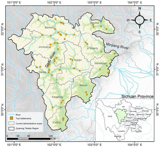
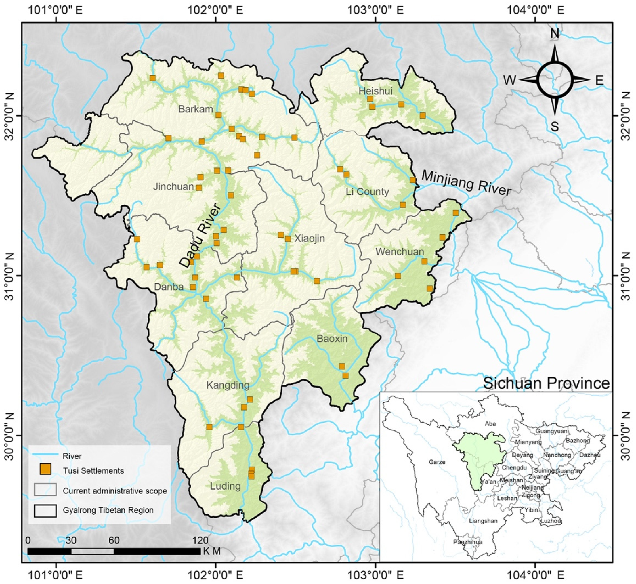
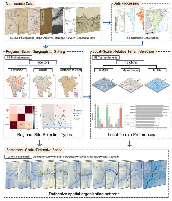
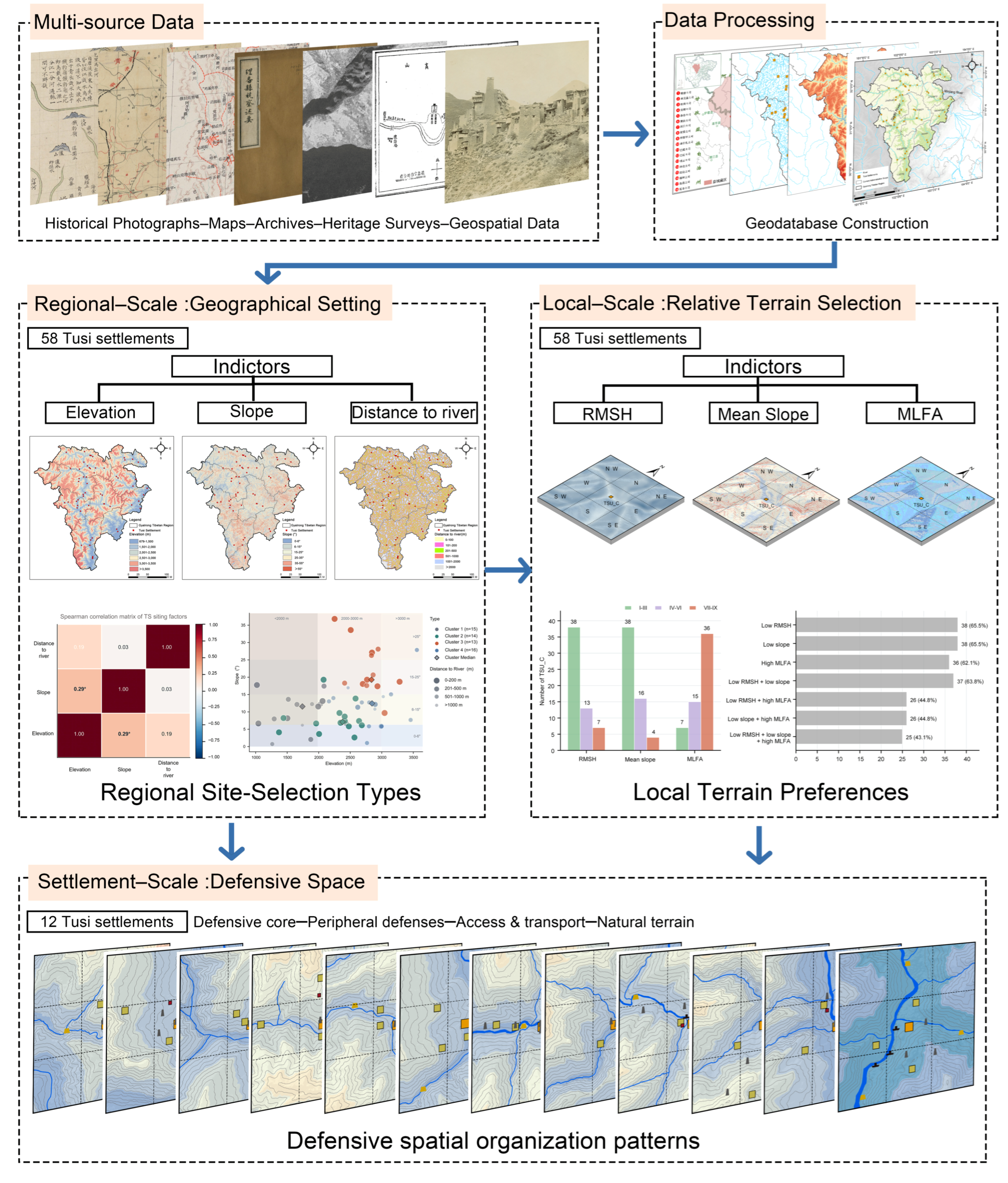
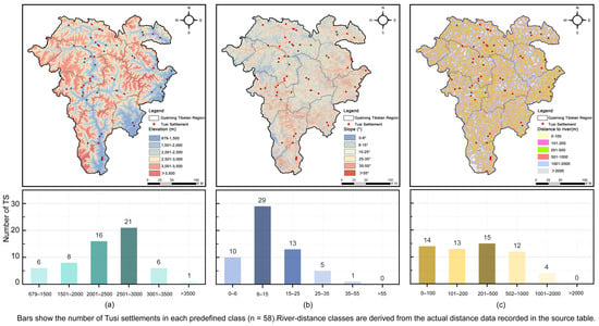
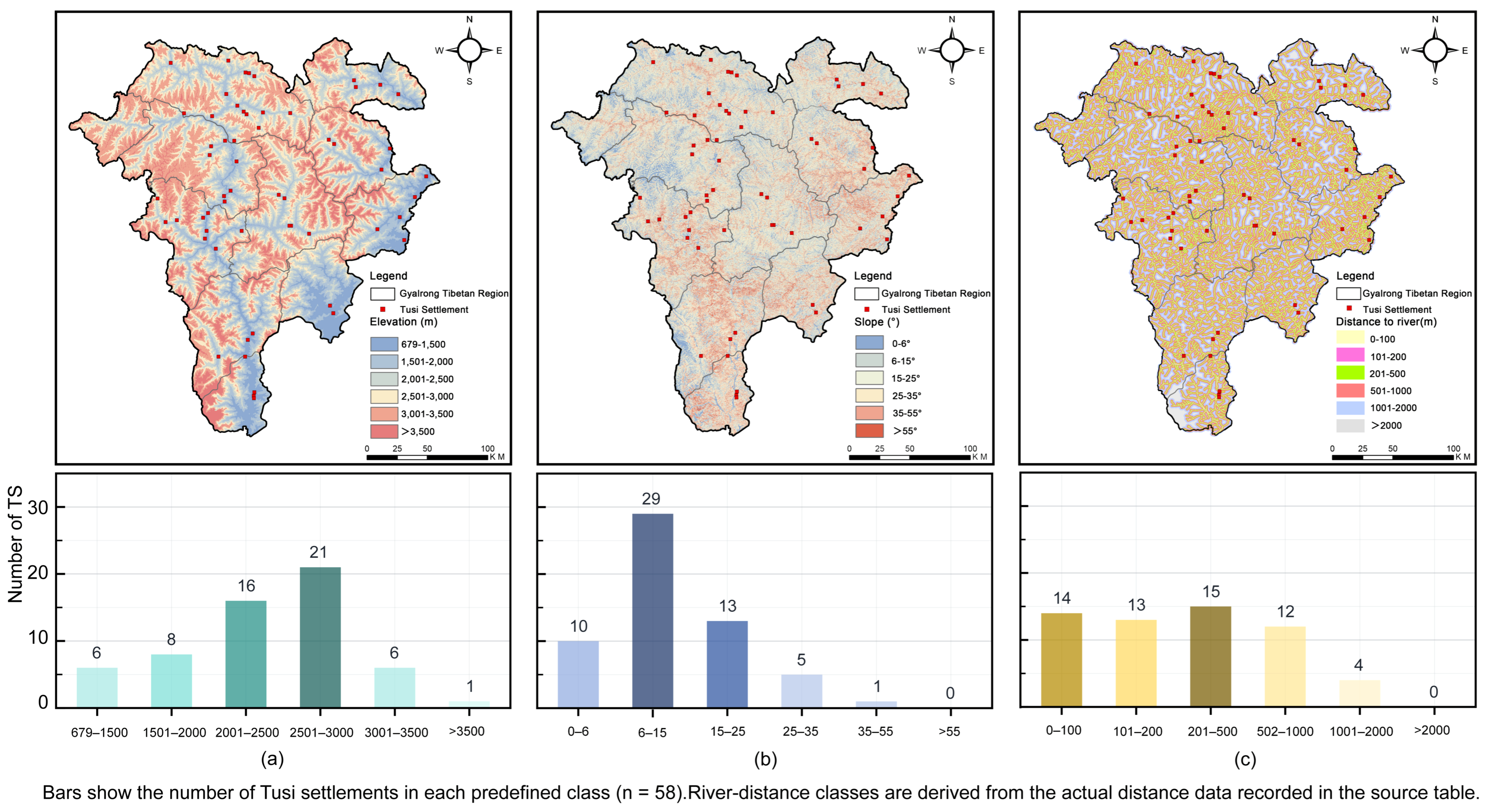
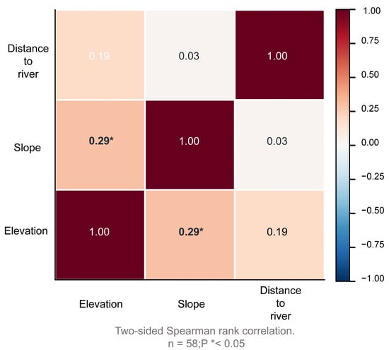
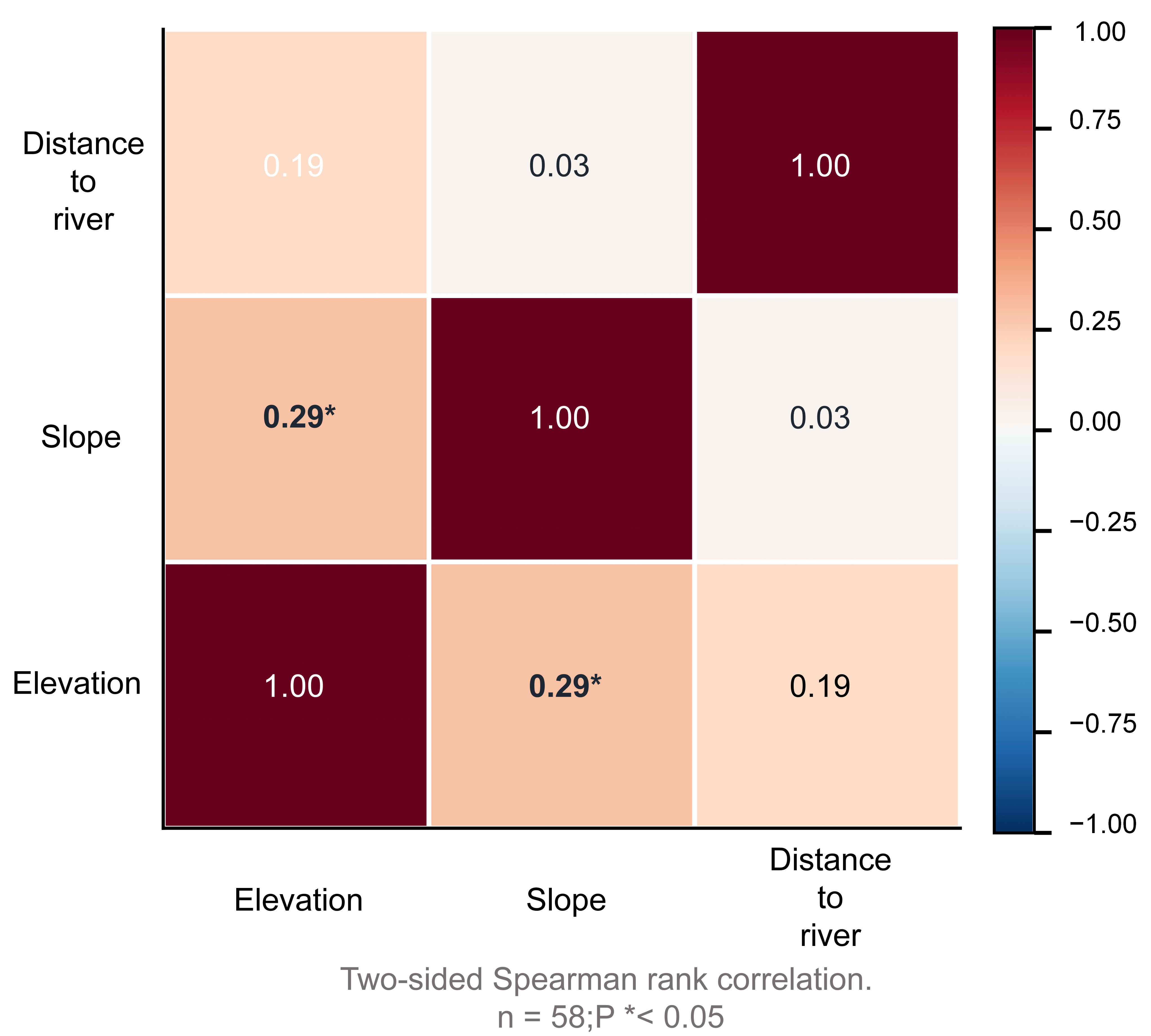
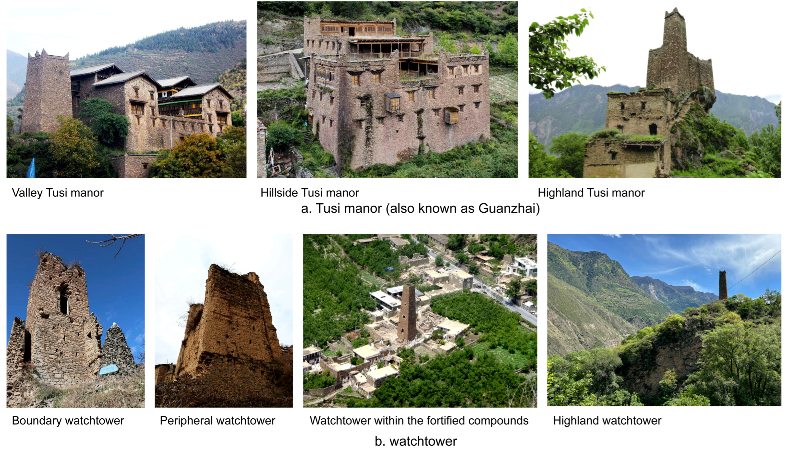
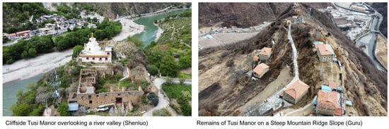
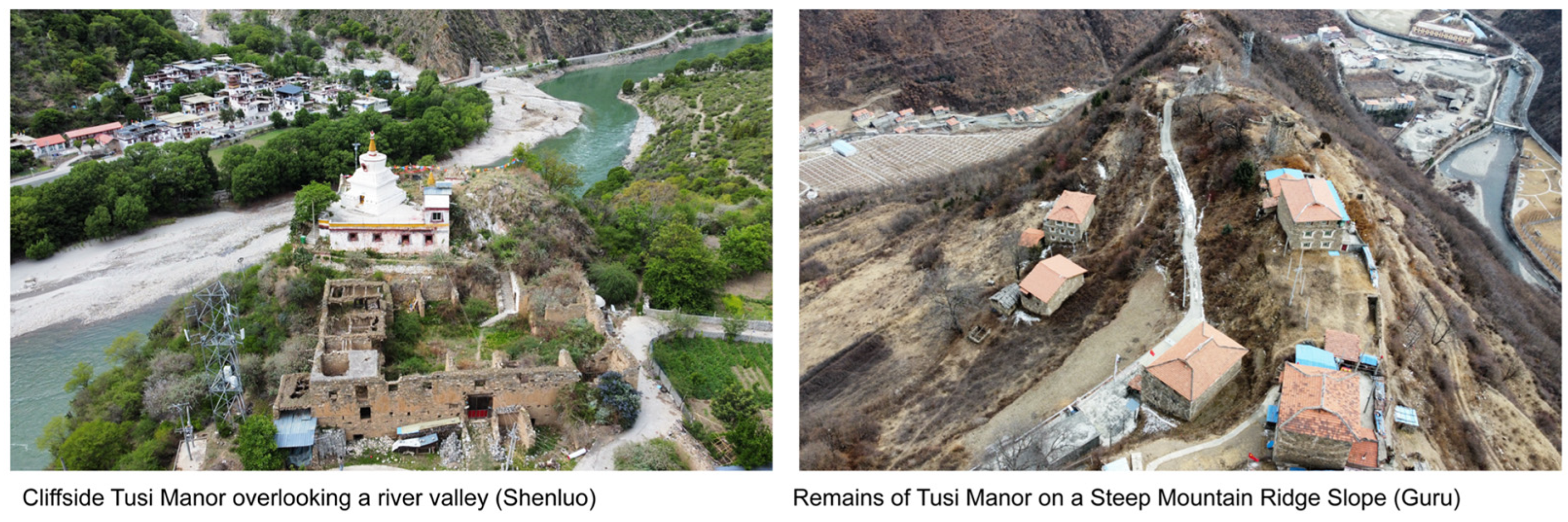
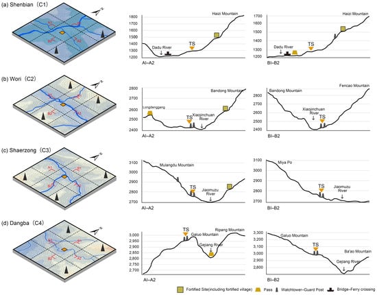
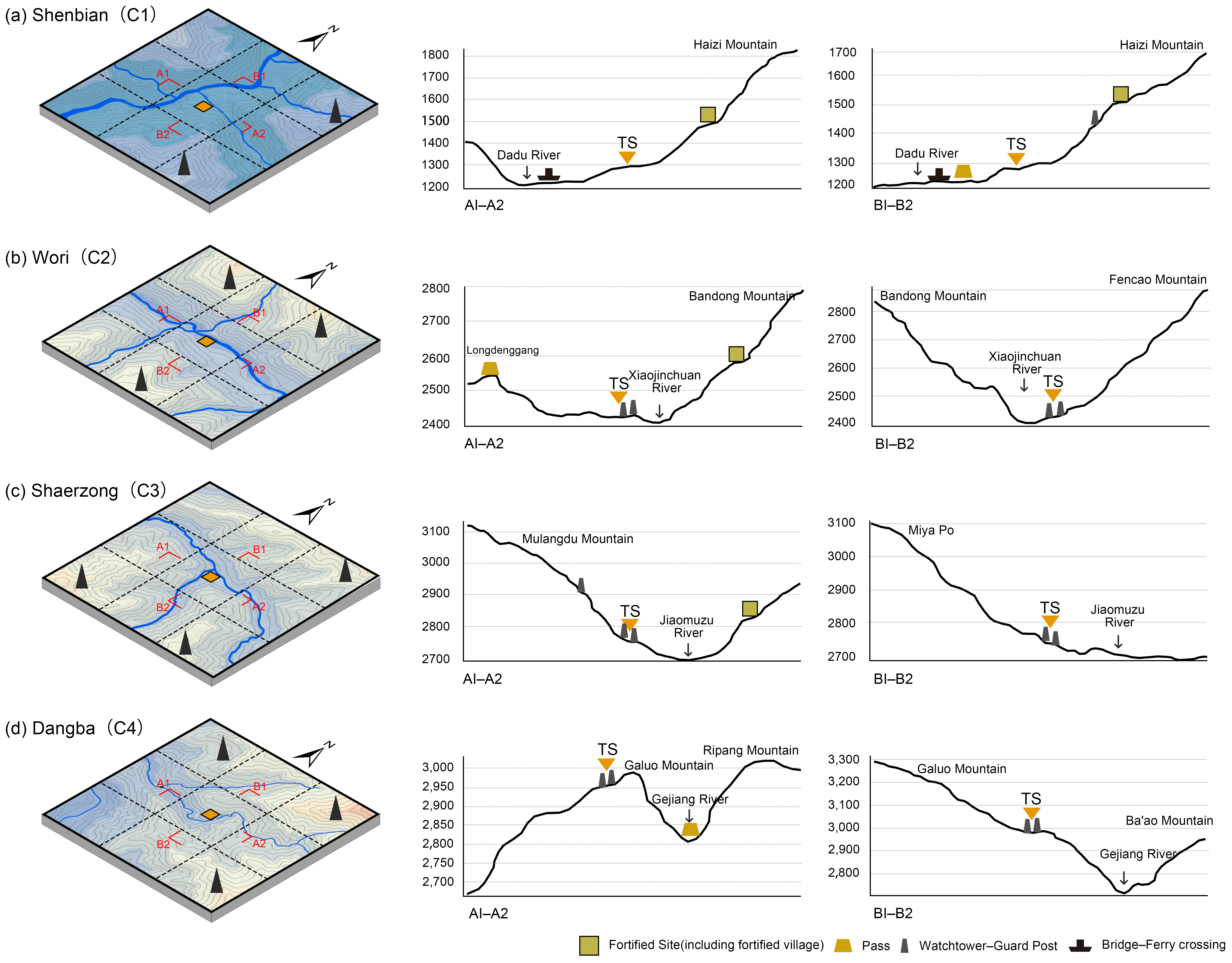
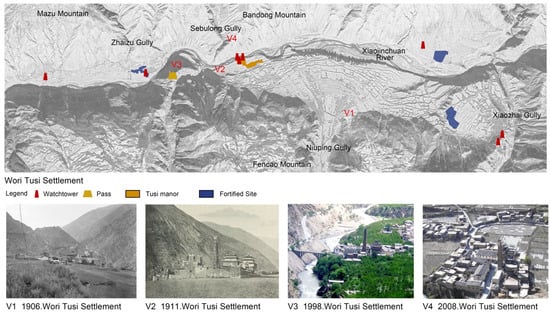
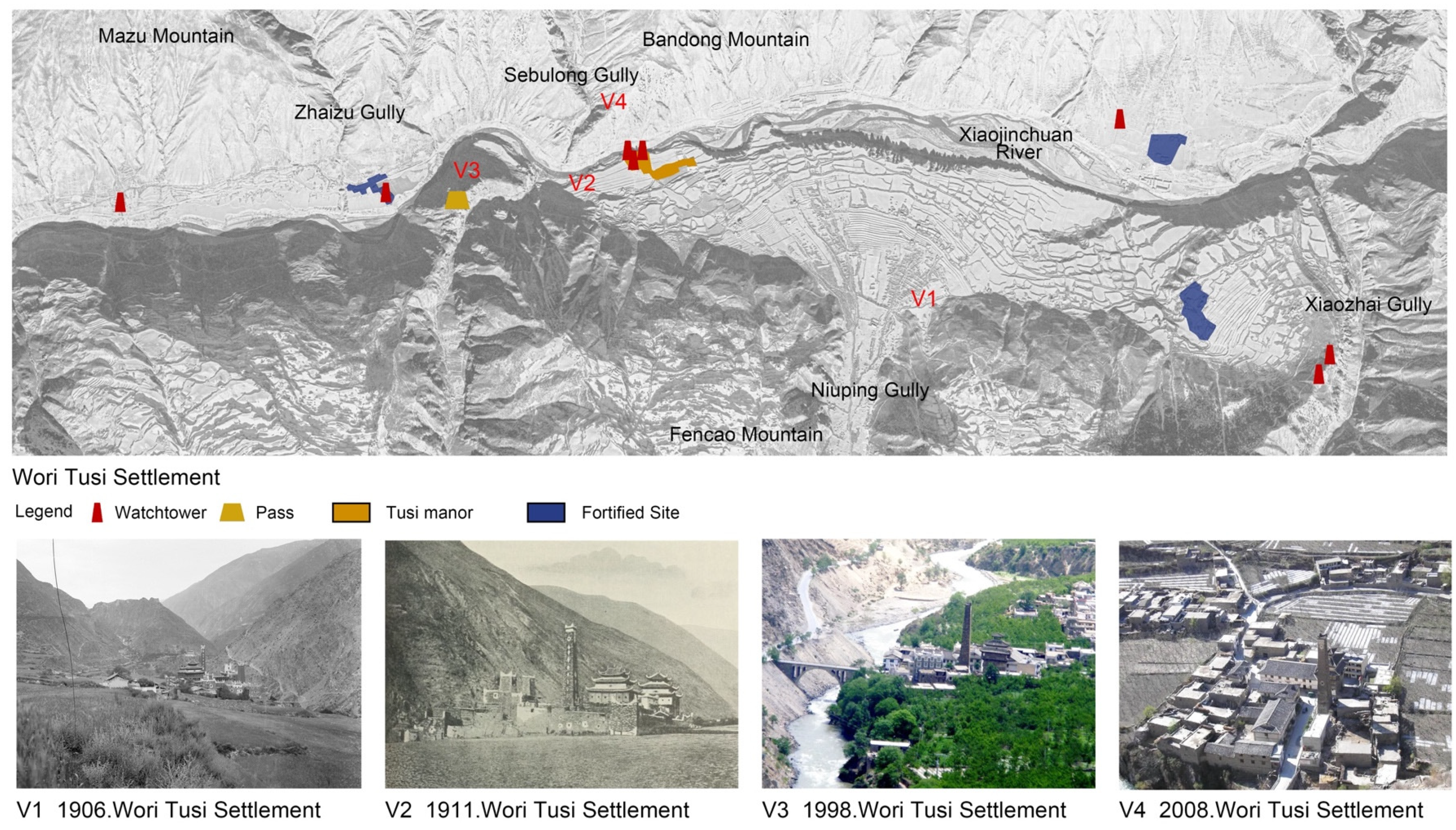
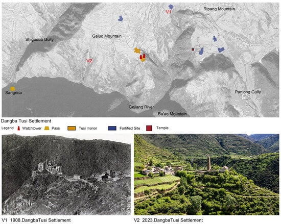
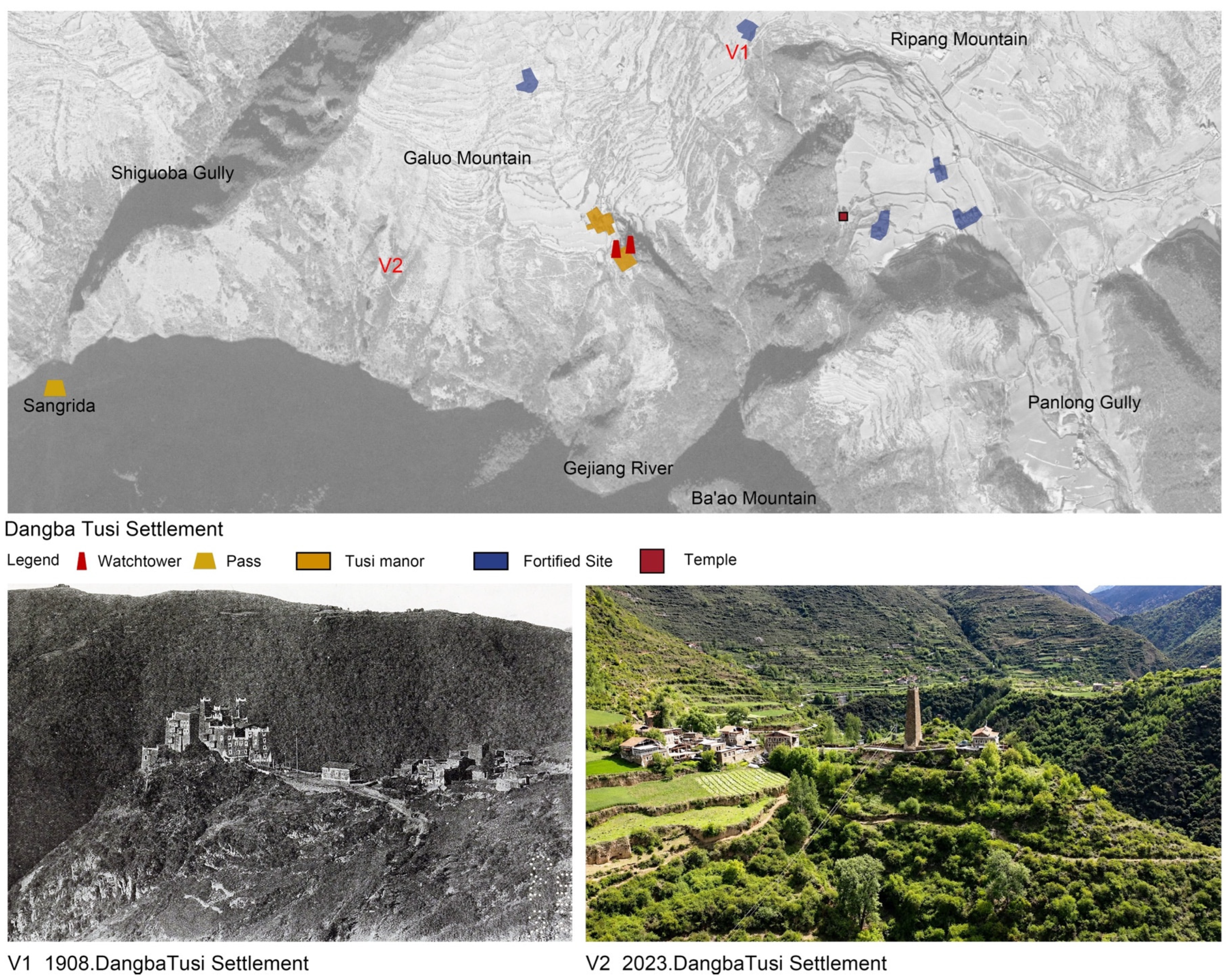

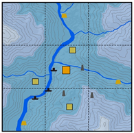
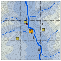
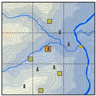
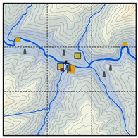
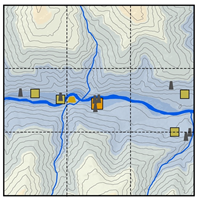
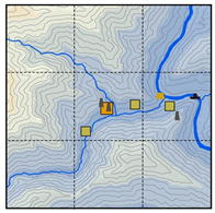
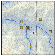
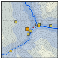
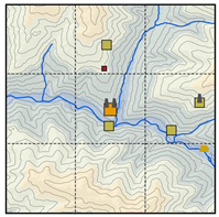
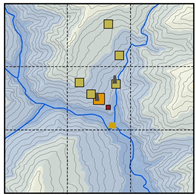
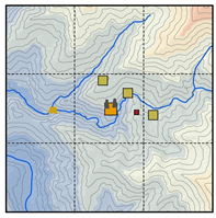
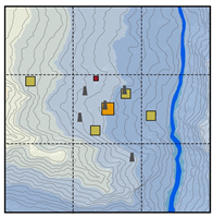

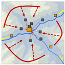
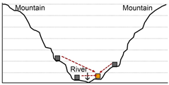
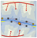
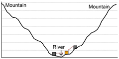
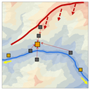
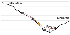
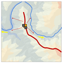
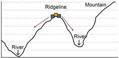
Disclaimer/Publisher’s Note: The statements, opinions and data contained in all publications are solely those of the individual author(s) and contributor(s) and not of MDPI and/or the editor(s). MDPI and/or the editor(s) disclaim responsibility for any injury to people or property resulting from any ideas, methods, instructions or products referred to in the content. |
© 2026 by the authors. Licensee MDPI, Basel, Switzerland. This article is an open access article distributed under the terms and conditions of the Creative Commons Attribution (CC BY) license.