


Abstract
Heritage-led renewal can improve the built environment of historic districts, but physical upgrading may not be accompanied by better public-space experiences or stronger place attachment among residents. However, comparative evidence remains limited on how different aspects of public-space experience relate to Place Identity (PI) and Place Dependence (PD). Taking Nantou Ancient City in Shenzhen as a case study, this research combined a survey of 780 residents with field observations and used Random Forest, XGBoost and out-of-fold SHAP to assess the relative predictive importance of Public-Space Governance, Perceived Accessibility and Social Interaction for PI and PD. The results show that (1) PI was most strongly associated with Social Interaction in XGBoost, which had the highest domain-level importance (46.5%), while Collective Participation, Informal Governance, Strong-Tie Interaction and Formal Governance were the leading dimensions; (2) PD was more closely related to functional and use conditions, with Perceived Accessibility showing the highest domain-level importance (44.5%), and with Perceived Physical Accessibility, Formal Governance and Perceived Social Accessibility the three highest-ranked dimensions for PD; and (3) Public-Space Governance showed substantial relative predictive importance for both PI and PD. Random Forest showed the same domain rankings as XGBoost for both outcomes and demonstrated high consistency at the indicator level. These results indicate that PI and PD are associated with different aspects of public space experience, but the causal relationship still lies beyond the scope of this cross-sectional study.
1. Introduction
Historic districts are not only places for daily life but also important areas for the protection of cultural heritage. Their streets, alleys and public spaces support daily activities, social interactions, and local memories [1,2]. Heritage-led urban renewal can improve the physical environment, but these improvements do not necessarily lead to a better public space experience for residents [1,3]. The value of a historical district lies not only in its architectural structure, but also in the practices and interpersonal relationships it sustains [4]. However, some of the updated practices still place more emphasis on the appearance and economic benefits of the built environment, while the actual experiences of residents in public spaces may not be adequately guaranteed [1,2].
In China, the renovation of historical districts is usually carried out within the framework of the government-led cultural heritage management and the broader economic development agenda. The policies for protecting cultural heritage are closely linked to local economic growth and cultural activities [5], but these achievements do not fully reflect the residents’ personal experiences of the renewal. Research on the management of cultural heritage in Lijiang has found that residents’ participation in the decision-making process is mainly limited to obtaining information and being consulted [6]. The evidence from Guangzhou also indicates that there is a correlation between residents’ perception of the neighborhood environment, their sense of community belonging, satisfaction, and their willingness to relocate [7]. Although these studies examined different environments, they all emphasized the importance of considering both the residents’ experiences and their physical and economic conditions. Therefore, when assessing heritage-oriented renovations, attention must be paid to the governance, accessibility, and usage patterns of public spaces in daily life.
The protection of heritage increasingly recognizes the relationship between residents and historical sites, and the protection of the built environment is equally important [2,4]. Place attachment provides a perspective for understanding these relationships, referring to the emotional connection that people establish through personal experience with a specific place [8]. During urban renewal processes, changes in the familiar environment and residents’ participation in local affairs may affect these connections [9]. Social interactions in daily activities and public spaces are also related to place attachment [10]. These studies indicate that when examining place attachment in renovated historical districts, it is necessary to consider residents’ experiences of public space governance, accessibility, and social interaction.
Previous studies have explored the relationship between urban facilities [11], the duration of residents’ residence and personal experiences [12], and the physical characteristics of green spaces [13] and place attachment, as well as other human–environment relationships. Recent studies have utilized interpretable machine learning methods to compare the predictors of community belonging in workplace communities [14] and the predictors of place belonging in rural markets [15]. However, these studies were conducted in different environmental contexts and did not directly compare the experiences of residents regarding public space governance, perceived accessibility, and social interaction during the process of historical district renewal. Therefore, the relative predictive importance of these three areas for place identity (PI) and place dependence (PD) remains unclear.
The research on urban renewal and community autonomy explored the relationship among residents’ participation, perceived sense of control, and sense of belonging to the local area [9,16]. This study compared the relative predictive importance of public space governance, perceived accessibility, and social interaction for place identity (PI) and place dependence (PD) in the Nantou Ancient City of Shenzhen. Both outcomes represent distinct dimensions of residents’ place attachment to the public spaces of Nantou Ancient City. By comparing the predictive factors at the domain, dimension and indicator levels, this study identified differences in predictive patterns related to identity-relatedness and functional dependence. The analysis focused on the current public space experience and did not assess the changes brought about by regeneration.
This study employed Random Forest and XGBoost to predict the degree of residents’ attachment to public spaces. The tree-based models can analyze the possible nonlinear relationships and interactions among the predictor variables [17]. SHAP is used to describe how each predictor affects the model’s prediction results, and to compare their relative importance at three levels: indicators, dimensions, and predictor groups [18]. The positive and negative SHAP values respectively indicate that the contribution to the baseline prediction of the model is higher or lower than that baseline. Previous studies have utilized machine learning and SHAP to analyze place attachment and its related person–place relationships [14,15]. Here, these methods can be used to compare the prediction patterns of PI and PD.
In conclusion, this paper raises two research questions: (1) Which domains and dimensions of residents’ public space experience have the greatest relative predictive importance for place identity and place dependence? (2) Which indicators of residents’ public space experience have the greatest relative predictive importance for place identity and place dependence? In the discussion section, the broader theoretical and practical significance of these predictive patterns for heritage-oriented public space renewal and management is also explored.
2. Literature Review
2.1. Theoretical Conceptualization of Place Attachment
Place attachment refers to the psychological connection that an individual forms with a specific location [19,20]. It was measured as an overall construct [21], and also evaluated through multiple dimensions, including place identity, place dependence, place emotions, and social connections [22]. This study adopts the two-dimensional framework proposed by Williams and Vaske [23]. Place Identity (PI) focuses on the symbolic significance of a location to an individual’s self-awareness, while Place Dependence (PD) reflects the functional suitability of that location in facilitating valuable activities compared to other alternative locations [23,24]. In this study, PI refers to the identity-related and symbolic attachment that residents have towards the public spaces of Nantou Ancient City, while PD refers to their perception of the suitability and substitutability of these public spaces for important daily activities. All the result items represent the overall situation of the public spaces in Nantou Ancient City.
Previous studies have explored the place-related relationships involving living continuity [12], ageing and environmental experience [25], as well as the physical characteristics and significance of places [13,26]. The accessibility of the local environment, the facilities available, and the spatial layout all influence people’s opportunities for movement, daily activities, and social interactions [11,13]. These individual and spatial characteristics provide a background for understanding the relationship between residents and the place.
These factors may be related to PI and PD in different ways [8]. Long-term residence offers residents more opportunities to develop a sense of familiarity, memories and social connections, which may be closely related to aspects of personal identity [20]. Age may influence the usage patterns of public spaces and the degree of dependence on the local environment, which is of great significance for both individuals and groups [25]. Accessibility, facilities and space usability are more closely related to the functional characteristics of PD, while the physical environment may also influence PI through its personal or historical significance [27]. A study in Guangzhou also found that social connections were more strongly associated with PI, whereas housing conditions were more strongly associated with PD [28].
These differences support the separate examination of PI and PD. Previous studies on historical urban areas in China, conducted under the background of government-led renewal, have also independently analyzed these two dimensions [29]. This research does not attempt to comprehensively model all the demographic, social and physical factors influencing local attachment, but focuses on three areas of residents’ lived experiences in public spaces—public space governance, perceived accessibility and social interaction—and compares their relative predictive importance for PI and PD.
2.2. Heritage-Led Urban Renewal and Changes in Residents’ Public-Space Experience
In historical districts, heritage is not only reflected in buildings, streets and alleys, but also integrated into daily practices, place-related memories, and community connections [4]. Therefore, public spaces are crucial venues for residents to experience the physical and social impacts brought about by urban renewal. Heritage-oriented renewal may alter the physical environment, usage patterns, social relationships, and the institutional conditions under which public spaces are utilized on a daily basis [3,30]. These changes may affect the way residents move around in public spaces, their usage habits and experiences, as well as their responses to the changes in daily living environments. Therefore, this study focuses on the actual life experiences of residents in the public spaces in Nantou Ancient City.
These changes can be organised into three broad aspects of public-space experience. Renewal may alter residents’ relationship with public-space management and participation, the conditions under which spaces can be accessed and used, and opportunities for everyday social interaction [31,32]. These three aspects are interrelated but conceptually distinct: they respectively involve the governance methods of public spaces, the residents’ access and usage experience of the space, and the support mechanisms for daily social life. In summary, they provide a focused analytical framework for studying the actual experience of heritage-oriented renewal in residents’ daily lives. Therefore, Section 2.3 discusses Public-Space Governance, Perceived Accessibility, and Social Interaction as the three predictive domains used to describe residents’ public-space experiences.
2.3. Public-Space Predictors of Place Attachment: Governance, Perceived Accessibility and Social Interaction
Based on Section 2.2, this section defines three predictive domains used to describe the experience of public spaces for residents: public space governance, perceived accessibility, and social interaction. These domains are not intended to cover all the determinants of local attachment, but rather to define the specific aspects of the public space experience examined in this study. Each domain is further divided into several dimensions to capture the different characteristics of the residents’ experience. The conceptual scope and its correlation with “Place Identity” (PI) and “Place Dependence” (PD) are as follows.
2.3.1. Public Space Governance
Public space governance refers to the management methods of public spaces, as well as how residents experience and interact with the formal and informal arrangements that shape their use [33,34]. This study distinguishes between formal governance and informal governance: the former involves institutionalized rules, transparency, opportunities for resident participation, and responsiveness in management; the latter focuses on shared norms, negotiation, and coordination led by residents [33,35]. The reason why these two dimensions are distinguished is that formal arrangements and daily informal practices may have different effects on residents’ experiences of the same public space. The concept of participation opportunities under formal governance is also different from actual participation, and the latter will be discussed as collective participation in Section 2.3.3.
Governance is closely related to local identity, as participation levels, perceived sense of control, and management experience can influence residents’ attitudes towards the local area. In the context of urban renewal, externally-driven changes may undermine residents’ sense of control, while community actions can help enhance local belonging [9]. Evidence from China’s historical districts also indicates that government-led service management is associated with both PI and PD [29]. Therefore, public space governance is still retained as a predictive field, while formal governance and informal governance are analyzed separately.
2.3.2. Perceived Accessibility
Perceived accessibility refers to the subjective assessment by residents of whether they can reasonably and comfortably use public spaces for the intended activities [36]. It addresses the limitations in objective measurements of geographical distance or spatial layout by capturing how individual capabilities, safety, and social constraints affect the actual experience of accessibility [36]. This study distinguishes between perceived physical accessibility (focusing on the practical convenience and safety of entering and using public spaces) and perceived social accessibility (concerning social acceptance and the degree of avoiding exclusion). This distinction reflects the existing evidence that perceived accessibility is influenced by both spatial conditions and social and interpersonal factors [37,38].
Perceived accessibility is closely related to place attachment because residents’ daily use of a certain place largely depends on whether they feel it is convenient to enter and utilize the place. Previous studies have linked subjective accessibility and walking convenience with place attachment [39]. This might be particularly important in PD, as PD focuses on whether a place has the functional suitability to support valuable activities [23]. However, there are still conceptual differences between perceived accessibility and PD: the former involves residents’ experiences of the accessibility and use of the place, while the latter focuses on the functional value of the place itself and its substitutability.
2.3.3. Social Interaction
Social interaction refers to the contact, communication and joint activities carried out by residents in public spaces [19,27]. This study distinguished between weak-tie interactions, strong-tie interactions and collective participation. Weak-tie interactions refer to low-intensity daily interactions, strong-tie interactions refer to continuous interactions in relatively stable relationships, and collective participation refers to organised participation in community or public space affairs [31,40]. These dimensions distinguish different forms and intensities of social connections. The specific questionnaire indicators are shown in Table 1.
There is a direct conceptual connection between social interaction and place attachment, as social relationships are formed through repeated place-based contacts and are constantly replicated within them. Previous studies have linked neighborhood social relationships, familiar interpersonal interactions, and community interactions with a sense of belonging and place attachment [2]. Relevant literature supports treating social interaction as a core predictive domain. Therefore, this study separately examines the relative predictive importance of Weak-Tie Interaction, Strong-Tie Interaction, and Collective Participation for Place Identity (PI) and Place Dependence (PD), without assuming that these three dimensions contribute equally to the two outcomes.
2.4. Machine Learning for Identifying Predictor Importance
The purpose of this study’s analysis is not only to explore whether the factors of public spaces are related to PI and PD, but also to compare their relative predictive importance. Traditional inferential methods mainly aim to estimate the pre-defined relationships and the uncertainty of parameters, while machine learning provides an additional framework for evaluating the predictive performance of multiple potential nonlinear predictors. Random Forest and XGBoost are ensemble learning methods that can handle multi-dimensional predictor sets and the complex relationships between predictors and outcomes [17,41]. Therefore, this study first compares the predictive performance of these models before examining which public-space factors contribute most to the predictions of PI and PD.
Just relying on the predictive performance cannot indicate the contribution degree of each predictor variable to the model output. Therefore, interpretable machine learning methods are needed to analyze the role of specific variables in complex predictive models [42]. This study adopts the SHAP method to quantify the contribution of each predictor variable to individual prediction results, and aggregates these contributions into global predictor variable importance indicators [18]. This enables the comparison of prediction importance at the indicator, dimension, and domain levels without interpreting these contributions as causal effects.
Interpretable machine learning has been employed to analyze the relative importance of environmental and social factors in community belonging [14], place attachment [15], and place identity [43]. These studies have shown that, combined with model interpretation, machine learning can identify the differences in predictive roles of various place-related factors. However, in the context of heritage-oriented urban renewal, systematic comparisons of residents’ experiences of public spaces are still relatively limited. This study fills this gap by comparing the relative predictive importance of public space governance, perceived accessibility, and social interaction in PI and PD.
2.5. Conceptual Framework
Based on the aforementioned literature, this study divides the residents’ experiences of public spaces in the context of heritage-oriented urban renewal into three predictive domains: public space governance, perceived accessibility, and social interaction. These three domains encompass seven measurable predictive dimensions. Place attachment is reflected through two outcome dimensions, namely place identity (PI) and place dependence (PD). This framework is used to compare the relative predictive importance of the three predictive domains, their constituent dimensions, and the specific indicators of PI and PD, and to identify the differences in their predictive structure (Figure 1).
Figure 1.
Analytical framework of public-space predictors and place attachment outcomes. Source: Authors’ elaboration.
3. Materials and Methods
3.1. Study Area
This study follows the information-oriented case selection principle proposed by Flyvbjerg [44] and selects Nantou Ancient City in Shenzhen as the research object. Nantou has a long history and was once the regional administrative center. In 1394, it became the location of the Dongguan military camp, and later in 1573, it was upgraded to Xin’an County. After the county seat was moved out in 1953, some historical streets, city gates, wall ruins and ancient buildings were preserved and gradually integrated into the subsequent village structure [45]. With the establishment of the Shenzhen Special Economic Zone and the acceleration of urbanization, the demand for rental housing has been increasing continuously, which has had a profound impact on the built environment of Nantou. The villagers expanded the scale of their self-built residences by filling in, expanding and adding floors. By the early 2000s, the area had basically formed the current high-density residential and compact street pattern, presenting a typical high-density urban-village morphology [46,47].
Nantou currently has a population of approximately 30,000 people, of which about 90% are immigrants or mobile population, while the rest are indigenous villagers and registered residents [48,49]. The long-standing rental housing system supports the majority of the population and continuously maintains the living function of the region. Historical streets, buildings, and wall remnants interweave with dense residential areas, rental houses, commercial facilities, and community services. Streets, alleys, and public spaces are still used for daily travel, social interaction, and community activities to this day. These daily uses keep residents closely connected to the heritage environment.
The protection and renewal of Nantou went through several stages. From the 1990s to 2015, the main efforts focused on the protection of cultural heritage, the improvement of historical districts, and the renovation of local public spaces. From 2016 to 2018, the 2017 Shenzhen-Hong Kong Bi-City Urban Planning/Architecture Biennale further emphasized cultural display, architectural renovation, and public space design. During the period from 2019 to 2020, a more comprehensive plan was launched, and the intervention measures after 2021 continued to update the functions of the renewal areas while further promoting spatial renewal [47,50]. The renewal mainly concentrated on some main roads and public space nodes, resulting in significant differences between the renewal area and the internal residential streets. On some renovated main roads, cafes, bookstores, cultural displays, and other facilities for tourists have become increasingly common, while some internal residential areas still retain supermarkets, convenience stores, and other service facilities for residents’ daily lives [47,51]. This combination of historical buildings, high-density urban-village residential spaces, and selective renewal provides a case background for studying residents’ experiences in public space governance, perceived accessibility, and social interaction. The location and boundary of the research area are shown in Figure 2.
Figure 2.
Location and boundary of Nantou Ancient City. Source: Authors’ elaboration.
3.2. Research Method
This study adopted a multi-method design. Through literature review and three rounds of Delphi consultation, indicators for public space governance, perceived accessibility, and social interaction were formulated and selected. Subsequently, cognitive interviews and pilot surveys were used to optimize the questionnaire. The final resident survey provided data for measurement verification and was used to model place identity (PI) and place dependence (PD) using Random Forest and XGBoost models. Non-participatory observations recorded management practices, physical conditions related to accessibility, and social behaviours, which were only used to provide background information for the quantitative results. The observed spatial conditions were not used to measure perceived accessibility, which was assessed through the questionnaire. Finally, based on the analysis framework structure shown in Figure 1, the OOF SHAP method was used to compare the importance of predictor variables at the domain, dimension, and indicator levels. Figure 3 summarizes the research process.
Figure 3.
Research design and analytical workflow. Source: Authors’ elaboration.
3.3. Data Collection
3.3.1. Non-Participant Observation
From January to August 2026, this study conducted non-participatory observation in Nantou Ancient City to document the everyday use of public spaces, management practices and social behaviour, without interfering with users’ activities. Direct observation and behavioural recording have been widely used to identify activities, dwell times and social interactions in public spaces, as well as their corresponding micro-spatial environments [52].
To cover a range of urban regeneration contexts, this study employed purposive sampling to identify public spaces for repeated observation. The study area was first divided into regenerated areas and original residential areas based on the nature of regeneration interventions, and representative public spaces were observed in both areas. These public spaces were selected based on their regeneration characteristics, typical patterns of public-space use, and suitability for repeated observation, to cover different contexts of governance, spatial use and social interaction. The selected public spaces were revisited between January and August 2026. Observations were conducted on weekdays from 09:00 to 11:00 and from 15:00 to 17:00. Public holidays were avoided where possible to reduce the influence of holiday-related activities on the observations.
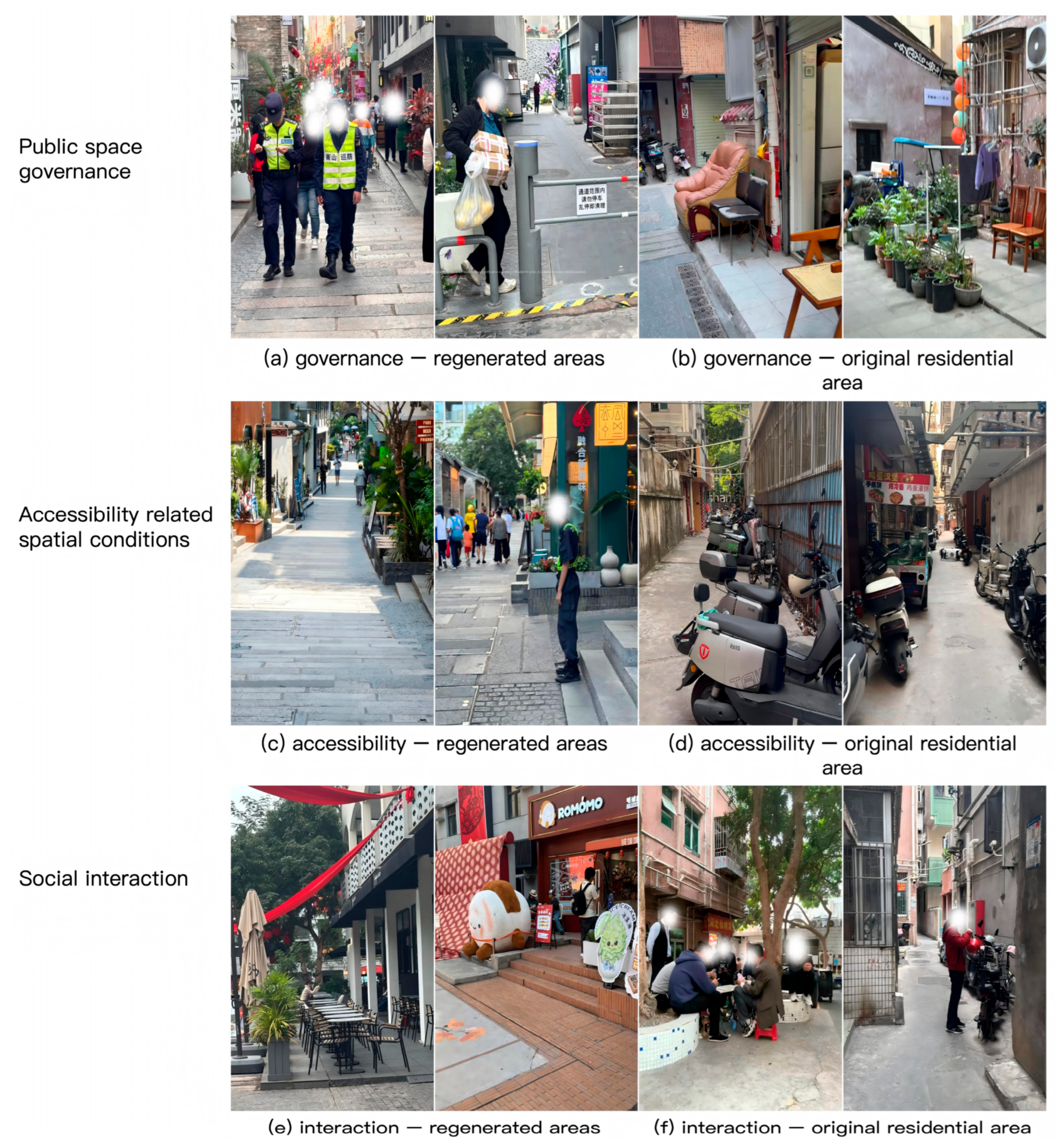
The observations documented three types of conditions relevant to the survey framework. First, governance practices included formal management of facilities and activities, residents’ and traders’ use of space, and adjustments to spatial boundaries. Second, accessibility-related physical conditions included entrances, pathways, barriers, available passageways, conditions for lingering, and pedestrian–vehicle relationships. Third, observable social interaction included lingering, face-to-face conversations, small-group gatherings and shared activities. These observations were used to describe on-site spatial and behavioural conditions and were not used to measure residents’ Perceived Accessibility [52]. Photographs were used to document and illustrate observed conditions.
Two long-term residents were purposively selected as key informants because of their familiarity with everyday public-space use and community life in Nantou Ancient City [53]. They assisted in identifying and interpreting local space use, management practices and daily activities observed during fieldwork. Their accounts were cross-checked against repeated field observations and were used to provide contextual explanations.
3.3.2. The Delphi Method
From January to February 2026, based on a review of relevant literature, this study initially constructed 33 indicators and conducted three rounds of anonymous Delphi expert consultations to assess the importance, clarity of expression, and practical applicability of these indicators. The expert group consisted of 56 experts from fields such as urban planning and design, sociology and community research, cultural heritage protection and urban renewal, and community management. During the recruitment process, the principal investigator contacted each expert separately, explaining that the Delphi consultation would involve multiple iterative stages and required continuous participation. Throughout the entire research period, these 56 experts were all fully involved in each round, and no members were replaced between rounds. At the beginning of each round, the researchers sent research information and corresponding questionnaires to each expert via WeChat. For experts who had not responded, follow-up was conducted based on their individual response time. If necessary, up to four WeChat reminder messages and two WeChat calls were used within one round to encourage them to complete the questionnaire. This personalized follow-up procedure was consistently implemented in all three rounds of consultation. All 56 experts completed all three rounds, and all returned questionnaires were valid, achieving a 100% completion rate for rounds and a 100% retention rate for the expert panel, with no cross-round attrition. The average service years of the experts were 19.54 years, and the average authority coefficient was 0.867, indicating that the expert panel had a high level of professional authority. The questionnaire used a five-point Likert scale, and the following criteria were established as the benchmark for retaining items: an average importance score of not less than 4.00, a coefficient of variation not exceeding 0.25, and an agreement rate of 75% or more between 4 and 5. After the first round of consultation, based on the experts’ suggestions, overlapping or ambiguous indicators were merged and rephrased, and in the second round, 29 indicators were finally determined. In the second round, similar indicators such as accessibility, ease of entry, shared activities and collective participation were further consolidated, and ‘internal circulation and dwell time’ was split into two separate indicators, ultimately resulting in 26 indicators for the third round. Over the course of three rounds of consultation, Kendall’s W increased from 0.128 to 0.436, whilst the average coefficient of variation decreased from 0.152 to 0.079, indicating that expert opinions gradually converged to form a relatively stable consensus. The final indicator system consists of three predictive domains—public space governance, perceived accessibility, and social interaction—and includes a total of seven dimensions with a total of 26 indicators. The specific structure is shown in Table 1.
Table 1.
Final predictor domains and indicators.
3.3.3. Questionnaire Data Collection
Place attachment was measured using two outcome dimensions: Place Identity (PI; PA1–PA6) and Place Dependence (PD; PA7–PA11). The PI items assessed identity, personal meaning and symbolic connection to the public spaces of Nantou Ancient City, whereas the PD items assessed their functional suitability and substitutability for residents’ valued daily activities. All 11 items referred to the public spaces of Nantou Ancient City considered collectively. PI and PD scores were calculated separately as the means of their six and five items, respectively, and used as the two prediction outcomes.
- (1)
- Preliminary Survey
A preliminary questionnaire survey was conducted in March 2026 as part of this study. Firstly, cognitive interviews were used to assess the target residents’ understanding of the meaning of the questionnaire items, their relevant experiences and the response options, with a particular focus on relatively abstract concepts such as ‘formal governance’, ‘informal governance’, ‘social acceptance’ and ‘rights to spatial use’. Cognitive interviews help to identify discrepancies between the meanings assumed by the researchers and the actual understanding of the respondents [79]. Building on this, a small-scale pilot test was then conducted to assess the overall comprehensibility and practicability of the revised questionnaire. Thirty residents who met the survey criteria completed the pilot test, which primarily examined completion time, omitted items, the use of response options and respondent feedback, whilst also providing a preliminary assessment of the scale’s internal consistency [80].
- (2)
- Formal Survey
The formal questionnaire survey was conducted in Nantou Ancient City from April to July 2026 using door-to-door questionnaires. Given the absence of a complete household sampling frame and the high residential mobility of the urban-village population, no prior household list was constructed. Residential units were approached where building access was possible, and occupants were available to respond. Respondent eligibility was assessed on site. Recruitment followed a non-probability, field-based approach rather than random household selection. Rental housing in Chinese urban villages often involves informal tenancy arrangements [81], and dwellings may be subdivided into separately occupied rooms with shared facilities [82]. Each separately occupied room or self-contained dwelling was therefore treated as one survey unit. Where unrelated tenants occupied separate rooms within the same premises, each room could provide one respondent; where a family shared one unit, only one eligible adult was surveyed. Respondents were required to be aged 18 years or older and to have lived continuously in Nantou Ancient City for at least 12 months [83]. This threshold was used to ensure that respondents had sufficient familiarity with local public spaces and their everyday use. Two long-term resident key informants [53] helped the researcher establish initial contact with some tenants. After eligibility and informed consent were confirmed, respondents completed the Chinese-language paper questionnaire on site. Of 1121 eligible residents approached, 874 completed the survey, giving a response rate of 77.97%.
Sample-size adequacy was assessed using two reference benchmarks. First, Cochran’s formula was applied using a 95% confidence level (Z = 1.96), a population proportion of p = 0.50 (q = 0.50), and a margin of error of e = 0.05 [84,85]. These assumptions yielded a reference sample size of approximately 384, reduced to 379 after finite-population correction for an estimated population of 30,000 residents. As respondents were recruited through non-probability sampling, this calculation served as a sample-size benchmark rather than evidence of statistical representativeness or a 5% sampling margin of error. Second, with 26 predictor variables, the commonly used heuristic of at least 10 observations per predictor provided a reference sample size of 260 [86]. The final sample includes 780 valid questionnaires, exceeding the above two reference sample sizes.
3.4. Data Analysis
3.4.1. Data Screening and Measurement Validation
A total of 874 questionnaires were collected. If more than 10% of the 37 Likert scale items were not answered (i.e., four or more were missing), or if all 37 items were selected from the same option, indicating a consistent response pattern, then the questionnaire would be excluded. These screening criteria were used to identify obviously incomplete or low-quality responses, which are in line with the existing recommendations for data screening in surveys [87,88]. After screening, a total of 94 questionnaires (10.8%) were excluded, and 780 valid questionnaires were retained for analysis.
The internal consistency of the scale was evaluated using Cronbach’s alpha coefficient. Subsequently, confirmatory factor analysis (CFA) was used to test the pre-defined measurement structure. Since the items were measured using a five-point Likert scale, they were regarded as ordinal indicators and estimated using the weighted least squares mean and variance adjusted (WLSMV) estimation method. The measurement quality was evaluated by standardized factor loadings, composite reliability (CR), average variance extracted (AVE), and the heterotrait–monotrait ratio (HTMT). According to the research of Williams and Vaske [23], PI and PD were regarded as two preset dimensions of local attachment, and their measurement structure and discriminant validity were evaluated. Subsequently, the mean values of the PI and PD items were used as two separate outcome variables in the machine learning analysis.
3.4.2. Machine-Learning Model Analysis
PI and PD used the same 26 common spatial indicators as predictor variables for modeling. Two tree-based ensemble learning models were compared: random forest regression and extreme gradient boosting (XGBoost) regression. Random Forest improves prediction stability by combining the prediction results of multiple relatively independent decision trees [17], while XGBoost reduces prediction errors gradually through gradient boosting and uses regularization to control model complexity [41]. These two models were compared to evaluate the performance of different tree-based learning mechanisms in prediction; Random Forest was also used for the subsequent robustness analysis of the importance of prediction variables.
The data were divided into a development set (n = 624) and a holdout test set (n = 156) in an 80:20 ratio. For each model–outcome combination, RandomizedSearchCV was used within the development set to optimize the hyperparameters. For each model–outcome combination, 30 candidate hyperparameter configurations were evaluated using 10 repetitions of five-fold cross-validation (50 validation folds in total). The mean cross-validation root mean squared error (RMSE) was used as the optimization criterion. In each algorithm, PI and PD used the same hyperparameter search space and fixed random seed, generating exactly the same 30 candidate configuration sets. Each configuration was independently evaluated for the two outcomes. For XGBoost, the same configuration achieved the lowest average cross-validation RMSE in both PI and PD metrics, while the Random Forest model selected different configurations (Table 2). The final selected hyperparameter settings are shown in Table 2, and the complete search space and distribution are detailed in Supplementary Table S1.
Table 2.
Final selected hyperparameter settings for the machine-learning models.
The selected configuration was evaluated using the same repeated cross-validation (repeated-CV) design. R2, RMSE, and MAE were used to summarize the predictive performance. The average RMSE of the repeated cross-validation was taken as the main criterion for model selection; for each result metric, the model with the lowest average RMSE was selected for the subsequent OOF SHAP analysis.
3.4.3. OOF SHAP Interpretation and Robustness Analysis
For the XGBoost model selected based on the average repeated cross-validation RMSE, the OOF (Out-of-Fold) SHAP was used to explain the predictive contributions. The OOF SHAP followed the same repeated five-fold cross-validation framework and was evaluated 10 times for model assessment. In each round, the model was fitted to the corresponding training subset, and the signed SHAP values were calculated only for the respondents in the validation round. Therefore, each respondent received an OOF SHAP vector in each repetition, and a total of 10 vectors were obtained throughout the repeated cross-validation process. These 10 signed OOF SHAP vectors were averaged by the indicators for each respondent to obtain the final OOF SHAP vector. The OOF SHAP analysis was not performed using the holdout set (n = 156).
The SHAP results are reported at three levels: domain, dimension, and indicator, which conforms to the analysis framework. The importance at the indicator level is obtained by calculating the mean of the absolute OOF SHAP values of each indicator among 624 respondents and normalizing it to obtain the relative SHAP importance. At the dimension and domain levels, a signed-sum-first grouping approach was adopted. For each respondent, the signed OOF SHAP values of each indicator within the same group are added first, and then the absolute value of the group contribution is calculated. Subsequently, the average and normalization of the group contributions of all respondents are performed to obtain the relative group SHAP importance. This method retains the positive and negative contributions that cancel each other out within each group before calculating the magnitude of the group contribution.
To analyze and visualize the direction and distribution of predictive contributions, SHAP swarm plots were generated using signed OOF SHAP values. For the top 5 indicators of PI and PD, a response category analysis was conducted by comparing the average signed OOF SHAP values across the five Likert response categories. To assess robustness, the SHAP values of the Random Forest were calculated using the same repeated OOF framework as XGBoost. The RF and XGBoost were compared using Spearman correlation coefficients at the indicator level, the top 10 overlapping indicators, dimension-level rankings, and domain-level rankings. The RF was used for robustness analysis.
4. Results
4.1. Observation Results
Non-participant observation provided contextual evidence for the three public-space experience domains outlined in Section 2.3: Public-Space Governance, Perceived Accessibility and Social Interaction. The observations were used to document on-site conditions relevant to these domains. The observations indicated contextual differences between regenerated areas and original residential areas. Regenerated areas mainly comprised spaces that had undergone public-space refurbishment and the introduction of commercial and cultural functions, whereas original residential areas mainly retained high-density residential functions. Figure 4 shows the spatial distribution of these two types of areas. The following results present illustrative observations from both areas.
Figure 4.
Spatial distribution in Nantou Ancient City. Source: Orthophoto base: Google Earth, Airbus imagery dated 27 August 2024, accessed January 2026. Spatial delineation of regenerated and original residential areas: redrawn by the authors based on the Urban Planning and Design Institute of Shenzhen [89] and field verification conducted in 2026.
Figure 5 presents illustrative examples from the regenerated area and the original residential area. In the regenerated area, observed formal management practices included prohibitory signage, on-site management and controls on space use. In the original residential area, observed uses of shared space included chairs, plants, household items and everyday occupation of space. Accessibility-related observations included open walking routes in parts of the regenerated area and narrow or obstructed routes in parts of the original residential area. Observed social activities included passing through, brief stops, resident conversations and gatherings. These examples provide contextual information on conditions recorded during fieldwork.
4.2. Sample Characteristics and Measurement Validation
4.2.1. Sample Characteristics and Descriptive Statistics
This study included a total of 780 respondents. The gender composition of the sample was relatively balanced, with men and women accounting for 47.3% and 52.7%, respectively. The age distribution was concentrated in the 25–44 age group, with those aged 25–34 and 35–44 accounting for 28.1% and 24.6%, respectively. The distribution of educational attainment was fairly broad, with respondents holding a bachelor’s degree accounting for the highest proportion (32.2%), followed by those with a secondary school or vocational school qualification (26.7%) and those with a college diploma (22.6%). In terms of occupation, office workers (26.4%) and those employed in the service sector or other roles (20.8%) accounted for a relatively high proportion. There were marked differences in the length of residence among respondents, with 34.1% having lived there for between 1 and less than 3 years, and 31.5% for 10 years or more. In terms of frequency of use of public spaces, 66.4% of respondents used them 1–6 times a week, whilst a further 18.5% used them daily or almost daily. As for the main areas of use, 36.3% of respondents frequently used both regenerated areas and original residential areas, 31.7% mainly used original residential areas, and 27.6% mainly used regenerated areas.
Figure 5.
Illustrative field photographs of public-space conditions in the regenerated and original residential areas of Nantou Ancient City. Source: Authors’ fieldwork, 2026.
4.2.2. Common Method Variance Assessment
Given that the focal constructs were measured using self-reported Likert-scale items, potential common method variance was assessed using Harman’s single-factor diagnostic [90]. An unrotated principal component analysis of all 37 item-level measures yielded eight components with eigenvalues greater than 1, with the first component accounting for 35.47% of the total variance. A forced one-factor principal-axis factoring sensitivity analysis produced a similar result (33.83%). These findings indicate no pronounced single-factor dominance.
4.2.3. Reliability Analysis
This study utilised Cronbach’s α and the corrected item-total correlation (CITC) to assess the internal consistency of the nine pre-defined scales. The Cronbach’s α values for each scale ranged from 0.791 to 0.907, all exceeding 0.70, with the CP scale having the lowest value (α = 0.791) and the PI scale the highest (α = 0.907). The CITC values for all 37 measurement items ranged from 0.612 to 0.777, all exceeding 0.30. Overall, all scales demonstrated good internal consistency; consequently, no items were deleted on the basis of the reliability analysis.
4.2.4. Confirmatory Factor Analysis and Construct Validity
Using the WLSMV estimation method, confirmatory factor analysis (CFA) was conducted on the pre-defined nine-factor measurement model. The overall model fit was good (CFI = 0.971, TLI = 0.968, RMSEA = 0.033, SRMR = 0.037). The standardized factor loadings ranged from 0.69 to 0.87, composite reliability (CR) ranged from 0.823 to 0.915, and average variance extracted (AVE) ranged from 0.597 to 0.669. These results supported the convergent validity and internal consistency of the nine-factor measurement model (Table 3).
Table 3.
Reliability and convergent validity of the nine-factor measurement model.
Discriminant validity was evaluated using the Fornell–Larcker criterion and the heterotrait–monotrait ratio (HTMT). The HTMT values ranged from 0.493 to 0.812, and all were below the threshold of 0.85, including the comparison between PI and PD. The Fornell–Larcker criterion was also met for PI and PD. These results indicated that although the two constructs were correlated, they were empirically distinguishable.
Since PI and PD were used as separate prediction outcomes in the subsequent analysis, the two-factor model was further compared with a single-factor model combining all 11 place attachment items. The two-factor model demonstrated significantly better fit than the single-factor model (Δχ2(1) = 74.30, p < 0.001). Combined with the discriminant validity results, this supported treating PI and PD as related but distinct dimensions of place attachment. Therefore, the mean scores of the PI and PD items were used as two separate outcome variables in the machine-learning analysis.
4.3. Predictive Modelling and SHAP Results
4.3.1. Model Performance and Selection
On the development set (n = 624), Random Forest (RF) and XGBoost were compared using 10 repetitions of five-fold cross-validation, and the mean cross-validation RMSE was used as the model selection criterion. The results showed that XGBoost achieved lower mean CV RMSE values for both PI (0.522 vs. 0.538) and PD (0.577 vs. 0.581), and was therefore selected for the subsequent SHAP analysis. RF was retained for robustness assessment.
Subsequently, the selected XGBoost models were refitted on the full development set and evaluated on the holdout test set (n = 156). The holdout R2 values were 0.637 for PI and 0.546 for PD. The complete RMSE, MAE, and R2 results are presented in Table 4. The holdout test set was not used for hyperparameter tuning, model selection, or OOF SHAP analysis.
Table 4.
Repeated cross-validation performance and holdout evaluation for PI and PD.
4.3.2. Domain- and Dimension-Level Predictive Importance
To answer RQ1, the relative predictive importance of the three domains and their constituent dimensions was compared for PI and PD. At the domain level, Social Interaction showed the highest normalised grouped OOF SHAP importance for PI (46.49%), followed by Public-Space Governance (39.46%) and Perceived Accessibility (14.06%; Figure 6). For PD, Perceived Accessibility ranked first (44.54%), followed by Public-Space Governance (36.51%) and Social Interaction (18.95%). Public-Space Governance ranked second for both outcomes, whereas the highest-ranked predictive domain differed between PI and PD.
Figure 6.
Domain-level relative predictive importance for PI and PD. Source: Authors’ analysis based on survey data.
At the dimension level, CP (20.41%), IG (19.61%), STI (19.11%), and FG (18.76%) were the four highest-ranked predictive dimensions for PI (Figure 7). For PD, PPA (26.98%), FG (25.15%), and PSA (17.61%) were the three highest-ranked predictive dimensions. These results indicate that predictive importance for PI was more concentrated in dimensions related to participation, social interaction, and governance, whereas predictive importance for PD was more concentrated in dimensions related to perceived accessibility and formal governance.
Figure 7.
Dimension-level relative predictive importance for PI and PD. Source: Authors’ analysis based on survey data.
4.3.3. Indicator-Level OOF SHAP Importance
To address RQ2, the relative predictive importance of the 26 individual indicators was examined using repeated OOF SHAP values from the selected XGBoost model. Global indicator importance was calculated as the mean absolute OOF SHAP value across the 624 respondents. For PI, STI1 showed the highest predictive importance (mean |OOF SHAP| = 0.0979; normalised importance = 8.11%), followed by CP1, IG2, CP2 and FG4 (Figure 8). The remaining Top-10 indicators were IG1, STI3, FG2, STI2 and CP3. Overall, the higher-ranked PI indicators were concentrated in Strong-Tie Interaction, Collective Participation, and Formal and Informal Governance.
Figure 8.
Top-10 indicator relative predictive importance for Place Identity (PI) and Place Dependence (PD). Source: Authors’ analysis based on survey data.
For PD, PPA4 showed the highest predictive importance (mean |OOF SHAP| = 0.1047; normalised importance = 9.21%), followed by FG2, PSA3, FG4 and PPA2. The remaining Top-10 indicators were FG5, PPA5, PSA4, PPA3 and IG3. The higher-ranked PD indicators were concentrated in Perceived Physical Accessibility, Perceived Social Accessibility and Formal Governance. Only FG2 and FG4 appeared in the Top-10 rankings for both outcomes, giving a 20% overlap. This indicates limited overlap in the highest-ranked indicators for PI and PD, although governance-related indicators appeared in both rankings.
4.3.4. Direction and Distribution of Key Predictors
Following the indicator-level results for RQ2, signed OOF SHAP values were examined to assess the direction and distribution of predictive contributions for the highest-ranked indicators (Figure 9). Overall, higher Likert response categories for the displayed indicators were more frequently associated with positive OOF SHAP values, whereas lower response categories were more frequently associated with negative values.
Figure 9.
OOF SHAP beeswarm plots for PI and PD. Source: Authors’ analysis based on model outputs.
Further response-category analysis examined the Top-5 indicators for PI and PD. For PI, the mean signed OOF SHAP values of STI1 and FG4 increased across response categories, whereas CP1, IG2, and CP2 showed smaller changes across the higher response categories. For PD, PPA4 and FG4 showed increases across response categories, whereas FG2, PSA3, and PPA2 showed smaller changes across the higher response categories. The highest response category contained 29 respondents for PI–CP1 and 23 respondents for PI–CP2; these category-specific results should therefore be interpreted in relation to their sample sizes.
4.3.5. Algorithmic Robustness of Predictor Importance
Finally, the robustness analysis examined whether the main patterns of predictor importance identified in the analyses addressing RQ1 and RQ2 were consistent between XGBoost and Random Forest (RF). At the indicator level, the Spearman rank correlation coefficient between the importance rankings of RF and XGBoost was ρ = 0.954 (p < 0.001) for PI and ρ = 0.986 (p < 0.001) for PD. The Top-10 indicator overlap was 100% for both PI and PD.
At the dimension level, the Spearman rank correlation coefficient between RF and XGBoost was ρ = 0.821 (p = 0.023) for PI and ρ = 0.964 (p < 0.001) for PD. For PI, the dimension ranking of XGBoost was CP, IG, STI, FG, WTI, PSA, and PPA, whereas that of RF was IG, FG, CP, STI, WTI, PSA, and PPA. For PD, the ranking of XGBoost was PPA, FG, PSA, IG, STI, CP, and WTI, whereas that of RF was FG, PPA, PSA, IG, STI, CP, and WTI. Thus, for PI, the four highest-ranked predictive dimensions differed in order between the models, whereas for PD, only the positions of PPA and FG were reversed.
At the domain level, RF and XGBoost produced the same domain rankings for both outcomes. For PI, the normalised grouped OOF SHAP importance values from RF were 44.44% for Social Interaction, 43.86% for Public-Space Governance, and 11.70% for Perceived Accessibility, consistent with the domain ranking obtained from XGBoost. For PD, the corresponding RF values were 41.98% for Perceived Accessibility, 40.04% for Public-Space Governance, and 17.98% for Social Interaction, also consistent with the domain ranking obtained from XGBoost. Overall, RF and XGBoost showed similar results in terms of Top-10 indicator composition, dimension-level rankings, and domain-level rankings, supporting the robustness of the main patterns of predictor importance across the two algorithms.
5. Discussion
5.1. Differentiated Public-Space Predictors of Place Identity and Place Dependence
Regarding RQ1, Place Identity (PI) and Place Dependence (PD) exhibited different patterns of relative predictive importance. For PI, Social Interaction showed the highest relative predictive importance, whereas for PD, Perceived Accessibility ranked first. Public-Space Governance ranked second for both outcomes. This pattern is largely consistent with the findings of Chang et al. [28], who discovered that social connections had a more significant impact on the PI, while housing conditions had a greater influence on the PD, although housing conditions and the perception of accessibility respectively reflected different aspects of the living experience. Yang and Li [32] also similarly linked resident interaction with community belonging, which was manifested in the urban renewal process. This study further expands this distinction, revealing how interaction, accessibility, and governance present different performance characteristics between the PI and the PD in the same heritage-oriented renewal environment.
For PI, collective participation, informal governance, and strong-tie interactions, along with formal governance, collectively highlight that higher predictive importance is concentrated in continuous relationships, collective participation, and daily participation in public spaces. These experiences are consistent with the symbolic and self-referential characteristics of PI [23,91], as familiar relationships, shared activities, and participation in local affairs constitute part of the way residents interact with the place. Weak-tie interactions are relatively less prominent, indicating that chance encounters contribute less to the predictive structure of PI, being more secondary compared to continuous interaction and collective participation.
For PD, Perceived Physical Accessibility, formal governance, and perceived social accessibility all indicate that the predictive importance of PD was concentrated in residents’ perceived ease of using public spaces, social acceptance, and clearly defined conditions of use. This is consistent with the research on perceived accessibility, which also takes into account social and individual factors as well as spatial conditions [37,92]. The pattern also accords with the functional orientation of PD [23], in which the value of a place is related to its suitability for everyday activities. The contrast between PI and PD therefore lies in the relative prominence of different dimensions of public-space experience, while governance remains relevant to both.
5.2. Public-Space Governance as a Cross-Cutting but Internally Differentiated Predictor
Public-Space Governance showed substantial relative predictive importance for both Place Identity (PI) and Place Dependence (PD), indicating that residents’ experiences of participation, rules, and the management of everyday public-space use are relevant to both outcomes. This is consistent with previous research linking place attachment to community participation and residents’ perceived control [9,93]. The results also reveal differences between governance dimensions: Informal Governance was relatively more important for PI, whereas Formal Governance was more important for PD.
For PI, the significance of informal governance may reflect the role of daily negotiations, shared norms, and mutual adjustments in the residents’ experience of local spaces. These practices are rooted in daily social life and acquire local significance through repeated use and interaction. Therefore, their prominent position is consistent with the symbolic and self-referential characteristics of PI [23]. Informal governance also overlaps to some extent with social interaction, especially when residents form negotiations and shared norms through repeated contact.
Regarding the use of public spaces, the prominence of formal governance reflects the actual conditions of how public spaces are utilised by the public. Clear rules, consistent treatment, and responsive management are closely related to whether residents consider public spaces as reliable venues for their daily activities. This aligns with PD [23] ‘s functional orientation, where the suitability aspect depends on whether the space can be used under understandable and relatively stable conditions. Du et al. [29] also reported the association between government-led service management and PI and PD in historical urban districts of China.
Nantou provides a useful backdrop for this distinction. The regenerated areas exhibit more pronounced formal management, including prohibitive signs, on-site management, and control over the use of space, while the original residential areas retain the residents’ daily occupation of public spaces. These different practices indicate that formal governance and informal governance coexist within the same heritage area. This context may help interpret the different predictive roles of Formal Governance and Informal Governance for PI and PD, although these associations do not establish a causal mechanism.
5.3. Interpretation of Indicator-Level Predictive Importance
Regarding RQ2, STI1, CP1, IG2, CP2 and FG4 were among the highest-ranked indicators for PI. Their content mainly involves continuous social relationships, collective participation, daily negotiations, and involvement in public space affairs. This model is more specific than the broader association between social interaction and place attachment, conforming to the symbolic and self-referential characteristics of PI [23], and is also consistent with the previous research results that link resident interactions with place attachment [32].
For PD, the higher-ranking indicators—PPA4, FG2, PSA3, FG4, and PPA2—are concentrated on aspects such as access and stay in public spaces, avoidance of exclusion, fair treatment, and transparent usage conditions. This pattern indicates that the functional orientation of PD is associated not only with perceived physical accessibility but also with the social and governance conditions surrounding the use of public spaces. This is consistent with the research, which states that perceived accessibility does not merely refer to physical accessibility [37].
Only FG2 and FG4 appeared in the Top-10 indicator rankings for both PI and PD, representing two shared indicators out of ten (20%). Although the same 26 predictive factors were evaluated for both outcomes, there were significant differences in the composition of the highest-ranking indicators between PI and PD. PI was more prominently manifested as a continuous relationship and collective participation, while PD was more prominently manifested as access routes and usage conditions. The coexistence of fairness and transparency also supports the pervasive role of governance discussed in Section 5.2 in all aspects.
PPA4 requires special caution because its convenience is conceptually similar to the functionality of public spaces for daily activities. Therefore, its high predictive importance may partly reflect this conceptual closeness in the measurement content. The response-category analysis further revealed differences in the patterns of signed OOF SHAP values across indicators. For PI, STI1 and FG4 showed clearer increases across response categories, whereas other highly ranked indicators exhibited less pronounced changes.
5.4. Theoretical and Practical Implications for Heritage-Led Urban Renewal
The findings support treating PI and PD as distinct dimensions of residents’ place attachment to public spaces. A single overall attachment measure may mask the distinction between identity-related attachment and the functional suitability of public spaces for daily activities. This distinction is consistent with the symbolic and functional dimensions described by Williams and Vaske [23]. In both results, the importance of public space governance also indicates that the place attachment in heritage-driven urban renewal cannot be understood merely through social and physical experiences. The experiences of residents in participation, fairness, transparency, responsiveness, and daily consultation constitute another important component of this relationship.
For renewal evaluation, this distinction will broaden the scope beyond mere physical restoration, environmental improvement, tourism and economic performance. PI emphasizes continuous interaction, collective participation, and integration into local public space life, while PD focuses more on accessibility, opportunities for staying, and freedom from exclusion. Governance showed substantial relative predictive importance for both outcomes, especially when residents’ daily use relies on how rules are communicated, implemented and negotiated.
These implications are particularly applicable to Nantou, where regenerated streets and public space nodes coexist with the internal streets and alleys, which continue to support the daily lives of the residents. Some regenerated streets are used for cultural displays and tourist-oriented purposes, while residential areas retain the relevant service facilities and shared spaces related to daily life. The coexistence of formal management measures visible in the regenerated areas and the daily use by residents also indicates the need for implementing regionally tailored governance in different areas of this region. In the context of heritage protection and renewal led by the Chinese government, these institutional and social spatial characteristics may have shaped the observed predictive patterns. Therefore, the research results should not be directly generalized to Western or other Asian regions, as the governance arrangements, resident structures, and public space practices in these regions are different.
In terms of planning and management, the findings suggest several considerations for public-space planning and management: preserving spaces for familiar social interactions and group activities, providing convenient access conditions and opportunities for staying and resting, reducing exclusion phenomena, and ensuring fair and transparent management. Resident participation and daily consultations should continue to be included in the project evaluation, allowing for the coexistence of cultural heritage, commercial uses, and tourist-oriented usage with continuous residential life.
5.5. Limitations and Future Research
This study is based on a cross-sectional survey in Nantou Ancient City, and its findings may not extend to historic districts with different governance arrangements, resident populations or renewal practices. The 12-month residence criterion excluded recent arrivals, whose public-space experiences and place attachment may differ from those of longer-term residents. The predictive importance rankings are limited to the 26 public-space experience indicators examined and may change if age, length of residence and independently measured physical–spatial conditions are included. Future research should compare these relationships across different districts and resident groups and use longitudinal designs to examine changes in public-space experiences, PI and PD over time.
6. Conclusions
This study examined the relative predictive importance of public-space experience for Place Identity (PI) and Place Dependence (PD) in Nantou Ancient City. The two outcomes showed different predictive patterns. In the XGBoost model, Social Interaction ranked first for PI (46.49%), while Collective Participation, Informal Governance, and Strong-Tie Interaction were among the leading predictive dimensions. Perceived Accessibility showed the highest relative predictive importance for PD (44.54%), particularly Perceived Physical Accessibility. Public-Space Governance ranked second for both outcomes. The domain rankings obtained from Random Forest were consistent with these results, although Social Interaction (44.44%) and Public-Space Governance (43.86%) showed similar relative importance for PI.
The research results support the need to assess Place Identity (PI) and Place Dependence (PD) separately when evaluating residents’ attachment to public spaces in heritage-led urban renewal. For heritage-oriented renewal, this distinction provides a basis for considering social interaction, accessibility, and governance as independent components of residents’ public space experience, alongside physical renewal. Since the analysis is based on cross-sectional, self-reported data, the identified predictive relationships should not be interpreted as causal effects. Therefore, the implications for planning and governance should be regarded as context-specific considerations rather than evidence of the effectiveness of intervention measures.
Supplementary Materials
The following supporting information can be downloaded at: https://www.mdpi.com/article/10.3390/buildings16214310/s1. Table S1: Hyperparameter search spaces and final selected settings for the machine-learning models; Supplementary Questionnaire S1: Questionnaire on Public Space Use Experience and Place Attachment in Nantou Ancient City (Chinese and English versions).
Author Contributions
Conceptualization, Z.H.; methodology, Z.H.; software, H.C.; validation, H.C.; formal analysis, H.C.; investigation, Z.H. and Y.S.; resources, Z.H.; data curation, Y.S.; writing—original draft preparation, Z.H.; writing—review and editing, Z.H., C.X. and N.A.B.R.; visualization, Z.H. All authors have read and agreed to the published version of the manuscript.
Funding
This research received no external funding.
Institutional Review Board Statement
The study received a favourable ethical opinion from the Welsh School of Architecture’s Research Ethics Committee, Cardiff University (SREC reference: 25010; 4 December 2025).
Informed Consent Statement
Informed consent was obtained from all participants involved in the study.
Data Availability Statement
The questionnaire data are not publicly available due to participant confidentiality and ethical considerations. Part of the machine-learning code is publicly available on Zenodo at https://doi.org/10.5281/zenodo.23479193. The original Chinese-language questionnaire is provided as Supplementary Material.
Acknowledgments
During the preparation of this manuscript, the authors used ChatGPT (OpenAI, GPT-5.6) solely for language editing and improving the clarity of the text. The authors reviewed and edited the content as needed and take full responsibility for the content of this publication.
Conflicts of Interest
The authors declare no conflicts of interest.
Abbreviations
The following abbreviations are used in this manuscript:
| PA | Place Attachment |
| PI | Place Identity |
| PD | Place Dependence |
| FG | Formal Governance |
| IG | Informal Governance |
| PPA | Perceived Physical Accessibility |
| PSA | Perceived Social Accessibility |
| WTI | Weak-Tie Interaction |
| STI | Strong-Tie Interaction |
| CP | Collective Participation |
| RF | Random Forest |
| XGBoost | Extreme Gradient Boosting |
| SHAP | SHapley Additive exPlanations |
| CFA | Confirmatory Factor Analysis |
| CR | Composite Reliability |
| AVE | Average Variance Extracted |
| HTMT | Heterotrait–Monotrait Ratio |
References
- Sun, S.; Jigyasu, R.; Nakajima, N. Navigating Discourses and Local Practices: The People-Centred Approach in Urban Heritage Practice. Built Herit. 2025, 9, 60. [Google Scholar] [CrossRef] [Scilit]
- Sun, S.; Okada, J.; Nakajima, N. Reproducing Place Attachment through People-Centered Heritage Practices: Relationship Making in Uchiko Town, Japan. Cities 2026, 176, 107234. [Google Scholar] [CrossRef] [Scilit]
- Lin, S.; van Ameijde, J. The Impact of Urban Renewal on Place Attachment: A Framework to Enhance Social Structures and Resident Satisfaction. Cities 2026, 172, 106894. [Google Scholar] [CrossRef] [Scilit]
- Pourbahador, P.; Brinkhuijsen, M. Municipal Strategies for Protecting the Sense of Place through Public Space Management in Historic Cities: A Case Study of Amsterdam. Cities 2023, 136, 104242. [Google Scholar] [CrossRef] [Scilit]
- Chen, K.; Tan, X. Does the Preservation Policy of Historical and Cultural Heritage Promote Economic Growth? Evidence from China. J. Cult. Herit. 2025, 74, 157–165. [Google Scholar] [CrossRef] [Scilit]
- Li, J.; Krishnamurthy, S.; Pereira Roders, A.; van Wesemael, P. Informing or Consulting? Exploring Community Participation within Urban Heritage Management in China. Habitat Int. 2020, 105, 102268. [Google Scholar] [CrossRef] [Scilit]
- Gu, J.; Zhang, C.; Li, X.; Chen, X. Research on the Association between Community Environmental Perception and Residents’ Intention to Relocation—A Case Study of Guangzhou. Front. Public Health 2025, 13, 1557220. [Google Scholar] [CrossRef] [Scilit]
- Lewicka, M. Place Attachment: How Far Have We Come in the Last 40 Years? J. Environ. Psychol. 2011, 31, 207–230. [Google Scholar] [CrossRef] [Scilit]
- Falanga, R. Understanding Place Attachment through the Lens of Urban Regeneration. Insights from Lisbon. Cities 2022, 122, 103590. [Google Scholar] [CrossRef] [Scilit]
- Bazrafshan, M.; Tabrizi, A.M.; Bauer, N.; Kienast, F. Place Attachment through Interaction with Urban Parks: A Cross-Cultural Study. Urban For. Urban Green. 2021, 61, 127103. [Google Scholar] [CrossRef] [Scilit]
- Westerholt, R.; Acedo, A.; Naranjo-Zolotov, M. Exploring Sense of Place in Relation to Urban Facilities–Evidence from Lisbon. Cities 2022, 127, 103750. [Google Scholar] [CrossRef] [Scilit]
- van der Star, M.E.; Hochstenbach, C. Continuity among Stayers: Levels, Predictors and Meanings of Place Attachment in Rural Shrinking Regions. J. Rural Stud. 2022, 96, 369–380. [Google Scholar] [CrossRef] [Scilit]
- Jiang, H.; Xie, W.; Dong, W.; Dong, Q. How Do Physical Characteristic Indicators of Urban Green Spaces Affect Residents’ Place Attachment: An Analysis Based on a Spatially Explicit Measure Approach. Humanit. Soc. Sci. Commun. 2026, 13, 492. [Google Scholar] [CrossRef] [Scilit]
- Ma, X.; Zhang, Z.; Guo, Q.; Zhao, X.; Wen, C. The Impact of Neighborhood Environment on Community Attachment in Work-Unit Communities. J. Environ. Psychol. 2025, 107, 102800. [Google Scholar] [CrossRef] [Scilit]
- Liu, M.; Xu, J.; Kong, X.; Shi, Y. The Influence of Cultural Landscape Gene Perception on Residents’ Place Attachment in Rural Marketplaces: An Interpretable Machine Learning Analysis Based on XGBoost–SHAP. Humanit. Soc. Sci. Commun. 2026, 13, 1428. [Google Scholar] [CrossRef] [Scilit]
- Cheng, X.; Zhong, W.; Li, D. Urban Neighborhood Self-Governance and Community Attachment: Evidence from Southwest China. Cities 2021, 112, 103128. [Google Scholar] [CrossRef] [Scilit]
- Breiman, L. Random Forests. Mach. Learn. 2001, 45, 5–32. [Google Scholar] [CrossRef] [Scilit]
- Lundberg, S.M.; Lee, S.-I. A Unified Approach to Interpreting Model Predictions. In Proceedings of the 31st International Conference on Neural Information Processing Systems: NIPS’17, Long Beach, CA, USA, 4–9 December 2017; Volume 30. [Google Scholar]
- Low, S.M.; Altman, I. (Eds.) Place Attachment; Springer: Boston, MA, USA, 1992; pp. 1–12. ISBN 978-1-4684-8755-8. [Google Scholar]
- Hidalgo, M.C.; Hernández, B. Place Attachment: Conceptual and Empirical Questions. J. Environ. Psychol. 2001, 21, 273–281. [Google Scholar] [CrossRef] [Scilit]
- Lewicka, M. What Makes Neighborhood Different from Home and City? Effects of Place Scale on Place Attachment. J. Environ. Psychol. 2010, 30, 35–51. [Google Scholar] [CrossRef] [Scilit]
- Ramkissoon, H.; Graham Smith, L.D.; Weiler, B. Testing the Dimensionality of Place Attachment and Its Relationships with Place Satisfaction and Pro-Environmental Behaviours: A Structural Equation Modelling Approach. Tour. Manag. 2013, 36, 552–566. [Google Scholar] [CrossRef] [Scilit]
- Williams, D.R.; Vaske, J.J. The Measurement of Place Attachment: Validity and Generalizability of a Psychometric Approach. For. Sci. 2003, 49, 830–840. [Google Scholar] [CrossRef] [Scilit]
- Jorgensen, B.S.; Stedman, R.C. Sense of Place as an Attitude: Lakeshore Owners Attitudes toward Their Properties. J. Environ. Psychol. 2001, 21, 233–248. [Google Scholar] [CrossRef] [Scilit]
- Rowles, G.D. Environmental Gerontology: Making Meaningful Places in Old Age; Springer Publishing Company: New York, NY, USA, 2013; ISBN 978-0-8261-0814-2. [Google Scholar]
- Stedman, R.C. Is It Really Just a Social Construction?: The Contribution of the Physical Environment to Sense of Place. Soc. Nat. Resour. 2003, 16, 671–685. [Google Scholar] [CrossRef] [Scilit]
- Scannell, L.; Gifford, R. Defining Place Attachment: A Tripartite Organizing Framework. J. Environ. Psychol. 2010, 30, 1–10. [Google Scholar] [CrossRef] [Scilit]
- Chang, J.; Lin, Z.; Vojnovic, I.; Qi, J.; Wu, R.; Xie, D. Social Environments Still Matter: The Role of Physical and Social Environments in Place Attachment in a Transitional City, Guangzhou, China. Landsc. Urban Plan. 2023, 232, 104680. [Google Scholar] [CrossRef] [Scilit]
- Du, J.; Yu, Z.; Cheng, S.; Li, L.; Miao, C. Exploring the Role of Government-Driven Culture-Led Micro-Regeneration in Shaping the Sense of Place within Urban Historic Districts in China. Cities 2026, 169, 106575. [Google Scholar] [CrossRef] [Scilit]
- Pan, Y.; Cobbinah, P.B. Embedding Place Attachment: Residents’ Lived Experiences of Urban Regeneration in Zhuanghe, China. Habitat Int. 2023, 135, 102796. [Google Scholar] [CrossRef] [Scilit]
- Bernabeu-Bautista, Á.; Serrano-Estrada, L.; Martí, P. The Role of Successful Public Spaces in Historic Centres. Insights from Social Media Data. Cities 2023, 137, 104337. [Google Scholar] [CrossRef] [Scilit]
- Yang, X.; Li, H. Community Attachment in the Context of Urban Settlement Regeneration: Mediating Role of Resident Interaction. Cities 2023, 140, 104398. [Google Scholar] [CrossRef] [Scilit]
- Zamanifard, H.; Alizadeh, T.; Bosman, C. Towards a Framework of Public Space Governance. Cities 2018, 78, 155–165. [Google Scholar] [CrossRef] [Scilit]
- de Magalhães, C.; Carmona, M. Dimensions and Models of Contemporary Public Space Management in England. J. Environ. Plan. Manag. 2009, 52, 111–129. [Google Scholar] [CrossRef] [Scilit]
- Kamalipour, H.; Dovey, K. Incremental Production of Urban Space: A Typology of Informal Design. Habitat Int. 2020, 98, 102133. [Google Scholar] [CrossRef] [Scilit]
- Lättman, K.; Olsson, L.E.; Friman, M. Development and Test of the Perceived Accessibility Scale (PAC) in Public Transport. J. Transp. Geogr. 2016, 54, 257–263. [Google Scholar] [CrossRef] [Scilit]
- Godwyll, J.M.; Buzinde, C.N.; Glover, T.D.; White, D.D.; Frazier, A.E.; Manuel-Navarrete, D. When Perception Is Reality: Examining Perceived Accessibility of Recreational Public Spaces through Social Space Production. World Leis. J. 2025, 67, 241–263. [Google Scholar] [CrossRef] [Scilit]
- Gao, S.; Ismail, H.N.; Liu, W.; Tan, P.Y. A Systematic Literature Review on Factors and Outcomes of Park Perceived Accessibility. J. Plan. Lit. 2026. online ahead of print. [Google Scholar] [CrossRef] [Scilit]
- Koohsari, M.J.; Yasunaga, A.; Oka, K.; Nakaya, T.; Nagai, Y.; McCormack, G.R. Place Attachment and Walking Behaviour: Mediation by Perceived Neighbourhood Walkability. Landsc. Urban Plan. 2023, 235, 104767. [Google Scholar] [CrossRef] [Scilit]
- Granovetter, M.S. The Strength of Weak Ties. Am. J. Sociol. 1973, 78, 1360–1380. [Google Scholar] [CrossRef] [Scilit]
- Chen, T.; Guestrin, C. XGBoost: A Scalable Tree Boosting System. In Proceedings of the 22nd ACM SIGKDD International Conference on Knowledge Discovery and Data Mining; Association for Computing Machinery: New York, NY, USA, 2016; pp. 785–794. [Google Scholar]
- Marcinkevičs, R.; Vogt, J.E. Interpretable and Explainable Machine Learning: A Methods-Centric Overview with Concrete Examples. WIREs Data Min. Knowl. Discov. 2023, 13, e1493. [Google Scholar] [CrossRef] [Scilit]
- Sun, M.; Kraus, T.; Eilts, J.; Garus, C. Machine Learning for Predicting Sense of Place among Hybrid Workers: A SHAP-Based Analysis of Key Factors. Wellbeing Space Soc. 2025, 9, 100328. [Google Scholar] [CrossRef] [Scilit]
- Flyvbjerg, B. Five Misunderstandings About Case-Study Research. Qual. Inq. 2006, 12, 219–245. [Google Scholar] [CrossRef] [Scilit]
- Huang, S.; Feng, J. Nantou Old Town: Diachronic Accumulation and Spatial Transition. Time Archit. 2023, 4, 14–22. [Google Scholar]
- Zhou, T.; He, X.; Zang, T.; Yang, X.; Ikebe, K. The Neglected Voices within Urban Village Regeneration as a Historic Urban Landscape: A Case Study of Nantou Village in Shenzhen. Curr. Urban Stud. 2022, 10, 763–786. [Google Scholar] [CrossRef]
- Qiu, B.; Ge, Z.; Du, Q. Reflection on Shenzhen’s Urban Village Renewal from the Perspective of Urban Fabric. J. Asian Archit. Build. Eng. 2025, 1–21. [Google Scholar] [CrossRef] [Scilit]
- Ling, J.; Wang, J. Remaking Urban Village through Culture: The Politics of Urban Aesthetics in Shenzhen, China. Urban Geogr. 2025, 46, 1003–1021. [Google Scholar] [CrossRef] [Scilit]
- Gu, S.; Li, J.; Wang, M.; Ma, H. Post-Renewal Evaluation of an Urbanized Village with Cultural Resources Based on Multi Public Satisfaction: A Case Study of Nantou Ancient City in Shenzhen. Land 2023, 12, 211. [Google Scholar] [CrossRef] [Scilit]
- Teo, S.S.K. Socially Engaged Municipal Statecraft in Urban China? The Shenzhen Biennale as Situated Planning Experiment. Int. J. Urban Reg. Res. 2023, 47, 581–600. [Google Scholar] [CrossRef] [Scilit]
- Fan, Y.; Chen, S.; Zhang, Q. Nantou Old Town as a Residential Place: Understanding the Evolution and Perception Comparison of a High-Density Residential Area in Shenzhen. Time Archit. 2023, 57–63. [Google Scholar]
- Mehta, V.; Bosson, J.K. Revisiting Lively Streets: Social Interactions in Public Space. J. Plan. Educ. Res. 2021, 41, 160–172. [Google Scholar] [CrossRef] [Scilit]
- Marshall, M. The Key Informant Technique. Fam. Pract. 1996, 13, 92–97. [Google Scholar] [CrossRef] [Scilit]
- Carmona, M. The Formal and Informal Tools of Design Governance. J. Urban Des. 2017, 22, 1–36. [Google Scholar] [CrossRef] [Scilit]
- Németh, J.; Schmidt, S. Toward a Methodology for Measuring the Security of Publicly Accessible Spaces. J. Am. Plan. Assoc. 2007, 73, 283–297. [Google Scholar] [CrossRef] [Scilit]
- Ayele, B.Y.; Megento, T.L.; Habetemariam, K.Y. The Governance and Management of Green Spaces in Addis Ababa, Ethiopia. Heliyon 2022, 8, e09413. [Google Scholar] [CrossRef] [Scilit]
- Eagles, P.F.J.; Romagosa, F.; Buteau-Duitschaever, W.C.; Havitz, M.; Glover, T.D.; McCutcheon, B. Good Governance in Protected Areas: An Evaluation of Stakeholders’ Perceptions in British Columbia and Ontario Provincial Parks. J. Sustain. Tour. 2013, 21, 60–79. [Google Scholar] [CrossRef] [Scilit]
- Flynn, A.; Stevenson-Blythe, C. The Governance of Public Space by Legally Unique Bodies: A Case Study of Vancouver’s Granville Island. Urban Stud. 2024, 61, 2737–2755. [Google Scholar] [CrossRef] [Scilit]
- Li, Y.; Zhou, J.; Hassan, A.S. From Regeneration to Stewardship: What Shapes Residents’ Willingness to Co-Manage Neighbourhood Micro-Public Spaces in Chongqing, China? Land 2026, 15, 667. [Google Scholar] [CrossRef] [Scilit]
- Aly, D.; Dimitrijevic, B. Systems Approach to the Sustainable Management of Urban Public Parks. Urban For. Urban Green. 2022, 68, 127482. [Google Scholar] [CrossRef] [Scilit]
- Van Oostrum, M. Appropriating Public Space: Transformations of Public Life and Loose Parts in Urban Villages. J. Urban. Int. Res. Placemak. Urban Sustain. 2022, 15, 84–105. [Google Scholar] [CrossRef] [Scilit]
- Wu, Y. The Process of Urban Renewal in China Based on Henri Lefebvre’s Theories, the Case of Urban Village, Nantou City’s Spatial Production. Master’s Thesis, Politecnico di Torino, Turin, Italy, 2024. [Google Scholar]
- Bandauko, E. ‘Shadowing the State’: Subaltern Surveillance and the Rhythms of Everyday Resistance. Dialogues Hum. Geogr. 2025. online ahead of print. [Google Scholar] [CrossRef] [Scilit]
- Koppen, G.; Tveit, M.S.; Sang, Å.O.; Dramstad, W. The Challenge of Enhancing Accessibility to Recreational Landscapes. Nor. Geogr. Tidsskr.—Nor. J. Geogr. 2014, 68, 145–154. [Google Scholar] [CrossRef] [Scilit]
- Wang, D.; Brown, G.; Zhong, G.; Liu, Y.; Mateo-Babiano, I. Factors Influencing Perceived Access to Urban Parks: A Comparative Study of Brisbane (Australia) and Zhongshan (China). Habitat Int. 2015, 50, 335–346. [Google Scholar] [CrossRef] [Scilit]
- De Vos, J.; Lättman, K.; van der Vlugt, A.-L.; Welsch, J.; Otsuka, N. Determinants and Effects of Perceived Walkability: A Literature Review, Conceptual Model and Research Agenda. Transp. Rev. 2023, 43, 303–324. [Google Scholar] [CrossRef] [Scilit]
- Park, K. Psychological Park Accessibility: A Systematic Literature Review of Perceptual Components Affecting Park Use. Landsc. Res. 2017, 42, 508–520. [Google Scholar] [CrossRef] [Scilit]
- Adkins, A.; Barillas-Longoria, G.; Nevárez Martínez, D.; Ingram, M. Differences in Social and Physical Dimensions of Perceived Walkability in Mexican American and Non-Hispanic White Walking Environments in Tucson, Arizona. J. Transp. Health 2019, 14, 100585. [Google Scholar] [CrossRef] [Scilit]
- Maurer, M.; Cook, E.M.; Yoon, L.; Visnic, O.; Orlove, B.; Culligan, P.J.; Mailloux, B.J. Understanding Multiple Dimensions of Perceived Greenspace Accessibility and Their Effect on Subjective Well-Being During a Global Pandemic. Front. Sustain. Cities 2021, 3, 709997. [Google Scholar] [CrossRef] [Scilit]
- Skjæveland, O.; Gärling, T.; Mæland, J.G. A Multidimensional Measure of Neighboring. Am. J. Community Psychol. 1996, 24, 413–435. [Google Scholar] [CrossRef] [Scilit]
- Yang, C. Community Parks, Social Interaction and Place Attachment in Master Planned Estates in Sydney, Australia. Ph.D. Thesis, University of Technology Sydney, Sydney, Australia, 2023. [Google Scholar]
- Buckner, J.C. The Development of an Instrument to Measure Neighborhood Cohesion. Am. J. Community Psychol. 1988, 16, 771–791. [Google Scholar] [CrossRef] [Scilit]
- Henning, C.; Lieberg, M. Strong Ties or Weak Ties? Neighbourhood Networks in a New Perspective. Scand. Hous. Plan. Res. 1996, 13, 3–26. [Google Scholar] [CrossRef] [Scilit]
- Rosenblatt, T.; Cheshire, L.; Lawrence, G. Social Interaction and Sense of Community in a Master Planned Community. Hous. Theory Soc. 2009, 26, 122–142. [Google Scholar] [CrossRef] [Scilit]
- Weijs-Perrée, M.; van den Berg, P.; Arentze, T.; Kemperman, A. Factors Influencing Social Satisfaction and Loneliness: A Path Analysis. J. Transp. Geogr. 2015, 45, 24–31. [Google Scholar] [CrossRef] [Scilit]
- Kim, J.; Kaplan, R. Physical and Psychological Factors in Sense of Community: New Urbanist Kentlands and Nearby Orchard Village. Environ. Behav. 2004, 36, 313–340. [Google Scholar] [CrossRef] [Scilit]
- Francis, J.; Giles-Corti, B.; Wood, L.; Knuiman, M. Creating Sense of Community: The Role of Public Space. J. Environ. Psychol. 2012, 32, 401–409. [Google Scholar] [CrossRef] [Scilit]
- Zhu, Y.; Fu, Q. Deciphering the Civic Virtue of Communal Space: Neighborhood Attachment, Social Capital, and Neighborhood Participation in Urban China. Environ. Behav. 2017, 49, 161–191. [Google Scholar] [CrossRef] [Scilit]
- Presser, S.; Couper, M.P.; Lessler, J.T.; Martin, E.; Martin, J.; Rothgeb, J.M.; Singer, E. Methods for Testing and Evaluating Survey Questions. In Methods for Testing and Evaluating Survey Questionnaires; Presser, S., Rothgeb, J.M., Couper, M.P., Lessler, J.T., Martin, E., Martin, J., Singer, E., Eds.; Wiley: Hoboken, NJ, USA, 2004; pp. 1–22. ISBN 978-0-471-45841-8. [Google Scholar]
- Johanson, G.A.; Brooks, G.P. Initial Scale Development: Sample Size for Pilot Studies. Educ. Psychol. Meas. 2010, 70, 394–400. [Google Scholar] [CrossRef] [Scilit]
- Wu, F. Housing in Chinese Urban Villages: The Dwellers, Conditions and Tenancy Informality. Hous. Stud. 2016, 31, 852–870. [Google Scholar] [CrossRef] [Scilit]
- Duan, W.; Wei, L.; Huang, Y.; Cui, Z. Inclusive Socio-Spatial Transformation: A Study on the Incremental Renovation Mode and Strategy of Residential Space in Beijing’s Urban Villages. Buildings 2025, 15, 1755. [Google Scholar] [CrossRef] [Scilit]
- Zhang, T.; Liu, J.; Chen, H.; Ng, M.K. The Associations of Communal Space with Sense of Place and Mental Health in Public Housing: Evidence from Guangzhou and Hong Kong. Int. J. Environ. Res. Public Health 2022, 19, 16178. [Google Scholar] [CrossRef] [Scilit]
- Cochran, W.G. Sampling Techniques; John Wiley & Sons: New York, NY, USA, 1977; Volume 3. [Google Scholar]
- Bartlett, J.E., II; Kotrlik, J.W.; Higgins, C.C.; Higgins, C. Organizational Research: Determining Appropriate Sample Size in Survey Research. Inf. Technol. Learn. Perform. J. 2001, 19, 43–50. [Google Scholar]
- Roscoe, J.T. Fundamental Research Statistics for the Behavioral Sciences, 2nd ed.; Holt, Rinehart and Winston: New York, NY, USA, 1975. [Google Scholar]
- Meade, A.W.; Craig, S.B. Identifying Careless Responses in Survey Data. Psychol. Methods 2012, 17, 437–455. [Google Scholar] [CrossRef] [Scilit]
- DeSimone, J.A.; Harms, P.D.; DeSimone, A.J. Best Practice Recommendations for Data Screening. J. Organ. Behav. 2015, 36, 171–181. [Google Scholar] [CrossRef] [Scilit]
- Urban Planning and Design Institute of Shenzhen. Pilot Comprehensive Improvement Plan for the Historic and Cultural Conservation and Character Enhancement of Nantou Ancient City (Nantou Ancient City Historic and Cultural District Comprehensive Plan); Urban Planning and Design Institute of Shenzhen: Shenzhen, China, 2021. [Google Scholar]
- Podsakoff, P.M.; MacKenzie, S.B.; Lee, J.-Y.; Podsakoff, N.P. Common Method Biases in Behavioral Research: A Critical Review of the Literature and Recommended Remedies. J. Appl. Psychol. 2003, 88, 879–903. [Google Scholar] [CrossRef] [Scilit]
- Proshansky, H.M.; Fabian, A.K.; Kaminoff, R. Place-Identity: Physical World Socialization of the Self. J. Environ. Psychol. 1983, 3, 57–83. [Google Scholar] [CrossRef] [Scilit]
- Pot, F.J.; Van Wee, B.; Tillema, T. Perceived Accessibility: What It Is and Why It Differs from Calculated Accessibility Measures Based on Spatial Data. J. Transp. Geogr. 2021, 94, 103090. [Google Scholar] [CrossRef] [Scilit]
- Manzo, L.C.; Perkins, D.D. Finding Common Ground: The Importance of Place Attachment to Community Participation and Planning. J. Plan. Lit. 2006, 20, 335–350. [Google Scholar] [CrossRef] [Scilit]
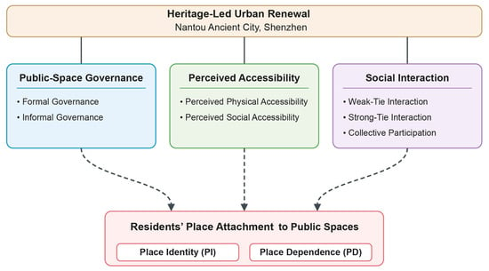
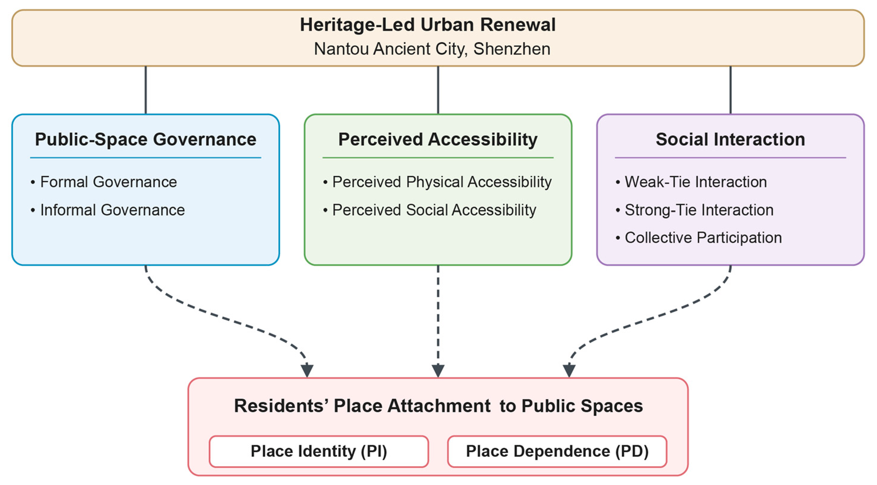
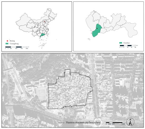
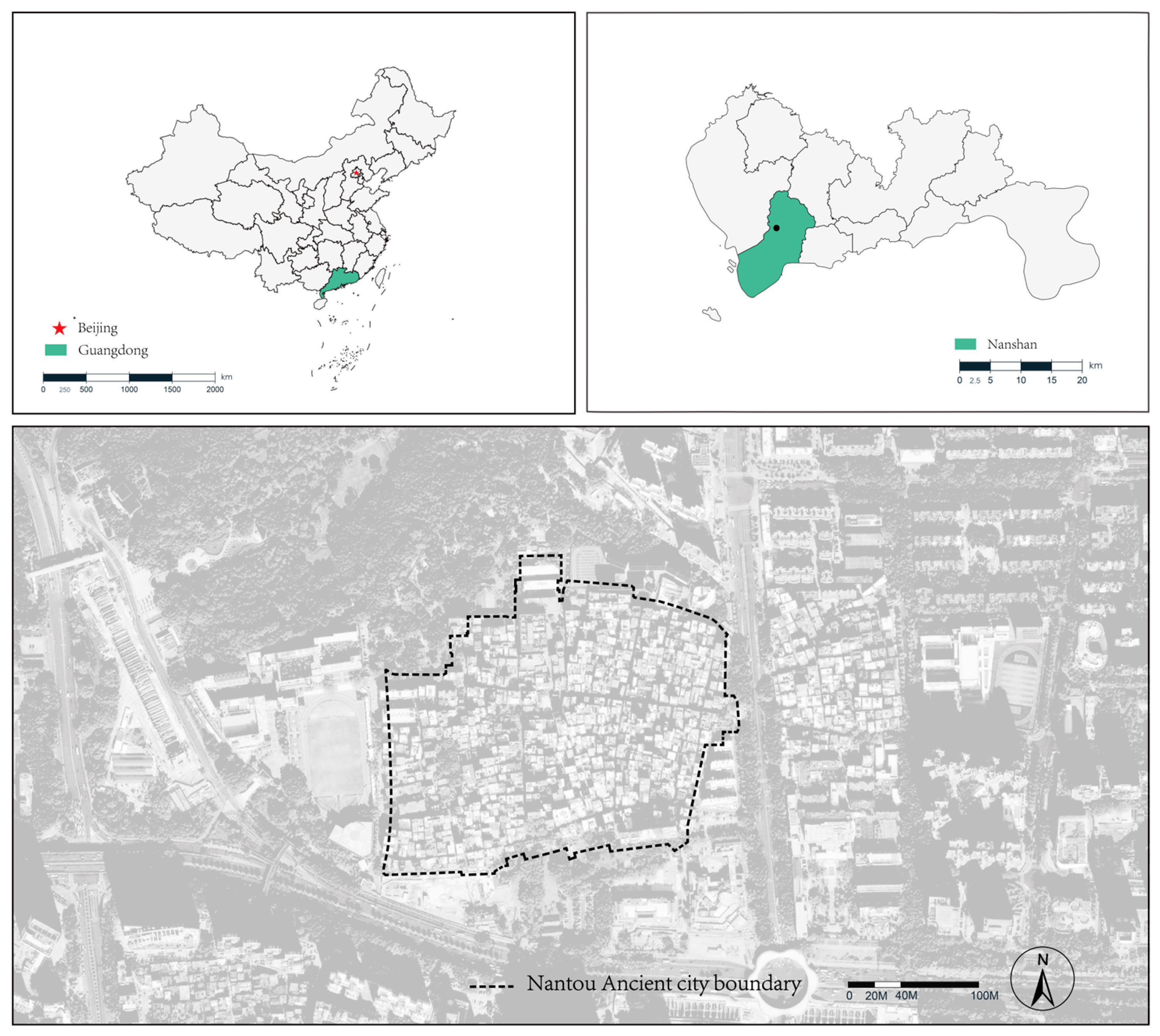
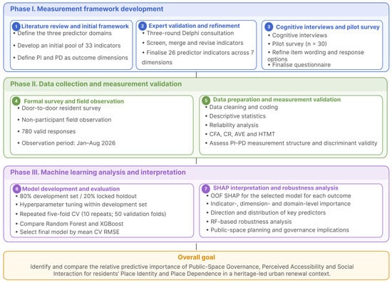
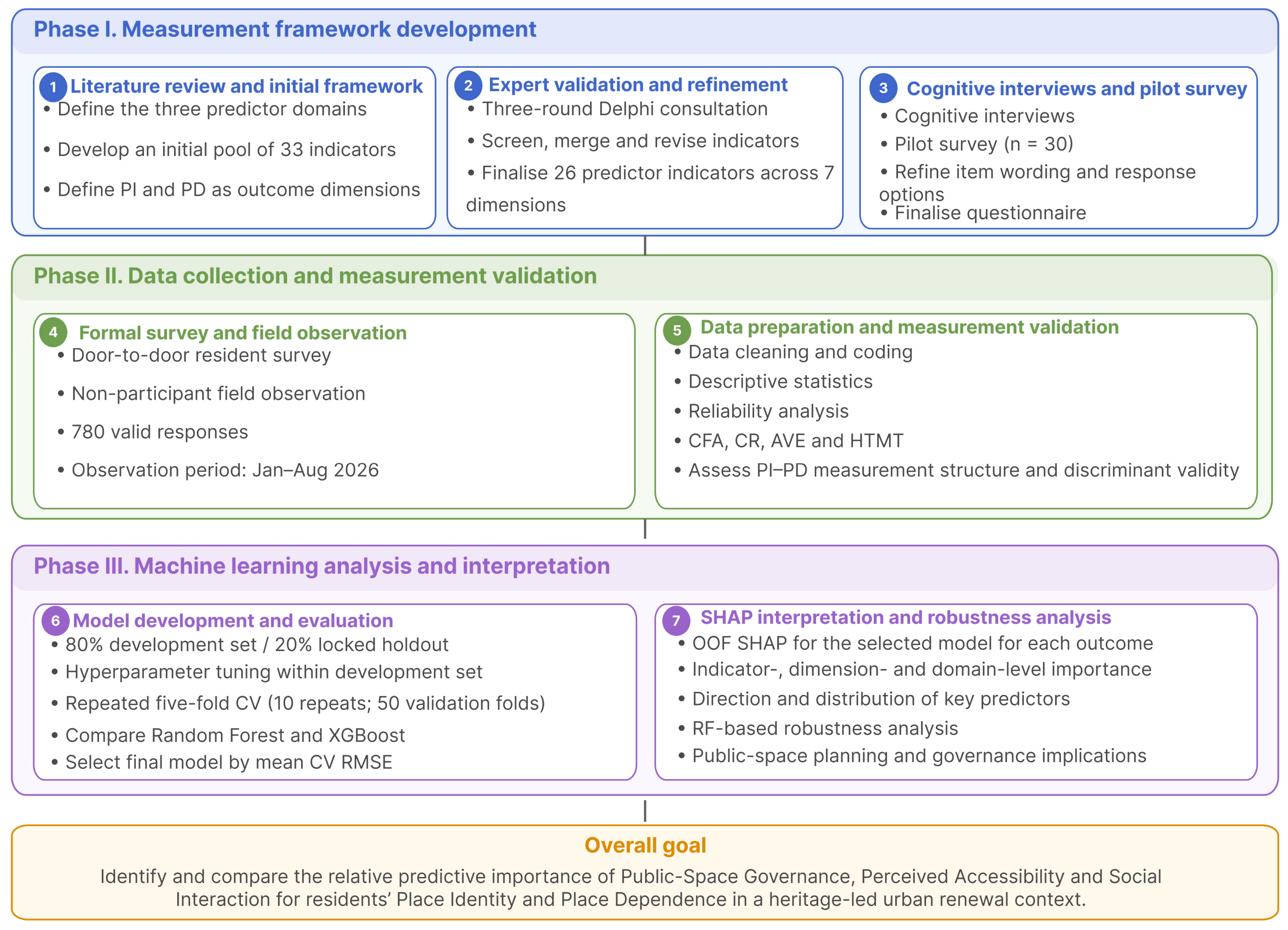
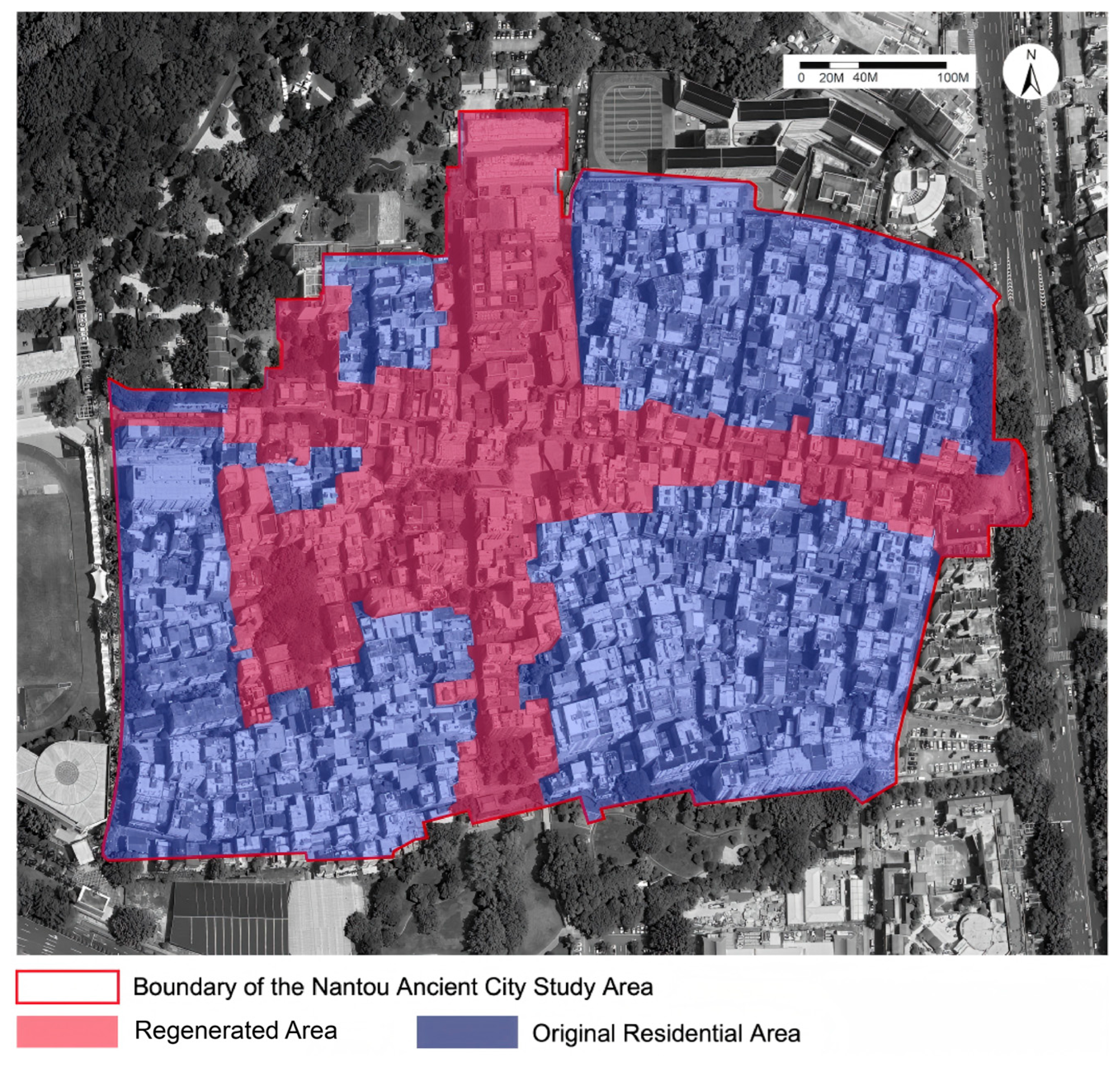
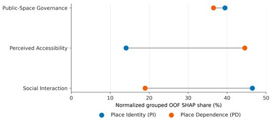
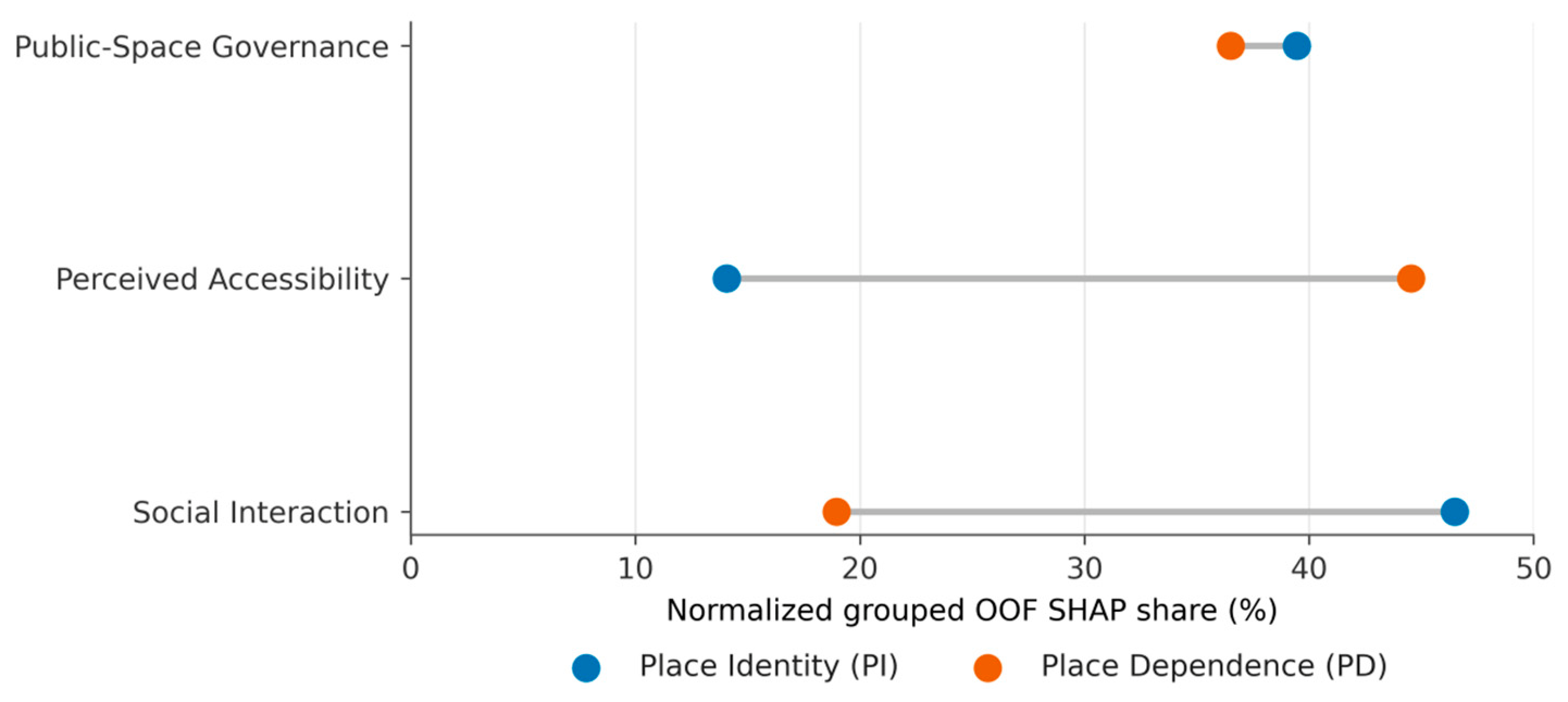
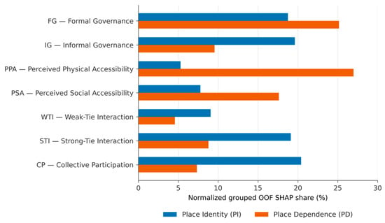
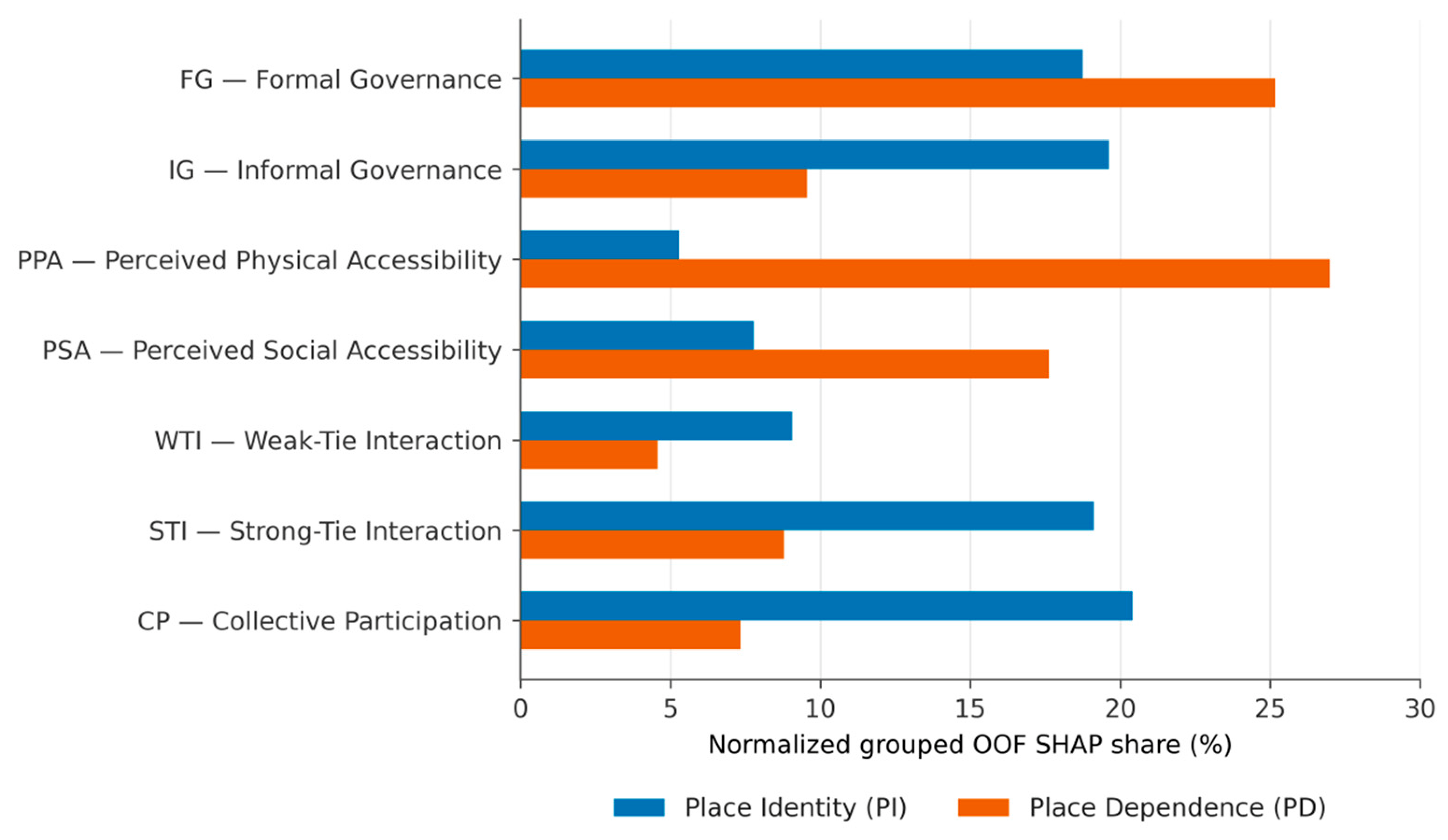
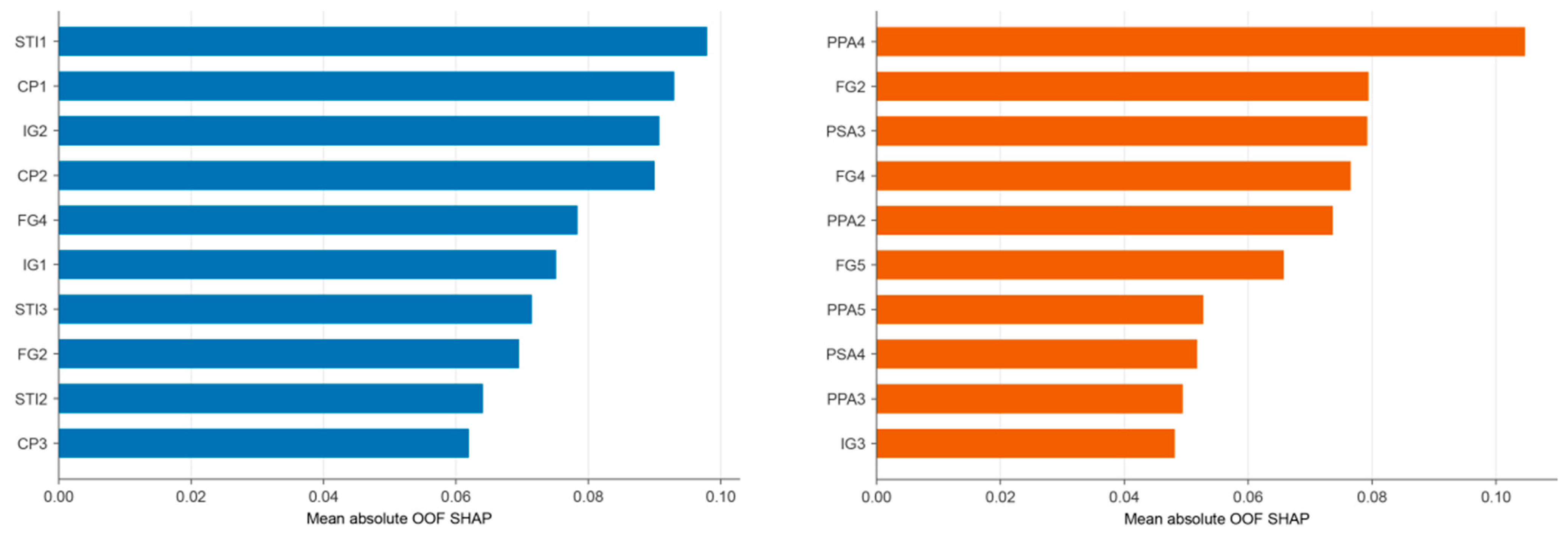
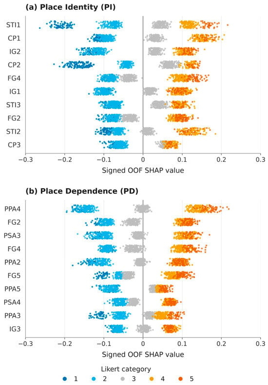
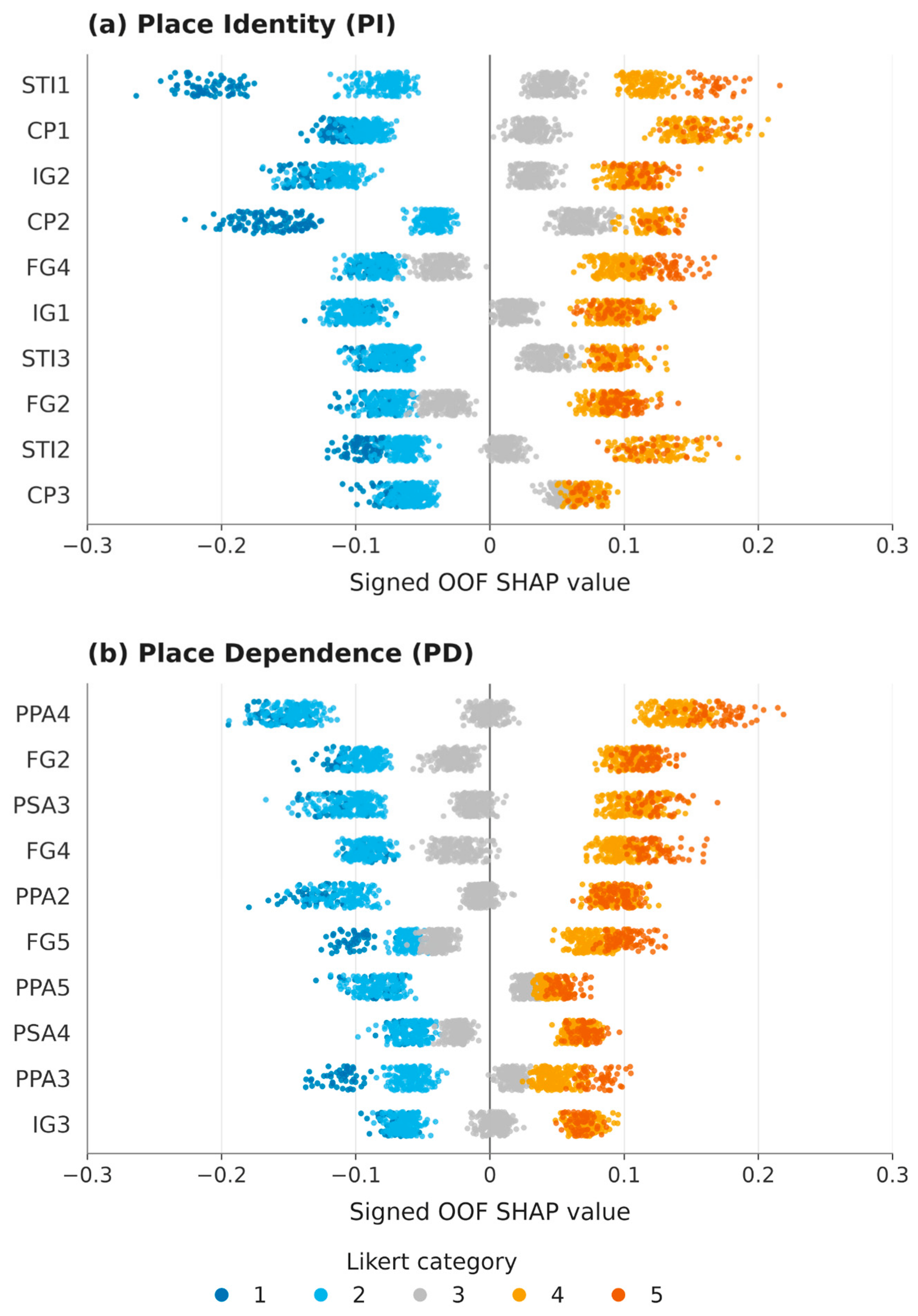

Disclaimer/Publisher’s Note: The statements, opinions and data contained in all publications are solely those of the individual author(s) and contributor(s) and not of MDPI and/or the editor(s). MDPI and/or the editor(s) disclaim responsibility for any injury to people or property resulting from any ideas, methods, instructions or products referred to in the content. |
© 2026 by the authors. Licensee MDPI, Basel, Switzerland. This article is an open access article distributed under the terms and conditions of the Creative Commons Attribution (CC BY) license.