1. Introduction
Historic urban districts are not static spaces intended solely for heritage display; rather, they are living environments shaped over time by historic buildings, street patterns, cultural resources, and place meanings while continuing to accommodate residential, service, recreational, and public activities. Urban regeneration aims to improve the physical, social, economic, and environmental conditions of existing urban areas, while in historic urban districts, it must also balance heritage conservation, contemporary development, and the quality of the living environment [
1,
2]. However, as heritage revitalization, tourism development, and commercial regeneration have advanced, some regeneration practices have placed greater emphasis on historic image, tourism attractiveness, and commercial vitality, while the needs of long-term users for walking, resting, everyday accessibility, and public interaction have not necessarily received equal attention [
3,
4,
5]. Therefore, how to preserve historic and cultural values while ensuring that regenerated historic districts continue to support the daily walking and public life of long-term residents represents an important practical challenge for age-friendly regeneration.
This issue is particularly important for older adults. Healthy aging depends on physical and social environments that enable older adults to remain engaged in daily activities, social interaction, and public life. As physical functioning changes, their independent mobility and social participation may become increasingly influenced by the walking environment, destination accessibility, public transport, resting facilities, and accessibility conditions. Walking is a form of physical activity that can be readily integrated into older adults’ daily lives and is associated with physical functioning, psychological well-being, and self-rated health [
6,
7]. At the same time, familiar environments in which older adults have lived or which they have used over extended periods may also embody local memories, emotional attachment, and social relationships [
8]. Therefore, daily walking among older adults is not only a form of physical activity but also a place-based practice through which familiar place experiences and social interactions are maintained [
9]. Age-friendly regeneration of historic urban districts therefore needs not only to meet basic walking and accessibility needs, but also to support older adults’ continued participation in everyday life within familiar environments.
Existing research on older adults’ walking has developed a relatively mature functional walkability framework, focusing primarily on built-environment characteristics such as population density, land-use mix, street connectivity, destination accessibility, public transport, and walking facilities [
10,
11,
12]. These conditions provide an important foundation for supporting walking, but existing assessment frameworks have largely been developed for general urban environments. Historic urban districts, by contrast, also contain place-based resources such as historical spatial continuity, cultural resources, sustained public life, and blue–green environments, which cannot be adequately represented by conventional functional indicators alone. Meanwhile, existing research on historic districts has focused more heavily on heritage conservation and regeneration, urban form, spatial vitality, and evaluations of regenerated environments [
13,
14], while the ways in which functional walking support and historical, cultural, and restorative resources jointly constitute older adults’ daily walking environments remain insufficiently integrated. Therefore, a multidimensional spatial-resource assessment framework is needed that incorporates both basic walking support and the contextual characteristics of historic urban districts.
However, a more comprehensive assessment of objective spatial resources is still insufficient to explain differences in older adults’ walking, because their cognitive, social, and emotional experiences of the environment may also be associated with daily walking. Place identity reflects the meanings and sense of belonging that connect individuals to particular places [
15]; social bonding refers to social relationships formed and maintained through place [
16]; and walking enjoyment captures positive emotional experiences during walking [
17]. Existing studies have shown that both social support and positive activity experiences are associated with older adults’ participation in physical activity [
18,
19]. However, objective spatial resources, place identity, social relationships, positive experiences, and older adults’ walking have largely been examined in separate research domains, with particularly limited integration in the context of historic urban districts. Therefore, it is necessary to further examine whether objective spatial resources are associated with older adults’ walking behavior through different place-based experiential pathways.
Based on the above research gaps, this study uses the Cuihu Historic and Cultural District in Kunming, China, as a case study to examine older adults’ daily walking by integrating objective spatial resources with individual place experiences. This study has three interrelated objectives. First, it integrates historical spatial resources, walking support resources, public cultural resources, and restorative environmental resources to construct a Spatial Resource Index (SRI) and identify spatial-resource differences across sub-zones. Second, it matches sub-zone-level SRI values with older adults’ place experiences and self-reported walking behavior to examine the associations of the SRI with place identity and walking behavior. Third, it tests whether the association between the SRI and walking behavior includes two indirect pathways operating through “place identity–social bonding” and “place identity–walking enjoyment,” respectively. This study integrates GIS-based spatial assessment, face-to-face questionnaires, and structural equation modeling. By extending conventional functional walkability to include multidimensional place-based resources and related experiences in historic districts, this study aims to provide empirical evidence for age-friendly regeneration that balances heritage conservation, everyday use, and healthy aging.
2. Literature Review and Research Hypotheses
2.1. Built Environment and Older Adults’ Walking Behavior
Walking is one of the forms of physical activity most readily integrated into older adults’ daily lives and is closely associated with psychological well-being and self-rated health [
7]. Supportive built environments are also associated with older adults’ physical activity, community participation, independent living, and aging in place [
20,
21]. Therefore, identifying environmental conditions that support older adults’ daily walking has long been an important issue in healthy-city and age-friendly community research.
Existing research on older adults’ walking primarily adopts a functional walkability framework, focusing on built-environment characteristics such as population density, land-use mix, street design and connectivity, destination accessibility, public transport, and walking facilities. Systematic reviews and empirical studies indicate that traffic safety, destination accessibility, greenery, and public transport are associated with older adults’ walking and physical activity; however, evidence for different environmental factors is not entirely consistent, and some associations exhibit nonlinear or threshold effects and vary according to individual characteristics such as age and retirement status [
10,
11,
22]. This suggests that, although existing frameworks have identified the basic functional conditions that support walking relatively well, their associations with walking behavior show clear individual variation and contextual dependence.
However, existing functional walkability frameworks primarily focus on general urban environmental characteristics such as roads, facilities, density, and accessibility, making them less able to capture place-based attributes of historic urban districts, including historical spatial continuity, cultural meaning, sustained public life, and restorative environmental quality. Conventional functional indicators therefore remain an important basis for assessing basic walking support, but are insufficient to fully characterize the multidimensional walking environment of historic districts, which combines both functional and place-based qualities. This contextual limitation indicates the need to retain basic functional walking support while incorporating historical, cultural, and restorative place-based resources into the analysis in order to further understand how the spatial environment of historic districts is associated with older adults’ daily walking.
2.2. Spatial Resources and Contextualized Walkability in Historic Urban Districts
In recent years, approaches to the conservation and regeneration of historic areas have gradually shifted from the static preservation of individual historic buildings toward a more integrated consideration of urban form, spatial vitality, and continued use [
23]. The Historic Urban Landscape (HUL) approach proposed by UNESCO further emphasizes that the physical form and natural environment of historic areas, together with their social, cultural, and economic values, should be considered comprehensively within a sustainable development framework to maintain the overall quality of the living environment [
2]. This shift implies that historic urban districts are not only objects of heritage conservation but also living environments that continue to accommodate residents’ daily activities, public interaction, and recreational walking. Accordingly, their walking environments should be understood not only in terms of general functional conditions, but also through place-based spatial resources jointly shaped by historical continuity, cultural use, public life, and the natural environment.
Existing studies indicate that different spatial resources in historic urban districts are associated with walking and place experience in multiple ways. Historic buildings, traditional streets, and spatial fabrics embody cultural memory and place identity [
23,
24]; daily services, public open spaces, resting facilities, and shade provide basic walking support [
25]; heritage and cultural spaces are associated with social interaction and community cohesion [
26]; and blue–green spaces are related to restorative experiences such as cognitive restoration and positive affect [
27]. Research on historic cultural streets in China further shows that streetscape and architectural characteristics, street connectivity, land-use mix, activity diversity, and social interaction are associated with walking motivation and experience, with these associations varying across street types and user groups [
28]. Together, these findings suggest that walking environments in historic urban districts are not constituted by a single functional condition, but involve multidimensional resources related to historical and cultural qualities, walking support, public social activity, and restorative environments, with clear contextual dependence.
However, existing research remains fragmented across heritage form and spatial vitality, walking support, culture and social interaction, and blue–green environments, with limited systematic integration of these spatial characteristics within a single analytical framework. Although conventional walkability assessments centered on functional conditions can identify basic walking support, they remain limited in representing the historical continuity, cultural use, sustained public life, and restorative environmental characteristics specific to historic urban districts. Therefore, the key limitation of existing research is not a lack of knowledge about individual environmental attributes, but the absence of a multidimensional assessment framework that integrates functional walking support with the place-based resources of historic districts. To address this gap, this study organizes spatial resources into four dimensions—historical spatial resources, walking support resources, public cultural resources, and restorative environmental resources—to construct a spatial-resource framework that is better adapted to the context of historic urban districts.
2.3. Place Identity and the Socio-Psychological Pathways of Older Adults’ Walking Behavior
Objective spatial conditions do not necessarily correspond to uniform behavioral responses; how individuals perceive, understand, and evaluate their environments is also an important dimension for explaining everyday behavior. Place identity refers to the cognitive structure within an individual’s self-identity that is related to the physical environment and includes memories, beliefs, understandings, and emotions associated with particular places [
15]. For older adults who have lived in or frequently used historic urban districts over extended periods, historic streets, traditional buildings, public cultural spaces, and familiar landscapes may also embody personal experiences, local memories, and meanings associated with everyday life. Existing research further indicates that cultural continuity, place characteristics, and social atmosphere are important components of how historic districts are perceived [
29]. Accordingly, place identity provides an important analytical dimension for understanding the relationship between objective spatial resources and older adults’ subjective place experiences.
The connection between individuals and places, together with the symbolic meanings reflected in place identity, also helps explain social relationships within specific environments. Public spaces, cultural facilities, and everyday activity nodes in historic urban districts provide concrete settings for residents to stay, interact with familiar others, and participate in public life. Existing research shows that the use of and engagement with natural and built environments are associated with community connectedness and place attachment, while social factors such as neighborhood contact, social support, and community participation are also associated with older adults’ daily walking [
30,
31]. These findings suggest that older adults’ walking does not occur solely within a physical environment, but is also embedded in a social context composed of familiar places, everyday interactions, and neighborhood relationships; therefore, place identity and social bonding may be importantly related.
Positive emotional experience represents another important dimension for understanding older adults’ walking. Existing studies indicate that street quality, functional configuration, and activity settings in historic urban districts are associated with walking motivation and experience [
28], while contact with natural environments is also associated with stress recovery and positive affect [
32]. Research on physical activity among older adults further shows that enjoyment is an important construct for assessing activity experience, and that the Physical Activity Enjoyment Scale (PACES) is applicable to older populations [
33]. Walking enjoyment therefore provides an important dimension for understanding older adults’ positive emotional experiences of walking environments; however, existing research has rarely examined it together with objective spatial resources in historic urban districts within a single analytical framework.
Overall, existing studies have separately examined associations among objective environments, place identity, social relationships, positive emotional experiences, and older adults’ walking, but the evidence remains dispersed across built-environment research, place studies, and physical-activity research. Particularly in the context of historic urban districts, GIS-measured objective spatial resources, place identity, social bonding, walking enjoyment, and walking behavior have rarely been integrated within a unified empirical framework. Therefore, an integrated perspective is needed that combines objective spatial environments with individual place experiences to further examine the associations among these factors and their possible pathways.
2.4. Research Hypotheses
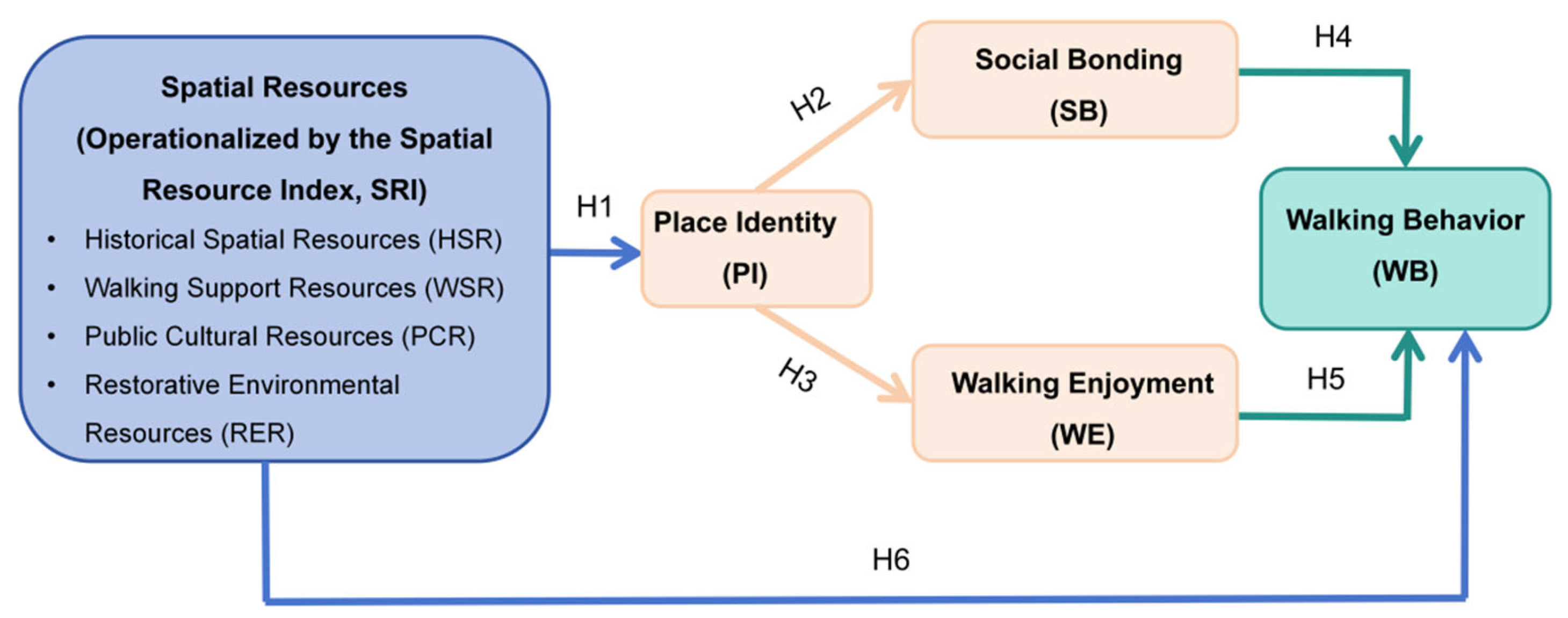
Based on the theoretical and empirical evidence reviewed above, this study develops a conceptual model comprising the Spatial Resource Index (SRI), place identity, social bonding, walking enjoyment, and walking behavior (
Figure 1). The SRI represents the level of objective spatial resources within older adults’ primary walking areas, while place identity, social bonding, and walking enjoyment reflect place-related cognitive, social, and emotional experiences, respectively, with walking behavior specified as the outcome variable. The model further proposes direct associations of the SRI with place identity and walking behavior, together with two indirect pathways involving place identity, social bonding, and walking enjoyment.
2.4.1. Spatial Resource Index and Place Identity
Multidimensional spatial resources in historic urban districts not only constitute the objective environment for older adults’ daily walking, but may also be associated with how they perceive neighborhood characteristics, local culture, and the meanings of everyday life. Existing studies indicate that the distinctiveness and cultural significance of architectural heritage, as well as the landscape, functional, and historical–cultural characteristics of urban landmarks, are associated with place identity [
34,
35]. Therefore, walking environments with higher overall levels of spatial resources may provide older adults with a richer environmental basis for recognizing place characteristics, developing familiarity, and attributing everyday meaning to place, and may consequently be associated with stronger place identity. Accordingly, the following hypothesis is proposed:
H1. The Spatial Resource Index of older adults’ primary walking areas is positively associated with their place identity.
2.4.2. Place Identity, Social Bonding, and Walking Enjoyment
Place identity, through its cognitive, emotional, and symbolic connections to place, may also be associated with social relationships formed and maintained within particular environments. Existing research shows that stronger neighborhood identity is associated with higher levels of social cohesion [
36]; within historic spatial contexts, social cohesion is also related to sense of belonging, place attachment, shared activities, and specific landscape characteristics [
37]. These findings suggest that stronger identification with and belonging to shared places may provide an important place-based foundation for older adults to maintain everyday social relationships. Accordingly, the following hypothesis is proposed:
H2. Place identity is positively associated with social bonding among older adults.
Place identity may also be associated with positive emotional experiences during activity. Existing studies have found positive associations of place perception and place attachment with restorative experiences, suggesting that stronger psychological connections between individuals and their environments may accompany more positive environmental experiences [
38]. Therefore, older adults who identify more strongly with their everyday walking environments may also experience more positive emotions during walking. Accordingly, the following hypothesis is proposed:
H3. Place identity is positively associated with walking enjoyment among older adults.
2.4.3. Social Bonding, Walking Enjoyment, and Walking Behavior
Social bonding, reflected in interactions with familiar others, companionship, and shared activities, may provide older adults with social support and opportunities to engage in daily walking. Longitudinal research has shown that social participation is associated with maintaining or increasing walking time among older adults [
39], while regular walking with companions is also associated with more positive changes in physical activity, autonomous motivation, and walking self-efficacy [
40]. Although these studies do not directly examine the construct of social bonding, together they suggest that stable social relationships and peer support may constitute important social conditions for maintaining older adults’ daily walking. Accordingly, the following hypothesis is proposed:
H4. Social bonding is positively associated with walking behavior among older adults.
Walking enjoyment reflects the interest, pleasure, and positive emotions experienced during walking. A systematic review of community-dwelling older adults identified enjoyment as an important factor supporting participation in physical activity, while low motivation was frequently reported as a barrier to participation [
41]. Therefore, more positive emotional experiences during walking may increase the intrinsic appeal of walking itself and be associated with sustained participation in daily walking. Accordingly, the following hypothesis is proposed:
H5. Walking enjoyment is positively associated with walking behavior among older adults.
2.4.4. Spatial Resource Index and Walking Behavior
Beyond sociopsychological experiences, the objective spatial environment also provides an important basis for supporting older adults’ daily walking. Existing studies have shown that built-environment characteristics such as destination accessibility, public transport, greenery, walking facilities, and street connectivity are associated with older adults’ walking and physical activity, although these associations vary across contexts and individual characteristics [
10,
11,
12,
20,
22,
25]. Studies based on objective spatial measurements further indicate that differences in neighborhood walkability are associated with older adults’ outdoor walking [
12]. Therefore, in historic urban districts, higher overall levels of spatial resources within older adults’ primary walking areas may provide greater environmental support for daily walking and be associated with higher levels of walking behavior. Accordingly, the following hypothesis is proposed:
H6. The Spatial Resource Index of older adults’ primary walking areas is positively associated with their walking behavior.
2.4.5. Dual Sequential Indirect Pathways
Beyond the direct associations proposed above, indirect associations between the objective spatial environment and older adults’ walking may also involve place experiences and social relationships. Existing research indicates that general neighborhood accessibility alone may be insufficient to explain older adults’ social connectedness, whereas third places that support everyday stays and social interaction are positively associated with their social support networks [
42]. This suggests that the relationship between the spatial environment and older adults’ walking may involve not only functional support but also social and experiential connections formed within particular places. Although existing studies have not directly examined the sequential indirect pathways proposed in this study, the theoretical relationships established in H1–H5 suggest that the association between the SRI and walking behavior may involve two indirect pathways: “place identity–social bonding” and “place identity–walking enjoyment.” Accordingly, the following hypotheses are proposed:
H7. The Spatial Resource Index is positively and indirectly associated with older adults’ walking behavior through place identity and social bonding.
H8. The Spatial Resource Index is positively and indirectly associated with older adults’ walking behavior through place identity and walking enjoyment.
3. Methodology
3.1. Research Design and Methodological Overview
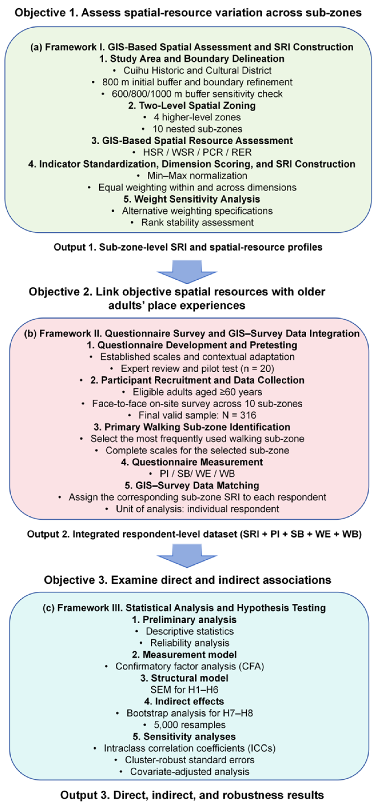
This study adopted an integrated research design comprising three interconnected methodological modules: GIS-based spatial assessment and SRI construction, questionnaire survey and GIS–questionnaire data integration, and statistical analysis and hypothesis testing. These three modules were used, respectively, to assess spatial-resource characteristics across sub-zones of the study area, match sub-zone-level objective spatial resources with older adults’ individual place experiences and walking behavior, and further test the direct and indirect associations among the study variables.
The three methodological modules correspond to the three research objectives and sequentially produce: (1) sub-zone-level SRI values and spatial-resource profiles; (2) an integrated individual-level GIS–questionnaire dataset; and (3) results for direct associations, indirect associations, and robustness tests. The three methodological frameworks and their interconnections are illustrated in
Figure 2a–c.
3.2. Study Area and Spatial Zoning
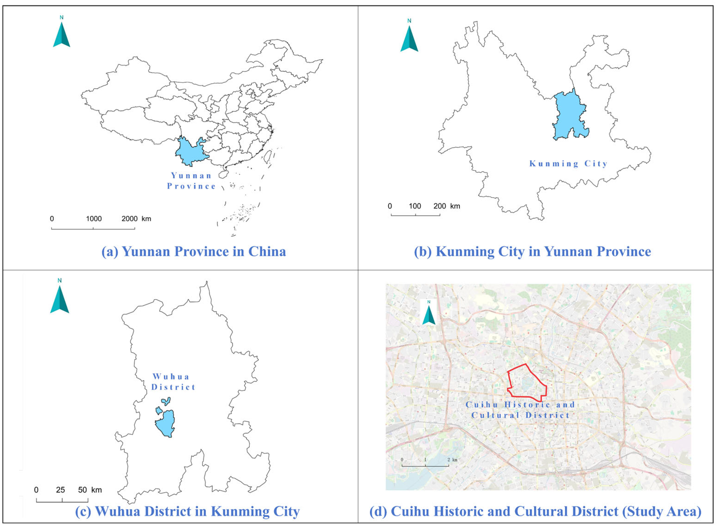
This study selected the Cuihu Historic and Cultural District in Kunming, Yunnan Province, China, as the empirical study area. Kunming was designated by the State Council in 1982 as one of China’s first National Historic and Cultural Cities [
43]. The Cuihu Historic and Cultural District is located in the core area of Kunming’s old city and contains a concentration of waterfront landscapes, historic buildings, public cultural facilities, traditional streets and alleys, and everyday service spaces. It therefore combines multiple functions related to heritage and culture, public recreation, and everyday life. The coexistence of diverse spatial resources and sustained everyday use makes it an appropriate empirical setting for examining associations among spatial resources, place experiences, and older adults’ walking behavior in historic urban districts (
Figure 3).
The study boundary was delineated through a three-step procedure that considered the distribution of historic and cultural resources, older adults’ daily walking scale, road accessibility, and spatial continuity. First, an initial 800 m buffer was established around a reference point within Cuihu Park, with a theoretical area of approximately 2.01 km
2. Existing GIS and physical-activity studies commonly use neighborhood buffer distances of approximately 400–1600 m, with 800 m frequently used to represent a general walking scale [
44], while research focusing on older adults in China suggests that their daily walking scale may be smaller [
45]. Accordingly, the 800 m distance was not treated as a fixed walking threshold for older adults, but only as an initial spatial extent for boundary delineation, intended to encompass the major public activity spaces and historic and cultural resources surrounding Cuihu.
Second, the initial buffer boundary was refined according to the road network, major traffic barriers, neighborhood accessibility, and spatial continuity. Peripheral areas with weak connections to walking activities around Cuihu or with clear spatial barriers were excluded, while areas continuously connected to Cuihu Park, historic streets and alleys, and major public activity nodes were retained. Finally, the boundary was further checked against the distribution of historic buildings, public cultural nodes, waterfront landscapes, everyday service facilities, and resting spaces, resulting in a final study area of approximately 1.67 km2.
To assess the sensitivity of the study boundary to the choice of initial buffer distance, 600 m, 800 m, and 1000 m radial buffers were generated around the same reference point and compared in terms of their spatial coverage of the final study area. The three buffers covered approximately 64.15%, 91.88%, and 100% of the final study area, respectively. However, buffer selection was not based on coverage alone, but also considered the officially defined historic-district boundary, road barriers, spatial continuity, and the contextual integrity of the study area. The 600 m buffer omitted a substantial portion of the study area, whereas the 1000 m buffer achieved complete coverage but extended considerably into peripheral urban areas that were less closely related to the spatial characteristics and daily walking activities of the Cuihu Historic and Cultural District. Therefore, the 800 m buffer provided a more appropriate balance between spatial coverage and contextual integrity of the historic district and was retained as the initial buffer distance. Detailed comparisons are provided in
Supplementary Table S4.
To reflect spatial heterogeneity within the study area and improve the spatial correspondence between objective spatial resources and respondents’ primary walking contexts, a two-level spatial zoning system was established. The zoning followed four principles: spatial continuity, whereby adjacent areas with closely connected spatial forms were grouped into the same unit; functional consistency, whereby each spatial unit was defined by relatively clear land-use and dominant activity characteristics; boundary interpretability, whereby boundaries were preferentially delineated along major roads, urban-block morphology, edges of public spaces, and clear functional transition interfaces; and respondent recognizability, whereby each spatial unit could be readily identified by respondents through major roads, landmark spaces, or distinctive functional characteristics.
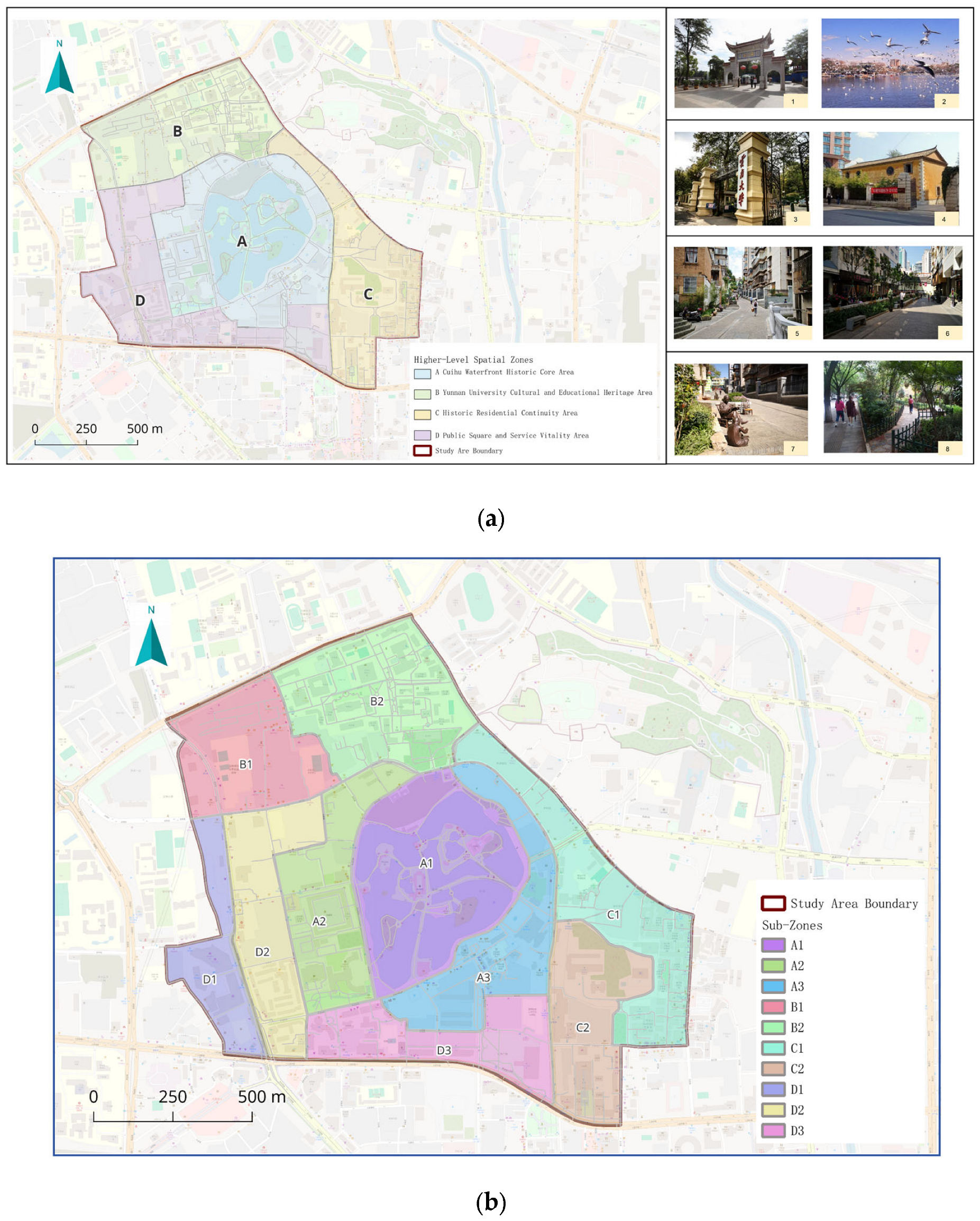
Based on these principles, the study area was first divided into four higher-level spatial zones to summarize its overall spatial structure, dominant functions, and historic and cultural characteristics (
Figure 4a), and was then further subdivided into ten nested sub-zones (
Table 1 and
Figure 4b). These ten sub-zones served as the basic spatial units for subsequent analysis, including GIS indicator calculation, SRI construction, identification of respondents’ primary walking sub-zones, and matching the corresponding spatial-resource values to individual questionnaire data.
3.3. Construction of the Spatial Resource Index
Based on the multidimensional spatial-resource framework for historic urban districts developed above, this study used GIS to quantify objective spatial resources across the ten sub-zones and constructed the Spatial Resource Index (SRI) to compare their overall spatial-resource levels and configuration differences. The detailed GIS-based spatial assessment and SRI construction process is illustrated in
Figure 2a.
The traditional 5D built-environment framework evaluates walking environments primarily in terms of functional conditions such as density, land-use mix, street design, destination accessibility, and public transport [
10,
46], but it provides relatively limited representation of contextual characteristics specific to historic urban districts, including historical continuity, public cultural resources, and restorative blue–green environments. Based on the theoretical discussion above, this study therefore incorporates the Historic Urban Landscape (HUL) perspective [
2] into conventional functional walking environment indicators to extend the representation of place-based spatial resources in historic urban districts.
Drawing on built-environment and walking research, the HUL perspective, and restorative-environment research, this study constructed four GIS-quantifiable spatial-resource dimensions: Historical Spatial Resources (HSR), Walking Support Resources (WSR), Public Cultural Resources (PCR), and Restorative Environmental Resources (RER). These four dimensions represent historical spatial continuity, support for daily walking, the provision of public cultural resources, and restorative environmental conditions, respectively, and together constitute the SRI. The conceptual role, theoretical basis, and GIS proxy indicators for each dimension are presented in
Table 2; detailed operational definitions, data sources, spatial scales, coordinate reference systems, spatial analysis methods, units, and standardization procedures are provided in
Supplementary Table S2.
- 1.
Indicator Standardization
To eliminate differences in measurement scales and numerical ranges among the GIS indicators, the Min–Max normalization method was applied to rescale each second-level indicator to the interval [0, 1]. As all selected indicators were positively oriented, the normalization formula was expressed as follows:
where
denotes the original value of sub-zone i for GIS indicator j;
and
denote the minimum and maximum values, respectively, of indicator j across the ten sub-zones; and
denotes the normalized value of indicator j for sub-zone i.
- 2.
Calculation of the First-Level Spatial Resource Dimensions
Given that this study aimed to construct an interpretable composite spatial resource index, and that there was insufficient theoretical or empirical evidence to justify differentiated weights among the indicators and resource dimensions, an equal-weighting approach was adopted. Specifically, equal weights were assigned to the secondary indicators within each first-level spatial resource dimension, and the four first-level spatial resource dimensions were also equally weighted.
Following normalization, the score for each first-level spatial resource dimension was calculated as the arithmetic mean of its corresponding second-level indicators:
where
denotes the score of spatial resource dimension k for sub-zone i;
denotes the set of second-level indicators included in spatial resource dimension k;
denotes the number of second-level indicators included in dimension k; and
denotes the normalized value of second-level indicator j for sub-zone i.
Historical spatial resources (HSR), walking support resources (WSR), and restorative environmental resources (RER) each comprised three second-level indicators, whereas public cultural resources (PCR) comprised two second-level indicators.
Finally, the Spatial Resource Index (SRI) for each sub-zone was calculated as the equal-weighted arithmetic mean of the four first-level spatial resource dimensions:
where
denotes the Spatial Resource Index of sub-zone i, while
,
,
, and
denote the scores of the four first-level spatial resource dimensions for that sub-zone.
To assess the robustness of the equal-weight specification across the four first-level spatial resource dimensions, a one-at-a-time sensitivity analysis was conducted. Starting from the baseline weight of 0.25 for each dimension, the weight of one dimension at a time was varied to 0.10, 0.15, 0.20, 0.30, 0.35, and 0.40, while the remaining weight was distributed equally among the other three dimensions. This procedure generated 24 alternative weighting specifications. Robustness was evaluated by comparing the resulting SRI rankings with the baseline ranking using Spearman’s rank correlations, maximum rank shifts, and the stability of the highest-ranked sub-zones. Detailed specifications are reported in
Supplementary Table S3.
3.4. Questionnaire Design and Pretest
3.4.1. Questionnaire Design
This study used a face-to-face questionnaire survey to measure older adults’ place experiences and walking behavior within their primary walking contexts in the Cuihu Historic and Cultural District. Participants were required to meet all of the following criteria: (1) continuous residence in Kunming for at least one year; (2) age ≥ 60 years; and (3) previous participation in walking, recreation, social interaction, cultural visits, or other daily activities within the Cuihu Historic and Cultural District. Before completing the scales, respondents were shown a map containing the ten sub-zones and asked to select the sub-zone in which they most frequently engaged in walking. All subsequent scales were completed with reference to this selected sub-zone, which was also used to match the corresponding SRI value. Throughout the questionnaire, “the area” referred to the respondent’s selected primary walking sub-zone.
The questionnaire comprised two sections: sociodemographic information and core study variables. Sociodemographic information included sex, age, educational attainment, current employment status, personal monthly income, and living arrangement; the core variables included place identity (PI), social bonding (SB), walking enjoyment (WE), and walking behavior (WB). Items for PI, SB, and WE were contextually adapted from established scales, whereas the WB items were developed with reference to relevant behavioral theories and the walking context of this study. The four constructs comprised a total of 17 measurement items, all assessed using a five-point Likert scale (1 = “strongly disagree” and 5 = “strongly agree”). The complete measurement items are provided in
Supplementary Table S1.
Before the formal survey, questionnaire review and pretesting were conducted in September 2025. Three experts with backgrounds in urban planning, older-adult behavior research, and public-space evaluation reviewed the initial questionnaire, and 20 older adults participated in a face-to-face pretest. Based on expert comments and pretest feedback, the wording of selected items, their contextual suitability, and the questionnaire structure were revised to produce the final survey instrument.
3.4.2. Data Collection
This study employed an on-site intercept survey to recruit older adults who met the eligibility criteria described above, with data collection covering all ten sub-zones within the study area. Survey locations included major walking spaces, waterfront areas, public cultural spaces, resting nodes, and areas surrounding everyday service facilities. Rather than using a single fixed survey point within each sub-zone, data were collected at multiple public spaces and walking nodes with relatively high concentrations of older adults, and specific survey locations were adjusted according to on-site activity patterns at different times of day to broaden coverage across sub-zones and spatial contexts.
Given that some older adults may have limited familiarity with or acceptance of online questionnaires, this study used face-to-face paper-based questionnaires, with fieldwork conducted by surveyors working in pairs. Before the survey began, respondents were informed of the study purpose, questionnaire content, principles of anonymity and voluntary participation, and their right to withdraw at any time, and the survey proceeded only after informed consent was obtained. Respondents then identified their primary walking sub-zone following the procedure described above and completed the questionnaire with reference to that sub-zone. For items that were difficult to understand, surveyors provided only standardized and neutral explanations and did not suggest or guide responses.
The formal survey was conducted from October to November 2025, primarily during periods when older adults were relatively active outdoors, namely 07:00–11:00 and 14:00–17:00. A total of 351 questionnaires were distributed. During data screening, questionnaires with clearly incomplete responses, obvious patterned responding, or failure to meet the inclusion criteria were excluded, resulting in 316 valid questionnaires and a valid response rate of 90.03%.
3.5. Data Analysis
The data analysis procedure is illustrated in
Figure 2c. Descriptive statistics were conducted using SPSS 29.0, while confirmatory factor analysis (CFA), structural equation modeling (SEM), and Bootstrap analysis were performed using the SEMLj module in jamovi 2.7.37. First, descriptive statistics were calculated for sociodemographic characteristics and the core study variables, and Cronbach’s α was used to assess the internal consistency of the scales. Subsequently, CFA was conducted to examine the measurement model comprising place identity (PI), social bonding (SB), walking enjoyment (WE), and walking behavior (WB); convergent and discriminant validity were assessed based on standardized factor loadings, composite reliability (CR), average variance extracted (AVE), and the Fornell–Larcker criterion.
In the structural model, the SRI was specified as an exogenous observed variable, while PI, SB, WE, and WB were specified as individual-level latent variables. Model parameters were estimated using maximum likelihood (ML). Model fit was evaluated using χ2/df, CFI, TLI, RMSEA, SRMR, NFI, and IFI. H1–H6 were tested based on standardized structural path coefficients (β) and their statistical significance, whereas H7 and H8 were tested using percentile Bootstrap analysis with 5000 resamples for the two specific indirect effects; statistical significance was determined by whether the corresponding 95% confidence intervals included zero. Bootstrap analysis reported unstandardized estimates and their 95% percentile confidence intervals for the direct effect, specific indirect effects, total indirect effect, and total effect, together with the corresponding standardized effects.
Given that respondents within the same primary walking sub-zone shared the same SRI value, additional clustering and covariate sensitivity analyses were conducted. First, intraclass correlation coefficients (ICCs) were calculated for PI, SB, WE, and WB to assess the degree of within-sub-zone clustering. The six main structural associations corresponding to H1–H6 were then re-estimated using standardized SRI values and standardized mean scores for the four constructs, with the ten sub-zones treated as clustering units and CR2 cluster-robust standard errors with Satterthwaite-adjusted degrees of freedom applied. Because this study included only ten spatial clusters, this analysis was used only as a robustness check for the main SEM results rather than as a replacement for the latent-variable SEM. In addition, a covariate-adjusted sensitivity analysis was conducted by including sex, age, educational attainment, current employment status, personal monthly income, and living arrangement. Complete results are provided in
Supplementary Tables S5 and S6.
4. Results
4.1. Sample Characteristics and Distribution Across Primary Walking Sub-Zones
Table 3 presents the demographic and household characteristics of the respondents. The sample comprised 173 men (54.7%) and 143 women (45.3%), indicating a relatively balanced gender distribution. Most respondents were aged 60–69 years, accounting for 212 participants (67.1%), while 104 respondents (32.9%) were aged 70 years or older. Regarding educational attainment, 38.9% had completed primary school or below, 31.1% had completed junior high school, 19.9% had completed senior high school or secondary vocational school, and 10.1% had attained a college education or above. Most respondents were retired (88.6%), and 50.6% reported a personal monthly income of RMB 2000–4000. In terms of living arrangements, 40.2% lived with their children, with or without a spouse, while 39.2% lived only with their spouse; together, these two groups accounted for 79.4% of the sample. Overall, the sample was predominantly composed of retired older adults aged 60–69 years who lived with either their spouse or children.
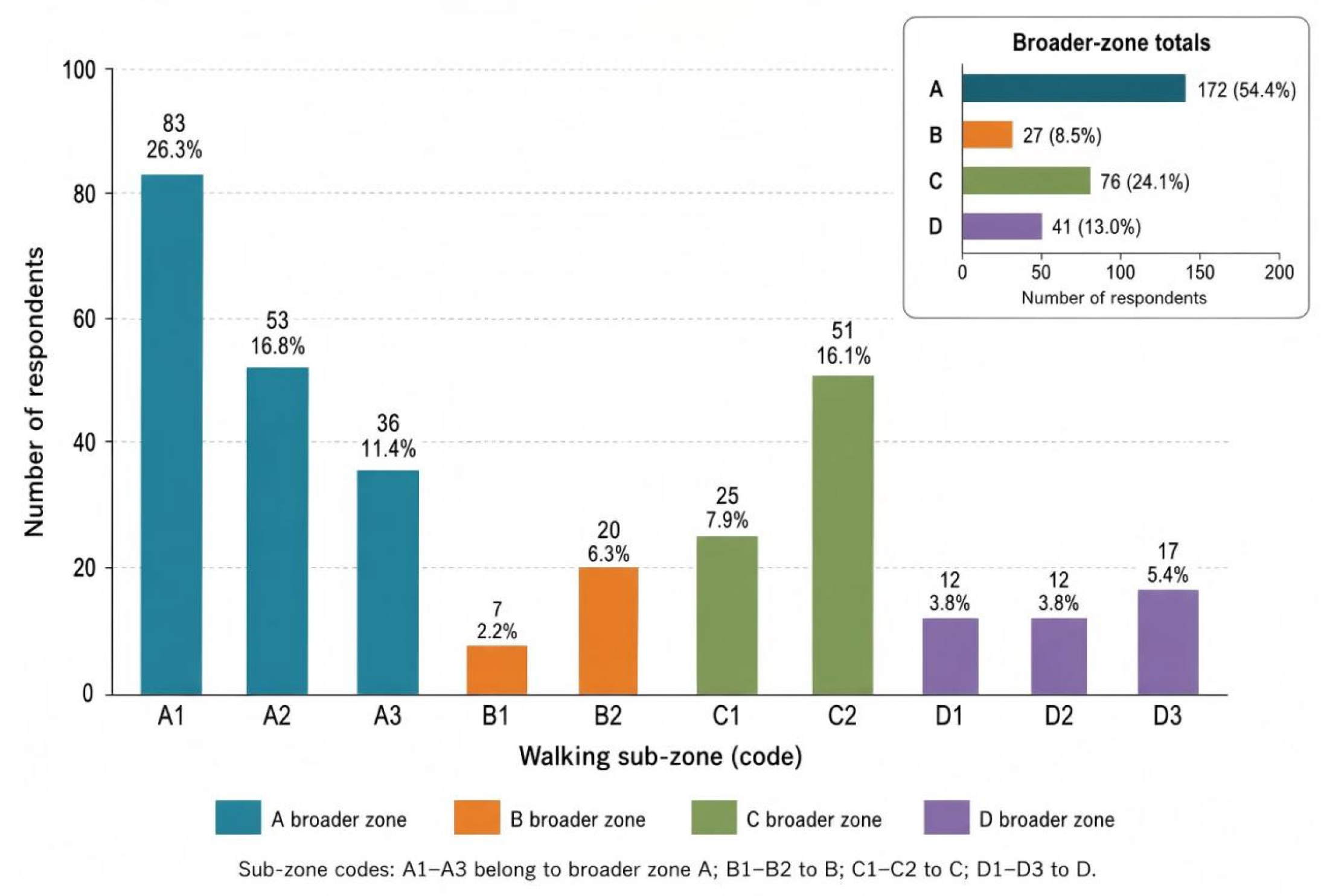
Figure 5 shows the distribution of respondents across their primary walking sub-zones. A1, the Cuihu Waterfront Recreation Core Area, had the largest number of respondents, with 83 participants (26.3%), followed by A2, the Yunnan Military Academy Historical and Cultural Activity Area, with 53 participants (16.8%), and C2, the Wuhua Hill–Confucian Temple Historical and Cultural Activity Area, with 51 participants (16.1%). A3, the Southeast Cuihu Street Daily-Life Service Area, included 36 respondents (11.4%); C1, the Huguo Street Daily-Life Service Area, included 25 respondents (7.9%); B2, Yunnan University Donglu Campus, included 20 respondents (6.3%); and D3, the Wuhua Square Activity Area, included 17 respondents (5.4%). D1, the Baihui Shopping Center Daily-Life Service Area, and D2, the Qianju Street Daily-Life Service Area, each included 12 respondents (3.8%), while B1, the Wenlin Street Daily-Life Service Area, had the fewest respondents, with 7 participants (2.2%). When aggregated by the four broader zones, Zone A included 172 respondents (54.4%), Zone C included 76 respondents (24.1%), Zone D included 41 respondents (13.0%), and Zone B included 27 respondents (8.5%). Overall, respondents were primarily concentrated in A1, A2, and C2, which represent the waterfront recreational core and two major historical and cultural activity areas within the study area. The sociodemographic distribution of respondents across the ten primary walking sub-zones is further reported in
Supplementary Table S7.
4.2. Sub-Zone Variations in Spatial Resources and the SRI
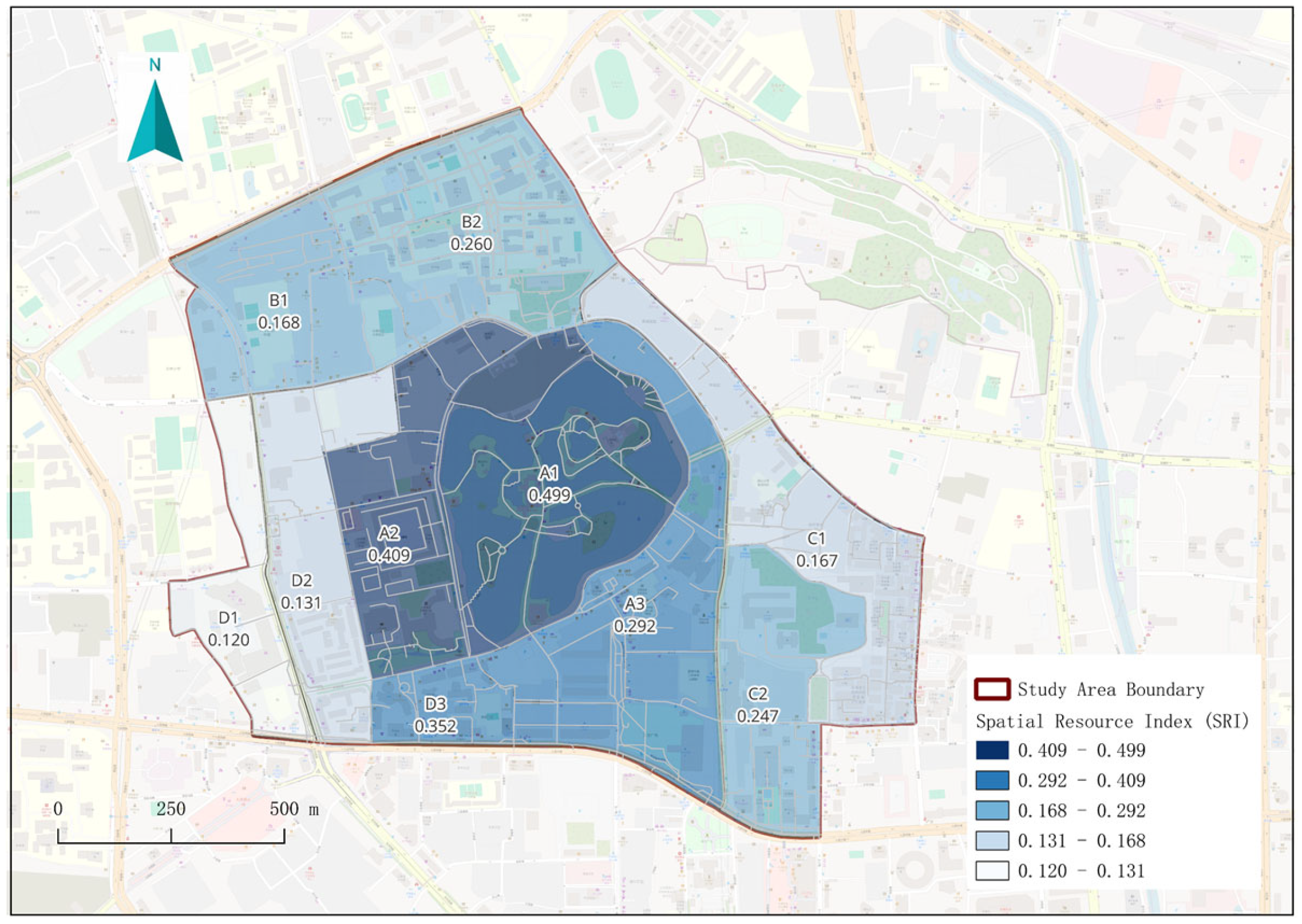
Based on the standardized scores of the four spatial resource dimensions, clear variation was observed across the ten sub-zones in historical spatial resources (HSR), walking support resources (WSR), public cultural resources (PCR), restorative environmental resources (RER), and the Spatial Resource Index (SRI) (
Table 4 and
Figure 6). The SRI values ranged from 0.120 to 0.499. A1, the Cuihu Waterfront Recreation Core Area, recorded the highest SRI value (0.499), followed by A2, the Yunnan Military Academy Historical and Cultural Activity Area (0.409), and D3, the Wuhua Square Activity Area (0.352). A3, the Southeast Cuihu Street Daily-Life Service Area (0.292), and B2, Yunnan University Donglu Campus (0.260), exhibited intermediate SRI levels. By contrast, D1, the Baihui Shopping Center Daily-Life Service Area (0.120), and D2, the Qianju Street Daily-Life Service Area (0.131), recorded relatively low SRI values. These results indicate considerable spatial heterogeneity in overall spatial resource provision within the Cuihu Historic and Cultural District. Rather than following a simple core-to-periphery declining pattern, the observed variation reflects the different combinations of spatial resources across the sub-zones.
Across the four spatial resource dimensions, the sub-zones exhibited distinct resource profiles. Historical spatial resources (HSR) reached their highest level in A2, the Yunnan Military Academy Historical and Cultural Activity Area (0.977), reflecting the concentration of historic buildings, traditional streets and alleys, and cultural heritage assets within this sub-zone. Walking support resources (WSR) were highest in B1, the Wenlin Street Daily-Life Service Area (0.486), and A1, the Cuihu Waterfront Recreation Core Area (0.484), while C1, the Huguo Street Daily-Life Service Area (0.435), and D1, the Baihui Shopping Center Daily-Life Service Area (0.430), also recorded relatively high values. Public cultural resources (PCR) reached their highest values in B2, Yunnan University Donglu Campus, and D3, the Wuhua Square Activity Area (both 0.500). Restorative environmental resources (RER), by contrast, were strongly concentrated in A1, which recorded a standardized score of 1.000, markedly higher than those of the other sub-zones. Overall, the sub-zones with relatively high values for HSR, WSR, PCR, and RER did not fully overlap, indicating differentiated spatial resource configuration patterns within the study area.
The SRI ranking remained stable under alternative weighting specifications: across 24 one-at-a-time weight perturbation scenarios, Spearman’s rank correlations with the baseline ranking ranged from 0.927 to 1.000, the maximum rank shift did not exceed two positions, and A1, A2, and D3 remained the top three sub-zones in all scenarios (
Supplementary Table S3).
4.3. Measurement Model Assessment
Before testing the structural model, the reliability and validity of the measurement model comprising four latent constructs—place identity, social bonding, walking enjoyment, and walking behavior—were assessed. Cronbach’s α coefficients ranged from 0.826 to 0.906 and were all above 0.80, indicating good internal consistency reliability for all four scales (
Table 5).
Confirmatory factor analysis indicated that the measurement model exhibited good overall fit (
Table 6). The standardized factor loadings of the measurement items ranged from 0.683 to 0.879, and all non-fixed factor loadings were statistically significant at
p < 0.001 (
Table 7). Composite reliability (CR) values ranged from 0.826 to 0.907, while average variance extracted (AVE) values ranged from 0.543 to 0.686, indicating good convergent validity for all four constructs (
Table 8). In addition, the square root of the AVE for each construct exceeded its correlations with the other constructs, satisfying the Fornell–Larcker criterion and supporting discriminant validity (
Table 9). Overall, the measurement model demonstrated satisfactory internal consistency reliability, model fit, convergent validity, and discriminant validity.
4.4. Structural Model and Hypothesis Testing
After the measurement model demonstrated acceptable reliability and validity, structural equation modeling was employed to examine the hypothesized relationships among the Spatial Resource Index (SRI), place identity, social bonding, walking enjoyment, and walking behavior. The structural model included a direct path from the SRI to walking behavior, together with two sequential indirect pathways through place identity–social bonding and place identity–walking enjoyment. A percentile bootstrap procedure with 5000 resamples was used to estimate the direct effect, the two specific indirect effects, the total indirect effect, and the total effect.
4.4.1. Structural Model Fit
The full structural model, including the direct path from the SRI to walking behavior, was estimated using the SEMLj module in jamovi with maximum likelihood estimation. Model fit was evaluated using the χ
2/df ratio, comparative fit index (CFI), Tucker–Lewis index (TLI), root mean square error of approximation (RMSEA), standardized root mean square residual (SRMR), normed fit index (NFI), and incremental fit index (IFI). As shown in
Table 10, all major fit indices met the recommended criteria, indicating that the structural model provided a good fit to the sample data.
4.4.2. Structural Paths and Hypothesis Testing
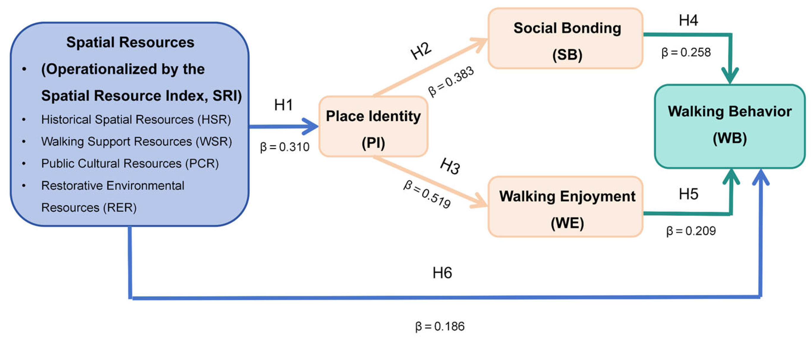
The structural path estimates are presented in
Figure 7. The SRI was significantly and positively associated with place identity (β = 0.310,
p < 0.001). Place identity was significantly and positively associated with both social bonding (β = 0.383,
p < 0.001) and walking enjoyment (β = 0.519,
p < 0.001). The standardized coefficient for the association between place identity and walking enjoyment was numerically larger than that for social bonding. The SRI was also significantly and positively associated with walking behavior (β = 0.186,
p = 0.002). In addition, both social bonding (β = 0.258,
p < 0.001) and walking enjoyment (β = 0.209,
p < 0.001) were significantly and positively associated with walking behavior. Overall, all six structural paths included in the revised model were supported by the data.
4.4.3. Direct and Indirect Effect Testing
A percentile bootstrap procedure with 5000 resamples was used to examine the direct effect, the two specific indirect effects, the total indirect effect, and the total effect of the SRI on walking behavior.
As shown in
Table 11, the direct effect of the SRI on walking behavior was statistically significant (unstandardized estimate = 1.182, standardized β = 0.186, 95% percentile bootstrap CI [0.410, 1.956]).
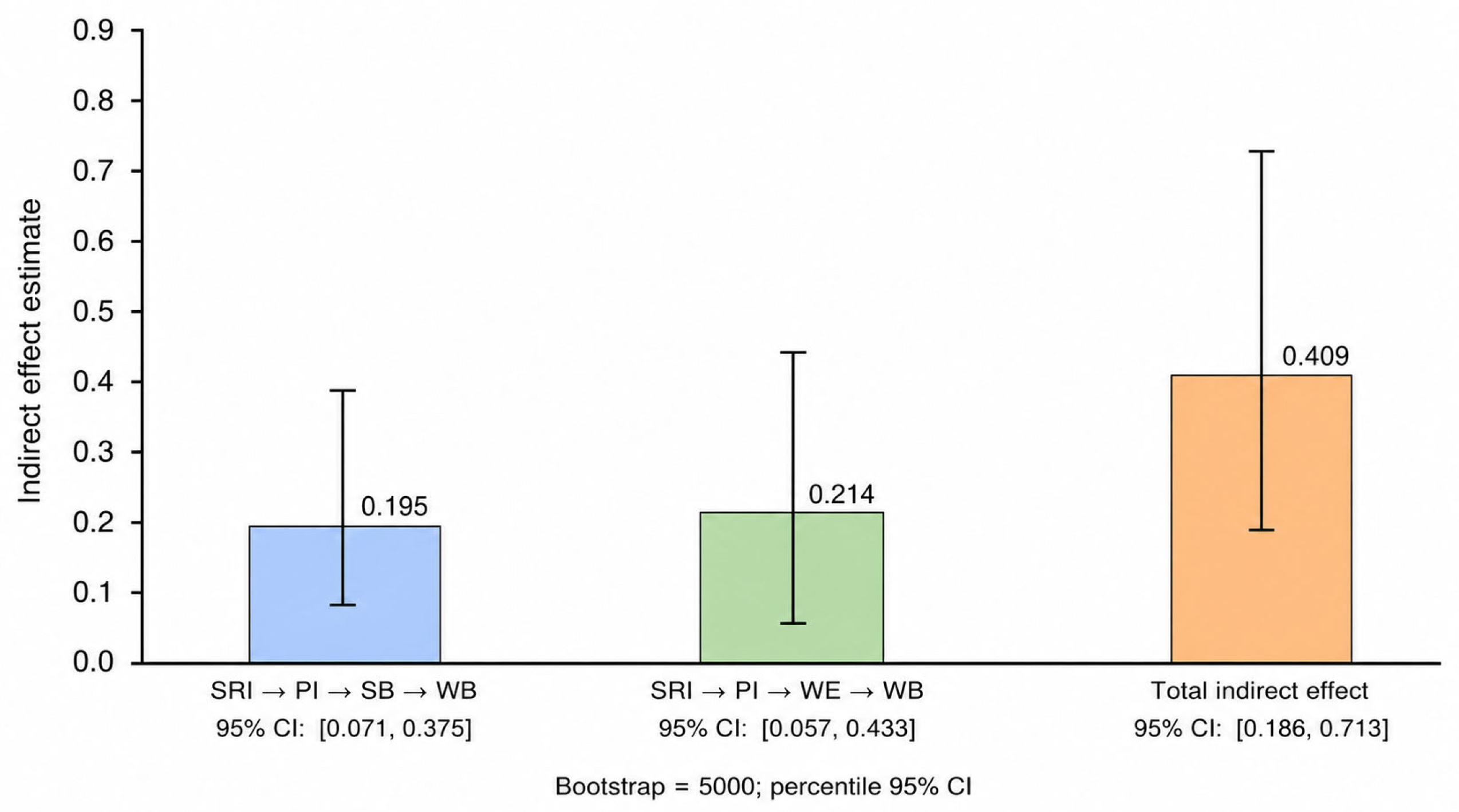
The two specific indirect effects were also statistically significant. The sequential pathway from the SRI to walking behavior through place identity and social bonding showed an unstandardized estimate of 0.195 (standardized β = 0.031, 95% percentile bootstrap CI [0.071, 0.375]), supporting H7. The sequential pathway through place identity and walking enjoyment showed an unstandardized estimate of 0.214 (standardized β = 0.034, 95% percentile bootstrap CI [0.057, 0.433]), supporting H8. Neither confidence interval included zero, indicating that both specific indirect effects were statistically significant.
The total indirect effect was 0.409 (standardized β = 0.064, 95% percentile bootstrap CI [0.186, 0.713]), while the total effect was 1.591 (standardized β = 0.250, 95% percentile bootstrap CI [0.808, 2.416]). Together with the significant direct effect, these results indicate that the SRI was associated with older adults’ walking behavior both directly and indirectly through place identity and, subsequently, social bonding and walking enjoyment. This pattern is consistent with partial mediation (
Figure 8).
4.4.4. Sensitivity Analyses
The intraclass correlation coefficients (ICCs) ranged from 0.066 to 0.269, indicating varying degrees of clustering across the four individual-level constructs. When sub-zone clustering was accounted for using CR2 cluster-robust standard errors, the directions of all six structural associations remained unchanged and the effect sizes were broadly comparable with those of the main analysis. However, the SRI → PI and SRI → WB associations were no longer statistically significant, while the WE → WB association was marginally significant (
p = 0.051), consistent with the limited cluster-level statistical power available with only ten spatial clusters (
Supplementary Table S5). In the covariate-adjusted sensitivity analysis, all six associations retained the same direction and remained statistically significant after adjustment for gender, age, educational attainment, employment status, personal income, and living arrangement, with only modest changes in the standardized coefficients (
Supplementary Table S6).
5. Discussion
5.1. Spatial Resource Configurations and Place Meaning: A Contextual Extension of Walkability in Historic Urban Districts
This study shows that historic urban districts vary not only in their overall levels of spatial resources, but also in resource configurations across sub-zones with similar SRI levels. Recent research has likewise identified substantial spatial heterogeneity in human activity and street vitality within Chinese historic cultural districts [
50]. The present study further shows that such heterogeneity is reflected not only in overall vitality or intensity of use, but also in the configuration of historical spatial, walking support, public cultural, and restorative environmental resources. Therefore, relying solely on aggregate levels or individual functional indicators may be insufficient to reveal the specific walking contexts of different spatial units within historic districts.
Conventional walkability frameworks are effective in identifying basic walking support conditions related to roads, facilities, accessibility, and transport [
10,
46]. Recent studies have begun to contextualize these frameworks for historic districts, for example by incorporating historical streetscape compatibility alongside connectivity, convenience, safety, and comfort [
51]. However, such assessments still focus primarily on street-scale walking performance, spatial quality, and historical character. In contrast, the SRI developed in this study integrates historical spatial, public cultural, and restorative environmental resources with basic walking support resources at the sub-zone level. Its contribution therefore lies not simply in adding more indicators, but in extending the assessment from whether a street is suitable for walking to the multidimensional place-based resource context in which walking occurs. Accordingly, the SRI is better understood as a contextualized complement to existing walkability assessments rather than a replacement for them.
Furthermore, the overall level of spatial resources was positively associated with older adults’ place identity. Recent research on historic streets has found that both the authenticity of tangible heritage and the authenticity of experiences within heritage environments are associated with place identity [
52], although this work has focused primarily on tourists’ subjective perceptions of heritage settings. By contrast, the present study links GIS-measured multidimensional objective spatial resources with older adults’ place identity in everyday settings, thereby extending existing research on “perceived heritage characteristics–place identity” to the association between “objective spatial resources–older adults’ place identity.” However, because the present study examined the composite SRI, the results cannot be used to determine the independent contributions, relative importance, or interactions of HSR, WSR, PCR, and RER. The current findings therefore support an integrated interpretation of a multidimensional place-based context rather than dimension-specific effects.
5.2. Place Identity and Social and Emotional Experiences: The Place-Meaning Pathway of Spatial Resources
Place identity was positively associated with both social bonding and walking enjoyment, suggesting that it may constitute an important linkage point connecting spatial resources with social and emotional experiences. Existing evidence for these relationships remains dispersed across different research streams: neighborhood identity has been associated with social cohesion and loneliness [
53], whereas place attachment and place identity in historic districts have been associated with restorative experiences [
54]. The former primarily concerns general community populations, while the latter does not focus specifically on older adults’ everyday walking. In contrast, the present study examined the associations of place identity with both social bonding and walking enjoyment within the same historic-district model, suggesting that older adults’ place identity may correspond simultaneously to two parallel dimensions—social relationships and positive walking experiences.
For the social dimension, existing studies have not reached a consistent interpretation of the direction of the relationship between place connections and social interaction. One study positioned neighborhood social interaction between perceived walkability and place attachment [
55], whereas another study of older adults found that social-environmental factors such as sense of belonging, community spirit, and community participation were closely associated with social interaction [
56]. These findings suggest that place connections and social interaction may be mutually embedded rather than following a simple unidirectional relationship. Accordingly, the positive association observed between place identity and social bonding in this study is more appropriately interpreted as a statistical relationship between two interrelated dimensions of place-based social experience, rather than as evidence that place identity unidirectionally “produces” social bonding.
For the emotional dimension, recent research has found that place attachment is associated with subjective well-being among community-dwelling older adults [
57] and with both walking for transport and recreational walking [
58]. The former focuses on overall well-being, while the latter concerns walking participation; neither directly examines positive emotional experiences during the walking process itself. The present finding that place identity is associated with walking enjoyment therefore extends previous research to a walking-specific positive emotional experience. This suggests that, in historic districts used over extended periods, walking may be not only a form of functional mobility but also a positive experience embedded in the meanings of familiar places.
5.3. Social Bonding and Walking Enjoyment: Dual Support Pathways from Place Experience to Walking Behavior
Social bonding and walking enjoyment were both positively associated with older adults’ walking behavior.
Longitudinal research has found that social group engagement among older adults is associated with better maintenance of physical activity and brisk walking over time [
59], while enjoyment of physical activity is also associated with physical activity levels among older adults [
60]. However, the former primarily examines social participation behaviors, whereas the latter focuses on enjoyment of physical activity in general. In contrast, the present study simultaneously examined place-based social bonding and enjoyment experienced during walking, suggesting that older adults’ walking in historic districts may be embedded in both social relationships and positive activity experiences.
More importantly, this study identified two statistically significant indirect association pathways, whereby the SRI was associated with walking behavior through “place identity–social bonding” and “place identity–walking enjoyment,” respectively. Existing studies have attempted to integrate walking environments, place connections, and walking behavior, but their model specifications have not been consistent: some have positioned social interaction between walkability and place attachment [
55], whereas others have positioned perceived walkability between place attachment and walking behavior [
58]. More recent research has further emphasized that the temporal ordering among environment, place attachment, and walking cannot be assumed a priori [
61]. Against this background, the present study integrates GIS-measured multidimensional spatial resources with place identity, social bonding, and walking enjoyment within a single model of older adults in a historic district and simultaneously examines two sequential indirect association pathways. The findings therefore provide an integrated statistical framework of associations rather than evidence for a unique causal mechanism.
After these indirect pathways were included, the SRI remained positively associated with walking behavior.
A systematic review further demonstrates the complexity of relationships between neighborhood environments and older adults’ walking, showing that associations vary across environmental attributes and walking domains, with inconsistent evidence for several factors [
62]. Thus, the relationship between spatial resources and walking cannot be reduced entirely to a single sociopsychological pathway, nor should it be interpreted as indicating that all spatial resources promote walking in the same way. The remaining association between the SRI and walking may involve accessibility, route continuity, facility support, or other factors not captured by the psychological constructs examined here. The coexistence of direct and indirect associations is consistent with a partial mediation pattern; however, the cross-sectional data cannot establish a causal mediation process.
5.4. Implications for Age-Friendly Regeneration in the Context of Healthy Aging: From Functional Walking Support to Place-Based Experiences
From the perspective of age-friendly regeneration, basic walking conditions remain fundamental to older-adult-friendly environments in historic urban districts, including safe and continuous walking routes, destination accessibility, public transport, resting facilities, and environmental comfort. A recent systematic review similarly indicates that multiple built and social environmental factors are associated with physical functioning among middle-aged and older adults, although the strength of evidence varies across environmental characteristics [
63]. Therefore, age-friendly regeneration should neither be reduced to the provision of a single type of facility nor assume that an individual spatial improvement will produce uniform behavioral outcomes. The present study further suggests that functional walking support in historic districts should be understood in conjunction with place identity, social connections, and positive walking experiences—that is, moving beyond whether older adults can walk conveniently to consider whether they are able and willing to continue walking in places that are meaningful to them.
Differences in resource configurations across sub-zones also suggest that regeneration should not adopt a uniform approach to resource allocation, but should first identify the existing resource structure and potential deficiencies of each spatial unit. In sub-zones with prominent historical resources, regeneration may maintain historical spatial continuity while improving resting opportunities, accessibility, and route conditions; in areas rich in public cultural or restorative resources, greater attention may be given to connecting these resources with everyday walking networks. Accordingly, the SRI is more appropriately used as a diagnostic tool for identifying differences in sub-zone resource configurations rather than as a tool for ranking resource priorities. Because this study did not examine the independent associations or interactions of the four resource dimensions, the findings cannot be used to infer synergistic effects among particular resource combinations or to determine that any one dimension should be prioritized.
From a broader healthy-aging perspective, historic districts also embody local memories, identities, and social relationships accumulated through long-term use. Recent research indicates that heritage and local memory are associated with older adults’ place identity, community connections, and experiences of aging in place [
64], while long-term experiences of green spaces also shape older adults’ place attachment and restorative experiences [
65]. Together with the present findings, this evidence suggests that historic buildings, traditional streets and alleys, and blue–green environments are not only assets for conservation or landscape quality, but also spatial settings that support everyday life and place experience. Historic-district regeneration should therefore maintain spaces with local distinctiveness and continued value for everyday use while improving accessibility, continuity, and environmental comfort, thereby better coordinating heritage conservation, everyday livability, and healthy aging. These implications remain based on statistical associations and should not be interpreted as evidence that specific spatial interventions will necessarily produce corresponding behavioral or psychological outcomes.
5.5. Limitations and Future Research
First, the SRI was designed to provide an integrated representation of the overall configuration of HSR, WSR, PCR, and RER. It can therefore identify differences in overall resource levels and configurations across sub-zones, but cannot determine the independent associations, relative contributions, or interactions of the four dimensions. The stable sub-zone rankings observed across alternative weighting schemes provide some support for the robustness of the composite index, but cannot substitute for dimension-specific analyses. Future research could further compare the differential associations of individual resource dimensions and resource-configuration patterns with older adults’ place experiences and walking behavior.
Second, this study matched SRI values with individual questionnaire data based on respondents’ self-reported primary walking sub-zones, thereby improving the correspondence between the objective spatial environment and their primary walking contexts. However, the “primary walking sub-zone” remains only a simplified proxy for an individual’s actual activity space and cannot fully capture actual walking trajectories, cross-sub-zone activities, or dynamic environmental exposure. Future studies could incorporate GPS, wearable devices, or mobile tracking data to measure individual activity spaces and environmental exposure more precisely.
Third, respondents within the same primary walking sub-zone shared the same SRI value, creating the possibility of within-sub-zone clustering. This study therefore conducted sensitivity analyses using ICCs and cluster-robust standard errors, and the directions of the main associations remained generally unchanged. However, because only ten sub-zones were included, these analyses are more appropriately interpreted as robustness checks rather than as a sufficient basis for inference about sub-zone-level effects. Future research could include a larger number of spatial units and apply multilevel models to further distinguish sub-zone-level from individual-level associations.
Finally, this study used a cross-sectional design, and walking behavior was primarily self-reported; therefore, the temporal ordering among spatial resources, place experiences, and walking behavior cannot be established, nor can causal inferences be made. Although covariate-adjusted analyses provided some support for the robustness of the main associations, unmeasured confounding, activity-space self-selection, and self-report bias cannot be ruled out. For example, older adults with a greater propensity to walk or stronger place preferences may use resource-rich sub-zones more frequently, thereby affecting the observed associations. Future research could combine longitudinal designs, natural experiments, and objective behavioral measures to further examine the temporal ordering and possible directionality of these relationships.
6. Conclusions
This study used the Cuihu Historic and Cultural District in Kunming as a case study and integrated GIS-based spatial assessment with questionnaire data from 316 older adults to examine the associations among objective spatial resources, place experiences, and walking behavior. Spatial analysis revealed clear differences in both SRI levels and resource configurations across the ten sub-zones. The structural model further showed that the SRI was positively associated with both place identity and walking behavior; place identity was associated with social bonding and walking enjoyment, which, in turn, were both associated with walking behavior. Bootstrap analysis also supported two indirect association pathways: “SRI–place identity–social bonding–walking behavior” and “SRI–place identity–walking enjoyment–walking behavior.” Together, these findings indicate that the relationship between spatial resources and older adults’ walking in historic urban districts involves not only objective environmental conditions but also place identity and related social and emotional experiences. Given the cross-sectional design of this study, these findings should be interpreted as statistical associations rather than causal relationships.
Based on these findings, this study suggests that older adults’ walking environments in historic urban districts should not be understood solely in terms of conventional functional walking conditions, but should also consider historical, public cultural, and restorative spatial resources and the place experiences associated with them. Differences in resource configurations across sub-zones indicate that age-friendly regeneration needs to consider the resource characteristics of specific spatial units, while the observed associations among the SRI, place identity, social bonding, walking enjoyment, and walking behavior further suggest that functional walking support and place-based social and emotional experiences should be regarded as complementary dimensions of planning. Therefore, alongside ensuring accessibility, continuous walking routes, resting opportunities, and basic environmental comfort, historic-district regeneration may also strengthen the connections between historical and cultural resources, public cultural spaces, blue–green environments, and everyday walking spaces, thereby better balancing heritage conservation, everyday use, and the needs of healthy aging.