


Abstract
Under the combined pressures of urbanization and tourism development, terraced agricultural heritage sites are increasingly threatened by the degradation of traditional landscapes, the weakening of living cultural practices, and mismatches between the supply and demand of cultural ecosystem services (CESs). As a representative type of Globally Important Agricultural Heritage Systems (GIAHSs), the rice terrace landscapes of southern China have formed an integrated system of forests, villages, terraces, and water networks, embodying multiple values related to production, ecology, landscape, and culture. To support the coordination of heritage conservation, tourism development, and the transformation of cultural value, this study takes the core area of the Longji Terraced Fields as a case study and develops an improved SolVES–IPA collaborative assessment framework from the perspective of tourist perception. Four CES categories are examined: recreational value, aesthetic value, historical and cultural value, and educational value. The results show that (1) the four CES categories exhibit significant spatial differentiation. Recreational and aesthetic values are mainly concentrated in high-altitude viewing spaces, whereas historical, cultural, and educational values depend more heavily on traditional architectural spaces and interpretive nodes. (2) Clear supply–demand mismatches exist across CES categories. Recreational value is constrained by limited activity diversity; aesthetic value is limited by inadequate architectural harmony; historical and cultural value is primarily restricted by insufficient continuity of living traditions; and educational value is constrained by incomplete interpretive content and single presentation formats. (3) CES optimization in the Longji Terraced Fields should adopt both type-specific and hierarchical intervention strategies, including priority optimization for high-value units with critical shortcomings, near-term improvement for high-value units with general shortcomings, functional enhancement for medium-value units with critical shortcomings, progressive optimization for medium-value units with general shortcomings, and potential cultivation of low-value units. Based on these findings, this study proposes several optimization directions, including strengthening participatory experiences, promoting the coordinated renewal of the architectural landscape, creating multisensory cultural display spaces, and establishing a multidimensional interpretation network. The improved SolVES–IPA collaborative assessment framework developed in this study integrates CES spatial identification, supply–demand diagnosis, and optimization priority setting, providing a methodological reference and practical support for enhancing cultural services and promoting the coordinated development of heritage conservation and cultural tourism in the Longji Terraced Fields and similar agricultural heritage sites.
1. Introduction
Under the combined pressures of rapid urbanization, rural outmigration, and tourism-oriented commercial development, terraced agricultural heritage sites are increasingly confronted with problems such as the degradation of traditional landscapes and the weakening of the living transmission of agrarian culture. As a representative type of Globally Important Agricultural Heritage Systems (GIAHS), the rice terrace systems of southern China have, through long-term evolution, formed a composite landscape pattern characterized by the integration of mountain ecosystems, settlement spaces, terrace production systems, and irrigation networks. These systems simultaneously perform functions related to agricultural production, ecological regulation, landscape formation, and cultural inheritance. In recent years, large-scale tourism development has continuously increased the demand for cultural services, while the inherent fragility of terrace ecosystems has further intensified the tension between heritage conservation and utilization, making imbalances between the supply and demand of cultural ecosystem services (CESs) increasingly prominent [1,2].
CESs refer to the non-material benefits that ecosystems provide to people, including values related to nature-based recreation, aesthetic experience, and cultural inheritance. The concept was formally articulated in the Millennium Ecosystem Assessment in 2005 [3]. Recent discussions in CES research has highlighted several major challenges, including the lack of a unified framework for assessing non-market values and the insufficient linkage between global research paradigms and local practice [4]. These challenges underscore the need for empirical studies based on representative local cases. Against the background of shifting social value orientations and growing demand for leisure consumption, CESs have become an important component of human well-being. In some contexts, demand for CESs has even exceeded that for other categories of ecosystem services [5,6,7]. Nevertheless, CESs remain relatively marginalized in policymaking and land-use planning [8]. From a theoretical perspective, social-ecological systems theory reveals the composite nature of terraced landscapes as products of the long-term coupling of natural processes and human activities [9]. Landscape ecology and landscape perception theory further suggest that the generation of cultural services is jointly shaped by landscape patterns, spatial accessibility, and individual perception [10]. Social value theory emphasizes that CESs are non-material, subjective, and context-dependent, and therefore cannot be fully identified through ecological or economic indicators alone [11]. It is therefore necessary to establish a CES research framework that simultaneously considers spatial heterogeneity and supply–demand relationships so as to better integrate cultural values into ecological governance and spatial planning.
In recent years, CES research has covered a wide range of landscape types, including urban areas [12], rural areas [13], forests [14], wetlands [15], and grasslands [16], yielding substantial findings on value identification, spatial mapping, influencing mechanisms, and management optimization. However, compared with these landscape types, studies focusing on agricultural heritage sites, especially terrace ecosystems, remain relatively limited. Terraced heritage landscapes are characterized by strong topographic differentiation, complex ecological foundations, and rich cultural connotations. The generation of their CESs is constrained not only by landscape resource endowment but also by interactions among tourism development, heritage conservation, and local livelihoods. Therefore, research on CESs in terraced landscapes should go beyond general landscape value assessment and further address spatial differentiation, supply–demand relationships, and optimization pathways.
From a methodological perspective, CES assessment methods can generally be divided into monetary and non-monetary approaches [17]. Early studies often employed monetary valuation methods, such as the market price method [18], the contingent valuation method [19], and the travel cost method [20], to estimate the economic value of cultural services [21]. However, these methods are more suitable for CES categories with relatively explicit economic value [22] and are limited in their ability to capture diverse non-material values such as aesthetic experience, intellectual inspiration, and cultural identity. To address this limitation, non-monetary approaches have gradually become important methodological pathways in CES research, including public participation GIS (PPGIS) [23], participatory mapping (PM) [24], the Social Values for Ecosystem Services (SolVESs) model [25], social media data analysis [26], and importance-performance analysis (IPA) [27].
Among these approaches, the SolVES model and the IPA method are two widely used non-monetary tools for CES assessment. By integrating social survey data on perceived values with geographic and environmental variables, the SolVES model combines value scoring, spatial modeling, and GIS-based interpolation analysis to quantify and spatially visualize social values, thereby revealing the spatial clustering characteristics of CESs [28,29]. For example, Zhou et al. used this model to map CESs in Xiuhu National Wetland Park and to analyze the effects of socioeconomic and environmental factors on value distribution [30]. In contrast, the IPA method is based on a two-dimensional framework of importance and performance. By comparing users’ evaluations of service importance with their perceptions of actual performance, it constructs a four-quadrant matrix to identify supply–demand matching conditions, experiential shortcomings, and priority dimensions for improvement, thereby providing targeted guidance for management decision-making [31]. Zhang et al. applied IPA to examine tourists’ perceived experiences of urban park CESs in central Wuhan, providing a reference for supply–demand optimization [32].
However, both methods have notable limitations when used independently. The SolVES model can accurately depict the spatial distribution patterns of CES values and their associations with geographic and environmental factors, but it has limited explanatory power regarding tourists’ perceptions, experiential differences, and supply–demand relationships, and may therefore overlook non-spatial dimensions of service deficiencies [33,34,35]. By contrast, the IPA method can effectively diagnose service supply–demand imbalances and identify core optimization dimensions, yet it lacks spatial positioning capability and cannot clearly determine the spatial priorities or practical contexts for service improvement. As a result, management strategies derived from IPA are often difficult to translate into specific spatial interventions. There is therefore an urgent need to construct an integrated assessment framework that combines spatial pattern identification with supply–demand diagnosis so as to enhance both the interpretability of CES assessment results and their practical relevance to planning and management.
This need is particularly evident in tourism-oriented agricultural heritage sites, where tourists are the direct users of cultural services and the primary source of feedback on service demand. Their perceptions can more directly reflect the actual use conditions, demand preferences, and experiential shortcomings. Compared with residents and managers, who are more often concerned with resource use, community livelihoods, and governance provision, tourists are better positioned to reveal the perceptual intensity, experiential differences, and optimization needs associated with cultural services from a user perspective during their visits. Incorporating tourist perceptions can therefore help identify the demand-side characteristics of CESs in terraced heritage sites and clarify directions for service improvement, thereby providing a more context-appropriate basis for diagnosing supply–demand relationships and experiential shortcomings in tourism settings.
Although existing studies provide an important methodological foundation for CES assessment, three main gaps remain. First, most studies have focused on wetlands, parks, and protected natural areas, whereas terraced agricultural heritage sites have received comparatively limited attention. Second, SolVESs and IPA have mostly been applied separately, and an integrated framework combining spatial pattern identification with supply–demand analysis is still lacking. Third, previous studies have paid insufficient attention to tourist perceptions, making it difficult to simultaneously reveal both the spatial clustering characteristics of cultural services and the demand-side shortcomings experienced by users.
As a GIAHS site, the Longji Terraced Fields in Guangxi constitute a highly representative living example of the rice terrace systems of southern China. Over more than two thousand years of intensive cultivation, Zhuang and Yao communities have jointly created a living heritage system characterized by close coordination between nature and culture [36]. Unlike many other terraced heritage sites, which are primarily shaped by the farming practices and cultural traditions of a single ethnic group, the Longji Terraced Fields are particularly notable for the coexistence and co-construction of Zhuang and Yao communities. Ethnic festivals, farming techniques, local beliefs, cultural symbols, and the terraced landscape have long been intertwined, forming a complex foundation for CES generation. At the same time, the study area possesses the dual attributes of heritage conservation and tourism development and therefore reflects the coordination challenges among landscape protection, cultural presentation, and visitor experience in terraced heritage sites. This makes the site a valuable case for empirical research.
Against this background, this study takes the core area of the Longji Terraced Fields as its study area and develops an improved SolVES–IPA collaborative assessment framework for terraced agricultural heritage sites based on the tourist perceptions. Specifically, this study evaluates four CES categories: recreational value, aesthetic value, historical and cultural value, and educational value. It seeks to answer three questions:
- (1)
- What spatial differentiation patterns do different CES categories exhibit in the Longji Terraced Fields?
- (2)
- What are the supply–demand mismatches and main shortcomings of each CES category?
- (3)
- How can spatially explicit optimization strategies be developed by integrating spatial patterns with supply–demand diagnoses?
By addressing these questions, this study aims to advance CES research on terraced agricultural heritage sites in three respects: expanding the range of study contexts, incorporating the perspective of tourist perception, and integrating assessment frameworks. It also seeks to provide practical guidance for cultural service optimization, agricultural heritage conservation, and the coordinated development of heritage protection and cultural tourism in similar heritage sites.
2. Materials and Methods
2.1. Study Area
The Longji Terraced Fields are located in Longji Town, Longsheng Various Nationalities Autonomous County, Guilin, Guangxi Zhuang Autonomous Region, China (25°42′–25°50′ N, 110°03′–110°12′ E). The study area includes parts of Ping’an, Zhongliu, Dazhai, Xiaozhai, Jinjiang, and Longji villages and covers approximately 70.16 km2 [37]. As an agricultural heritage landscape shaped through long-term cultivation by the ancestors of the Zhuang and Yao ethnic groups, the Longji Terraced Fields comprise a contiguous terraced area of 1174 ha. With elevations ranging from 380 to 1180 m, the area forms a three-dimensional agricultural landscape characterized by the integration of forests, villages, terraced fields, and water systems.
The study area is located within an ecological conservation red-line zone and is therefore subject to strict protection under national laws and policies, including the Wetland Protection Law of the People’s Republic of China, Measures for the Administration of Important Agricultural Heritage Systems, and the conservation principles of the FAO GIAHS program. The region belongs to the mid-subtropical evergreen broad-leaved forest zone and supports diverse vegetation types, including rare native species such as Taxus chinensis, Fagus longipetiolata, and Ginkgo biloba. Owing to the altitudinal gradient, the soils exhibit clear vertical zonation, transitioning from red soils at lower elevations to yellow-red and yellow soils at higher elevations, thereby providing favorable conditions for rice cultivation and vegetation growth. The area is also rich in water resources, with 33 perennial streams and more than 50 additional streams of varying sizes, forming a composite wetland system composed of terraced wetlands, streams and ditches, and mountain ponds and reservoirs. It is an important water-conservation area in the upper Pearl River Basin and plays a vital role in maintaining regional ecological security.
Through long-term interactions between local communities and the natural environment, the region has developed a distinctive ethnic cultural system. This system encompasses terraced rice cultivation practices, traditional Northern Zhuang costumes, stilt-house architecture, stone inscriptions and artifacts, copper-drum songs and dances, elder-based village governance, the culinary heritage known as the “Four Treasures of Longji,” and various traditional festival customs. In recent years, the natural and cultural resources of the Longji Terraced Fields have been increasingly integrated into tourism development, leading to the emergence of scenic areas centered on Longji Ancient Zhuang Village, Ping’an Zhuang Village, and Jinkeng Dazhai Village. These three scenic areas are characterized by relatively well-developed tourism infrastructure and high visitor density. Accordingly, they were selected as the study sites (Figure 1) for investigating the spatial distribution of CESs and the characteristics of CES supply–demand relationships.
Figure 1.
(a) Location of the Guangxi Zhuang Autonomous Region, (b) location of the Longji Terraced Fields scenic area, and (c) distribution of key attractions in the core area of the Longji Terraced Fields.
2.2. Data Collection
This study integrated three types of data: point of interest (POI) data, tourist perception data, and geospatial data.
2.2.1. Point of Interest Data
POI data provide rich attribute information and precise locational data [38]. In this study, CES-related POI data were used to reflect both the natural and cultural characteristics of the Longji Terraced Fields, although some functional overlap and value convergence may exist among different CES categories [39].
The POI data were obtained from the GAODE Map API platform (https://lbs.amap.com/, accessed on 12 March 2024) using Python 3.10 scripts. After verification and cleaning, nine POIs located outside the core study area were excluded, and 23 attraction POIs were retained as the basic spatial analysis units. Their coordinates were then transformed into a unified coordinate system and georeferenced in ArcGIS 10.8 for the spatial visualization and kernel density analysis of CES perception values.
2.2.2. Tourist Perception Data
Tourist perception data were collected through questionnaire surveys. Based on a literature review, field reconnaissance, and a pilot survey, the questionnaire was designed to assess CES perceptions and the associated supply–demand relationships. The questionnaire consisted of three parts. The first part collected respondents’ basic demographic information, including gender, age, education level, occupation, place of origin, and visitation frequency. The second part focused on the assignment of CES perceptions to specific attractions. With the aid of a schematic map of the scenic area, respondents were asked to identify one to four attractions where each of the four CES categories was most strongly perceived: recreational value, aesthetic value, historical and cultural value, and educational value. The third part assessed the importance of and satisfaction with CES-related indicators. A five-point Likert scale was used to evaluate 17 CES-related indicators, with importance scored from 1 (“very unimportant”) to 5 (“very important”) and satisfaction scored from 1 (“very dissatisfied”) to 5 (“very satisfied”).
The survey was conducted in two stages: a pilot survey and a formal survey. The pilot survey was conducted in early July 2024, with 10 questionnaires distributed at each of the three sites: Longji Ancient Zhuang Village, Ping’an Zhuang Village, and Jinkeng Dazhai Village. Based on respondents’ feedback, the questionnaire structure, wording, and number of items were revised, and the final completion time was controlled at approximately 6 min per questionnaire. According to visitor flow information provided by local tourism operators, the peak tourist seasons in the Longji Terraced Fields mainly occur during the irrigation period (April–May) and the autumn harvest period (September–October). To cover the principal tourism periods and improve the representativeness of the sample across the principal peak seasons, the formal survey was conducted from 1 to 3 October 2024 and from 1 to 3 May 2025.
The formal survey adopted an on-site intercept approach using a non-probability convenience sampling strategy at major viewing points where tourists tended to gather and stay for relatively long periods. Before administering the survey, the investigators explained the purpose of the study and the content of the questionnaire. To avoid influencing respondents, no additional prompts were provided during the attraction assignment or CES evaluation sections. Eligible respondents were tourists who had completed their main visit and were capable of responding independently. Excluded respondents included scenic area operators and managers, local permanent residents, and non-typical visitors whose main purpose was visiting relatives or accompanying others and who had strong local ties to the area. Questionnaires with incomplete core items, obvious logical inconsistencies, or duplicate responses were also excluded.
The target sample size was determined based on two considerations. First, previous studies conducted at comparable or larger spatial scales generally employed 200–400 valid questionnaires [40,41]. Second, this study needed to support the perception assignment and spatial representation of four CES categories across 23 attractions, as well as the importance and satisfaction assessment of 17 indicators, reliability and validity testing of the scale, and IPA. The sample size therefore needed to satisfy the requirements of both spatial and statistical analyses while also exceeding the commonly accepted rule-of-thumb minimum number of respondents per item. Based on these considerations, the target sample size for the formal survey was set at 300. A total of 320 questionnaires were distributed across the two survey rounds, including 152 in October 2024 and 168 in May 2025. Ultimately, 306 valid questionnaires were obtained, yielding an effective response rate of 95.63%.
To assess the reliability and validity of the scale, IBM SPSS Statistics 29.0 was used to evaluate questionnaire quality. The results showed that the Kaiser-Meyer-Olkin (KMO) value was 0.87 and that Bartlett’s test of sphericity was significant (p < 0.001). Cronbach’s alpha coefficients for the importance scale, satisfaction scale, and overall scale were 0.859, 0.878, and 0.902, respectively, indicating good internal consistency and acceptable construct validity of the questionnaire.
2.2.3. Geospatial Data
Geospatial data were mainly used to delineate the study area boundary, locate POIs, and produce spatial maps. Administrative boundary vector data for the Guangxi Zhuang Autonomous Region in 2024 were downloaded from the Resource and Environmental Science Data Center of the Chinese Academy of Sciences (https://www.resdc.cn, accessed on 10 April 2024). Based on these data, the administrative boundary of Longsheng Various Nationalities Autonomous County was extracted. With reference to the boundary map of the Longji Terraced Fields scenic area obtained from GAODE Map, the study area boundary was delineated in ArcGIS 10.8. Satellite imagery of the study area was obtained from Google Maps (https://www.google.com/maps, accessed on 20 April 2024), projected into the WGS_1984_UTM_Zone_49N coordinate system, and clipped to the study area boundary to generate the base map used in this study.
2.3. Evaluation Indicator System
Based on the widely adopted ecosystem service classification framework proposed by Costanza [42] and the Millennium Ecosystem Assessment [43], this study initially classified the CESs of the Longji Terraced Fields into seven categories: aesthetic value, tourism, health and well-being, education, cultural heritage, spiritual and religious value, and sense of place. This preliminary classification was then integrated and refined according to the characteristics of the study area and visitors’ actual perceptions.
Specifically, four adjustments were made. First, cultural heritage and sense of place in the Longji Terraced Fields were conceptually overlapping and closely related; they were therefore merged into historical and cultural value. Second, health and well-being and tourism-related services were both primarily realized through recreational activities and were often difficult for visitors to distinguish in practice; these categories were therefore combined into recreational value. Third, spiritual and religious value showed limited salience in tourists’ perceptions within the study area and was therefore considered to have limited general relevance and measurability [44]; it was therefore excluded from the final evaluation framework. Fourth, aesthetic and education were reformulated as aesthetic value and educational value, respectively. Accordingly, the final CES framework for the Longji Terraced Fields consisted of four categories: recreational value, aesthetic value, historical and cultural value, and educational value.
To ensure the scientific rigor and representativeness of the selected indicators, this study combined literature review, online text analysis, field verification, and expert consultation. First, previous studies on CES-related landscape elements and characteristics were systematically reviewed [45,46,47] to identify the core dimensions of tourists’ perceptions of CESs in terraced landscapes. Second, travel blogs related to the “Longji Terraced Fields” published on Mafengwo and Ctrip from 2020 to 2025 were collected as the textual data source. These texts were obtained using Octoparse 8.7 web-scraping software, manually checked, and deduplicated, resulting in 423 valid travel blogs. High-frequency term analysis and semantic analysis were then conducted using ROST CM6 to extract landscape elements and experiential features frequently mentioned in tourists’ narratives. Meanwhile, field surveys were conducted to verify the specific spatial carriers and manifestations of these high-frequency perceptual elements within the study area. Finally, based on the results of the literature review, online text analysis, and field verification, and with input from five experts in urban and rural planning, landscape architecture, and architectural design, indicators with overlapping meanings, high collinearity, or poor discriminability were removed or integrated. This process resulted in a final set of 17 indicators representing the CES characteristics of the Longji Terraced Fields (Table 1).
Table 1.
Evaluation framework and indicator system for cultural ecosystem services in the Longji Terraced Fields.
2.4. Analytical Methods
2.4.1. Development of the Improved SolVES–IPA Collaborative Assessment Framework
This study developed an improved SolVES–IPA collaborative assessment framework (Figure 2) to identify the spatial distribution patterns of CESs and diagnose their supply–demand mismatches in the core area of the Longji Terraced Fields. The original SolVES model is typically used to explain the spatial distribution of social values and their relationships with environmental variables by coupling social value points with environmental data. However, the present study focused more on identifying CES hotspots and diagnosing tourist-perceived service deficiencies in terraced agricultural heritage landscapes than on explaining the causal effects of environmental drivers. Accordingly, the SolVES framework was adapted to better fit the research objectives.
Figure 2.
Improved SolVES–IPA collaborative assessment framework.
This adjustment was based on two main considerations. First, the Longji Terraced Fields cover a large area with substantial topographic variation, and environmental factors such as water networks, road layouts, and entrance locations largely constitute fixed background conditions that are difficult to modify through short-term management interventions. Second, terrain, water systems, and land-use types are themselves important components of visitor experience and intrinsic elements of heritage value and are therefore not appropriate to be treated simply as exogenous environmental variables. On this basis, the present study retained the core logic of SolVESs in terms of social-value assignment and spatial representation, while incorporating IPA to construct a collaborative assessment pathway. Specifically, tourist perception data obtained through questionnaires were used as the social value data, and 23 attraction POIs were used as spatial carriers to represent the perceived values of different CES categories. The resulting spatial patterns were then combined with the IPA results to identify shortcomings in CES supply–demand relationships for each service type, thereby providing a basis for spatial optimization and management strategy development.
2.4.2. Kernel Density Analysis
Kernel density analysis is a commonly used method for identifying spatial hotspots. By applying a distance-decay function to estimate the spatial concentration of point features, this method can intuitively reveal the spatial distribution characteristics of perceived values for different CES categories [48]. The formula is as follows:
In this equation, is the kernel density estimation function, represents the distance-decay threshold, is the spatial weighting function, denotes the number of sample points whose distance from location is less than or equal to , and ( − ) indicates the distance between the estimated point and the sample point .
2.4.3. IPA
Importance-performance analysis (IPA) was used to compare differences between tourists’ ratings of importance and satisfaction for CES-related indicators, thereby identifying relative strengths, weaknesses, and supply–demand mismatches in CES provision [49]. In this study, a data-centered IPA matrix was adopted. The mean importance score was used as the vertical reference line, and the mean satisfaction score as the horizontal reference line, thereby dividing the evaluation results for each indicator into four quadrants corresponding to different management priorities (Figure 3).
Figure 3.
IPA quadrant model.
2.4.4. Integrated Diagnosis of Spatial Patterns and Supply–Demand Shortcomings
To connect CES spatial pattern identification with the diagnosis of supply–demand shortcomings, the results of the improved SolVES–IPA collaborative assessment framework were further integrated into a comprehensive analytical pathway consisting of four steps: spatial hotspot identification, value classification, supply–demand shortcoming diagnosis, and priority unit delineation. First, the main spatial carriers of different CES categories were identified based on attraction-level perception values and their kernel density distributions. Second, the Natural Breaks (Jenks) method was used to classify attraction-level CES perception values into high-value, medium-value, and low-value units. Third, according to the IPA results, indicators located in Quadrant IV were defined as critical shortcomings, whereas those in Quadrant III were defined as general shortcomings. Finally, based on the overlay of attraction value level and shortcoming type, the spatial optimization sequence for different CES categories was determined.
The underlying logic is that when a CES category is perceived as highly important but insufficiently satisfying, targeted optimization should first be implemented in the high-value spaces that primarily carry that service. Specifically, high-value units with critical shortcomings were identified as priority optimization units, whereas high-value units with general shortcomings were classified as near-term improvement units. Medium-value units with critical shortcomings were defined as functional enhancement units, whereas medium-value units with general shortcomings were regarded as progressive optimization units. Low-value attractions were generally treated as potential cultivation units for future development (Table 2). By linking perceptual hotspots with supply–demand shortcomings, this approach enables the formulation of more targeted and spatially explicit optimization strategies.
Table 2.
Classification of the spatial optimization sequence.
3. Results
3.1. Respondent Characteristics
A total of 306 valid questionnaires were included in the analysis, and the characteristics of the respondents are summarized in Table 3. Male respondents accounted for 48.0% of the sample, whereas female respondents accounted for 52.0%, indicating a balanced gender distribution. In terms of age, respondents were mainly concentrated in the 18–30 and 31–45 age groups, accounting for 27.8% and 33.7% of the sample, respectively. Visitors under 18 years of age also represented a considerable proportion (22.2%), whereas those over 60 years of age accounted for less than 3.0%. With respect to educational attainment, 64.4% of respondents held a college degree or above, suggesting a relatively well-educated visitor profile. In terms of occupation, students constituted the largest group (35.9%), followed by civil servants and employees of enterprises or public institutions, who together accounted for 41.5% of the sample. Regarding place of origin, 14.7% of respondents were from other cities in Guangxi, whereas 74.8% came from other parts of China. Most respondents (82.0%) were first-time visitors to the Longji Terraced Fields and were mainly from outside Guilin. By contrast, respondents who had visited the site two or more times were predominantly from Guilin and were more likely to enter the scenic area on weekends and public holidays.
Table 3.
Characteristics of respondents.
3.2. Spatial Distribution of CESs
The spatial distribution of CES values reflects visitors’ overall preferences within the study area. Based on kernel density analysis of attraction-level perception data in ArcGIS, the overall spatial pattern of perceived CES values in the core area of the Longji Terraced Fields exhibited clear spatial clustering, with high-value areas concentrated in a limited number of core attractions and their surrounding areas (Figure 4). In terms of attraction-level value assignments, the five highest-ranked attractions were Qiancengtianti Viewpoint (131 value points, 9.49%), Longji Zhuang Ecomuseum (129 value points, 9.35%), Jinfoding Viewpoint (126 value points, 9.13%), Jiulongwuhu Viewpoint (121 value points, 8.77%), and Longji Century-Old Traditional House (116 value points, 8.41%). Together, these attractions constituted the principal spatial carriers of CES perception in the Longji Terraced Fields.
Figure 4.
Overall spatial distribution of perceived CES values across attractions.
A more detailed analysis revealed pronounced spatial differentiation among the four CES categories (Figure 5). Recreational value and aesthetic value showed a relatively high degree of spatial overlap, with hotspots mainly concentrated in the high-altitude viewing areas of Jinfoding Viewpoint, Qiancengtianti Viewpoint, Jiulongwuhu Viewpoint, and Qixingbanyue Viewpoint. This indicates that open viewsheds, three-dimensional terrain, and concentrated viewing functions form the key spatial basis supporting these two CES categories. In contrast, hotspots of historical and cultural value were mainly concentrated in the Longji Century-Old Traditional House area, suggesting that traditional settlement spaces, the preservation of historic buildings, and the continuity of overall landscape character are the principal foundations of historical and cultural perception. Jinfoding Viewpoint and Qiancengtianti Viewpoint formed secondary hotspots for this category, indicating that intensive landscape-experience spaces may also reinforce visitors’ cultural perception to some extent. Educational value exhibited a more distinct nodal clustering pattern. Its core hotspot was concentrated in the Longji Zhuang Ecomuseum cluster, whereas Jinfoding Viewpoint, Qiancengtianti Viewpoint, and Jiulongwuhu Viewpoint formed secondary hotspots. This suggests that educational value depends not only on specialized interpretive nodes such as museums and visitor centers but can also be strengthened through the presentation of agricultural heritage in representative viewing spaces.
Figure 5.
Spatial distribution of the four categories of cultural ecosystem service values.
Overall, the CES spatial pattern in the core area of the Longji Terraced Fields was characterized not by a single dominant center, but by two distinct types of high-value spaces. One was a landscape-experience-oriented type represented by high-altitude viewing platforms, which mainly carried recreational value and aesthetic value. The other was a cultural-cognition-oriented type represented by traditional architecture in Longji Ancient Zhuang Village, which mainly carried historical and cultural value and educational value.
3.3. IPA Evaluation Results of CESs
As shown in Figure 6, the mean perceived importance scores of all CES landscape elements and characteristic indicators were above 4.0, indicating that visitors generally held high expectations for the Longji Terraced Fields. Except for B1 (richness of vegetation landscapes) and B2 (diversity of waterscapes), the satisfaction-minus-importance (S-I) values were negative for all other indicators, suggesting a general gap between pre-visit expectations and on-site experiences. This gap also varied substantially across CES dimensions. In this study, the mean importance and satisfaction scores for recreational value (A: I = 4.38, S = 4.05), aesthetic value (B: I = 4.30, S = 4.28), historical and cultural value (C: I = 4.37, S = 4.04), and educational value (D: I = 4.27, S = 3.87) were used as the crosshair coordinates to divide the IPA matrix into four quadrants and analyze the characteristics of CES supply–demand relationships (Figure 7).
Figure 6.
Importance and satisfaction scores for each cultural ecosystem service indicator. Codes A1–A5, B1–B5, C1–C4, and D1–D3 correspond to the cultural ecosystem service types and indicators defined in Table 1.
Figure 7.
IPA results for the different cultural ecosystem service categories. Codes A1–A5, B1–B5, C1–C4, and D1–D3 correspond to the cultural ecosystem service types and indicators defined in Table 1.
Within the recreational value dimension, A1 (diversity of recreational activities), A2 (adequacy of service facilities), A4 (effectiveness of the wayfinding system), and A5 (effectiveness of transportation organization) all had importance scores above the mean, indicating that these were key determinants of the recreational experience. Among them, A1 was located in Quadrant IV, indicating a pattern of high importance but low satisfaction and thus representing the principal shortcoming of recreational value. This suggests that, beyond sightseeing, the Longji Terraced Fields still lack sufficient organized activities and participatory experiences. Although the satisfaction scores of A2, A3, A4, and A5 were all above the mean, indicating that the scenic area already provides relatively strong support in terms of infrastructure, spatial experience of streets and alleys, and wayfinding and transportation organization, the satisfaction score of A2 was only slightly above the mean, suggesting limited room to spare in service-facility provision.
Within the aesthetic value dimension, B3 (topographic layering) and B4 (architectural harmony) had importance scores above the mean, indicating that they were the core landscape factors underpinning aesthetic experience. Among them, B3 fell in Quadrant I, suggesting that visitors highly recognized the spatial layering and viewing perspectives created by terraced topography, which constituted the core strength of aesthetic value in the Longji Terraced Fields. In contrast, B4 was located in Quadrant IV, indicating that the harmony of architectural style had become an important constraint on further improving aesthetic value. B1 (richness of vegetation landscapes) and B2 (diversity of waterscapes) were located in Quadrant II, suggesting that their current performance met visitor expectations, although their influence on the overall aesthetic experience was relatively limited. B5 (distinctiveness of landscape features) fell in Quadrant III, indicating that it was not currently the principal issue affecting aesthetic value.
Within the historical and cultural value dimension, three indicators, C1 (integrity of heritage conservation), C3 (authenticity of historical landscape character), and C4 (continuity of living cultural traditions), had importance scores above the mean, whereas C2 (protection of ancient and notable trees) did not. C1 and C3 were both located in Quadrant I, indicating that visitors highly valued traditional architectural remains, the historic character of the villages, and the authenticity of the overall setting and that these elements together constituted the core basis of the historical and cultural appeal of the Longji Terraced Fields. By contrast, C4 fell in Quadrant IV, suggesting that although visitors attached high importance to living cultural traditions, actual opportunities for participation and cultural engagement remained insufficient.
Within the educational value dimension, D3 (agricultural heritage education) was located in Quadrant I and constituted the principal supporting factor of this CES category. This indicates that visitors were strongly interested in the terraced agricultural system, traditional farming practices, and the ecological wisdom embedded in them and that current display and interpretation responded to this demand to some extent. By contrast, although D1 (interpretation of architectural knowledge) and D2 (ethnic cultural education) fell in Quadrant III. Although they were not the most salient constraints in relative terms, their satisfaction scores remained comparatively low, indicating persistent deficiencies in communicating architectural construction logic, ethnic cultural meanings, and local knowledge. Overall, educational value in the study area exhibited an uneven pattern characterized by relatively strong agricultural heritage education but comparatively weak architectural and cultural interpretation.
3.4. Identification of Priority Units for CES Optimization
The classification results of attraction-level perceived values into three levels using the Natural Breaks (Jenks) method are presented in Table 4. Combined with the shortcoming types identified through the IPA, the priority optimization units for each CES category were determined (Figure 8), and their key shortcomings and optimization directions are summarized in Table 5. In terms of spatial distribution, the priority optimization units for recreational value and aesthetic value were mainly concentrated around high-altitude viewing platforms. The priority optimization units for historical and cultural value were Jinfoding Viewpoint, Qiancengtianti Viewpoint, and Longji Century-Old Traditional House. The near-term improvement units for educational value were mainly located at Longji Century-Old Traditional House and Longji Zhuang Ecomuseum. In terms of shortcoming type, the first two CES categories were primarily constrained by limited activity diversity and insufficient architectural harmony, respectively. By contrast, historical and cultural value was chiefly limited by insufficient continuity of living cultural traditions, whereas educational value was constrained by weak interpretation of architectural knowledge and ethnic cultural education.
Table 4.
Natural Breaks (Jenks) classification of attraction-level CES perception values by category.
Figure 8.
Spatial distribution of priority optimization units for different CES categories.
Table 5.
Priority improvement units and major shortcomings for different CES categories.
These results indicate that CES optimization in the Longji Terraced Fields should not rely on uniform interventions, but rather on differentiated strategies based on the value level and shortcoming type of each service category. More specifically, the optimization process should follow not only a principle of type-specific differentiation but also a logic of graded governance intensity: high-value units with critical shortcomings should be prioritized for optimization; high-value units with general shortcomings should be targeted for near-term improvement; medium-value units with critical shortcomings should receive functional enhancement; medium-value units with general shortcomings should undergo progressive optimization; and low-value units should focus primarily on potential cultivation. On this basis, landscape-experience-oriented spaces should prioritize the expansion of participatory activities and the enhancement of landscape coherence, whereas cultural-cognition-oriented spaces should emphasize strengthening living cultural display and systematic interpretation so as to improve the match between CES supply and visitor demand.
4. Discussion
4.1. Spatial Differentiation Patterns and Formation Mechanisms of CESs
The results indicate that the spatial differentiation of CESs in the Longji Terraced Fields is not determined solely by differences in resource endowment among landscape units, but rather by the combined effects of two mechanisms: a visibility-based landscape mechanism and a socio-cultural mediation mechanism. The former primarily shapes the spatial clustering of recreational value and aesthetic value, whereas the latter exerts a stronger influence on the formation and expression of historical and cultural value and educational value. Accordingly, the spatial organization of CESs in the Longji Terraced Fields reflects not only tourists’ direct responses to landscape visibility and accessibility, but also the uneven accumulation and representation of socio-cultural meanings across spatial units within the agricultural heritage system.
Previous studies have shown that recreation, aesthetic appreciation, historical and cultural experience, and education are among the CES types most frequently identified and mapped [50,51,52]. Among these, recreation and aesthetic experience generally exhibit higher levels of visitor perception and recognition [53,54]. At the same time, the same landscape type is often capable of providing multiple cultural services, while the perceived intensity of different services is influenced by visitor preferences, modes of experience, and processes of spatial contact [55,56]. These findings provide an important basis for interpreting the type-based differentiation of CESs in the Longji Terraced Fields.
More specifically, recreational value and aesthetic value were mainly concentrated in high-altitude viewing spaces, which is broadly consistent with previous findings that landscape visibility and supporting facilities jointly shape the spatial clustering of CESs [57,58]. In the Longji Terraced Fields, high-altitude viewpoints typically combine panoramic views, layered terraced scenery, and relatively complete supporting conditions such as boardwalks, resting facilities, and commercial services. Visitors are therefore able to form direct and intense perceptions within a short period, making these locations more likely to concentrate recreational value and aesthetic value. This suggests that such services are primarily driven by the visibility-based landscape mechanism; that is, cultural value is rapidly activated through spatial conditions that are visible, accessible, and suitable for staying.
By contrast, historical and cultural value and educational value did not increase synchronously with improved viewing advantages but instead relied more heavily on the traditional architectural spaces of Longji Ancient Zhuang Village. This indicates that the formation of these two CES categories depends less on immediate visual perception and more on the preservation status of heritage carriers, the local cultural atmosphere, and processes of knowledge translation. Relevant studies have pointed out that cultural experience in traditional agricultural heritage villages is not determined by a single material landscape, but is built upon a sense of authenticity jointly supported by the natural setting, settlement morphology, and cultural narratives. Meanwhile, museums, visitor centers, and interpretive nodes distributed along tourist routes also serve as important spatial support for the formation of educational value in agricultural heritage sites [59]. The traditional architectural spaces of the Longji Terraced Fields embody precisely this kind of socio-cultural mediation mechanism, which requires visitors to enter the setting, understand its meanings, and develop cognitive recognition. Such value cannot be acquired merely through immediate viewing but must instead be translated into clearer cultural perception and identity through the heritage entity itself, the spatial atmosphere, and cultural interpretation.
From this perspective, the Longji Terraced Fields should not be understood not only as a mountain landscape for visual consumption, but also as a composite agro-cultural landscape shaped by the terraced production system, traditional settlement patterns, ethnic cultural traditions, and interpretive infrastructure. Recreational value and aesthetic value mainly reflect the visual attractiveness of the landscape, whereas historical and cultural value and educational value more strongly reflect its cultural legibility and interpretive depth. Therefore, the spatial differentiation of CESs in the Longji Terraced Fields cannot be explained simply by where scenery is more attractive or where facilities are better provided. Rather, it reflects differences in perceptual thresholds, meaning-making processes, and spatial modes of expression among CES categories. Under the current tourism context, however, both mechanisms still exhibit a strong degree of visual dominance. The visible landscape mechanism largely remains at the level of scenic viewing. The socio-cultural landscape mechanism, although extending toward cultural cognition and knowledge acquisition, still depends heavily on static displays, symbolic exhibitions, and interpretive reading. It has not yet been fully transformed into embodied experiences grounded in productive practices, everyday life, and bodily participation. This means that the identification and management of CESs in agricultural heritage sites should not stop at general judgments of landscape hotspots or the allocation of interpretive nodes but should also pay close attention to how socio-cultural meanings in different spatial units can be genuinely activated and transmitted through participation, practice, and lived experience.
4.2. Supply–Demand Imbalance of CESs
The IPA results reveal a widespread gap between high expectations and relatively limited actual experiences in the CESs of the Longji Terraced Fields, and the core shortcomings vary significantly across value dimensions. This suggests that the current problem in cultural service provision does not lie in the lack of landscape and cultural resources themselves, but rather in the insufficient transformation of these resources into experiential content, modes of participation, and value transmission processes that correspond to visitor expectations.
The key constraint on recreational value lies in the insufficient diversity of activities. At present, tourism in the terraced fields still mainly relies on static forms of visitation such as sightseeing and photography, while lacking participatory programs such as farming experiences and folk-cultural interaction. As a result, although visitors can obtain strong immediate perceptions, they often fail to develop rich and memorable experiences. This is similar to the findings of Zhang et al. in the Hani Terraces, where tourism models overly dependent on landscape viewing were shown to easily produce experiential homogenization and to fail to meet diversified recreational demands [60].
The shortcoming of aesthetic value is mainly reflected in the insufficient harmony of architectural style. Some newly built and renovated structures deviate from the formal, scalar, and material characteristics of traditional stilted architecture, thereby weakening the original visual continuity among terraced fields, villages, and the mountain environment. This reflects the pressure exerted by modern construction demands in tourism development on traditional landscape patterns and stylistic order. Related studies have shown that, with the continued expansion of tourism development and modernization, the rustic atmosphere and local characteristics of traditional villages can easily be eroded, thereby weakening tourists’ perception of the overall aesthetic quality of heritage landscapes [61]. Therefore, the insufficiency of aesthetic value in the Longji Terraced Fields is not merely caused by isolated disorder in architectural style but also reflects the absence of a stable and effective coordination mechanism between heritage conservation and tourism development.
The core bottleneck of historical and cultural value lies in the insufficient continuity of living cultural traditions. Existing cultural experiences largely remain at a superficial level, such as costume rental and handicraft sales, and lack immersive presentations of rice-farming culture, folk beliefs, and local knowledge systems. Particularly noteworthy is that the Longji Terraced Fields are a mixed settlement area of the Zhuang and Yao peoples, yet current cultural presentation places greater emphasis on Zhuang symbols while providing insufficient interpretation of the process of Zhuang–Yao cultural integration and its local significance. Kuo et al. pointed out that the value of cultural products is shifting from intrinsic value to use value, and that this value transformation depends on co-creation and active interaction among participants [62]. The current lack of cultural presentation forms capable of guiding tourists toward deeper participation and understanding is therefore an important reason for the supply–demand imbalance in historical and cultural value.
The shortcoming of educational value mainly lies in incomplete interpretive content and relatively monotonous presentation forms. Existing educational content focuses on general introductions to terrace composition, farming customs, and architectural style, but lacks systematic explanation and experiential translation of terrace irrigation practices, such as stone-carved water distribution and water conservation, as well as the ecological wisdom embedded in these systems. Likewise, local knowledge embodied in stilt-house lifestyles, such as the raised first floor, second-floor living spaces, and the use of indoor fire pits, has not been adequately explained. In addition, current presentation remains dominated by static graphic and textual displays and has not yet developed an integrated experiential system combining dynamic demonstration, interactive participation, and digital media.
Overall, the supply–demand mismatch of CESs in the Longji Terraced Fields does not stem from a lack of resources, but from the fact that cultural service provision still largely remains at the level of visual appreciation and symbolic display and has not yet been sufficiently transformed into participatory, immersive, and embodied experiential processes. This also suggests that enhancing CESs in agricultural heritage sites cannot rely solely on landscape optimization and supplementary display but requires promoting the transformation of cultural resources from being merely visible to becoming perceivable, practicable, and understandable.
4.3. Innovation and Applicability of the Improved SolVES–IPA Collaborative Assessment Framework
The improved SolVES–IPA collaborative assessment framework developed in this study provides a more suitable methodological pathway for the integrated identification of CESs in agricultural heritage sites. The SolVES model enables the spatial visualization of perceived CES values through GIS-based interpolation analysis, thereby compensating for the limitation of traditional assessments that emphasize value identification while neglecting spatial representation [63]. The IPA model, in turn, identifies supply–demand deviations and improvement priorities across different service dimensions through a two-dimensional importance-satisfaction matrix, thereby compensating for the weakness of spatial analysis in revealing service shortcomings [31]. Compared with existing studies on CES assessment in terraced landscapes [64,65], this study retained the advantages of spatial CES identification while further refining the indicator system in a place-based manner by taking into account the landscape characteristics and visitor experience context of the Longji Terraced Fields. It also incorporated spatial hotspot identification, supply–demand shortcoming diagnosis, and priority unit determination into a unified analytical framework. As a result, CES assessment no longer remains at the descriptive level of value distribution but is advanced into a comprehensive diagnostic process that simultaneously considers spatial patterns, supply–demand mismatches, and optimization priorities. This also strengthens the visual and quantitative support for translating research findings into planning and management decisions.
At the same time, this framework helps transform relatively abstract cultural service issues in agricultural heritage sites into spatial governance issues that are locatable, comparable, and gradable. The results for the Longji Terraced Fields show that the high-value spaces associated with different CES categories are not identical, and that their supply–demand shortcomings also differ markedly. Therefore, heritage site optimization should not adopt a homogenized transformation strategy but should instead implement differentiated interventions centered on the core carrying spaces of different service types.
For landscape-experience-oriented spaces centered on high-altitude viewpoints, the optimization focus should shift from merely improving viewing facilities to increasing participatory content linked to agricultural seasonal rhythms, while also strengthening the coordinated renewal of architectural styles. Relevant studies have shown that integrating seasonal farming experiences and folk-cultural interactive programs can effectively alleviate overdependence on static sightseeing in similar heritage sites such as the Hani Terraces and Ziquejie Terraces, while also enhancing visitor perception of the living value of agricultural heritage [66]. However, the introduction of such experiential programs should still be premised on ecological carrying capacity and the protection of heritage authenticity, so as to avoid weakening the stability of the terraced system through overdevelopment. To address the problem of uncoordinated architectural styles, it is necessary to maintain overall consistency in building forms, materials, and spatial interfaces through style control and moderate renewal. This is consistent with the requirements for authenticity and integrity in the conservation of Globally Important Agricultural Heritage Systems [67], and also echoes findings that excessive modernization can erode heritage identity [60].
For cultural-cognition-oriented spaces centered on traditional architecture, optimization should focus on enhancing the capacity for living cultural display and knowledge interpretation. To address the insufficiency of living cultural inheritance and educational services, efforts should be made to promote multisensory cultural communication and the construction of a multidimensional interpretation network. Through the coordinated configuration of professional exhibition venues, on-site interpretive signage, digital interactive platforms, and display nodes along tourist routes, the systematic expression of architectural knowledge, ethnic culture, and agricultural ecological wisdom can be strengthened. Existing studies have pointed out that multisensory experience helps transform abstract cultural information into more perceivable and participatory cognitive processes, thereby enhancing visitors’ emotional connection with intangible culture [68]. Evidence from the Hani Terraces also shows that an integrated interpretation system combining museums, on-site display, and digital media is better able to accommodate the dispersed spatial pattern and complex content of terraced agricultural heritage [59]. Therefore, from the perspective of planning and management, improving CESs in the Longji Terraced Fields is not simply a matter of adding facilities or supplementing displays, but requires shifting cultural service provision from a visual consumption orientation to an embodied experience orientation, and from a dispersed-node orientation to an integrated narrative orientation.
5. Conclusions
Taking the core area of the Longji Terraced Fields as the study area, this study developed an improved SolVES–IPA collaborative assessment framework based on tourist questionnaires, attraction POIs, and GIS-based spatial analysis, and used it to identify the spatial distribution, supply–demand characteristics, and optimization priorities of CESs. The main conclusions are as follows.
- (1)
- CESs in the Longji Terraced Fields exhibit clear type-based differentiation and distinct spatial distribution patterns. Recreational value and aesthetic value are mainly concentrated in high-altitude viewing spaces, whereas historical and cultural value and educational value rely more heavily on traditional architectural spaces and interpretive nodes. This spatial differentiation results not only from differences in resource endowment, but also from the combined effects of landscape visibility and socio-cultural meanings.
- (2)
- A marked supply–demand imbalance exists in CESs, and the core shortcomings differ substantially across service types. Recreational value is mainly constrained by the insufficient diversity of activities; aesthetic value is primarily limited by the insufficient harmony of architectural style; historical and cultural value is chiefly restricted by the insufficient continuity of living cultural traditions; and educational value is mainly constrained by incomplete interpretive content and monotonous presentation forms.
- (3)
- CES optimization in the Longji Terraced Fields should move beyond a visual-appreciation orientation toward a more balanced approach that emphasizes participatory experience and knowledge translation. Landscape-experience-oriented spaces should, while maintaining their viewing advantages, strengthen participatory content and improve the coordination of landscape character. Cultural-cognition-oriented spaces, by contrast, should enhance living cultural display and systematic interpretation, thereby promoting cultural service provision from being merely visible to becoming perceivable, understandable, and participatory.
- (4)
- The findings provide spatially explicit support for the optimization of cultural services in agricultural heritage sites. By coupling CES spatial distribution with IPA-based supply–demand analysis, this study identified the high-value spaces, weak links, and optimization priorities of different cultural service types. These results provide more targeted planning and management guidance for the Longji Terraced Fields and similar agricultural heritage sites, particularly in the graded management of key landscape nodes, participatory experience design, architectural style control within traditional settlements, living cultural display, and the improvement of educational interpretation systems.
- (5)
- The improved SolVES–IPA collaborative assessment framework enhances both the comprehensiveness and the management applicability of CES assessment in agricultural heritage sites. By integrating spatial high-value identification, supply–demand shortcoming diagnosis, and priority-unit determination into a unified analytical process, the framework advances CES assessment from a simple description of value distribution to a comprehensive diagnosis that simultaneously considers spatial patterns, supply–demand mismatches, and optimization priorities. This provides a useful technical reference for differentiated optimization in similar heritage sites.
- (6)
- This study still has certain limitations, and future research should further expand toward multi-stakeholder and dynamic process analysis. The present study mainly relied on tourist perception data and did not incorporate the perspectives of local residents or experts. In addition, although the surveys were conducted during two major peak tourism periods (the irrigation season and the autumn harvest season), perceptions of CESs in terraced agricultural heritage sites remain strongly seasonal and highly dependent on farming cycles. The study is therefore still limited in its ability to capture off-season and year-round dynamics. Moreover, while attraction POIs are suitable as basic spatial units for hotspot identification and priority ranking, they are less capable of representing dynamic experiential processes. Future research could combine multi-stakeholder surveys, multi-season comparisons, tourist trajectory data, and in-depth interviews to further reveal the formation mechanisms and optimization pathways of CESs in terraced agricultural heritage sites.
Author Contributions
Conceptualization, Y.W.; Methodology, Y.W.; Software, J.W.; Validation, W.X.; Investigation, J.W. and W.X.; Resources, Y.Z.; Data curation, J.W.; Formal analysis, J.W.; Writing—original draft, J.W. and Y.W.; Writing—review and editing, Y.W. and Y.Z.; Visualization, J.W.; Supervision, Y.W.; Project administration, Y.W.; Funding acquisition, Y.W. and Y.Z. All authors have read and agreed to the published version of the manuscript.
Funding
This research was supported by the National Natural Science Foundation of China (Grant No. 52268007), the Humanities and Social Sciences Research Project of the Ministry of Education of China (Grant No. 24YJC760132) and the Guangxi Philosophy and Social Sciences Research Project (Grant No. 24YSC004).
Data Availability Statement
The original contributions presented in this study are included in this article, further inquiries can be directed to the corresponding author.
Conflicts of Interest
The authors declare no conflicts of interest.
References
- Shams, A. Tourism flow and the consumption of aesthetic landscape values in high-elevation mountain areas in the Alps: A cartographic and spatio-market methodology. J. Outdoor Recreat. Tour. 2025, 51, 100911. [Google Scholar] [CrossRef] [Scilit]
- Zhao, Y.; Zhou, R.; Yu, Q.; Zhao, L. Revealing the contribution of mountain ecosystem services research to sustainable development goals: A systematic and grounded theory driven review. J. Environ. Manag. 2025, 373, 123452. [Google Scholar] [CrossRef] [Scilit]
- Sarukhán, J.; Whyte, A. Ecosystems and Human Well-Being: Synthesis (Millennium Ecosystem Assessment); Island Press: Washington, DC, USA; World Resources Institute: Washington, DC, USA, 2005. [Google Scholar]
- Narrative Summary of the Webinar on Cultural Ecosystem Services and Biocultural Heritage; Fundação para a Ciência e a Tecnologia: Lisbon, Portugal, 2025. Available online: https://www.fct.pt/wp-content/uploads/2025/05/resumo-narrativo-webinar.pdf (accessed on 28 January 2026).
- Carpenter, S.R.; Mooney, H.A.; Agard, J.; Capistrano, D.; DeFries, R.S.; Díaz, S.; Dietz, T.; Duraiappah, A.K.; Oteng-Yeboah, A.; Pereira, H.M.; et al. Science for managing ecosystem services: Beyond the Millennium Ecosystem Assessment. Proc. Natl. Acad. Sci. USA 2009, 106, 1305–1312. [Google Scholar] [CrossRef] [Scilit]
- Ingold, K.; Zimmermann, W. How and why forest managers adapt to socio-economic changes: A case study analysis in Swiss forest enterprises. For. Policy Econ. 2011, 13, 97–103. [Google Scholar] [CrossRef] [Scilit]
- Tribe, J. The Economics of Recreation, Leisure and Tourism; Routledge: Oxfordshire, UK, 2020. [Google Scholar]
- De Groot, R.S.; Alkemade, R.; Braat, L.; Hein, L.; Willemen, L. Challenges in integrating the concept of ecosystem services and values in landscape planning, management and decision making. Ecol. Complex. 2010, 7, 260–272. [Google Scholar] [CrossRef] [Scilit]
- Gerrits, L. Traveling Between Worlds: Repositioning Methods and Theory for Research into Coupled Socio-Ecological Systems. Landsc. Ecol. 2023, 38, 4065–4077. [Google Scholar] [CrossRef] [Scilit]
- Morin, K.M. Landscape Perceptions. In International Encyclopedia of Human Geography, 2nd ed.; Elsevier: Amsterdam, The Netherlands, 2020; pp. 121–125. [Google Scholar]
- Scholte, S.S.K.; van Teeffelen, A.J.A.; Verburg, P.H. Integrating Socio-Cultural Perspectives into Ecosystem Service Valuation: A Review of Concepts and Methods. Ecol. Econ. 2015, 114, 67–78. [Google Scholar] [CrossRef] [Scilit]
- Xu, C.; Zhao, T.; Shao, Y.; Yan, G. Assessing the value of cultural ecosystem services in urban landscapes: Evidence from Tai’an City, China. Front. Environ. Sci. 2025, 13, 1546844. [Google Scholar] [CrossRef] [Scilit]
- Csurgó, B.; Smith, M.K. The value of cultural ecosystem services in a rural landscape context. J. Rural Stud. 2021, 86, 76–86. [Google Scholar] [CrossRef] [Scilit]
- Zhang, H.; Gao, Y.; Hua, Y.; Zhang, Y.; Liu, K. Assessing and mapping recreationists’ perceived social values for ecosystem services in the Qinling Mountains, China. Ecosyst. Serv. 2019, 39, 101006. [Google Scholar] [CrossRef] [Scilit]
- Zhong, J.Q.; Gao, M.F.; Zhao, Y.Q. Attribution research on the spatial differentiation of cultural ecosystem services in China’s internationally important coastal wetlands. Acta Geogr. Sin. 2024, 79, 76–96. [Google Scholar]
- Luo, Q.; Zhen, L.; Yang, W.N.; Xu, Z.R. Research on the Impact of Ecological Governance Projects on the Perception of Grassland Cultural Ecosystem Services in Xilingol. J. Nat. Resour. 2020, 35, 119–129. [Google Scholar]
- Hirons, M.; Comberti, C.; Dunford, R. Valuing cultural ecosystem services. Annu. Rev. Environ. Resour. 2016, 41, 545–574. [Google Scholar] [CrossRef] [Scilit]
- Sumarga, E.; Hein, L.; Edens, B.; Suwarno, A. Mapping monetary values of ecosystem services in support of developing ecosystem accounts. Ecosyst. Serv. 2015, 12, 71–83. [Google Scholar] [CrossRef] [Scilit]
- Dou, Y.; Zhen, L.; De Groot, R.; Du, B.; Yu, X. Assessing the importance of cultural ecosystem services in urban areas of Beijing Municipality. Ecosyst. Serv. 2017, 24, 79–90. [Google Scholar] [CrossRef] [Scilit]
- Sun, B.D.; Cui, L.J.; Li, W. Valuation of recreational tourism of coastal wetlands in Liaoning Province based on the cost interval method. Resour. Sci. 2017, 39, 1160–1170. [Google Scholar]
- Chan, K.M.A.; Satterfield, T.; Goldstein, J. Rethinking ecosystem services to better address and navigate cultural values. Ecol. Econ. 2012, 74, 8–18. [Google Scholar] [CrossRef] [Scilit]
- Cheng, X.; Van Damme, S.; Li, L.; Uyttenhove, P. Evaluation of cultural ecosystem services: A review of methods. Ecosyst. Serv. 2019, 37, 100925. [Google Scholar] [CrossRef] [Scilit]
- García-Díez, V.; García-Llorente, M.; González, J.A. Participatory mapping of cultural ecosystem services in Madrid: Insights for landscape planning. Land 2020, 9, 244. [Google Scholar] [CrossRef] [Scilit]
- Bogdan, S.M.; Stupariu, I.; Andra-Topârceanu, A.; Năstase, I.I. Mapping social values for cultural ecosystem services in a mountain landscape in the Romanian Carpathians. Carpath. J. Earth Environ. Sci. 2019, 14, 199–208. [Google Scholar] [CrossRef] [Scilit]
- Huang, S.; Tian, T.; Zhai, L.; Deng, L.; Che, Y. Understanding the dynamic changes in wetland cultural ecosystem services: Integrating annual social media data into the SolVES. Appl. Geogr. 2023, 156, 102992. [Google Scholar] [CrossRef] [Scilit]
- Wang, L.; Huang, L.; Cao, W.; Zhai, J.; Fan, J. Assessing grassland cultural ecosystem services supply and demand for promoting the sustainable realization of grassland cultural values. Sci. Total Environ. 2024, 912, 169255. [Google Scholar] [CrossRef] [Scilit]
- Wang, J.; Wang, K.; Li, S.; Song, H.; Ma, S.; Han, W.; Pang, D. Exploring the relationship between cultural ecosystem services and human well-being of Qiandao Lake in China: Insights from tourists and residents. Environ. Res. Commun. 2025, 7, 015030. [Google Scholar] [CrossRef] [Scilit]
- Sherrouse, B.C.; Clement, J.M.; Semmens, D.J. A GIS application for assessing, mapping, and quantifying the social values of ecosystem services. Appl. Geogr. 2011, 31, 748–760. [Google Scholar] [CrossRef] [Scilit]
- Sherrouse, B.C.; Semmens, D.J.; Clement, J.M. An application of social values for ecosystem services (Solves) to three national forests in Colorado and Wyoming. Ecol. Indic. 2014, 36, 68–79. [Google Scholar] [CrossRef] [Scilit]
- Zhou, L.; Guan, D.; Huang, X.; Yuan, X.; Zhang, M. Evaluation of the cultural ecosystem services of wetland park. Ecol. Indic. 2020, 114, 106286. [Google Scholar] [CrossRef] [Scilit]
- Fu, L.; Fu, H.; Xiong, C. Evaluating perceived cultural ecosystem services in urban green spaces using big data and machine learning: Insights from Fragrance Hill Park in Beijing, China. Sustainability 2025, 17, 1725. [Google Scholar] [CrossRef] [Scilit]
- Zhang, Y.; Zhao, L.; Hu, S. Assessing perception and equity of cultural ecosystem services in urban parks using social media data. Sci. Rep. 2025, 15, 33127. [Google Scholar] [CrossRef] [Scilit] [PubMed]
- Zhang, J.M.; Zuo, L.; Liu, H.J. Evaluation of cultural ecosystem service value of desert tourist attractions based on tourists’ perception: A case study of Tukai Desert Tourist Attraction. Acta Ecol. Sin. 2025, 45, 5710–5722. [Google Scholar]
- Fan, G.; Wang, Y.; Zhao, S.; Qiao, X.; Yang, G.; Lin, Z. Optimization of social values for ecosystem services assessment based on the analytic hierarchy process: A case study of the core district parks in Zhengzhou. Environ. Sustain. Indic. 2025, 27, 100786. [Google Scholar] [CrossRef] [Scilit]
- Chen, M.Y.; Lin, G.S. How perceived sensory dimensions of urban green spaces affect cultural ecosystem benefits: A study on Haizhu Wetland Park, China. Urban For. Urban Green. 2023, 86, 127983. [Google Scholar] [CrossRef] [Scilit]
- Ma, W.; Zeng, Y.; Zhou, J.; Hu, R.; Liu, H.; Liu, Y. Traditional utilization of weeds and ethnic ecological wisdom in Longsheng terraces: A study based on globally important agricultural heritage systems. J. Ethnobiol. Ethnomed. 2025, 21, 84. [Google Scholar] [CrossRef] [Scilit]
- Hu, L.; Guo, X.; Yan, P.; Li, X. The construction and application of a model for evaluating tourism climate suitability in terraced agricultural cultural heritage sites: A case study of Longji terraced fields in China. Atmosphere 2024, 15, 756. [Google Scholar] [CrossRef] [Scilit]
- Wehrens, R.; Kruisselbrink, J. Flexible Self-Organizing Maps in Kohonen 3.0. J. Stat. Softw. 2018, 87, 1–18. [Google Scholar] [CrossRef] [Scilit]
- Zhao, Y.; You, W.; Lin, X.; He, D. Assessing the supply and demand linkage of cultural ecosystem services in a typical county-level city with protected areas in China. Ecol. Indic. 2023, 147, 109992. [Google Scholar] [CrossRef] [Scilit]
- Martín-López, B.; Iniesta-Arandia, I.; García-Llorente, M.; Palomo, I.; Casado-Arzuaga, I.; Del Amo, D.G.; Gómez-Baggethun, E.; Oteros-Rozas, E.; Palacios-Agundez, I.; Willaarts, B.; et al. Uncovering ecosystem service bundles through social preferences. PLoS ONE 2012, 7, e38970. [Google Scholar] [CrossRef] [Scilit]
- Zhang, Z.; Zhang, H.; Feng, J.; Wang, Y.; Liu, K. Evaluation of Social Values for Ecosystem Services in Urban Riverfront Space Based on the SolVES Model: A Case Study of the Fenghe River, Xi’an, China. Int. J. Environ. Res. Public Health 2021, 18, 2765. [Google Scholar] [CrossRef] [Scilit] [PubMed]
- Costanza, R.; d’Arge, R.; de Groot, R.; Farber, S.; Grasso, M.; Hannon, B.; Limburg, K.; Naeem, S.; O’Neill, R.V.; Paruelo, J.; et al. The value of the world’s ecosystem services and natural capital. Nature 1997, 387, 253–260. [Google Scholar] [CrossRef] [Scilit]
- Millennium Ecosystem Assessment. Ecosystems and Human Well-Being; Island Press: Washington, DC, USA, 2005. [Google Scholar]
- Kumar, M.; Kumar, P. Valuation of the ecosystem services: A psycho-cultural perspective. Ecol. Econ. 2008, 64, 808–819. [Google Scholar] [CrossRef] [Scilit]
- Ren, S.; Chen, X.; Zhang, H. Emotional landscape analysis of cultural ecosystem services in heritage parks: A deep learning approach using social media data. Urban Ecosyst. 2025, 28, 96. [Google Scholar] [CrossRef] [Scilit]
- Li, J.; Gao, J.; Zhang, Z.; Fu, J.; Shao, G.; Zhao, Z.; Yang, P. Insights into citizens’ experiences of cultural ecosystem services in urban green spaces based on social media analytics. Landsc. Urban Plan. 2024, 244, 104999. [Google Scholar] [CrossRef] [Scilit]
- Liu, Y.S.; Wang, Z.Y.; Shan, Z.R. Research on evaluation and optimization strategies of cultural ecosystem services of rural water spaces in Suzhou. Landsc. Archit. Front. 2021, 9, 38–49. [Google Scholar] [CrossRef] [Scilit]
- Guo, R.-Z.; Lin, L.; Xu, J.-F.; Dai, W.-H.; Song, Y.-B.; Dong, M. Spatio-temporal characteristics of cultural ecosystem services and their relations to landscape factors in Hangzhou Xixi National Wetland Park, China. Ecol. Indic. 2023, 154, 110910. [Google Scholar] [CrossRef] [Scilit]
- Martilla, J.A.; James, J.C. Importance-performance analysis. J. Mark. 1977, 41, 77–79. [Google Scholar] [CrossRef] [Scilit]
- Tengberg, A.; Fredholm, S.; Eliasson, I.; Knez, I.; Saltzman, K.; Wetterberg, O. Cultural ecosystem services provided by landscapes: Assessment of heritage values and identity. Ecosyst. Serv. 2012, 2, 14–26. [Google Scholar] [CrossRef] [Scilit]
- Nahuelhual, L.; Carmona, A.; Lozada, P.; Jaramillo, A.; Aguayo, M. Mapping recreation and ecotourism as a cultural ecosystem service: An application at the local level in southern Chile. Appl. Geogr. 2013, 40, 71–82. [Google Scholar] [CrossRef] [Scilit]
- Plieninger, T.; Dijks, S.; Oteros-Rozas, E.; Bieling, C. Assessing, mapping, and quantifying cultural ecosystem services at community level. Land Use Policy 2013, 33, 118–129. [Google Scholar] [CrossRef] [Scilit]
- Brown, G.; Brabyn, L. The extrapolation of social landscape values to a national level in New Zealand using landscape character classification. Appl. Geogr. 2012, 35, 84–94. [Google Scholar] [CrossRef] [Scilit]
- Atik, M.; Işıklı, R.C.; Ortaçeşme, V. Clusters of landscape characters as a way of communication in characterisation: A study from Side, Turkey. J. Environ. Manag. 2016, 182, 385–396. [Google Scholar] [CrossRef] [Scilit]
- Muñoz, L.; Hausner, V.; Brown, G.; Runge, C.; Fauchald, P. Identifying spatial overlap in the values of locals, domestic- and international tourists to protected areas. Tour. Manag. 2019, 71, 259–271. [Google Scholar] [CrossRef] [Scilit]
- Tajima, Y.; Hashimoto, S.; Dasgupta, R.; Takahashi, Y. Spatial characterization of cultural ecosystem services in the Ishigaki Island of Japan: A comparison between residents and tourists. Ecosyst. Serv. 2023, 60, 101520. [Google Scholar] [CrossRef] [Scilit]
- Schirpke, U.; Timmermann, F.; Tappeiner, U.; Tasser, E. Cultural ecosystem services of mountain regions: Modelling the aesthetic value. Ecol. Indic. 2016, 69, 78–90. [Google Scholar] [CrossRef] [Scilit]
- He, S.; Hu, C.; Li, J.; Wu, J.; Xu, Q.; Lin, L.; Zhu, C.; Li, Y.; Zhou, M.; Zhu, L. Revealing spatial patterns of cultural ecosystem services in four agricultural landscapes: A case study from Hangzhou, China. Int. J. Environ. Res. Public Health 2022, 19, 9269. [Google Scholar] [CrossRef] [Scilit] [PubMed]
- Yang, L.; Li, Y.; Wei, X. Validating social media data reliability for cultural ecosystem services mapping in data-scarce GIAHS: A mixed-methods approach in Hani rice terraces. Ecol. Indic. 2025, 175, 113530. [Google Scholar] [CrossRef] [Scilit]
- Zhang, Y.; Zheng, Q.; Tang, C.; Liu, H.; Cui, M. Spatial characteristics and restructuring model of the agro-cultural heritage site in the context of culture and tourism integration. Heliyon 2024, 10, e30227. [Google Scholar] [CrossRef] [Scilit] [PubMed]
- Min, Q.W. Agricultural cultural heritage: An interdisciplinary field with promising development prospects. J. Resour. Ecol. 2021, 12, 437–443. [Google Scholar]
- Kuo, S.-L.; Chen, C.-L. Operation analysis of cultural heritage service ecosystems: Empirical study based on Dihua Street and Guansi Shihdianzih Old Street in Taiwan. Appl. Syst. Innov. 2022, 5, 42. [Google Scholar] [CrossRef] [Scilit]
- Duan, H.; Xu, N. Assessing social values for ecosystem services in rural areas based on the Solves model: A case study from Nanjing, China. Forests 2022, 13, 1877. [Google Scholar] [CrossRef] [Scilit]
- Chen, S.; Wang, X.; Liu, T.; Xie, M.; Lin, Q. Using geo-data and social media images to explore the supply and demand of cultural ecosystem services for terraces in China. Ecosyst. Serv. 2025, 76, 101778. [Google Scholar] [CrossRef] [Scilit]
- Zhou, N.; An, Y.; Wang, Y.; Jing, C.; Hua, H. Analysis of the conflicts between development preferences and spatial differences based on participatory mapping in the Honghe Hani Rice Terraces World Heritage Site, China. Geocarto Int. 2025, 40, 2570060. [Google Scholar] [CrossRef] [Scilit]
- Zhang, Y.X.; Min, Q.W.; Li, X.D. Evaluation of spatial differences in the value of tourism resources of Honghe Hani Rice Terraces. Chin. J. Eco-Agric. 2018, 26, 971–979. [Google Scholar]
- Food and Agriculture Organization of the United Nations (FAO). Globally Important Agricultural Heritage Systems: A Legacy for the Future; FAO: Rome, Italy, 2011. [Google Scholar]
- Chan, C.-S.; Shek, K.F.; Lu, Y.; Wong, S.Y. Narratives come alive: Enhancing cultural heritage experiences through sensorial narrative-based guiding tours. J. Herit. Tour. 2025, 20, 487–507. [Google Scholar] [CrossRef] [Scilit]
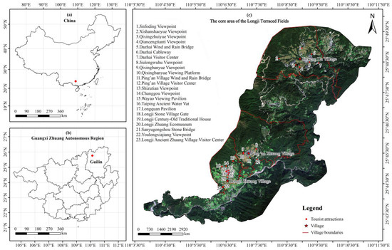
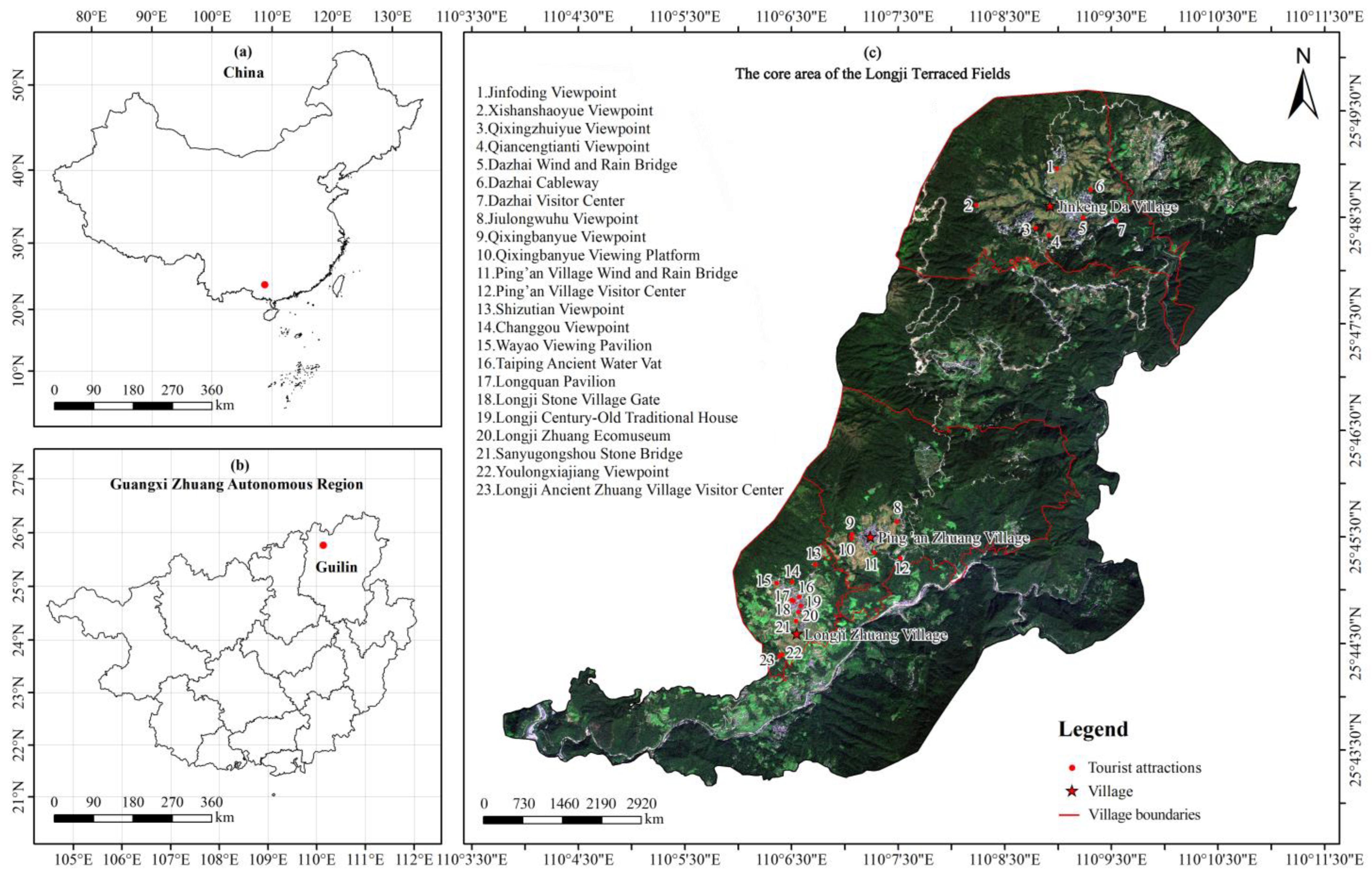
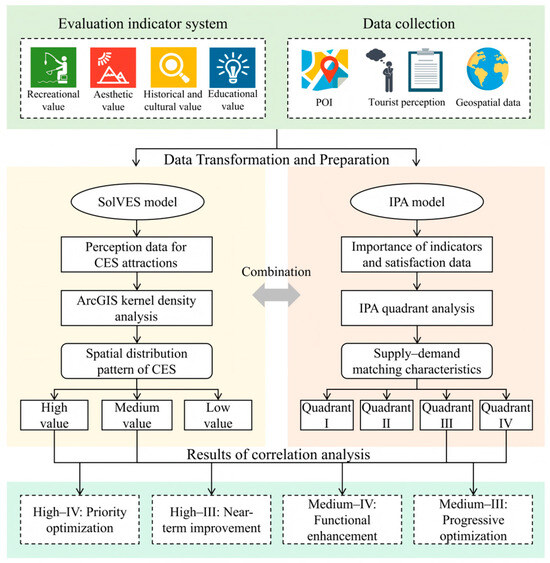
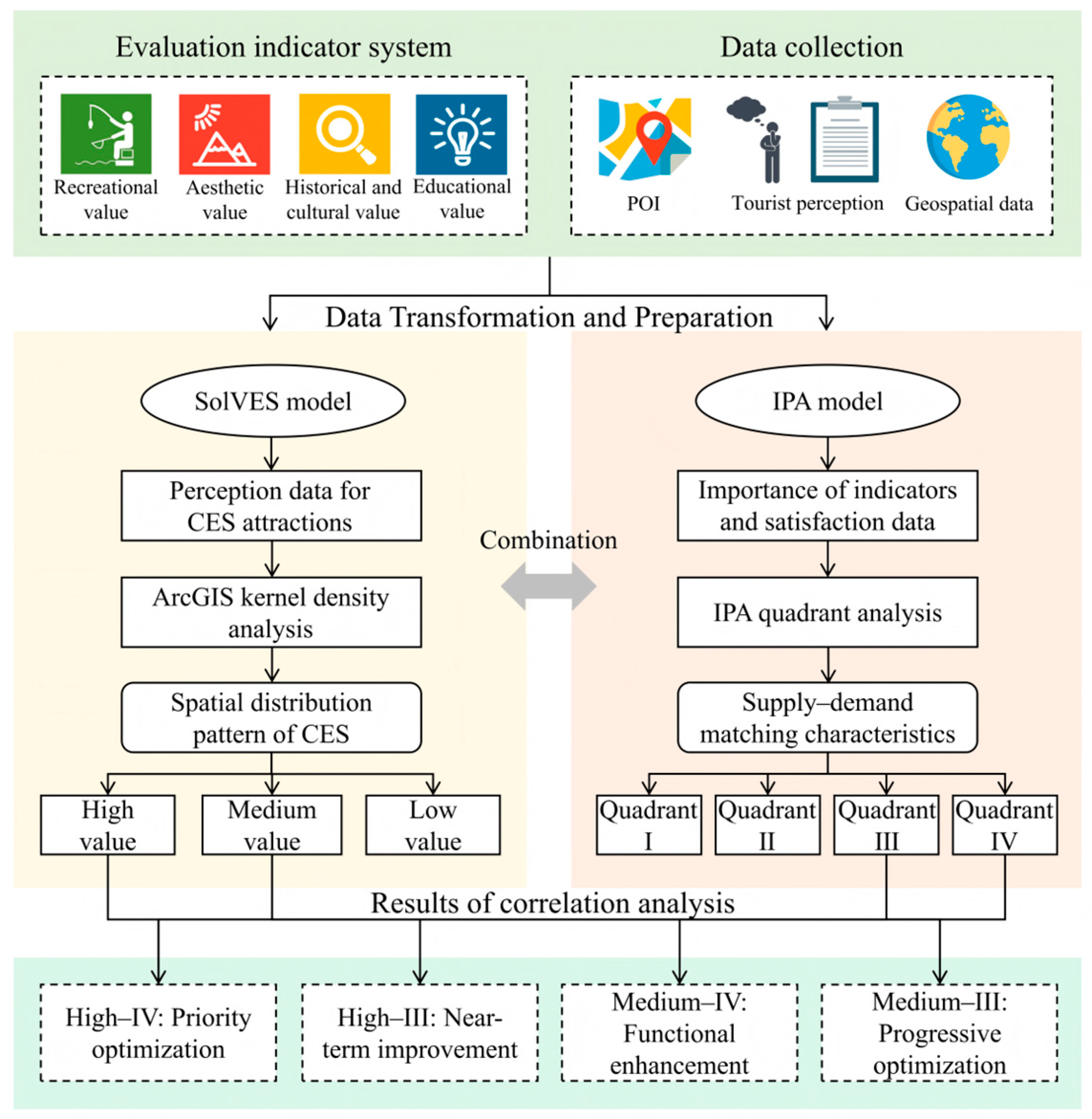
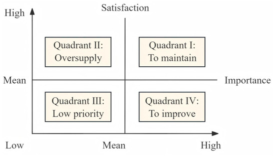
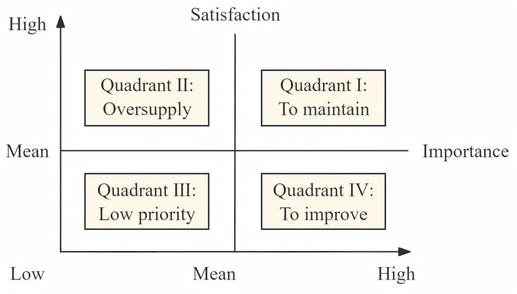
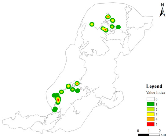
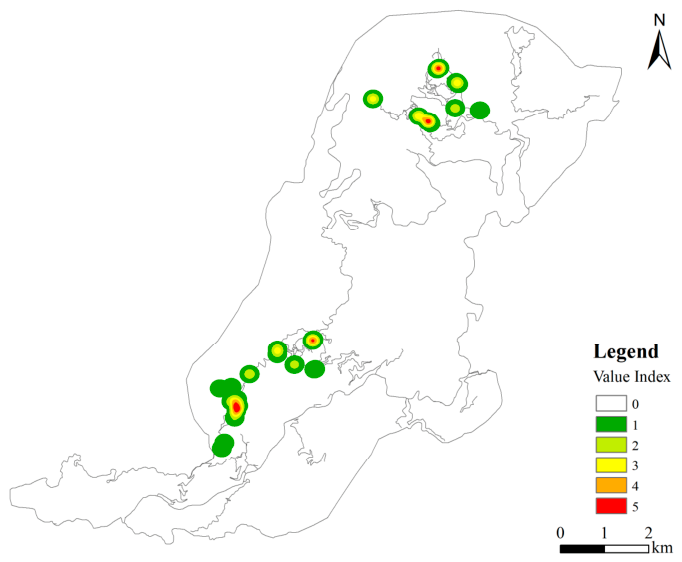
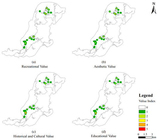
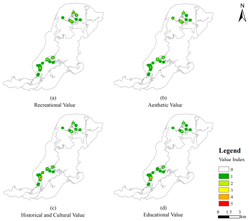
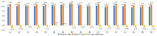
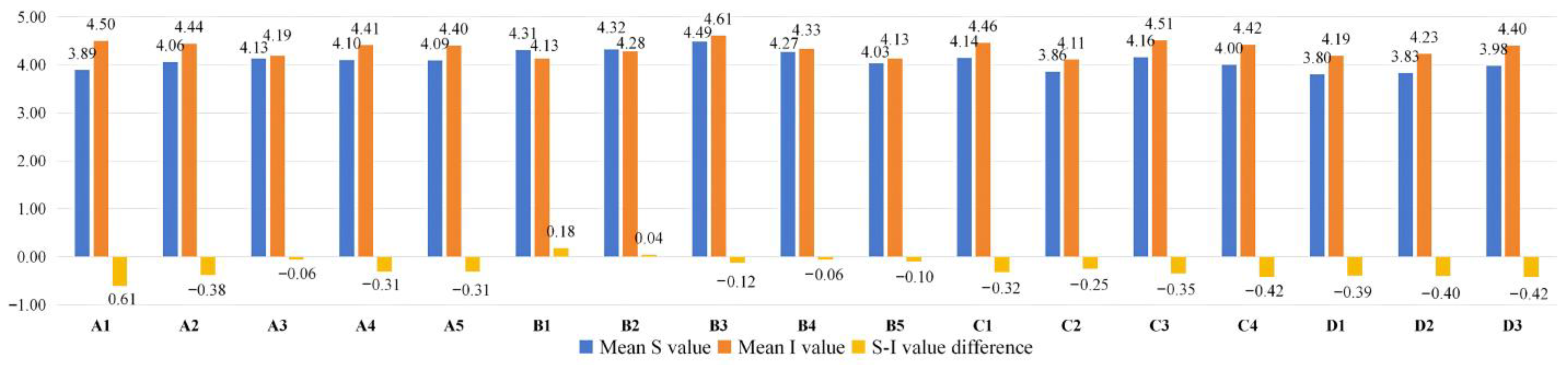
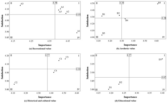
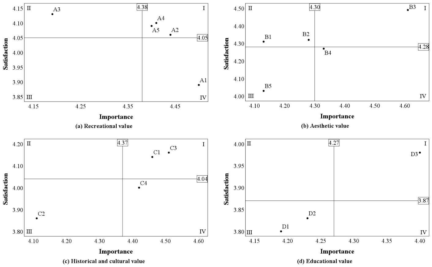
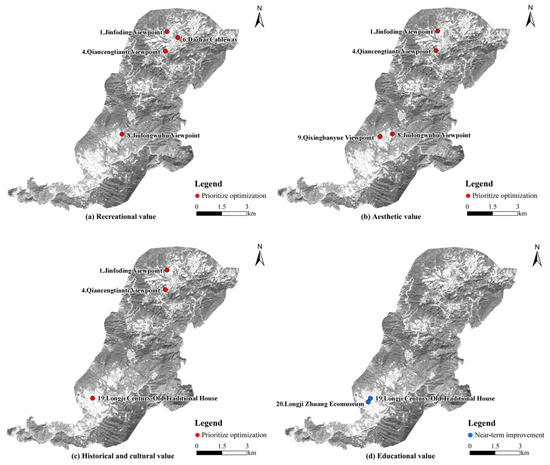
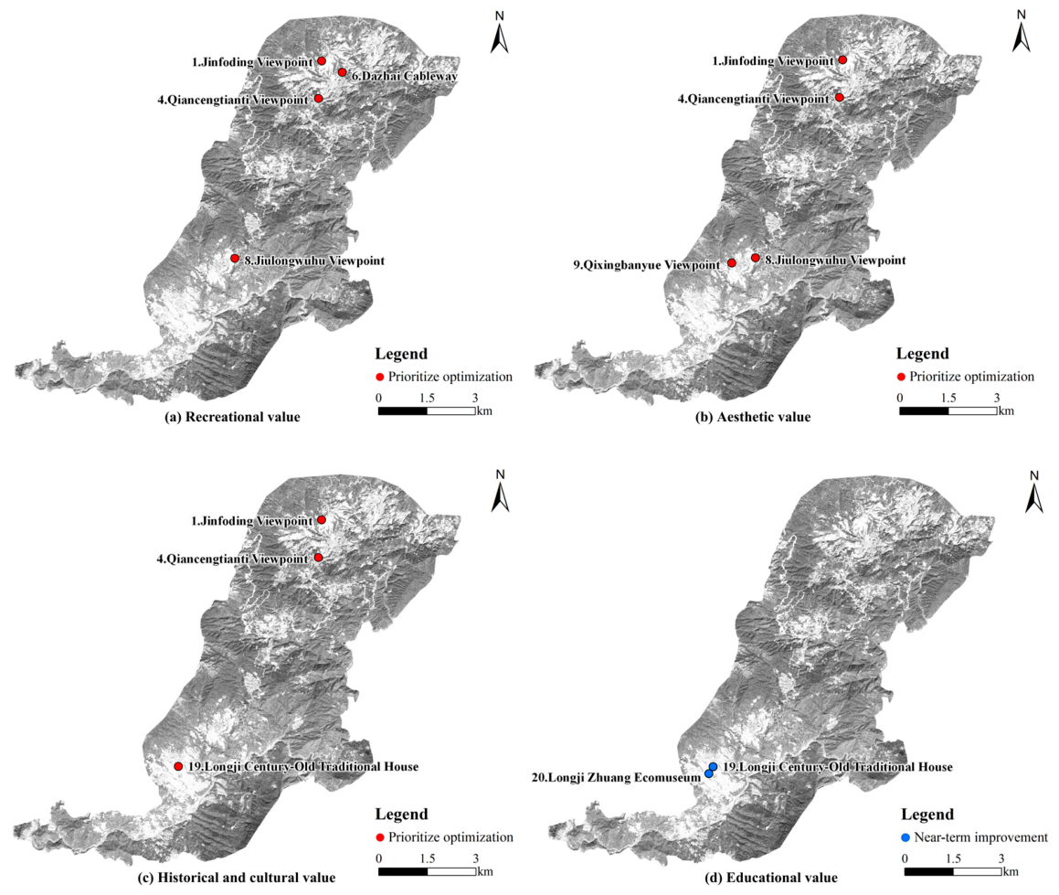

Disclaimer/Publisher’s Note: The statements, opinions and data contained in all publications are solely those of the individual author(s) and contributor(s) and not of MDPI and/or the editor(s). MDPI and/or the editor(s) disclaim responsibility for any injury to people or property resulting from any ideas, methods, instructions or products referred to in the content. |
© 2026 by the authors. Licensee MDPI, Basel, Switzerland. This article is an open access article distributed under the terms and conditions of the Creative Commons Attribution (CC BY) license.