


Abstract
Chile’s economic development model, which was shattered by the military coup, restructured under the dictatorship, and institutionalised under democracy as a neoliberal model, gave rise to a liberalisation process that affects the country’s natural resources and commercial dynamics and, by extension, places society itself at the service of the system. This model, enshrined in the 1980 Political Constitution, was founded on the principles of external openness, private investment, and deregulation. Against this backdrop, this paper examines and analyses the impact of strengthening private ownership over tangible assets on the increase in land transactions in the rural commune of Hualaihué. The research, based on a quantitative and qualitative analysis of land ownership records from 2005, 2015, 2021, and 2022, as well as information from 23 semi-structured interviews with different territorial stakeholders, reveals the impact of territorial commodification in the area of study. The results indicate that the sale of rural land, the increase in land sales, and the reduction in the size of plots acquired since 2021 constitute an emerging and latent problem, which confirms that rural land is undergoing a subdivision process that presents urban development characteristics in certain parts of the commune. This needs to be critically examined to develop urgent, comprehensive planning dynamics, thereby reducing emerging socio-territorial conflicts.
1. Introduction
Neoliberalism, as a sociopolitical and economic context, has defined the relationship between the state, the market, and society, promoting market-based mechanisms as the primary means of resource allocation and human well-being [1,2]. This model is characterised by processes such as privatisation, deregulation, re-regulation, and the commodification or pricing of objects, which have progressively extended market logics into multiple spheres of social and territorial life [1,3,4].
In this context, it is common for a state’s fundamental law, which serves as a guide for the organisation of public powers, to promote decentralised administration, giving rise to regionalisation processes that serve as a prelude to re-regulation, since the transfer of powers and resources to regions creates a framework conducive to the revision and redefinition of rules that allow for market-oriented territorial management, promoting economic efficiency and regional competitiveness [5,6,7]. The transfer of responsibility for state regulation to market mechanisms drives deregulation and privatisation, shifting planning functions to private and mixed actors. Within this framework, territorial planning increasingly operates under market-oriented logics, contributing to territorial inequalities, weakening the role of the state, and increasing social and environmental vulnerabilities [8].
Various studies in Latin American countries have documented community-based organisational processes of resistance against the actions of dispossession, expropriation, and exploitation driven by the commodification and privatisation of land [8], as well as the neoliberal influence on social inequality, the deterioration of democratic institutions, and its profound impact on the distribution of wealth in the Latin American region [9]. Empirical experiences show that social organisation in defence of life in Latin America calls into question the terms under which capitalism has shaped the fabric of life to ensure the logic of the market. They also envision a reconnection and reappropriation of what has been lost or altered by the metabolism of capital [8]. However, despite social organisation and coordination against neoliberal domination, unfortunately no changes have been achieved in the vindication of rights or in the legal struggle against privatisation [9].
Despite the extensive literature on neoliberalisation in Latin America and Chile, there remains a significant gap in understanding how specific legal–institutional arrangements—particularly private property rights—translate into concrete spatial transformations at the local scale. While previous studies have examined commodification, dispossession, and green grabbing as broad processes, fewer have empirically demonstrated how these dynamics interact and materialise through land market expansion in rural territories. In particular, there is limited evidence linking national legal frameworks to observable changes in land transactions, territorial fragmentation, and socio-spatial reconfiguration in specific local contexts.
In this context, examining rural territories provides a critical entry point for understanding how neoliberal policies operate in practice. Unlike urban areas, where planning instruments are more developed, rural territories in Chile are characterised by regulatory gaps and fragmented governance frameworks. These conditions make them particularly susceptible to market-driven transformations, offering a strategic lens through which to analyse the spatial consequences of neoliberal private property rights.
Based on these privatisations, this paper addresses the following research question: How does the strengthening of private property rights under Chile’s neoliberal framework drive rural land transactions and reshape territorial dynamics in Hualaihué? To answer this question, this paper aims to explore and analyse, in the Chilean commune of Hualaihué, the impact of strengthening private ownership over tangible assets, in accordance with Article 19 No. 24 of the Constitution [10], on the increase and effects of land transactions in an unregulated rural territory. It also explores and analyses the evolution of land transactions, the actors involved in these processes and their roles in land market dynamics, and the socio-spatial transformations perceived by local stakeholders, integrating quantitative, qualitative, and spatial evidence.
It is important to examine this process, which, since the formation of the commune in 1979, has led to a new phase of regional and local territorialisation, driven by the extensive economic liberalisation of natural resources [11,12,13,14] and, consequently, the emergence of an active market around water (both continental and marine) [14,15], forests, tourism products, and conservation goods [16]. All of this has had an impact on land and water ownership, with the latter taking the form of aquaculture concessions [17]. In this regard, it should be noted that neoliberal territorialisation in Chile occurs in a sectoral rather than territorial manner, shaped by various spatial planning tools that have historically encompassed urban areas [18]. That said, the rural nature that characterises the commune of Hualiahué is deregulated and, therefore, at the mercy of the market.
To strengthen the analytical link between the theoretical framework and the empirical analysis, this paper explicitly operationalises the proposed causal chain linking private property rights, commodification of nature, and accumulation by dispossession. Through the integration of land transaction data, plot size evolution, and qualitative evidence from territorial actors, the research traces how legal–institutional arrangements materialise in observable socio-spatial transformations. This approach allows moving beyond descriptive accounts and provides a systematic empirical validation of the theoretical relationships proposed.
Following the Introduction, this article is organised into five sections. The first is theoretical in nature and addresses how the neoliberalisation project required the commodification of the territory; the second presents the methodological aspects and the area of study; the third presents the results, highlighting the voices of the people interviewed; the fourth discusses the results from a theoretical perspective; and finally, the fifth section concludes with the conclusions and proposes new research on this topic.
2. Theoretical Framework: The Neoliberal Project in Chile’s Rural Territory
The Chilean neoliberal project formally began during the military dictatorship, under a Constitution that continues to enjoy legal and institutional support. Neoliberalisation in Chile began with the regionalisation process of 1976, which sought to bring investment and modernisation to the territories and thus promote the commodification of nature and planning. Although neoliberalism has promoted modernisation and economic growth [9], rural planning has been deficient and/or non-existent, showing evidence of re-regulation and deregulation.
2.1. Commodification of Nature
The opening of the Chilean economy to the free market, oriented towards the export of unprocessed raw materials, led, among other effects, to the commodification of natural resources and landscapes, particularly pronounced in the northern regions associated with mining [19], as well as in the southern regions of Chile due to their waters and natural greenery [20]. The state-led drive to achieve this goal was based on strengthening the private ownership of natural resources and common goods and, thus, on the distribution and commodification of these resources in the global market [9,14]. The legal basis for the neoliberal transformation was private property and, therefore, land ownership, which gave rise to unsustainable rural scenarios given the concentration and fragmentation of the land [4].
Alongside private property, Article 19 No. 24 of the Political Constitution of the Republic of Chile (1980) [10] also established:
The right of ownership in its various forms over all kinds of tangible or intangible property. Only the law may establish the manner of acquiring, using, enjoying and disposing of property, as well as the limitations and obligations arising from its social function. This social function encompasses everything required by the general interests of the nation, national security, public utility and health, and the preservation of environmental heritage. No one may, under any circumstances, be deprived of his or her property, the asset affected, or any of the essential attributes or powers of ownership, except by virtue of general or special law authorising expropriation for public utility or national interest, qualified by the legislator. The expropriated party may challenge the legality of the act of expropriation before ordinary courts and shall always have the right to compensation for the patrimonial damage actually caused, which shall be determined by mutual agreement or by a judgement issued in accordance with law by such courts.
Conceptually, Article 19 No. 24 refers to the individual, absolute, and exclusive nature of ownership for whoever acquires property, thus making it a critical factor in advancing towards greater coordination in rural planning policies [10].
The commodification that has taken place in Chile since 1973 has been supported by sectoral legislation and control technologies to make them available for capitalist development [12]. Six essential conditions underpin the commodification of nature: privatisation, alienability, individuation, abstraction, valuation, and displacement [11,21], all of which are aligned with the economic practices implemented by Chile. On the other hand, accumulation by dispossession [6,22] involves the privatisation of land and the conversion of different forms of property into private ownership, the expulsion of peasant populations, the suppression of resources, the elimination of alternative forms of production and consumption, the colonial appropriation of natural resources, monetisation and taxation, usury, and indebtedness through credit. In this regard, each of the conditions outlined by both [21,22] required active state intervention, with the resulting creation of institutions and supporting material structures that allowed nature to be used as an environmental service. In the case study, this refers to the rise in land transactions and the promotion of nature tourism as a green investment (so-called “green grabbing”) [23,24], as well as its use in the aquaculture industry [14,25].
Ultimately, this commodification has helped redefine the rural environment by serving as a lever for the territorialisation of new dynamics and activities within it, which involve processes of “commodification of nature as a spatial practice” [16] (p. 12). Some research in the field of geography explains the “neoliberalisation of nature” using terms such as “green conservation and development”, which instead leads to environmental degradation and social fragmentation [26]. As a result, ecological narratives and green imaginaries have underscored the significance of natural heritage, thus generating land grabbing processes and, therefore, the privatisation of this land in a global context where it is a scarce and difficult-to-access resource [27,28]. This economic/ecological process generates new inequalities and perpetuates the dispossession of the local population [8,23,29].
In this paper, these processes are understood as a sequential mechanism in which strengthened private property rights enable the commodification of nature, activating land markets and facilitating accumulation by dispossession, including contemporary forms such as green grabbing.
To further clarify the analytical hierarchy and interaction between the key theoretical concepts, this study distinguishes between enabling conditions, mechanisms, and outcomes. The strengthening of private property rights operates as an enabling institutional condition that legally secures exclusive control over land. This condition activates these dynamics, understood as the transformation of land into a tradable asset within market logics. In turn, this commodification facilitates accumulation by dispossession, particularly under conditions of asymmetric information and weak regulation. Finally, green grabbing emerges as a contemporary manifestation of these dynamics, where environmental narratives legitimise land acquisition for tourism and conservation purposes. This hierarchical clarification allows for a more precise interpretation of how legal frameworks translate into spatial patterns such as land fragmentation and concentration observed in the rural commune of Hualaihué.
2.2. Territorialisation Devices: Spatial Planning Tools
Rural land ownership between 1967 and 1973 was redefined in terms of the social and productive functions that it would provide for the country. Two reforms were implemented to achieve this goal: the Constitutional Law of 1966 (Law No. 16,615) and the Agrarian Law of 1967 (Law No. 16,640). Following the military coup, these reforms were dismantled to facilitate the exploitation of rural land for the export of fruit, wine, and forestry products [13]. This goal was achieved, with indicators showing a reduction in poverty (from 75% to 17% between 1990 and 2017) and an increase in real income (2.3% between 1998 and 2017). However, these developments took place on rural lands lacking comprehensive planning, where inequalities in access, land grabbing and property fragmentation remain evident today [13,24,28].
In rural areas, the Neoliberal State is limited to planning and regulating the territory in pursuit of its private appropriation and commercialisation [4,14]. Spatial planning through territorial regulation does not organise the territory based on the country’s dynamics, interests, and characteristics, nor on the needs of the population. Similarly, given that the case study is a rural area, it should be noted that planning in Chile has historically focused on urban areas and specific sectors [18]. Ultimately, Chile’s rural territory lacks coherent and connected spatial planning tools that grant planning and regulatory powers over these areas. It should be noted that rural areas will be governed by a Regional Plan for Spatial Planning (PROT), under Law No. 21,074/2010, once regulating Supreme Decree 243 has been approved. In this context, the PROT has emerged as an instrument that will guide the development of each Chilean region based on its intrinsic physical and social characteristics and interests, since it will encompass territories not currently regulated by urban-level instruments. Conversely, there is a set of legal norms still in force that impact the rural territory. Notably, spatial planning tools with implications for rural areas include Decree Law No. 458/1976, Article 55 of which establishes land-use changes, and Decree Law No. 3516/1980 on the division of rural plots [17]. The latter was introduced after earlier regulations failed and is particularly relevant to this research due to its effects on the subdivision of land ownership.
With regard to land-use change regulations, the former decree allows rural plots to be converted to other categories, such as residential, commercial, and industrial uses, while the second establishes a minimum rural subdivision of 5000 m2, thereby allowing for the creation of so-called “recreational plots” and the residential colonisation of rural land [13,18,28]. By permitting such subdivisions, Decree Law 3516/1980 facilitated the expansion of urban-style housing into rural areas, thus significantly shaping residential colonisation by outsiders and investors in real estate and tourism projects [30].
This process bears no relation to the regulation, strategy or planning of rural territory, as it merely reflects the implementation of individual cases consistent with the neoliberal model. There is no doubt that the division of rural plots negatively affects the rational settlement of rural areas, since it has become a mechanism for creating urban-style residential areas in rural zones, through recreational plots and/or rural estates, thereby circumventing the requirements of Article 55 of Decree Law No. 458/1976 [18].
Figure 1 illustrates the causal sequence linking the neoliberal property regime in Chile with socio-spatial transformations in rural territories. The strengthening of private property rights enables the commodification of nature, which activates land markets. This process materialises through land subdivision dynamics and facilitates accumulation by dispossession and green grabbing, ultimately generating socio-territorial changes.
Figure 1.
Theoretical framework linking neoliberal property regimes and socio-spatial transformations.
Building on the theoretical perspectives outlined above, this paper operationalises its key concepts through observable empirical indicators that enable their identification within the case study. This process is examined through the increase in rural land transactions and changes in land use, reflecting the progressive incorporation of territory into market dynamics. In turn, accumulation by dispossession is analysed through processes such as the displacement of local populations and the growing concentration of land ownership, revealing asymmetries in access to and control over territorial resources. Finally, green grabbing is identified through the acquisition of land for conservation and tourism-related purposes, evidencing emerging forms of appropriation linked to environmental valorisation. By linking these conceptual dimensions to measurable indicators, the paper establishes an analytical framework that allows for a systematic examination of how neoliberal dynamics materialise in the transformation of rural territories.
3. The Case Study, Materials, Methods, and Analysis
3.1. The Case Study: The Rural Commune of Hualaihué or Walaywe
As for the study area, the rural commune of Hualaihué or Walaywe, it should be noted that two important facts must be considered to understand the make-up of the commune. First, the history prior to the coup and subsequent dictatorship transcended the administrative boundaries that were imposed. Because the commune lies opposite the island and archipelago of Chiloé (Figure 2), the island’s inhabitants historically travelled by sailboat to the mainland in search of fish, shellfish, seaweed, and alerce (Lahuén), a native conifer prized for its wood [31].
Figure 2.
Geographical location of the commune of Hualaihué.
They built close ties with the Indigenous Mapuche Williche communities of Walaywe through exchanges of natural resources based on communal labour, a process that resulted in the settlement and establishment of a territory of fishers, shore gatherers, and alerce harvesters. Second, the imposition of a harsh economic policy led, among other things, to the respective establishment of the commune of Hualaihué in 1979, once it had been connected to and integrated with the rest of the territory by the Carretera Austral (Route 7) during the military dictatorship (Figure 1). Against this backdrop, the commune of Hualaihué emerged as a product of the regionalisation process to implement the neoliberal economic model [32]. Administrative boundaries were drawn to render it sovereign and productive, and Hornopirén was proclaimed the commune’s capital.
The commune is rural and belongs administratively to the Los Lagos Region, Palena Province. It has a population of 9480 inhabitants, 5303 of whom live in rural areas, mainly along the coast due to their seafaring status [33]. Among them, 3358 are members of the Mapuche Williche people, who inhabit and organise themselves across the territory through 27 communities [33]. Hualaihué is surrounded by the inland sea of the Gulf of Ancud, the Reloncaví Estuary and the Andes Mountain range (Figure 2). Its landscape features beaches, rivers, estuaries, fjords, wetlands (marshes and mallines), volcanoes, grasslands, and ancient native forests, which make it an attractive location for acquiring and investing in rural properties, thanks to its biological and scenic diversity and its cultural assets. It should also be noted that the commune’s inland and marine waters have become a market commodity [14,25], where investment linked to the salmon industry began in 1986 and continues to this day [17]. Although outside the scope of this study, this development must be acknowledged given the environmental and social impact it has had on this rural territory made up of fishers, shore harvesters, and alerceros. Finally, it should be noted that the commune does not have planning or territorial management aligned with the specific processes and dynamics of rural territory. Its only spatial planning tool is an Urban Boundary dating from 1988, which applies exclusively to the town of Hornopirén, the commune’s urban centre.
3.2. Methodology, Methods, and Analysis
The research is structured around a convergent mixed-methods design to capture both structural land dynamics/spatial configurations by Geographic Information Systems (GIS) (quantitative) and actor perceptions (qualitative) [34], which is particularly suitable for capturing complex socio-spatial processes where structural patterns and actor perceptions interact. The spatial dimension was examined through GIS, using ArcGIS (Esri, version 10.6.1 software under license) for geospatial data processing, spatial analysis, and cartographic visualisation.
This method enhances the robustness of findings through triangulation and reduces the limitations inherent in single-method approaches.
A single-method approach would fail to capture both the structural dynamics of land markets and the lived experiences of territorial actors. Therefore, the combination of quantitative, qualitative, and spatial data is essential to provide a comprehensive understanding of the processes under study.
To ensure analytical coherence between the theoretical framework and the empirical analysis, the key concepts discussed above are operationalised through a set of observable indicators. Table 1 summarises the relationships between theoretical constructs, their underlying mechanisms, and the empirical variables used in this study. This operationalisation guides both data/testimony collection and analytical procedures.
Table 1.
Operationalisation of theoretical concepts and their empirical indicators.
This approach integrates documentary analysis of territorial planning regulations and land ownership records with qualitative content analysis of information derived from 23 semi-structured interviews with different territorial stakeholders.
Thus, following the bibliographic and regulatory review that provided a theoretical and legal foundation for the research problem, empirical work was conducted through the collection of primary data associated with land transactions recorded in the years 2005, 2015, 2021, and 2022 from the books of the Hualaihué property register.
The selection of the study years (2005, 2015, 2021, and 2022) responds not only to data availability but also to their analytical relevance in capturing key phases of rural land market transformation in the commune of Hualaihué. The year 2005 represents a pre-expansion phase, characterised by relatively low levels of land market activity. The year 2015 reflects a period of consolidation, in which land transactions began to intensify alongside the expansion of nature tourism and of the salmon industry [17,24,27]. Finally, the years 2021 and 2022 capture a recent acceleration phase associated with broader socio-economic transformations, including the effects of the 2019 social unrest in Chile and the COVID-19 pandemic, which have contributed to increased mobility, changing residential preferences, and heightened demand for rural land. Post-2022 data are not yet publicly available from the Internal Revenue Service (SII) and the books of the Hualaihué property register. This temporal framework allows for a more nuanced interpretation of the evolution of land transactions in relation to both structural and conjunctural processes.
It should be noted that information related to land transactions forms part of private legal circulation and, consequently, is neither centralised by the state nor accessible through transparency legislation. As a result, the examination of title deeds for the four years consulted had to be conducted in person and under strict confidentiality. Over a period of seven days, the transaction history was reviewed on-site, with a specific focus on purchase and sale operations. Based on this review, a proprietary database was compiled, referencing each property’s cadastral identifier and including information on the new owner and their region of origin, the previous owner, and the folio number of the preceding transaction, where applicable. Additionally, each record included the year of transaction, the locality of the property sold or purchased, the purchase price, and the land area acquired, along with its respective boundary markers and/or property limits.
Once the database was refined, it was compared and supplemented with the Natural Resources Information Centre (CIREN) database for the year 2015. Similarly, it was complemented with data available from the SII through its virtual consultation platform on real estate assets, as well as its digital cartography viewer (Figure 3). This process allowed the proprietary database to incorporate new fields such as location, land-use classification, and tax contribution status, thereby enabling triangulation and the generation of thematic maps and spatial analyses of territorial fragmentation based on the primary data collected.
Figure 3.
Process of triangulating primary information with official data from CIREN and SII. Source: Prepared by the author based on the collection and creation of primary documentary sources.
Primary data collection was supported through the conduct of 23 semi-structured interviews with 27 participants, following the signing of informed consent forms [35] and with full transparency regarding the nature of the research [36]. Most in-depth interviews were conducted individually, except for three cases in which two to three participants were interviewed simultaneously (Table 2). The main thematic axes addressed by the semi-structured interview guide focused on participants’ views regarding the development model implemented in Chile, its effects on the territory, and the ways in which this model influences territorial planning and local decision-making. Each interview followed a set of predefined questions without strict response categories, allowing for improvisation and adaptation according to the flow of the conversation. This semi-structured methodology enabled the comparison of responses across participants while providing flexibility to explore new perspectives that emerged during the interviews.
Table 2.
Classification of key actors interviewed.
Some questions focused on participants’ perceptions of socioenvironmental changes that have occurred since the implementation of the neoliberal model in the commune of Hualaihué. For example, “What do you consider to be the main ‘resource’ or asset of the commune? Do you perceive a transformation of the rural territory in terms of modifications to the natural environment for production, as well as changes in local identity?” In addition, the relationship between these changes and their consequences was examined, including participants’ perceptions of the arrival of new inhabitants, the causes attributed to these transformations, and how participants understand the commune’s status as a rural area. Finally, the interviews explored participants’ evaluations of management policies implemented by territorial planners in the rural context.
The selection of interview participants followed a purposive sampling strategy based on their relevance as territorial actors directly involved in land governance, resource use, or local decision-making processes (Table 2). The diversity of actors included—public institutions, private sector, civil society, and Indigenous communities—ensures a comprehensive coverage of perspectives relevant to the research. This strategy aimed to capture a diversity of perspectives regarding land transactions and territorial transformations within the study area. However, this approach may underrepresent informal actors or marginalised voices that are not directly linked to formal governance structures. This limitation should be considered when interpreting the findings, particularly in relation to power asymmetries and access to land.
Likewise, this categorisation enabled the analysis of the relationships of cooperation, their knowledge of the area, and/or conflict established among them (Table 2). The composition of the interview shows a relatively balanced distribution in terms of gender, with 15 men and 12 women. Regarding age structure, the majority of participants are concentrated in the intermediate age groups: 10 participants were between 18 and 40 years old, 16 between 40 and 65 years old, and only one participant was over 65. This distribution allows for capturing diverse perspectives, although with a predominance of actors in the active working-age population.
Each interview was transcribed using two methods: Cloud University of Barcelona (UB) Word, which identifies speakers (interviewee–researcher), and OpenAI’s Whisper, which does not perform speaker recognition. Subsequently, the transcripts were analysed using qualitative content analysis software, specifically ATLAS.ti 24 (under license UB L-4D0-4D7), which enabled the efficient and systematic organisation, analysis, and interpretation of the data. This software also facilitated the generation of coded texts based on the interview and focus group materials, allowing for the identification of conceptual categories for subsequent analysis. In addition, the semantic search tool in ATLAS.ti 24 facilitated access to secondary data, providing an additional resource for data triangulation and for supporting the grounding and generalisation of qualitative findings.
The integration of qualitative, quantitative, and spatial data follows a triangulation logic in which each type of evidence is used not only independently but also comparatively to validate and interpret the others. Quantitative data on land transactions provide objective trends in market dynamics, while GIS analysis identifies their spatial distribution and concentration patterns. These findings are then interpreted and contextualised through qualitative interview data, which capture local perceptions and social impacts. This integrative strategy allows for both corroboration and explanation: while statistical and spatial analyses identify patterns, qualitative evidence explains the underlying processes and meanings attributed by territorial actors. In this way, the mixed-methods design ensures not only complementarity but also mutual validation across data sources.
Using excerpts from participants’ testimonies and data obtained through the mixed-methods approach, the triangulation of information strengthened the study’s findings, based on the assumption that the weaknesses of one method are compensated for by the strengths of another. Consequently, this research documents empirical realities and articulates the effects of commodification as a discourse capable of fostering new reflections on the rural territory of Hualaihué.
4. Results
With regard to the impact on the territory of Hualaihué and the natural and human resources that define it as a commune, the empirical study revealed that the arrival of the salmon industry gave rise to other underlying issues, including (un)regulated urban growth in Hornopirén and greater openness and visibility of the commune, which in turn led to population growth and increased land transactions. It should be noted that this work made it possible to spatially visualise the ownership and control of the rural territory, as a vital element for subsequent comprehensive planning of the commune’s land and coastal areas.
4.1. Ownership and Control of the Rural Territory
The review and analysis of spatial planning in Chile and land ownership records made it possible to obtain a map of land ownership distribution (Figure 4), which extends from the sea to the Andes mountains. Regarding the sea, the area administered by the Ministry of National Defence (MDN) corresponds to the marine coast, which includes territorial waters (encompassing a portion of the water, seabed and rocky formations), intertidal beaches, and beachlands. Within territorial waters, the state, through the MDN Undersecretary of the Armed Forces, grants aquaculture concessions as private rights of use and enjoyment to exploit certain public domain resources (the sea) for economic purposes. However, it should be noted that there is a Mañihueico-Huinay Marine Coastal Area of Indigenous Peoples (ECMPO), officially designated in 2018 in the marine coastal area. Although administered by the MDN, its significance lies in the fact that it is the result of collaborative environmental governance, which achieved the management of rights of use and enjoyment, as well as protection of customary use by the Indigenous communities of Walaywe, under a prior agreement with the state for its administration [17]. A similar situation occurs with the Admapu-Walaywe ECMPO; however, that area (including beach and beachlands) is still under administrative review (Figure 4), which has put the communities on alert regarding the potential arrival of real estate and tourism projects along the coastline.
Figure 4.
Current land ownership situation in the commune of Hualaihué. Source: Prepared by the author based on the 2015 CIREN-SII land ownership records, as well as a review of land sales for the years 2005, 2015, 2021, and 2022.
Hualaihué is one of the few coastal communities in the Los Lagos Region with a substantial amount of fiscal land adjacent to the coastal area (Figure 4). Technically, fiscal land refers to property owned by the state and administered by the Ministry of National Property (MBN), whose use does not correspond to common purposes, such as a public square or a road. Fiscal property corresponds to public buildings, such as council offices and healthcare and education facilities (rural schools). Fiscal land is also used for the construction of social housing, and a significant portion of this land in Hualaihué is designated as officially protected areas (Figure 4). These protected areas, administered by the recently established Biodiversity and Protected Areas Service, are intended for the protection and conservation of the Hornopirén and Pumalín national parks.
Finally, it should be noted that fiscal property without official protection is subject to potential sale for private use and may pass into private ownership. Private ownership is intended primarily for residential purposes (and/or second homes), as well as real estate development and nature-based tourism.
4.2. (Un)regulated Urban Growth
It is worth noting that the consolidation of the salmon industry, following the completion of Route 7, opened up the commune and connected it to the rest of the Los Lagos Region. This development led to population growth, accompanied by corresponding land sales, especially in Hornopirén, and brought changes “in housing, in homes and also in culture, new people with different habits” (member, Association of Indigenous Communities of the Walaywe Territory).
There is no doubt that the only spatial planning tool, the 1988 Urban Boundary, has been completely overrun, with no planning whatsoever (Figure 5). As a result of unregulated growth, it should be noted that this “has led to the deterioration of ecosystems with high ecological value, such as the Hornopirén wetland, the shoreline, rivers and native forest” (member, municipal entity). Furthermore, precarious settlements have emerged in tsunami-prone areas affected by landslides, flooding, and volcanic activity. Both regulated and unregulated urban development suffers from a lack of sanitary infrastructure, public facilities, green spaces, and connectivity, and the current capacity of the treatment plant, at 643 m3/day, has been strained.
Figure 5.
Spatio-temporal growth of the urban area of Hornopirén, 1985–2025. Source: Prepared by the author based on images extracted from Google Earth.
As a result of the creation of Palena Province and the commune of Hualaihué, the commune’s population grew by approximately 61% between the 1970 census, when the total population was 5526, and the 2017 census, which recorded 8932 inhabitants (Table 3) [33]. Of the 8932 inhabitants in 2017, 5303 lived in rural areas, while 3629 resided in the urban area of Hornopirén [33] (Figure 5). Historically, the population was concentrated in rural areas, accounting for 86.15% (6982) in 1992. Over the years, however, this figure decreased to 59.37% (5303), as reflected in the 2017 census. By contrast, the urban population increased over the same period, rising from 13.85% (1122) in 1992 to 40.63% (3629) in 2017 (Table 3).
Table 3.
Population distribution according to the census in the commune of Hualaihué.
In Chile, an update of the census was conducted in 2024; however, the data only became available in December 2025 and are only general, since they are still in the process of being reviewed and validated. Thus, empirical evidence, along with the statements of the interviewees, suggests that the number of residents in Hornopirén has increased significantly since 2021, after the 2019 social unrest and the COVID-19 pandemic.
For example, regarding the commune’s Rural Drinking Water (APR) system, the committee stated:
As a committee, we notice the arrival of new residents through all the water requests [being processed]. There are many people from Santiago and the north who are coming and buying property here now, with the intention of coming to live here [in Hornopirén] in the future. But here we are, behind on everything. We still don’t have a regulatory plan, so people just build, and that’s a concern because we will continue to grow in an unplanned way.(member, APR Committee)
A Communal Regulatory Plan is currently being developed to guide Hornopirén’s urban residents towards balanced and sustainable urban development, given that rapid and unregulated growth has spilled over the Urban Boundary (Figure 5). However, all rural areas, which make up a large part of the commune, will continue to wait for a PROT in order to be organised and planned comprehensively based on local interests.
4.3. Activation of the Land Market
This section examines the expansion of land market activity. Evidenced urban growth, therefore, reflects openness and visibility, along with the consequent arrival of new residents and speculators, who act by purchasing land.
Below are three excerpts from accounts that will be used to illustrate the research findings:
Residents could leave the commune [once Route 7 was complete], just as newcomers with long-term vision began to arrive. So more salmon farming companies and tourism entrepreneurs began to turn up, forward-thinking people. They thought, this is beautiful, maybe it’ll be invaluable in 20 years, so let’s build cabins or buy land, which was cheap at the time. And that’s when people started getting familiar with money by selling land and working on salmon farms.(member, Salvemos Río Negro)
The new arrivals come to work on the salmon farms and stay, which is very noticeable here, because people with money also arrive, especially from Santiago and abroad, people who have the resources to buy these large plots of land that used to be estates.(member, research centre)
In the last few years here, we’ve seen and heard that lots of people have come from other places to buy sites and plots of land, some fleeing the city and others escaping water shortages in parts of the north. So there are many people looking for places to buy. Unfortunately, all kinds of people come here, which isn’t very convenient for us either, because they bring different customs with them.(member, Association of Indigenous Communities of the Walaywe Territory)
To support the accounts regarding land sales, the total for the four years reviewed was 1075 transactions, which broke down as follows: 28 in 2005, 121 in 2015, 509 in 2021, and 417 in 2022. This demonstrates the increase in sales, especially in 2021.
The increase in land prices and demand reported by interviewees is consistent with quantitative data showing a sharp rise in land transactions, particularly after 2021.
However, three key points are worth highlighting: (a) 759 transactions related to rural land, 496 of which corresponded to supposedly unused land that was not actually vacant; (b) the SII does not list the land category for a total of 196 transactions, thus casting doubt on all of those sales; and (c) the average plot size sold in 2005 was 195.95 hectares, while in 2022 it was 1.75 hectares. This trend indicates a transition from a relatively inactive land market to a dynamic and expanding one.
From a temporal perspective, the evolution of land transactions can be interpreted as a sequence of distinct phases reflecting broader socio-economic transformations. The year 2005 represents a pre-expansion phase, characterised by a low number of transactions and large plot sizes, indicating limited market activity and a predominantly traditional rural land structure. By 2015, the data suggest a phase of consolidation, with a noticeable increase in transactions and the initial fragmentation of land, associated with the growing presence of nature tourism and of the salmon industry. In contrast, the years 2021 and 2022 reflect an accelerated expansion phase, with a sharp rise in the number of transactions and a significant reduction in plot size. This recent dynamic is closely linked to post-pandemic mobility patterns and the sociopolitical context following the 2019 social unrest in Chile, which have intensified demand for rural land and reinforced processes of commodification and territorial restructuring. These phases provide empirical support for the theoretical framework outlined above, particularly in relation to the progressive commodification of land and the emergence of accumulation dynamics through dispossession.
With regard to the original landowners, it should be noted that these were local residents, many of whom sold their plots at extremely low prices due to a lack of information and limited awareness of the land’s market value and the absence of local government guidance in these transactions. Those who benefitted most from this process were real estate developers, tourism operators, and numerous individuals from the Santiago Metropolitan Region, who are attracted by environmental amenities and perceived quality of life improvements. The latter account for a total of 390 land purchases during the years analysed.
These findings are further reinforced through the integration of quantitative, qualitative, and spatial data. The increase in land transactions identified in property records is spatially concentrated in coastal and high-amenity areas, as shown by GIS analysis (Figure 4). These patterns are supported by the testimony’s interviews, in which participants consistently report rising land prices, increased demand, and the arrival of external investors. This cross-validation demonstrates that subjective perceptions of rising demand and land pressure correspond to objectively measurable spatial and market trends, reinforcing the consistency and reliability of the findings.
4.4. Land Fragmentation as Commodification
From a theoretical perspective, land fragmentation constitutes a key material expression of the commodification of nature, as it reflects the transformation of land into a divisible and tradable asset adapted to market demands.
The activation of the land market is accompanied by a process of increasing land fragmentation (Figure 4), which constitutes a key empirical expression of the commodification of nature. This is evidenced by the significant reduction in the average size of land plots, from 195.95 hectares in 2005 to 1.75 hectares in 2022.
Transactions have evolved in terms of price and plot size. The Cheñue Estate in the coastal town of Lleguimán, for example, is notable for two fundamental aspects. In 2005, 847 hectares of land were sold in a single transaction, while that same estate was sold through 138 and 72 transactions in 2021 and 2022, respectively. In other words, the Cheñue Estate has undergone a land subdivision process with urban development characteristics, given that the average size of plot sold in 2021 and 2022 was 1.82 and 1.97 hectares, respectively.
These findings reveal the existence of an unregulated process of subdivision and “urbanisation” of the rural territory.
Land fragmentation reflects both a quantitative reduction in parcel size and a transformation in land use, increasingly oriented towards residential, tourism, and investment purposes.
All of the above is supported, on the one hand, by quantitative data showing a drastic reduction in the average plot size, from 195.95 hectares in 2005 to 1.75 hectares in 2022, and, on the other hand, by interview data which further confirms this trend, as participants describe the subdivision of large estates into smaller plots for residential and tourist purposes.
4.5. Accumulation by Dispossession: Social Evidence
Qualitative evidence illustrates how the expansion of land markets translates into processes of accumulation by dispossession at the local scale, particularly under conditions of asymmetrical information and weak institutional regulation. This qualitative evidence further shows that many local actors have sold their land under conditions of limited access to market information, weak institutional support, and asymmetrical power relations with external buyers. As one interviewee explained, six or seven years ago, I sold a plot of land. It was almost a hectare. I sold the land. At that time, I don’t really know why. It was for a friend who asked me to sell it. I wasn’t using it, but it wasn’t in the way either. Despite my son’s objections, I sold it for five million pesos. That very plot I sold, I saw so many people coming because it had been subdivided. That same plot, or less than half a hectare [was being sold for] 11 or 12 million pesos. And now, I’m talking about last year [2021], the same half hectare [sold for] 20 million pesos. Elsewhere, they’re charging 25 to 30 [million], and the buyers were paying those prices (member, Caleta El Manzano Traditional Market Vendors’ Committee) (Table 4).
Table 4.
Selected quotes from the interviews.
This testimony illustrates the rapid increase in land values and the unequal distribution of benefits derived from these transactions. Also, this testimony is confirmed by transaction data, which indicate a growing presence of external buyers and increasing land values over time.
Another interviewee highlighted that one of the most striking changes in terms of social relations for local inhabitants was that “since the arrival of the salmon farming industry in 1986, Hornopirén has been one of the fastest-growing urban centres in Chile, yet in a haphazard manner, with the consequent influx of new residents, specifically from the north, who are very wealthy” (member, Federation of Artisanal Fishers).
Interview testimonials also reveal that external actors—including real estate developers, tourism entrepreneurs, and individuals from urban areas—have become dominant in land acquisition processes. In contrast, local actors often lack the resources, information, or institutional backing to participate on equal terms. This imbalance contributes to the gradual transfer of land ownership and control away from local communities.
Moreover, the process of dispossession extends beyond economic dimensions, affecting social and cultural relationships with the territory. Interviewees highlighted changes in local identity, the arrival of new inhabitants with different lifestyles, and increasing tensions related to land use and access to natural resources (Table 4). These dynamics reflect deeper transformations in the socio-territorial fabric of the commune.
4.6. Green Grabbing and Emerging Land Uses
Recent land acquisitions are increasingly associated with tourism and conservation-oriented uses, particularly in areas with high environmental and landscape value.
Clearly, in the commune of Hualaihué, the commodification of nature is reflected in an unregulated increase in land sales. One of the most prominent themes expressed by interviewees when characterising and defining the territory is its rich natural environment. Among the elements most frequently mentioned are “the sea,” “the forest,” “water,” and “rivers and glaciers,” often accompanied by descriptors such as “tranquility,” “very green,” or “very beautiful.” These references clearly highlight the dominant presence of both forest and sea as defining features of the landscape (Figure 6).
Figure 6.
Key elements that characterise the richness of the commune of Hualaihué.
Another way of representing the territory emerges through expressions such as “a source of life from the sea,” “clean air from the forests,” and “tranquility.” These phrases suggest an understanding of the forest as a generator of oxygen and a natural purifier of the air, as well as a provider of goods and services for the local population—particularly those derived from the sea (Figure 6).
In this sense, as part of the analysis of interviews with grassroots actors, key elements that characterise the natural landscape of Hualaihué become evident: forests, the sea, rivers, beaches, glaciers, and natural resources. Since the opening of the commune, these elements have undergone processes of commodification (Figure 6). It is clear that such features have transformed rurality into an attraction, fostering, on the one hand, nature-based tourism as a potential source of green investment—green grabbing.
Here is an excerpt from the testimony of one of the interviewees:
So many people arrive in the summer, they are amazed and promise to always return to Hualaihué—for the landscapes, for the mountains, for the calypso-colored sea, for the seafood, and for the fresh vegetables. Because you can get out of bed and go buy a fresh lettuce, and we have not been/were not able to truly value our territory.”.(member of Williche Mapunewenche and Admapu Ka Lafquen Mapuche group)
In this context, land is increasingly acquired for conservation-oriented, tourism-related, or amenity-based purposes, often justified through environmental and landscape values but embedded in market-driven logics.
Furthermore, another effect of commodification is evident in three estates that were acquired by tourism entrepreneurs. One of these, the 2128-hectare Cordillera Estate, was sold in 2005 and has been exploited for nature tourism, given that its features include hot springs, geysers, and ancient native forests.
In this regard,
I see sailboats arriving every day in the summer [December to March]. All these people have money, they go on four- to five-day tours, they visit the Porcelana hot springs, the estate of Chilean businessman N.I. in Vodudahue. And all this is bringing about changes and problems for the few local residents of the fjords.(member, research centre)
The acquisition of large estates for nature tourism provides a clear example of this trend. Properties such as the Cordillera Estate have been reoriented towards tourism activities that capitalise on natural features, including forests, hot springs, and scenic landscapes. While these developments are often framed in terms of sustainability or conservation, they also contribute to the commodification of nature and the reconfiguration of land use.
Interviewees highlighted the growing presence of high-income individuals and investors seeking environmental amenities, reinforcing new forms of territorial inequality. As one participant noted, the increasing arrival of outsiders is linked to the search for tranquillity, environmental quality, and investment opportunities, transforming the commune into a desirable destination for second homes and exclusive tourism projects.
These dynamics are also associated with emerging socioenvironmental conflicts, particularly in coastal and ecologically sensitive areas. The expansion of tourism and real estate activities places additional pressure on ecosystems such as wetlands, forests, and coastal zones, while also challenging existing forms of local governance and resource management. Spatial analysis reveals that many of these transactions are concentrated in areas with high environmental and landscape value, particularly along the coastline and forested zones (Figure 4).
The above brings us to another account of the emerging conflicts taking place in rural Chile: “socioenvironmental conflicts have increased significantly due to the issue of private land ownership. In the Araucanía Region, this is a major issue” (academic, Catholic University of Temuco). This account calls for a closer look at the rural–urban rhetoric to guide territorial decisions that can help prevent new conflicts in Hualaihué, given that the increase in land sales is an emerging, latent issue.
The analysis of this state-led idea of economic development instead shows that this is a case of accelerated economic development, in which accumulation by dispossession and the commodification of nature are evident in the territory of Hualaihué, and which, in turn, lacks environmental management and rural territorial planning. The capitalist economic model has only intensified its status as an underdeveloped extractivist economy and offers no miracles for Chilean society [5,9].
The rise in land transactions, based on a quantitative review of land ownership records and a qualitative review of interviews, shows that the free market, which favours the right to private property [10] (Article 19 No. 24), disregards the historically specific interdependent relationships of the Mapuche Williche territory. Instead, it undermines and transforms this uniqueness and places nature and its people at the service of the market.
In the commune of Hualaihué, the sale of rural land, the increase in land sales, and the reduction in the size of plots purchased since 2021 constitute an emerging and latent problem, which confirms that rural land is undergoing a subdivision process that presents urban development characteristics in certain areas of the commune. The increase in land transactions and the progressive subdivision of plots can be interpreted as an empirical manifestation of the commodification of nature, enabled by the consolidation of private property rights. This process facilitates accumulation by dispossession, as local actors transfer land under conditions of asymmetrical information, while external investors consolidate control over fragmented parcels. This needs to be critically examined to develop urgent, comprehensive planning dynamics, thereby reducing emerging socio-territorial conflicts.
The results presented here highlight the dominance of economic power and private property in Chile over protection of the environment, the rural world and its people (Table 3). For many reasons, it is important to note the following. The Ministry of Agriculture has observed a proliferation of land subdivision projects in rural areas that contravene current regulations and purport to maintain agricultural use, when in reality they are being converted to residential properties. In response, it decided to adopt urgent and effective measures by issuing Ordinary Instruction No. 637 on 12 July 2022, to suspend or reject the subdivision of rural properties, as such practices threaten agricultural production systems, ecosystems and the ecological balance of rural areas. In opposition to the ruling, the association of rural real estate companies filed a protection appeal with the Supreme Court on 11 August 2022 against the instruction, in which it argued that the Ministry of Agriculture’s decision lacked foundation and legal validity, in addition to violating constitutional guarantees and economic public order. The Court of Appeals of Santiago de Chile subsequently ruled the appeal admissible.
Together, these processes illustrate how the strengthening of private property rights under a neoliberal framework translates into concrete socio-spatial transformations, characterised by market expansion, land fragmentation, dispossession, and emerging forms of green grabbing.
5. Discussion
The findings of this study provide robust empirical support for the proposed analytical framework by demonstrating how legal–institutional arrangements translate into observable socio-spatial transformations in rural territories. Rather than functioning as isolated processes, the expansion of land markets, land fragmentation, and emerging forms of land appropriation are closely interconnected and grounded in a specific institutional configuration.
Although this paper focuses on the rural commune of Hualaihué, similar dynamics of rural land commodification and fragmentation have been widely documented in other global contexts, particularly in regions experiencing amenity migration (rural Europe), tourism expansion, and environmental valorisation [37,38]. Empirical evidence from Southern Europe, North America, and Latin America reveals comparable processes of rural gentrification, land green grabbing (Argentine Patagonia), and increasing ecological pressures [13,23,24,39]. This suggests that the Chilean case is not exceptional, but rather illustrative of broader global trends associated with neoliberal rural restructuring.
The growth-oriented development model imposed in the rural commune of Hualaihué has given rise to socio-territorial transformations since its formation in 1979.
In line with the proposed analytical framework, the strengthening of private property rights—enshrined in Article 19 No. 24 of the 1980 Constitution and operationalised through Decree Law 3.516—constitutes the enabling condition for the commodification of rural land. This process is empirically reflected in the sharp increase in land transactions and the progressive reduction in plot sizes. Quantitative data show a sustained rise in transactions, particularly after 2021, while interviewees consistently report increasing land prices and demand. These findings reinforce the argument that these dynamics are not merely a conceptual process, but a measurable transformation driven by institutional arrangements.
New discourses associated with sustainability and nature conservation have emerged and have become institutionalised and subject to regulation. Research in Patagonia shows that these discourses are grounded in the market and environmental services as key drivers of development [23,27,28]. Based on this premise, the authors argue that nature is viewed as a potential source of investment that needs to be privatised at different scales in order to be economically valued and traded in global markets. In line with what the authors stated, discourses on nature and neoliberalism are closely connected, with the idea of conservation, in fact, being equally capitalist and shaped by unequal power relations. Given this, it should be noted that the personal accounts revealed that the massive arrival of new inhabitants and investors in the Hualaihué territory in search of peace, clean air, and direct contact with nature is undeniable. Therefore, the joint analysis of qualitative data and primary source documentation from the Hualaihué property register confirms the emergence of a new land market, in line with other research regarding “green land grabbing, as a process of land accumulation, justified in terms of environmental protection or environmentally friendly projects” [24] (p. 690).
The overall vision of the commune is evolving over time, in accordance with its biological and scenic diversity and cultural heritage, consistent with the arguments of the authors [23,27,28] regarding the perception and value of natural areas for their commercialisation, which essentially reflects the neoliberalisation of nature. This study demonstrates the increase in land transactions through a deregulated process, carried out predominantly by large real estate investors, tourism operators, and large numbers of people from the Santiago Metropolitan Region.
Neoliberal conservation and “green utopias” have faced widespread criticism, since the way in which the land market is expanding in Hualaihué is associated with processes described by Harvey (accumulation by dispossession to favour privatisation) [6,22] and Holmes (land grabbing, environmental degradation and social exclusion) [26]. In this context, the absence of the state, information asymmetries, and uneven knowledge, as highlighted in this study, work to the advantage of those with greater power and expertise in these transactions. This green imaginary, according to previous research [27,28], emphasises the privatisation of nature in a global context, rather than its protection or intrinsic value.
The case of Hualaihué demonstrates that the expansion of land markets is not merely a spontaneous market process, but the result of a specific institutional configuration based on strong private property rights and weak territorial regulation. This configuration enables commodification, which in turn drives accumulation by dispossession and, more recently, green grabbing dynamics.
In this regard, the state provides local stakeholders with no regulatory or economic tools to prevent the rise in land transactions in rural areas. Within the neoliberal context in which Chile is “developing”, such initiatives are ineffective, since transaction prices are determined exclusively and hypothetically by the market, with no law to protect or guide landowners.
Consequently, the only mechanism that could be developed to safeguard rural land while awaiting approval of the PROT is an exemption from land sales.
Nevertheless, beyond regulatory approaches, alternative pathways to address these dynamics include the promotion of community-based land governance models, cooperative ownership structures, and participatory territorial planning processes. These mechanisms could contribute to rebalancing power asymmetries, strengthening local control over land, and fostering more equitable and sustainable territorial outcomes.
These findings resonate with global processes of rural restructuring under neoliberal frameworks, where similar dynamics of land commodification, amenity migration, and environmental valorisation have been documented. However, the Chilean case is particularly illustrative due to the strength of its property rights regime and the relative weakness of rural planning instruments. This combination creates a unique configuration that intensifies land market dynamics, offering valuable lessons for other regions facing similar pressures.
Empirical Validation of the Causal Mechanism
To further strengthen the analytical coherence between the theoretical framework and the empirical findings, this section explicitly validates the proposed causal mechanism linking neoliberal property regimes to socio-spatial transformations in rural territories.
The results support a sequential and interdependent process rather than isolated dynamics. First, the strengthening of private property rights—enshrined in Article 19 No. 24 of the 1980 Constitution and operationalised through Decree Law 3516—constitutes the institutional foundation that enables these dynamics. This is evidenced by the absence of effective territorial regulation in rural areas and the legal facilitation of land subdivision processes.
Second, this institutional framework activates land markets, as demonstrated by the significant increase in land transactions, particularly after 2021. Quantitative data reveal a sharp rise in the number of transactions, while qualitative evidence confirms increased demand driven by external actors, including investors and amenity migrants.
Third, the expansion of land markets materialises in processes of land fragmentation, reflected in the drastic reduction in average plot size from 195.95 hectares in 2005 to 1.75 hectares in 2022. Spatial analysis further shows that this fragmentation is concentrated in high-amenity areas, particularly along coastal and environmentally valuable zones.
Fourth, these dynamics facilitate accumulation by dispossession, particularly under conditions of asymmetrical information and weak institutional support. Interview data reveal that local actors often sell land at undervalued prices, while external buyers consolidate control over subdivided plots, capturing the benefits of rising land values.
Finally, in its contemporary phase, this process increasingly takes the form of green grabbing, as land is acquired for tourism, conservation, and amenity-based uses. These transformations are supported by both spatial patterns and qualitative evidence, highlighting the growing role of environmental valorisation in land market dynamics.
Taken together, these findings provide empirical support for a causal interpretation in which neoliberal property regimes do not merely coexist with socio-spatial transformations, but actively structure and drive them through a sequential mechanism linking institutional arrangements to observable territorial outcomes.
6. Conclusions
This paper demonstrates that the expansion of rural land markets in the commune of Hualaihué is not a neutral or spontaneous process, but rather the result of a neoliberal property regime that prioritises private ownership and market allocation over territorial planning and social equity. The findings show that the strengthening of private property rights has facilitated the commodification of land, triggering processes of fragmentation, accumulation by dispossession, and green grabbing, which together produce profound socio-spatial transformations.
Empirical evidence reveals three key dynamics: (1) a rapid increase in land transactions and a drastic reduction in plot size, indicating the consolidation of a dynamic land market; (2) the growing participation of external actors, leading to asymmetrical power relations and the displacement of local populations; and (3) the expansion of tourism- and conservation-oriented land uses, which intensify pressures on ecosystems and reinforce new forms of territorial inequality.
These findings highlight a critical territorial governance gap: while land markets are strongly protected by legal frameworks (re-regulation), rural territories remain weakly regulated, and poorly planned, allowing market dynamics to operate with limited oversight (deregulation).
By examining the implications of the consolidation of private property rights (Article 19 No. 24 of the Constitution/DL 3516) in conjunction with the intensification of land market dynamics and their socio-territorial impacts in the rural municipality of Hualaihué, this study demonstrates that regulatory deregulation has facilitated accelerated urban expansion in Hornopirén and Contao. This process has, in turn, led to the progressive degradation of ecosystems of high ecological value, including urban wetlands, coastal environments, river systems, and native forests. Moreover, the findings underscore the growing deterioration of coastal ecosystems resulting from the proliferation of irregular and unregulated constructions along the municipality’s shoreline.
Furthermore, the intensification of land transactions is largely driven by tourism and real estate investors, whose operations promote land fragmentation and generate emerging socio-spatial challenges within rural territories. Although these transactions are embedded within a formally regulated market in which private property rights are constitutionally safeguarded (re-regulation), their spatial implementation occurs in rural areas characterised by regulatory gaps and limited planning oversight (deregulation).
According to the interviewees, land sales are gaining momentum due to the emerging development of nature tourism, which forms part of the target vision outlined in the commune’s regulatory plan. However, the envisaged tourism plan follows traditional growth approaches. It is further reinforced by the green discourses and imaginaries that promote the commune, where people, mostly from the Santiago Metropolitan Region and with high purchasing power, acquire these lands for personal use and enjoyment, thereby displacing the local population.
The problem of rural land grabbing arises because the governance frameworks for environmental and natural resource management are based on hierarchical, centralised structures that favour the market, with a strong urban bias that leaves little room for alternative visions of nature and development, providing minimal control over natural resources to local governments, let alone to the people living in the area. As a result, the implementation of adequate spatial planning tools to fully protect and organise rural areas does not occur; this situation instead leads to private investment in unregulated spaces.
From a policy perspective, the findings suggest the need for more targeted and operational instruments at the local scale. These include: (1) the implementation of municipal systems to monitor land transactions and identify speculative dynamics; (2) the establishment of subdivision thresholds adapted to ecological and territorial conditions, for example, subdivision exclusion zones; and (3) the introduction of fiscal mechanisms, such as differentiated taxation—tax on rural second homes for non-local people—or transaction controls aimed at discouraging land fragmentation and speculative investment. Additionally, instruments such as pre-emption rights for local governments or community land trusts could be explored as viable alternatives to safeguard local access to land. It is also important to incorporate Indigenous governance structures into territorial planning under the framework of the ECMPO (bottom-up governance).
Further research beyond the scope of this study would be useful, given the accounts of the commune’s residents highlighting illegalities and fraud in land sales within the so-called “unused” plot category, plots that in reality are often not vacant. Similarly, new empirical research could shed light on whether or not these sales are actually materialising, that is, through the construction of new or additional residential, tourist, and/or second-home properties on the land parcels surveyed in this study.
More broadly, the case study of the rural commune of Hualaihué contributes to global debates on neoliberal rural restructuring by demonstrating how property regimes shape land market expansion and socio-spatial inequalities in rural territories. This paper highlights the importance of linking legal–institutional analysis with empirical observation to better understand these transformations. Future research should explore comparative cases across different geographical contexts in order to assess the generalisability of these dynamics and to identify alternative governance models capable of mitigating their negative effects.
In this sense, rural land markets should not be understood as neutral economic systems, but as institutional constructs that redistribute power, access, and control over territory.
This study has some limitations that should be acknowledged. First, the focus on a single case study (Hualaihué) limits the generalisability of the findings. Second, access to land transaction data is restricted, resulting in temporal gaps beyond 2022 due to incomplete data (SII) and the Hualaihué commune’s real estate registry. Third, although the sampling strategy ensured the inclusion of key actors, certain perspectives—particularly those of more marginalised groups—may be underrepresented. Acknowledging these limitations provides a more nuanced interpretation of the results and highlights avenues for future research through comparative studies.
Funding
This study was undertaken within the framework of the Knowledge Generation Project with reference PID2023-148550OB-I00 of the State Plan for Scientific and Technical Research and Innovation 2021–2023; within the framework of the strategic project aimed at the ecological and digital transition with reference TED2021-132384B-I00 of the State Plan for Scientific and Technical Research and Innovation 2021–2023 (funded by MCIN/AEI/10.13039/501100011033/ and the European Union NEXTGENERATIONEU/PRTR); and within the framework of the Government of Catalonia’s Consolidated Research Group on Territory, Tourism and Climate Change. The contribution was also supported by the Chilean National Agency for Research and Development (ANID) through the Human Capital Subdirectorate, Scholarships Abroad-Chile Scholarships N° folio 72210505.
Data Availability Statement
The original contributions presented in this study are included in the article. Further inquiries can be directed to the corresponding author.
Acknowledgments
The author would like to thank the people belonging to the small-scale fishers’ organisations, environmental NGOs, grassroots actors of Hualaihué, and public entities who collaborated in this research. In addition, extend my gratitude to Dra. María Belén Gómez Martín for her reviews and comments. Finally, I would like to acknowledge the support of projects PID2023-148550OB-I00 and TED2021-132384B-I00.
Conflicts of Interest
The author declares no conflicts of interest. The funders had no role in the design of the study; in the collection, analysis, or interpretation of data; in the writing of the manuscript; or in the decision to publish the results.
Abbreviations
| APR | Rural Drinking Water |
| CIREN | Natural Resources Information Centre |
| DGA | General Directorate of Water |
| GIS | Geographic Information Systems |
| IMH | Illustrious Municipality of Hualaihué |
| INE | National Statistics Institute |
| ECMPO | Marine Coastal Area of Indigenous Peoples |
| MBN | Ministry of National Property |
| MDN | Ministry of National Defence |
| PROT | Regional Plan for Spatial Planning |
| SII | Internal Revenue Service |
| SUBPESCA | Undersecretary of Fisheries and Aquaculture |
| UB | University of Barcelona |
References
- Castree, N. Neoliberalising Nature: The Logics of Deregulation and Reregulation. Environ. Plan. A 2008, 40, 131–153. [Google Scholar] [CrossRef] [Scilit]
- McCarthy, J.; Prudham, S. Neoliberal Nature and the Nature of Neo liberalism. Geoforum 2004, 35, 275–283. [Google Scholar] [CrossRef] [Scilit]
- Bridge, G. Resource Geographies II: The Resource-State Nexus. Prog. Hum. Geogr. 2014, 38, 118–130. [Google Scholar] [CrossRef] [Scilit]
- Durand, L.; Nygren, A.; de la Vega-Leinert, A.C. Naturaleza y Neoliberalismo en América Latina; Centro Regional de Investigaciones Multidisciplinarias-UNAM: Mexico City, Mexico, 2019; p. 570. [Google Scholar] [CrossRef] [Scilit]
- Arrizabalo, X. Chile: Milagro o Quimera, Significado Histórico del Modelo Económico de la Dictadura a 50 Años del Golpe, 2nd ed.; Instituto Marxista de Economía: Madrid, Spain, 2023; p. 353. [Google Scholar]
- Harvey, D. Breve Historia del Neoliberalismo; Akal: Madrid, Spain, 2007; p. 256. [Google Scholar]
- Uribe-Sierra, S.E.; Panez-Pinto, A.; Toscana-Aparicio, A.; Mansilla-Quiñones, P. Mining, development and unequal regionalization in subnational Latin American contexts. Extr. Ind. Soc. 2023, 13, 101209. [Google Scholar] [CrossRef] [Scilit]
- Navarro-Trujillo, M.; Linsalata, L. Capitaloceno, luchas por lo común y disputas por otros términos de interdependencia en el tejido de la vida. Reflexiones desde América Latina. Relac. Int. 2021, 46, 81–98. [Google Scholar] [CrossRef] [Scilit]
- Bozo-Marambio, J.; Parada-Ulloa, M. Transformaciones neoliberales en América Latina: Impacto en economía, cultura, sociedad y política. Prometeica—Rev. Filos. Cienc. 2025, 32, e18999-1. [Google Scholar] [CrossRef] [Scilit]
- Library of the National Congress of Chile. Constitución Política de la República de Chile [Political Constitution of the Republic of Chile]; Biblioteca del Congreso Nacional de Chile: Santiago, Chile, 1980. [Google Scholar]
- Castree, N. Neoliberalising Nature: Processes, Effects, and Evaluations. Environ. Plan. A 2008, 40, 153–173. [Google Scholar] [CrossRef] [Scilit]
- Román, A.; Barton, J.R. Una ecología política de las transformaciones territoriales en Chile: Poder y Gobernanza en los sectores forestal y salmonero. In Ecología Política en Chile: Naturaleza, Propiedad, Conocimiento y Poder; Bustos, B., Prieto, M., Barton, P., Eds.; Editorial Universitaria: Santiago, Chile, 2015; pp. 237–264. [Google Scholar]
- Villavicencio-Pinto, E. Beyond the agro-export boom: The challenges of land concentration and fragmentation in Chile. Land Use Policy 2025, 157, 107624. [Google Scholar] [CrossRef] [Scilit]
- Bustos, B.; Prieto, M. Nuevas aproximaciones teóricas a las regiones-commodity desde la ecología política. EURE 2019, 45, 153–176. [Google Scholar] [CrossRef] [Scilit]
- Bustos, B.; Lukas, M.; Stamm, C.; Torres, A. Neoliberalismo y gobernanza territorial: Propuestas y reflexiones a partir del caso de Chile. Rev. Geogr. Norte Gd. 2019, 73, 161–183. [Google Scholar] [CrossRef] [Scilit]
- Núñez, A.; Aliste, E.; Bello, Á. El discurso del desarrollo en Patagonia-Aysén: La conservación y la protección de la naturaleza como dispositivos de una renovada colonización. Chile, siglos XX–XXI. Scr. Nova Rev. Electrónica Geogr. Cienc. Soc. 2014, 18, 46. [Google Scholar]
- Barría, J. Perspectivas del sur de Chile: Afectaciones de la salmonicultura en las relaciones socionaturales en la comuna de Hualaihué, Región de los Lagos, Chile. In América Latina Ante los (Nuevos) Retos de la Justicia Social y Ambiental; Gusman, I., Pérez Guilarte, Y., Cidrás, D., Vila Vázquez, J., Lios González, R., Eds.; Asociación Española de Geografía: Madrid, Spain, 2023; pp. 65–85. [Google Scholar] [CrossRef] [Scilit]
- Márquez, M.; Veloso, E. El ordenamiento territorial en Chile: Estado del arte. Estado Gob. Gestión Pública 2020, 35, 139–179. [Google Scholar] [CrossRef] [Scilit]
- Pereira, M.; Ulloa, A.; O’ryan, R.; De Miguel, C. Síndrome Holandés, Regalías Mineras y Políticas de Gobierno Para un País Dependiente de Recursos Naturales: El Cobre en Chile; Serie Medio ambiente y desarrollo; CEPAL: Santiago, Chile, 2009; Available online: https://hdl.handle.net/11362/5681 (accessed on 13 September 2025).
- Barton, J.; Floysand, A. The political ecology of Chilean salmon aquaculture, 1982–2010: A trajectory from economic development to global sustainability. Glob. Environ. Change-Hum. Policy Dimens. 2010, 4, 739–752. [Google Scholar] [CrossRef] [Scilit]
- Castree, N. Commodifying what nature? Prog. Hum. Geogr. 2003, 27, 273–297. [Google Scholar] [CrossRef] [Scilit]
- Harvey, D. El neoliberalismo como destrucción creativa. Apunt. Cenes 2008, 27, 1–25. [Google Scholar]
- Fairhead, J.; Leach, M.; Scoones, I. Green grabbing: A new appropriation of nature? J. Peasant Stud. 2012, 39, 237–261. [Google Scholar] [CrossRef] [Scilit]
- Núñez, A.; Benwell, M.C.; Aliste, E. Interrogating green discourses in Patagonia-Aysén (Chile): Green grabbing and eco-extractivism as a new strategy of capitalism? Geogr. Rev. 2022, 112, 688–706. [Google Scholar] [CrossRef] [Scilit]
- Bustos, B.; Délano, J.; Prieto, M. “Chilote tipo salmón”. Relaciones entre comodificación de la naturaleza y procesos de producción identitaria. El caso de la región de Los Lagos y la industria salmonera. Estud. Atacameños 2019, 63, 383–402. [Google Scholar] [CrossRef] [Scilit]
- Holmes, G. What is a land grab? Exploring green grabs, conservation, and private protected areas in southern Chile. J. Peasant. Stud. 2014, 41, 547–567. [Google Scholar] [CrossRef] [Scilit]
- Aliste, E.; Núñez, A. Tan verde como rentable: Capital y deseo en torno a la conservación de la naturaliza en Patagonia, Chile. Geo UERJ 2024, 46. [Google Scholar] [CrossRef] [Scilit]
- Adiego, A.; Gale, T.; Aladrén, L.A.L.; Báez-Montenegro, A.; Hernández-Moreno, Á. Rural Property Subdivision: Land Use Change Patterns and Water Rights Around Cerro Castillo National Park, Chilean Patagonia. Land 2025, 14, 1877. [Google Scholar] [CrossRef] [Scilit]
- Swyngedouw, E. Whose environment? The end of nature, climate change and the process of postpolitization. Ambiente Soc. 2011, 14, 69–87. [Google Scholar] [CrossRef] [Scilit]
- Jiménez, V.; Hidalgo, R.; Campesino, A.; Alvarado, V. Normalización del modelo neoliberal de expansión residencial más allá del límite urbano en Chile y España. EURO 2018, 44, 27–46. [Google Scholar] [CrossRef] [Scilit]
- Olea, J.; Román, J. Ordenamiento territorial y modernización en la Patagonia norte chilena, el caso de la comuna de Hualaihué: Borde costero, salmoneras y comunidades indígenas. Planeo 2016, 70, 1–11. [Google Scholar]
- Boisier, S. Chile: La vocación regionalista del gobierno militar. EURE 2000, 26, 81–107. [Google Scholar] [CrossRef] [Scilit]
- Instituto Nacional de Estadísticas. Censo de Población y de Vivienda, Chile. 2024. Available online: https://www.ine.gob.cl/estadisticas/sociales/censos-de-poblacion-y-vivienda (accessed on 21 December 2025).
- Creswell, J. Research Design: Qualitative, Quantitative, and Mixed Approaches, 4th ed.; SAGE Publications: Thousand Oaks, CA, USA, 2014. [Google Scholar]
- Universidad de Barcelona. Código Ético de Integridad y Buenas Prácticas de la Universidad de Barcelona; Edicions de la Universitat de Barcelona: Barcelona, Spain, 2019; pp. 1–17. Available online: http://diposit.ub.edu/dspace/handle/2445/137899 (accessed on 15 March 2023).
- Shaw, I.F. Ethics in Qualitative Research and Evaluation. J. Soc. Work 2003, 3, 9–29. [Google Scholar] [CrossRef] [Scilit]
- Woods, M. Rural, 1st ed.; Routledge: New York, NY, USA, 2011. [Google Scholar] [CrossRef] [Scilit]
- Bebbington, A. Underground political ecologies: The second annual lecture of the Cultural and Political Ecology Specialty Group of the Association of American Geographers. Geoforum 2012, 43, 1152–1162. [Google Scholar] [CrossRef] [Scilit]
- Borras, S.M.; Hall, R.; Scoones, I.; White, B.; Wolford, W. Towards a better understanding of global land grabbing: An editorial introduction. J. Peasant Stud. 2011, 38, 209–216. [Google Scholar] [CrossRef] [Scilit]
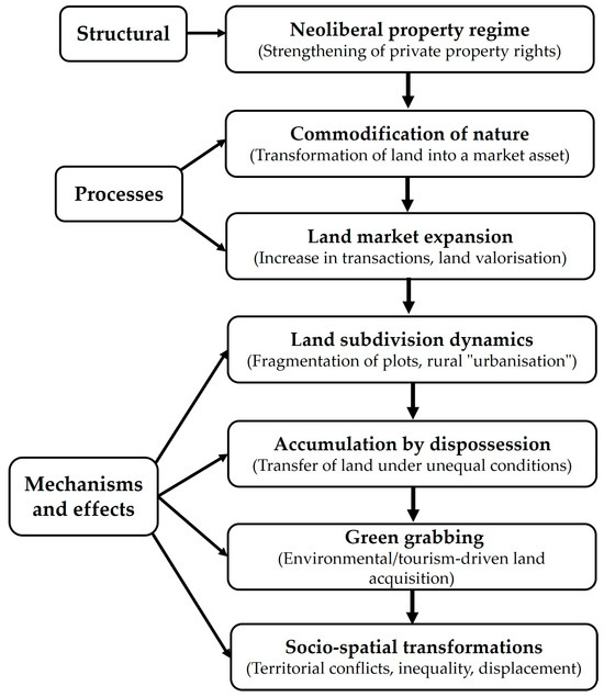
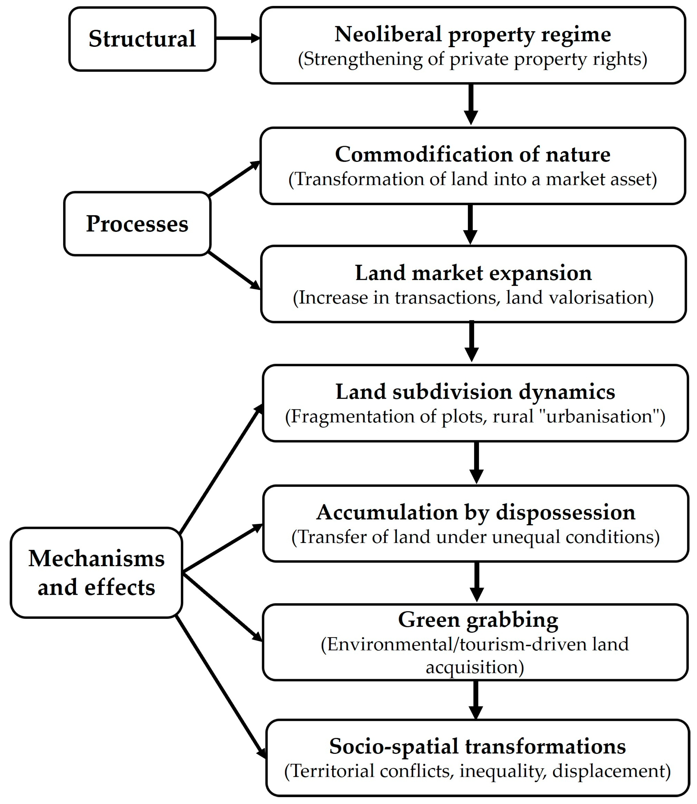
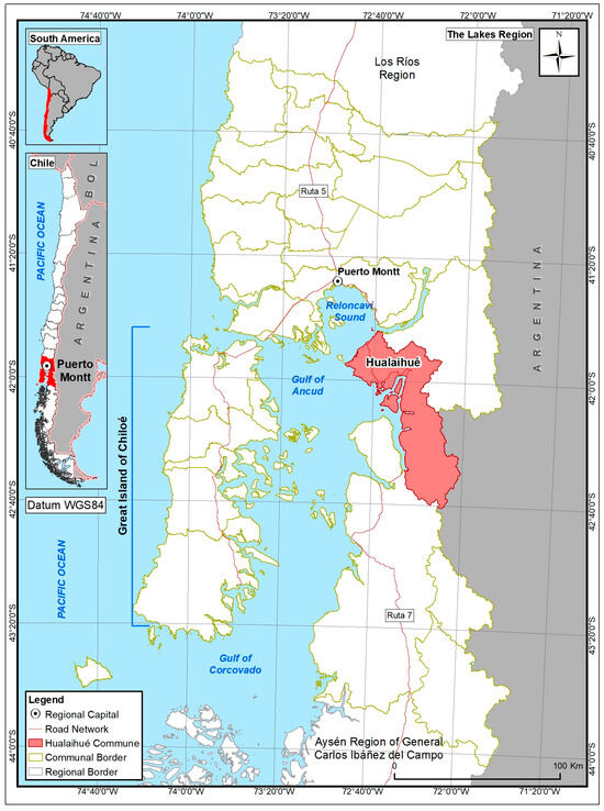
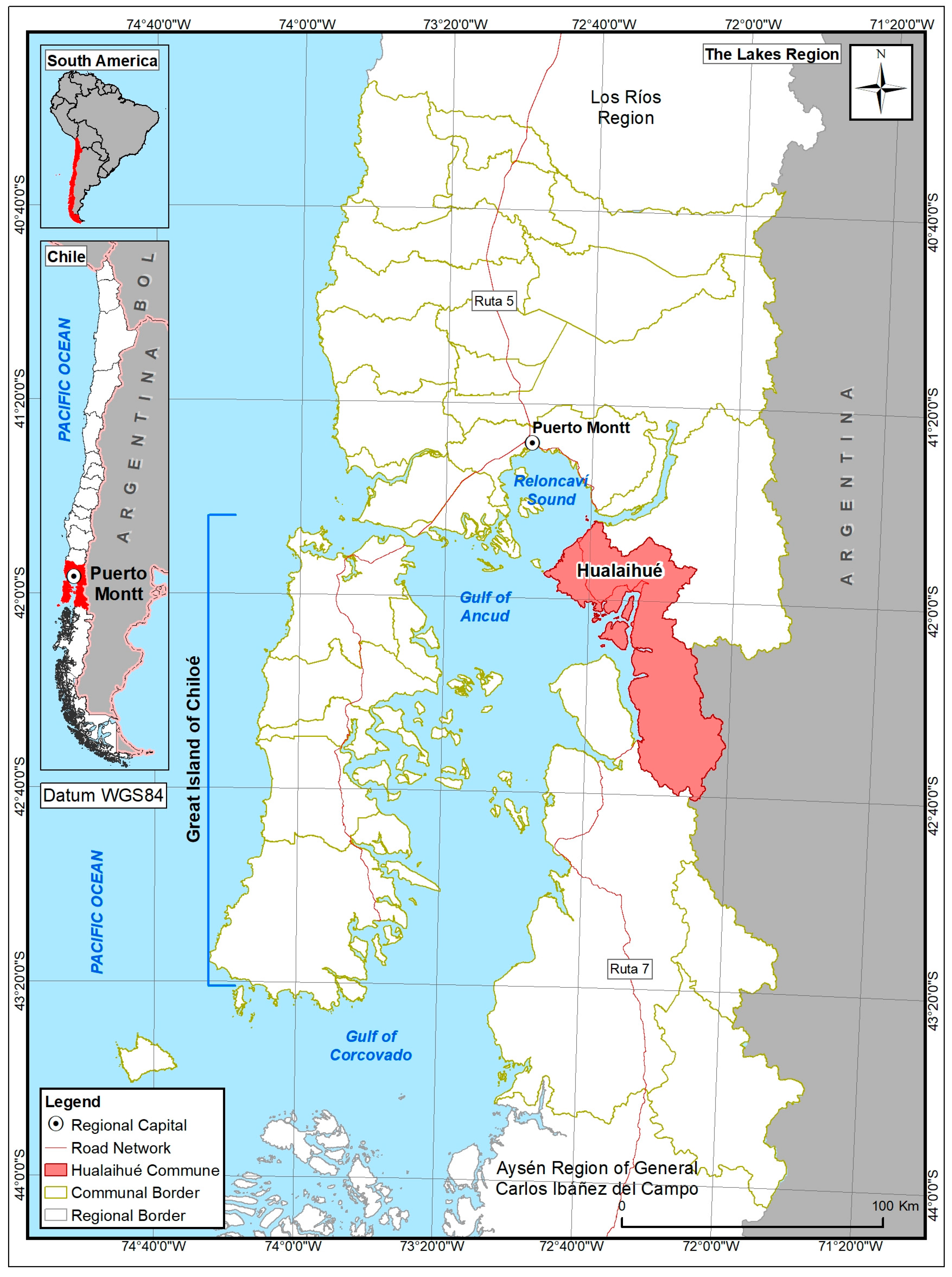
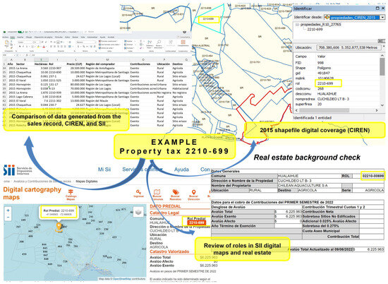
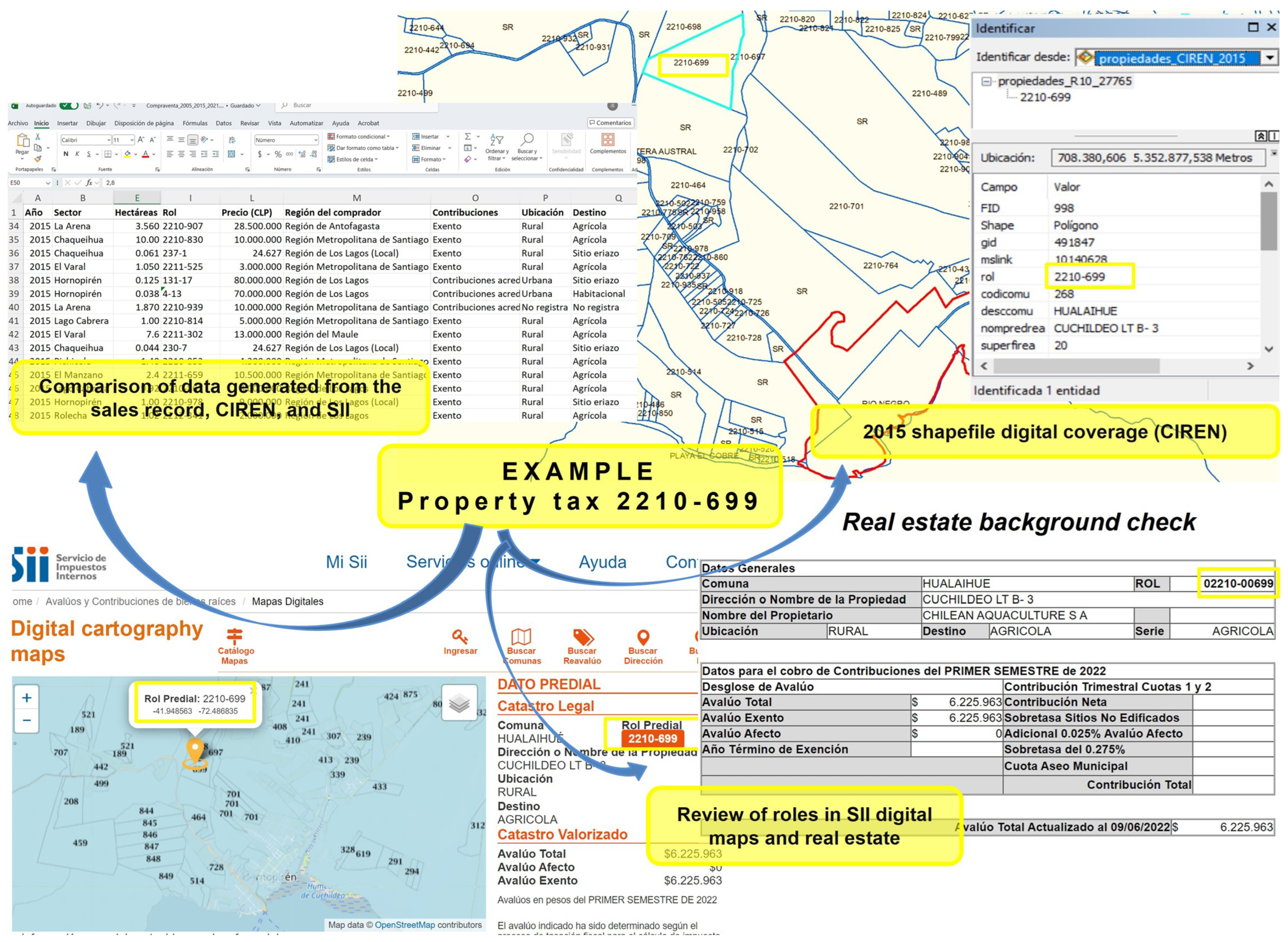
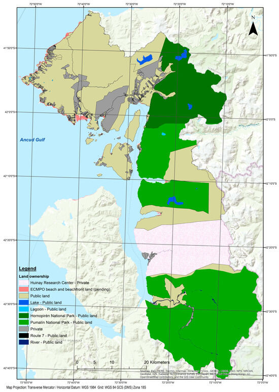
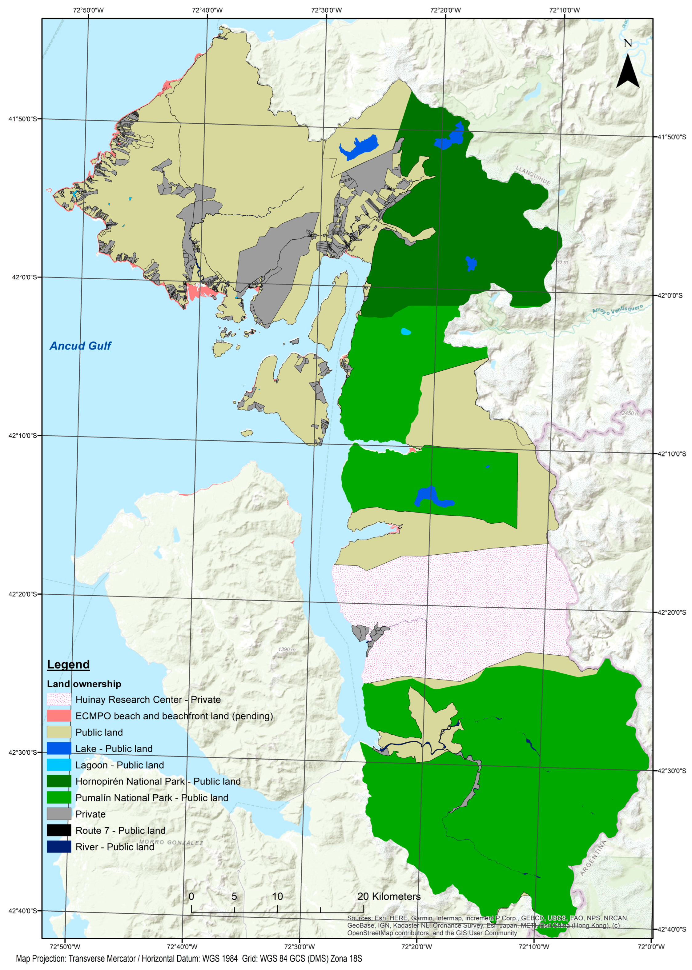
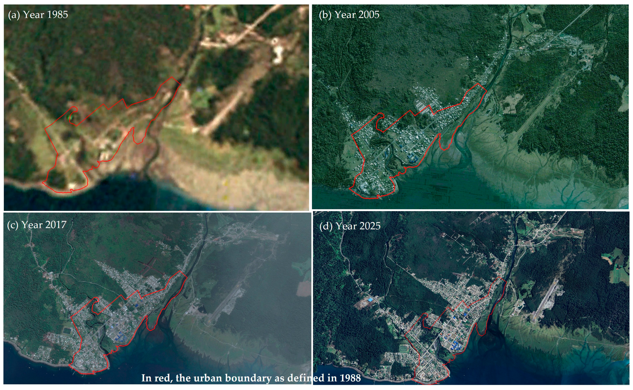
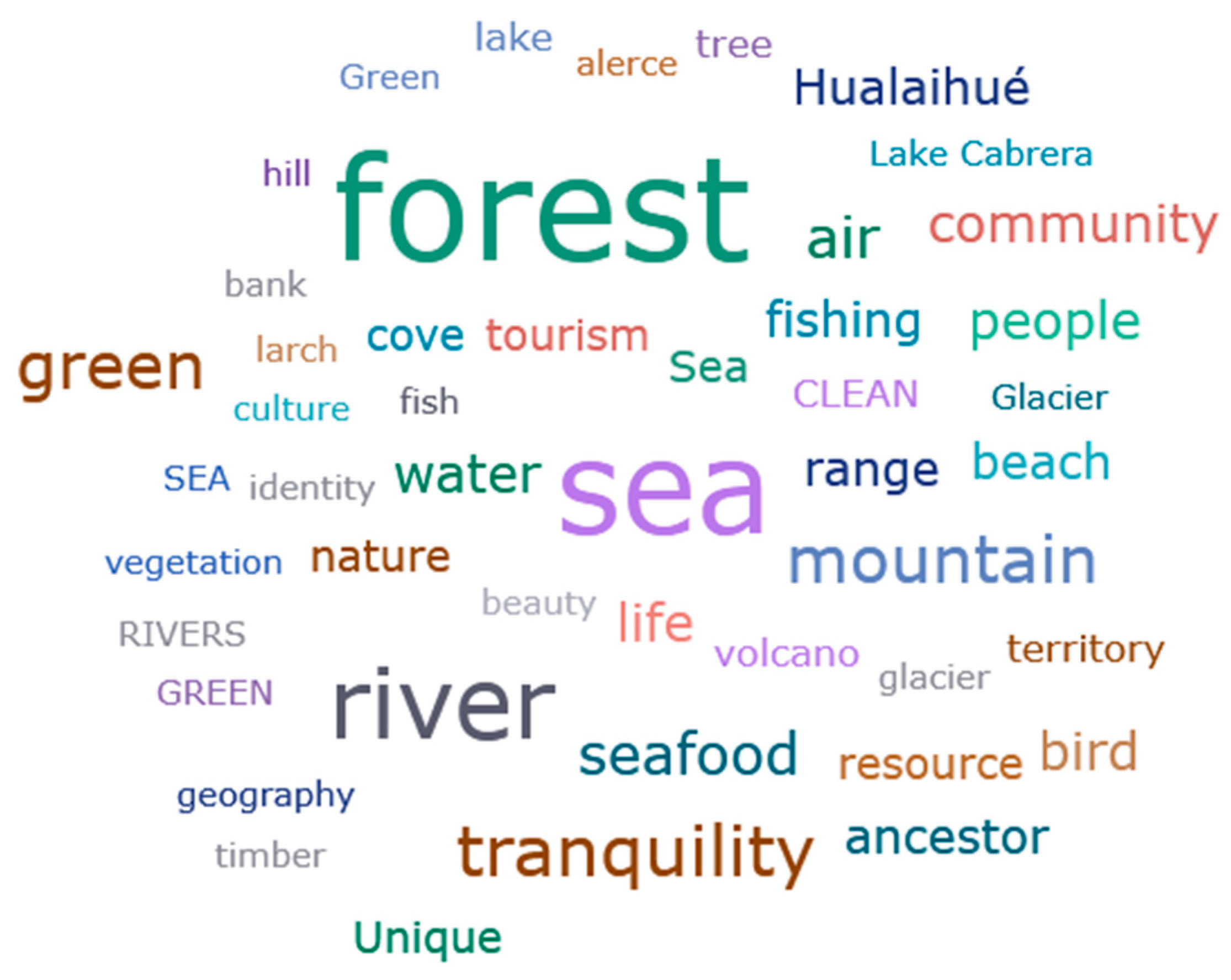

Disclaimer/Publisher’s Note: The statements, opinions and data contained in all publications are solely those of the individual author(s) and contributor(s) and not of MDPI and/or the editor(s). MDPI and/or the editor(s) disclaim responsibility for any injury to people or property resulting from any ideas, methods, instructions or products referred to in the content. |
© 2026 by the author. Licensee MDPI, Basel, Switzerland. This article is an open access article distributed under the terms and conditions of the Creative Commons Attribution (CC BY) license.