


Abstract
Urban flood adaptation research increasingly recognises the importance of community participation and local knowledge in strengthening urban resilience. However, limited attention has been given to how residents of unregulated settlements collectively reshape the built environment in response to recurrent flooding, and how these adaptive practices interact with ecosystem services and formal flood governance. This study examines community-led flood adaptation in an unregulated settlement in Bader District, Amman (Jordan), using a qualitative case study approach combining semi-structured interviews, field observations, spatial analysis, and document review. The findings show that adaptation extended beyond household coping strategies to include neighbourhood-scale interventions, including the construction of an artificial rainwater runoff channel, the extension of an unregulated street, and the incremental modification of dwellings. These practices emerged through experiential environmental learning, negotiated land-use adjustments, and collective action, while their effects remained spatially differentiated and constrained by infrastructure and governance limitations. The study highlights the importance of integrating community knowledge, ecosystem services, and participatory flood governance to support more context-sensitive and sustainable flood risk reduction in rapidly urbanising cities.
1. Introduction
Urban flooding has become one of the most significant environmental challenges facing cities worldwide, driven by the combined effects of rapid urbanisation, climate change, and the increasing disruption of natural hydrological systems [1,2,3]. Expanding impervious surfaces, the encroachment of urban development onto natural drainage corridors, and more frequent and intense rainfall events have collectively increased both the frequency and severity of urban flood hazards [4,5]. These challenges are particularly pronounced in rapidly urbanising cities of the Global South, where urban growth often exceeds the capacity of planning systems and infrastructure provision, increasing the exposure and vulnerability of communities occupying environmentally sensitive locations [6,7,8].
Flood risk is now widely recognised as a socially produced phenomenon that emerges through the interaction between environmental processes and patterns of urban development rather than from hydrological hazards alone [9,10,11]. Consequently, contemporary flood resilience research has progressively shifted from an exclusive emphasis on engineered flood protection towards more integrated approaches that recognise the importance of adaptive capacity, local knowledge, ecosystem services, and participatory governance in reducing flood risk [12,13,14,15,16]. Within this evolving perspective, communities are increasingly understood as active contributors to flood resilience whose lived experiences and locally embedded knowledge provide valuable insights into how environmental risks are recognised, interpreted, and managed [17,18,19,20].
Although recent scholarship has considerably advanced understanding of flood resilience, several important gaps remain. First, much of the literature continues to prioritise engineered flood mitigation and institutional planning responses, while giving comparatively less attention to how vulnerable communities themselves recognise flood risk, generate adaptive knowledge, and collectively reshape their environments through everyday practices [14,17,18,21]. Second, research examining community adaptation has predominantly focused on household-level coping strategies or post-disaster recovery, with fewer studies investigating how neighbourhood-scale collective action influences the spatial organisation of flood-prone settlements over time [22,23,24]. Finally, although ecosystem services and nature-based approaches have become increasingly influential within flood resilience research, limited attention has been given to how communities living in highly urbanised and unregulated environments recognise, maintain, and adapt to the ecological functions that continue to shape everyday flood risk [13,16,25].
These gaps are particularly significant within unregulated and informal urban settlements, where flood vulnerability emerges through the interaction of environmental processes, incremental urban development, and limited institutional capacity. Such settlements are frequently characterised in planning literature as sites of infrastructural deficiency and environmental vulnerability. Consequently, research has often concentrated on their physical shortcomings while giving less consideration to the adaptive capacities that evolve through residents’ lived experiences of environmental risk [6,8]. Yet prolonged exposure to recurrent flooding may generate detailed local environmental knowledge, collective forms of organisation, and adaptive practices that remain largely overlooked within formal planning processes.
An unregulated settlement in Bader District in Amman provides an opportunity to address these gaps. Developed incrementally within a former wadi through an unregulated urbanisation process, the settlement experiences recurrent flooding despite the implementation of conventional drainage infrastructure. At the same time, residents have progressively developed a range of neighbourhood-scale and household-level adaptations that seek to accommodate the site’s natural hydrological processes while reducing flood impacts. Rather than treating this settlement solely as an example of urban vulnerability, this paper approaches it as a context in which locally embedded adaptive capacity, community agency, and environmental knowledge can be examined in relation to broader debates on participatory flood governance and ecosystem services.
Against this background, this paper examines how residents of the unregulated settlement of Bader, Amman, perceive flood risk, develop adaptive practices, and collectively reshape their built environment in response to recurrent flooding. More specifically, the study investigates how community-led adaptation evolves across neighbourhood and household scales, how these adaptive practices are informed by residents’ experiential understanding of local hydrological processes, and how they interact with formal planning and flood governance. By adopting a qualitative case study approach, the paper seeks to advance understanding of the relationships between risk perception, community agency, ecosystem services, and participatory flood resilience within rapidly urbanising contexts.
The paper makes three principal contributions to the literature. First, it demonstrates that community adaptation extends beyond household coping strategies to encompass neighbourhood-scale collective action, illustrating how residents incrementally reshape the physical organisation of their settlement through locally negotiated spatial interventions. Second, it shows that adaptive practices in unregulated settlements are closely intertwined with residents’ recognition of natural hydrological processes, highlighting how ecosystem services continue to influence flood resilience even within densely urbanised environments. Third, the study demonstrates that while community-led adaptation can substantially reduce flood vulnerability, its long-term effectiveness ultimately depends upon meaningful collaboration between community knowledge and institutional capacity. Collectively, these findings contribute to growing debates on participatory flood governance by illustrating how community agency can strengthen urban resilience when recognised and supported within formal planning processes.
The paper is organised as follows. Section 2 reviews the literature on community adaptation, ecosystem services, participatory flood governance, and risk perception. Section 3 outlines the qualitative research methodology. Section 4 presents the empirical findings from the Bader case study, while Section 5 discusses their theoretical and planning implications. The paper concludes by reflecting on the broader significance of community-led adaptation for flood resilience and participatory urban planning in rapidly urbanising cities.
2. Literature Review
2.1. Urban Flood Risk and Community Adaptation
Community adaptation has become an increasingly important concept within flood resilience research, reflecting a shift away from viewing communities as passive recipients of environmental hazards towards recognising them as active agents in reducing vulnerability and shaping adaptive responses [17,26,27]. Rather than relying exclusively on externally designed interventions, communities frequently develop locally embedded adaptive practices through everyday experiences of environmental change, drawing upon social networks, local knowledge, and available resources to reduce flood impacts [14,22,28]. These practices often emerge incrementally over time as residents respond to recurring hazards and adjust both their behaviours and the physical organisation of their neighbourhoods.
Within this perspective, adaptation is understood not as a single intervention or end state but as a continuous process of environmental learning and collective action [3,27,29,30,31,32,33]. Repeated exposure to flooding enables communities to accumulate practical knowledge regarding local environmental conditions, evaluate the effectiveness of previous responses, and progressively modify their adaptive strategies. Consequently, adaptation is shaped not only by the magnitude of environmental hazards but also by the capacity of communities to learn, cooperate, and mobilise shared resources over time [17,18,19].
This evolving understanding has also led to increasing recognition of community agency as a central component of urban resilience. Community agency extends beyond individual coping behaviours to encompass the collective capacity of residents to negotiate, organise, and reshape their surrounding environment in response to shared challenges [18,34]. Such agency may become visible through collective decision-making, negotiated land-use practices, shared management of local resources, and collaborative modifications to neighbourhood infrastructure. These processes illustrate that communities are not simply adapting within existing urban environments; they can also actively participate in producing new spatial arrangements that reduce vulnerability while supporting everyday life.
Despite these advances, much of the existing literature continues to emphasise household-level adaptation or post-disaster recovery, with comparatively less attention given to neighbourhood-scale collective adaptation within unregulated or informal urban settlements. Consequently, there remains limited understanding of how community agency influences the physical evolution of flood-prone settlements through locally negotiated spatial interventions. Addressing this gap is particularly important in rapidly urbanising cities, where communities frequently undertake adaptive actions before formal planning interventions are implemented. There is also limited understanding of how such locally developed adaptations interact with existing drainage systems and formal planning institutions, including the extent to which they reduce or redistribute flood exposure across different parts of a settlement.
2.2. Adaptive Capacity and Environmental Learning
Flood risk perception is widely recognised as a key component of climate adaptation and disaster risk reduction because it shapes how individuals and communities interpret hazards, evaluate vulnerability, and decide whether and how to respond [32,35,36,37]. Rather than constituting an objective assessment of hazard, risk perception is shaped by personal experience, social values, environmental knowledge, and institutional trust, resulting in considerable variation in how communities understand and respond to similar flood events [32,35,36,38,39,40]. Within flood-prone environments, repeated exposure to flooding often strengthens local understanding of environmental processes, enabling residents to recognise patterns of water movement, identify vulnerable locations, and anticipate future hazards.
Such experiential understanding forms an important foundation for environmental learning, through which communities progressively accumulate practical knowledge by observing the outcomes of previous flood events and adapting their responses accordingly [19,41,42]. Environmental learning is inherently iterative: each flood event provides new information that enables residents to evaluate existing adaptive measures, refine previous practices, and develop new responses that are more closely aligned with local environmental conditions. Consequently, adaptation is not simply a reaction to hazard but a continuous learning process through which communities improve their capacity to coexist with environmental change.
This process contributes directly to the development of adaptive capacity, commonly understood as the ability of individuals, communities, and institutions to anticipate, respond to, and recover from environmental disturbances while maintaining essential functions [3,29,30]. Adaptive capacity extends beyond access to financial or technical resources and includes social organisation, environmental knowledge, collective decision-making, and the ability to modify behaviours and physical environments in response to changing conditions [14,17,32,43]. Communities possessing strong adaptive capacity are, therefore, better positioned to transform lived experiences of flooding into practical adaptive strategies rather than remaining dependent upon external interventions alone.
Importantly, recent research increasingly recognises that adaptive capacity is not solely an individual attribute but also a collective process that emerges through cooperation, social learning, and community organisation [19,27,32,41]. Shared experiences of environmental risk can strengthen social networks, encourage collective problem-solving, and facilitate neighbourhood-scale adaptation that extends beyond individual households. Nevertheless, much of the existing literature continues to examine adaptive capacity primarily at the household level, with comparatively limited attention given to how communities collectively translate experiential knowledge into spatial interventions that reshape flood-prone urban environments. Addressing this gap is particularly important within unregulated and informal settlements, where community organisation frequently compensates for limited institutional capacity, and where locally generated knowledge may become a critical resource for flood risk reduction and adaptive capacity.
2.3. Ecosystem Services and Ecological Planning for Urban Flood Resilience
The growing recognition of ecosystem services has fundamentally influenced contemporary approaches to urban flood resilience by shifting attention from controlling natural processes through engineered infrastructure towards understanding and working with the ecological functions that regulate urban environments [16,44]. Regulating ecosystem services—including stormwater retention, surface water infiltration, groundwater recharge, and the maintenance of natural drainage systems—play a critical role in reducing flood risk by moderating the movement and accumulation of water across urban landscapes [13,44,45,46]. However, rapid urbanisation frequently disrupts these ecological functions through the expansion of impervious surfaces, the encroachment of development onto floodplains and wadis (i.e., natural drainage channels), and the fragmentation of natural hydrological systems, thereby increasing urban flood vulnerability [5,44].
These concerns have contributed to the emergence of ecological planning and nature-based approaches that advocate designing urban environments in closer accordance with natural environmental processes rather than relying exclusively on conventional grey infrastructure [47,48,49,50,51,52]. Rather than attempting to eliminate flood hazards entirely, these approaches seek to accommodate water within urban landscapes by preserving natural drainage corridors, enhancing blue–green infrastructure, and integrating hydrological processes into land-use planning. Consequently, urban resilience is increasingly understood as depending not only on engineered flood protection but also on maintaining the ecological functions that continue to regulate environmental change within cities [13,15,16,25].
Although ecosystem services are frequently discussed in relation to formally planned green infrastructure and large-scale urban ecological networks, considerably less attention has been given to how these ecological functions continue to influence flood resilience within densely urbanised and unregulated settlements. Such environments are often portrayed primarily as examples of ecological degradation and planning failure, leaving limited consideration of how residents themselves recognise, maintain, or adapt to the natural environmental processes that persist despite extensive urbanisation. As a result, the relationship between community adaptation and ecosystem services remains insufficiently understood in contexts where ecological functions have been substantially modified but not entirely eliminated.
This study builds upon ecological planning theory by examining how residents’ lived experiences of flooding influence their understanding of local hydrological processes and how this understanding informs community-led adaptive practices. Rather than treating ecosystem services as static environmental assets, the paper explores how regulating ecological functions become embedded within everyday spatial practices, collective decision-making, and locally negotiated adaptations in an unregulated urban settlement. In doing so, it extends existing discussions on ecosystem services by highlighting how ecological and hydrological functions interact with community agency, participatory governance, and locally developed flood adaptation in unregulated urban settlements.
In this study, community adaptation is not treated as synonymous with nature-based solutions. While some practices preserved or accommodated existing hydrological pathways, others involved low-tech grey infrastructure, physical barriers, street modification, and household-level alterations. The concept of hybrid, community-negotiated spatial adaptation is, therefore, used to capture the combination of environmental accommodation, incremental physical intervention, and collective decision-making evident in the study area.
2.4. Participatory Flood Governance and Community Knowledge
Growing recognition of the social dimensions of flood resilience has encouraged a shift from conventional, top-down approaches to flood risk management towards more participatory and collaborative models of urban governance [2,53,54,55]. Rather than viewing communities solely as recipients of technical interventions, participatory governance recognises local residents as important contributors to the planning, implementation, and long-term management of adaptation strategies. This perspective acknowledges that effective flood resilience depends not only on engineering expertise and institutional capacity, but also on the meaningful integration of local knowledge, community participation, and collaborative decision-making [14,32,56].
Within flood-prone urban environments, community knowledge constitutes an important yet often underutilised resource for planning. Residents who experience recurrent flooding frequently develop detailed understandings of local hydrological processes, vulnerable locations, and the practical effectiveness of different adaptive measures through continuous interaction with their environment [19,57,58,59]. Integrating this experiential knowledge with scientific expertise can contribute to more context-sensitive, socially legitimate, and locally appropriate flood adaptation strategies [16,20]. Consequently, participation should not be understood simply as consultation during decision-making, but as an ongoing process of knowledge co-production through which communities and institutions jointly contribute to urban resilience.
Despite increasing recognition of participatory approaches, many planning systems continue to privilege technical expertise while giving limited consideration to the adaptive capacities and environmental knowledge that already exist within vulnerable communities [14,54,60]. This challenge is particularly evident within unregulated settlements, where communities often undertake substantial adaptive actions independently, yet remain only marginally involved in formal planning processes. As a result, opportunities to build upon locally developed adaptive practices and strengthen collaboration between communities and institutions are frequently overlooked.
Against this background, this paper examines how residents of an unregulated settlement in Bader District, Amman, perceive recurrent flood risk, develop adaptive practices, and collectively reshape their built environment. More specifically, the study addresses three questions: (1) How do residents of an unregulated flood-prone settlement develop and apply experiential knowledge of recurrent flooding and local hydrological processes? (2) How does this knowledge translate into household- and neighbourhood-scale spatial adaptations? (3) How do these community-led adaptations interact with formal infrastructure and municipal flood governance, and what are their limitations for longer-term flood risk reduction?
By addressing these questions through an interpretivist qualitative case study, the paper contributes to understanding community-led flood adaptation as an evolving socio-spatial process, rather than solely as a set of household coping practices. It further demonstrates how experiential environmental knowledge can inform collective spatial interventions, while also highlighting the spatially differentiated effects and structural limits of such adaptations. The findings, therefore, provide insights into how community knowledge and adaptive capacity can be connected to formal planning and flood governance in rapidly urbanizing and environmentally vulnerable settlements.
3. Materials and Methods
3.1. Research Design
This study adopted an interpretivist qualitative case study design to examine how residents of the unregulated settlement in Bader District perceive flood risk, develop adaptive practices, and interact with municipal institutions. A qualitative approach was considered appropriate because the research seeks to understand residents’ lived experiences, locally embedded knowledge, and adaptive practices rather than estimate the statistical prevalence or magnitude of flood hazards [61,62,63]. The interpretivist paradigm acknowledges that flood risk is socially experienced and that adaptive responses emerge through interactions between people and their environment [61,62].
A single case study was selected because it enables complex environmental and social processes to be examined within their real-world context [63]. Rather than seeking statistical generalisation, the study aims to generate analytical insights into community-led flood adaptation in unregulated urban settlements [64].
The qualitative design was, therefore, intended to explain how flood risk was experienced and interpreted by residents, and how such interpretations informed adaptive practices, rather than to establish statistical relationships between flood exposure and household characteristics. Spatial analysis was used, alongside the qualitative evidence, to contextualise residents’ accounts by examining the relationship between flood experiences, the settlement’s physical morphology, topography, drainage pathways, and observed adaptation measures.
3.2. Case Study Selection and Spatial-Hydrological Context
The research was undertaken in a specific unregulated residential settlement within Bader District, located in the south-west of Amman, Jordan. The study area represents only a portion of Bader District, and is administratively located within Al Akhdar neighbourhood. The term “unregulated settlement” refers specifically to the explored residential area rather than to Bader District as a whole. The settlement was selected because it has experienced recurrent flooding over several decades while exhibiting extensive community-led adaptation to flood risk. The settlement occupies the course of a former wadi that has been progressively urbanised, creating a context in which flood risk, incremental development, and community adaptation intersect. This setting defines the settlement in Bader as an information-rich case, in which community adaptation and participatory flood governance could be examined [63,64].
Table 1 provides district-level contextual indicators for Bader District, while the explored unregulated settlement represents the specific flood-prone area within Bader District, which was examined in this study. Bader District receives an average annual rainfall of approximately 404 mm, reflecting the relatively wetter conditions of this part of Amman, within the city’s broader semi-arid climatic context [65].
The topographic and hydrological context shown in Figure 1 complements the district-level indicators and flood-vulnerability assessment presented in Table 1. The mapped DEM and stream-flow network in Figure 1 illustrate the settlement’s position within a broader drainage system (Seil Amman Basin), while the flood-vulnerability assessment provides an independent spatial indication of flood exposure based on flood-generation, flood-accumulation, and socio-economic factors [66]. The explored settlement mainly falls within the severe to moderate flood risk areas, as identified by this assessment. Situated at the foot of a steep hillside and extending along a minor wadi, the settlement occupies a pronounced topographic wadi depression that naturally conveys stormwater from the surrounding higher slopes into Amman’s wider drainage network (i.e., downstream to Downtown Amman in Al Madinah District, and further north-east of the city) (Figure 2, Figure 3 and Figure 4). Residential development progressively occupied this natural drainage corridor, increasing exposure to overland flow during intense rainfall. The settlement occupies both sides of the drainage corridor, while remnants of the original wadi remain partly visible on the upper and lower slopes (Figure 5). The settlement’s exposure, therefore, reflects its position within a local runoff pathway, rather than rainfall falling exclusively within the built-up area.
Figure 1.
Topographic and hydrological context of the explored unregulated settlement within Bader District, showing the digital elevation model (DEM), stream-flow network, Seil Amman Basin, Bader District boundary, and location of the explored settlement. Source: map produced based on data obtained from the GIS Department at GAM.
Figure 2.
Land use map of Bader District showing the zoning of the explored unregulated area (framed with the black rectangle) into residential uses, specifically D residences. Source: map produced based on the overlay of land use data from GAM and satellite image from Global Mapper.
Figure 3.
Urban fabric structure map of Bader District showing existing buildings and vacant plots within the explored unregulated area (framed with the black rectangle). Source: map produced based on the overlay of existing building data from GAM, OpenStreetMap, and satellite image from Global Mapper.
Figure 4.
Map of the urban fabric and its relationship to the natural characteristics in Bader District showing the natural stream path and the steep slopes surrounding it within the explored unregulated area (framed with the black rectangle). Source: map produced based on the overlay of urban fabric, slope and stream GIS data from GAM, and satellite image from Global Mapper.
Figure 5.
A picture of the explored area from below, showing the elevated Prince Abdullah Street to the right, the unregulated area located above the wadi channel in the centre, and the higher residences of Al Akhdar Neighbourhood to the top left. Source: picture taken by the researcher, 2020.
Table 1.
Bader District profile and contextual indicators for the explored study area. Source: data sources are detailed in the footnotes.
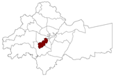
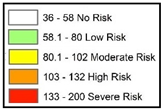

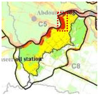
The investigated settlement developed through unregulated residential expansion during the 1960s and 1970s, based on the records of the district directorate. According to a municipal practitioner at the local directorate of Bader District, who was familiar with this particular context, the physical layout of the settlement evolved incrementally outside formal planning regulations, since the plots of land occupied by residents were part of a large “common land” that was not officially divided and regulated by the municipality (Interview 1, 2020). Instead, the residents, who owned percentages of this common land, together subdivided the land into smaller individual plots, and built their houses without any municipal guidance, nor following existing building regulations (i.e., setbacks, height, percentage of built-up area and green area, etc.). Although these households did not obtain any building permits before construction, they were connected afterwards to the city’s infrastructural services, similar to any formally regulated area (Interview 1, 2020). As a result, the layout, shape, and distribution of housing in the area were the outcome of this unregulated building process. Hence, throughout this paper, “unregulated” refers to the planning and development status of the settlement, rather than to the absence of private land ownership. According to the spatial and hydrological characteristics discussed above, it becomes clear that flood vulnerability in this site results not only from its location within the former wadi, but also from the interaction between its physical setting and incremental urban development. These characteristics provide the contextual baseline for interpreting the community experiences and adaptive practices presented in the following sections.
3.3. Data Collection
Data were collected using multiple qualitative methods, including semi-structured interviews, field observations, document review, and spatial analysis. The combination of these complementary sources enabled methodological triangulation and allowed evidence concerning residents’ experiences, the physical environment, and institutional responses to be examined alongside one another [63,69,70].
Semi-structured interviews constituted the principal source of empirical evidence. Resident participants were selected purposively, with attention to variation in gender, age, duration of residence, property ownership, and location within the settlement. Interviews were spatially distributed across the upper and lower portions of the settlement to capture differences in flood exposure and adaptive experience. This spatial distribution was particularly important because residents’ experiences varied according to their position within the settlement’s topography and drainage pathway. Interviews were conducted with 12 households comprising 18 individuals (Table A1 in Appendix A.1). Data collection continued until theoretical saturation was reached, defined in this study as the point at which no substantively new themes or relevant information were emerging from the interviews. Four additional informal conversations with other residents were also used as supplementary contextual evidence. Interview questions explored participants’ experiences of flooding, perceptions of flood risk, adaptive practices, relationships with municipal institutions, and perspectives on future flood risk reduction.
Interviews were also conducted with municipal representatives involved in the administration and management Bader District (Table A2 in Appendix A.1). These interviews supported in the initial identification and understanding of the local conditions of this vulnerable site at an early stage of the fieldwork, and provided institutional perspectives on the physical conditions of the settlement, existing drainage infrastructure, municipal responsibilities, and the constraints affecting potential flood risk interventions. The institutional participants were treated as a complementary source of evidence, rather than as a statistically representative sample of municipal staff.
Field observations documented the physical characteristics of the settlement, evidence of previous flooding, adaptive modifications to buildings and streets, drainage infrastructure, and the relationship between the built environment and the former wadi. Particular attention was given to the visible physical modifications that residents identified as responses to recurrent flooding. These observations were subsequently compared with participants’ descriptions of flood behavior and adaptation.
Document sources, including municipal reports, planning documents, historical records, and community-generated materials, provided contextual information regarding the settlement’s development, planning status, and previous flood events. Spatial analysis was used to examine the relationship between land-use planning, the existing urban fabric, natural drainage pathways, topography, and the locations of observed community adaptations. Together, these sources enabled the study to examine both the social and spatial dimensions of community adaptation.
3.4. Data Analysis
The qualitative data were analysed using an iterative thematic analysis approach [71]. Interview transcripts, field notes, document materials, and spatial observations were read repeatedly to develop familiarity with the dataset before coding was undertaken. The analytical process combined theoretically informed and data-driven coding. Initial prefigured categories were derived from the literature, while emergent categories were developed from participants’ accounts and observations. These categories were progressively reviewed, refined, and organized into broader themes through continual comparison across the different sources of evidence [71].
The organization, coding, and retrieval of qualitative data were supported using NVivo, a computer-assisted qualitative data analysis software. The coding structure provided a systematic means of organising participants’ accounts while retaining openness to themes emerging from the empirical material. The final themes focused on recurring patterns concerning flood risk perception, community adaptation, environmental knowledge, and interactions with municipal institutions. Findings were subsequently compared across interviews, field observations, document evidence, and spatial analysis, so that interpretations emerging from one source could be examined against evidence from others [63,70]. Spatial evidence was not treated as a separate quantitative dataset for statistical testing. Instead, the location of participants, reported flood experiences, observed adaptation measures, and identified drainage pathways were spatially contextualized and compared with the physical characteristics of the settlement. This enabled differences between upper and lower portions of the settlement to be considered when interpreting residents’ accounts and adaptation practices.
3.5. Research Quality and Trustworthiness
Several strategies were employed throughout the research process to enhance the trustworthiness of the findings. In accordance with established approaches to qualitative research, credibility was strengthened through methodological triangulation, prolonged engagement with the study area, and comparison of evidence from interviews, field observations, document materials, and spatial analysis [61,72,73]. This process enabled recurring findings to be examined from multiple sources rather than relying on a single form of evidence (additional quotes and figures are also provided in Appendix A.2 and Appendix A.3).
Dependability and confirmability were supported through systematic documentation of the research process, including the interviews guides, coding procedures, analytical decisions, and iterative refinement of themes. The use of NVivo provided a systematic structure for organising and retrieving coded material, while continued comparison between empirical evidence and emerging themes helped maintain a clear connection between the data and the interpretations [72].
Transferability was addressed through detailed contextual description of the study area, the characteristics of the participating households, and the institutional context within which community adaptation occurred. The purpose of the qualitative case study was not statistical generalization, but the development of analytically transferable insights that may be relevant to other flood-prone urban settlements exhibiting comparable environmental and governance conditions [63,64].
4. Results
4.1. Community Recognition of Flood Risk and Collective Reshaping of the Built Environment
The spatial vulnerability of the settlement arose from the interaction between its location within a former wadi and its incremental development outside formal planning and infrastructure provision. Interviews indicate that residents initially settled in the area without recognising its flood-prone characteristics, gradually developing an understanding of the site’s environmental conditions through direct experience rather than through planning guidance or hazard information.
A resident described the circumstances surrounding the development of the settlement:
“Now, we regulated the area in this way, because when we came here the municipality had nothing to do with it … When we went to the municipality and told them that we have a piece of land here and we want to connect it to a street, they told us that this is outside of the regulated plan… It hadn’t entered into municipal projects to regulate it”(Interview F, 2020).
The interviews indicate that the unregulated status of the settlement concerned its planning and development status, rather than the absence of private land ownership. Residents reported purchasing percentages within large plots of lands, and then developing their house outside the municipality’s formal planning and building-control framework. Consequently, residents assumed substantial responsibility for organising the settlement and responding to its environmental challenges.
Comparison between the existing settlement and the municipality’s official land-use plan revealed that residential development had been planned within the same flood-prone wadi, as illustrated in (Figure 6). Figure 6a shows the official land-use plan, while Figure 6b illustrates its overlap with the natural wadi course. Figure 6c shows the wadi in relation to the existing site, and Figure 6d demonstrates the proximity of existing buildings to the drainage pathway. Hence, the principal difference between the existing settlement and the municipality’s official land-use plan, lay not simply in the location of development, but in the configuration and provision of formal infrastructure, suggesting that vulnerability was shaped by the interaction between the site’s physical characteristics and planning and infrastructure decisions.
Figure 6.
Relationship between the official land-use plan, existing urban development, and the natural wadi course in the unregulated settlement: (a) The official land use plan. (b) The overlap between the official land use and the natural wadi course, revealing the lack of consideration for natural landscape characteristics in the official regulation of land. (c) Satellite image with the wadi course. (d) The overlap between the existing buildings and the natural wadi course, illustrating their proximity and spatial relationship. Source: maps produced based on the overlay of land use data from GAM; existing building data from GAM, OpenStreetMap, and satellite image from Global Mapper; and slope and stream GIS data from GAM.
Residents described having limited prior awareness of the area’s potential exposure to flooding, and recalled being surprised by the presence of a natural wadi channel running through their plots after purchasing them.
As one resident recalled:
“When we came to live here, there were no residents at all. There were only vacant lands open on one another… There were also no storm drain inlets, no sewer lines, nothing. I swear, we came and bought this piece of land and said we would build on our own… How could we have known where ‘the path of happiness’ is, to follow it? We bought a piece of land, and thanked God for it”(Interview H, 2020).
Another resident similarly reflected:
“They [the local authorities] are selling lands in the wadis. Here in the wadi below. On this site, we’re still higher than the ones below. I mean, they don’t follow a regulatory process to take care of people and consider where they sold them or where people bought the land. This is nonsense. If you don’t take care of yourself, no one will take care of you. When we bought this land, we were ignorant. I mean, we didn’t know the reality of the situation… One didn’t know that rainwater could invade the land in this area”(Interview G, 2020).
The residents’ understanding of flood risk developed through lived experience and direct observation of the landscape rather than through institutional guidance. Their growing environmental awareness of natural drainage patterns provided the foundation for the collective neighbourhood-scale adaptations that followed, particularly the preservation and organisation of pathways for stormwater through the settlement.
4.2. Community-Led Construction of the Artificial Rainwater Runoff Channel
Following their recognition of the flood-prone characteristics of the site, neighbouring residents collectively implemented one of the settlement’s most distinctive flood adaptation measures: the construction of an artificial rainwater runoff channel. Located between six adjacent residential plots at the upper part of the settlement, the channel was created along a minor natural drainage path before it descended towards the lower wadi. Field observations revealed that the channel remains directly connected to the exposed natural drainage line visible within the vacant land immediately upslope of the settlement (Figure 7, Figure 8 and Figure 9). This spatial relationship indicates that the intervention retained a connection with the existing drainage pathway, rather than attempting to block the movement of stormwater.
Figure 7.
Photos (a,b) showing the artificial rainwater channel, built between the residences, from above. Source: picture taken by the researcher, 2020.
Figure 8.
Photos (a,b,c) showing the artificial rainwater channel, built between the residences, from below. Source: picture taken by the researcher, 2020.
Figure 9.
Photos (a,b) showing the exposed natural wadi in the vacant plots above the artificial rainwater channel. Source: picture taken by the researcher, 2020.
The intervention did not originate from municipal planning or technical advice. Instead, residents explained that they recognised the natural drainage pattern after purchasing their plots and experiencing rainfall during the early stages of development. This experiential knowledge subsequently informed a collective response to flood risk.
Residents explained that, once they understood the route of floodwater, neighbouring households voluntarily negotiated a shared solution. Rather than diverting runoff onto their adjacent properties, they agreed to relinquish small portions of their privately owned land to create a continuous drainage corridor between their houses.
“This [channel] was established when we built our houses… We saw that the rainwater comes here, floating on its own whims. It’s not permissible for anyone to interfere in changing its course… So, when we were building, my neighbour and I looked at the situation. When I was building at the beginning, I didn’t have a fence wall. The rainwater raided us and entered inside our house… We looked, and I said, “Oh my neighbour. Water is a danger and an enemy. We must protect ourselves from the stream with the means available to us.” He said, “Yes, we should protect ourselves.” I told him, “You give up 30 cm, and I will give up 30 cm, from our lands.” I preserved 30 cm and built my fence, and my neighbour preserved 30 cm and built his fence. Because this is an enemy, the rainwater. It is an enemy, so we must prevent its damage… We gave up parts of our land, and they [the local authority] didn’t give us any financial compensation, nor did we ask for compensation. We did this to disperse danger”(Interview G, 2020).
A neighbouring resident confirmed that the intervention resulted from mutual agreement rather than external direction:
“We and our neighbours agreed on this, because of the rainwater… To preserve a pathway for the rainwater. Where would it go during the winter season?… My father vacated a little bit of his land, and our neighbour as well. He agreed with him, that this would be good for us to leave a pathway for the rainwater. But the municipality had nothing to do with the stream, nothing… If we had built at the location of the channel here, and there was a building here that blocked the way. Where would the rainwater go?”(Man in Interview H, 2020).
Together, these accounts indicate that the artificial runoff channel was conceived, negotiated, and implemented by residents. Adjacent households voluntarily modified their plot boundaries by relinquishing approximately 30–50 cm of land each, creating a continuous channel approximately 60–100 cm wide that directed stormwater through the neighbourhood. As additional houses were constructed, new residents were encouraged by their neighbours to preserve the same drainage corridor, resulting in the extension of the channel across six adjoining plots. Although the channel originated as a community initiative, it was later connected to the area’s formal drainage network through the installation of storm drain inlets at both its upper and lower ends. A community-led intervention, therefore, became connected to the municipal infrastructure despite having developed independently of the formal planning process.
The artificial rainwater runoff channel, therefore, represents more than an individual coping measure. It illustrates how residents translated experiential knowledge of flood processes into a neighbourhood-scale spatial intervention through voluntary cooperation, negotiated land-use adjustments, and shared responsibility for managing floodwater.
The channel did not, however, eliminate stormwater from the entire settlement. Rather, it organised the movement of runoff through a defined pathway towards the lower parts of the settlement. This suggests that the benefits of the intervention were spatially differentiated: while directing water through a defined channel reduced uncontrolled accumulation around some properties, runoff continued downslope towards areas that remained exposed to flooding. This distinction is important when assessing the wider effects of community-led adaptation across the settlement.
4.3. Community-Led Extension of the Unregulated Street
While the artificial rainwater runoff channel represents one form of neighbourhood-scale adaptation, residents also collectively reshaped the settlement through the extension of an unregulated access street along its lower part. Extending beyond the regulated pathways of Prince Abdullah As-Salim As-Subah, the street currently provides access to 27 occupied residential plots and largely follows the alignment of the former natural wadi. Unlike the formal street network, this extension emerged through agreements among residents rather than municipal planning, representing another example of community-led adaptation to recurring flood risk.
Comparison between the existing settlement and the municipality’s land-use plan reveals contrasting approaches to development. The contrast between the planned and existing conditions is visible in Figure 10a shows the regulated street and planned residential plots, whereas Figure 10b shows the extended unregulated street, the artificial rainwater channel, and the remaining open wadi. Although the official plan allocated the wadi corridor for residential development, it proposed access to these properties primarily through side stairways connected to higher streets (Interview 1, 2020). Residents instead chose to extend the existing street through their own properties, recognising that maintaining an open corridor along the former drainage path would improve accessibility, while providing a route for stormwater during heavy rainfall.
Figure 10.
Maps for the explored case revealing the pro-active flood risk reduction measures implemented by the local community: (a) The official land use plan showing residence D plots & the regulated street (i.e., Prince Abdullah As-Salim As-Subah Pathway 3) (Yellow). (b) Satellite image showing the reality, including the regulated street (Yellow), the artificial rainwater channel (Blue), the vacant land above the artificial rainwater channel (Brown), the extended unregulated street (Red), and the remaining open wadi channel (Green). Source: maps produced based on land use data from GAM, satellite image from Global Mapper, and site visits.
As one resident explained:
“We opened it [the street]. From our lands, not from the municipality’s lands. The street is not originally included in the land use plans. We did this. I mean, it’s not on the municipality’s map. This street doesn’t exist there. It’s not included in the land use map, because it’s considered private property and not public property. We, the neighbours, agreed between ourselves and opened the street… We’re the ones who fixed the situation”(Interview F, 2020).
Another resident described how the extension of the street was informed by observations of stormwater movement across the site:
“These are all pieces of land. They gave away some space so that the stream could pass through… In winter, a stream descends… You’ll find that each one has opened a metre or two, something like that, from his plot… Because this is sloping land. We had to leave a way because we saw the situation in winter. The way the stream goes down. This street was originally a wadi”(Man in Interview K, 2020).
These accounts indicate that the street extension, like the artificial runoff channel, emerged from residents’ experiential understanding of the landscape rather than formal planning guidance. Neighbouring households voluntarily relinquished between one and two metres of privately owned land to create a continuous access corridor that would also accommodate stormwater flowing downslope. The resulting street extends beyond the municipality’s regulated road network, bypasses the official dead-end, and continues towards the lower part of the settlement where the remaining section of the natural wadi is still visible. Its irregular width reflects the incremental and negotiated nature of its development, with individual households contributing different amounts of land according to their local circumstances (Figure 11 and Figure 12).
Figure 11.
Photos showing the extended unregulated street: (a) Shows the dead-end sign indicating the end of the regulated street. (b) Shows the condition of the unregulated street, which extends beyond the regulated street. (c) Shows the irregular width of the unregulated street. Source: Picture taken by the researcher, 2020.
Figure 12.
Photos (a,b) showing the exposed wadi course following the unregulated residential area. Source: Picture taken by the researcher, 2020.
The street extension indicates that residents were not merely responding to individual flood events but were collectively reorganising the spatial structure of their settlement in ways intended to reduce future flood impacts, while maintaining access to their homes. Similar to the artificial runoff channel, the intervention was implemented through voluntary cooperation without technical guidance or financial support from the municipality, while simultaneously improving everyday accessibility within the settlement.
Despite these neighbourhood-scale interventions, flood risk was not eliminated. Instead, the measures primarily directed stormwater through the settlement, potentially reducing uncontrolled exposure for some households, while transferring floodwater towards lower-lying areas. Field observations and interviews indicate that residents continued to experience flooding despite these collective adaptations, suggesting that community-led measures alone were insufficient to fully address the settlement’s underlying flood vulnerability. The following sections, therefore, examine how residents experienced these continuing impacts and how households adapted to recurrent flooding.
4.4. Lived Experiences and Risk Perceptions of Flooding
Despite the collective interventions undertaken by residents, flooding remains a recurring feature of everyday life in this unregulated settlement. Interviews indicated that residents continued to experience flooding at both the street and household scales, particularly during the winter season. The accounts, therefore, suggest that community-led spatial interventions had reduced some aspects of exposure, but had not eliminated flood risk. Rather than describing floods as exceptional events, participants characterised them as recurring seasonal experiences that have become embedded within everyday life.
Residents distinguished between two principal patterns of flooding according to their location within the settlement. These accounts also revealed a spatial differentiation in flood experience between the upper and lower portions of the settlement. Houses adjacent to the artificial rainwater runoff channel primarily experienced flooding when storm drain inlets became overwhelmed or blocked, causing runoff to accumulate before overtopping into private yards and, during more severe events, entering houses. Interviewees recalled repeated flooding episodes over several decades, including major events during the 1980s, 1990s, and 2015 (Figure 13), with residents reporting flood depths ranging from approximately 25 cm to one metre inside affected dwellings.
Figure 13.
Picture showing the accumulation of floodwater in the street above the artificial channel in 2015. Source: provided by an interviewed resident, 2020.
In contrast, residents living along the unregulated street described the formation of a fast-flowing seasonal stream that occupied the full width of the street during periods of intense rainfall. Runoff from the surrounding hillsides converged within the former wadi corridor, producing reported water depths ranging from 30 cm to 1.5 m. Although participants regarded these conditions as a normal feature of winter, they also recalled repeated flooding of private yards and several incidents in which floodwater entered their homes, in some cases reaching depths of one metre.
Residents consistently attributed flood risk to both natural and human-induced processes. Flooding was associated not only with the settlement’s location within a former wadi, but also with blocked drainage infrastructure, ageing sewer systems, inadequate municipal services, and changing rainfall patterns. One long-term resident explained how the delayed installation of the stormwater drainage system increased flood exposure by raising the street level relative to existing houses:
“The sewage service, as I remember, was running by 1981. But not the rainwater system. The rainwater system was constructed around 15 years ago. They placed it on top of the sewage system… They killed us. We’re not taking about a slight difference in the street level here. I swear, they destroyed us”(Interview L, 2020).
Continuous exposure to flooding also shaped residents’ emotional experience of the winter season. Rather than expressing concern only during major storms, interviewees described persistent anxiety throughout the rainy season, remaining alert when heavy rainfall was forecast or observed. As one participant explained:
“Every year, we’re afraid. We remain in fear from the beginning of the winter season… And then, when is there fear? At the end and beginning of winter. Because there would be strong rainfall, and the stream would return immediately… Whenever it rains, we stay up all night to look after our children. How could we sleep when the whole mountain pours down on us?”(Woman 2 in Interview H, 2020).
Beyond physical damage to houses and infrastructure, residents associated flooding with threats to personal safety, children’s wellbeing, livelihoods, mobility, mental health, and the deterioration of their surrounding environment (Figure 14). Their accounts also revealed that vulnerability was unevenly distributed spatially, with houses located along the lower reaches of the former wadi perceived to be at greater risk than those situated higher upslope. As one resident observed:
Figure 14.
Photos showing the poor and cratered condition of the settlement’s environment: (a) Showing the condition of the unregulated street. (b) Showing the buckling of a fence wall in one of the houses located along the artificial rainwater channel, due to its constant exposure to rainwater pressure. Source: picture taken by the researcher, 2020.
“The more you go down, the greater the problem. You should continue downwards. Go down and see all the tragedy. They drown. The situation is easier for us here, but there is still some damage”(Interview G, 2020).
This spatial differentiation was also consistent with field observations and the residents’ position in relation to the main drainage pathway. Households located along the upper portion of the settlement, more frequently described the need to direct and manage the movement of stormwater runoff, whereas residents along the lower unregulated street described greater exposure to concentrated and fast-moving floodwater, stormwater accumulation, access difficulties, and the limitations of existing drainage infrastructure. The spatial comparison, therefore, provided an important context for interpreting differences in residents’ accounts, rather than treating flood experience as uniform across the settlement.
Participants further identified a range of physical characteristics that influenced household flood exposure, including proximity to steep vacant slopes, ground elevation, entrance levels relative to the street, the presence of basements, the height and condition of boundary walls, sidewalks, and the configuration of private gardens. These locally derived assessments closely correspond with the spatial patterns identified during field observations, demonstrating a detailed understanding of how the built environment influences flood vulnerability within the neighbourhood.
Collectively, these findings indicate that flood risk perception in the unregulated settlement in Bader was grounded in prolonged lived experience rather than abstract awareness of environmental hazards. Residents understood not only the processes generating flooding, but also the spatial characteristics shaping differential vulnerability across the settlement. This experiential understanding provided an important basis for the household-level adaptations described below.
4.5. Household-Level Adaptive Practices
Repeated exposure to flooding prompted residents to adopt a wide range of household-level adaptive practices that complemented the neighbourhood-scale interventions described in the previous sections. Unlike the collective construction of the artificial runoff channel and the extension of the unregulated street, these measures were implemented independently by individual households in response to their own experiences of flood impacts. Together, they illustrate how residents progressively modified their homes and everyday routines in response to recurrent flooding.
Residents described a variety of anticipatory measures before and during the winter season. Physical preparations included storing bricks, timber panels, and other materials to construct temporary barriers around entrances, monitoring and clearing storm drain inlets, and preparing alternative pedestrian routes across flooded streets. Behavioural responses included monitoring weather conditions, remaining awake during periods of intense rainfall, stocking essential household supplies, temporarily relocating children to safer locations, and seeking refuge on higher floors when heavy rainfall was anticipated. These measures reflected residents’ awareness that flood events could occur rapidly and with limited warning.
As one resident explained:
“If it enters the house, it will enter, we can’t prevent it. I mean, even my husband was sealing the door that opens into here. He was placing bricks in front of the door last winter… Here, at the entrance to my house. We built two rows of bricks. I mean, we built them on the basis that if the stream forms, it wouldn’t enter inside our house”(Interview C, 2020).
Despite these precautionary efforts, residents described flood events as sudden and difficult to control. Household responses, therefore, frequently shifted from preparedness to emergency action once floodwater entered their properties. Participants reported sealing doors with cloth, constructing temporary barriers, manually removing floodwater using buckets and mops, clearing blocked drainage inlets, disconnecting electrical appliances, and assisting family members to move to safer locations. These actions were undertaken largely with household resources and reflected the limited assistance available during flood events.
Residents also emphasised that their ability to respond was influenced by both physical and social circumstances. Fast-flowing floodwater often restricted movement within the neighbourhood, while elderly residents described declining physical capacity to undertake emergency actions. Women further explained that prevailing social norms sometimes limited their ability to leave the house during flood events. Consequently, households relied primarily on immediate family members and close neighbours living within the same building rather than on wider community networks.
Recovery following flood events similarly depended on household resources. Residents manually removed floodwater, cleaned or replaced damaged belongings, and repaired walls, gates, and fences where financial circumstances allowed. In many cases, however, participants reported that municipal assistance was delayed or insufficient, leaving families to recover largely through their own efforts.
The most enduring adaptations emerged after repeated flood experiences. Rather than restoring houses to their previous condition, residents progressively modified the physical characteristics of their homes to reduce future flood impacts (Figure 15, Figure 16, Figure 17, Figure 18 and Figure 19). These long-term adaptations included raising and reinforcing boundary walls; permanently closing vulnerable entrances and opening new entrances at higher levels; constructing permanent brick barriers; elevating door thresholds; creating drainage openings through boundary walls; digging channels in street asphalt to direct floodwater away from house entrances; horizontally extending roof drainage pipes beyond property boundaries to prevent rainwater accumulation and flooding of property (i.e., referred to in previous research as ‘urban showers’ [32]); abandoning flood-prone basements; relocating to higher houses within the neighbourhood; and, in some cases, permanently leaving the area.
Figure 15.
Photos showing long-term adaptation practices: (a) Showing a channel dug into the street’s asphalt to direct floodwater away from a house entrance. (b) Showing the concrete barriers placed by the local community above the steep vacant lands that descend towards the unregulated residential area. Source: picture taken by the researcher, 2020.
Figure 16.
Photos showing long-term adaptation practices: (a) The attempt of residents to create an additional pathway at the end of the unregulated street to connect it to the higher street. (b) The gradual increase in the height of a fence wall parallel to the artificial rainwater channel to prevent rainwater from pouring into the property. (c) A hole opened in the fence of a property to avoid the accumulation of rainwater in front of the fence and speed up its drainage into the artificial rainwater channel. (d) The permanent closure of an entrance door to prevent floodwater from entering the property. Source: picture taken by the researcher, 2020.
Figure 17.
Photos from (a–d) showing the practice of raising the level of ground floors and constructing doorsteps for entrances, as adopted by some residents. Source: picture taken by the researcher, 2020.
Figure 18.
Photos from (a–d) are representative examples of permanent brick barriers, of various shapes and sizes, constructed by residents to protect gates and entrances from floodwater. Source: picture taken by the researcher, 2020.
Figure 19.
Photos from (a–d) are representative examples of horizontal extensions of roof drainage pipes beyond property boundaries (i.e., urban showers). Source: picture taken by the researcher, 2020.
As one resident explained:
“We opened another entrance. Our entrance used to be from here. When we were flooded six years ago, we said it might be because our house is at street level. We closed that door, and we opened this door. It’s higher so that rainwater doesn’t enter our house”(Interview C, 2020).
Other resident similarly described the construction of permanent protective barriers:
“I swear it [the stream] enters our house. See this [brick barrier] here. We built it because of the winter”(Interview E, 2020).
“At the street level, if you go out from here, you’ll find a street. Look at it, you’ll find large concrete barriers placed along the street, with concrete poured between them. We did this at our own expense. We got it and did it so the water wouldn’t storm down on us from the mountain”(Interview F, 2020).
Collectively, these findings indicate that household adaptation evolved incrementally through repeated experiences of flooding rather than through formally planned adaptation strategies. Each flood event generated new experiential knowledge that informed subsequent modifications to dwellings and their immediate surroundings. Consequently, the built environment of the settlement became a physical record of accumulated adaptation, reflecting residents’ continuing efforts to reduce their exposure to recurrent flood hazards.
4.6. The Limits of Community-Led Adaptation
The findings presented in the previous sections indicate that residents of the unregulated settlement in Bader District have developed considerable capacity to adapt through neighbourhood-scale and household-level interventions. However, the interviews also reveal clear limits to what community-led adaptation can achieve in the absence of sustained institutional support. While residents accepted responsibility for implementing immediate measures to reduce flood impacts, they consistently argued that long-term flood risk reduction depended upon municipal investment in drainage infrastructure and the continued maintenance of the stormwater system. Participants justified this expectation on the basis that they contribute to municipal revenues through annual property taxes and, therefore, regarded flood protection as a legitimate public responsibility.
Several participants explained that, if adequate protection could not be provided, relocation with fair financial compensation would represent the only permanent solution to their recurrent exposure to flooding.
“You know, if we receive good compensation, we’ll leave the area. It’ll be better than worrying every year”(Woman 1 in Interview H, 2020).
“You know what, I’d rather the municipality take this house, and compensate us, so that we can live somewhere else, just like the others. So that we can rent another house outside this area”(Interview L, 2020).
More commonly, however, residents identified improvements to the stormwater drainage system as the most realistic means of reducing flood risk (Figure 20). They argued that the existing infrastructure lacked sufficient capacity to convey runoff through the settlement and described repeated attempts to persuade the municipality to implement a more comprehensive solution. Municipal employees similarly acknowledged that the existing drainage network beneath the unregulated street was technically inadequate and explained that effective flood protection would require widening the street and installing a larger drainage system (Interview 1, 2020). Such improvements, however, would require the demolition of boundary walls and, in some cases, parts of existing houses, creating significant financial and administrative challenges (Interview 1, 2020).
Figure 20.
Photos (a,b) showing the small drainage pipe that runs beneath the unregulated street and drains into the natural wadi course. Source: picture taken by the researcher, 2020.
Importantly, residents did not merely request municipal intervention, but actively sought to participate in achieving it. In 2017, households collectively submitted an official letter to the Bader District Directorate requesting improved stormwater infrastructure while expressing their willingness to relinquish portions of privately owned land to facilitate the widening of the street and construction of a more effective drainage system. This initiative extended the same collaborative approach that had previously enabled the construction of the artificial runoff channel and the community-led street extension.
Despite this willingness to cooperate, no agreement was reached. Residents explained that they were unable to finance the demolition and reconstruction of boundary walls and affected properties, while municipal representatives asserted that the proposed engineering solution exceeded available financial resources. Responsibility for flood risk reduction, therefore, became contested: both residents and municipal representatives recognized the need for intervention, but neither side possessed the resources or institutional arrangements required to implement the proposed solution.
Participants repeatedly described feelings of frustration and marginalisation arising from this prolonged impasse. Many believed that their concerns had not been adequately acknowledged despite years of complaints and repeated engagement with municipal officials, while others perceived that communities with greater political influence or financial resources would have received more effective responses.
“All the neighbours agreed. We got them the signatures, but then they told us that the municipality’s budget doesn’t allow for this. They told us, “You demolish the fence walls at your expense, and you build the new ones at your expense, and we’ll only come to construct the street” … We’ve been complaining for about 13 years… If we had a deputy living here in the neighbourhood, or a minister… you would have already found the street constructed, fixed, and 100% correct”(Interview F, 2020).
Consequently, residents expressed limited confidence that existing institutional arrangements would resolve their long-standing flood challenges. Although participants acknowledged periodic municipal maintenance, such as clearing storm drain inlets before winter, these activities were generally regarded as temporary measures that failed to address the underlying causes of flooding. This perception reinforced residents’ reliance on self-organised adaptation while contributing to feelings of neglect and exclusion from urban decision-making processes.
Collectively, these findings indicate that community-led adaptation can reduce aspects of flood exposure and provide practical responses to recurrent flooding, but cannot, by itself, overcome structural deficiencies in urban infrastructure, institutional coordination, and resource allocation. The findings, therefore, highlight the continuing dependence of community initiatives on sustained institutional support and provide the basis for the discussion of participatory flood governance that follows.
Across the different forms of adaptation, the spatial distribution of flood experience remained an important differentiating factor. Residents in the upper part of the settlement described collective efforts to preserve and direct stormwater through the artificial runoff channel, while households along the lower unregulated street reported greater exposure to concentrated and fast-moving floodwater. Household-level adaptations similarly varied according to elevation, proximity to drainage pathways, entrance levels, and other characteristics of individual properties. These spatial differences indicate that community adaptation was not a uniform neighbourhood-wide response; rather, it developed in relation to resident’s position within the settlement’s topography, drainage pathways, and built environment.
5. Discussion
5.1. Community Adaptation as an Evolving Process of Place-Making
The findings indicate that adaptation in the unregulated settlement in Bader was not a series of isolated responses to flood events, but an evolving process through which residents progressively reshaped both their dwellings and the wider settlement [18,30]. As demonstrated by the artificial runoff channel and the community-led extension of the lower street (Section 4.2 and Section 4.3), adaptation extended beyond emergency responses to the collective modification of shared spatial infrastructure. At the household scale, repeated flooding also produced incremental modifications to entrances, walls, thresholds, drainage arrangements, and vulnerable spaces (Section 4.5). Collectively, these interventions became embedded within the physical evolution of the settlement, transforming the built environment into a material record of accumulated experience with flood hazards.
This finding supports research that recognises vulnerable communities as active agents rather than passive recipients of disasters [14,22,23,24,26,32]. In Bader’s unregulated settlement, adaptation extended beyond household actions to include collective neighbourhood interventions, through which residents negotiated privately owned land, reorganised access routes, and jointly implemented measures intended to manage floodwater and improve local accessibility. These practices exemplify forms of self-organisation and collective agency that are increasingly recognised as important dimensions of community flood adaptation and resilience [34,74].
This case further indicates that adaptation was fundamentally place-based. Rather than applying predefined technical solutions, residents developed responses that reflected the settlement’s topography, morphology, land tenure arrangements, and social conditions. These findings reinforce perspectives that conceptualise vulnerability and adaptation as context-specific processes shaped by local environmental and social conditions [10,11,29,75], while highlighting the value of qualitative research for revealing locally embedded adaptive practices.
The study also points out that adaptation operated across multiple spatial scales. Community-led interventions reshaped shared settlement infrastructure, while individual households continuously modified their own dwellings following successive flood events. Together, these actions demonstrate that flood adaptation developed through the interaction of collective and household responses rather than through either scale alone. This finding contributes to the growing literature emphasising the importance of analysing adaptation across multiple spatial scales [76,77].
Finally, the findings indicate that adaptation evolved through continuous environmental learning. Residents’ accounts of the former wadi, runoff pathways, lower-lying area, and the performance of previous interventions (Section 4.1, Section 4.2, Section 4.3, Section 4.4 and Section 4.5) show how repeated flood events generated practical knowledge that informed subsequent adaptations. This iterative process reflects the gradual development of adaptive capacity described within resilience scholarship [14,30,32], illustrating how local knowledge becomes embedded in the ongoing transformation of vulnerable urban environments.
5.2. The Limits of Autonomous Adaptation and the Need for Participatory Flood Governance
The findings presented in Section 4.5 demonstrate that community-led adaptation has clear structural limits. Residents developed substantial practical knowledge and repeatedly mobilized collective resources, yet these capacities could not substitute for the larger-scale drainage infrastructure and institutional resources required to address persistent flood exposure.
Residents’ willingness to negotiate land use, contribute land, and petition municipal authorities indicates that participation was already occurring in practice. The principal limitation was, therefore, not a absence of community participation, but the absence of institutional mechanisms through which community knowledge and locally developed adaptations could be systematically incorporated into formal flood planning.
The Bader case indicates that community-led adaptation can address aspects of flood exposure, but cannot resolve the structural conditions that generate and sustain flood risk. Residents implemented a wide range of neighbourhood- and household-level adaptations using their own knowledge, labour, financial resources, and social networks. However, these initiatives remained constrained by inadequate drainage infrastructure, limited financial capacity, planning conditions, and restricted institutional support. Adaptation, therefore, reached a threshold beyond which further risk reduction depended upon municipal intervention. This illustrates the inherent limits of autonomous adaptation when structural vulnerabilities remain unaddressed.
Together, these findings reinforce previous research arguing that community adaptation should complement rather than substitute public investment and institutional responsibility [14,26,30,32,78]. In Bader’s unregulated settlement, residents repeatedly demonstrated their willingness to contribute to flood risk reduction—not only through autonomous adaptations, but also by negotiating the use of privately owned land, organising neighbourhood initiatives, and collectively petitioning the municipality to widen the unregulated street (Section 4.2, Section 4.3 and Section 4.6). Community adaptation, therefore, should not be understood as an alternative to formal governance, but as a locally generated resource that could inform and complement it.
An equally important finding concerns the relationship between local knowledge and formal planning. Through repeated flood events, residents accumulated detailed knowledge of stormwater behaviour, spatial patterns of vulnerability, and the effectiveness of different adaptive measures (Section 4.1 and Section 4.4). Yet, there was little evidence that this experiential knowledge informed subsequent municipal planning or infrastructure decisions. This observation supports a growing body of research emphasising that locally embedded environmental knowledge should complement scientific and technical expertise in developing context-sensitive adaptation strategies [19,20,57,58].
The findings expose a disconnect between complementary forms of knowledge and capacity. Residents possessed detailed understanding of local environmental processes, but lacked the institutional authority and financial resources to implement larger-scale interventions. Municipal authorities, by contrast, possessed statutory responsibility and technical expertise, but had limited access to the situated knowledge shaping flood risk within the settlement. Bridging this divide represents one of the principal governance challenges identified by the Bader case.
The findings also challenge common assumptions that unregulated and informal settlements are characterised primarily by weak organisation or institutional non-compliance. On the contrary, residents repeatedly demonstrated their willingness to collaborate with municipal authorities by voluntarily contributing privately owned land for the construction of the artificial runoff channel, the extension of the unregulated street, and the proposed widening of the street to accommodate improved drainage infrastructure. These initiatives indicate that community participation already exists in practice; what remains limited are institutional mechanisms capable of recognising and incorporating these locally initiated efforts into formal planning.
The Bader unregulated settlement case, therefore, suggests that participatory flood governance should extend beyond public consultation to recognise communities as co-producers of knowledge and active partners in flood adaptation, reflecting more meaningful forms of citizen participation than those associated with traditional top-down planning [53,54]. Integrating community knowledge with institutional capacity offers greater potential for addressing the environmental, spatial, and social dimensions of flood risk than either approach could achieve independently. This reinforces broader calls for collaborative and adaptive governance capable of linking local knowledge with formal planning and long-term infrastructure investment [41,56,58,79].
5.3. Reconsidering Ecosystem Services in Unregulated Settlements
The study offers important insights into the relationship between community adaptation and the ecological processes that continue to shape rapidly urbanising settlements. Although the neighbourhood developed through an unregulated process, residents did not disconnect themselves from the site’s natural hydrological system. Instead, many adaptive practices were informed by an understanding of the former wadi, local topography, and stormwater flow pathways. Community adaptation, therefore, was informed by continuous interaction with the settlement’s underlying environmental processes, alongside social organisation and collective experience. These adaptations combined ecological accommodation with locally constructed physical interventions. The Bader case, therefore, illustrates a hybrid form of spatial adaptation, rather than a conventional nature-based solution: residents preserved or accommodated existing drainage pathways, while simultaneously constructing low-teach physical measures to manage water movement. The continued reliance on incremental and largely low-tech measures should not be interpreted as evidence that long-term flood risk has been resolved. Recurrent flooding, persistent household exposure, and residents’ continuing dependence on municipal drainage improvements demonstrate the limits of such adaptations. These findings support ecosystem services research, which argues that urbanisation should not be understood simply as the replacement of natural systems with engineered infrastructure, but as a process that reshapes the ecological functions upon which cities continue to depend [5,44,45]. Regulating ecosystem services—including natural drainage, stormwater retention, and water regulation—can contribute to regulating urban flood risk, while their disruption through land-use change and increasing impervious surfaces has been widely recognised as a major driver of flooding [5,44].
Rather than seeking to completely eliminate these natural processes, residents developed incremental adaptations that accommodated aspects of the continued movement of stormwater through the settlement. The preservation of an open rainwater runoff channel, the extension of the unregulated street along the former natural drainage pathway, and the continual modification of individual dwellings all reflected an understanding that stormwater required space to move through the settlement. Although these interventions emerged incrementally and without formal technical guidance, they reflect a practical understanding of hydrological processes and the continued regulating role of the site’s drainage pathways.
The findings also extend discussions of ecological planning by suggesting that the hydrological functions associated with ecosystem services should not be considered solely through formally designated green or blue infrastructure. In Bader’s unregulated settlement, important hydrological functions persisted despite the absence of planned ecological spaces because they became embedded within everyday spatial practices, negotiated land-use decisions, and locally developed adaptations. Consequently, the ecological significance of the former wadi was recognised through residents’ lived experiences of flooding rather than through statutory environmental protection.
This interpretation reinforces the long-standing principle of designing with nature advanced by McHarg [47] and subsequently developed through ecological planning and landscape-based approaches to flood management [48,49,50,51]. Rather than restoring a natural hydrological system, residents developed hybrid, community-negotiated spatial solutions that balanced everyday residential needs with the continued functioning of stormwater pathways. This case, therefore, provides empirical evidence that ecological processes can remain integral to adaptation even within unregulated settlements.
Importantly, the findings suggest that the functioning of ecosystem services in unregulated settlements is shaped through interactions between ecological processes and social practices. The regulating functions associated with the former wadi depended not only on the site’s physical characteristics but also on residents’ environmental knowledge, collective decision-making, and willingness to preserve drainage pathways. This finding illustrates the co-evolution of social and ecological systems in shaping urban adaptation [18], and reinforces growing recognition that ecosystem services are co-produced through interactions between ecological systems and human practices [80], linking ecosystem services directly with community resilience and participatory adaptation.
From a planning perspective, these findings suggest that flood risk reduction in unregulated settlements should move beyond treating natural drainage corridors as vacant land or engineering problems requiring complete containment. Instead, such corridors should be recognised as multifunctional landscape systems whose hydrological functions need to be considered alongside residential and access needs. Integrating community knowledge with ecological planning principles may, therefore, provide a more context-sensitive pathway towards long-term flood risk reduction than approaches that rely exclusively on conventional grey infrastructure.
5.4. Adaptation, Spatial Differentiation, and the Redistribution of Flood Exposure
The Bader case also highlights an important limitation of evaluating community adaptation at the scale of individual households or immediate neighbourhoods [28]. The spatial distribution of flood impacts described in Section 4.4 shows that vulnerability was not uniform across the settlement, with residents in the lower portions reporting greater exposure to accumulated and fast-moving floodwater. The community-led interventions described in Section 4.2 and Section 4.3 need to be understood within this wider spatial context [28,34].
The artificial runoff channel illustrates this tension particularly clearly. Residents collectively created a defined pathway for stormwater through the upper part of the settlement, reducing uncontrolled accumulation around some properties. However, the water continued downslope towards the lower portions of the settlement, where residents reported greater flood exposure (Section 4.2 and Section 4.4). Similarly, the extension of the unregulated street preserved a corridor that accommodated both access and stormwater movement, but did not remove the underlying flow pathway. Community adaptation, therefore, altered the spatial organization of floodwater without eliminating the underlying hazard.
This spatial differentiation suggests that the benefits and costs of locally developed adaptations may not be distributed evenly [34]. This also raises a potential concern of maladaptation, where measures that reduce vulnerability in one location or for some actors may inadvertently increase exposure or vulnerability elsewhere [81]. An intervention that protects an individual property or reduces uncontrolled runoff in one location, may redirect water towards another part of the drainage pathway [28]. The findings, therefore, caution against evaluating community-led adaptation solely according to whether it reduces impacts for the households that implement it.
The implication is not that community-led adaptation is ineffective, but that its effects need to be considered within the connected hydrological and spatial system in which it operates [28]. Where locally developed interventions influence the movement of stormwater beyond individual properties, coordination at a wider neighbourhood and municipal scale becomes necessary. Community knowledge can, therefore, contribute most effectively to flood risk reduction when it is connected to broader spatial and hydrological planning, rather than treated as a self-contained solution [28,34].
5.5. Implications for Planning Practice and Flood Risk Reduction in Rapidly Urbanising Cities
The Bader unregulated settlement case indicates that flood risk reduction in rapidly urbanising cities cannot be achieved through technical infrastructure alone. Effective flood risk reduction requires planning approaches that recognise the place-specific and context-dependent nature of vulnerability, build upon existing community adaptive capacities, and acknowledge the continuing interaction between urban development and natural environmental processes [15,82]. These findings reinforce resilience scholarship, which argues that adaptation must be grounded in local environmental and social contexts rather than relying solely on standardised engineering solutions [10,29,75,78].
A key implication of this study is that communities in environmentally vulnerable settlements should not be viewed solely through the lens of deficiency. Despite significant infrastructural and socio-economic constraints, residents of Bader developed considerable capacity to adapt through decades of experience with recurrent flooding. Their neighbourhood- and household-level adaptations illustrate that communities generate valuable environmental knowledge, organisational capacity, and practical experience that may contribute to flood risk reduction when recognised within formal planning processes. Similar arguments have been advanced within participatory planning and resilience literature, which emphasises that local knowledge represents a critical resource for more effective and socially legitimate adaptation [19,54].
The findings also highlight the importance of integrating hydrological processes into urban planning from the earliest stages of development. Residents consistently linked flood risk to the interaction between topography, natural drainage pathways, urban expansion, and infrastructure provision, reinforcing ecological planning principles that advocate working with environmental processes rather than attempting to replace them through increasingly complex engineering interventions [13,25,47,51]. This suggests that planning in flood-prone settlements should protect and accommodate natural drainage systems while recognising their continuing role in regulating urban hydrology.
Equally important is the need to strengthen participatory flood governance. The repeated willingness of Bader residents to negotiate land use, implement collective adaptations, and collaborate with municipal authorities indicates that participatory capacity already exists within the community. Planning institutions should, therefore, move beyond consultation towards governance arrangements that recognise communities as long-term partners in the design, implementation, and management of flood adaptation strategies [79,83]. Such approaches are likely to produce solutions that are not only technically effective but also locally appropriate and socially supported.
In practical terms, this could involve a staged framework through which municipal and disaster-management authorities: (1) identify and map community-reported flood pathways and adaptation measures alongside conventional spatial and hydrological data; (2) establish participatory micro-scale drainage planning with residents and municipal technical departments; (3) technically assess and, where appropriate, formalise community-developed drainage pathways and other locally effective interventions; (4) develop co-financing or shared-responsibility arrangements for interventions that require household contributions and municipal investment; and (5) establish longer-term maintenance and monitoring agreements that clarify responsibilities between communities and public institutions. Such mechanisms would allow locally generated environmental knowledge to become an input into formal planning, rather than remaining an informal and largely invisible resource. The Bader experience suggests that such mechanisms are particularly important where residents are willing to contribute land or local resources, but lack the financial and institutional capacity to implement technically demanding infrastructure independently.
Although the adaptive practices documented in Bader’s unregulated settlement are rooted in the settlement’s specific environmental and social context, the broader principles emerging from this study may be relevant to rapidly urbanising cities where unregulated development intersects with environmentally sensitive landscapes. Recognising local environmental knowledge, integrating community adaptive capacity into formal governance, and preserving the ecological functions of natural drainage systems offer practical pathways towards more resilient and context-sensitive urban flood management. Rather than treating unregulated and informal settlements solely as planning problems, the findings suggest that they can also provide valuable lessons for developing more inclusive and context-sensitive approaches to urban flood risk reduction.
6. Conclusions
This study examined how residents of an unregulated settlement in Bader District, Amman, perceive flood risk, develop adaptive practices, and collectively reshape their built environment in response to recurrent flooding. Drawing on semi-structured interviews, field observations, spatial analysis, and document review, the research demonstrates that residents are not passive recipients of flood impacts but active agents who progressively developed adaptive capacities through continuous interaction with their social and environmental surroundings.
The findings show that adaptation in Bader’s unregulated settlement extended beyond individual coping strategies to encompass neighbourhood-scale collective action. Residents recognised the hydrological characteristics of the former wadi, negotiated changes to privately owned land, constructed an artificial rainwater runoff channel, extended an unregulated access street, and progressively modified individual dwellings following repeated flood events. These interventions illustrate that adaptation evolved across multiple spatial scales through incremental processes of environmental learning, collective action, and household adaptation, becoming materially embedded within the physical evolution of the settlement.
The study makes three principal contributions to the literature. First, it demonstrates that community adaptation in unregulated settlements should be understood as a continuous process of place-making rather than a series of isolated coping strategies. Second, it shows that adaptive practices were closely linked to residents’ understanding of the settlement’s natural hydrological processes, highlighting the continuing importance of regulating ecosystem services and local environmental knowledge in shaping flood adaptation. Third, it demonstrates that autonomous adaptation has clear structural limits. While residents developed practical measures to reduce aspects of their flood risk, longer-term flood risk reduction depends upon institutional investment in infrastructure and more effective collaboration between communities and local government.
These findings also highlight that the effects of community-led adaptation were not spatially uniform. The artificial runoff channel and the extension of the unregulated street organised the movement of stormwater through the settlement and reduced uncontrolled exposure around some properties, but they did not eliminate the underlying flow pathway or the vulnerability of lower-lying areas. Community adaptation should, therefore, not be evaluated solely according to its benefits for the households that implement particular measures. Locally developed interventions can alter the distribution of flood exposure across connected parts of a settlement, reinforcing the importance of considering adaptation within the wider spatial and hydrological system.
The findings have important implications for planning practice in rapidly urbanising cities. Flood risk reduction should not be viewed solely as a technical challenge addressed through engineered infrastructure, nor should community adaptation be treated as a substitute for institutional responsibility. Instead, planning institutions should recognise communities as sources of environmental knowledge and active partners in the identification, design, implementation, and maintenance of locally appropriate adaptation measures. Participatory flood mapping, co-produced micro-scale drainage planning, technical assessment of community-developed interventions, shared financing and maintenance arrangements, and longer-term coordination between residents and public institutions provide potential mechanisms for connecting locally generated knowledge with formal planning.
Although the adaptive practices documented in Bader’s unregulated settlement are rooted in its specific environmental and social context, the broader principles emerging from this case may be relevant to other rapidly urbanizing settlements where unregulated development intersects with environmentally sensitive landscapes. Rather than treating such settlements solely as sites of vulnerability or planning deficiency, the findings suggest that they can also provide valuable lessons for developing more inclusive and context-sensitive approaches to urban flood risk reduction. Future research could usefully examine similar adaptive processes across different urban contexts, investigate how community-generated environmental knowledge can be more effectively integrated into formal planning systems, and evaluate the long-term effectiveness of collaborative adaptation under changing climatic and urban development conditions.
Author Contributions
Conceptualization, S.O.M.; methodology, S.O.M. software, S.O.M.; validation, S.O.M., A.J.N. and S.G.F.; formal analysis, S.O.M.; investigation, S.O.M.; resources, S.O.M.; data curation, S.O.M.; writing—original draft preparation, S.O.M.; writing—review and editing, S.O.M., A.J.N. and S.G.F.; visualization, S.O.M.; supervision, A.J.N. and S.G.F.; project administration, S.O.M., A.J.N. and S.G.F.; funding acquisition, S.O.M. All authors have read and agreed to the published version of the manuscript.
Funding
This research paper is part of a PhD thesis, completed at the University of Edinburgh (UK) in 2024, with funding from the University of Petra (Jordan). The unpublished PhD thesis includes a more detailed discussion of the dynamics of flood risk reduction across time, space, and actors in the city of Amman (Jordan).
Institutional Review Board Statement
The research was conducted in accordance with the Edinburgh College of Art (ECA) Ethics Policy and Procedures. An ethics self-assessment checklist and risk assessment were completed prior to undertaking the field research, and no foreseeable ethical risks were identified through this process.
Informed Consent Statement
Informed consent was obtained from all participants prior to their participation in the study. Participants were provided with an informed consent form explaining the purpose of the research, the voluntary nature of participation, their right to decline to answer or withdraw, and the use of audio recording. Confidentiality and anonymity were maintained throughout the research process, and participants are identified using interview codes rather than personal names in the manuscript.
Data Availability Statement
The original contributions presented in this study are included in the article. Further inquiries can be directed to the corresponding authors.
Acknowledgments
During the preparation of this manuscript/study, the author(s) used ChatGPT (GPT-5.6 Luna; OpenAI) for the purposes of assisting with language refinement, structural editing, and improving the clarity and conciseness of the manuscript. The AI tool was not used for study design, data collection, data analysis, interpretation of findings, or the generation of original scientific content. The authors have reviewed and edited the output and take full responsibility for the content of this publication.
Conflicts of Interest
The authors declare no conflicts of interest. The funders had no role in the design of the study; in the collection, analyses, or interpretation of data; in the writing of the manuscript; or in the decision to publish the results.
Appendix A
Appendix A.1
Table A1.
Profiles of interviewed residents in the unregulated residential area in Bader District.
Table A2.
Profiles of interviewed municipal representatives at Bader District Directorate.
Appendix A.2
Additional Quotes
A.Q.1: Highlighting the context and process in which the artificial rainwater runoff channel initiative was developed.
“This [channel] is not for the municipality. This is at our expense. This is at our expense, I swear… We did it as soon as we started building our house. We left around half a metre from us, and half a metre from our neighbour. And we constructed fence walls from both sides to bound the rainwater… We did this because we said let us stop the rainwater from coming down on us. We did this as a precaution. We wanted, God forgive me, to secure our future. We did this on our grounds… What would have happened to us if we did not do this? Tell me, what would have happened to us? But from that day, we and our neighbours have put our minds together. We agreed with each other, praise be to God… I swear, the municipality did not tell us. This was completed by us. It is our personal diligence. The municipality did not tell us, nor did they ask us to do anything. However, we have left half a metre and my neighbour left half a metre. We left this as a precaution for the rainwater, and we did not see the municipality at that time”(Woman 2 in Interview H, 2020).
A.Q.2: Highlighting the process and intent behind the unregulated development of the street between the lower plots in the explored area.
“Each person has built and left some space in front of his house, so that they may clear a way to our houses. We want to have access to our houses. People can’t keep going up and down the stairs”(Interview J, 2020).
“This street is not actually a street. I mean, it’s not a government street in the first place. It is a street for people. They all opened it from their plots. Not from our side, but from the other side… They opened it themselves so they could pass… I mean, if they had not left it, their houses would have been demolished by water”(Woman in Interview K, 2020).
“This street was a stream before. It used to be a stream… You know, the people here, each of them lived and left a small space for the passage of water. We did, the people on this side, but not the people on the other side”(Interview L, 2020).
A.Q.3: Highlighting the residents’ concern about the winter season, the occurrence of flood events, and their associated damage.
“We suffer from the stream during the winter. We can’t wait for summer to come”(Woman 1 in Interview A, 2020).
“I swear we experience stress in the winter, especially if the winter season is strong. We will have tension. Although we thought we were finished with this problem, but unfortunately, we are not”(Interview C, 2020).
“You should see how the floodwater rises in the wadi when it rains. It would be terrifying”(Woman 2 in Interview J, 2020).
“The whole area would be filled with rainwater, and the stream might drag him [the child] away. I swear, if you could hear its sound, you would worry that it would drag all the children away with it”(Interview L, 2020).
“We only fear for the children. I fear for the lives of the children. I’m afraid something might happen to them. I mean, we’re old, but the children and such young kids, how would they manage such incidents?”(Woman 1 in Interview H, 2020).
A.Q.4: Highlighting the local community’s adoption of physical measures in anticipation of flood events.
“I swear you can’t go out here [in the street]. The water would enter inside. That’s why my son has put them [the bricks] here. We even placed several ones here so that they can pass… When winter comes, we’ll place them here again. They are stacked here now”(Interview E, 2020).
“I mean, we take precautions from the water. I mean, I would take a look at the storm drain inlets, check their condition, and remove any obstructions”(Man in Interview H, 2020).
“Honestly, there are people in the neighbourhood who put stones and other objects so that the water doesn’t enter inside of their houses… I mean, the neighbours’ house here, the ones I told you that the water enters inside their house, they have placed some bricks. If only you can see how. They have placed the bricks right next to the fence and made like a barrier with them”(Woman in Interview K, 2020).
“They make it [the brick barrier] in the winter, and they remove it again in the summer, to park their cars inside the garage. I mean, in summer, there is no harm, so they remove them. Honestly, they don’t even throw them away. They put them aside, and in the winter, they’ll place them back again”(Man in Interview K, 2020).
A.Q.5: Highlighting the local community’s adoption of various social measures in anticipation of flood events.
“There is worry. We don’t sleep when it rains heavily. We stay up late and observe the situation, from our fear that the water would increase in height and enter our house”(Interview G, 2020).
“As soon as it starts raining, my husband always tells me to close the house door when it starts raining and go to my father-in-law’s house above… If it was a little cloudy, I would carry my children and go upstairs, even if it was the middle of the night. I would go above because it’s safer”(Woman 1 in Interview H, 2020).
“Look, the only thing that we can do is to bring all the necessary house supplies, so that one doesn’t need to go out when it rains”(Woman 2 in Interview J, 2020).
“I mean, the last time the water entered on us, we were nervous. My uncle was calling us from the apartment above and told us that we should close everything and stay aware. And Glory be to God, we weren’t expecting it, but it happened. I mean, from its noise, we were listening to the rain, and we felt that it was calm, so we thought it wouldn’t enter our house. We said there’s no problem. I mean, we were telling my uncle, why are you making us nervous? But then it entered inside our house, at that same moment… When there’s news about a strong weather depression, we know. I mean, what can we do? We take caution. We continue to monitor the situation. Other than that, we don’t do much because it’s difficult”(Interview C, 2020).
“And I swear, dear, the situation requires constant observation and inspection, when it’s raining, I mean”(Interview L, 2020).
“I swear, we remain updated on the weather forecast. On the day it rains, we don’t sleep that night. We don’t sleep”(Woman 2 in Interview H, 2020).
A.Q.6: Highlighting the coping measures adopted by the local community in the immediate response to flood events.
“Now, in my case, the water only entered into my corridor. But I took my precaution then. I placed strips of cloth behind the door. I got wet and so when I did this… I secured the house, placed the cloth strips that I had, and then I ran away”(Woman 1 in Interview H, 2020).
“Now look, it didn’t enter inside my house. It entered up until the first four stairs… Then they [her family members] did something. They started to take out the water with a bucket… Every year the water would come inside, but we used to catch up with the water immediately”(Woman 1 in Interview D, 2020).
“I mean, nothing happened to the electricity, because we immediately removed all the plugs”(Interview C, 2020).
“These neighbours in front of us have placed something so that they could pass across the street and go out from our staircase to the street above. Like a wood panel or something like that”(Woman in Interview K, 2020).
A.Q.7: Highlighting the ineffectiveness and negative consequences of some of the measures adopted by the residents in their response to floods.
“There was about a metre of water here [in the yard]. So, I came here and said, what should I do? I went inside and started looking for a big hammer… I needed it to break the fence… Now, when I was breaking the fence wall, the wall is strong. It’s made of stone. I swear I broke my finger when I was opening it. My finger broke from the hammer and the stone. But everyone was crying and screaming”(Interview G, 2020).
“We had to entirely tear down the gate to push the floodwater out of the yard”(Interview B, 2020).
“This woman who used to live in the neighbour’s house below, her brothers broke down the house wall to get them out of the house”(Woman 1 in Interview H, 2020).
A.Q.8: Highlighting social practices adopted by the residents during the accumulation of floodwater and the formation of the stream in their area.
“We can’t do anything. What can we do? Our safety is on God. This is something that is imposed on us. I mean, in such situations, the children can’t get out of here, it’s difficult, unless we carry them, or let them take a day off from school”(Woman 1 in Interview D, 2020).
“When it rains, they can’t go anywhere. Children can’t even go to school… I swear to God it’s a tragedy, my daughter. I swear to God it’s a tragedy. I swear, most of the time we would need something, but we wouldn’t go out to buy it, because it would be raining, and the entire area would be shaking and floating with water. We can’t distinguish the street from the mountain when it rains”(Interview L, 2020).
“Man: Honestly, from our side, we take our caution. We prevent our children from going out when it rains and when the stream is flowing downwards.
Woman: I mean, for example, I don’t allow my daughter to go to school when the stream is formed. I don’t let her go out of the house. I don’t allow her. I give her the day off. I worry what might happen if she goes outside”(Interview K, 2020).
“What can we do? We don’t go out, and those outside remain outside. I mean, if our kids are outside, they remain outside until the rain becomes light, and then they would come back home”(Interview E, 2020).
“Honestly, it is very difficult, that one lives here in the winter. One tries to avoid going out because the land becomes filled with water. Children suffer the most, because they need to walk to school every morning”(Woman 1 in Interview J, 2020).
“Water entered from the garage, from here and here. It entered the floor below, and the children climbed up to the windows. They would have drowned had it not been for God’s protection. I ran downstairs and we pulled them out. The woman was crying. These were our neighbours. They were renting the house from us”(Interview G, 2020).
A.Q.9: Highlighting the vulnerability of children and elderly in the area.
“I swear, this rainwater comes and disturbs us. What can I tell you? I mean, we are here beside a stream. Water would come and pour down on us from here. And they [the local authorities] didn’t fix the stream or anything else here. And we are old, and many of our children have left… When we were young, we used to get up and take action, but now, I swear, we can’t do it anymore”(Woman 2 in Interview H, 2020).
“Woman 2: I swear, my husband and I can’t go out or anything. We need people to help us and stand with us. We don’t go out, we don’t leave. It [the floodwater] comes down from here and reaches the stairs… We can’t do anything anymore. We are old now.
Woman 1: In the winter, the poor lady, she used to stand on the sidewalk to push the water away and keeps on pushing it away. But now, she’s not able to do that anymore, and I’m not allowed to go out. The women aren’t allowed to go outside. Our men don’t allow us. What can we do?”(Quick Conversation with Female Residents, 2020).
“Now, whenever the stream overflows on us, from behind the windows I would say, “Oh God, you are our ally. I have handed my affairs over to you. I have no power in my hands, oh God, from everything that is happening to us. I have no power in my hands.” This street would turn into a sea, who would dare to go inside of it? I don’t have any youth, and I do not have anyone”(Woman in Interview L, 2020).
A.Q.10: Highlighting the absence of external support from any governmental or non-governmental authority during the community’s response to past flood events.
“I mean, last winter, we called the Civil Defence. They responded by bringing a pump, but it was all over. I mean, they don’t come until the problem is over. It was done. The rain had already stopped, and the stream had disappeared. I mean, they don’t catch up with the situation to do anything for us”(Interview C, 2020).
“And I was calling out on them, “Where are you, people?” I didn’t leave anyone, not a person, a mosque, the municipality, and even the Civil Defence. I called them all so that they could come and rescue us. They drowned. I mean they drowned completely… We called the Civil Defence, but they didn’t respond. All of Amman was flooded that day. Water entered the market and the shops. I mean, may God help them too. But still, it’s not our fault. Neither us nor those shops… The people who didn’t go out of the area, what can they do? They can’t do anything. I told you, there was no one that day, except me and my son’s family”(Interview L, 2020).
“Man: There wasn’t even a single person [from the municipality]. They weren’t answering the phone…
Woman: They only come later. They took so long to come. They were just taking pictures, they didn’t help people, no”(Interview H, 2020).
“Woman 2: Even if we talk to the municipality, the municipality doesn’t come. They don’t come…
Woman: No, no, no, there is no help from outside. No, no, not at all”(Interview D, 2020).
“During the rainfall, how does one go and tell them? Nobody can go out and ask them to come and see the water. Nobody can honestly… They [the municipal employees] come, they come afterwards, but they don’t see what was going on here, you know?”(Interview E, 2020).
A.Q.11: Highlighting the state of residents in the recovery stage.
“We drowned last winter. Even this furniture is from my sister. She gave it to me. I’m still cleaning my furniture, little by little. It’s even placed outside”(Interview C, 2020).
“Even my sister-in-law… the poor thing, she was damaged. She couldn’t rescue anything. Her entire house was filled with mud. We sat for two weeks just to remove the mud and clean the furniture, the poor thing. She couldn’t repair anything. We’ve all donated furniture to her… Where would she get the money to buy new furniture? She was barely able to put all her money together to buy her former furniture in the first place”(Woman 1 in Interview H, 2020).
“Even the fence walls collapsed, from the rainwater, and we built them again”(Man in Interview H, 2020).
“We had to throw away the furniture. It was all ruined. The water entered, and it was filled with sewage. It comes as a mixture of rainwater and sewage. You have no idea. That’s why we started throwing the furniture away. It was a lot and abnormal. I mean, there’s a lot of suffering here”(Interview D, 2020).
“We would take it [the furniture] outside and return it inside ourselves. We were removing it ourselves and rinsing the floor with water on our own. The municipality came here, and took a round between the houses, and saw the water. But I swear, we didn’t benefit from them, not even a little”(Woman 2 in Interview H, 2020).
“We support those close to us. I mean, we help those [who live on the floors] below, whatever we can do”(Woman 1 in Interview H, 2020).
A.Q.12: Highlighting the resident’s adoption of long-term adaptation measures, as well as their recognition of other measures taken by their neighbours.
“We made this hole [in the fence] so that the rainwater would go down the channel. So that it wouldn’t keep coming into our house”(Man in Interview H, 2020).
“Our neighbour left her house and went to rent another house outside of the area. What do you want more than this? A neighbour who used to live here. She has left the house she owns and rented a house outside the area. She found it better than being humiliated every year… She used to always cry and scream during winter, the poor lady”(Woman 1 in Interview H, 2020).
“We closed the house from here. We closed the door from here, and made the entrance to the house from behind, because the stream entered our house. We drowned deeply… Ever since I came up until this year, and they witness the same suffering every year. To the extent that, as I told you, we have closed the door with asphalt stones”(Interview D, 2020).
“I can’t park my car here. In winter, I can’t park it here, because it would be dragged by the stream. I park it on the main street above”(Interview F, 2020).
“I swear there came a rainfall, where this storm drain inlet became blocked. Why do you think we opened this [hole in the fence] here? … I did this hole in the fence here as a precaution. This one. I said if it happens again, it [rainwater] would either drain through the drain inlet, or through this hole into the channel. We have taken the necessary precautions for our situation”(Interview G, 2020).
“This neighbour used to live here, but has moved to another house above, because of winter water”(Interview I, 2020).
“This apartment below is still empty. It used to be my son’s house, but they left two years ago because of their fear of rainwater. He said, “I swear, I won’t sleep in this house, as long as it rains here.” He was terrified. He was afraid”(Interview L, 2020).
A.Q.13: Highlighting the insufficiency of long-term adaptive measures adopted by the local community.
“To protect ourselves from the water, so that it doesn’t enter inside of our house. We placed them [the bricks] two years ago, because of our fear, our fear, our fear. We also can’t block the street. We placed these bricks so that instead of water entering our property, it would deflect and flow away from us, for that reason. But it still doesn’t fulfil the purpose”(Interview L, 2020).
“It’s all with the same outcome. Despite lifting the entrance off the ground, the water still enters inside, in short… There is nothing else that we could do. Each person would raise the entrance to his house, even if this would harm his neighbour, he would raise it. Now when you go out, take a look. You’ll find that a certain resident has made a channel in front of his door. Another has lifted bricks in front of his house, affecting the movement of cars up and down the street. But what can they do? There is no other solution than this”(Interview F, 2020).
“To say that it’s a normal problem that will go away, no. We even changed the door, and the problem didn’t go away… It’s all in vain. I mean, what can we do? We did what we were able to do. We changed our door, and it was useless. I mean we moved it from here to there, and it was useless. It didn’t work. The rainwater even comes from the sewage. I mean we said the problem might be because our door level is low. We moved it and placed it at a higher elevation. It was useless. It entered from the sewage this year”(Interview C, 2020).
A.Q.14: Highlighting the residents’ unfulfilled desire to move permanently out of the area, as some do not have the capacity to move out of the area, while others plan to do so.
“What can we do? Where would we go? My children and I all live here. Where can we all go and find a place to rent? I mean, now if we want to leave, the cheapest house to rent is 200 dinars. Sometimes all our salaries don’t reach 200 dinars”(Interview E, 2020).
“We don’t have the money to go out and rent another house. We are forced to stay here… I mean now, from all the previous incidents that have already happened, about half of the population here wants to leave. Those who have money have already left. There are a lot of neighbours who have already moved out of the area”(Woman 1 in Interview H, 2020).
“… I mean, I like this area, and I gave birth and raised my kids here. And let’s say that I try to sell my house, who would see all the rainwater and its tragedy and would still want to live in this house?… Also, we’re poor people here, the people of this area… You see, we hardly have enough capacity to survive. We’re refugees and displaced people. I mean, I don’t have the capacity to leave this area, after raising eight boys and two girls. I already have high blood pressure. I swear, my daughter, I don’t have the capacity. And our children are just like us, they don’t have anything… If I want to leave the area, where will I get the money to leave? I’ll need to pay rent for any other house. But with the rent money, I can buy the entire supplies of this house. With this money, I can pay my electricity and water bills”(Interview L, 2020).
“We’re not planning to stay here. We’re building a house in Sahab, and God willing, we’ll leave the area. Because it’s too much. I mean, the environment here is abnormal”(Interview D, 2020).
“Leaving the area isn’t desirable because it’s serviced and close to everything. We also suffer from a miserable financial situation. That’s why we didn’t leave the area and stayed here. The municipality can’t compensate the entire neighbourhood”(Interview A, 2020).
“When it comes to leaving the house, if we were able to leave, if we had the capability, we would have left”(Interview C, 2020).
“This is the worst street in the Kingdom. The worst street. I mean, to the level that one is thinking of selling and running away from here. But find me someone willing to buy in this area. I mean at the level of the price of land. The price of houses here because of the street and because of the rainwater, their price is very low, very low. The street above us here, the price of a plot of land is 100,000 JD. Look at the difference between the prices, and they are right next to each other. They are right behind us and the price of a plot of land is 100,000 JD, other than the existing buildings. For us here, the best house on the street, is entirely worth 30,000 or 40,000 JD with the land. This is all because of the street and because of the winter”(Interview F, 2020).
“Honestly, yes, we thought about leaving, but the problem is that rents elsewhere are a bit expensive”(Interview I, 2020).
“I mean, we can’t leave this house because we have put all of our capacity to build it, and it’s located in the centre of the city”(Interview G, 2020).
“Let me tell you, I swear, yesterday, I saw a neighbour in Al-Muqabalain, only yesterday. He sold his house here and moved out into an apartment with one bedroom, a kitchen, and a bathroom. I mean, I like this area, and I gave birth and raised my kids here. And let’s say that I try to sell my house, who would see all the rainwater and its tragedy and would still want to live in this house?… Also, we are poor people here, the people of this area… You see, we hardly have enough capacity to survive. We are refugees and displaced people. I mean, I don’t have the capacity to leave this area, after raising eight boys and two girls, to get up and leave this area. I already have high blood pressure. I swear, my daughter, I don’t have the capacity. And our children are just like us, they don’t have anything. When one has children and is raising them, where can they manage to earn more money? And people have left the area. As I told you, yesterday I went to see a house in Al-Muqabalain, in Daheyet Al-Hajj Hassan. I went to the market, and then passed by a house. A room with a hallway, similar to this but a bit bigger, with a kitchen and a toilet. They were asking for 80 dinars for rent. Not only is it expensive. If I want to leave the area, where will I get the money to leave? I will need to pay rent for any other house. But with the rent money, I can buy the entire supplies of my house. With this money, I can pay my electricity and water bills”(Interview L, 2020).
A.Q.15: Highlighting the residents’ proposal that the municipality appropriates their properties and compensates them to leave the area permanently.
“I mean, in this area, and the areas above and below us, we are always affected. I wish they would build us a proper street, or widen the storm drain inlets, or do anything, I mean. Or even if they wanted to open a street and demolish the houses, and then compensate the owners of the houses, so that they can move to another area”(Woman 1 in Interview J, 2020).
A.Q.16: Highlighting the residents’ perception that the main challenge to progressing a solution in their area lies in the residents’ inability to access municipal funds and draw the municipality’s attention to their severe flooding situation.
“We complained but in vain. Municipal employees blamed Miyahuna, and Miyahuna blamed the municipality. They all blame each other. They say, this isn’t our specialty”(Man in Interview H, 2020).
“We didn’t leave any possible means through the official channels that we didn’t approach. We didn’t leave any of the government doors and set laws and conditions that we didn’t knock on, and there was no benefit”(Interview G, 2020).
“Although we’ve been waiting here for years, I swear. We have been complaining from the beginning of the problem, but it’s all in vain… They filed a complaint to the municipality to construct a culvert here, so that there would be enough space for the rainwater on the street to enter inside the culvert and not into our houses. They filed a complaint, but no one did anything”(Interview C, 2020).
“After all, no matter how much we speak, it’s all in vain. There’s no action”(Interview I, 2020).
S.Q.17: Highlighting the conflicted relationship between the local community and the municipality and the community’s lack of trust in municipal efforts.
“There’s no solution, no one responds to us… The municipality doesn’t worry about us. How do they accept it on us? Would they accept this harm on themselves? No, they wouldn’t”(Interview A, 2020).
“It [the solution] will never move forward. It’ll never move forward, as long as the municipality is here… It’s the same problem, and whenever damage occurs, the same statements are repeated. I mean, the same promises and there’s no solution”(Interview F, 2020).
“I mean, one day, they [the municipality] will come here to find that we’ve all drowned by the stream and were gone. I mean, this situation is distressing… No one cares about us, no one. God knows, my daughter, what is hidden for us in this world… I am telling you, the government and the municipality have absolutely no regard for us, whatsoever”(Interview L, 2020).
“[This challenge has persisted] for a long time, for a long time. How long have I been living here? I’ve never seen the municipality do something radical to solve this problem”(Interview K, 2020).
“Honestly, they [the municipality] do not come. They come sometimes, people bring them, and then they go back and forget about the topic. The problem is quite old honestly”(Interview E, 2020).
“I swear, they [the municipality] have nothing to do with us. They don’t even care about us”(Woman 1 in Interview H, 2020).
“If we had waited for this government to do it [the rainwater channel], we would have drowned numerous times, I mean”(Interview G, 2020).
Appendix A.3
Additional Figures
Figure A1.
Photos from (a–d) are representative examples of permanent brick barriers, of various shapes and sizes, constructed by residents to protect gates and entrances from floodwater. Source: picture taken by the researcher, 2020.
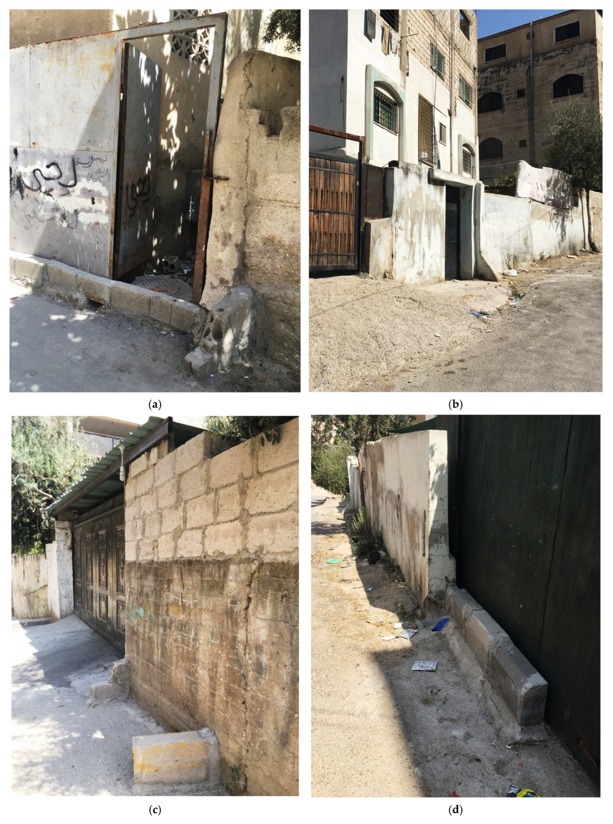
Figure A2.
Photos from (a–d) are representative examples of horizontal extensions of roof drainage pipes beyond property boundaries (i.e., urban showers). Source: picture taken by the researcher, 2020.
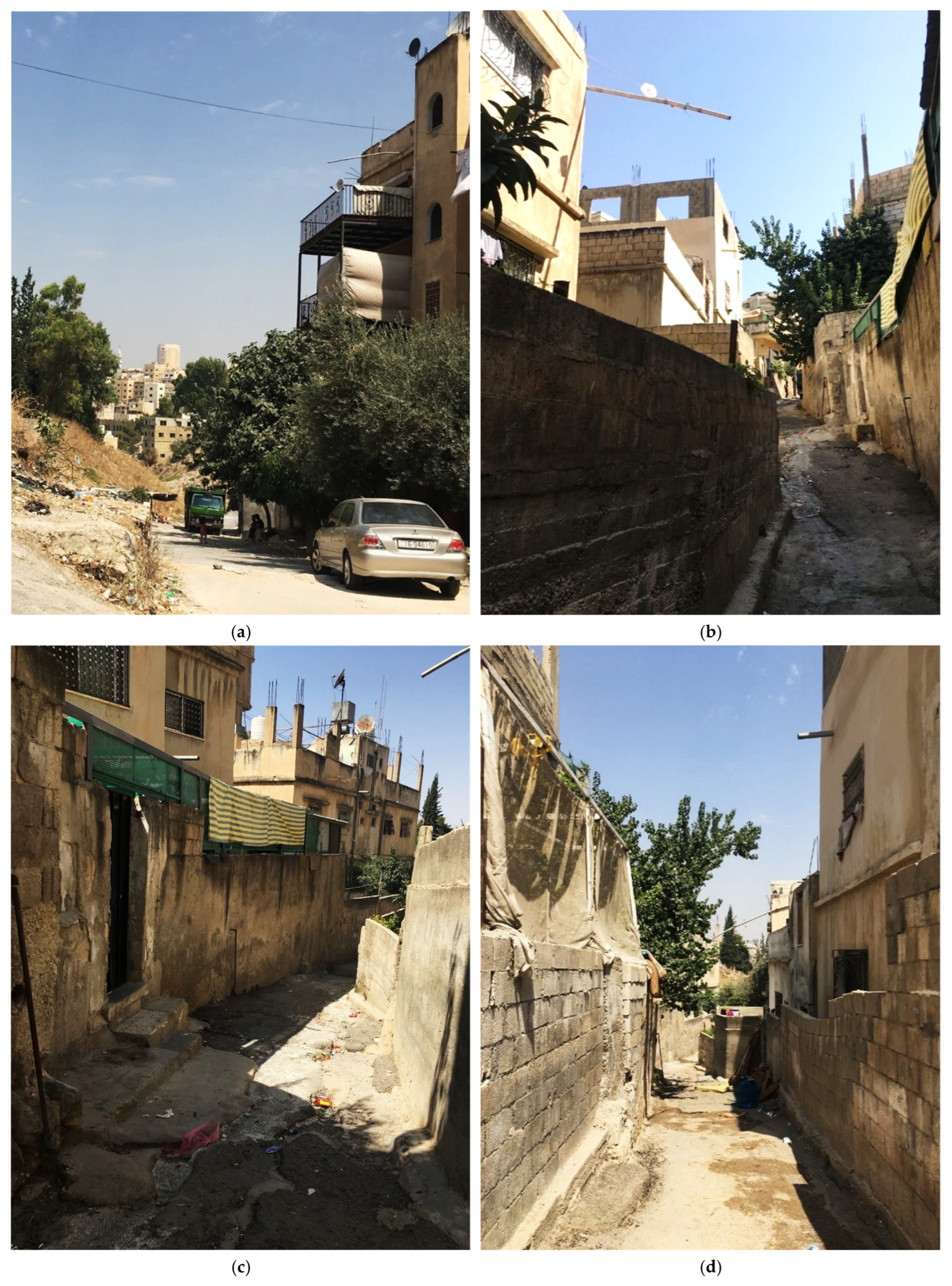
References
- Carter, J.G.; Cavan, G.; Connelly, A.; Guy, S.; Handley, J.; Kazmierczak, A. Climate change and the city: Building capacity for urban adaptation. Prog. Plan. 2015, 95, 1–66. [Google Scholar] [CrossRef] [Scilit]
- United Nations Office for Disaster Risk Reduction (UNISDR). Sendai Framework for Disaster Risk Reduction 2015–2030; United Nations: Geneva, Switzerland, 2015; Available online: https://www.undrr.org/publication/sendai-framework-disaster-risk-reduction-2015-2030 (accessed on 17 June 2020).
- Intergovernmental Panel on Climate Change (IPCC). Climate Change 2022: Impacts, Adaptation and Vulnerability. Contribution of Working Group II to the Sixth Assessment Report of the Intergovernmental Panel on Climate Change; Cambridge University Press: Cambridge, UK, 2022. [Google Scholar] [CrossRef] [Scilit]
- Ashley, R.M.; Balmforth, D.J.; Saul, A.J.; Blanskby, J.D. Flooding in the future—Predicting climate change, risks and responses in urban areas. Water Sci. Technol. 2005, 52, 265–273. [Google Scholar]
- Ahern, J.; Cilliers, S.; Niemelä, J. The concept of ecosystem services in adaptive urban planning and design: A framework for supporting innovation. Landsc. Urban Plan. 2014, 125, 254–259. [Google Scholar] [CrossRef] [Scilit]
- Satterthwaite, D.; Huq, S.; Pelling, M.; Reid, H.; Lankao, P.R. Adapting to Climate Change in Urban Areas: The Possibilities and Constraints in Low- and Middle-Income Nations; Human Settlements Discussion Paper Series; International Institute for Environment and Development (IIED): London, UK, 2007. [Google Scholar]
- Douglas, I.; Alam, K.; Maghenda, M.; McDonnell, Y.; McLean, L.; Campbell, J. Unjust waters: Climate change, flooding and the urban poor in Africa. Environ. Urban. 2008, 20, 187–205. [Google Scholar] [CrossRef] [Scilit]
- United Nations Human Settlements Programme (UN-Habitat). World Cities Report 2020: The Value of Sustainable Urbanization; UN-Habitat: Nairobi, Kenya, 2020. [Google Scholar]
- Pelling, M. The Vulnerability of Cities: Natural Disasters and Social Resilience; Routledge: London, UK, 2003. [Google Scholar]
- Turner, B.L.; Kasperson, R.E.; Matson, P.A.; McCarthy, J.J.; Corell, R.W.; Christensen, L.; Eckley, N.; Kasperson, J.X.; Luers, A.; Martello, M.L.; et al. A framework for vulnerability analysis in sustainability science. Proc. Natl. Acad. Sci. USA 2003, 100, 8074–8079. [Google Scholar] [CrossRef] [Scilit] [PubMed]
- Wisner, B.; Blaikie, P.; Cannon, T.; Davis, I. At Risk: Natural Hazards, People’s Vulnerability and Disasters, 2nd ed.; Routledge: London, UK, 2003. [Google Scholar]
- Andjelkovic, I. Guidelines on Non-Structural Measures in Urban Flood Management; IHP-V Technical Documents in Hydrology No. 50; UNESCO: Paris, France, 2001. [Google Scholar]
- Ahern, J. From fail-safe to safe-to-fail: Sustainability and resilience in the new urban world. Landsc. Urban Plan. 2011, 100, 341–343. [Google Scholar] [CrossRef] [Scilit]
- Wamsler, C.; Brink, E. Moving beyond short-term coping and adaptation. Environ. Urban. 2014, 26, 86–111. [Google Scholar] [CrossRef] [Scilit]
- Meerow, S.; Newell, J.P.; Stults, M. Defining urban resilience: A review. Landsc. Urban Plan. 2016, 147, 38–49. [Google Scholar] [CrossRef] [Scilit]
- Raymond, C.M.; Frantzeskaki, N.; Kabisch, N.; Berry, P.; Breil, M.; Nita, M.R.; Geneletti, D.; Calfapietra, C. A framework for assessing and implementing the co-benefits of nature-based solutions in urban areas. Environ. Sci. Policy 2017, 77, 15–24. [Google Scholar] [CrossRef] [Scilit]
- Adger, W.N. Social aspects of adaptive capacity. In Climate Change, Adaptive Capacity and Development; Smith, J.B., Klein, R.J.T., Huq, S., Eds.; Imperial College Press: London, UK, 2003; pp. 29–49. [Google Scholar]
- Berkes, F.; Colding, J.; Folke, C. Navigating Social-Ecological Systems: Building Resilience for Complexity and Change; Cambridge University Press: Cambridge, UK, 2003. [Google Scholar]
- Berkes, F. Understanding uncertainty and reducing vulnerability: Lessons from resilience thinking. Nat. Hazards 2007, 41, 283–295. [Google Scholar] [CrossRef] [Scilit]
- Eriksen, S.; Aldunce, P.; Bahinipati, C.S.; Martins, R.D.; Molefe, J.I.; Nhemachena, C.; O’Brien, K.; Olorunfemi, F.; Park, J.; Sygna, L.; et al. When not every response to climate change is a good one: Identifying principles for sustainable adaptation. Clim. Dev. 2011, 3, 7–20. [Google Scholar] [CrossRef] [Scilit]
- Haque, A.N.; Dodman, D.; Hossain, M.M. Individual, communal and institutional responses to climate change adaptation in urban informal settlements: A systematic literature review. Clim. Dev. 2021, 13, 95–109. [Google Scholar] [CrossRef] [Scilit]
- Moser, C.; Stein, A. Implementing Urban Participatory Climate Change Adaptation Appraisals: A Methodological Guideline; Global Urban Research Centre, University of Manchester: Manchester, UK, 2011. [Google Scholar]
- Limthongsakul, S.; Nitivattananon, V.; Arifwidodo, S.D. Localized flooding and autonomous adaptation in peri-urban Bangkok. Environ. Urban. 2017, 29, 51–68. [Google Scholar] [CrossRef] [Scilit]
- Bera, M.K.; Daněk, P. The perception of risk in the flood-prone area: A case study from the Czech municipality. Disaster Prev. Manag. 2018, 27, 2–14. [Google Scholar] [CrossRef] [Scilit]
- Ahern, J. Urban landscape sustainability and resilience: The promise and challenges of integrating ecology with urban planning and design. Landsc. Ecol. 2013, 28, 1203–1212. [Google Scholar] [CrossRef] [Scilit]
- Bankoff, G. Cultures of coping: Adaptation to hazard and living with disaster in the Philippines. Philipp. Sociol. Rev. 2003, 51, 1–16. [Google Scholar]
- Pelling, M. Adaptation to Climate Change: From Resilience to Transformation; Routledge: Abingdon, UK, 2011. [Google Scholar]
- Barendrecht, M.H.; Sairam, N.; Cumiskey, L.; Metin, A.D.; Holz, F.; Priest, S.J.; Kreibich, H. Needed: A systems approach to improve flood risk mitigation through private precautionary measures. Water Secur. 2020, 11, 100080. [Google Scholar] [CrossRef] [Scilit]
- Smit, B.; Wandel, J. Adaptation, adaptive capacity and vulnerability. Glob. Environ. Change 2006, 16, 282–292. [Google Scholar] [CrossRef] [Scilit]
- Nelson, D.R.; Adger, W.N.; Brown, K. Adaptation to environmental change: Contributions of a resilience framework. Annu. Rev. Environ. Resour. 2007, 32, 395–419. [Google Scholar] [CrossRef] [Scilit]
- United Nations Office for Disaster Risk Reduction (UNISDR). UNISDR Terminology on Disaster Risk Reduction; UNISDR: Geneva, Switzerland, 2009; Available online: https://www.unisdr.org/files/7817_UNISDRTerminologyEnglish.pdf (accessed on 8 June 2020).
- Wamsler, C. Cities, Disaster Risk and Adaptation; Routledge: Abingdon, UK, 2014. [Google Scholar]
- Intergovernmental Panel on Climate Change (IPCC). Climate Change 2014: Synthesis Report. Contribution of Working Groups I, II and III to the Fifth Assessment Report of the Intergovernmental Panel on Climate Change; Core Writing Team, Pachauri, R.K., Meyer, L.A., Eds.; IPCC: Geneva, Switzerland, 2014; 151p. [Google Scholar]
- Forrest, S.A.; Trell, E.-M.; Woltjer, J. Socio-spatial inequalities in flood resilience: Rainfall flooding in the city of Arnhem. Cities 2020, 105, 102843. [Google Scholar] [CrossRef] [Scilit]
- Slovic, P. Perception of risk. Science 1987, 236, 280–285. [Google Scholar] [CrossRef] [Scilit] [PubMed]
- Wachinger, G.; Renn, O.; Begg, C.; Kuhlicke, C. The risk perception paradox—Implications for governance and communication of natural hazards. Risk Anal. 2013, 33, 1049–1065. [Google Scholar] [CrossRef] [Scilit] [PubMed]
- van der Linden, S. The social-psychological determinants of climate change risk perceptions: Towards a comprehensive model. J. Environ. Psychol. 2015, 41, 112–124. [Google Scholar] [CrossRef] [Scilit]
- Adger, W.N.; Lorenzoni, I.; O’Brien, K.L. (Eds.) Adapting to Climate Change: Thresholds, Values, Governance; Cambridge University Press: Cambridge, UK, 2009. [Google Scholar] [CrossRef] [Scilit]
- Bubeck, P.; Botzen, W.J.W.; Aerts, J.C.J.H. A review of risk perceptions and other factors that influence flood mitigation behavior. Risk Anal. 2012, 32, 1481–1495. [Google Scholar] [CrossRef] [Scilit] [PubMed]
- Kellens, W.; Terpstra, T.; De Maeyer, P. Perception and communication of flood risks: A systematic review of empirical research. Risk Anal. 2013, 33, 24–49. [Google Scholar] [CrossRef] [Scilit] [PubMed]
- Folke, C.; Hahn, T.; Olsson, P.; Norberg, J. Adaptive governance of social-ecological systems. Annu. Rev. Environ. Resour. 2005, 30, 441–473. [Google Scholar] [CrossRef] [Scilit]
- Pahl-Wostl, C. A conceptual framework for analysing adaptive capacity and multi-level learning processes in resource governance regimes. Glob. Environ. Change 2009, 19, 354–365. [Google Scholar] [CrossRef] [Scilit]
- Engle, N.L. Adaptive capacity and its assessment. Glob. Environ. Change 2011, 21, 647–656. [Google Scholar] [CrossRef] [Scilit]
- Millennium Ecosystem Assessment (MEA). Ecosystems and Human Well-Being: General Synthesis; Island Press: Washington, DC, USA, 2005. [Google Scholar]
- Bolund, P.; Hunhammar, S. Ecosystem services in urban areas. Ecol. Econ. 1999, 29, 293–301. [Google Scholar] [CrossRef] [Scilit]
- Alves, A.; Patiño Gómez, J.; Vojinovic, Z.; Sánchez, A.; Weesakul, S. Combining co-benefits and stakeholders’ perceptions into green infrastructure selection for flood risk reduction. Environments 2018, 5, 29. [Google Scholar] [CrossRef] [Scilit]
- McHarg, I.L. Design with Nature; John Wiley & Sons: New York, NY, USA, 1969. [Google Scholar]
- Spirn, A.W. The Granite Garden: Urban Nature and Human Design; Basic Books: New York, NY, USA, 1984. [Google Scholar]
- Lyle, J.T. Design for Human Ecosystems: Landscape, Land Use, and Natural Resources; Island Press: Washington, DC, USA, 1985. [Google Scholar]
- Rouse, D.C.; Bunster-Ossa, I.F. Green Infrastructure: A Landscape Approach; American Planning Association: Chicago, IL, USA, 2013. [Google Scholar]
- Spirn, A.W. Ecological urbanism: A framework for the design of resilient cities. In The Ecological Design and Planning Reader; Ndubisi, F.O., Ed.; Island Press: Washington, DC, USA, 2014; pp. 532–555. [Google Scholar]
- Fletcher, T.D.; Shuster, W.; Hunt, W.F.; Ashley, R.; Butler, D.; Arthur, S.; Trowsdale, S.; Barraud, S.; Semadeni-Davies, A.; Bertrand-Krajewski, J.-L.; et al. SUDS, LID, BMPs, WSUD and more—The evolution and application of terminology surrounding urban drainage. Urban Water J. 2015, 12, 525–542. [Google Scholar] [CrossRef] [Scilit]
- Arnstein, S.R. A ladder of citizen participation. J. Am. Inst. Plan. 1969, 35, 216–224. [Google Scholar] [CrossRef] [Scilit]
- Healey, P. Collaborative Planning: Shaping Places in Fragmented Societies; Macmillan Press: London, UK, 1997. [Google Scholar]
- Alexander, M.; Priest, S.; Mees, H. A framework for evaluating flood risk governance. Environ. Sci. Policy 2016, 64, 38–47. [Google Scholar] [CrossRef] [Scilit]
- Reed, M.S. Stakeholder participation for environmental management: A literature review. Biol. Conserv. 2008, 141, 2417–2431. [Google Scholar] [CrossRef] [Scilit]
- Berkes, F.; Berkes, M.K.; Fast, H. Collaborative integrated management in Canada’s North: The role of local and traditional knowledge and community-based monitoring. Coast. Manag. 2007, 35, 143–162. [Google Scholar] [CrossRef] [Scilit]
- Brugnach, M.; Craps, M.; Dewulf, A. Including indigenous peoples in climate change mitigation: Addressing issues of scale, knowledge and power. Clim. Change 2017, 140, 19–32. [Google Scholar] [CrossRef] [Scilit]
- Lejano, R.P.; Rahman, M.S.; Kabir, L.; Mattiace, S. Local knowledge and the governance of flood risk: Learning from community adaptation. Int. J. Disaster Risk Reduct. 2021, 52, 101948. [Google Scholar] [CrossRef] [Scilit]
- Forester, J. The Deliberative Practitioner: Encouraging Participatory Planning Processes; MIT Press: Cambridge, MA, USA, 1999. [Google Scholar]
- Creswell, J.W.; Poth, C.N. Qualitative Inquiry and Research Design: Choosing Among Five Approaches, 4th ed.; SAGE Publications: Thousand Oaks, CA, USA, 2018. [Google Scholar]
- Denzin, N.K.; Lincoln, Y.S. (Eds.) The SAGE Handbook of Qualitative Research, 5th ed.; SAGE Publications: Thousand Oaks, CA, USA, 2018. [Google Scholar]
- Yin, R.K. Case Study Research and Applications: Design and Methods, 6th ed.; SAGE Publications: Thousand Oaks, CA, USA, 2018. [Google Scholar]
- Flyvbjerg, B. Five misunderstandings about case-study research. Qual. Inq. 2006, 12, 219–245. [Google Scholar] [CrossRef] [Scilit]
- USAID. Water Management Initiative (WMI)—Rainwater Harvesting for Households Guide; Tetra Tech: Burlington, VT, USA, 2018.
- Almasri, S. Flood Water Management and Risk Reduction in Semiarid Cities—Amman. Master’s Thesis, Cologne University of Applied Sciences, Cologne, Germany, University of Jordan, Amman, Jordan, 2017. [Google Scholar]
- Ababsa, M. Social disparities and public policies in Amman. In Cities, Urban Practices and Nation Building in Jordan; Ababsa, M., Ed.; Presses de l’Institut Français du Proche-Orient: Beirut, Lebanon, 2011; pp. 205–232. [Google Scholar]
- Ababsa, M. Atlas of Jordan: History, Territories and Society; Institut Français du Proche-Orient: Beirut, Lebanon, 2013. [Google Scholar]
- Denzin, N.K. The Research Act: A Theoretical Introduction to Sociological Methods, 2nd ed.; McGraw-Hill: New York, NY, USA, 1978. [Google Scholar]
- Patton, M.Q. Qualitative Research & Evaluation Methods: Integrating Theory and Practice, 4th ed.; SAGE Publications: Thousand Oaks, CA, USA, 2015. [Google Scholar]
- Braun, V.; Clarke, V. One size fits all? What counts as quality practice in (reflexive) thematic analysis? Qual. Res. Psychol. 2021, 18, 328–352. [Google Scholar] [CrossRef] [Scilit]
- Lincoln, Y.S.; Guba, E.G. Naturalistic Inquiry; SAGE Publications: Beverly Hills, CA, USA, 1985. [Google Scholar]
- Shenton, A.K. Strategies for ensuring trustworthiness in qualitative research projects. Educ. Inf. 2004, 22, 63–75. [Google Scholar] [CrossRef] [Scilit]
- Liao, K.-H. A theory on urban resilience to floods—A basis for alternative planning practices. Ecol. Soc. 2012, 17, 48. [Google Scholar] [CrossRef] [Scilit]
- Adger, W.N. Vulnerability. Glob. Environ. Change 2006, 16, 268–281. [Google Scholar] [CrossRef] [Scilit]
- Działek, J.; Biernacki, W.; Bokwa, A.; Konieczna, J.; Kupidura, A. Social capacity for adaptation to climate-related hazards in Poland. Int. J. Disaster Risk Reduct. 2013, 5, 190–203. [Google Scholar] [CrossRef] [Scilit]
- Waters, J.J.; Adger, W.N. Spatial, network and temporal dimensions of the determinants of adaptive capacity in poor urban areas. Glob. Environ. Change 2017, 46, 42–49. [Google Scholar] [CrossRef] [Scilit]
- Denton, F. Climate adaptation. In International Development: Ideas, Experience, and Prospects; Currie-Alder, B., Kanbur, R., Malone, D.M., Medhora, R., Eds.; Oxford University Press: Oxford, UK, 2014; pp. 430–444. [Google Scholar]
- Ostrom, E. Polycentric systems for coping with collective action and global environmental change. Glob. Environ. Change 2010, 20, 550–557. [Google Scholar] [CrossRef] [Scilit]
- Andersson, E.; Barthel, S.; Ahrné, K. Measuring social–ecological dynamics behind the generation of ecosystem services. Ecol. Appl. 2014, 24, 1181–1198. [Google Scholar] [CrossRef] [Scilit] [PubMed]
- Barnett, J.; O’Neill, S. Maladaptation. Glob. Environ. Change 2010, 20, 211–213. [Google Scholar] [CrossRef] [Scilit]
- Meerow, S.; Newell, J.P. Urban resilience for whom, what, when, where, and why? Urban Geogr. 2019, 40, 309–329. [Google Scholar] [CrossRef] [Scilit]
- Innes, J.E.; Booher, D.E. Reframing public participation: Strategies for the 21st century. Plan. Theory Pract. 2004, 5, 419–436. [Google Scholar] [CrossRef] [Scilit]
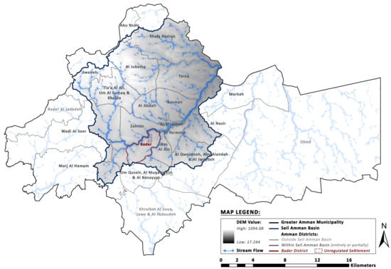
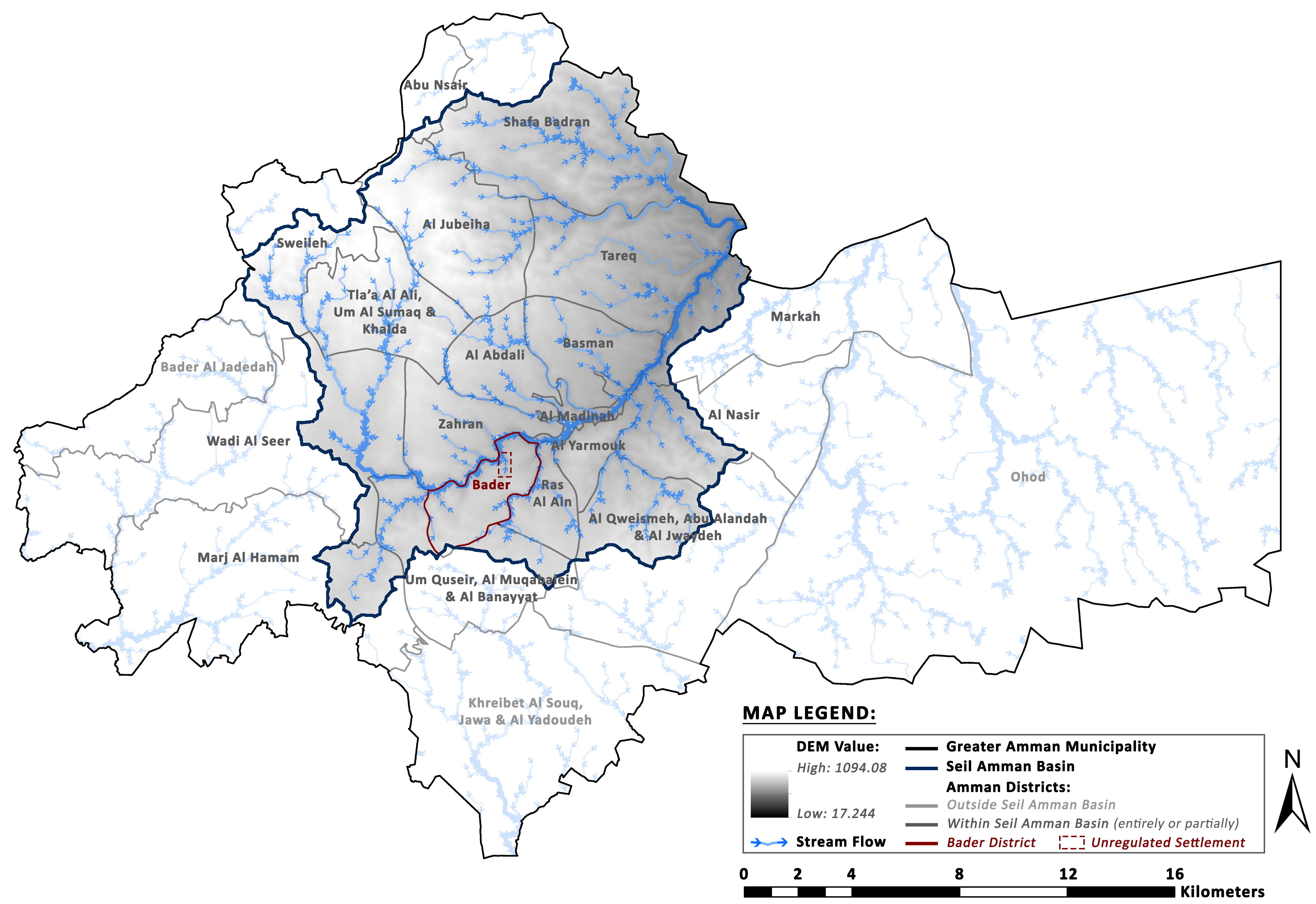
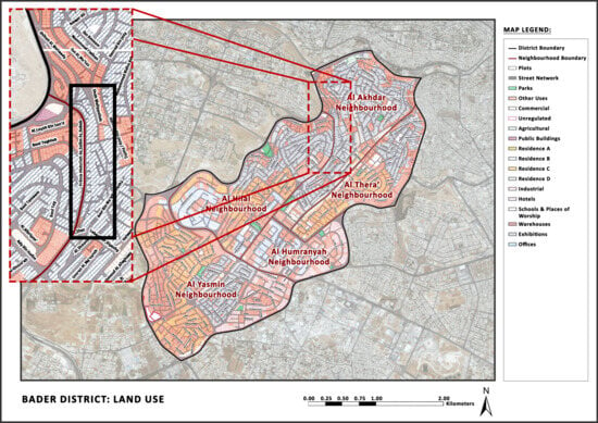
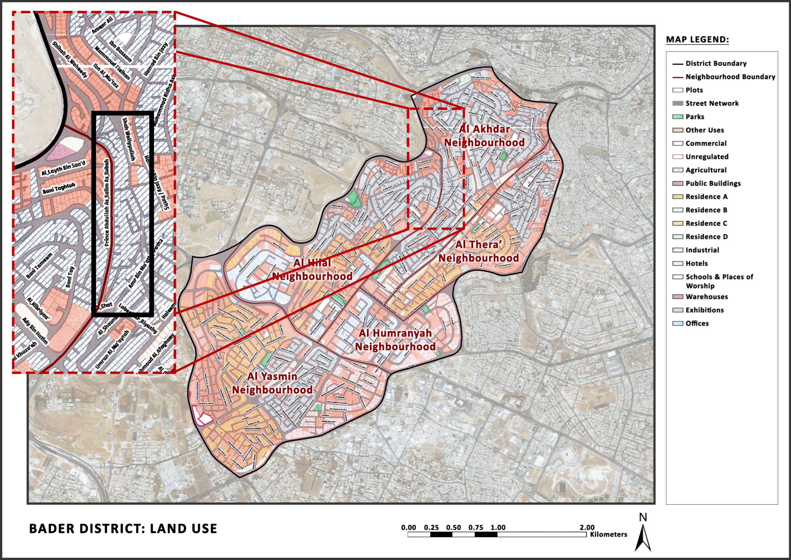
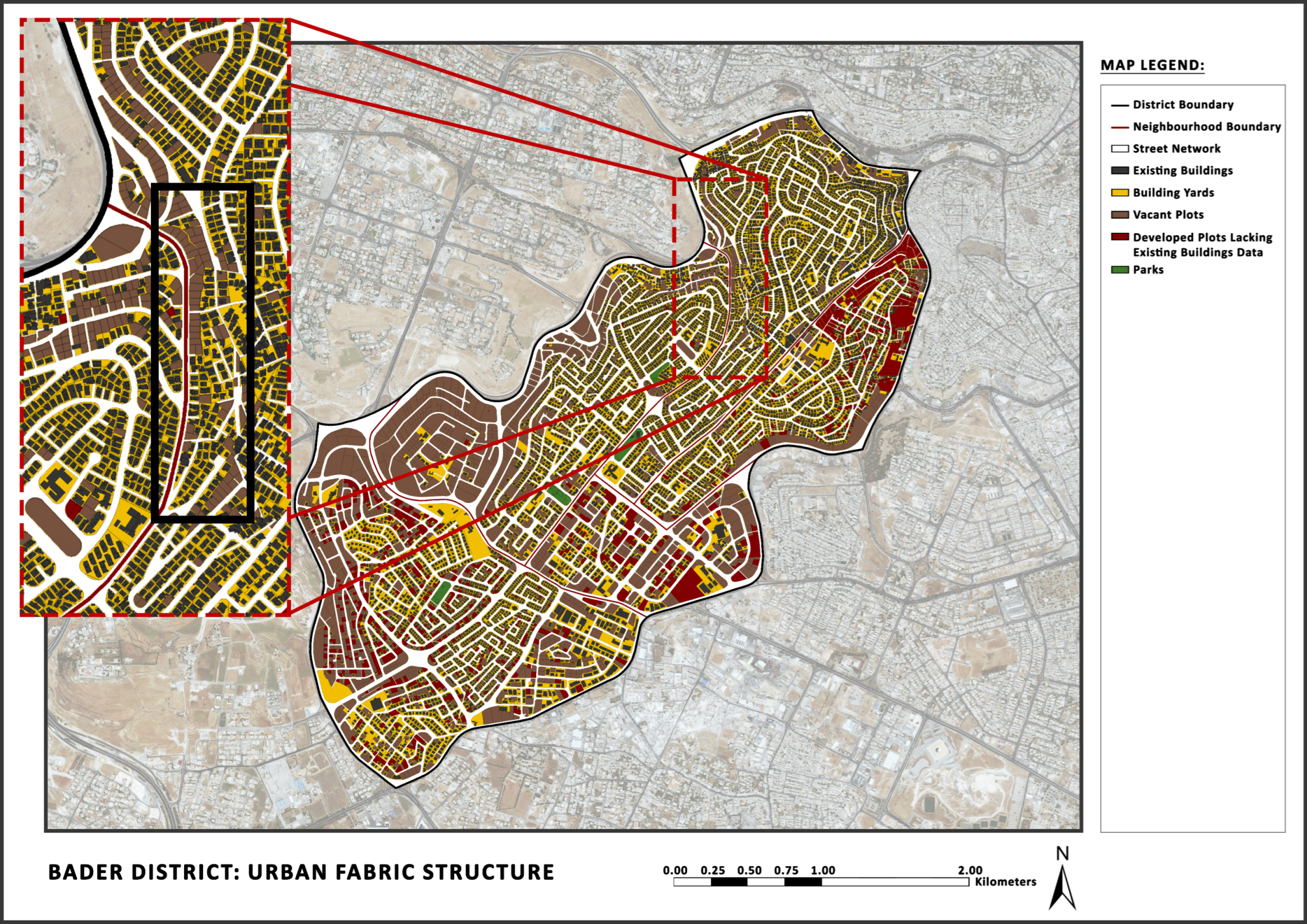
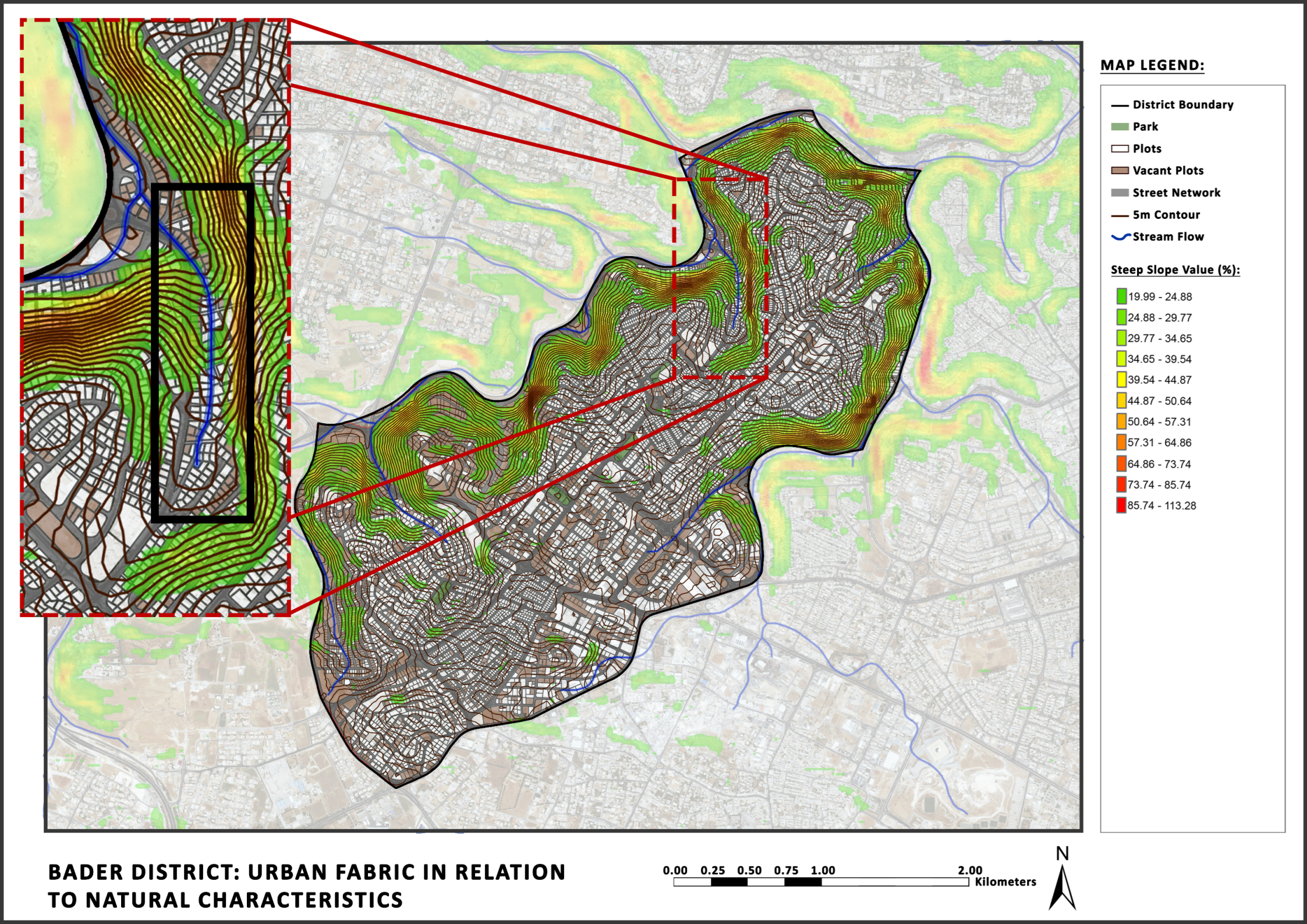
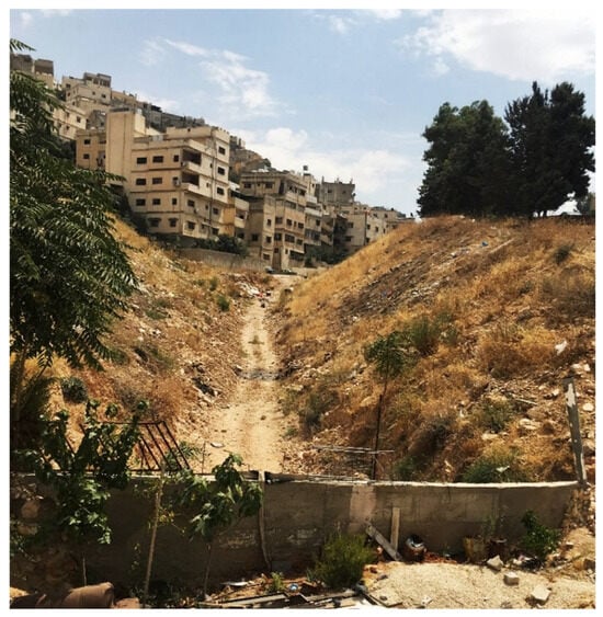
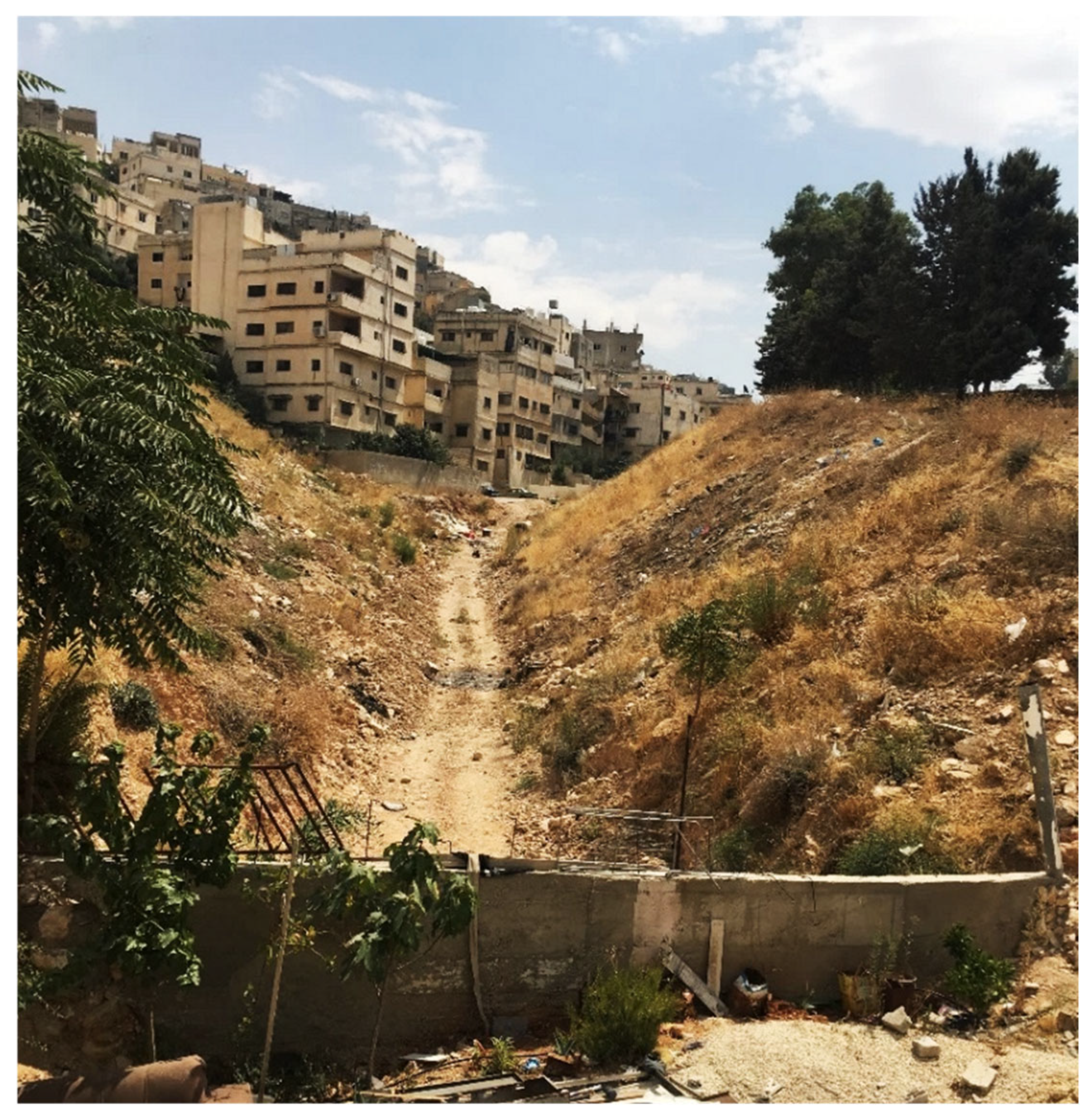
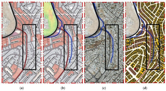
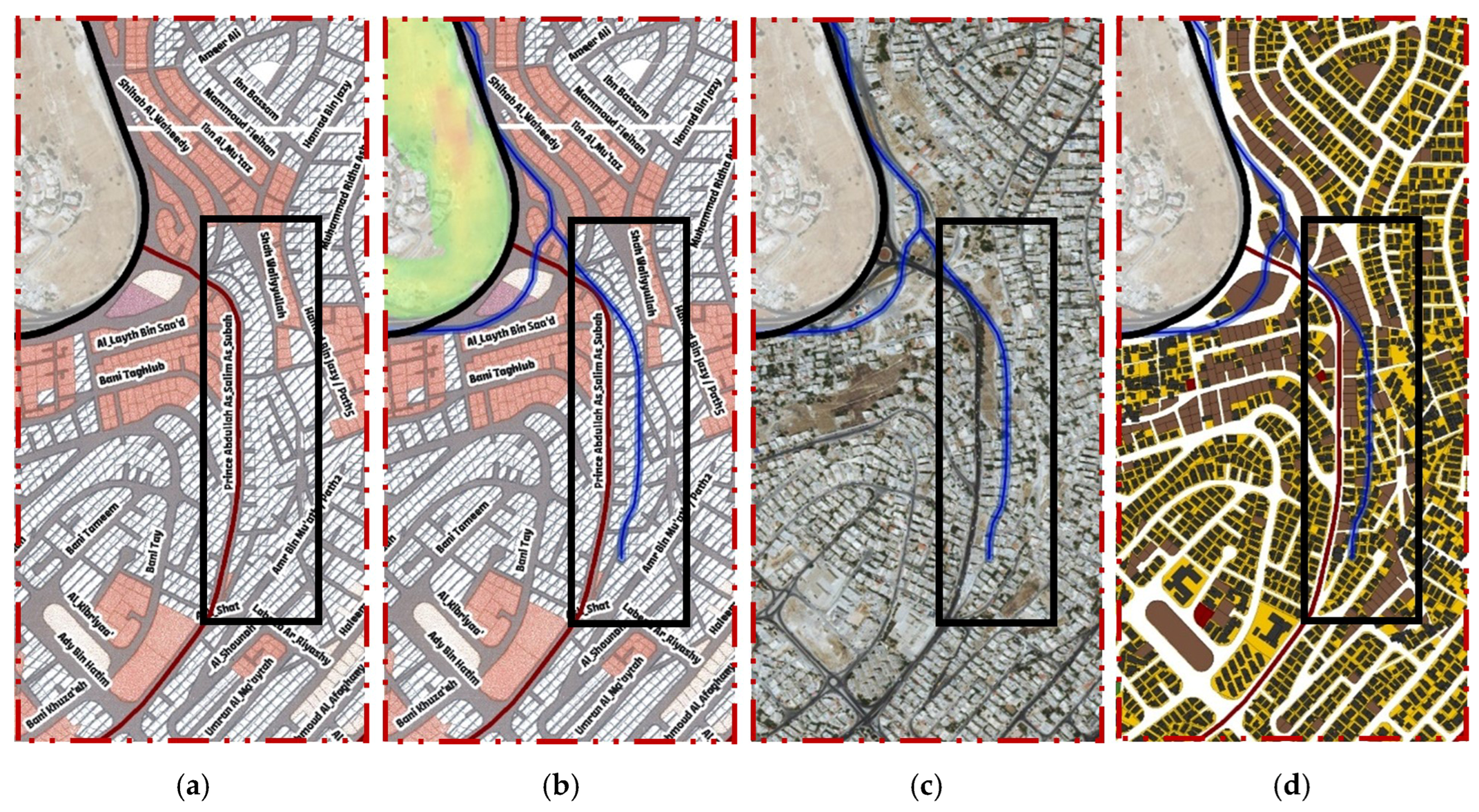
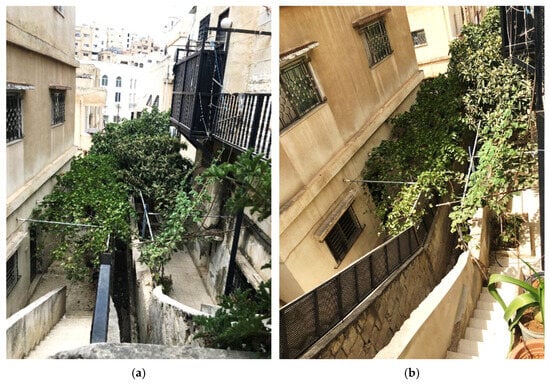
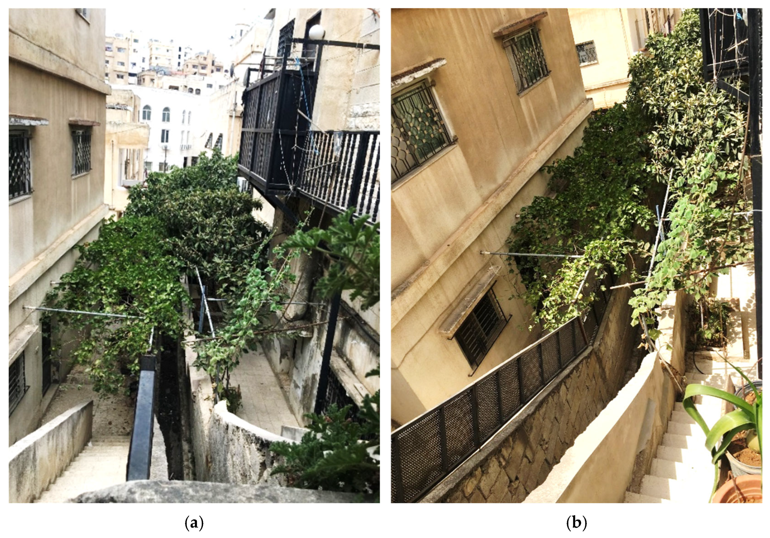
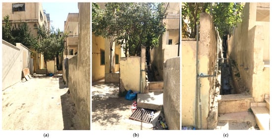
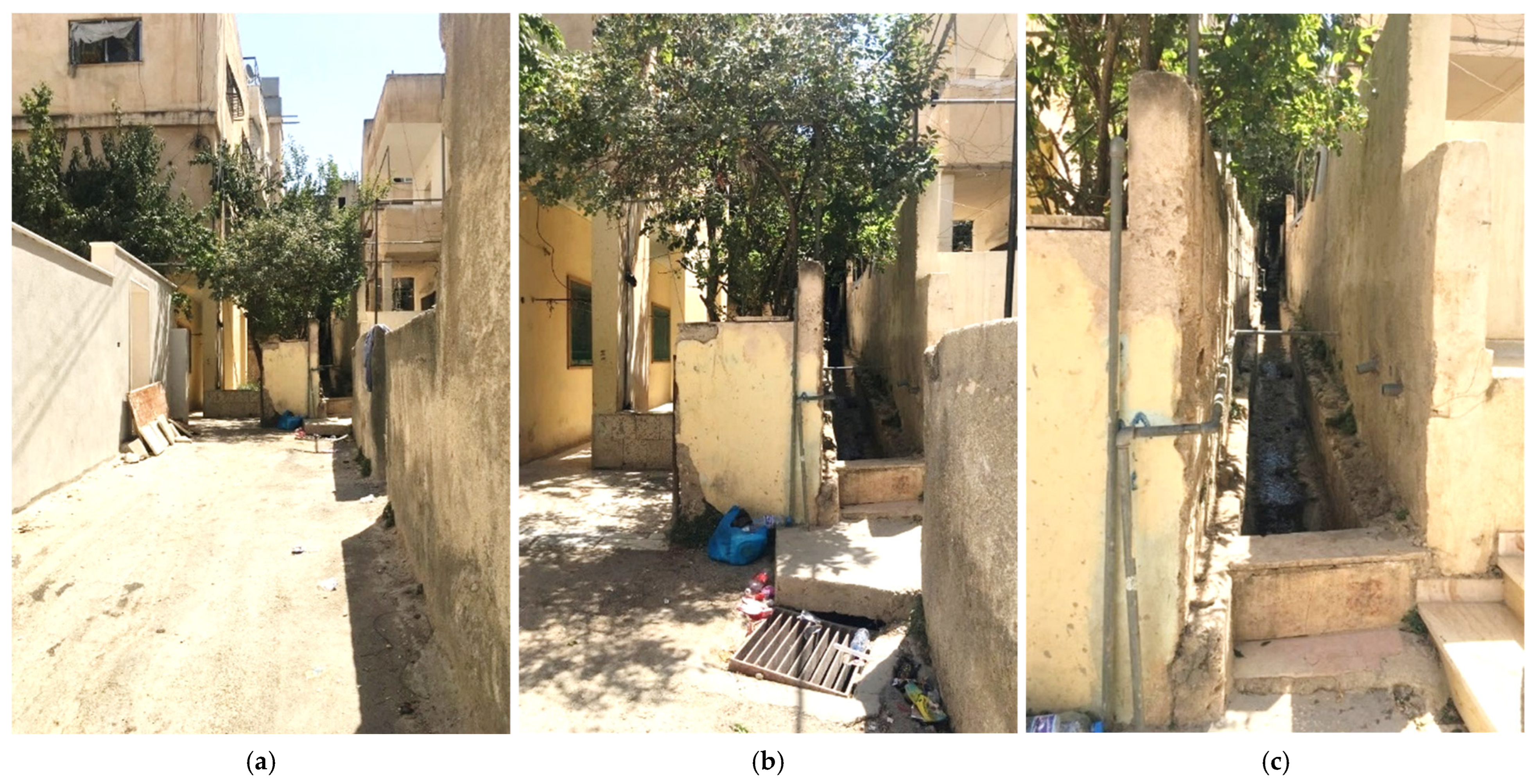
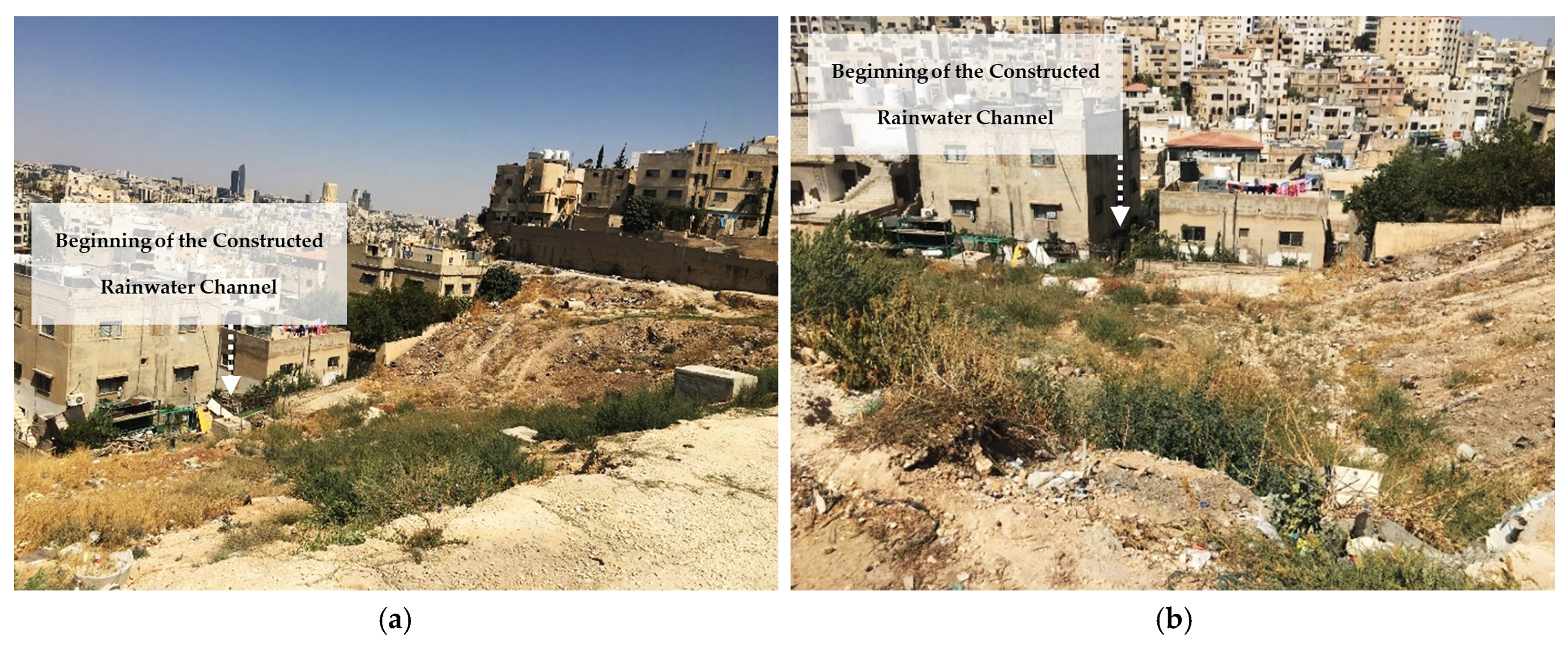
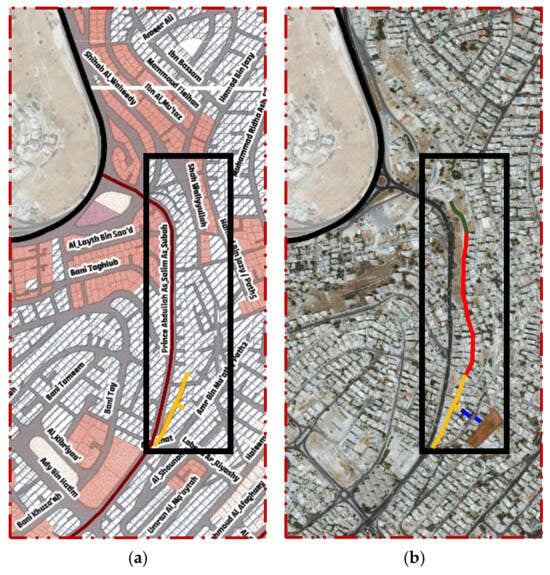
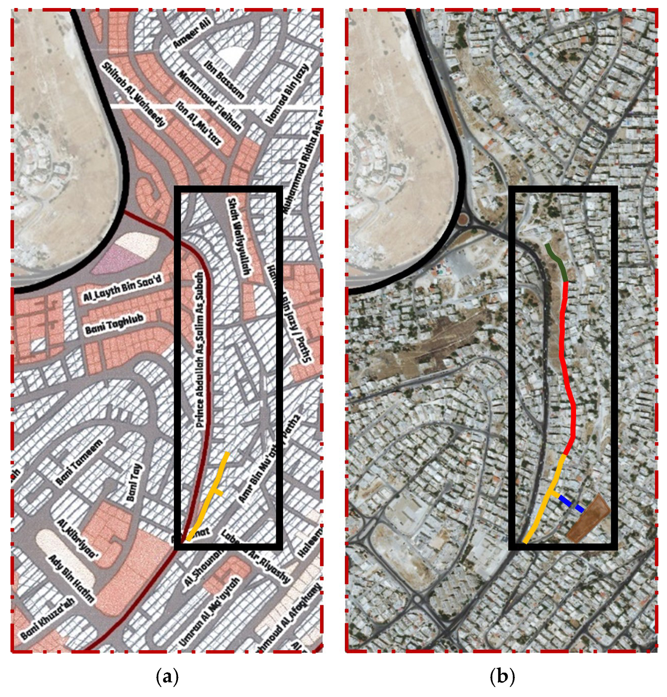
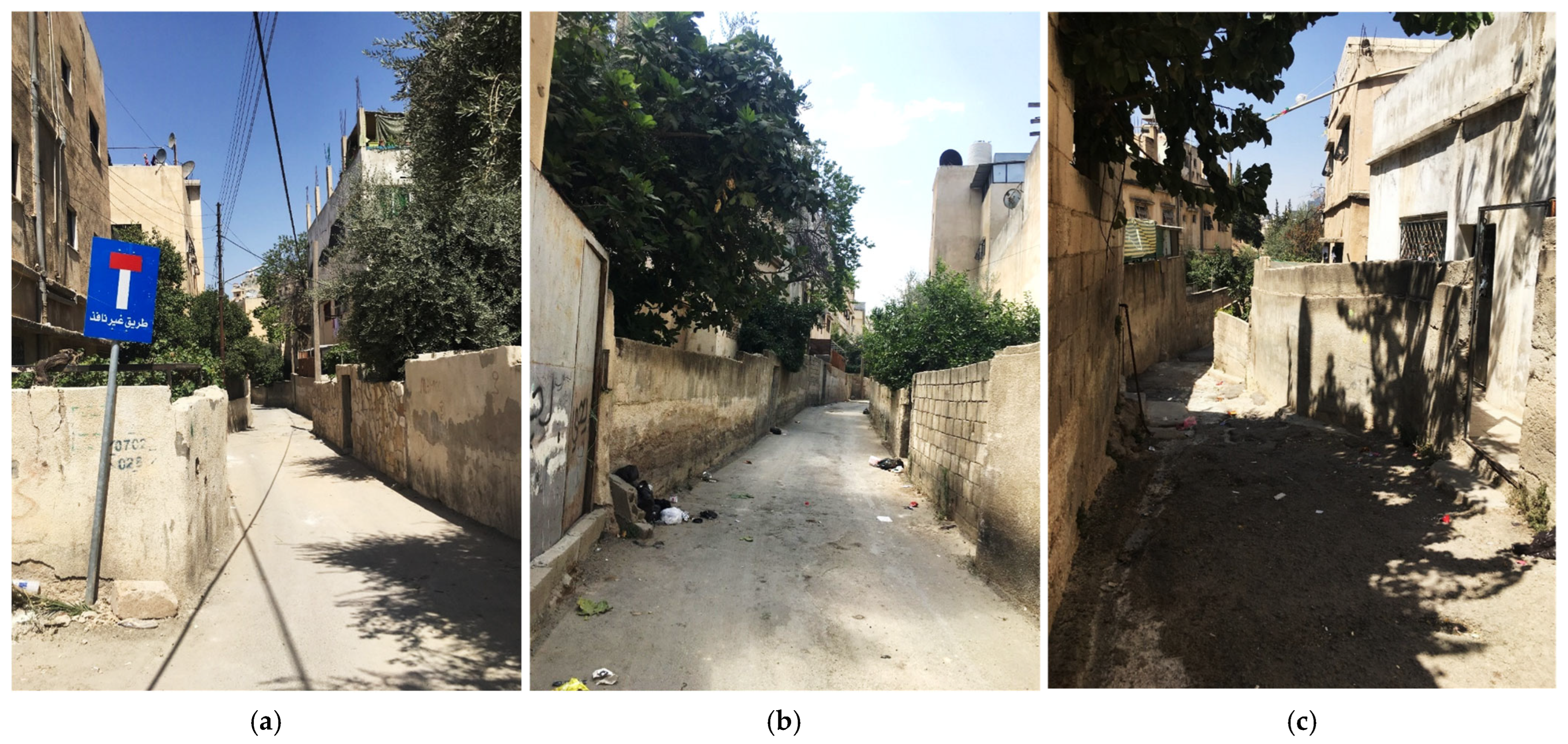
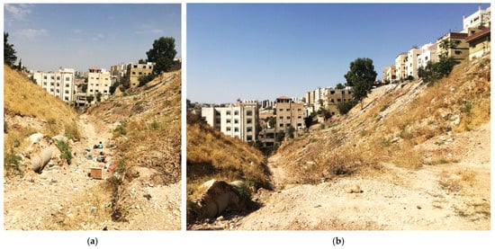
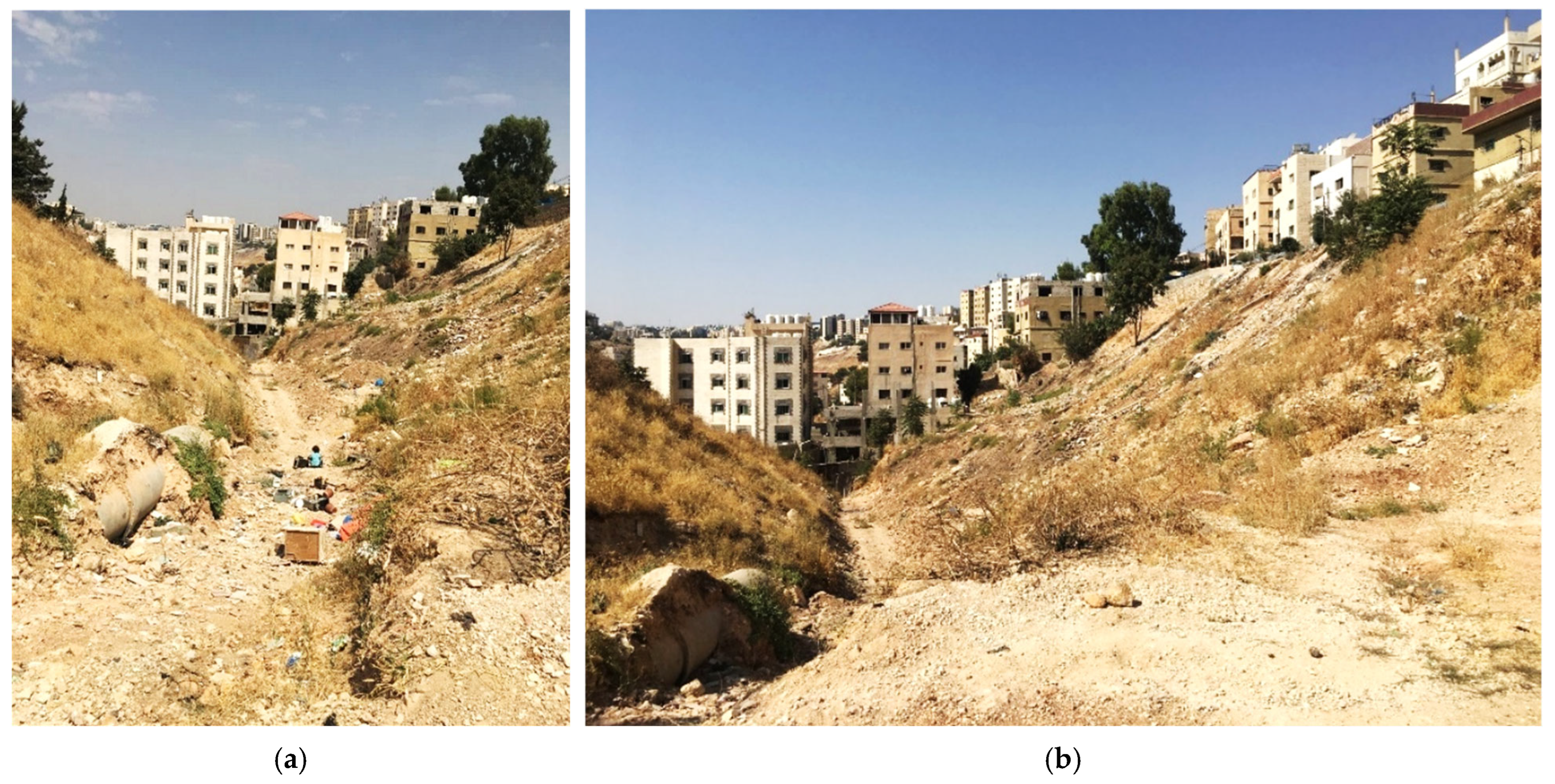
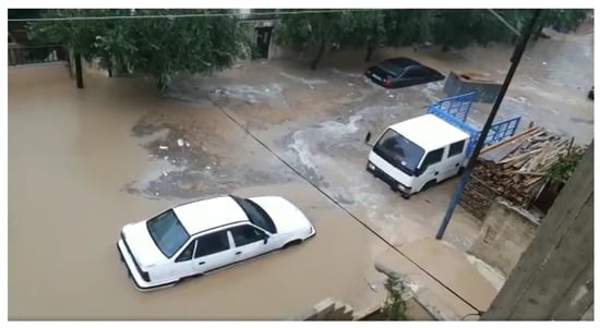
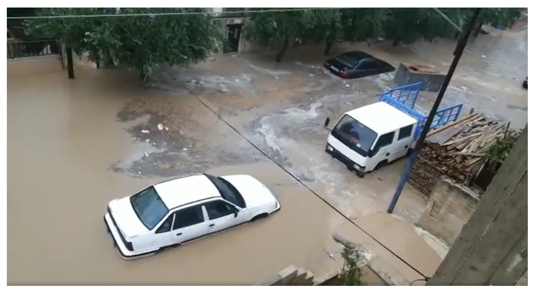
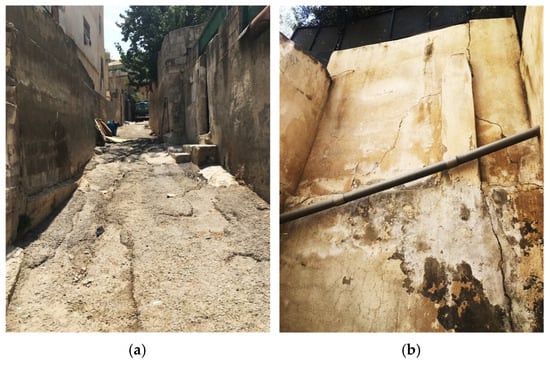
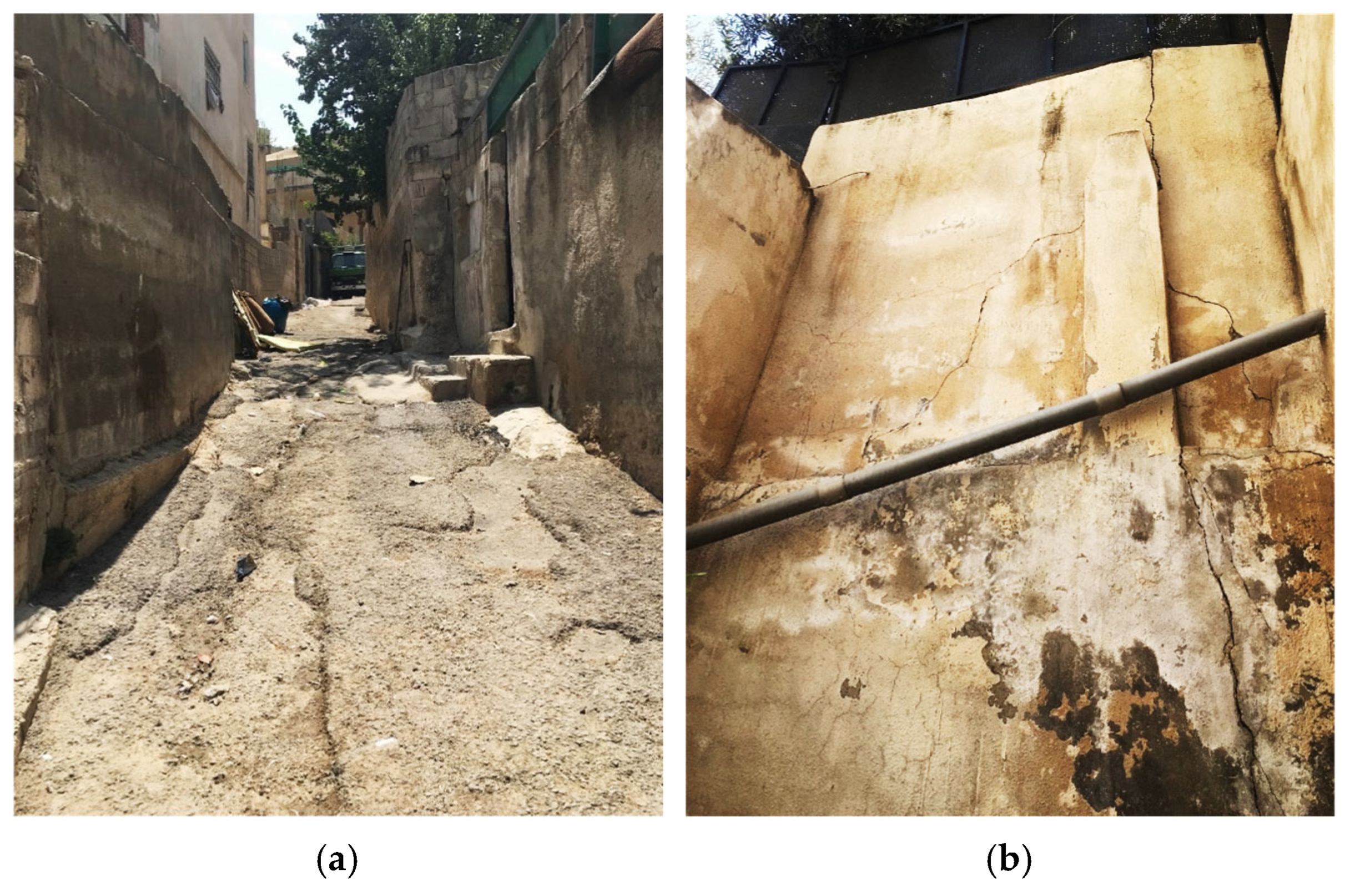
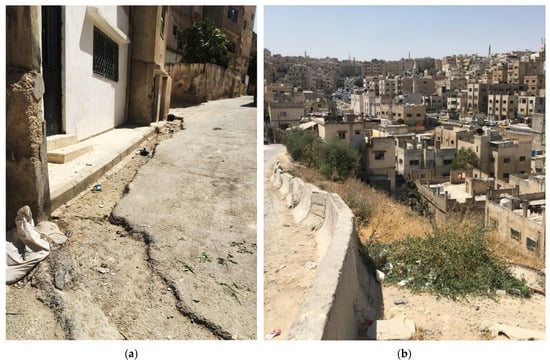
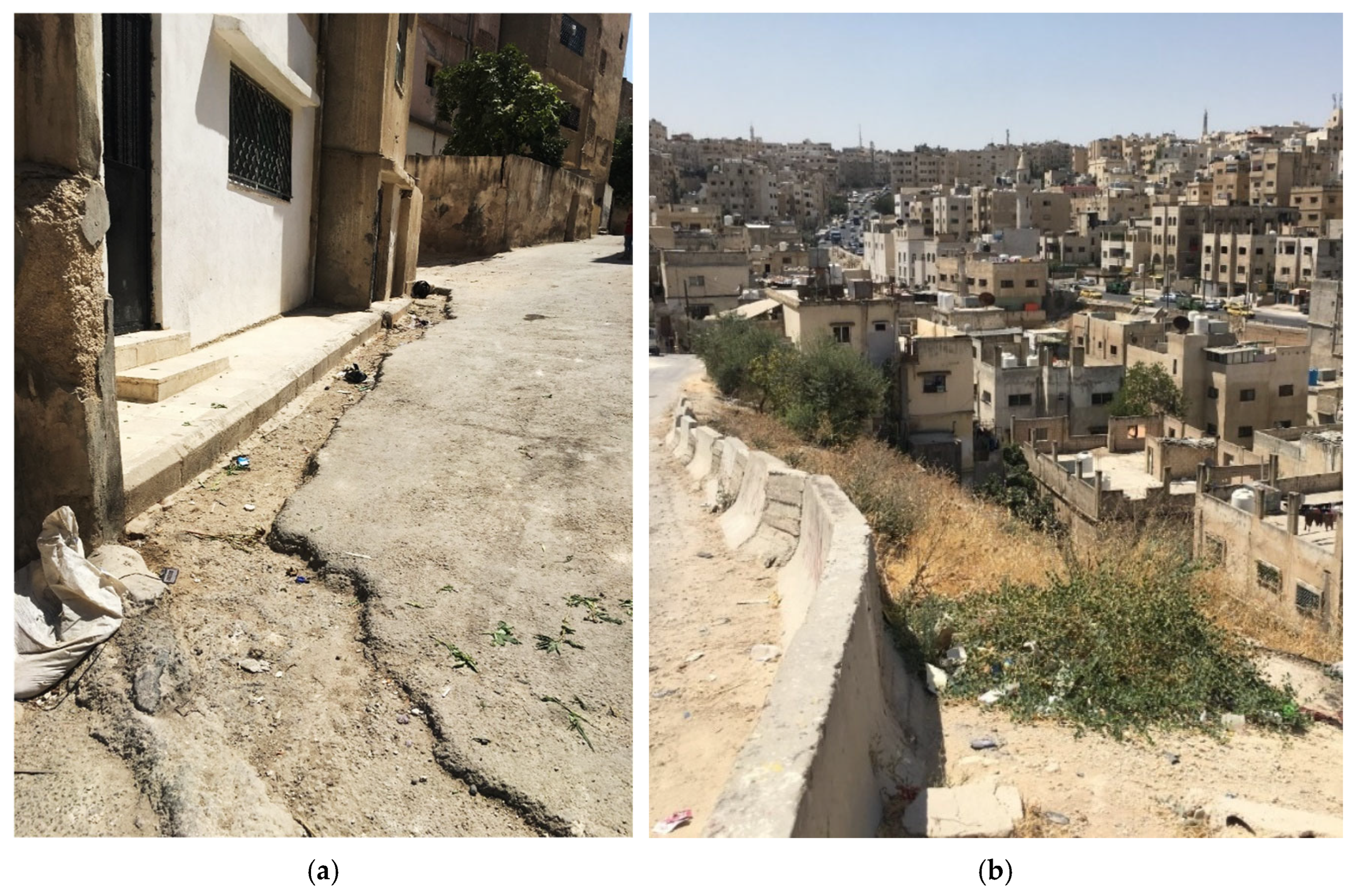
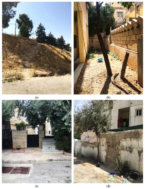
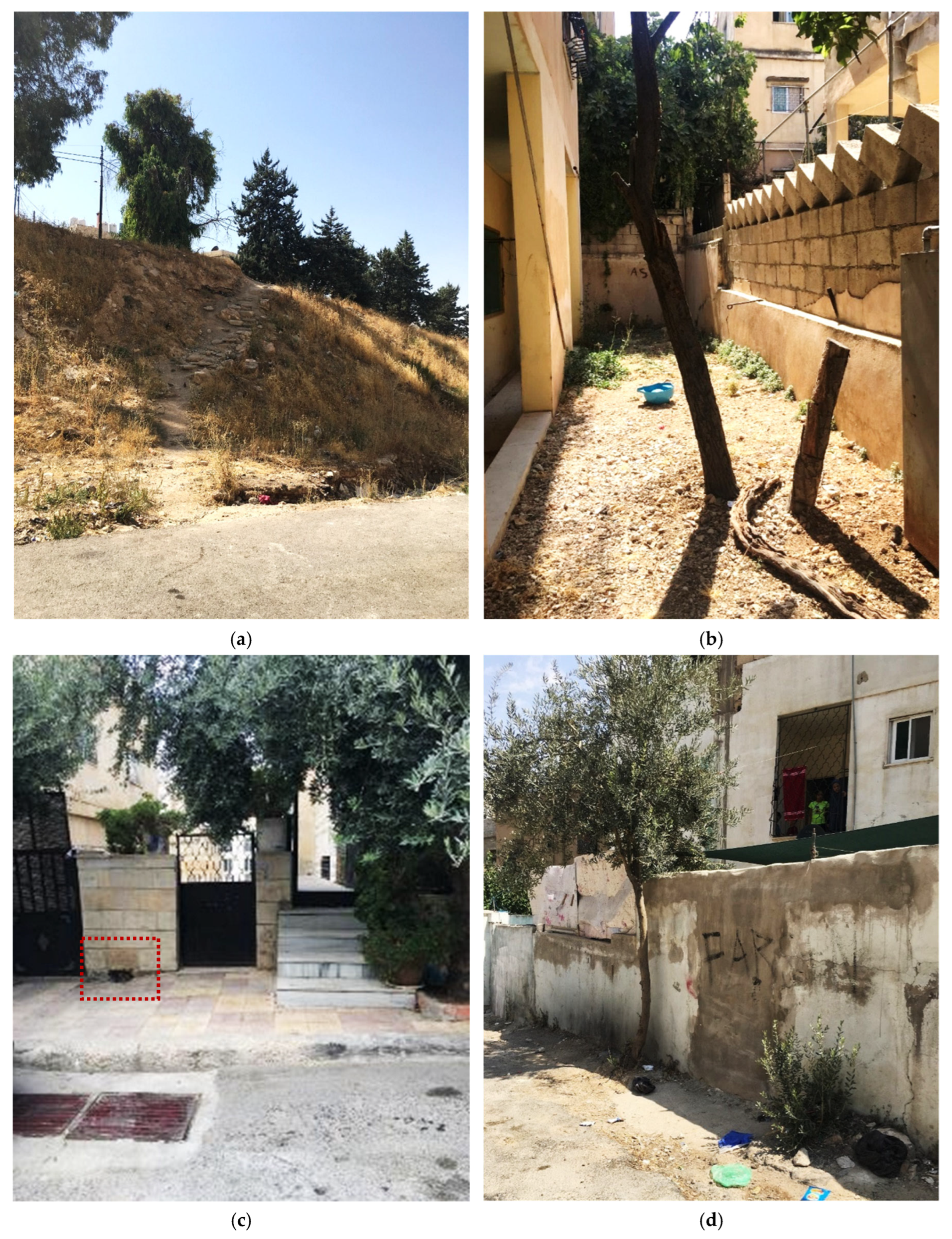
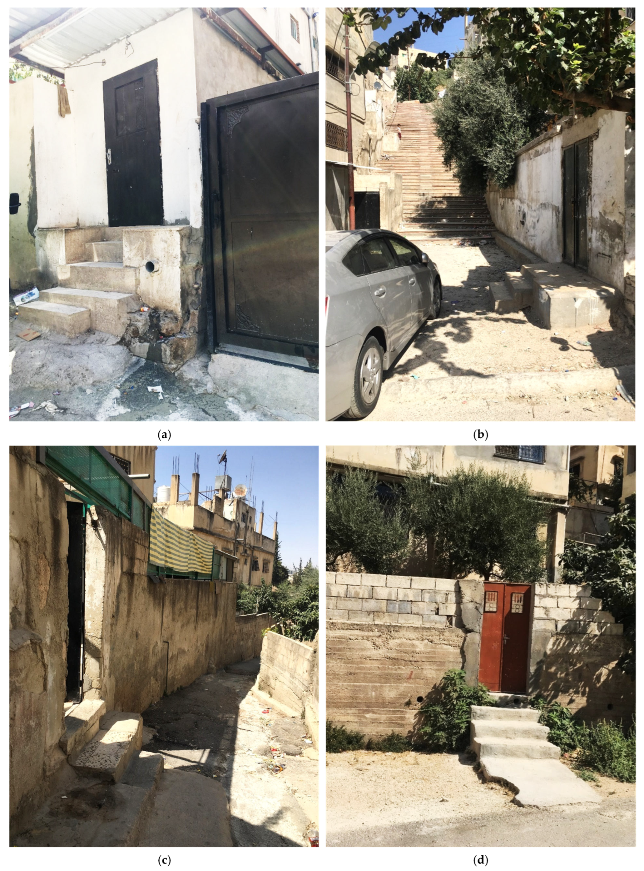
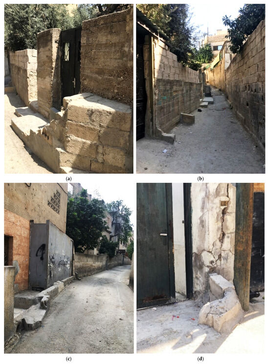
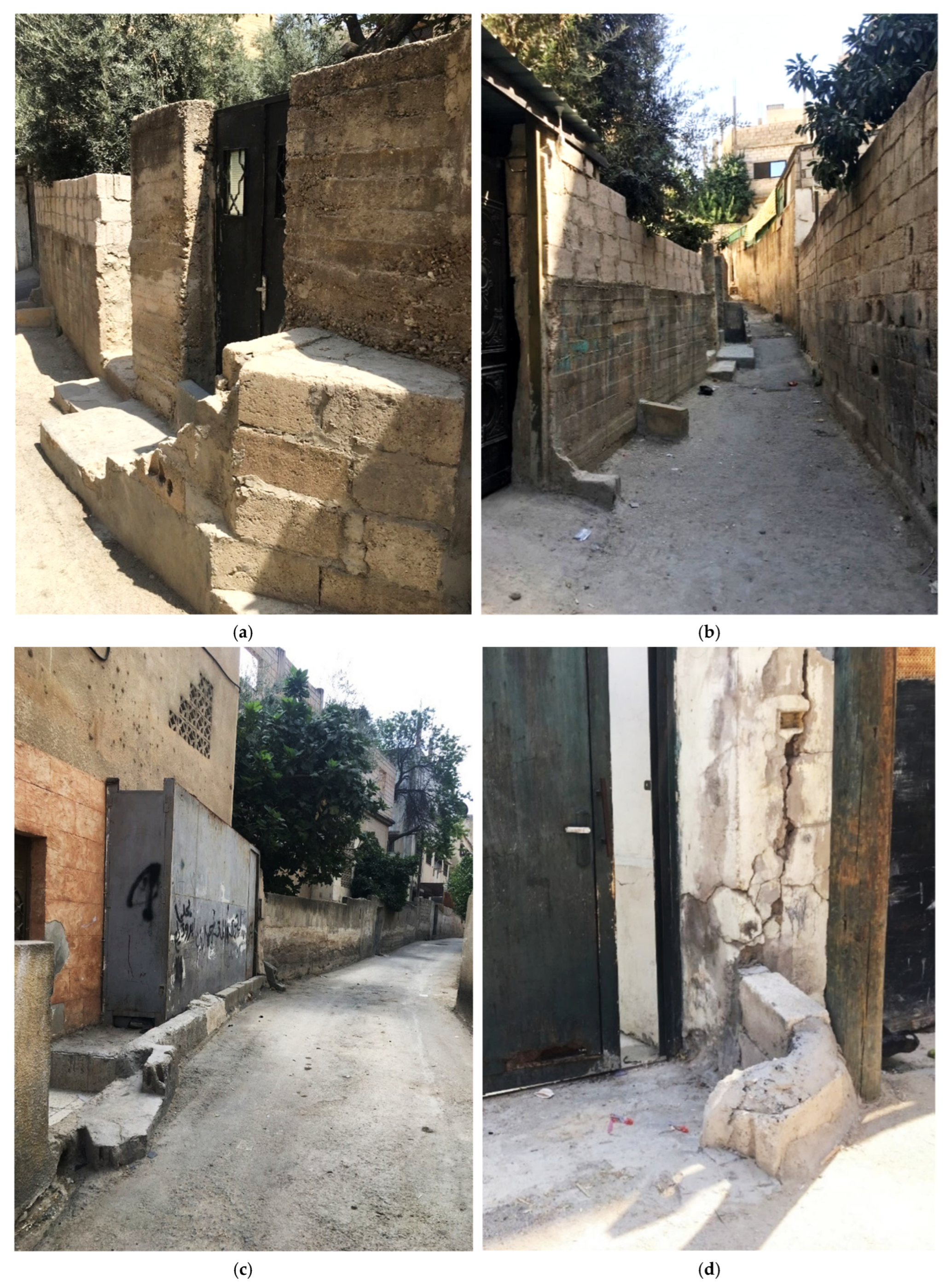
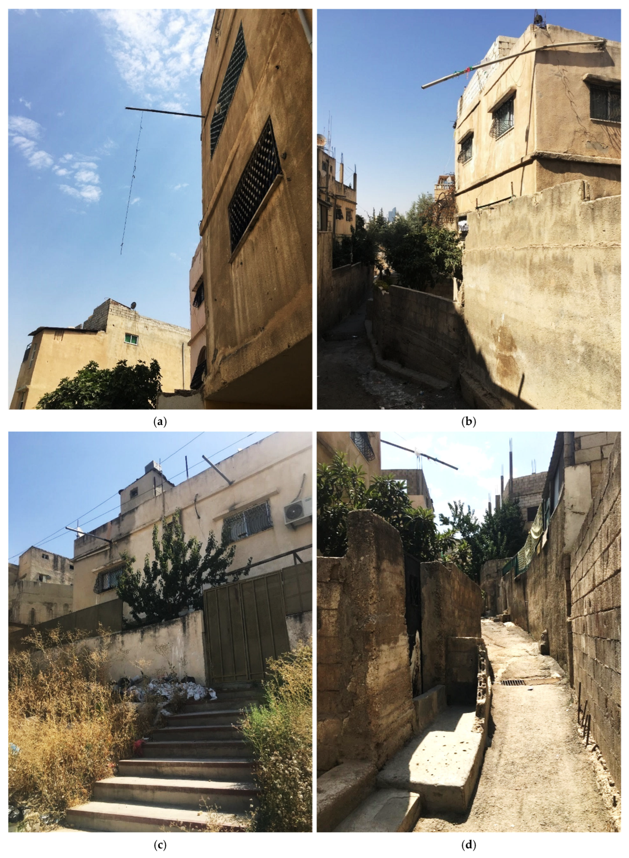
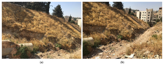
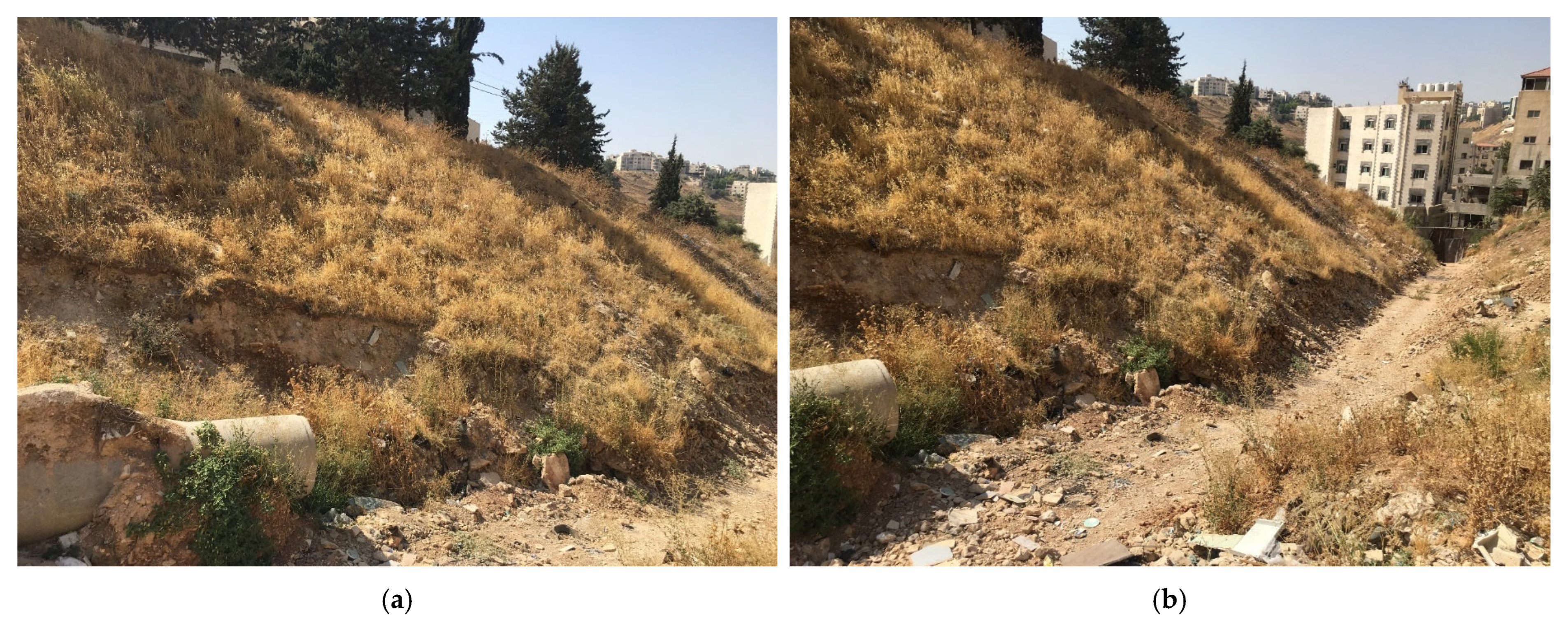
Disclaimer/Publisher’s Note: The statements, opinions and data contained in all publications are solely those of the individual author(s) and contributor(s) and not of MDPI and/or the editor(s). MDPI and/or the editor(s) disclaim responsibility for any injury to people or property resulting from any ideas, methods, instructions or products referred to in the content. |
© 2026 by the authors. Licensee MDPI, Basel, Switzerland. This article is an open access article distributed under the terms and conditions of the Creative Commons Attribution (CC BY) license.