


Abstract
The intensification of agriculture and large-scale rural development policies present major challenges to the sustainability of agroecosystems worldwide. In China, the ‘Rural Revitalization Strategy’ has reshaped rural landscapes, yet its net impact on the interplay between agricultural production, ecosystem health, and human well-being remains poorly quantified at a national scale. This study investigates the spatiotemporal dynamics of Rural Ecological Livability (REL)—an integrated measure of agroecosystem health and quality of life—and identifies its key agro-ecological and socioeconomic drivers across 31 Chinese provinces from 2005 to 2020. We employed an innovative evaluation framework and a nested-weight spatial Durbin model to analyze these complex interactions. Our findings reveal a significant, yet spatially uneven, improvement in REL, with a persistent gradient between developed coastal regions and inland agricultural provinces. Forest coverage and moderate climatic conditions were key positive local drivers of REL. Crucially, our model uncovers significant negative spatial spillovers, demonstrating that intensified agricultural mechanization in one province can degrade the ecological livability of neighboring agroecosystems, likely through increased market competition and resource pressure. These results reveal a critical tension between local agricultural modernization and regional environmental sustainability. They underscore the necessity for agri-environmental policies that transcend administrative boundaries and manage landscape-level spillovers to achieve truly sustainable agroecosystem management.
1. Introduction
Although urbanization is a growing trend, almost half of the world’s population (44%) continues to reside in rural areas [1]. The United Nations SDGs aim to tackle poverty, protect the environment, and promote peace and prosperity [2]; improving rural ecological livability (REL) is essential for achieving these targets [3]. However, rural areas face numerous challenges as a result of globalization and urbanization, including the weakening of rural industries and the erosion of traditional livelihoods [4]. Over future decades, it is expected that urban areas will continue to expand, and rural citizens will continue to gradually migrate to urban areas [5]. Thus, while cities become more densely populated, rural areas face distinct challenges, including limited access to quality healthcare [6,7]. Climate change, population change, and economic globalization are also threats to agricultural sustainability and livability in rural areas [8,9]. Therefore, increasing access to clean water and sanitation infrastructure, improving green coverage rates, and promoting sustainable agricultural production are crucial for fostering a livable lifestyle in rural communities, which, in turn, promotes urban and rural social equity and stability [10,11].
Community livability refers to the harmonious association between human development and the well-being of its natural, cultural, and ecological aspects [12,13,14]. However, livability differs in interpretation according to research perspective; some researchers interpret it as the environmental quality and suitability of living spaces [15,16], while others consider it the fairness and satisfaction of social welfare for residents [17,18], ecological resilience [19], or land-carrying capacity [20]. These concepts are used to explore REL levels at the regional scale. To assess the fairness of changes in human settlements and access to public services, researchers have generally used three evaluation techniques. One is remote sensing and spatial analysis. Using Landsat satellite images, Zhu et al. [21] derived surface vegetation coverage, temperature, and humidity data; coupled them with socioeconomic data; and constructed a Human Settlement Environment Development Index. Another is first-hand household survey data analysis. These data are collected to assess resident perceptions of the accessibility and fairness of natural and social welfare in residential communities. Türkoğlu [22] investigated housing and neighborhood characteristics, including housing size, physical condition, and access to municipal services, and found that subjective evaluations of these factors significantly influence residents’ satisfaction in Istanbul. The third is socioeconomic data analysis. These data are used to establish evaluation frameworks for comprehensively assessing community environment at the regional level. Li et al. [23] employed a framework to evaluate community living environments based on five dimensions: infrastructure conditions, public services, environmental health, employment opportunities, and social participation. However, most human settlement research focuses on urban areas, implying that rural areas have been generally overlooked. Nevertheless, the results of these studies suggest that REL can be holistically measured using similar frameworks.
Rural areas have unique ecological livability characteristics, such as low population density and semi-natural ecosystems [24]. Although rural areas are considered ecologically livable based on their production, living, and ecological features, they often find themselves at a disadvantage, lacking the political power and resources needed to protect their land from exploitation [25,26,27]. Integrated agroecological practices and sustainable rural community development are inextricably linked to Sustainable Development Goal (SDG)-focused rural development [28]. Several studies have demonstrated that eco-friendly agricultural practices, such as reduced tillage, can enhance farmer income and dietary diversity and reduce environmental externalities associated with the agricultural industry [29,30,31]. Combining agroecological practices and local livability improvement initiatives leads to great improvements in the quality of life of rural communities [32,33]. However, the lack of proper protection may lead to the collapse of these “ecological livability” systems, which can be devastating to rural communities’ economies and relate to, for example, loss of livelihoods [34,35]. As an example of efforts to ensure REL, several aboriginal communities have been working collaboratively with conservation organizations to preserve the boreal caribou in Canada, which is essential to its regional habitat/biodiversity, and to provide economic opportunities for residents [36]. Overall, REL depends on tailored infrastructure, education, agroecology, and tailored policies. Therefore, it is crucial to develop initiatives that support rural communities in adapting to future changes, such as through investments in renewable energy sources, while also ensuring their REL.
China’s rural areas are undergoing rapid transformation, and the development of urban–rural relations is at a turning point, making it essential to understand both the spatial distribution and temporal evolution of REL [23,37]. While urbanization has accelerated in the country since the year 2000, discordant phenomena have concomitantly hindered sustainable rural development. Many Chinese people in rural areas remain in poverty because of the lack of basic services and infrastructure. Consequently, rural communities face greater disadvantages and exclusion than urban communities. To mitigate these challenges, governments and organizations must focus on creating sustainable strategies for rural development [38]. In 2005, the Chinese government started to gradually increase investment in agricultural and rural construction, proposing the strategy of “industry nurturing agriculture, cities supporting rural areas.” It started by providing a layout of agricultural production, a unified urban–rural labor market, and rural healthcare and basic medical services [39]. In 2018, the “Opinions of the Central Committee of the Communist Party of China and the State Council on Implementing the Rural Revitalization Strategy” gave rise to a period of continued promotion of solutions to the “three rural issues” (san nong), namely agriculture, rural areas, and farmers [40]. This document placed great policy attention and financial preference on rural development, which led to the improvement of the livelihood and access to markets, technologies, and capital for rural populations [41]; these factors are closely related to REL and sustainable development in rural areas. However, some questions remain unanswered: has China’s REL improved since the implementation and transformation of urban–rural relations through the aforementioned policy? Are any regional economic ties or related factors hindering REL improvements? Answering these urgent questions requires more evidence on the REL change dynamics, change differences across regions, and underlying causes of REL improvement or lack thereof.
In the face of escalating global ecological challenges and the urgent need for sustainable rural development, this study offers a timely and critical exploration of China’s REL—a subject of immense significance both nationally and globally: (1) Focusing on a pivotal phase in China’s urban–rural transformation from 2005 to 2020, which was marked by substantial ecological and green economic transitions, this study uncovers the spatial and temporal dynamics of rural livability during this critical period. Given China’s vast rural population and its influence on global ecological systems, these findings provide actionable insights for global ecological governance and sustainable rural development amid rapid industrialization and urbanization. (2) To address gaps in the existing research, this study establishes a quantitative framework for evaluating REL. Unlike previous studies, which have largely remained theoretical, we draw from established urban livability metrics to introduce tailored indicators encompassing green agricultural production, environmental sustainability, life convenience, education and entertainment, and material living standards. This framework not only advances the quantification of REL but also offers practical tools for replicable measurement, filling a significant void in the literature. (3) Furthermore, the study employs advanced spatial econometric models and adopts a geographic interconnection perspective to analyze the factors driving spatial and temporal evolution, as well as regional disparities in REL. This comprehensive analytical approach reveals nuanced development patterns across China’s diverse rural areas, providing robust scientific evidence to support policymaking for sustainable rural habitat construction and ecological revitalization. By integrating strategic timing, a tailored evaluation framework, and advanced analytical methods, this paper delivers both theoretical advancements and practical guidance. It underscores the urgency of addressing REL in China while highlighting its broader global ecological implications, making a vital contribution to the discourse on sustainable development.
Accordingly, this study pursues three aims: to measure the spatiotemporal evolution of rural ecological livability (REL) across China’s 31 provinces from 2005 to 2020; to identify its determinants across four dimensions (natural resource endowment, rural environmental governance, rural construction investment, and agricultural technology progress), rather than treating them as a single agricultural-development construct; and to quantify the cross-provincial spatial spillovers of these determinants. The rest of this paper is organized as follows. Section 2 presents the theoretical framework and literature review for the study. Section 3 presents the methods and data for measuring REL scores across 31 Chinese provinces between 2005 and 2020. Section 4 presents the results on the spatiotemporal evolution and regional differences in REL, Section 5 provides the discussion, and Section 6 concludes the study.
2. Theoretical Framework and Literature Review
2.1. Theoretical Foundation for Rural Ecological Livability
Rural ecological livability rests on three theoretical traditions that together explain how spatial, temporal, and systemic factors shape rural development. The first, sustainable development theory, suggests that rural livability requires ecological sustainability and social well-being to advance simultaneously rather than in sequence [2,42]. Because rural areas function as nodes within wider social–ecological systems, changes in their land use and livelihoods propagate to the broader ecological and social systems that surround them [43]. Sustainable rural development therefore cannot be achieved through single-sector interventions; it depends on integrated strategies that connect renewable energy, agricultural transformation, and the wider Sustainable Development Goals [3].
The second tradition, spatial economics, provides a framework for understanding how geographic proximity, economic connectivity, and institutional relationships generate interdependence among rural regions [44]. Development in one region produces spillover effects that reach its neighbors through market linkages, knowledge flows, and environmental connections, so that rural livability is shaped as much by the relations between regions as by the conditions within them [45]. This perspective revises the assumption that rural areas are spatially isolated, showing instead how economic integration forms functional regions that transcend administrative boundaries and cohere through economic complementarity rather than mere physical proximity [46].
The third tradition, human settlement theory, links these spatial-economic processes to the lived experience of rural residents [13,22]. In this view, livability emerges from the interaction of built environments, natural systems, and social institutions that jointly determine quality of life [17]. Rural settlements differ systematically from urban areas, exhibiting lower population densities, greater dependence on natural resources, and closer coupling between economic activity and ecological processes [24]; these differences create both opportunities and constraints that call for place-specific development strategies, as empirical studies of rural livability in China have demonstrated [14].
2.2. Spatial Integration Mechanisms and Development Trajectories
Taken together, these traditions imply that local endowments and regional processes are connected through several concrete channels. Geographic proximity operates through ecosystem-service flows, shared infrastructure systems, and institutional closeness, which create opportunities for coordinated governance and resource sharing [47]. This mechanism helps to explain why geographically clustered regions tend to follow similar development trajectories, whereas isolated regions remain persistently disadvantaged in accessing the resources and opportunities upon which livability depends.
Economic spillovers travel through market integration, labor mobility, and supply-chain linkages that bind provinces into functional economic regions extending beyond administrative boundaries [44]. These processes generate externalities in both directions: productivity gains in one region may provide neighboring areas with new markets and technology transfer, yet can simultaneously expose them to intensified competition. Because the resulting spatial pattern reflects economic complementarity rather than simple distance decay, it is economic geography, rather than physical geography, that governs the strength and direction of inter-regional influence.
Whether these spillovers draw regions together or push them apart depends on local adaptive capacity. Where such capacity is high, agglomeration economies, knowledge spillovers, and coordinated governance reinforce one another to produce self-sustaining advantage, while regions that lack it experience persistent marginalization [45]. Convergence is further mediated by threshold effects: a region must possess a minimum level of institutional capacity and resource endowment before it can participate effectively in regional development networks [48].
2.3. Natural Resource Endowments and Ecological Sustainability Foundations
Natural resource endowments constitute the material basis of rural ecological livability, both directly, through the provision of ecosystem services, and indirectly, through their influence on economic opportunity and environmental quality [49]. Climate, forest coverage, water availability, and resilience to disaster define the parameters within which rural development proceeds. These endowments are not fixed assets but dynamic systems that respond to management practices and environmental change over time [50]. Their relationship with livability is nonlinear, since benefits accrue within an optimal range rather than increasing steadily with the quantity of any single resource.
Forest coverage exemplifies this dual character. It supports rural livability through carbon sequestration, watershed protection, biodiversity conservation, and recreation [51], yet it also places regions in competition with one another, since a well-endowed province can capture tourism revenue and ecological transfer payments that might otherwise reach its less-forested neighbors. Because forest resources are simultaneously a local asset and a source of inter-regional rivalry, environmental governance requires coordination mechanisms that are capable of managing the spatial externalities that they generate [52].
Water resources and climate conditions impose more fundamental constraints, shaping agricultural productivity, settlement patterns, and the scope for economic diversification [47]. Livability is highest under moderate temperature and precipitation, which sustain agricultural diversity while limiting exposure to extreme weather. Regions outside this range face either aridity, which restricts agricultural potential, or excessive heat and moisture, which depress both output and quality of life; this trade-off underscores the value of ecosystem-service science in environmental decision-making [53].
2.4. Rural Development Paradigms and Multifunctional Agriculture
The rural development paradigm has evolved beyond production-centered models toward multifunctional approaches that integrate ecological sustainability with economic viability and social well-being [11]. This shift recognizes that rural areas perform several functions within broader territorial systems, including food production, environmental services, cultural preservation, and recreation. The multifunctional approach aligns closely with the principles of ecological livability, since both emphasize the integration of production, living, and ecological spaces within rural territories [23,26].
Multifunctional agriculture and multifunctional rural development, though related, are not interchangeable. The former centers on the roles of farming itself, whereas the latter is broader, encompassing non-agricultural activities and, increasingly, the environmental functions of rural areas. In the economic literature, these are termed the non-commodity outputs (or non-commercial functions) of agriculture and rural areas: goods such as landscape, biodiversity, and environmental services that are jointly produced with commodities but exhibit externality and public-good characteristics [54,55]. In this study, we retain multifunctional agriculture for the functions of farming itself while incorporating the broader environmental dimension of multifunctional rural development, with which rural ecological livability is closely aligned through these non-commodity functions.
Agroecological practices form a central component of this agenda, enhancing agricultural productivity and environmental quality together while improving farmers’ well-being [29,30]. Reduced-impact methods that build soil health and conserve biodiversity demonstrate how technological innovation can support rural livability rather than erode it. Their adoption, however, is not automatic: it depends on supportive policy frameworks and institutional arrangements that facilitate knowledge transfer and reward environmental stewardship [31].
Decoupling agricultural output from environmental degradation remains the central challenge of rural development, particularly in rapidly developing economies where intensive farming practices can compromise long-term sustainability [41]. Addressing it depends on continued technological progress and on optimizing the scale of production, so that gains in output do not come at the expense of ecological integrity. Sustainable outcomes thus require aligning agricultural modernization with the maintenance of the ecological systems upon which rural livelihoods ultimately depend.
2.5. Policy Intervention Effects and Governance Mechanisms
Policy influences rural livability along two tracks simultaneously, building local development capacity and reshaping relationships between regions [35]. Infrastructure investment improves transport access, communications, and service delivery, and in doing so alters each province’s position in regional competition and market integration. Investment in education and cultural services strengthens human capital and social cohesion, and supports the population retention and community identity that underpin long-term sustainability [20].
Because local actions and system-wide outcomes are tightly coupled, the governance of sustainability transitions must be coordinated rather than fragmented [48]. Isolated policy interventions rarely raise rural livability on their own; what proves effective are integrated governance arrangements that align multiple sectors and scales of action, and that establish the enabling conditions under which adaptive capacity and institutional learning can develop. The effectiveness of such governance therefore rests less on the intensity of any single intervention than on its capacity to coordinate across the actors and levels involved.
Historical development decisions continue to influence contemporary outcomes through institutional lock-in, accumulated advantages or disadvantages, and social learning processes that become embedded in local development cultures. Policy interventions can nevertheless create critical transition points at which targeted investment shifts a region’s development trajectory toward a more sustainable path [45]. This path dependence helps to explain why similar interventions produce divergent outcomes across regions, depending on local conditions and institutional context.
Taken together, these traditions yield three testable expectations for China’s provinces. First, REL should have improved over 2005 to 2020 but unevenly, widening the gap between the developed eastern coast and the inland provinces (H1). Second, the four determinant dimensions (natural resource endowment, rural environmental governance, rural construction investment, and agricultural technology progress) should each shape a province’s own local REL (H2). Third, because provinces are economically and geographically linked, these determinants should also generate cross-provincial spillovers, with agricultural mechanization in particular exerting a negative effect on neighbors (H3). We test these expectations with a nested-weight spatial Durbin model.
3. Materials and Methods
3.1. Evaluation System for REL
A prerequisite for rural area sustainable development is ensuring that rural residents have a suitable way of life, a sustainable resource utilization, and a sustainable space use for rural production and life [56]. As farmers are the main driving force of rural development, it is fundamental that they have a suitable living environment to secure rural area survival. REL refers to the harmonious development of agricultural production, living, and ecological spaces through institutional arrangements and projects and adherence to ecological, social, and economic development laws [26]. In this study, sustainable development was used as a guiding principle and goal, leading to the construction of an REL evaluation index system focusing on the integration of production, living, and ecological spaces.
Rural living environments are highly coupled with nature and culture. Livability refers to living- and enjoyment-related human needs [57]. Thus, rural ecology refers to the promotion of a harmonious human–nature development through improving the rural ecological environment, thereby creating an organic circulation system between farmers’ production, life, and ecology [56]. Rural livability refers to the efforts to ensure that farmers have access to good lives, encompassing the development and maintenance of essential infrastructure, such as rural sewage systems, alongside access to cultural, sports, and healthcare services [58]. Therefore, REL should be divided into two levels: ecological sustainability and living comfort. REL’s living comfort includes the convenience and availability of basic infrastructure in rural areas, and its ecological sustainability refers to the green transformation of rural villages and sustainable resource utilization in the natural ecological system (Figure 1). Ecological sustainability and living comfort reflect the multidimensional relationships between rural livability and ecology.
Figure 1.
Theoretical evaluation and factors influencing the ecological basis of rural ecological livability. The labelled arrows denote the mechanisms linking rural ecological livability with and among its three dimensions—spatial integration, ecological sustainability, and living comfort—namely enhancement, optimization, feedback, transition, reconstruction, coordination, and spillover.
The design of the evaluation indicators was guided by key principles, including scientific validity, systematic structure, comparability, and operability. These indicators were organized under the two levels defined above, reflecting rural economic development. The evaluation indicators encompass five secondary indicators and 24 tertiary indicators. Of the five secondary indicators, green agricultural production encompasses factors related to reduction in the adverse effects of agricultural products while ensuring production. Environmental sustainability encompasses the factors of sustainable development while ensuring ecological safety. Life convenience refers to quality of life improvement factors. Education and entertainment relate to factors that improve cultural literacy and leisure activities. Material living encompasses factors related to farmer income, as shown in Table 1.
Table 1.
Evaluation index system of REL.
3.2. Indicator Weight Calculation
3.2.1. Data Standardization
Based on the nature of the evaluation indicators, to eliminate the influence of dimensionality, the positive and negative extreme value methods were used to standardize the initial indicators. Initial standardized scores were then subjected to a comprehensive standardization calculation (Equation (1)):
where and are the original and standardized values of indicator j in year i, respectively, and and are the maximum and minimum values of indicator j, respectively.
3.2.2. Weighting of Indicators
Indicator weights were determined objectively using the information-entropy weight method, which assigns each indicator a weight according to the amount of information (variability) it carries, thereby avoiding subjective bias.
Information Entropy
The weights of indicator for province i (Equation (2)) and information entropy are calculated using Equation (3). The size of reflects the degree of dispersion of its numerical distribution, so that the larger the , the higher the dispersion.
Entropy Weight
Using the information entropy of index j in the ith province, we calculate the weight of each index (Equation (4)). The more information () the indicator contains, the greater its role in the comprehensive evaluation and its weight ().
where m (24 in this study) is the number of evaluation indicators.
3.3. Model Settings
To investigate the impact of natural resource endowment and rural construction investment on REL, we consider the spatial relationship of variables using the spatial error model (SEM), spatial autoregressive model (SAR), and spatial Durbin model (SDM). The spatial Durbin model has been widely used because it considers the dependencies in the spatial relationships [44], and it is as follows:
where , , , and represent natural resource endowment, rural construction investment, rural environmental governance, and agricultural technological progress of province i in year t. to represent the estimated coefficient, represents the individual-fixed effect, represents the time-fixed effect, represents the error term, and represents the spatial weight matrix.
The spatial weight matrix in SDM focuses on quantifying the proximity between regions using spatial adjacency (0–1) weight and inverse distance matrix. However, these two indices only reflect regional correlations and do not consider economic connections. This study thus used nested matrices of economic and geographical distances () to reflect regional geographical proximity and economic connectivity. The matrix is set as , where is the geographic distance matrix; specifically, , and is the geographic distance between i and j calculated from their respective latitudes and longitudes; the larger the , the higher the economic connection caused by the geographical proximity between provinces. Meanwhile, , and means that province i is in for the per capita GDP at constant prices from 2005 to 2020. belongs to the economic distance matrix, and represents the proportion of the geographical distance matrix. In this study, is set to 0.5.
Regarding variable selection, this study focused on explanatory factors of changes in REL from four perspectives: natural resource endowment, rural environmental governance, rural construction investment, and agricultural technology progress, as shown in Table 2.
Table 2.
Explanatory variables and descriptive statistics for the regional differentiation of REL in China.
- Natural resource endowment. Natural resources and geographical factors affect rural development and are an important material basis for realizing REL. Considering data availability, this study uses annual precipitation, annual average temperature, forest coverage, and crop damage areas as indexes of rural area natural resource endowment. The higher the forest coverage, annual precipitation, and annual average temperature, the better the natural resource endowment condition. The larger the crop damage area, the more susceptible agricultural production is to natural disasters, which is unfavorable for agricultural production.
- Rural environmental governance. Promoting sustainable use of the rural ecological environment is also key to improving REL. Afforestation and soil and water conservation areas were used as indices of rural environmental governance. The larger the area of afforestation and soil and water conservation, the more effective the protection of the rural environment and promotion of rural sustainable development.
- Rural construction investment. Increasing investment in public infrastructure, particularly in areas such as rural sanitation, can result in various benefits, including improved environmental governance, pollution control, rural hygiene standards, a stronger sense of belonging among residents, and greater community livability, all of which enhance rural ecological livability (REL). In this study, rural construction investment was measured by the investment in sanitation facilities and the proportion of village planning and construction.
- Agricultural technological progress. Rural social and economic activities interact with the natural environment through agricultural production. Improvements in agricultural technology progress can affect REL in the following ways, all of which improve the rural environment: it can reduce waste/pollution related to land use and improve land utilization rate and boost productivity; technological progress in rural environmental protection can improve the living environment and the livability of rural areas.
3.4. Spatial Autocorrelation Test
Interregional connectivity refers to the similar attributes of geographically close regions. A prerequisite for building an SDM is considering the degree of correlation between variables in different regions. Thus, this study introduces the global Moran’s I index to measure the similarity between variables in two or more regions; this serves to measure the correlation of the study object at different spatial locations and is calculated as follows:
where represents the number of spatial units; i and j are the index numbers of two spatial units; x is the relevant variable; is the average value of ; is the spatial weight between spatial units i and j; and is the total sum of . The value of I ranges from −1 to 1. If I < 0, region i has a strong negative spatial correlation with neighbor j. If I = 0, there is no spatial correlation. If I > 0, a there is a strong positive spatial correlation with neighbor j. These tests allow for determining whether REL and its explanatory variables are spatially correlated. All spatial econometric models were estimated in Stata 18 (StataCorp LLC, College Station, TX, USA), and all maps were produced in QGIS 3.34 (QGIS Development Team, QGIS Association, Grüt, Switzerland).
4. Results
4.1. Spatiotemporal Evolution of REL in China
From 2005 to 2020, China’s REL grew steadily from 0.386 to 0.435. Rural environmental protection significantly improved, with ecological sustainability increasing from 0.243 (2005) to 0.265 (2020). Living comfort also increased, from 0.143 (2005) to 0.170 (2020), with increasing education, medical care, and transportation indicators, as shown in Figure 2. There has been a noticeable fluctuation in ratings since 2014; a peak was reached in 2019, followed by a broad plateau through 2020.
Figure 2.
Temporal trend of REL in China (2005–2020) (a) and its subconstruct scores (b). In (a), the red line with markers shows the national mean REL and the grey bars denote its annual values; in (b), the green and blue lines denote the ecological sustainability and living comfort subconstructs, respectively.
Significant spatial differences were observed in REL (2005–2020), particularly between the southeastern coastal areas and northwestern inland areas, as shown in Figure 3. In 2005, provinces with the best REL were located along the eastern and southern coasts, and Beijing and Sichuan had the best REL inland. Although REL values increased over time, Beijing, Shanghai, Jiangsu, and Sichuan consistently maintained a leading position, with REL values ranging from 0.45 to 0.60. In Hebei, Tianjin, Henan, Zhejiang, Fujian, and Xinjiang, REL values were also relatively high, ranging from 0.40 to 0.45. In 2015, high REL values accounted for a higher proportion of the total values than low values. Almost every locality in China showed an REL over 0.35, except for the Tibet Autonomous Region, which had an REL below 0.35. In the eastern coastal provinces and in Sichuan and Chongqing, REL values were generally higher than 0.45. In 2020, REL values in most localities ranged from 0.45 to 0.60. The exceptions were Tibet, Qinghai, Gansu, and Liaoning, where the REL was lower than 0.45. Extremely high values, above 0.60, were observed in Sichuan and Jiangsu. Regarding the average growth rate, REL significantly improved in western provinces, including Tibet, Sichuan, Inner Mongolia, Gansu, and Guizhou, with an increase of approximately 83%. In the more developed eastern provinces, including Guangdong, Tianjin, Shanghai, and Beijing, the average growth rate was lower, at approximately 23%.
Figure 3.
Spatial distribution of REL in China in 2005 (a), 2010 (b), 2015 (c), and 2020 (d).
This study classified average REL values across provinces from 2005 to 2020, using the natural breakpoint method, as shown in Figure 4. Beijing, Shanghai, Sichuan, and Jiangsu are in the first gradient, with REL values ranging from 0.48 to 0.54. The second gradient includes Zhejiang, Tianjin, Fujian, Hebei, Guangxi, and Chongqing, where REL values range from 0.42 to 0.48. The western provinces of China, including Guizhou, Gansu, Qinghai, and Tibet, exhibited the lowest RELs. In terms of ecological sustainability, the eastern provinces recorded values ranging from 0.20 to 0.26, followed by the western provinces with values between 0.21 and 0.27. The central provinces showed comparatively lower values, ranging from 0.19 to 0.24. For living comfort, the eastern provinces ranged from 0.16 to 0.24, the central provinces from 0.17 to 0.20, and the western provinces from 0.13 to 0.24, with the western region recording the lowest levels overall. Therefore, the eastern provinces showed the highest standards of ecological sustainability and living comfort, and the northeastern and western provinces showed relatively high levels of ecological sustainability. The central region has a moderate level of living comfort and lower ecological sustainability.
Figure 4.
Ranks of the average REL, ecological sustainability, and living comfort for China’s provinces (2005–2020).
4.2. Spatial Agglomeration of REL in China
Table 3 shows that the global Moran’s I statistic consistently exhibits a significant positive correlation with China’s REL. The global Moran’s I of REL was significantly positive at the 1% level in 2005, 2010, 2015, and 2020, and indicated an increasing trend over time. Thus, China’s REL displayed an agglomeration effect in space that gradually increased in the studied period.
Table 3.
The global Moran’s I of REL in China.
Regarding spatial distribution, the eastern region showed mostly a positive correlation, as indicated by the significant positive autocorrelation relationship in the local spatial autocorrelation coefficient matrix, as shown in Figure 5. Zhejiang and Fujian were high-value agglomeration areas for REL, whereas Shanxi, Shaanxi, Heilongjiang, and Tibet formed contiguous low-value agglomeration areas. The Pearl River Delta and west coast of the Taiwan Strait formed another high-value agglomeration area for REL. In the western region, large-scale low-value agglomeration areas formed in the border areas of Shaanxi, Gansu, and Ningxia. Additionally, three smaller low-value agglomeration areas were distributed in Guangxi, Heilongjiang, and the adjacent areas of Hunan and Guangxi.
Figure 5.
Distribution of spatial autocorrelation types for 2005 (a), 2010 (b), 2015 (c), and 2020 (d), for REL in China.
4.3. Temporal Trends and Regional Differences in Second-Level Indicators of REL in China
Rural areas in China have shown multidimensional improvements in second-level indicators of REL from 2005 to 2020. Figure 6 illustrates the temporal evolution of REL and its regional disparities across China from 2005 to 2020. Regarding ecological sustainability from 2005 to 2020 across regions, the western region consistently ranked the highest, followed by the eastern and northeastern regions. Despite improvements in the central region regarding green agricultural production, the pace of improvement slowed down, making it the lowest-scoring region in China. Regarding environmental sustainability, the central region showed the greatest improvement, and despite the gradual improvement in the northeastern region, it ranked relatively low. Concerning education and entertainment, they showed an upward trend across regions, with a significant difference in the scores between the western and central regions of China in 2005; still, all had improved in this factor by 2020. Pertaining to life convenience, the eastern region consistently outperformed all other regions. Still, both life convenience and material living scores increased significantly across all regions of China, with the eastern region enjoying a higher quality of life.
Figure 6.
The temporal evolution of REL and its regional (eastern (a), central (b), western (c) and northeastern (d)) differences in China from 2005 to 2020 (e). GP, green agricultural production; ES, environmental sustainability; LC, life convenience; EE, education and entertainment; ML, material living.
4.4. Influencing Factors of the Spatiotemporal Evolution of REL in China
4.4.1. Climatic Conditions
We also examined the relationship between climatic conditions—specifically, annual average temperature and annual precipitation—and rural ecological livability (REL) at the provincial level. Climatic conditions and REL showed an inverse U-shaped relationship, with temperature having the greatest impact on REL (Figure 7). The general trend of annual precipitation in China shows a gradual decrease from the southeastern coast to the northwest inland, and the REL levels of Shanghai, Sichuan, Jiangsu, and other provinces with an annual precipitation of approximately 1000 to 1200 mm were the highest. Meanwhile, the REL of southeastern provinces—including Guangdong, Hainan, and Fujian—with an annual precipitation of more than 1500 mm and the arid (annual precipitation of less than 500 mm) northwestern provinces such as Xinjiang, Inner Mongolia, Gansu, and Tibet, were significantly lower.
Figure 7.
Relationships between average REL and annual precipitation (a) and average temperature (b). In each panel, the solid curve is the fitted quadratic relationship and the blue band its 95% confidence interval; the green band marks the estimated optimum, and point color denotes the aridity index.
A high REL level was observed in provinces with an average annual temperature of 15 °C, including Zhejiang, Jiangsu, and Chongqing. In places with an average annual temperature over 20 °C, REL significantly decreased.
4.4.2. Natural Resource Endowment and Socioeconomic Impacts Based on the SDM
Model selection was conducted using panel data, as shown in Table 4. To test whether the panel data could be used for a mixed ordinary least squares (OLS) regression model model, we first examined spatial errors and lags using the LM test. The results showed that the mixed OLS model had to be rejected because of the apparent coefficient estimation bias. Fixed-effects models were shown to be more effective than random-effects models when dealing with regional and multivariate time-series data. Based on the Hausman test results, the fixed-effects model was better than the random-effects model. A nested economic distance matrix was incorporated into the SDM to analyze the spatial agglomeration impact of the factors on REL. Assuming that the SDM was chosen, a likelihood ratio test was conducted to determine whether it should be simplified into an SAR model or SEM. The study data were shown to be more suitable for establishing an SDM.
Table 4.
Model selection related tests.
Estimation Results and Discussion
We estimated a simple empirical model (Model 1) with no fixed effects, using the OLS model as a reference. In Models 2–4, time and individual fixed-effects are controlled for using ordinary fixed-effects panel regression models. Model 5 is a fixed-effects panel regression model with robust standard errors, which correct for potential non-normality and heteroscedasticity in the errors. In Model 6, a nested economic distance matrix was introduced and the regression results from the SDM were applied (Table 5).
Table 5.
Estimation results of different fixed-effect models.
Regarding natural resource endowment, Models 4–6 showed that forest coverage (FrstCvrg) significantly affected REL at the 1% level. Thus, forest coverage had a significant and effective improvement effect on REL. Crop damage area (CropDmg) had a negative effect on REL, although its significance under the two-way fixed-effects specification is unclear. Areas with crop damage hinder agricultural production and ecological sustainability. However, an area with crop damage is unlikely to reflect the regional governance capacity related to natural conditions, making its negative correlation weak when considering the long term. Certain areas may be prone to natural disasters, which may damage crops and negatively affect regional REL. Still, the regional government cannot control such factors; therefore, this does not necessarily indicate a weak governance capacity. This also means that proper management of these natural disasters can substantially reduce the impact of crop damage area on regional REL.
Regarding rural environmental governance, the results indicate that soil and water conservation areas (SoilEroCtl) significantly impact REL by at least 5%. In the short-term, China intends to conserve soil and water by planting trees, building soil conservation projects, and improving agricultural productivity. These efforts are expected to reduce soil erosion, improve soil fertility, and increase water availability, improving the ecological environment and REL. Afforestation expansion (Afforest) is currently occurring in areas with relatively poor ecological conditions, as it can improve the environment by reducing soil erosion, water conservation, and the amount of carbon stored in the soil. This may reduce the effects of climate change, improve air quality, and reduce water pollution.
Furthermore, rural villages with high public sanitation facility (RII_Sanit) levels positively influenced REL; specifically, there has been an increase in the number of public facilities being built to improve sanitation in rural villages, which led to an increase in rural infrastructure investment. REL is often positively correlated with the rural economy investment capacity. Additionally, if sanitation facilities are on place, waterborne diseases can be more efficiently prevented and overall health improved. They also boost the productivity of rural workers and encourage economic growth, enabling rural economies to invest more.
Regarding rural construction investment, Models 1–3 indicate a positive correlation between the proportion of village planning and construction (RII_Renov) and REL; Models 4–5 demonstrate a negative correlation, albeit the coefficient values are small. This may be because village planning and construction are important processes for improving REL, and the one-way effects of these initiatives positively influence REL. Village planning and construction are crucial for protecting and preserving the natural environment and improving quality of life in communities by controlling land use and preventing overdevelopment. In environmentally friendly villages, it is less likely for harmful pollutants to be released and contaminate the air, water, and soil, helping with natural resource conservation. Moreover, green infrastructure construction in villages can foster a sense of community and improve residents’ quality of life by providing them with access to green spaces, public transportation, and other amenities.
Regarding agricultural technological progress, agricultural mechanization can enhance the agricultural production efficiency and maximize land resources. Farmers can increase their income and living standards by increasing their agricultural machinery input, which in turn increases the agricultural production efficiency and speed. Then, by maximizing land resource use, farmers can reduce waste and manage their land more effectively. According to our results (Table 5, Models 4–6), the mechanical input per unit sowing area (SowMech) was positively correlated with REL, but the correlation was not statistically significant. That is, agricultural machinery may directly influence agricultural production and management and significantly increase the crop yield/productivity, but may not significantly influence REL. These results show that soil and water quality improvements and rural industry establishment should also be considered when assessing the impact of agricultural technological progress.
Direct and Indirect Effects of Explanatory Factors on REL
Changes in REL can be further explained by the direct effects, which refer to influences on REL within a local area, and indirect effects, which pertain to influences on REL in neighboring regions (Table 6). Results of analyses showed that crop damage area, investment in rural sanitation facilities (RII_Sanit), and soil and water conservation areas (SoilEroCtl) do not have spatial spillover effects. Meanwhile, forest coverage (FrstCvrg), afforestation area (Afforest), and mechanical input per unit of sowing area (SowMech) had very significant spatial spillover effects, though they were diametrically opposed. If the proportion of forest coverage and investment in rural sanitation facilities in adjacent areas increases by 1% and afforestation area decreases by 1%, the local REL score will increase by 0.050, 0.001, and 0.012, respectively. Furthermore, changes in afforestation areas and agricultural mechanization in adjacent areas have a much greater impact than they do on local REL, indicating that spatial spillover effects resulting from environmental governance and agricultural technology progress can play a crucial role in changing REL for regions that are closely connected economically.
Table 6.
Decomposition of estimated direct and indirect effects based on SDM coefficients.
Robustness Test
In the nested spatial weight matrix, the parameter η governs the relative contribution of geographic proximity and economic linkage. Because η was fixed at 0.50 in the baseline rather than estimated, we re-estimated the spatial Durbin model at η = 0.25 and η = 0.75 and re-computed the direct and indirect (spillover) effects (Table 7); the η = 0.50 column reproduces the baseline decomposition reported in Table 6. The local direct effects are stable: forest coverage (FrstCvrg) retains a significantly positive direct effect across all three schemes (0.034, 0.033, and 0.036 for η = 0.25, 0.50, and 0.75; all p < 0.01), as does soil-and-water conservation (SoilEroCtl) (all p < 0.01). Most importantly, the negative cross-province spillover of agricultural mechanization (SowMech) remains significantly negative under every specification (−0.096, −0.106, and −0.080; all p < 0.01), and afforestation (Afforest) retains a positive spillover throughout. The forest-coverage spillover is negative and significant under economic or balanced weighting (−0.046 and −0.050 at η = 0.25 and 0.50) but attenuates as geographic proximity comes to dominate (η = 0.75), consistent with our interpretation that these cross-province effects are transmitted mainly through economic rather than geographic linkage. Because the sign, significance, and magnitude of the key effects are preserved, our main conclusions are not artifacts of the chosen weighting parameter.
Table 7.
Robustness of the spatial Durbin model to the geographic–economic weight ratio η.
5. Discussion
Our study provides a comprehensive assessment of rural ecological livability (REL) in China from 2005 to 2020, examining both its spatiotemporal evolution and underlying determinants through a spatial econometric approach. By developing an integrated evaluation framework that captures the multidimensional nature of rural livability and employing spatial Durbin models to analyze inter-regional dependencies, our analysis reveals three key patterns: significant temporal improvements driven by policy interventions, persistent spatial inequalities across economic regions, and complex spillover effects that both facilitate and constrain regional development. These findings contribute to understanding how rural areas navigate the tension between ecological sustainability and livability enhancement while highlighting the critical role of spatial interactions in shaping development outcomes.
5.1. Temporal Dynamics and Policy-Driven Transformation of Rural Ecological Livability
The documented increase in China’s REL from 0.386 in 2005 to 0.435 in 2020 represents a substantial shift in the country’s approach to rural development, moving from an urban-centered model toward integrated urban–rural development. This trajectory aligns with the strategic policy transitions initiated in 2005 when the Chinese government adopted the “industry nurturing agriculture, cities supporting rural areas” strategy, marking a departure from decades of resource extraction from rural to urban areas [39]. The observed fluctuation around 2014 coincides with the intensification of ecological civilization construction policies and the implementation of stricter environmental regulations, suggesting that policy adjustment periods create temporary disruptions in development trajectories. China’s post-2005 policy shift was part of a wider global expansion of agri-environmental policy. Wuepper et al. [59] record more than 6000 such policies across roughly 200 countries, which places China’s rural turn in an international context rather than a purely national one.
The decomposition of REL improvements reveals differential progress across dimensions, with ecological sustainability showing more pronounced gains than living comfort indicators. This pattern reflects the prioritization of environmental restoration and conservation in China’s recent rural policies, particularly following the 2018 Rural Revitalization Strategy implementation. The significant improvements in education, entertainment, and environmental sustainability from 2015 to 2020 demonstrate the effects of sustained policy focus and investment allocation. However, the relatively slower progress in living comfort indicators suggests persistent challenges in translating ecological improvements into quality-of-life enhancements for rural residents.
The temporal analysis reveals that policy interventions operate through feedback mechanisms rather than simple linear pathways. The government’s rural construction investments have created positive development cycles in certain regions, where improved infrastructure attracts further investment and population retention, subsequently enhancing local economic vitality and environmental quality. This phenomenon aligns with Zhao et al.’s [60] findings on rural development trajectories, where initial policy interventions can trigger self-reinforcing improvement processes. The slight decline observed after 2019 may reflect the maturation of certain policy interventions and the need for more place-specific approaches to sustain long-term growth.
5.2. Spatial Heterogeneity and Structural Inequalities in Regional Development
The pronounced spatial differentiation in REL levels across China’s four major economic zones reflects structural inequalities rooted in both natural endowments and historical development patterns. The eastern region’s consistent leadership in REL (values ranging from 0.45 to 0.60) stems from initial advantages in geographical location, infrastructure, and institutional capacity that create reinforcing development benefits. The flat terrain, favorable agricultural conditions, and proximity to economic centers have enabled eastern provinces to develop integrated agricultural value chains and rural–urban linkages that are difficult to replicate in other regions [11].
The central region’s position—characterized by high agricultural productivity in plains such as Guanzhong and Yangtze-Huai but relatively low REL scores—illustrates the distinction between economic output and ecological livability. Despite serving as China’s primary grain production base, these areas face natural resource constraints and environmental pressures that limit their overall livability potential [61]. This pattern suggests that agricultural intensification, while economically beneficial, may impose ecological costs that constrain long-term sustainability and livability outcomes.
The western region’s challenges extend beyond economic disadvantage to encompass ecological constraints. Provinces such as Xinjiang, Ningxia, and Gansu face harsh climates, water scarcity, and poor soil fertility that create fundamental constraints on agricultural productivity and rural livability [38]. The spatial isolation from economic centers compounds these challenges by limiting access to markets, technologies, and services that are essential for rural development. However, the significant improvement in western provinces (approximately 83% growth rate) compared to eastern regions (23% growth rate) suggests that targeted policy interventions can overcome some structural disadvantages, albeit from a low baseline.
The spatial autocorrelation analysis revealing increasing positive clustering (Moran’s I from 0.436 to 0.504) indicates that REL development follows regional convergence patterns within clusters while maintaining divergence between clusters. The high-value clusters in Zhejiang and Fujian demonstrate how geographic proximity facilitates knowledge spillovers, resource sharing, and coordinated development initiatives. Conversely, the persistent low-value clusters in Shanxi, Shaanxi, Heilongjiang, and Tibet suggest that disadvantaged regions become trapped in development cycles where multiple constraints interact to perpetuate underdevelopment. Similar structural traps appear outside China. San-Martín González and Soler-Vaya [62] trace rural depopulation in peripheral Spanish municipalities to self-reinforcing disadvantages in accessibility and services, while Oliva and Camarero [63] show how car dependence and poor accessibility deepen rural peripheralization. These accounts parallel the service-access constraints that hold back livability in China’s western provinces.
5.3. Environmental Governance and Spatial Spillover Effects
The spatial Durbin model results reveal complex interdependencies between local environmental governance actions and regional REL outcomes that challenge conventional assumptions about the benefits of environmental protection. Forest coverage illustrates the divergence most sharply, raising livability within a province (direct effect, 0.033) while lowering it in adjacent provinces (indirect effect, −0.050). The most likely explanation is competition for the rents that forests generate, since tourism revenue, green investment, and ecological transfer payments tend to concentrate in well-endowed provinces and to drain away from their less-forested neighbors.
The two land-conservation measures differ from forest coverage in the spatial reach of their effects. Soil and water conservation remain spatially confined: their local effect is positive (0.011), whereas their spillover is statistically indistinguishable from zero. This pattern reflects the largely in situ nature of the intervention, since mitigating erosion and disaster risk enhances agricultural productivity and stability for the implementing province alone. Afforestation exhibits the opposite configuration, imposing a modest local cost (−0.003) while generating a positive regional benefit (0.012). Such a division between localized costs and shared gains is characteristic of conservation programs [36]. Afforestation withdraws arable land from cultivation and entails long maturation lags, whereas its improvements in watershed regulation and climate function accrue across a broader area.
Whereas conservation governs the spatial distribution of ecological benefits, agricultural production governs that of economic pressure, and here, the model yields its most consequential finding. Agricultural mechanization generates a large negative spillover (−0.106) that has received limited attention in the literature. Where mechanization is adopted, output and rural incomes rise, but the resulting increase in supply exerts downward price pressure and intensifies competition in neighboring provinces. Comparable competitive externalities have been documented for agricultural technology more generally [64]. A spillover of this magnitude suggests that uncoordinated modernization may widen regional disparities rather than reduce them. That these effects propagate across space reflects economic linkage, rather than geographic proximity. The nested economic–geographic weight matrix allows provinces connected through trade and labor flows to influence one another even without shared borders. Environmental governance defined by administrative units therefore captures only part of the relevant interdependence. These transmission channels and their combined effect on rural ecological livability are summarized in Figure 8.
Figure 8.
Policy impact and transmission mechanism of rural ecological livability.
These findings share a common spatial dimension. The effects of forest coverage, mechanization, and other drivers extend beyond provincial boundaries, so the central policy question concerns not the level of environmental investment but the spatial organization of environmental governance. Province-level policy cannot fully internalize externalities that cross jurisdictional borders. Watershed- or ecosystem-based governance, which coordinates management across administrative boundaries, is better matched to the scale at which these externalities operate. This scale dependence is not unique to China. For rural land systems across Europe, Nicholas and Scown [65] report that the same systems both advance and hinder the Sustainable Development Goals, depending on scale, which supports our central point that the sign of an intervention’s effect depends on the spatial scale of evaluation.
5.4. Limitations and Future Research
This study has several limitations that also indicate directions for future work. First, the analysis covers 2005–2020. This window captures the core phase of China’s urban–rural transformation and the early Rural Revitalization Strategy, and 2020 is the most recent year for which the rural, agricultural, and environmental indicators are available on a nationally consistent basis. It does not, however, reflect developments after 2020, and extending the series as newer statistical yearbooks are released is a priority. Second, the analysis is conducted at the provincial scale, which may mask within-province (county-level) heterogeneity in rural ecological livability. Third, REL is measured from statistical indicators rather than household-survey or remote-sensing data, so it captures objective conditions more than residents’ subjective perceptions. Fourth, the spatial estimates depend on the design of the weight matrix; the η robustness check (Robustness Test Section) shows that the main conclusions are stable, but the spillovers should be read as associations within the SDM framework rather than strict causal effects. Future work that combines finer spatial scales, survey-based and remotely sensed measures, and longer, more recent series would further strengthen the evidence base.
6. Conclusions
This study introduced an integrated evaluation framework for rural ecological livability (REL) in China, integrating ecological sustainability and living comfort to comprehensively assess its spatiotemporal evolution and the underlying spatial mechanisms from 2005 to 2020. Our application of spatial econometric models offers novel insights into the drivers of rural livability and the critical role of spatial spillover effects in shaping regional development trajectories.
The empirical results confirm that China’s REL improved substantially over the study period, with the national average rising from 0.386 to 0.435, particularly accelerating after the implementation of rural revitalization policies. However, this aggregate improvement masks deep spatial disparities; eastern coastal provinces consistently maintained higher REL levels than their western and northeastern counterparts. Furthermore, our spatial autocorrelation analysis revealed an increasing trend of regional clustering, indicating that high-performing provinces are becoming more geographically concentrated, while disadvantaged areas remain clustered in western and northeastern China.
Our analysis identified complex, and at times competing, drivers of REL. Forest coverage was found to be a critical factor enhancing local REL, yet it also generated negative spatial spillovers, suggesting inter-regional competition for the economic benefits derived from forest ecosystems. Environmental governance interventions exhibited varied spatial impacts: while soil and water conservation efforts yielded primarily localized benefits, afforestation projects generated positive regional spillovers despite potential short-term local costs. Crucially, the Spatial Durbin Model highlighted the double-edged nature of modernization; for instance, agricultural mechanization, while locally beneficial, produced significant negative spillovers, likely through intensified market competition that disadvantages neighboring regions.
From a policy perspective, our findings unequivocally demonstrate the necessity of shifting from provincially focused strategies to coordinated, regional-scale governance that accounts for spatial interdependencies. For economically and geographically interconnected regions, development policies must be harmonized to maximize collective benefits and mitigate the negative externalities associated with resource competition and market saturation. Theoretically, this research advances the understanding of rural development by demonstrating that livability is not merely a localized outcome but is fundamentally shaped by a web of inter-regional spatial effects. Methodologically, the replicable indicator system provides a robust and replicable framework for assessing rural livability in other nations undergoing rapid rural transformation, offering an evidence-based tool for crafting more effective and equitable sustainable development policies.
Author Contributions
Conceptualization, Z.H. and J.H.; methodology, Z.H.; software, Z.H.; validation, Z.H. and J.H.; formal analysis, Z.H.; investigation, Z.H.; resources, J.H.; data curation, Z.H.; writing—original draft preparation, Z.H.; writing—review and editing, Z.H. and J.H.; visualization, Z.H.; supervision, J.H.; project administration, J.H.; funding acquisition, Z.H. All authors have read and agreed to the published version of the manuscript.
Funding
This research was funded by the National Natural Science Foundation of China, grant number 72304263.
Data Availability Statement
The data that support the findings of this study are available upon request from the corresponding author.
Conflicts of Interest
The authors declare no conflicts of interest.
References
- Kelley, J.; Robinson, R.; Klein, H. A Theory of Social Mobility, with Data on Status Attainment in a Peasant Society; Australian National University: Canberra, Australia, 2022. [Google Scholar]
- Caetano, T.; Winkler, H.; Depledge, J. Towards zero carbon and zero poverty: Integrating national climate change mitigation and sustainable development goals. Clim. Policy 2020, 20, 773–778. [Google Scholar] [CrossRef] [Scilit]
- Cai, Y.; Xu, J.; Ahmad, P.; Anwar, A. What drives carbon emissions in the long-run? The role of renewable energy and agriculture in achieving the sustainable development goals. Econ. Res.-Ekon. Istraz. 2022, 35, 4603–4624. [Google Scholar]
- Han, Z.; Song, W. Abandoned cropland: Patterns and determinants within the Guangxi Karst Mountainous Area, China. Appl. Geogr. 2020, 122, 102245. [Google Scholar] [CrossRef] [Scilit]
- Zhao, J.; Xiao, Y.; Sun, S.; Sang, W.; Axmacher, J.C. Does China’s increasing coupling of ‘urban population’ and ‘urban area’ growth indicators reflect a growing social and economic sustainability? J. Environ. Manag. 2022, 301, 113932. [Google Scholar]
- Dussault, G.; Franceschini, M.C. Not enough there, too many here: Understanding geographical imbalances in the distribution of the health workforce. Hum. Resour. Health 2006, 4, 12. [Google Scholar] [CrossRef] [Scilit] [PubMed]
- Douthit, N.; Kiv, S.; Dwolatzky, T.; Biswas, S. Exposing some important barriers to health care access in the rural USA. Public Health 2015, 129, 611–620. [Google Scholar] [CrossRef] [Scilit] [PubMed]
- Escaffre, F.; Gambino, M.; Haouès-Jouve, S. A territorial approach to urban spaces between sustainability and liveability. In Integrated Urban Environment Management and Resilience: From the Contemporary City to Sustainable Urbanity; Wiley: Hoboken, NJ, USA, 2022; p. 129. [Google Scholar]
- Zou, Y.; Yi, C.; Luo, F.; Du, P.; Liu, H.; Chen, T.; Song, Y.; Wu, P.; Zhou, Y. Revitalization paths for different types of rural settlements based on life cycle theory: A case study of a township in the farming-pastoral ecotone of northern China. Habitat Int. 2025, 163, 103461. [Google Scholar] [CrossRef] [Scilit]
- Gavrilescu, M. Sustainability. In Comprehensive Biotechnology; Elsevier: Amsterdam, The Netherlands, 2011; pp. 974–993. [Google Scholar]
- Long, H.; Ma, L.; Zhang, Y.; Qu, L. Multifunctional rural development in China: Pattern, process and mechanism. Habitat Int. 2022, 121, 102530. [Google Scholar] [CrossRef] [Scilit]
- Economist Intelligence Unit. Best Cities Ranking and Report; The Economist: London, UK, 2012. [Google Scholar]
- Li, W.; Yao, C. Trends of livability in the capital region of Taiwan. J. Asian Archit. Build. Eng. 2013, 12, 293–300. [Google Scholar] [CrossRef] [Scilit]
- Li, Y.; Qiao, L.; Wang, Q.; Karácsonyi, D. Towards the evaluation of rural livability in China: Theoretical framework and empirical case study. Habitat Int. 2020, 105, 102241. [Google Scholar] [CrossRef] [Scilit]
- Hribernik, J.; Mussap, A.J. Research note: Leisure satisfaction and subjective wellbeing. Ann. Leis. Res. 2010, 13, 701–708. [Google Scholar] [CrossRef] [Scilit]
- Qu, Y.; Jiang, G.; Zhao, Q.; Ma, W.; Zhang, R.; Yang, Y. Geographic identification, spatial differentiation, and formation mechanism of multifunction of rural settlements: A case study of 804 typical villages in Shandong Province, China. J. Clean. Prod. 2017, 166, 1202–1215. [Google Scholar] [CrossRef] [Scilit]
- Okulicz-Kozaryn, A. City life: Rankings (livability) versus perceptions (satisfaction). Soc. Indic. Res. 2013, 110, 433–451. [Google Scholar]
- Ao, Y.; Yang, D.; Chen, C.; Wang, Y. Exploring the effects of the rural built environment on household car ownership after controlling for preference and attitude: Evidence from Sichuan, China. J. Transp. Geogr. 2019, 74, 24–36. [Google Scholar] [CrossRef] [Scilit]
- Xie, X.; Zhou, G.; Yu, S. Study on rural ecological resilience measurement and optimization strategy based on PSR–taking Weiyuan in Gansu Province as an example. Sustainability 2023, 15, 5462. [Google Scholar]
- Liu, Y.; Zang, Y.; Yang, Y. China’s rural revitalization and development: Theory, technology and management. J. Geogr. Sci. 2020, 30, 1923–1942. [Google Scholar] [CrossRef] [Scilit]
- Zhu, J.; Tian, S.; Tan, K.; Du, P. Human settlement analysis based on multi-temporal remote sensing data: A case study of Xuzhou City, China. Chin. Geogr. Sci. 2016, 26, 389–400. [Google Scholar] [CrossRef] [Scilit]
- Türkoğlu, H.D. Residents’ satisfaction of housing environments: The case of Istanbul, Turkey. Landsc. Urban Plan. 1997, 39, 55–67. [Google Scholar] [CrossRef] [Scilit]
- Li, X.; Yang, H.; Jia, J.; Shen, Y.; Liu, J. Index system of sustainable rural development based on the concept of ecological livability. Environ. Impact Assess. Rev. 2021, 86, 106478. [Google Scholar] [CrossRef] [Scilit]
- Ma, L.; Liu, S.; Tao, T.; Gong, M.; Bai, J. Spatial reconstruction of rural settlements based on livability and population flow. Habitat Int. 2022, 126, 102614. [Google Scholar] [CrossRef] [Scilit]
- Greaves, C.; Parrott, L. Re-grounding cumulative effects assessments in ecological resilience. Environ. Impact Assess. Rev. 2024, 105, 107403. [Google Scholar]
- Liao, G.; He, P.; Gao, X.; Lin, Z.; Huang, C.; Zhou, W.; Deng, O.; Xu, C.; Deng, L. Land use optimization of rural production–living–ecological space at different scales based on the BP–ANN and CLUE–S models. Ecol. Indic. 2022, 137, 108710. [Google Scholar]
- Liu, X. Exploring in the approach to rural revitalization in the view of green development. IOP Conf. Ser. Earth Environ. Sci. 2019, 310, 052074. [Google Scholar] [CrossRef] [Scilit]
- Lin, S.; Hou, L. SDGs-oriented evaluation of the sustainability of rural human settlement environment in Zhejiang, China. Heliyon 2023, 9, e13492. [Google Scholar] [CrossRef] [Scilit] [PubMed]
- Wezel, A.; Casagrande, M.; Celette, F.; Vian, J.-F.; Ferrer, A.; Peigné, J. Agroecological practices for sustainable agriculture. A review. Agron. Sustain. Dev. 2014, 34, 1–20. [Google Scholar]
- Milheiras, S.G.; Sallu, S.M.; Loveridge, R.; Nnyiti, P.; Mwanga, L.; Baraka, E.; Lala, M.; Moore, E.; Shirima, D.D.; Kioko, E.N.; et al. Agroecological practices increase farmers’ well-being in an agricultural growth corridor in Tanzania. Agron. Sustain. Dev. 2022, 42, 56. [Google Scholar] [CrossRef] [Scilit] [PubMed]
- Muhie, S.H. Novel approaches and practices to sustainable agriculture. J. Agric. Food Res. 2022, 10, 100446. [Google Scholar] [CrossRef] [Scilit]
- Singh, K.; Shishodia, A. Rural Development: Principles, Policies, and Management; SAGE Publishing: New Delhi, India, 2016. [Google Scholar]
- Tang, W.; Zhu, J. Informality and rural industry: Rethinking the impacts of e-commerce on rural development in China. J. Rural Stud. 2020, 75, 20–29. [Google Scholar] [CrossRef] [Scilit]
- Liu, W.; Yang, C.; Liu, Y.; Wei, C.; Yang, X. Impacts of concentrated rural resettlement policy on rural restructuring in upland areas: A case study of Qiantang Town in Chongqing, China. Land Use Policy 2018, 77, 732–744. [Google Scholar] [CrossRef] [Scilit]
- Guo, Y.; Liu, Y. The process of rural development and paths for rural revitalization in China. Acta Geogr. Sin. 2021, 76, 1408–1421. [Google Scholar]
- Lamb, C.T.; Willson, R.; Richter, C.; Owens-Beek, N.; Napoleon, J.; Muir, B.; McNay, R.S.; Lavis, E.; Hebblewhite, M.; Giguere, L.; et al. Indigenous-led conservation: Pathways to recovery for the nearly extirpated Klinse-Za mountain caribou. Ecol. Appl. 2022, 32, e2581. [Google Scholar] [PubMed]
- Xu, Y.; Geng, Y.; Gao, Z.; Xiao, S.; Zhang, C.; Zhuang, M. Accounting greenhouse gas emissions of food consumption between urban and rural residents in China: A whole production perspective. Front. Energy 2022, 16, 357–374. [Google Scholar]
- Chen, H.; Gao, K.; Tian, S.; Sun, R.; Cui, K.; Zhang, Y. Nexus between energy poverty and sustainable energy technologies: A roadmap towards environmental sustainability. Sustain. Energy Technol. Assess. 2023, 56, 102949. [Google Scholar] [CrossRef] [Scilit]
- Zhang, Z.; Lu, Y. China’s urban-rural relationship: Evolution and prospects. China Agric. Econ. Rev. 2018, 10, 260–276. [Google Scholar]
- Qian, Z. Property rights and urban–rural integrated development. In Property Rights and Urban Transformation in China; Edward Elgar Publishing: Cheltenham, UK, 2022; pp. 115–144. [Google Scholar]
- Wang, R.; Chen, J.; Li, Z.; Bai, W.; Deng, X. Factors analysis for the decoupling of grain production and carbon emissions from crop planting in China: A discussion on the regulating effects of planting scale and technological progress. Environ. Impact Assess. Rev. 2023, 103, 107249. [Google Scholar] [CrossRef] [Scilit]
- Rockström, J.; Gupta, J.; Lenton, T.M.; Qin, D.; Lade, S.J.; Abrams, J.F.; Jacobson, L.; Rocha, J.C.; Zimm, C.; Bai, X.; et al. Identifying a safe and just corridor for people and the planet. Earth’s Future 2021, 9, e2020EF001866. [Google Scholar] [CrossRef] [Scilit]
- Folke, C.; Polasky, S.; Rockström, J.; Galaz, V.; Westley, F.; Lamont, M.; Scheffer, M.; Österblom, H.; Carpenter, S.R.; Chapin, F.S.; et al. Our future in the anthropocene biosphere. Ambio 2021, 50, 834–869. [Google Scholar] [CrossRef] [Scilit] [PubMed]
- Atikah, N.; Rahardjo, S.; Afifah, D.L.; Kholifia, N. Modelling spatial spillovers of regional economic growth in East Java: An empirical analysis based on Spatial Durbin Model. J. Phys. Conf. Ser. 2021, 1872, 012029. [Google Scholar] [CrossRef] [Scilit]
- Grillitsch, M.; Sotarauta, M. Trinity of change agency, regional development paths and opportunity spaces. Prog. Hum. Geogr. 2020, 44, 704–723. [Google Scholar] [CrossRef] [Scilit]
- Shearmur, R. Are cities the font of innovation? A critical review of the literature on cities and innovation. Cities 2012, 29, S9–S18. [Google Scholar] [CrossRef] [Scilit]
- Lane, C.R.; Creed, I.F.; Golden, H.E.; Leibowitz, S.G.; Mushet, D.M.; Rains, M.C.; Wu, Q.; D’Amico, E.; Alexander, L.C.; Ali, G.A.; et al. Vulnerable waters are essential to watershed resilience. Ecosystems 2023, 26, 1–28. [Google Scholar] [CrossRef] [Scilit] [PubMed]
- Patterson, J.; Schulz, K.; Vervoort, J.; Van Der Hel, S.; Widerberg, O.; Adler, C.; Hurlbert, M.; Anderton, K.; Sethi, M.; Barau, A. Exploring the governance and politics of transformations towards sustainability. Environ. Innov. Soc. Transit. 2017, 24, 1–16. [Google Scholar] [CrossRef] [Scilit]
- Costanza, R.; Kubiszewski, I.; Rasheed, R. Commentary: The future of changes in global ecosystem services. Glob. Environ. Change 2021, 71, 102399. [Google Scholar] [CrossRef] [Scilit]
- Ouyang, Z.; Song, C.; Zheng, H.; Polasky, S.; Xiao, Y.; Bateman, I.J.; Liu, J.; Ruckelshaus, M.; Shi, F.; Xiao, Y.; et al. Using gross ecosystem product (GEP) to value nature in decision making. Proc. Natl. Acad. Sci. USA 2020, 117, 14593–14601. [Google Scholar] [CrossRef] [Scilit] [PubMed]
- Leclère, D.; Obersteiner, M.; Barrett, M.; Butchart, S.H.M.; Chaudhary, A.; De Palma, A.; DeClerck, F.A.J.; Di Marco, M.; Doelman, J.C.; Dürauer, M.; et al. Bending the curve of terrestrial biodiversity needs an integrated strategy. Nature 2020, 585, 551–556. [Google Scholar] [CrossRef] [Scilit] [PubMed]
- Seddon, N.; Smith, A.; Smith, P.; Key, I.; Chausson, A.; Girardin, C.; House, J.; Srivastava, S.; Turner, B. Getting the message right on nature-based solutions to climate change. Glob. Change Biol. 2021, 27, 1518–1546. [Google Scholar] [CrossRef] [Scilit] [PubMed]
- Mandle, L.; Shields-Estrada, A.; Chaplin-Kramer, R.; Mitchell, M.G.; Bremer, L.L.; Gourevitch, J.D.; Hawthorne, P.; Johnson, J.A.; Robinson, B.E.; Smith, J.R.; et al. Increasing decision relevance of ecosystem service science. Nat. Sustain. 2021, 4, 161–169. [Google Scholar] [CrossRef] [Scilit]
- Van Huylenbroeck, G.; Vandermeulen, V.; Mettepenningen, E.; Verspecht, A. Multifunctionality of Agriculture: A Review of Definitions, Evidence and Instruments. Living Rev. Landsc. Res. 2007, 1, 3. [Google Scholar] [CrossRef] [Scilit]
- OECD. Multifunctionality: Towards an Analytical Framework; OECD Publishing: Paris, France, 2001. [Google Scholar]
- Yang, Y.; Wang, L.; Yang, F.; Hu, N.; Liang, L. Evaluation of the coordination between eco-environment and socioeconomy under the “Ecological County Strategy” in western China: A case study of Meixian. Ecol. Indic. 2021, 125, 107585. [Google Scholar] [CrossRef] [Scilit]
- Ji, T.; Yu, Z. A study on the mode of home-based care for the rural areas in Guanzhong, Shaanxi, China. IOP Conf. Ser. Earth Environ. Sci. 2019, 233, 022029. [Google Scholar] [CrossRef] [Scilit]
- Zhang, D.; Yu, L.; Wang, W. Promoting effect of whole-region comprehensive land consolidation on rural revitalization from the perspective of farm households: A China study. Land 2022, 11, 1854. [Google Scholar] [CrossRef] [Scilit]
- Wuepper, D.; Wiebecke, I.; Meier, L.; Vogelsanger, S.; Bramato, S.; Fürholz, A.; Finger, R. Agri-environmental policies from 1960 to 2022. Nat. Food 2024, 5, 323–331. [Google Scholar] [CrossRef] [Scilit] [PubMed]
- Zhao, L.; Zhu, H.; Hu, S. Human-environment sustainable development of rural areas in China. IOP Conf. Ser. Earth Environ. Sci. 2017, 64, 012054. [Google Scholar] [CrossRef] [Scilit]
- Li, M.; Zhang, T.; Tu, Y.; Ren, Z.; Xu, B. Monitoring post-flood recovery of croplands using the integrated Sentinel-1/2 imagery in the Yangtze-Huai River Basin. Remote Sens. 2022, 14, 690. [Google Scholar]
- San-Martín González, E.; Soler-Vaya, F. Depopulation determinants of small rural municipalities in the Valencia Region (Spain). J. Rural Stud. 2024, 110, 103369. [Google Scholar] [CrossRef] [Scilit]
- Oliva, J.; Camarero, L. Accessibility, Car Dependence and Rural Peripheralization: The Automobility Gap in the Spanish Countryside. Sociol. Rural. 2025, 65, e12505. [Google Scholar] [CrossRef] [Scilit]
- Viatte, G. Adopting technologies for sustainable farming systems: An OECD perspective. In Adoption of Technologies for Sustainable Farming Systems, Wageningen Workshop Proceedings; OECD: Paris, France, 2001; Volume 14, pp. 14–23. [Google Scholar]
- Nicholas, K.A.; Scown, M. Rural land systems both support and hinder the Sustainable Development Goals across Europe. Commun. Earth Environ. 2024, 5, 692. [Google Scholar] [CrossRef] [Scilit]
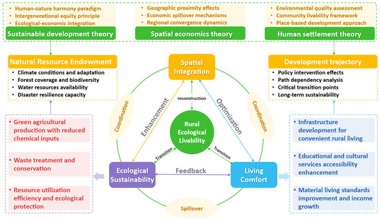
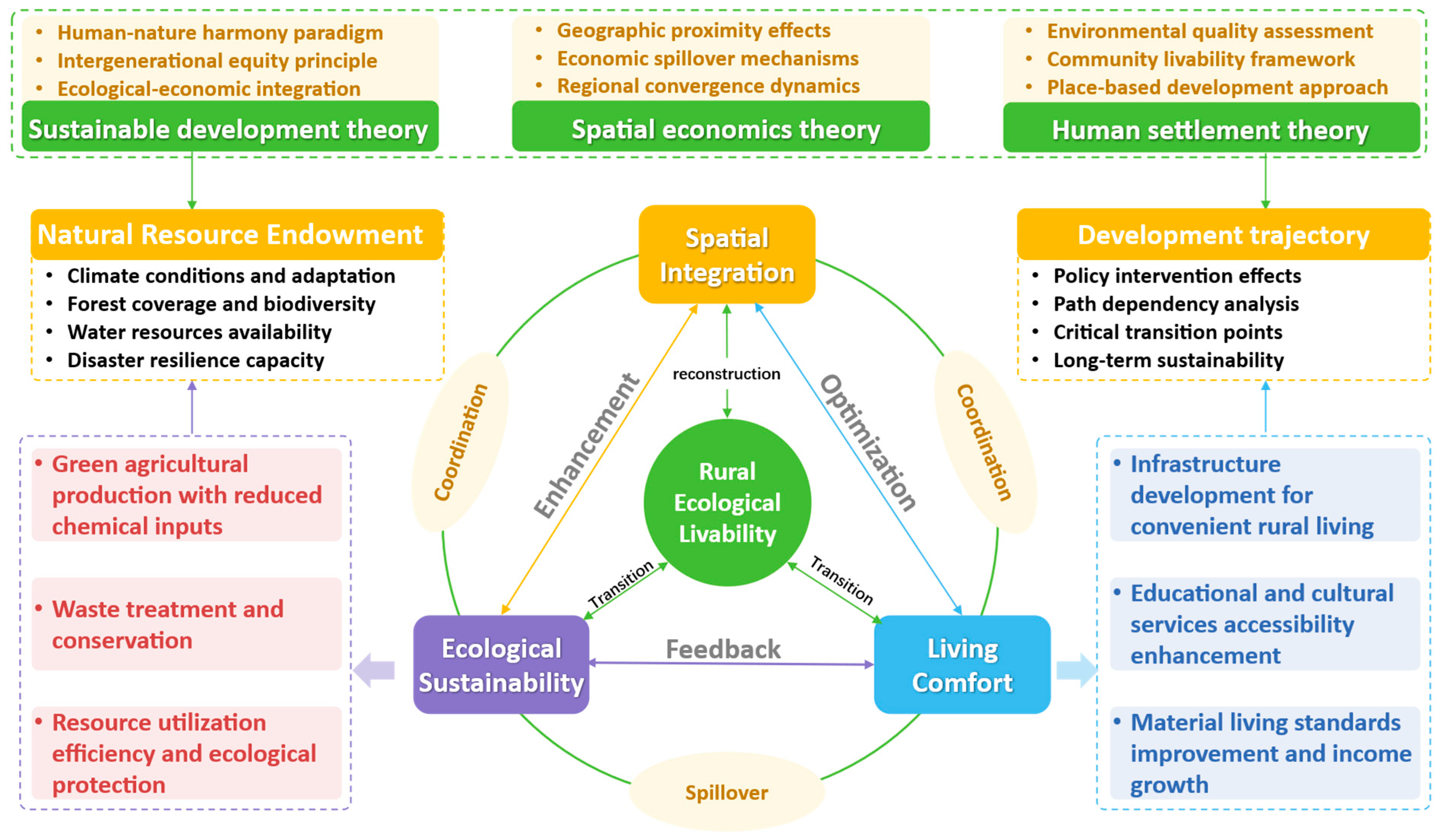
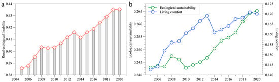
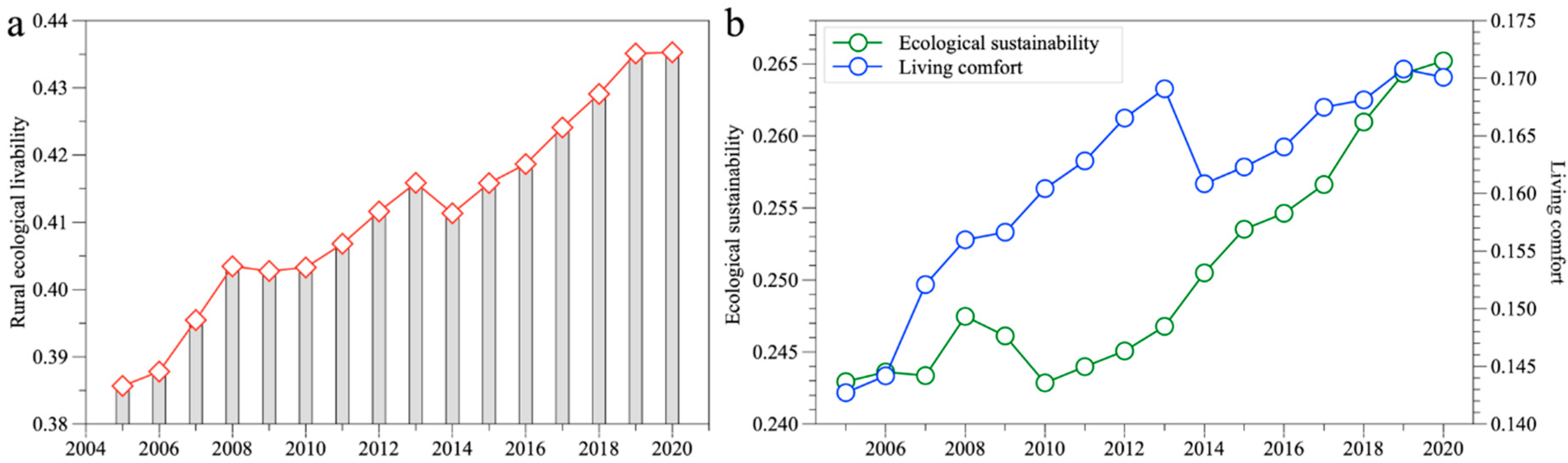
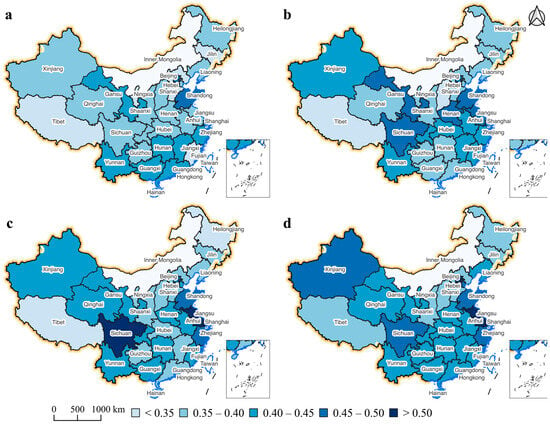
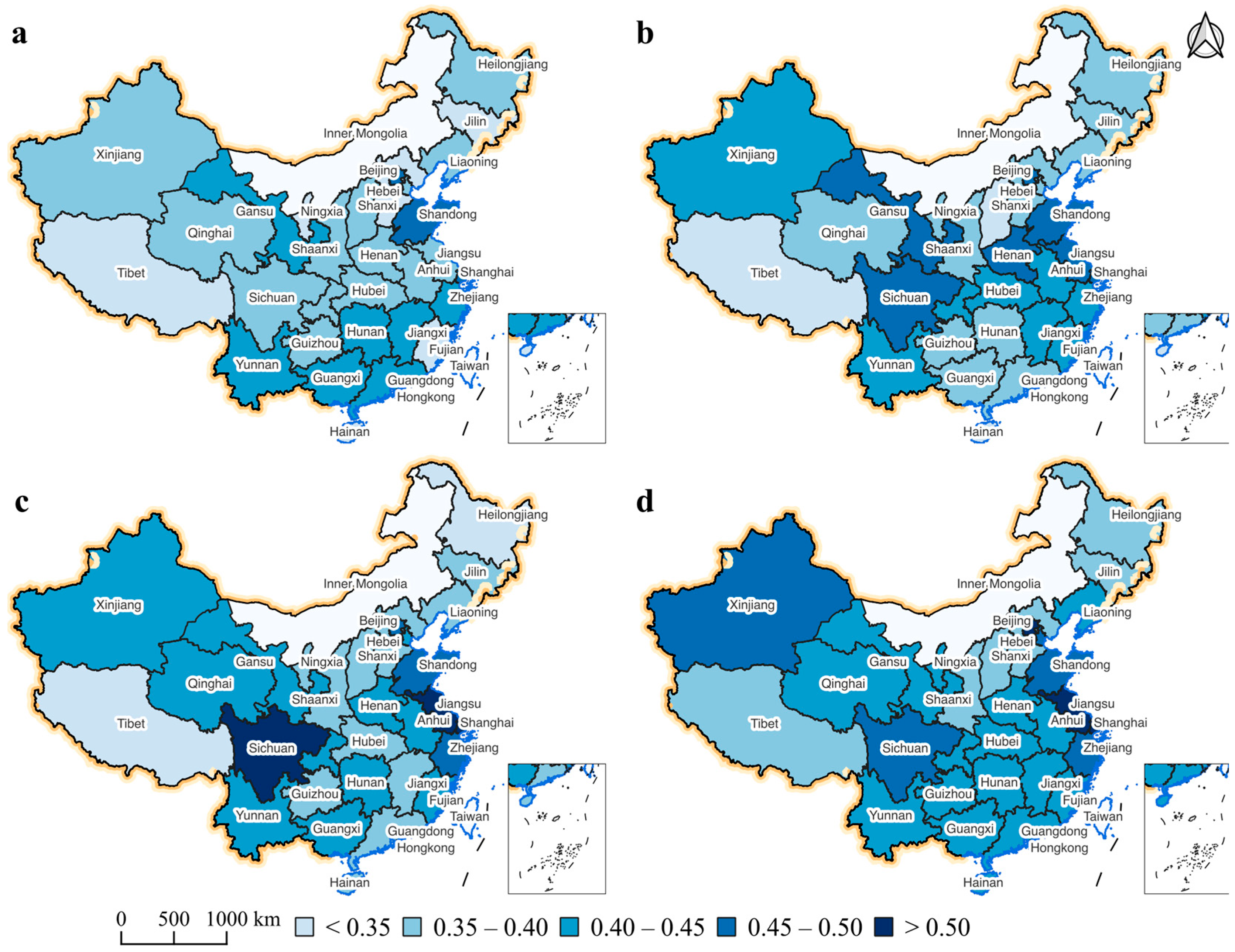
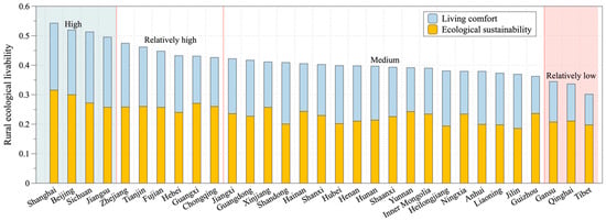
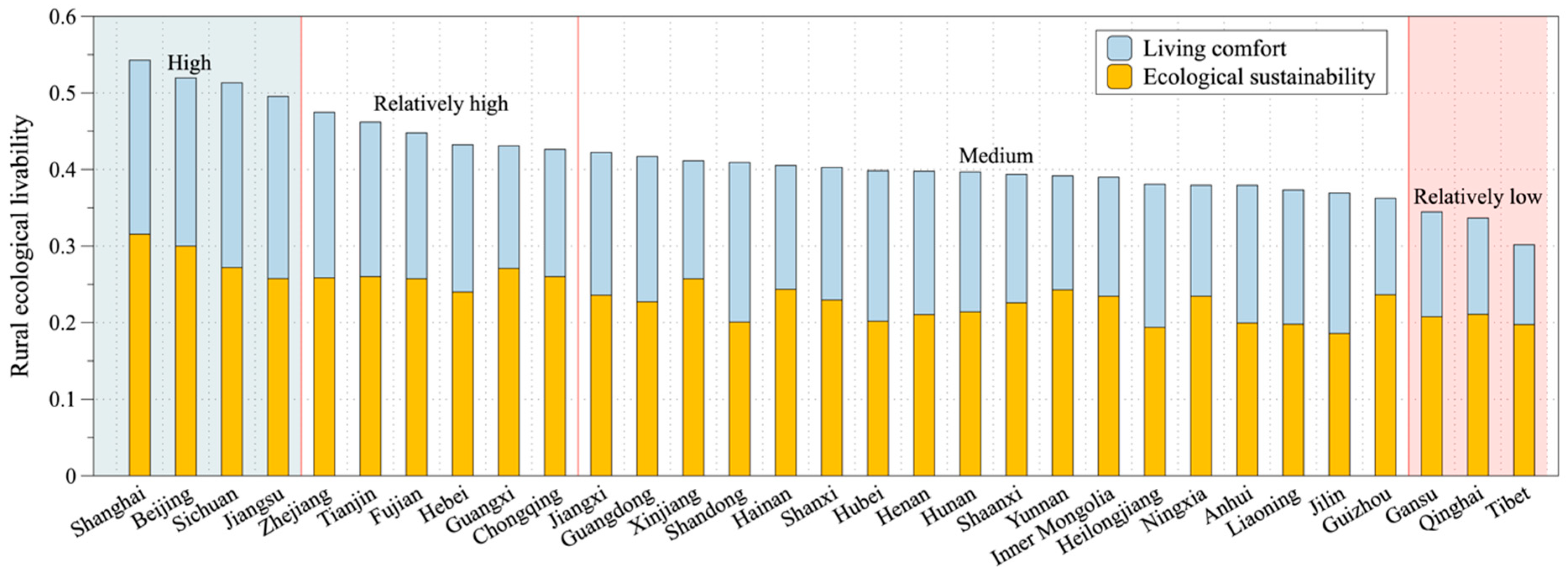
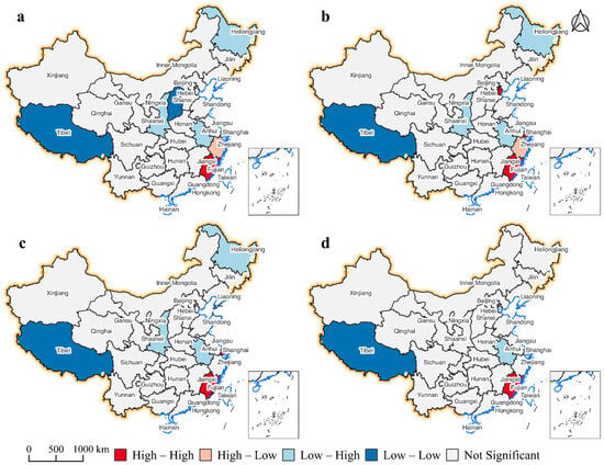
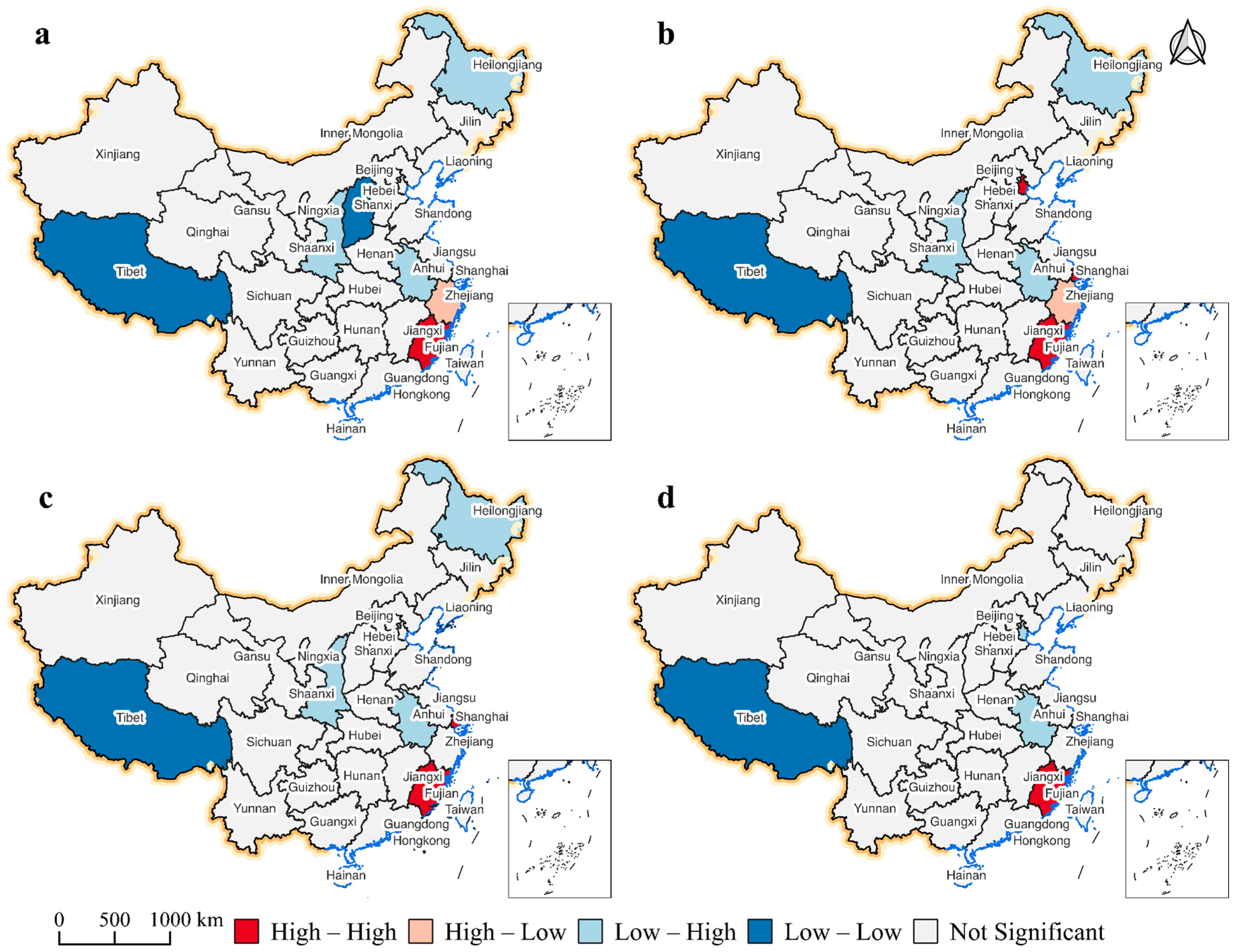
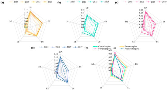
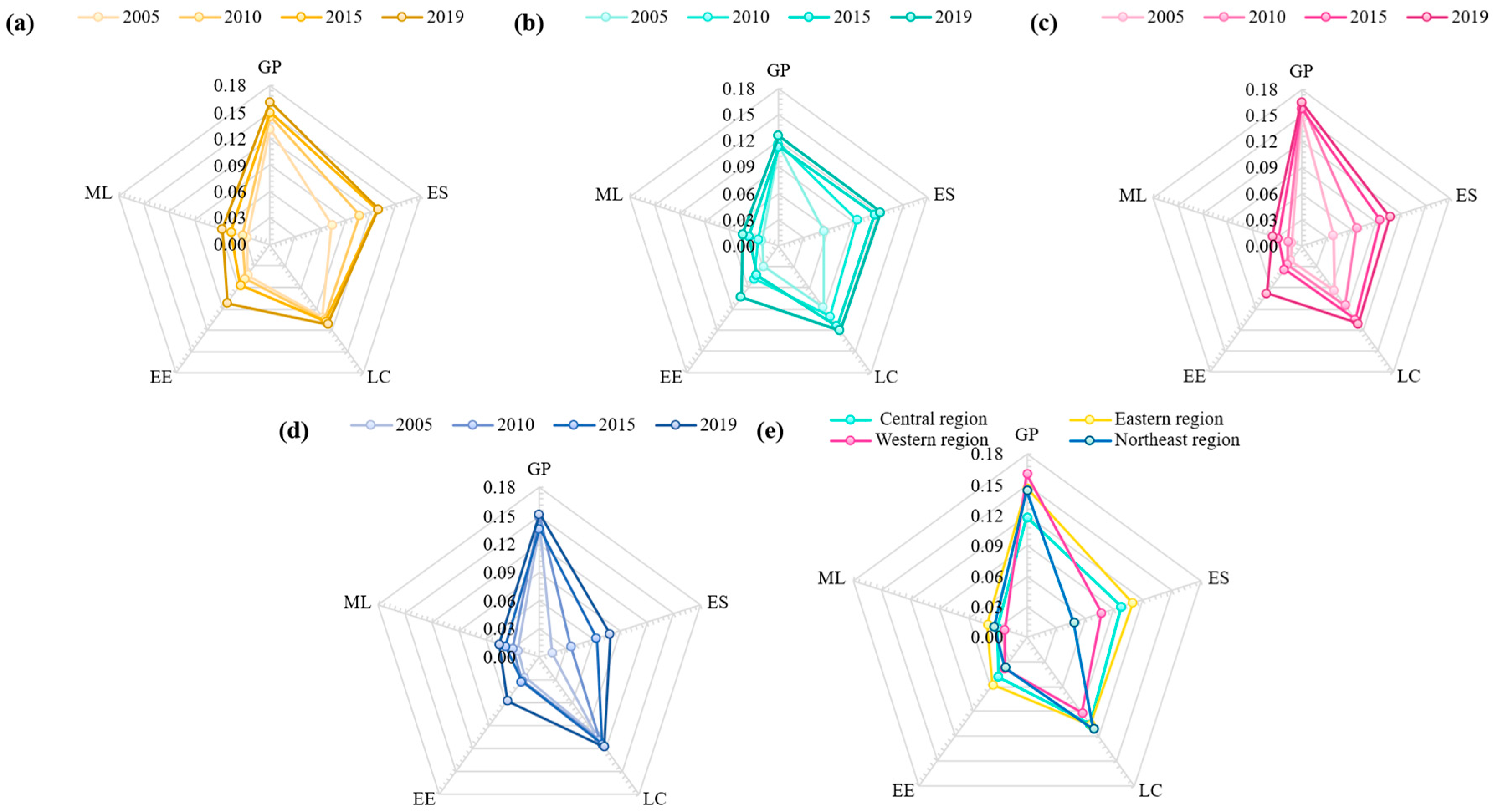
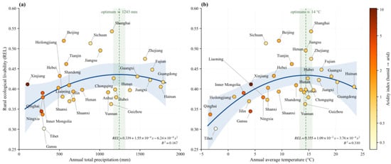
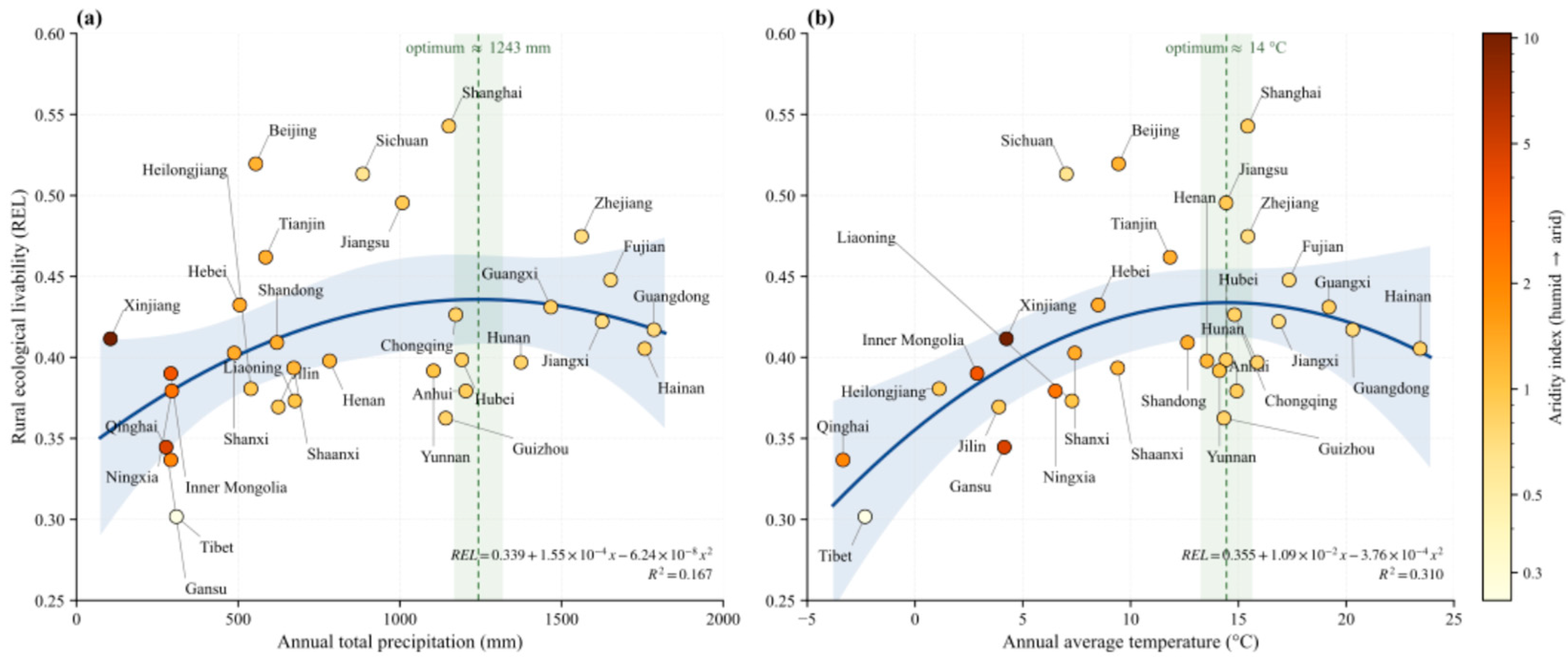
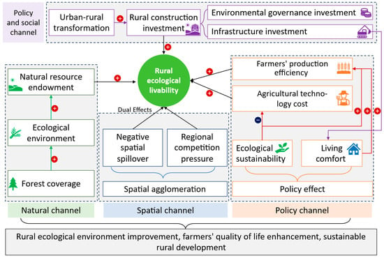
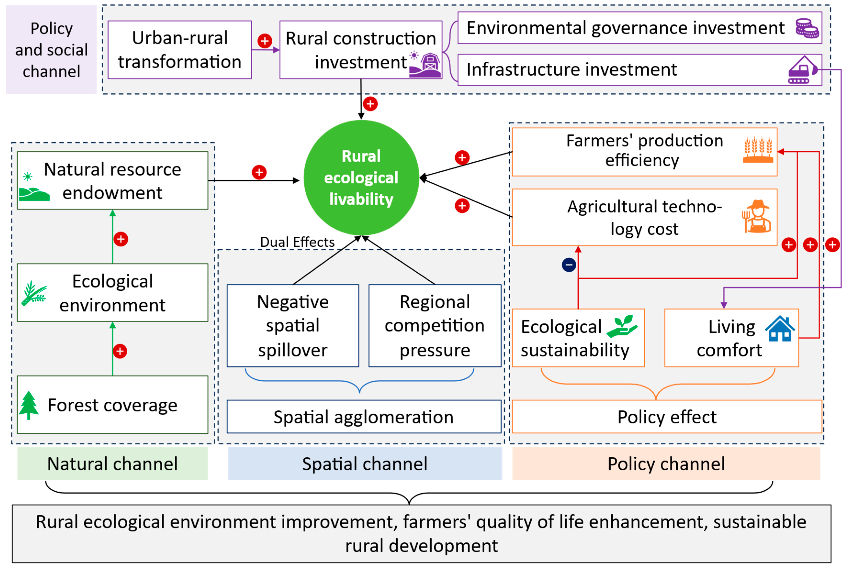

Disclaimer/Publisher’s Note: The statements, opinions and data contained in all publications are solely those of the individual author(s) and contributor(s) and not of MDPI and/or the editor(s). MDPI and/or the editor(s) disclaim responsibility for any injury to people or property resulting from any ideas, methods, instructions or products referred to in the content. |
© 2026 by the authors. Licensee MDPI, Basel, Switzerland. This article is an open access article distributed under the terms and conditions of the Creative Commons Attribution (CC BY) license.