


Abstract
Against the background of urbanization driven by county-level cities as key platforms, the landscape pattern of built-up land serves as a crucial tool for analyzing the human-land spatial relationship in the arid-semi-arid ecological transition zone. This study focuses on 112 county-level units along the Silk Road within China. Based on 2023 land-use data, it analyzes the spatial differentiation characteristics and factor correlations of built-up land across three major geographic sections and qualitatively explores the boundaries of policy regulation. The results indicate: (1) the landscape pattern exhibits significant section-level heterogeneity and a binary differentiation between urban districts and ordinary counties: patches in urban districts generally exhibit a landscape pattern characterized by contiguous areas, high aggregation, and regular boundaries, whereas those in ordinary counties are characterized by small scale, high fragmentation, and complex boundaries. (2) Spatial differentiation was significantly correlated with distance from water systems, cultivated land area and land-averaged GDP. At the same time, spatial controls such as urban development boundaries and ecological red lines exhibit spatial guidance characteristics at the qualitative level in relation to the boundaries of built-up land parcels, providing an institutional context for explaining the current landscape pattern. This study provides empirical guidance for advancing refined territorial spatial governance tailored to local conditions in ecologically fragile regions.
1. Introduction
In the contemporary period, county-level units act as pivotal centers for the exchange of urban and rural resources, as well as for structural and functional transformation; their significance and role in the emerging framework of new-type urbanization and integrated urban–rural development are becoming increasingly pronounced [1]. Recent national urbanization policies in China emphasize county towns as fundamental carriers for advancing new-type urbanization and integrating urban–rural development [2]. This strategic priority was further reinforced during the 20th CPC National Congress, which highlighted the necessity of people-centered urbanization and called for a coordinated urban system comprising urban agglomerations, metropolitan areas, and county seats as primary vehicles [3]. Landscape ecology, meanwhile, offers a new perspective for assessing the characteristics of urban evolution [4]. Landscape pattern is commonly employed to define the spatial structural characteristics of a landscape; it pertains to the representation of the spatial organization of landscape mosaics with diverse sizes, forms, and combinations [5]. Research methods for landscape pattern primarily include landscape index methods, landscape ecological models, and spatial statistical methods [6,7,8]. The built-up land landscape pattern of a county functions as the ecological foundation, spatial framework, functional platform, and cornerstone of livability for county-level urbanization. It assesses the county’s developmental potential, quality of life, industrial capacity, and degree of urban–rural integration, serving as both a fundamental assurance and a crucial spatial mechanism for promoting urbanization at the county level.
The Silk Road, a terrestrial route traversing Asia and linking the Eurasian continent, has significantly influenced cultural interchange, economic trade, and political and military interactions, thus influencing the development of human society [9]. The emergence and development of built-up land landscape patterns in counties along the Silk Road serve as a comprehensive depiction of the human-environment relationship in geographical space and a spatial projection of regional socioeconomic activity. However, with the rapid pace of urbanization and intensified human activities, the landscape pattern of built-up land in counties along the Silk Road faces prominent challenges. Unregulated urban spatial expansion, coupled with unsustainable land-use practices, exerts considerable pressure on the fragile regional eco-environment [10]. A series of ecological issues has become increasingly pronounced, including accelerated soil erosion, intensifying land desertification, water environment degradation, and sparse vegetation loss [11]. Urban expansion has often lacked effective spatial guidance, frequently resulting in the homogenization of urban forms and landscape patterns across distinct geographical contexts [12]. Such disordered and unsustainable development models, driven by intense human activities, have exerted prolonged pressure on regional environments, triggering severe ecological disruptions and undermining localized ecosystem functions across western China [13]. In addition, regional development imbalances are also hindering the optimization of the overall landscape. Regional central cities lack the capacity to drive the development of surrounding towns, and the spillover effects of large cities struggle to extend to nearby small and medium-sized cities [14]. Therefore, conducting an in-depth exploration of the characteristics of built-up land landscape patterns in county-level units along the Silk Road and their driving factors, and uncovering the complex interrelationships among human activities, the natural environment, and urban development [15], is of great significance for optimizing the rational allocation of land resources and promoting a new model of urbanization with county-level units as key vehicles.
Domestic scholars have achieved significant results in the study of landscape patterns, and research methods have become increasingly diverse, encompassing interdisciplinary approaches such as landscape ecology, spatial econometrics, and geographic information systems. At the research scale, existing studies have primarily focused on administrative units, concentrating on urban agglomerations and cities in the developed eastern regions. These studies cover provincial levels [16], municipal levels [17], and central urban districts [18], as well as the Yellow River Basin [19], karst mountainous regions [20], and the Yangtze River Delta [21], among other typical and unique regions, with a focus on rural settlements [22]. Systematic research on counties in western China—particularly those along the Silk Road—has been relatively scarce. In research content, the study covers a wide range of areas, including land use [23], ecosystem health [24], and characteristics of urbanization [25], reflecting a trend toward diversified and comprehensive research. In methodology, techniques such as GIS, remote sensing imagery, and landscape index analysis have been widely applied. Recently, with the advancement of the “Belt and Road” Initiative, academic circles have begun to pay greater attention to the landscape patterns of cities along the Silk Road and their influencing factors, focusing primarily on the evolutionary patterns of representative cities such as Lanzhou [26] and Zhangye [27]. However, there has been little systematic research on the landscape patterns of built-up areas at county levels. Most existing studies have focused on coastal regions or homogeneous plains characterized by abundant water and heat resources and high economic concentration. Research on extremely long, corridor-like, strip-shaped regions that span significant water, heat, and ecological gradients—particularly studies examining the landscape heterogeneity and governing mechanisms of county-level units with different functional attributes under the interplay of extreme natural constraints and human development—remains insufficient. Research abroad has developed a relatively mature theoretical framework and methodology. In recent years, foreign scholars studying landscape patterns have focused on issues such as the spatial evolution of urban form in metropolitan areas [28], the health of urban ecosystems [29], the impacts of haphazard urban expansion in areas surrounding large cities [30], and the evolution of urban land use and land cover [31,32,33]. To unravel the intricate drivers underlying spatial patterns, the Geodetector method has gained widespread prominence owing to its capacity to capture spatially stratified heterogeneity and detect nonlinear factor interactions without strict linear collinearity assumptions. In arid and semi-arid environments—particularly across Northwest China and the Central Asian corridor—several scholars have successfully deployed Geodetector to investigate built-up land evolution and oasis urban sprawl. For example, combining the Geodetector method with spatial simulation models has revealed how physical accessibility and oasis resources regulate the spatial expansion of urban agglomerations in Xinjiang [34], using typical oasis cities in Xinjiang as case studies to examine the driving factors and their interrelationships in spatial expansion [35], and by quantifying the nonlinear spatial heterogeneity of urban construction land expansion in arid and semi-arid inland regions, the study confirmed the decisive controlling roles of water resource availability, arable land background, and transportation networks on the agglomeration and fragmentation of construction land [36]. However, existing research has primarily focused on total built-up area or the core of a single major metropolitan area, resulting in critical knowledge gaps regarding comprehensive, multi-dimensional landscape indicators at the county level along the Silk Road.
A review of existing research reveals that significant progress has been made in the study of landscape patterns, with most studies focusing on the characteristics and evolutionary patterns of typical regions or cities. However, systematic research that thoroughly examines landscape patterns and their influencing factors at the county level—particularly within the specific context of the Silk Road Corridor—remains scarce. Given the pronounced environmental and socioeconomic gradients within this corridor, natural conditions impose strict baseline constraints on the landscape pattern of building sites throughout the arid and semiarid regions; however, in socioeconomically developed areas such as the Guan Zhong-Longxi section, the direct explanatory power of natural factors is less than that of socioeconomic factors. At the same time, the various factors influencing the landscape pattern of built-up land do not operate in isolation. They exhibit synergistic effects when patches cluster together, and there is marked spatial heterogeneity across different geographic sub-regions. To test these hypotheses, this study focuses on 112 county-level units traversed by the Silk Road—a typical and distinctive geographical corridor—as an empirical case. Using land-use vector data, vector graphics representing urban, rural, industrial, mining, and residential land-use types were extracted. The study divides the research area into three subregions: the “Guanzhong-Longxi Section,” the “Hexi Corridor Section,” and the “Northern and Southern Sections of Tianshan Mountains.” This study attempts to introduce model algorithms such as the Landscape Pattern Index and Geodetector to investigate the characteristics of built-up land landscape patterns in counties along the Silk Road, as well as the influences of their primary and interacting factors. The aim is to provide a scientific basis and decision-making support for promoting new-type urbanization in counties along the Silk Road and optimizing the regional spatial pattern.
2. Research Methods and Data Sources
2.1. Research Methods
2.1.1. Landscape Pattern Index Method
Landscape indices [37] are a collection of metrics that quantitatively characterize landscape patterns. This paper employs the landscape pattern index methodology from landscape ecology and utilizes Fragstats 4.2 software to select pertinent quantitative analysis indicators, including total class area (CA), number of patches (NP), mean patch size (MPS), patch density (PD), Aggregation Index (AI), mean shape index (MSI), and mean fractal dimension (FRAC-MN), to examine the built-up land landscape pattern characteristics and regional variations in county-level units along the Silk Road (Table 1).
Table 1.
Landscape Pattern Indices of County-Level Built-up Land Along the Silk Road.
2.1.2. Geographic Detector
Geographic detection comprises statistical methods grounded in spatial autocorrelation that identify geographical variability and its impacting elements [38]. This method can effectively identify the spatial variability of geographic features, the intensity of various influencing factors, and the interactive and coupled relationships among driving factors and has been widely applied in numerous fields. In this study, we employ this method to examine and analyze the determinants of built-up land landscape patterns in counties along the Silk Road. The analytical equation is as follows:
In the equation, q signifies the impact of a factor on the built-up land landscape patterns index of county-level units along the Silk Road; L symbolizes the stratification of the driving factor X. Nh denotes the quantity of sample units in the next-level region; N signifies the total number of sample units within the entire study area; σ2_h and σ2 indicate the sample variance of the next-level study area and the variance of urban regions in the entire research area, respectively. The value of q spans from [0, 1]; a larger value signifies greater explanatory power of the influencing factor, while a lower value denotes diminished explanatory power.
2.2. Data Sources and Processing
This study primarily utilizes spatial and socioeconomic data. The spatial data primarily consists of the 2023 China Multi-period Land Use Remote Sensing Monitoring Dataset (CNLUCC) with 30-m resolution, sourced from the Center for Resource and Environmental Science and Data at the Chinese Academy of Sciences. The elevation data and the slope data derived from it are sourced from the 30-m raster ASTER GDEM dataset provided by the National Aeronautics and Space Administration (NASA). In addition, hydrological and road network vector layers were retrieved from the 2023 OpenStreetMap (OSM) platform. The annual Normalized Difference Vegetation Index (NDVI) dataset was obtained from the 2023 monthly synthesized MOD13A3 product with a spatial resolution of 1 km. County-level administrative boundaries were generated based on the 2023 China Standard Map vector data (Map Approval No. GS(2023)2767) released by the Standard Map Service System of the Ministry of Natural Resources, with the base map remaining unmodified. Furthermore, reference was made to the fundamental geographic information databases of Shaanxi Province, Gansu Province, the Ningxia Hui Autonomous Region, and the Xinjiang Uygur Autonomous Region. Socioeconomic data were primarily sourced from the *2024 Shaanxi Statistical Yearbook*, the *2024 Gansu Statistical Yearbook*, the *2024 Ningxia Statistical Yearbook*, the *2024 Xinjiang Statistical Yearbook*, and the *2024 China County-Level Statistical Yearbook*, while also referencing the statistical bulletins on national economic and social development published by various cities and districts in Shaanxi Province, Gansu Province, the Ningxia Hui Autonomous Region, and the Xinjiang Uygur Autonomous Region.
Data processing was broadly divided into the following steps. First, vector graphics representing urban and rural areas, industrial and mining areas, residential areas, and cropland within the study area for 2023 were extracted from the land-use vector database. The coordinate system used was the Asia North Albers Equal Area Conic projection. Given the large volume of raw-resolution land-use raster data and to reduce the computational load on the model, the raster pixel size was set to 50 m after reprojection. Second, the land-use raster data was converted to TIFF format using a conversion tool, enabling the calculation of various landscape indices in the landscape pattern analysis software FragStats 4.2. An 8-neighborhood rule was used for patch identification. Using ArcGIS 10.8, slope and elevation data were extracted from the Digital Elevation Model (DEM) data, and the shortest distances from the center of mass of built-up land to rivers and roads were determined using the Nearest Neighbor analysis tool. To satisfy the requirements of the geographic detector for the discretization of independent variables, this study employs the natural breakpoint method to discretize continuous independent variables into discrete categories. Accounting for differences in sample size across the region and its subregions, and to avoid statistical bias resulting from insufficient samples within strata due to overly fine subdivision of small samples, adaptive stratification numbers were set for different scales: The overall region is divided into 6 categories; the Guanzhong-Longxi section and the northern and southern sections of the Tianshan Mountains are divided into 4 categories; and the Hexi Corridor section is divided into 3 categories. Regular fishing net grids were established across 112 county-level units. Given the vast spatial scale of the whole study area, as well as the Hexi Corridor and the northern and southern sections of the Tianshan Mountains, a 10 km × 10 km grid was established for these regions. Meanwhile, given the relatively small spatial scale of the Guanzhong-Longxi section, a 6 km × 6 km grid was established in this area to more accurately capture fragmented patches. This approach balances the precision required to characterize spatial heterogeneity with the robustness of statistical inference. Finally, using the single-factor and interaction-factor detectors in the geographic detector, quantitative measurements were made of the spatial association strength and synergistic effects of various potential influencing factors on the landscape pattern differentiation of built-up land.
2.3. Overview of Research Area
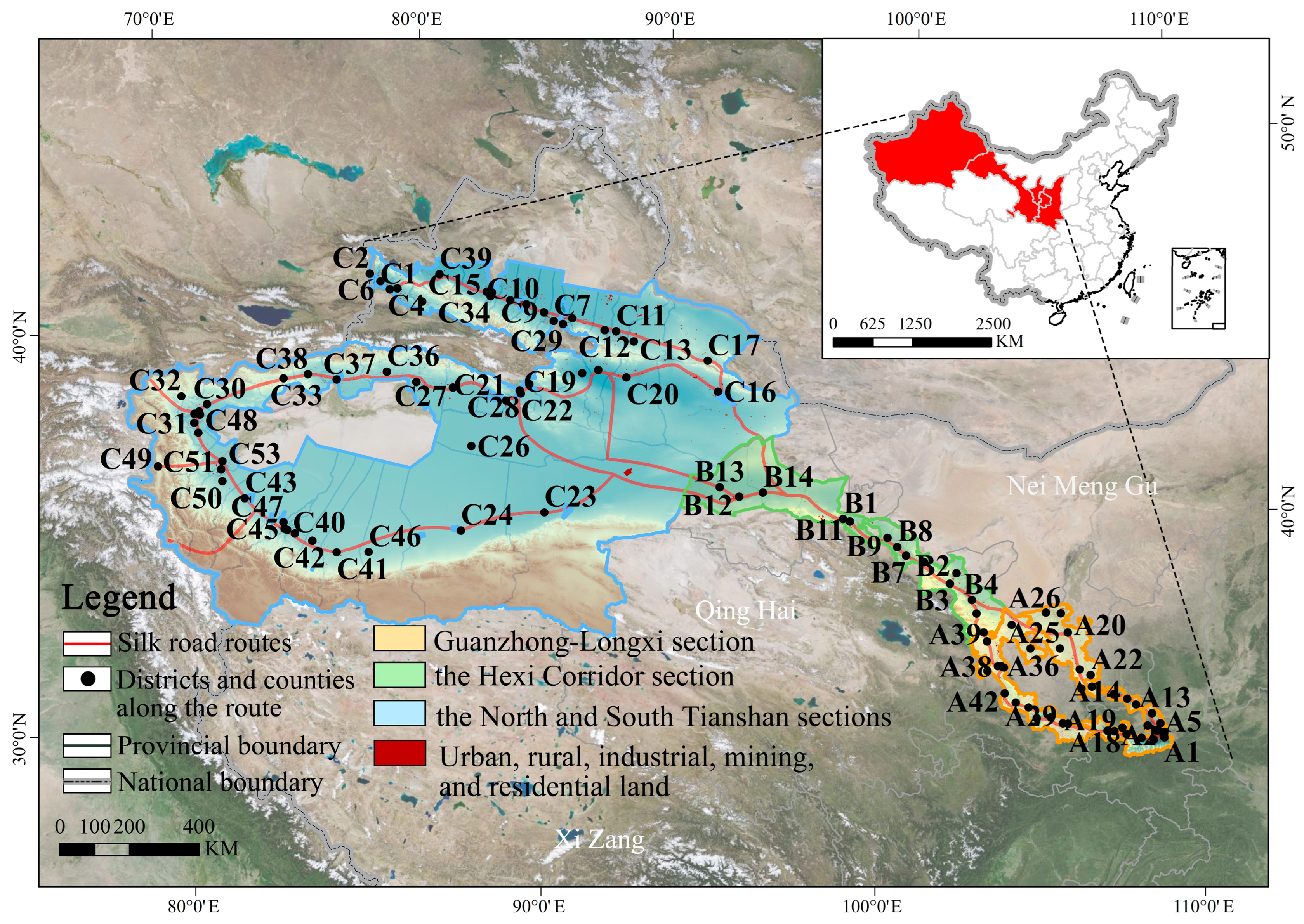
The study area covers 29 prefecture-level cities (including autonomous prefectures and municipalities directly under the central government) and 112 districts and counties within the four provinces (autonomous regions)—Shaanxi, Gansu, Ningxia, and the Xinjiang Uygur Autonomous Region—along the Silk Road within China (Figure 1). The total area of the study region is approximately 1,388,657 km2, of which urban, rural, industrial, mining, and residential land accounts for about 1,051,331 hm2, representing approximately 0.76% of the total area. The region features diverse landforms with significant topographic variations. From east to west, the major landforms are, in order, the Loess Plateau, the Qilian Mountains, the Altai Mountains, the Junggar Basin, the Tianshan Mountains, the Tarim Basin, and the Kunlun Mountains. The region has diverse climate types, spanning three major climate zones from east to west: temperate monsoon climate, temperate continental climate, and plateau-mountain climate. Water resources are unevenly distributed, the ecological environment is fragile, and the relationship between people and the land is delicate. This study comprehensively considers factors such as economic development, climatic conditions, topography, and geographical location to divide the study area into the Guanzhong-Longxi Section, the Hexi Corridor section, and the northern and southern sections of the Tianshan Mountains. Specifically, the Guanzhong-Longxi Section is situated in the transitional zone between the Loess Plateau and the Qinling Mountains, historically serving as a quintessential cradle of intensive farming and ancient civilization. The Hexi Corridor Section, functioning as a narrow corridor bridging Central China and the Western Regions, relies predominantly on glacial and snowmelt water to sustain constrained inland river oases. Meanwhile, the Northern and Southern Sections of the Tianshan Mountains exhibit a typical ‘mountain–oasis–desert’ mosaic landscape under hyper-arid conditions.
Figure 1.
Scope of the study area.
3. Results and Analysis
3.1. Analysis of Built-Up Land Landscape Pattern Characteristics
The landscape pattern index analysis results for the 112 districts and counties along the Silk Road were obtained using Fragstats 4.2. Given the significant differences in the scale of built-up land between urban districts and ordinary counties within the statistical units, this study separated urban districts from ordinary counties for statistical analysis to minimize the interference of outliers on the results, and used the median to characterize the landscape pattern levels of built-up land in different regions. Based on the analysis results, it is evident that the landscape patterns of built-up areas in counties along the Silk Road exhibit significant regional variations (Table A1).
3.1.1. Scale Characteristics
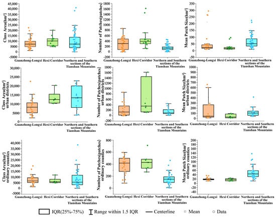
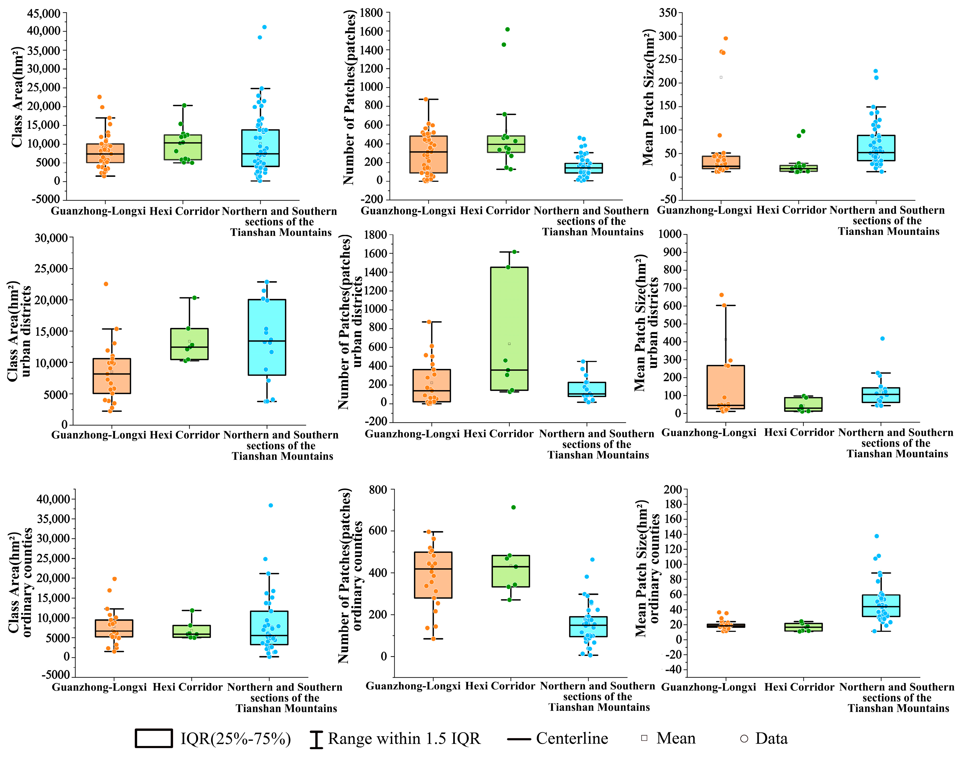
In terms of the scale of patch distribution, the total area of built-up land landscape patches along the Silk Road is 1,051,331 hm2. Of this, the Guanzhong-Longxi section accounts for 348,967 hm2, the Hexi Corridor section accounts for 141,775 hm2, and the northern and southern sections of the Tianshan Mountains combined account for 560,589 hm2. The median total area of patches in each region was 7384.25 hm2, 10,400 hm2, and 7549.5 hm2, respectively. The total number of patches is 29,425, of which 13,113 are in the Guanzhong-Longxi section, 7516 in the Hexi Corridor, and 8796 in the northern and southern sections of the Tianshan Mountains. The median number of patches in each region was 313, 394, and 147, respectively. The mean patch size in the Guanzhong-Longxi section, the Hexi Corridor section, and the northern and southern ends of the Tianshan Mountains was approximately 26.61 hm2, 18.86 hm2, and 63.73 hm2, respectively, while the median mean patch size in each region was approximately 22.70 hm2, 19.74 hm2, and 50.67 hm2, respectively. Based on the analysis results at the municipal district level (including county-level cities), the median total class area (CA) in the Hexi Corridor section and the northern and southern Tianshan sections was significantly higher than that of ordinary counties, even surpassing that of the Guanzhong-Longxi section. In contrast, the median total class area (CA) across the various sections in ordinary counties showed little variation. Analysis of the number of patches (NP) reveals that the median for ordinary counties in the Guanzhong-Longxi section exhibits high dispersion and fragmentation, far exceeding that of urban districts in the same section. In contrast, the median number of patches for both municipal districts and ordinary counties in the northern and southern Tianshan sections remains at a relatively low level, indicating a highly concentrated spatial distribution. The high degree of concentration in the northern and southern Tianshan sections is also reflected in their mean patch size (MPS), where the median values for both municipal districts and ordinary counties are significantly higher than those in the Guanzhong-Longxi section and Hexi Corridor sections. In contrast, the median values for ordinary counties in the Guanzhong-Longxi and Hexi Corridor sections cluster at low values (Figure 2).
Figure 2.
Scale Characteristics of the Landscape Pattern of Built-up Land.
3.1.2. Distribution Characteristics
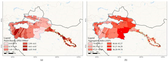
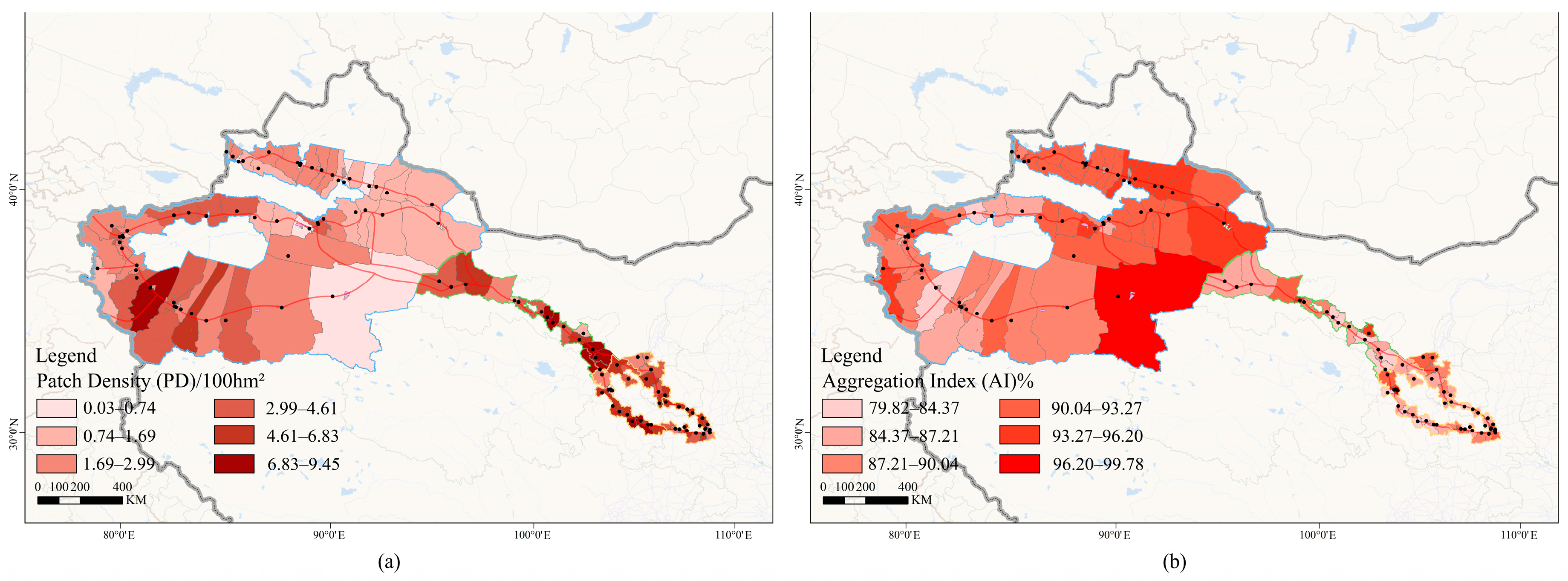
The patch density in the built-up land landscape patterns of counties along the Silk Road is 2.80 patches/100 hm2, with 3.76 patches/100 hm2 in the Guanzhong-Longxi section, 5.30 patches/100 hm2 in the Hexi Corridor section, and 1.57 patches/100 hm2 in the northern and southern sections of the Tianshan Mountains. The median patch density in each region was approximately 4.40 patches/100 hm2, 5.11 patches/100 hm2, and 1.97 patches/100 hm2, respectively, while the aggregation index (AI) was approximately 87.47%, 86.02%, and 91.37%, respectively. Based on the analysis of patch density (PD), the median patch density in ordinary counties in the Guanzhong-Longxi section and the Hexi Corridor section was significantly higher than that in the northern and southern Tianshan sections, and the urban districts in the Guanzhong-Longxi section and the northern and southern Tianshan sections were substantially lower than the ordinary counties in the same section. Based on the analysis of the Aggregation Index (AI), the median AI values for municipal districts and counties in the northern and southern Tianshan sections showed an extremely high level of aggregation, while the median values for general counties in the Guanzhong-Longxi and Hexi Corridor sections were at a low point (Figure 3).
Figure 3.
(a) Schematic Diagram of the Patch Density of the Landscape Pattern of Built-up Land (b) Schematic Diagram of the Aggregation Index of the Landscape Pattern of Built-up Land.
3.1.3. Shape Characteristics
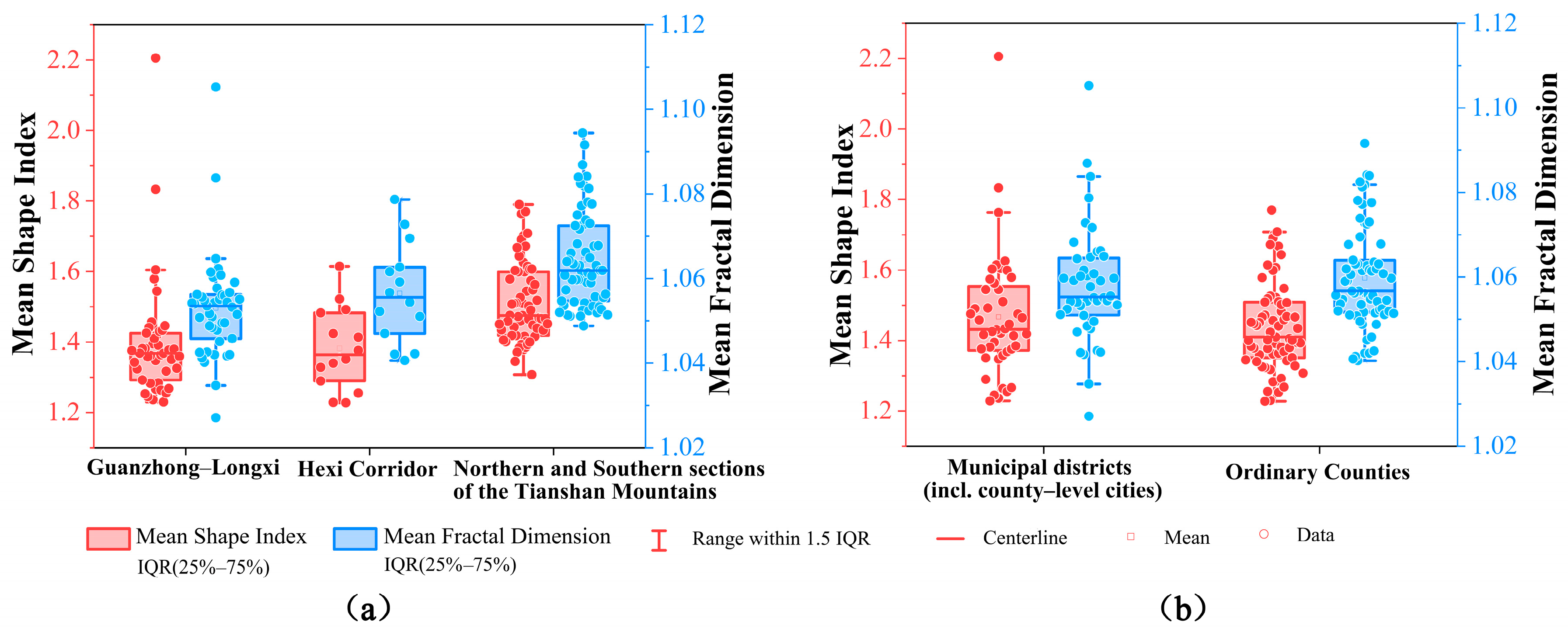
The mean shape index of built-up landscape patterns in county-level units along the Silk Road is about 1.40, whereas the mean fractal dimension is about 1.06, based on the shape characteristics of the patches. In the Guanzhong-Longxi section, the numbers are 1.39 and 1.05, respectively. In the Hexi Corridor section, they are 1.35 and 1.06, respectively. And in the sections north and south of the Tianshan Mountains, they are 1.53 and 1.07, respectively. A comparison of the shape indices across the aforementioned regions reveals that there is little variation in the regularity of the built-up land landscape patterns in counties along the Silk Road. In terms of macro-geometric complexity, the median mean shape index for municipal districts is higher than that for ordinary counties. The outer contours of their built-up land are more elongated and complex. However, their morphological indices are lower than those of ordinary counties, with patch boundaries primarily taking the form of regular rectangles or geometric clusters, indicating strong characteristics of man-made geometric planning (Figure 4).
3.2. Analysis of Driving Factors
Built-up land landscape patterns in county-level units along the Silk Road are shaped by the natural environment and anthropogenic activities. Consequently, the factors influencing these patterns are diverse and complex. Based on regional differences among counties along the Silk Road, this study developed a relevant set of indicators (Table 2) after comprehensively evaluating the applicability of the indicators, data availability, and the geographical characteristics of the study area. The objective is to elucidate the impact patterns and relative contributions of the eight factors identified from the dimensions of natural conditions and socioeconomic factors.
Table 2.
Driving factors of built-up land landscape patterns in counties along the Silk Road.
Figure 4.
(a) Schematic Diagram of the Shape Characteristics of the Landscape Pattern of Built-up Land (b) Schematic Diagram Comparing the Shape Characteristics of Urban Districts and Ordinary Counties.
3.2.1. Results of the Single-Factor Analysis
Based on the results of the analysis of the built-up land landscape patterns in counties along the Silk Road presented above, the mean patch size with significant regional differences in the Guanzhong-Longxi section, the Hexi Corridor section, and the northern and southern Tianshan sections was selected as the Y-value. This was used to investigate and analyze the driving factors of the built-up land landscape patterns in counties along the Silk Road, yielding the following results (Table 3).
Table 3.
Single-Factor detection results of mean patch size.
- (1)
- Overall Dominance: The Combined Drive of Soil and Water Baseline Constraints and Economic Expansion
At the overall regional scale, the spatial variation in the mean patch size (MPS) of built-up land exhibits a three-factor driving pattern, with cultivated land area (X4, q = 0.339) as the primary determinant and land-averaged GDP (X8, q = 0.290) serving as key supporting factors. The development of large, contiguous areas of built-up land is highly dependent on flat, open, and contiguous spaces. Areas rich in cultivated land typically correspond to optimal natural habitats such as alluvial plains and river valley basins. These areas not only provide low-cost land reserves that are easy to develop in contiguous blocks for urban and industrial construction but also serve as the physical foundation for the expansion of large-scale building complexes. Land-averaged GDP, as a comprehensive indicator of capital density and industrial intensification, drives the development of large-scale industrial parks, modern logistics hubs, and high-density new cities. High-intensity capital investment breaks down the physical boundaries of previously fragmented land parcels, prompting the strong agglomeration and integration of built-up land toward central urban areas. Furthermore, distance from water systems (X5) and distance to main transport corridors (X6) constitute the synergistic constraint factors in the second tier. The terrain along the Silk Road varies dramatically. High-altitude mountainous regions impose insurmountable physical constraints based on vertical zonation, strictly confining large-scale land parcels to low-altitude corridors.
- (2)
- Guanzhong-Longxi Section: The Absolute Dominance of Socioeconomic Factors in Mature Metropolitan Areas
The Guanzhong-Longxi section exhibits a strikingly different pattern of influence, with population density (X7, q = 0.842) exerting an overwhelmingly dominant influence, while the explanatory power of natural factors such as slope (X1) and elevation (X2) is completely insignificant. The Guanzhong-Longxi section features an open, flat terrain with favorable water and heat conditions, a long history of city-building and agriculture, and topographical constraints from earlier periods that have been largely erased through long-term land development. The region’s urbanization has moved beyond the initial stage of extensive adaptation to natural conditions and has entered a phase of polarization characterized by high levels of capitalization and population concentration. The strong gravitational pull of high population density (X7) has spurred large-scale, contiguous renewal of high-density residential clusters and public service facilities. Land-averaged GDP (X8), which has relatively high explanatory power, has driven the seamless integration of large-scale development zones spanning multiple counties, national-level high-tech zones, and infrastructure networks. Consequently, socioeconomic factors have driven the evolution of built-up land into intensive patches characterized by high continuity and relatively regular boundaries.
- (3)
- Hexi Corridor Section: Oasis-Dependent Evolution Under Water and Soil Resource Constraints
The explanatory power of individual factors in the Hexi Corridor section was generally low. Only cultivated land area (X4, q = 0.168) and land-averaged GDP (X8, q = 0.115) achieved relatively significant dominance, while the remaining factors were at extremely low levels. Nestled deep in the inland hinterland, the Hexi Corridor is sandwiched between the Qilian Mountains and the Beishan Gobi. Its arid climate and scarce water resources form an absolute ecological barrier across the entire region, cutting off the physical possibility of continuous cross-regional expansion of built-up land and forcing urban settlements to be distributed in a “bead-like, island-style” pattern. In this harsh environment, the marginal driving effect of individual factors is severely suppressed, resulting in generally low q-values for factors across the region. Against this backdrop, the limited cultivated land area (X4) directly represents the upper limit of water and soil resource carrying capacity and the volume of living space within oases; thus, development land patches must and can only survive and expand within the larger agricultural hinterlands of oases, while the industrial and commercial agglomerations in corridor node cities (such as Jiuquan, Zhangye, and Jiayuguan) provide a secondary driving force for the moderate concentration and expansion of patches within the core areas of the oases.
- (4)
- North and South Sections of the Tianshan Mountains: Economic Leadership in Key Sectors and Rigid Constraints Imposed by All Ecological Factors
The northern and southern sections of the Tianshan Mountains exhibit a unique combination of economic leadership and natural constraints. Not only does land-averaged GDP (X8) hold an absolute dominant position across all regions, but cultivated land area (X4) and elevation (X2) follow closely behind. The region centered on the Tianshan Northern Slope Economic Belt concentrates the vast majority of Xinjiang’s modern heavy chemical industry, deep-processing of energy resources, and modern logistics sector. Its exceptionally high economic density directly translates into powerful spatial capital, driving the explosive expansion of built-up land in the provincial capital’s core and its satellite districts and counties in the form of massive industrial clusters and transportation and logistics hubs, thereby generating giant spatial patches. Unlike the Guanzhong-Longxi section, where natural factors have lost their explanatory power, elevation (X2), cultivated land (X4), water systems (X5), and transportation (X6) on the northern and southern slopes of the Tianshan Mountains maintain a strong controlling influence. Built-up land can only grow in contiguous patches within alluvial oases nourished by glacial water systems. Once beyond the boundaries of these water-rich oases, one encounters deserts and steep mountains.
3.2.2. Results of the Interaction Factor Detection
- (1)
- Area-Wide Interaction: Complementarity of Water and Land Resources and Synergy Through Corridor Resonance
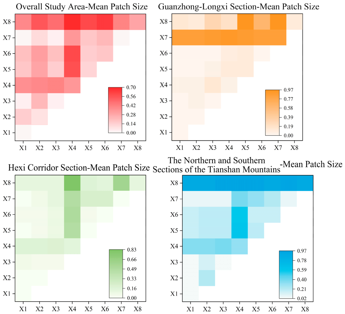
The overall interaction analysis results for the study area indicate that the spatial variation in the mean patch size (MPS) of built-up land is driven by the synergistic interaction of multiple pathways—including socioeconomic factors, land baseline conditions, and spatial corridors—with interaction types ranging from bi-factor enhancement to nonlinear enhancement. First, the interaction between cultivated land area and land-averaged GDP exhibited the highest explanatory power (X4∩X8 = 0.708), emerging as the strongest driving combination for the aggregation and expansion of land parcels across the entire study area. This profoundly reveals that the carrying capacity of flat, suitable land, combined with high-intensity capital investment, jointly constitutes the complementary core influencing force that enables built-up land to overcome fragmentation and achieve large-scale, contiguous development. At the same time, the interactions between land-averaged GDP (X8), transportation distance (X6) and distance to waterways (X5) all exhibit significant nonlinear enhancement characteristics. Second, the enhancement combinations dominated by X4 (X4∩X5 = 0.576, X4∩X6 = 0.606) generally exhibited explanatory power that is quite high as well. It indicates that, against the macro-scale arid and semi-arid backdrop of the Silk Road, economic capital does not simply spread homogeneously but rather strictly relies on the skeletal corridors formed by riverine oases and major transportation arteries, thereby exponentially amplifying the scale of expansion and the momentum of agglomeration in the patches along these corridors (Table 4 and Figure 5).
Table 4.
Interaction analysis results for mean patch size in the study area.
Figure 5.
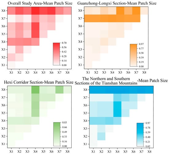
Schematic illustration of the results of interactive detection of mean patch sizes.
- (2)
- Guanzhong-Longxi Section: Absolute Socioeconomic Dominance and Nonlinear Coupling of Soil and Water Factors
The results of the interaction factor analysis for the Guanzhong-Longxi section reveal a pattern of differentiation characterized by socioeconomic factors dominating with high absolute explanatory power, while natural and agricultural factors exhibit synergistic enhancement. In terms of interaction explanatory power values, the interaction between land-averaged GDP and distance to waterways (X8∩X5 = 0.960), population density (X8∩X7 = 0.950), and cultivated land area and population density (X4∩X7 = 0.913) constitute the highest tier of explanatory power for the entire section, reaffirming that socioeconomic factors and major spatial corridors form the core framework for the large-scale, contiguous growth of built-up land in the Guanzhong-Longxi section. It is worth noting that the interaction types involving socioeconomic factors in this region generally exhibit a significant synergistic enhancement. Although natural and hydrological factors have limited direct explanatory power in single-factor analyses, when combined with population (X7) or economic (X8) factors, they produce a strong synergistic enhancement effect. This profoundly reveals that in the Guanzhong-Longxi section—which represents a mature stage of urban agglomeration development—the spatial evolution of built-up land has transcended the rigid constraints of individual natural conditions. Instead, under the deep coupling of multiple factors, it is influencing the large-scale expansion and intensive evolution of settlement patches (Table 5).
Table 5.
Interaction analysis results for mean patch size in the Guanzhong-Longxi Section.
- (3)
- Hexi Corridor Section: Agricultural Matrix Dependency and Nonlinear Synergistic Surge
The results of the interactive analysis for the Hexi Corridor section reveal a system characteristic characterized by the overwhelming dominance of synergistic enhancement and intense resonance between the cultivated land base and economic capital. Although the independent explanatory power of individual factors in this region was generally low in single-factor analysis, their explanatory power increased significantly after pairwise interactions. Among these, the interactive explanatory power between cultivated land area (X4) and land-averaged GDP (X8) reached as high as 0.830, making it the strongest driving force behind the large-scale clustering of patches in this region. At the same time, the interactive explanatory power of cultivated land area with transportation distance (X4∩X6 = 0.515), river system distance (X4∩X5 = 0.495), and population density (X4∩X7 = 0.482) all exceeded 0.48, while the interaction between land-averaged GDP and population density was similarly as high as 0.588 (X7∩X8). These results profoundly reveal that, within the isolated, string-of-pearls-like oases of the Hexi Corridor—which are fragmented and encircled by deserts—it is extremely difficult for any single factor to overcome the harsh ecological environment. Furthermore, the water system (X5∩X6 = 0.032) closely aligns with the fact that the region’s narrow, strip-shaped transportation corridors (such as the Lianhuo Expressway and the Lanzhou–Xinjiang Railway) have long been constructed along river valley oases. These two types of linear corridors exhibit a high degree of parallel alignment and information redundancy in geographical space. Consequently, their combined explanatory power does not yield any additional benefit (Table 6).
Table 6.
Interaction analysis results for mean patch size in the Hexi Corridor Section.
- (4)
- Northern and Southern Sections of the Tianshan Mountains: Economic Dominance with Topographical Collinearity Overlap
The results of the interactive analysis of the northern and southern sections of the Tianshan Mountains reveal a composite characteristic characterized by socioeconomic factors exerting overwhelming explanatory power and nonlinear resonance between cultivated land bases and ecological corridors. First, all interaction combinations involving land-averaged GDP (X8) exhibit an absolute, dominant influence, with explanatory power generally exceeding 0.93 and consistently demonstrating bi-enhancement. This indicates that certain economic hubs in both the northern and southern sections of the Tianshan Mountains constitute super-cores driving the large-scale agglomeration of built-up land. The high-density injection of capital forms a rigid complementarity with the water and soil resources of the oases, thereby overcoming the limitations of any single factor. Second, the interaction combinations centered on cultivated land area (X4) primarily exhibit nonlinear enhancement characteristics. Cultivated land serves as the foundation that blocks desert encroachment and supports urban growth. When arable land resources are deeply coupled with water corridors nourished by glaciers and modern transportation infrastructure, it instantly activates the intensive reorganization of land within alluvial fan oases. Finally, certain natural topographic factors exhibit single-factor attenuation, which objectively reflects the spatial collinearity inherent in the Tianshan Mountains’ unique vertical zonation. As meltwater from high-altitude snow and ice flows into alluvial fans, and major transportation arteries extend closely along the alluvial plains at the mountain’s base, the alignment of these corridors highly overlaps with the macro-topography. Consequently, their superposition does not provide significant additional information (Table 7).
Table 7.
Interaction analysis results for mean patch size in the northern and southern sections of the Tianshan Mountains.
3.3. Analysis of Factors Contributing to Spatial Differentiation
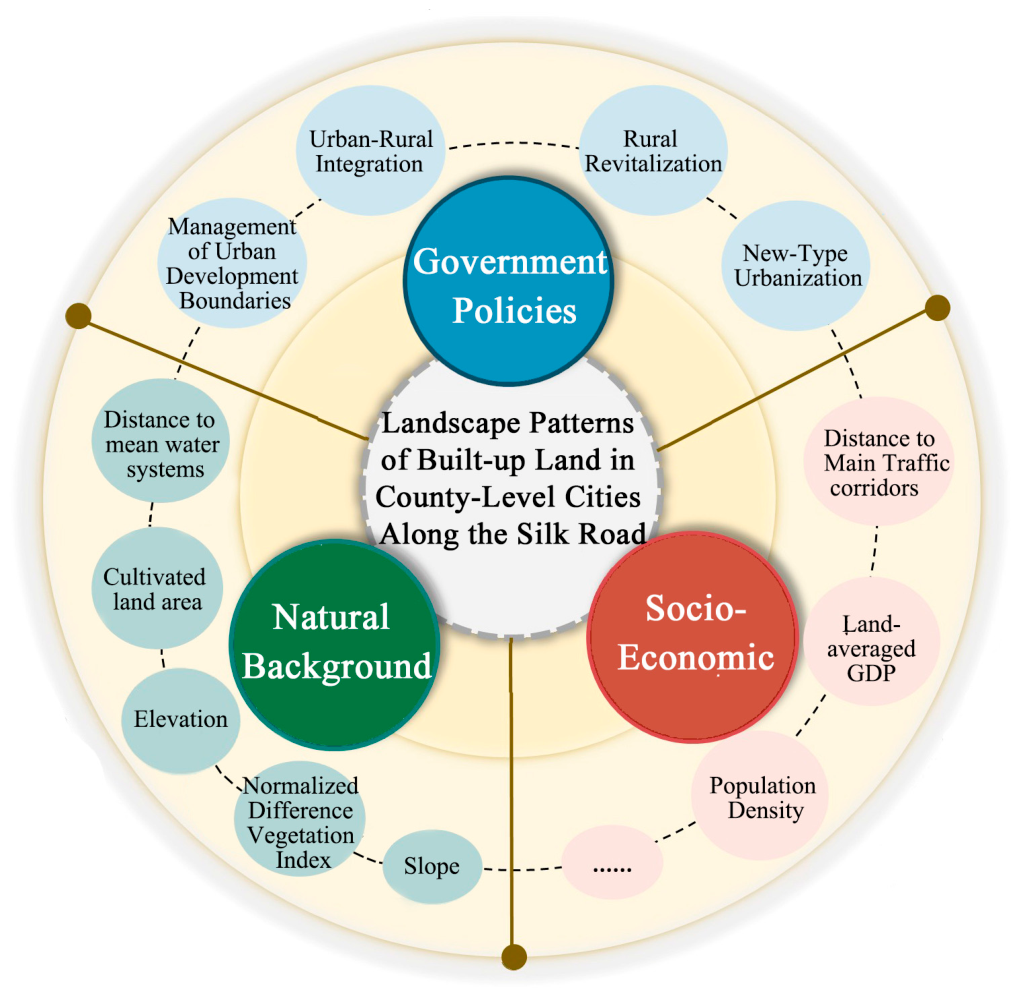
Through the detection and analysis of various factors influencing the built-up land landscape patterns in counties along the Silk Road, the results indicate that the spatial differentiation characteristics of built-up land landscape patterns exhibit significant spatial correlations with natural background constraints and socioeconomic activities. Furthermore, the intensity of these correlations and the nature of their interactions vary across different sections. Furthermore, the current state of these landscape patterns objectively reflects the spatial guidance and regulatory characteristics of policy factors such as the urbanization process in these counties, integrated urban–rural development, national spatial planning, and urban development boundary controls (Figure 6).
3.3.1. The Fundamental Relationship Between Natural Background Factors and Spatial Variation in Built-Up Land Landscape Pattern
The study area spans China’s northwestern arid and semi-arid regions, where the natural geographic background—including cultivated land area and the distribution of water systems—exhibits a significant spatial correspondence with the current spatial boundaries of county-level built-up land. This spatial differentiation exhibits distinct geographic dependencies across different sections. In the Guanzhong-Longxi section, the advantageous physical and topographical conditions have propelled the development of towns into a stage of population polarization, demonstrating the region’s suitability for high-density settlements. In the Hexi Corridor section, due to spatial barriers posed by harsh natural boundaries such as the desert and Gobi on the outer periphery, built-up land exhibits a linear distribution along the oases and is generally highly fragmented. In contrast, in the northern and southern sections of the Tianshan Mountains, areas with favorable soil and water conditions on alluvial fan plains correspond to larger, relatively concentrated patches of built-up land. The aforementioned spatial correspondence indicates that, from a single-period cross-sectional perspective, the natural background conditions of arid and semi-arid regions objectively constitute an indispensable, rigid geographical foundation for the spatial differentiation of the built-up land landscape pattern.
3.3.2. Analysis of the Relationship Between Socioeconomic Factors and Spatial Differentiation of Built-Up Land
The spatial unevenness of socioeconomic activity is profoundly reflected in the geometric morphology, density, and spatial agglomeration characteristics of landscape patches on land designated for construction. The analysis results show that economic density, population distribution, and transportation location are highly correlated with mean patch size (MPS), agglomeration index (AI), and mean fractal dimension (FRAC_MN). In terms of spatial correspondence, districts and counties in the Guanzhong–Longxi section with high population density and economic size directly correspond to high mean patch size and low fragmentation in landscape indices, indicating a significant spatial isomorphism between strong socioeconomic agglomeration and contiguous, unbroken patches. In contrast, the arid oasis environments of the Hexi Corridor and the northern and southern Tianshan sections have made transportation arteries the physical links connecting isolated oasis patches. Transportation location factors and the linear and ribbon-like patterns of built-up land along major transportation axes exhibit a highly consistent spatial distribution pattern, and areas of high population and economic density overlap with highly intensive core patches within the oases. These characteristics objectively confirm that socioeconomic and locational conditions are key explanatory factors reflecting the spatial intensity and differentiation patterns of built-up areas along the Silk Road.
3.3.3. Qualitative Supplementary Explanation from the Perspectives of Spatial Planning and Policy Regulation
It should be noted that, given the difficulty of quantitatively representing policy factors in a spatially continuous manner, this study does not directly incorporate explicit policy-related explanatory variables into the model. Instead, it offers a qualitative, exploratory discussion from the perspectives of institutional governance and planning policies. In recent years, the state has explicitly promoted new-type urbanization and integrated urban–rural development with county towns as key vehicles [39]. Under this policy guidance, public resources and industrial factors have been allocated with a tendency toward county-level centers. Spatially, this aligns well with the policy context of the spatial distribution revealed earlier, in which city districts and ordinary counties maintain high levels of agglomeration (AI) and regularity. At the same time, the strict implementation of territorial spatial control tools—such as the “Three Zones and Three Lines” (the arable land protection red line, the ecological protection red line, and the urban development boundary)—has imposed rigid spatial constraints and regulatory boundaries on the disorderly sprawl of built-up land use. This is particularly evident in the ecologically fragile Hexi Corridor and the northern and southern Tianshan sections. Development boundary controls have objectively directed new construction space toward existing transportation corridors and the hinterlands of existing oases, thereby curbing the blind outward expansion of scattered patches along the edges of the Gobi and desert regions. Therefore, although macro-level policy regulations were not included as quantitative factors in the statistical analysis as part of the external institutional environment, they objectively corroborate and further explain-through spatial orientation and development boundaries-the characteristics of intensification and boundary constraints in the current landscape pattern of built-up land.
Figure 6.
Schematic Diagram of the Concept of Influencing Factors.
4. Conclusions and Discussion
4.1. Conclusions
4.1.1. The Built-Up Land Landscape Pattern for Development Exhibits Significant Spatial Heterogeneity Across Different Sections
In all sections, both the area of urban districts and the mean patch size (MPS) remained at high levels. The agglomeration index (AI) generally exceeded 89.0%, while the shape index was relatively low. Among these, the urban districts in the northern and southern sections of the Tianshan Mountains exhibited the most pronounced compact clustering (with a median MPS of 101.41 hm2), while those in the Hexi Corridor section had the highest number of patches. The Guanzhong-Longxi section displayed a continuous, low-fragmentation pattern supported by plain terraces. Ordinary counties exhibited significantly lower MPS values. Ordinary counties in the Guanzhong-Longxi and Hexi Corridor sections showed higher fragmentation, which spatially correlated closely with the topography of ravines and oasis margins. In contrast, ordinary counties in the northern and southern sections of the Tianshan Mountains were constrained by the boundaries of inland oases, making it difficult for construction land to spread outward. As a result, these areas exhibit the lowest patch density in the entire region and are characterized by a compact, intensive layout.
4.1.2. Analysis of Spatial Variation Characteristics and Factor Correlations in the Landscape Pattern of Built-Up Land
Based on factor analysis and interactive analysis using the Geographic Detector, the spatial differentiation of the landscape pattern of built-up land along the Silk Road shows a strong correlation with distance to waterways, the baseline of cultivated land resources and land-averaged GDP. Due to the combined influence of regional differences in natural geographic conditions and socioeconomic carrying capacity, the areas of high population and economic density in the Guanzhong-Longxi section closely align with large, regular patches. In the Hexi Corridor section, the agglomeration of built-up land is constrained by oasis water and soil conditions as well as major transportation routes, while the core oasis patches in the northern and southern sections of the Tianshan Mountains exhibit a high degree of agglomeration and compactness. Overall, the spatial pattern of county-level built-up land along the Silk Road reflects, in a static spatial context, a dual spatial mapping of rigid constraints imposed by natural water and soil conditions and the intensity of socioeconomic activities. At the same time, spatial land-use control red lines—such as the “Three Zones and Three Lines”—provide an institutional explanatory framework for the boundaries of intensive land use in each section at the macro-qualitative level. This offers a scientific basis for promoting the optimization and refined governance of county-level territorial space in the ecologically fragile belt of Northwest China in a manner tailored to local conditions.
4.2. Discussion
Since the launch of reform and opening up, China’s urbanization has progressed rapidly. By 2025, the national urbanization rate had reached 67.89% [40]. Recent studies indicate that the rate of urban land expansion in China far exceeds the rate of population growth [41], and in the process of urbanization at the county level, land urbanization generally advances faster than population urbanization [42]. Nonetheless, due to China’s substantial population and constrained land resources, the swift progression of urbanization, industrialization, and economic development has resulted in heightened rivalry across many land-use categories, potentially precipitating a variety of socioeconomic and ecological challenges. In recent years, effective regulation of the unrestrained growth of urban and rural construction land in the economically advanced eastern regions has been achieved, guided by national spatial planning focused on the judicious allocation of land resources and the harmonious development of the relationship between people and land, leading to a stabilization of regional demand for construction land. Meanwhile, demand for construction land has risen significantly in cities in central and western China [43]. Therefore, based on the spatial differentiation characteristics identified in this study, land-use planning for counties along the Silk Road should not simply replicate the development models of the developed eastern regions. Instead, it should adopt differentiated and refined spatial regulation strategies tailored to local conditions. The Guanzhong-Longxi section should focus on consolidating fragmented land parcels and revitalizing existing urban areas within municipal jurisdictions. The Hexi Corridor section should adhere to the principle of “land use determined by water availability,” strictly control blind expansion along major transportation corridors, and delineate ecological buffer zones around oases. The northern and southern Tianshan sections should rigidly lock in urban development boundaries, strictly prohibit the encroachment of built-up land into alluvial fan water and soil conservation areas, and implement compact and intensive development within oases.
As a key land corridor for the westward opening of the “Belt and Road” Initiative, the Silk Road not only serves as a strategic economic corridor for China’s new urbanization and westward opening but also functions as a national ecological security barrier spanning from the semi-humid Loess Plateau to the extremely arid desert regions. The findings of this study are supported by empirical research conducted at the typical urban scale. For example, the “string of pearls” pattern of built-up land extending along the Hexi Corridor further corroborates the spatial characteristics of oasis cities such as Zhangye, which are highly dependent on water sources and major transportation corridors. Meanwhile, the compact clustering of urban districts in the northern and southern sections of the Tianshan Mountains is largely consistent with the established understanding that towns in Xinjiang form “widely dispersed yet locally clustered” oasis islands, constrained by the rigid water and soil boundaries of alluvial fans at the mountain foothills.
Further examining the Silk Road Corridor within the context of global arid regions reveals a strikingly different spatial logic. In Egypt’s Nile Delta, urbanization manifests as the disorderly and informal encroachment on high-quality alluvial farmland amid weak institutional oversight [44]. In the “Sun Corridor” of the U.S. Southwest, low-density “sprawl” has emerged, driven by interbasin water transfer projects that have overcome water constraints, leading to the widespread encroachment on desert habitats and the fragmentation of ecological networks [45]. In stark contrast, development within the Chinese sections of the Silk Road—particularly the Hexi Corridor and the Tianshan Mountain regions—is subject to dual, rigid constraints: the strict limits imposed by local water and soil resources, and China’s top-down national spatial planning. Land for construction has not expanded indiscriminately into the ultra-arid desert matrix, nor has it evolved into a one-way encroachment on farmland; rather, using farmland as a foundation, it has exhibited characteristics of synergistic clustering within the oases.
Future research should focus on the following areas: (1) The data collected in this study are limited to the year 2023. Given the relatively narrow study period, it is not possible to track the dynamic temporal trajectory of construction land expansion over several decades, nor can a strict causal mechanism be established based on this data. Future research should expand to include 10–30 years of long-term remote sensing interpretation to dynamically reveal the evolution of spatial patterns. (2) This study uses county-level units as the basic statistical unit, which introduces a certain degree of administrative unit effect. Micro-scale heterogeneity within counties (such as at the township level or within kilometer-scale grids) may be masked by county-level statistical averages. Future research should incorporate higher-resolution gridded spatial data to conduct multi-scale nested comparisons. (3) Although the study covers a total of 112 districts and counties across the region, the sample size of districts and counties in subregions—such as the Hexi Corridor section—within the three-tier geographic classification is relatively small. This limits, to some extent, the statistical freedom of the geographic detector in multi-level interactive detection within subregions. In the future, micro-patch units could be introduced to expand the sample size. (4) Due to limitations in the standardized matching of spatial data, this model was unable to incorporate fine-grained climate change parameters from long-term time series—such as precipitation and temperature. Furthermore, national-level spatial governance policies are difficult to directly convert into quantifiable grid-based indicators, resulting in policy factors being discussed only as a qualitative context. Future research should further explore the in-depth integration of spatial quantification models for policy intensity with high-precision climate simulation data.
Author Contributions
Conceptualization, Y.G. and L.Z.; methodology, L.Z. and F.W.; software, L.Z. and F.W.; validation, Y.G., L.Z. and Y.J.; formal analysis, L.Z.; investigation, L.Z.; resources, Y.G.; data curation, L.Z.; writing—original draft preparation, L.Z.; writing—review and editing, Y.G.; visualization, L.Z.; supervision, Y.G.; project administration, Y.G.; funding acquisition, Y.J. All authors have read and agreed to the published version of the manuscript.
Funding
This research was funded by the General Program of the National Natural Science Foundation of China (Grant No. 52478069); the Social Science Foundation of Shaanxi Province (Grant No. 2025J009); the Key Scientific Research Program Funded by Education Department of Shaanxi Provincial Government (Grant No. 24JT008); and the Natural Science Basic Research Program of Shaanxi (Grant No. 2026JC-YXQN-154).
Data Availability Statement
Data will be made available on request.
Conflicts of Interest
The authors declare no conflicts of interest.
Appendix A
Table A1.
Results of the Urban Landscape Patterns in 112 County-Level Units Along the Silk Road.
References
- Lei, G. Agglomerative shrinkage of county-level population in the process of urban-rural integration: Impacts and response strategies. China Popul. Resour. Environ. 2024, 34, 1–11. (In Chinese) [Google Scholar]
- Chinese Government. General Office of the CPC Central Committee & General Office of the State Council. Opinion on Advancing Urbanization with Counties as Important Carriers. 2022. Available online: https://www.gov.cn/zhengce/2022-05/06/content_5688895.htm (accessed on 15 April 2026). (In Chinese)
- Chinese Government. Xi Jinping Report to the 20th National Congress of the Communist Party of China. 2022. Available online: https://www.gov.cn/xinwen/2022-10/25/content_5721685.htm (accessed on 15 April 2026). (In Chinese)
- Jiao, L.M.; Mao, L.F.; Liu, Y.L. Multi-order Landscape Expansion Index: Characterizing urban expansion dynamics. Landsc. Urban Plan. 2015, 137, 30–39. [Google Scholar] [CrossRef] [Scilit]
- Wan, Y.L.; Jin, R.; Tang, J.B.; Jin, M.H. Spatial Heterogeneity of Urban Expansion Structure Based on Spatial Clustering Method in Dongguan City. Econ. Geogr. 2019, 39, 84–92. (In Chinese) [Google Scholar]
- Deng, L.Y.; Zhang, Q.; Cheng, Y.; Cao, Q.; Wang, Z.Y.; Wu, Q.Y.; Qiao, J.M. Underlying the influencing factors behind the heterogeneous change of urban landscape patterns since 1990: A multiple dimension analysis. Ecol. Indic. 2022, 140, 108967. (In Chinese) [Google Scholar] [CrossRef] [Scilit]
- Plieninger, T.; Draux, H.; Fagerholm, N.; Bieling, C.; Bürgi, M.; Kizos, T.; Kuemmerle, T.; Primdahl, J.; Verburg, P.H. The driving forces of landscape change in Europe: A systematic review of the evidence. Land Use Policy 2016, 57, 204–214. [Google Scholar] [CrossRef] [Scilit]
- Bettencourt, L.M.A. The Origins of Scaling in Cities. Science 2013, 340, 1438–1441. [Google Scholar] [CrossRef] [Scilit] [PubMed]
- Chen, F.H.; Dong, G.H.; Chen, J.H.; Gao, Y.Q.; Huang, W.; Wang, T.; Chen, S.Q.; Hou, J.Q. Climate change and silk road civilization evolution in arid central Asia: Progress and issues. Adv. Earth Sci. 2019, 34, 561–572. (In Chinese) [Google Scholar]
- Shi, L.; Halik, Ü.; Mamat, Z.; Aishan, T.; Welp, M. Spatiotemporal investigation of the interactive coercing relationship between urbanization and ecosystem services in arid northwestern China. Land Degrad. Dev. 2021, 32, 4105–4120. [Google Scholar] [CrossRef] [Scilit]
- Yang, Y.; Hu, N. The spatial and temporal evolution of coordinated ecological and socioeconomic development in the provinces along the Silk Road Economic Belt in China. Sustain. Cities Soc. 2019, 47, 101466. (In Chinese) [Google Scholar] [CrossRef] [Scilit]
- Zhou, W.; Pickett, S.T.A.; Cadenasso, M.L. Shifting concepts of urban spatial heterogeneity and their implications for education and practice. Landsc. Ecol. 2017, 32, 15–30. (In Chinese) [Google Scholar] [CrossRef] [Scilit]
- Fang, C.; Wang, S.; Li, G. Changing urban forms and carbon dioxide emissions in China: A case study of 30 provincial capital cities. Appl. Energy 2015, 158, 519–531. (In Chinese) [Google Scholar] [CrossRef] [Scilit]
- Wang, S.J.; Bai, Y.X. Construction of the Silk-road Economic Belt and the Promotion of the Western Urbanization in China. Soc. Sci. Ningxia 2015, 1, 51–59. (In Chinese) [Google Scholar]
- Yang, J.H.; Shi, W.J.; Zhou, W.Q.; Wang, J.H.; Qian, Y.G.; Wang, W.M. A review on the driving factors and their characteristics in urban landscape pattern changes. Acta Ecol. Sin. 2024, 44, 10486–10498. (In Chinese) [Google Scholar]
- Gao, Q.; Fang, C.L.; Zhang, X.L.; Liu, H.M.; Ren, Y.F. Spatio-temporal evolution characteristics and mechanisms of influence of urban construction land expansion in Xinjiang, the Core Area of the Silk Road Economic Belt. Acta Ecol. Sin. 2019, 39, 1263–1277. (In Chinese) [Google Scholar] [CrossRef] [Scilit]
- Che, T.; Li, C.; Luo, Y.J. Changes in landscape pattern of built-up land and its driving factors during urban sprawl. Acta Ecol. Sin. 2020, 40, 3283–3294. (In Chinese) [Google Scholar] [CrossRef] [Scilit]
- Li, Z.Y.; Liu, Y.; Long, Y. Study of urban construction land expansion characteristics in Kunming central city from1990 to 2017. J. Yunnan Univ. Nat. Sci. Ed. 2019, 41, 964–973. (In Chinese) [Google Scholar]
- Zhao, X.Z.; Liang, J.N. Influence of spatial expansion of central cities in the Yellow River Basin on landscape pattern: A case study of Xi’an. J. Northwest Univ. (Nat. Sci. Ed.) 2022, 52, 391–401. (In Chinese) [Google Scholar]
- Ding, N.; Lyu, X. Analysis on the Landscape Pattern of Urban Green Space in Karst Mountainous Area. North. Hortic. 2020, 3, 85–92. (In Chinese) [Google Scholar]
- Deng, Q.; Liang, Y.Y.; Li, Y.; Zhao, L.N.; Ke, W.X. Analysis of landscape pattern change of urban agglomerations in the Yangtze River Delta—Take Shanghai, Suzhou and Hangzhou as examples. Technol. Econ. Chang. 2019, 3, 1–3. (In Chinese) [Google Scholar]
- Fan, S.P.; Wang, Q.; Wang, S.G.; Liu, Y.B.; Fei, L.C.; Liu, Y.Z. Spatial—Temporal differentiation of landscape pattern in rural residential areas within the urban—Rural fringes and its driving mechanism. J. Arid. Land Resour. Environ. 2025, 39, 92–106. (In Chinese) [Google Scholar]
- Ren, Y.; Zhu, P.; Molla, A.; Zuo, S. Evaluating the Effects of Urbanization on Land Use and Landscape Patterns in Southern China (1990–2020). Sci. Rep. 2025, 15, 42220. [Google Scholar] [CrossRef] [Scilit] [PubMed]
- Gu, T.C.; Li, T.; Zhang, Y.; Wu, X.D.; Wang, Z.G.; Zhang, G.X.; Yao, Z.M. Coupled relationships between landscape pattern and ecosystem health in response to urbanization. J. Environ. Manag. 2024, 367, 122076. [Google Scholar] [CrossRef] [Scilit] [PubMed]
- Zhang, R.W.; Ju, J.T.; Yang, J.J.; Chen, T. Exploring the Response of Landscape Patterns to Urbanization along Urban–Rural Gradients: Case Studies of Three Major Cities in the Yellow River Basin. Sci. Total Environ. 2026, 1012, 181266. [Google Scholar] [CrossRef] [Scilit] [PubMed]
- Jia, Z.; Wang, Y.J.; Cao, H.H.; Zhao, J.Y. Urban spatial evolution of Lanzhou along the Silk Road and its influencing factors. Quat. Sci. 2022, 42, 311–324. (In Chinese) [Google Scholar]
- Lei, Y.; Zhang, X.B.; Luo, J.; Li, Y.X.; Wang, Z.Y.; Yao, L.T.; Li, X.H. Spatio-temporal evolution of urban landscape pattern in arid areas based on different zones: A case study of Zhangye City. Acta Ecol. Sin. 2023, 43, 2034–2048. (In Chinese) [Google Scholar] [CrossRef] [Scilit]
- Wijesinghe, D.C.; Sun, P.J.; Liu, Z.G. Spatial Evolution Characteristics and Driving Factors of Urban Forms in the Colombo Metropolitan Area (CMA), Sri Lanka: A Geo-Informatics Approach. Land Use Policy 2026, 162, 107900. [Google Scholar] [CrossRef] [Scilit]
- Ran, P.; Frazier, A.E.; Cong, X.; Tiando, D.S.; Feng, Y.B. How Does Urban Landscape Pattern Affect Ecosystem Health? Insights from a Spatiotemporal Analysis of 212 Major Cities in China. Sust. Cities Soc. 2023, 99. [Google Scholar] [CrossRef] [Scilit]
- Salem, M.; Tsurusaki, N. Impacts of Rapid Urban Expansion on Peri-Urban Landscapes in the Global South: Insights from Landscape Metrics in Greater Cairo. Sustainability 2024, 16, 2316. [Google Scholar] [CrossRef] [Scilit]
- Wahyudi, A.; Liu, Y.; Corcoran, J. Combining Landsat and Landscape Metrics to Analyse Large-Scale Urban Land Cover Change: A Case Study in the Jakarta Metropolitan Area. J. Spat. Sci. 2019, 64, 515–534. [Google Scholar] [CrossRef] [Scilit]
- Woodman, T.L.; Alexander, P.; Burslem, D.F.R.P.; Travis, J.M.J.; Winkler, K.; Eigenbrod, F. Global Assessment of Landscape Pattern Changes from 1992 to 2020. Landsc. Ecol. 2025, 40, 196. [Google Scholar] [CrossRef] [Scilit] [PubMed]
- Dadashpoor, H.; Azizi, P.; Moghadasi, M. Land use change, urbanization, and change in landscape pattern in a metropolitan area. Sci. Total Environ. 2019, 655, 707–719. [Google Scholar] [CrossRef] [Scilit] [PubMed]
- Gan, L.; Liu, Y.; Zhang, Y. Integrating multi-source data to explore spatiotemporal dynamics and future scenarios of arid urban agglomerations: A Geodetector-PLUS modelling framework in Xinjiang, Northwest China. Remote Sens. 2025, 17, 1851. [Google Scholar] [CrossRef] [Scilit]
- Wang, L.H.; Zhang, J.M. Driving Force Analysis of Spatial Expansion of Oasis Towns Basedon Geographical Detectors: Take Shihezi City in Xinjiang as An Example. Areal Res. Dev. 2019, 38, 68–74. [Google Scholar]
- Liu, J.; Zhang, G.; Zhuang, Z. Analysis of the heterogeneity of urban expansion and its driving mechanism in the arid and semi-arid zones using Geodetector. Ecol. Indic. 2022, 137, 108781. [Google Scholar]
- Mcgarigal, K.; Marks, B.J. FRAGSTATS-Spatial Pattern Analysis Program for Quantifying Landscape Structure. In General Technical Report; PNW-GTR-351; US Department of Agriculture, Forest Service, Pacific Northwest Research Station: Portland, OR, USA, 1995. [Google Scholar]
- Wang, J.F.; Xu, C.D. Geodetector: Principle and prospective. Acta Geogr. Sin. 2017, 72, 116–134. (In Chinese) [Google Scholar]
- Xu, G.P.; Xi, Z.X. Spatiotemporal Patterns and Types of Evolutionary Driving Forces for County Urbanization in China. Dong Yue Trib. 2025, 46, 111–120. (In Chinese) [Google Scholar]
- National Bureau of Statistics. Statistical Communiqué of the People’s Republic of China on the 2025 National Economic and Social Development. 2026. Available online: https://www.stats.gov.cn/xxgk/sjfb/tjgb2020/202602/t20260228_1962662.html (accessed on 15 April 2026). (In Chinese)
- Miao, H.; Zhao, S.Q. Tracing Trajectories and Co-Evolution of Metropolitan Urbanization in the United States, Europe, and China. Sci. Total Environ. 2024, 945, 173894. [Google Scholar] [CrossRef] [Scilit] [PubMed]
- Yu, L.L.; Liao, D.M. Spatial correlation network of new-type urbanization and its impact on territorial spatial utilization efficiency. J. Soil Water Conserv. 2026, 40, 304–318. (In Chinese) [Google Scholar]
- Wen, L.G.; Shen, T.Y. Inter-regional Land Resource Allocation Under China’s Territorial Spatial Planning System: Realistic Challenges and Solutions. Inq. Into Econ. Issues 2024, 8, 87–100. (In Chinese) [Google Scholar]
- Radwan, T.M.; Blackburn, G.A.; Whyatt, J.D.; Atkinson, P.M. Dramatic Loss of Agricultural Land Due to Urban Expansion Threatens Food Security in the Nile Delta, Egypt. Remote Sens. 2019, 11, 332. [Google Scholar] [CrossRef] [Scilit]
- Perkl, R.; Norman, L.M.; Mitchell, D.; Feller, M.; Smith, G.; Wilson, N.R. Urban growth and landscape connectivity threats assessment at Saguaro National Park, Arizona, USA. J. Land Use Sci. 2018, 13, 195–213. [Google Scholar] [CrossRef] [Scilit]

Disclaimer/Publisher’s Note: The statements, opinions and data contained in all publications are solely those of the individual author(s) and contributor(s) and not of MDPI and/or the editor(s). MDPI and/or the editor(s) disclaim responsibility for any injury to people or property resulting from any ideas, methods, instructions or products referred to in the content. |
© 2026 by the authors. Licensee MDPI, Basel, Switzerland. This article is an open access article distributed under the terms and conditions of the Creative Commons Attribution (CC BY) license.