


Abstract
Alleviating the cultivated land pressure in the black soil region of Northeast China is an essential requirement for safeguarding national food security. Taking 34 prefecture-level and above cities in the Northeast China black soil region from 2008 to 2022 as the research samples, this study comprehensively adopts the spatiotemporal geographically weighted regression model and K-means clustering model to reveal the driving factors and spatial differentiation of cultivated land pressure in the study area. The research conclusions are as follows: (1) Temporally, the cultivated land pressure in the Northeast China black soil region presents a fluctuating downward trend, and 41% of the cities are in a pressure-free state. Spatially, it shows an unbalanced pattern ranked as Heilongjiang > Liaoning > Jilin > the four leagues in eastern Inner Mongolia. (2) Cultivated land pressure in the Northeast China black soil region is affected by multiple factors, including local finance, agricultural mechanization, agricultural infrastructure, urbanization, chemical fertilizer application, and population loss, with the influence intensity of each factor exhibiting obvious spatial heterogeneity. (3) Based on the spatial heterogeneity of influencing factors of cultivated land pressure, the study area can be classified into six types: the Songnen Plain, dominated by local fiscal health and agricultural mechanization investment intensity; the Sanjiang Plain, dominated by the degree of population loss; the Liaohe Plain, dominated by the urbanization level; the Changbai Mountain–Eastern Liaoning region, with balanced driving effects of all influencing factors; the Western Windy–Sandy Region, dominated by agricultural mechanization investment intensity; and the Greater Khingan Range region, dominated by the chemical fertilizer application level. There are significant differences in cultivated land pressure and its driving factors among subregions of the Northeast China black soil region. Therefore, it is necessary to formulate differentiated cultivated land pressure mitigation strategies according to local actual conditions.
1. Introduction
Food security has long been considered to be of national strategic importance [1,2]. The black soil region in Northeast China is of paramount importance for the national equilibrium of grain supply and demand. This is due to its status as a principal grain production base and a commodity grain center [3,4]. Driven by the expansion of international grain trade and shifts in the consumption patterns of the domestic population, both domestic and international grain demand have risen sharply [5,6,7]. The intensive use of cultivated land has thus become a common strategy to meet food supply demands. However, this region now faces severe challenges due to expanding urban land use, illegal farmland transactions, and soil erosion [8,9]. It follows that exploration into the extent and potential threats to such land resources in this vital agricultural region is significant.
Black soil, often called the “giant panda” of cultivated land due to its rarity and exceptional fertility, has been increasingly recognized as a critical and strategic natural resource requiring urgent protection and sustainable use in recent years. Driven by central government initiatives, the Northeast region has developed an integrated model for black soil conservation and utilization. This approach combines engineering and biological techniques, aligns agricultural machinery with agronomic practices, and integrates land use with conservation planning, producing promising early outcomes. Nonetheless, the black soil region continues to suffer from increasingly severe issues, including soil thinning, degradation, and compaction, which significantly constrain agricultural productivity. According to a report by the Northeast Institute of Geography and Agroecology [10], grain production capacity in this region has fallen by around 20% compared to the levels before reclamation. Additionally, the black soil layer, once 60–80 cm thick prior to reclamation, has now declined to only 20–40 cm.
Against the backdrop of national food security, some critical questions arise: What are the temporal and spatial patterns of cultivated land pressure in this region? Is there spatial heterogeneity in the driving factors? Other researchers have conducted preliminary explorations of this pressure in the study region from food security and international trade perspectives, and have gradually focused on the spatial configuration of this pressure [11]. However, existing research ignores the regional heterogeneity of the driving forces and mostly shows the aggregate influence of several extrinsic factors on cultivated land pressure. This study aims to address the following goals: (1) Using the “trinity” protective concept of cultivated land as a guide, develop a theory-based analysis framework for cultivated land pressure; (2) determine the regional and temporal dynamics of this pressure using panel data from 34 prefecture-level cities in the research region (2008–2022); (3) use a spatiotemporal geographically weighted regression (GTWR) model to empirically examine the spatial heterogeneity of the driving variables; and (4) further reveal regional disparities in driving mechanisms through K-means clustering analysis.
2. Literature Review and Theoretical Foundations
2.1. Literature Review
The term “pressure” originated from the Latin word “premere” and was initially applied in the fields of physics and psychology. Over time, the concept has expanded to the domain of cultivated land. In 2007, the research team led by Chinese scholar Cai et al. (2002) [12] proposed the core calculation method of the cultivated land pressure index in the article “Analysis of the Spatiotemporal Law of China’s Cultivated Land Pressure Index” published in Acta Geographica Sinica. This index quantifies the tension in regional cultivated land resources by comparing the ratio of the theoretical minimum per capita cultivated land (based on factors such as grain demand and yield levels) to the actual per capita area of cultivated land. This model transforms “pressure” from an abstract description into a measurable scientific indicator, laying the methodological foundation for subsequent related research.
A review of the literature reveals that existing studies on cultivated land pressure have primarily focused on four dimensions, which are detailed as follows: (1) Various methods have been used to assess cultivated land pressure. Despite the diversity in approaches, most studies still emphasize the fundamental concept of this pressure. A widely accepted measure involves the comparison of the proportion of minimally cultivated land per capita to the existing per acre area, which has become a standard way to quantify this pressure. (2) Researchers have investigated the spatiotemporal patterns of this pressure using various models, such as centrogravity, gray, and predictive models [13,14], in order to highlight key regional differences. Some researchers have enhanced these indices by incorporating a standard coefficient to account for regional variations in land quality. Based on their analysis of spatiotemporal changes in this way, they suggest that land protection strategies should focus on the buffer period when pressure decreases. This period offers an opportunity for managing fallow cycles and crop rotation, thus improving soil fertility. Some scholars have also introduced the external pressure index and the original model to form a comprehensive pressure index of cultivated land for spatiotemporal characteristic analysis [15,16]. (3) In terms of driving factors, international grain trade and urbanization are commonly viewed as key drivers of increased cultivated land pressure [17,18], while agricultural technological progress, the level of agricultural infrastructure, and policy regulations can effectively alleviate the pressure on cultivated land. (4) In terms of pressure trend prediction, most scholars have adopted methods such as the gray model GM (1,1), the smoothing prediction method, and the combination of the gray GM (1,1) prediction method and the Markov modified model to predict the trend of food security based on cultivated land pressure index values in different regions of China [19,20,21]. The research conclusion generally holds that various regions show distinct trends in their land pressure levels. Such pressure can be alleviated and regional food security can be guaranteed by improving agricultural technology and increasing the multiple cropping index.
Compared with previous studies, the possible marginal contribution of this research lies in the following: First, while cultivated land pressure measurement in this region has been extensively studied, investigations into the spatial heterogeneity of its driving factors remain limited. Against the backdrop of the current dual reality of food security and the conservation and exploitation of black soil, it is important to reveal the spatial heterogeneity of the factors responsible for pressure on cultivated land in this region. Second, this pressure is a dynamic process exhibiting spatiotemporal variation. Given China’s vast territory and significant differences in geographic locations and resource endowments among cities, these factors may display non-stationary characteristics across time and space. Existing studies have predominantly adopted a global perspective, focusing on the average influence of each factor, while largely overlooking spatial heterogeneity. The method employed in this study facilitates a fine-scale understanding of cultivated land pressure, enabling the formulation of more targeted and region-specific policies. Third, this study utilizes continuous panel data from the Northeast Black Soil Region, minimizing data heterogeneity and ensuring comparability over time.
2.2. Theoretical Foundations
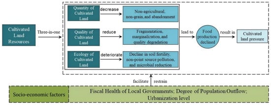
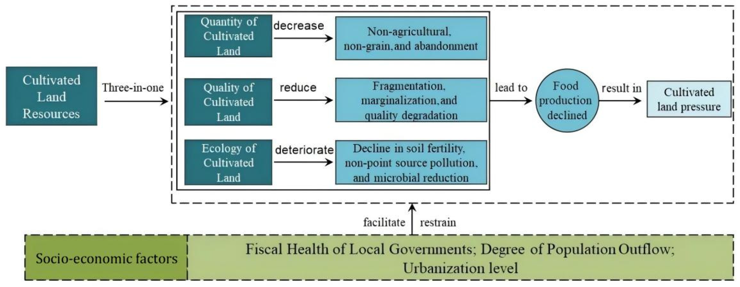
Cultivated land protection has achieved a historic transformation from “emphasizing quantity” to “attaching equal importance to quantity and quality” to “integrating quantity, quality, and ecology” [22]. The extent of cultivated land pressure change indicates the effectiveness of protection measures [23]. When the demand for cultivated land exceeds its available supply, an imbalance occurs between supply and demand []. This pressure reflects the interaction between human activities and land resources. Accordingly, this study aims to develop a theoretical framework for analyzing cultivated land pressure, based on the “three-in-one” concept of land protection (Figure 1). (1) Cultivated land is faced with problems such as “non-agricultural, non-grain, and abandonment,” which leads to a sharp decrease in the grain output of cultivated land, thereby aggravating the tension of cultivated land resources. A reduction in the amount of arable land directly leads to a reduction in grain production capacity while also increasing the volatility of food supply, thus leading to uncertainty in regional food supply. (2) The irrational cultivated land system has caused land fragmentation and marginalization, resulting in reduced grain production and exacerbating pressure on resources in particular, the basis of grain production is arable land productivity or soil fertility. (3) Excessive input of production factors such as fertilizers and pesticides has led to problems such as “non-point source pollution and microbial reduction” on cultivated land.
Figure 1.
The research framework of farmland pressure theory.
This pressure is the result of multiple socio-economic factors (Figure 1) and, as such, the model includes local fiscal health, agricultural mechanization intensity, infrastructure development, urbanization level, chemical fertilizer application, and population loss rate as control variables [24,25]. Among them, the local fiscal health level reflects the structural imbalance between government expenditure and revenue capacity in a certain region, and the selection of its indicators can reveal whether cities have more funds for cultivated land protection and improvement, which in turn affects the pressure on cultivated land. With an increase in the agricultural mechanization input level, the regional agricultural cultivation efficiency can be significantly improved, which has a positive effect on this land pressure. The level of chemical fertilizer use indicates the total amount applied in agricultural production over a specific period. Moderate application of chemical fertilizers can promote food production, but excessive application can induce farmland pollution and lead to increased farmland pressure. The level of agricultural infrastructure construction plays a crucial role in adjusting regional agricultural structures. Well-equipped rural irrigation and drainage, power transmission and distribution, field roads, and farmland protection can improve agricultural quality and efficiency. As urbanization increases, some land is shifted from farming to other uses, reducing grain production and intensifying land pressure in this region. Population loss refers to the phenomenon of migration or movement of people from one region to another due to socio-economic development. Theoretically, population loss can effectively alleviate this pressure. However, as young people migrate for work, issues like a shrinking agricultural labor force and land abandonment arise, limiting agricultural production and industrial development, which in turn worsens the pressure on regional cultivated land.
3. Materials and Methods
3.1. Study Area
Located in Northeast China, the Northeast Black Soil Region is widely known as China’s “Granary.” This region covers 38 prefecture-level and higher administrative units across four provinces, with a total area of approximately 1.24 million square kilometers. It should be noted that four prefecture-level units—Daxing’anling Prefecture, Jixi City, Yanbian Korean Autonomous Prefecture, and Dandong City—were excluded from this study due to severe gaps in socio-economic data. Finally, 34 prefecture-level cities were selected as the case areas for this study. As a result, 34 prefecture-level cities were ultimately selected as the research objects. According to the “Report on the Protection and Utilization of Black Soil in Northeast China (2021),” the share of national grain output produced by this region rose from 12.74% to 25.36% between 2000 and 2021, and the growth of grain output in this region contributed to 50.71% of the total increase in China’s national grain output over this period. Compared with other regions in China, the study area is characterized by fertile black soil, high grain yield, excellent grain quality, and a high grain commercialization rate. However, issues including the shrinking quantity of cultivated land, declining cultivated land quality, and deteriorating ecological environment of cultivated land have become increasingly prominent in this region. Therefore, researching the state of cultivated land pressure in this region is of great necessity.
3.2. Research Methodology
(1) Cultivated land pressure index model. The ratio of the minimum per capita cultivated land area to the actual per capita cultivated land area is widely used to characterize cultivated land pressure, as the method is scientifically valid, produces intuitive results, and is simple to apply. This approach has been adopted in the studies of Deng et al. (2022) [25] and Cui, Wang et al. (2023) [11]. The specific calculation formula is as follows:
In the formula, CLSI is cultivated land pressure; Smin is the minimum per capita cultivated area (hm2/per person); S is the actual per capita cultivated land area (hm2). The formula for calculating Smin is as follows:
In the formula, β characterizes the regional grain self-sufficiency rate (%), which is a dimensionless indicator. Gr is the regional per capita food requirement (kg/per person). p, q, and k represent regional grain yield (kg/hm2), the proportion of regional grain sown area in total regional crop sown area, and regional multiple cropping index, respectively.
Therefore, based on the existing research, this study corrects the traditional cultivated land pressure by increasing the proportion of cultivated land grain production capacity in each region of Northeast China, and the specific correction formula is as follows:
In the formula, α represents the correction coefficient of cultivated land pressure, which mainly reflects the quota of the average cultivated land production capacity in a certain region to the total production capacity of the country, and the calculation formula is as follows:
In the formula, Pb and Pc characterize the regional grain yield per unit area (kg/hm2) and the national grain yield per unit area (kg/hm2), respectively. kb and kc characterize by the regional multiple cropping index and the national average multiple cropping index, respectively. Ab and Ac are the regional cultivated land area (hm2) and the national cultivated land area (hm2), respectively.
(2) Spatiotemporal geographically weighted regression model. The geographically weighted regression model (GWR) embeds spatial locations into ordinary linear regression models (OLR) to detect the spatial non-stationarity of things [26]. Different from the geographically weighted regression model, the spatiotemporal geographically weighted regression method (GTWR) can provide multi-dimensional analysis capabilities as it has the ability to explore the non-stationary characteristics of a certain property in both spatial and temporal dimensions. Therefore, this model is used to analyze the spatiotemporal distribution characteristics and driving factors of cultivated land pressure in this region. In this paper, the empirical model is set as
In the formula, Y represents cultivated land pressure; X represents explanatory variables such as the health level of local finance; i characterizes samples from various regions; μ, v, and t represent the sample longitude, latitude, and time, respectively; β0(μi, vi, ti) is the intercept; βk(μi, vi, ti) is the estimation coefficient; k is the ordinal number of the explanatory variable; p is the total number of explanatory variables. If β > 0, it is considered to be positively correlated with the relationship between the explanatory variable and the explanatory variable; otherwise, it is negatively correlated. εit denotes the random error term.
3.3. Data Sources
Considering the 34 prefecture-level cities in the research area from 2008 to 2022 as the basic units, five factors were selected as the basic indicators to evaluate the pressure on cultivated land [27,28,29,30]: (1) the area of cultivated land; (2) the total grain production; (3) total demand; (4) sown area of grain, and (5) total sown area of crops (Table 1). The local financial health level, agricultural mechanization input intensity, agricultural infrastructure construction level, urbanization level, and population loss degree were used as explanatory variables. The panel data used in this study were mainly from the China Regional Economic Statistical Yearbook and the China City Statistical Yearbook, and some of the missing data in the above yearbooks are supplemented using regional statistical yearbooks and related databases (Table 1).
Table 1.
Variable description and data sources.
4. Results and Analysis
4.1. Analysis of the Spatiotemporal Evolution of Cultivated Land Pressure in the Northeast Black Soil Region of China
From the perspective of temporal evolution, the pressure on cultivated land in the black soil region of Northeast China generally showed a fluctuating downward trend throughout the study period. Overall, it decreased from 0.865 in 2008 to 0.814 in 2022, with a multi-year average of 0.887, placing it at the low-pressure level. If the current conditions remain unchanged, there is theoretically room for an improvement of at least 38.7% for cultivated land in this region to reach a pressure-free state. In terms of pressure grade classification (Table 2), around 35% of the cities are at or above the low-pressure grade, while approximately 41% of them fall into the pressure-free interval. Following the research method proposed by Cui and Wang, (2023) [11], we divided the cultivated land pressure index into multiple grades. The results indicate that for the 34 studied cities in the black soil region of Northeast China between 2008 and 2022, the number of cities with a cultivated land pressure index lower than 0.5 remained stable at 14, all classified as pressure-free. The number of cities at the low- and medium-pressure grade stayed at 5 and 3, respectively, while the number of high-pressure-grade cities remained at 13.
Table 2.
Number of cultivated land pressure grading regions in the black soil area of Northeast China, 2008–2022.
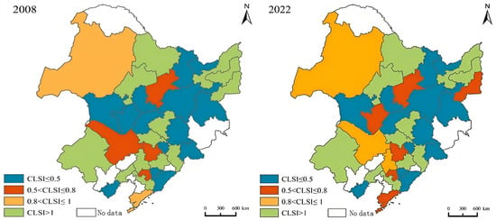
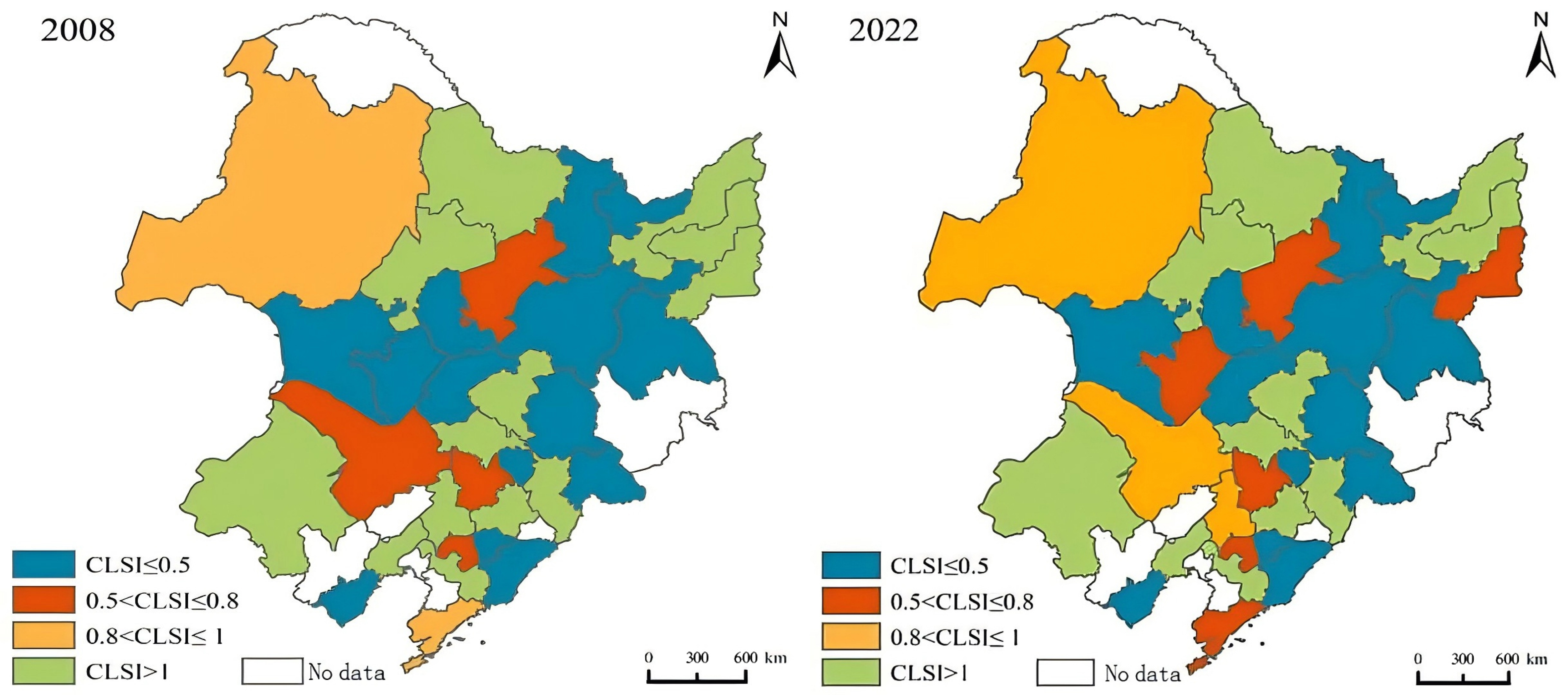
From the perspective of spatial evolution, cultivated land pressure in the black soil region of Northeast China during the study period presents an overall pattern of Heilongjiang > Liaoning > Jilin > four leagues in eastern Inner Mongolia. The minimum cultivated land pressure value is 0.026 (recorded in Baishan City in 2016), and the maximum value is 2.939 (recorded in Tonghua City in 2009). Notably, cultivated land pressure in Heilongjiang, Jilin, and the four leagues of eastern Inner Mongolia shows a downward trend, while that in Liaoning Province shows an upward trend. Among the four administrative regions, Jilin Province saw the most prominent decline, with a drop of 0.25. This study adopted the natural break point method to classify the cultivated land pressure of the 34 studied cities into four grades (Figure 2). The results reveal that cultivated land pressure has obvious spatial agglomeration characteristics, presenting a general spatial pattern of “low in the central region and high in surrounding areas.” High-pressure areas are mainly distributed in Heihe City, Qiqihar City, Jiamusi City, Shuangyashan City, Chifeng City, and other regions. Low-pressure areas are concentrated in Hinggan League, Baicheng City, Daqing City, Songyuan City, Harbin City, and other regions.
Figure 2.
Spatial pattern of cultivated land pressure levels in the black soil area of Northeast China, 2008–2022. Note: This figure is based on the standard map with review number GS (2024) 0650 provided by the National Geospatial Information Center (same below).
4.2. Analysis of the Spatial Heterogeneity of Driving Factors for Cultivated Land Pressure in the Black Soil Region of Northeast China
4.2.1. Comparison of OLS, GWR, and GTWR Models
We first performed multicollinearity diagnosis and significance tests on various driving factors of cultivated land pressure in the black soil region of Northeast China. The variance inflation factor (VIF) values of all explanatory variables were calculated. The VIF values ranged from 1.36 to 7.82, all less than 10, indicating no serious multicollinearity among the selected driving factors. Based on the test results, this study draws on the research method in reference [31] and adopts the geographically and temporally weighted regression (GTWR) model for empirical analysis, using a fixed Gaussian kernel function. The optimal bandwidth of 0.1150 and spatiotemporal ratio τ = 0.2731 were determined by minimizing the AICc value. We then compared the fitting performance of GTWR with that of Ordinary Least Squares (OLS) and the traditional geographically weighted regression (GWR) model. According to the model fitting parameters listed in Table 3, when evaluated according to three core indicators—the coefficient of determination (R2), residual sum of squares, and corrected Akaike information criterion (AICc)—the GTWR model achieves the best fitting performance; in particular, its R2 reaches 0.83, its residual sum of squares is only 47.48, and its AICc is 428.207. GTWR has higher fitting accuracy than the other two models, which fully confirms that the GTWR model integrating both spatial and temporal dimensions has superior performance.
Table 3.
Comparison of results from the OLS, GWR, and GTWR models.
4.2.2. Spatial Heterogeneity of Influencing Factors of Cultivated Land Pressure in the Black Soil Region of Northeast China
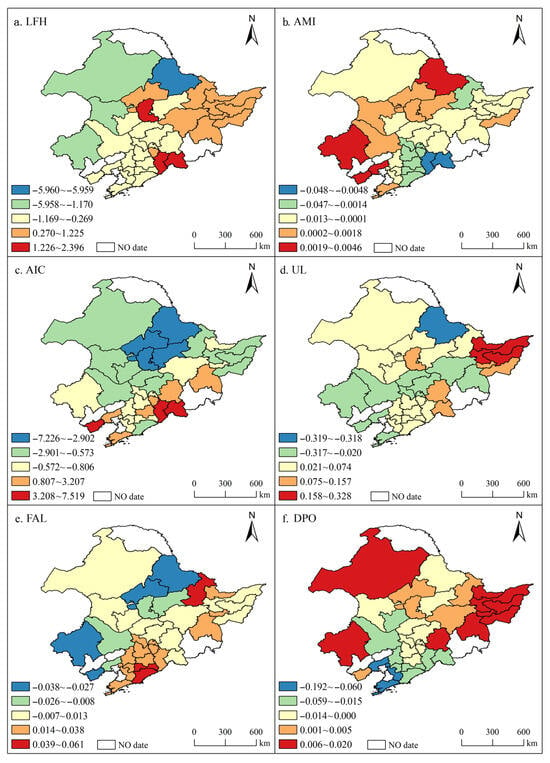
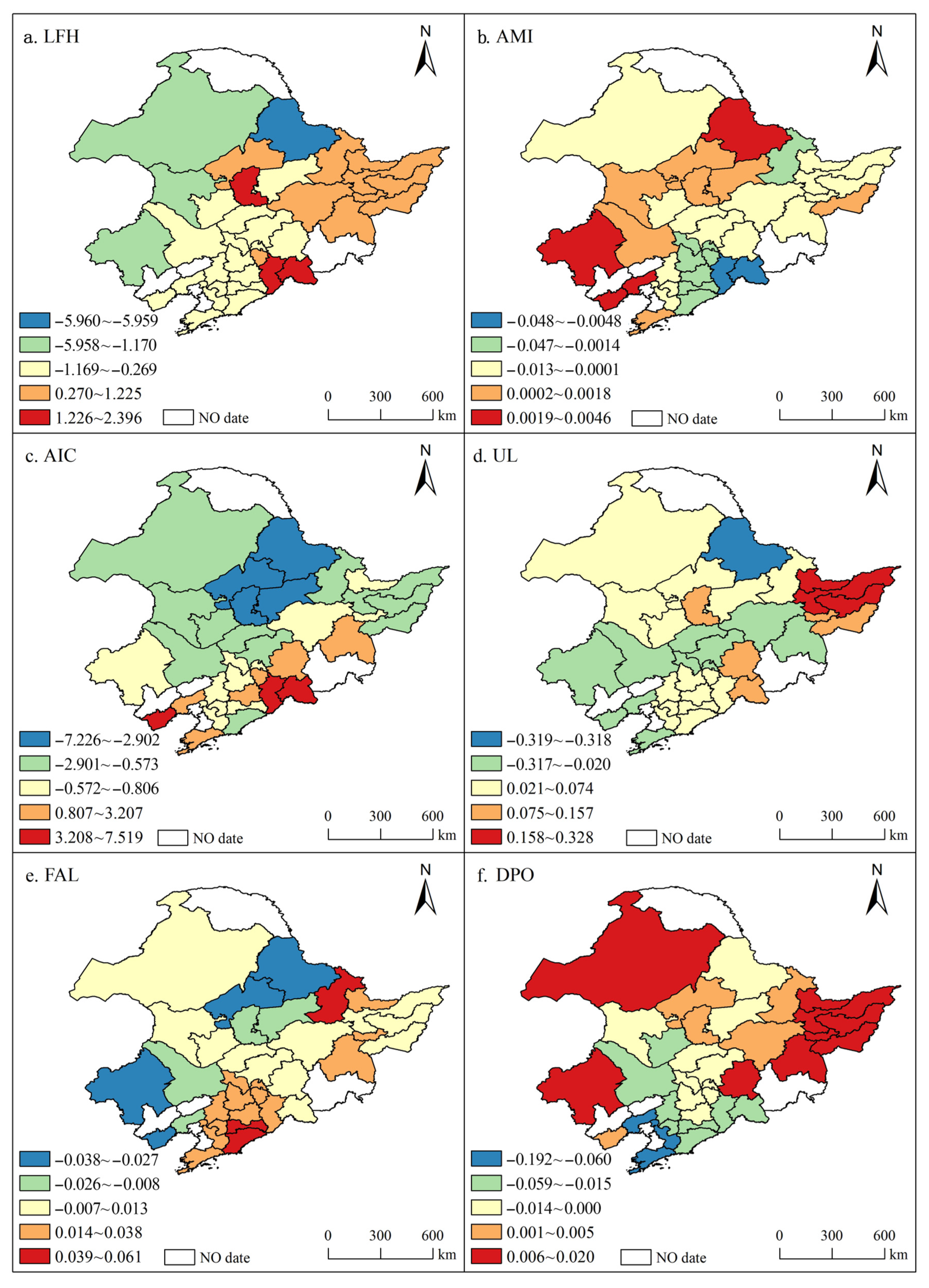
Based on the GTWR model, this study analyzed the spatial heterogeneity of the average regression coefficients for various driving factors of cultivated land pressure across 34 prefecture-level cities in the black soil region of Northeast China from 2008 to 2022. It is worth noting that the bootstrap resampling approach with 1000 replicates was applied to calculate the standard errors and 95% confidence intervals of local coefficients for the GTWR model. The 2.5th and 97.5th percentiles of the bootstrapped coefficient distribution were used as the lower and upper bounds of the confidence intervals to examine the statistical significance of driving factors. For OLS and GWR models, 95% confidence intervals were derived from analytical variance estimates. The results are presented in Figure 3, and all driving factors demonstrate significant spatial differentiation characteristics.
Figure 3.
Spatial heterogeneity of driving factors of cultivated land pressure in the black soil area of Northeast China, 2008–2022.
The health level of local finance mainly exerts a negative driving effect on cultivated land pressure in the Northeast China black soil region; that is, for most regions, the higher the local financial health level, the lower the cultivated land pressure. The statistical results show that the proportion of spatiotemporal units with negative regression coefficients for local financial health level reaches 70.6% (this statistic only represents the sign distribution of estimated local coefficients and does not mean that coefficients in all units pass the significance test, so as to avoid readers misinterpreting the coefficient sign as equivalent to statistical significance (same below)), and this negative effect is particularly prominent in the four-league areas of eastern Inner Mongolia. Sound local financial conditions can provide stable financial support for high-standard farmland construction, black soil protection, comprehensive control of soil erosion, and cultivated land ecological restoration; furthermore, such conditions can also promote the intensive, large-scale, and ecological utilization of cultivated land, thus alleviating problems such as excessive reclamation, soil degradation, and agricultural non-point source pollution, thereby effectively reducing the bearing pressure on cultivated land. The four-league areas of eastern Inner Mongolia are located in an ecologically fragile transition zone, where the conservation of black soil and coordinated governance of cultivated land and grassland are highly dependent on financial investment [32]. Good local financial conditions can guarantee the implementation of various farmland protection, agricultural benefit, and ecological restoration projects, thus producing a more significant inhibitory effect on cultivated land pressure.
The input intensity of agricultural mechanization mainly exerts a negative driving effect on cultivated land pressure in the black soil region of Northeast China. The statistical results show that the proportion of spatiotemporal units with a negative regression coefficient for agricultural mechanization input intensity reaches 67.6%; that is, in most regions, the higher the input intensity of agricultural mechanization, the lower the cultivated land pressure. This negative effect is particularly prominent in most areas of Jilin Province. Regions with higher agricultural mechanization input intensity can support the implementation of water-saving irrigation, precise fertilization and pesticide application, and straw return to the field, steadily increasing regional grain output and thus alleviating the pressure of implicit productivity decline caused by long-term overloaded utilization of cultivated land. Furthermore, higher agricultural mechanization input intensity can effectively reduce the impacts of natural disasters on grain harvest and improve the resilience of grain production, thus alleviating the tension between the supply and demand of cultivated land. Notably, Jilin Province is characterized by concentrated plain landforms and contiguous cultivated land, which provides favorable conditions for the promotion and application of agricultural machinery. The land-saving, land-protecting, and efficiency-enhancing effects of mechanization can be fully unleashed, leading to a more significant negative alleviation effect on cultivated land pressure.
The level of agricultural infrastructure also mainly exerts a negative driving effect on cultivated land pressure in the black soil region of Northeast China; that is, for most regions, the higher the level of agricultural infrastructure, the lower the cultivated land pressure. The statistical results show that 70.6% of spatiotemporal units have negative regression coefficients for agricultural infrastructure level, and this negative effect is more pronounced in the four-league areas of eastern Inner Mongolia, as well as parts of Jilin and Heilongjiang. The improvement of agricultural infrastructure can not only effectively optimize the physical and chemical properties of cultivated soil, but also enhance soil fertility and water retention capacity, which ensures the steady growth of grain output and thus effectively alleviates regional cultivated land pressure. Regions with higher agricultural infrastructure levels usually have sound irrigation systems, road networks, and disaster prevention water conservancy facilities, which bring advantages in boosting per-unit yield and total grain output, thereby alleviating regional cultivated land pressure. In addition, such regions can minimize grain output losses when encountering droughts, floods, and other natural disasters, and enhance grain production resilience, which further effectively eases cultivated land pressure. The four leagues of eastern Inner Mongolia and parts of Jilin and Heilongjiang are characterized by high cultivated land connectivity and a solid foundation for large-scale production. In these regions, the marginal efficiency improvement effect of infrastructure is more easily realized, leading to a more significant inhibitory effect on cultivated land pressure.
The level of chemical fertilizer application mainly has a positive driving effect on cultivated land pressure in the black soil region of Northeast China, which means that higher chemical fertilizer application levels correspond to greater cultivated land pressure in most regions. The statistical results show that 70.6% of all spatiotemporal units have positive regression coefficients for the chemical fertilizer application level. Positive driving effects are mainly distributed in parts of Liaoning and Heilongjiang, while negative effects occur in parts of Inner Mongolia and Jilin. According to the “Report on the Protection and Utilization of Black Soil in Northeast China (2021),” the input of agricultural production factors in the black soil region of Northeast China has entered a period of structural adjustment. Since 2015, the application of chemical fertilizers and pesticides has continued to decline (https://www.cas.cn/spx/202210/t20221001_4849775.shtml, accessed on 30 September 2022) with pesticide application falling below the international warning line. Some areas in Liaoning and Heilongjiang are characterized by high-intensity agricultural production. To achieve higher grain yield per unit area, local farmers have continuously increased chemical fertilizer inputs. Excessive fertilization easily leads to soil compaction, fertility degradation of black soil, and agricultural non-point source pollution, which aggravates ecological degradation and increases the bearing load of cultivated land, further pushing up cultivated land pressure. In contrast, driven by the promotion of conservation tillage policies and soil testing and formulated fertilization technology, some regions in Inner Mongolia and Jilin have achieved reasonable reduction in chemical fertilizer application. Scientific fertilization maintains soil fertility and mitigates ecological damage, forming a negative correlation between fertilizer input and cultivated land pressure [25], thereby easing cultivated land pressure.
The degree of population loss mainly has a negative driving effect on cultivated land pressure in the black soil region of Northeast China; that is, for most regions, the higher the degree of population loss, the lower the cultivated land pressure. The statistical results show that 64.7% of spatiotemporal units have negative regression coefficients for population loss degree. High negative-value negative-effect areas are mainly located in parts of Liaoning and Jilin, whereas positive-effect areas are concentrated in parts of eastern Inner Mongolia and Heilongjiang. Continuous rural population outflow in most areas of Liaoning and Jilin reduces the size of the rural labor force, which in turn curbs extensive cultivation, excessive reclamation, and high-intensity farming disturbances. This alleviates the human–land contradiction, effectively eases the production and ecological bearing pressure of cultivated land, and thus presents an obvious negative alleviation effect. By contrast, large-scale agricultural operations dominate most parts of Inner Mongolia and Heilongjiang. Moderate population loss tends to trigger farmland abandonment and inadequate field management, leading to low land use efficiency. At the same time, there is still demand for developing reserved cultivated land in these regions, which results in a positive correlation between population loss and cultivated land pressure.
The urbanization level mainly exerts a positive driving effect on cultivated land pressure in the black soil region of Northeast China; that is, in most regions, a higher urbanization level corresponds to greater cultivated land pressure. The statistical results show that the proportion of spatiotemporal units with positive regression coefficients for urbanization level reaches 82.4%. Positive effects are mainly observed in Yichun City, Hegang City, Jiamusi City, Shuangyashan City, Qitaihe City, Hulunbuir City, Qiqihar City, and other regions, while negative effects are concentrated in Heihe City and Chifeng City. The reason is that regions such as Yichun and Hegang follow a land-extensive urbanization development pattern. During the process of urbanization, construction land continues to occupy cultivated land, while agricultural production still relies on the expansion of cultivated land scale, which further increases the bearing load of cultivated land. Therefore, the urbanization level is positively correlated with cultivated land pressure. In comparison, Heihe City and Chifeng City are located in ecologically fragile mountainous and hilly border areas. Their urbanization follows an intensive development pattern characterized by rural-to-urban population migration. A large number of rural laborers have moved to cities and towns, which effectively eases the population-bearing pressure on regional cultivated land.
4.2.3. Regional Identification and Zoning of Influencing Factors of Cultivated Land Pressure in the Black Soil Region of Northeast China
Using the GeoDa software (version1.20.0), we adopted the K-means clustering method to conduct cluster analysis on the spatial driving factors of cultivated land pressure across 34 prefecture-level cities in the black soil region of Northeast China from 2008 to 2022, and provide practical references for formulating differentiated regulatory policies. It is worth noting that, the input dataset for K-means clustering consists of the local regression coefficients of driving factors derived from the GTWR model for each prefecture-level city. Prior to clustering, Z-score standardization was applied to eliminate dimensional differences among variables. The elbow method and silhouette coefficient were jointly adopted to determine the optimal number of clusters (k = 6) and reduce the bias caused by random initialization of cluster centroids. The results show that the ratio of between-cluster sum of squares to total sum of squares is 0.36906, indicating good clustering performance (Table 4).
Table 4.
K-means clustering results of driving factors for cultivated land pressure in the black soil region of Northeast China.
Considering the heterogeneity of geographical location and drawing on the research framework proposed in reference [32], we divided the study area into six subregions based on natural background conditions, including hydrothermal conditions, landforms, and soil types: Songnen Plain, Sanjiang Plain, Liaohe Plain, Changbai–Liaodong region, Western wind–sand region, and Greater Khingan Range region. The results in Table 3 show that cultivated land pressure across all cities has obvious spatial agglomeration characteristics. In the first subregion, the Songnen Plain, cultivated land pressure is mainly driven by the level of local fiscal health and the input intensity of agricultural mechanization. In the second subregion, the Sanjiang Plain, population decline is the dominant driving factor of cultivated land pressure. In the third subregion, the Liaohe Plain, the urbanization level is the core driving factor of cultivated land pressure. In the fourth subregion, the Changbai–Liaodong region, the impacts of various driving factors on cultivated land pressure are relatively balanced. In the fifth subregion, the Western wind–sand region, the input intensity of agricultural mechanization is the major driving factor. In the sixth subregion, the Greater Khingan Range region, the level of chemical fertilizer application is the key driving factor of cultivated land pressure.
5. Discussion
The black soil region carries an important responsibility for ensuring national food security and maintaining agricultural ecological security and, as such, studying the pressure on arable land in Northeast China’s black soil region has value for improving human well-being [33]. With ongoing efforts to protect and utilize black soil, research on arable land pressure in the Northeast black soil region has been increasing. Some scholars have revealed the current situation of arable land pressure in this region based on case studies and multiple case areas. Others have further confirmed that issues such as high utilization intensity and high degradation risk exist for arable land in the area, and that arable land pressure is influenced by multiple factors. In this study, while verifying the situation of arable land pressure in Northeast China, a clear polarization phenomenon was observed across the region. From the empirical results, although it cannot be said that the framework developed in this paper has completely solved the ‘black box’ problem of arable land pressure, it can be concluded that the driving factors of arable land pressure in the region exhibit significant spatial heterogeneity. Compared to previous studies, this research reveals the problem of spatial heterogeneity in the factors affecting arable land pressure in the Northeast black soil region, effectively addressing the limitation of previous studies that focused too much on the overall picture and overlooked the spatial heterogeneity of the influencing factors. Furthermore, this study uses cities as the research unit, dividing the Northeast black soil region into six major areas, employing a finer scale to deeply understand the mechanisms of interaction between arable land pressure and the socio-economic system, thus enabling the development of targeted policy recommendations to relieve arable land pressure in different regions. It is worth noting that this study has certain limitations; for example, arable land pressure in different cities results from multiple factors acting together, while this study only explores the spatial heterogeneity characteristics of each factor acting alone on arable land pressure, and whether there is interaction among two or more main systems still needs further consideration. Furthermore, due to data limitations, this study focused on socio-economic variables when selecting variables while neglecting natural variables, which is also a key area needing improvement in future research. Furthermore, this study has several limitations. When performing K-means clustering for regional zoning, we adopted multi-year averages of annual GTWR coefficients for each prefecture-level city. Such averaging may smooth short-term temporal fluctuations and partially mask the temporal heterogeneity in certain years. Although the temporal dynamics of driving effects are analyzed in the preceding section, the averaging approach cannot capture abrupt changes of driving impacts across different periods. Future research can adopt spatiotemporal joint clustering to retain annual coefficient information and realize simultaneous zoning in both spatial and temporal dimensions. Furthermore, this study does not produce separate maps showing the significance of local coefficients, and future research may supplement such visualization to further identify regions with statistically significant impacts.
6. Countermeasures and Suggestions
6.1. Conclusions
Combining the GTWR model and K-means clustering method, this study measured the cultivated land pressure of 34 prefecture-level cities in the black soil region of Northeast China from 2008 to 2022, and empirically analyzed its driving factors and spatial differentiation characteristics. The main conclusions drawn are as follows.
From a temporal perspective, the cultivated land pressure in the black soil region of Northeast China showed an overall downward trend during the study period, with obvious regional grade differences. There is still 38.7% room for optimization. Spatially, cultivated land pressure presents remarkable spatial agglomeration features, showing a general pattern of “low in the central part and high in the surrounding areas.” The cultivated land pressure is jointly affected by multiple driving factors. The local financial health level, input intensity of agricultural mechanization, agricultural infrastructure level, and population loss degree mainly produce negative driving effects, while the chemical fertilizer application level and urbanization level exert dominant positive driving effects. The impacts of driving factors on cultivated land pressure exhibit significant spatial differentiation. The cultivated land pressure in the Songnen Plain is mainly driven by the local financial health level and input intensity of agricultural mechanization. The degree of population loss acts as the leading driving factor in the Sanjiang Plain. The urbanization level is the core driving factor in the Liaohe Plain. The input intensity of agricultural mechanization dominates in the Western wind–sand region, and the chemical fertilizer application level serves as the key driving factor in the Greater Khingan Range region.
6.2. Suggestions
In light of the above findings, this study proposes the following recommendations:
(1) Continuously Alleviate Cultivated Land Pressure in the Black Soil Region of Northeast China
First, establish a long-term mechanism for “stabilizing control and improving quality” of cultivated land pressure. Quantify the governance objectives of cultivated land pressure in the black soil region of Northeast China, and set phased and regional thresholds for cultivated land pressure reduction as well as standards for cultivated land quality improvement. Strengthen time-series dynamic monitoring, early warning, and regulation; build an annual–quarterly dynamic monitoring system for cultivated land pressure; accurately identify risk points of pressure rebound and lag-governed areas in the time dimension; and consolidate the governance achievements of cultivated land pressure reduction. Second, reverse the spatial pattern of “low pressure in the central part and high pressure in the surrounding areas.” Promote the construction of high-quality development demonstration zones for cultivated land protection, popularize mature technical models and institutional experience, give full play to spatial spillover effects, and drive gradient pressure reduction and coordinated governance in surrounding high-pressure areas. Third, implement region-differentiated spatial governance across the whole region. Improve the assessment system for cultivated land pressure. Following the principle of “stabilizing central areas and reducing pressure in surrounding areas,” set differentiated assessment weights. High-pressure regions should be mainly assessed according to the effect of pressure reduction, while low-pressure regions should focus on the assessment of cultivated land quality improvement. Furthermore, strengthen the spatial planning guidance for black soil conservation. Incorporate the spatiotemporal pattern of cultivated land pressure into territorial spatial planning and special plans for black soil protection, optimize the spatial layout of production, living, and ecological spaces, and promote the continuous reduction in cultivated land pressure from the source.
(2) Implement Targeted Regional Policies Based on Spatial Differentiation of Driving Factors
Fully grasp the spatial differentiation law of driving factors for cultivated land pressure and adopt tailored governance strategies for each subregion. Songnen Plain: Firstly, build a stable financial support mechanism for black soil protection, increase vertical transfer payments from central and provincial governments, set up special bonds for cultivated land protection and agricultural infrastructure construction, attract market participation, and improve local financial support capacity. Secondly, shore up weaknesses in agricultural infrastructure, focusing on improving irrigation–drainage facilities, farmland road networks, and soil fertility conservation projects, and promoting moderate-scale farmland renovation and the upgrading of outdated facilities. Sanjiang Plain: Firstly, implement plans for stabilizing agricultural employment and cultivating local talents, and support family farms, farmers’ cooperatives, and agricultural socialized service organizations to replace scattered small-holder farming. Secondly, improve the guarantee mechanism for cultivated land transfer and withdrawal for out-migrating laborers, guide cultivated land to concentrate towards moderate-scale operators, and realize “efficiency improvement despite population decline.” Liaohe Plain: Firstly, strictly observe urban development boundaries and implement special protection for permanent basic farmland, and prohibit disorderly occupation of high-quality black soil by non-agricultural construction. Secondly, establish a mechanism for feeding land-value-added gains back to black soil conservation, so as to realize win–win coordination between urban development and cultivated land protection. Changbai–Liaodong region: Give full play to existing resource endowments and promote coordinated effects of all driving factors. Western wind–sand region: Moderately adjust the input intensity of agricultural mechanization, carry out windbreak and sand-fixation ecological projects, adopt eco-friendly tillage patterns, and mitigate cultivated land pressure in ecologically fragile zones from the production end. Greater Khingan Range region: Firstly, enforce rigid measures for chemical fertilizer reduction and efficiency improvement, and promote technologies including soil testing and formulated fertilization, organic fertilizer substitution, water–fertilizer integration, and green manure planting. Secondly, establish a total-quantity control and plot-scale monitoring system for chemical fertilizer application, encourage green agricultural inputs, and restrain excessive chemical fertilizer application.
Author Contributions
Project administration and funding, L.Z. and G.L.; writing—review and editing, X.Y.; conceptualization, S.Z.; methodology and formal analysis, X.Y.; writing—original draft preparation, G.L.; visualization, F.J.; data curation and software, G.L.; validation, L.Z.; writing—review and editing, G.L. All authors have read and agreed to the published version of the manuscript.
Funding
This research was supported by the General Program of the National Natural Science Foundation of China (42271284; 42671371), and by the Fundamental Research Funds for Public Universities in Liaoning (LDJBKYSK2026024).
Data Availability Statement
The original contributions presented in this study are included in the article. Further inquiries can be directed to the corresponding authors.
Acknowledgments
This study acknowledges the assistance provided by staff members of municipal statistics bureaus in supplying relevant data. We also express our gratitude to the reviewers for their valuable comments on earlier versions of this manuscript.
Conflicts of Interest
The authors declare no conflicts of interest. The funders had no role in the design of the study; in the collection, analyses, or interpretation of data; in the writing of the manuscript; or in the decision to publish the results.
References
- Zhou, L.; Luo, J.Z.; Fang, P. Who will feed China in the 21st Century? Pandemic Crisis, Glocalization and organized Responsibility. Int. Econ. Rev. 2021, 5, 53–80. [Google Scholar]
- Lin, G.D.; Lyu, X.; Peng, W.L.; Ma, W.R. Practical Logic and Key Mechanisms of Black Soil Protection: A Multi-Case Study of Typical Pilot Areas. J. Nat. Resour. 2023, 38, 2523–2535. [Google Scholar] [CrossRef] [Scilit]
- Lyu, X.; Xu, C.; Li, Z.H. Cultivation of High-Quality Farmers and Black Soil Protection and Utilization under Rural Revitalization: Logical Relationship, Collaborative Mechanism and Promotion Path. J. Nat. Resour. 2026, 41, 19–33. [Google Scholar] [CrossRef] [Scilit]
- Sui, H.J.; Song, G.; Gao, J. Spatiotemporal Differentiation of Cultivated Land Ecological Degradation in Typical Black Soil Region of Northeast China: A Case of Fujin City. J. Nat. Resour. 2022, 37, 2277–2291. [Google Scholar] [CrossRef] [Scilit]
- Gao, Y.L.; Wang, Z.G. Does Urbanization Increase Cultivated Land Pressure? Empirical Evidence from China. Chin. Rural. Econ. 2020, 9, 65–85. [Google Scholar]
- Zhang, Z.; Huang, L.; Song, W.; Chi, L.; Shen, C. Decoupling or Displacement? The Shifting Drivers of Cultivated Land Pressure and Potential Degradation Risk in Urbanizing China: From Technological Dividends to Demographic Contraction. Land Degrad. Dev. 2026, 37, 7995–8016. [Google Scholar] [CrossRef] [Scilit]
- Yang, X.J.; Xu, Z.X.; Zuo, D.P.; Cai, S.Y. Risk Assessment of Agricultural Drought in Three Northeast Provinces of China. Acta Geogr. Sin. 2018, 73, 1324–1337. [Google Scholar]
- Yang, X.; Li, D.; Li, L.; Shi, X.; Wang, C.; Zhang, X.; Zhang, X.; Li, X. From traditional to balanced: The upgrade of dietary structure leads to increased pressure on cultivated land ecological compensation. Environ. Dev. Sustain. 2026, 1–22. [Google Scholar] [CrossRef] [Scilit]
- Wang, Y.; Bai, Y.; Wang, J.; Deng, X.; Hu, Y.; Chen, X. Rethinking workable solutions for saving cultivated land use and enhancing climate adaptation through diet shifts. Land Use Policy 2026, 164, 107927. [Google Scholar] [CrossRef] [Scilit]
- Qin, Y.; Tang, J.; Li, T.; Qi, X.; Zhang, D.; Wang, S.; Lun, F. Cultivated Land Demand and Pressure in Southeast Asia from 1961 to 2019: A Comprehensive Study on Food Consumption. Foods 2023, 12, 3531. [Google Scholar] [CrossRef] [Scilit]
- Cui, N.B.; Wang, S.N. Dynamic Change and Trend of Cultivated Land Pressure in Typical Black Soil Region of Northeast China under Food Security. Trans. Chin. Soc. Agric. Eng. 2022, 38, 220–230. [Google Scholar] [CrossRef]
- Cai, Y.L.; Fu, Z.Q.; Dai, E.F. Regional Minimum Per Capita Arable Land and Arable Land Resource Regulation. Acta Geogr. Sin. 2002, 2, 127–134. [Google Scholar]
- Sun, L. Impact of Cultivated Land-Use Change on the Cultivated Land Pressure in Jilin Province of China from 1980 to 2015. J. Resour. Ecol. 2023, 14, 581–590. [Google Scholar] [CrossRef] [Scilit]
- Wu, X.; Wang, Y.J.; Zhu, H.B. Does Economic Growth Lead to an Increase in Cultivated Land Pressure? Evidence from China. Land 2022, 11, 1515. [Google Scholar] [CrossRef] [Scilit]
- Wu, X.; Wang, Y.J.J.; Zhu, H.B. Analysis of the Spatio-Temporal Differentiation of Cultivated Land Pressure in the Pearl River-Xijiang Economic Zone and Its Influencing Factors. J. Resour. Ecol. 2022, 13, 407–416. [Google Scholar] [CrossRef] [Scilit]
- Chao, Z.; Zhang, P.; Wang, X. Impacts of Urbanization on the Net Primary Productivity and Cultivated Land Change in Shandong Province, China. J. Indian Soc. Remote Sens. 2018, 46, 809–819. [Google Scholar] [CrossRef] [Scilit]
- Gomes, E.; Abrantes, P.; Banos, A.; Rocha, J.; Buxton, M. Farming under urban pressure: Farmers’ land use and land cover change intentions. Appl. Geogr. 2019, 102, 58–70. [Google Scholar] [CrossRef] [Scilit]
- Chen, J.D.; Cheng, S.L.; Song, M. Estimating policy pressure for China’s cultivated land use protection based on an extended index. Phys. Chem. Earth 2017, 101, 21–34. [Google Scholar] [CrossRef] [Scilit]
- Li, Y.; Fang, B.; Li, Y.R.; Feng, W.L.; Yin, X. Spatiotemporal Pattern of Cultivated Land Pressure and Its Influencing Factors in the Huaihai Economic Zone, China. Chin. Geogr. Sci. 2023, 33, 287–303. [Google Scholar] [CrossRef] [Scilit]
- Li, J.P.; Shangguan, Z.P. Spatial-temporal distribution of cultivated land production capacity in Shaanxi province. Trans. Chin. Soc. Agric. Eng. 2012, 28, 239–246. [Google Scholar]
- Yang, D.; Liu, Z.Y.; Zhang, P.Y.; Chen, Z.; Chang, Y.; Wang, Q.; Zhang, X.; Lu, R.; Li, M.; Xing, G.; et al. Understanding Relationships between Cultivated Land Pressure and Economic Development Level across Spatiotemporal Characteristics: Implications for Supporting Land-Use Management Decisions. Int. J. Environ. Res. Public Health 2022, 19, 16362. [Google Scholar] [CrossRef] [Scilit]
- Yin, K.X.; Shang, Q.K.; Mi, W.B. Coupling Relationship and Trend Prediction between Cultivated Land Productivity and Food Security in Ningxia. J. Arid. Land Resour. Environ. 2020, 34, 37–45. [Google Scholar] [CrossRef]
- Xiong, Y.; Liu, M.; Wen, L.; Zhang, A. Does urbanization inevitably exacerbate cropland pressure? The multiscale evidence from China. J. Clean. Prod. 2025, 504, 145413. [Google Scholar] [CrossRef] [Scilit]
- Liang, A.Z.; Zhang, Y.; Chen, X.W.; Zhang, S.; Huang, D.; Yang, X.; Zhang, X.P.; Li, X.J.; Tian, C.J.; McLaughlin, N.; et al. Development Status and Effect of Conservation Tillage in Black Soil Region of Northeast China. Sci. Geogr. Sin. 2022, 42, 1325–1335. [Google Scholar] [CrossRef]
- Deng, X.Z.; Liang, L.; Liao, X.Y.; Liu, Y.J.; Li, Z.H.; Yue, T.X.; Dong, J.W.; Sun, Z.G.; Chen, M.X. Production Pressure Changes and Conservation Strategies of Black Soil in Northeast China under International Grain Trade. J. Nat. Resour. 2022, 37, 2209–2217. [Google Scholar] [CrossRef] [Scilit]
- Huang, B.; Wu, B.; Barry, M. Geographically and temporally weighted regression for modeling spatial-temporal variation in house prices. Int. J. Geogr. Inf. Sci. 2010, 24, 383–401. [Google Scholar] [CrossRef] [Scilit]
- Fan, Y.K.; Li, Y.; Chen, Z.M.; Zhang, N.; Ding, W.X. Evolution of Dry Farming Black Soil Quality and Its Driving Factors in the Sanjiang Plain. Trans. Chin. Soc. Agric. Eng. 2025, 41, 247–257. [Google Scholar] [CrossRef]
- Zhang, L.X.; Bi, X.; Huang, Z.J. Urban Industrial Land Use Efficiency under Economic Transition: A Case Study of Cities in the Yangtze River Economic Belt. Resour. Sci. 2020, 42, 1728–1738. [Google Scholar] [CrossRef] [Scilit]
- Wu, J.Q.; Fang, S.L.; Li, G.C.; Xu, G.T. Spatial Spillover Effect of Agricultural Mechanization on Grain Output in China: From the Perspective of Cross-Regional Operation. Chin. Rural. Econ. 2017, 6, 44–57. [Google Scholar] [CrossRef]
- Zhang, H.; Wang, Y. Spatial Differentiation of Cultivated Land Pressure and Its Socioeconomic Drivers in China Based on Panel Data of 342 Prefecture-Level Cities. Geogr. Res. 2017, 36, 731–742. [Google Scholar]
- Lu, X.H.; Li, J.; Liu, C.; Kuang, B.; Cai, D.W. Driving Factors and Spatial Differentiation of Urban Land Green Use Efficiency in China. Sci. Geogr. Sin. 2022, 42, 611–621. [Google Scholar] [CrossRef]
- Lu, F.G. Does Population Loss Affect Economic Growth in Northeast China? Based on Registered Population Loss Data. Popul. Dev. 2021, 27, 98–110+120. [Google Scholar]
- Xu, Y.D.; Pei, J.B.; Li, S.Y.; Zou, H.T.; Wang, J.K.; Zhang, J.B. Main Characteristics and Protection Strategies of Different Black Soil Regions in Northeast China. Chin. J. Soil Sci. 2023, 54, 495–504. [Google Scholar] [CrossRef]

Disclaimer/Publisher’s Note: The statements, opinions and data contained in all publications are solely those of the individual author(s) and contributor(s) and not of MDPI and/or the editor(s). MDPI and/or the editor(s) disclaim responsibility for any injury to people or property resulting from any ideas, methods, instructions or products referred to in the content. |
© 2026 by the authors. Licensee MDPI, Basel, Switzerland. This article is an open access article distributed under the terms and conditions of the Creative Commons Attribution (CC BY) license.