


Abstract
This study examines the coupling coordination degree of rural “Production–Living–Ecological” (PLE) functions in Guangdong Province, China, at the county. A county indicator system was constructed from multi-source data. The PLE functional levels and the coupling coordination degree of each county were then measured. The driving factors were identified using a Geographically Weighted Random Forest (GWRF) model. The main findings are as follows. (1) Rural PLE functions exhibit pronounced spatial heterogeneity. The production function scores high in northern Guangdong but low in the core Pearl River Delta. The living function concentrates in the PRD and declines from the core toward the periphery. The ecological function is generally higher in the north and lower in the south. (2) The coupling coordination degree also displays marked spatial contrasts. The core Pearl River Delta suffers from functional imbalance, driven by the excessive concentration of the living function and the compression of production and ecological spaces. In contrast, northern Guangdong—designated primarily as an ecological development zone—forms a high-coordination cluster. Its coordination is supported by ecological conservation, green industries, and infrastructure. (3) The coordination degree is jointly shaped by topographic, climatic, socioeconomic, agricultural production, and land use planning factors, and the effects of all factors vary markedly across space. The effects of administrative area and slope show opposite gradients between the Pearl River Delta Plain and northwestern Guangdong; the effect of economic development follows a “high–low–high” banded pattern from northeast to southwest, reflecting a saturation effect in Guangzhou and Shenzhen; the effects of economic synergy, irrigated area, and chemical fertilizer application are spatially concentrated; and the effects of built-up area extent and vegetation cover extent are relatively weak in northeastern Guangdong. This study introduces the GWRF model into county PLE coordination research. The model captures the spatially nonstationary relationships that conventional models overlook. The findings provide a reference for zone-based optimization and differentiated territorial space governance.
1. Introduction
Land is an indispensable natural resource that underpins human survival and development. Rapid urbanization has profoundly reshaped human-land relationships and regional patterns on a global scale. While driving economic growth, this process has also triggered severe structural contradictions [1]. As the largest developing country, China is significantly affected by urbanization, with its land use functions facing the typical dilemma of utilization conflicts [2]. Urban expansion, driven by land expropriation, has progressively encroached upon rural areas, while the continuous outflow of rural population has intensified the loss of development factors and the evolution of “hollowed villages” [3,4]. The interplay between spatial encroachment and factor outflow has led to significant degradation of rural production and ecological functions, exposing the institutional limitations of the existing spatial planning system in optimizing land use allocation and underscoring the urgency of planning innovation. Against this backdrop, investigating the coupling coordination factors of “production–living–ecological” land functions not only helps reveal the evolution of rural territorial systems during urban–rural transformation and alleviate regional development imbalances, but also provides scientific evidence and practical insights for sustainable land use and human–environment harmony under rapid global urbanization.
Rapid industrialization and urbanization have intensified the inherent tension between human activity and land systems [5]. Land use worldwide now faces a dual challenge [6]. On the one hand, the disorderly expansion of urban construction land continues to encroach on high-quality arable land, causing agricultural space to shrink steadily [7]. On the other hand, rising land development intensity has degraded ecosystem services [8]. Against this backdrop, optimizing the allocation of land resources and enhancing the comprehensive functions of land use has become a core issue in sustainability research [9,10]. Research on land use functions has evolved from a single-system perspective toward integrated analytical frameworks [11,12]. Early studies focused on isolated land use systems, examining the functional characteristics of agricultural systems [13], natural ecosystems [14], and urban systems [15] separately. These studies deepened the understanding of individual systems, but they could not address the reality that multiple land functions are closely intertwined. As understanding advanced, De Groot et al. proposed a multidimensional classification system for ecosystem services [16], and Lovell et al. further developed a “production–ecology–culture” triadic functional framework, laying a theoretical foundation for the integrated analysis of multiple land values [17]. Building on this work, Chinese scholars have developed a “production–living–ecological” (PLE) spatial functional framework informed by China’s territorial space governance practice. This framework has gradually become the dominant analytical paradigm in the field [18,19,20]. Through sustained inquiry, the framework has grown into a systematic theoretical body encompassing the deconstruction of functional connotations, the formulation of multidimensional evaluation criteria, and the identification of spatial optimization pathways [21,22,23]. Its core lies in classifying territorial space by dominant utility: production space serves as a base for material production and carries product supply and value creation; living space supports human habitation and social activities [24,25]; and ecological space maintains ecosystem services and environmental security [26,27]. In terms of functional connotation, the production function refers to the capacity to transform natural resources into socioeconomic products through human labor, covering both primary resource extraction and downstream processing [28]. The living function refers to the capacity of land to provide material security and spatial support for residents, mainly reflected in meeting basic needs such as housing and transportation and maintaining a livable environment; together with the production function, it constitutes the material foundation of human society [29]. The ecological function refers to the capacity of land to supply ecological products and ecosystem services and to sustain environmental regulation and stability [30]. Compared with the fragmented perspective of traditional land use classification, the PLE framework effectively links the analysis of land multifunctionality with territorial space governance objectives, providing important support for practices such as the delimitation of “three zones and three lines” and territorial spatial planning.
Research on PLE functions has formed an integrated methodological system linking function identification, pattern characterization, relationship analysis, and driver analysis. For function identification, existing studies follow two main approaches. The quantitative approach constructs a multi-indicator comprehensive evaluation system to measure production, living, and ecological functions at the administrative-unit level. The qualitative approach classifies PLE functions according to dominant land use types. The former is comprehensive but depends heavily on the scientific soundness of indicator selection; the latter aligns identification results effectively with the actual land use pattern, yet struggles to capture compound functions [4,31]. For pattern characterization, spatial autocorrelation analysis (Moran’s I, LISA clustering) and the Geodetector model are widely used in combination to reveal the spatial agglomeration and differentiation of functions, and to systematically examine the dual role of natural-geographical constraints and socioeconomic drivers in shaping functional dynamics [18,32]. Notably, the emphasis of spatial analysis differs between the two identification approaches: quantitative studies stress statistical comparison across administrative units, whereas qualitative studies emphasize parcel-scale typological analysis [12]. For relationship analysis, scholars widely recognize that multiple land use functions interact in unpredictable ways, giving rise to two typical relationships—trade-offs and synergies. A trade-off reflects an inverse relationship between functions, whereas a synergy reflects a mutually reinforcing one [1,33]. Empirically, correlation analysis [34], spatial correlation analysis [35], redundancy analysis (RDA) [36], Bayesian belief networks (BBN) [37], and self-organizing maps (SOM) [38] have been successively applied to identify trade-offs and synergies among PLE functions, providing an evidence base for functional optimization and regulation [39,40]. For driver analysis, variables from natural [41], social [42], and economic [43] dimensions are commonly used as explanatory variables to probe the formation factors of functional synergies. Studies are mostly conducted at municipal [44] and county [45] scales, employing Geodetector [46], multiple regression, sensitivity analysis [47], and logistic regression models to examine how land use change affects functional synergies.
Nevertheless, the field still faces methodological challenges. First, the relationships between PLE functions and their influencing factors are complex, and traditional linear models may not fully capture them, thereby limiting analytical accuracy. Second, natural and socioeconomic factors are unevenly distributed across space, and spatial heterogeneity persists; if it is not incorporated into modelling, the underlying patterns through which drivers shape functions may not be accurately revealed. These methodological limitations in turn constrain theoretical progress. Given the difficulty of precisely characterizing such complex relationships, existing studies offer only limited insight into the boundary conditions and intensity of drivers’ effects. As a result, theoretical explanations often remain at the level of simple factor–function correspondence and fail to reveal how functional synergies form and evolve in different contexts. There is therefore an urgent need for analytical methods capable of accommodating complex relationships and spatial heterogeneity simultaneously, so as to strengthen the method foundation and advance both driver research and the theory of functional synergy.
In response to the research gaps identified above, this study takes Guangdong Province as the study area and the county as the basic analytical unit, and constructs an integrated analytical framework of “function evaluation–coupling coordination–driver attribution”. On this basis, the study makes three contributions to the existing literature. Theoretically, this study links county function evaluation, coupling coordination analysis, and driver identification into a single analytical chain, rather than treating them as separate research tasks. This integration extends the explanatory power of the PLE framework: trade-offs and synergies among functions are no longer described as isolated phenomena but are explained within a unified “pattern–relationship–driver” framework. The integrated chain thus helps reveal how functional synergies form and evolve across different contexts, which is precisely the theoretical question that previous studies, constrained by fragmented frameworks, have left largely unanswered. Empirically, study provides evidence on trade-offs and synergies among production, living, and ecological functions at the county level in Guangdong, a region under the dual pressures of rapid urbanization and ecological protection. The findings deepen the understanding of how land use functions interact in economically developed regions and can inform differentiated territorial space regulation. Methodologically, this study introduces the geographically weighted random forest (GWRF) model into research on PLE coupling and coordination. The model combines the flexible fitting capacity of random forests with the local modeling advantage of geographical weighting, and can simultaneously capture complex relationships among variables, interaction effects, and the spatial variation in the importance of drivers. It thereby overcomes the limitations of traditional linear models, which are constrained by fixed functional-form assumptions, and of geographically weighted regression, which handles complex interactions poorly. The GWRF model thus offers an analytical pathway that accommodates both complex relationships and spatial heterogeneity in driver identification, directly addressing the methodological challenges outlined above.
2. Theoretical Framework
2.1. The Theory of Coupling and Coordination
The PLE functional system essentially constitutes a dynamic, dialectical, and organic whole; its components can coexist and integrate, but may also give rise to contradictions and conflicts [29]. Understanding the spatial distribution of these functions and their coupling and coordination relationships is crucial for formulating effective land-use policies, enhancing environmental sustainability, and promoting harmonious socio-economic development [48]. As a typical coupled system, the rural territorial system—comprising production, living, and ecological spaces—is characterized by the interdependence and interaction of its various elements [49]. In this context, interactions between functions can be categorized into three types: conflict, synergy, and compatibility. Conflict occurs when the combination of functions impairs a specific function’s capacity to provide goods and services, whereas synergy implies that the combination enhances a specific function. Compatibility indicates that functions coexist without mutually weakening or enhancing one another. Within rural geographical systems, PLE functions are interrelated and evolve dynamically across time and space, forming a process characterized by dialectical relationships [48]. These functions are mutually dependent: agricultural production relies on healthy soil and water systems, while a high-quality living environment requires green spaces and a clean environment. However, contradictions frequently arise; agricultural production often encroaches on ecological areas, leading to biodiversity loss and a reduction in ecosystem services [10]. Furthermore, the expansion of living spaces threatens farmland and the natural environment, exacerbating competition for resources [50]. Since China’s reform and opening-up, rapid urbanization and industrialization have triggered rural population outflow and land use changes, resulting in an imbalance of rural functions. In particular, the intensification of agricultural production and the expansion of rural living spaces have led to environmental degradation, significantly undermining rural ecological functions. Therefore, a deeper understanding of the coupling and coordination between rural PLE functions is fundamental to achieving sustainable rural development goals.
2.2. Driving Factors of the Coupling and Coordination
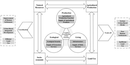
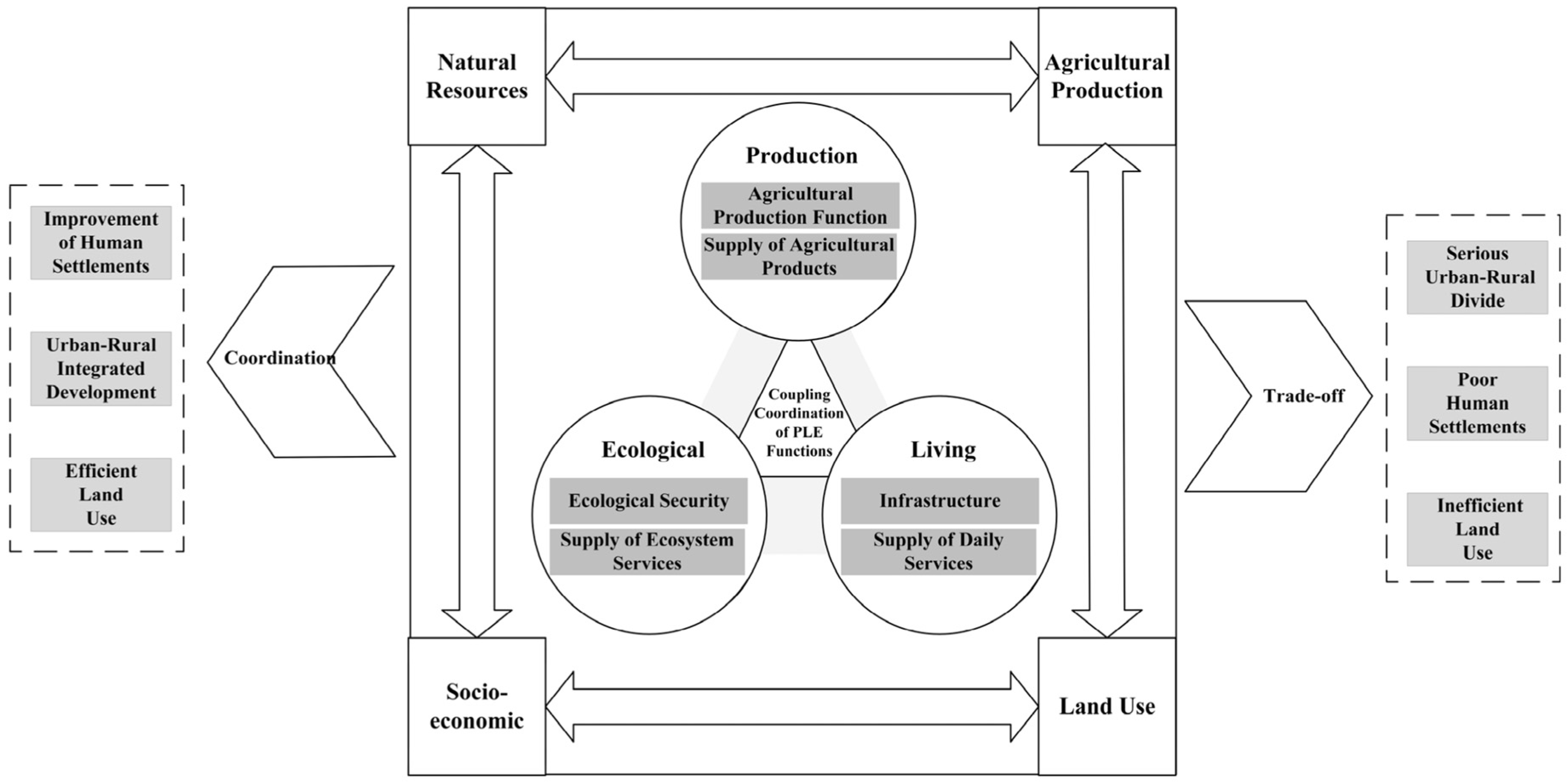
The spatial interactions between socio-economic activities and natural resource endowments profoundly shape the distribution patterns and interactions of the PLE functions. Natural factors constitute the basis of land use patterns, determining the scope and intensity of these functions [51]. Although humans possess the capacity to alter topography and climate, the construction of spaces for production and living largely adapts to topographical, geomorphological, and climatic conditions [52]. Conversely, socio-economic factors act as direct drivers influencing the coupling and coordination of the PLE functions [49]. Land use functions inherently exhibit characteristics of diversity and competition. Socio-economic development drives the transformation of land use patterns, subsequently altering land use functions and ultimately affecting the coupling and coordination status of the PLE system [53]. Specifically, the expansion of built-up zones directly shapes the spatial layout and intensity of living functions, while vegetation cover primarily dictates the supply capacity and quality of ecological functions. Furthermore, agricultural production conditions profoundly influence both agricultural and ecological functions, serving as a significant factor in the coupling of the PLE system. For instance, the application of agricultural chemicals enhances productivity but often exerts adverse effects on the ecological environment; this trade-off constitutes a key contradiction affecting the coordination of PLE functions (Figure 1).
Figure 1.
Theoretical Analysis Framework.
3. Research Methods and Data Sources
3.1. Study Area
Guangdong Province is situated at the southern tip of mainland China, spanning 20°09′ to 25°31′ north latitude and 109°45′ to 117°20′ east longitude. It administers 21 prefecture-level cities and 122 county administrative units, covering a total area of 179,800 square kilometres. The province exhibits a distinct dual topographic pattern, characterised by the alluvial plains of the Pearl River Delta contrasting with the mountainous and hilly terrain of Eastern, Western, and Northern Guangdong. As a national pilot zone for reform and opening-up and the core hinterland of the Guangdong–Hong Kong–Macao Greater Bay Area, Guangdong has undergone a profound restructuring of its human-land relationship and regional development patterns. Rising spatial heterogeneity has precipitated issues of ‘over-concentration’ in the Pearl River Delta, such as arable land fragmentation and ecological encroachment, whilst Northern Guangdong faces the contradictions of ‘developmental stagnation’, including rural depopulation and inefficient land use. Consequently, the differentiation of regional functions and the imperative for spatial governance have become more prominent than ever. Currently, the Guangdong Provincial Territorial Spatial Plan (2020–2035) aims to establish a differentiated development framework known as “One Core, One Belt, and One Zone”. Against this backdrop, a systematic analysis of the coupling coordination between rural production, living, and ecological functions at the county level, along with the precise identification of differentiated regional functional types—such as urban–rural integration zones in the Pearl River Delta and traditional agricultural areas in the province’s eastern, western, and northern regions—holds critical practical value for resolving regional development balances and optimising the territorial spatial governance system.
3.2. Data Sources
Data sources and their descriptions are presented in Table 1; all data points are from 2023. Based on the obtained data, county administrative divisions were used as the basic units of analysis to calculate the values of various secondary land-use functional indicators. Notably, as Zhongshan City and Dongguan City do not have formal municipal districts, the entire territories of Zhongshan City and Dongguan City were treated as the units of analysis.
Table 1.
Data Sources and Notes.
3.3. Construction of the Indicator System
The interaction between human activities and the natural environment is the primary driving force behind the evolution of territorial space systems. The manifestations of land use functions constitute the substantive connotation of PLE functions, representing humans’ capacity to transform and utilize land to obtain necessary resources and services at a given development stage. Rural functions emphasize the unique and irreplaceable effects of rural territorial systems, such as food production and ecological protection.
The essential distinction between rural and urban functions stems from differences in constituent elements and operational logics of the two systems. First, rural functions rely on natural resources—land, water, and climate—as core carriers, with outputs directly constrained by natural reproduction processes, whereas urban functions are dominated by the agglomeration of capital, technology, and information, and are relatively detached from natural constraints. Second, rural functions feature extensive, low-intensity land use and perform wide-ranging ecological roles, while urban functions manifest as concentrated, high-intensity use. Third, rural functions undertake fundamental, public-interest responsibilities—food security, ecological protection, and cultural transmission—that carry externality values unachievable through market factors, whereas urban functions center on economic agglomeration, innovation, and public services. Rural functions are therefore not a spatial extension of urban functions, but an independent functional system rooted in the distinctive attributes of rural territories. Based on differences in objects of action and development goals, rural functions can be classified into production, living, and ecological functions, each with distinct dominant characteristics [54]. Within a given rural territory, the three functions interact with and constrain one another, forming an organically integrated whole.
Based on differences in their objects of action and development goals, rural functions can be classified into three categories: production, living, and ecological functions, each with dominant characteristics that distinguish it from the others [55]. Within a given rural territory, the three functions interact with and constrain one another, together forming an organically integrated functional whole.
The enhancement of agricultural production functions plays a fundamental role in ensuring food security and sustaining urban development. Production functions serve as the essential foundation for the development of living and ecological functions, providing both functions with material conditions and resource support. The strength of rural production functions largely determines the level of regional food security and the capacity of resource supply for urban development. Living functions represent an important goal of production and ecological functions; their core lies in meeting farmers’ needs for basic public services, such as education and healthcare, thereby providing spatial support for human development [56]. Ecological functions, in turn, provide a vital environmental safeguard for the enhancement of production and living functions. By supplying ecological services, maintaining the environment, and delivering ecological products, they sustain the long-term operation of rural territorial systems. Any improvement or deterioration in ecological functions will directly shape the evolution of production and living functions.
Drawing on relevant literature, this study constructs an evaluation index system for rural functions at the county level in Guangdong Province, grounded in the PLE framework. The system comprises three dimensions—production, living, and ecological functions—and employs 12 indicators to quantitatively assess their development levels (Table 2). The production function refers to the capacity of land to yield various products and services directly through cultivation or to serve as a medium for social production. Focusing on the agricultural production function in rural areas, this study selects four indicators—grain supply, vegetable supply, meat supply, and agricultural industry status—to reflect agricultural production capacity, based on data availability and practical considerations. The living function refers to the capacity to provide basic security for human survival and development, primarily encompassing social security and development capabilities. Four indicators—transportation accessibility, healthcare services, education facilities, and economic conditions—were selected to represent this function. The ecological function refers to the role of rural areas in regional ecological regulation, conservation, and biodiversity protection, supported by natural resource endowments. Considering the specific conditions of Guangdong Province, four indicators—climate regulation, water conservation, soil conservation, and biodiversity conservation—were chosen to evaluate ecological functions. Notably, the three ecosystem indicators—water conservation, soil conservation, and biodiversity protection—are mainly derived from the Spatial Distribution Dataset of Terrestrial Ecosystem Services Value in China [57]. This dataset is based on remote sensing-based classification data of terrestrial ecosystem types across China and, drawing on the ecosystem service value equivalent factor method proposed by Xie et al. [58], estimates the values of 11 ecosystem services in four major categories for the years 2000, 2005, 2010, 2015, and 2020. These include provisioning services (food production, raw material production, and water supply), regulating services (gas regulation, climate regulation, environmental purification, and hydrological regulation), supporting services (soil conservation, nutrient cycling maintenance, and biodiversity protection), and cultural services (aesthetic landscape). As the dataset does not cover 2023, the corresponding data for 2023 in this study were calculated based on these indicators using the same method.
Table 2.
Evaluation indicator system for PLE functions in rural Guangdong.
3.4. Research Methods
3.4.1. Entropy Method
Based on the established county rural functional evaluation indicator system, data is standardised using the range method, and weights are calculated using the entropy weighting method. The rural functional values are then derived by multiplying the weights of each indicator by its corresponding numerical value.
Step 1: Calculate the proportion of the i-th sample under the j-th indicator. The formula for calculating the sample weight is as follows:
Step 2: Calculate the entropy value for the jth indicator. The formula for calculating the indicator entropy value is as follows:
Step 3: Calculate the coefficient of variation for the jth indicator. The information utility value of an indicator is given by dj, which depends on the difference between the indicator’s information entropy (ej) and 1. This value directly influences the magnitude of the weight. The larger the information utility value, the greater the importance of the indicator in the evaluation, and consequently, the larger the weight.
dj = 1 − ej
Step 4: Calculate the weights of the evaluation indicators. The entropy method is used to estimate the weights of each indicator; essentially, this involves using the coefficient of variation of the indicator’s information. The higher the coefficient of variation, the greater the indicator’s importance to the evaluation. The formula for calculating the weight of the j-th indicator is:
Step 5: Calculate the composite scores for each sample. The specific formula is as follows:
3.4.2. Coupling Coordination Method
The Coupling Coordination Degree model is an effective tool for quantifying the degree of coordination in the interactions between multiple systems. This paper employs this model to quantitatively assess the coupling coordination relationships among the PLE functions in rural counties of Guangdong Province. The calculation formula is as follows:
where C represents the coupling degree between the PLE functions; T represents the comprehensive evaluation value of the PLE functions; D represents the coupling coordination degree of the PLE functions for the evaluation unit; n represents the number of functions, with n = 3 in this study (corresponding to the production, living and ecological functions); a, b and c represent the weights of the production, living and ecological function subsystems, respectively. Based on the assumption in this study that production, livelihood and ecological functions are of equal importance in rural development at the county level, equal weights are assigned.
T = aX1i + bX2i+⋯+cXni
3.4.3. Geographically Weighted Random Forest
The Geographically Weighted Random Forest (GWRF) model builds upon the local modelling framework of Geographically Weighted Regression (GWR). By incorporating a spatial weight matrix to extend the traditional Random Forest (RF) algorithm, it effectively addresses the limitations of global models in analyzing spatial heterogeneity [59]. Through the establishment of location-specific local RF sub-models, this approach successfully captures both the spatial heterogeneity and the non-linear characteristics of spatial data [60,61]. Compared with traditional modelling methods, GWRF offers three distinct advantages: (1) it effectively captures non-linear relationships between variables; (2) it automatically identifies interactions between variables; and (3) it fully accounts for spatial autocorrelation, thereby systematically mitigating the impact of spatial non-stationarity on modelling results. This study employs the ‘SpatialML’ package in R to implement the GWRF model. The mathematical expression of the GWRF model is defined as follows:
where Yi is the value of the dependent variable for the th observation, i, α(ui,vi)xi is the prediction from the RF model calibrated at location i, e is the model error, and (ui,vi) is the coordinate.
Yi = α(ui,vi)xi + e
Given the variations in natural resource endowments and economic conditions across counties in Guangdong Province, the factors influencing PLE functions are likely to differ considerably among counties. Accordingly, the coupling coordination degree of PLE functions was taken as the dependent variable, and a geographically weighted random forest (GWRF) model was applied to estimate the influence of each factor. In selecting the explanatory variables, particular attention was paid to their potential relationship with the PLE functional evaluation results: variables directly derived from or conceptually tied to the evaluation indicators were excluded, and the variable system was kept parsimonious rather than incorporating a large number of objective variables across multiple dimensions, in order to reduce the risk of overestimating variable importance. Taking into account the availability of county-level data, 12 explanatory variables were ultimately selected from four aspects—natural environmental conditions, land use planning, agricultural modernisation, and socio-economic conditions (Table 3). Variance inflation factor (VIF) tests and Pearson correlation analysis were further conducted to examine multicollinearity among the variables; all VIF values were below 10, indicating that no severe multicollinearity existed among the selected variables.
Table 3.
Indicators for factors influencing PLE functions.
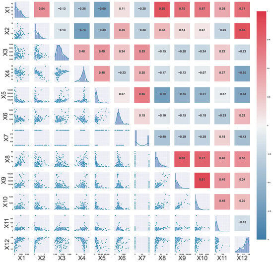
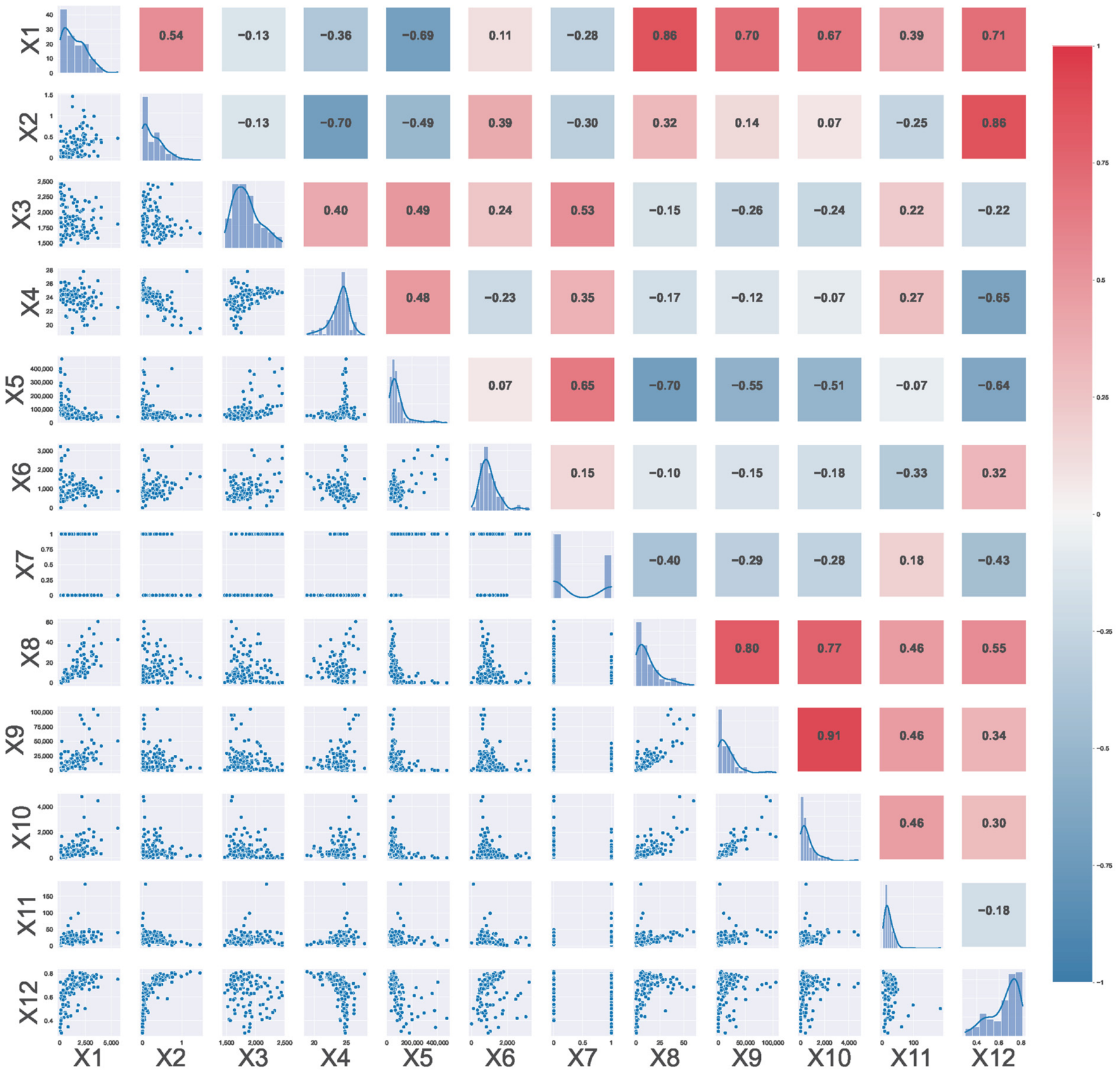
To test for multicollinearity among the explanatory variables, this study conducted a pairwise correlation analysis of the 12 influencing factors (Figure 2). The results show that the correlation coefficients of most variable pairs were below 0.8, and only a few pairs exceeded 0.8. These relatively high correlations have a clear real-world basis. x1 and x8 reflect the inherent link between area and irrigation conditions. An inevitable relationship also exists between administrative area and construction land area. x2 and x12 indicate that terrain relief is closely related to vegetation coverage. x9 and x10 show that fertilizer application and pesticide use typically vary in the same direction. These relationships are consistent with the actual conditions of regional physical geography and agricultural production. Despite these correlations, the random forest model is insensitive to multicollinearity. In addition, this study used permutation importance to measure variable importance, which reduces, to some extent, the interference of inter-variable correlations on the interpretation of the results. Therefore, the GWRF results can still robustly reflect the spatial heterogeneity in the importance of each influencing factor.
Figure 2.
Relationships between influencing factors.
To justify the selection of random forest (RF) as the base learner of the geographically weighted random forest (GWRF) model, we conducted model validation and comparison. Specifically, RF was compared with four benchmark models: XGBoost, decision tree, linear regression, and gradient boosting regression. All models were trained and validated using five-fold cross-validation. Model performance was evaluated based on the mean absolute error (MAE), root mean square error (RMSE), and coefficient of determination (R2). The results are presented in Table 4.
Table 4.
Comparison of Model Performance.
As shown in Table 4, this comparison also provides indirect evidence that a purely linear specification is insufficient for characterizing the relationships between the explanatory variables and the coupling coordination degree: linear regression performed notably worse than RF and XGBoost, suggesting that these relationships involve complexities that linear models cannot fully capture. The decision tree also performed poorly (R2 = 0.5416), indicating that a single tree tends to overfit the data and that ensemble methods are therefore necessary. Taken together, these results support the use of flexible ensemble models capable of capturing complex relationships. XGBoost slightly outperformed RF, but the difference between them was marginal. More importantly, GWRF requires fitting a separate local model for each county, with local sample sizes considerably smaller than the global one. In such small-sample local modelling, RF is less prone to overfitting than boosting-based methods. In addition, RF is the base learner implemented in the ‘SpatialML’ package, which ensures computational compatibility and stable local estimation. RF was therefore selected as the base learner for the GWRF model.
In the GWRF model, an adaptive nearest-neighbor kernel was adopted. Adaptive kernels are widely used in geographically weighted modeling because they maintain a stable local sample size when the density of observations varies [62]. Following established random forest tuning practices [63], we tuned the RF hyperparameters through a two-stage grid search over predefined candidate values. With p = 12 predictors, the first grid evaluated mtry values of 3, 5, 8, and 12, while ntree was initially fixed at 1000. Based on ten-fold cross-validation, mtry = 5 was selected. With mtry fixed at 5, the second grid search compared ntree values of 500, 1000, and 1500; the prediction error stabilized at 1000 trees, and ntree = 1000 was therefore retained. The final GWRF specification adopted ntree = 1000, mtry = 8, and an adaptive bandwidth.
4. Analysis of Results
4.1. Spatial Patterns of PLE Functions in Rural Guangdong
4.1.1. Spatial Characteristics of Production Functions
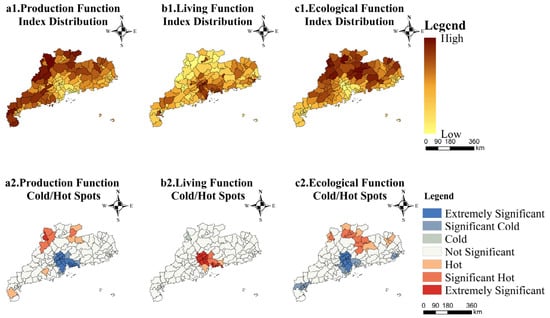
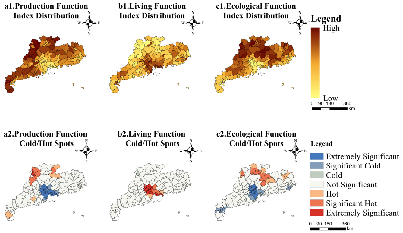
As illustrated in Figure 3, agricultural production functions generally exhibit a concentric spatial pattern characterised by ‘low values at the centre and high values at the periphery’. Two distinct high-value clusters have emerged in north-western Guangdong, whilst the Pearl River Delta (PRD) has evolved into a pronounced low-value cluster. Centred on Guangzhou, Shenzhen, and Zhongshan, the PRD is subject to the dual pressures of rapid urbanisation and industrialisation. Regarding labour, the continuous outflow of the rural working-age population to the secondary and tertiary sectors in core urban areas has resulted in a structural shortage of agricultural labour. In terms of land resources, the conversion of agricultural land for urban construction has led to the compression and fragmentation of agricultural space. This reallocation of factors essentially represents the spatial manifestation of agricultural production factors flowing into non-agricultural sectors.
Figure 3.
Spatial distribution of PLE functions in Guangdong Province.
With Liannan as the core, extending to Lianzhou, Lianshan, and Huaiji, the first high-value region forms a key agricultural production base. This area benefits from alluvial valley plains formed by rivers such as the Lianjiang and Suijiang, offering superior natural endowments for agriculture. The fertile plains are well-suited for crop cultivation; situated in a subtropical monsoon climate zone, the region receives an average annual rainfall of 1600–1800 mm. Coupled with abundant sunlight and a frost-free period exceeding 280 days, these conditions provide an ideal growth environment for double-cropping rice, sugarcane, and citrus fruits.
Shixing, Nanxiong, Lianping, and Wengyuan constitute the second major agricultural production hub. Leveraging unique mountainous microclimates and ecological advantages, this region has developed a distinctive agricultural landscape. The undulating terrain on the southern slopes of the Nanling Mountains creates significant altitudinal variations, fostering diverse microclimates. These conditions are particularly conducive to the accumulation of sugars and the synthesis of aromatic compounds in cash crops—such as tobacco and citrus—yielding products of significantly higher quality compared to plain areas. Furthermore, the natural barrier effect of the mountainous terrain effectively mitigates meteorological disasters such as typhoons and floods, ensuring greater stability in agricultural production.
4.1.2. Spatial Characteristics of Living Functions
The spatial pattern of living functions exhibits distinct gradient differentiation, generally characterised by a ‘core–periphery’ structure with intensity attenuating from the centre outwards. Hotspots for living functions are predominantly concentrated in the Pearl River Delta (PRD) region, anchored by cities such as Dongguan, Zhongshan, and Guangzhou. The formation of these high-value clusters is driven by the multidimensional synergy of population agglomeration, economic growth, and infrastructure development. As one of China’s most economically dynamic regions, the PRD attracts significant population inflows, directly stimulating demand for living services, including education, healthcare, and entertainment. Sustained infrastructure investment has expanded the spatial capacity of cities within the region, facilitating the networked provision of public service facilities.
Notably, the spatial pattern of living functions in Guangdong Province reveals no significant cold spots. This absence of low-value areas is largely attributable to the province’s persistent strategy of strengthening infrastructure investment and promoting the equalisation of basic public services. Through a coordinated development model and the construction of cross-regional public service networks, inter-regional development gradients have been effectively narrowed. This state of spatial equilibrium underscores the regulatory efficacy of Guangdong Province’s new urbanisation initiatives in optimising public service allocation.
4.1.3. Spatial Characteristics of Ecological Functions
Guangdong Province exhibits distinct spatial differentiation in ecological functions, generally characterised by a gradient pattern of ‘high values in the north and low values in the south’. Northern ecological hotspots are primarily concentrated in prefecture-level cities such as Qingyuan, Shaoguan, Heyuan, and Zhaoqing. This region is predominantly characterised by mountainous and hilly terrain; notably, the Nanling Mountains traverse Shaoguan and Qingyuan, constituting a significant proportion of the region’s land area. The complex topography provides diverse habitats for flora and fauna, underpinning biodiversity conservation. Furthermore, the region contains critical wetland resources that deliver key ecosystem services, including water conservation, purification, flood regulation, and drought mitigation. Leveraging these superior natural endowments, Guangdong Province has actively advanced the construction of the Northern Ecological Development Zone. The establishment of a system of protected areas—such as the Nanling and Dinghu Mountain National Nature Reserves—has been instrumental in safeguarding biodiversity and maintaining ecosystem integrity, thereby consolidating the region’s status as a core ecological barrier. Conversely, areas with lower ecological functionality are mainly concentrated in the Pearl River Delta urban agglomeration, centred on Dongguan, Zhongshan, and Guangzhou. Rapid urbanisation has resulted in extensive land sealing, which has significantly compromised soil and water conservation capabilities. Particularly in central urban areas and industrial clusters, the scarcity of ecological buffer zones limits the capacity for effective ecological regulation and protection.
4.1.4. Spatial Differentiation of Coupling Coordination of PLE Functions
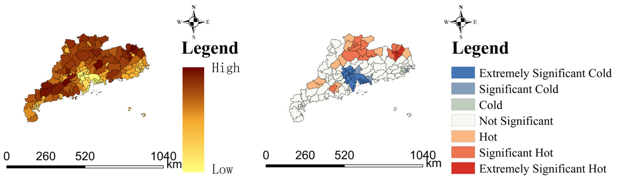
Figure 4 reveals significant spatial heterogeneity in the coupling coordination of rural production–living–ecological functions across Guangdong Province. The core area of the Pearl River Delta (PRD) exhibits a marked imbalance in functional coupling. Driven by rapid urbanisation and industrialisation, extensive tracts of productive and ecological land have been converted into urban living spaces, resulting in an excessive concentration of living functions. This structural bias in land resource allocation, whilst accommodating population agglomeration, has continuously eroded agricultural production capacity and ecological service efficacy, creating a pronounced trade-off among production, ecological, and living functions. This imbalance exhibits distinct spatial diffusion characteristics, radiating from the PRD hinterland to peripheral areas via transport networks, ultimately forming a regional pattern of functional disequilibrium that poses a systemic constraint on sustainable development.
Figure 4.
Spatial pattern of coupling coordination of production–living–ecological functions.
In contrast, the Northern Guangdong Ecological Development Zone displays high coordination levels with significant spatial clustering, achieved through the establishment of green production systems and the optimisation of living environments. Meizhou City stands out as a hotspot for coupling coordination, with its formation mechanism primarily twofold: Firstly, leveraging its status as a pioneer of the National Forest City, it has activated the forestry resource market through rights transfer platforms and forestry cooperatives. This industrialisation of forestry has enhanced agricultural efficiency while synergising ecological conservation with economic development. Secondly, by integrating urban forestry into infrastructure planning and securing funding via public budgets and special project appropriations, Meizhou has improved its infrastructure system, fostering a synergy among ecological, social, and economic benefits.
As a sub-hotspot, Shaoguan City has pursued a transformative development path. Using the construction of Lingnan and Danxia Mountain National Parks as strategic pivots, it has systematically advanced the realisation of ecological product value. First, through specialised clusters—such as bamboo deep processing and organic tea cultivation—it has established multi-dimensional channels for converting ecological resources into economic value, achieving integrated production–ecological development. Second, anchored by the Danxia Mountain World Heritage Site, the region has developed a comprehensive tourism framework. Initiatives like the Danxia Cultural Tourism Complex have effectively enhanced living services, establishing a virtuous cycle between ecological conservation and livelihood improvement.
4.2. Influencing Factors of Coupling Coordination of PLE Functions in Rural Guangdong
4.2.1. Global Importance of Influencing Factors
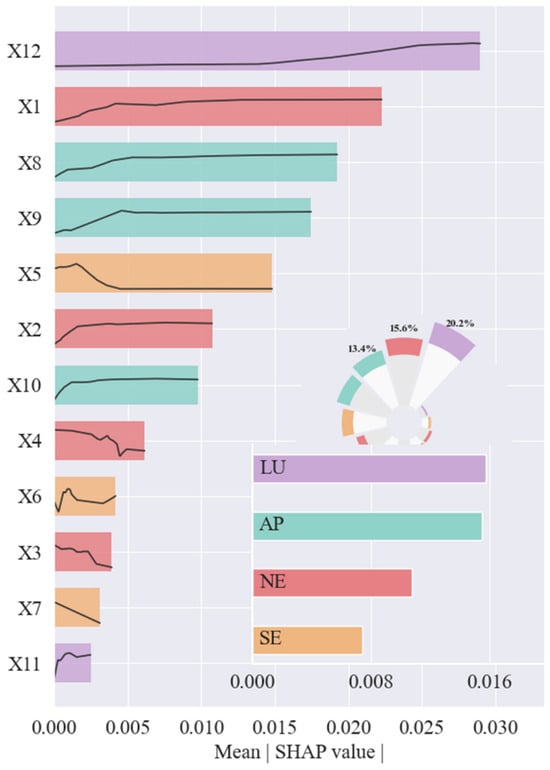
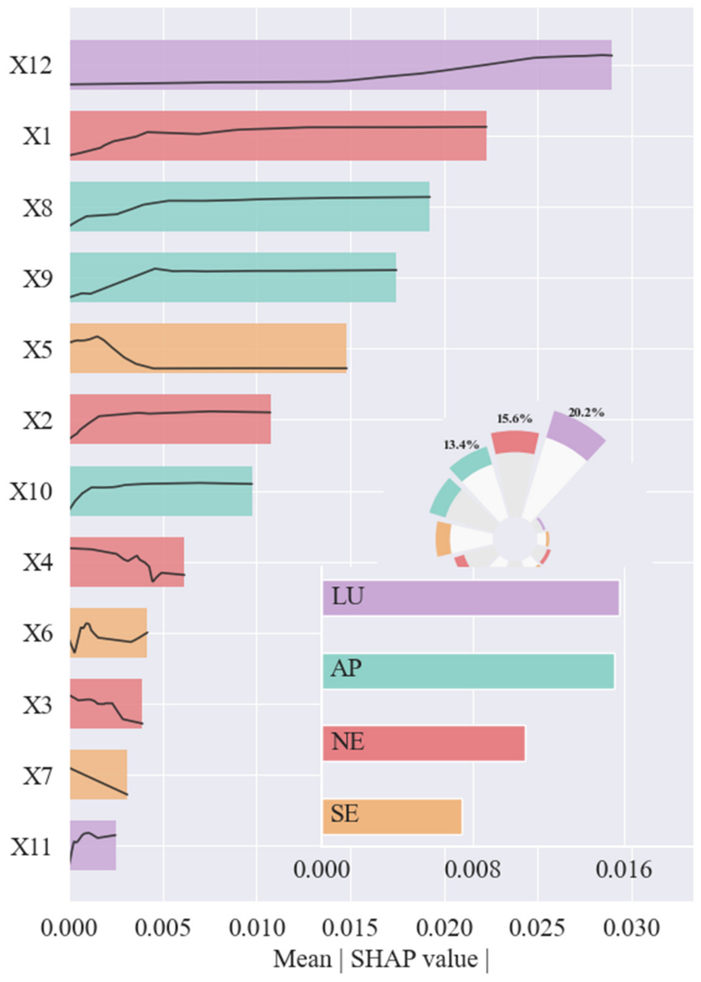
The degree of coupling and coordination of the PLE functions in the rural areas of Guangdong’s counties is shaped by the combined effects of multiple factors. To accurately identify the key influencing factors, this study employs the Geographically Weighted Random Forest (GWRF) model to analyse 12 variables across 122 county-level administrative units in Guangdong Province in 2023. The importance of each variable is measured by the percentage increase in the mean absolute SHAP value (Mean |SHAP|), with higher values indicating greater variable importance.
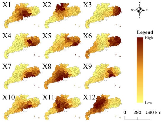
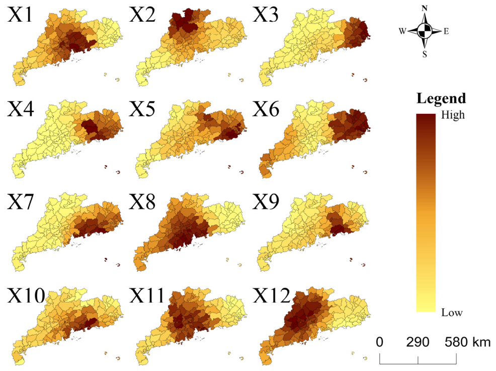
The analysis proceeds in two stages. First, a general assessment of the factors influencing the land use function index in Guangdong Province is presented (Figure 5), in which X12 are found to exert a significant influence. Second, drawing on the GWRF results, spatial distribution maps depicting the importance of the 12 influencing factors are produced (Figure 6), in which areas are classified into high-value and low-value zones according to their importance values, with darker colours denoting higher importance and lighter colours corresponding to lower importance. Overall, the local importance of the influencing factors exhibits pronounced spatial heterogeneity across regions.
Figure 5.
Mean |SHAP| for coupling coordination of PLE functions at the county level in Guangdong.
Figure 6.
Spatial distribution map of the importance of driving factors.
4.2.2. Spatial Heterogeneity of Influencing Factors
Figure 6 illustrates the spatial heterogeneity of the factors influencing the coordination of rural production–living–ecological functions across Guangdong Province.
In terms of topography, the effect intensities of administrative area (X1) and slope (X2) exhibit opposite gradient patterns. The effect intensity of administrative area decreases progressively from the southeastern coast of Guangdong toward the northwest. Its high-value zones are concentrated in the Pearl River Delta Plain. In contrast, the effect intensity of slope decreases progressively from northwestern Guangdong toward the southeast coast. Its high-value zones are concentrated in the mountainous and hilly areas of northern Guangdong, such as Lianzhou and Yangshan. The Pearl River Delta Plain forms the corresponding low-value zone. In terms of climatic factors, the driving effects of precipitation (X3) and temperature (X4) display a distinct differentiation trending from northeast to southwest, suggesting that hydrothermal conditions play a moderating role in PLE function coordination in specific areas.
Among the socioeconomic factors, the effect intensity of public expenditure (X5) exhibits pronounced spatial differentiation, with high-value zones concentrated in northeastern Guangdong. The effect intensity of economic development (X6) displays a “high–low–high” banded pattern from northeast to southwest. Economically developed regions such as Guangzhou and Shenzhen correspond to the low-value segments, where the effect intensity of economic development on the coupling coordination degree is markedly low. This pattern may be attributed to the “saturation effect” that arises once the economic level crosses a certain threshold; that is, in highly developed regions, further improvement in coordination no longer depends primarily on the expansion of economic scale, and the marginal driving effect of economic development correspondingly diminishes. In contrast, economic development remains a strong driving factor for the improvement of the coupling coordination degree in northeastern and southwestern Guangdong. The effect of economic synergy (X7) is highly concentrated in space: it exerts a significant influence on the coupling coordination degree within the Shenzhen–Dongguan–Huizhou economic circle, whereas its effect intensity in other regions is negligible.
In terms of agricultural production conditions, the effect intensity of irrigated area (X8) exhibits pronounced spatial differentiation, with high-value zones concentrated in the hilly areas of northeastern Guangdong. However, it shows an inverse spatial association with the effect intensity of precipitation (X3): zones with a high effect intensity of precipitation correspond to zones with a low effect intensity of irrigation, whereas zones with a high effect intensity of irrigation occur in areas where the effect of precipitation is relatively weak. The effect intensity of chemical fertilizer application (X9) remains low across most of the study area, with relatively high-value zones appearing only in northeastern Guangdong. In contrast to the spatial patterns of the above two factors, pesticide application (X10) does not show a relatively high effect intensity in northeastern Guangdong; rather, its high-value zones are concentrated in the Pearl River Delta region.
In terms of land use planning, the effect intensity of built-up area extent (X11) exhibits pronounced spatial differentiation: it is relatively low in northeastern Guangdong, whereas its effect on the coupling coordination degree is relatively strong in other regions. The effect intensity of vegetation cover extent (X12) is relatively weak in mountainous areas such as northeastern Guangdong, but remains relatively high in other regions.
4.2.3. Action Factors of Coupling Coordination
The coordination of production–living–ecological functions results from the interplay of natural conditions, socio-economic development, agricultural production, and land-use planning; however, the relative importance of these drivers exhibits significant spatial heterogeneity. Accordingly, this paper elucidates the influencing factors as follows:
Land-use planning plays a central role. Built-up area extent and vegetation cover, as key indicators of spatial configuration, profoundly influence functional coordination through interaction factors. Specifically, the expansion of built-up areas exerts a crowding-out effect on ecological and production spaces to accommodate living facilities, inducing potential functional conflicts. Conversely, increased vegetation coverage primarily reflects the demand for ecological restoration and agricultural preservation, which may impose constraints on the spatial expansion of living spaces. This bidirectional spatial trade-off indicates that optimising urban–rural spatial allocation—and balancing built-up expansion with vegetation conservation—is the core pathway to achieving synergistic enhancement of the three functions.
Agricultural production conditions significantly moderate coupling coordination. Irrigation capacity (X8), fertiliser application (X9), and pesticide use (X10) exert effects on the system. While improved irrigation significantly enhances production functions, and moderate agrochemical inputs boost efficiency, excessive application undermines ecological integrity through non-point source pollution and poses risks to quality of life. Reasonable threshold control of agricultural inputs is a crucial factor in maintaining functional coordination.
Socio-economic conditions act as pivotal drivers. Public expenditure, economic growth, and economic synergy influence coordination through multi-dimensional pathways. Increased public expenditure directly strengthens public service provision, enhancing living quality. Economic growth drives production expansion via land-use transition but risks functional imbalances through excessive encroachment on agricultural and ecological land. Furthermore, economic synergy exhibits a ‘dual-layer regulation’ characteristic: promoting regional functional division and synergy at the macro level, while potentially inducing functional conflicts within individual units. Consequently, socio-economic regulation must balance macro-synergy with micro-adaptation to establish a dynamic equilibrium of “functional zoning and factor flow”.
Natural conditions exert a foundational influence. Favorable endowments provide suitable conditions for production while maintaining ecosystem stability, thereby promoting coordinated development. Conversely, adverse conditions limit production feasibility and necessitate substantial resource expenditure for environmental modification. This dual constraint often triggers a cumulative effect of weakened production and degraded ecology, ultimately leading to systemic dysfunction.
5. Conclusions and Discussion
This paper constructs a comprehensive evaluation index system for rural functions at the county level based on the production–living–ecological functions framework, analyses the spatial distribution characteristics and coupling coordination relationships of these functions in rural Guangdong, identifies the driving factors, and proposes zonal optimisation pathways.
First, at the county level, the “production–living–ecological” functions display a spatial pattern in which high-coordination clusters and coordination imbalance coexist. Guided by a rural functional perspective, this study finds that the degree of functional coordination is not simply and positively associated with the level of regional economic development. In the highly urbanized Pearl River Delta, living functions are highly concentrated, whereas the provision of production and ecological functions is relatively insufficient. The three functions therefore show a pronounced trade-off effect, and the overall coupling coordination degree is low. By contrast, the Ecological Development Zone of northern Guangdong, where economic development lags behind, forms clusters of high coordination. While infrastructure construction meets living needs, urban expansion has substantially displaced production and ecological spaces. These results suggest that the core of functional coordination lies not in the level of economic development itself, but in the structural balance among production, living, and ecological spaces.
Second, the driving factors of coupling coordination exhibit pronounced spatial heterogeneity. Previous studies have mostly relied on global regression or the geographical detector, which report province-wide or average effects and thus can hardly capture the spatial differentiation of driving structures. The results of the geographically weighted random forest (GWRF) model in this study show that the importance of driving factors varies markedly across space. Terrain factors (elevation and slope) are considerably more important in the mountainous areas of northern Guangdong, reflecting how terrain constraints restrict local urbanization and industrialization. In the Pearl River Delta, by contrast, public fiscal expenditure and economic development act as the dominant factors and exert strong pressure on production and ecological spaces. This finding indicates that the causal structures underlying functional imbalance differ fundamentally across regions. A uniform, “one-size-fits-all” policy is therefore unlikely to be effective. Future governance should instead follow a differentiated, zone- and category-specific approach to territorial space management, based on the dominant driving factors in each region.
Third, the land use pattern is a key driving factor at the global scale. The global importance ranking from GWRF shows that the built-up area and vegetation coverage rank highest. These two variables represent the forces of construction expansion and ecological protection, respectively, and the spatial competition between them constitutes the central constraint on functional coordination. The expansion of built-up land can squeeze ecological space and intensify functional imbalance. This finding cautions against treating land use merely as a background or control variable. It also implies that regulating functional coordination through the optimization of territorial spatial patterns is a feasible policy pathway.
Limitations and future research. This study has three main limitations. First, the county-level analysis may mask intra-county heterogeneity, especially in counties with diverse land use types and rugged terrain, where county averages smooth over important local differences. Second, the GWRF model captures the spatial variation in variable importance, but it does not identify causal direction, effect size, or threshold effects. The results should therefore be interpreted as spatial associations rather than causal mechanisms. Third, constrained by statistical calibers and data availability, some socioeconomic indicators are missing or outdated, which may affect the precision of the model estimates. Future research could be deepened in three directions. First, multi-temporal data could be introduced to examine the evolution of functional coordination patterns through trajectory analysis. Second, partial dependence analysis combined with quasi-experimental designs could be used to test the causal mechanisms behind the spatial associations identified by GWRF. Third, finer-resolution data at the village or grid level could reveal micro-scale heterogeneity that county-level analysis cannot capture, thereby providing more precise empirical evidence for differentiated governance policies.
Author Contributions
Conceptualization, H.L. and W.H.; methodology, Y.Z.; software, Y.Z.; investigation, H.L.; data curation, Y.Z. and W.H.; writing—original draft preparation, H.L. and W.H.; writing—review and editing, H.L., Y.Z., and Y.Z.; visualization, H.L.; supervision, H.L. and W.H.; funding acquisition, H.L. All authors have read and agreed to the published version of the manuscript.
Funding
This work was supported by the Key Laboratory of Natural Resources Monitoring in Tropical and Subtropical Area of South China, Ministry of Natural Resources (No. 2024NRMK04) and the Fundamental Research Funds for the Central Universities (No. 1253200022).
Data Availability Statement
The original contributions presented in this study are included in the article. Further inquiries can be directed to the corresponding author.
Conflicts of Interest
The authors declare no conflicts of interest.
References
- Kong, L.Y.; Xu, X.D.; Wang, W.; Wu, J.X.; Zhang, M.Y. Comprehensive Evaluation and Quantitative Research on the Living Protection of Traditional Villages from the Perspective of “Production-Living-Ecology”. Land 2021, 10, 570. [Google Scholar] [CrossRef] [Scilit]
- Ye, C.; Ma, X.; Gao, Y.; Johnson, L. The Lost Countryside: Spatial Production of Rural Culture in Tangwan Village in Shanghai. Habitat Int. 2020, 98, 102137. [Google Scholar] [CrossRef] [Scilit]
- Yu, Z.; Xu, E.; Zhang, H.; Shang, E. Spatio-Temporal Coordination and Conflict of Production-Living-Ecology Land Functions in the Beijing-Tianjin-Hebei Region, China. Land 2020, 9, 170. [Google Scholar] [CrossRef] [Scilit]
- Holmes, J. The Multifunctional Transition in Australia’s Tropical Savannas: The Emergence of Consumption, Protection and Indigenous Values. Geogr. Res. 2010, 48, 265–280. [Google Scholar] [CrossRef] [Scilit]
- Huang, J.; Tichit, M.; Poulot, M.; Darly, S.; Li, S.; Petit, C.; Aubry, C. Comparative Review of Multifunctionality and Ecosystem Services in Sustainable Agriculture. J. Environ. Manag. 2015, 149, 138–147. [Google Scholar] [CrossRef] [Scilit]
- Li, S.; An, W.; Zhang, J.; Gan, M.; Wang, K.; Ding, L.; Li, W. Optimizing Limit Lines in Urban-Rural Transitional Areas: Unveiling the Spatial Dynamics of Trade-Offs and Synergies among Land Use Functions. Habitat Int. 2023, 140, 102907. [Google Scholar] [CrossRef] [Scilit]
- Zhu, C.; Dong, B.; Li, S.; Lin, Y.; Shahtahmassebi, A.; You, S.; Zhang, J.; Gan, M.; Yang, L.; Wang, K. Identifying the Tradeoffs and Synergies among Land Use Functions and Their Influencing Factors from a Geospatial Perspective: A Case Study in Hangzhou, China. J. Clean. Prod. 2021, 314, 128026. [Google Scholar] [CrossRef] [Scilit]
- Zhang, M.; Tan, S.; Liang, J.; Zhang, C.; Chen, E. Predicting the Impacts of Urban Development on Urban Thermal Environment Using Machine Learning Algorithms in Nanjing, China. J. Environ. Manag. 2024, 356, 120560. [Google Scholar] [CrossRef] [Scilit]
- Zhang, Y.; Ge, J.; Wang, S.; Dong, C. Optimizing Urban Green Space Configurations for Enhanced Heat Island Mitigation: A Geographically Weighted Machine Learning Approach. Sustain. Cities Soc. 2025, 119, 106087. [Google Scholar] [CrossRef] [Scilit]
- Hai, Z.; Perlman, R.L. Extreme Weather Events and the Politics of Climate Change Attribution. Sci. Adv. 2022, 8, eabo2190. [Google Scholar] [CrossRef] [Scilit]
- Feng, Y.; Zhang, W.; Yu, J.; Zhuo, R. Exploring Nonlinear Land Use Drivers and Multi-Scenario Strategies for Ecological Impact Mitigation: A Case Study of the Hohhot-Baotou-Ordos Area, Inner Mongolia, China. Cities 2025, 162, 105935. [Google Scholar] [CrossRef] [Scilit]
- Lian, H.; Zhang, Y.; Xiong, X.; Han, W. Functional Assessment of Rural Counties Under the Production–Living–Ecological Framework: Evidence from Guangdong, China. Land 2025, 14, 995. [Google Scholar] [CrossRef] [Scilit]
- Li, H.; Wu, Y.; Huang, X.; Sloan, M.; Skitmore, M. Spatial-Temporal Evolution and Classification of Marginalization of Cultivated Land in the Process of Urbanization. Habitat Int. 2017, 61, 1–8. [Google Scholar] [CrossRef] [Scilit]
- Song, X.; Huang, Y.; Wu, Z.; Ouyang, Z. Does Cultivated Land Function Transition Occur in China? J. Geogr. Sci. 2015, 25, 817–835. [Google Scholar] [CrossRef] [Scilit]
- Costanza, R.; De Groot, R.; Braat, L.; Kubiszewski, I.; Fioramonti, L.; Sutton, P.; Farber, S.; Grasso, M. Twenty Years of Ecosystem Services: How Far Have We Come and How Far Do We Still Need to Go? Ecosyst. Serv. 2017, 28, 1–16. [Google Scholar] [CrossRef] [Scilit]
- De Groot, R. Function-Analysis and Valuation as a Tool to Assess Land Use Conflicts in Planning for Sustainable, Multi-Functional Landscapes. Landsc. Urban Plan. 2006, 75, 175–186. [Google Scholar] [CrossRef] [Scilit]
- Lovell, S.T.; DeSantis, S.; Nathan, C.A.; Olson, M.B.; Ernesto Méndez, V.; Kominami, H.C.; Erickson, D.L.; Morris, K.S.; Morris, W.B. Integrating Agroecology and Landscape Multifunctionality in Vermont: An Evolving Framework to Evaluate the Design of Agroecosystems. Agric. Syst. 2010, 103, 327–341. [Google Scholar] [CrossRef] [Scilit]
- Yang, Y.; Bao, W.; Liu, Y. Coupling Coordination Analysis of Rural Production-Living-Ecological Space in the Beijing-Tianjin-Hebei Region. Ecol. Indic. 2020, 117, 106512. [Google Scholar] [CrossRef] [Scilit]
- Zhang, Y.; Long, H.; Tu, S.; Ge, D.; Ma, L.; Wang, L. Spatial Identification of Land Use Functions and Their Tradeoffs/Synergies in China: Implications for Sustainable Land Management. Ecol. Indic. 2019, 107, 105550. [Google Scholar] [CrossRef] [Scilit]
- Decoville, A.; Schneider, M. Can the 2050 zero land take objective of the EU be reliably monitored? A comparative study. J. Land Use Sci. 2015, 11, 331–349. [Google Scholar] [CrossRef] [Scilit]
- Bencardino, M. Land take and urban sprawl: Drivers e contrasting policies. Boll. Della Soc. Geogr. Ital. 2019, 8, 217–237. [Google Scholar] [CrossRef] [Scilit]
- Liu, Y.; Lu, S.; Chen, Y. Spatio-temporal change of urban–rural equalized development patterns in China and its driving factors. J. Rural Stud. 2013, 32, 320–330. [Google Scholar] [CrossRef] [Scilit]
- Evans, N. Multifunctional Agriculture: A Transition Theory Perspective. Rural Stud. 2010, 26, 81–82. [Google Scholar] [CrossRef] [Scilit]
- Wang, J.; Lin, Y.; Glendinning, A.; Xu, Y. Land-use changes and land policies evolution in China’s urbanization processes. Land Use Policy 2018, 75, 375–387. [Google Scholar] [CrossRef] [Scilit]
- Weng, Q. Land use change analysis in the Zhujiang Delta of China using satellite remote sensing, GIS and stochastic modelling. J. Environ. Manag. 2002, 64, 273–284. [Google Scholar] [CrossRef] [Scilit]
- Deng, J.S.; Wang, K.; Hong, Y.; Qi, J.G. Spatio-temporal dynamics and evolution of land use change and landscape pattern in response to rapid urbanization. Landsc. Urban Plan. 2009, 92, 187–198. [Google Scholar] [CrossRef] [Scilit]
- Deng, Y.; Yang, R. Influence Mechanism of Production-Living-Ecological Space Changes in the Urbanization Process of Guangdong Province, China. Land 2021, 10, 1357. [Google Scholar] [CrossRef] [Scilit]
- Zhou, D.; Xu, J.; Lin, Z. Conflict or Coordination? Assessing Land Use Multi-Functionalization Using Production-Living-Ecology Analysis. Sci. Total Environ. 2017, 577, 136–147. [Google Scholar] [CrossRef] [Scilit]
- Zou, L.; Liu, Y.; Wang, J.; Yang, Y. An Analysis of Land Use Conflict Potentials Based on Ecological-Production-Living Function in the Southeast Coastal Area of China. Ecol. Indic. 2021, 122, 107297. [Google Scholar] [CrossRef] [Scilit]
- Geoghegan, J. The Value of Open Spaces in Residential Land Use. Land Use Policy 2002, 19, 91–98. [Google Scholar] [CrossRef] [Scilit]
- Holmes, J. Impulses Twards a Mltifunctional Tansition in Rral Australia: Gaps in the Rsearch Aenda. J. Rural Stud. 2006, 22, 142–160. [Google Scholar] [CrossRef] [Scilit]
- Lu, Z.; Zhang, M.; Hu, C.; Ma, L.; Chen, E.; Zhang, C.; Xia, G. Spatiotemporal Changes and Influencing Factors of the Coupled Production–Living–Ecological Functions in the Yellow River Basin, China. Land 2024, 13, 1909. [Google Scholar] [CrossRef] [Scilit]
- Turner, R.K.; Daily, G.C. The Ecosystem Services Framework and Natural Capital Conservation. Environ. Resour. Econ. 2008, 39, 25–35. [Google Scholar] [CrossRef] [Scilit]
- Bennett, E.M.; Peterson, G.D.; Gordon, L.J. Understanding Relationships among Multiple Ecosystem Services. Ecol. Lett. 2009, 12, 1394–1404. [Google Scholar] [CrossRef] [Scilit]
- Liu, C.; Xu, Y.Q.; Sun, P.L.; Liu, J. Progress and Prospects of Multi-Functionality of Land Use Research. Prog. Geogr. 2016, 35, 1087–1099. (In Chinese) [Google Scholar] [CrossRef] [Scilit]
- Fan, Y.; Jin, X.; Gan, L.; Jessup, L.H.; Pijanowski, B.C.; Yang, X.; Xiang, X.; Zhou, Y. Spatial Identification and Dynamic Analysis of Land Use Functions Reveals Distinct Zones of Multiple Functions in Eastern China. Sci. Total Environ. 2018, 642, 33–44. [Google Scholar] [CrossRef] [Scilit]
- Chen, W.T.; Hu, Q.Y.; Liu, F.L.; Liu, Y.; Wang, S. Evaluating the Trade-Offs and Synergies of Ecosystem Services in the Jinsha River Basin. J. Resour. Ecol. 2024, 15, 15–32. [Google Scholar] [CrossRef] [Scilit]
- Fan, Y.T.; Jin, X.B.; Gan, L.; Lin, J.H.; Yang, Q.K.; Lv, L.G.; Li, Y. Spatial characteristics and influencing mechanism of trade-offs between multiple land use functions in the Yangtze River Delta region. Resour. Sci. 2022, 44, 1589–1603. (In Chinese) [Google Scholar] [CrossRef] [Scilit]
- Zhou, S.Y.; Li, W.; Lu, Z.; Cheng, R.H. An Ecosystem-Based Analysis of Urban Sustainability by Integrating Ecosystem Service Bundles and Socio-Economic Environmental Conditions in China. Ecol. Indic. 2020, 117, 106691. [Google Scholar] [CrossRef] [Scilit]
- Sun, X.Y.; Shan, R.F.; Liu, F. Spatio-Temporal Quantification of Patterns, Trade-Offs and Synergies among Multiple Hydrological Ecosystem Services in Different Topographic Basins. J. Clean. Prod. 2020, 268, 122338. [Google Scholar] [CrossRef] [Scilit]
- Liu, H.; Shu, C.; Zhou, T.T.; Liu, P. Trade-Off and Synergy Relationships of Ecosystem Services and Driving Force Analysis Based on Land Cover Change in Altay Prefecture. J. Resour. Ecol. 2021, 12, 777–790. [Google Scholar] [CrossRef] [Scilit]
- Zeng, K.H.; Tang, J.; Yang, S.F. Research on trade-offs and synergy relationship of land use functions and the driving factors: A case study in Wuhan. China Land Sci. 2024, 38, 66–77. (In Chinese) [Google Scholar]
- Zhu, C.M.; Yuan, S.F. Spatio-temporal characteristics and influencing factors of trade-offs/synergies in land use functions in Hangzhou City, China. Trans. Chin. Soc. Agric. Eng. 2022, 38, 264–273. (In Chinese) [Google Scholar] [CrossRef]
- Huang, L.J.; Lu, Z.; Hu, W.Y. Spatio-temporal coupling characteristics and influencing factors of “production-living-ecological” functions of urban space in the Yangtze River economic belt. Resour. Environ. Yangtze Basin 2024, 33, 687–698. (In Chinese) [Google Scholar]
- Cheng, J.Q.; Lin, Y.L.; Zhao, J.S.; Qin, B.G. Spatiotemporal characteristics and influencing factors of functional coupling and coordination of ’Production-living-Ecological’ Spaces in Kunming City. Res. Soil Water Conserv. 2024, 31, 299–310, 319. (In Chinese) [Google Scholar] [CrossRef]
- Zhang, X.P.; Li, H.R.; Wang, J.T.; Wang, L.J. Impact of climate and land usechanges on coupling coordination relationship of ecological functions indifferent vegetation zones: A case study of Qinghai-Xizang Plateau Ecological Shelter. Res. Soil Water Conserv. 2026, 33, 216–224. (In Chinese) [Google Scholar] [CrossRef]
- Guan, M.; Zhang, W.X.; Jiang, H.M.; Lu, C.; Ge, Y.B.; Dong, G.L. Cross-sensitivity evaluation of ecosystem services based on land use changes inShandong Province. J. China Agric. Univ. 2022, 27, 192–203. (In Chinese) [Google Scholar] [CrossRef]
- Liu, Y.; Zhou, Y. Territory Spatial Planning and National Governance System in China. Land Use Policy 2021, 102, 105288. [Google Scholar] [CrossRef] [Scilit]
- Boone, R.B.; Conant, R.T.; Sircely, J.; Thornton, P.K.; Herrero, M. Climate Change Impacts on Selected Global Rangeland Ecosystem Services. Glob. Change Biol. 2018, 24, 1382–1393. [Google Scholar] [CrossRef] [Scilit]
- Zou, L.; Liu, Y.; Yang, J.; Yang, S.; Wang, Y.; Cao, Z.; Hu, X. Quantitative Identification and Spatial Analysis of Land Use Ecological-Production-Living Functions in Rural Areas on China’s Southeast Coast. Habitat Int. 2020, 100, 102182. [Google Scholar] [CrossRef] [Scilit]
- Liu, C.; Xu, Y.; Lu, X.; Han, J. Trade-Offs and Driving Forces of Land Use Functions in Ecologically Fragile Areas of Northern Hebei Province: Spatiotemporal Analysis. Land Use Policy 2021, 104, 105387. [Google Scholar] [CrossRef] [Scilit]
- Zhang, Z.; Liu, Y.; Wang, Y.; Liu, Y.; Zhang, Y.; Zhang, Y. What Factors Affect the Synergy and Tradeoff between Ecosystem Services, and How, from a Geospatial Perspective? J. Clean. Prod. 2020, 257, 120454. [Google Scholar] [CrossRef] [Scilit]
- Fan, Y.; Gan, L.; Hong, C.; Jessup, L.H.; Jin, X.; Pijanowski, B.C.; Sun, Y.; Lv, L. Spatial Identification and Determinants of Trade-Offs among Multiple Land Use Functions in Jiangsu Province, China. Sci. Total Environ. 2021, 772, 145022. [Google Scholar] [CrossRef] [Scilit]
- He, W.; Li, X.; Yang, J.; Ni, H.; Sang, X. How Land Use Functions Evolve in the Process of Rapid Urbanization: Evidence from Jiangsu Province, China. J. Clean. Prod. 2022, 380, 134877. [Google Scholar] [CrossRef] [Scilit]
- Willemen, L.; Hein, L.; van Mensvoort, M.E.F.; Verburg, P.H. Space for People, Plants, and Livestock? Quantifying Interactions among Multiple Landscape Functions in a Dutch Rural Region. Ecol. Indic. 2010, 10, 62–73. [Google Scholar] [CrossRef] [Scilit]
- Lyu, Y.; Wang, M.; Zou, Y.; Wu, C. Mapping Trade-Offs among Urban Fringe Land Use Functions to Accurately Support Spatial Planning. Sci. Total Environ. 2022, 802, 149915. [Google Scholar] [CrossRef] [Scilit]
- Xu, X. China Terrestrial Ecosystem Service Value Dataset. Resource and Environmental Science Data Platform. Resource and Environmental Science Data Platform. 2026. Available online: https://www.resdc.cn/DOI/doi.aspx?DOIid=195 (accessed on 10 December 2025)(In Chinese). [CrossRef]
- Xie, G.D.; Zhang, C.X.; Zhang, C.S.; Xiao, Y.; Lu, C.X. The value of ecosystem services in China. Resour. Sci. 2015, 37, 1740–1746. (In Chinese) [Google Scholar]
- Lotfata, A.; Georganos, S.; Kalogirou, S.; Helbich, M. Ecological Associations between Obesity Prevalence and Neighborhood Determinants Using Spatial Machine Learning in Chicago, Illinois, USA. ISPRS Int. J. Geo-Inf. 2022, 11, 550. [Google Scholar] [CrossRef] [Scilit]
- Draidi Areed, W.; Price, A.; Arnett, K.; Mengersen, K. Spatial Statistical Machine Learning Models to Assess the Relationship between Development Vulnerabilities and Educational Factors in Children in Queensland, Australia. BMC Public Health 2022, 22, 2232. [Google Scholar] [CrossRef] [Scilit]
- Grekousis, G.; Feng, Z.; Marakakis, I.; Lu, Y.; Wang, R. Ranking the Importance of Demographic, Socioeconomic, and Underlying Health Factors on US COVID-19 Deaths: A Geographical Random Forest Approach. Health Place 2022, 74, 102744. [Google Scholar] [CrossRef] [Scilit]
- Gollini, I.; Lu, B.; Charlton, M.; Brunsdon, C.; Harris, P. GWmodel: An R Package for Exploring Spatial Heterogeneity Using Geographically Weighted Models. J. Stat. Softw. 2015, 63, 1–50. [Google Scholar] [CrossRef] [Scilit]
- Shu, T.; Yang, S.; Yu, T.; Chen, Y.; Liang, L.; Cai, Z.; Liao, X. How urban amenity factors shape the geography of innovative enterprises: A geographical random forest approach in Beijing. Cities 2026, 179, 107612. [Google Scholar] [CrossRef] [Scilit]

Disclaimer/Publisher’s Note: The statements, opinions and data contained in all publications are solely those of the individual author(s) and contributor(s) and not of MDPI and/or the editor(s). MDPI and/or the editor(s) disclaim responsibility for any injury to people or property resulting from any ideas, methods, instructions or products referred to in the content. |
© 2026 by the authors. Licensee MDPI, Basel, Switzerland. This article is an open access article distributed under the terms and conditions of the Creative Commons Attribution (CC BY) license.