


Abstract
Urban green infrastructure (UGI) depends on connections between spatial planning, project delivery and long-term operation. This article develops a conceptual, document-based assessment of those connections using Singapore as a reference case and Shanghai as a prospective application context. Six analytical dimensions organise five governance linkages: planning to project rules; spatial networks to differentiated uses; interagency project delivery; professional stewardship to operational data; and participation to access and care. A source-level mapping makes the distinction between documented arrangements, institutional reports and proposed applications explicit. A 2025 professional study visit supplies contextual background, not interview or outcome data. The Singapore materials describe instruments joining governance functions, but do not establish continuous implementation or causal effects. Shanghai’s publicly released 2026–2030 ecological-space plan contains related commitments whose project-level operation remains untested. Four fit conditions address authority and accountability, spatial and climatic suitability, operating capacity, and public value. An illustrative application to published research on Portland shows how these conditions can structure questions outside Asia without demonstrating successful transfer. The contribution is an auditable heuristic for locating interfaces that require investigation, rather than an evaluation of city performance or a validated model of policy transfer.
1. Introduction
Urban green space is no longer expected to serve only as amenity planting or recreational land. Parks, greenways, waterways, streetscapes, building greenery, and conservation areas are increasingly planned as a land-based urban landscape system that can mitigate heat, retain and convey stormwater, support biodiversity, improve health, enable active mobility, and strengthen social life [1,2,3,4]. This shift has expanded the policy vocabulary from parks and beautification to urban green infrastructure (UGI), blue–green infrastructure (BGI), nature-based solutions, ecological networks, and urban resilience. The common premise is that connected and multifunctional green and blue spaces can deliver more value than isolated sites [3,4,5,6].
The implementation record, however, is uneven. Connectivity and multifunctionality may be articulated at the regional or citywide planning level but fragmented during land allocation, greenway alignment, project approval, procurement, construction, and maintenance [7,8,9,10]. Agencies may share broad sustainability goals while retaining separate budgets, technical standards, asset registers, and performance indicators. A river restoration project can therefore be designed as a landscape, drainage facility, habitat, and public space, yet later be managed through disconnected operational regimes. The problem is not only how much green space a city possesses, but whether spatial planning, project delivery, stewardship, and learning form a continuous institutional process.
Singapore is widely documented as a case of long-term urban greening. Its trajectory from a “Garden City” to a “City in a Garden” and subsequently a “City in Nature” is associated with statutory land-use planning, an island-wide network of parks and connectors, blue–green projects, vertical greenery, professional horticultural capacity, tree management, and community gardening [11,12,13,14,15,16,17]. Yet visible landscapes can invite superficial lesson-drawing. Tropical vegetation, iconic developments, a city-state government, and comparatively concentrated public authority are not readily reproduced in a large metropolitan region.
Shanghai offers a prospective application context with a larger and more heterogeneous administrative territory. Its ecological-space planning encompasses parks, greenways, waterfronts and peri-urban landscapes [18,19,20]. The publicly released 2026–2030 plan reports 1100 parks as its 2025 baseline and sets directions for their further development [21]. A stated planning commitment is the relevant evidence here; its fulfilment is a separate empirical question.
The comparison concerns governance functions and the conditions under which lessons might be adapted. Dolowitz and Marsh distinguish policy learning from incomplete or inappropriate transfer [22], while collaborative-governance research examines the conditions for collective action [23]. Policy-mobilities scholarship draws attention to the transformation of policies as they circulate [24]. Accordingly, this article does not treat a Singapore programme as a fixed package that can be installed elsewhere. It asks which actor–instrument relationships would have to be reconstructed locally.
Existing scholarship documents Singapore’s greening history, greenways, biophilic urbanism, water-sensitive projects and horticultural participation [11,12,15,16,25,26]. UGI research already addresses integration and governance, including the GREEN SURGE project [3,4,5,6,7,8,9,10]. Shanghai studies examine thermal mitigation and well-being [27,28], and the Valencia–Mexico City comparison explicitly examines the governance context of BGI in public space [29]. The contribution sought here is narrower than a new general theory: a source-linked account of the interfaces between familiar governance functions, followed by a bounded assessment of the evidence needed for application in Shanghai.
This study addresses that gap through three research questions:
- •
- Which connections between UGI governance functions are explicitly described in the selected Singapore sources?
- •
- Which corresponding commitments are documented in Shanghai, and what additional evidence would be needed to assess their operation?
- •
- How can institutional, spatial and climatic, operational, and public-value conditions structure a prospective assessment of these linkages?
The article contributes an implementation-chain heuristic and an explicit separation of documentary findings from prospective applications. Its six dimensions draw on established UGI and implementation scholarship; its five linkages group concrete interfaces for examination. Neither the number of dimensions nor the Singapore arrangements are claimed to be unique. The contribution rests on traceability from a source to an institutional connection and to the limits of the inference that can be drawn.
2. Materials and Methods
2.1. Comparative Design and Case Selection
This is a conceptual, document-based study with an asymmetric design. Singapore supplies examples of formally described governance arrangements. Shanghai supplies a policy context in which analogous functions and evidence needs are identified. The analysis does not evaluate transfer already undertaken, compare equivalent implementation datasets, or estimate governance effects. The term “comparison” therefore refers to a structured contrast of documented functions and contextual conditions.
Singapore’s reported 2025 land area was 736.3 km2 and its total population 6.11 million [30,31]. Shanghai covers 6340.5 km2 and reported approximately 24.85 million permanent residents at the end of 2025 [32,33]. The population denominators differ and are used only to situate scale. Singapore combines national and metropolitan functions within a city-state. Shanghai is a province-level municipality with district and neighbourhood-level implementation responsibilities. Table 1 identifies the planning interfaces relevant to this asymmetry; Section 4.2 treats climate as a contextual fit condition rather than an additional governance dimension.
2.2. Evidence Base and Scope
The evidence consists of public planning and programme documents, statistics and published research. To make the revised interpretation inspectable, a focused mapping was prepared during revision for 15 primary web records: 14 Singapore records spanning the six governance functions and the public Shanghai 2026–2030 plan. These records were purposively selected from the manuscript’s policy sources for explicit instruments, actors or operating applications, rather than for outcome coverage. Supplementary Material S1 lists every mapped record, its issuing body, date or version, locator and assigned dimensions. Other references supply conceptual, historical or contextual support and are not counted as additional coded records. This is a bounded source mapping, not a systematic literature review or an exhaustive inventory of implementation evidence.
One author’s professional visit to Singapore in November 2025 helped identify relevant sites and questions. The programme included institutional briefings, lectures, site visits and exchanges with NParks personnel and project or site managers. The available daily summaries document activities from 16 to 28 November; the itinerary in Supplementary Material S1 reports those entries and their page locations. These summaries do not establish the full travel period or a return date. Programme records do not establish individual attendance at every optional activity. Observations and unrecorded exchanges are background only: they are not research interviews, a coded field dataset, or independent corroboration of agency claims.
2.3. Analytical Framework and Comparative Procedure
The framework is a literature-informed heuristic. Connectivity and multifunctionality inform its spatial focus [3,4,5,6], while GREEN SURGE and governance research already address integration, collaboration and capacity [8,9,10,22,23]. Implementation theory cautions that policy objectives do not specify how ambiguity, conflict and authority will be resolved in practice [34]. The six dimensions organise the source mapping described below:
- •
- D1 Strategic commitment: Policy authority and continuity across planning horizons.
- •
- D2 Spatial integration: Connections and differentiated functions across parks, waterways, corridors, streets and other green spaces.
- •
- D3 Cross-sector delivery: Assignment and coordination of responsibilities in project preparation and delivery.
- •
- D4 Life-cycle stewardship: Professional capacity, procurement, inspection, maintenance and renewal duties.
- •
- D5 Monitoring and feedback: Asset information, operational records and their documented use in decisions.
- •
- D6 Societal embedding: Participation, access rules and arrangements for public care.
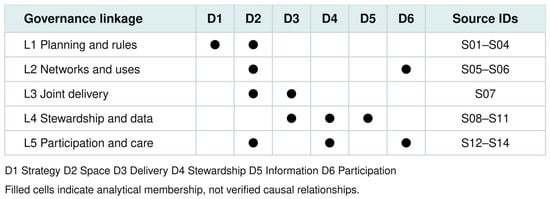
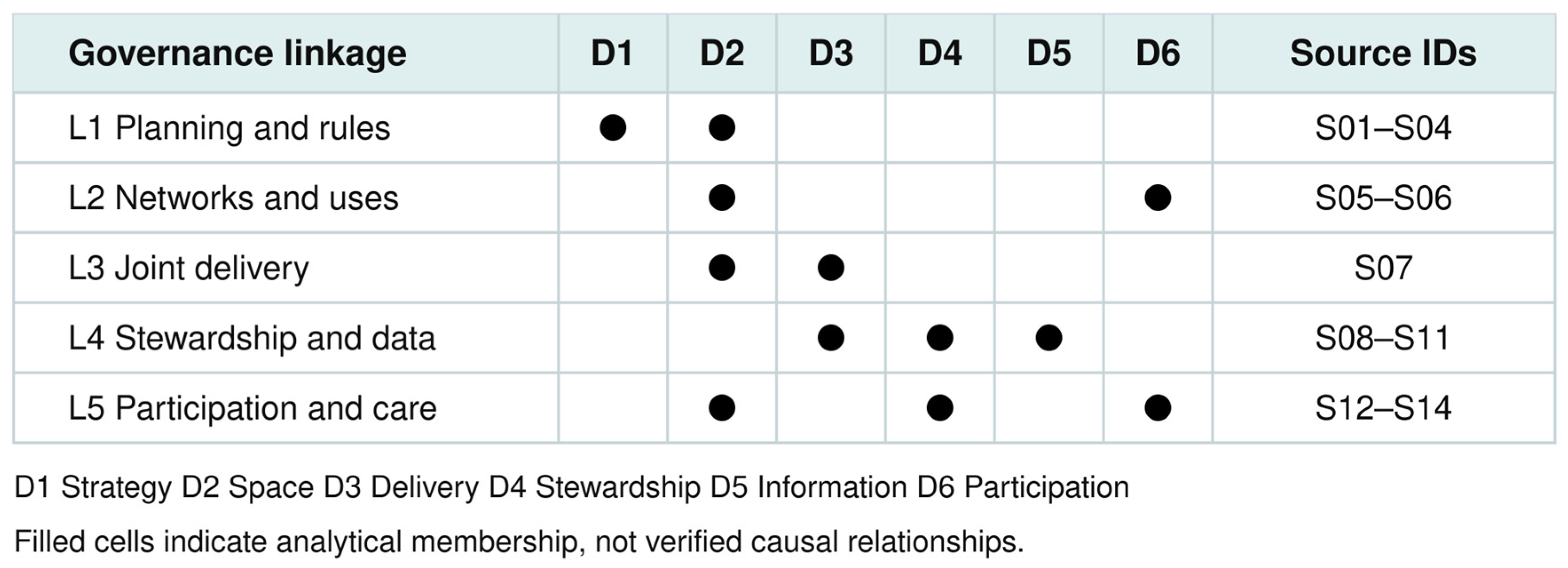
Each of the 15 records was mapped to one or more dimensions using explicit content, with a brief extraction of instrument, named actor, application and reported output or commitment. The mapping distinguishes formal provisions from agency descriptions of practice; neither category independently demonstrates effects. Figure 1 gives the resulting six-to-five crosswalk. A governance linkage requires an identifiable actor or instrument connecting at least two functions across one or more cited records. Shared vocabulary alone is insufficient. These are the five linkages presented in Section 3.2, replacing the original term “mechanisms” because the materials cannot establish causal processes. The mapping does not claim saturation, independent duplicate coding or inter-coder reliability. Readers can inspect and contest each assignment in Supplementary Material S1.
Figure 1.
Crosswalk from six analytical dimensions to five governance linkages. Filled cells identify the dimensions used to interpret each linkage; source IDs refer to Supplementary Material S1. Membership is an analytical assignment, not a causal effect or a frequency score.
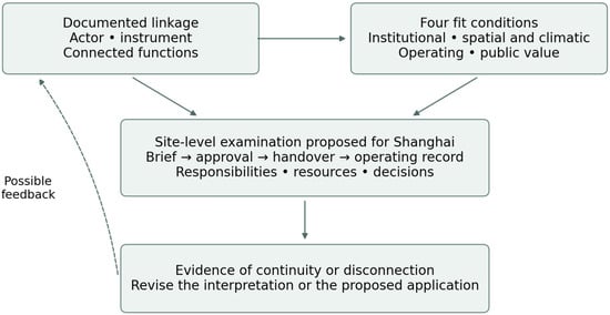
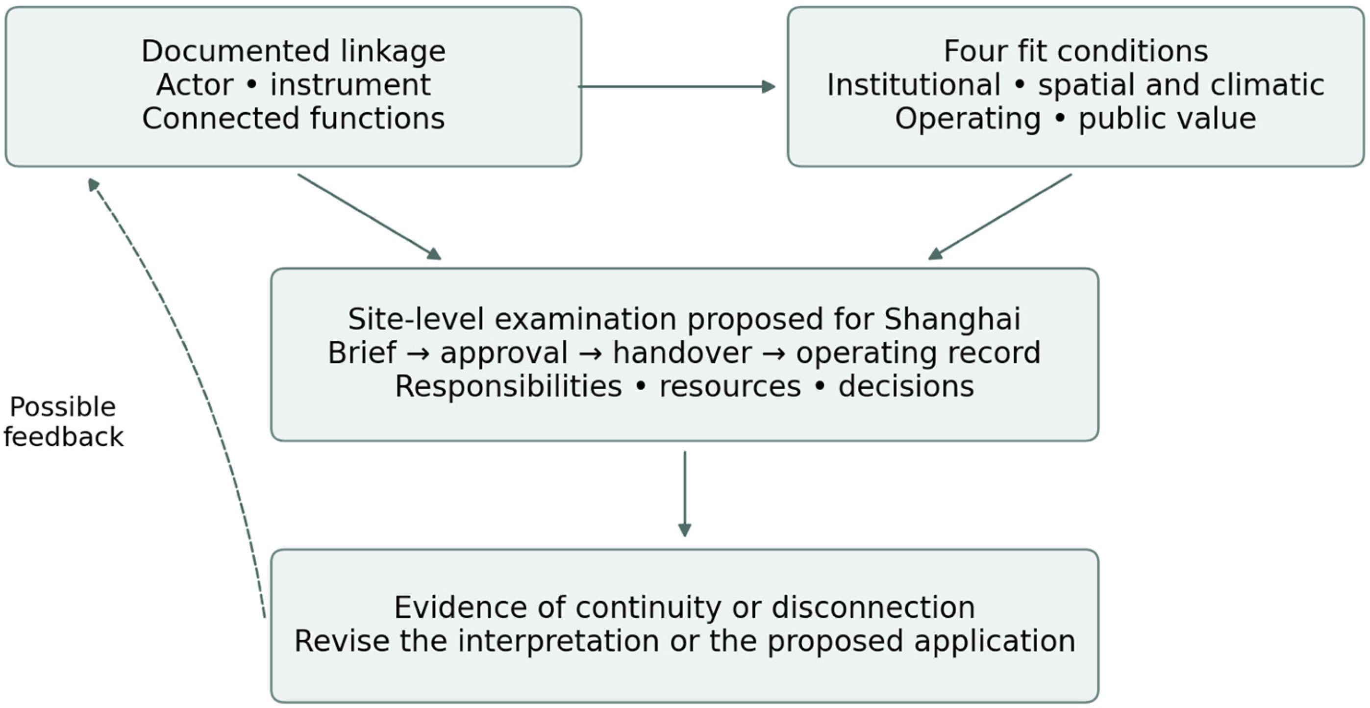
The “implementation chain” is an analytical representation of connected governance functions, not a fixed temporal sequence or a demonstrated causal chain. Planning, maintenance and public use may overlap; operational experience may prompt revised rules or designs. Feedback arrows in Figure 2 represent relationships to investigate, not effects established by this study. Four fit conditions then organise prospective application: institutional authority and accountability; spatial and climatic suitability; operating resources and capabilities; and public value, including access and ecological protection. These conditions guide inquiry, rather than calculating a transferability score.
Figure 2.
Proposed evidence path for testing a governance linkage. Solid arrows indicate the main steps and inputs in the proposed analytical pathway, whereas the dashed arrow denotes a possible feedback relationship to investigate. The four fit conditions guide the site-level examination. The figure presents a research design, not observed transfer, causal effects, or demonstrated outcomes.
2.4. Comparability and Researcher Positionality
Park inventories and access indicators are not harmonised. For example, a 2021 Singapore announcement states a 2030 goal of all households being within a ten-minute walk of a park [35]. Shanghai’s 2026–2030 plan instead specifies park service-radius coverage exceeding 93% in the main urban area [21]. These are targets with different units and denominators, not comparable observations of residents’ walking access. A future comparison would require a shared walking-network threshold, entrances and opening hours, eligible green-space categories, population grid and reference year. No composite ranking or inferred accessibility advantage is reported.
The authors work in Shanghai public landscape institutions, and the funding includes support from the Shanghai Landscaping and City Appearance Administrative Bureau, which issued the plan under examination. These professional relationships may influence issue selection and interpretation and are disclosed here and in the back matter. Practitioner familiarity motivates questions about handover, maintenance and data responsibility, but is not presented as independent evidence of Shanghai implementation. The analysis uses public provisions rather than unpublished employer information to support its Shanghai findings. No interviews, project contracts or operational audits were collected for this article.
Table 1.
Planning and administrative terms relevant to the documentary comparison.
3. Results
3.1. Planning Contexts and Administrative Interfaces
The relevant comparison is between responsibilities spanning planning and operation. In Singapore, the long-term plan frames land needs over at least 50 years, while the statutory Master Plan guides development over approximately 10–15 years and is reviewed every five years [36,37]. Development controls give these objectives a site-level expression. Shanghai’s municipal Master Plan and sectoral five-year plans provide different types of direction [18,19,21]; district delivery and site management cannot be read directly from the existence of either plan.
Table 1 gives operational glosses for the planning and administrative terms used below. A citywide strategy, a statutory land-use provision, a sectoral programme and a management contract have different authority. Their alignment must be demonstrated at the relevant interface rather than assumed from their inclusion in a planning hierarchy.
Three Shanghai instruments also require clarification. “Park opening and sharing” concerns expanded public use of existing green spaces and facilities, including institution-associated greenery; it does not itself transfer ownership. The Outer Ring ecological park belt is a spatial connectivity programme around the Outer Ring corridor. The planned industry spatial map is an integrated spatial information instrument for the sector. Each can be examined through the functions it is meant to connect, without assuming a completed operating arrangement [21].
3.2. Five Documented Governance Linkages in Singapore
3.2.1. L1 Planning Objectives and Project Rules
Singapore’s greening trajectory supplies the historical context [11,12]. Current strategy connects nature conservation and urban greening [13,14], but a strategy alone does not explain project compliance. L1 concerns the interface between policy horizons and spatial controls.
URA’s long-term and master-planning descriptions identify different planning horizons [36,37,39]. Its LUSH development-control guidance provides a more concrete site interface [38]. In the cited sports-and-recreation development handbook, landscape replacement requirements vary by location and development characteristics, and design guidance includes maintenance considerations. This is evidence of a specified rule linking planning and site design, not a uniform requirement for every development or an audit of enforcement. The Parks and Trees Act supplies a distinct statutory basis for greenery protection [40].
L1 combines D1 and D2. The documentary finding is the presence of named planning instruments and site controls. Whether a project preserves the intended ecological function after approval and construction requires compliance records and subsequent inspection.
3.2.2. L2 Spatial Networks and Differentiated Uses
Network planning connects park nodes and linear spaces whose functions differ [16,17,41]. L2 links spatial integration with public-use arrangements (D2 and D6), rather than treating every green corridor as an interchangeable recreational route.
The joint URA–NParks account of the Rail Corridor Central reopening describes improved access alongside habitat-sensitive design, including the absence of night lighting [35]. It supplies a specific example of reconciling access and ecological use within a corridor. The account reports a project configuration; it does not establish biodiversity gains or an optimal access regime.
NParks specifies designated trails, restrictions on certain activities, opening hours and permit requirements for nature parks and reserves [42]. Those rules show how spatial access is differentiated. Compliance and the distribution of benefits would need separate observation.
The connection with multifunctionality scholarship [3,4,6] is therefore operational: assigning several functions to the same land also requires decisions about where, when and by whom it may be used.
3.2.3. L3 Interagency Project Delivery
L3 concerns the connection between spatial objectives and joint delivery responsibilities (D2 and D3). A shared sustainability objective is insufficient evidence of coordination; the source must identify an actual project interface or assignment of roles.
PUB describes the Kallang River transformation at Bishan–Ang Mo Kio Park as a joint project with NParks [43]. The park landscape also accommodates flood conveyance. PUB reports that bioengineering techniques were tested before installation, illustrating the need for local technical adaptation within a joint project. Liao’s study situates the project within Singapore’s ABC Waters practice [25]. These records identify the collaboration and design arrangement, but do not disclose a complete contract, dispute-resolution process or long-term allocation of costs.
3.2.4. L4 Professional Stewardship and Operational Data
L4 links life-cycle stewardship and operational information (D4 and D5), with procurement as an interface to D3. CUGE’s training programmes describe professional capacity development [44]. The Landscape Company Register connects qualifications to eligibility: its published FAQ specifies registration requirements for government landscape contracts [45]. This is a concrete relationship between provider capacity and procurement, not evidence that registration guarantees ecological performance.
NParks’ 2023 announcement links a new maintenance tender at Bishan–Ang Mo Kio district to digital work processes, a central management platform and contractor inspection duties with referral to NParks staff [46]. GovTech’s TreesSG account describes asset information and also records technical difficulties encountered during system development [47]. Such details qualify a frictionless digitalisation narrative. Both remain institutional accounts; neither independently measures effects on tree risk, cost or service quality.
The interpretation belongs within established UGI governance debates, including GREEN SURGE [8]. Thorne et al.’s Portland research identifies uncertainty and institutional barriers to BGI adoption [10], supporting attention to the capacity to sustain operation. Our proposed examination of maintenance budgets and contract horizons follows from that problem; these sources do not establish that a particular procurement duration is optimal. The testable interface is whether a funded operating duty persists when construction finishes and providers or information systems change.
3.2.5. L5 Participation in Access and Care
Community in Bloom describes support for establishing and managing community gardens, while Friends of the Parks describes community involvement around particular parks [48,49]. URA’s Master Plan engagement provides a separate channel for public input into planning [50]. These arrangements connect participation with spaces and care responsibilities (D2, D4 and D6). Their presence does not establish representative participation or the influence of participants on decisions.
L5 concerns who can participate in managing or shaping a space. It differs from L2, which concerns the spatial allocation of uses and access. Participation can include gardening, monitoring or planning input; its suitability depends on site permissions and ecological limits [42].
Figure 1 makes the many-to-many correspondence explicit. The six dimensions remain analytical lenses; L1–L5 are the five groupings used consistently in Section 3.2 and Table 2. Together they locate institutional interfaces for investigation without demonstrating a complete chain in every Singapore project.
Table 2.
Five governance linkages and corresponding Shanghai policy commitments. All Shanghai entries concern stated policy, not verified operation.
3.3. Documented Shanghai Commitments and Evidence Boundaries
Shanghai’s existing master and ecological-space plans provide a spatial and policy context [18,19]. The publicly released 2026–2030 plan adds relevant commitments [21]. Table 2 maps these provisions to L1–L5 using explicit section locators. It reports correspondence at the level of stated functions. A policy provision cannot demonstrate whether a district, asset owner or contractor has put that function into routine operation.
The public plan makes its provisions inspectable but remains an official account of intended development. The Shanghai column is therefore labelled “documented commitment”, and the final column states what the source does not establish. Questions for future testing are developed separately in Section 4.3.
L4 combines stewardship and information. Table 2 uses the same five groupings and labels as Section 3.2 and Figure 1. The table’s analytical result is the limited correspondence between documented functions; it is not a finding that the proposed linkages work in Shanghai.
4. Discussion
4.1. Contribution and Relationship to Established Frameworks
The selected records identify concrete interfaces: a planning requirement applied to a site, shared delivery of a water–park project, and a maintenance programme connected to data and inspection responsibilities. They do not show that these interfaces operate continuously across Singapore. The implementation-chain heuristic makes that distinction visible by requiring evidence at the connection between functions, rather than inferring continuity from a list of programmes.
The dimensions overlap deliberately with UGI planning and governance scholarship [3,4,6,8]. The heuristic does not supersede GREEN SURGE or the policy cycle. Its narrower use is to ask whether a spatial objective retains an actor, instrument and operating responsibility as it moves into delivery and care. Implementation theory’s attention to ambiguity and conflict explains why an apparently coherent policy design can leave such responsibilities unresolved [34].
The Valencia–Mexico City study [29] offers an appropriate comparative reference because it treats BGI public space through its governance context. Here, that contextual focus is carried into questions about the authority and resources behind each interface. We do not infer that either city validates the Singapore linkages. Similarly, a biophilic landscape account [15] can describe urban form without establishing the durability of the institutional arrangements supporting it.
4.2. Four Conditions for Prospective Application
Policy transfer involves selection and reinterpretation in a receiving setting [22,24]. Accordingly, the prospective unit of learning is an actor–instrument relationship, such as the allocation of responsibility for inspection and maintenance, rather than a finished landscape or agency structure. “Policy” here includes spatial planning, environmental regulation, procurement, funding and participation arrangements.
In Shanghai, project-system scholarship directs attention to the relationship between higher-level priorities, project resources and local implementation [51]. Research on campaign-style enforcement shows that resource mobilization and authority can alter compliance [52]; it does not show that Shanghai’s parks are governed by campaigns. These perspectives require a distinction between temporary delivery mobilization and funded routine care. National–municipal and municipal–district fiscal relationships are also different interfaces: a citywide mandate does not by itself identify which budget bears a site’s recurring costs. This study has no district fiscal or contract dataset from which to diagnose their adequacy.
Institutional fit requires an authorized decision maker and a clear allocation of responsibility across scales. Spatial and climatic fit requires adaptation to site structure, hazards and ecological processes: Shanghai’s seasonal temperature and rainfall regime calls for local planting, inspection and drainage specifications, not imported tropical parameters. No climatic threshold or quantified transfer limit is estimated. Operating fit concerns recurrent finance, skills, procurement and data upkeep. Public-value fit concerns who benefits, who undertakes care, and how access is balanced with ecological protection. The four conditions structure inquiry; none is established merely by identifying a policy counterpart.
4.3. Proposed Tests for Shanghai and an Illustrative Application
Five prospective tests follow from the linkages. They are research proposals, not results or requirements contained in Shanghai’s plan. For L1, trace one network or resilience objective from a plan through an actual project brief, approval, handover and later review. Record where the objective is retained, changed or lost and who has authority to resolve the change.
For L2, examine a corridor crossing administrative or asset boundaries. Compare the intended network role with permissions, access hours and maintenance responsibilities at each boundary. This would test institutional continuity at a spatial link without treating corridor length as evidence of connectivity in use.
For L3, examine the brief and agreements for a project combining park and water functions. Identify the responsibilities and funding attached to design changes, public safety, acceptance and subsequent repairs. Evidence of a joint committee alone would not establish the allocation of these duties.
For L4, follow selected assets from handover into maintenance records and later procurement. Test whether identifiers, inspection duties, corrective actions and recurring budgets remain connected when staff or providers change. A comparison of contract horizons would need to consider costs, provider participation and ecological maturation, rather than assume that longer contracts perform better.
For L5, examine how a participation arrangement allocates decisions and care duties. Record whose views are represented, the professional support available, continuity over time, and whether access or ecological safeguards change. Attendance totals alone would be insufficient.
A future study could select contrasting Shanghai sites and collect project briefs, contracts, budget records and maintenance logs, supplemented by appropriately designed interviews. Figure 2 illustrates the evidence path and possible feedback relationships for such a study. No pilot is reported as completed here.
An illustrative non-Asian application uses the Portland setting described by Thorne et al. [10], rather than adding a third empirical case. Their study concerns barriers and uncertainty in BGI adoption. Institutional fit would ask which agency can reconcile street and stormwater duties; spatial and climatic fit would ask how wet-season runoff and dry-season care affect specifications; operating fit would examine maintenance funding and responsibility; and public-value fit would examine whose concerns enter the choice and care of facilities. These are our proposed applications of the four conditions to a published setting, not findings about present-day Portland or evidence that Singapore arrangements have transferred successfully. Wider usefulness therefore concerns the questions the heuristic can organise.
4.4. Limitations and Research Agenda
The central limitation is the nature of the evidence. The mapped records chiefly describe official arrangements and agency-reported practice. Agreement among pages from the same institutional system is not independent triangulation. The study visit supplies context but does not remedy this limitation. Even concrete examples, including digitalisation difficulties, leave failures, informal bargaining and routine contractor behaviour incompletely observed.
The study neither estimates ecological or social effects nor verifies the sequence through which a governance arrangement produces them. A causal mechanism claim would require evidence on actual decisions, actions, intermediate processes and alternative explanations. The term “linkage” is used to keep the present contribution within its documentary basis.
The focused 15-record mapping makes selected interpretations inspectable but is not exhaustive and cannot establish that the linkages are unique, prevalent or sufficient. The Shanghai application is prospective and relies on planning provisions. The Portland illustration demonstrates a use of the questions, not external validation.
Further research should combine project documentation, operational records and participant evidence across multiple sites and periods. It should examine conflicting responsibilities, costs and distributional effects, as well as successful coordination. Equity remains material because UGI provision and benefits can be uneven [7].
5. Conclusions
This article organises six established governance functions into five source-linked interfaces for studying UGI implementation. Singapore’s documents identify arrangements connecting rules, spatial uses, delivery, stewardship, information and participation. The evidence supports a conceptual account of those connections, not a finding that an uninterrupted implementation chain causes better urban outcomes.
Shanghai’s public planning record offers counterparts at the level of stated commitments. Whether those commitments become durable project and operating arrangements remains to be tested. The four fit conditions specify issues for prospective investigation, and the proposed evidence path connects each question to inspectable project or operational records.
The practical contribution is to make an implementation claim answerable: identify the objective, the responsible actors and instruments, the handover between functions, and the evidence needed to determine what happens afterwards. Applications beyond the two settings require their own contextual and operational evidence.
Supplementary Materials
The following supporting information can be downloaded at: https://www.mdpi.com/article/10.3390/land15101810/s1, File S1. Study-visit itinerary and revision-stage documentary mapping, including source identifiers, locators, dimension assignments and evidence boundaries.
Author Contributions
Conceptualisation, W.Y.; methodology, J.G.; formal analysis, Y.Z.; investigation, J.G. and Y.Z.; resources, J.G. and Y.Z.; data curation, J.G.; writing—original draft preparation, J.G.; writing—review and editing, Y.Z. and W.Y.; visualisation, J.G. and Y.Z.; supervision, W.Y.; funding acquisition, W.Y. All authors have read and agreed to the published version of the manuscript.
Funding
This research was funded by the Science and Technology Commission of Shanghai Municipality, grant number 23DZ1204601, and the Shanghai Landscaping & City Appearance Administrative Bureau, grant numbers G240304 and B260302.
Institutional Review Board Statement
Not applicable. No human-participant research dataset was collected or analyzed. Professional exchanges during the study visit were not conducted as research interviews and are used only as background.
Informed Consent Statement
Not applicable.
Data Availability Statement
The primary sources mapped in this article are publicly accessible at the links listed in the References and Supplementary Material S1. File S1 provides the revision-stage source mapping and an itinerary reconstructed from the authors’ study-visit summaries. The underlying training slides and daily summaries are contextual programme materials, not an interview or outcome dataset; they are not represented as publicly available research data. No personal exchange is quoted as research evidence.
Acknowledgments
The authors thank the National Parks Board of Singapore and the participating project and site teams for supporting the 2025 professional study visit and related professional exchanges. The authors used ChatGPT (GPT-5.6 Sol, OpenAI) to assist with manuscript structuring, language refinement, and reference-format checking. All sources, interpretations, and final text were reviewed and verified by the authors, who take full responsibility for the content of the manuscript.
Conflicts of Interest
The authors’ employment in Shanghai public landscape institutions and the Bureau funding disclosed above create a professional connection to the issuer of the Shanghai plan discussed in this article. These relationships are acknowledged in Section 2.4. The authors declare no other conflicts of interest.
References
- Haaland, C.; van den Bosch, C.K. Challenges and strategies for urban green-space planning in cities undergoing densification: A review. Urban For. Urban Green. 2015, 14, 760–771. [Google Scholar] [CrossRef] [Scilit]
- Meerow, S.; Newell, J.P.; Stults, M. Defining urban resilience: A review. Landsc. Urban Plan. 2016, 147, 38–49. [Google Scholar] [CrossRef] [Scilit]
- Hansen, R.; Pauleit, S. From multifunctionality to multiple ecosystem services? A conceptual framework for multifunctionality in green infrastructure planning for urban areas. Ambio 2014, 43, 516–529. [Google Scholar] [CrossRef] [Scilit]
- Korkou, M.; Tarigan, A.K.M.; Hanslin, H.M. The multifunctionality concept in urban green infrastructure planning: A systematic literature review. Urban For. Urban Green. 2023, 85, 127975. [Google Scholar] [CrossRef] [Scilit]
- Liu, L.; Jensen, M.B. Green infrastructure for sustainable urban water management: Practices of five forerunner cities. Cities 2018, 74, 126–133. [Google Scholar] [CrossRef] [Scilit]
- Li, L.; Carter, J. Exploring the relationship between urban green infrastructure connectivity, size and multifunctionality: A systematic review. Landsc. Ecol. 2025, 40, 61. [Google Scholar] [CrossRef] [Scilit]
- Grabowski, Z.J.; McPhearson, T.; Pickett, S.T.A. Transforming US urban green infrastructure planning to address equity. Landsc. Urban Plan. 2023, 229, 104591. [Google Scholar] [CrossRef] [Scilit]
- Pauleit, S.; Ambrose-Oji, B.; Andersson, E.; Anton, B.; Buijs, A.; Haase, D.; Elands, B.; Hansen, R.; Kowarik, I.; Kronenberg, J.; et al. Advancing urban green infrastructure in Europe: Outcomes and reflections from the GREEN SURGE project. Urban For. Urban Green. 2019, 40, 4–16. [Google Scholar] [CrossRef] [Scilit]
- Bush, J.; Doyon, A. Building urban resilience with nature-based solutions: How can urban planning contribute? Cities 2019, 95, 102483. [Google Scholar] [CrossRef] [Scilit]
- Thorne, C.R.; Lawson, E.C.; Ozawa, C.; Hamlin, S.L.; Smith, L.A. Overcoming uncertainty and barriers to adoption of blue-green infrastructure for urban flood risk management. J. Flood Risk Manag. 2018, 11, S960–S972. [Google Scholar] [CrossRef] [Scilit]
- Tan, P.Y.; Wang, J.; Sia, A. Perspectives on five decades of the urban greening of Singapore. Cities 2013, 32, 24–32. [Google Scholar] [CrossRef] [Scilit]
- Yuen, B. Creating the garden city: The Singapore experience. Urban Stud. 1996, 33, 955–970. [Google Scholar] [CrossRef] [Scilit]
- Government of Singapore. City in Nature. Available online: https://www.greenplan.gov.sg/key-focus-areas/city-in-nature/ (accessed on 18 September 2026).
- National Parks Board. NParks to Work with the Community to Transform Singapore into a City in Nature. 2020. Available online: https://www.nparks.gov.sg/news/news-detail/nparks-to-work-with-the-community-to-transform-singapore-into-a-city-in-nature (accessed on 24 July 2026).
- Newman, P. Biophilic urbanism: A case study on Singapore. Aust. Plan. 2014, 51, 47–65. [Google Scholar] [CrossRef] [Scilit]
- Tan, K.W. A greenway network for Singapore. Landsc. Urban Plan. 2006, 76, 45–66. [Google Scholar] [CrossRef] [Scilit]
- Urban Redevelopment Authority. A City in Nature. 2026. Available online: https://www.ura.gov.sg/land-planning/master-plan/master-plan-2025/themes/stewarding-nature-and-heritage/a-city-in-nature/ (accessed on 13 August 2026).
- Shanghai Municipal People’s Government. 14th Five-Year Plan for Ecological Space Construction and Urban Appearance and Environmental Optimization in Shanghai; Shanghai Municipal People’s Government: Shanghai, China, 2021. Available online: https://cdn.shanghai.gov.cn/nw12344/20210804/6b844da3270b4b4c847b2a74c3813781.html (accessed on 24 July 2026). (In Chinese)
- Shanghai Municipal People’s Government. Shanghai Master Plan 2017–2035; Shanghai Municipal People’s Government: Shanghai, China, 2018. Available online: https://www.shanghai.gov.cn/newshanghai/xxgkfj/2035001.pdf (accessed on 24 July 2026). (In Chinese)
- Information Office of Shanghai Municipality. Building a Park City and an Ecologically Livable City. 2021. Available online: https://cdn.shanghai.gov.cn/nw12344/20210714/97c4aebc8e24429bbb1f6a115cd02216.html (accessed on 24 July 2026). (In Chinese)
- Shanghai Landscaping and City Appearance Administrative Bureau. Notice Issuing the 15th Five-Year Plan for Ecological Space Construction and Urban Appearance and Environmental Optimization in Shanghai. 2026. Available online: https://lhsr.sh.gov.cn/zcqfzgh/20260814/bb4f4dcc-ff7b-44cf-a950-2cc6737b1e38.html (accessed on 18 September 2026). (In Chinese)
- Dolowitz, D.P.; Marsh, D. Learning from abroad: The role of policy transfer in contemporary policy-making. Governance 2000, 13, 5–23. [Google Scholar] [CrossRef] [Scilit]
- Ansell, C.; Gash, A. Collaborative governance in theory and practice. J. Public Adm. Res. Theory 2008, 18, 543–571. [Google Scholar] [CrossRef] [Scilit]
- Peck, J.; Theodore, N. Mobilizing policy: Models, methods, and mutations. Geoforum 2010, 41, 169–174. [Google Scholar] [CrossRef] [Scilit]
- Liao, K.H. The socio-ecological practice of building blue-green infrastructure in high-density cities: What does the ABC Waters Program in Singapore tell us? Socio-Ecol. Pract. Res. 2019, 1, 67–81. [Google Scholar] [CrossRef] [Scilit]
- Sia, A.; Tan, P.Y.; Er, K.B.H. The contributions of urban horticulture to cities’ liveability and resilience: Insights from Singapore. Plants People Planet 2023, 5, 828–841. [Google Scholar] [CrossRef] [Scilit]
- Zhang, H.; Kang, M.; Guan, Z.; Zhou, R.; Zhao, A.; Wu, W.; Yang, H. Assessing the role of urban green infrastructure in mitigating summertime urban heat island (UHI) effect in metropolitan Shanghai, China. Sustain. Cities Soc. 2024, 112, 105605. [Google Scholar] [CrossRef] [Scilit]
- Zhong, Z.; Fang, X.; Kong, L. Pathways linking urban green infrastructure to residents’ well-being: The mediating roles of ecosystem services and physical activity in Shanghai. Trans. Earth Environ. Sustain. 2025, 2, 232–248. [Google Scholar] [CrossRef] [Scilit]
- Ibarraran, M.E.; Casiano Flores, C.; Perez-Garcia, T.; Alvarado Vazquez, S. Understanding the governance context for blue-green infrastructure in public space: The cases of Valencia and Mexico City. City Environ. Interact. 2026, 30, 100353. [Google Scholar] [CrossRef] [Scilit]
- National Population and Talent Division. Population in Brief 2025; Government of Singapore: Singapore, 2025. Available online: https://www.population.gov.sg/files/media-centre/publications/Population_in_Brief_2025.pdf (accessed on 24 July 2026).
- Singapore Department of Statistics. Land Area (As at June), Annual. Available online: https://data.gov.sg/datasets/d_d5472d7368d6547892138f779872bbff/view (accessed on 24 July 2026).
- Shanghai Municipal People’s Government. Shanghai Overview 2025; Shanghai Municipal People’s Government: Shanghai, China, 2025. Available online: https://www.shanghai.gov.cn/shanghai/newshanghai/shgl2025.pdf (accessed on 24 July 2026). (In Chinese)
- Shanghai Municipal Statistics Bureau. Statistical Communiqué of Shanghai on the 2025 National Economic and Social Development. 2026. Available online: https://tjj.sh.gov.cn/tjgb/20260330/e0772941e8e041eaaad2df850b44ef98.html (accessed on 24 July 2026). (In Chinese)
- Matland, R.E. Synthesizing the implementation literature: The ambiguity-conflict model of policy implementation. J. Public Adm. Res. Theory 1995, 5, 145–174. [Google Scholar] [CrossRef] [Scilit]
- Urban Redevelopment Authority. Rail Corridor (Central) Reopens to Bring Nature, Heritage and Recreational Experiences Closer to Singaporeans. 2021. Available online: https://www.ura.gov.sg/news/media/pr21-05/ (accessed on 18 September 2026).
- Urban Redevelopment Authority. Long-Term Plan. Available online: https://www.ura.gov.sg/land-planning/long-term-plan/ (accessed on 18 September 2026).
- Urban Redevelopment Authority. Master Plan. Available online: https://www.ura.gov.sg/land-planning/master-plan/ (accessed on 18 September 2026).
- Urban Redevelopment Authority. Landscaping for Urban Spaces and High-Rises (LUSH). Available online: https://www.ura.gov.sg/guidelines/development-control/development-control-handbooks/non-residential/sr/greenery/ (accessed on 18 September 2026).
- Urban Redevelopment Authority. Master Plan 2025 Gazetted: Shaping a City of Possibilities for All. 2025. Available online: https://www.ura.gov.sg/news/media/pr25-64/ (accessed on 24 July 2026).
- Singapore Statutes Online. Parks and Trees Act 2005. Available online: https://sso.agc.gov.sg/Act/PTA2005 (accessed on 24 July 2026).
- National Parks Board. About Us. Available online: https://www.nparks.gov.sg/who-we-are/about-us (accessed on 24 July 2026).
- National Parks Board. Nature Parks and Reserves Dos and Don’ts. Available online: https://www.nparks.gov.sg/visit/when-visiting-parks/etiquette/nature-parks-reserve-dos-donts (accessed on 18 September 2026).
- Public Utilities Board. Bishan–Ang Mo Kio Park. Available online: https://www.pub.gov.sg/Public/Places-of-Interest/Our-Reservoirs-and-Waterways/Bishan-Ang-Mo-Kio-Park (accessed on 18 September 2026).
- Centre for Urban Greenery and Ecology. About CUGE Programmes. Available online: https://cuge.nparks.gov.sg/about-cuge-programmes/ (accessed on 18 September 2026).
- Centre for Urban Greenery and Ecology. Landscape Company Register Requirements and FAQs. Available online: https://cuge.nparks.gov.sg/landscape-company-register/lcr-requirements-and-faqs/ (accessed on 18 September 2026).
- National Parks Board. NParks Rolls Out New Model of Greenery Management for Parks and Streetscape That Leverages Suite of Digital Tools Developed with Landscape Industry. 2023. Available online: https://www.nparks.gov.sg/news/news-detail/nparks-rolls-out-new-model-of-greenery-management-for-parks-and-streetscape-that-leverages-suite-of-digital-tools-developed-with-landscape-industry (accessed on 18 September 2026).
- Government Technology Agency of Singapore. The Inside Story of How NParks Mapped 500,000 Trees in Singapore on TreesSG. Available online: https://www.tech.gov.sg/technews/the-inside-story-of-how-nparks-mapped-500000-trees-in-singapore-on-treessg/ (accessed on 18 September 2026).
- National Parks Board. Community in Bloom: A Nationwide Gardening Programme. Available online: https://gardeningsg.nparks.gov.sg/get-involved/cib/about/ (accessed on 18 September 2026).
- National Parks Board. Friends of the Parks. Available online: https://fotp.nparks.gov.sg/about-fotp/ (accessed on 18 September 2026).
- Urban Redevelopment Authority. Public Engagement for Master Plan 2025. Available online: https://www.ura.gov.sg/land-planning/master-plan/master-plan-2025/public-engagement/ (accessed on 18 September 2026).
- Qu, J. The project system: A new form of state governance. Soc. Sci. China 2012, 33, 28–47. [Google Scholar] [CrossRef] [Scilit]
- Liu, N.N.; Lo, C.W.H.; Zhan, X.; Wang, W. Campaign-style enforcement and regulatory compliance. Public Adm. Rev. 2015, 75, 85–95. [Google Scholar] [CrossRef] [Scilit]

Disclaimer/Publisher’s Note: The statements, opinions and data contained in all publications are solely those of the individual author(s) and contributor(s) and not of MDPI and/or the editor(s). MDPI and/or the editor(s) disclaim responsibility for any injury to people or property resulting from any ideas, methods, instructions or products referred to in the content. |
© 2026 by the authors. Licensee MDPI, Basel, Switzerland. This article is an open access article distributed under the terms and conditions of the Creative Commons Attribution (CC BY) license.