


Abstract
Post-socialist urban landscapes often undergo spontaneous transformation where formal governance is fragmented or discontinuous, yet the spatial logic of these transitions remains insufficiently quantified. This study examines Krzemionki, a landscape archaeological heritage site in Krakow, Poland, using multi-temporal land cover classification based on QGIS-based geospatial analysis, AI-assisted segmentation, and manual verification. Between 2009 and 2025, spontaneous vegetation cover increased by 36.27 ha, whereas developed spatial fragments increased by only 4.82 ha, revealing substantially unequal dynamics between ecological regeneration and anthropogenic spatial persistence. Change frequency analysis further shows that 76.85% of mapped improvised spatial practice area was located in areas experiencing zero or one land cover transition. This pattern suggests a spatial concentration of observable improvised practices in relatively stable interstitial spaces. This observed pattern may reflect selective spatial anchoring, although it should be interpreted as an indication of spatial tendency rather than direct evidence of persistent practices over the entire study period. By integrating ecological regeneration, fragmented development, and everyday spatial practices into a unified framework, this study identifies three differentiated types of spatial logic—expansion, persistence, and spatial distribution of observable practices—that characterise the observed landscape transition. Selective spatial anchoring is further proposed as one possible interpretation of these patterns. These findings support differentiated planning responses based on spatial stability, including selective formalisation in stable areas, temporary or adaptive use in low-frequency transition zones, and limited intervention in highly dynamic areas.
1. Introduction
1.1. Background
The urban–rural fringes of post-socialist cities represent some of the most dynamically changing areas in Central and Eastern Europe, where significant land use transformations have occurred [1]. Following the institutional transformation around 1990, the pre-existing land use order in these areas was disrupted: large-scale industrial facilities from the socialist period were gradually decommissioned and abandoned, while collective agricultural land was increasingly underused [2,3]. Under the institutional and functional transition after socialism, urban fringe areas developed into ambiguous and marginalised spaces: abandoned industrial sites gradually lost their original functions, while remaining structures and informal everyday practices contributed to new forms of spatial appropriation beyond formal planning frameworks [4,5]. This spatial restructuring, shaped by ecological processes, material remnants, and everyday practices, represents a form of landscape heritage that is neither solely the result of natural succession nor a product of deliberate urban planning, but a form of landscape transformation occurring beyond conventional planning frameworks [4,6].
However, existing research still has a limited understanding of the spatial dynamics of post-socialist landscapes. A large body of literature focuses on suburbanisation and urban sprawl in post-socialist cities [7], while this research focuses on urban fringe areas in an intermediate state—neither completely abandoned nor formally incorporated into redevelopment agendas—and examines their internal spatial logic through systematic quantitative analysis. More specifically, it asks how ecological regeneration and built heritage transform over time and how observable improvised spatial practices are spatially distributed within these dynamics. These questions have not yet been adequately answered. Addressing this gap can strengthen the empirical basis for understanding landscape transition and inform more context-sensitive land planning and urban regeneration.
1.2. Literature Review
Over the past three decades, post-socialist landscape research has developed several important scholarly strands. The first strand focuses on land use change in urban fringe areas. Studies have shown that the urban–rural fringe of post-socialist cities in Central and Eastern Europe are one of the most dynamic areas of land use change, a trend that remains pronounced even under conditions of population stagnation or decline [8]. Urban sprawl in these areas has caused significant environmental damage, largely because local planning and land use management have not been adequately implemented [1]. The second strand centres on spontaneous vegetation recolonisation of post-industrial sites. Spontaneous vegetation succession on abandoned industrial sites can support the development of diverse and ecologically valuable ecosystems. A comparative study of coal mining spoil heaps across Central Europe found that spontaneous revegetation can provide greater conservation value than forestry reclamation [9]. The third strand focuses on informal spatial practices in post-socialist cities. In Bucharest, the green spaces of socialist housing estates were initially shaped by informal, temporary land use arrangements under socialism, which encouraged gardening and agricultural activities. After that period, residents continued to hold informal rights to these spaces, using them for gardening, temporary structures, and home extensions [10].
Although the above studies provide an important foundation for understanding post-socialist landscapes, a key theoretical gap remains in the interactive relationships among the spatial forces have not yet been integrated into a unified analytical framework. Most studies tend to examine ‘ecological restoration,’ ‘developed heritage,’ or ‘improvised spaces’ separately, while neglecting the structural relationships in which these three coexist and interact within the same site. It is precisely this gap that constitutes the theoretical starting point of this study.
1.3. Research Objectives and Questions
Based on the above background and literature review, this study takes the palimpsest landscape cultural heritage site of Krzemionki in Krakow, Poland, as a case study and proposes the following research questions:
- What area changes and spatial restructuring occurred in spontaneous vegetation cover and fragmented developed area in Krzemionki over the sixteen-year period (2009–2025)?
- What spatial distribution pattern does improvised spatial practice exhibit within observed landscape transition?
- What do the observed spatial and temporal patterns imply for land planning and urban regeneration in Krzemionki area?
The theoretical contribution of this study lies in bringing ecological succession, fragmented development, and improvised spatial practices into a unified analytical framework for examining landscape transition. Rather than treating these elements as independent characteristics of the Krzemionki landscape, this research investigates how they exhibit differentiated spatial and temporal logics: active ecological expansion, relative persistence of anthropogenic spatial fragments, and selective anchoring of everyday spatial practices. In particular, the concept of ‘unequal dynamics’ is used to characterise the markedly different capacities and trajectories through which ecological and anthropogenic spaces transform and persist, while the spatial distribution of improvised practices is examined to explore their relationship with areas of changing and relatively stable land cover. This study develops a semi-automated land cover classification workflow based on QGIS and AI-assisted segmentation, combining graphic and text prompt segmentation with manual verification. Land cover is classified at four time points (2009, 2015, 2021, and 2025), and longitudinal change frequency analysis is used to quantify spatial transformation and examine the relationship between land cover dynamics and improvised spatial practices and examine the spatial distribution of improvised spatial practices in relation to land cover dynamics.
2. Materials and Methods
2.1. Research Area
The study area is located in the southern part of Krakow, Poland, within the Podgorze district, approximately 3 km south of the city centre (Figure 1). Located within the Krzemionki Hills in the Podgorze district of Krakow, the post-industrial heritage Liban Quarry has a long history of limestone extraction, dating back to approximately the 14th century, with large-scale quarrying beginning around 1873 [11]. During the Nazi occupation (1942–1944), the quarry was converted into a labour camp, leaving the site deeply marked by wartime violence. Mining activities at the Liban Quarry continued on a large scale from the late nineteenth century until their termination on 30 June 1986 [11].
Figure 1.
Location map of the study area: (a) national context; (b) Krakow context.
The Krzemionki landscape is characterised by a layered palimpsest of cultural heritage, extraction, industry, wartime persecution and commemoration, and tourism activities. Major infrastructure such as roads, beside railways, and industrial zones has fragmented the natural areas. In 2007, the Krakow City Council adopted the Miejscowy plan zagospodarowania przestrzennego obszaru ‘Krzemionki’ (Local Spatial Development Plan for the Krzemionki area, Figure 2), which defined the study area boundary (approximately 123 ha), and the spatial boundary defined by this 2007 plan serves as the unified spatial framework for all analyses in this study. The 2007 planning documents are presented as contextual information and were not used to define the land cover classes or the temporal transition analysis. The operational spatial categories analysed in this study were identified using an AI-assisted workflow and manual visual verification.
Figure 2.
Study area and 2007 planning designations used as contextual information.
2.2. Data Sources
2.2.1. Primary Data
Four primary data sources were employed in this study (Table 1).
Table 1.
Multi-temporal satellite imagery and ancillary spatial data used in this study.
Multi-temporal, very-high-resolution satellite imagery covering the study area acquired in the years 2009, 2015, 2021, and 2025 was accessed through the Krakow Spatial Information System (MSIP) online map composition tool (Figure 3). The imagery was exported as GeoTIFF format, and it had a sub-metre spatial resolution (<1 m); then, it was georeferenced to the ETRF2000-PL/CS2000/21 (EPSG:2178) to ensure spatial consistency across all temporal phases.
Figure 3.
Multi-temporal satellite imagery of the Krzemionki study area.
The spatial boundary (Figure 3) of the study area was defined according to the 2007 Local Spatial Development Plan for the Krzemionki area, obtained from the Krakow City Hall Public Information Bulletin (BIP). The planning map was digitised as a vector polygon layer in QGIS. Administrative boundary data were sourced from the Polish Geoportal and supplemented with OpenStreetMap data, which are available under the Open Database License (ODbL).
Field reconnaissance was conducted in 2025 to record plant cover and improvised spatial features within the study area. Using a handheld GPS device, the spatial locations of informal use points—including temporary cultivation plots, informal footpaths, and makeshift structures—were logged.
2.2.2. Time Nodes
The year 2009 serves as a baseline two years after the enactment of the 2007 Local Spatial Plan. The year 2015 coincides with the commencement of infrastructure projects such as the Krakow–Krzemionki railway link, representing a period of concentrated anthropogenic intervention [12]. The year 2021 provides an intermediate observation point spanning the COVID-19 period. The year 2025 represents the recent available imagery, reflecting the current landscape state.
Vegetation succession following agricultural abandonment may involve the establishment of woody species within the first decade [13]. A 4–6 year interval is more sufficient to capture identifiable changes in vegetation structure, reflected in changes in tone progression and texture progression, while reducing noise introduced by annual fluctuations.
Selected orthophotos correspond to the available cloud-free, high-resolution imagery. All imagery is sourced from the same official data source, the Krakow Spatial Information System (MSIP), ensuring data consistency and comparability.
The four images were identified as observations from the selected images through comparison with additional satellite imagery from nearby dates, which was used to assess the consistency of vegetation conditions around each selected time node. However, differences in image acquisition timing may affect the degree of above-ground development and spectral visibility of perennial herbaceous vegetation. This is potentially relevant at Krzemionki, where perennial herbaceous species such as Arrhenatherum elatius and Festuca rupicola have been recorded in the field work. The former is a relatively tall, vigorous perennial grass that can form dense stands, while the latter is a lower-growing, tussock-forming grass associated with relatively dry grassland conditions, and the above-ground development of both may vary with the timing of image acquisition. Consequently, some herbaceous vegetation may have been less apparent at certain stages of seasonal development, potentially resulting in variation in the apparent extent of vegetative cover. The selected images were therefore considered suitable for temporal analysis, while acknowledging that differences in acquisition timing may introduce a degree of uncertainty in the absolute extent of the maps.
2.3. Data Processing
2.3.1. AI-Assisted Workflow
Land cover classification was performed through a human-calibrated, AI-assisted workflow. The workflow integrated multiple QGIS plugins and models to enhance segmentation robustness and classification accuracy (Table 2). By delegating geometric boundary extraction to the SAM algorithm, this workflow reduces the subjective drift and errors commonly associated with purely manual interpretation.
Table 2.
AI model configuration and comparison workflow for land cover classification.
The primary segmentation was generated using the SAM 2.1 base model; to cross-compare and refine results, the SAM 2 base and SAM 3 models were also utilised. The use of multiple models served as a form of methodology, allowing the study to compare and integrate respective outputs. During the training and debugging phase of the AI-assisted segmentation models, multiple sources of satellite imagery were used to optimise model performance and prompting strategies. In addition to deploying graphic prompts with varying configurations to select target areas, inverse selection—e.g., selecting and removing unwanted portions—was also employed as a complementary cross-comparison measure.
By iteratively adjusting the type, placement, and density of graphic prompts, the optimal prompting strategies for different land cover classes were determined. After the model parameters and prompting strategies were stabilised, the imagery used for final classification was entirely replaced with high-resolution orthophotos from the Krakow Spatial Information System (MSIP).
All AI-generated polygons (Figure 4) were then systematically reviewed and manually corrected by a single trained operator against the official, very-high-resolution satellite imagery. This manual review process followed a consistent set of interpretation keys based on tonal and textural characteristics. The final, manually calibrated vector layers across the four temporal sections form the basis of all subsequent analyses.
Figure 4.
All original AI plugin-generated polygons.
2.3.2. Graphic Identification
The three spatial categories employed in this study are defined through graphic identification keys derived from direct visual inspection of very-high-resolution satellite imagery. These keys are grounded in tonal, textural, geometric, and contextual cues observable on true-colour orthophotos, enabling consistent manual recognition across all temporal phases. These categories are based on observed landscape characteristics rather than planning designations and were applied consistently across all time nodes.
Mapped spontaneous vegetation cover is identified primarily by green spectral tones, with light green corresponding to grass and fields and darker green tones indicating tree cover; texture and spectral characteristics can further assist in distinguishing grass, shrub, and tree classes [14]. This class represents spatially continuous patches of spontaneous vegetation cover, irrespective of specific geometric boundaries. Vegetated areas under active human maintenance or management are classified as anthropogenic spatial fragments rather than spontaneous vegetation cover, because they result from deliberate design and regular upkeep rather than spontaneous ecological processes. In boundary cases, classification was based not solely on vegetation appearance but also on the spatial context, relationship to maintained structures, and temporal consistency across the four observation years. For example, the two allotments located at the northwestern and southwestern parts of the site occupy relatively stable spatial footprints on the maps and are surrounded by clearly maintained vegetation strips and rows of trees, which provide spatial and morphological cues for distinguishing maintained vegetation from adjacent spontaneous vegetation. Where image resolution, shadow, or other visual obstructions prevented a reliable distinction, the area was retained as unclassified rather than assigned to any category by inference.
Mapped developed spatial fragments were identified using object-level visual cues, including tone, geometric shape, regular boundaries, and spatial context [15], with grey, grey-white, and reddish-brown tones and regular rectangular or linear configurations commonly indicating artificial surfaces. This class includes roads, artificial green belts, buildings, hardened surfaces, and other constructions that are directly visible as distinct anthropogenic features on the imagery.
Mapped improvised spatial practices encompass a diverse range of low-intensity, non-permanent human activities that leave detectable but often subtle traces on the land surface. The 2025 field observation was used to support the identification and interpretation of improvised spatial practices rather than provide longitudinal data for the classifications in four time sections. These practices were identified from satellite imagery for each observation year, with the 2025 field observation serving as a contemporary ground-level reference for interpreting their spatial characteristics. Improvised spatial practices in the imagery were identified through systematic visual interpretation of observable spatial features and their recurrence across the image series (Figure 5). This reduces the certainty of attributing individual field observation features to improvised spatial practices; therefore, the analysis focuses on spatial patterns and change frequency relationships. Unlike spontaneous vegetation cover and spatial fragments, which are primarily area-based classes, improvised spatial practices are characterised by smaller and more diverse spatial signatures. Some manifestations, such as graffiti and campfire remnants, are too small to be reliably delineated as spatial units in the imagery and were therefore not mapped (Figure 6). By contrast, informal footpaths have a clear linear spatial form that can be identified and mapped from satellite imagery. Although their physical forms vary, they share a common function as localised and informal forms of spatial appropriation rather than constituting distinct land cover types. Spatial elements that are under construction but not yet physically completed are also excluded from the improvised spatial practices category as they lack the spontaneous, bottom-up appropriation that defines this class.
Figure 5.
Examples of improvised spatial practices traces identifiable in historical satellite imagery.
Figure 6.
Field photographs illustrating minor human appropriations: (a) graffiti on abandoned structure; (b) temporary seating traces. These features are spatially associated with trail networks, confirming their classification as ancillary elements. (Photographs taken by the author in September/October 2025).
2.3.3. Data Validation
The accuracy of the mapped spatial categories was assessed using independent reference-point interpretation based on the very-high-resolution, sub-meter satellite imagery available for each observation year. For spontaneous vegetation cover and developed spatial fragments, 300 spatially random validation points were generated within the approximately 123 ha study area using simple random sampling. The result includes unclassified areas.
The unclassified category was included only for accuracy assessment and was not treated as a land cover category in the subsequent spatial analysis. Reference labels were assigned through independent visual interpretation of the corresponding sub-meter satellite imagery. For accuracy assessment, the very limited polygon overlap was assigned a single class at each validation point based on the dominant identifiable spatial feature, while the original polygon delineations, including these localised overlaps, were retained and considered in the final mapping.
Confusion matrices were counted separately for the AI-assisted segmentation stage and the subsequent manual calibration stage (Appendix A and Appendix B). Overall accuracy (OA), user’s accuracy (UA), producer’s accuracy (PA), and Kappa were calculated to compare the two stages (Table 3). This procedure enabled comparison of the accuracy between the AI-assisted segmentation and manual calibration stages.
Table 3.
(a) Overall accuracy and Kappa coefficients of the spontaneous vegetation cover and developed spatial fragments classifications. (b) Producer’s and user’s accuracy and Kappa coefficients of the improvised spatial practice classification.
Improvised spatial practices were evaluated separately because they constitute a relatively small and spatially distinct mapping component. Because the AI-assisted mapping improvised spatial practice component occupied only a small proportion of the study area, a larger total of random sample points was used to obtain sufficient observations within this class for accuracy assessment. Each point was assigned a binary reference label (improvised/non-improvised) through independent visual interpretation of the corresponding high-resolution imagery. Because most validation points fell within the non-improvised area, the OA and the UA and PA of the non-improvised category were not used as primary indicators as these measures could be strongly influenced by the dominant non-improvised class. Instead, the comparison between the AI-assisted and manually calibrated stages focused on Kappa, UA, and PA for the improvised spatial practice category (Table 3).
For the manually calibrated improvised spatial practice layer, additional validations were conducted using the same binary reference procedure using simple random sampling (Table S3). These additional verifications were used for further validation and served as the final reference for accuracy assessment of the manually calibrated improvised spatial practice layer. The larger sample size increased the number of reference observations available for evaluating the small spatial component. For the improvised spatial practices area, the accuracy assessment was used to evaluate the reliability of the mapped observable features rather than to establish complete detection of all practices present on the site. The resulting accuracy measures were treated as supplementary evidence for the reliability of the manually calibrated mapping. The relatively small spatial extent and heterogeneous visual characteristics of improvised spatial practices introduce sampling uncertainty, which is acknowledged as a limitation in the interpretation of this layer.
2.3.4. Methods and Future Prospects
The AI tools employed in this study fall within the category of interactive AI-assisted segmentation rather than machine learning classification. Directly transferring supervised machine learning to the long-term historical remote sensing scenarios in this study context in fact encounters three practical difficulties. First, reliable ground-truth samples for historical periods are often limited, making direct supervised classification across different temporal phases or sensors challenging. Deep learning-based classification is highly dependent on the similarity between labelled source and target data, and cross-spatiotemporal applications can suffer from severe domain shifts that reduce classification transferability. Temporal model transfer may further introduce prediction biases and temporal inconsistencies when models are applied beyond their training periods [16,17]. Second, traditional machine learning largely relies on pixel-level spectral features for discrimination and is often incapable of handling the phenomenon of ‘same spectrum, different objects,’ easily producing systematic misclassification [18]. Third, pixel-level classification outputs generally exhibit a ‘salt-and-pepper effect,’ which can fragment spatially continuous land cover patches and compromise the delineation of coherent parcel boundaries [18,19], thereby limiting the reliability of parcel-based landscape morphology analysis.
For these reasons, this study does not blindly pursue a fully automated paradigm. Instead, it adopts promptable interactive segmentation based on pretrained SAM, leveraging the generalised geometric priors acquired through pretraining on the massive SA-1B data set to generate initial masks [20]. It then introduces expert knowledge for systematic calibration. This approach achieves a rational trade-off between algorithmic efficiency and semantic discrimination accuracy under conditions of scarce annotated samples. This methodological choice does not reject end-to-end automation; rather, it represents a pragmatic response to the current constraints of data scarcity and spatiotemporal heterogeneity. Looking ahead, as adaptive foundation model frameworks such as SA4L continue to mature [21], semantic reasoning and SAM-based geometric delineation are likely to become increasingly integrated in land cover mapping. The grid-based conversion framework developed here provides a flexible basis for such integration and supports large-scale, multi-site comparative research on landscape transition.
2.4. Analytical Framework
The analytical framework progresses from macro-theoretical context to micro-operational indicators, integrating qualitative and quantitative analyses into a unified system (Figure 7).
Figure 7.
Analytical framework diagram drawn by the author.
Post-socialist transformation is not merely a change of political and economic regime, but also a significant spatial restructuring. In this transformation, the original socialist planning system was weakened and progressively restructured and governance powers and responsibilities were decentralised to local governments, while property rights underwent substantial institutional reconfiguration, with formal and informal rights increasingly intertwined [22]. Post-socialist cities have undergone ongoing political, institutional, socioeconomic, and spatial transformations rather than remaining spatially static [22]. These transformations provide the institutional background for understanding how spatial change is produced and differentiated at the site level.
Following the transition from socialism, Poland underwent a substantial transformation of its spatial planning system, characterised by liberalisation and the increasing influence of market-oriented development after 1989 [23]. However, the exercise of planning authority was shaped not only by formal rules but also by institutional ambiguity and inconsistent practices; post-socialist urban planning has been characterised by weak institutional capacity, inconsistent policy agendas, and limited synchronisation between policy agendas and regulatory practices [24] (pp. 767–775). Thus, post-socialist spatial transformation involved not only a shift in planning principles, but also a more differentiated and fragmented institutional environment in which planning, development, and land use practices could vary across space.
These transformations often exacerbated rather than alleviated spatial fragmentation [25]. Urban welfare infrastructure complexes were divided, enclosed, and repurposed to accommodate commodification, privatisation, and isolated particularism [25]. The regional economic geography of Central and Eastern Europe follows a spatial logic associated with the socialist legacy [26]. Taken together, these processes indicate a fragmented institutional and spatial context in which planning authority, land use decisions, and development processes became increasingly differentiated across space. Studies of post-socialist de-industrialised areas have documented how such institutional and spatial fragmentation can be accompanied by abandoned or underused industrial land and difficulties in coordinating subsequent regeneration processes [27]. Rather than treating this broader context as a direct determinant of specific land cover outcomes, this study considers it the broader institutional context within which ecological succession, developed fragments, and improvised spatial practices become spatially observable.
The post-socialist institutional context is superimposed on a longer and complex historical landscape. During the Nazi occupation, the Krzemionki–Plaszow area was associated with the German Nazi forced labour camp established in 1942, which was transformed into a concentration camp in 1944 and became a site of mass persecution and death during World War II [28]. The wartime history subsequently became an important component of the site’s heritage significance, with surviving traces of the former camp, cemeteries, landscape modifications, and commemorative sites contributing to its contemporary historical identity [29]. This historical layer is therefore treated as part of the inherited landscape context within which post-socialist transformation and contemporary spatial change are interpreted. This legacy forms part of the broader context shaping contemporary planning, commemorative interventions, and patterns of site use.
In some urban settings, underused and vacant areas may emerge through processes of de-industrialisation and urban restructuring [30] and may persist in relatively underused conditions, thereby retaining potential for future redevelopment or regeneration. When such spaces remain underused or unmanaged, spontaneous vegetation can progressively colonise abandoned surfaces and produce spatial patterns that are observable through multi-temporal remote sensing. Accordingly, in this study, ‘ecological succession’ is operationally represented by spontaneous vegetation cover that can be identified from satellite imagery. This operational definition does not equate vegetation cover with the entirety of ecological succession; rather, it provides an observable spatial proxy through which the process of ecological regeneration can be examined longitudinally.
At the same time, limited planning coordination does not imply the cessation of development. In the absence of systematic planning coordination, development activities continue in a fragmented manner [27]. At the site level, such processes may become visible as spatially discontinuous anthropogenic interventions such as scattered road extensions, isolated garage buildings, discontinuous infrastructure, and other localised interventions that can persist alongside ecological regeneration. In this study, ‘developed spatial fragments’ refer to these spatially discontinuous anthropogenic interventions and their resulting fragmented spatial configuration. Mapped developed spatial fragments is therefore operationalised as an observable spatial configuration rather than inferred solely from the institutional history of the site. This distinction keeps the institutional explanation at the contextual level while defining fragmented development through directly observable spatial evidence.
Amid institutional ambiguity and changing regimes of access and use, informal spatial practices emerge through the spontaneous appropriation of spaces outside formal regulation [31]. Informal spatial practices develop in the interstitial spaces of residence, expressed through spatial occupation, everyday care, and repair protocols [31]. In the Krzemionki heritage context, this framework operationalises this broader concept as observable improvised spatial practices, primarily represented by informal routes and paths and where spatially identifiable, small-scale occupation is featured. This extends the framework beyond land cover change by incorporating observable forms of everyday spatial use as a third process within the same longitudinal analysis.
The resulting analytical framework therefore links a macro-level institutional context, a historically layered site context, and three site-level observable spatial processes: spontaneous vegetation cover, development spatial fragments, and improvised spatial practices. AI-assisted segmentation combined with manual visual interpretation is used to extract vector data from multi-temporal imagery for four time points (2009, 2015, 2021, and 2025). These data are then subjected to complementary quantitative analyses of area change and land cover conversion. The resulting spatial patterns are then interpreted in relation to the broader institutional and historical context, with particular attention to the differentiated spatial and temporal relationships among the three processes and their implications for landscape heritage transformation. Within this analytical framework, the driving forces are analysed in the Discussion and then integrated into the overall framework. The framework thus connects contextual explanation, spatial operationalisation, quantitative analysis, and interpretive discussion, allowing the case to serve not only as a description of local change but also as empirical evidence for understanding the spatial logic of landscape heritage transformation.
3. Results
3.1. Spontaneous Vegetation Cover
Figure 8 illustrates the spatial distribution and changes in spontaneous vegetation cover in the Krzemionki study area from 2009 to 2025.
Figure 8.
Spontaneous vegetation cover in Krzemionki ((a) 2009, (b) 2015, (c) 2021, (d) 2025).
As shown in Figure 8, spontaneous vegetation cover in Krzemionki exhibited a continuous expansion over the study period, increasing from 27.35 ha in 2009 to 63.62 ha in 2025, representing a net increase of 36.27 ha. The expansion was accompanied by a progressive increase in the spatial connectivity and extent of vegetation patches across the study area.
In 2009, spontaneous vegetation covered 27.35 ha and was mainly concentrated in the woodlands in the western and southeastern parts of the research area. In the central area, vegetation occurred as several spatially isolated patches, with exposed ground and abandoned quarry areas separating the individual patches. The overall spatial pattern was therefore characterised by relatively concentrated vegetation in the western and southeastern areas and fragmented patches in the central area.
By 2015, spontaneous vegetation cover had increased to 39.96 ha, an increase of 12.61 ha compared with 2009. Vegetation expanded outward from the existing patches, particularly in the southeastern part of the study area, where previously isolated patches became increasingly connected. This expansion resulted in the gradual formation of elongated vegetation patches extending along a northwest–southeast axis. Spontaneous vegetation cover also expanded along the margins of existing woodland and quarry areas, increasing the overall spatial continuity of the vegetation cover.
In 2021, spontaneous vegetation cover further increased to 59.86 ha, representing an increase of 19.90 ha from 2015. Vegetation occupied most of the southeastern core area, while additional expansion occurred in the central part of the study area. In the eastern part, areas that had previously been characterised by bare soil or temporary storage yards were increasingly covered by vegetation. Compared with 2015, the vegetation patches became substantially larger and more spatially connected.
By 2025, vegetation cover reached 63.62 ha, the largest extent recorded during the study period. Compared with 2009, the total vegetation area had increased by 36.27 ha, corresponding to an increase of approximately 132.7%. The vegetation patches in the western and central parts became increasingly connected, while a large continuous vegetation patch was established in the southern-centre part of the study area.
The spatial expansion was not uniform across the study area. Spontaneous vegetation expansion was more pronounced toward the north and southeast, whereas the western and northwestern boundaries remained comparatively stable. In the northeastern corner and southwestern parts of the study area, vegetation boundaries showed limited inward movement throughout the study period, resulting in relatively stable spatial boundaries between spontaneous vegetation and adjacent land cover types. Overall, the temporal sequence indicates a transition from fragmented spontaneous vegetation patches in 2009 toward larger and more spatially connected spontaneous vegetation areas by 2025.
3.2. Spatial Fragmentation
The total area of spatial fragments and roads remained relatively stable throughout the study period. The mapped area increased from 34.48 ha in 2009 to 39.30 ha in 2025, representing a net increase of 4.82 ha. Compared with the substantial expansion of spontaneous vegetation cover, the spatial extent of fragments and roads exhibited limited changes over the 16-year period.
In 2009, spatial fragments were mainly distributed in the peripheral parts of the study area, including allotment areas, former industrial buildings, and ancillary facilities associated with the heritage site. These fragments formed a discontinuous spatial pattern surrounding the central open areas.
By 2015, the total area of spatial fragments increased to 37.22 ha. Changes were mainly observed in the central parts of the study area. Several former industrial areas in the north remained spatially identifiable as fragment units, while additional constructed surfaces appeared in the central area associated with the temporary open-air museum facilities.
In 2021, the spatial fragment area reached 37.83 ha. Compared with 2015, the central intervention areas decreased in extent, while some northern areas showed reduced intensity of spatial use and changes in the condition of existing structures. However, the overall spatial distribution pattern of fragments remained largely unchanged.
By 2025, spatial fragments reached their maximum extent of 39.30 ha. The increase mainly occurred through the addition of small-scale fragmented units rather than large-scale spatial transformation. The northern heritage-related landscape and allotment areas remained as persistent spatial components, while newly appeared interventions were distributed sporadically within the study area (Figure 9).
Figure 9.
Spatial fragments in Krzemionki ((a) 2009, (b) 2015, (c) 2021, (d) 2025).
The counted land use area (Table 4) indicates limited bidirectional conversion between spatial fragmentation and spontaneous vegetation cover during the study period. Some spatial fragment areas were converted into vegetation, particularly in the central part of the study area between 2015 and 2021, whereas some vegetation-covered areas were replaced by newly developed spatial fragments, such as the residential development area within the northeastern quarry enclosure. Nevertheless, the overall conversion area between these two categories remained limited compared with the total increase in spontaneous vegetation cover.
Table 4.
Mapped land cover categories (ha) and change trends, 2009–2025.
Spatially, the spontaneous vegetation to anthropogenic developed spatial fragments transitions were concentrated in the southwestern part of the study area, where the KL Plaszow Museum and associated open museum site interventions are located. In the 2015–2025 imagery, localised transitions between spontaneous vegetation and anthropogenic developed spatial fragments can be observed in this area.
3.3. Improvised Spatial Practice
Figure 10 illustrates the distribution and changes of mapped improvised spatial practice area across the four years.
Figure 10.
Mapped improvised spatial practice in Krzemionki ((a) 2009, (b) 2015, (c) 2021, (d) 2025).
As shown in Figure 10, mapped improvised spatial practices covered 1.10 ha in 2009 and were already spatially established across the eastern study area. The mapped practices were mainly concentrated in transitional areas between spontaneous vegetation and spatial fragments, particularly along spaces between formally developed areas and larger vegetation patches. The main linear traces extended predominantly along a northwest–southeast axis, connecting the built-up area in the north with the more open areas in the south.
By 2015, the mapped area of improvised spatial practices had decreased to 0.69 ha, followed by a further decrease to 0.63 ha in 2021. Despite this reduction in total area, the locations of the principal spatial traces remained broadly consistent across the three observation periods. Changes were mainly observed in secondary branches and peripheral sections, where some paths disappeared and reappeared in adjacent locations.
In 2025, the mapped area of improvised spatial practices decreased further to 0.58 ha, representing a net reduction of 0.52 ha, or approximately 47.3%, compared with 2009. Despite the reduction in mapped extent, the overall spatial configuration remained relatively stable. When the networks identified in 2009 and 2025 were overlaid, main corridors remained in approximately the same locations, while changes were concentrated primarily in secondary branches and peripheral segments.
3.4. Classification Accuracy Assessment
The accuracy assessment was conducted before and after manual visual correction (Table 3). For spontaneous vegetation cover and developed spatial fragments across the four time sections, the initial AI-generated classifications achieved overall accuracy of 68.67–78.67% and Kappa coefficients of 0.51–0.68 (Table 3). Following manual calibration, overall accuracy increased to 89.33–91.67%, while Kappa coefficients increased to 0.83–0.87, corresponding to an increase of 12.33–21.00 percentage points in overall accuracy. For improvised spatial practices, PA increased from 37.93–61.70% to 69.23–78.57%, UA from 25.58–53.70% to 85.71–93.33%, and Kappa from 0.29–0.56 to 0.76–0.85 following manual correction (Table 3).
4. Discussion
4.1. Unequal Dynamics
The quantitative data on land cover change in Krzemionki over the 16-year study period reveal pronounced differences in the magnitude and direction of spatial change. Spontaneous vegetation cover increased by 36.27 ha, from 27.35 ha in 2009 to 63.62 ha in 2025, whereas the area of spatial fragments increased by only 4.82 ha, from 34.48 ha to 39.30 ha. The estimated areas were subject to sampling uncertainty, with 95% confidence intervals reported in Appendix C. The net increase in spontaneous vegetation cover was therefore approximately 7.5 times that of developed spatial fragments. These contrasting trajectories indicate that spatial transformation in Krzemionki was uneven, providing an empirical basis for examining the differentiated dynamics of ecological recovery and spatial persistence.
The unequal expansion of vegetation was spatially selective rather than uniform. Spontaneous vegetation primarily expanded into abandoned or low-intensity-use areas, particularly around woodland margins and quarry edges, whereas little inward expansion occurred in areas characterised by intensive anthropogenic intervention (Figure 8 and Figure 9). This asymmetry suggests that ecological regeneration and anthropogenic land use were not engaged in continuous competition for the same spaces. Rather, their trajectories were spatially differentiated, producing a pattern of demarcation and coexistence: vegetation expanded into spaces released from intensive use, while relatively stable boundaries persisted where anthropogenic intervention remained concentrated.
The contrast in the magnitude of change further indicates that these two processes possessed different capacities to transform space. Spontaneous vegetation was able to extend progressively into spaces released from intensive use, whereas the expansion of spatial fragments remained comparatively limited and spatially constrained. This difference is crucial because landscape transition is shaped not only by the direction of change, but also by the different capacities of spatial processes to expand and persist. Studies of post-socialist urban transformation have emphasised the fragmentation and selective redevelopment of formerly integrated spatial structures, particularly under changing governance, ownership, and market conditions [25,32]. By contrast, research on post-socialist green space change has shown that ecological trajectories may follow different spatial dynamics after the transition from centralised to market-oriented planning [33,34]. The Krzemionki heritage case brings these processes into the same spatiotemporal framework and shows that they do not possess equivalent capacities to transform available space. Mapped ecological regeneration could progressively occupy newly available space, whereas mapped anthropogenic spatial fragments retained a greater degree of spatial persistence.
This difference in transformation capacity helps explain the resulting landscape configuration. Rather than replacing the inherited anthropogenic structure wholesale, mapped ecological regeneration progressively expanded around and between relatively persistent spatial fragments. The landscape heritage consequently developed as an expanding ecological matrix containing residual and persistent anthropogenic elements, rather than as a simple transition from a built landscape heritage to a naturalised one. Similar tensions between ecological succession, redevelopment, and heritage preservation have been identified in contemporary post-industrial landscapes, where different transformation pathways can produce markedly different relationships between ecological recovery and inherited industrial structures [35,36]. What is distinctive in the case study is therefore not the presence of mapped spontaneous succession or mapped fragmented development individually, but their unequal capacities operating within the same landscape over time. The resulting configuration suggests that landscape heritage transition is produced not only by land cover conversion itself, but also by the different abilities of spatial processes to expand, persist, and occupy newly available space.
This configuration provides a useful way to understand the landscape heritage character of Krzemionki beyond a simple opposition between natural recovery and built development. The post-socialist landscape was produced through different temporalities of change: ecological regeneration proceeded extensively once space was released from intensive use, whereas fragmented anthropogenic elements changed more slowly and remained spatially persistent. Their unequal dynamics consequently generated a layered and heterogeneous landscape in which ecological regeneration progressively reworked the spaces surrounding inherited anthropogenic structures without eliminating them. In this sense, the landscape heritage of Krzemionki is not constituted solely by the persistence of built or cultural elements, but also by the uneven ecological processes that have developed around, between, and alongside them.
4.2. Observed Spatial Patterns of Mapped Improvised Spatial Practices
The distribution of mapped improvised spatial practices within the change frequency map (Figure 11) constitutes the second core finding of this study. A total of 76.85% of mapped improvised spaces area was located in zero- or one-time low-frequency change zones (Table 5). This spatial distribution pattern situates improvised spaces within the transition framework described above and reveals a distinct spatial position.
Figure 11.
Transition frequency map of Krzemionki (2009–2025) with improvised spatial practice.
Table 5.
Transition frequency distribution of mapped improvised spatial practice area.
The mapped improvised spatial practices were concentrated in relatively stable areas rather than areas undergoing intensive ecological or anthropogenic transformation. Despite their heterogeneous physical forms, these practices were interpreted as an analytical category because they represent informal modes of spatial use outside formally planned or maintained, while being distinct from spontaneous nature and therefore not primarily driven by ecological processes. The observed pattern suggests otherwise: mapped improvised spatial practice areas were concentrated in relatively stable zones and were less prevalent in the highest change frequency. Their spatial distribution therefore indicates a spatial pattern distinct from both ecological regeneration and built heritage.
The expansion of mapped spontaneous vegetation cover is driven by ecological processes such as seed dispersal, plant colonisation, and succession and is expressed spatially through progressive expansion. By contrast, the persistence of mapped developed fragments primarily reflects the physical continuity of inherited structures and facilities, resulting in a relatively passive form of spatial persistence. Improvised spatial practices emerge through a different mechanism: they reflect the everyday spatial needs and repeated movements of local users rather than either ecological process or formal development decision. Their spatial behaviour is therefore better characterised as selective anchoring, whereby routes and spaces that remain accessible and usable may be repeatedly used and maintained.
This distinction is particularly evident in the temporal pattern of mapped improvised spatial practice. Their core spatial skeleton remained stable over the 16-year period. Improvised spatial practice therefore neither expanded progressively like spontaneous vegetation cover nor simply persisted as fixed physical structures like built fragments. Instead, they were selectively maintained within relatively stable interstitial spaces between ecological regeneration and anthropogenic intervention. In this sense, improvised spatial practices can be understood as a third spatial process that contributes to the observed landscape transition through patterns of repeated everyday use, adding a human behavioural dimension to the ecological and developmental dynamics described above.
These dynamics help explain why the spatial persistence of improvised spatial practice cannot be reduced to the survival of temporary or residual land uses. Once established, these routes may persist through repeated use and continued accessibility, even as surrounding ecological and anthropogenic conditions change. The resulting pattern indicates that mapped improvised spatial practices were not randomly distributed across the transition landscape; rather, they tended to be less prevalent in areas undergoing intensive spatial change and became anchored in relatively stable zones. This selective spatial anchoring represents a distinct spatial logic of informality, complementing existing understandings that have primarily emphasised its institutional, socioeconomic, and everyday practice dimensions [10,31]. Research on informal gardening and everyday spatial practices in post-socialist Bucharest demonstrates how such practices can persist and adapt through repeated community use despite changing urban conditions [10,31]. Studies of post-socialist allotments in Budapest similarly show that informal self-help practices can remain spatially embedded while adapting to changing socioeconomic and institutional contexts [37,38,39].
Their persistence also gives improvised spatial practices a significance beyond that of temporary or residual land use. By maintaining access and connectivity within relatively stable parts of a changing landscape, established routes may provide an existing spatial framework through which subsequent activities are organised or accessed. Improvised spatial practice may therefore function as spatial precursors for subsequent use, rather than merely responding to the landscape produced by ecological regeneration and fragmented development. Their significance lies in their capacity to carry everyday patterns of movement and access across successive phases of landscape change.
Taken together, these findings suggest that improvised spatial practice constitute a persistent adaptive spatial layer within landscape transition. Unlike mapped spontaneous vegetation cover, which transforms space through progressive ecological expansion, or mapped built spatial fragments, which persist primarily through the continuity of inherited physical structures, improvised practices persist through repeated human use and ‘selective spatial anchoring.’ Their contribution to the formation of the landscape therefore lies not in competing directly with ecological regeneration or fragmented development, but in occupying and maintaining relatively stable interstitial spaces between them. This reveals a third and distinctly human temporal logic of landscape heritage transformation: while ecological processes expand and built structures persist, everyday spatial practices selectively reproduce access and movement, potentially shaping how the landscape is subsequently used and experienced.
As these interpretations are derived from a single case study, the identified spatial logic should not be understood as universally applicable to other post-socialist heritage sites. Their broader applicability requires comparative research across sites with different conditions.
4.3. Driving Mechanism
The observed ecological human-made unequal dynamics should be understood in relation to the institutional transformation of post-socialist urban space. After 1989, the transition from state ownership and centralised planning toward privatisation, market-based land allocation, and decentralised planning fundamentally changed the actors and mechanisms involved in urban development in Central and Eastern Europe [23,40]. Hirt and Stanilov describe the post-socialist transition as involving the shift toward market-based urban development, extensive privatisation, and substantial changes in the organisation and use of urban space [40] (pp. 25–26). These transformations were associated with fragmented ownership structures and uncertainty that shaped uneven redevelopment pressures in areas where former industrial and public uses had declined [41].
This context provides an institutional explanation for the spatial pattern observed in Krzemionki. The 36.27 ha increase in spontaneous vegetation between 2009 and 2025 cannot be attributed to ecological succession alone without detailed information on ownership changes and planning implementation. In Krzemionki, this pattern is also reflected in spatially selective institutional interventions. More recently, institutional intervention has intensified within and beyond the southwestern part of the study area through the development of the KL Plaszow Memorial Museum. The project involved substantial vegetation removal in 2021 including 275 permitted trees and 250 additional non-protected trees and shrubs while the outdoor exhibition opened in March 2024 and construction of the memorial building began in July 2024 [42]. Thus, the unequal dynamics identified in this study may reflect not only ecological processes but also the differentiated capacity of particular areas to be redeveloped, maintained, or actively managed.
Planning and infrastructure interventions further shaped this process. In post-socialist cities, planning institutions operated within increasingly decentralised governance systems, while differences in legal frameworks and the institutionalisation of plan implementation contributed to divergent planning responses and spatial outcomes [43]. In Krzemionki, such institutional conditions may help explain why intensive anthropogenic interventions remained spatially concentrated. At the same time, the persistence of improvised spatial practices suggests that everyday uses can remain anchored in spaces that are neither fully incorporated into formal development nor completely natural. Together, these patterns point to the coexistence of institutional interventions and locally anchored practices within a landscape undergoing ecological succession. These interpretations do not establish direct causal relationships between post-socialist institutional changes, ownership conditions, particular policies, and individual land cover changes; they identify institutional and socioeconomic conditions that interacted with ecological succession and local practices to produce the observed landscape instead.
4.4. Implications
The fundamental implication of Krzemionki’s palimpsest heritage research is that urban fringe areas are not blank canvases awaiting cumbersome planning to fill, but activated arenas of transitions already shaped by ecological processes, built elements, and informal everyday practice. The net increase of 36.27 ha in vegetation over sixteen years provides evidence of substantial ecological regeneration rather than simply representing temporary vegetation cover. What landscape planners face is not ‘vacant land,’ but a highly structured landscape that has already developed its own spatial logic.
The conventional regeneration paradigm tends to treat abandoned industrial areas as resources ‘awaiting development [44]’—clearing vegetation, demolishing dilapidated buildings, and re-parcelling land to make way for new development. However, the land data and social phenomena observed in Krzemionki suggest that such an approach may overlook existing ecological and spatial values. Research in Central Europe has shown that spontaneous revegetation can provide greater nature-conservation value and higher species richness than forestry reclamation, while studies of post-industrial and brownfield landscapes highlight the often-overlooked ecological value of spontaneously developing vegetation [9,44,45]. Where ecology has already claimed most of the land through prior occupancy, the primary task of planning is not to automatically replace this existing spatial condition, but to recognise and respect its internal logic.
Studies on landscape transformation in post-socialist urban fringe areas further support this view. Research on the suburban areas of large Polish cities has demonstrated that development at the urban fringe intensifies land use conflicts and agricultural land conversion to non-agricultural uses [46,47]. The case of Krzemionki shows that in these zones, ecological processes may have already altered the spatial conditions within which future land use decisions will be made, including through extensive spontaneous vegetation regeneration. Planners need to acknowledge this has been accomplished.
The finding that 76.85% of mapped improvised spatial practice area was located in zero- or one-time low-frequency change zones provides planners with a potential spatial screening indicator.
Improvised spatial practices are not spatially uniform; their observed concentration may reflect repeated or recurrent use of particular locations. The areas with mapped improvised practices were predominantly associated with zones showing relatively low frequencies of ecological–developmental transition. Given the limited temporal field observations and the potential obstruction of small-scale practices by vegetation canopies, this pattern should be interpreted as an observable spatial tendency and should not be interpreted as direct evidence of persistent collective use throughout the sixteen-year period (Table 6).
Table 6.
Improvised zoning framework for urban regeneration based on change frequency and space distribution. Percentages of land change categories: stable (0 changes), resilient (1 change), and active (2 changes and 3 changes).
The core logic of this framework is that the intensity of planning intervention could be differentiated according to the frequency of land cover change. In the existing literature on the governance of informal spaces, scholars have proposed three strategic pathways: ‘strategic hands-off,’ ‘formalisation,’ and ‘temporary use [48].’ The Krzemionki’s data provide an empirical basis for considering the spatial allocation of these strategies. Change frequency can serve as a quantifiable spatial indicator to support the preliminary differentiation of management approaches, rather than as a standalone determinant of which strategy should be applied to a given area. If planners can recognise and appropriately accommodate these already observable use patterns while avoiding interventions that disregard existing spatial practices, they may better accommodate existing patterns of use.
4.5. Conceptual Positioning
The concept of unequal dynamics is related to broader discussions of uneven spatial transformation, including Harvey’s theory of uneven development, which links spatial differentiation to the uneven geographical organisation of capital accumulation and development [49] (pp. 413–429). In post-socialist urban studies, comparative research has documented divergent planning responses and spatial transformation trajectories as cities adapted to changing economic, social, and institutional conditions [43]. Building on these perspectives, this study uses unequal dynamics at the site level to describe the different magnitudes, rates, and degrees of persistence of spatial processes within the same landscape. The concept provides an analytical lens for examining how spatial practices follow differentiated temporal and spatial trajectories.
The concept of selective spatial anchoring is grounded in research on informal and everyday spatial practices in post-socialist cities, which has documented how residents appropriate, adapt, and maintain particular spaces amid changing institutional and socioeconomic conditions [31]. While existing studies emphasise the persistence, adaptation, and appropriation of informal practices, this study uses the term to highlight their selective spatial concentration and relative temporal persistence within particular parts of a changing landscape. Thus, unequal dynamics characterises the differentiated relationships among multiple spatial processes, whereas selective spatial anchoring specifies the localised persistence of improvised spatial practices within those dynamics.
4.6. Contribution to Sustainability
The proposed regeneration framework contributes directly to multiple Sustainable Development Goals (SDGs) [50].
SDG 11.2: Provide safe, affordable, and sustainable transport systems [50]. The informal path network within improvised spaces is itself a relative complete pedestrian and micro-mobility network. Upgrading it into a community slow-mobility system is more consistent with residents’ actual movement needs than planning a brand-new pedestrian network from scratch. SDG 11.3: Enhance inclusive and sustainable urbanisation [50]. Zoning based on the distribution of improvised spaces is essentially a bottom-up planning approach. Rather than starting from an abstract urban design blueprint, it proceeds from residents’ actual spatial use patterns, thereby transforming daily practices into formal planning documents. SDG 11.7: Provide safe, inclusive, and accessible green public spaces [50]. The stable areas anchored by improvised spaces (22.37% within zero-change areas) constitute spontaneously emerging public space carriers. Through low-cost path formalisation and the addition of facilities, the surfaces already used by residents can be transformed into formal green infrastructure, without the need for land acquisition or large-scale earthworks.
SDG 13: Climate action [50]. Over the study period, Krzemionki experienced a net vegetation increase of 36.27 ha. The ‘strategic non-intervention’ zoning strategy proposed in this framework protects this spontaneously formed carbon sink and avoids the carbon release that would result from its redevelopment into artificial surfaces. SDG 15: Protect, restore, and promote sustainable use of terrestrial ecosystems [50]. Designating high-frequency spatial conversion zones (2–3 changes) as ‘strategic non-intervention areas’ according to their own conditions allows ecological succession to proceed spontaneously, thereby avoiding unnecessary artificial intervention in ecologically sensitive areas.
4.7. Limitations
This study has limitations at three levels: methods, object of analysis, and conclusions. At the methodological level, land cover classification employed a semi-automated workflow combining geoOSAM/geoSAM automatic segmentation with manual correction. Although manual correction reduced apparent classification errors, uncertainties remain that cannot be fully eliminated, including spectral confusion between vegetation and bare soil, the identification accuracy of improvised spaces in imagery (e.g., spaces not captured due to tree canopy occlusion), and systematic bias potentially introduced by differences in illumination and months among images from different years. Because land cover identification combined AI-assisted segmentation with manual visual interpretation, subjective judgment in delineating land cover boundaries and handling ambiguous features may also have introduced discrepancies in edge details, particularly in the improvised spatial practice layer. Minor spatial overlaps may occur between some classification categories, particularly along ambiguous or transitional boundaries, which may introduce a small degree of uncertainty into the mapped area. These localised overlaps were retained in the final mapping but were not included in the transition analysis. Nevertheless, the conclusion of this study—that mapped improvised spatial practice tends to be distributed in low-frequency change zones and less prevalent in high-frequency transition zones—is based on the overall spatial distribution of mapped practice areas rather than the precise boundary. Even if edge details differ, the macroscopic spatial distribution trend is unlikely to change fundamentally. The study area estimates themselves are also subject to sampling uncertainty, with 95% confidence intervals reported in Appendix C; confidence intervals were not calculated for improvised spatial practices because their mapped extent was used primarily to characterise spatial distribution and change patterns rather than as a principal area-based estimate. In addition, the spatial union of improvised practices across the four observation years, consistent with the transition analysis, emphasises cumulative rather than inter-annual spatial distribution and may slightly overestimate their apparent persistence. Meanwhile, 3.94% of mapped improvised spatial practice area fell outside the coverage of the change detection analysis and was not included in the frequency analysis; however, this proportion is extremely small and does not affect the core conclusions. The relatively small-mapped area of improvised spatial practice and the limited number of sampled points within these areas also increase the potential for sampling variability in their accuracy assessment. Differences in image acquisition months, illumination, and seasonal vegetation conditions may further affect the consistency of visual interpretation across the four time sections, particularly where vegetation phenology influences the distinction between spontaneous and maintained vegetation.
At the level of the object of analysis, Krzemionki as a cultural heritage palimpsest in Krakow is characterised by topography, a specific vegetation succession trajectory, and a local policy environment (planning constraints imposed by the cultural value protection zone), all of which limit the transferability of the proposed planning framework and the broader applicability of the identified spatial logic. This framework should be understood as a spatial diagnostic method instead of a directly transferable planning scheme; different landscapes need to adjust it according to local ecological conditions and social needs. As the empirical analysis is based on a single case, the identified unequal dynamics and selective spatial anchoring should likewise not be interpreted as universally applicable to other heritage sites with a context similar to Krzemionki; their broader applicability requires comparative research under different historical, institutional, and ecological conditions.
At the level of conclusions, this study reveals spatial change patterns and examines potential socioeconomic driving forces behind them. However, the analysis of these driving forces remains constrained by the limited availability and systematic analysis of socioeconomic and institutional data. In particular, the effects of property rights transformation, planning and policy changes, and other socioeconomic factors cannot be separately identified from the available evidence. This limitation affects the analytical inference: while the study can identify spatial associations and provide some interpretations of the factors underlying observed changes, it cannot determine the relative contribution of individual socioeconomic factors or establish direct causal relationships between these factors and specific spatial changes. Further investigation through sociological, anthropological, and qualitative approaches is therefore needed to substantiate and differentiate these driving mechanisms. Moreover, the 2009–2025 time range only captures the later stage of post-socialist transformation according to planning policy documents, failing to cover the period of intense social change in the early 1990s–2000s. The actual onset of ecological recolonisation may have occurred earlier. Future studies extending the temporal scope would provide a more complete transformation trajectory. Although field observations were conducted only in 2025, they provided ground-level insights that informed the identification and interpretation of improvised spatial practices. The absence of corresponding historical field records limits direct verification of these practices in the 2009, 2015, and 2021 imagery. Consequently, the observed concentration of mapped improvised spatial practice in relatively low-frequency change zones provides evidence of a spatial association, but it cannot establish that the same practices or user groups persistently occupied these locations throughout the sixteen-year period. The interpretation of selective spatial anchoring should therefore be understood as a spatiotemporal inference derived from the relationship between contemporary field observations and the historical change frequency pattern, rather than as direct evidence of long-term behavioural persistence, repeated collective use, or continuous occupation. This limitation means that selective spatial anchoring should be treated as a tentative interpretive concept describing an observed spatial tendency, rather than as a demonstrated behavioural mechanism.
5. Conclusions
Taking the Krzemionki landscape palimpsest heritage as a case study, this study identifies a specific transition logic within the urban fringe of contemporary Krakow. Longitudinal spatial analysis shows that mapped spontaneous vegetation cover and spatial fragments exhibited markedly unequal dynamics, with vegetation increasing by 36.27 ha compared with only 4.82 ha for spatial fragments. Improvised spatial practice followed a distinct logic of spatial distribution: 76.85% of the mapped improvised spatial practice area occurred in low-frequency change zones, while their core spatial skeleton remained relatively stable despite a decline in total area. By integrating ecological regeneration, fragmented development, and everyday spatial practices into a unified framework, this study demonstrates three differentiated spatial logic—expansion, persistence, and spatial concentration—within the case that jointly shape the landscape. Methodologically, the combination of change frequency mapping and the spatial distribution of improvised spatial practices provides an analytical approach for examining these relationships, whose broader applicability requires comparative research across other sites. For planning and regeneration, the findings support differentiated intervention based on spatial stability, including recognition and selective formalisation in stable areas, adaptive or temporary use in low-frequency transition zones, and limited intervention in highly dynamic areas. Krzemionki landscape heritage should therefore not be treated simply as vacant land awaiting redevelopment, but as an already transformed landscape in which ecological regeneration, persistent anthropogenic elements, and observable informal spatial practices have developed differentiated spatial patterns that planning can recognise and work with.
Supplementary Materials
The following supporting information can be downloaded at: https://www.mdpi.com/article/10.3390/land15101791/s1, Table S1. Initial AI-generated classification validation of improvised spatial practices. Table S2. Preliminary validation of the manually corrected improvised spatial practices. Table S3. Additional validation for the corrected improvised spatial practices.
Author Contributions
Conceptualisation, J.G.; methodology, J.G.; software, J.G.; validation, J.G.; formal analysis, J.G.; investigation, K.F. and J.G.; data curation, J.G.; writing—original draft preparation, J.G.; writing—review and editing, K.F. and J.G.; visualisation, J.G.; supervision, K.F. All authors have read and agreed to the published version of the manuscript.
Funding
This research received no external funding.
Data Availability Statement
The original data presented in this study are included in the article. Further inquiries can be directed to the authors.
Acknowledgments
The authors acknowledge the use of the geoOSAM/geoSAM plugin for QGIS v3.44, which integrates Meta’s Segment Anything Model 2.1 (SAM 2.1) and SAM3 for the purposes of semi-automated land cover segmentation and classification from satellite imagery. The outputs were manually verified and corrected by the authors, who take responsibility for the content of this publication.
Conflicts of Interest
The authors declare no conflicts of interest.
Appendix A
Table A1.
Confusion matrices for initial AI-generated land cover classification of spontaneous vegetation cover and developed spatial fragments in 2009.
Table A2.
Confusion matrices for initial AI-generated land cover classification of spontaneous vegetation cover and developed spatial fragments in 2015.
Table A3.
Confusion matrices for initial AI-generated land cover classification of spontaneous vegetation cover and developed spatial fragments in 2021.
Table A4.
Confusion matrices for initial AI-generated land cover classification of spontaneous vegetation cover and developed spatial fragments in 2025.
Appendix B
Table A5.
Confusion matrices for final manually corrected land cover classification of spontaneous vegetation cover and developed spatial fragments in 2009.
Table A6.
Confusion matrices for final manually corrected land cover classification of spontaneous vegetation cover and developed spatial fragments in 2015.
Table A7.
Confusion matrices for final manually corrected land cover classification of spontaneous vegetation cover and developed spatial fragments in 2021.
Table A8.
Confusion matrices for final manually corrected land cover classification of spontaneous vegetation cover and developed spatial fragments in 2025.
Appendix C
As an auxiliary consistency check, validation-based area estimates and approximate 95% confidence intervals were derived from 300 randomly generated validation points using simple random sampling. The 95% confidence intervals were calculated using the Clopper–Pearson binomial method and converted to area by multiplying their lower and upper limits by 123 ha. These intervals are reported as supplementary reference values for consistency checking.
Table A9.
Estimated areas and 95% confidence intervals for spontaneous vegetation cover and developed spatial fragments.
The validation-based area estimates are provided as an independent reference for assessing the uncertainty of the mapped areas rather than as replacements for the map-derived temporal measurements. Differences in their year-to-year values may reflect sampling variability among the independent validation samples. Notably, the mapped areas for spontaneous vegetation and developed spatial fragments fall within the corresponding 95% confidence intervals for all four observation years.
The 95% confidence interval was not reported for improvised spatial practices because this class mainly consists of small, narrow, and fragmented features, making polygon area estimation highly sensitive to spatial delineation and sampling. The analysis therefore focuses on its spatial distribution and temporal transition patterns rather than precise area estimates.
References
- Vasárus, G.L.; Farkas, J.Z.; Hoyk, E.; Kovács, A.D. The Impact of Urban Sprawl on the Urban-Rural Fringe of Post-Socialist Cities in Central and Eastern Europe—Case Study from Hungary. J. Urban Manag. 2024, 13, 800–812. [Google Scholar] [CrossRef] [Scilit]
- Grigorescu, I.; Dumitrică, C.; Dumitrașcu, M.; Mitrică, B.; Dumitrașcu, C. Urban Development and the (Re)Use of the Communist-Built Industrial and Agricultural Sites after 1990. The Showcase of Bucharest–Ilfov Development Region. Land 2021, 10, 1044. [Google Scholar] [CrossRef] [Scilit]
- Prishchepov, A.V.; Radeloff, V.C.; Baumann, M.; Kuemmerle, T.; Müller, D. Effects of Institutional Changes on Land Use: Agricultural Land Abandonment during the Transition from State-Command to Market-Driven Economies in Post-Soviet Eastern Europe. Environ. Res. Lett. 2012, 7, 024021. [Google Scholar] [CrossRef] [Scilit]
- Petri, J. Under Construction: Urban Practices of Terrain Vague in Upper Silesia. Acta Univ. Lodz. Folia Philos. Ethica-Aesthetica-Pract. 2019, 33, 65–74. [Google Scholar] [CrossRef] [Scilit]
- Jucu, I.S.; Voiculescu, S. Abandoned Places and Urban Marginalized Sites in Lugoj Municipality, Three Decades after Romania’s State-Socialist Collapse. Sustainability 2020, 12, 7627. [Google Scholar] [CrossRef] [Scilit]
- Talento, K.; Amado, M.; Kullberg, J.C. Landscape—A Review with a European Perspective. Land 2019, 8, 85. [Google Scholar] [CrossRef] [Scilit]
- Sandu, A. The Post-Socialist Cities from Central and Eastern Europe: Between Spatial Growth and Demographic Decline. Urban Stud. 2024, 61, 821–837. [Google Scholar] [CrossRef] [Scilit]
- Pénzes, J.; Hegedűs, L.D.; Makhanov, K.; Túri, Z. Changes in the Patterns of Population Distribution and Built-Up Areas of the Rural–Urban Fringe in Post-Socialist Context—A Central European Case Study. Land 2023, 12, 1682. [Google Scholar] [CrossRef] [Scilit]
- Šebelíková, L.; Csicsek, G.; Kirmer, A.; Vítovcová, K.; Ortmann-Ajkai, A.; Prach, K.; Řehounková, K. Spontaneous Revegetation versus Forestry Reclamation—Vegetation Development in Coal Mining Spoil Heaps across Central Europe. Land Degrad. Dev. 2019, 30, 348–356. [Google Scholar] [CrossRef] [Scilit]
- Guțoiu, G.-I. The Urban Political Ecologies of the Green Spaces of Socialist Housing Estates: An Analysis of Green Spaces in Bucharest, Romania. Eurasian Geogr. Econ. 2024, 65, 957–984. [Google Scholar] [CrossRef] [Scilit]
- Zarychta, R.; Zarychta, A.; Bzdęga, K. Progress in the Reconstruction of Terrain Relief Before Extraction of Rock Materials—The Case of Liban Quarry, Poland. Remote Sens. 2020, 12, 1548. [Google Scholar] [CrossRef] [Scilit]
- O Kwadrans Skróci Się Podróż Do Zakopanego. Rusza Budowa Linii Kolejowej w Krakowie. Available online: https://www.plk-sa.pl/o-spolce/biuro-prasowe/informacje-prasowe/szczegoly/o-kwadrans-skroci-sie-podroz-do-zakopanego-rusza-budowa-linii-kolejowej-w-krakowie-2882 (accessed on 18 August 2026).
- Harmer, R.; Peterken, G.; Kerr, G.; Poulton, P. Vegetation Changes during 100 Years of Development of Two Secondary Woodlands on Abandoned Arable Land. Biol. Conserv. 2001, 101, 291–304. [Google Scholar] [CrossRef] [Scilit]
- Moskal, L.M.; Styers, D.M.; Halabisky, M. Monitoring Urban Tree Cover Using Object-Based Image Analysis and Public Domain Remotely Sensed Data. Remote Sens. 2011, 3, 2243–2262. [Google Scholar] [CrossRef] [Scilit]
- Blaschke, T.; Hay, G.J.; Kelly, M.; Lang, S.; Hofmann, P.; Addink, E.; Queiroz Feitosa, R.; Van Der Meer, F.; Van Der Werff, H.; Van Coillie, F.; et al. Geographic Object-Based Image Analysis—Towards a New Paradigm. ISPRS J. Photogramm. Remote Sens. 2014, 87, 180–191. [Google Scholar] [CrossRef] [Scilit]
- Luo, M.; Ji, S. Cross-Spatiotemporal Land-Cover Classification from VHR Remote Sensing Images with Deep Learning Based Domain Adaptation. ISPRS J. Photogramm. Remote Sens. 2022, 191, 105–128. [Google Scholar] [CrossRef] [Scilit]
- Filippelli, S.K.; Schleeweis, K.; Nelson, M.D.; Fekety, P.A.; Vogeler, J.C. Testing Temporal Transferability of Remote Sensing Models for Large Area Monitoring. Sci. Remote Sens. 2024, 9, 100119. [Google Scholar] [CrossRef] [Scilit]
- Chen, Y.; Zhou, Y.; Ge, Y.; An, R.; Chen, Y. Enhancing Land Cover Mapping through Integration of Pixel-Based and Object-Based Classifications from Remotely Sensed Imagery. Remote Sens. 2018, 10, 77. [Google Scholar] [CrossRef] [Scilit]
- Pu, R.; Landry, S.; Yu, Q. Object-Based Urban Detailed Land Cover Classification with High Spatial Resolution IKONOS Imagery. Int. J. Remote Sens. 2011, 32, 3285–3308. [Google Scholar] [CrossRef] [Scilit]
- Kirillov, A.; Mintun, E.; Ravi, N.; Mao, H.; Rolland, C.; Gustafson, L.; Xiao, T.; Whitehead, S.; Berg, A.C.; Lo, W.-Y.; et al. Segment Anything. In Proceedings of the 2023 IEEE/CVF International Conference on Computer Vision (ICCV), Paris, France, 1–6 October 2023; IEEE: Piscataway, NJ, USA, 2023; pp. 3992–4003. [Google Scholar]
- Jiang, Z.; Wu, Y.; Yang, H. Adapting Segment Anything Model for Land Cover Classification: The SA4L Model and Its Applications in Remote Sensing. In Proceedings of the Second International Conference on Remote Sensing Technology and Survey Mapping (RSTSM 2025), Beijing, China; Mercorelli, P., Jiang, Z., Wang, C., Eds.; SPIE: Bellingham, WA, USA, 2025; p. 6. [Google Scholar]
- Tsenkova, S.; Nedović-Budić, Z. (Eds.) The Urban Mosaic of Post-Socialist Europe: Space, Institutions and Policy; Contributions to Economics; Physica-Verlag HD: Heidelberg, Germany, 2006. [Google Scholar]
- Havel, M.B. Neoliberalization of Urban Policy-Making and Planning in Post-Socialist Poland—A Distinctive Path from the Perspective of Varieties of Capitalism. Cities 2022, 127, 103766. [Google Scholar] [CrossRef] [Scilit]
- Cvetinovic, M. Do Blurred Institutional Organisation and Inconsistent Policy Agendas Hinder Urban Development of Post-Socialist Neighbourhoods in Serbia? MAS-ANT Method of Analysis. In REAL CORP 2015. PLAN TOGETHER—RIGHT NOW—OVERALL. From Vision to Reality for Vibrant Cities and Regions, Proceedings of the 20th International Conference on Urban Planning, Regional Development and Information Society, Ghent, Belgium, 5–7 May 2015; Competence Center of Urban and Regional Planning: Vienna, Austria, 2015; pp. 767–775. [Google Scholar]
- Sechi, G.; Golubchikov, O. Neoliberalism as Space Fragmentation: A Lefebvrian Gaze at Post-Socialist Urban Transitions. Urban Stud. 2025, 62, 2725–2747. [Google Scholar] [CrossRef] [Scilit]
- Paul, L. Regional Development in Central and Eastern Europe: The Role of Inherited Structures, External Forces and Local Initiatives. Eur. Spat. Res. Policy 2025, 2, 19–41. [Google Scholar] [CrossRef] [Scilit]
- Taraba, J.; Forgaci, C.; Romein, A. Creativity-Driven Urban Regeneration in the Post-Socialist Context—The Case of Csepel Works, Budapest. J. Urban Des. 2022, 27, 161–180. [Google Scholar] [CrossRef] [Scilit]
- USHMM Plaszow. Available online: https://encyclopedia.ushmm.org/content/en/article/plaszow (accessed on 11 September 2026).
- Karski, K.; Kobiałka, D. If Archaeology Is Not Just About the Past. The Landscape of the KL Plaszow Memorial. Apolona 2023, 61, 219–237. [Google Scholar] [CrossRef] [Scilit]
- Sandu, A. Exploring the Urban Land-Use Patterns and Dynamics in Central and Eastern Europe. Town Plan. Rev. 2023, 94, 293–317. [Google Scholar] [CrossRef] [Scilit]
- Axinte, A.; Rafanell, C.; Iancu, B. Commoning the Gardens by the Bloc. Informal Gardening Practices in the Collective Housing Districts of a Post-Socialist City. Environ. Sociol. 2025, 11, 426–437. [Google Scholar] [CrossRef] [Scilit]
- Castañeda Dower, P.; Pyle, W. Land Rights, Rental Markets and the Post-Socialist Cityscape. J. Comp. Econ. 2019, 47, 962–974. [Google Scholar] [CrossRef] [Scilit]
- Badiu, D.L.; Onose, D.A.; Niță, M.R.; Lafortezza, R. From “Red” to Green? A Look into the Evolution of Green Spaces in a Post-Socialist City. Landsc. Urban Plan. 2019, 187, 156–164. [Google Scholar] [CrossRef] [Scilit]
- Vasilevska, L.; Vranic, P.; Marinkovic, A. The Effects of Changes to the Post-Socialist Urban Planning Framework on Public Open Spaces in Multi-Story Housing Areas: A View from Nis, Serbia. Cities 2014, 36, 83–92. [Google Scholar] [CrossRef] [Scilit]
- Dylong, K.; Kalita, D.; Tunkel, M. Sustainable Reclamation and Revitalization of Post-Industrial Landscapes: Evidence from the Dąbrowa Basin, Southern Poland. Sustainability 2025, 18, 118. [Google Scholar] [CrossRef] [Scilit]
- Box, J. Nature Conservation and Post-Industrial Landscapes. Ind. Archaeol. Rev. 1999, 21, 137–146. [Google Scholar] [CrossRef]
- Gibas, P.; Boumová, I. The Urbanization of Nature in a (Post)Socialist Metropolis: An Urban Political Ecology of Allotment Gardening. Int. J. Urban Reg. Res. 2020, 44, 18–37. [Google Scholar] [CrossRef] [Scilit]
- Gagyi, A.; Vigvári, A. Limits and Openings for Peri-Urban Gardening in the Context of Post-Socialist Extended Urbanization: A Case from Budapest. Environ. Sociol. 2025, 11, 465–475. [Google Scholar] [CrossRef] [Scilit]
- Djokić, V.; Ristić Trajković, J.; Furundžić, D.; Krstić, V.; Stojiljković, D. Urban Garden as Lived Space: Informal Gardening Practices and Dwelling Culture in Socialist and Post-Socialist Belgrade. Urban For. Urban Green. 2018, 30, 247–259. [Google Scholar] [CrossRef] [Scilit]
- Hirt, S.; Stanilov, K. Twenty Years of Transition: The Evolution of Urban Planning in Eastern Europe and the Former Soviet Union, 1989–2009; Human Settlements Global Dialogue Series; U.N. HABITAT: Nairobi, Kenya, 2009. [Google Scholar]
- Keresztély, K.; Scott, J.W. Urban Regeneration in the Post-Socialist Context: Budapest and the Search for a Social Dimension. Eur. Plan. Stud. 2012, 20, 1111–1134. [Google Scholar] [CrossRef] [Scilit]
- KL Plaszow Museum. Project Schedule. Available online: https://plaszow.org/en/about-the-museum/investments (accessed on 11 September 2026).
- Tsenkova, S. Planning Trajectories in Post-Socialist Cities: Patterns of Divergence and Change. Urban Res. Pract. 2014, 7, 278–301. [Google Scholar] [CrossRef] [Scilit]
- Merwin, L.; Umek, L.; Anastasio, A.E. Urban Post-industrial Landscapes Have Unrealized Ecological Potential. Restor. Ecol. 2022, 30, e13643. [Google Scholar] [CrossRef] [Scilit]
- Trentanovi, G.; Campagnaro, T.; Kowarik, I.; Munafò, M.; Semenzato, P.; Sitzia, T. Integrating Spontaneous Urban Woodlands into the Green Infrastructure: Unexploited Opportunities for Urban Regeneration. Land Use Policy 2021, 102, 105221. [Google Scholar] [CrossRef] [Scilit]
- Cegielska, K.; Różycka-Czas, R.; Gorzelany, J.; Olczak, B. Land Use and Land Cover Conflict Risk Assessment Model: Social and Spatial Impact of Suburbanisation. Landsc. Urban Plan. 2025, 257, 105302. [Google Scholar] [CrossRef] [Scilit]
- Milczarek-Andrzejewska, D.; Zawalińska, K.; Czarnecki, A. Land-Use Conflicts and the Common Agricultural Policy: Evidence from Poland. Land Use Policy 2018, 73, 423–433. [Google Scholar] [CrossRef] [Scilit]
- Stanford, H.R. What to Do with the Spaces in between? The Social-Ecological Value of Informal Green Space and the Challenge of Planning the Unplanned. Landsc. Urban Plan. 2025, 259, 105372. [Google Scholar] [CrossRef] [Scilit]
- Harvey, D. The Limits to Capital; Verso: London, UK, 2018; pp. 413–429. [Google Scholar]
- The Sustainable Development Goals. Available online: https://www.un.org/sustainabledevelopment/development-goals/ (accessed on 18 August 2026).
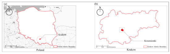
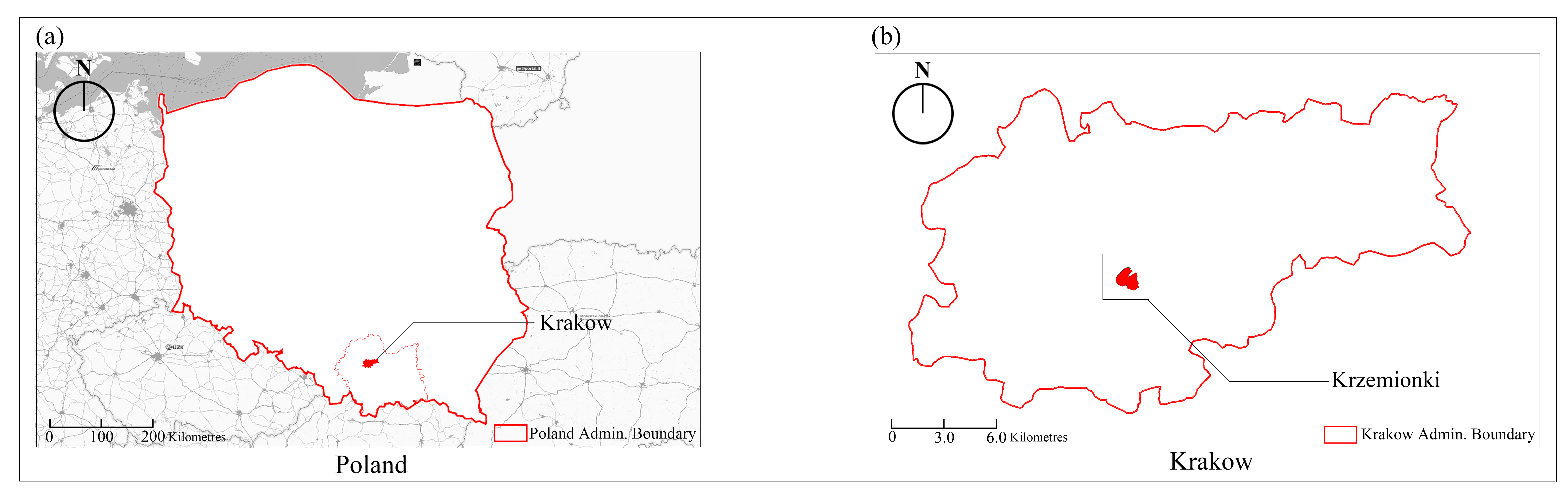
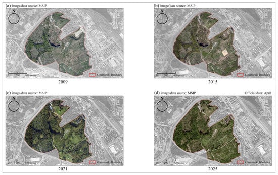
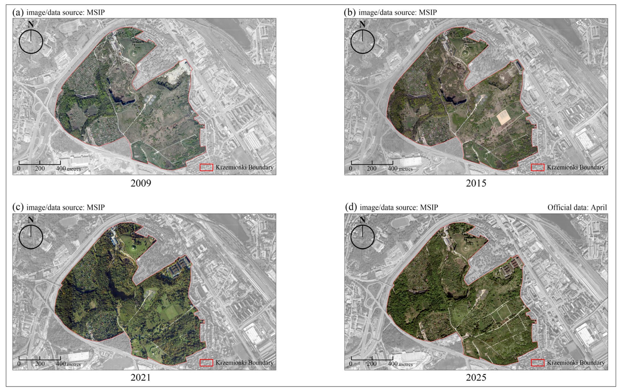
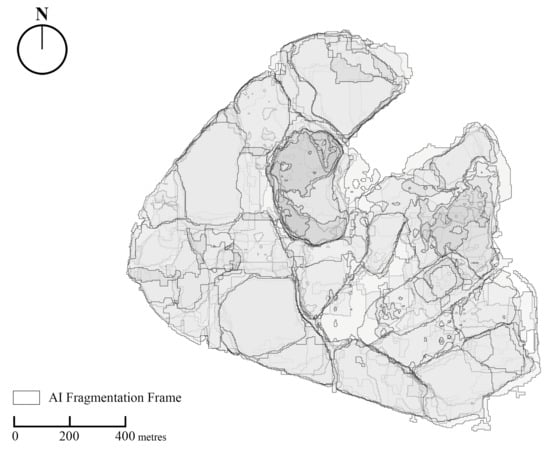
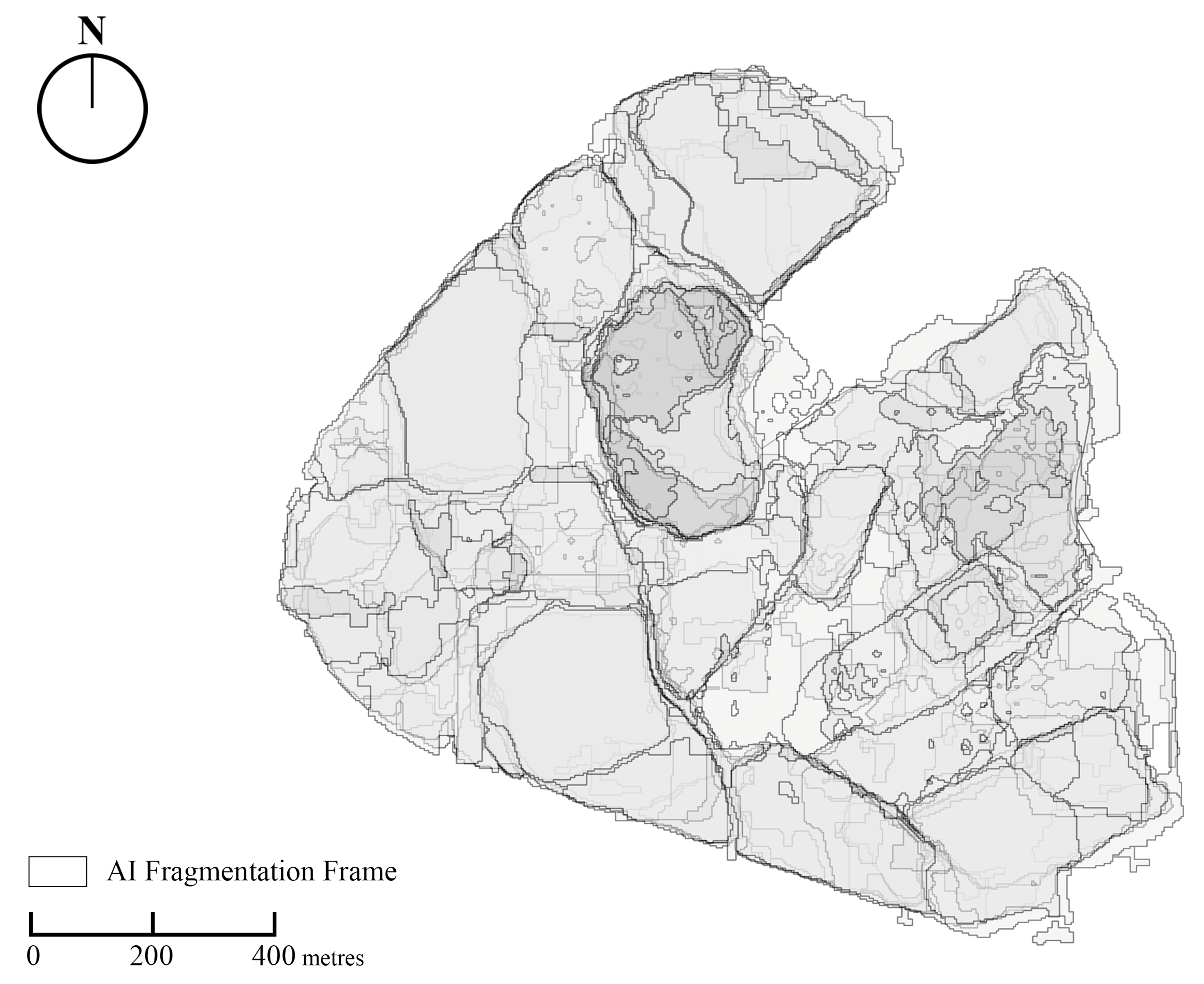
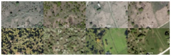
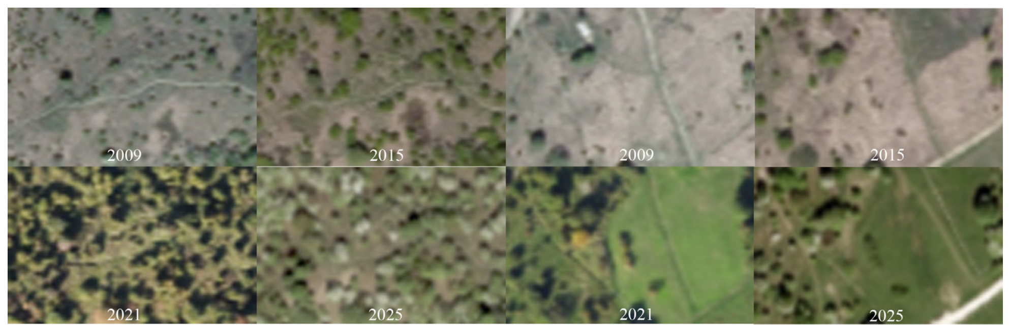
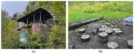
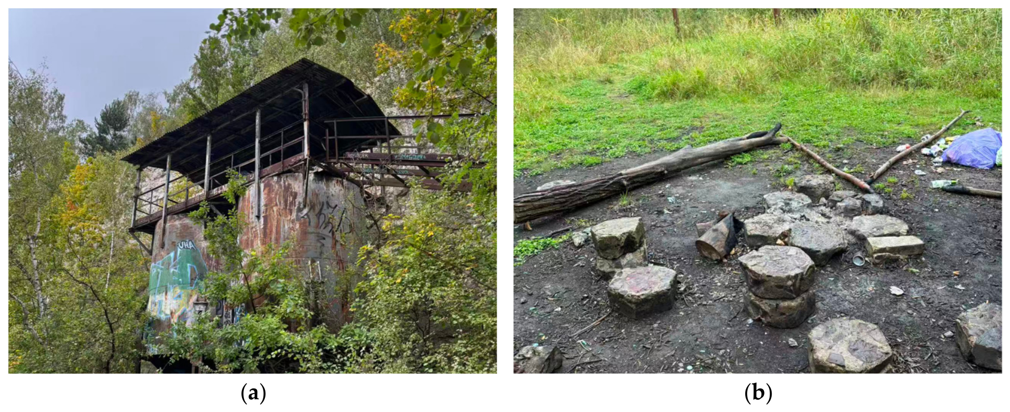
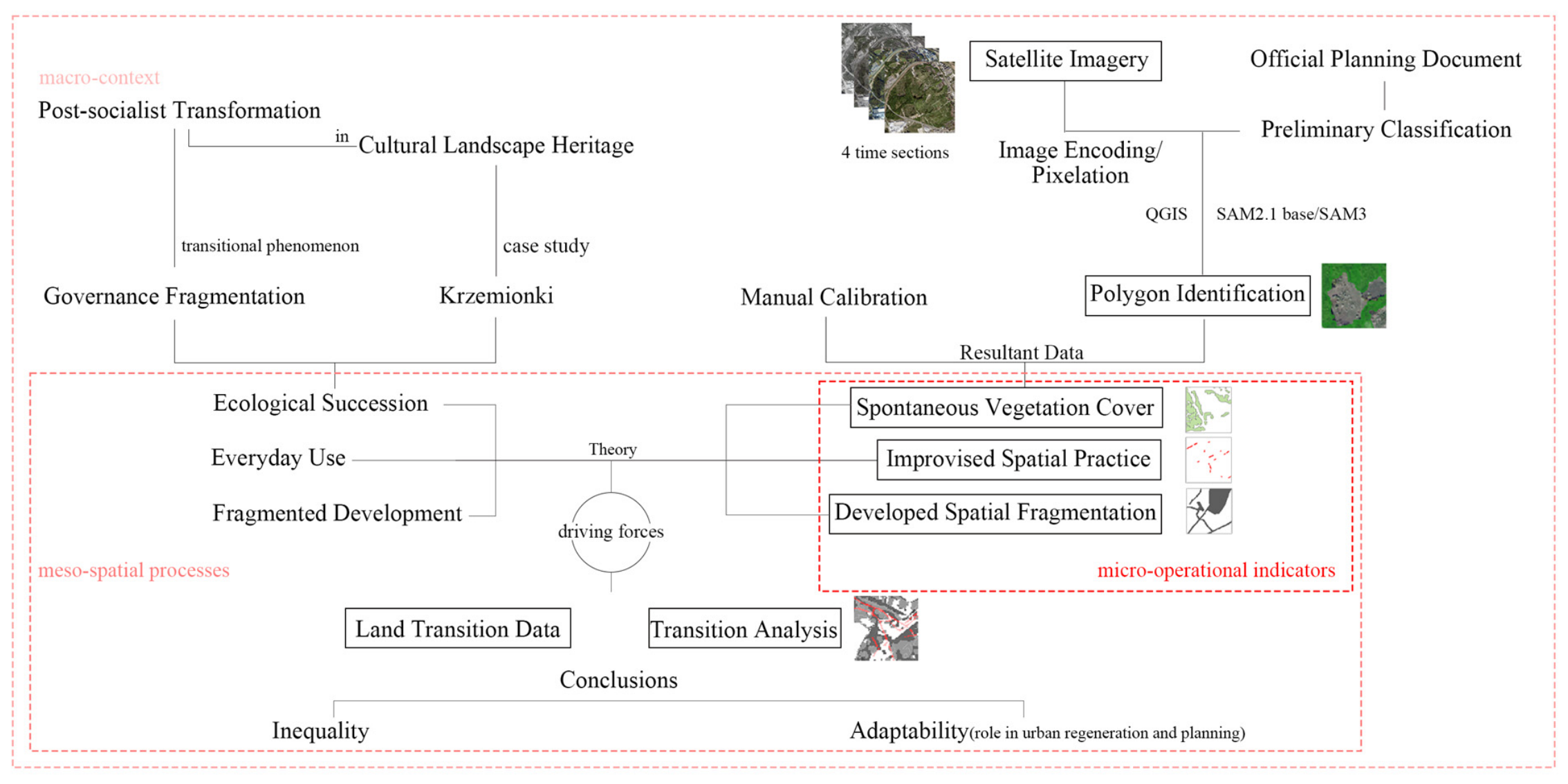
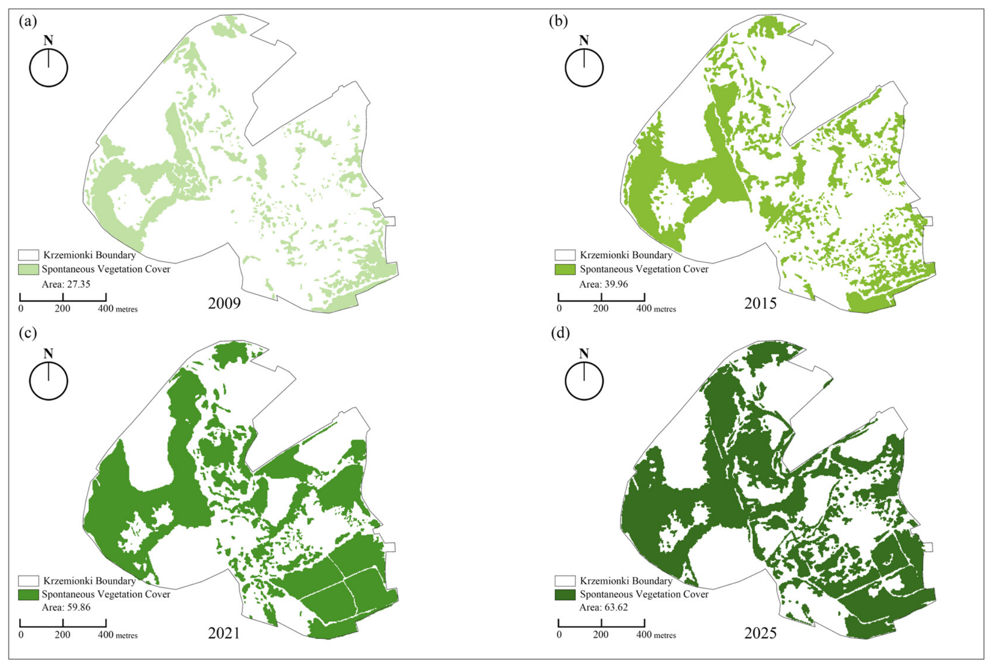
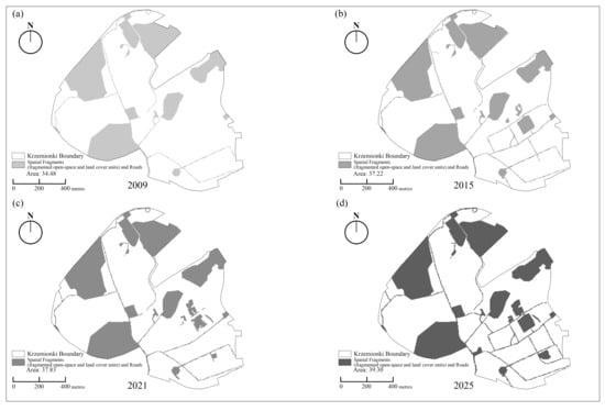
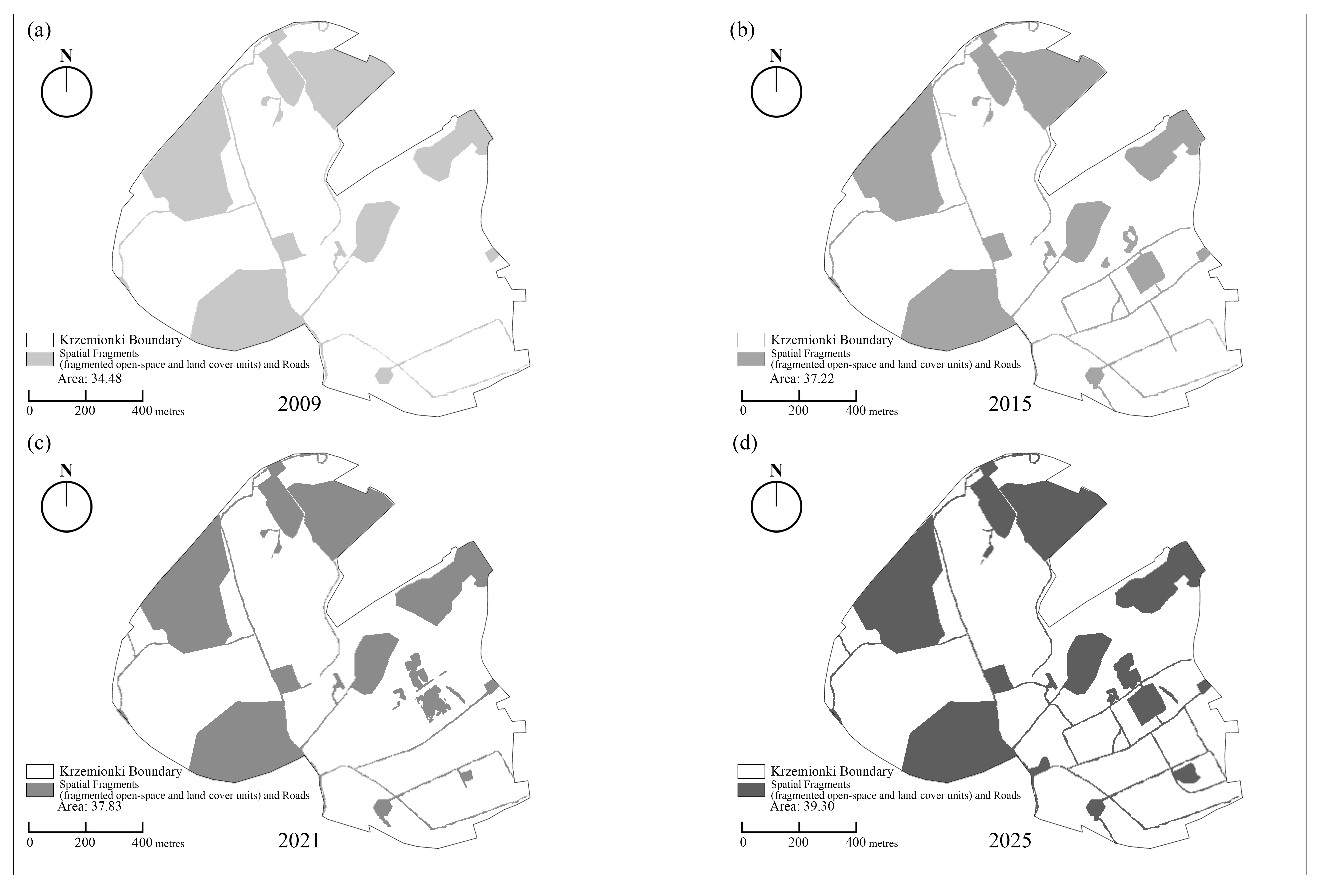
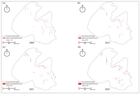
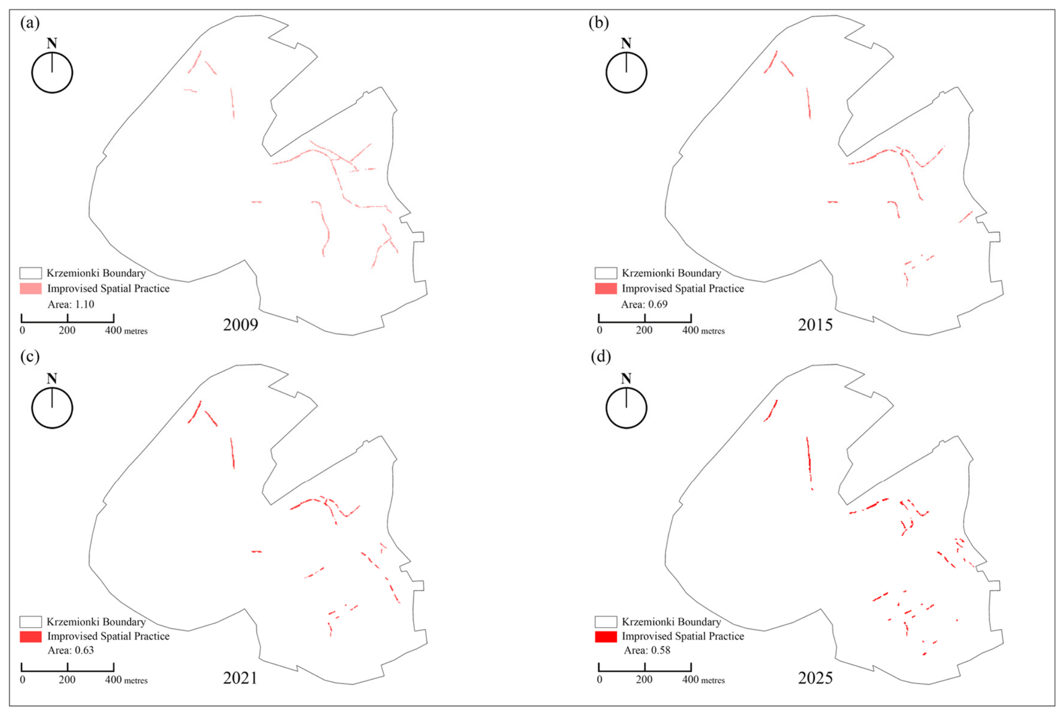
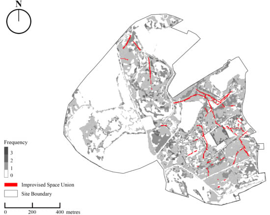
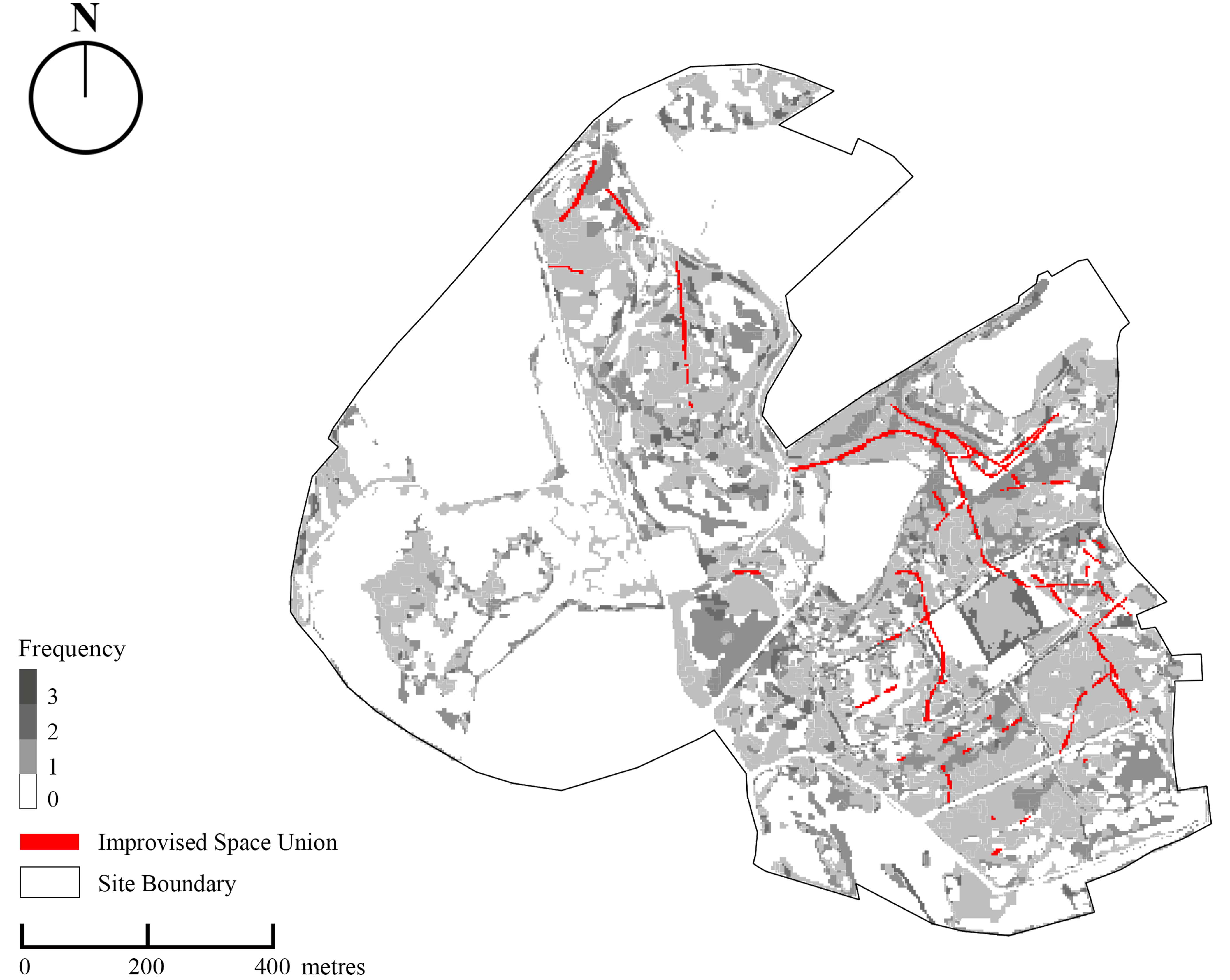

Disclaimer/Publisher’s Note: The statements, opinions and data contained in all publications are solely those of the individual author(s) and contributor(s) and not of MDPI and/or the editor(s). MDPI and/or the editor(s) disclaim responsibility for any injury to people or property resulting from any ideas, methods, instructions or products referred to in the content. |
© 2026 by the authors. Licensee MDPI, Basel, Switzerland. This article is an open access article distributed under the terms and conditions of the Creative Commons Attribution (CC BY) license.