


Abstract
The carbonate massifs of the southern Italian Apennines host extensive karst aquifers, which represent the principal drinking water resources. This study focuses on the Dragone Plain polje, a vast closed karst depression located in the main recharge sector of the Terminio–Tuoro carbonate massif. The polje drains a ~55 km2 endorheic catchment and may be flooded during the cold and wet season, forming a temporary lake. We employed continuous hydroclimatic time series (rainfall, groundwater level, spring discharge, and river level) together with sparse Sentinel-2 true color satellite images for the period 2020–2024 to analyze the flooding process in the polje and its hydraulic connection with the saturated zone of the karst aquifer. Results indicate that lake formation depends on the balance among soil moisture, rainfall intensity, and runoff development, which were modeled on a daily scale. Daily recharge was also estimated and compared with groundwater level time series from the deep karst aquifer. The modeling was integrated with cross-correlation analysis of the time series, providing insights into the propagation of precipitation pulses through the hydrogeological system. This case study represents an important example for understanding the relationship between karst polje hydrological functioning and climate in a Mediterranean area.
1. Introduction
Karst aquifers play a central role in the supply of drinking water in the Mediterranean area [1]. Their recharge-discharge mechanism is controlled by several surface (soil/epikarst, landforms, absorption points) and underground (faults, fractures, conduit network) features of the karst system. An important role in recharge processes is played by closed morphological depressions (dolines, uvalas, and poljes) [2], which drain a wider endorheic catchment, where runoff is completely absorbed (internal runoff) [3]. Thus, the comprehension of the internal dynamics of endorheic areas is essential to understand recharge processes in karst aquifers [4,5].
Poljes are very large, flat-floored depressions with an internal drainage [6], although several definitions and classifications exist [7,8,9,10,11]. Water enters poljes in many different ways, and flooding commonly starts when inflow exceeds the drainage capacity of ponors due to intense or prolonged rainfall [12]. Rapid snowmelt is another important process that promotes polje flooding, as observed in the Apennines. In other areas, the groundwater level can rise and flood the polje [9,12]. An ephemeral lake can form, acting as a regulating reservoir in aquifer recharge processes [12]. The main drivers of the abovementioned processes are meteorological factors, which are not stationary under climate change conditions, thereby impacting the annual frequency and magnitude of flood phenomena over the long period [13].
Within poljes, concentrated infiltration occurs at ponors (or swallow holes), normally located along the margin. Ponors are discontinuities in the bedrock connected to the karst network of fissures, conduits, and caves, through which water directly sinks underground [14]. These features determine a rapid aquifer response to precipitation and a fast transit of water from the surface to the saturated zone. Slower diffuse infiltration occurs through the soil cover and fractures and fissures of the underlying carbonate bedrock [3].
Therefore, poljes can be considered as integral parts of a wider karst aquifer system and represent subsystems in the process of surface and groundwater flow through the karst massif [9,11]. Their hydrological functioning is a matter of interest because of its implications for flood risk for human activities [15] and groundwater recharge [16]. However, considering the extreme variability of climate and hydrological processes, each case study requires specific investigations [12].
This study discusses a case history in southern Apennines (Italy), a region typified by karst massifs. Their summit sectors host small to large poljes, whose endorheic catchment ranges from a few to several tens of square kilometers and spans elevation differences in several hundred meters [4]. From an aquifer recharge perspective, previous studies have highlighted how large karst poljes in the region provide a significant contribution in terms of recharge volume [4]. In this study, we investigated the flooding and recharge processes in the Dragone Plain polje through an integrated analysis of water table records from a deep monitoring well and multi-temporal Sentinel-2 satellite images. The Dragone Plain represents the main recharge area of the Terminio-Tuoro carbonate aquifer (southern Italy), which feeds several powerful basal springs exploited for drinking purposes. The Dragone Plain is affected by the formation of an ephemeral lake during the wet season, which is drained by a ponor and influences aquifer recharge processes. The formation and impacts of the ephemeral lake were investigated by statistical time series analysis and a hydrological model. The latter predicts the internal runoff and recharge processes at the daily timescale.
Wide groundwater oscillations (>50 m) within the saturated zone of the karst aquifer and the typical fast response to recharge input were recorded, indicating a rapid water transit through the unsaturated zone, which is on the order of a few days. On the other hand, a smoothed signal was observed in the spring hydrograph.
As a major novelty, this study clarifies the relationship between polje flooding and climate variability, highlighting the critical role of winter-early spring precipitation. This, in turn, has made it possible to better understand the hydrological processes controlling the recharge of the Terminio-Tuoro karst massif, which appear to be common to many other karst areas of the Apennines, characterized by similar climate and hydrogeological conditions. This is fundamental for developing models describing the hydraulic behavior of this karst aquifer system.
2. Materials and Methods
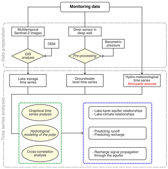
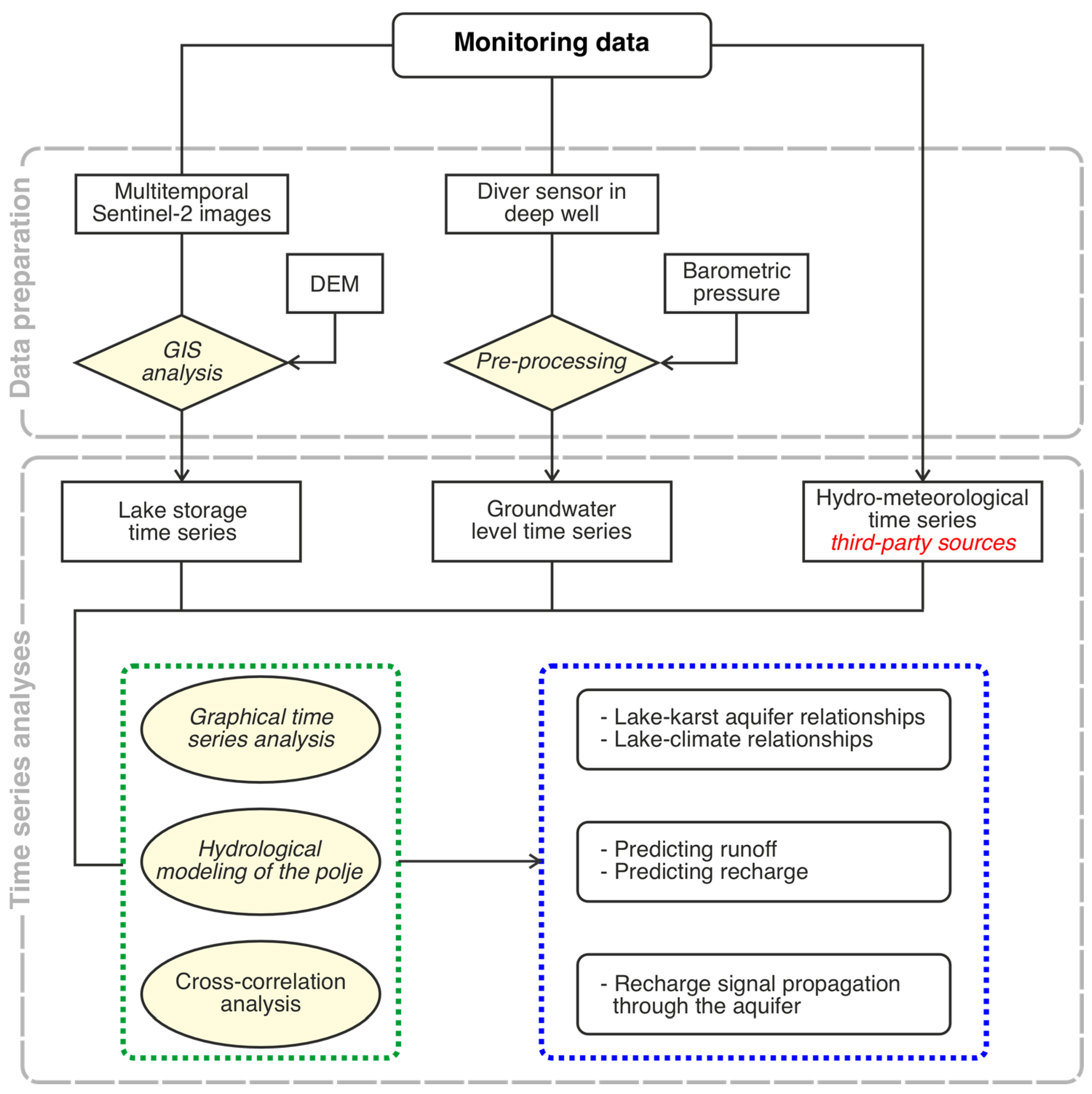
This section presents the study area, data, and methods. A workflow is presented in Figure 1, illustrating the data and methods used, as well as the key insights gained.
Figure 1.
Workflow summarizing the main data, analyses, and key insights gained.
2.1. Study Area
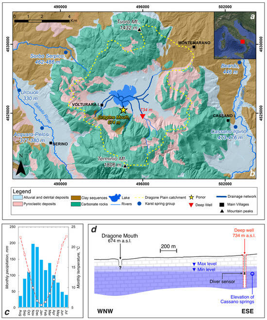
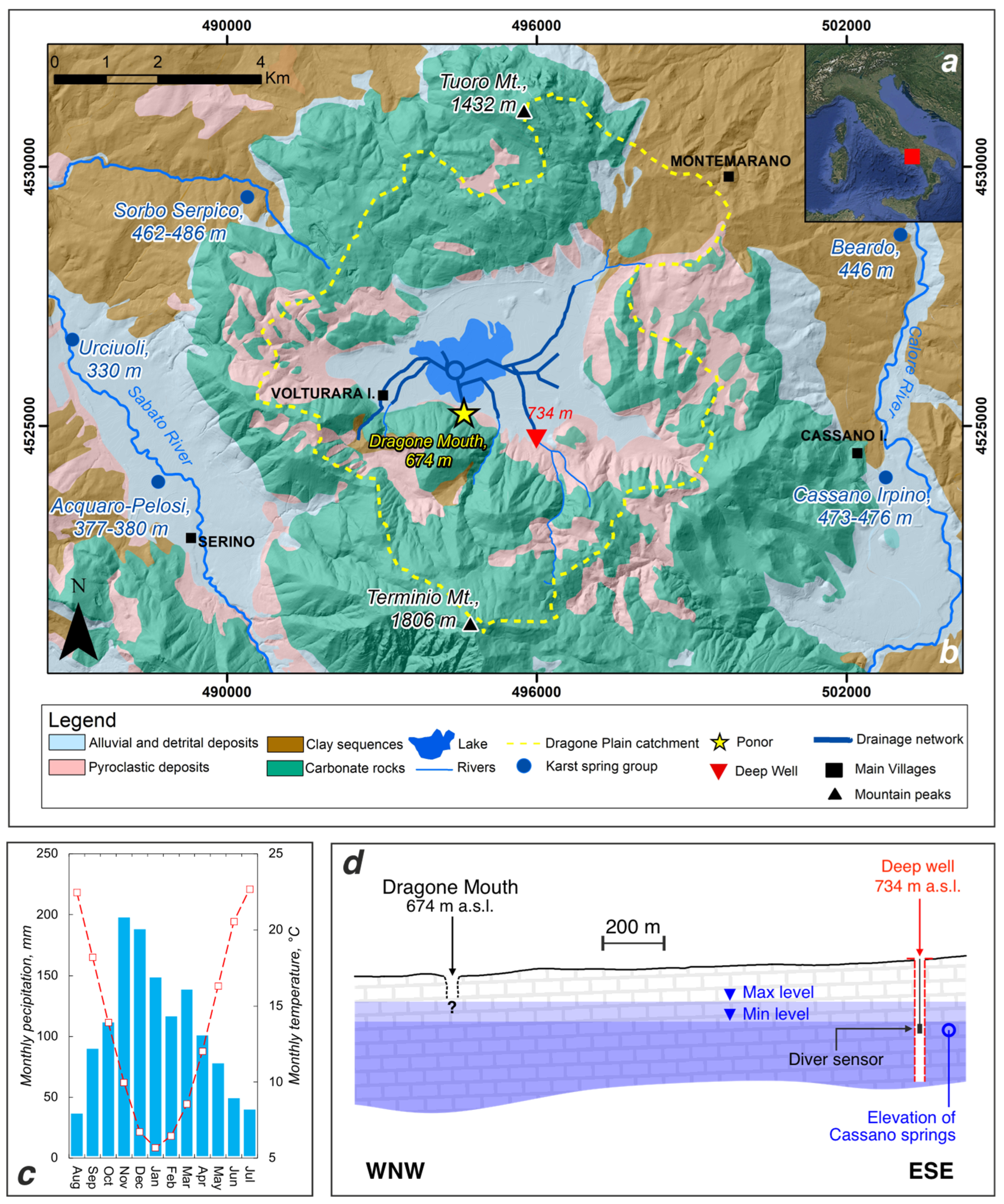
The Dragone Plain Polje is part of the Terminio-Tuoro karst massif (southern Italy; Figure 2a,b). It is composed of a Mesozoic carbonate platform succession of limestone, dolomitic limestone, and dolostone [17], characterized by intense fracturing and high secondary permeability [18]. The massif is surrounded by Meso-Cenozoic deep-basin deposits and Upper Tortonian–Lower Messinian clastic sediments. Quaternary terrains, including alluvial, pyroclastic, lacustrine, and slope deposits, represent the infill of fluvial valleys and endorheic basins.
Figure 2.
(a) Map of Italian Peninsula; the red square is the study area. (b) Hydrogeological sketch of the Terminio-Tuoro karst massif and the Polje of Dragone Plain. (c) Average monthly precipitation (blue bars) and air temperature (red dashed line) over the last 30 years (Serino station, 327 m a.s.l.). (d) Schematic cross-section across the well and the ponor of Dragone Mouth; the figure shows the minimum and maximum groundwater level in the monitoring period, the elevation of Cassano springs, and the position of the TD-Diver pressure sensor.
The massif hosts one of the most productive spring systems in southern Italy, with an overall mean discharge of approximately 5.5 m3/s [4], supplying drinking water to several regions, including Apulia and areas of the Campania region. The main outlets are represented by the Cassano and Serino spring groups, respectively. The first group includes springs located on the eastern side of the massif (Pollentina, Bagno della Regina, Peschiera, and Prete), with elevations between 473 and 476 m a.s.l. and an overall mean discharge of 2.63 m3/s [19]. The second group includes springs located on the western side of the massif, namely the Acquaro-Pelosi (377–380 m a.s.l.) and Urciuoli (330 m a.s.l.) springs, with an overall mean discharge of 2.25 m3/s [19]. Other minor outlets are the Sorbo Serpico springs, with elevations of 462–486 m a.s.l. and an overall mean discharge of 0.180 m3/s, and the Beardo spring, with an elevation of 446 m a.s.l. and a mean discharge of 0.250 m3/s.
The area is characterized by a Mediterranean climate (Figure 2c), with dry and warm periods from June to September. Cooler and wetter conditions prevail during winter, enhancing infiltration and subsequent groundwater recharge.
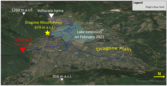
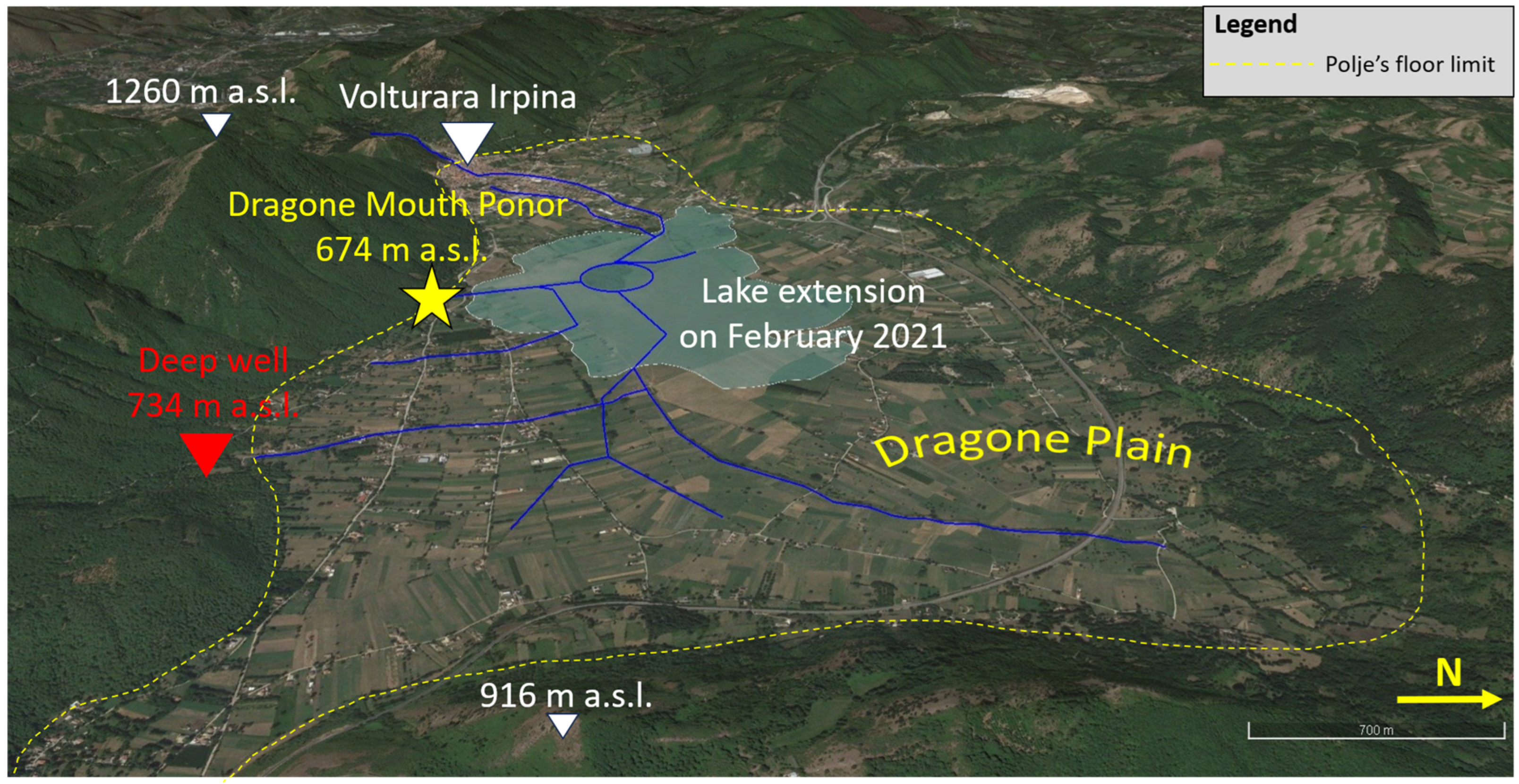
The Dragone Plain polje (Figure 2b and Figure 3) is a tectonic karstic depression. Its floor covers approximately 12 km2 and lies at an average elevation of 681 m a.s.l. The polje catchment covers 55 km2 and represents a significant recharge zone for the karst aquifer. The polje lacks permanent surface flow, and artificial channels convey the runoff toward the ponor of Dragone Mouth, located on the southern side (Figure 2b and Figure 3). Following the flooding events of the nineteenth and twentieth centuries, artificial drainage channels were built to convey water to the ponor (Figure 2b and Figure 3). During the wet and cold season, runoff may accumulate in the lowest part of the plain, forming a temporary lake. As demonstrated by tracer tests carried out in the 1980s, the Dragone Mouth ponor is connected to the eastern Cassano springs, highlighting the strategic importance of the polje for water supply [20]. Although the tracer was not detected at the western Serino springs, a connection with the Dragone Mouth ponor cannot be excluded.
Figure 3.
Satellite image of the Dragone Plain.
2.2. Monitoring Time Series
Analyzed time series (Table 1) cover different time periods, corresponding to 2020–2024 for daily scale analyses, and 1965–2024 for monthly and annual scale analyses.
Table 1.
List of the monitoring time series analyzed in this study.
2.2.1. Precipitation and Lake Storage
Precipitation and lake discharge represent the input signals to the karst aquifer.
Daily precipitation recorded at the Serino rain gauge was considered representative of the study area, given its statistical correlation with the discharge of local springs and groundwater levels. The rain gauge is located at 327 m a.s.l. in the western sector of the massif, in the vicinity of the Urciuoli springs (Figure 2b). Precipitation data were collected by the National Hydrographic and Oceanographic Service (SIMN; https://centrofunzionale.regione.campania.it/documenti; accessed on 28 March 2026) until 1999, and since 2000 by the Functional Center of the Civil Protection of the Campania Region (https://centrofunzionale.regione.campania.it/#/pages/dashboard; accessed on 28 March 2026).
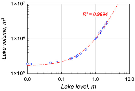
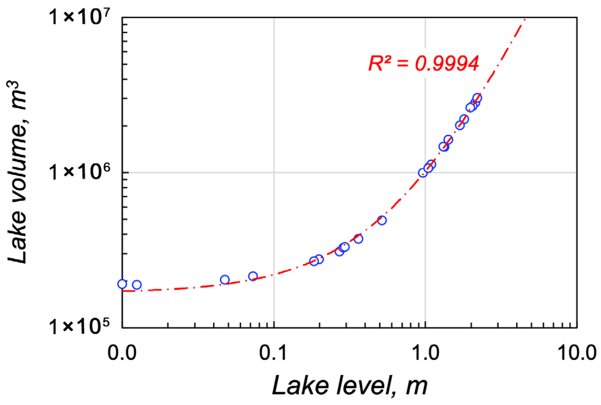
To map the flooded area and estimate lake storage, multi-temporal Sentinel-2 true color satellite images (Copernicus Program, European Space Agency, ESA) were visually analyzed. The satellite revisit time was approximately five days. Due to the seasonal distribution of precipitation and temperature, the lake does not form during the summer–autumn period. Therefore, only images from November to May of the following year were analyzed. The presence or absence of the lake was assessed: when present, the flooded area was digitized in a GIS environment; otherwise, its absence was recorded. The mapped lake perimeter represents the water level, and its elevation was extracted from a 5 m Digital Elevation Model (DEM) using standard GIS tools. Specifically, the lake surface level was assumed to be the mean elevation of the lake perimeter. Lake storage was estimated as the volume between the DEM surface, representing the reservoir bottom, and the lake contour, representing the water surface. The relationship between lake level and volume is shown in Figure 4.
Figure 4.
Logarithmic plot showing the relationship between volume and level of the Dragone Plain’s ephemeral lake (level on a reference hydrometric zero); R2 is the determination coefficient of the regression curve.
2.2.2. Groundwater Level and Spring Discharge
Groundwater levels and spring discharge represent the intermediate and final outputs of karst aquifers. Groundwater monitoring began in October 2021. A deep well located along the southern margin of the polje, approximately 1.5 km from the Dragone Mouth ponor (Figure 3), was used for this purpose. It is situated at approximately 734 m a.s.l. and penetrates about 400 m into the carbonate sequence (Figure 2c), extending below the elevation of the basal Cassano springs (473–476 m a.s.l.).
Continuous monitoring was carried out using a pressure sensor (TD-Diver; Van Essen Instruments, Delft, The Netherlands), located in the saturated zone of the aquifer. The original sampling frequency was 3 h, and the data were subsequently aggregated to a daily time step. When submerged, the pressure sensor records the combined hydrostatic pressure of the water column and atmospheric pressure. Accordingly, the groundwater level (GWL, m a.s.l.) was calculated as follows:
where H (m a.s.l.) is the ground elevation, Lcab (m) is the length of the cable used to install the sensor into the well (measured from the ground), PDiver (mH2O) is the measured pressure, and PA (in mH2O) is the atmospheric pressure. As the sensor is ~501 m a.s.l., the atmospheric pressure of the Montella station (515 m a.s.l., in the vicinity of the Cassano springs, Figure 2b) was considered for barometric compensation.
The daily discharge of the Cassano springs was provided by Acquedotto Pugliese S.p.A. (Bari, Italy). This spring group consists of four outlets, and only the daily time series of the Bagno della Regina spring was analyzed. Differently, the contribution of all springs was considered in the analysis of long-term annual time series.
2.3. Time Series Analysis
Graphical analysis of time series [21] was carried out. The preparation and the interpretation of the specific graphs will be presented in the results section.
Furthermore, cross-correlation analysis was employed to investigate the propagation of the input recharge signal through the aquifer [22,23]. The cross-correlation function, CCF, describes the degree of linear correlation between an input time series X and the lagged versions of another output time series Y as a function of the time lag k introduced between X and Y [24]:
where sX and sY are the standard deviations of time series X and Y, respectively, and cXY(k) is the cross-covariance coefficient at lag k:
T is the time series length, t is the t-th the time step, and mX and mY are the mean of the time series.
The CCF varies between −1 and +1, and for a given lag k, its value assumes the same meaning as the ordinary correlation coefficient. In data-driven modeling, cross-correlation is employed to find the linear transfer function describing the dynamic relationships between X and Y. A short time lag to the CCF peak and a very high (or low) correlation value indicate rapid transit and a high similarity between the input and output signals. However, the shape of the cross-correlation function is also relevant, as it may provide insights into process inertia [25]: smooth variations in the CCF suggest higher inertia and damping of the input signal; rapid variations in the CCF suggest a lower inertia and limited damping
2.4. Daily Scale Recharge (DSR) Model
A Daily Scale Recharge (DSR) model [4] was used to predict internal runoff and recharge in the polje. The model assumes that, when the soil reaches field capacity, an amount of rainfall can percolate through the unsaturated zone and reach the saturated zone, providing recharge. If rainfall intensity exceeds the infiltration capacity, it generates runoff; this process, in the endorheic catchment [3], provides an additional recharge as concentrated infiltration through ponors. An ephemeral lake forms when ponors are unable to drain all the internal runoff. In open areas, the same condition generates external runoff to rivers, allowing surface water to leave the karst massif without contributing to recharge.
The DSR Model is based on the water balance of the soil mantle. It splits the daily rainfall, P, into several parts:
where AET is the actual evapotranspiration, Δθ the increase in water content of the soil, R is the diffuse recharge and RO is the internal runoff. The variables in Equation (4) and the following equations are expressed in mm/day.
During no-rainfall periods (P = 0), R and RO are zero, and the soil moisture decreases because of evapotranspiration (−Δθ = AET). This decrease can occur up to a minimum value of the soil moisture, θmin, which is close to the wilting point of the vegetation. The actual evapotranspiration (AET) from the soil is a conditional function of the potential evapotranspiration (PET), estimated using the Thornthwaite and Mather method [26], and the soil moisture θ:
During cold wet periods (PET < P, P > 0), the soil moisture can increase up to the field capacity of the soil, θmax. When this condition is achieved, diffuse and concentrated recharge can occur. The excess rainfall, Pexc, can be calculated:
It is the rainfall amount that is available to percolate through the unsaturated zone and reach the water table as diffuse recharge, R, or that is conveyed toward ponors (internal runoff) generating concentrated recharge:
The model assumes that internal runoff in the closed area, or external runoff on open slopes, occurs if Pexc exceeds a daily threshold, Tr. Previous studies estimated the threshold as Tr = 22.3 mm/day [4].
3. Results
The first part of Section 3 focuses on the graphical analysis of the time series, while the second part presents the outcomes of the hydrological modeling. The third part offers general considerations on long-term meteorological fluctuations and their effects on hydrological processes.
3.1. Relationships Between Rainfall, Ephemeral Lake and Karst Aquifer
The graphical analysis focused on four hydrological years—two wet, one average, and one dry—which can therefore be considered representative of the range of meteorological conditions occurring in the area.
3.1.1. November 2020–May 2021
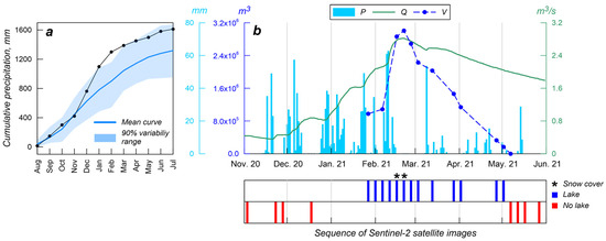
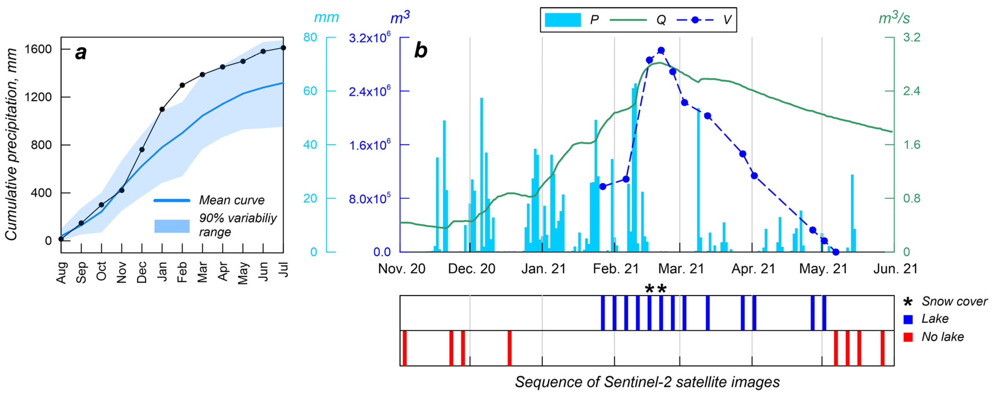
Figure 5a presents the cumulative monthly rainfall curves from August 2020 to July 2021. The blue line represents the average curve calculated over the last 30 years, and the shaded area represents the 90% variability interval between the lower 5th and the upper 95th percentiles. The 2020–2021 period is well above average (wet year) because of abundant winter precipitation.
Figure 5.
(a) Cumulative monthly precipitation curve (black) for the hydrological year 2020–2021. (b) Daily precipitation, P, lake storage volume, V, and daily discharge, Q, of Bagno della Regina spring (Cassano spring group) for the period 1 November 2020–1 June 2021. The bottom panel provides the sequence of Sentinel-2 satellite images, and the star marks the presence of a snow cover across the polje’s catchment. The lake volume has been interpolated between two consecutive satellite images.
Figure 5b shows the daily time series of precipitation, lake storage volume, and spring discharge for the period from November 2020 to May 2021. The summer to mid-autumn period was not considered because, although rainfall occurs, the lake does not form during this time. Piezometric data are not included in this figure as groundwater monitoring started in October 2021. The bottom panel provides the sequence of available and interpretable Sentinel-2 satellite images. A prolonged flood occurred this year. The lake was probably in its initial stage of accumulation in late December, and the Dragone Plain remained continuously flooded until early May 2021. The largest lake storage during the entire study period, ~3 × 10⁶ m3, was observed in February 2021. The cumulative precipitation curve in Figure 5a shows a large water surplus in this month, associated with abundant winter rainfall. In late February, lake storage remained high despite the absence of precipitation, suggesting that snowfall and subsequent snowmelt delayed the storage peak by several days after the precipitation events. Notably, the maximum lake storage also coincided with the seasonal peak in spring discharge.
The good temporal coverage of satellite images allowed us to estimate the contribution of the lake to recharge. We assumed that evapotranspiration was negligible, which is reasonable during the cold period. Recharge was calculated based on the change in storage volume (ΔV, m3) estimated between two satellite images during emptying, as ΔV/ΔT, where ΔT (seconds) is the time interval between the images. Assuming that the lake recession began in late February 2021, the maximum recession rate was ~1 m3/s (26 February to 3 March). From 3 March to 2 May, the lake baseflow was ~0.45 m3/s. The very low permeability of the deposits underlying the lake suggests that the Dragone Mouth ponor is the only concentrated point of infiltration.
3.1.2. November 2021–May 2022
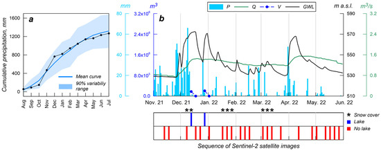
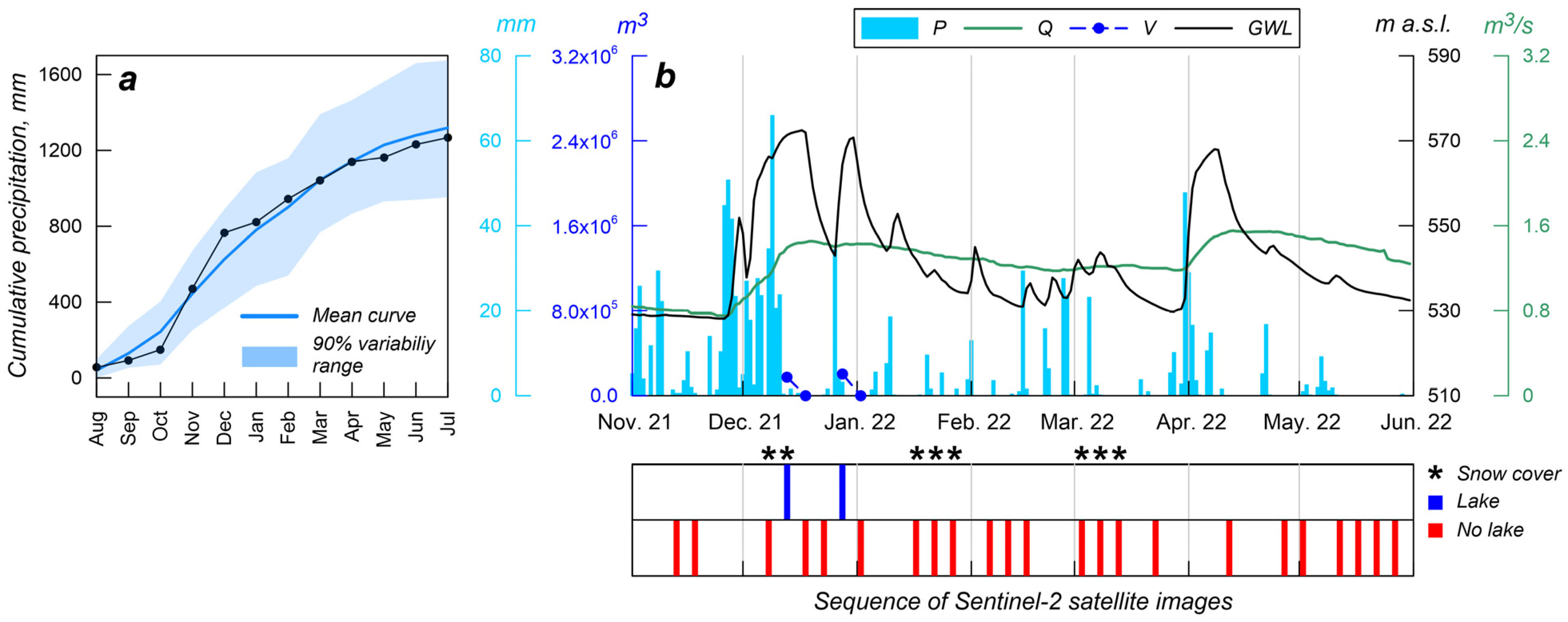
The 2021–2022 year can be considered an average hydrological year (Figure 6a). Numerous satellite images are available for this period, but only a few capture the lake (Figure 6b) due to the short duration of the flooding events, despite a prolonged rainfall period that occurred between late November and early December 2021.
Figure 6.
(a) Cumulative monthly precipitation curve (black) for the hydrological year 2021–2022. (b) Daily precipitation, P, lake storage volume, V, groundwater level, GWL, and daily discharge, Q, of Bagno della Regina spring (Cassano spring group) for the period 1 November 2021–1 June 2022. The bottom panel provides the sequence of Sentinel-2 satellite images, and the star marks the presence of a snow cover across the polje’s catchment. The lake volume has been interpolated between two consecutive satellite images.
Both groundwater in the karst aquifer and spring discharge rapidly increase in response to precipitation pulses. Specifically, the deep well is placed in the main recharge zone and reaches the deep karst aquifer. The groundwater hydrograph shows several peaks, in correspondence with intense rainfall; the highest peak presents a flat summit zone, which can be interpreted as (i) recharge nearly equal to discharge, or (ii) a diffuse mechanism of overflow along the boundary of the spring catchment. The groundwater level drops rapidly as soon as the lake disappears, indicating an influence of concentrated recharge through the Dragone Mouth ponor. Therefore, based on the hydrograph shape, a lake was likely present even in early April, but no usable satellite images are available for this period.
3.1.3. November 2022–May 2023
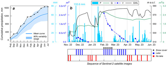
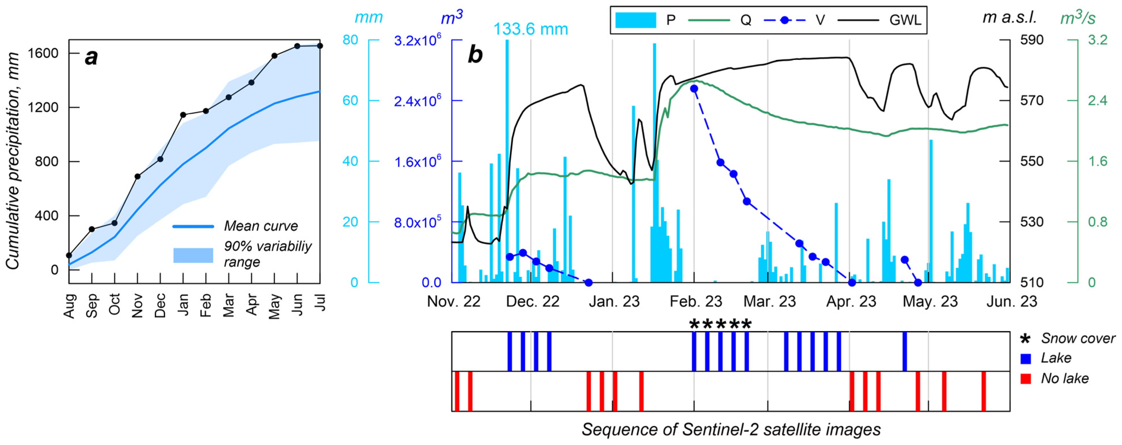
The 2022–2023 period is a wet (above-average) year (Figure 7a). As shown in Figure 7b, several flood episodes and flat peaks in the groundwater hydrograph occurred. It appears that, when the lake is completely drained, the groundwater level rapidly drops. In this case, the groundwater level shows an upper limit due to the previously explained reasons.
Figure 7.
(a) Cumulative monthly precipitation curve (black) for the hydrological year 2022–2023. (b) Daily precipitation, P, lake storage volume, V, groundwater level, GWL, and daily discharge, Q, of Bagno della Regina spring (Cassano spring group) for the period 1 November 2022–1 June 2023. The bottom panel provides the sequence of Sentinel-2 satellite images, and the star marks the presence of a snow cover across the polje’s catchment. The lake volume has been interpolated between two consecutive satellite images.
The second main flood episode characterizes the period from late January to early April. Specifically, January precipitation caused polje flooding, which was associated with a rapid increase in groundwater level and spring discharge. Part of the precipitation accumulated in the spring catchment as snow, creating an additional, temporary water reservoir. Due to snowmelt and lake drainage, the groundwater level continued to rise until April, while spring discharge gradually decreased.
3.1.4. November 2023–May 2024
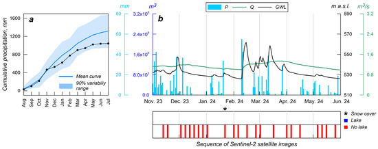
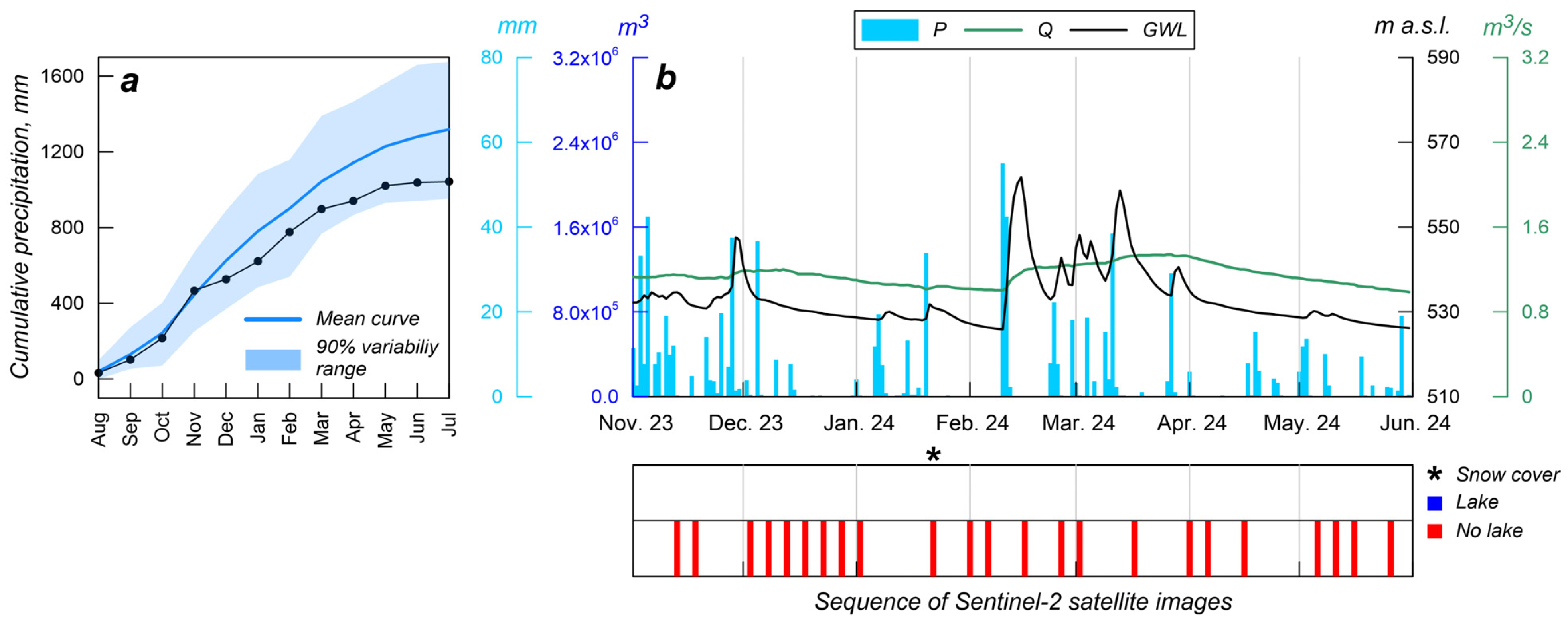
The 2023–2024 period is a dry (below-average) year, characterized by very low precipitation during the winter period (Figure 8a), and no lake formed (Figure 8b). The rainfall deficit began in December and induced a hydrological drought in the system. This low rainfall resulted in isolated and minor peaks in the water table, associated with low values of the spring discharge throughout the year.
Figure 8.
(a) Cumulative monthly precipitation curve (black) for the hydrological year 2023–2024. (b) Daily precipitation, P, lake storage volume, V, groundwater level, GWL, and daily discharge, Q, of Bagno della Regina spring (Cassano spring group) for the period 1 November 2023–1 June 2024. The bottom panel provides the sequence of Sentinel-2 satellite images, and the star marks the presence of a snow cover across the polje’s catchment.
3.2. Diffuse and Concentrated Recharge Processes
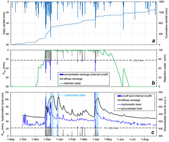
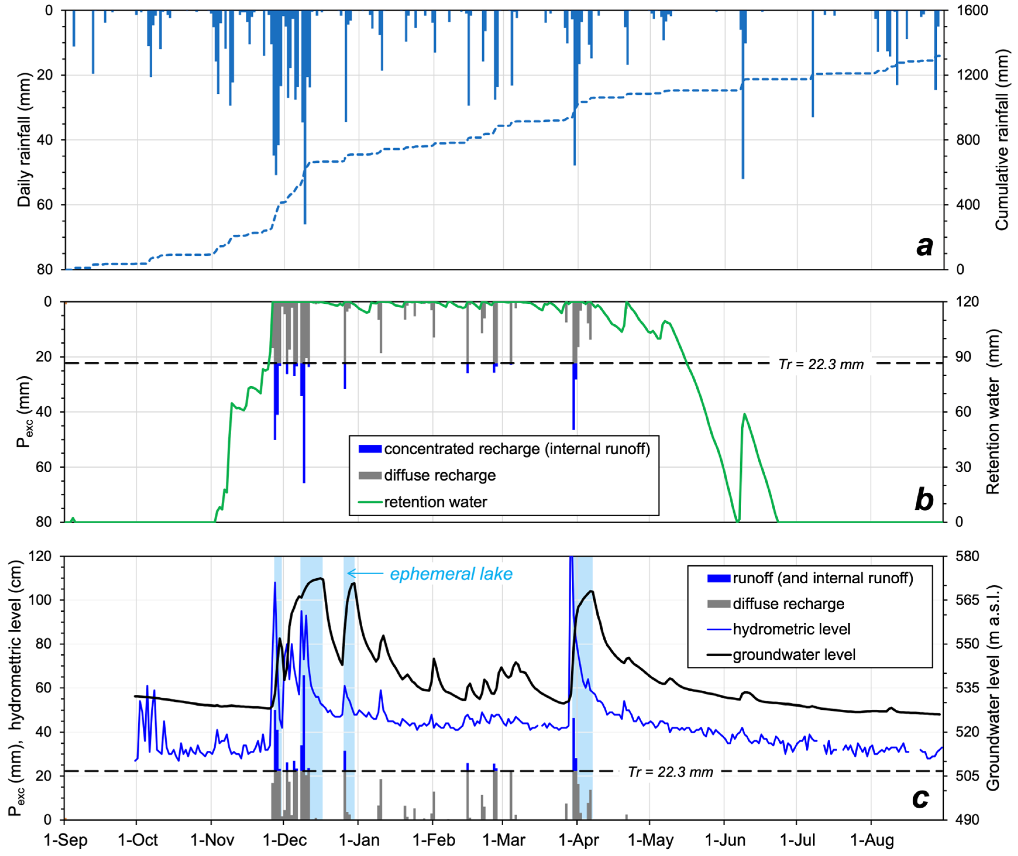
We applied the DSR model to provide a quantitative description of the processes described above. The model was run for the meteorological year 2021–2022, and the results are shown in Figure 9. Specifically, Figure 9a shows the daily rainfall distribution in a typical year for this area, with a total cumulative effective rainfall of 1300 mm. The field capacity, θmax, is reached by the end of November, after which daily rainfall produces an amount of excess rainfall, Pexc (Figure 9b). This water cannot be retained by the soil and percolates downward toward the deep saturated zone, generating diffuse recharge events. Percolation through the unsaturated zone is very rapid, with water reaching the aquifer within a few hours to days, as evidenced by the fast response of the groundwater level in the saturated zone (Figure 9c). When the excess precipitation, Pexc, exceeds the 22.3 mm/day threshold, it becomes runoff; this amount provides additional recharge in the endorheic area or feeds the river flow in open areas, allowing water to leave the karst catchment. This latter component is monitored by the hydrometer, and the corresponding record is shown in Figure 9c. Although the gauging station primarily reflects runoff processes on open slopes, the mechanisms controlling runoff generation are comparable to those occurring within the polje. The runoff in the endorheic areas feeds the ephemeral lake, which is slowly absorbed, providing continuous replenishment to the water table.
Figure 9.
2021–2022 hydrological year. (a) Daily and cumulative rainfall (Serino rain gauge, 327 m a.s.l.). (b) Soil retation water content was computed by the DSR model (soil moisture capacity = 120 mm) and daily excess rainfall, Pexc; this amount is split into diffuse and concentrated recharge; (c) Diffuse and concentrated recharge, groundwater level of karst aquifer, and hydrometric level of the Calore River (Montella hydrometer). The blue shaded zones highlight the periods of persistence of the ephemeral lake.
3.3. Long-Term Rainfall-Karst System Relationships
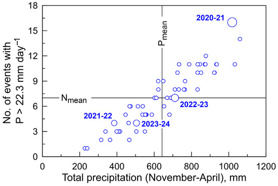
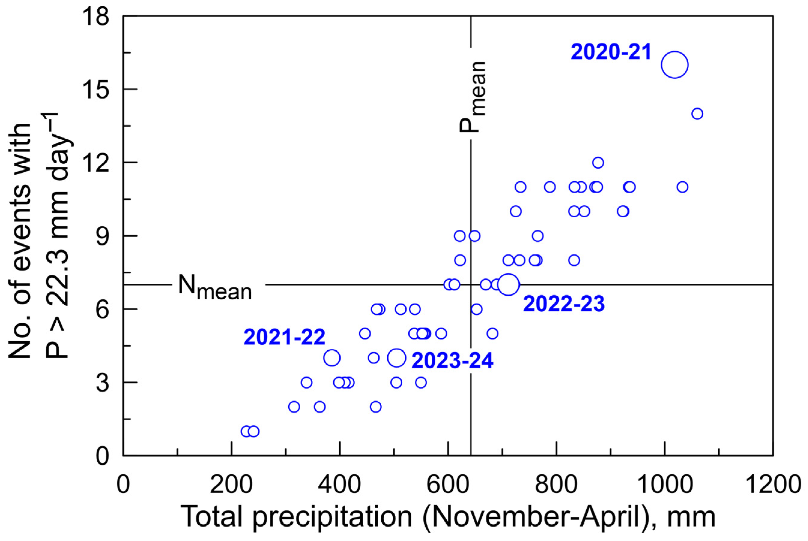
Rainfall intensity and soil water content control the development of internal runoff, which feeds the ephemeral lake. These processes are particularly relevant during the late November–early April period, when the soil approaches field capacity. During this period, we found a direct correlation between the accumulated precipitation and the frequency of intense events (Pexc > 22.3 mm/day; Figure 10). As such, lake formation, expansion, and persistence are favored during normal-wet year. Abundant precipitation and the highest frequency of intense events of the whole sequence occurred in 2020–2021, explaining the severe, prolonged flood observed in Figure 5a.
Figure 10.
Correlation between total precipitation in November–April and the number of events with intensity >22.3 mm/day (1966–2024 period). Larger symbols highlight the analyzed years.
These results provide a basis for further analysis of the relationships between long-term climate variability and polje flooding.
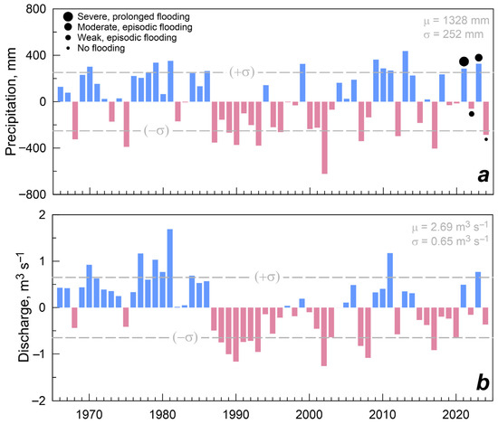
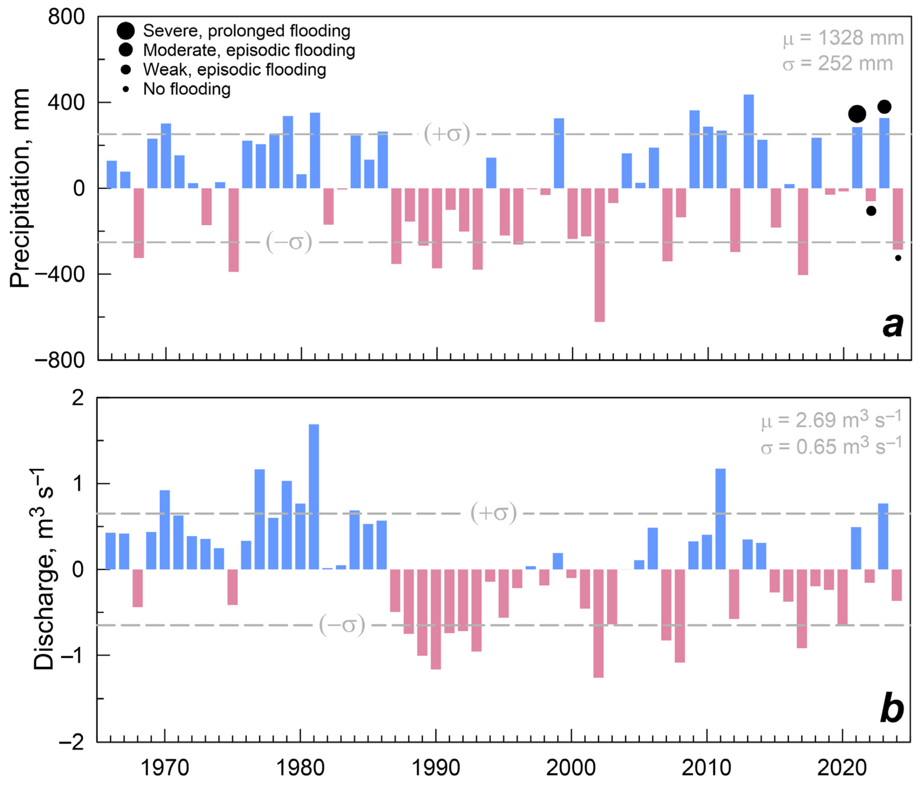
In particular, Figure 11a illustrates the long-term relationships between rainfall and spring discharge. It is evident that the absence of a lake during the entire winter–spring season serves as a proxy for prolonged meteorological drought, which leads to reduced recharge in that year. However, the response of the karst aquifer as a whole is more complex and is reflected at the springs. The impact of a meteorological drought on spring discharge also depends on the discharge of the previous year, as the aquifer “memory” modulates the spring response to rainfall. Consequently, groundwater deficits can accumulate in the aquifer during periods of frequent meteorological drought, such as 1986–1999 and 2015–2021. Conversely, a storage surplus can buffer the negative effects of a meteorological drought in the following year, as observed at the end of the monitoring period in 2024.
Figure 11.
Annual time series (1966–2024) of precipitation (a) and total discharge of Cassano springs (b). Values are expressed in deviations from the long-term average (μ). Blue and red bars represent above and below average values, respectively, while the dashed lines display ±1 standard deviation (σ) from the average. Dots highlight the ephemeral lake condition for the 2021–2024 years.
4. Discussions
The Dragone Plain represents one of the major karst poljes in the southern Apennine region. Its significance lies in its near-natural conditions, which make it an ideal site for investigating flooding and recharge processes, also owing to the presence of deep wells that reach the saturated zone of the karst aquifer. Several studies have highlighted the importance of integrating continuous time series of rainfall, lake level, and groundwater level to develop conceptual models of polje–aquifer interactions [13,15] and to calibrate numerical simulations [27]. In the absence of direct lake level observations, this study relies on alternative datasets. Specifically, satellite RGB imagery was visually analyzed to reconstruct the presence and spatial extent of the lake. Automated lake mapping based on satellite indices was avoided, as it can introduce significant errors and lead to a loss of information for relatively small and shallow lakes such as the one in our study. Overall, satellite imagery is subject to limitations compared with in situ monitoring. Image availability strongly depends on meteorological conditions, which are typically unfavorable during the winter period—especially in wet years—thereby reducing data coverage. Conversely, imagery is more frequently available during dry and mild periods, when the lake may be absent or its duration is limited. Additionally, the average satellite revisit time of approximately six days constrains temporal resolution. As a result, prolonged flooding events are better captured, while short-lived inundation episodes are likely underrepresented.
Groundwater monitoring also poses major challenges in extensive karst areas characterized by a thick unsaturated zone. In this study, we utilized a deep well located within the polje, which occupies the main recharge zone of the aquifer. This well extends below the basal springs of the Cassano group and crosses the main karst aquifer. Although the water table exhibited wide fluctuations, it remained below the polje floor, excluding a direct influence of deep aquifer oscillations on flooding. Consequently, meteorological factors are the primary drivers of the ephemeral lake dynamics.
The active ponor and underground karst pathways favor the concentrated infiltration of surface water and its direct transfer into the aquifer. These features cause a rapid recharge after rainfall, highlighted by the rapid increase in the water level in the deep well. The spring hydrographs show a smoothed response, which highlights the role of the saturated zone in modulating the groundwater flow. Based on our estimations, the maximum ponor discharge reached approximately ~1 m3/s in the monitoring period. The whole endorheic area of the Dragone Plain has a significant role in aquifer recharge estimated at 71.6 × 10⁶ m3/year [4], equal to an average flow of approximately 2.3 m3/s. This suggests that the lake is not merely a surface water body but also an integral subsystem of the karst aquifer, regulating its recharge. This is clearly evident from Figure 7, where the water table suddenly drops when the lake disappears. Lake drainage also causes small fluctuations in the time series of Cassano Springs.
Flooding is primarily controlled by the intensity, duration, and frequency of precipitation events, antecedent soil moisture conditions, and the drainage capacity of the ponor. Rainfall occurring in November is generally retained in the soil and does not feed surface flow (Figure 9). On average, wet years are characterized by a higher frequency of intense rainfall events (>22.3 mm/day), which promote internal runoff and flooding. Conversely, the lake is unlikely to form during prolonged meteorological droughts, as observed in the 2023–2024 period (Figure 8), because of accumulated soil water deficit and infrequent intense rainfall. Therefore, flooding is not a seasonally recurrent phenomenon but is closely linked to climate change. The role of antecedent soil moisture and rainfall intensity is quantitatively described by the DSR model. The underlying concept is that both concentrated and diffuse groundwater recharge can be predicted using a water balance model of the soil cover [4].
Continuous monitoring of lake levels would enhance the understanding and analysis of the relationship between climatic factors and recharge processes. Furthermore, the installation of an additional sensor in a deep well is proposed to obtain an additional groundwater-level observation point, allowing for the assessment of the spatial variability of groundwater fluctuations.
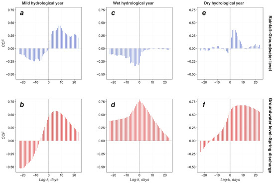
Monitoring time series can be further exploited to study how the meteorological signal propagates through the karst aquifer at different time scales. Groundwater levels and spring discharge rapidly increase in response to precipitation. However, the propagation of precipitation pulses through the aquifer appears to differ between meteorologically dry and wet years. This behavior was analyzed using cross-correlation analysis, considering data from November to April of different years (Figure 12). It should be noted that the strong buffering effect of the karst system limits any direct comparison between daily precipitation and spring discharge. This type of analysis should involve multiple rainfall time series, i.e., cumulative rainfall over varying time windows, typically greater than 60 days [28].
Figure 12.
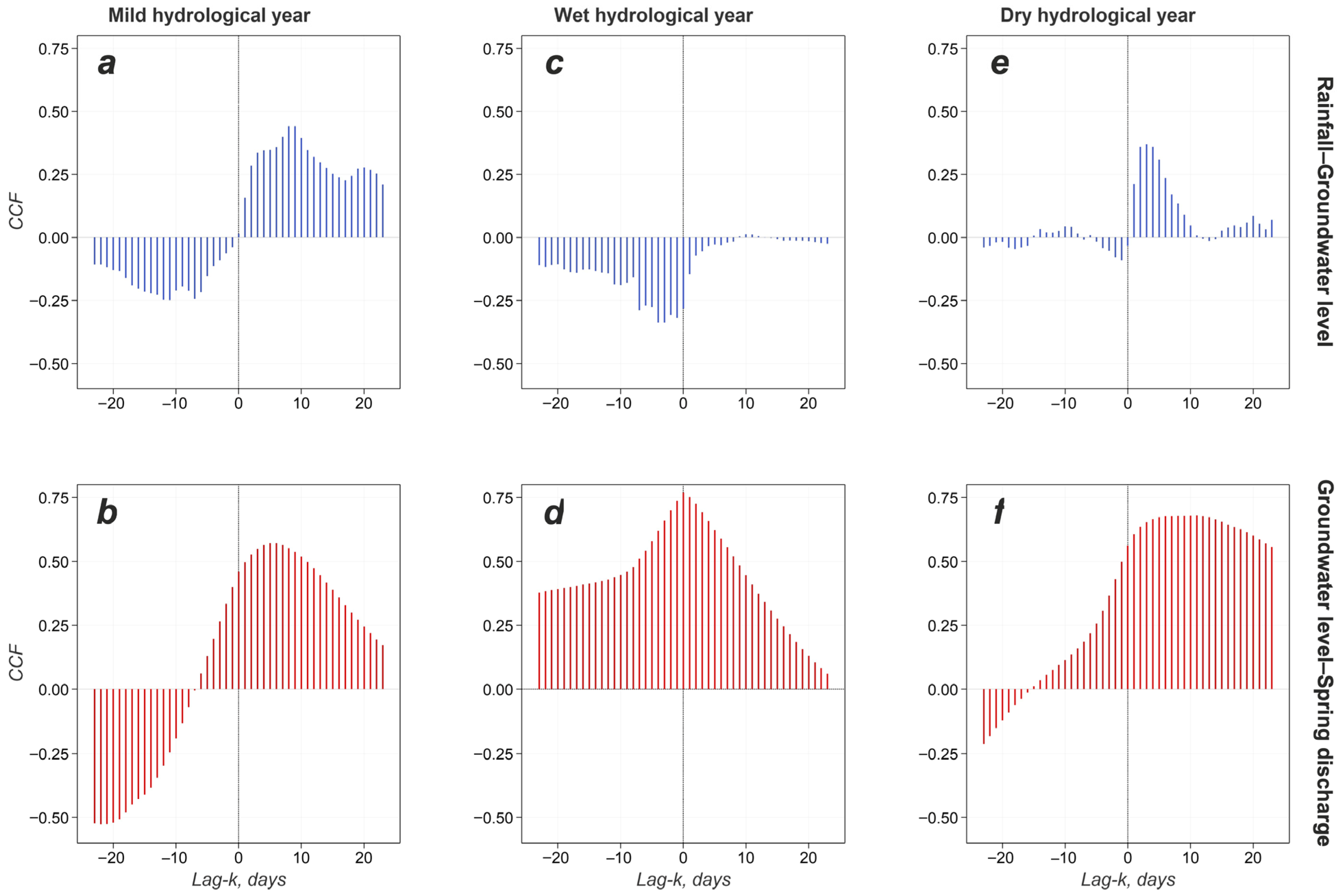
Cross-correlation functions (CCF) between rainfall and groundwater level (blue bars) and groundwater level and spring discharge (red bars) for different years; (a,b) 2021–2022, (c,d) 2022–2023, (e,f) 2023–2024 time series.
Results of cross-correlation analysis are shown in Figure 12, for lags from −20 to +20 days. Only positive lags should be considered, given the causal relationships among the variables. In wet years, the cross-correlation analysis indicates no direct correlation between daily precipitation and groundwater level (Figure 12c), as polje flooding buffers the precipitation input and delays the peak in the water table. High correlation with no time lag is observed between groundwater level and spring discharge (Figure 12d).
In mild years, the influence of daily precipitation on groundwater level is evident (Figure 12a). The CCF provides the time required for precipitation pulses to propagate through the system, although temporary polje flooding further contributes to delaying signal propagation. The peak correlation is reached after 8–9 days. An additional 6-day lag between groundwater level and spring discharge is detected via the cross-correlation function (Figure 12b). The location of the deep well explains the more rapid response of groundwater to precipitation (Figure 12a). In contrast, the smoother cross-correlation function in Figure 12b indicates strong damping of the signal as it travels and diffuses through the aquifer.
The “undisturbed” response of the saturated zone can be observed in dry years. During drought, the lag between precipitation and groundwater level decreases to approximately 3 days (Figure 12e), and the cross-correlation function declines rapidly. Rainfall is efficiently drained by the polje, and no flooding occurred. Recharge transits through the unsaturated zone within a few days, but it is limited and does not produce significant changes in the spring discharge. Therefore, the cross-correlation between groundwater level and spring discharge is essentially flat (shallow and smooth fluctuations; Figure 8b), indicating a weak response of the karst aquifer to recharge and a dominant inertial component in the spring discharge time series.
5. Conclusions
This preliminary study improves the knowledge about the recharge mechanisms of a heterogeneous and complex karst aquifer, such as the Terminio-Tuoro massif. This massif is crucial for the water supply of southern Italy as it hosts an extensive groundwater resource naturally drained by several basal springs.
These first results have made it possible to investigate the hydrological processes controlling recharge of the Terminio-Tuoro karst, during dry and wet years, and appear to be common to many other karst areas of the Apennines, characterized by similar climate and hydrogeological conditions. We observed wide groundwater level fluctuations (>50 m) within the saturated zone of the karst aquifer, and a fast response to recharge input; this behavior appears smoothed at the springs, due to the complex modulating and filtering effect of the aquifer saturated zone.
This study aimed to understand the contribution of Dragone Plain Polje to the recharge process of the Terminio-Tuoro karst aquifer. The polje’s lake has a pivotal role in modulating aquifer recharge. The lake impacts were recognized in the discharge time series of Cassano springs, confirming the hydraulic connection between the polje and these outlets. The formation and expansion of the ephemeral lake characterize the winter and early spring precipitation periods, which are controlled by antecedent soil moisture and rainfall intensity. Flooding occurs following two main mechanisms: (i) temporary flooding occurs in response to intense rainfall and, subsequently, runoff water accumulates because of the limited drainage capacity of the Dragone Mouth ponor; (ii) prolonged flooding occurs in wet hydrological years characterized by frequent and distributed intense rainfall, and by snowmelt. On the other hand, the lake is unlikely to form in dry years. The absence of the ephemeral lake during the entire winter-spring season can be assumed to be a proxy for prolonged meteorological drought, which reduces recharge and induces a groundwater drought.
Continuous monitoring of groundwater level allowed us to observe the recharge episodes within the saturated zone of the deep karst aquifer and, the relationships with precipitation and the temporary karst lake. This lake, as well as the snow mantle, represents a temporary water reservoir that delays aquifer recharge. Cross-correlation indicates that the typical transit time of recharge pulses through the unsaturated zone is on the order of a few days. Inflow through the Dragone Mouth Ponor alone provides a concentrated recharge of hundreds of liters per second, and it can likely exceed one thousand. The impacts of climate change, in terms of global warming, rainfall distribution variations, and reduced solid precipitation, could affect the frequency of the ephemeral karst lake formation and its magnitude. The combined monitoring of the water level and lake formation/duration appears to be an important tool for analyzing the observed reduction in the spring discharge over the last decades, and to prevent hydrological drought phenomena. Further studies, continuing the monitoring program, will aim to develop a new conceptual model of the aquifer and its recharge-discharge processes, also accounting for the interaction between lake dynamics and groundwater recharge.
Author Contributions
Conceptualization, G.L. and F.F.; methodology, G.L. and F.F.; software, S.A.C. and G.L.; validation, G.L., L.E. and F.F.; statistical analysis, G.L.; hydrological modeling, M.G.; filed measurements, M.G. and L.E.; data curation, S.A.C., M.G. and L.E.; figure preparation, G.L. and M.G.; writing—original draft preparation, all authors; writing—review and editing, G.L. and F.F.; supervision, G.L., L.E. and F.F. All authors have read and agreed to the published version of the manuscript.
Funding
This research received no external funding.
Data Availability Statement
Precipitation, temperature and hydrometric data can be found here (Functional Center of the Civil Protection of the Campania Region): https://centrofunzionale.regione.campania.it/#/pages/dashboard (accessed on 15 April 2026). Sentinel-2 satellite images can be found here (Copernicus Program, European Space Agency, ESA): https://browser.dataspace.copernicus.eu (accessed on 15 April 2026). Groundwater level data are available on request from the corresponding author. Spring discharge data are not publicy available and were provided by Acquedotto Pugliese S.p.A (Bari, Italy).
Acknowledgments
Authors are grateful to Acquedotto Pugliese S.p.A (Bari, Italy) for the spring discharge data and to the anonymous Reviewers for their helpful comments.
Conflicts of Interest
The authors declare no conflicts of interest.
References
- Stevanović, Z. Karst Waters in Potable Water Supply: A Global Scale Overview. Environ. Earth Sci. 2019, 78, 662. [Google Scholar] [CrossRef] [Scilit]
- Ćalić, J. Karstic Uvala Revisited: Toward a Redefinition of the Term. Geomorphology 2011, 134, 32–42. [Google Scholar] [CrossRef] [Scilit]
- White, W.B. Karst Hydrology: Recent Developments and Open Questions. Eng. Geol. 2002, 65, 85–105. [Google Scholar] [CrossRef] [Scilit]
- Fiorillo, F.; Pagnozzi, M.; Ventafridda, G. A Model to Simulate Recharge Processes of Karst Massifs. Hydrol. Process. 2015, 29, 2301–2314. [Google Scholar] [CrossRef] [Scilit]
- Bonacci, O.; Andrić, I. Karst Spring Catchment: An Example from Dinaric Karst. Environ. Earth Sci. 2015, 74, 6211–6223. [Google Scholar] [CrossRef] [Scilit]
- Ford, D.; Williams, D. Karst Hydrologyandgeo—Morphology; John Wiley & Sons: Chichester, UK, 2007. [Google Scholar]
- Cvijic’, J. Das Karstphänomen: Versuch Einer Morphologischen Monographie. Geogr. Abh. 1893, 5, 218–389. [Google Scholar]
- Gracia, F.J.; Gutiérrez, F.; Gutiérrez, M. The Jiloca Karst Polje-Tectonic Graben (Iberian Range, NE Spain). Geomorphology 2003, 52, 215–231. [Google Scholar] [CrossRef] [Scilit]
- Bonacci, O. Poljes, Ponors and Their Catchments. In Treatise on Geomorphology; Elsevier: Amsterdam, The Netherlands, 2013; pp. 112–120. ISBN 978-0-08-088522-3. [Google Scholar]
- Field, M. Lexicon of Cave and Karst Terminology with Special Reference to Environmental Karst Hydrology; EPA National Center for Environmental Assessment: Washington, DC, USA, 2002; p. 214. [Google Scholar]
- Gams, I. The Polje: The Problem of Definition. Z. Für Geomorphol. 1978, 22, 170–181. [Google Scholar] [CrossRef] [Scilit]
- Xanke, J.; Stevanović, Z.; Liesch, T.; Kaltenbrunn, A.; Ravbar, N.; Jourde, H.; Andreo, B.; Barberá, J.A.; Goldscheider, N. Flooding and Flood Water Storage in Karst Systems of the Mediterranean Region. Hydrogeol. J. 2024, 32, 1587–1605. [Google Scholar] [CrossRef] [Scilit]
- Luca, Z.; Chiara, C.; Emanuele, F.; Philippe, T. Flood Hazard Assessment in a Polje: The Case of Mucille (Classical Karst Region, NE Italy). Environ. Earth Sci. 2023, 82, 293. [Google Scholar] [CrossRef] [Scilit]
- Bonacci, O. Karst Springs Hydrographs as Indicators of Karst Aquifers. Hydrol. Sci. J. 1993, 38, 51–62. [Google Scholar] [CrossRef] [Scilit]
- López-Chicano, M.; Calvache, M.L.; Martín-Rosales, W.; Gisbert, J. Conditioning Factors in Flooding of Karstic Poljes—The Case of the Zafarraya Polje (South Spain). CATENA 2002, 49, 331–352. [Google Scholar] [CrossRef] [Scilit]
- Gunn, J. Point-Recharge of Limestone Aquifers—A Model from New Zealand Karst. J. Hydrol. 1983, 61, 19–29. [Google Scholar] [CrossRef] [Scilit]
- Vitale, S.; Ciarcia, S. Tectono-Stratigraphic Setting of the Campania Region (Southern Italy). J. Maps 2018, 14, 9–21. [Google Scholar] [CrossRef] [Scilit]
- Corniello, A.; Ducci, D.; Aquino, A. Hydrogeological Map of the Monti Picentini Regional Park (Southern Italy) at 1: 50,000 Scale. Boll. Geofis. Teor. Ed Appl. 2010, 51, 325–343. [Google Scholar]
- Fiorillo, F.; Leone, G.; Pagnozzi, M.; Esposito, L. Long-Term Trends in Karst Spring Discharge and Relation to Climate Factors and Changes. Hydrogeol. J. 2021, 29, 347–377. [Google Scholar] [CrossRef] [Scilit]
- Celico, P. The Suspended Water-Tables of the Mt. Terminio Carbonatic Massif (Campania); Their Hydrogeologic Implications and Significance. In Appennino Meridionale; Annuario Club Alpino Italiano: Sezione Napoli, Italy, 1988; pp. 99–112. [Google Scholar]
- Chambers, J.M.; Cleveland, W.S.; Kleiner, B.; Tukey, P.A. Graphical Methods for Data Analysis, 1st ed.; Chapman and Hall/CRC: London, UK, 2018; ISBN 978-1-351-07230-4. [Google Scholar]
- Duvert, C.; Jourde, H.; Raiber, M.; Cox, M.E. Correlation and Spectral Analyses to Assess the Response of a Shallow Aquifer to Low and High Frequency Rainfall Fluctuations. J. Hydrol. 2015, 527, 894–907. [Google Scholar] [CrossRef] [Scilit]
- Manga, M. On the Timescales Characterizing Groundwater Discharge at Springs. J. Hydrol. 1999, 219, 56–69. [Google Scholar] [CrossRef] [Scilit]
- Box, G.E.P.; Jenkins, G.M.; Reinsel, G.C.; Ljung, G.M. Time Series Analysis: Forecasting and Control. In Wiley Series in Probability and Statistics, 5th ed.; John Wiley & Sons, Inc.: Hoboken, NJ, USA, 2016; ISBN 978-1-118-67502-1. [Google Scholar]
- Hyndman, R.J.; Athanasopoulos, G. Forecasting: Principles and Practice, 3rd ed.; OTexts: Melbourne, Australia, 2021; ISBN 978-0-9875071-3-6. [Google Scholar]
- Thornthwaite, C.W.; Mather, J.R. The Water Balance; Publications in Climatology; Drexel Institute of Technology, Laboratory of Climatology: Centerton, NJ, USA, 1955; Volume 8, pp. 1–104. [Google Scholar]
- Mayaud, C.; Gabrovšek, F.; Blatnik, M.; Kogovšek, B.; Petrič, M.; Ravbar, N. Understanding Flooding in Poljes: A Modelling Perspective. J. Hydrol. 2019, 575, 874–889. [Google Scholar] [CrossRef] [Scilit]
- Fiorillo, F.; Doglioni, A. The Relation between Karst Spring Discharge and Rainfall by Cross-Correlation Analysis (Campania, Southern Italy). Hydrogeol. J. 2010, 18, 1881–1895. [Google Scholar] [CrossRef] [Scilit]

Disclaimer/Publisher’s Note: The statements, opinions and data contained in all publications are solely those of the individual author(s) and contributor(s) and not of MDPI and/or the editor(s). MDPI and/or the editor(s) disclaim responsibility for any injury to people or property resulting from any ideas, methods, instructions or products referred to in the content. |
© 2026 by the authors. Licensee MDPI, Basel, Switzerland. This article is an open access article distributed under the terms and conditions of the Creative Commons Attribution (CC BY) license.