


Abstract
To address the urgent need for enhancing landslide risk monitoring in reservoir embankment slopes, a core component of water conservancy projects, this paper proposes the LRES-YOLO algorithm for real-time landslide detection on reservoir embankments. In LRES-YOLO, we first integrate coordinate attention into basic feature extraction convolutional blocks to form the CACBS attention module, which enhances the model’s ability to identify and locate landslide targets in complex reservoir terrain, overcoming positional information insensitivity in deep networks. Second, we add novel downsampling DP modules and ELAN-W modules to the backbone network, improving feature recognition efficiency for embankment slopes with diverse hydrological and topographical interference. Third, we optimize the feature fusion network with targeted concatenation and pooling operations, balancing semantic information enhancement with computational load reduction to mitigate overfitting in variable reservoir environments. Finally, we adopt Focal Loss and EIoU Loss to accelerate training convergence and strengthen target feature representation for small or obscured landslides on embankments. Experimental results show that LRES-YOLO outperforms traditional algorithms in detecting landslides across diverse reservoir embankment scenarios: it achieves an average improvement of 8.4 percentage points in mean mAP over the best-performing baseline across five independent trials, a detection speed of 8.2 ms per image, and memory usage of 139 MB. This lightweight design makes it suitable for edge computing devices, providing robust technical support for intelligent monitoring systems in water conservancy projects.
1. Introduction
In recent years, the number of artificial slopes in water conservancy projects such as reservoir dams, as well as mountain highways, railways, and open-pit mines, has been increasing [1]. Frequent landslide accidents triggered by heavy rainfall have caused severe socioeconomic losses and hindered sustainable development. Notably, landslides around reservoir dams can lead to spillway blockages, raise the reservoir bed elevation, and in extreme cases, impede flood discharge and drainage functions, thereby disrupting water supply, hydropower generation, and regional safety. Meanwhile, investigations into probabilistic slope stability under complex geotechnical conditions [2] and the fracture behavior of geological materials subjected to extreme thermal loading [3] have further deepened the theoretical understanding of slope failure mechanisms. Thus, enhancing the monitoring and early warning of slope landslides in reservoir dam areas has become a critical priority in water conservancy engineering [4].
Currently, common slope landslide monitoring methods in water conservancy scenarios are mainly divided into slope displacement monitoring, slope landslide formation monitoring, slope landslide deformation monitoring [5], monitoring based on fiber Bragg grating sensor technology [6], video image recognition technology, and manual inspection [7]. Absolute displacement monitoring of slopes mainly employs geodetic methods [8,9], GPS measurement [10], and remote sensing technology [11]. Although these technologies are relatively mature, they are greatly affected by terrain and meteorological conditions, and they are costly. Slope landslide monitoring primarily involves meteorological monitoring, human activity monitoring, and groundwater dynamics monitoring [12], but the applicability of these methods is limited as the monitoring variables need to be analyzed based on the environment. Slope landslide deformation monitoring is mainly used for deformation monitoring and related anomaly detection in areas that need monitoring. However, the shortcomings of this method include numerous monitoring factors and significant human resource requirements [13,14].
With the development of modern computer vision technology, it has become possible to solve practical engineering problems using machine learning-based target detection algorithms. For example, ref. [15] used HOG and LBP features to detect landslides and background objects using a random forest structure, transforming the binary classification problem between landslides and background objects into a regression problem of landslide probability. Although this approach reduced the problem of unbalanced data distribution, the detection accuracy was not high and was susceptible to the quality of the dataset. Similarly, ref. [16] processed and modeled landslide point data using three-dimensional laser scanning technology, and then used a convolutional neural network (CNN) to evaluate selected landslide points and compared them with field test values, achieving landslide detection. Researchers have also introduced Transformer-based architectures and small-sample learning methods into the field of landslide detection: ref. [17] embedded a Vision Transformer and CBAM attention module into ResU-Net, achieving superior mIoU and F1-score across geologically diverse datasets; ref. [18] proposed a meta-learning intermediate representation to enable few-shot prediction of landslide susceptibility over large heterogeneous areas. YOLO series algorithms [19,20,21], as representative target detection algorithms, exhibit fast and precise detection performance. To improve detection performance in complex landslide scenarios, researchers have proposed various improved YOLO variants: ref. [22] developed YOLOX-Pro with VariFocal loss and a redesigned backbone for more universal detection; ref. [23] combined the GEE platform with an improved YOLOX for automatic loess landslide detection; ref. [24] proposed SE-YOLOv7 with Squeeze-and-Excitation attention and an improved loss function for better feature discrimination. However, existing methods still exhibit notable limitations in reservoir embankment slope scenarios. Traditional approaches generalize poorly across diverse environments. Transformer-based and few-shot methods involve high computational complexity that hinders real-time deployment. Improved YOLO variants are mainly validated on open-terrain or loess scenarios, and their performance under reservoir embankment conditions, including background similarity, rain interference, and large-scale targets, remains insufficient, leading to false detections, missed detections, and excessive model parameters.
To address these limitations, this paper proposes LRES-YOLO, a landslide detection algorithm specifically tailored for reservoir embankment slope scenarios. By targeting the unique challenges of this environment, including complex background interference, adverse weather conditions, and large-scale slope targets, LRES-YOLO achieves improved detection accuracy and robustness while maintaining a lightweight architecture suitable for real-time edge deployment in water conservancy monitoring systems.
2. Methodology
2.1. Target Detection Algorithm for Landslides on Reservoir Embankment Slopes: LRES-YOLO
To effectively improve the detection accuracy of slope landslides around reservoir dams, YOLO series algorithms perform poorly in large-scale target scenarios like slope landslides, leading to false positives and missed detections. In this paper, a slope landslide detection algorithm, LRES-YOLO, is proposed to enhance the recognition accuracy of reservoir dam slope landslides.
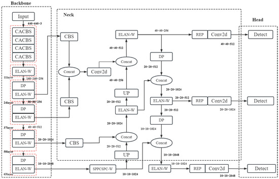
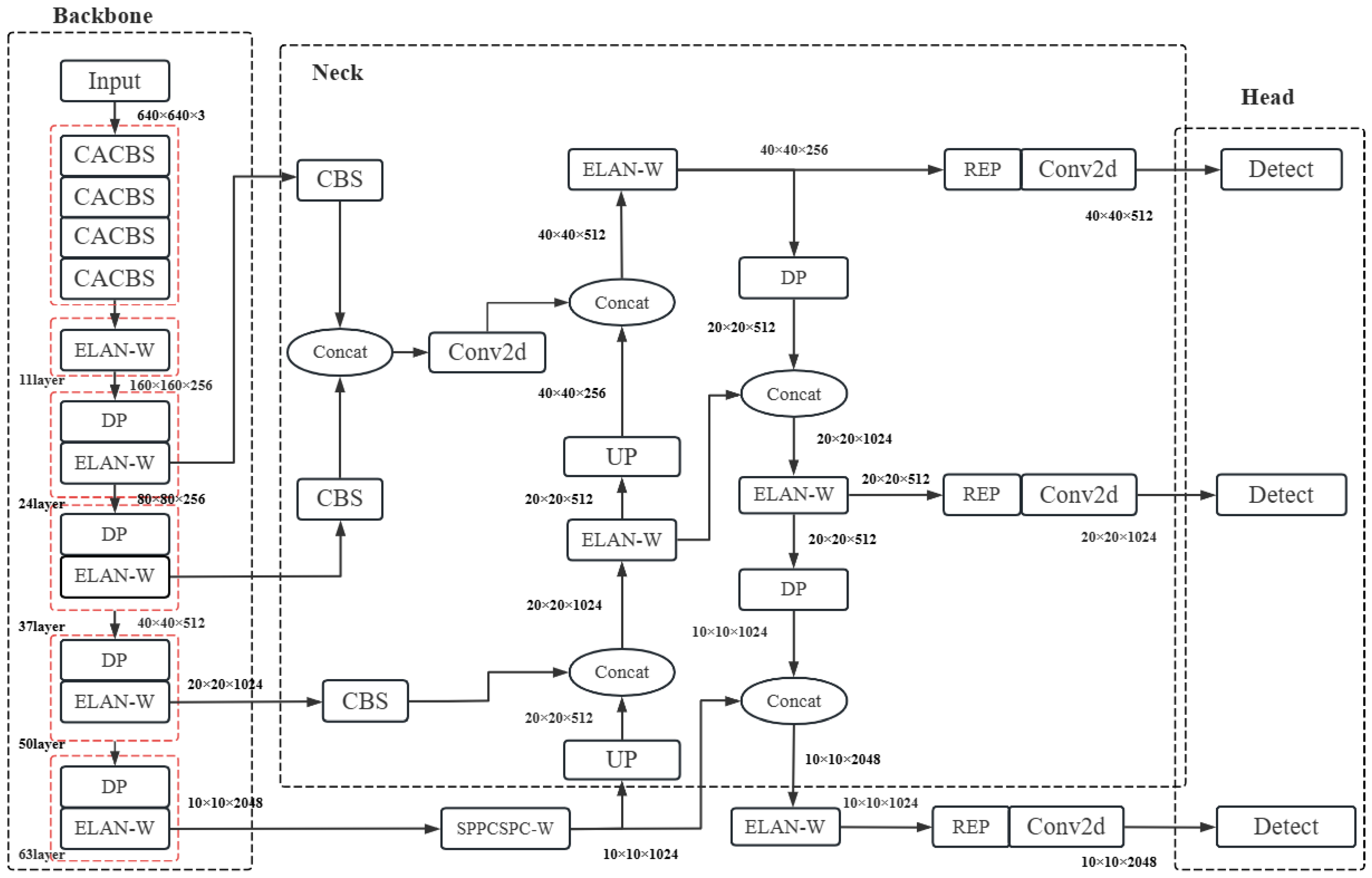
Specifically, the proposed algorithm introduces a coordinate attention mechanism (CA) [25] and integrates it into convolution blocks (CBS, Conv + Batchnorm + Silu) to form an innovative attention convolution module (CACBS, Coordinate Attention + Conv + Batchnorm + Silu). This allows the model to more accurately identify and locate slope landslide targets, effectively addressing the false positives and missed detections in algorithms. In addition, more layers are added to the backbone feature extraction network, including a downsampling module (DP, Downsample) [26] with a kernel size of 2 × 2 for max pooling, and a multi-branch stacked module (ELAN-W) formed by combining an extended efficient layer aggregation network (ELAN) with the attention convolution module. This improves recognition efficiency in large-scale target scenarios. More effective feature maps of different scales are concatenated in the feature fusion network, and additional pooling operations are introduced, which not only extract rich semantic information but also reduce computational load, avoiding overfitting caused by an excessive number of parameters. The target detection network architecture of LRES-YOLO algorithm is shown in Figure 1.
Figure 1.
LRES-YOLO network architecture (red dashed boxes denote module groups in the Backbone).
2.2. Improved Attention Module with Integrated Coordinate Attention (CA)
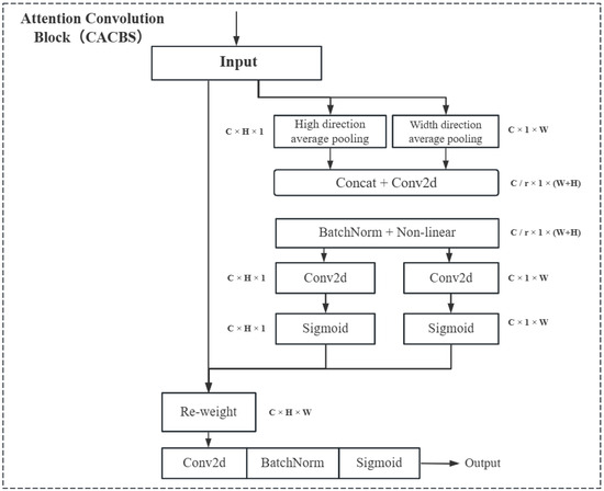
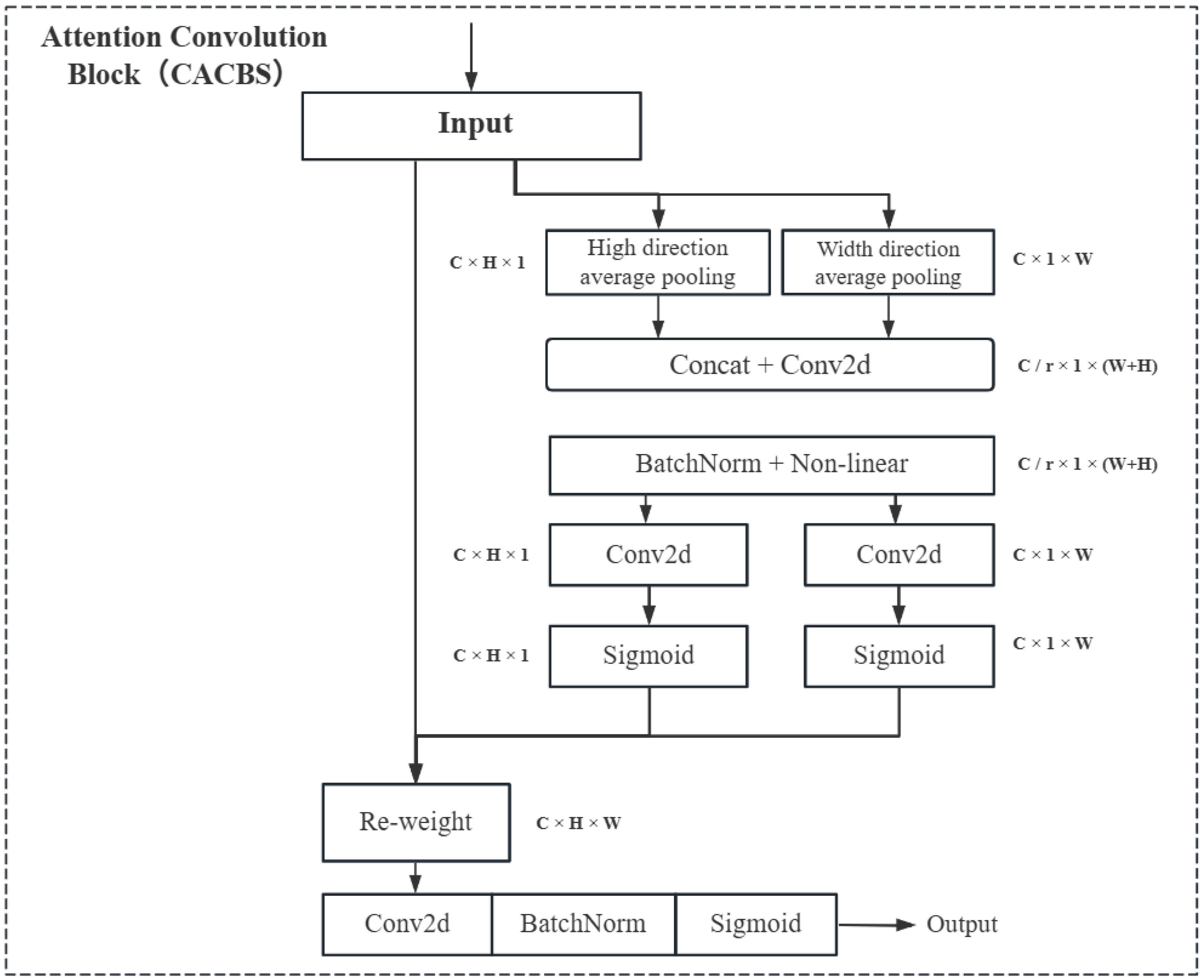
For reservoir dam slope landslide recognition, most cases involve large-scale slope targets. Convolution operations can only extract local relationships and lack the ability to capture long-range dependencies. The coordinate attention mechanism (CA) not only encodes horizontal and vertical positional information into channel attention but also allows the network to focus on a broader range of positional information without significantly increasing computational cost. To this end, by integrating the CA attention module into the convolution layer CBS, an improved attention convolution module, CACBS, is proposed. This module can selectively focus on regions of interest while also addressing long-range dependency issues in features. The specific network structure is shown in Figure 2. The coordinate attention mechanism can transform any intermediate feature tensor within the network and output a tensor of the same size. To obtain attention in the width and height directions and encode precise positional information, take the third effective feature map output from the backbone network with a dimension size of 10 × 10 × 2048 as an example. The feature map is first divided into width and height directions, and global average pooling is performed according to the following Equation (1), resulting in a width direction feature map of size (2048, 10, 1) and a height direction feature map of size (2048, 1, 10).
where represents the output of the c-th channel at horizontal position w, represents the output of the c-th channel at vertical position h, and and denote the corresponding spatial entries of the intermediate feature tensor
Figure 2.
Attention Convolution Block Network Architecture.
Next, the width and height dimensions are concatenated, and then a 1 × 1 shared convolution is used to adjust the channel dimensions, resulting in intermediate feature maps that encode spatial information in the width and height directions. These are then normalized and passed through a linear layer, followed by processing using the following Equation (2). Specifically, two 1 × 1 convolution transformations are applied to the width and height direction feature maps, respectively. An activation function is then used to obtain the attention weights for the width and height directions, and .
where is the Sigmoid activation function [27], and are the 1 × 1 convolution transformations for the width and height directions, and and are the feature maps in the width and height directions, respectively.
Finally, the original feature map of size 10 × 10 × 2048 is weighted using multiplication (as shown in Equation (3)), resulting in the final feature map with attention weights in both the width and height directions, maintaining the same size of 10 × 10 × 2048.
where represents the feature map with attention weights in both the width and height directions, represents the convolution layer with an input kernel size of , and and represent the attention weight values in the width and height directions, respectively.
2.3. Improved Backbone Network Module
The backbone network in deep learning usually consists of multiple convolutional and pooling layers. These hierarchical operations gradually reduce the size of the feature maps while increasing the number of channels, extracting richer and more abstract features. The backbone network can learn a large number of parameters to adapt to different tasks and datasets, providing the network with a certain level of representation and generalization ability.
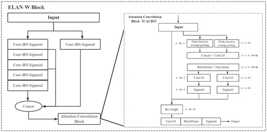
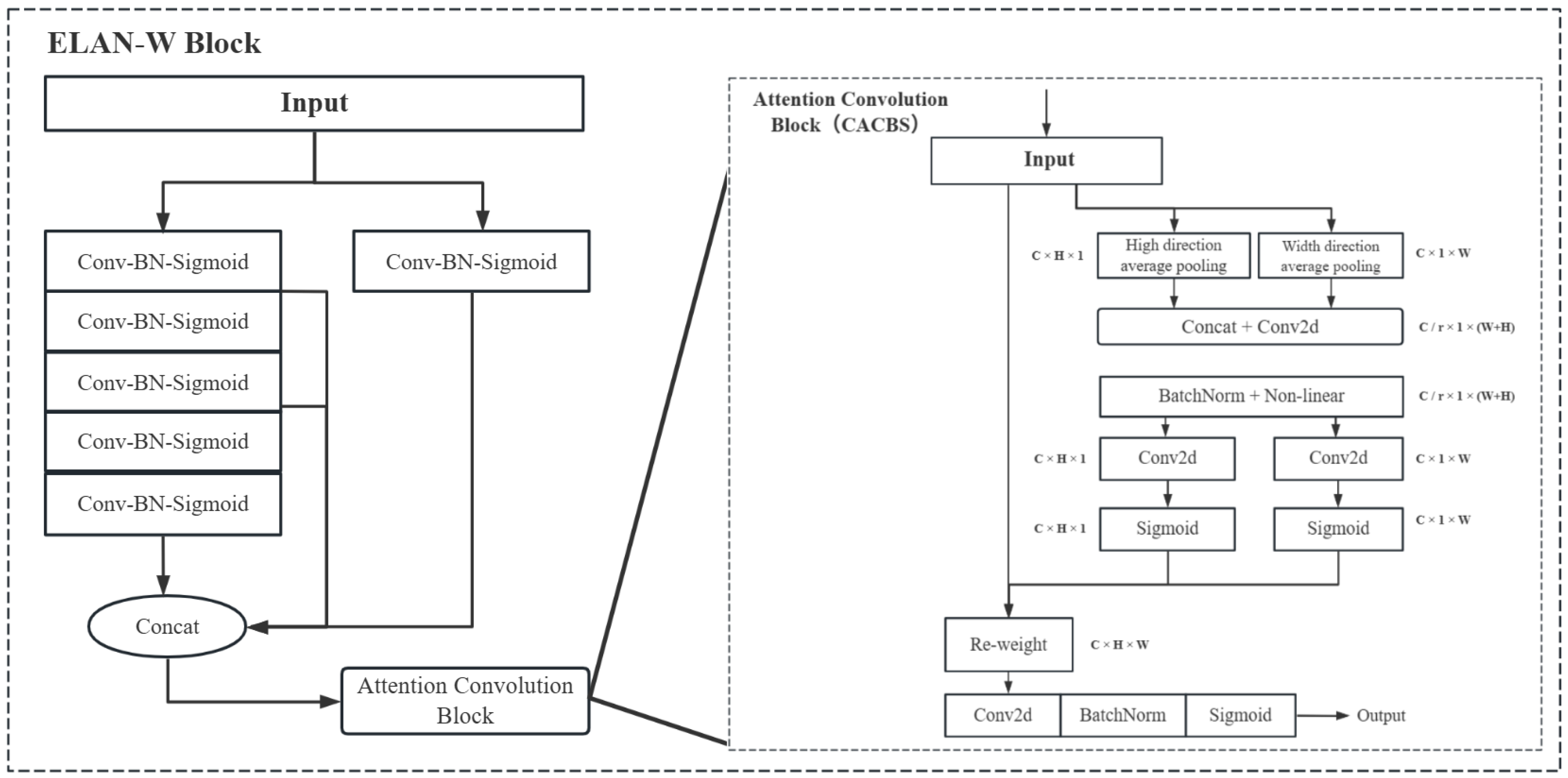
To enhance the recognition capability in dam slope landslide scenarios, a slope landslide detection algorithm, LRES-YOLO, is proposed, as shown in Figure 1. The backbone mainly consists of four components: the aforementioned attention convolution module (CACBS), the 2 × 2 max pooling module (DP), and the multi-branch stacked module (ELAN-W). In the initial layers of the backbone network, the improved attention convolution module replaces the standard feature extraction convolution modules, enhancing the extraction capability of image information. The Downsampling module is replaced by a 2 × 2 max pooling operation, reducing the number of parameters without compromising accuracy. The multi-branch stacked module ELAN-W (shown in Figure 3) is formed by combining the proposed attention convolution module (CACBS) with the backbone’s efficient layer aggregation module (ELAN), which helps to extract image features while avoiding the loss of deep positional information.
Figure 3.
ELAN-W Network Structure Based on the Proposed Attention Convolution Module (CACBS).
Next, to further enhance the recognition capability of dam slope landslides, additional layers are added to the backbone, incorporating the aforementioned max pooling module (DP) and multi-branch stacked module (ELAN-W). Thus, the improved backbone network outputs three effective feature maps with dimensions of (40, 40, 512) from layer 37, (20, 20, 1024) from layer 50, and (10, 10, 2048) from layer 64. On the one hand, the improvements enhance the model’s representation capability, enabling it to better adapt to complex data distributions and tasks. On the other hand, the deeper network structure allows it to learn more and more abstract features, making it more robust to small variations in the input data and improving the model’s accuracy.
This combination is motivated by the inherent limitation of standard YOLO backbones, which lose spatial positional information as the network deepens. For reservoir embankment slope landslide detection, where targets are large-scale and spatially irregular, such positional information loss directly leads to false positives and missed detections. CACBS is therefore introduced to embed coordinate attention into the basic convolution block, preserving horizontal and vertical positional information throughout feature extraction. The DP module replaces strided convolution with 2 × 2 max pooling for downsampling, reducing parameters while retaining dominant feature responses without sacrificing detection capability. ELAN-W combines the multi-branch aggregation structure of ELAN with CACBS, enabling the backbone to simultaneously aggregate multi-scale features and retain deep positional information under complex reservoir terrain conditions, thereby improving overall detection robustness.
2.4. Improved Feature Fusion Module
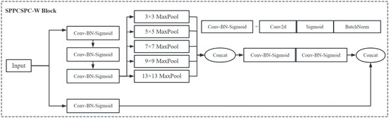
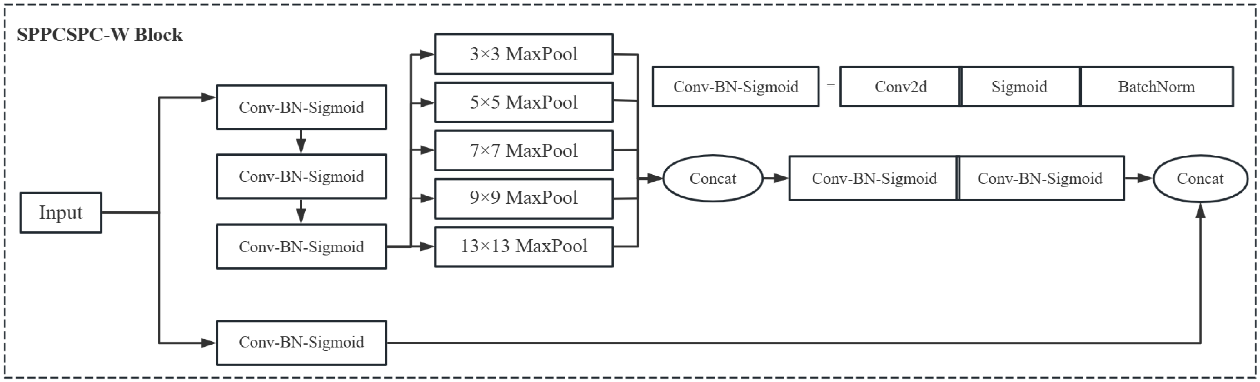
The feature fusion module is mainly used to enhance the feature extraction capability of the network. By using a unique network structure called SPPCSPC, it captures multi-scale contextual information from the backbone network output and fuses features through different paths to reduce redundancy in the feature maps and improve feature representation. However, adding more layers to the backbone network increases the computational load of the model. To reduce the computational burden introduced by this modification, an improved spatial pyramid pooling module, referred to as SPPCSPC-W, is proposed. This module uses max pooling operations of different kernel sizes—3 × 3, 5 × 5, 7 × 7, 9 × 9, and 13 × 13—to pool the original feature maps into sub-feature maps of different scales and concatenate them, obtaining more comprehensive and richer feature representations. More pooling operations help to prevent overfitting by reducing the number of parameters. The structure of the improved SPPCSPC-W module is shown in Figure 4.
Figure 4.
SPPCSPC-W Block Network Structure.
Additionally, to integrate more feature map information during feature extraction, the third effective feature map output from the backbone network, with dimensions of 10 × 10 × 2048, is upsampled and concatenated with the output feature map from layer 50 of the improved backbone network after the attention convolution block, resulting in a feature map of size 20 × 20 × 512. This is then processed through the multi-branch stacked module ELAN-W and the DP module to obtain the first feature map of size 40 × 40 × 256. The feature maps output by layers 24 and 37 of the backbone network are then concatenated, and after processing through the attention convolution module, a second feature map of size 40 × 40 × 256 is obtained. The two feature maps, each containing different feature information and of size 40 × 40 × 256, are then concatenated. This not only ensures that positional information is preserved but also provides richer semantic information.
2.5. Improved Loss Function Module
The loss function is used to measure the difference between predicted results and true labels. By minimizing the loss function, the model’s parameters are optimized, allowing the model to accurately predict the position and category of the target. The loss function consists of three parts: the localization loss function, the classification loss function, and the confidence loss function. The confidence loss and classification loss functions are calculated using binary cross-entropy, while the localization loss function is computed using CIOU Loss [28]. However, both binary cross-entropy [29] and CIOU Loss have certain limitations when applied to reservoir slope landslide recognition, as they struggle to distinguish overlapping target regions effectively.
Therefore, a Focal loss function [30] is proposed, incorporating a dynamic scaling factor based on binary cross-entropy (CE) to reduce the weight of easily distinguishable samples during training, thus quickly shifting the focus to the difficult-to-distinguish samples. This is used to calculate the classification loss, with the specific calculations given in Equations (4)–(6).
The Focal Loss is reformulated as a unified expression in Equation (6).
where is a balancing factor used to balance the number of positive and negative samples, p is the predicted probability by the model, and is a modulation factor used to adjust the weight of easy and hard samples. By introducing the modulation factor , Focal Loss can effectively address the class imbalance problem in object detection. It focuses more on the difficult-to-classify samples, thereby improving the model’s ability to predict minority classes and enabling more accurate prediction of target locations and categories.
In addition, based on the penalty term of CIoU, the influence factors of aspect ratio are separated, and the EIoU loss function [31] is used to calculate the localization loss by individually calculating the lengths and widths of the target box and the predicted box. By breaking down the localization loss into overlap loss, center distance loss, and width–height loss, the training convergence speed is accelerated. The specific calculation is given in Equation (7).
where and represent the width and height of the closure between the ground truth box and the predicted box, respectively. As can be seen from the equation, the loss function is divided into three parts: IoU loss , center distance loss , and width-height loss .
By combining the classification loss calculated by the aforementioned Focal Loss with the high-precision regression loss function EIoU Loss for localization loss, the proposed approach optimizes the sample imbalance problem in the bounding box regression task. It allows the regression process to focus on high-quality anchor boxes, while also accelerating convergence and improving the precision of regression.
2.6. Generative Adversarial Network with Fusion Image Super Resolution
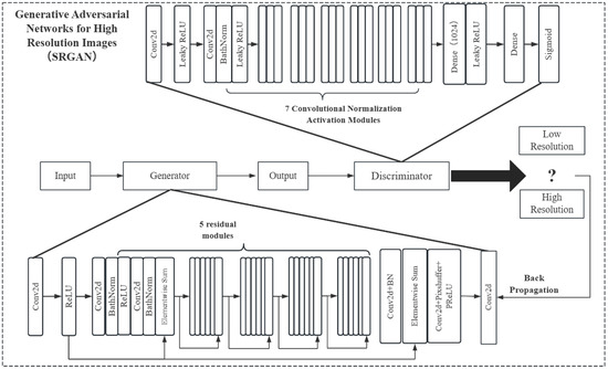
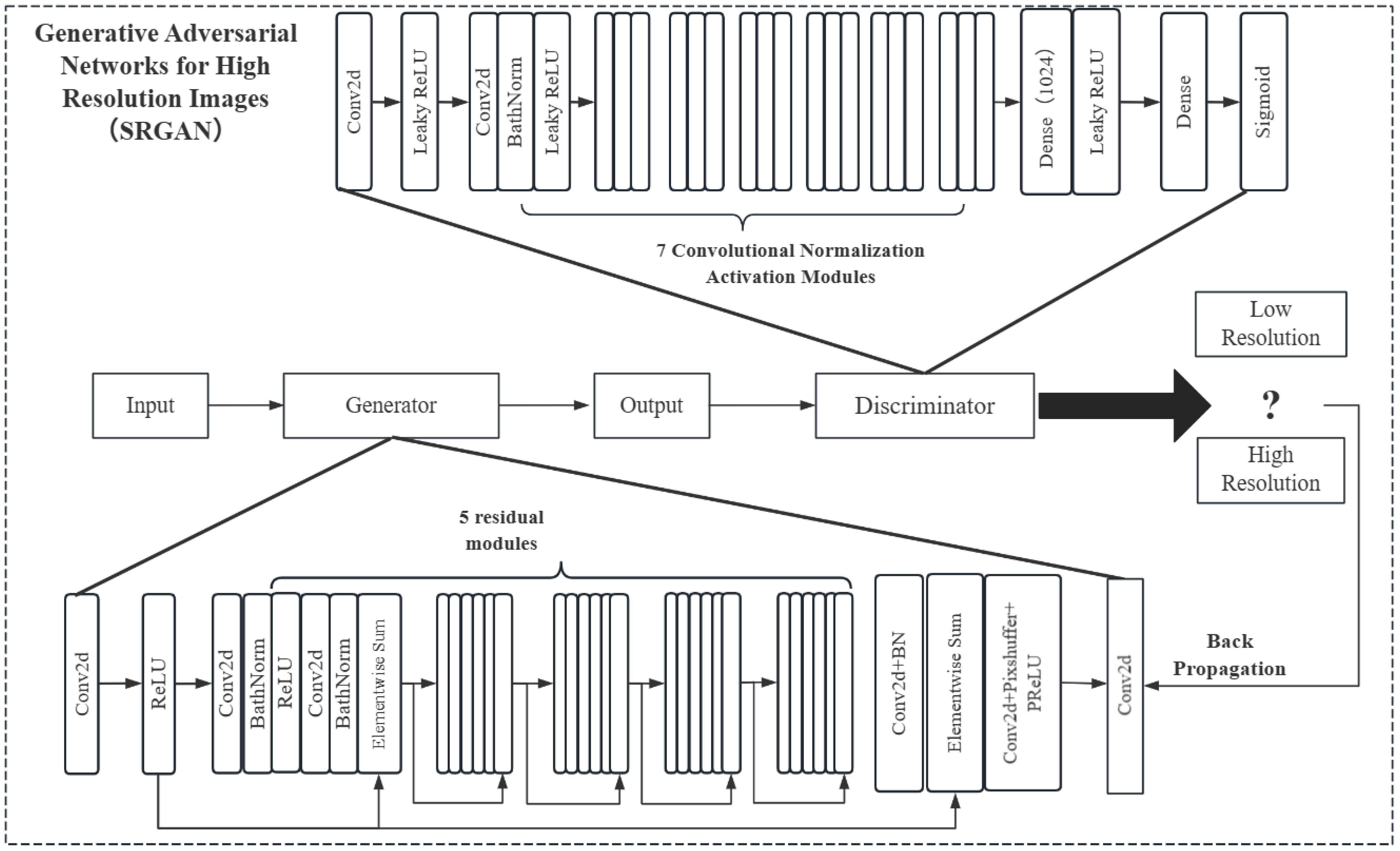
To improve the robustness of the monitoring system under low-resolution conditions, a Super-Resolution Generative Adversarial Network (SRGAN) model [32] is proposed. In practical reservoir embankment monitoring, cameras often capture low-resolution images due to equipment limitations, adverse weather, or long-range shooting distances. Therefore, SRGAN is designed as a front-end enhancement module integrated into the complete LRES-YOLO detection pipeline. The full system processes incoming images through SRGAN enhancement before feeding them into the detection model. To ensure consistency between training and testing, SRGAN is applied to low-resolution samples in both the training and test sets. This setup evaluates the end-to-end performance of the entire system, which directly reflects the intended deployment workflow. The structure of SRGAN is shown in Figure 5. It mainly generates high-quality high-resolution images through adversarial training, which includes two parts: the generator and the discriminator. The generator is a deep convolutional neural network that receives a low-resolution input image and attempts to generate an output image similar to a high-resolution image. The generator uses transposed convolution and residual blocks to increase the image resolution, and employs skip connections to retain more detail. The generator’s goal is to produce high-quality high-resolution images that can deceive the discriminator. The discriminator is also a deep convolutional neural network, and its goal is to evaluate the authenticity of the input image. Through training, it improves its ability to distinguish between real and generated images. It uses convolutional layers and fully connected layers to classify images and updates its parameters based on the classification results.
Figure 5.
SRGAN Network Structure.
The training process of SRGAN is carried out by alternately training the generator and the discriminator. In each training iteration, the generator produces a batch of high-resolution images, which are then passed to the discriminator for evaluation. The discriminator classifies the images generated by the generator alongside real high-resolution images, and updates its parameters based on the classification results. The generator, in turn, updates its parameters based on the evaluations from the discriminator to better deceive it. Through iterative training, both the generator and discriminator gradually improve their abilities. Eventually, the generator can produce high-quality high-resolution images, while the discriminator becomes increasingly challenged to distinguish between generated images and real high-resolution images.
3. Experiments
3.1. Experiments Setting
The experimental equipment and parameter settings for algorithm performance validation and comparative analysis are shown in Table 1.
Table 1.
Experiment Devices.
3.2. Datasets
The available public landslide slope datasets are limited and often come from a single source. To address this issue and construct a more representative dataset for reservoir embankment scenarios, we collected images from multiple reservoir embankment areas during different seasons and weather conditions, including sunny days, rainy days, and overcast conditions. The dataset primarily consists of soil-type landslides on reservoir embankment slopes. The scenes contain various interference factors such as vegetation coverage, water surface reflection, turbid water, and engineering construction disturbances including personnel and equipment. All images were captured in actual field settings and preprocessed to a unified resolution of 640 × 640 pixels. The Labelimg tool was then used to label the landslides in the dataset as the “landslide” class, generating the corresponding .xml label files for reservoir dam slope landslides. The dataset was then split into a ratio of 7:2:1, resulting in 840 images for training, 240 for validation, and 120 for testing. To simulate real-world deployment conditions where reservoir embankment monitoring systems frequently capture low-resolution images due to equipment limitations, adverse weather, or long-range shooting distances, a super-resolution generative adversarial network is employed as a front-end enhancement module. Specifically, SRGAN is applied to low-resolution samples in both the training and test sets, while original high-resolution samples remain unchanged. This ensures that the model operates on inputs with similar quality distributions during training and testing, avoiding an artificial domain gap that would misrepresent real-world performance. Meanwhile, by applying Mosaic data augmentation to the dataset, the diversity and robustness of the training samples are enhanced.
3.3. Training the Model
Based on the characteristics of reservoir dam slope landslide hazards, the experimental parameters for the LRES-YOLO algorithm are set as follows: the batch size is set to 16, meaning that 16 samples are extracted in each training iteration. To enhance the generalization ability during training, the learning rate is set to 0.01 and gradually decreases as training progresses until convergence is reached, after which it remains constant. The number of training epochs is set to 300. Next, the previously divided training set is fed into the LRES-YOLO algorithm for training, while the validation set is used to validate the training results. Through continuous backpropagation, the training parameters are updated to obtain the optimal weight file. The super-resolution generative adversarial network (SRGAN) is then used to process the test set, converting low-resolution images in the test set to high-resolution ones. Finally, the processed test set is used to test the trained LRES-YOLO algorithm, and the model’s performance is evaluated.
4. Results
4.1. Evaluation Metrics of the Experiment
Based on the results of testing the model on the test set, the recognition accuracy, recall, F1-score (harmonic mean of precision and recall), and the mean average precision (mAP) for each category are calculated to evaluate the model’s performance. The specific equations are as follows:
- (1)
- Accuracy: Proportion of correct predictions among all test samples. The equation is given in Equation (8).
- (2)
- Recall: Proportion of Correct Predictions. The equation is given in Equation (9).
- (3)
- F1-score: Ranges from 0 to 1, with a value closer to 1 indicating better model performance. The F1-score is calculated as a weighted average of precision and recall, ensuring that the model performs well in predicting both positive and negative samples. The calculation equation is presented in Equation (10).
- (4)
- mAP (mean Average Precision): Mean Average Precision for Each Class. The calculation equation is presented in Equation (11).where represents the average precision at different recall levels, and is the total number of classes.
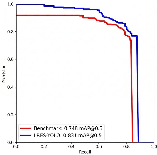
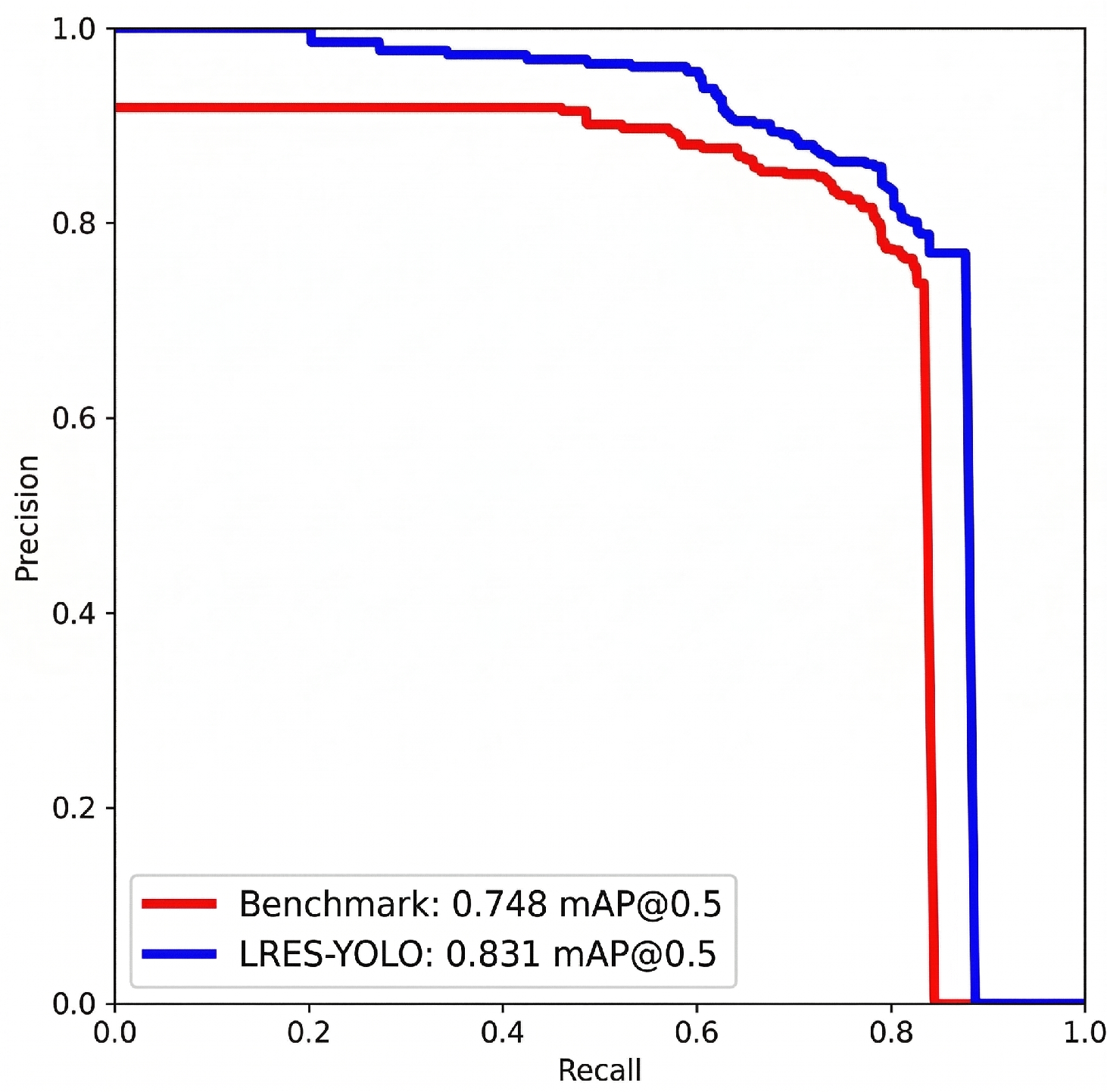
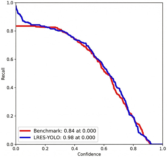
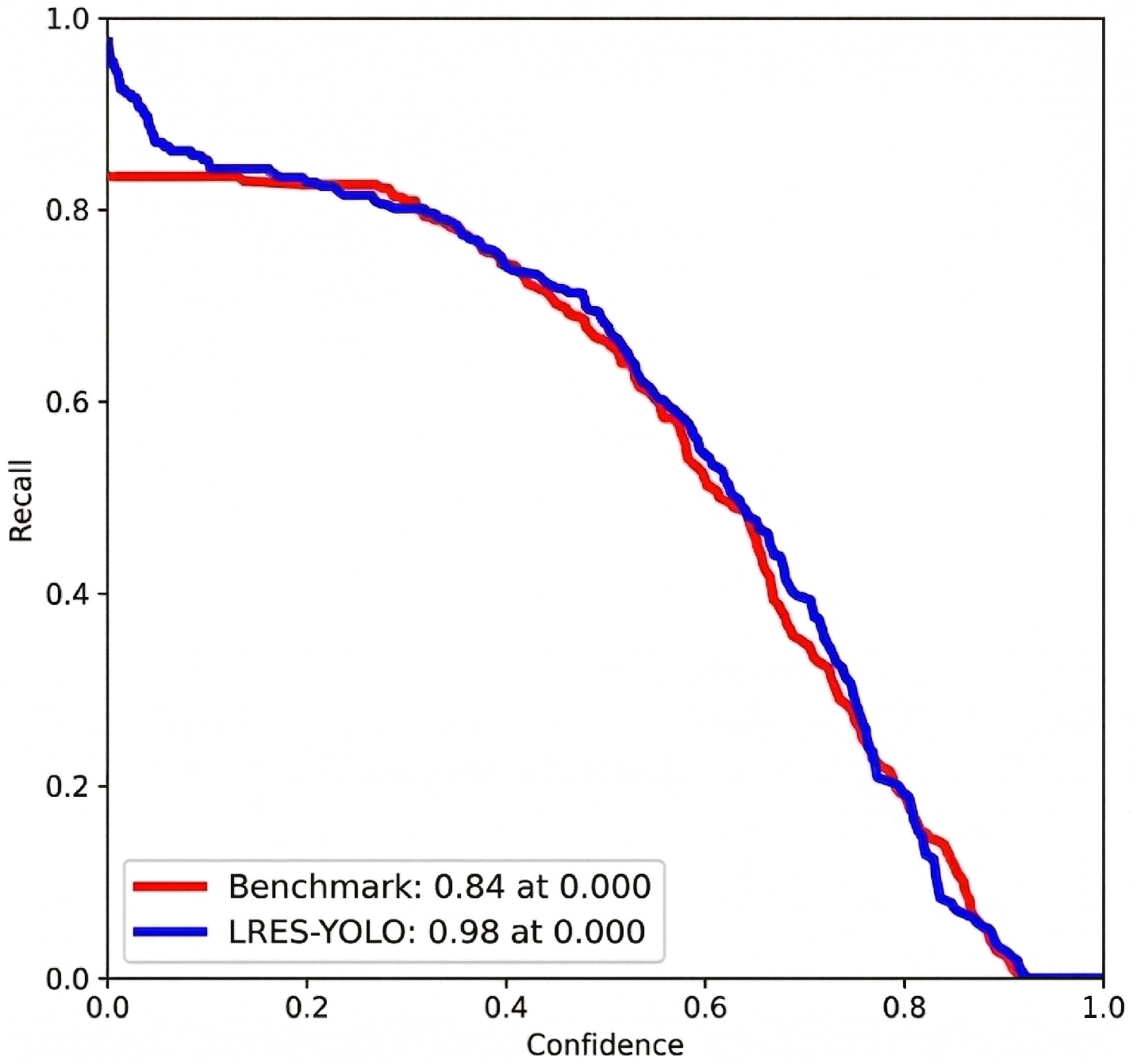
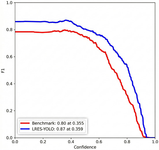
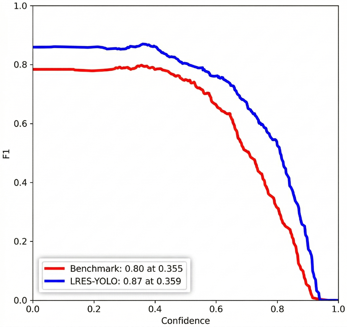
As shown in Figure 6, Figure 7 and Figure 8, the Precision–Recall relationship, the Recall–Confidence relationship, and the F1-score–Confidence relationship are respectively compared between the benchmark algorithm and the proposed LRES-YOLO algorithm. These curves are obtained from a representative single trial. Among the five independent runs, the run whose key evaluation metrics are closest to the corresponding five-trial means is selected, ensuring that the figures show typical curve shapes without overlapping five sets of curves.
Figure 6.
Relationship between Precision and Recall.
Figure 7.
Relationship between Recall and Confidence.
Figure 8.
Relationship between the F1-score and Confidence.
From Figure 6, the relationship between Precision and Recall can be observed. The area under the curve between the x-axis (recall) and y-axis (precision) represents the AP value (average precision for each class). The mean of all class AP values is the mAP. By overlaying the Precision–Recall curves of the benchmark algorithm and the proposed LRES-YOLO algorithm in the same coordinate system, it can be clearly observed that the mean mAP for the “landslide” class has improved by 8.3 percentage points on average across five independent trials.
From Figure 7, the relationship between Recall and Confidence can be seen. Recall refers to the ratio of the number of correctly detected bounding boxes to the total number of targets. The Recall–Confidence curves of both algorithms are plotted on the same axes, revealing that the recall of the LRES-YOLO algorithm is consistently higher than that of the benchmark algorithm. This indicates that the LRES-YOLO model achieves superior recall performance under the same experimental conditions, which is more beneficial for recognizing landslide hazards in slopes.
From the relationship between the F1-score and Confidence in Figure 8, it is evident that the F1-score ranges from 0 to 1, with a value closer to 1 indicating better model performance. This suggests that the model performs well in predicting both positive and negative samples. The F1-score is the harmonic mean of precision and recall. By combining the F1-score curves of both algorithms in a single figure, it can be clearly seen that the F1-score of the LRES-YOLO algorithm is higher across a wide range of confidence thresholds, with a mean F1-score improvement of 7 percentage points over the benchmark algorithm on average across five independent trials, indicating that the proposed algorithm achieves better performance in predicting slope landslides.
4.2. Comparative Experiment
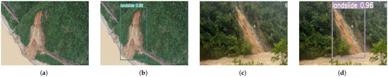
To validate the advantages of the improved algorithm in slope landslide target detection, the proposed LRES-YOLO algorithm is compared with Faster RCNN, SSD, YOLOv4, YOLOX, YOLOv5, and YOLOv7 algorithms under different scenarios. These three scenarios include: slope landslides with features similar to the background, slope landslides in scenes with relatively low image clarity, and slope landslides with clear features. Typical comparison images for recognition are shown in Figure 9, Figure 10, and Figure 11, respectively.
Figure 9.
Comparison of Slope Landslide Characteristics and Background Proximity Scene Recognition. (a) Faster RCNN. (b) LRES-YOLO. (c) YOLOv4. (d) LRES-YOLO.
Figure 10.
Recognition Comparison in a Scene with Relatively Low Image Clarity. (a) SSD. (b) LRES-YOLO. (c) YOLOX, close-range scene. (d) LRES-YOLO.
Figure 11.
Comparison of Scene Recognition with Clear Characteristics of Slope Landslides. (a) YOLOv5. (b) LRES-YOLO. (c) YOLOv7. (d) LRES-YOLO.
- (1)
- Scenario Where Slope Landslide Features Are Similar to the Background: In Figure 9, subfigures (a) and (b) present a close-range scene with engineering construction disturbances, while subfigures (c) and (d) present a close-range scene with turbid water surface interference. From Figure 9, it can be observed that in the scenario where slope landslide features are similar to the background, Faster RCNN produces detections with low confidence scores and YOLOv4 exhibits false detections, whereas the proposed LRES-YOLO can accurately detect and fully label the landslides.
- (2)
- Scenario Where Slope Landslide Features Are Relatively Unclear: In Figure 10, subfigures (a) and (b) present a distant-view scene, while subfigures (c) and (d) present a close-range scene under rainy conditions where image clarity is degraded by rain interference. As shown in Figure 10, in the scenario where image clarity is relatively low, both SSD and YOLOX experience missed detections, indicating that these two algorithms have lower recognition accuracy in this scenario. The reason is that the two-stage object detection algorithm, SSD, struggles to capture semantic and spatial information from images when the target is distant and features are blurry, making it difficult to classify and locate the target in subsequent processes, leading to missed detections. The one-stage YOLOX algorithm, which uses an anchor-free approach, lacks predefined anchor boxes to guide target localization under rainy conditions with degraded image clarity, resulting in missed detections. The proposed LRES-YOLO algorithm, by adding a coordinate attention mechanism to the backbone network, allows the network to focus on more extensive information. Combined with convolution blocks, this enhances the feature extraction ability of the backbone network. Additionally, incorporating more feature information during enhanced feature extraction improves the model’s overall performance. Furthermore, the proposed LRES-YOLO algorithm adopts an anchor-based approach, allowing for more accurate target localization by presetting anchor box sizes, thereby effectively enhancing detection accuracy.
- (3)
- Scenario Where Slope Landslide Features Are Clear: In Figure 11, subfigures (a) and (b) present a close-range scene, while subfigures (c) and (d) present a medium-to-long-range scene. As shown in Figure 11, in the scenario where slope landslide features are clear, both YOLOv5 and YOLOv7 algorithms detect and recognize landslides, but their mAP values and accuracy are relatively low, indicating that YOLOv5 and YOLOv7 have poor robustness. When the threshold is set high, they are prone to missed detections; when the threshold is adjusted to reduce missed detections, their accuracy will further decrease due to increased false positives. In contrast, the proposed LRES-YOLO algorithm does not exhibit false positives or missed detections in any of the three scenarios, and its mAP value and accuracy are both higher, demonstrating the effectiveness of the proposed improvements.
To further validate the effectiveness of the proposed algorithm for detecting dam slope landslides, the proposed LRES-YOLO algorithm is compared with Faster RCNN, SSD, YOLOv4, YOLOX, YOLOv5, and YOLOv7 algorithms using the same hardware and software setup and the same dataset. To ensure a fair comparison, all models were trained under identical conditions: the same dataset split, 300 training epochs, a batch size of 16, an initial learning rate of 0.01 with identical scheduling, consistent input resolution of 640 × 640 pixels, and the same Mosaic data augmentation strategy. The hyperparameters of each compared model were individually tuned on the validation set to achieve their respective best performance. By calculating the mean average precision, Recall, F1 Score and Accuracy for each class across five independent random splits, the comparative experimental results are shown in Table 2.
Table 2.
Comparison of Experimental Results for Different Object Detection Algorithms (mean ± std across five trials). Bold indicates the best result.
From the comparison results in Table 2, it can be seen that the proposed algorithm achieves the highest mean mAP and mean recall, with a mean mAP of 83.3% and mean recall of 97.8% across five independent trials, respectively. In contrast, the mean mAP values of the two-stage object detection algorithms, such as Faster RCNN and SSD, are the lowest at 65.7% and 66.2%, respectively. These results indicate that single-stage algorithms that directly perform detection outperform two-stage algorithms, with better ability to predict true positive samples. The primary reason is the complexity of dam slope landslide detection scenarios, where two-stage detection algorithms have significant latency and higher error rates. The proposed algorithm integrates coordinate attention mechanisms, multiple effective feature layers, and loss functions that separate classification from regression, resulting in an average improvement of 8.4 percentage points in mean mAP compared with the best-performing baseline across five independent trials. The proposed LRES-YOLO achieves a mean accuracy of 92.4% on the test set, further confirming its superiority in overall detection performance.
Furthermore, the detection accuracy and recall rates of both two-stage algorithms (Faster-RCNN, SSD) and single-stage algorithms (YOLOv4, YOLOX, YOLOv5, and YOLOv7) are lower than those of the proposed LRES-YOLO algorithm. This comparative analysis further confirms the effectiveness and robustness of the proposed improved algorithm, providing an effective solution for intelligent recognition and early warning of dam slope landslides.
4.3. Ablation Testing
To further validate the effectiveness of the improvements made to the benchmark algorithm network modules, ablation studies were conducted to compare the relevant improved modules and thoroughly evaluate their impact on the algorithm’s performance. Table 3 presents the experimental performance of the improved modules, including the coordinate attention mechanism, increased network layers, improved feature fusion network, and modified loss functions.
Table 3.
Ablation Study Results under Different Module Combinations (mean ± std across five independent trials; ×: module not applied, √: module applied). Bold indicates the best result.
From the experimental data in Table 3, it can be observed that integrating the coordinate attention mechanism (CA) with the convolution module (CBS) allows the algorithm to adjust its focus on different locations based on the positional information of the target, resulting in a mean mAP improvement of 2.3 percentage points, from 74.8% to 77.1%, averaged across five independent trials. Enabling the Improved Feature Fusion Network alone allows the network to capture target information at multiple scales, enabling the algorithm to extract image features more comprehensively, ultimately increasing mean mAP by 3.3 percentage points, reaching 78.1%. Using Focal Loss and EIoU Loss functions, which separate classification from regression, avoids interference between these tasks, thereby optimizing classification and regression more effectively and increasing mean mAP by 7.5 percentage points, reaching 82.3%.
The individual contributions of these modules are reflected in the ablation study in Table 3. CA+CBS alone improves mean mAP from 74.8% to 77.1%, demonstrating its effectiveness in feature localization. The Increased Network Layers module, which incorporates DP and ELAN-W, provides the critical structural foundation for other modules to function effectively, as evidenced by the recovery of mean mAP to 80.0% when combined with the Improved Feature Fusion Network.
However, simply combining two of the improvements—adding the coordinate attention mechanism, integrating more effective feature layers, increasing network layers, or modifying loss functions—can lead to a decrease in mean mAP. For instance, combining CA+CBS and the Improved Feature Fusion Network without the Increased Network Layers results in a notable mean mAP drop to 71.3%, as shown in the 7th row of Table 3, which is lower than the baseline mean mAP of 74.8%. This decrease can be explained by the structural dependency between these modules. The Improved Feature Fusion Network is specifically designed to leverage the deeper backbone output from layer 64, upsampling it and concatenating it with the layer 50 output, and further concatenating the layer 24 and layer 37 outputs after processing through the CACBS module. This fusion process fundamentally relies on the richer feature representations provided by the additional backbone layers introduced in the Increased Network Layers module. When the Increased Network Layers module is absent, the feature fusion network cannot obtain the deep hierarchical features it requires, causing the concatenation operations to introduce inconsistent rather than complementary information, resulting in performance degradation. When CA+CBS, Increased Network Layers, and Improved Feature Fusion Network are all combined, mean mAP recovers to 82.1%, as shown in the 12th row of Table 3, confirming that the feature fusion network functions as intended only when supported by the deeper backbone structure. In contrast, combining three or all four of these improvement strategies significantly enhances dam slope landslide recognition, with the full combination achieving a mean mAP of 83.3% across five independent trials. Therefore, the ablation studies indicate that the proposed improvement modules effectively enhance the detection accuracy of dam slope landslides, providing a feasible solution for landslide recognition in complex environments.
5. Conclusions
This paper proposed the LRES-YOLO reservoir embankment slope landslide detection algorithm, which enhances the detection accuracy of slope landslides on reservoir dams by optimizing the backbone network, feature fusion network, and loss functions for water conservancy scenarios. The proposed improved algorithm first introduces a coordinate attention mechanism to the benchmark algorithm, which, combined with the basic convolution blocks, forms an innovative attention convolution module. Additionally, the attention convolution module is integrated with the backbone’s efficient layer aggregation network to form an innovative multi-branch stacked module. Secondly, by adding more layers to the backbone network, the model’s ability to recognize large targets such as slope landslides is enhanced. The feature fusion network is also improved by modifying the spatial pyramid pooling module to include more pooling operations, which helps to prevent overfitting due to excessive parameters and enhances the model’s feature representation ability. Lastly, Focal Loss is used for calculating classification loss, and EIoU Loss is used for calculating regression loss, effectively addressing the issue of positive and negative sample imbalance, accelerating convergence, and improving regression accuracy. Comparative experiments with traditional algorithms show an average improvement of 8.4 percentage points in mean mAP over the best-performing baseline for landslide detection across diverse reservoir scenarios (e.g., rainy season seepage slides, dry season erosion slides), with a mean accuracy of 92.4% on the test set across five independent trials. Based on the current dataset and experimental setup, the algorithm demonstrates its potential for real-time monitoring of reservoir embankment slopes, providing a feasible technical reference for intelligent risk warning in water conservancy projects. Moreover, the proposed method has the potential to be extended to landslide detection on river and lake slopes, as the characteristics of such scenarios share similarities with reservoir embankment slopes. Future work will focus on three main directions: first, large-scale deployment and validation in real-world reservoir engineering environments to further assess the generalization capability of the proposed method; second, edge deployment optimization for extreme reservoir environments to expand practical applicability; and third, integrating multi-source monitoring data such as InSAR and displacement measurements to establish a multimodal early warning framework, enabling landslide identification in the early stages before complete collapse.
Author Contributions
Conceptualization, X.X. and H.W.; methodology, X.B.; software, Z.W.; validation, X.X. and H.W.; formal analysis, X.X.; investigation, X.X., H.W. and X.W.; resources, X.X. and H.W.; data curation, X.B.; writing—original draft preparation, X.B. and Z.W.; writing—review and editing, X.X., H.W. and X.W.; visualization, X.X.; supervision, X.X.; project administration, X.X.; funding acquisition, X.X. All authors have read and agreed to the published version of the manuscript.
Funding
This research was supported by the Key R&D Program Project of Jiangxi Provincial Department of Science and Technology under Grant 20243BBH81006; the Jiangxi Provincial Technology Innovation Guidance Program under Grant 20223AEI91008; the Jiangxi Province Water Resources Science and Technology Key Projects under Grants 202325ZDKT19, 202426ZDKT10, and 202425TGKT11; the Jiangxi Province Water Resources Department Science and Technology Project under Grant 202527ZDKT14; and the Jiangxi Province Water Resources Department Key Project under Grant 202426ZDKT16.
Data Availability Statement
The raw data supporting the conclusions of this article will be made available by the authors on request.
Acknowledgments
We would like to express our sincere gratitude to the editors and anonymous reviewers for their valuable insights and constructive feedback, which have significantly contributed to the improvement of this manuscript. All authors have read and agreed to the published version of the manuscript.
Conflicts of Interest
The authors declare no conflicts of interest.
References
- Hou, D.; Song, X.; Li, S.; Lu, C.; Ma, K.; Li, J. Remote Real Time Monitoring System of Slope and Its Application in Sustainable Mining of Open Pit Coal Mine. J. Phys. Conf. Ser. 2021, 1974, 012008. [Google Scholar] [CrossRef] [Scilit]
- Zhu, D.; Huang, J.; Griffiths, D.V.; Fenton, G.A. Probabilistic stability analyses of undrained slopes by 3D random fields and finite element methods. Geosci. Front. 2018, 9, 1657–1664. [Google Scholar] [CrossRef] [Scilit]
- Chen, C.; Chu, P.; Xie, H.; Li, M.; Li, C.; Shang, D. Fracture behavior of high-temperature granite subjected to liquid nitrogen cooling: Semi-circular bending test and crack evolution analysis. Theor. Appl. Fract. Mech. 2023, 128, 104100. [Google Scholar] [CrossRef] [Scilit]
- Bao, H.; Zeng, C.; Peng, Y.; Wu, S. The use of digital technologies for landslide disaster risk research and disaster risk management: Progress and prospects. Environ. Earth Sci. 2022, 81, 446. [Google Scholar] [CrossRef] [Scilit]
- Damm, B.; Terhorst, B. A model of slope formation related to landslide activity in the Eastern Prealps, Austria. Geomorphology 2010, 122, 338–350. [Google Scholar] [CrossRef] [Scilit]
- Zhu, J.; Song, H. Research on Safety Perception Monitoring and Early Warning Technology of Highway Construction Based on Holographic Three-Dimensional Real-World Big Data. In CICTP 2025: Transportation, Artificial Intelligence, and Energy; ASCE: Reston, VA, USA, 2025; pp. 1615–1624. [Google Scholar]
- Deng, L.; Yuan, H.; Chen, J. Research progress on landslide deformation monitoring and early warning technology. J. Tsinghua Univ. (Sci. Technol.) 2023, 63, 849–864. [Google Scholar]
- Sestras, P.; Bilașco, Ș.; Roșca, S.; Veres, I.; Ilies, N.; Hysa, A.; Spalević, V.; Cîmpeanu, S.M. Multi-instrumental approach to slope failure monitoring in a landslide susceptible newly built-up area: Topo-Geodetic survey, UAV 3D modelling and ground-penetrating radar. Remote Sens. 2022, 14, 5822. [Google Scholar] [CrossRef] [Scilit]
- Pandey, A.; Dabral, P.P.; Chowdary, V.M.; Yadav, N.K. Landslide hazard zonation using remote sensing and GIS: A case study of Dikrong river basin, Arunachal Pradesh, India. Environ. Geol. 2008, 54, 1517–1529. [Google Scholar] [CrossRef] [Scilit]
- Yin, Y.; Liu, X.; Zhao, C.; Tomás, R.; Zhang, Q.; Lu, Z.; Li, B. Multi-dimensional and long-term time series monitoring and early warning of landslide hazard with improved cross-platform SAR offset tracking method. Sci. China Technol. Sci. 2022, 65, 1891–1912. [Google Scholar] [CrossRef] [Scilit]
- Mohan, A.; Singh, A.K.; Kumar, B.; Dwivedi, R. Review on remote sensing methods for landslide detection using machine and deep learning. Trans. Emerg. Telecommun. Technol. 2021, 32, e3998. [Google Scholar] [CrossRef] [Scilit]
- Li, R.; Sun, P.; Sang, K.; Ke, C.; Zhang, S. Characteristics and initiation mechanism of the large mudstone Dongping landslide induced by heavy rainfall in Gansu Province, NW China. Geoenviron. Disasters 2024, 11, 39. [Google Scholar] [CrossRef] [Scilit]
- Li, X.; Zhou, L.; Su, F.; Wu, W. Application of InSAR technology in landslide hazard: Progress and prospects. Natl. Remote Sens. Bull. 2021, 25, 614–629. [Google Scholar]
- Khan, R.; Yousaf, S.; Haseeb, A.; Uddin, M.I. Exploring a design of landslide monitoring system. Complexity 2021, 2021, 5552417. [Google Scholar] [CrossRef] [Scilit]
- Chen, F.; Yu, B.; Xu, C.; Li, B. Landslide detection using probability regression, a case study of Wenchuan, northwest of Chengdu. Appl. Geogr. 2017, 89, 32–40. [Google Scholar] [CrossRef] [Scilit]
- Becker, D.; Raddatz, L.; Roussel, C.; Klonowski, J. Analysis methods for deformation detection using TLS and UAS data on the example of a landslide simulation. Int. J. Geo-Eng. 2024, 15, 9. [Google Scholar] [CrossRef] [Scilit]
- Yang, Z.; Xu, C.; Li, L. Landslide detection based on ResU-Net with transformer and CBAM embedded: Two examples with geologically different environments. Remote Sens. 2022, 14, 2885. [Google Scholar] [CrossRef] [Scilit]
- Chen, L.; Ding, Y.; Pirasteh, S.; Hu, H.; Zhu, Q.; Ge, X.; Zeng, H.; Yu, H.; Shang, Q.; Song, Y. Meta-learning an intermediate representation for few-shot prediction of landslide susceptibility in large areas. Int. J. Appl. Earth Obs. Geoinf. 2022, 110, 102807. [Google Scholar] [CrossRef] [Scilit]
- Zhao, Z.Q.; Zheng, P.; Xu, S.T.; Wu, X. Object detection with deep learning: A review. IEEE Trans. Neural Netw. Learn. Syst. 2019, 30, 3212–3232. [Google Scholar] [CrossRef] [Scilit]
- Zhang, Y.; Zhang, W.; Yu, J.; He, L.; Chen, J.; He, Y. Complete and accurate holly fruits counting using YOLOX object detection. Comput. Electron. Agric. 2022, 198, 107062. [Google Scholar] [CrossRef] [Scilit]
- Wang, C.Y.; Bochkovskiy, A.; Liao, H.Y.M. YOLOv7: Trainable bag-of-freebies sets new state-of-the-art for real-time object detectors. In 2023 IEEE/CVF Conference on Computer Vision and Pattern Recognition (CVPR); IEEE: New York, NY, USA, 2023; pp. 7464–7475. [Google Scholar]
- Hou, H.; Chen, M.; Tie, Y.; Li, W. A universal landslide detection method in optical remote sensing images based on improved YOLOX. Remote Sens. 2022, 14, 4939. [Google Scholar] [CrossRef] [Scilit]
- Yu, Z.; Chang, R.; Chen, Z. Automatic detection method for loess landslides based on GEE and an improved YOLOX algorithm. Remote Sens. 2022, 14, 4599. [Google Scholar] [CrossRef] [Scilit]
- Liu, Q.; Wu, T.; Deng, Y.; Liu, Z. SE-YOLOv7 landslide detection algorithm based on attention mechanism and improved loss function. Land 2023, 12, 1522. [Google Scholar] [CrossRef] [Scilit]
- Hou, Q.; Zhou, D.; Feng, J. Coordinate attention for efficient mobile network design. In 2021 IEEE/CVF Conference on Computer Vision and Pattern Recognition (CVPR); IEEE: New York, NY, USA, 2021; pp. 13713–13722. [Google Scholar]
- Murray, N.; Perronnin, F. Generalized max pooling. In Proceedings of the IEEE Conference on Computer Vision and Pattern Recognition; IEEE: New York, NY, USA, 2014; pp. 2473–2480. [Google Scholar]
- Narayan, S. The Generalized Sigmoid Activation Function: Competitive Supervised Learning. Inf. Sci. 1997, 99, 69–82. [Google Scholar] [CrossRef] [Scilit]
- Zheng, Z.; Wang, P.; Liu, W.; Li, J.; Ye, R.; Ren, D. Distance-IoU loss: Faster and better learning for bounding box regression. Proc. AAAI Conf. Artif. Intell. 2020, 34, 12993–13000. [Google Scholar] [CrossRef] [Scilit]
- Botev, Z.I.; Kroese, D.P.; Rubinstein, R.Y.; L’Ecuyer, P. The Cross-Entropy Method for Optimization. In Handbook of Statistics; Elsevier: Amsterdam, The Netherlands, 2013; Volume 31, pp. 35–59. [Google Scholar]
- Li, X.; Lv, C.; Wang, W.; Li, G.; Yang, L.; Yang, J. Generalized focal loss: Towards efficient representation learning for dense object detection. IEEE Trans. Pattern Anal. Mach. Intell. 2022, 45, 3139–3153. [Google Scholar] [CrossRef] [PubMed]
- Zhang, Y.F.; Ren, W.; Zhang, Z.; Jia, Z.; Wang, L.; Tan, T. Focal and efficient IOU loss for accurate bounding box regression. Neurocomputing 2022, 506, 146–157. [Google Scholar] [CrossRef] [Scilit]
- Nagano, Y.; Kikuta, Y. SRGAN for super-resolving low-resolution food images. In Proceedings of the Joint Workshop on Multimedia for Cooking and Eating Activities and Multimedia Assisted Dietary Management; ACM: New York, NY, USA, 2018; pp. 33–37. [Google Scholar]






Disclaimer/Publisher’s Note: The statements, opinions and data contained in all publications are solely those of the individual author(s) and contributor(s) and not of MDPI and/or the editor(s). MDPI and/or the editor(s) disclaim responsibility for any injury to people or property resulting from any ideas, methods, instructions or products referred to in the content. |
© 2026 by the authors. Licensee MDPI, Basel, Switzerland. This article is an open access article distributed under the terms and conditions of the Creative Commons Attribution (CC BY) license.