


Abstract
The shallow-buried abandoned Yellow River Delta (893–1855 AD) exhibits a distinctive geomorphic system shaped by coupled fluvial sediment reduction, climatic transition, and relative sea-level fluctuations, with its intact deposits recording key temperate delta evolution during climate change. Using four sediment cores, we applied optically stimulated luminescence (OSL) dating, sedimentary facies analysis, and grain-size techniques (C-M diagram, end-member modeling), integrated with geomorphic interpretation and historical data, to reconstruct the delta’s evolutionary sequence and clarify storm surge-driven geomorphic reworking and its diagnostic indicators. Results indicate that the delta’s evolution was governed by abrupt fluvial sediment loss, intensified storm dynamics, and relative sea-level rise. The 893 AD Yellow River avulsion triggered delta abandonment (893–1482 AD), driving a shift from a fluvially dominated muddy coast to a wave-controlled sandy system. Sandy deposits initially formed at M04A and prograded landward to M03A. During the Little Ice Age (1482–1855 AD), frequent storm surges further expanded and elevated these sandy accumulations, while weak sedimentation persisted in the inland depression (B03). This differential process generated a unique plain lowland–coastal highland system, a rare geomorphic type among large river deltas that differs from classic island–continent and barrier–lagoon systems. This study elucidates the phased response of temperate monsoon abandoned deltas to millennial-scale climate change, advances theories of multi-factor coupled delta evolution, and provides scientific support for coastal protection, stability assessment, and evolutionary prediction under global warming.
1. Introduction
Coastal deltas, as critical land-sea interaction zones, are highly sensitive to fluvial water-sediment flux changes, climate variability, and coastal hydrodynamic processes [1,2,3,4]. For large river deltas in temperate monsoon regions, water-sediment supply, coupled with periodic storm surges and sea-level fluctuations, results in complex geomorphic differentiation and evolutionary trajectories [5]. Among these, abandoned deltas formed by river avulsion serve as ideal natural archives for deciphering multi-factor coupling mechanisms, as their evolution is no longer dominated by continuous fluvial input but is reshaped by the synergistic effects of residual sediment reworking, climate change, and coastal dynamics [6,7].
Coastal deltas in temperate monsoon regions are shaped by the complex coupling of fluvial dynamics, coastal hydrodynamics, and climate oscillations, and abandoned deltas exhibit unique sensitivity to the reworking of residual sediments and extreme events [7,8,9,10]. Previous studies on the Yellow River Delta have mainly emphasized that the reduction in water and sediment supply is the dominant trigger for delta abandonment [11,12]. However, the multi-factor coupling of sea-level rise, variations in water and sediment supply, and climate fluctuations constitutes the fundamental driving mechanism for delta geomorphic evolution [13]. The shallow-buried abandoned Yellow River Delta, which developed on the modern Yellow River Delta plain and was exposed during 893 AD–1855 AD, well preserves the geomorphic and sedimentary records formed under the combined effects of changes in water and sediment supply, climate variability, and sea-level rise [6]. Therefore, a systematic geomorphological study of this abandoned delta can reveal the geomorphic evolution laws of large river deltas in temperate monsoon regions driven by multi-factor coupling. From previous investigations of the shell ridges in the abandoned Yellow River Delta [6], the shoreline did not experience significant retreat after the Yellow River Delta lost its sediment and water supply due to river avulsion in 893 AD. Moreover, large-scale alongshore sand bodies developed along the coast of the delta in 1855 AD [14]. The water depth increased rapidly on the outer side, while banded coastal lagoonal depressions were distributed on the inner side, forming a reverse geomorphic gradient rising from the inner lagoonal depressions to the coastal highlands [15]. This special geomorphic pattern is significantly different from the evolutionary laws of abandoned large temperate river deltas in classic theories [15,16]. In addition, the exposure period of this abandoned delta (893 AD–1855 AD) corresponds to the δ18O and δ13C records from Kaiyuan Cave [17,18], 150 km southwest of Lijin: the 590 years before 1482 AD represent the Medieval Warm Period (MWP) with strong and stable summer monsoons, and the 412 years after 1482 AD represent the Little Ice Age (LIA) with weak and unstable summer monsoons. Based on historical document statistics [17,18], only nine storm surge disasters were recorded in the Bohai Sea during the 933 years of the ancient Yellow River Delta (40 BC–893 AD), while as many as 34 storm surge disasters occurred during the 962 years of the abandonment stage (893 AD–1855 AD). Among them, only three events took place in 589 years from 893 AD to 1482 AD, and 31 events surged in 373 years from 1482 AD to 1855 AD [19]. Abrupt climate change and alterations in storm surge and wave dynamics directly modify coastal sedimentary dynamic conditions, thereby controlling the geomorphic evolution of estuaries and deltas. Such intense climate fluctuations likely caused the abandoned Yellow River Delta to present a unique evolutionary path distinct from traditional large river deltas in temperate monsoon regions.
Previous studies have confirmed a significant correlation between climate change and variations in wave conditions [20,21]. Storm surges exert dual erosional and depositional effects on coastal geomorphology, and their episodic nature and high hydrodynamic intensity enable them to disrupt and reshape the process of geomorphic evolution [22]. Unlike other large river deltas worldwide, the Bohai Sea area where the Yellow River Delta is situated has long been a well-recognized region prone to intense storms [23,24], and the exposure stage of this abandoned delta coincides precisely with the climatic transition period of the Shandong Peninsula. Therefore, it is imperative to systematically elucidate the dynamic mechanism of storm surges and emphasize their pivotal role in the geomorphic shaping of the abandoned delta during the LIA. Unlike the thick coarse-grained deposits formed by tropical typhoons [25,26], temperate storm surges are mainly driven by cold waves and are characterized by high frequency, short duration, and multi-directionality [27,28]. Most existing studies on storm surge deposits focus on thick coarse-grained accumulations induced by tropical typhoons [25,26]. However, the geomorphic reworking characteristics of temperate storm surges still lack systematic identification, their coupling mechanism with factors such as water-sediment supply and sea level remains unclear, and their contribution to geomorphic evolution and the differential characteristics of local landforms have not been fully revealed.
To fill the above research gaps, this study selected four cores from the shallow-buried abandoned Yellow River Delta to conduct systematic optically stimulated luminescence (OSL) dating, sedimentary facies identification, and grain-size parameter analysis, and integrated previous research results and historical data [29,30,31,32]. The objectives are to: (1) reconstruct the local geomorphic evolution process of the abandoned Yellow River Delta. The results can provide a scientific basis for improving the theory of multi-factor coupled evolution of large river deltas in temperate monsoon regions and support coastal zone management; (2) reveal the geomorphic reworking characteristics of storm surges and their associated geomorphic effects in temperate monsoon regions.
2. General Settings
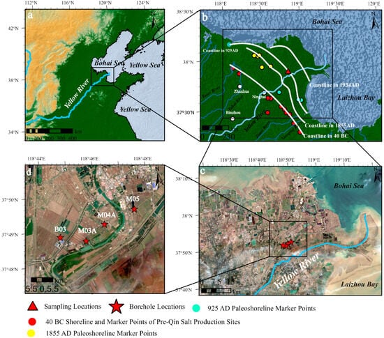
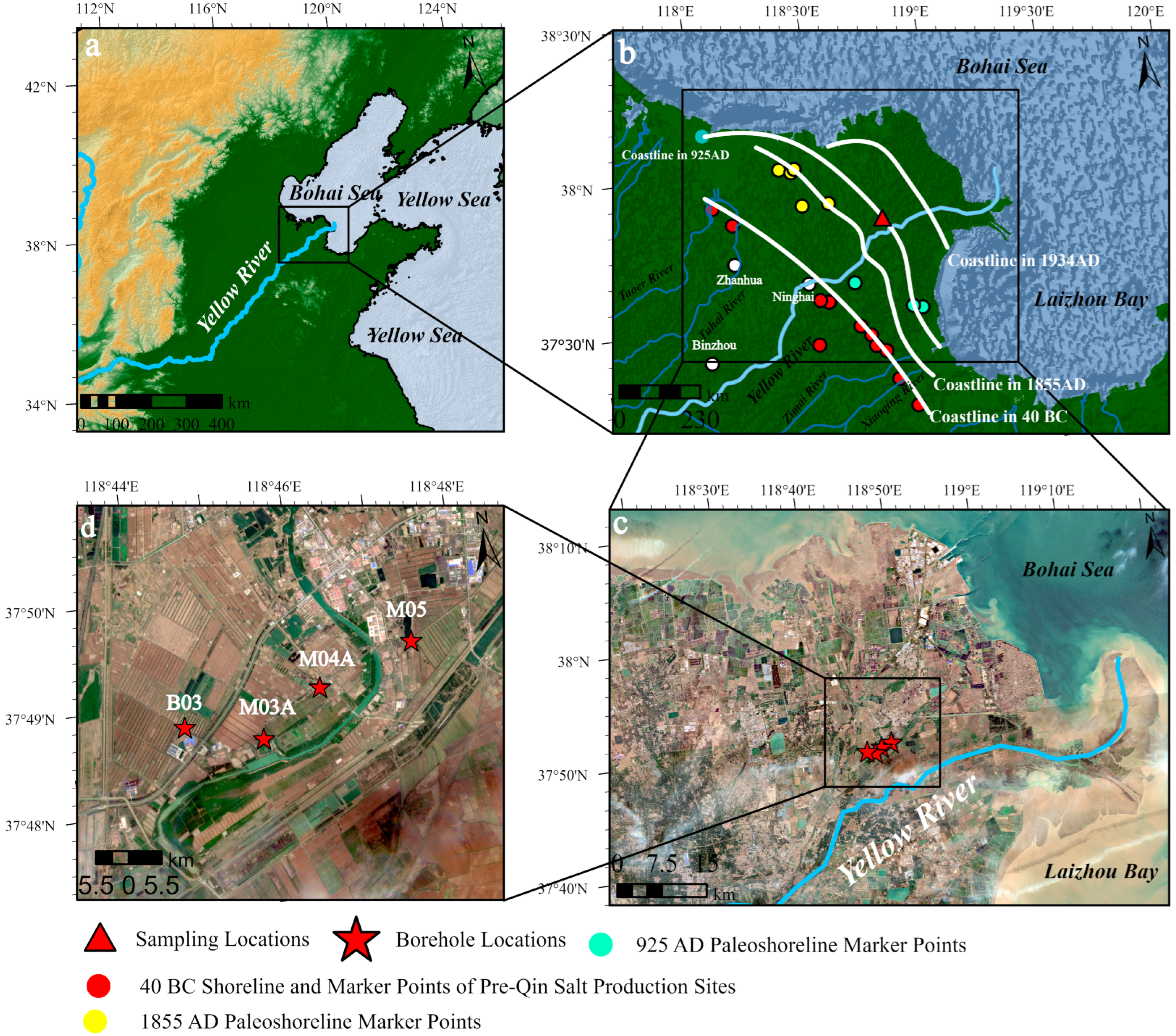
The modern Yellow River Delta takes Ninghai as its apex, starting from the mouth of the Taoer River in the north and ending at the mouth of the Zhimai River in the south, with a total land area of approximately 6000 km2 and an average fan slope of about 0.75‰ [33]. Unlike the continuous development of many deltas following the maximum Holocene transgression, the Yellow River Delta is characterized by discontinuous development [34,35,36]. According to historical documents, the delta’s evolution over the past 2000 years has undergone two developmental stages and one abandonment stage [29]. From 40 BC to 893 AD, the Yellow River emptied into the Bohai Sea via Lijin, forming the ancient Yellow River Delta. Subsequently, from 893 to 1855 AD, namely the period from the MWP to the LIA, the delta remained in an abandoned state for nearly 1000 years [17,18]. In 1855 AD, the Yellow River avulsed and flowed into the Bohai Sea via Lijin once again, and the entire abandoned delta was rapidly buried, giving rise to the modern YRD [29]. Frequent abandonment and discontinuous accumulation thus constitute the distinctive features of the YRD’s geomorphic evolution, with its coastal shoreline undergoing multiple shifts accordingly. As shown in Figure 1b, the shoreline positions for 40 BC, 893 AD, 925 ± 70 AD, 1855 AD, and 1934 AD were determined based on historical records, previous studies, and field investigations.
Figure 1.
Geographical setting, paleoshoreline evolution markers, sampling sites, and borehole locations in the Yellow River Delta, China. (a) Macrogeographical setting of the Yellow River Delta, illustrating its position within the coastal zone of the Bohai Sea, North China. (b) Detailed regional map of the Yellow River Delta, displaying paleoshoreline markers that record approximately 2000 years of coastal evolution, including pre-Qin salt production sites, as well as 40 BC, 925 AD, 1855 AD, and 1934 AD paleoshorelines, alongside sampling and borehole locations. (c) Sampling sites overlaid on a satellite image. (d) Detailed distribution of the four boreholes.
The core study area is located in the central plain of the modern Yellow River Delta, as illustrated in Figure 1. The shallow-buried abandoned delta (893–1855 AD) exhibits a narrow trumpet-shaped distribution, extending approximately 25 km in the east-west direction and 15 km in the north-south direction. The core area is situated east of Lijin (37°40′–37°50′ N, 118°30′–118°50′ E) (Figure 1b), with an average burial depth of 5 to 7 m and no significant late-stage disturbance, completely preserving the sedimentary signals spanning the MWP to the LIA. The study area belongs to a warm temperate semi-humid monsoon climate, with an annual average temperature of 11.7–12.6 °C, an annual precipitation of 530–630 mm (70% concentrated in June–September), an annual average wind speed of 3.1–4.6 m/s, and an average of 18–22 days of strong wind weather per year [37]. The gales often cause strong wave action and storm surges, resulting in severe erosion of the abandoned delta coast. During the historical period the coastal area around the YRD was noted for strong storm surges. According to statistics in historical documents there were 31 disastrous storm surges in the Bohai Sea during the Little Ice Age, which was 10 times higher than the number during the Medieval Warm Period [38].
3. Materials and Methods
3.1. Sample Collection
Drilling was conducted in March 2023 using an XY-150 single-tube rotary drilling rig (Shandong Master Machinery Group Co., Ltd., Jining, Shandong, China). The coring tube was a PVC tube with a diameter of 110 mm and a length of 1 m to avoid metal contamination of OSL samples. The latitude, longitude, and elevation of the boreholes were measured using TOPCON RTK-1002 equipment (TOPCON CORPORATION, Tokyo, Japan) (positioning accuracy ±5 cm), with specific borehole parameters detailed in Table 1. After collection, the cores were sealed and protected from light, and transported back to the laboratory within 48 h. The specific experimental procedures are as follows ① Longitudinally split and photographed at high resolution to record macro lithological characteristics. ② Determine sediment color and systematically record structure, bedding, and marker information. ③ Scrape off 2 cm of sediment from the outer wall to eliminate contamination, collect 2315 grain size samples at 1 cm intervals, and 31 OSL samples at 2.5 cm intervals. ④ Store the remaining cores in a −4 °C refrigerator protected from light.
Table 1.
Sampling and Drilling Sites.
3.2. Optically Stimulated Luminescence (OSL) Dating
OSL samples were processed to isolate grain size fractions of 38–63 μm. Carbonates and organic matter were eliminated using 10% HCl (80 °C, 24 h) and 30% H2O2 (60 °C, 12 h), respectively. The treated samples were rinsed with ultrapure water to neutrality and then dried. After centrifugal separation with Na2Cr2O7 heavy liquid (density: 2.62–2.7 g/cm3), feldspar was etched by immersion in 35% H2SiF6 or 14 days. Quartz purity was verified via Infrared Stimulated Luminescence/Optically Stimulated Luminescence (IR/OSL) signal ratio (IR/OSL signal < 5%), and pure quartz grains were mounted on stainless steel discs with 16 aliquots per sample.
A Danish Riso Thermo luminescence/Optically Stimulated Luminescence-DA-20 luminescence reader (Technical University of Denmark, Lyngby, Denmark) was employed, equipped with blue LED (470 ± 20 nm) stimulation and U-340 filter detection. The Single-Aliquot Regenerative-Dose (SAR) protocol was adopted to determine Equivalent Doses (De), with a preheating temperature of 220 °C, stimulation temperature of 130 °C, and stimulation duration of 40 s [39]. The total dose rate comprised radioactive element dose rate contents of U, Th, K determined by Instrumental Neutron Activation Analysis (INAA) and cosmic ray dose rate calculated using the formula proposed by Prescott and Hutton. Water content was measured by oven-drying and weighing (error: ±5%). Luminescence ages were processed using the “Luminescence” package in R, and 31 valid OSL age data were obtained after excluding outliers.
3.3. Grain Size Analysis
Pretreatment Pretreatment of sediment grain size analysis samples referred to the method of Lu and An [40] and was optimized according to the sediment characteristics in this study: 1 g of grain size sample was taken, 10 mL of 10% H2O2 solution (80 °C) was added, and continuous stirring was performed until no bubbles were generated to ensure complete decomposition of organic matter, subsequently, 10 mL of 10% HCl solution (60 °C) was added and soaked for 24 h to remove carbonate minerals, with stirring every 8 h during this period, finally, the sample was rinsed to neutrality with ultrapure water, then 10 mL of 0.05 mol/L (NaPO3)6 solution was added and oscillated in an ultrasonic oscillator for 8 min to ensure complete dispersion of sediment particles. The test instrument used was a Malvern Mastersizer 3000 Ultra laser particle size analyzer, which has a measurement range of 0.02–2000 μm, a resolution of 0.01 μm, and a repeat test error < 2%, meeting the accuracy requirements for sedimentological analysis. During testing, deionized water was used as the dispersion medium, the sample shading rate was adjusted to 10–12%, each sample was tested 3 times continuously, and the average value was taken as the final result. Data output included: basic grain size parameters (Mz, σ, Sk, Kg) calculated according to the formulas of Folk and Ward [41], volume percentage data of 100 logarithmic grain size classes output for conducting follow-up analyses., sediments were classified into three categories according to the Udden-Wentworth grain size classification standard: clay (<4 μm), silt (4–63 μm), and sand (>63 μm), providing a basis for sedimentary environment identification. For the convenience of comparing borehole characteristics, the particle size unit in micrometers (μm) was converted to the phi unit (ϕ).
To extract more comprehensive sedimentary environment information from sediment grain size, in addition to the basic grain-size parameters mentioned above, the C and M values, which are closely related to sediment transport and deposition, were also selected following Passega [42,43]. The C value represents the grain size at the 1% content level, corresponding to the coarse fraction of the sample and reflecting the maximum hydrodynamic energy of the depositional environment. The M value characterizes the median hydrodynamic intensity of the depositional setting. A C-M plot was constructed with C on the vertical axis and M on the horizontal axis, both in μm, using double logarithmic coordinates. Grain-size end-member analysis was performed using the AnalySize program implemented in MATLAB 2019a, and an appropriate method was chosen for end-member decomposition [44]. Under the premise of satisfactory fitting performance without overfitting, the minimum number of end members was adopted; consequently, three end members were selected for all four boreholes in the final end-member modeling results.
4. Results
4.1. Grain Size Parameter Characteristics of Borehole Sediment
4.1.1. Grain Size Parameter Characteristics of B03
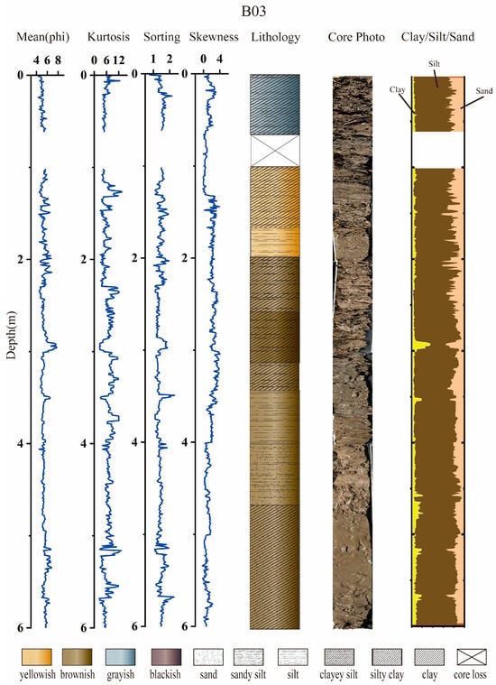
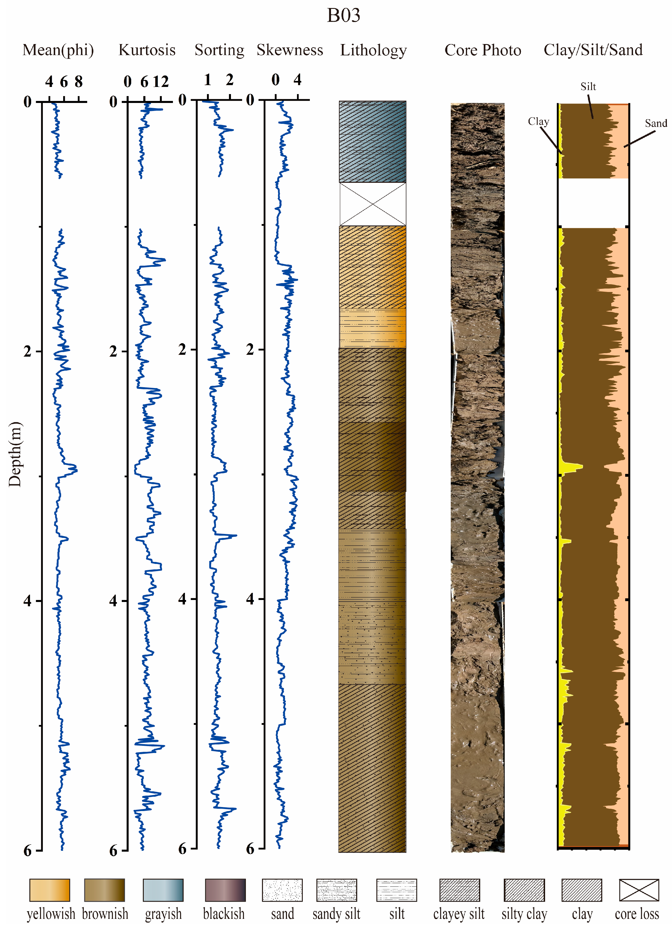
As shown in Figure 2, the sedimentary sequence of Borehole B03 spans a depth interval of 0–6 m, exhibiting distinct vertical variations in grain-size parameters (mean grain size, median grain size, sorting coefficient, skewness and kurtosis), lithology, and clay–silt–sand composition. The mean and median grain sizes display fluctuating patterns: they remain relatively stable (4–6 ϕ) in the 0–1.7 m interval, show intensified fluctuations (4–8 ϕ) from 1.7 to 2.5 m, and gradually fine (4–8 ϕ) between 2.5 and 3 m, with the minimum grain size occurring at 2.9–3 m. Grain size is stable (4–5 ϕ) from 3 to 3.5 m, with a secondary fine-grain peak (7 ϕ) observed at 3.5 m. It fluctuates mildly (5–5.5 ϕ) from 3.5 to 4.2 m and slightly (4–6 ϕ) in the 4.2–6 m interval. The sorting coefficient ranges from 1.77 to 2.25. Sediment skewness is predominantly positive (right-skewed), and all sediment layers exhibit leptokurtic grain-size distributions, with pronounced fluctuations in the 0–3 m and 5–6 m intervals. The vertical lithological succession of the core is as follows (in ascending order): dark gray plain fill, yellow clayey silt, yellow silt, brown clayey silt, brown silty clay, brown sandy silt, and a thick bed of brown silty clay. Silt is the dominant component (50–95%) throughout the borehole. A clay content peak (25–35%) is detected at 2.9–3 m. The sand content varies from 2% to 40%, peaking within the 0–2.5 m depth interval (up to 40%) and showing intense fluctuations (2–40%) therein, while remaining relatively stable in other intervals.
Figure 2.
Grain Size and Sedimentary Characteristics of Borehole B03.
4.1.2. Grain Size Parameter Characteristics of M03A
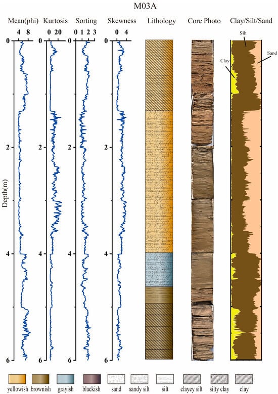
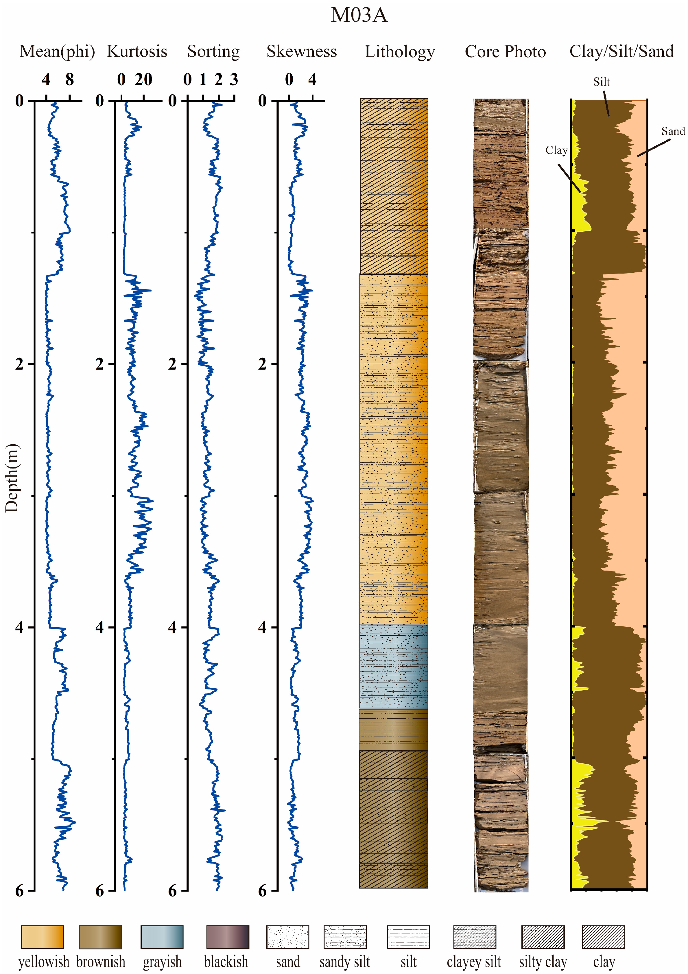
As shown in Figure 3, the sedimentary sequence of Borehole M03A spans a depth interval of 0–6 m, exhibiting distinct vertical variations in grain-size parameters (mean grain size, median grain size, sorting coefficient, skewness and kurtosis), lithology, and clay–silt–sand composition. The mean and median grain sizes fluctuate significantly: they vary slightly (5–8 ϕ) in the 0–1.3 m interval and show a gradually coarsening trend downward; the grain size increases significantly and remains basically stable (3.8–5 ϕ) in the 1.3–4 m interval, fluctuates again and becomes finer (4.9–5.8 ϕ) from 4 to 5 m, and further refines (5–8.2 ϕ) between 5 and 6 m.
Figure 3.
Grain size and sedimentary characteristics of borehole M03A.
4.1.3. Grain Size Parameter Characteristics of M04A
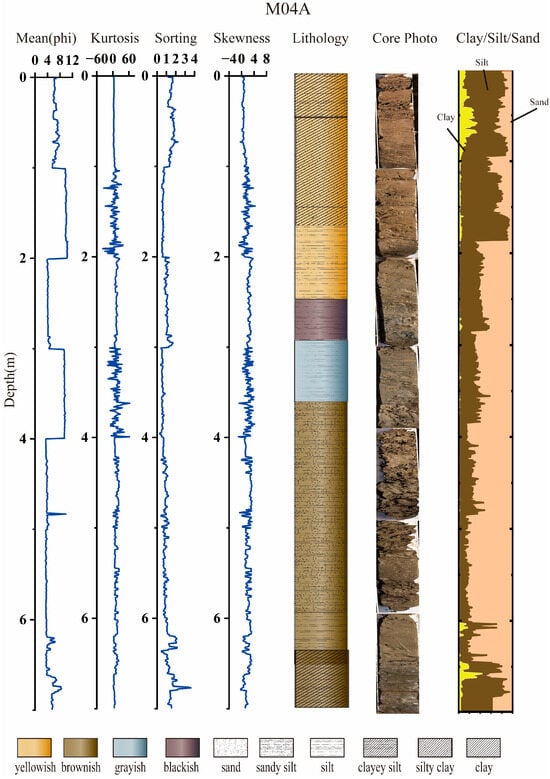
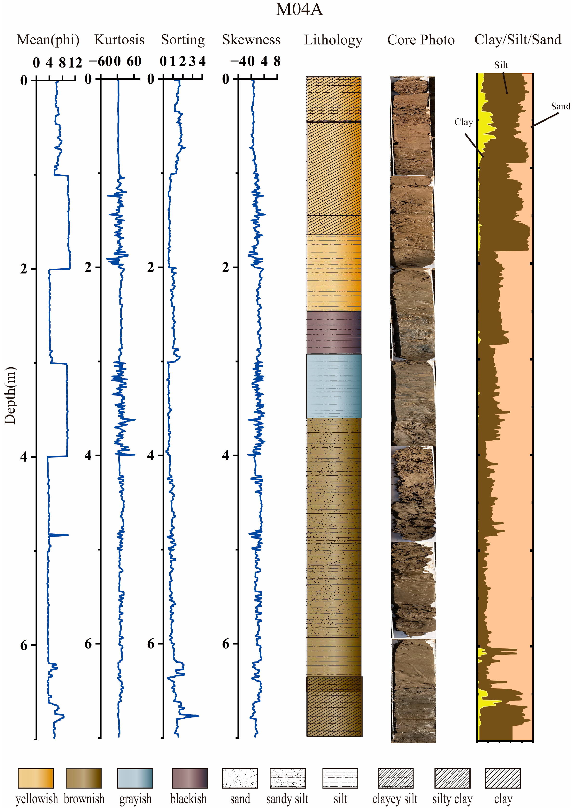
As shown in Figure 4, the sedimentary sequence of Borehole M04A spans a depth interval of 0–7 m, with pronounced vertical variations in grain-size parameters (mean grain size, median grain size, sorting coefficient, skewness, and kurtosis), lithology, and clay–silt–sand composition. The mean and median grain sizes display stepwise shifts, with minimal intra-interval variability: they fluctuate slightly (5.5–7.7 ϕ) in the 0–1 m interval and exhibit a gradual downward coarsening trend; grain size decreases sharply and remains highly stable (9.6–10.5 ϕ) between 1–2 m, increases abruptly (3.85–4.9 ϕ) from 2–3 m, decreases sharply again (9.2–9.5 ϕ) at 3–4 m, rises sharply once more (5–8.2 ϕ) from 4–6.5 m, and shows brief fluctuations (3.5–8.2 ϕ) in the 6.5–7 m interval. The sorting coefficient ranges from 0.5 to 2.2. Sediment skewness is predominantly extremely significantly negative (left-skewed), with only a few depth intervals exhibiting positive, extremely significantly positive (right-skewed) values; sharp alternations between positive and negative skewness occur at 1–2 m and 3–4 m. Grain-size distribution kurtosis fluctuates sharply (−60–60) exclusively in the 1–2 m and 3–4 m intervals, while all other intervals display extremely leptokurtic characteristics (6–20). The vertical lithological succession (in ascending order) is as follows: yellow silty clay, yellow silt, black silt (rich in abundant black organic matter and shell fragments), gray silt (containing a certain amount of humus), brown sandy clay, and brown clayey silt. The borehole exhibits strong vertical differentiation: silt is dominant (60–95%) in the 0–2 m interval; a stable, stepwise increasing high-sand-content interval (60–90%) occurs at 2–6.5 m; and silt again becomes dominant at 6.5–7 m, with sharp content fluctuations (20–80%).
Figure 4.
Grain size and sedimentary characteristics of borehole M04A.
4.1.4. Grain Size Parameter Characteristics of M05
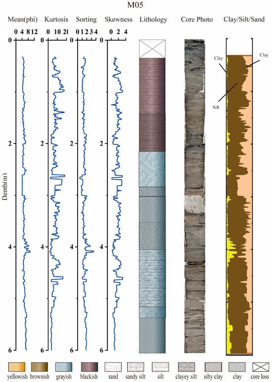
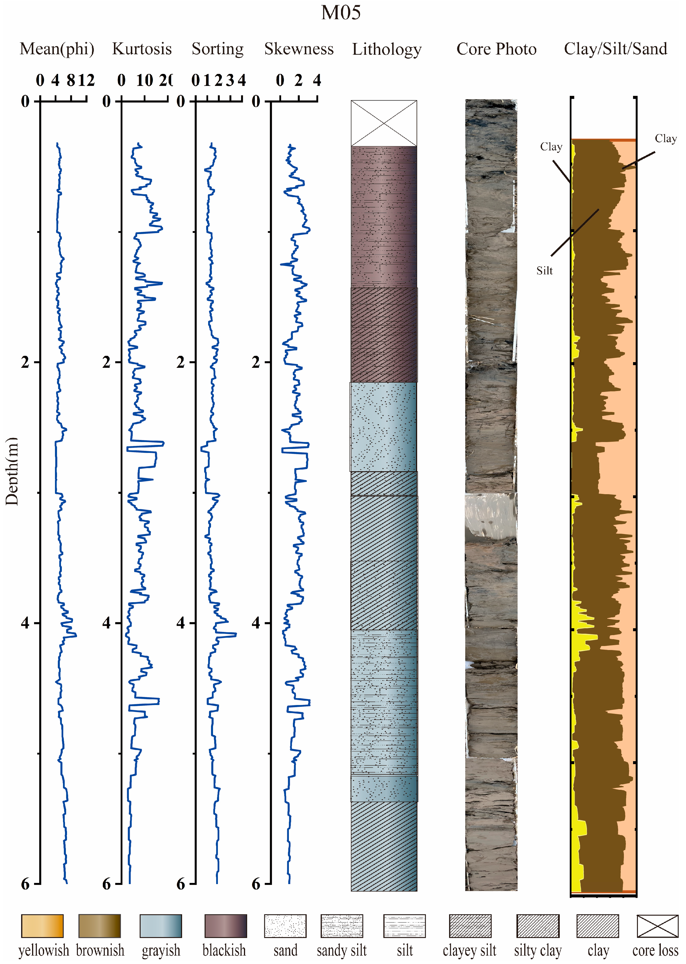
Within As shown in Figure 5, the sedimentary sequence of Borehole M05 spans a depth interval of 0–6 m, exhibiting segmented vertical variations in grain-size parameters (mean grain size, median grain size, sorting coefficient, skewness and kurtosis), lithology, and clay–silt–sand composition. The mean and median grain sizes show moderate fluctuations (4.35–8 ϕ) in most intervals, with a minimum value (9.3 ϕ) only occurring at 3.8–4.1 m. The median and mean grain sizes are 4.3–6.4 ϕ in the 1–2 m interval, coarser than the upper interval (5.5–7.7 ϕ) in the 2–4 m interval, and gradually coarsen with increasing depth, reaching the maximum value at 4 m; the grain size decreases slightly with mild fluctuations (4.7–7 ϕ) in the 4–6 m interval. The sorting coefficient ranges from 0.8 to 2. The sediment skewness is predominantly extremely positive (0–4) and fluctuates alternately from top to bottom. The grain-size distribution of the borehole generally exhibits extremely leptokurtic characteristics (3–16). The vertical lithological succession of the core (from bottom to top) is as follows: black silt, black clayey silt (containing humus at the lower end), gray silty sand, gray clayey silt, gray silty sandy clay, gray silty sand, and gray clay. The borehole exhibits significant and distinct segmented vertical differentiation: silt is the dominant component (60–85%) in the 0–1.5 m interval; there are several interbedded structures dominated by silt and clay in the 1.5–5.4 m interval.
Figure 5.
Grain size and sedimentary characteristics of borehole M05.
4.2. OSL Dating Results
OSL dating results present detailed parameters for all samples in Table 2. The water content of all boreholes ranges from 18% to 21%. The OSL ages of each sample are finally obtained as follows:
Table 2.
OSL sample code, radionuclide concentrations, depth, water content, and dose rates.
Specifically, the ages of six samples from the B03 borehole range from 0.17 to 1.39 ka, with the sample at a depth of 195 cm dated at 0.17 ka and the sample at 395 cm at 1.39 ka. For the M03A borehole, the ages of ten samples span 0.15 to 1.63 ka, the sample at 120 cm depth has an age of 0.15 ka and the sample at 510 cm depth 1.63 ka. Seven samples from the M04A borehole yield ages between 0.13 and 1.23 ka, with the 150 cm depth sample at 0.13 ka and the 670 cm depth sample at 1.23 ka. The eight samples from the M05 borehole have an age range of 0.07 to 1.22 ka, where the sample at 105 cm depth is dated at 0.07 ka and the sample at 540 cm depth at 1.22 ka.
4.3. Chronostratigraphic Core Sequence
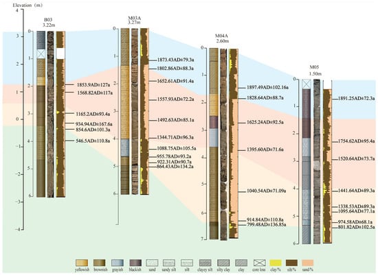
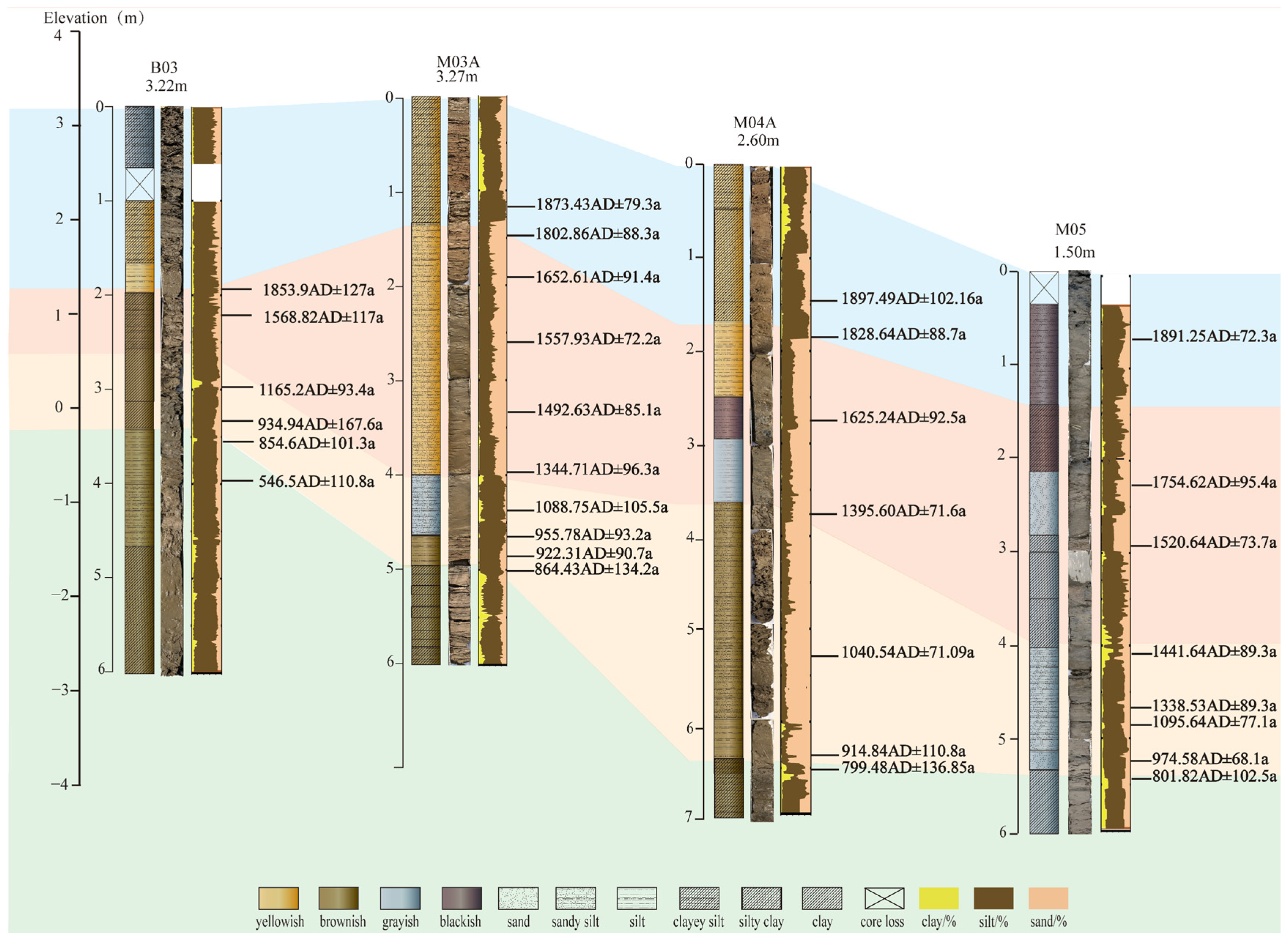
Integrating OSL ages and sedimentary facies depth variations, the stratigraphic characteristics of the four boreholes were further subdivided and correlated (Figure 6). Combined with OSL-derived isochrons, historical records of major delta evolutionary phases [29,45,46] and climatic archives [5,17,18], these sedimentary sequences were divided into four distinct units: the paleodelta (40 BC–893 AD), early abandoned delta (893–1482 AD), late abandoned delta (1482–1855 AD), and modern delta (post-1855 AD). Silt (4–63 μm) dominated most samples. Clay content (<4 μm) showed localized vertical peaks in the cores and was generally below 20%, whereas sand content exhibited the broadest variation (5–90%). Distinct sand layers occurred in the middle intervals of M03A (1.3–4 m) and M04A (2–6.5 m), with the latter hosting shell debris-rich sand beds; grain-size analysis confirmed these layers are dominated by very fine sand. Grain-size depth profiles of the four boreholes collectively exhibited three distinct stages: the upper and lower sections were fine-grained, while the middle section had higher sand content and highly fluctuating grain-size parameters, indicative of substantial depositional environmental changes. The lowermost sediments of B03, M03A, and M04A were primarily yellow silt and dense silty clay, with their basal sections consisting of dense dark yellow or brown silty clay. In contrast, the entire M05 core was dark grayish-black to dark gray. Combined with grain size, color and sedimentary structures, the dark grayish-black lower sediments formed in subaqueous reducing environments, while the yellow silt in upper sections was oxidized by frequent subaerial exposure [5]. Thus, M05 is inferred to have remained in a subaqueous environment throughout the past millennium. Published shoreline migration records indicate the study area lies seaward of the 1855 AD paleoshoreline [5,29]. However, core color and OSL dating data reveal positive landforms seaward of this paleoshoreline; these landforms, situated between M04A and M05, experienced frequent or persistent subaerial exposure. Based on this sedimentary evidence, the 1855 AD topographic settings of the four boreholes are interpreted as: coastal depression (B03), landward side of the sandy coastal highland (M03A), seaward side of the sandy coastal highland (M04A), and outer shallow marine environment (M05).
Figure 6.
Stratigraphic columns, core photos and OSL chronologies of four boreholes (B03, M03A, M04A, M05).
4.4. CM Diagram and End-Member Grain-Size Analyses
4.4.1. C-M Diagram Analysis
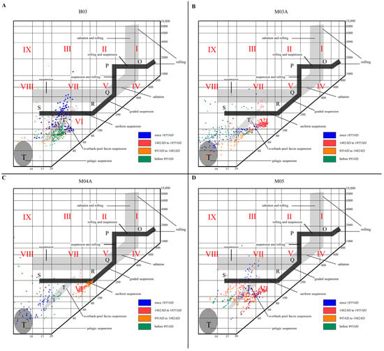
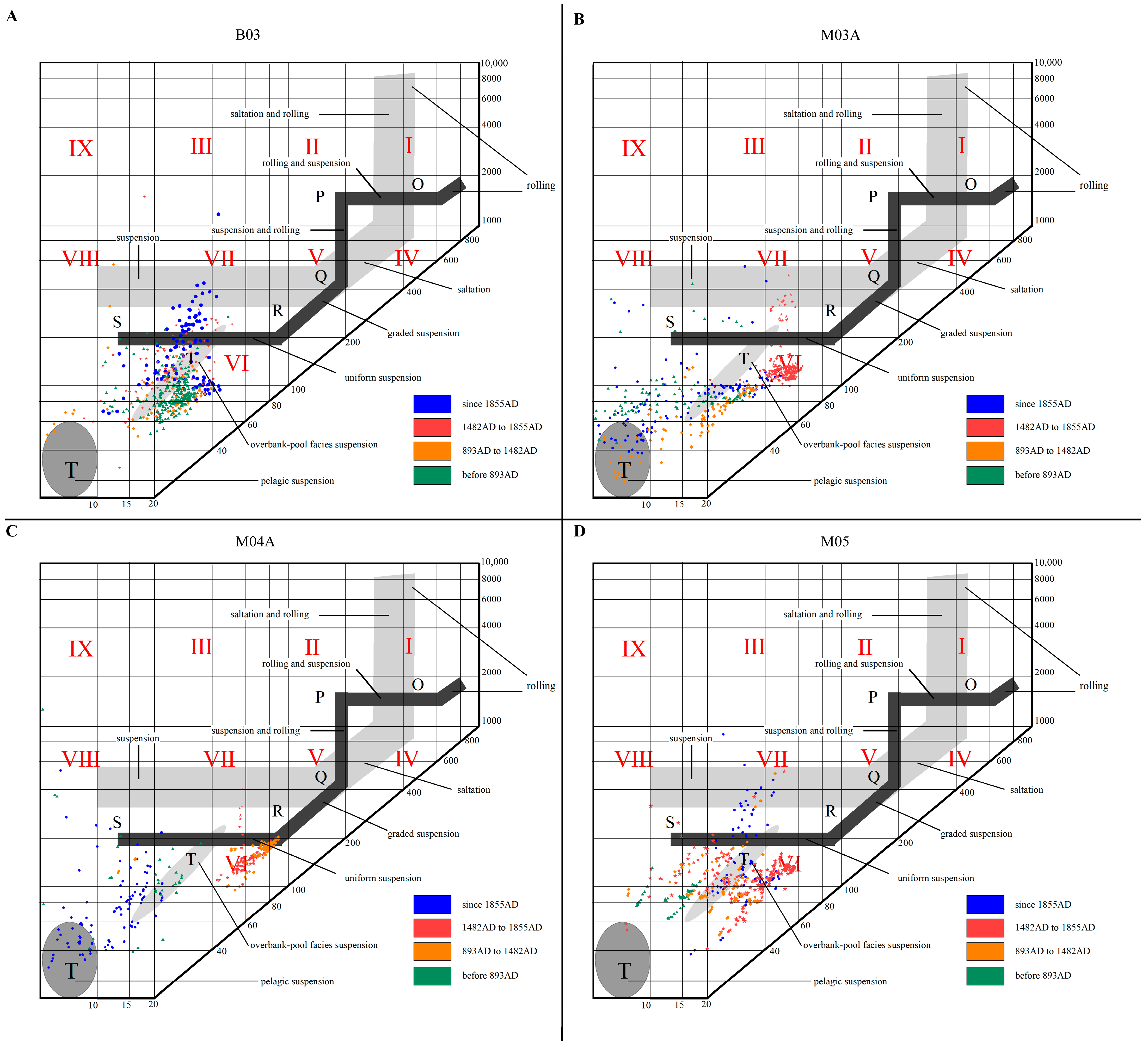
The sediment grain size C-M diagram (Figure 7) can effectively analyze sediment transportation modes and hydrodynamic conditions. Based on the results of sedimentary unit identification, the C-value and M-value datasets of each borehole are divided into four parts (before 893 AD, 893–1482 AD, 1482–1855 AD, and 1855 AD to present), combined with historical shoreline records and sedimentary profile information. The transportation modes and hydrodynamic conditions of each borehole are as follows:
Figure 7.
CM diagrams of sediments from four drill cores (B03, M03A, M04A, M05), categorized by chronological intervals. Blue dots denote sediments deposited since 1855 AD, red dots denote sediments from 1482 AD to 1855 AD, orange dots denote sediments from 893 AD to 1482 AD, green dots denote sediments deposited before 893 AD. (A) Drill core B03, (B) Drill core M03A, (C) Drill core M04A, (D) Drill core M05.
Before 893 AD, the data points of all four boreholes were concentrated in Zones VII–VIII, with C-values ranging from 10 to 60 μm and M-values ranging from 10 to 30 μm. The transportation modes of B03 (Figure 7A), M03A (Figure 7B), M04A (Figure 7C), and M05 (Figure 7D) were dominated by graded suspension, supplemented by uniform suspension and pelagic suspension. The hydrodynamics were moderate to weak, dominated by fine-grained sedimentation, and all were weak dynamic sedimentary environments of shallow sea or delta front, reflecting the stable weak dynamic conditions in the early stage of this area. Comparing the spatial differences of the four boreholes, it is found that the M-value of B03 was larger and more concentrated than that of the other three boreholes, indicating that the sedimentary dynamics of the environment where B03 was located were relatively stronger and more stable.
During 893–1482 AD, the data points of all four boreholes moved to Zones V–VI. The C-values increased to 25–75 μm, and the M-values increased slightly (18–36 μm). The transportation mode was dominated by uniform suspension, and some transitioned to the suspension and rolling zone. The hydrodynamics were moderately enhanced. The sedimentary environments of B03 (Figure 7A), M03A (Figure 7B), and M04A (Figure 7C) were delta front or estuary, while that of M05 was delta front or shallow sea. The improved flow stability and increased coarse-grained particles reflected the regional enhancement of hydrodynamics in the late Medieval Warm Period. Comparing the spatial differences of the four boreholes, it is found that the data points of M04A were more concentrated, and the C-values (100–200 μm) and M-values (80–100 μm) were generally higher, indicating a stronger and more stable hydrodynamic environment than the other boreholes.
During 1482–1855 AD, the four boreholes further moved to Zones IV–V. The C-values increased to 100–200 μm, the M-values increased to 40–80 μm, and the sediment grain size increased significantly. The transportation mode was dominated by suspension and rolling, and some was uniform suspension. The hydrodynamics were significantly enhanced, with a large number of coarse-grained particles appearing, and the transportation mode transitioned from uniform suspension to rolling + suspension. The sedimentary environment was estuary or delta front, with more coarse-grained particles. The spatial differentiation of the four boreholes increased: B03 was still in the low-energy suspension zone; M03A (Figure 7B), M04A (Figure 7C), and M05 (Figure 7D) all showed varying degrees of coarsening and concentrated distribution. However, vertical distribution of C-values (400 μm) appeared in M03A and M04A, indicating the input of abnormal coarse particles and strong hydrodynamics.
After 1855 AD, the four boreholes fell back to Zones VII–VIII. The C-values decreased to 15–50 μm, the M-values decreased to 0–40 μm, and the sediment grain size became finer. The transportation mode was dominated by graded suspension, supplemented by uniform suspension and pelagic suspension. The hydrodynamics were significantly weakened, with fluctuations in flow intensity, a significant decrease in coarse-grained particles, and suspension transportation re-dominated, all reflecting the consistency of weakened regional hydrodynamics after the Yellow River course change. Since these samples are close to the surface, they may have been disturbed by late-stage human activities (such as tillage), but the decrease in M-values and C-values indicates that the overall dynamics were significantly weakened.
4.4.2. End-Member Analysis
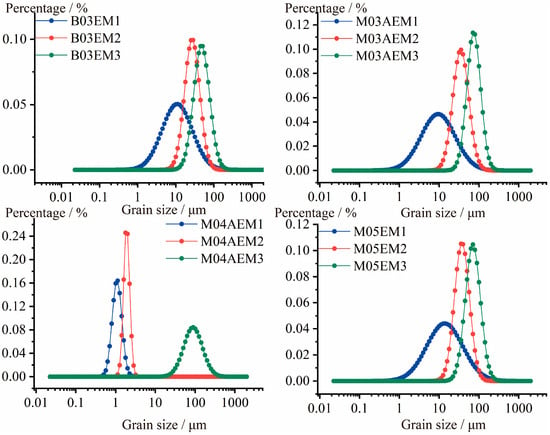
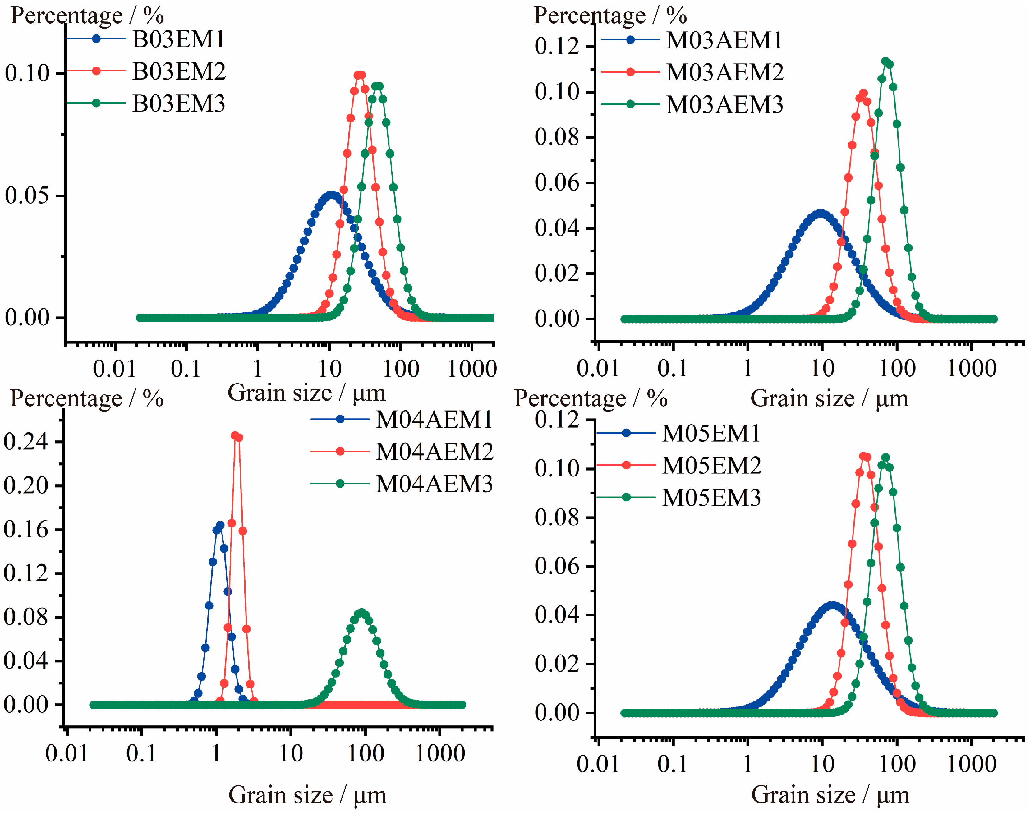
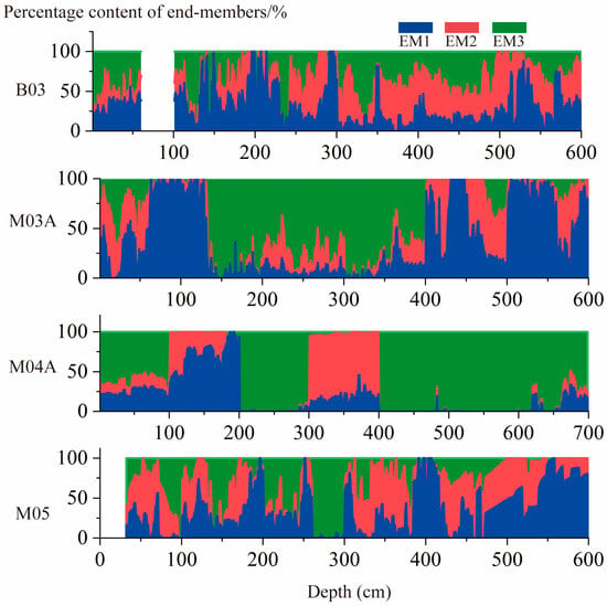
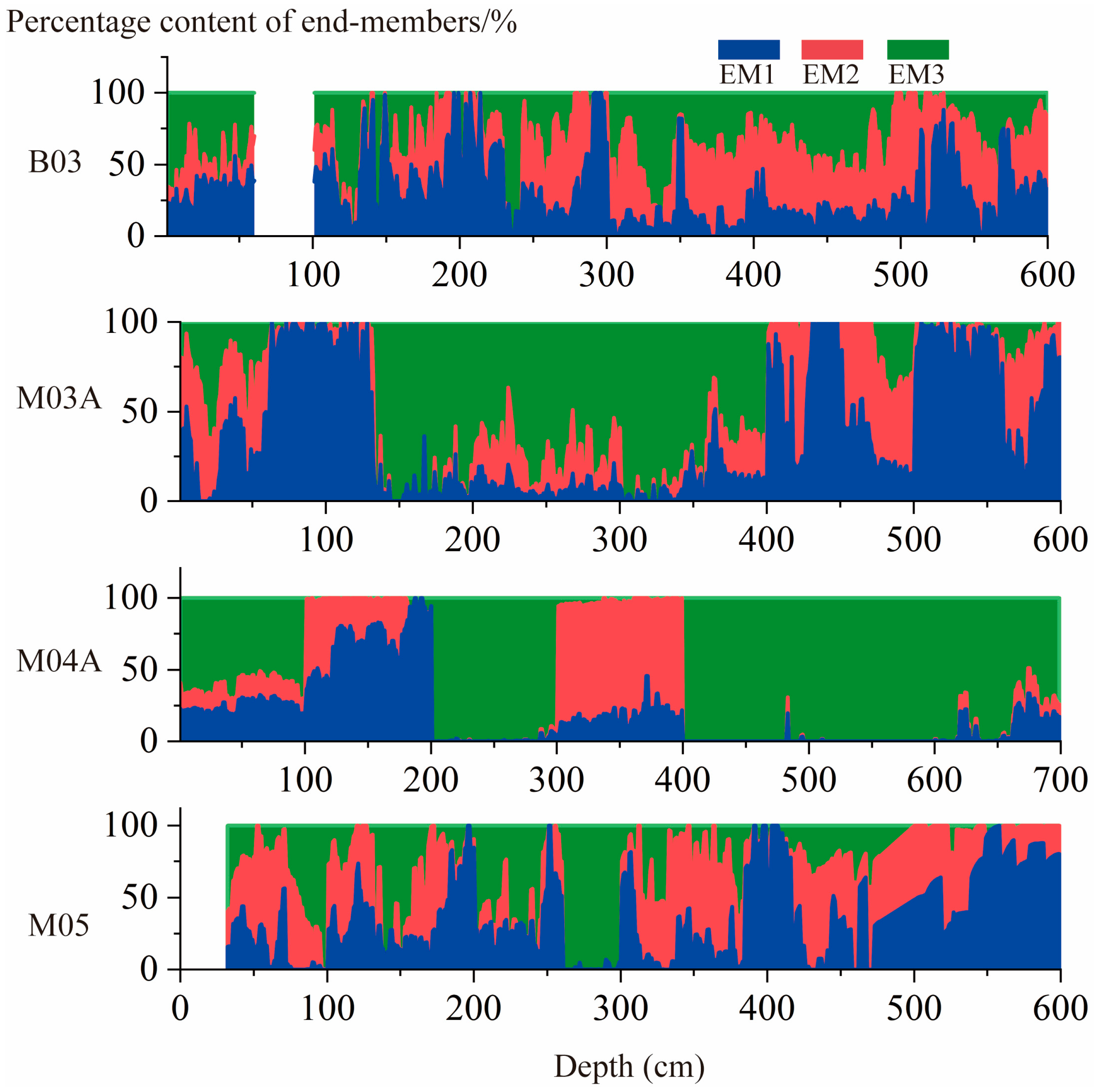
The end-member grain size model of the four boreholes decomposed three dominant dynamic end-members respectively (Figure 8). The end-member grain-size analysis of the four boreholes resolved three dominant dynamic end-members (Figure 8). Cores B03, M03A, and M05 exhibited comparable end-member characteristics: EM1, a fine-grained component with a modal peak at ~10 μm, is interpreted to represent a low-energy dynamic setting with intermittent fluctuations; EM2, a medium-grained end-member peaking at 40–60 μm, signifies a highly stable moderate-energy environment, typified by tidal or wave reworking; and EM3, a coarse-grained end-member with a modal peak at 90–100 μm, indicates persistent high-energy hydrodynamic conditions. In contrast, core M04A displayed a distinct end-member assemblage: both EM1 and EM2 were extremely fine-grained components (modal peaks at 1–4 μm), reflecting a low-energy and stable depositional environment, while EM3, a coarse-grained end-member with a modal peak at ~100 μm, points to relatively episodic high-energy events.
Figure 8.
End-member grain size distributions for sediment samples B03, M03, M04, and M05.
Combined with the hydrodynamic implications of end-member (EM) grain-size analysis—EM1 (fine-grained, weak hydrodynamic suspension transport), EM2 (medium-grained, moderate hydrodynamic suspension and weak saltation), and EM3 (coarse-grained, strong hydrodynamic saltation and rolling)—the depth profiles of EM proportions at the four boreholes clearly reveal the spatio-temporal evolution of sedimentary dynamics in the abandoned Yellow River delta (Figure 9). For B03, M03A, and M05, the EM variations exhibit consistent patterns. In the ancient Yellow River delta deposits (B03: 3.5–6 m; M03A: 5.48–6 m), EM1 dominates, indicating weak hydrodynamic suspension during the early MWP. In the pre-abandonment delta (893–1482AD) deposits (B03: 2.5–3.5 m; M03A: 4–5 m; M05: 3.8–5.48 m), EM2 proportions increase stepwise, accompanied by a corresponding decrease in EM1, reflecting a segmented moderate hydrodynamic environment dominated by suspension and weak saltation. In the late abandonment delta deposits (B03: 1.7–2.5 m; M03A: 1.3–4 m; M05: 1.5–3.8 m), EM3 proportions rise sharply and become dominant at certain depths, signifying a high-energy hydrodynamic environment characterized by coarse-grained saltation and rolling. In contrast, M04A displays distinct EM variations, reflecting its unique position in the offshore-nearshore hydrodynamic transition zone. In the pre-abandonment delta deposits (6.5–7 m), EM1 and EM2 are dominant, with EM1 characterized by finer grain sizes, indicating extremely weak hydrodynamics and fine-grained suspension in the offshore quiet environment during the MWP. At depths of 4–6 m, EM3 proportions increase continuously and become dominant, while EM1 and EM2 decrease significantly, indicating a drastic shift to a strong hydrodynamic environment dominated by coarse-grained saltation and rolling. Although EM1 and EM2 regain dominance at 3–4 m, EM3 remains the primary component overall, revealing a significant enhancement in hydrodynamics and a major shift in sedimentary environment at M04A during the LIA. Collectively, the EM variations at the four boreholes reflect both the regional commonality of sedimentary dynamics (weak hydrodynamics in the early MWP, moderate hydrodynamics in the late MWP, strong hydrodynamics in the LIA, and weak hydrodynamics in the modern period) and spatial differentiation. B03, M03A, and M05, located in the nearshore-moderate hydrodynamic transition zone, show synchronous EM changes, while M04A experienced a more pronounced hydrodynamic enhancement during the LIA of the abandoned delta. This spatio-temporal variation is highly coupled with the progradation-abandonment processes of the Yellow River delta and the changes driven by climate fluctuations.
Figure 9.
Vertical end-member percentage distributions for sediment cores B03, M03A, M04A, and M05.
5. Discussion
5.1. Characteristics of Phased Geomorphic Evolution
The cessation of fluvial sediment input into the sea leads to delta abandonment, transforming the delta from a construction phase to a “destruction” phase and forming the so-called “delta cycle” [15,16]. Numerous studies have shown that since the 20th century, many large river deltas have experienced coastal erosion due to reduced sediment discharge, including shoreline retreat, subaqueous delta erosion-accretion changes [47], and tidal flat coarsening [37,48]. Reduced fluvial sediment transport and sea-level rise affect estuarine distributary channel geomorphology, altering estuarine circulation and sediment trapping efficiency, thereby impacting mangroves and shelf sediment supply in the Mekong Delta [49,50]. Meanwhile, delta abandonment exhibits significant spatial heterogeneity in local geomorphology [5,51]. Even without complete cessation of fluvial sediment input, quasi-abandonment coastal erosion occurs due to river avulsion, sediment redistribution [51], and human activities. Additionally, climate change directly affects estuarine and coastal sedimentary dynamic processes by altering the intensity and frequency of storms, winds, waves, sea ice, and precipitation [52,53]. Storm surges exert both erosional and depositional effects on coastal geomorphology [54]; studies have demonstrated that storms and waves can cause shoreline retreat and beach coarsening [55], with waves becoming the dominant force shaping beach morphology during storms [56,57], leading to landward migration of coastal dunes and significant erosion-accretion on subaqueous slopes [58]. Eroded sediments from beaches and dunes during storms also serve as important sediment sources for lagoons and salt marshes [20,59]. The geomorphic impact of relative sea-level rise on delta interfluve floodplains is often intertwined with and mutually reinforced by land subsidence and its uneven spatial distribution [60]. By synthesizing these in situ datasets with regional paleoclimatic archives and existing research on deltaic evolution, this section clarifies the phased coupling mechanism of sedimentary dynamics and its overarching control on the millennial-scale geomorphic trajectory of the abandoned delta.
5.1.1. River-Dominated Stable Stage (40 BC–893 AD)
The first stage (40 BC–893 AD) represents a fluvially dominated stable interval, where persistent sediment supply from the Yellow River exerted the primary control on deltaic geomorphic development and provided the initial sedimentary substrate for subsequent evolution [5]. OSL dating from the basal parts of all drill cores verifies that this stage postdates the initiation of the ancient Yellow River delta around 40 BC and predates the Yellow River avulsion in 893 AD (Table 2), representing the developmental phase of the ancient Yellow River delta, with sedimentary properties matching a typical fluvially dominated deltaic setting [61]. Sediments throughout this stage are dominated by clayey silt (Figure 6). Sediment transport is characterized by graded suspension as the main mode, supplemented by uniform suspension and pelagic suspension, corresponding to moderate-to-weak hydrodynamic conditions favoring fine-grained accumulation. Drill cores M03A and M04A exhibit regular interbedded structures with consistent single-layer thickness Figure 6), and data point groups in the C-M plot (Figure 7B,C) lie nearly parallel to the C-axis (lateral changes in M values). These two features are diagnostic of seasonally controlled fluvial deltas, and coincide well with the stable water and sediment supply forced by strong summer monsoons in the ancient delta [5]. End-member analysis shows that EM1 and EM2, representing fine-grained suspended load transport, are dominant throughout this stage (Figure 9); such weak and steady hydrodynamic conditions correspond well to the sedimentary signature of the ancient delta front facies [62]. This persistent fluvial dominance is consistent with regional paleoclimatic records, which reflect a warm and humid climate with intensified summer monsoons that maintained high runoff and sediment load in the Yellow River [63]. Previous studies have documented that the Yellow River Delta displayed one of the highest progradation rates among large fluvial deltas worldwide during this interval [5,64], confirming that a thick sedimentary basement was formed prior to the abandonment of the Yellow River Delta (Figure 6).
5.1.2. Slow Fluctuation Stage (893 AD–1482 AD, MWP)
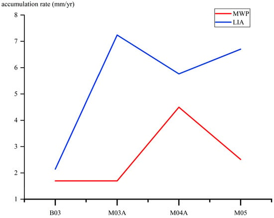
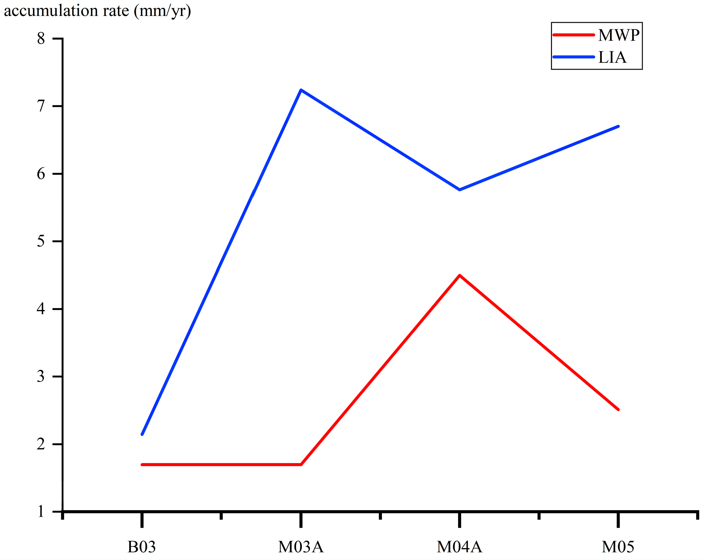
Following the Yellow River avulsion in 893 AD, the period 893–1482 AD still occurred within the MWP. This avulsion resulted in an abrupt reduction in fluvial sediment input to the study area. Like many deltas that have entered the abandonment stage [65], the Yellow River Delta has gradually transitioned from fluvial-dominated to wave- and tide-dominated conditions [5], which signifies the onset of the initial abandonment stage. The sedimentation rates in the region have generally decreased (compared with 5.31 mm/yr for the paleo-delta) [5] (Figure 10).However, Borehole M04A still maintained a relatively high sedimentation rate (approximately 4.3 mm/yr). Noticeable changes in sedimentary dynamics were observed across the four drill cores. All cores displayed a slight grain size coarsening trend (Figure 2, Figure 3, Figure 4 and Figure 5), and the dominant sediment transport mode shifted from graded suspension to uniform suspension and weak rolling (Figure 7) [66]. End member analysis indicates that the proportion of EM2 (representing medium-energy coastal transport) increased while EM1 decreased (Figure 9); notably, the coarse-grained end member EM3 increased rapidly in Borehole M04A. These features collectively point to a regional transition from fluvial-dominated to marine-dominated dynamics, reflecting diminished fluvial influence and progressively strengthened coastal hydrodynamics [67,68,69]. Spatial differentiation in sedimentary dynamics also emerged among the boreholes. Borehole M04A exhibited significant grain-size coarsening, a rapid rise in sand content (Figure 4), and swift dominance by EM3 (Figure 9), along with tightly clustered and distinctly elevated C values (100–200 μm) and M values (60–100 μm) (Figure 7C). The rapid increase in coarse grains and stable grain size distribution suggest that M04A was the first to respond to the termination of sediment supply and the shift from weak fluvial to strong marine dynamics, leading to the development of a sandy sedimentary body. This sandy unit formed at approximately 914 AD and prograded landward (toward Borehole M03A) (Figure 6). Sandy accumulation also initiated at Borehole M03A around 1344 AD and thickened continuously thereafter. Although sandy deposits began to form as early as 893–1482 AD, their accumulation rate remained extremely low (Figure 10). Regional sea-level records [68] indicate a relatively slow rise during the MWP (2.31 mm/yr). Furthermore, historical storm surge records [24] for the Bohai Bay document only three events during this interval, far fewer than in the subsequent Little Ice Age, implying that coastal hydrodynamic strength was inadequate to drive large scale geomorphic modification.
Figure 10.
Borehole sediment accumulation rates (MWP vs. LIA).
This stage thus represents the initial abandonment phase of delta evolution: the cessation of fluvial sediment supply laid the groundwork for geomorphic change, yet the lack of intense coastal forcing resulted in only slow, minor erosion of the delta front, accompanied by gradual local geomorphic differentiation [5]. This finding supplements previous studies focused primarily on the long-term erosion of abandoned deltas, and highlights the phased nature of the initial abandonment stage, as well as the constraining effect of weak dynamic coupling on geomorphic modification.
5.1.3. Storm Surge Intensification-Dominated Intensive Reconfiguration Stage (1482–1855 AD, LIA)
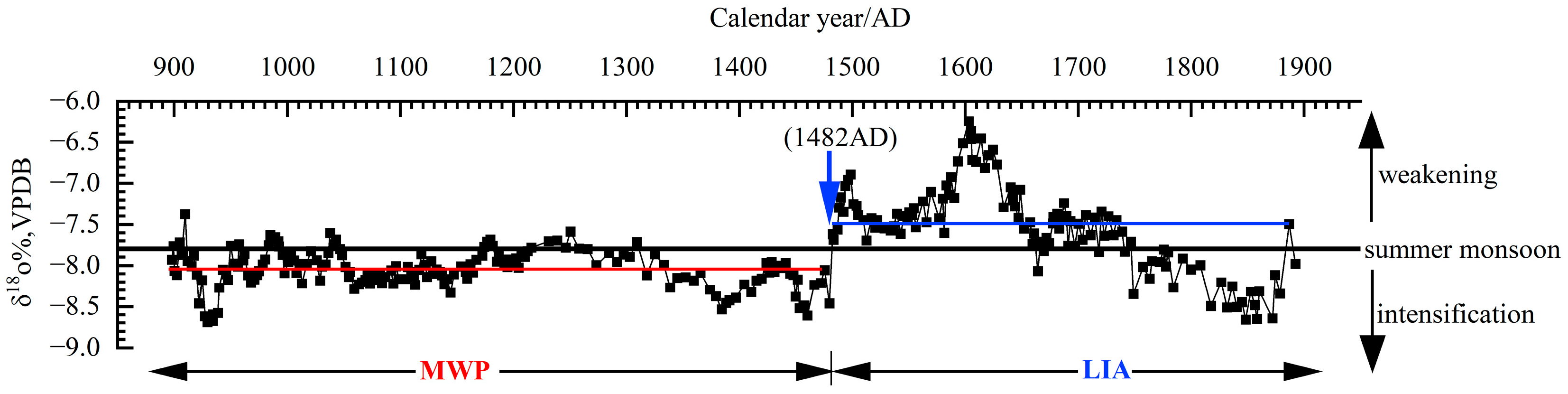
During the 1482–1855 AD (LIA), the abandoned delta experienced profound environmental changes characterized by three key features. First, the Yellow River shifted to capture the Huaihe River and empty into the sea in Jiangsu Province by 1495 AD, resulting in a complete termination of fluvial water and sediment supply to the study delta [5]. Second, the climatic regime shifted from the Medieval Warm Period, featured by strong and stable summer monsoons, to the Little Ice Age, marked by weakened and unstable summer monsoons and frequent storm activities (Figure 11). Historical records confirm that the frequency and intensity of storm surges during the LIA (31 events) were approximately ten times those during the MWP (3 events) [24]. Third, the rate of relative sea-level rise accelerated (2.31 mm/yr) [68]. After being subaerially exposed for more than a century, the abandoned delta was dominated by marine processes [5], and distinct spatial divergence in sedimentation rates emerged among the drill cores (Figure 10). Pronounced differentiation in sedimentary dynamics is evident across the cores. The most striking characteristic is that all cores show variable fluctuations in grain-size properties, especially the contrast between the clayey silt layers in B03 and the interbedded silt and clay layers in M03A and M04A (Figure 6). Distinct interlayers of gray and yellow silt mixed with fine sand, as well as shell-bearing sand layers and coarse sand lenses, are recognized at 2.5–4 m depth in M04A. These interbeds exhibit normal grading (Figure 4), reflecting hydrodynamic shifts from high-energy coarse-grained deposition to low-energy fine-grained deposition. Frequent color variations indicate rapid alternations between oxidizing and reducing environments, providing direct evidence for short-term fluctuations between strong and weak hydrodynamic conditions. Pronounced spatial differentiation in sedimentary dynamics was evident among the four cores (Figure 7). B03 retained weak hydrodynamic conditions dominated by suspended deposition. M03A and M04A both show highly concentrated data points with M values of 40–60 μm, but their C values vary vertically between 80 and 400 μm, indicating high-energy yet unstable sedimentary dynamics. Data points in M05 are scattered nearly parallel to the C=M line, suggesting relatively stable hydrodynamic conditions consistent with its persistent shallow-marine setting. Nevertheless, M05 also displays noticeable grain coarsening and stepwise changes compared to earlier deposits, implying periodic variations in sediment supply intensity or minor adjustments of shallow-marine hydrodynamic patterns under a generally stable marine regime. The accelerated rate of relative sea-level rise during this stage further expanded the influence of storm surges [69]. Notably, anomalously coarse grains delivered by storm surges were identified in the pre-existing depression recorded in B03 (Figure 7A). After 1855 AD, rapid accumulation of sediments from the modern Yellow River eliminated the sedimentary differences among the cores, resulting in the rapid burial of the abandoned Yellow River delta.
Figure 11.
Evolution of summer monsoon intensity revealed by δ18O records in the study area during the late Holocene (900–1900 AD), obtained from the study by Wang [17,18].
In summary, reduced sediment supply, climate-induced intense storm dynamics, and relative sea-level rise collectively drove the geomorphic evolution of the shallow-buried abandoned Yellow River Delta during 893–1855 AD [70]. After delta abandonment induced by reduced sediment supply post-893 AD, marine (tidal and wave processes) dynamics first formed a sandy accumulation body at M04A and drove the continuous landward progradation of the sandy coast toward M03A. During the LIA, driven by storm surges, the sandy accumulation body further widened and elevated, whereas sedimentation in the inland plain depression remained relatively weak. These factors collectively constituted a plain lowland-coastal highland system, which is distinct from traditional island-continent [71] and barrier-lagoon systems [72], and is unique among large river deltas.
5.2. Geomorphic Characteristics and Identification of Temperate Storm Surges
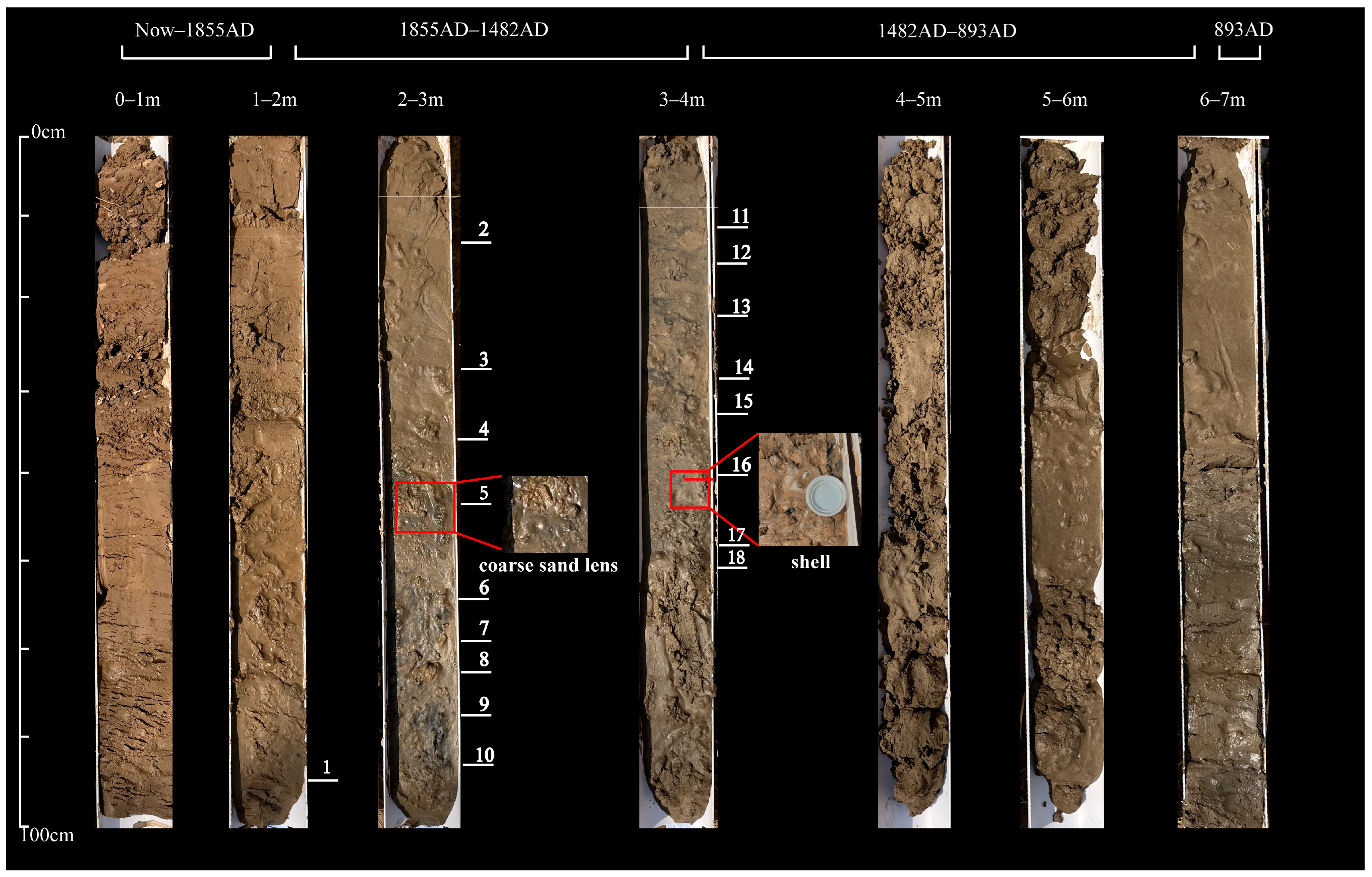
The geomorphic reworking of the delta by temperate storm surges is essentially a dynamic-sedimentary coupling process: the high-energy hydrodynamics driven by storms mobilize residual sediment, and the subsequent weakening of hydrodynamic energy triggers the selective deposition of sediment, which can be completely recorded in sedimentary proxies. Vertically, the storm-affected layers (Figure 12) present an alternating rhythm of “coarse-fine-coarse”, corresponding to the occurrence of multiple storm events. For example, coarse sand lenses are developed at 2.5~4 m in M04A, with a thickness of 3~5 cm and sand content higher than 70%, which are identified as strong storm deposits; the inter-storm silty clay (9.2~9.5 ϕ) below the lenses and the overlying coarse-grained sediment layers record the subsequent storm activities. The grayish-yellow mixed sandy silt and shell layers in M04A also indicate the pulsed activity characteristics of storms [26]. Through the observation of M04A borehole, it is found that this sedimentary rhythm (18 layers) is consistent with the high occurrence frequency of storms (31 times) during the LIA [24]. The changes in end-member model and C-M plot can also reflect the dynamic-sedimentary response characteristics: compared with the inter-storm period, the proportion of end-member three increases (40~60%) during the storm period, while the proportions of end-member 1 and end-member 2 decrease (Figure 9), indicating that the sediment transport mode changes from suspension-dominated to saltation-rolling-dominated (Figure 7); correspondingly, the data points in the C-M plot migrate from the uniform suspension area to the suspension-rolling area, the C value increases in the range of 200~400 μm, and the M value increases by 20~40 μm, directly recording the process of hydrodynamic enhancement driven by storms. Notably, there are significant differences in the dynamic-sedimentary response characteristics between temperate storm surges and tropical typhoons: the single extreme energy input of tropical typhoons forms thick-layer (>20 cm), poorly sorted sedimentary bodies (sorting coefficient > 2.5) [73], while the pulsed moderate energy input of temperate storm surges forms thin-layer (usually less than 5 cm) coarse-grained lenses interbedded with fine-grained sediments, and multiple winnowing effects make the sediment sorting relatively good (sorting coefficient < 2.2).
Figure 12.
Storm Surge Sedimentary Diagnostic Markers of Borehole M04A This figure displays the core photographs of Borehole M04A, with chronological intervals (Now~1855 AD, 1855 AD–1482 AD, 1482 AD–893 AD, and before 893 AD) indicated at the top. By integrating multiple diagnostic indicators including grain size, lithology, and shell fragments, 18 storm surge sedimentary layers were identified and numbered (1–18). These layers are defined by grayish-yellow silty sand beds that are distinctly coarser than those in other boreholes. Key sedimentary features, such as a coarse sand lens (in the 2–3 m interval) and shell fragments (in the 3–4 m interval), are highlighted with red boxes and magnified insets for clear identification.
5.3. Synergistic Effects of Key Geomorphic Drivers
The fundamental driver of the delta’s evolutionary transition is the cessation of fluvial water-sediment supply, with storm surges acting as a critical geomorphic modifier and relative sea-level rise as an auxiliary amplifier.
5.3.1. Dominant Role of Phased Sediment Supply Termination
The delta’s abandonment and evolutionary shift were ultimately triggered by the progressive loss of Yellow River sediment input. The 893 AD avulsion marked the initial cutoff, transitioning the delta from fluvial construction (paleo-delta’s sedimentation rate of 5.31 mm/yr [5]) to marine modification [29]. Further reduction in 1128 AD weakened fluvial dominance, with M04A’s sedimentation rate declining to 1.8 mm/yr (vs. 4.3 mm/yr in 893–1128 AD), and complete termination by 1495 AD eliminated exogenous supply—this constituted the core prerequisite for evolutionary change. Without this sediment loss, the delta would have maintained fluvial stability, and storm surges (31 events in the LIA vs. 3 in the MWP [24]) could not have driven substantial reorganization. Post-abandonment, M03A, M04A accumulated 60–90% sand via storm reworking, while the B03 had sand content ≤ 40% and sedimentation rate ≤ 1.0 mm/yr, reflecting spatial differentiation induced by storm modification on the basis of sediment supply loss.
5.3.2. Auxiliary Amplification by Phased Sea-Level Rise
Sea-level changes synergized with the abandoned delta’s vulnerability to modulate processes [68,69]. Stable during 79–1019 AD (rise rate ≤ 0.5 mm/yr), it had negligible impact while fluvial supply persisted. Slow rise (1.2–1.8 mm/yr) in 1019–1800 AD expanded wave/tide action ranges, amplifying storm energy transfer and promoting sandy highland progradation. Accelerated rise (>2.0 mm/yr) post-1800 AD intensified outer M05 coarsening, with sand content increasing from 30% to 50%. However, this rise only amplified existing differences caused by sediment supply loss and storm reworking—OSL dating confirms M05′s coarsening post-1800 AD (0.07–0.27 ka) (Table 2) coincided with both accelerated sea-level rise and reduced sediment input, rather than initiating the transition.
In summary, the driver hierarchy is clear: fluvial water-sediment supply termination (evidenced by declining sedimentation rates from 5.31 mm/yr to ≤1.0 mm/yr and sand content divergence) was the dominant trigger for abandonment, storm surges (31 LIA events [24]) were the key modifier shaping post-abandonment geomorphology, and sea-level rise (rate up to >2.0 mm/yr) was the auxiliary amplifier—collectively governing the delta’s unique trajectory.
6. Conclusions
Based on grain-size analysis, sedimentary facies analysis and optically stimulated luminescence (OSL) dating of four sediment cores, integrated with geomorphological investigations, we reconstructed the geomorphic evolution of the shallow-buried abandoned Yellow River Delta during its development, and examined the geomorphic reworking characteristics and diagnostic indicators produced by storm surges. The main conclusions are as follows:
(1) The geomorphic evolution of the shallow-buried abandoned Yellow River Delta (893–1855 AD) was collectively governed by reduced fluvial sediment supply, intensified storm dynamics linked to climatic changes, and accelerated relative sea-level rise. After delta abandonment caused by the sharp decline in sediment input after 893 AD, marine (wave) processes initially formed a sandy sediment body at M04A and drove the progressive landward expansion of the sandy coast toward M03A. During the Little Ice Age, storm surges further promoted the widening and uplift of the sandy accumulation, whereas sedimentation in the inland plain depression remained relatively weak. These interactions gave rise to a unique plain lowland–coastal highland system, which differs from classic island–continent and barrier–lagoon systems and represents a distinctive geomorphic type among large river deltas.
(2) Repeated intense storm surges drove a fundamental shift in the erosion–deposition pattern of the abandoned delta front. The transitional zone (M03A, M04A) became the dominant depocenter for massive coarse-grained sediment accumulation, forming prominent sandy highlands. By contrast, the coastal depression (B03) and outer shallow sea (M05) were dominated by erosion or slight grain coarsening, eventually establishing a typical tripartite geomorphic framework: “coastal depression—sandy highland—outer shallow sea”. Following multiple intense storm surge events, this pattern was further enhanced: the sandy highlands increased significantly in area and elevation, creating a strong topographic contrast with the adjacent coastal depression and outer shallow sea, and completely reshaping the coastal geomorphology of the study area.
(3) The geomorphic evolutionary transition of the shallow-buried abandoned Yellow River Delta is governed by hierarchical multi-factor coupling, with the phased cessation of fluvial water-sediment supply as the primary trigger, temperate storm surges as the core geomorphic modifier, and relative sea-level rise as the auxiliary amplifier. The Yellow River avulsion in 893 AD resulted in a significant attenuation of sediment input driven by fluvial water-sediment supply; with the phased further reduction in water-sediment supply, the sedimentation rate in the study area continued to decrease (893 AD–1128 AD) until the complete termination of water-sediment supply in 1495 AD, laying the essential prerequisite for the delta’s abandonment. Frequent storm surges during the Little Ice Age reworked residual sediments. Relative sea-level rise expanded the action range of coastal hydrodynamics and amplified the storm-induced spatial differentiation of sedimentary and geomorphic features. This hierarchical driving mechanism reveals the intrinsic evolutionary logic of abandoned deltas in temperate monsoon zones, providing a typical scientific reference for understanding the multi-factor synergistic effects in the geomorphic evolution of large river deltas globally.
Author Contributions
Conceptualization, T.S., H.S., Y.L. and H.W. (Hongshi Wu); methodology, H.W. (Haojian Wang) and T.S.; software, H.W. (Haojian Wang); validation, H.W. (Haojian Wang), T.S. and H.S.; formal analysis, H.W. (Haojian Wang); investigation, H.W. (Haojian Wang), T.L., S.Y. and B.L.; resources, T.S., H.S., Y.L. and H.W. (Hongshi Wu); data curation, H.W. (Haojian Wang), T.L., S.Y. and B.L.; writing—original draft preparation, H.W. (Haojian Wang); writing—review and editing, T.S., H.S., Y.L. and H.W. (Hongshi Wu); visualization, H.W. (Haojian Wang); supervision, T.S., H.S., Y.L. and H.W. (Hongshi Wu); project administration, T.S.; funding acquisition, T.S., H.S., Y.L. and H.W. (Hongshi Wu). All authors have read and agreed to the published version of the manuscript.
Funding
This study was financially supported by Shandong Provincial University Youth Innovation and Technology Support Program (Grant No. 2025KJH173), National Natural Science Foundation of China (Grant No. 42501002), and Shandong Provincial Natural Science Foundation of China (Grant No. ZR2024QD231).
Data Availability Statement
The original contributions presented in this study are included in the article. Further inquiries can be directed to the corresponding author.
Acknowledgments
The authors gratefully acknowledge the financial support and academic guidance from the School of Hydraulic and Civil Engineering, School of Resources and Environmental Engineering, and Shandong Provincial Key Laboratory of Estuary and Coast & Nuclear Environment at Ludong University. We also thank all graduate students (Lu Tao, Yao Shiqi, Liu Baomu) for their assistance in experimental operation and sample processing. During the preparation of this manuscript, the authors used ChatGPT (https://chat.openai.com/) for polishing the language of the article. The authors have reviewed and edited the output and take full responsibility for the content of this publication.
Conflicts of Interest
The authors declare no conflicts of interest. The funders had no role in the design of the study, in the collection, analyses, or interpretation of data, in the writing of the manuscript, or in the decision to publish the results.
References
- Gelfenbaum, G.; Stevens, A.; Elias, E.; Warrick, J. Modeling sediment transport and delta morphology on the dammed Elwha River, Washington State, USA. In Proceedings of the Coastal Dynamics 2009, Tokyo, Japan, 7–11 September 2009; pp. 1–15. [Google Scholar] [CrossRef] [Scilit]
- Leonardi, N.; Fagherazzi, S. Effect of Local Variability in Erosional Resistance on Large-Scale Morphodynamic Response of Salt Marshes to Wind Waves and Extreme Events. Geophys. Res. Lett. 2015, 42, 5872–5879. [Google Scholar] [CrossRef] [Scilit]
- Syvitski, J.; Kettner, A.; Overeem, I.; Hutton, E.W.H.; Hannon, M.T.; Brakenridge, G.R.; Day, J.; Vörösmarty, C.; Saito, Y.; Giosan, L.; et al. Sinking deltas due to human activities. Nat. Geosci. 2009, 2, 681–686. [Google Scholar] [CrossRef] [Scilit]
- Wang, H.; Wu, X.; Bi, N.; Li, S.; Yuan, P.; Wang, A.; Syvitski, J.P.; Saito, Y.; Yang, Z.; Liu, S.; et al. Impacts of the Dam-Orientated Water-Sediment Regulation Scheme on the Lower Reaches and Delta of the Yellow River (Huanghe): A Review. Glob. Planet. Change 2017, 157, 93–113. [Google Scholar] [CrossRef] [Scilit]
- Wang, Q.; Zeng, L.; Zhan, C.; Liu, X.; Wang, L.; Cheng, S.; Cui, B. Geomorphologic Evolution of the Shallow-Buried Abandoned Yellow River Delta During the Last 2000 Years. Front. Mar. Sci. 2022, 9, 1073961. [Google Scholar] [CrossRef] [Scilit]
- Anthony, E.J. Wave Influence in the Construction, Shaping and Destruction of River Deltas: A Review. Mar. Geol. 2015, 361, 53–78. [Google Scholar] [CrossRef] [Scilit]
- Shi, X.F.; Qiao, S.Q.; Yang, S.Y.; Li, J.R.; Wang, S.M.; Zou, J.J.; Xiong, Z.F.; Hu, L.M.; Yao, Z.Q.; Dong, L.S.; et al. Advances in Sedimentological Studies of the Asian Continental Margin (2011–2020). Bull. Mineral. Petrol. Geochem. 2021, 40, 319–336. [Google Scholar] [CrossRef]
- Wang, H.; Bi, N.; Saito, Y.; Wang, Y.; Sun, X.; Zhang, J.; Yang, Z. Recent changes in sediment delivery by the Huanghe (Yellow River) to the sea: Causes and environmental implications in its estuary. J. Hydrol. 2010, 391, 302–313. [Google Scholar] [CrossRef] [Scilit]
- Hou, L.; Gao, J. Investigations on alleviation effect of Bragg breakwater on harbor resonance induced by irregular waves. Ocean Eng. 2026, 353, 124797. [Google Scholar] [CrossRef] [Scilit]
- Gao, J.; Ma, X.; Zang, J.; Dong, G.; Ma, X.; Zhu, Y.; Zhou, L. Numerical investigation of harbor oscillations induced by focused transient wave groups. Coast. Eng. 2020, 158, 103670. [Google Scholar] [CrossRef] [Scilit]
- Wang, Z.; Liu, C. Two-Thousand Years of Debates and Practices of Yellow River Training Strategies. Int. J. Sediment Res. 2022, 37, 73–83. [Google Scholar] [CrossRef] [Scilit]
- Syvitski, J.; Anthony, E.; Saito, Y.; Zăinescu, F.; Day, J.; Bhattacharya, J.P.; Giosan, L. Large deltas, small deltas: Toward a more rigorous understanding of coastal marine deltas. Glob. Planet. Change 2022, 218, 103958. [Google Scholar] [CrossRef] [Scilit]
- Xue, C.T.; Cheng, G.D. Shelly Ridges in West Coast of Bohai Sea and Holocene Yellow River Delta System. In Quaternary Processes and Events in China’s Offshore and Coastal Areas; Yang, Z.G., Lin, H.M., Eds.; Ocean Press: Beijing, China, 1989; pp. 117–125. (In Chinese) [Google Scholar]
- Wang, Z.H.; Huang, S.G. Study on the Evolution of the Yellow River Delta Using Recent Surveyed Nautical Charts and Historical Nautical Charts. Coast. Eng. 1988, 2, 49–60. (In Chinese) [Google Scholar]
- Roberts, H. Dynamic Changes of the Holocene Mississippi River Delta Plain: The Delta Cycle. J. Coast. Res. 1997, 13, 605–627. [Google Scholar]
- Stanley, D.J.; Warne, A.G. Nile Delta in its destruction phase. J. Coast. Res. 1998, 14, 795–825. [Google Scholar]
- Wang, Q.; Zhou, H.; Cheng, K.; Chi, H.; Shen, C.; Wang, C.; Ma, Q. Theclimate reconstruction in Shandong peninsula, north China during the lastmillennia based on stalagmite laminae. Clim. Past 2015, 11, 4643–4668. [Google Scholar] [CrossRef] [Scilit]
- Wang, Q.; Zhou, H.Y.; Chi, H.; Cheng, K.; Wang, H.Y.; Ma, Q.Q.; Wang, C.S. δ18O and δ13C records of stalagmites for climatic and environmental changes in western Shandong Peninsula during the last millennium. Mar. Geol. Quat. Geol. 2015, 35, 135–142. [Google Scholar] [CrossRef]
- Wang, X.F. Historical Regularity Research on Storm Surge Disasters Along the Coast of Shandong: Focusing on the Historical Materials of the Ming and Qing Dynasties (1374–1911). Master’s Thesis, Ocean University of China, Qingdao, China, 2011. [Google Scholar]
- Burvingt, O.; Masselink, G.; Scott, T.; Davidson, M.; Russell, P. Climate forcing of regionally-coherent extreme storm impact and recovery on embayed beaches. Mar. Geol. 2018, 401, 112–128. [Google Scholar] [CrossRef] [Scilit]
- Bacino, G.L.; Dragani, W.C.; Codignotto, J.O. Changes in wave climate and its impact on the coastal erosion in Samborombón Bay, Río de la Plata estuary, Argentina. Estuar. Coast. Shelf Sci. 2019, 219, 71–80. [Google Scholar] [CrossRef] [Scilit]
- Gao, J.L.; Hou, L.H.; Dai, S.S.; Liao, Y.D. Investigation on the Tsunami Resonance Characterization in Pearl River Estuary. China Ocean Eng. 2026, 40, 1–12. [Google Scholar] [CrossRef] [Scilit]
- Feng, S.Z. An Introduction to Storm Surges; Science Press: Beijing, China, 1982. [Google Scholar]
- Liu, A.G. A Discussion on Historical Storm Surges Along the Coast of Shandong. J. Ocean Univ. Qingdao 1989, 19, 19–27. [Google Scholar] [CrossRef]
- Chen, Q.; Zhang, Y.; He, F.; Liu, S.; Wang, Y.P.; Jia, J. Morphological Response and Recovery of a Headland-Bay Beach Under Consecutive Typhoon Impacts. Mar. Geol. 2025, 492, 107698. [Google Scholar] [CrossRef] [Scilit]
- Zhao, P.P.; Yang, Y.; Jia, J.J.; Zhao, N.; Zhang, W.T.; Gao, S. Typhoon and flooding occurrences on Chongming Island, Changjiang Estuary, as revealed by a newly acquired sedimentary record. Front. Mar. Sci. 2024, 11, 1366676. [Google Scholar] [CrossRef] [Scilit]
- Shi, H.Y.; Ma, P.C.; Sun, J.W.; Zhao, S.N.; Ma, R.Q.; Li, L.S.; Zhan, C.; Liang, H. Study on the response mechanism of the Yellow River delta region to the cold wave process. Front. Mar. Sci. 2024, 11, 1430823. [Google Scholar] [CrossRef] [Scilit]
- Mo, D.; Hou, Y.J.; Li, J.; Liu, Y.H. Study on the storm surges induced by cold waves in the Northern East China Sea. J. Mar. Syst. 2016, 161, 26–39. [Google Scholar] [CrossRef] [Scilit]
- Gao, S.; Li, Y.; An, F.; Wang, Y.; Yan, F. Formation and Sedimentary Environment of the Yellow River Delta; Science Publishing Company: Beijing, China, 1989. [Google Scholar]
- Chen, G.; Yi, L.; Xu, X.; Yu, H.; Cao, J.; Su, Q.; Yang, L.-H.; Xu, Y.-H.; Ge, J.-Y.; Lai, Z.-P. Testing the standardized growth curve (SGC) to OSL dating coastal sediments from the south Bohai Sea, China. Geochronometria 2013, 40, 101–112. [Google Scholar] [CrossRef] [Scilit]
- Gao, S.; Collins, M.B. Holocene sedimentary systems on continental shelves. Mar. Geol. 2014, 352, 268–294. [Google Scholar] [CrossRef] [Scilit]
- Zhan, C.; Wang, Q.; Cui, B.; Zeng, L.; Dong, C.; Li, X.; Yu, X.; Wang, X.; Liu, X. The morphodynamic difference in the western and southern coasts of Laizhou Bay: Responses to the Yellow River Estuary evolution in the recent 60 years. Glob. Planet. Change 2020, 187, 103138. [Google Scholar] [CrossRef] [Scilit]
- Editorial Committee of the Bay Chorography in China. The Bay Chorography in China; Beijing Ocean Press: Beijing, China, 1993; Volume 3, pp. 1–81. [Google Scholar]
- Hoitink, A.J.F.; Wang, Z.B.; Vermeulen, B.; Huismans, Y.; Kästner, K. Tidal controls on river delta morphology. Nat. Geosci. 2017, 10, 637–645. [Google Scholar] [CrossRef] [Scilit]
- Gao, L.; Long, H.; Zhang, P.; Tamura, T.; Feng, W.; Mei, Q. The sedimentary evolution of Yangtze River delta since MIS3: A new chronology evidence revealed by OSL dating. Quat. Geochronol. 2019, 49, 153–158. [Google Scholar] [CrossRef] [Scilit]
- Gugliotta, M.; Saito, Y. Matching Trends in Channel Width, Sinuosity, and Depth Along the Fluvial to Marine Transition Zone of Tide-Dominated River Deltas: The Need for a Revision of Depositional and Hydraulic Models. Earth-Sci. Rev. 2019, 191, 93–113. [Google Scholar] [CrossRef] [Scilit]
- Jiang, C.; Pan, S.Q.; Chen, S.L. Recent morphological changes of the Yellow River (Huanghe) submerged delta: Causes and environmental implications. Geomorphology 2017, 293, 93–107. [Google Scholar] [CrossRef] [Scilit]
- Liu, A.; Zhang, D. On the Historical Storm Surges Round the Bohai Sea Region. Period. Ocean Univ. China 1991, 21, 21–36. (In Chinese) [Google Scholar]
- Murray, A.S.; Wintle, A.G. Luminescence Dating of Quartz Using an Improved Single-Aliquot Regenerative-Dose Protocol. Radiat. Meas. 2000, 32, 57–73. [Google Scholar] [CrossRef] [Scilit]
- Lu, H.Y.; An, Z.S. Pretreated Methods on Loess-Palaeosol Samples Granulometry. Chin. Sci. Bull. 1998, 43, 237–240. [Google Scholar] [CrossRef] [Scilit]
- Folk, R.L.; Ward, W.C. Brazos River Bar (Texas), A Study in the Significance of Grain Size Parameters. J. Sediment. Petrol. 1957, 27, 3–26. [Google Scholar] [CrossRef] [Scilit]
- Passega, R. Texture as Characteristic of Clastic Deposition. AAPG Bull. 1957, 41, 1952–1984. [Google Scholar] [CrossRef] [Scilit]
- Passega, R. Grain size representation by CM patterns as a geologic tool. J. Sediment. Res. 1964, 34, 830–847. [Google Scholar] [CrossRef] [Scilit]
- Niu, D.F.; Li, T.; Zhong, Y.Y.; Liu, L.L.; Li, B.S. Study on Holocene environmental evolution based on grain size end-member model: A case study of two outcrop sections in Salawusu River Basin. PLoS ONE 2024, 19, e0305282. [Google Scholar] [CrossRef] [Scilit]
- Gao, S. Coastal and Shelf Sedimentation in Association with Dynamic Processes, Global Change Impacts, and Stratigraphic Records: An Overview of the Scientific Problems. Quat. Sci. 2010, 30, 856–863. [Google Scholar] [CrossRef]
- Xue, C. Historical Changes in the Yellow River Delta, China. Mar. Geol. 1993, 113, 321–330. [Google Scholar] [CrossRef] [Scilit]
- Jiang, C.; Chen, S.L.; Pan, S.Q.; Fan, Y.S.; Ji, H.Y. Geomorphic evolution of the Yellow River Delta: Quantification of basin-scale natural and anthropogenic impacts. CATENA 2018, 163, 361–377. [Google Scholar] [CrossRef] [Scilit]
- Cao, Y.; Wang, Q.; Zhan, C.; Li, R.; Qian, Z.F.; Wang, L.S.; Liu, X.B.; Zhu, J.; Shi, H.Y.; Li, Y. Evolution of tidal flats in the Yellow River Qingshuigou sub-delta: Spatiotemporal analysis and mechanistic changes (1996–2021). Front. Mar. Sci. 2023, 10, 1286188. [Google Scholar] [CrossRef] [Scilit]
- Allison, M.A.; Nittrouer, C.A.; Ogston, A.S.; Mullarney, J.C.; Nguyen, T.T. Sedimentation and Survival of the Mekong Delta: A Case Study of Decreased Sediment Supply and Accelerating Rates of Relative Sea Level Rise. Oceanography 2017, 30, 98–109. [Google Scholar] [CrossRef] [Scilit]
- Dunn, F.E.; Minderhoud, P.S.J. Sedimentation strategies provide effective but limited mitigation of relative sea-level rise in the Mekong delta. Commun. Earth Environ. 2022, 3, 3. [Google Scholar] [CrossRef] [Scilit]
- Bi, N.; Wang, H.; Wu, X.; Saito, Y.; Xu, C.; Yang, Z. Phase Change in Evolution of the Modern Huanghe (Yellow River) Delta: Process, Pattern, and Mechanisms. Mar. Geol. 2021, 437, 106516. [Google Scholar] [CrossRef] [Scilit]
- Ning, W.; Nielsen, A.B.; Norbäck Ivarsson, L.; Jilbert, T.; Åkesson, C.M.; Slomp, C.P.; Andrén, E.; Broström, A.; Filipsson, H.L. Anthropogenic and climatic impacts on a coastal environment in the Baltic Sea over the last 1000 years. Anthropocene 2018, 21, 66–79. [Google Scholar] [CrossRef] [Scilit]
- Pryor, S.C.; Barthelmie, R.J. Climate change impacts on wind energy: A review. Renew. Sustain. Energy Rev. 2010, 14, 430–437. [Google Scholar] [CrossRef] [Scilit]
- Bian, S.H.; Hu, Z.J.; Liu, J.Q.; Zhu, Z.C. Sediment suspension and the dynamic mechanism during storms in the Yellow River Delta. Environ. Monit. Assess. 2017, 189, 3. [Google Scholar] [CrossRef] [Scilit]
- Schuerch, M.; Dolch, T.; Reise, K.; Vafeidis, A.T. Unravelling interactions between salt marsh evolution and sedimentary processes in the Wadden Sea (southeastern North Sea). Prog. Phys. Geogr. Earth Environ. 2014, 38, 701–720. [Google Scholar] [CrossRef] [Scilit]
- Ji, H.; Chen, S.; Li, P.; Pan, S.; Gong, X.; Jiang, C. Spatiotemporal Variability of Suspended Sediment Concentration in the Coastal Waters of Yellow River Delta: Driving Mechanism and Geomorphic Implications. Mar. Geol. 2024, 470, 107266. [Google Scholar] [CrossRef] [Scilit]
- Manchia, C.M.; Mulligan, R.P.; Mallinson, D.J.; Culver, S.J. Coastal Response to the Landfall of a Hurricane on a Series of Inlets and Narrow Back-Barrier Waterways. Estuaries Coasts 2023, 46, 1690–1708. [Google Scholar] [CrossRef] [Scilit]
- Li, H.; Li, Y.; Zheng, B.; Zhong, G.; Zhang, H.; Wang, H.; Qiao, L. Typhoon Soudelor (2015) Induced Offshore Movement of Sand Dunes and Geomorphological Change: Fujian Coast, China. Water 2019, 11, 1191. [Google Scholar] [CrossRef] [Scilit]
- Swindles, G.T.; Galloway, J.M.; Macumber, A.L.; Croudace, I.W.; Emery, A.R.; Woulds, C.; Bateman, M.D.; Parry, L.; Jones, J.M.; Selby, K.; et al. Sedimentary records of coastal storm surges: Evidence of the 1953 North Sea event. Mar. Geol. 2018, 403, 262–270. [Google Scholar] [CrossRef] [Scilit]
- Da Lio, C.; Tosi, L. Vulnerability to relative sea-level rise in the Po river delta (Italy). Estuar. Coast. Shelf Sci. 2019, 228, 106379. [Google Scholar] [CrossRef] [Scilit]
- Zhang, X.H.; Zhang, Z.X.; Lan, X.H.; Li, R.H. Areal Geology of the South Yellow Sea; China Ocean Press: Beijing, China, 2013; pp. 1–442. (In Chinese) [Google Scholar]
- Zhou, L.Y.; Liu, J.; Saito, Y.; Gao, M.S.; Diao, S.B.; Qiu, J.D.; Pei, S.F. Modern sediment characteristics and accumulation rates from the delta front to prodelta of the Yellow River (Huanghe). Geo-Mar. Lett. 2016, 36, 247–258. [Google Scholar] [CrossRef] [Scilit]
- Wang, L.Y.; Li, G.X.; Wang, L.M.; Zhang, W.C.; Zhang, Y.; Liu, Y.; Wang, X.D.; Wang, H.Y. In-phase and out-of-phase behavior of the East Asian summer and winter monsoons recorded in the South Yellow Sea sediment over the past 9.5 ka. Quat. Res. 2020, 99, 2. [Google Scholar] [CrossRef] [Scilit]
- Pennington, B.T.; Sturt, F.; Wilson, P.; Rowland, J.; Brown, A.G. The fluvial evolution of the Holocene Nile Delta. Quat. Sci. Rev. 2017, 170, 212–231. [Google Scholar] [CrossRef] [Scilit]
- Pradhan, U.K.; Sahoo, R.K.; Pradhan, S.; Mohany, P.K.; Mishra, P. Textural Analysis of Coastal Sediments along East Coast of India. J. Geol. Soc. India 2020, 95, 67–74. [Google Scholar] [CrossRef] [Scilit]
- Passega, R. Significance of CM diagrams of sediments deposited by suspensions. Sedimentology 1977, 24, 723–733. [Google Scholar] [CrossRef] [Scilit]
- Nienhuis, J.H.; Ashton, A.D.; Roos, P.C.; Hulscher, S.J.M.H.; Giosan, L. Wave reworking of abandoned deltas. Geophys. Res. Lett. 2013, 40, 5899–5903. [Google Scholar] [CrossRef] [Scilit]
- Wang, Q.; Zhan, C.; Su, T.; Shi, H.Y.; Wang, L.S.; Zeng, L.; Liu, X.B.; Cui, B.L. Causes and Geomorphological Effects of Relative Sea Level Movement in the Yellow River Delta During the Last 2000 Years. J. Ocean Univ. China 2025, 24, 323–331. [Google Scholar] [CrossRef] [Scilit]
- Fanning, A.C.; Janssen, M.S.; Lemke, L.; Miller, J.K. Methodology and data for quantifying storm erosion potential considering sea level rise. Data Brief 2024, 55, 110685. [Google Scholar] [CrossRef] [Scilit]
- Fan, Y.; Chen, S.; Pan, S.; Dou, S. Storm-Induced Hydrodynamic Changes and Seabed Erosion in the Littoral Area of Yellow River Delta: A Model-Guided Mechanism Study. Cont. Shelf Res. 2020, 205, 104171. [Google Scholar] [CrossRef] [Scilit]
- Sathish, S.; Kankara, R.S.; Chenthamil Selvan, S.; Umamaheswari, M.; Arthur James, R. Sedimentary Facies and Morphodynamics of Sand Spit and Island Inference as Coastal River Process. J. Geol. Soc. India 2023, 99, 951–964. [Google Scholar] [CrossRef] [Scilit]
- Leont’yev, I.O. On the Mechanisms Generating Nearshore Bars on a Sandy Coastal Slope. Oceanology 2023, 63, 406–412. [Google Scholar] [CrossRef] [Scilit]
- Li, Y.; Chen, X.; Jiang, X.Y.; Li, J.F.; Tian, L.Z. Numerical simulations and comparative analysis for two types of storm surges in the Bohai Sea using a coupled atmosphere-ocean model. Acta Oceanol. Sin. 2019, 38, 35–47. [Google Scholar] [CrossRef] [Scilit]

Disclaimer/Publisher’s Note: The statements, opinions and data contained in all publications are solely those of the individual author(s) and contributor(s) and not of MDPI and/or the editor(s). MDPI and/or the editor(s) disclaim responsibility for any injury to people or property resulting from any ideas, methods, instructions or products referred to in the content. |
© 2026 by the authors. Licensee MDPI, Basel, Switzerland. This article is an open access article distributed under the terms and conditions of the Creative Commons Attribution (CC BY) license.