


Abstract
Interconnected fractures induced by coal mining, known as water-conducting fracture zones (WCFZs), form a fractured zone where water from overlying aquifers flows into the goaf. Substantial findings have been established on the development height of WCFZs; however, these analyses have been based on intact structures or rock masses. Research on how primary fissures or other water-conducting structures influence the development of WCFZs remains limited. The mining seam of the Gaojiapu Coal Mine in the Ordos Basin, China, is overlaid by a gigantic and highly confined Cretaceous aquifer. Additionally, the primary fissures of the overlying strata are highly developed. Geophysical inversion of the primary fissures and vertical and horizontal drilling were undertaken in order to systematically investigate the characteristics of WCFZ development in the overlying strata. The results show that a dense network of primary fissures is connected with the middle and lower Cretaceous aquifer developed in Mining Zone 1. These fissures are prone to connecting with mining-induced fractures to form the highly developed WCFZs observed and verified in this study. A grouting engineering approach was adopted at the Gaojiapu Coal Mine to block the primary fissures in advance, as this can effectively control the abnormal development of the WCFZs and decrease the discharge of mine water, ultimately protecting the water resources of the Cretaceous aquifer. Our research clarifies the significant role of primary fissures in the development of water-conducting fracture zones, and provides important theoretical guidance for the accurate prediction and prevention of mine roof water hazards in areas with similar mining conditions.
1. Introduction
In response to the complexities of climate change and increasingly severe environmental pollution, China is rapidly developing clean energy sources, such as solar energy, wind energy, and hydropower; however, coal remains the primary source of energy in the country [1]. As one of 14 large-scale coal production bases with an annual output exceeding 100 million tons, the Huanglong Coal Base plays a critical role in supplying energy to coal-deficient provinces in Central and Southwest China. It is renowned for the excellent quality of its coal, highly efficient mining, and its large production capacity. Yet the exploitation of the region’s coal seams is threatened by an extremely thick and highly pressurized Cretaceous aquifer [2].
Coal mining induces bending and deformation in the overlying strata under gravity, which generates numerous fractures [3]. These interconnected fractures form a fractured zone through which water from overlying aquifers flows into the goaf, which is known as a water-conducting fracture zone (WCFZ). The development height of a WCFZ directly influences the severity of water hazards in coal mines [4], and this is influenced by factors that include the thickness of the coal seam, the mechanical properties and structure of the overburden, panel dimensions, burial depth, and the dip angle of the coal seam [5,6,7,8,9,10].
Chinese researchers often use the ratio of the developed height of a WCFZ to the vertical thickness of the coal seam to quantitatively analyze the characteristics of the WCFZs [11]. Due to differences in overburden properties and depositional environments, in the coal fields of Eastern China, this ratio is from approximately 5 to 15 in, while it generally exceeds 20 in Western China, reaching up to 40 in some mines [12]. Traditional empirical formulas for the prediction of the height of a WCFZs continue to be widely used, and are compiled in the Regulations for Coal Pillar Retention and Pressure Coal Mining under Buildings, Water Bodies, Railways, and Main Shafts and Roadways [13]. Given the complexity of the way in which fractures develop, mathematical methods with multiple parameters, such as the modified formula [14], creep mathematical model [15], and adaptive neuro-fuzzy inference system [16], have been established to refine these traditional empirical formulas.
Various prediction and monitoring methods have been employed in efforts to accurately analyze the fracture characteristics of mining-induced WCFZs. Qian et al. (2003) found that the mining-induced fracturing of more highly elevated key layers, which are the extremely thick and hard strata, is one of the primary causes of water hazards [17]. Relying on the mechanical characteristics of strata movement, Miao et al. (2011) proposed a prediction method for WCFZ height that is based on the positioning of key strata [18]. Adhikary et al. (2015) established a mechanical model for permeability change in longwall mining and derived a corresponding formula for its calculation [19].
With increasing computational power, numerical simulation software packages such as UDEC, 3DEC, FLAC, and COMSOL are increasingly being adopted, promising to improve the accuracy of WCFZ height prediction [20,21,22,23]. The borehole measurement method is still the most direct approach for determining WCFZ height—including surface boreholes and underground boreholes inclined upward [24]—in which the loss of drilling fluid is observed or borehole imaging technology is adopted to allow for the precise investigation of fracture development [25].
Geophysical instruments are also widely used. Li et al. (2021) adopted the transient electromagnetic method (TEM) in boreholes in order to investigate the characteristics of overburden fracture zone development [26]. Liu et al. (2018) established a mechanical model based on Brillouin optical frequency domain analysis (BOFDA) technology to characterize the process of fracture evolution, revealing the relationship between fiber strain and rock strata deformation, which was subsequently applied to obtain the development heights of caved and fractured zones [27].
Substantial findings on the development height and characteristics of WCFZs have been established, encompassing both theory and experimentation; however, existing analyses are based on intact structures or rock masses. Research investigating how primary fissures or other water-conducting structures influence the development of WCFZs remains limited [28]. In engineering practice, overburden rock masses contain primary fissures and defect structures of varying scales. These structures significantly influence the characteristics of WCFZ development [29].
Therefore, research on the geophysical inversion of geological settings, field assessment of WCFZs, and investigations into the formation mechanisms of the water-conducting fracture networks induced by overburden movement and failure under the influence of primary fractures are necessary. The findings of such studies can provide theoretical reference for preventing and controlling water-induced accidents from roof aquifers at engineering sites with similar geological conditions.
2. Study Area
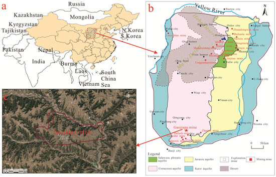
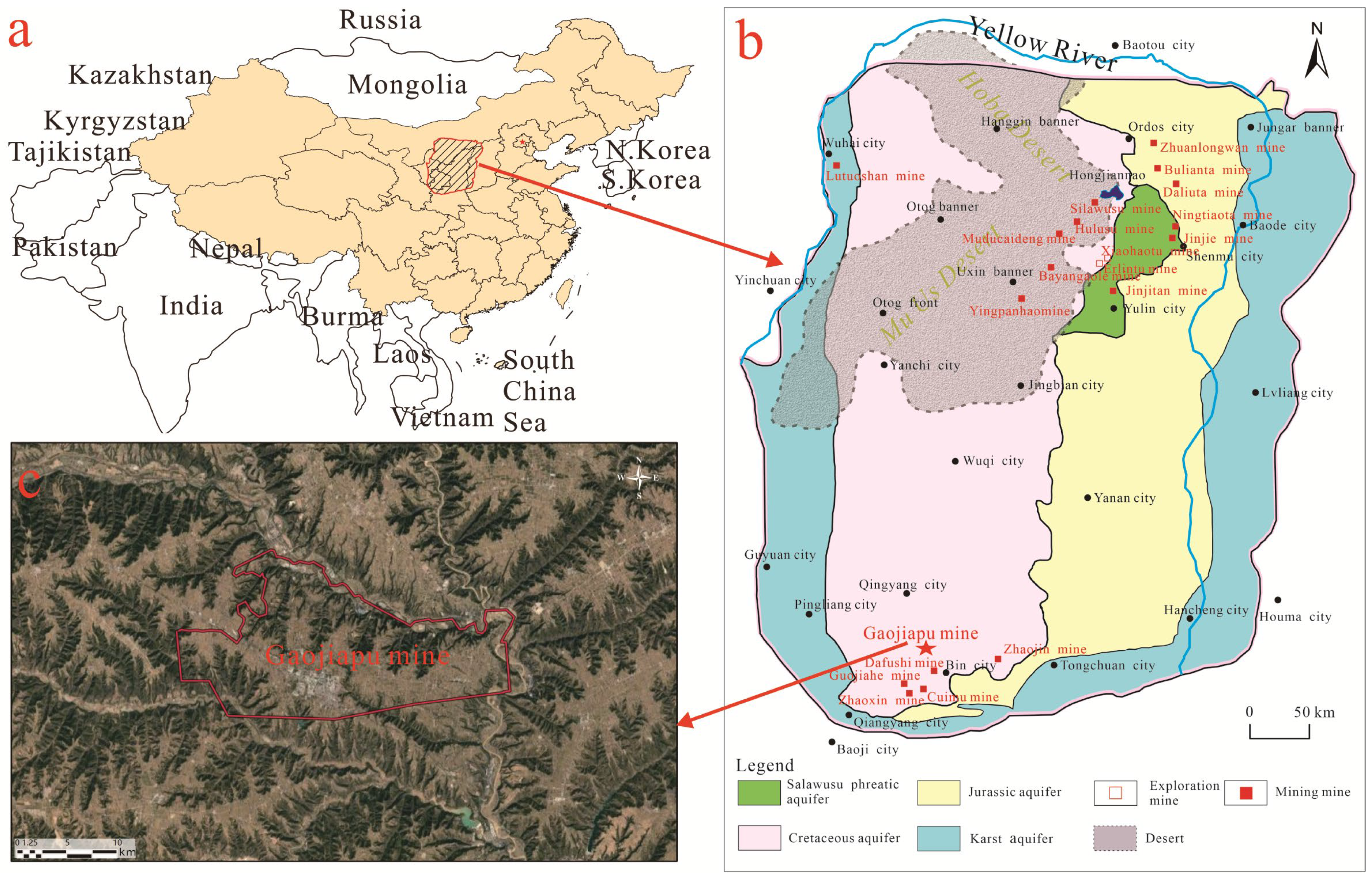
Gaojiapu Coal Mine is one of the large-scale modernized mines in the Huanglong Coal Base, which is located in the southern reaches of the Ordos Basin. Due to the semi-arid and semi-desert continental climate, with annual evaporation exceeding 2770 mm, surface water resources are extremely scarce (Figure 1), and industrial production and agricultural irrigation mainly depend on Cretaceous water. However, to prevent water hazards from the Cretaceous aquifer, a large quantity of these water resources has been extracted from the coal mine and wasted, which has intensified conflicts over water resources.
Figure 1.
(a) Location of the study area in China; (b) distribution of water resources in the Ordos Basin; and (c) aerial photo of the Gaojiapu Coal Mine.
The mine site is approximately 25.7 km in length from east to west, and 16.6 km in width from north to south. Currently, the mine’s production capacity is 4.5 million tons per year, with a planned service life of 69.4 years. The main coal seam is the No. 4 coal seam in the Yan’an Formation strata, which is found at an average depth of 836 m and has an average thickness of 9.3 m.
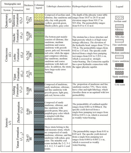
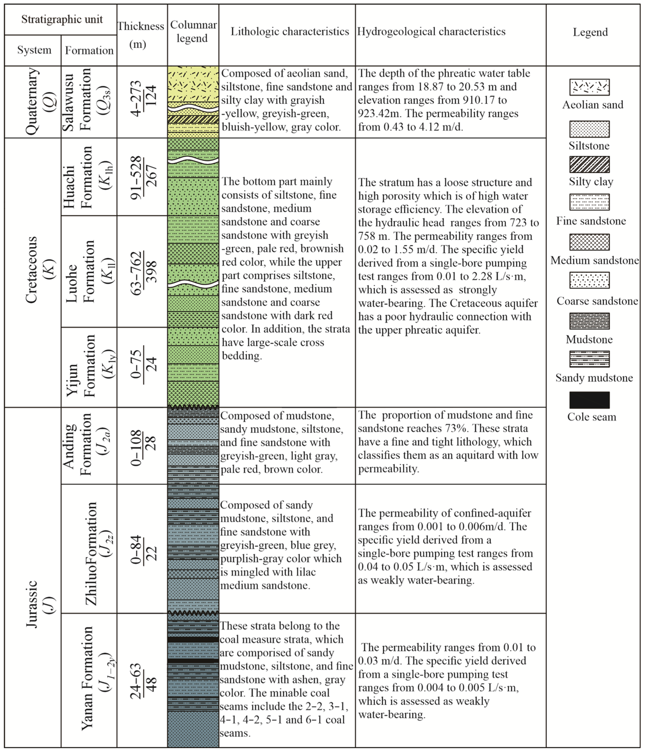
The surface of the coal mine is covered by Quaternary loess and Neogene red clay, which form the Loess Plateau landform. Additionally, the strata of the Huachi Formation of the lower Cretaceous are exposed along the Jinghe River and the Heihe River. The lithology of the coal-bearing Yan’an Formation strata mainly consists of gray sandstone, gray black and black siltstone, and mudstone, and its thickness ranges from 24 m to 63 m, with an average thickness of 48 m. The overlying strata are the Jurassic Zhiluo Formation, the Jurassic Anding Formation, the Cretaceous system, the Neogene system, and the Quaternary system, and the lithology and hydrogeological characteristics of these are described in Figure 2.
Figure 2.
Stratigraphic column of the Gaojiapu Coal Mine.
The Cretaceous system consists of the Huachi Formation, Luohe Formation, and Yijun Formation, which form a thick and productive aquifer, posing a significant water hazard for coal mining at this location. The thickness of the strata between the Cretaceous Huachi Formation and the No. 4 coal seam is greater than 400 m. Therefore, the threat posed by the Huachi Formation aquifer to coal mining here is relatively limited. The Yijun Formation is composed of a conglomerate that consists of quartz and chert, with a permeability coefficient of 0.02 m/d. It is a weakly water-bearing aquifer. The Cretaceous Luhe Formation is mainly composed of sandstones of various particle sizes—the medium- and coarse-grained sandstone strata form the productive aquifer—and its average thickness is 379 m. These strata constitute a strongly water-bearing aquifer with high permeability coefficients of between 0.027 and 1.552 m per day. The Cretaceous aquifer is divided, in line with variations in its lithology and porosity, into four sections with approximate thicknesses of 51 m, 125 m, 124, and 79 m. The water in the middle of the Cretaceous aquifer is abundant and has not been penetrated by the WCFZs.
3. Methods
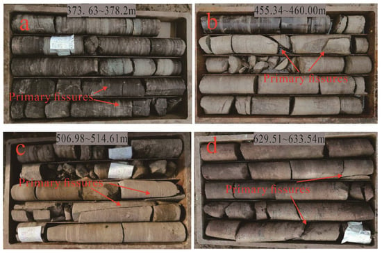
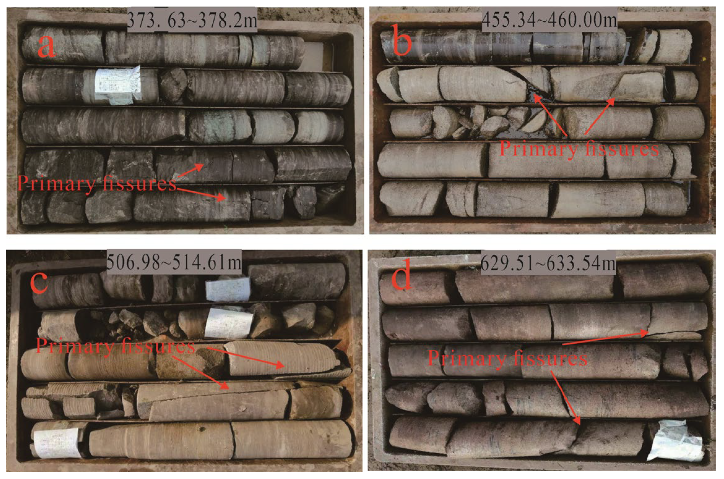
A core of the Cretaceous strata taken from Boreholes DT1 and DT2 at the No. 203 working face of Gaojiapu Coal Mine is shown in Figure 3, with the fissures in the strata marked. The rock is mainly dominated by high-angle structural fissures at angles greater than 60°, induced by the high regional stress. Affected by the action of tectonic stress, the weak points in the rock strata deform and fracture.
Figure 3.
Core images with the primary fissures of the Cretaceous strata at depths of (a) 373 to 378 m; (b) 455 to 460 m; (c) 506 to 514 m; and (d) 629 to 633 m.
3.1. Seismic Multi-Attribute Impedance Inversion Method
Typically, fissures are classified into three categories: large-scale fissures, small-scale fissures, and micro-scale fissures. For the determination of large-scale fissures, prediction techniques assessing the post-stack seismic attributes are adopted, such as discontinuity detection, curvature analysis, and ant tracking technology. For small-scale faults and fissures, identification methods such as stress field analysis and seismic geometric attribute analysis are adopted. Given the different scales of the fissures that have developed in the Cretaceous strata, I3D multi-attribute analysis was adopted. The multi-attribute seismic parameters consist of different geometries of the reflection surface, such as the seismic dip attribute, maximum curvature, spectral energy, and discontinuity characteristics. In addition, the advanced I3D multi-attribute method can effectively remove acquisition footprint interference and improve resolution, which helps ensure the prediction results are consistent with geological laws, and results in fine and accurate characterization of fracture features.
3.2. Drilling Investigation Using Vertical Holes
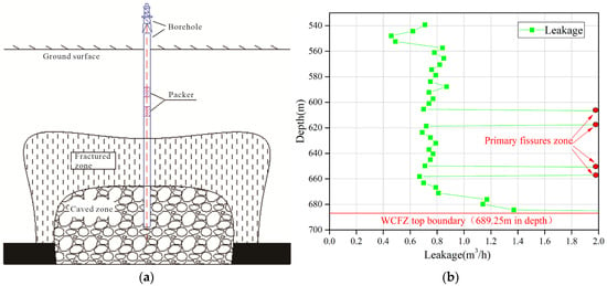
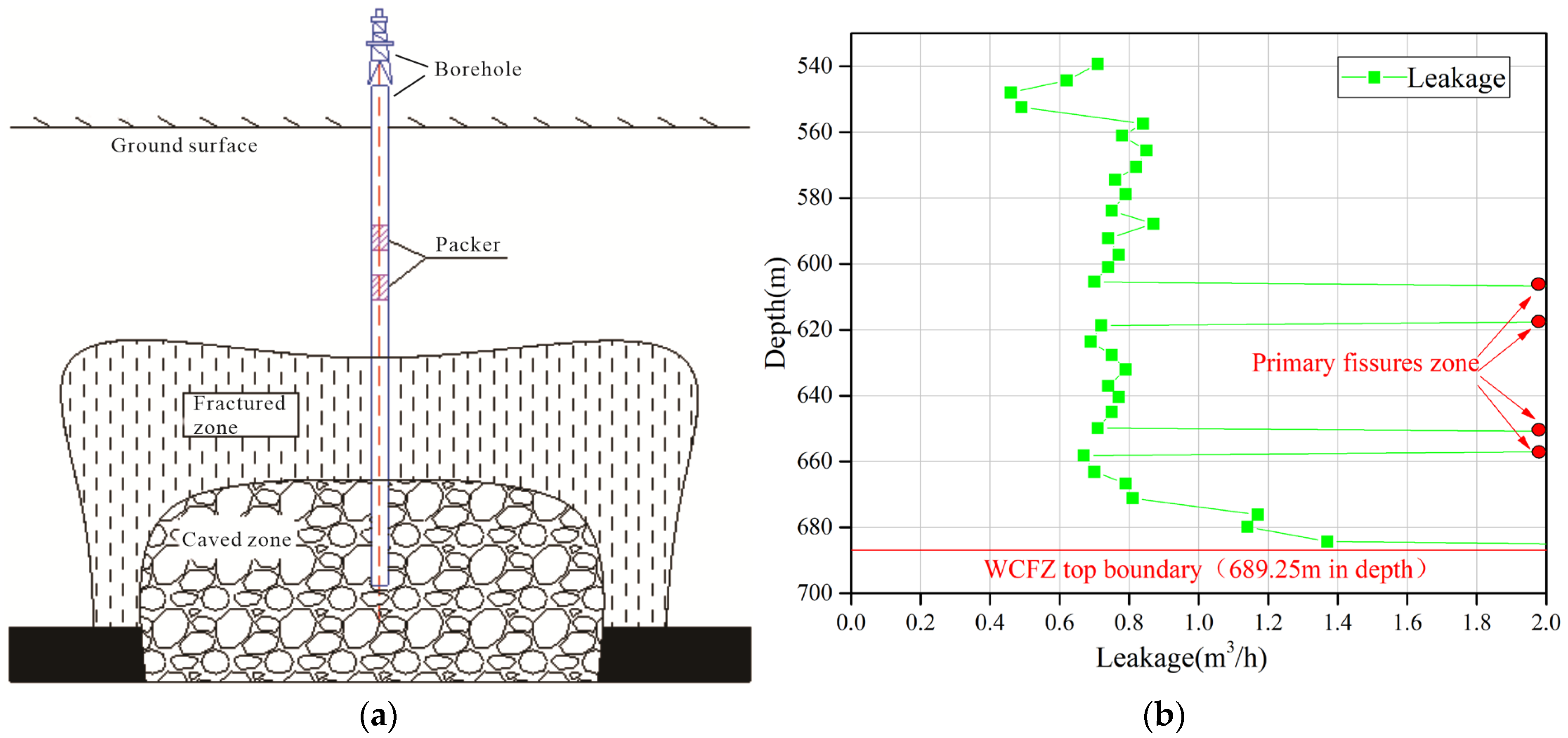
The leakage investigation of water injection via the vertical holes was carried out at No. 204 working face in Mining Zone 2. The capsule, a double-end packer device, was used for the water injection test (Figure 4a). Normally, coupled capsules are used, designed in a cylindrical form, that can move freely within the borehole. When water or air is supplied to the capsules through the pipeline under a certain pressure, the capsules rapidly expand and tightly seal the borehole section located between the coupled capsules. Water was then injected into the packed section through the injection pipeline at a rate of 50 m3/h and under a hydraulic pressure of 2 MPa. The amount of stable leakage was measured, and should have exceeded 10 min, which enabled determination of the degree of fissure development in the packed section. When the packed section in the WCFZs was measured, the amount of leakage was found to be large, but the water table was not observed. By analyzing the variation in the water loss in the overlying strata, the development height of the WCFZs can be determined.
Figure 4.
The detection of WCFZ height using vertical drilling. (a) Schematic diagram of the water injection method; (b) the amount of leakage in the strata at different depths.
3.3. Drilling Investigation Using Horizontal Grouting Holes
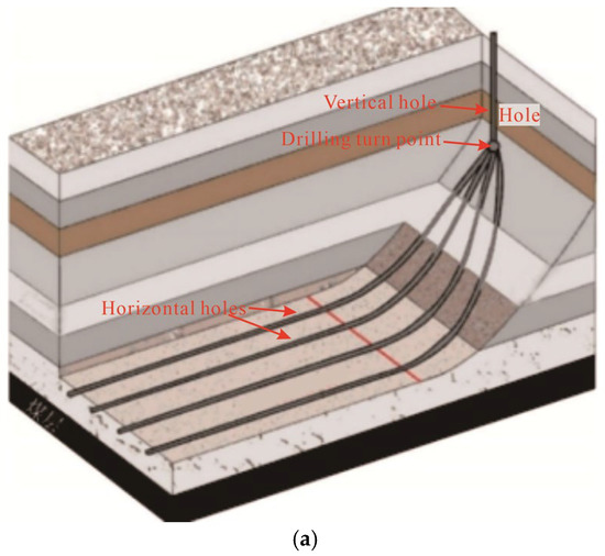
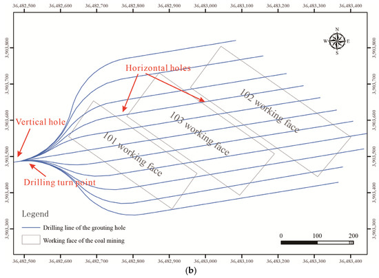
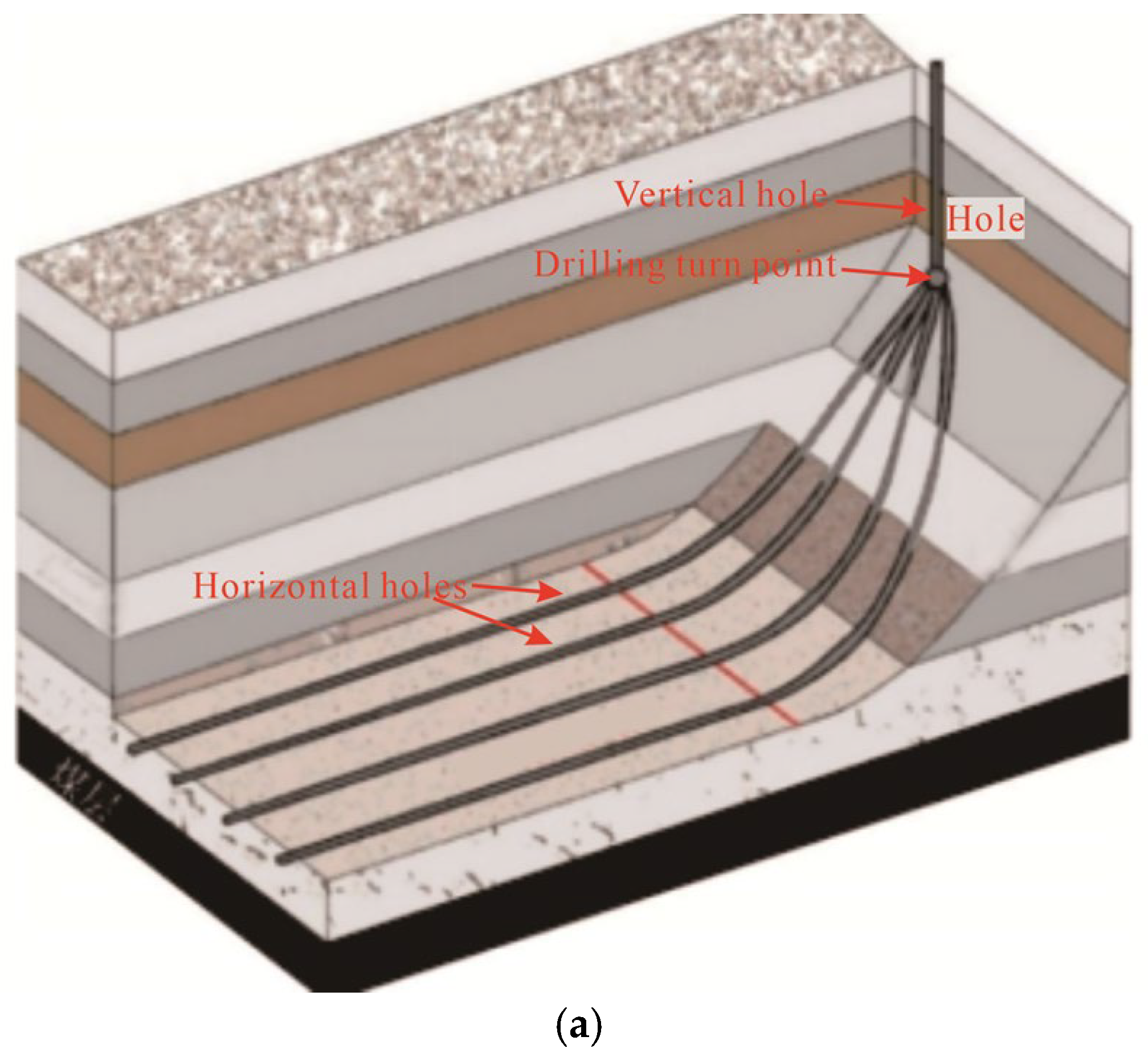
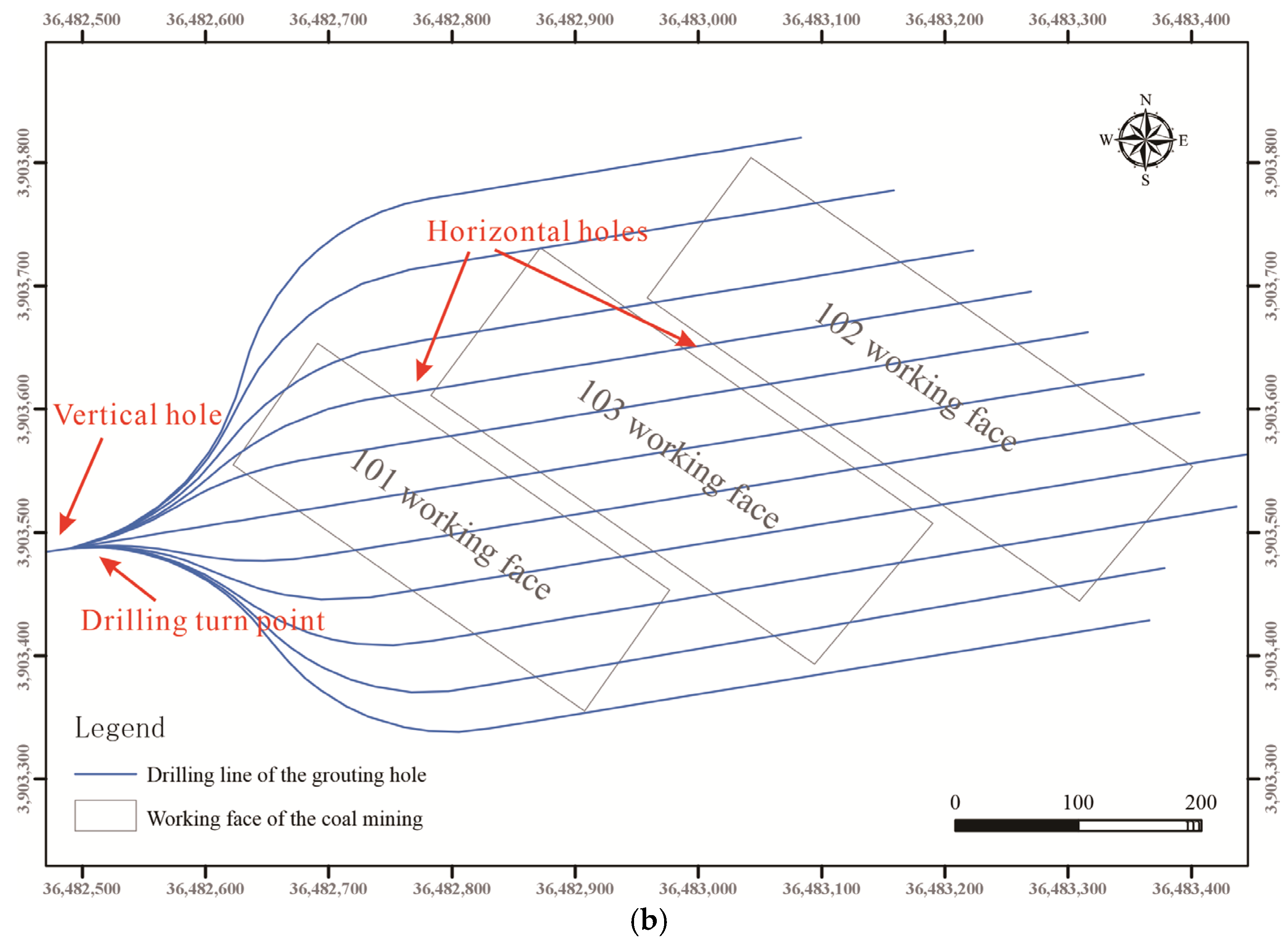
To prevent water hazards caused by roof water inrush into the goaf area from the Cretaceous aquifer, horizontal holes were employed to inject grout into the fissures of the Cretaceous strata. Simultaneously, the horizontal holes play a significant role in investigating mining-induced fractures. The horizontal holes were drilled from the turn point of the vertical borehole from multiple directions (Figure 5), which reduced the drilling required and established a horizontal waterproof curtain at the lower Cretaceous strata.
Figure 5.
Schematic diagram of post-mining investigation with horizontal grouting holes. (a) Spatial distribution; (b) horizontal distribution.
4. Results
4.1. Distribution Laws of Primary Fissures in the Overlying Strata
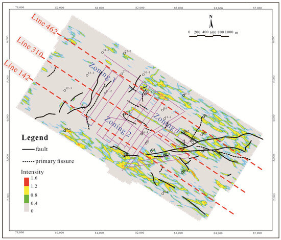
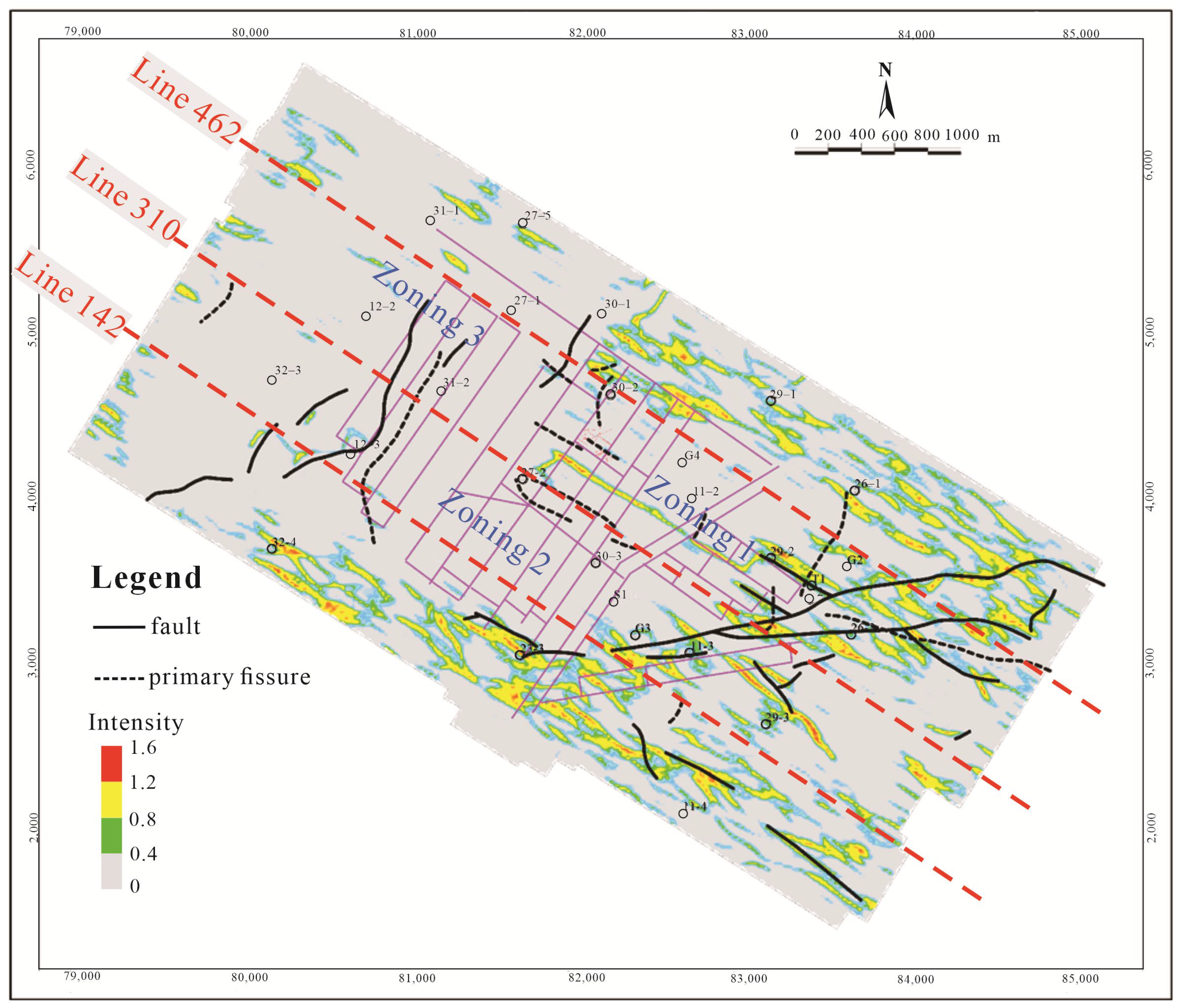
The development plane is shown in Figure 6. In Zone 1 and Zone 3, the distribution of the primary fissure is from the northwest to the southeast, while the fissures from the northeast to the southwest are mainly distributed in Zone 2. The length of a single fissure is small, and multiple fissures are superimposed over one another. The fissures in the southeast of the mine site in Zone 1 developed densely and form a mutual superposition. In Zone 2 and Zone 3 of the central and northwestern parts of the mine site, the degree of fissure development is relatively low, and the superposition exhibits dislocation. In addition, the eastern and western parts of Zone 2 are mainly areas of fissure development, while the central part is characterized by the development of faults. However, it should be noted that the superposition of fissures and fractures will have a significant impact on coal mining.
Figure 6.
Plane view showing the distribution of fissures in the Cretaceous strata.
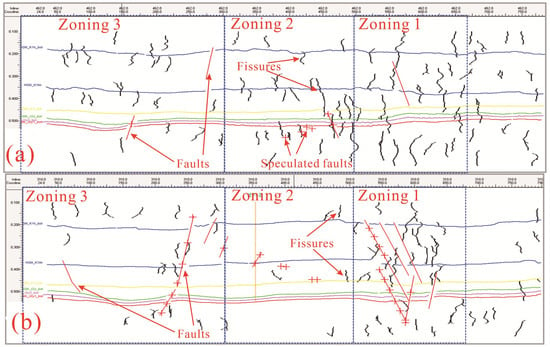
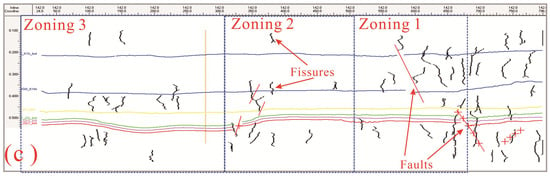
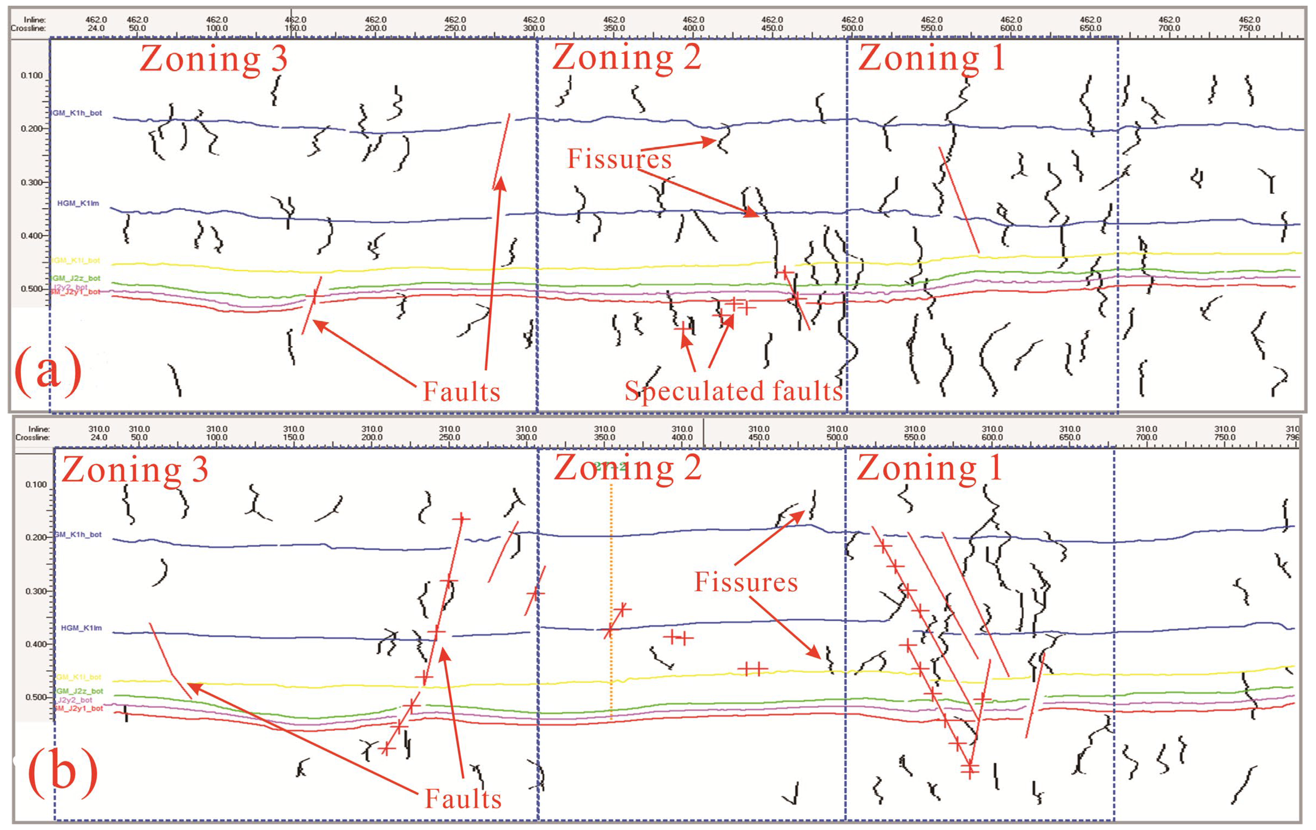
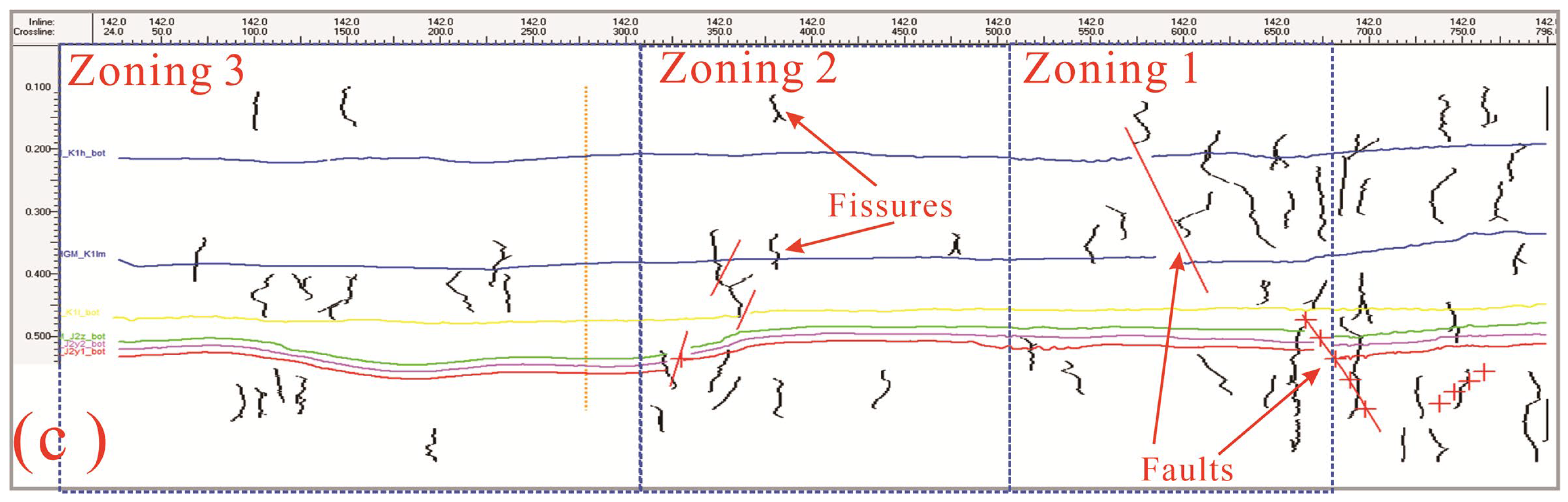
As shown in Figure 7, the vertical distribution of the fissures is characterized by discontinuous and short extensions that are concentrated in the middle and lower sections of the Luohe Formation, and are densely distributed in the fault development areas due to tectonic effects. Particularly in Zone 1, the primary fissures are the most developed and are superimposed with faults. Due to penetration by the primary fissures, hydraulic conductivity between the middle and lower sections of the Luohe Formation is increased. Subsequently, the primary fissures of the lower section of the Luohe Formation formed direct water-conducting channels to the coal seam, inducing water inrush from the Cretaceous aquifer into the goaf. The degree of fissure development in Zones 2 and 3 in the central and northwestern parts of the mine site is low. The fissures that have developed here are mainly in the upper and lower sections of the Luohe Formation, with short fissure extensions. Under this development model, water from the lower Cretaceous aquifer flows into the goaf, and poses only a limited threat to coal mining.
Figure 7.
Cross-section showing the distribution of fissures in the Figure 6. (a) Line 462; (b) Line 310; (c) Line 142.
4.2. The Height of the WCFZs Based on the Drilling Test
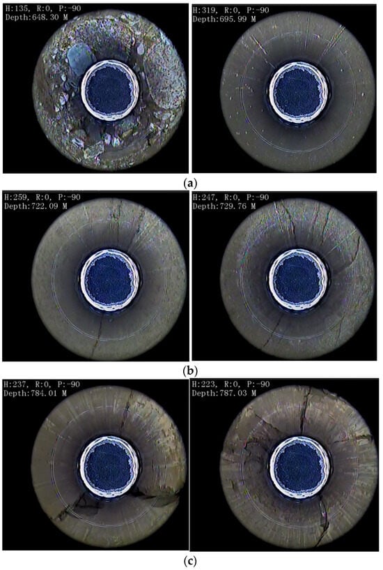
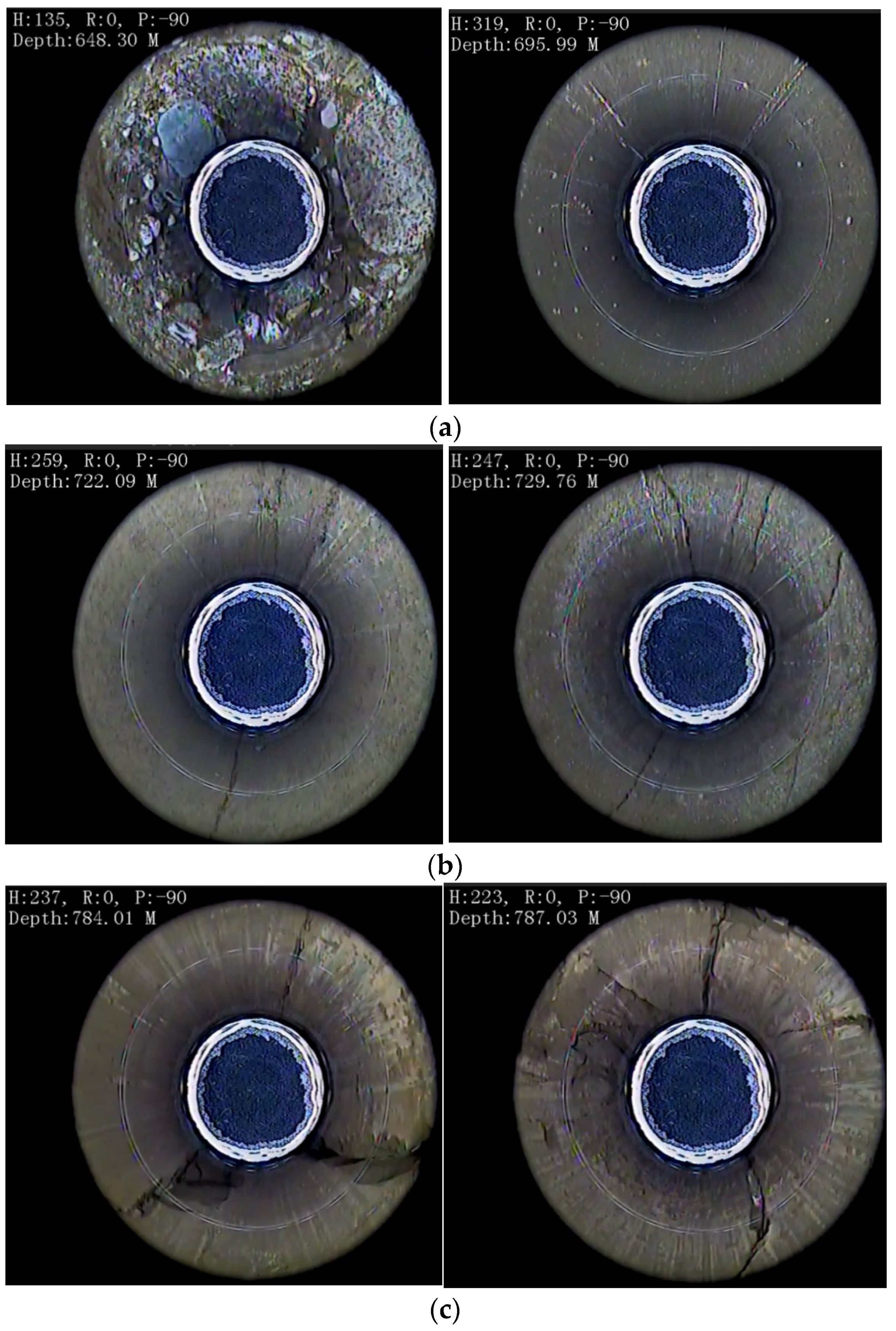
The water loss at depths from 540 m to 689 m is small. Meanwhile, in the section below a depth of 684 m, the water loss is significant, making it impossible to observe the water table using the orifice water injection method. By calculating the average formation leakage rate for each measuring section, the leakage rate at depths from 540 m to 689 m ranges from 0.46 m3/h to 1.37 m3/h, with an average of 0.78 m3/h. Meanwhile, below 689 m, the leakage rate increases significantly (Figure 4b). Based on borehole televiewer data (Figure 7), fracture development in the overlying strata can be divided into three sections. The section at depths from 540 m to 689 m has less well-developed fractures. The borehole wall is relatively intact and contains occasional transverse fissures, while vertical fissures are not developed or connected vertically (Figure 8a). The section at depths from 689 m to 735 m has insufficiently developed mining-induced fractures, though vertical fissures have begun to develop, but their number and size is small, and their vertical connectivity is weak (Figure 8b). The section at depths below 735 m has fully developed mining-induced fissures; both the transverse and vertical fissures are relatively well-developed, and the vertical connectivity is stronger (Figure 8c).
Figure 8.
Borehole view of water-conducting fissure development in the DT2 borehole (a) from 486 to 705.78 m; (b) from 705.78 to 735.02 m; and (c) below 735.02 m in depth.
Vertically, the investigation involved the four drilling direction changes located, respectively, at the depths of 150 m and 165 m above the coal seam roof in the lower cretaceous strata, as well as at 205 m and 225 m above the coal seam roof in the mid-cretaceous strata. At a depth of 150 m above the coal seam, where the primary branch of the horizontal holes was drilled to 1317 m, five leakage zones were determined at 1253 m, 1304 m, 1306.75 m, 1308.25 m, and 1312 m. At a depth of 165 m above the coal seam, where the primary branch of the horizontal holes was drilled to 1370 m, seven leakage zones were determined at 1319 m, 1323 m, 1338 m, 1342 m, 1350.6 m, 1354.8 m, and 1368.8 m. At a depth of 205 m above the coal seam, where the primary branch of the horizontal holes was drilled to 1355 m, three leakage zones were determined at 1344 m, 1348 m, and 1350 m. At a depth of 225 m above the coal seam, where the primary branch of the horizontal holes was drilled to 1472 m, multiple leakage points were determined at 1242.17 m, 1251.31 m, 1269.3 m, 1278.32 m, 1305.75 m, 1314.91 m, 1324.91 m, 1332.9 m, 1352 m, 1386.99 m, 1431 m, 1432.67 m, 1460.11 m, 1472 m, 1487.21 m, and 1496.35 m.
The drilling investigation using the horizontal grouting holes found that the development height of the MCFZ was more than 210 m above the coal seam, which is higher than what was established by the investigation using vertical holes. Induced by the primary fissures, the WCFZs connected the water-rich middle–upper aquifer of the Luohe Formation strata, which led to water inrush from the water-rich aquifer and posed a threat of a water inrush disaster.
5. Discussion
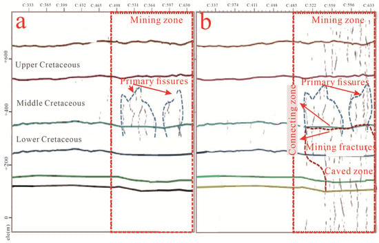
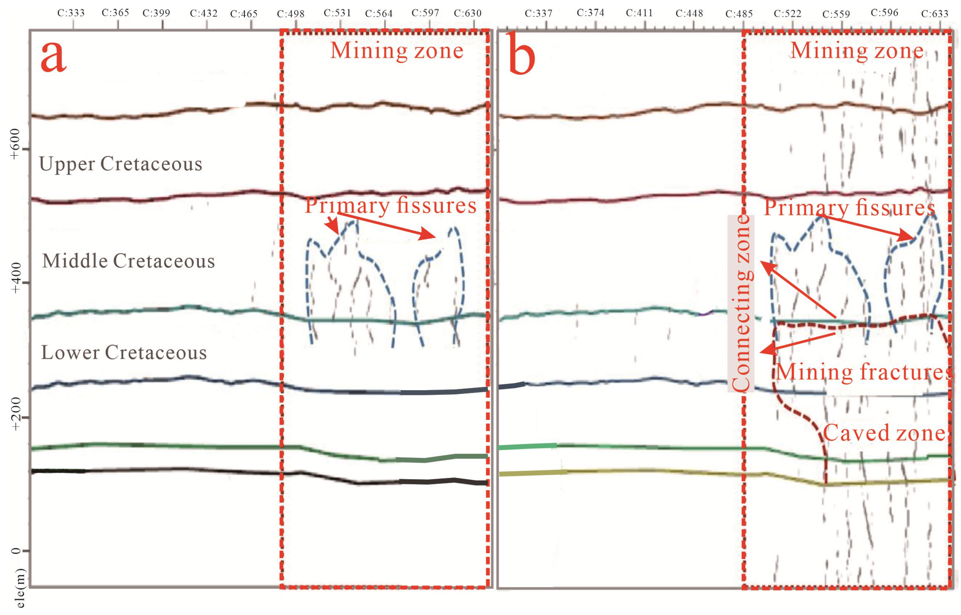
At the No. 203 working face of the coal mine, the primary fissures within the Cretaceous strata were identified, and their characteristics were determined via high-precision three-dimensional (3D) seismic exploration. Following mining activity, and under mining-induced stress, the primary fissures propagated downward and connected with mining-induced fractures, resulting in the development of the WCFZs (Figure 9). Concurrently, penetrating pathways from the productive middle Cretaceous aquifer to the goaf were created, resulting in a severe water hazard for the coal mine.
Figure 9.
The connectivity of the primary fissures and the WCFZs (a) before coal mining and (b) after coal mining.
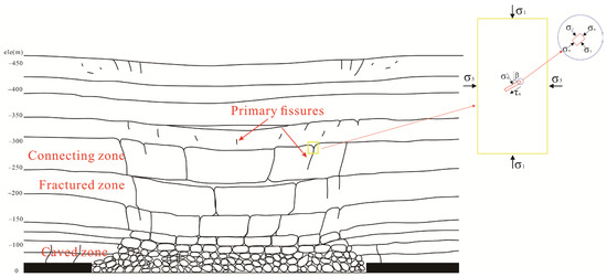
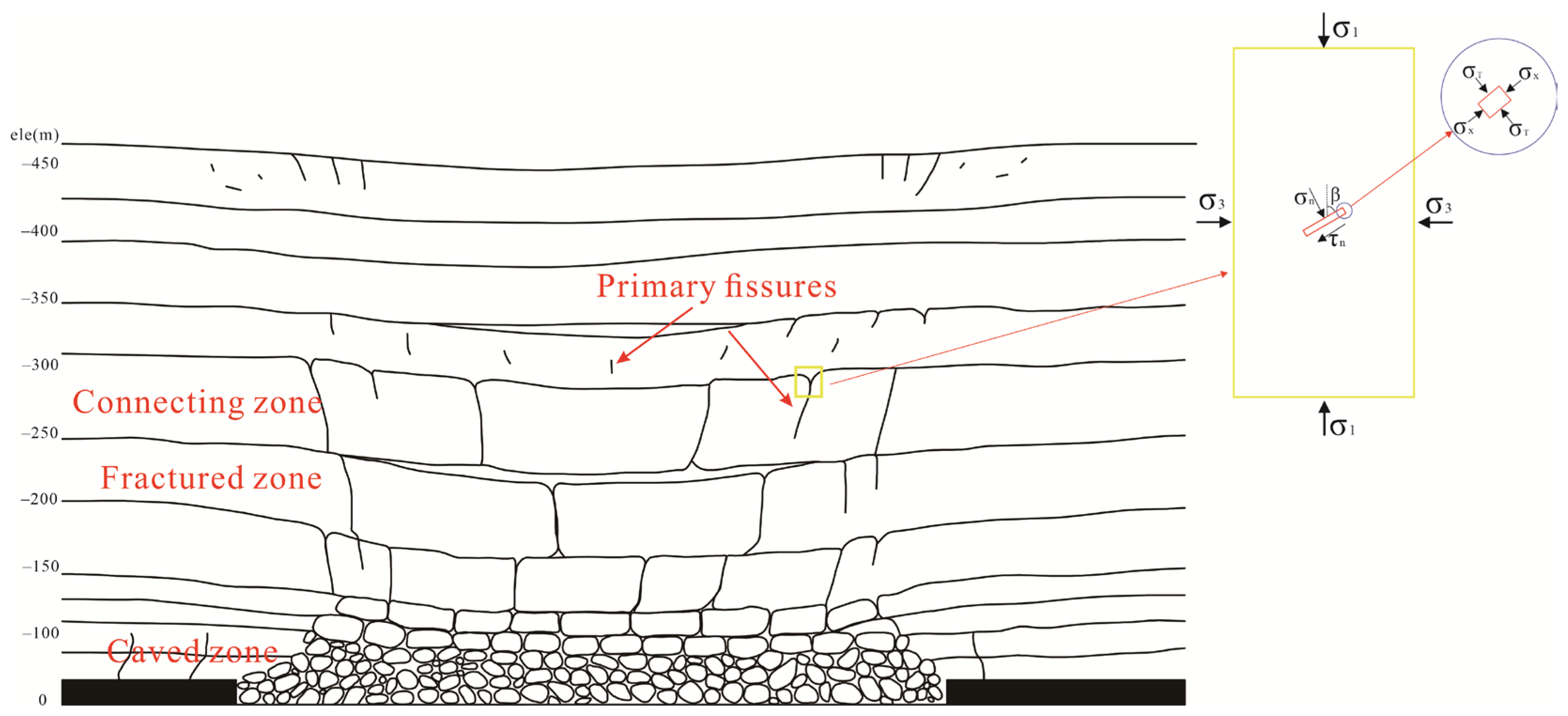
In practical terms, the crack propagation of the primary fissures was induced by complex mining-related stress, which caused two types of fractures: tensile fractures (mode I fractures) and shear fractures (mode II fractures) [14]. The mechanical analysis of the primary mining-induced fissures is shown in Figure 10. Thus, the effective normal stress and shear stress can be determined using the following equations:
where σ1 represents first principal stress, σ3 represents third principal stress, σn represents normal stress, and τn represents shear stress.
Figure 10.
Schematic diagram of the composite fracture zone model.
The stress intensity factor (SIF) of the mode I and mode II fractures is determined using the following equations:
Considering the effects of mining and the lateral tensile stress superposition effect at the tip of the open fracture, the SIF of mode I and mode II fractures is determined using the following equations:
where KI represents the first stress intensity factor, and KII represents the second stress intensity factor.
According to Griffith strength theory, when the energy released by crack propagation is greater than the material’s resistance, the crack can extend, which is determined using the following equation:
where Ke represents the representative value of the stress intensity factor, and K(I+II)C represents the crack resistance of the rock.
Thus, as the weak points of the rock, particularly under cementation, fissures reduce the stress needed to initiate fractures and lead to crack generation. As the preferential channels of the stress concentration and energy release, the fissures significantly lower the energy threshold for new rock fractures, which enables the water-conducting fractures to propagate upward in a jumping manner under lower mining-induced stress.
Traditional studies on the mechanisms of water inrush from overlying aquifers have often treated the overburden as a homogeneous medium, and focused on the fracturing of intact rock layers [13]. However, the overburden of many mining areas, such as the Gaojiapu Coal Mine, contains abundant fissures, resulting in traditional prediction studies being challenged. The activation of primary fissures not only alters the mechanical structure of the rock mass, but significantly increases the height of the WCFZs. Thus, it is necessary to pre-investigate the location and the characteristics of the primary fissures in order to determine the abnormal development height of the WCFZs. Currently, horizontal grouting technology is adopted by the Gaojiapu Coal Mine to block the primary fissures in advance, which effectively controls the abnormal development of the WCFZs and decreases the discharge of mine water. The water resource of the Cretaceous aquifer has therefore been protected.
In summary, the development of the WCFZs in the overburden of Gaojiapu Coal Mine is a complex process dominated by the initial damage caused by the primary fissures. Under mining-induced stress, this process involves fracture activation, the synergistic enhancement of seepage, and network interconnection. This study has ascertained the mechanism of the abnormal increase in WCFZ height and the water inrush risks of overburdens with primary fissures. However, the extended depth of the primary fissures, a factor in the development height of the WCFZs, was not quantified.
6. Conclusions
To investigate the characteristics of WCFZ development in overlying strata with primary fissures induced by coal mining, geophysical inversion of primary fissures and vertical and horizontal drilling measures were adopted. The study systematically analyzes the influence of primary fissures on WCFZ development in overlying strata. The primary fissures developed in the Cretaceous strata in the Gaojiapu Coal Mine, which is a significant factor determining the development height of the WCFZs. The widespread high-angle fissures in the overlying strata of Gaojiapu Coal Mine are activated and expanded under mining stress, and then connect to mining-induced fractures to form higher WCFZs than could be foreseen using conventional prediction methods. This was determined by a drilling investigation using horizontal grouting holes. The development height of the WCFZs was more than 210 m above the coal seam, which is higher than what was determined by just the investigation using vertical holes.
The fissures, as the weak points in the rock, particularly under cementation, form preferential channels for stress concentration, significantly lowering the energy threshold for new rock fractures, which enables the water-conducting fractures to propagate upward in a jumping manner under lower mining-induced stress. The water-conducting network is complex, involving fracture activation, the synergistic enhancement of seepage, and network interconnection. Thus, it is necessary to pre-investigate the location and attitude of the primary fissures and determine the abnormal development height of the WCFZs. A grouting engineering approach was adopted at the Gaojiapu Coal Mine to block the primary fissures in advance, which can effectively control the abnormal development of WCFZs and decrease the discharge of mine water to protect the water resource of the Cretaceous aquifer.
This research reveals that the traditional prediction methods for WCFZ height and water prevention strategies, taking into consideration mining factors, have limitations in terms of overlying strata with developed fissures. The initial effect of the damage caused by the primary fissures should be taken into consideration in future research and engineering practice. The spatial distribution of the fissures should be established by precise geophysical detection, such as I3D multi-attribute analysis, and targeted water prevention responses should be determined in order to ensure the effective prevention and control of roof water hazards.
Author Contributions
Methodology, J.Z. and W.Q.; validation, W.C. and W.Q.; formal analysis, W.C. and X.C.; investigation and resources, J.Z. and C.L. (Chengsen Lin); writing—original draft preparation, J.Z.; Data curation, Visualization, C.L. (Chengsen Lin); writing—review and editing, X.C. and C.L. (Cong Liu); supervision, W.Q.; project administration, J.Z.; funding acquisition, W.Q. All authors have read and agreed to the published version of the manuscript.
Funding
This research was funded by the National Natural Science Foundation of China (Grant No. 42472334 and No. 52308359) and the Intelligent Transportation Technology Innovation Project of Jiangsu Collaborative Innovation Center for Green Smart Cities and Heritage Conservation (Project No. SJXTTD2504).
Data Availability Statement
The raw data supporting the conclusions of this article will be made available by the authors on request.
Conflicts of Interest
Authors Jinkui Zhang and Chengsen Lin were employed by the company ShaanxiZhengtong Coal Industry Co., Ltd. The remaining authors declare that this research was conducted in the absence of any commercial or financial relationships that could be construed as potential conflicts of interest.
References
- China National Energy Administration (CNEA). Available online: http://www.nea.gov.cn (accessed on 6 March 2025).
- Chen, W.C.; Li, W.P.; He, J.H.; Qiao, W.; Wang, Q.Q.; Yang, R.Y. Impact of mining-induced bed separation space on Cretaceous aquifer: A case study of Yingpanhao coal mine, Ordos Basin, China. Hydrogeo. J. 2022, 30, 691–706. [Google Scholar] [CrossRef] [Scilit]
- Liu, J.; Elsworth, D. Three-dimensional effects of hydraulic conductivity enhancement and desaturation around mined panels. Int. J. Rock Mech. Min. Sci. 1997, 34, 1139–1152. [Google Scholar] [CrossRef]
- Fan, K.F.; He, J.H.; Li, W.P.; Chen, W.C. Dynamic evolution and identification of bed separation in overburden during coal mining. Rock Mech. Rock Eng. 2022, 55, 4015–4030. [Google Scholar] [CrossRef] [Scilit]
- Fan, Z.Q.; Eichhubl, P.; Newell, P. Basement fault reactivation by fluid injection into sedimentary reservoirs: Poroelastic effects. J. Geophys. Res. Solid Earth 2019, 124, 7354–7369. [Google Scholar] [CrossRef] [Scilit]
- Hu, Y.B.; Li, W.P.; Wang, Q.Q.; Liu, S.L.; Wang, Z.K. Evaluation of water inrush risk from coal seam floors with an AHP-EWM algorithm and GIS. Environ. Earth Sci. 2019, 78, 290–305. [Google Scholar] [CrossRef] [Scilit]
- Sun, W.; Zhou, W.; Jiao, J. Hydrogeological classification and water inrush accidents in China’s coal mines. Mine Water Environ. 2016, 35, 214–220. [Google Scholar] [CrossRef] [Scilit]
- Yin, S.X.; Zhang, J.; Liu, D. A study of mine water inrushes by measurements of in situ stress and rock failures. Nat. Hazards 2015, 79, 1961–1979. [Google Scholar] [CrossRef] [Scilit]
- Wang, D.K.; Li, L.; Zhang, H.T.; Li, S.W.; Zhang, F.K.; Xia, Y.L. Intelligent identification of coal fractures using an improved U-shaped network. Adv. Geo-Energy Res. 2025, 15, 129–142. [Google Scholar] [CrossRef] [Scilit]
- Wang, J.; Xie, X.X.; Li, W.P.; Chen, X.H.; Zhang, X.D.; Fan, N.; Wang, T.; Zhang, H. Damage-fracture evolution mechanism of rock bridge structures in flawed sandstone under cyclic disturbance: Insights from DIC-AE. Theor. Appl. Fract. Mech. 2025, 140, 105180. [Google Scholar] [CrossRef] [Scilit]
- Majdi, A.; Hassani, F.P.; Nasiri, M.Y. Prediction of the height of destressed zone above the mined panel roof in longwall coal mining. Int. J. Coal Geol. 2012, 98, 62–72. [Google Scholar] [CrossRef] [Scilit]
- Wang, S.W.; Yan, Y.T. Numerical study of dynamic fracture behaviors of rock containing double pre-existing flaws under different confined stress and flaw geometry. Eur. J. Environ. Civ. Eng. 2023, 27, 3363–3379. [Google Scholar] [CrossRef] [Scilit]
- Liu, Y.; Liu, Q.M.; Li, W.P.; Li, T.; He, J.H. Height of water-conducting fractured zone in coal mining in the soil–rock composite structure overburdens. Environ. Earth Sci. 2019, 78, 242–255. [Google Scholar] [CrossRef] [Scilit]
- Liu, Q.; Zhou, C.; Ma, D.; Liu, Y.; Wang, G.; Huang, Z. Evolution of Water-Conducting Fracture in Weakly Cemented Strata in Response to Mining Activity: Insights from Experimental Investigation and Numerical Simulation. Water 2023, 15, 4173. [Google Scholar] [CrossRef] [Scilit]
- Hu, S.C.; Zhang, C.X.; Ru, W.K.; Han, J.M.; Guo, S.H.; Zhou, X.D.; Yang, L. Creep properties and energy evolution characteristics of weakly cemented rock under step loading. Int. J. Rock Mech. Min. Sci. 2023, 170, 105428. [Google Scholar] [CrossRef] [Scilit]
- Wang, Z.K.; Li, W.P.; Chen, J.F. Application of Various Nonlinear Models to Predict the Uniaxial Compressive Strength of Weakly Cemented Jurassic Rocks. Nat. Resour. Res. 2022, 31, 371–384. [Google Scholar] [CrossRef] [Scilit]
- Xu, J.L.; Qian, M.G. Method to distinguish key strata in overburden. J. China Univ. Min. Technol. 2000, 29, 463–467. (in Chinese). [Google Scholar]
- Miao, X.X.; Cui, X.M.; Wang, J.A.; Xu, J.L. The height of fractured water-conducting zone in undermined rock strata. Geotech. Geol. Eng. 2011, 120, 32–39. [Google Scholar] [CrossRef] [Scilit]
- Adhikary, D.P.; Guo, H. Modelling of longwall mining-induced strata permeability change. Rock Mech. Rock Eng. 2015, 48, 345–359. [Google Scholar] [CrossRef] [Scilit]
- Zhang, K.; Yang, T.; Bai, H.; Gamage, R.P. Longwall Mining-Induced Damage and Fractures: Field Measurements and Simulation Using FDM and DEM Coupled Method. Int. J. Geomech. 2018, 18, 19. [Google Scholar] [CrossRef] [Scilit]
- Zhou, L.; Li, X.; Peng, Y.; Fang, L. Material point method with a strain-softening model to simulate roof strata movement induced by progressive longwall mining. Int. J. Rock Mec. Min. Sci. 2023, 170, 18. [Google Scholar] [CrossRef] [Scilit]
- Wang, G.; Wu, M.; Wang, R. Height of the mining-induced fractured zone above a coal face. Geotech. Geol. Eng. 2016, 216, 140–152. [Google Scholar] [CrossRef] [Scilit]
- Salmi, E.F.; Nazem, M.; Karakus, M. Numerical analysis of a large landslide induced by coal mining subsidence. Geotech. Geol. Eng. 2017, 217, 141–152. [Google Scholar]
- Adhikary, D.P.; Guo, H. Measurement of Longwall Mining Induced Strata Permeability. Geotech. Geol. Eng. 2014, 32, 617–626. [Google Scholar] [CrossRef] [Scilit]
- Karacan, C.; Goodman, G. Hydraulic conductivity changes and influencing factors in longwall overburden determined by slug tests in gob gas ventholes. Int. J. Rock Mech. Min. Sci. 2009, 46, 1162–1174. [Google Scholar] [CrossRef] [Scilit]
- Li, Y.P.; Sun, D.Q.; Zhao, S.K.; Liang, S.K.; Cui, K.; Wang, H.H. Investigation of pressure relief borehole effects using in situ testing based on distributed optical fibre sensing technology. Adv. Civ. Eng. 2021. [Google Scholar] [CrossRef] [Scilit]
- Liu, Y.; Li, W.P.; He, J.H.; Liu, S.W.; Cai, L.Y.; Cheng, G. Application of Brillouin optical time domain reflectometry to dynamic monitoring of overburden deformation and failure caused by underground mining. Int. J. Rock Mech. Min. Sci. 2018, 106, 133–143. [Google Scholar] [CrossRef] [Scilit]
- Zheng, K.; Ma, L.J.; Liu, H.F. A new modified maximum principal stress criterion for predicting rock fracture toughness under mixed-mode I/III loading. Int. J. Rock Mech. Min. Sci. 2025, 194, 106192. [Google Scholar] [CrossRef] [Scilit]
- Zhao, C.X.; Zhang, Z.X.; Lei, Q.H. Role of hydro-mechanical coupling in excavation-induced damage propagation, fracture deformation and microseismicity evolution in naturally fractured rocks. Geotech. Geol. Eng. 2021, 289, 106169. [Google Scholar] [CrossRef] [Scilit]
Disclaimer/Publisher’s Note: The statements, opinions and data contained in all publications are solely those of the individual author(s) and contributor(s) and not of MDPI and/or the editor(s). MDPI and/or the editor(s) disclaim responsibility for any injury to people or property resulting from any ideas, methods, instructions or products referred to in the content. |
© 2026 by the authors. Licensee MDPI, Basel, Switzerland. This article is an open access article distributed under the terms and conditions of the Creative Commons Attribution (CC BY) license.