


Abstract
Coastal scenic quality is increasingly recognized as a valuable tool for characterizing coastal landscape states, identifying visible anthropogenic pressures, and supporting decision-making within integrated coastal zone management. However, despite the ecological, cultural, and socio-economic importance of the Moroccan North Atlantic coast, no systematic assessment of its landscape quality had been carried out to date. This study presents the first assessment of the coastal scenic quality along the Moroccan North Atlantic coast. It aims to objectively assess the landscape quality of beaches, classify them according to their landscape value, and identify the main physical and human factors influencing their quality. In total, 64 beaches were assessed using the Coastal Scenic Evaluation System (CSES), a semi-quantitative method based on 26 parameters (18 physical and 8 human) and fuzzy-logic mathematics to overcome subjectivity and quantify uncertainties. An evaluation index (D) was obtained for each site, enabling them to be classified into five scenic classes from Class I (exceptional landscape quality) to Class V (severely degraded landscape quality). The evaluation showed that 3 beaches (4.7%) were classified in Class I (D ≥ 0.85), 15 beaches (23.4%) in Class II (0.85 > D ≥ 0.65), 14 beaches (21.9%) in Class III (0.65 > D ≥ 0.40), 15 beaches (23.4%) in Class IV (0.40 > D ≥ 0.00) and 17 beaches (26.6%) in Class V (D < 0.00). The low percentage of sites classified in the higher classes I and II (28.1%) and the predominance of sites classified in the lower classes IV and V (50%, i.e., half of the sites studied) highlight the degradation of coastal landscapes and underline the significant influence of anthropogenic pressures on the current deterioration in the absence of appropriate coastal management. Overall, 38% of the sites studied obtained low scores for the parameter “Litter”, 42% for “Built environment” and 59% for “Utilities”. These findings provide decision-makers and coastal managers with relevant information to prevent and limit further degradation and propose measures to preserve and improve the quality of coastal landscapes. Furthermore, this data is essential for understanding the natural and anthropogenic processes that influence the landscape and provides a scientific basis for identifying priority areas for conservation, management or restoration, within the framework of a sustainable development approach and integrated coastal management.
1. Introduction
Coastal areas constitute one of the most dynamic and productive interfaces on the planet, where interactions between terrestrial and marine processes give rise to environments of great ecological and geomorphological complexity [1,2]. These natural areas provide a wide range of essential ecosystem services, including the maintenance of biodiversity, protection against natural hazards, carbon sequestration, the regulation of biogeochemical cycles, and support for numerous economic activities [3,4]. The coasts are home to a significant portion of strategic infrastructure, port activities, global maritime trade, fisheries and aquaculture [5,6]. From a cultural and social perspective, coastal areas also hold significant cultural and heritage value, contributing directly to the well-being of local populations and to socio-economic development [7,8,9]. However, coastal areas are now among the environments most heavily affected by human pressures and environmental changes. Factors such as rapid urbanization, infrastructure expansion, industrial activities, fishing, pollution, waste accumulation and changes in land use are gradually altering the functioning of coastal ecosystems and compromising their ecological integrity [10,11,12,13,14]. Of all the components of coastal areas, the beach is one of the most appreciated and frequented elements of the coastline. They fulfil major ecological functions by providing habitats for specific biodiversity, dissipating wave energy, storing sediments and providing natural protection against erosion and extreme events [4,15,16]. At the same time, it constitutes the main support for seaside tourism, often referred to as “Sun, Sea and Sand” (3S) tourism, which remains one of the most important and profitable sectors of the global tourism industry [17,18,19,20,21]. In many coastal countries, the attractiveness of beaches is therefore a key driver of local economic development, job creation and tourism investment [22,23,24]. For example, in 2025, Morocco welcomed 19.8 million international visitors, thus confirming its position as Africa’s leading tourist destination. The sector generated record revenue of US$14.72 billion and a contribution of approximately 8.0% to GDP and created nearly 894,000 direct jobs [25].
Beaches attract hundreds of millions of visitors each year thanks to the quality of their environment, the recreational opportunities they offer, and, not to mention one extremely important aspect: coastal scenery [9,26,27]. Among the multiple criteria that determine the attractiveness of a beach, grouped under the name “Big Five”: water quality, facilities, litter, safety and scenery [28], the coastal landscape occupies a central role, having long been identified as a determining criterion in the choice of a seaside destination [29,30,31]. Defined by the Council of Europe [32] as “an area, as perceived by people, whose character is the result of the action and interaction of natural and/or human factors”, the coastal landscape combines natural features (geology, topography, beaches, dunes, cliffs, vegetation, marine dynamics, etc.) with human interventions (urbanization, infrastructure, protective structures, tourist facilities, etc.), which give each portion of coastline its own distinct landscape identity [33]. Visitors generally favour landscapes characterised by a well-preserved natural environment, high visual quality, minimal human intervention, and low levels of pollution; all factors that determine their satisfaction and their willingness to revisit a site [34,35,36]. Beyond its aesthetic value, it serves as a key indicator of the health of coastal ecosystems [37], it strengthens territorial identity and local economic appeal, and it improves the well-being of populations while enhancing the natural and cultural heritage of the coastline [24,38,39]. However, unlike other components of the coastal system that are relatively easy to measure, landscape remains a complex concept that is difficult to assess [7,40].
To overcome this complexity, several quantitative approaches have been developed over the past two decades, combining physical, ecological, visual and anthropogenic indicators within standardized frameworks [41,42,43,44]. Early contributions include Fines [45], who developed a systematic approach to landscape evaluation using visual assessments and photographic ratings, and Penning-Rowsell [46], who emphasized the importance of public preferences in assessing landscape quality. Subsequently, Penning-Rowsell [47] examined the practical application of landscape evaluation methods by local authorities, highlighting their relevance and limitations for landscape planning and management. Traditional approaches, such as the Scenic Beauty Estimation (SBE) method proposed by Daniel and Boster [48], rely on public perceptions and aesthetic preferences to quantify landscape attractiveness. More specifically, Peña-Alonso et al. [38] developed an indicator-based approach integrating scenic, natural and cultural heritage values to assess tourist beaches, while Pérez-Hernández et al. [49] evaluated the scenic quality of coastal dune systems through composite indicators incorporating user perceptions. Similarly, Er-Ramy et al. [50] proposed the Coastal Scenic Quality Evaluation (CSQE) method, which assesses coastal landscapes through 33 variables grouped into four dimensions: Substratum, Sea-Coastal Area, Vegetation and Scenic Background. Other evaluation frameworks, such as the Beach Quality Index (BQI) developed by Ariza et al. [51] adopt a broader perspective by integrating recreational, natural and protective functions into an overall assessment of beach quality. Among the methods specifically developed for coastal scenic assessment, the Coastal Scenic Evaluation System (CSES), proposed by Ergin et al. [42], and subsequently updated by Ergin [52], is currently the most widely adopted methodology for assessing coastal scenic quality. One of the main strengths of the CSES lies in its ability to provide a standardized, quantitative and reproducible assessment of landscape quality, which makes it particularly suitable for the objectives of the present study. CSES has been successfully applied to over a thousand sites across more than 40 countries on different continents, covering a variety of coastal environments ranging from natural beaches to heavily urbanized areas [53,54]. Unfortunately, the geographical distribution of these studies remains highly uneven. Most landscape assessments focus on the coasts of Europe, the Caribbean, or certain regions of South America, whilst the coasts of Africa remain poorly documented.
In Morocco, research on beaches has mainly focused on the quality of seawater [55,56], marine pollution [57,58], marine litter [59,60,61,62,63], marine communities [64,65], coastal erosion [66,67] and, more recently, the health of marine and coastal ecosystems [37]. In contrast, coastal scenic quality, although considered an essential component of tourist appeal and sustainable coastal management, has been the subject of very little quantitative research. This deficiency is particularly pronounced on the Moroccan North Atlantic coastline, a region characterized by remarkable geomorphological diversity, including beaches, dune systems, rocky cliffs, estuaries and river mouths, etc., but also by a whole series of anthropogenic pressures. The Moroccan Atlantic coastline studied is subject to increasingly intense coastalization processes, leading to a growing concentration of population, infrastructure and economic activities in coastal areas, where a large part of urban, industrial, port and tourism activities are concentrated. These changes are increasing the pressure on coastal ecosystems, gradually altering the natural and landscape features of the coastline, and posing significant challenges in terms of conservation, land-use management, and spatial planning in a context where the reference data needed for their management are lacking. However, despite the growing body of research on coastal environments in Morocco, the scenic quality of the northern Atlantic coastline remains poorly documented. This lack of knowledge leaves a significant gap and limits managers’ ability to guide future development and to integrate the landscape dimension into integrated coastal zone management (ICZM) strategies. From this perspective, integrating landscape indicators into integrated coastal zone management strategies provides a valuable tool for guiding planning decisions on a scientific basis. In accordance with the principles of ICZM, landscape quality assessment can help to identify priority areas for conservation, restoration or controlled development, while also providing managers and decision-makers with objective information to reconcile the preservation of natural resources with socio-economic development within a framework of sustainable development.
In this context, this paper aims to fill this gap by presenting the first assessment of the quality of coastal landscapes along the Moroccan North Atlantic coast, based on the Coastal Scenic Evaluation System (CSES). Moreover, the contribution of the present study goes beyond the application of an established assessment methodology to a previously unstudied geographical area. By examining coastal scenic quality across different geographical sectors and beach typologies, the study provides new insights into the spatial distribution of landscape quality and the physical and anthropogenic factors associated with its degradation. Furthermore, the identification of key pressures and the evaluation of potential improvements under different management interventions provide a practical basis for establishing conservation and restoration priorities. These findings contribute to addressing an important knowledge gap and provide a regional baseline for integrating landscape quality into coastal planning and integrated coastal zone management strategies. The study aims to (i) objectively assess the landscape quality of 64 coastal sites spread along the North Atlantic coast of Morocco, (ii) characterize and classify the sites according to their scenic value and attractiveness, including various beach typologies (remote, rural, village, urban and resort), (iii) identify the main natural and anthropogenic factors influencing the quality of coastal landscapes, and (iv) provide a sound scientific basis to guide strategies for conservation, sustainable tourism development and integrated coastal zone management.
2. Study Area
The Moroccan coastline benefits from a major geographical advantage thanks to its two coastlines, which extend over approximately 3500 km: nearly 3000 km along the Atlantic Ocean and more than 500 km along the Mediterranean Sea (Figure 1). The Atlantic Ocean represents 85% of Morocco’s total coastline and constitutes the country’s longest stretch of coastline. Of its 3000 km, a 360 km stretch of coastline, situated on the northern coast and extending from Cape Spartel to the southern boundary of the Skhirat-Temara, was the subject of this study.
Figure 1.
Location map of the 64 sites investigated along the northern Atlantic coast of Morocco. (A) Overview of the study area showing all investigated sites; (B–G) enlarged maps of coastal sectors where sites are closely spaced, including (B) Tangier–Asilah, northern sector (sites 1–10), (C) Tangier–Asilah, southern sector (sites 11–20), (D) Asilah–Larache (sites 21–26), (E) Kenitra–Sale (sites 37–45), (F) Sale–Rabat–Temara (sites 46–53), and (G) Temara–Skhirat (sites 54–64).
The Moroccan Atlantic coastline studied is characterized by considerable geomorphological and landscape diversity. In the northern sector, between Cape Spartel and Asilah, rocky headlands, sandstone cliffs, and sandy beaches alternate with dune systems and estuarine wetlands, particularly around Tahaddart estuary. Further south, around Larache, sandy beaches and dunes coexist with rocky shore platforms and coastal cliffs near the Loukkos estuary. The central sector, extending towards Kenitra, is dominated by low-lying sandy coasts, dune systems, and important wetlands, including the Merja Zerga lagoon, Sebou estuary, and Sidi Boughaba coastal lake. In contrast, the southern sector, from Sale to Skhirat–Temara, is characterized by consolidated quaternary dune ridges, rocky platforms, cliffs, and small sandy beaches. This geomorphological diversity supports a variety of coastal habitats and gives rise to the landscape heterogeneity of the study area. These natural habitats serve as reservoirs of biodiversity and provide essential ecosystem services of ecological importance, which justifies the protected status enjoyed by many of them at national and international levels, particularly as Ramsar sites and Sites of Biological and Ecological Interest (SIBE).
All of these landscape units together give the Moroccan Atlantic coast great ecological, functional and aesthetic value, while also contributing to its recreational appeal. Due to its length and strategic location, this coastline plays a vital role in the country’s economic development. It hosts a significant proportion of port, industrial and agricultural activities and is a major hub for population growth. This coastline also holds great recreational, aesthetic and cultural value, making it a distinctive feature of the national environmental heritage. Seaside tourism brings the highest number of visitors between May and September, with crowds peaking in July and August during the country’s main holiday season. However, this dynamic is accompanied by increasing pressure on coastal ecosystems and landscapes, which undermines their balance and exacerbates the challenges associated with their sustainable management and conservation.
3. Materials and Methods
3.1. CSES Method
The coastal scenic quality of the Moroccan Atlantic coast was assessed using the well-known methodology “Coastal Scenic Evaluation System” (CSES) (Figure 2). The technique is semi-quantitative and provides an excellent synthesis of previous attempts to value scenic quality [45,46,47,68,69], knitting together the expert and general viewpoints alongside robust mathematical tools, i.e., fuzzy logic. The CSES method was first presented by Ergin et al. [42] and subsequently updated by Ergin [52]. The choice of the CSES is justified by its ability to integrate both biophysical and anthropogenic components simultaneously, thereby providing a comprehensive assessment of coastal landscape quality.
Figure 2.
Illustration of the main steps of the method applied.
Step 1: Parameter selection
The first step involved identifying and selecting the relevant parameters for assessing coastal scenic quality. An initial list of parameters was first drawn up based on literature reviews, coastal expert consultations, and over 1000 questionnaires completed by beach users [70]. This process led to the selection of the 26 most relevant parameters (18 physical and 8 human), resulting in a final checklist (Table 1).
Table 1.
Detailed list of the 26 evaluation parameters used in the CSES.
Step 2: Parameter weighting
In a second stage, more than 500 interviews conducted on the beaches in Turkey, Malta, the UK and Croatia were used to assign a relative importance to each of the 26 selected parameters. This approach served to establish their weighting, reflecting the fact that not all parameters contribute equally to scenic quality. Therefore, a specific weight is assigned to each of them according to the priorities and preferences expressed by beach users.
Step 3: Field assessment and fuzzy logic
To assess the parameters in situ along the coastline under study, field visits were carried out. These parameters were obtained by direct observations and visual estimates of landscape characteristics (e.g., beach type and colour, cliff features, etc.), as well as by using geographic information system (GIS) tools to verify and measure certain geographical variables (e.g., cliff height, beach width, etc.). Each parameter assessed was assigned a score on a five-point scale, from 1 to 5, ranging from the absence/presence of the elements considered, from poor quality to excellent quality, or from elements not appreciated to highly appreciated, in accordance with the assessment criteria defined in the checklist (Table 1). For example, the “beach colour” parameter includes five attributes: absent, dark, dark tan, light tan/bleached and white/gold. A site with a dark tan colour is given a score of 3, while a site with a gold colour is given a score of 5. It should be noted that a parameter refers to a specific physical or human characteristic being evaluated, whereas attributes represent the five predefined categories used to describe and score each parameter, ranging from 1 to 5 (Table 1).
For the processing of numerical data, a mathematical model, “Fuzzy Logic Assessment” (FLA) [71] was applied. It is an analytical tool designed to process data containing a certain degree of uncertainty and to integrate subjective perceptions within a rigorous evaluation system. Following this logic, if we consider the “water colour and clarity” parameter for a site to be green/grey blue, which corresponds to attribute 3, fuzzy logic assigns this attribute a maximum membership value of 1, while the two adjacent attributes (2 and 4) are assigned a partial membership value of 0.5 in order to account for the uncertainty associated with classifying the parameter too strictly into a single category. After the assessment of the parameters and the entry of the data, final evaluation matrices were generated, incorporating the weighted averages of the attributes as well as the membership degrees, which reflect the overall result of the scenic quality, thereby providing a concise and instantaneous representation of the landscape quality of a coastal site. The weighted averages of the attributes reflect the relative importance of the different parameters in the assessment based on the scores assigned to their attributes, provide a comparison between physical and human parameters, and indicate the potential ranking of sites based on their landscape assessment (as illustrated later in the Results). Furthermore, the degree of membership associated with the attribute curves provides an integrated measure of the overall landscape quality, considering the relative contribution of each attribute level. From an operational perspective, a higher frequency of attribute 5, corresponding to the highest quality level, indicates better landscape quality at the site.
Step 4: Scenic evaluation index (D)
A numerical value, called the evaluation index (D), was calculated for each site using the standard CSES equation. This is a decision index calculated from membership degrees in relation to the attributes to produce a single value reflecting the landscape condition of each site. High values for the D index indicate better landscape quality, while low values indicate coastal landscape degradation. The algorithm used, which combines weighting coefficients with the fuzzy logic approach and integrates all the elements mentioned above, enabled the evaluation index to be calculated using the following equation:
In this equation, A12, A23, A34, and A45 represent the areas under the membership-degree curve between consecutive attribute scores (1–2, 2–3, 3–4, and 4–5, respectively). These areas are derived from the graphical distribution of fuzzy membership degrees across the five scenic attributes. The denominator corresponds to the total area under the curve (At), calculated as the sum of these four areas (A12 + A23 + A34 + A45). For more information on calculation methods and mathematical formulae, a comprehensive review of the assessment is described in Ergin et al. [42,72,73] and Ergin [52].
Step 5: Scenic quality classification
The evaluation index (D) is used to classify each site into one of five distinct coastal landscape classes and provides an indication of its natural beauty based on its landscape value. The five classes are defined according to Ergin et al. [42] as follows:
- “Class I: Extremely attractive natural site with a very high landscape value (D ≥ 0.85);
- Class II: Attractive natural site with high landscape value (0.85 > D ≥ 0.65);
- Class III: Mainly natural site with little outstanding landscape features (0.65 >D ≥ 0.4);
- Class IV: Mainly unattractive urban site with a low landscape value (0.4 > D ≥ 0.00);
- Class V: Very unattractive urban site with intensive development and a low landscape value (D < 0)”.
3.2. Site Selection and Typologies
Along the study area, 64 coastal sites were selected based on several criteria, including (i) their geographical distribution along the coastline, (ii) accessibility and beach use, (iii) environmental importance and conservation value, (iv) diversity of beach characteristics and typologies, and (v) their relevance to environmental monitoring programs, particularly beaches subject to annual pollution assessments and identified as important sites for environmental surveillance. These criteria aimed to ensure the inclusion of a wide range of ecological, landscape, and anthropogenic conditions (Figure 1). The fieldwork was carried out during the summer, between 10 a.m. and 4 p.m., in normal and stable weather conditions, to ensure optimal lighting conditions and normal tourist numbers to minimize the influence of climatic factors on the evaluation of certain parameters (e.g., water colour and clarity, disturbance factor, etc.). The assessment and scoring of the 26 CSES parameters were carried out by the first three authors using the standardized evaluation criteria presented in Table 1. In cases of disagreement or inconsistencies in the assigned scores, the evaluations were reviewed and, where necessary, revised by the last two authors, based on their expertise in coastal scenic assessment. This procedure helped ensure greater consistency in the final scores assigned to each site.
Furthermore, the sites studied were classified according to the beach typologies defined in the BARE approach (Bathing Area Registration and Evaluation), in accordance with the classification proposed by Williams and Micallef [28]. The integration of the BARE typology complements the landscape assessment by adding a functional and socio-economic dimension to the analysis of coastal sites. This classification divides coastal sites into five typologies, considering several criteria, such as facilities and equipment, available public services, degree of difficulty and access modes, natural characteristics of the sites, and accommodation capacity. The five typologies defined are Remote, Rural, Village, Urban and Resort. The importance of integrating this classification into the CSES also lies in identifying priority management needs and assessing the specific impacts associated with each typology to facilitate the implementation of multidimensional conservation and management strategies and models.
3.3. Statistical Analysis
To examine spatial variations in coastal scenic quality at the administrative level and investigate whether the patterns observed at the individual beach level remain visible when the data are examined at broader spatial scales, the 64 investigated sites were grouped into six administrative units: Tangier–Asilah, Larache, Kenitra, Sale, Rabat, and Skhirat–Temara. For each unit, the mean, standard deviation, and median of the scenic evaluation index (D) were calculated. Differences among administrative units were examined using the Kruskal–Wallis test, followed by Dunn’s post-hoc test with Holm correction for multiple comparisons. Welch’s one-way ANOVA was also performed as a complementary test of differences in mean D values, accounting for unequal sample sizes and variances. Statistical significance was assessed at p < 0.05. Given the non-random selection and uneven spatial distribution of the investigated sites, statistical comparisons were considered exploratory and interpreted at the level of the sampled beaches.
To investigate the relationship between coastal landscape characteristics and scenic quality, the 64 sites were grouped according to the presence or absence of four natural features: cliffs, dunes, rocky shores, and valleys. The presence or absence of these features was determined using the corresponding CSES parameters: cliff height (Parameter 1), rocky-shore extent (Parameter 8), dunes (Parameter 10), and valleys (Parameter 11). For each parameter, a score of 1 indicated absence, whereas scores from 2 to 5 indicated presence. Each feature was examined independently, as several landscape characteristics could coexist at the same site. Differences in D values between sites with and without each feature were assessed using the two-sided Mann–Whitney U test, with the Holm correction applied to account for multiple comparisons (p < 0.05).
To examine the relationship between coastal scenic quality and protection status, the 64 investigated beaches were grouped according to their Ramsar/SIBE designation status. Differences in the scenic evaluation index (D) between designated and non-designated sites were assessed using the Mann–Whitney U test. In addition, Fisher’s exact test was applied to examine the association between conservation designation and high scenic quality (Classes I–II versus Classes III–V). Statistical significance was assessed at p < 0.05.
4. Results
Following the assessment of the coastal landscape quality along the Moroccan Atlantic coast, the sites studied were classified into one of the five CSES classes and then classified according to their typology. The results of these classifications are presented in Table 2 and illustrated graphically in Figure 3, Figure 4 and Figure 5.
Table 2.
Coastal landscape quality, typology and location of the sites studied along the Moroccan North Atlantic Coast.
Figure 3.
Landscape evaluation index (D) values of sites along the study area.
Figure 4.
Spatial distribution of coastal scenic classes according to beach typologies along the study area.
Figure 5.
Representative examples and parameter states for classes I to V, including (A) scenic evaluation ratings, (B) membership degree curves, and (C) weighted average histograms.
4.1. Classification and Characteristics of Sites According to CSES
The sixty-four sites studied along the Moroccan Atlantic coast were categorized and classified into five scenic classes. Three sites (4.7%) were classified in Class I, fifteen (23.4%) in Class II, fourteen (21.9%) in Class III, fifteen (23.4%) in Class IV, and seventeen (26.6%) in Class V (Figure 4). This section analyzes the landscape evaluation values (D) of the sites studied while describing their characteristics and distribution. Five representative examples were chosen in Figure 5 to illustrate each CSES scenic class. Histogram figures are very useful in providing an immediate visual summary of general physical and human parameter scores obtained from Table 1 (Figure 5A). The membership degree vs. attribute curves represent the overall scenic assessment over the attributes; a curve skewed to the right clearly reflects top scores (attributes 4 and 5; e.g., Moulay Bousselham 2), while a curve skewed to the left reflects the opposite (e.g., Sale; Figure 5B). Lastly, weighted averages of attributes (Figure 5C) enable a direct comparison between physical and human parameter scores.
- Class I
Sites classified in this category are extremely attractive natural sites of very high landscape value, where the D index is greater than 0.85. Along the study area, only 3 of the 64 beaches fall into this class, representing 4.7% of the sites studied (Figure 3 and Figure 4), with an average scenic value of 0.93. All these sites are located in natural or isolated areas and fit into rural and remote typologies—meaning they experience minimal human influence—and none of them have been awarded the Blue Flag. These sites are distinguished by their high classification and maximum scores, thanks to the quality of their exceptional natural features. It is primarily the geological, topographical and geomorphological characteristics of these beaches that determine their high aesthetic value [74,75]. In this category, high and very high scores were obtained for both natural and human parameters. The most valued parameters were usually: beach type and colour, dune, water colour and clarity, natural vegetation cover, landscape features and vegetation debris for natural parameters, with scores of 4 or 5, and noise pollution, sewage, litter, built and non-built environment, access type, skyline and utilities for the human parameters, also with scores of 4 or 5. Other highly valued parameters that distinguished Class I sites included: the presence of cliffs and rocky shores, attractive beach width, the presence of valleys, and skyline landforms.
To give an example, Moulay Bousselham 2 beach (Figure 5 and Figure 6A,B) is classified as a Class I site. It is a wild beach located at the north-western end of the Gharb Plain, approximately 120 km north of Rabat. It has a very high landscape value (1.05), the highest along the Moroccan Atlantic coast, due to its exceptional natural features. The site retains a largely preserved character and is distinguished by the presence of a quaternary sandstone bank covered with dune sand, clear waters, well-developed dunes reaching heights of up to 70 m, and dense natural vegetation dominated by eucalyptus and acacia forest formations. The beach is located right next to a coastal lagoon called “Merja Zerga”, which extends for approximately 9 km long and 5 km wide, covering an area of around 4000 hectares. It is the largest wetland in Morocco and one of the largest in North-West Africa. The lagoon takes the form of an inlet extending inland, offering landscapes of great aesthetic value (considered as “Coastal landscape features”, Table 1). The site has been designated a Site of Biological and Ecological Interest (SIBE) and classified as a nature reserve listed on the RAMSAR List since 1980 as a wetland of international importance, home to a rich biodiversity comprising migratory and endangered species and playing a major role in maintaining global biodiversity. Human parameters indicate low anthropogenic pressure, as the site is in a very good state of conservation and is characterized by the almost total absence of human occupation and man-made structures, except for a few scattered litter items (rated 4, Table 1). Other examples of Class I sites distributed along the study area include Houara Forest and Mezgalef (Table 2, Figure 3).
Figure 6.
Examples of Class I ((A,B): Moulay Bousselham 2) and Class II ((C,D): Tahaddart) sites highlighting exceptional natural and landscape features.
- Class II
Sites classified in this category generally comprise attractive natural coastal sites with high landscape values (D) ranging from 0.85 to 0.65, where human occupation is low and anthropogenic activities are very acceptable [26]. Along the study area, 15 sites were classified in Class II, representing 23.4% of the sites studied (Figure 3 and Figure 4), with an average scenic value of 0.73. All of these sites are classified as rural, and none has been awarded the Blue Flag. In general, these sites fall into a category lower than Class I, either because their natural landscape features obtained lower scores for physical parameters due to the absence of certain distinctive natural elements [74,76], or because their high scores for natural parameters were affected by low scores for one of the anthropogenic parameters. Along the study area, most of the Class II sites retain exceptional natural features and are located within protected natural areas, while others are situated on the periphery. High scores were recorded for parameters such as the presence of cliffs, beach features (type, width and colour), the presence of rocky shores, dunes, valleys, landscape features, vegetation cover, water colour, the absence of sewage, the quality of the skyline, etc. Similarly, moderate or low scores were recorded for certain parameters related to anthropogenic activities, which serve as indicators of the early stages of human occupation, such as litter, access type, built environment, noise pollution and utilities.
As an example, the coastal site of Tahaddart is classified as Class II (Figure 5 and Figure 6C,D). It is located in north-western Morocco, approximately 20 km south of the city of Tangier. It is characterized by the presence of attractive natural features that form a coastal landscape of great ecological and tourist value. Despite the absence of cliffs, the site scored highly for most of the natural parameters. The sandy beach is characterized by its fine, light-coloured sand, clear waters, exceptional landscape features, and a belt of shallow, straight dunes with relatively dense vegetation cover, dominated by Acacia cyanophylla (an exotic species introduced to stabilize the dunes). The site largely preserves its original natural character, and the beach lies adjacent to the Oued Tahaddart estuary system, the largest river in the Tangier region. This site has been classified as a RAMSAR Site since 2005 and is recognized as a Site of Biological and Ecological Interest (SIBE). It constitutes a vital habitat for numerous threatened or vulnerable waterbird species, as well as for rare plant species, while providing essential ecosystem services. Human parameters are well assessed, with the exception of the negative impacts related to the built environment and facilities resulting from the presence of an industrial complex—notably a thermal power station visible from the beach, whose installations do not integrate well into the natural landscape—and the construction of a main road cutting through the dune system. However, the site retains significant tourist value within a landscape where natural environments and human uses coexist. Other examples of Class II sites distributed along the study area include Sidi Taybi, Sidi Boughaba, and Diplomatic Forest (Table 2, Figure 3).
- Class III
In general, sites classified in this category are semi-natural sites, often situated in attractive landscapes but exhibiting very few exceptional landscape features, and are subject to considerable anthropogenic pressures [26,75]. Along the study area, 14 sites were classified in this category, representing 21.9% of the sites studied (Figure 3 and Figure 4), with an average scenic value of 0.51. These sites are divided into rural (12) and resort (2) typologies, with two sites having been awarded the Blue Flag. This class is distinguished by two groups of sites. The first is characterized by intermediate scores for natural and human parameters, given the absence of notable landscape features and the development of human activities. The second is characterized by an imbalance between these two categories of parameters, where the good results in one category compensate of the lower scores in the other, thus leading to an average overall landscape quality. As a result, some sites recorded high scores for certain natural parameters, such as the presence of cliffs and rocky shores, beach characteristics such as type and colour, water colour and vistas, but recorded low scores for certain human parameters, such as the presence of litter, varying degrees of urban development and public facilities. Indeed, the presence of litter, resulting mainly from the activities of beach users, is the main problem affecting most sites in this category and represents a source of visual pollution that harms the natural beauty of the landscape.
Good examples of Class III sites are Sol and Achakar (Figure 5 and Figure 7A,B), two popular coastal sites situated at the northern end of the Moroccan Atlantic coast, just a few kilometers from the city of Tangier. Geographically close to one another, they generally share similar natural and human parameters. The mountainous terrain favours the formation of coastal cliffs made of marine sandstone reaching heights of 30 to 50 m, enabling these sites to achieve high scores for the first three parameters (Table 1). The natural environment offers an attractive view, characterized by fine and light sandy beaches, vast rocky platforms, and clear waters, combined with relatively dense and permanent natural vegetation. Both sites show intermediate to high values for all natural and human parameters. The Sol site, whose name means “Sun”, is rated slightly higher. It extends for around 500 m along the coast and takes the form of a cove flanked by cliffs, offering an open vista on two sides and excellent panoramic views. The Achakar site is an iconic location of great heritage value, forming an exceptional historic landscape at the foot of the coastal cliffs and home to a series of coastal caves very close to each other, including the famous Caves of Hercules, offering a tourist landscape with great potential. The negative aspects of these sites are linked to human parameters, namely a certain degree of noise pollution associated with tourist activities and the presence of man-made structures along the coastline. In addition, a parking area is visible from the beach at the Sol site and the urban development of tourist complexes at the Achakar site. Other examples of Class III sites along the study area are Rmilat, Houara Riad, and Sidi Kacem (Table 2, Figure 3).
Figure 7.
Examples of landscape features of Class III sites: (A) Sol, (B) Achakar, and of Class IV sites: (C) Ba Kacem, (D) Val D’Or 2.
- Class IV
This class comprises less attractive sites, primarily urban, with modest landscape value (between 0 and 0.40) that have been severely damaged by human activities with a significant impact on the landscape [74,76]. Along the study area, 15 sites were classified as Class IV, representing 23.4% of the sites studied (Figure 3 and Figure 4), with an average scenic value of 0.22. These sites are distributed across the following typologies: urban (5), rural (5), village (3) and resort (2). Two sites within this class are associated with conservation designations, while only one site, i.e., Ba Kacem, has been awarded the Blue Flag label. In this category, there are generally two groups of sites. The first comprises rural or resort sites presenting intermediate to low scores for natural and/or human parameters; in this case, the D value is close to the upper limit of Class IV. The second group comprises urban and village sites characterized by low scores for natural and/or human parameters, for which the D value tends towards the lower limit of Class IV, and which are undergoing a degradation process leading to Class V. The low scores obtained for parameters such as cliffs, rocky shores, dunes, valleys and natural vegetation cover had a significant impact on the overall quality of the landscape. The negative impacts observed are mainly attributable to human parameters resulting from pressures linked to increasing urbanization, waste accumulation, noise pollution, the presence of facilities and the gradual degradation of the natural elements.
At the northern end of the Moroccan Atlantic coast, the sites of Ba Kacem and Jbila 2 are examples of rural and resort sites classified in Class IV. Although geographically close, they present contrasting landscape characteristics, both in terms of natural and human parameters. The Ba Kacem site (Figure 7C) is distinguished by relatively well-assessed physical parameters, which include cliffs, rocky shores, a highly undulating landform, a light-coloured sandy beach of optimal width, and dark blue waters combined with low humid vegetation. Human parameters show intermediate values, mainly due to noise pollution generated by a restaurant/music club located on the beach, as well as the occasional presence of scattered litter and man-made structures along the coastline. The Jbila 2 site has low physical parameter scores, which contrast with the generally intermediate human parameters. However, the site’s distance from urban centers limits direct anthropogenic pressure on the human parameters, which are relatively well assessed, despite the presence of some impacts related to the built environment, some scattered litter, and the quality of the skyline and public facilities. The Rose Marie and Val d’Or 2 sites (Figure 5 and Figure 7D) are examples of urban-type beaches classified in Class IV. These small sandy beaches are largely dominated by rocky platforms extending across the mid-tidal and infra-tidal zones. Both sites show similar scenic value, with broadly similar natural and human parameters. However, intense seafront luxury urbanization and infrastructure significantly reduce their scenic quality through the continuous presence of artificial structures, limited buffer zones, and degraded built and non-built environments. Other examples of Class IV sites throughout the study area include Ras R’mel, Val d’Or 1, and Mehdia (Table 2, Figure 3).
- Class V
This class comprises coastal sites with low landscape values (D < 0), very unattractive, characterized by intensive development where human occupation is highly concentrated [26,75]. Along the study area, 17 sites were classified in this category, representing 26.6% of the sites studied (Figure 3 and Figure 4), with an average scenic value of −0.17. This is the category with the highest number of sites, divided between urban (13), resort (3) and village (1) typologies, two of which have been awarded the Blue Flag. At the Class V level, low and very low scores were recorded for the physical and human parameters. The low scores assigned to natural parameters are explained by the absence of distinctive or notable landscape features. Similarly, human parameters show low to very low scores due to the high intensity of anthropogenic pressures and activities. The main negative aspects observed relate to the prevalence of unattractive, intensive urban development in the immediate vicinity of the coast, characterized by high-rise buildings, coastal roads, a highly degraded natural environment, and large quantities of litter and sewage discharges. In addition to this, there is poor quality of the skyline, types of access, the absence of unbuilt spaces and buffer zones, noise pollution generated by musical events, cafes and restaurants, or heavy coastal traffic, as well as the presence of a large number of public facilities, including coastal protection structures.
Two representative cases are Sale and Rabat (Figure 5 and Figure 8A,B), both urban beaches located near the city center on opposite sides of the Bouregreg River mouth. These are small beaches, less than 500 m in length, consisting of light-coloured sands supplied by sediment transport from the river. Rabat Beach, located on the southern bank of the river, is bounded by a groin that reduces wave energy and a river jetty forming an artificial cove at the foot of the Kasbah of the Oudayas, an emblematic 12th-century fortress listed as a UNESCO World Heritage Site. The site is distinguished by its significant landscape value, linked to its historical character, traditional architecture and panoramic views of the Atlantic Ocean. Sale Beach, located on the northern shore, is slightly wider and is similarly bounded by a river jetty and a groin. It is home to two port facilities: a small-scale fishing port on the Atlantic coast and a marina on the riverfront. Both beaches are easily accessible and experience high summer visitor numbers, reaching around 30,000 per day. Physical and human parameters recorded very low values. Intensive urbanization, the presence of sewage, hard protective structures (groins, dykes, jetties, seawalls, etc.), noise pollution and some accumulation of waste are the main factors that adversely affect their scenic quality. Another example is Sidi El Abed site (Figure 8C), the lowest ranked among all the sites studied along the Moroccan Atlantic coast. It is characterized by a very narrow sandy beach and the absence of a buffer zone, with the area behind the beach entirely occupied by tourist accommodation. The site is heavily artificialized due to the presence of a marina, whose two maritime jetties frame the beach and restrict the view of the open sea, which becomes relatively closed. The natural and human parameters show very low values, reflecting advanced degradation of the coastline. Other examples of Class V sites along the study area include Jouhara, The Nations, and Guy Ville (Table 2, Figure 3).
Figure 8.
Examples of landscape features of Class V sites: (A) Sale, (B) Rabat, and (C) Sidi El Abed.
4.2. Classification and Characteristics of Sites According to Beach Typology
The sites studied along the Moroccan Atlantic coast were then classified according to the five beach typologies. Two sites (3.1%) were classified as “remote”, thirty-three (51.6%) as “rural”, four (6.3%) as “village”, eighteen (28.1%) as “urban” and seven (10.9%) as “resort” (Table 2, Figure 4). The analysis of the evaluation index (D) values for the coastal landscapes studied, based on the different typologies and their characteristics, is described below.
- Remote
Along the Moroccan Atlantic coast studied, remote sites are the least represented, with only 2 out of 64 sites (3.1%), where natural features are even more prominent than human impacts. Within this typology, all sites belong to scenic Class I, with a very high average evaluation index (D = 0.96), reflecting exceptionally attractive coastal landscapes. With regard to the physical parameters (Figure 9), the highest scores were given to “dunes” (average score: 5), “beach type” (5) and “vegetation cover” (4.5), as all the remote sites consist of sandy beaches bordered by well-developed dune systems and dense natural vegetation. Indeed, the presence of these factors is generally associated with high-quality landscapes, characterized by a high degree of naturalness and a good state of conservation. Regarding human parameters (Figure 9), several parameters achieved the maximum average score (5), such as “sewage”, “built environment”, “access type”, “utilities”, etc., confirming the very low level of artificialization. The lowest-scoring parameter was “litter”, with an average score of 4, indicating the presence of a few scattered items, a score that may be considered acceptable given the isolated nature of these sites and the difficulty of accessing them for regular cleaning and maintenance operations.
Figure 9.
Heatmap of mean physical and human parameter scores by beach typology and study area.
- Rural
Rural sites are the most dominant typology, with 33 out of 64 sites (51.6%), reflecting the nature and the still largely unurbanized stage of development of the coastline. These rural sites are more concentrated on the northern coast, between Tangier and Kenitra, with 31 sites, reflecting a relatively preserved and wild coastline, occasionally interrupted by a few urban sites, while the southern coast between Sale and Skhirat-Temara has only two rural sites and is most subject to the dynamics of urbanization. The average scenic value of the evaluation index (D = 0.59) indicates an intermediate overall landscape quality. The distribution by class shows that only one site falls into Class I, with a predominance of Class II (15 sites) and Class III (12 sites), five sites in Class IV and none in Class V. In terms of physical parameters (Figure 9), the highest-rated parameters were “beach type”, “vegetation debris” and “water colour and clarity”, with average scores of 5, 4.3 and 4 respectively, given that all the rural sites studied have sandy beaches, are often light in colour, devoid of vegetation debris and have dark blue water. Conversely, the lowest scores relate to the presence of remarkable “landscape features” (1.3), “features” (1.8) and the “height” of the cliffs (2.2). Regarding human aspects (Figure 9), the highest-rated parameters were “sewage” (5), “non-built environment” (5) and “access type” (4.5), reflecting wild sites with natural areas behind the beach free from sewage contamination. The lowest-scoring parameters were “litter” and “utilities” (3.5 each). For litter, the lowest score (2) was recorded at the Boukemour site due to the presence of a continuous strandline of beach litter linked to access difficulty and the low interest from local authorities. The other sites showed either simple accumulations (3) or a few scattered items (4). As regards public facilities, ten sites achieved the minimum score (1) due to the very frequent presence of multiple facilities such as electricity networks, public lighting, promenades, seasonal recreational facilities and those related to traditional fishing, etc. These results are consistent with a trend similar to that observed on certain rural Mediterranean and Black Sea beaches along the coasts of Italy and Bulgaria [77,78].
- Village
The village typology comprises 4 out of the 64 sites studied (6.3%). The average value of the evaluation index (D = 0.08) indicates a low overall landscape quality. The sites were classified in the lowest scenic classes, with 3 sites in Class IV and 1 site in Class V. In general, the highest-rated physical parameters were “beach type”, “vegetation debris” and “water colour and clarity”, with average scores of 5, 4.3 and 4 respectively, reflecting the predominance of sandy beaches without vegetation debris (or few scattered items) and clear/dark blue waters. Conversely, the parameters that received the lowest ratings were “cliff features”, “cliff height”, and “rocky shore slope” with average scores from 1 to 1.3 (Figure 9). Regarding human aspects, the highest-scoring parameters were “sewage” (5) and “access type” (4), indicating sites where no traces of wastewater were found and buffer zones occupied by wild parking areas visible from the beaches. Conversely, the lowest-rated parameters were “utilities” (1.5) and “skyline” (2.5). Facilities were a real problem for village sites, as three out of four sites received the lowest possible score (1) due to the high presence of public and tourist facilities given the nature of seasonal tourist activities at village sites.
- Urban
Urban sites represent 18 out of 64 (28.1%). They are mainly concentrated on the southern coast, between the provinces of Sale and Skhirat-Temara, reflecting a highly urbanized coastal area at an advanced stage of development. The average value of the evaluation index (D) is −0.06, indicating a very low overall landscape quality. The sites were classified into the lowest scenic classes, with 5 sites in Class IV and 13 in Class V. Regarding the physical parameters (Figure 9), the highest-scoring parameters were “beach type” with a maximum average score (5), “extent” of rocky shores (4.6) and “vegetation debris” (3.9). The general absence of “dunes”, “vegetation cover”, and “cliffs” was reflected in their low mean scores of 1.1, 1.6, and 1.6, respectively, and reflects a historical process of coastal transformation linked to urban expansion. Among the human parameters (Figure 9), the highest-rated parameter was “sewage” (4.4), with only traces observed at 3 sites: Sale, Rabat and Harhoura. The parameters “access type” (3.8) and “litter” (3.6) also achieved relatively acceptable average scores due to the presence of parking areas visible from the beach and regular cleaning operations carried out by the municipalities during the summer period. Conversely, the lowest-rated parameters were “non-built environment” (1.2), “utilities” and “skyline”, due to the lack of nearby natural spaces and the high density of infrastructure, particularly hard protective structures (e.g., seawalls, groins, etc.).
- Resort
Resorts represent 7 out of 64 sites (10.9%). The average value of the evaluation index (D) is 0.10, indicating a low overall landscape quality. The sites were distributed across varied scenic classes III and IV (2 sites each) and Class V (3 sites) and generally subject to regular maintenance aimed at preserving their aesthetic quality and meeting visitors’ expectations. Regarding the physical parameters (Figure 9), the highest average scores were given to beach “type” (5), “width” and “colour” (both 3.9) and “water colour” (3.9). The aesthetic characteristics of a beach are among the main criteria influencing visitors’ preferences and choices [49,79,80]. Beach width is also a very important parameter in this typology, as it determines whether the beach has sufficient space for users to practice their recreational activities. As regards human parameters (Figure 9), the highest scores were “sewage” (4.7) and “litter” (3.9). These results can be explained by the fact that seaside resorts are characterized by regular cleaning and maintenance. The “disturbance factor” parameter, somewhat unexpectedly given the nature of the seaside resort sites, obtained an acceptable average score (3.3), with only two sites receiving low scores. These results, contrary to the trends observed in similar studies [81], can be explained by the fact that these sites are located some distance from urban centers and are characterized by limited public access, with most visitors being residents of the complex infrastructure. The lowest-rated parameters were “utilities” (1.3) and “skyline” (2.7). The presence of facilities is entirely expected for seaside resorts, as the beaches are entirely occupied by temporary seasonal equipment and permanent facilities, including cafes, clubs, and restaurants.
4.3. Spatial Variations in Coastal Scenic Quality Across Administrative Units
The administrative-level analysis revealed marked spatial differences in coastal scenic quality along the Moroccan Atlantic coast (Table 3). The highest mean scenic evaluation index (D) was recorded in the beaches of Larache (0.642 ± 0.177), followed by Kenitra (0.584 ± 0.314) and Tangier–Asilah (0.477 ± 0.244). In contrast, considerably lower mean values were observed in Sale (0.062 ± 0.319), Skhirat–Temara (−0.037 ± 0.248), and Rabat (−0.160 ± 0.072).
Table 3.
Descriptive statistics of the scenic evaluation index (D) and distribution of coastal scenic classes across the administrative units along the northern Moroccan Atlantic coast.
The Kruskal–Wallis test revealed significant differences in scenic quality among the six administrative units (H(5) = 33.795, p < 0.001). This result was supported by Welch’s ANOVA (F(5, 15.97) = 29.855, p < 0.001). Subsequent pairwise comparisons using Dunn’s test with Holm correction identified significant differences between Skhirat–Temara and the three northern administrative units (Tangier–Asilah, Larache, and Kénitra), as well as between Rabat and both Larache and Kénitra (adjusted p < 0.05).
Overall, these results highlight a clear contrast between the generally higher scenic quality of the sampled beaches in the northern administrative units and the lower values observed toward the more urbanized southern coast, consistent with the broader spatial patterns identified in this study.
4.4. Relationship Between Coastal Landscape Features and Scenic Quality
The analysis of coastal landscape characteristics revealed differences in the occurrence of natural features across the 64 sites investigated. Rocky shores were the most frequently recorded feature, occurring at 43 sites (67.2%), followed by cliffs at 38 sites (59.4%), dunes at 23 sites (35.9%), and valleys at 22 sites (34.4%). The comparison of scenic quality according to the presence or absence of these features revealed significant differences for dunes and rocky shores (Table 4). Beaches with dunes exhibited considerably higher mean D values (0.642) than those without dunes (0.160), with the difference being statistically significant (Mann–Whitney U = 834.0, Holm-adjusted p < 0.001). Conversely, beaches with rocky shores showed significantly lower mean D values (0.247) than those without rocky shores (0.508; U = 255.0, Holm-adjusted p = 0.015). This feature was recorded at 21 of the 23 sites (91.3%) in the southern sector, compared with 22 of the 41 sites (53.7%) in the northern sector. Rocky shores were also present at 16 of the 18 urban beaches (88.9%). These results indicate that the overall negative association between rocky-shore presence and scenic quality coincides with the greater concentration of rocky shores in the more urbanized southern coastal sector. Although higher mean D values were also recorded at beaches with cliffs (0.408 versus 0.224) and valleys (0.427 versus 0.284), these differences were not statistically significant (Holm-adjusted p = 0.191 for both comparisons).
Table 4.
Comparison of coastal scenic evaluation index (D) values according to the presence or absence of selected natural landscape features at the 64 investigated beaches.
4.5. Relationship Between Coastal Scenic Quality and Protection Status
The analysis revealed a significant association between protection status and coastal scenic quality (Table 5). Beaches associated with Ramsar or SIBE status (n = 11) had higher mean D values (0.635 ± 0.273) than those without a recorded status (n = 53; 0.270 ± 0.366), with the difference being statistically significant (Mann–Whitney U test = 463.0, p = 0.002).
Table 5.
Descriptive statistics of the coastal scenic evaluation index (D) for beaches with protection status and those without protection status along the northern Moroccan Atlantic coast.
Furthermore, 63.6% of Ramsar/SIBE sites were classified in the highest scenic classes (I–II), compared with only 20.8% of sites without a recorded designation. This association was also statistically significant (Fisher’s exact test, p = 0.008), with an odds ratio of 6.68. Overall, these findings indicate that beaches associated with conservation-designated areas generally exhibited higher scenic quality than those beaches without such designations along the Moroccan Atlantic coast studied.
5. Discussion
In light of the results obtained, 28.1% of the sites studied are classified in the higher classes I and II, while 50% are classified in the lower classes IV and V, with a significant proportion of Class III sites at risk of being downgraded to lower classes. Indeed, the predominance of sites classified in the lower classes and the significant percentage of unattractive sites with low landscape value, representing half of the study area, clearly reflect the degradation and loss of natural beauty of the coastal landscapes that have affected the Moroccan Atlantic coast in the absence of appropriate coastal management and highlight the significant influence of anthropogenic pressures on the current aesthetic and environmental degradation of the coastline. Analysis of the results also highlights several spatial trends in the distribution of landscape quality across the study area:
- (i)
- The existence of a north–south gradient: the beaches on the north coast having the highest D values, those on the central coast having intermediate values, and those on the south coast having the lowest values.
- (ii)
- A gradual decrease in D values was observed, as expected, in line with an increasing gradient of anthropization (reflected by beach typologies): beaches least affected by human activities retain a higher landscape quality, while the most urbanized sites record the lowest scores.
- (iii)
- The highest-ranked beaches are mainly located in natural areas or in areas benefiting from protected status or conservation measures that limit landscape transformations; conversely, low values are observed in areas subject to significant anthropogenic pressures, often lacking any form of protection or conservation status, reflecting insufficiently integrated coastal planning.
The administrative-level analysis provides additional insights into the spatial variability of coastal scenic quality and its implications for integrated coastal zone management (ICZM). The higher mean D values recorded in Larache (0.642), Kenitra (0.584), and Tangier–Asilah (0.477), compared with Sale (0.062), Skhirat–Temara (−0.037), and Rabat (−0.160), highlight marked differences in landscape conditions among the investigated coastal sectors. These findings emphasize the importance of adopting geographically differentiated management strategies. In the northern sectors, management efforts should prioritize the preservation of high-quality natural landscapes and the prevention of further degradation, whereas the more urbanized southern sectors require targeted interventions to reduce anthropogenic pressures, improve landscape quality, and regulate coastal development. From an ICZM perspective, these differences also underline the need for coordinated planning among administrative authorities, with management priorities adapted to the specific environmental and landscape characteristics of each coastal sector.
The analysis of coastal landscape features provides further insights into the factors associated with scenic quality along the investigated coastline. Beaches with dunes exhibited significantly higher D values than those without dunes, highlighting the importance of these natural formations in coastal landscape attractiveness. This relationship may also reflect the greater occurrence of dune systems in the less urbanized northern sector, where natural landscape characteristics are generally better preserved. Conversely, the significantly lower D values recorded at beaches with rocky shores should not be interpreted as a negative influence of rocky shores themselves on scenic quality. Indeed, rocky shores were particularly common in the southern sector, where intensive urbanization and associated anthropogenic pressures have considerably altered coastal landscapes. The negative association observed for rocky shores may therefore be partly explained by their geographical distribution and the greater concentration of urban development, infrastructure, and other human pressures in this sector. In contrast, the presence of cliffs and valleys was not significantly associated with variations in D values, suggesting that scenic quality depends on a combination of natural and anthropogenic characteristics rather than the presence of individual landscape features. However, these relationships should be interpreted cautiously, as the investigated features are themselves included in the CSES calculation and their associations with D do not establish independent causal effects. Furthermore, the spatial distribution of these geomorphological features does not necessarily follow administrative boundaries but is primarily influenced by geological, topographical, and coastal processes.
5.1. Main Factors Adversely Affecting Coastal Sceneries
The CSES approach allows us to quantify the relative impact of each parameter on the classification of sites and to determine the extent to which it contributes to the landscape quality of the Moroccan Atlantic coast. In terms of physical parameters, certain parameters such as tides, skyline landforms, landscape features, cliffs and their specific features, etc., have low average scores at the sites studied. However, coastal planners and managers cannot always intervene in physical parameters, as little or nothing can be done to improve landscape quality. Natural features are intrinsic to each site, and their modification is often impossible or ecologically inappropriate. Therefore, directly improving physical parameters is a complex issue and is rarely a priority in management strategies. Conversely, anthropogenic parameters offer a more realistic means of action for improving landscape quality. In this context, the results show that (i) litter, (ii) extreme urbanization and (iii) utilities are among the three main factors contributing to the degradation of the coastal landscape along the Moroccan Atlantic coast. Indeed, 24 sites (38%) show moderate to low scores (1 to 3) for the “litter” parameter, 27 sites (42%) for “built environment” and 38 sites (59%) for “utilities”. These anthropogenic pressures not only degraded sites but also threatened beaches of high scenic value.
5.1.1. Litter
Litter was observed at all 64 sites studied; none of them achieved the maximum score (5) in the assessment of this parameter. This reality confirms that litter is now one of the main factors contributing to the deterioration of the quality of Moroccan coastal landscapes (Figure 10A,B). According to the study by Jambeck et al. [82], Morocco was among the top twenty global producers of poorly managed plastic waste, with a daily waste production of 1.46 kg per capita, of which approximately 5% is plastic. The study estimates that around 0.31 million tons of waste are mismanaged each year, of which 0.05 to 0.12 million tons reach coastal areas. More recently, the World Bank [83] estimates that every kilometer of the Moroccan coastline generates around 6.3 kg of mismanaged plastic waste per day, which eventually ends up in the sea. These alarming figures highlight the scale of the problem and underscore the limitations of current waste management and disposal practices. Data from the National Laboratory for Pollution Studies and Monitoring [84], which is responsible for monitoring beach sand quality, show that plastic and polystyrene waste constitutes by far the most abundant category of marine litter, representing 86.9% of the items collected. Within this category, cigarette ends and filters (23%), plastic bottle caps and lids (21%), and chip and candy wrappers (15%) are the most frequently recorded sub-categories.
Figure 10.
Examples of the main factors having a negative impact on the coastal landscape: (A,B) litter; (C) excessive urbanization; (D) hard protective structures; (E) noise pollution from beach clubs; (F) vegetation debris; (G) sewage; (H) lack of buffer zones; (I) parking lots located directly on beaches and (J) vehicle traffic.
In terms of causes, this pollution is linked to several anthropogenic factors, including rapid and extreme coastal urbanization, population growth, the intensification of tourism activities, and a lack of environmental responsibility [59]. The abundance of litter on beaches depends on several factors, including daily beach use, population density, beach size, difficulty of beach access, frequency of clean-up operations, and beach typology characteristics [85]. Human activities are one of the main sources of beach litter [86,87] and are therefore partly responsible for coastal scenic quality deterioration. The presence of litter profoundly alters the perception of coastal landscapes and affects the aesthetic quality of beaches, the quality of bathing waters, marine biodiversity (flora and fauna), human health and the overall functioning of coastal ecosystems [88,89,90,91,92,93]. In addition, litter on beaches has a detrimental impact on seaside tourism and threatens the growth and economy of a coastal region. As a result, litter pollution generates a double economic burden: high direct costs associated with clean-up operations and indirect costs related to a decline in tourist numbers on affected beaches.
Beach clean-up operations are carried out along the beaches studied. Although these operations are regularly conducted, they are generally concentrated in urban areas and seaside resorts during the summer season and less frequently during the rest of the year. Unfortunately, this approach remains insufficient for sustainably controlling the continuous influx of litter, and clean-up operations, while a necessary corrective measure, do not address the root causes of the problem. The results obtained in this study are consistent with those reported in many regions of the world, including the Caribbean, particularly in Colombia [76], Brazil [94] and Cuba [74], the Pacific Ocean, in Chile [75], and Ecuador [95], the Indian Ocean in Indonesia [96], as well as in the Mediterranean basin, notably in Spain [26] and Italy [77].
5.1.2. Extreme Urbanization
Urbanization is one of the main factors contributing to the deterioration in landscape quality. The rapid expansion of urban areas, infrastructure development, and the growing concentration of tourist activities have profoundly transformed coastal landscapes, leading to a gradual loss of their natural character (Figure 10C). This development is part of a dynamic observed for several decades along the Moroccan coast, where extreme urbanization and rapid population growth are putting increasing pressure on coastal ecosystems and compromising their aesthetic and environmental quality. In this context, according to the general population census carried out in 2024, the two administrative regions located within the study area, Tangier-Tetouan-Al Hoceima and Rabat-Sale-Kenitra, have a total population of nearly 9.2 million, representing approximately 24.9% of Morocco’s population, with average annual growth rates of 1.26% and 1.14%, respectively. The coastal provinces of these two regions have approximately 5.1 million inhabitants, representing nearly 15.4% of the national population, with an average annual growth rate of 1.78% [97,98]. Furthermore, the observed urbanization rates confirm the north–south anthropization gradient highlighted in this study, which reaches 65.5% in the Tangier-Tetouan-Al Hoceima region and 70.7% in the Rabat-Sale-Kenitra region.
While urban development can generate economic opportunities through the strengthening of tourism activities and infrastructure, it often comes with significant environmental costs. The transformation of natural areas into residential, tourist or industrial zones can irreversibly alter the structure of landscapes, reduce natural habitats, and promote the fragmentation of coastal ecosystems, while increased population density exacerbates pressures related to traffic, pollution and waste production [99,100,101,102]. Visitors generally perceive heavily urbanized areas as less aesthetically pleasing, more congested, and less enjoyable, which negatively influences their choice of destination [75,103]. In Morocco, this issue is particularly concerning. For several decades, coastal development has largely relied on a logic according to which greater urbanization should necessarily promote the growth of tourism and economic revenues [85]. This approach has often led to the rapid urbanization of natural areas, without a corresponding increase in necessary human intervention, particularly in terms of waste management, sanitation and ecosystem protection. These findings are consistent with research previously carried out in Morocco [9,59] as well as in many coastal regions worldwide [2,75,103,104,105,106,107,108].
5.1.3. Utilities
Along the study area, facilities and equipment can be grouped into two main categories: (i) seasonal recreational facilities, consisting mainly of temporary structures, sometimes installed in a haphazard manner, such as parasols, beach huts, kiosks and other lightweight facilities, and (ii) permanent infrastructure, including coastal protection structures, promenades, road infrastructure and other fixed facilities (Figure 10D). From a management perspective, the first category, owing to its temporary and removable nature, remains relatively easy to manage, regulate, relocate or remove. In contrast, the second category is much more difficult to manage, particularly coastal protection structures, as modifying or dismantling them involves significant technical, economic and environmental constraints. This situation illustrates the problem posed by the widespread preference in Morocco for hard protection measures, which rely on the construction of groins, dykes, jetties and other defense structures designed to limit the effects of coastal erosion. This approach is also seen in many countries where the Coastal Scenic Evaluation System (CSES) has been applied [26,76,109,110].
The replacement of beaches, dunes and natural formations with concrete or riprap structures reduces the natural character of the coastline and disrupts the continuity of the landscape. This finding is consistent with the conclusions of numerous studies that highlight that hard coastal defenses contribute to the gradual artificialization of coastlines, the loss of natural habitats and a reduction in the scenic appeal of coastal destinations [102,111,112]. Their presence can also obstruct panoramic views, limit access and mobility on the beach, and diminish the quality of the recreational experience for users. From this perspective, approaches based on nature-based solutions appear to be more in line with the objectives of integrated coastal zone management. Dune restoration, revegetation with native species, and beach nourishment not only enhance the resilience of the coastline to erosion but also preserve its natural character and landscape value [26,113,114]. Beyond their aesthetic value, coastal dunes represent an important ecological and socio-economic resource, as they provide numerous ecosystem services and enhance the attractiveness of coastal destinations [115]. Similarly, dense and diverse natural vegetation plays a fundamental role in the functioning of dunes by promoting sand fixation, limiting erosion processes and ensuring the stability of dune systems, as it also serves as an indicator of the good conservation status of these systems and their ecological integrity [16,116,117,118].
5.1.4. Others
In addition to these main identified factors, other factors, although less intense, also contribute to the deterioration of the coastal landscape quality (Figure 10). Noise pollution, vegetation debris, sewage, the lack of buffer zones between built-up areas and the shoreline, and the poor quality of the skyline are all factors that affect the perception and aesthetic quality of coastal landscapes.
Noise pollution is a factor contributing to the deterioration of coastal landscape quality. By disrupting the natural atmosphere and tranquillity of these sites, it reduces their recreational value and attractiveness to visitors. Regarding sewage, the results are consistent with the bathing water quality assessments carried out as part of the national monitoring program run by the National Laboratory for Pollution Studies and Monitoring [84]. According to this classification, which distinguishes four quality categories (“Excellent”, “Good”, “Sufficient” and “Insufficient”), the beaches of Sale, Rabat and Harhoura, which show signs of sewage contamination, are classified as “Sufficient”, whereas they had been classified as “Insufficient” in previous years. Another significant pressure observed at several sites relates to “access” and vehicle traffic directly on beaches and dunes (Figure 10). This practice contributes to the degradation of coastal landscapes while affecting the functioning of coastal systems; it compacts sediments, alters their physical properties, disrupts the natural transfer of sand between the beach and the dunes and promotes erosion. It also leads to the destruction of dune vegetation, the degradation of coastal habitats and a reduction in the aesthetic quality of the sites. These impacts, which have already been documented in several regions around the world [76,119,120], are also evident on several of the beaches studied (especially in village and resort beaches), where the lack of specific regulations encourages the gradual transformation of certain areas into informal traffic or parking spaces.
5.2. Proposed Measures for Integrated Landscape Management
5.2.1. Proposal of Judicious Interventions to Increase Site Attractiveness
In order to assess, in a practical and quantitative manner, the negative impact of certain parameters on the quality of the coastal landscapes along the studied coastline, as well as approaches to significantly improve their quality, a series of management measures and interventions aimed at mitigating these impacts has been proposed (Table 6). These measures are part of an integrated coastal zone management (ICZM) approach, which aims to reconcile landscape protection, recreational uses and the sustainability of marine and coastal ecosystems. In this context, regarding the “litter” parameter, the implementation of regular coastal collection and clean-up programs would help to improve its score, which could reach a value of 4 or even 5 (in this study, a score of 4 was adopted). Sites can benefit from this intervention through a significant improvement in their evaluation index (D). Thus, some sites currently classified as Class II could be upgraded and reclassified as Class I (e.g., Sidi Boukssibate, Chelihate, etc.), while some Class III sites could be upgraded to Class II (e.g., Agla, The Rocky Arch Beach, etc.). Similarly, Class IV sites could be reclassified as Class III (e.g., Ras R’mel, Boukmour, etc.), and sites in the lower Class V could be upgraded to Class IV (e.g., Asilah Port, Rabat Corniche, etc.) (Table 6). In addition to the issue of litter, other measures have been proposed to improve the quality of coastal landscapes, particularly with regard to the following parameters: “sewage” (projected score: 5), “vegetation debris” (4), “access type” (4), “dunes” (4), “skyline” (4), “utilities” (4), and “disturbance factor” (4). Implementing interventions related to these parameters, even individually, can lead to a significant improvement in site classification: some sites could move from Class II to Class I (e.g., Ibn Batouta 1), from Class III to Class II (e.g., Sidi Abderrahim, Sol, etc.), from Class IV to Class III (e.g., Val d’Or 1, Ras R’mel, etc.), and from Class V to Class IV (e.g., The Nations, Jouhara, etc.). Furthermore, an improvement in the D value within the same class, bringing a site closer to the threshold for the next higher class, can also be observed (e.g., Diplomatic Forest, Rabat, etc.).
Table 6.
Coastal management actions aimed at improving the landscape quality of the sites studied through a single intervention.
The hypothetical management scenarios presented in Table 6 provide an indication of the relative influence of individual interventions on the scenic evaluation index (D), as they provide a basis for prioritizing interventions according to their potential contribution to scenic quality improvement and their practical feasibility. Among the selected examples, improvements in the disturbance factor produced increases in D ranging from 0.17 to 0.20, followed by litter management (0.12 to 0.23), utilities (0.12 to 0.16), and skyline improvements (0.11 to 0.14). However, these variations depend on the specific conditions at each site and the magnitude of the assumed changes in parameter scores and should not be regarded as universal or fixed estimates of parameter influence. From a management perspective, prioritizing interventions should consider not only the potential improvement in scenic quality but also their implementation costs, feasibility, and environmental implications. Within this logic, rather than implementing all proposed measures simultaneously, coastal managers could initially focus on interventions offering substantial increases in the scenic evaluation index (D) with relatively limited technical and financial requirements. For instance, at The Nations beach, the estimated improvements in the evaluation index (D) associated with disturbance control (+0.18) and utilities management (+0.16) exceed those associated with sewage control (+0.09), although their implementation costs and environmental implications may differ considerably. Similarly, improving litter management at Boukmour could increase D by +0.23, highlighting the potential effectiveness of targeted interventions. These examples suggest that regulatory measures, regular litter management and the removal or relocation of unnecessary temporary facilities could represent practical initial actions at suitable sites. Conversely, interventions involving permanent infrastructure, wastewater treatment or dune restoration may require greater investment and longer implementation periods. However, management priorities should not depend exclusively on scenic improvements, as environmental protection, public health and coastal safety must also be considered. Although the absence of site-specific cost data prevents formal economic optimization, the combination of estimated D improvements, implementation feasibility, maintenance requirements and environmental priorities provides an initial framework for selecting and sequencing coastal management actions. Future studies integrating detailed economic assessments would help to identify cost-effective intervention combinations under defined budget constraints.
In this context of improving the quality of the coastline, Morocco has demonstrated a clear commitment through the implementation of rigorous management measures along the Atlantic coast. During the summer of 2025, local authorities carried out large-scale campaigns aimed at freeing the unduly occupied maritime public domain in order to eliminate or reorganize temporary and unauthorized structures that had been inappropriately set up on beaches and were being used for seasonal activities in violation of the laws in force, hindering access to the beach and altering the aesthetic quality of the coastal landscapes (Figure 11). Several sites studied as part of this research have benefited from these operations, notably Sidi Kacem, Jbila 2, Jbila 3, Asilah Port, Sidi Mghit 1 and 2, etc. These encouraged actions are of major importance for preserving the ecological and landscape integrity of the coastline and recovering degraded ecological functions, insofar as they help to restore the continuity of coastal systems and improve and enhance the visual quality of the landscapes.
Figure 11.
Rigorous management measures implemented along the Moroccan Atlantic coast (source: https://en.le360.ma/ (accessed on 6 June 2026)).
5.2.2. Need to Shift Towards an Integrated Coastal Zone Management (ICZM)
Integrated coastal zone management (ICZM) has been presented for several years as the framework for reconciling and guiding the coastline towards an increasingly structured path of sustainable development [121]. In practice, several categories of constraints hinder the effective implementation of this approach, limit the effectiveness of management policies and compromise the sustainability of coastal areas. These can be grouped into four dimensions: (i) physical and environmental, (ii) socio-economic, (iii) institutional and governance, and (iv) legal and regulatory.
- (i)
- Physical and environmental constraints relate to the heavy anthropogenic pressure exerted on Morocco’s coastal areas. Population density, tourist infrastructure, industrial and port activities, and rapid urbanization lead to a progressive artificialization of the coastline, an increasing consumption of natural spaces, and a multiplication of conflicts over use.
- (ii)
- Socio-economic and demographic constraints are key factors. Significant regional disparities between coastal urban and rural areas, the persistence of precarious housing, a coastal economy that remains dominated by low value-added activities, the limited development of sustainable tourism, and the low valorization of natural resources all limit the potential for balanced development.
- (iii)
- At the institutional level, fragmented coastal governance remains a major constraint on ICZM implementation. The involvement of multiple administrations with overlapping responsibilities, weak cross-sectoral coordination, limited integration between land and marine management, and the absence of an integrating entity capable of resolving conflicts of use hinder the application of ICZM principles. Furthermore, delays in the decentralization process are limiting regional management capacities, while stakeholder participation remains uneven.
- (iv)
- Legal and regulatory constraints further limit ICZM implementation. Although Law No. 81-12 on the coastline and the National Coastal Plan (PNL) represent important advances in coastal governance, their effectiveness is reduced by delays in adopting implementing decrees. Weak environmental control mechanisms, a lack of human and financial resources, and punishment for violations, as well as the limited capacity of local authorities, hinder the effective application of protection and integrated management measures.
The results highlight the need to adopt an integrated approach to coastal landscape management. However, pressures on the Moroccan coastline result from the interaction of environmental, economic and social factors that go far beyond the scope of any single sector. In this context, governance is a fundamental element of integrated coastal landscape management [113,122,123,124] and for addressing these challenges. Effective governance should therefore rely on coordinated participation among scientists, managers, local authorities, urban planners, tourism operators, associations, and local communities throughout planning and decision-making processes. This approach would promote better integration of scientific knowledge into spatial planning policies while reducing conflicts of use between the various coastal actors.
5.2.3. Coastal Scenic Quality as a Complementary Indicator for Coastal Management: The Potential Key Role of CSES
The results highlight the potential relevance of coastal scenic quality assessments as complementary tools for understanding landscape states and identifying visible anthropogenic pressures along coastal environments. High scenic quality values were generally recorded at sites characterized by well-preserved natural landscape features and limited human intervention, whereas lower values were associated with more intensively developed coastal areas. While several parameters included in the CSES, such as vegetation cover, dunes, litter, sewage, and coastal development, reflect certain aspects of the health status of the beaches, as demonstrated by Defeo et al. [16], when applying the CSES, scenic quality provides a vital, complementary measure of aesthetic value and socio-environmental quality in coastal systems. By identifying visible environmental pressures and changes in landscape characteristics, CSES can provide complementary information to support wise coastal conservation, management and planning, particularly when considered alongside ecological and geomorphological assessments. In this regard, future studies combining CSES with coastal health assessments and ecological indicators would help clarify the relationships between scenic quality, ecological integrity and coastal ecosystem functioning.
The relationship between coastal scenic quality and protection status provides additional insights into the potential contribution of the CSES to coastal conservation and management. The significantly higher D values and greater proportion of Class I and II beaches associated with conservation designations suggest that these sites generally retain more favourable landscape characteristics and experience relatively limited visible anthropogenic disturbance. This association highlights the importance of preserving natural coastal landscapes and suggests that the CSES could complement existing conservation and management frameworks by identifying sites of high scenic value and areas requiring targeted management measures. However, the observed relationship should not be interpreted as evidence that protection status directly determines scenic quality, since other factors, including geographical location, natural beach characteristics, and anthropogenic pressures, may also contribute to the differences observed. Furthermore, high scenic quality does not necessarily imply favourable ecological conditions, and independent ecological assessments remain necessary to establish a direct relationship with ecosystem health.
By combining both natural characteristics and anthropogenic pressures, the CSES not only enables sites to be classified according to their scenic quality but also allows for a multidimensional assessment to identify the specific factors responsible for their degradation [33,125]. The results provided by the CSES can also contribute to the designation or long-term monitoring of various protection statuses, such as marine protected areas or Ramsar sites, by highlighting areas of both high ecological and landscape value. In this regard, the CSES application should, however, go beyond a simple tool for ranking beaches, an approach that could encourage interventions aimed solely at improving the appearance of sites without addressing the actual causes of their degradation [126].
In this context, the global SEASCAPE initiative (https://seascapeglobal.org/) offers a practical approach for recognizing, conserving, and promoting coastal sceneries of exceptional quality. Based on the CSES methodology, this certification framework is specifically intended for Class I and II landscapes and requires conservation actions and regular monitoring of their natural and human parameters. In this respect, SEASCAPE could complement well-established schemes such as the Blue Flag. While the latter addresses a broad set of criteria related to environmental management, water quality, safety, services, and accessibility, SEASCAPE focuses more specifically on the conservation and preservation of natural and scenic values. This distinction is particularly relevant to the Class I and II sites identified in our study, where maintaining their low level of anthropogenic pressure should remain a management priority. In this sense, certification should help preserve the characteristics that make these sites exceptional while promoting responsible tourism, rather than encourage additional facilities or development that could reduce their scenic and ecological value.
Finally, the results of this study show that a sustainable improvement in the quality of coastal landscapes requires the implementation of specific management plans that simultaneously integrate ecological conservation, landscape quality and socio-economic development. These plans should be based on strategies aimed at reducing anthropogenic pressures, restoring degraded areas, preserving outstanding coastal landscapes and conducting long-term scientific monitoring.
5.3. Uncertainty, Sensitivity and Robustness of the Assessment
Although the Coastal Scenic Evaluation System (CSES) provides a standardized framework for assessing coastal scenic quality, several sources of uncertainty should be considered when interpreting its results, given its nature as a semi-quantitative approach. The fuzzy logic approach integrated into CSES helps account for uncertainty in the assignment of attributes by introducing partial membership to adjacent categories rather than relying exclusively on rigid classifications. In some cases, this approach implies that the scores recorded should be regarded as the most probable, rather than as exclusive, and that the results should be interpreted within a broader context rather than a narrow one. Further uncertainty may arise from the temporal variability of certain landscape characteristics. Although field assessments were carried out during the summer, under relatively stable weather conditions, parameters such as litter accumulation, disturbances caused by recreational activities and temporary beach facilities may vary seasonally or even over shorter periods. Consequently, the results should be interpreted as representing the landscape conditions observed during the assessment period rather than necessarily reflecting the full range of conditions throughout the year. Furthermore, the parameter weights used in CSES were originally established from public-perception surveys carried out in different geographical and cultural contexts, and potential differences in landscape preferences among Moroccan beach users should be acknowledged.
The sensitivity of the final landscape classification also deserves consideration, particularly for sites with evaluation index (D) values close to the established class boundaries. An examination of the reported D values showed that 13 of the 64 sites (20.3%) were within 0.02 of a class threshold, while 24 sites (37.5%) were within 0.05. Conversely, 51 sites (79.7%) and 40 sites (62.5%) were located more than 0.02 and 0.05, respectively, from the nearest class boundary. These results indicate that the classifications of most sites would remain unchanged under hypothetical absolute variations in D of up to 0.02, while a larger proportion could be affected by variations of 0.05. However, these thresholds represent illustrative disturbance scenarios rather than quantified measurement uncertainties, and a more comprehensive sensitivity analysis, involving the scores and weightings of each parameter, would be necessary to assess the stability of the classification more thoroughly.
To assess the robustness of the results, we examined whether the differences in scenic quality between the northern and southern coastal sectors remained consistent when considering both mean and median D values. The northern sector, including Tangier–Asilah, Larache and Kenitra (n = 41), showed a considerably higher mean value for D (0.538) than the southern sector, including Sale, Rabat and Skhirat–Temara (n = 23; D = −0.032). A similar difference was observed when comparing the median values, which were 0.590 in the north and −0.080 in the south. Thus, these two comparisons confirmed the same geographical pattern, with higher scenic quality in the northern sector. We also examined whether the beach with the highest D value (1.05) had a major influence on this pattern. After excluding this site, the mean D of the northern sector decreased only slightly, from 0.538 to 0.525, and remained substantially higher than that of the southern sector. These findings suggest that the main geographical differences in scenic quality are consistent and are not strongly influenced by individual sites with exceptionally high D values, providing preliminary evidence of the robustness of the results.
Overall, the standardized application of the CSES methodology, together with the consistency of the main geographical patterns under these descriptive checks, supports the use of the results for comparative coastal landscape assessment and regional management, in addition to the wide range of advantages mentioned in Section 3.1 and Section 5.2.3.
6. Conclusions
The present study constitutes the first systematic assessment of coastal landscape quality along the North Atlantic coast of Morocco, using the Coastal Scenic Evaluation System (CSES). The combined analysis of physical and human parameters has made it possible to classify the sites into five scenic classes, ranging from Class I (exceptional landscape value, minimal human occupation) to Class V (landscapes severely degraded by intense human pressure). The results regarding the quality of coastal landscapes show that only 4.7% of sites fall into Class I and 23.4% into Class II, while 21.9% are classified as Class III and 50% of the investigated beaches are distributed between Classes IV and V. This predominance of intermediate and lower classes partly reflects the influence of human activities on the current state of the coastal landscape. The highest-rated landscapes are mainly natural rural areas that are difficult to access or minimally developed, characterized by remarkable geomorphology, including beaches, dunes, cliffs and natural vegetation cover. Conversely, the lowest scores are concentrated near urban centers, where human activities often exacerbate the loss of landscape value. Indeed, uncontrolled urbanization, litter accumulation, and inadequate infrastructure have been identified as the main factors responsible for the degradation of coastal landscapes along Morocco’s Atlantic coast.
The preservation of high-quality coastal landscapes and the reduction of anthropogenic pressures are essential components of sustainable coastal management. In this context, the CSES provides a useful decision-support tool for identifying sites of high scenic value and evaluating visible landscape degradation. Thus, the present approach can be used as a relevant indicator of coastal sustainability and serves as a decision-making tool that helps to identify priority areas for conservation, guide restoration efforts, and support integrated coastal zone management policies. Class I and II sites should be subject to appropriate protective measures to preserve their scenic quality. Class III and IV sites require targeted strategies aimed at limiting anthropogenic pressures and, where possible, restoring the natural features that determine their ecological and aesthetic quality. In contrast, Class V sites generally exhibit high levels of degradation, which are often difficult to reverse, severely limiting the scope for improvement. To this end, several corrective measures have been proposed for the studied sites, including the establishment of regular waste collection and clean-up activities, the implementation of measures to restore and stabilize coastal dune systems, the removal or reduction of unnecessary facilities and infrastructure that disrupt the natural harmony of the beach, the enforcement of noise control legislation, etc.
In a context of increasing human pressure, the findings also highlight the need to implement several priority actions to sustainably improve and preserve coastal scenic quality at a national scale. These include strengthening spatial planning, protecting and restoring coastal ecosystems and explicitly integrating landscape quality into planning and tourism development policies. These measures should be accompanied by a more integrated approach to governance, based on better coordination between the institutions concerned, regular environmental monitoring and greater involvement of coastal stakeholders. Finally, this study provides an essential baseline for future monitoring programs of the Moroccan coastline and opens up new avenues for research into the interactions between landscape quality, ecological integrity and ecosystem services.
Author Contributions
Conceptualization, N.E.-R. and D.N.; methodology, N.E.-R., S.A., D.N., A.M. and G.A.; software, N.E.-R.; validation, D.N., A.M. and G.A.; formal analysis, N.E.-R., S.A., D.N., A.M. and G.A.; investigation, N.E.-R., S.A. and D.N.; data curation, N.E.-R., S.A., D.N., A.M. and G.A.; writing—original draft preparation, N.E.-R., S.A., D.N., A.M. and G.A.; writing—review and editing, N.E.-R., S.A., D.N., A.M. and G.A.; supervision, G.A.; project administration, D.N. All authors have read and agreed to the published version of the manuscript.
Funding
This research received no external funding.
Data Availability Statement
The original contributions presented in this study are included in the article. Further inquiries can be directed to the corresponding author.
Acknowledgments
This work is a contribution to the PAI-Research Group RNM-373 of Andalucia, Spain.
Conflicts of Interest
The authors declare no conflicts of interest.
Abbreviations
The following abbreviations are used in this manuscript:
| CSES | Coastal Scenic Evaluation System |
| ICZM | Integrated Coastal Zone Management |
| FLA | Fuzzy Logic Assessment |
| GDP | Gross Domestic Product |
References
- Pilkey, O.H.; Neal, W.J.; Kelley, J.T.; Cooper, J.A.G. The World’s Beaches: A Global Guide to the Science of the Shoreline; University of California Press: Berkeley, CA, USA, 2011. [Google Scholar]
- Pilkey, O.H.; Cooper, J.A.G. Are Natural Beaches Facing Extinction? J. Coast. Res. 2014, 70, 431–436. [Google Scholar] [CrossRef] [Scilit]
- Harris, L.R.; Defeo, O. Sandy shore ecosystem services, ecological infrastructure, and bundles: New insights and perspectives. Ecosyst. Serv. 2022, 57, 101477. [Google Scholar] [CrossRef] [Scilit]
- McLachlan, A.; Defeo, O. Where will the children play? A personal perspective on sandy beaches. Estuar. Coast. Shelf Sci. 2023, 280, 108186. [Google Scholar] [CrossRef] [Scilit]
- Cardoso, R.S.; Barboza, C.A.M.; Skinner, V.B.; Cabrini, T.M.B. Crustaceans as ecological indicators of metropolitan sandy beaches health. Ecol. Indic. 2016, 62, 154–162. [Google Scholar] [CrossRef] [Scilit]
- Kaltenborn, B.P.; Linnell, J.; Gómez-Baggethun, E. Can cultural ecosystem services contribute to satisfying basic human needs? A case study from the Lofoten archipelago, northern Norway. Appl. Geogr. 2020, 120, 102229. [Google Scholar] [CrossRef] [Scilit]
- Rangel-Buitrago, N. (Ed.) Coastal Scenery: Evaluation and Management; Springer: Dordrecht, The Netherlands, 2019; 247p. [Google Scholar] [CrossRef] [Scilit]
- Pilkey, O.H.; Longo, N.J.; Neal, W.J.; Rangel-Buitrago, N.G.; Pilkey, K.C.; Hayes, H.L. Vanishing Sands; Duke University Press: Durham, UK, 2022; 272p. [Google Scholar] [CrossRef] [Scilit]
- Er-Ramy, N.; Nachite, D.; Anfuso, G.; Williams, A.T. Coastal Scenic Quality Assessment of Moroccan Mediterranean Beaches: A Tool for Proper Management. Water 2022, 14, 1837. [Google Scholar] [CrossRef] [Scilit]
- Portz, L.; Manzolli, R.P.; Hermanns, L.; Alcántara Carrió, J. Evaluation of the efficiency of dune reconstruction techniques in Xangri-Lá (Rio Grande Do Sul, Brazil). Ocean. Coast. Manag. 2015, 104, 78–89. [Google Scholar] [CrossRef] [Scilit]
- Bergmann, M.; Gutow, L.; Klages, M. Marine Anthropogenic Litter; Springer International Publishing: Berlin, Germany, 2015. [Google Scholar] [CrossRef] [Scilit]
- Williams, A.T.; Rangel-Buitrago, N.; Pranzini, E.; Anfuso, G. The management of coastal erosion. Ocean Coast. Manag. 2018, 156, 4–20. [Google Scholar] [CrossRef] [Scilit]
- Williams, A.T.; Rangel-Buitrago, N. The past, present, and future of plastic pollution. Mar. Pollut. Bull. 2022, 176, 113429. [Google Scholar] [CrossRef] [Scilit] [PubMed]
- Corraini, N.R.; Rangel-Buitrago, N.; Scherer, M.E.G. Where to start? Ranking priority areas for shoreline management on Santa Catarina Island, Brazil. Ocean Coast. Manag. 2025, 261, 107536. [Google Scholar] [CrossRef] [Scilit]
- Defeo, O.; McLachlan, A.; Armitage, D.; Elliott, M.; Pittman, J. Sandy beach social–ecological systems at risk: Regime shifts, collapses, and governance challenges. Front. Ecol. Environ. 2021, 19, 564–573. [Google Scholar] [CrossRef] [Scilit]
- Defeo, O.; Licandro, J.A.; Olalde, J.; Bausero-Jorcin, S.; Celentano, E.; De Álava, A.; Jorge-Romero, G.; Lercari, D.; Rangel-Buitrago, N. Assessing the health and scenic quality of sandy beaches: A large-scale evaluation using expert judgement. Ocean Coast. Manag. 2024, 259, 107468. [Google Scholar] [CrossRef] [Scilit]
- Houston, J.R. The economic value of beaches—A 2013 update. Shore Beach 2013, 81, 3–11. [Google Scholar]
- Houston, J.R. The economic value of America’s beaches—A 2018 update. Shore Beach 2018, 86, 3–13. [Google Scholar]
- Papageorgiou, M. Coastal and marine tourism: A challenging factor in Marine Spatial Planning. Ocean Coast. Manag. 2016, 129, 44–48. [Google Scholar] [CrossRef] [Scilit]
- Alipour, H.; Olya, H.G.T.; Maleki, P.; Dalir, S. Behavioral responses of 3S tourism visitors: Evidence from a Mediterranean Island destination. Tour. Manag. Perspect. 2020, 33, 100624. [Google Scholar] [CrossRef] [Scilit]
- Shasha, L.; Feng, C.; Hongshuai, Q.; Jianhui, L.; Wei, Y.; Gen, L. Economic contribution of beach resources and their sustainable development in China. Ocean Coast. Manag. 2023, 239, 106598. [Google Scholar] [CrossRef] [Scilit]
- Vaz, B.; Pereira Da Silva, C.; Phillips, M.; Williams, A.T. The importance of user’s perception for beach management. J. Coast. Res. 2009, 56, 1164–1168. [Google Scholar]
- Zorpas, A.A.; Voukkali, I.; Loizia, P. The impact of tourist sector in the waste management plans. Desalin. Water Treat. 2015, 56, 1141–1149. [Google Scholar] [CrossRef] [Scilit]
- García-Onetti, J.; Scherer, M.E.G.; Asmus, M.L.; Sanabria, J.G.; Barragán, J.M. Integrating ecosystem services for the socio-ecological management of ports. Ocean Coast. Manag. 2021, 206, 105583. [Google Scholar] [CrossRef] [Scilit]
- Ministry of Tourism, Handicrafts and Social and Solidarity Economy (Morocco). 2025, a Record-Breaking Year for Moroccan Tourism, Key Figures. 2025. Available online: https://mtaess.gov.ma/fr/chiffres-cles/ (accessed on 1 July 2026).
- Williams, A.T.; Rangel-Buitrago, N.G.; Anfuso, G.; Cervantes, O.; Botero, C.M. Litter impacts on scenery and tourism on the Colombian north Caribbean coast. Tour. Manag. 2016, 55, 209–224. [Google Scholar] [CrossRef] [Scilit]
- Botero, C.M.; Cabrera, J.A.; Zielinski, S. Tourist Beaches. In Encyclopedia of Coastal Science; Encyclopedia of Earth Sciences Series; Finkl, C., Makowski, C., Eds.; Springer: Berlin/Heidelberg, Germany, 2018. [Google Scholar] [CrossRef] [Scilit]
- Williams, A.T.; Micallef, A. Beach Management: Principles and Practice, 1st ed.; Earthscan: London, UK, 2009. [Google Scholar] [CrossRef] [Scilit]
- Morgan, A.R.; Williams, A.T. Socio-demographic parameters and user priorities at Gower beaches, UK. In Directions in European Coastal Management; Healy, M.G., Doody, J.P., Eds.; EUCC & Samara Publishing Ltd.: Cardigan, UK, 1995; pp. 83–90. [Google Scholar]
- Unal, O.; Williams, A.T. Beach visits and willingness to pay: Cesme peninsula, Turkey. In Medcoast 99—Land Ocean Interactions: Monitoring Coastal Ecosystems; Ozhan, E., Ed.; Medcoast: Ankara, Turkey, 1999; pp. 1149–1162. [Google Scholar]
- Ergin, A.; Williams, A.T.; Micallef, A. Coastal scenery: Appreciation and evaluation. J. Coast. Res. 2006, 224, 958–964. [Google Scholar] [CrossRef] [Scilit]
- Council of Europe. European Landscape Convention; Council of Europe: Florence, Italy, 2000. [Google Scholar]
- Williams, A.T. The Concept of Scenic Beauty in a Landscape. In Coastal Scenery: Evaluation and Management; Rangel-Buitrago, N., Ed.; Springer: Dordrecht, The Netherlands, 2019; pp. 17–41. [Google Scholar] [CrossRef] [Scilit]
- Barbosa de Araújo, M.C.; da Costa, M.F. Environmental quality indicators for recreational beaches classification. J. Coast. Res. 2008, 24, 1439–1449. [Google Scholar] [CrossRef] [Scilit]
- Rodella, I.; Madau, F.A.; Carboni, D. The Willingness to Pay for Beach Scenery and Its Preservation in Italy. Sustainability 2020, 12, 1604. [Google Scholar] [CrossRef] [Scilit]
- Mustafaraj, M.; Kjerstad, Ø.K.; Zhang, H. Water quality indices and their impact on coastal pollution and tourist satisfaction: A systematic review. Reg. Stud. Mar. Sci. 2026, 98, 105057. [Google Scholar] [CrossRef] [Scilit]
- Er-Ramy, N.; Azaaouaj, S.; Nachite, D.; Anfuso, G. Coastal Health of the Moroccan Mediterranean Coast: An Ecosystem Perspective for Coastal Management. Land 2025, 14, 1279. [Google Scholar] [CrossRef] [Scilit]
- Peña-Alonso, C.; Pérez-Chacón, E.; Hernández-Calvento, L.; Ariza, E. Assessment of scenic, natural and cultural heritage for sustainable management of tourist beaches. A case study of Gran Canaria island (Spain). Land Use Policy 2018, 72, 35–45. [Google Scholar] [CrossRef] [Scilit]
- Santana-Santana, S.B.; Peña-Alonso, C.; Espino, E.P.-C. Assessing physical accessibility conditions to tourist attractions. The case of Maspalomas Costa Canaria urban area (Gran Canaria, Spain). Appl. Geogr. 2020, 125, 102327. [Google Scholar] [CrossRef] [Scilit]
- Williams, A.T.; Khattabi, A. Beach scenery at Nador Province, Morocco. J. Coast. Conserv. 2015, 19, 743–755. [Google Scholar] [CrossRef] [Scilit]
- Tudor, D.T.; Williams, A.T. Public perception and opinion of visible beach aesthetic pollution: The utilisation of photography. J. Coast. Res. 2003, 19, 1104–1115. [Google Scholar]
- Ergin, A.; Karaesmen, E.; Micallef, A.; Williams, A.T. A new methodology for evaluating coastal scenery: Fuzzy logic systems. Area 2004, 36, 367–386. [Google Scholar] [CrossRef] [Scilit]
- Villares, M.; Roca, E.; Serra, J.; Montori, C. Social Perception as a Tool for Beach Planning: A Case Study on the Catalan Coast. J. Coast. Res. 2006, 48, 118–123. [Google Scholar]
- Roca, E.; Villares, M.; Ortego, M.I. Assessing public perceptions on beach quality according to beach users’ profile: A case study in the Costa Brava (Spain). Tour. Manag. 2009, 30, 598–607. [Google Scholar] [CrossRef] [Scilit]
- Fines, K.D. Landscape evaluation: A research project in East Sussex. Reg. Stud. 1968, 2, 41–55. [Google Scholar] [CrossRef] [Scilit]
- Penning-Rowsell, E.C. A public preference evaluation of landscape quality. Reg. Stud. 1982, 16, 97–112. [Google Scholar] [CrossRef] [Scilit]
- Penning-Rowsell, E.C. Landscape Evaluation in practice: A survey of local authorities. Landsc. Res. 1989, 14, 35–37. [Google Scholar] [CrossRef] [Scilit]
- Daniel, T.C.; Boster, R.S. Measuring Landscape Esthetics: The Scenic Beauty Estimation Method; RM-167; U.S. Department of Agriculture, Forest Service, Rocky Mountain Forest and Range Experiment Station: Fort Collins, CO, USA, 1976; 66p. [Google Scholar]
- Pérez-Hernández, E.; Peña-Alonso, C.; Fernández-Cabrera, E.; Hernández-Calvento, L. Assessing the scenic quality of transgressive dune systems on volcanic islands. The case of Corralejo (Fuerteventura island, Spain). Sci. Total Environ. 2021, 784, 147050. [Google Scholar] [CrossRef] [Scilit] [PubMed]
- Er-Ramy, N.; Nachite, D.; Anfuso, G.; Azaaouaj, S. A Novelty Methodological Approach to Coastal Scenic Quality Evaluation—Application to the Moroccan Mediterranean Coast. J. Mar. Sci. Eng. 2023, 11, 953. [Google Scholar] [CrossRef] [Scilit]
- Ariza, E.; Jimenez, J.A.; Sarda, R.; Villares, M.; Pinto, J.; Fraguell, R.; Roca, E.; Marti, C.; Valdemoro, H.; Ballester, R.; et al. Proposal for an Integral Quality Index for Urban and Urbanized Beaches. Environ. Manag. 2010, 45, 998–1013. [Google Scholar] [CrossRef] [Scilit] [PubMed]
- Ergin, A. Coastal Scenery Assessment by Means of a Fuzzy Logic Approach. In Coastal Scenery: Evaluation and Management; Rangel-Buitrago, N., Ed.; Springer: Dordrecht, The Netherlands, 2019; pp. 67–106. [Google Scholar] [CrossRef] [Scilit]
- Anfuso, G.; Williams, A.T.; Rangel-Buitrago, N. Examples of Class Divisions and Country Synopsis for Coastal Scenic Evaluations. In Coastal Scenery: Evaluation and Management; Rangel Buitrago, N., Ed.; Springer: Dordrecht, The Netherlands, 2019; pp. 143–210. [Google Scholar] [CrossRef] [Scilit]
- Rangel-Buitrago, N.; Ben-Haddad, M. A 20-year review of the coastal scenery evaluation system. Ocean Coast. Manag. 2024, 257, 107341. [Google Scholar] [CrossRef] [Scilit]
- Simou, A.; Mrabet, A.; Abdelfattah, B.; Bougrine, O.; Khaddor, M.; Allali, N. Distribution, ecological, and health risk assessment of trace elements in the surface seawater along the littoral of Tangier Bay (Southwestern Mediterranean Sea). Mar. Pollut. Bull. 2024, 202, 116362. [Google Scholar] [CrossRef] [Scilit] [PubMed]
- Koubaa, Z.; Oujidi, B.; Tahri, M.; Thaiki, M.; Houssa, R.; Dakak, H.; Dekkaki, H.C. Assessment of heavy metals in surface seawater of Al Hoceima Bay, Northern Morocco. Ocean Coast. Manag. 2025, 265, 107624. [Google Scholar] [CrossRef] [Scilit]
- Krikech, I.; Conti, G.O.; Pulvirenti, E.; Rapisarda, P.; Castrogiovanni, M.; Maisano, M.; Le Pennec, G.; Leermakers, M.; Ferrante, M.; Cappello, T.; et al. Microplastics (≤10 µm) bioaccumulation in marine sponges along the Moroccan Mediterranean coast: Insights into species-specific distribution and potential bioindication. Environ. Res. 2023, 235, 116608. [Google Scholar] [CrossRef] [Scilit] [PubMed]
- Senhaji, A.; Miyah, Y.; Benjelloun, M.; Messaoudi, N.E.; Bouabadi, I.; Radi, F.Z.; Feniche, M.E.; Georgin, J.; Hwang, Y. Review of artisanal pollution from traditional tanneries: Historical insights, environmental impacts, and sustainable nanocomposite treatment approaches. Sustain. Chem. One World 2025, 7, 100105. [Google Scholar] [CrossRef] [Scilit]
- Nachite, D.; Maziane, F.; Anfuso, G.; Williams, A.T. Spatial and temporal variations of litter at the Mediterranean beaches of Morocco mainly due to beach users. Ocean Coast. Manag. 2019, 179, 104846. [Google Scholar] [CrossRef] [Scilit]
- Azaaouaj, S.; Nachite, D.; Anfuso, G.; Er-Ramy, N. Abundance and distribution of microplastics on sandy beaches of the eastern Moroccan Mediterranean coast. Mar. Pollut. Bull. 2024, 200, 116144. [Google Scholar] [CrossRef] [Scilit] [PubMed]
- Azaaouaj, S.; Er-Ramy, N.; Nachite, D.; Anfuso, G. First Evidence of Mesoplastic Pollution in Beach Sediments of the Moroccan Mediterranean Coast. Water 2025, 17, 3258. [Google Scholar] [CrossRef] [Scilit]
- Azaaouaj, S.; Er-Ramy, N.; Nachite, D.; Anfuso, G. Presence, Spatial Distribution, and Characteristics of Microplastics in Beach Sediments Along the Northwestern Moroccan Mediterranean Coast. Water 2025, 17, 1646. [Google Scholar] [CrossRef] [Scilit]
- Azdem, D.; Abarkan, A.; Alsayer, I.; Fatni, A.; Taghlaoui, H.; Mabrouki, J. Macroplastic and microplastic pollution in beach sediments along the southern Atlantic Coast of Morocco. Toxicol. Anal. Clin. 2026, 38, 370–385. [Google Scholar] [CrossRef] [Scilit]
- Aboussalam, S.; Khalil, K.; Erzini, K.; Libralato, S.; Ouissoule, I.; Kabdani, Y.E.; Elkalay, K. Structure and functioning of the Moroccan Mediterranean marine ecosystem: A trophic perspective. Commun. Ecol. 2026, 27, 57–75. [Google Scholar] [CrossRef] [Scilit]
- Bendahad, O.; Mghili, B.; Ezzoubi, M.; Lamoudni, A.; Sibaouaih, A.; Laamraoui, M.R.; Hasni, S.; Haddaoui, H.; Aksissou, M. Historical changes in artisanal landings and fish community structure in northwestern Morocco. Reg. Stud. Mar. Sci. 2026, 97, 104970. [Google Scholar] [CrossRef] [Scilit]
- El Mrini, A.E.; Maanan, M.; Anthony, E.J.; Taaouati, M. An integrated approach to characterize the interaction between coastal morphodynamics, geomorphological setting and human interventions on the Mediterranean beaches of northwestern Morocco. Appl. Geogr. 2012, 35, 334–344. [Google Scholar] [CrossRef] [Scilit]
- Naji, E.M.; Aberkan, M.; Saadane, A.; Nmiss, M. Erosion and shoreline retreat indicators in the Rabat-Salé littoral and their impact on coastal planning. J. Afr. Earth Sci. 2025, 223, 105534. [Google Scholar] [CrossRef] [Scilit]
- Countryside Council for Wales (CCW). Annual Report, the Welsh Landscape: Our Inheritance and Its Future Protection and Enhancement; CCW: Bangor, UK, 1996. [Google Scholar]
- Countryside Council for Wales (CCW). The LANDMAP Information System, 1st ed.; CCW: Bangor, UK, 2001. [Google Scholar]
- British Council Report (BCR). Coastal Scenic Assessments at Selected Sites in Turkey, UK and Malta; Final Report; British Council Office: Ankara, Turkey; Valetta, Malta, 2003; p. 64. [Google Scholar]
- Zadeh, L.A. Fuzzy sets. Inf. Control 1965, 8, 338–353. [Google Scholar] [CrossRef] [Scilit]
- Ergin, A.; Özölçer, İ.H.; Şahin, F. Evaluating coastal scenery using fuzzy logic: Application at selected sites in Western Black Sea coastal region of Turkey. Ocean Eng. 2010, 37, 583–591. [Google Scholar] [CrossRef] [Scilit]
- Ergin, A.; Karaesmen, E.; Uçar, B. A quantitative study for evaluation of coastal scenery. J. Coast. Res. 2011, 27, 1065–1075. [Google Scholar] [CrossRef] [Scilit]
- Anfuso, G.; Williams, A.T.; Martínez, G.C.; Botero, C.M.; Hernández, J.A.C.; Pranzini, E. Evaluation of the scenic value of 100 beaches in Cuba: Implications for coastal tourism management. Ocean Coast. Manag. 2017, 142, 173–185. [Google Scholar] [CrossRef] [Scilit]
- Rangel-Buitrago, N.; Contreras-Lopez, M.; Martinez, C.; Williams, A.T. Can coastal scenery be managed? The Valparaíso region, Chile as a case study. Ocean Coast. Manag. 2018, 163, 383–400. [Google Scholar] [CrossRef] [Scilit]
- Rangel-Buitrago, N.; Williams, A.T.; Micallef, A.; Neal, W.J.; Pilkey, O.H. Not all that glitters is gold: Can the real scenic value of the Colombian Caribbean coast be restored? Ocean Coast. Manag. 2022, 227, 106292. [Google Scholar] [CrossRef] [Scilit]
- Mooser, A.; Anfuso, G.; Pranzini, E.; Rizzo, A.; Aucelli, P.P.C. Beach Scenic Quality versus Beach Concessions: Case Studies from Southern Italy. Land 2023, 12, 319. [Google Scholar] [CrossRef] [Scilit]
- Mooser, A.; Anfuso, G.; Stanchev, H.; Stancheva, M.; Williams, A.T.; Aucelli, P.P.C. Most Attractive Scenic Sites of the Bulgarian Black Sea Coast: Characterization and Sensitivity to Natural and Human Factors. Land 2022, 11, 70. [Google Scholar] [CrossRef] [Scilit]
- Pranzini, E.; Anfuso, G.; Botero, C.-M.; Cabrera, A.; Campos, Y.A.; Martinez, G.C.; Williams, A.T. Sand colour at Cuba and its influence on beach nourishment and management. Ocean. Coast. Manag. 2016, 126, 51–60. [Google Scholar] [CrossRef] [Scilit]
- Rodella, I.; Corbau, C. Linking scenery and users’ perception analysis of Italian beaches (case studies in Veneto, Emilia-Romagna and Basilicata regions). Ocean Coast. Manag. 2020, 183, 104992. [Google Scholar] [CrossRef] [Scilit]
- Fernández Enríquez, A.; Mooser, A.; Anfuso, G.; García-Onetti, J. Coastal Sceneries of Albania, An Emerging 3S Destination: Analysis of Physical Characteristics and Human Activity Impacts. Land 2025, 14, 73. [Google Scholar] [CrossRef] [Scilit]
- Jambeck, J.R.; Geyer, R.; Wilcox, C.; Siegler, T.R.; Perryman, M.; Andrady, A.; Narayan, R.; Law, K.L. Plastic waste inputs from land into the ocean. Science 2015, 347, 768–771. [Google Scholar] [CrossRef] [Scilit] [PubMed]
- World Bank. Plastic-Free Coastlines: Addressing Marine Plastic Pollution in Morocco and Tunisia. 2022. Available online: https://www.worldbank.org/en/brief/2022/05/11/plastic-free-coastlines-addressing-marine-plastic-pollution-in-morocco-and-tunisia (accessed on 31 July 2026).
- National Laboratory for Pollution Studies and Monitoring. Monitoring the Quality of Bathing Water and Sand on the Kingdom’s Beaches; Ministry of Energy Transition and Sustainable Development, Department of Sustainable Development: Rabat, Morocco, 2025. [Google Scholar]
- Er-Ramy, N.; Nachite, D.; Anfuso, G.; Azaaouaj, S. The Sector Analysis as a Coastal Management Tool for Sustainable Tourism Development on the Mediterranean Coast of Morocco. Sustainability 2023, 15, 12581. [Google Scholar] [CrossRef] [Scilit]
- Rangel-Buitrago, N.; Brabo, L.; Giarrizzo, T.; Neal, W.J.; Cooper, J.A.G.; Galgani, F. What are plastic sinks? A comprehensive framework and functional typology. Mar. Pollut. Bull. 2026, 232, 120068. [Google Scholar] [CrossRef] [Scilit] [PubMed]
- Rangel-Buitrago, N.; Galgani, F.; Neal, W.J. Invisible pressures: A global review of unconventional coastal pollution sources and their environmental impacts. Mar. Pollut. Bull. 2026, 222, 118610. [Google Scholar] [CrossRef] [Scilit] [PubMed]
- Bergmann, M.; Lutz, B.; Tekman, M.B.; Gutow, L. Citizen scientists reveal: Marine litter pollutes Arctic beaches and affects wild life. Mar. Pollut. Bull. 2017, 125, 535–540. [Google Scholar] [CrossRef] [Scilit] [PubMed]
- Brouwer, R.; Hadzhiyska, D.; Ioakeimidis, C.; Ouderdorp, H. The social costs of marine litter along European coasts. Ocean Coast. Manag. 2017, 138, 38–49. [Google Scholar] [CrossRef] [Scilit]
- Araújo, M.C.B.; Silva-Cavalcanti, J.S.; Costa, M.F. Anthropogenic litter on beaches with different levels of development and use: A snapshot of a coast in Pernambuco (Brazil). Front. Mar. Sci. 2018, 5, 233. [Google Scholar] [CrossRef] [Scilit]
- Corraini, N.R.; De Souza De Lima, A.; Bonetti, J.; Rangel-Buitrago, N. Troubles in the paradise: Litter and its scenic impact on the North Santa Catarina island beaches, Brazil. Mar. Pollut. Bull. 2018, 131, 572–579. [Google Scholar] [CrossRef] [Scilit] [PubMed]
- Clark, B.L.; Carneiro, A.P.B.; Pearmain, E.J.; Rouyer, M.; Clay, T.A.; Cowger, W.; Phillips, R.A.; Manica, A.; Hazin, C.; Eriksen, M.; et al. Global assessment of marine plastic exposure risk for oceanic birds. Nat. Commun. 2023, 14, 3665. [Google Scholar] [CrossRef] [Scilit] [PubMed]
- Caro-Martínez, D.M.; Niño-Torres, C.A.; Osten, J.R.-V.; Castelblanco-Martínez, D.N.; Rios-Mendoza, L.M.; Frausto-Martínez, O.; Del Pilar Blanco-Parra, M.; Borges-Ramírez, M.M.; Charruau, P. Microplastic characterization and abundance in stomach contents of the American crocodile (Crocodylus acutus) from Cozumel, Mexico. Reg. Stud. Mar. Sci. 2026, 98, 105043. [Google Scholar] [CrossRef] [Scilit]
- Da Costa Cristiano, S.; Rockett, G.C.; Portz, L.C.; De Souza Filho, J.R. Beach landscape management as a sustainable tourism resource in Fernando de Noronha Island (Brazil). Mar. Pollut. Bull. 2020, 150, 110621. [Google Scholar] [CrossRef] [Scilit] [PubMed]
- Mestanza-Ramón, C.; Anfuso, G.; Chica-Ruiz, J.A.; Mooser, A.; Botero, C.M.; Pranzini, E. Coastal Scenic Evaluation of Continental Ecuador and Galapagos Islands: Human impacts and management issues. J. Mar. Sci. Eng. 2020, 8, 468. [Google Scholar] [CrossRef] [Scilit]
- Taofiqurohman, A.; Zallesa, S.; Faizal, I. Coastal Scenic Assessment in Pangandaran District, West Java Province, Indonesia. GeoJ. Tour. Geosites 2023, 46, 184–193. [Google Scholar] [CrossRef] [Scilit]
- High Commission for Planning. General Census of Population and Housing. 2014. Available online: https://www.hcp.ma/Recensement-population-RGPH-2014_a2941.html (accessed on 1 July 2026).
- High Commission for Planning. General Census of Population and Housing. 2024. Available online: https://www.hcp.ma/Plateforme-interactive-du-RGPH-2024_a4026.html (accessed on 1 July 2026).
- Bulleri, F.; Chapman, M.G. The introduction of coastal infrastructure as a driver of change in marine environments. J. Appl. Ecol. 2009, 47, 26–35. [Google Scholar] [CrossRef] [Scilit]
- Laurance, W.F.; Peletier-Jellema, A.; Geenen, B.; Koster, H.; Verweij, P.; Van Dijck, P.; Lovejoy, T.E.; Schleicher, J.; Van Kuijk, M. Reducing the global environmental impacts of rapid infrastructure expansion. Curr. Biol. 2015, 25, R259–R262. [Google Scholar] [CrossRef] [Scilit] [PubMed]
- Sandifer, P.A.; Sutton-Grier, A.E.; Ward, B.P. Exploring connections among nature, biodiversity, ecosystem services, and human health and well-being: Opportunities to enhance health and biodiversity conservation. Ecosyst. Serv. 2015, 12, 1–15. [Google Scholar] [CrossRef] [Scilit]
- De Andrés, M.; Barragán, J.M.; Sanabria, J.G. Ecosystem services and urban development in coastal Social-Ecological Systems: The Bay of Cádiz case study. Ocean Coast. Manag. 2018, 154, 155–167. [Google Scholar] [CrossRef] [Scilit]
- Burt, J.A.; Killilea, M.E.; Ciprut, S. Coastal urbanization and environmental change: Opportunities for collaborative education across a global network university. Reg. Stud. Mar. Sci. 2019, 26, 100501. [Google Scholar] [CrossRef] [Scilit]
- Orlando, L.; Ortega, L.; Defeo, O. Urbanization effects on sandy beach macrofauna along an estuarine gradient. Ecol. Indic. 2020, 111, 106036. [Google Scholar] [CrossRef] [Scilit]
- Orlando, L.; Ortega, L.; Defeo, O. Perspectives for sandy beach management in the Anthropocene: Satellite information, tourism seasonality, and expert recommendations. Estuar. Coast. Shelf Sci. 2021, 262, 107597. [Google Scholar] [CrossRef] [Scilit]
- Costa, L.L.; Fanini, L.; Zalmon, I.R.; Defeo, O.; McLachlan, A. Cumulative stressors impact macrofauna differentially according to sandy beach type: A meta-analysis. J. Environ. Manag. 2022, 307, 114594. [Google Scholar] [CrossRef] [Scilit] [PubMed]
- Corte, G.N.; Checon, H.H.; Esmaeili, Y.S.; Defeo, O.; Turra, A. Evaluation of the effects of urbanization and environmental features on sandy beach macrobenthos highlights the importance of submerged zones. Mar. Pollut. Bull. 2022, 182, 113962. [Google Scholar] [CrossRef] [Scilit] [PubMed]
- Diniz, L.L.; Machado, P.M.; Lima, J.S.; Costa, L.L.; Da Costa, I.D.; Zalmon, I.R. Coastal Scenery Quality: A management tool for sandy beaches. J. Environ. Assess. Policy Manag. 2022, 24, 2250024. [Google Scholar] [CrossRef] [Scilit]
- Rangel-Buitrago, N.; Williams, A.T.; Anfuso, G. Hard protection structures as a principal coastal erosion management strategy along the Caribbean coast of Colombia. A chronicle of pitfalls. Ocean Coast. Manag. 2018, 156, 58–75. [Google Scholar] [CrossRef] [Scilit]
- Alharbi, O.A.; Rangel-Buitrago, N. Landscape degradation in the Jazan coastal desert: Understanding the impact of human activities. Mar. Pollut. Bull. 2023, 190, 114874. [Google Scholar] [CrossRef] [Scilit] [PubMed]
- Perkins, M.J.; Ng, T.P.; Dudgeon, D.; Bonebrake, T.C.; Leung, K.M. Conserving intertidal habitats: What is the potential of ecological engineering to mitigate impacts of coastal structures? Estuar. Coast. Shelf Sci. 2015, 167, 504–515. [Google Scholar] [CrossRef] [Scilit]
- Wootton, L.; Miller, J.; Miller, C.; Peek, M.; Williams, A.; Rowe, P. New Jersey Sea Grant Consortium Dune Manual; New Jersey Sea Grant Consortium: Fort Hancock, NJ, USA, 2016; 76p. [Google Scholar]
- Anfuso, G.; Williams, A.T.; Hernández, J.A.C.; Pranzini, E. Coastal scenic assessment and tourism management in western Cuba. Tour. Manag. 2014, 42, 307–320. [Google Scholar] [CrossRef] [Scilit]
- Houston, J. Beach nourishment provides resilient protection for critical coastal infrastructure. Shore Beach 2022, 90, 19–32. [Google Scholar] [CrossRef] [Scilit] [PubMed]
- Rangel-Buitrago, N.; Gracia, C.A. Human impact on the scenic quality of coastal dunes: A study of the central Caribbean coast of Colombia. Reg. Stud. Mar. Sci. 2024, 79, 103813. [Google Scholar] [CrossRef] [Scilit]
- Hesp, P.A.; Dong, Y.; Cheng, H.; Booth, J.L. Wind flow and sedimentation in artificial vegetation: Field and wind tunnel experiments. Geomorphology 2019, 337, 165–182. [Google Scholar] [CrossRef] [Scilit]
- Rangel-Buitrago, N.; Gracia, C.A.; Neal, W.J. Dune ecosystems along the central Caribbean coast of Colombia: Evolution, human influences, and conservation challenges. Ocean Coast. Manag. 2023, 243, 106767. [Google Scholar] [CrossRef] [Scilit]
- Alessandrini, V.; Bertoni, D.; Rangel-Buitrago, N.; Ciccarelli, D. Implementing a vegetation-based risk index to support management actions in Mediterranean coastal dunes. Ocean Coast. Manag. 2024, 252, 107105. [Google Scholar] [CrossRef] [Scilit]
- Bertoni, D.; Sarti, G.; Alquini, F.; Ciccarelli, D. Implementing a coastal dune vulnerability index (CDVI) to support coastal management in different settings (Brazil and Italy). Ocean Coast. Manag. 2019, 180, 104916. [Google Scholar] [CrossRef] [Scilit]
- Orchard, S.; Fischman, H.S.; Schiel, D.R. Managing beach access and vehicle impacts following reconfiguration of the landscape by a natural hazard event. Ocean Coast. Manag. 2022, 220, 106101. [Google Scholar] [CrossRef] [Scilit]
- Nachite, D.; Sbaï, L. Towards an Integrated Coastal Management in Morocco (Vers une Gestion Intégrée du Littoral Marocain); Editions Universitaires Européennes: Saarbrücken, Germany, 2017; p. 200. ISBN -13: 978-3-639-54200-4. (In French) [Google Scholar]
- Maestro, M.; Chica-Ruiz, J.A.; Popovi’c Perkovi’c, Z.; Pérez-Cayeiro, M.L. Marine Protected Areas Management in the Mediterranean Sea—The Case of Croatia. Diversity 2022, 14, 448. [Google Scholar] [CrossRef] [Scilit]
- Maestro, M.; Pérez-Cayeiro, M.L.; Morales-Ramírez, Á.; Chica-Ruiz, J.A. Evaluation of the Management of Marine Protected Areas. Comparative Study in Costa Rica. J. Environ. Manag. 2022, 308, 114633. [Google Scholar] [CrossRef] [Scilit] [PubMed]
- Rangel-Buitrago, N.; Neal, W.J.; Galgani, F. Unconventional coastal polluters: Closing the gaps in global governance. Ocean Coast. Manag. 2026, 279, 108274. [Google Scholar] [CrossRef] [Scilit]
- Micallef, A.; Rangel-Buitrago, N. The Management of Coastal Landscapes. In Coastal Scenery: Evaluation and Management; Rangel-Buitrago, N., Ed.; Springer: Cham, Switzerland, 2019; pp. 211–247. [Google Scholar] [CrossRef] [Scilit]
- McKenna, J.; Williams, A.T.; Cooper, J.A.G. Blue Flag or Red Herring: Do beach awards encourage the public to visit beaches? Tour. Manag. 2011, 32, 576–588. [Google Scholar] [CrossRef] [Scilit]
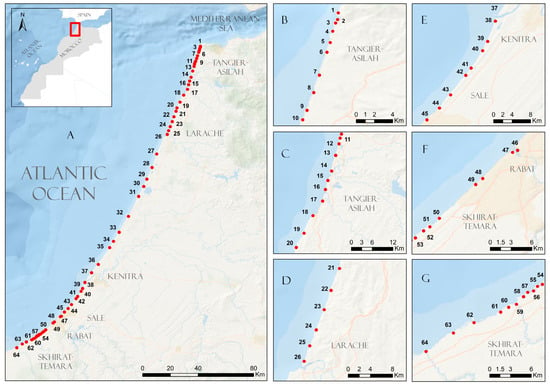
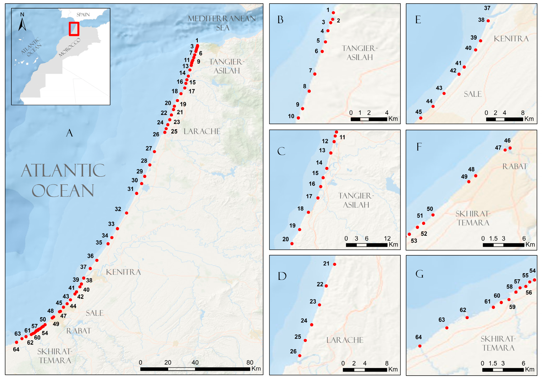
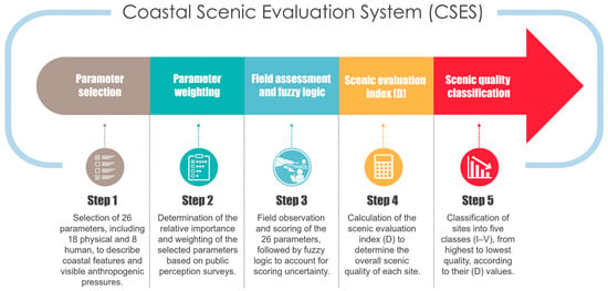
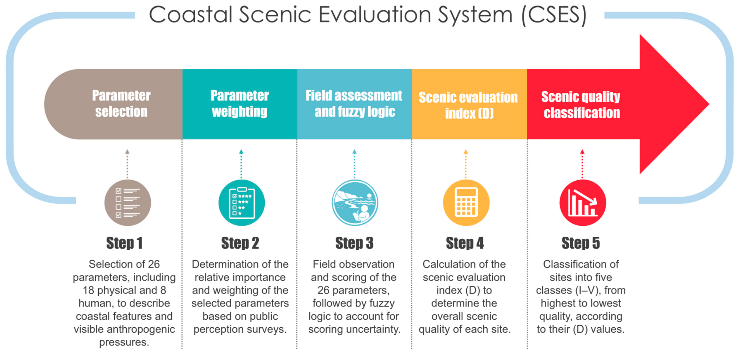
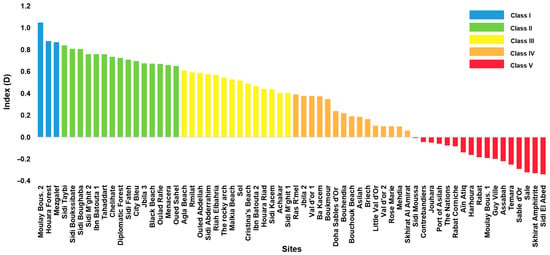
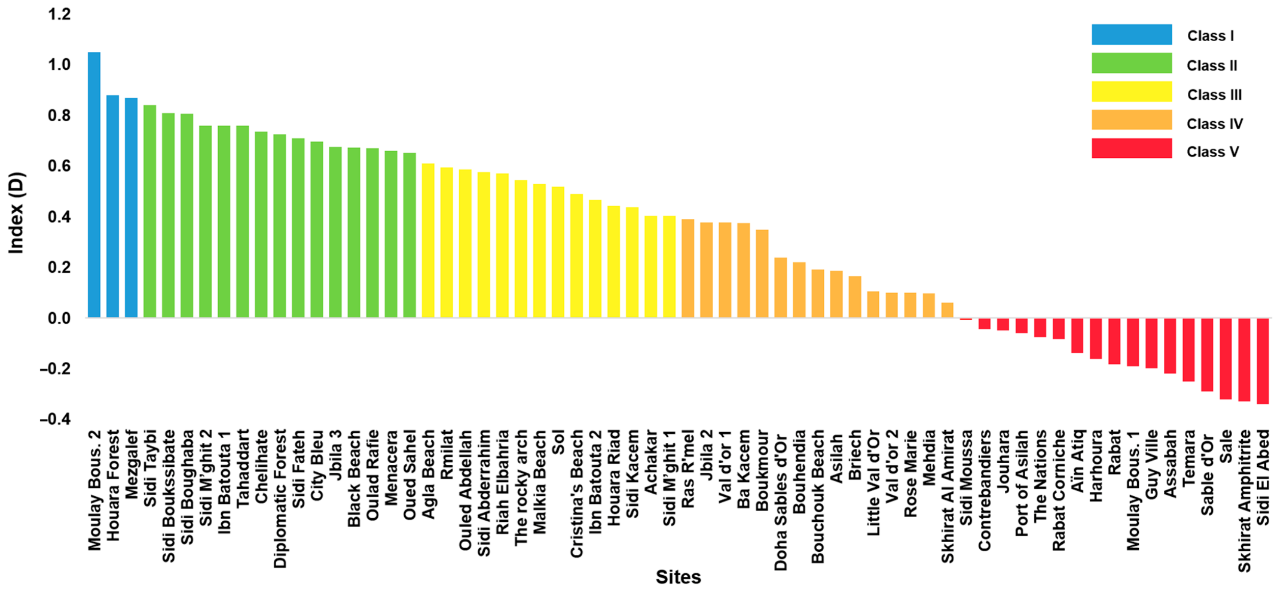
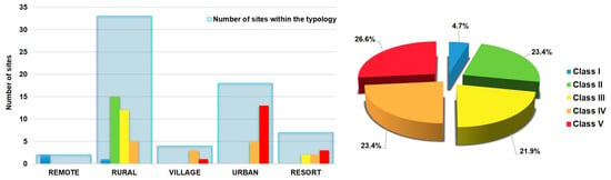
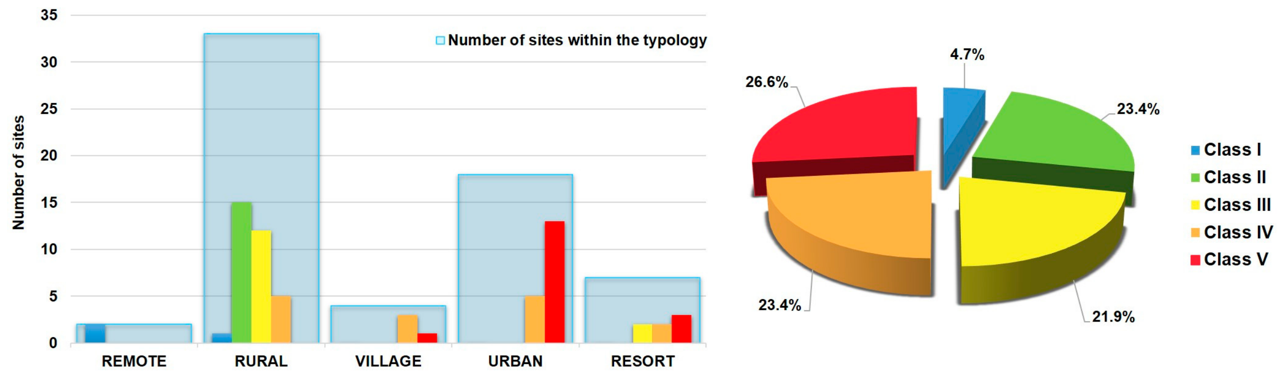
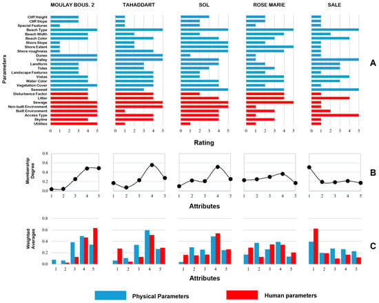
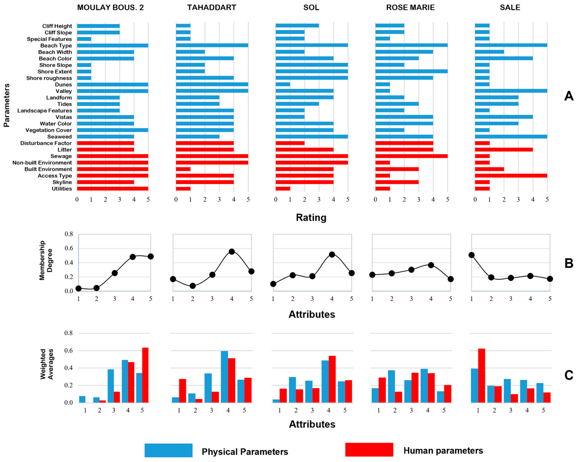
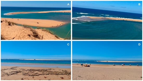
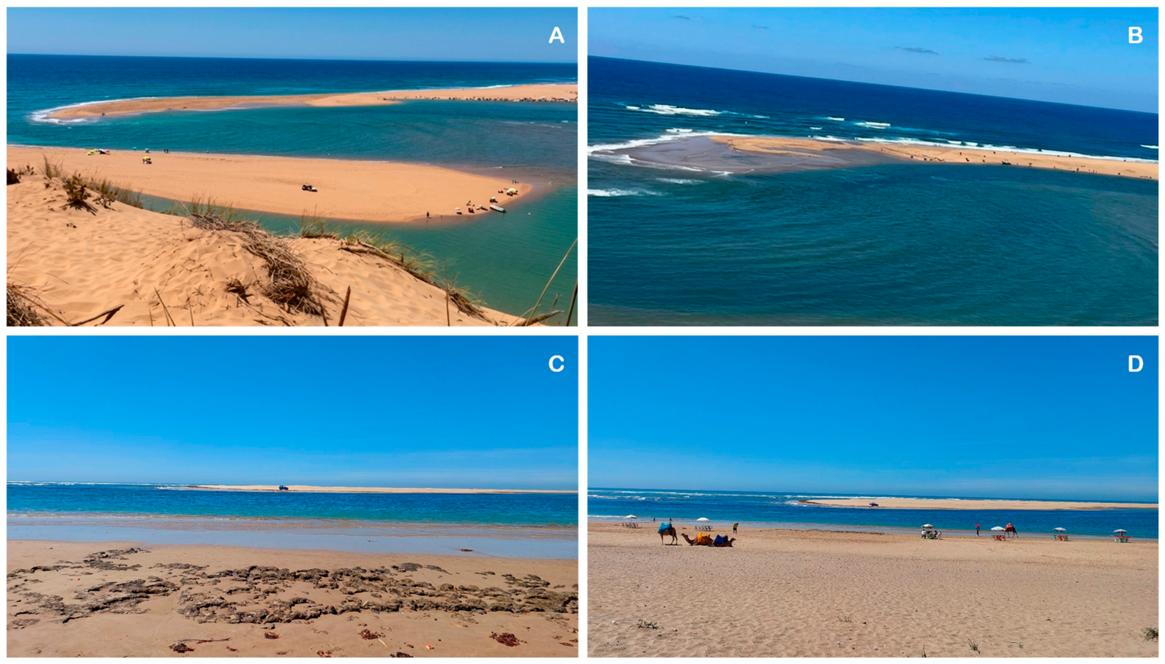
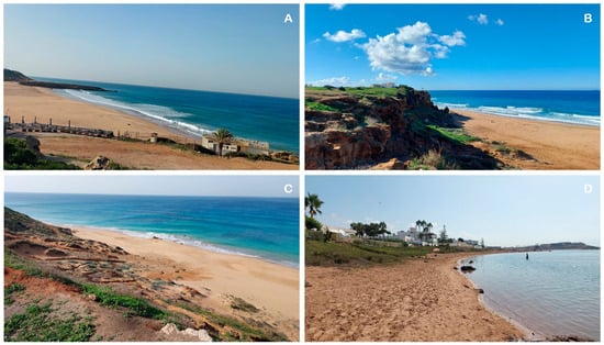
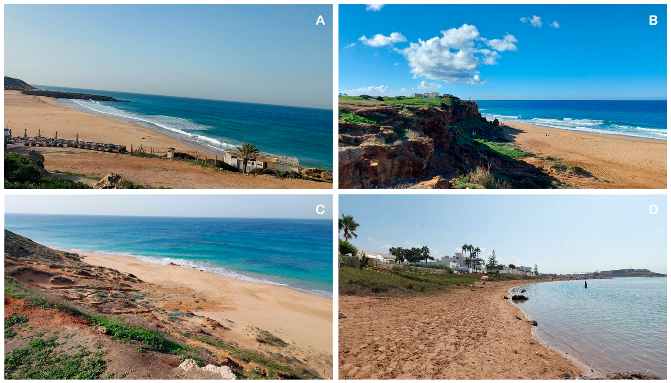
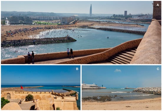
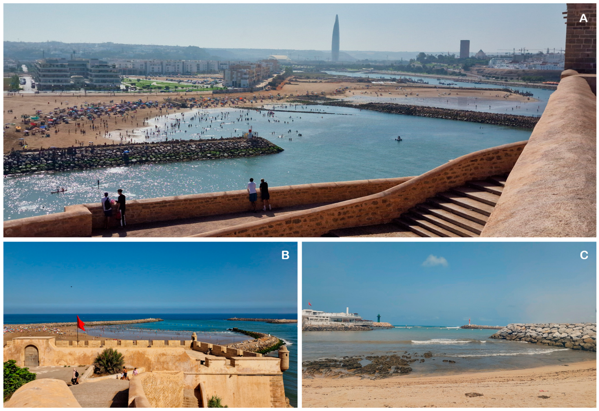
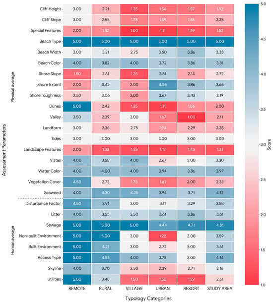
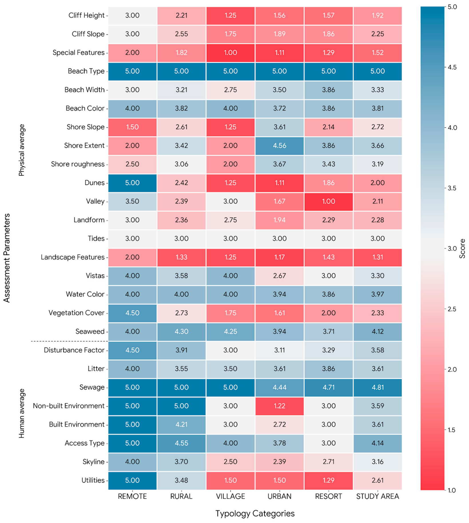
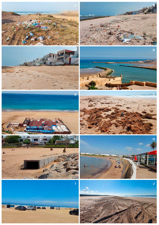
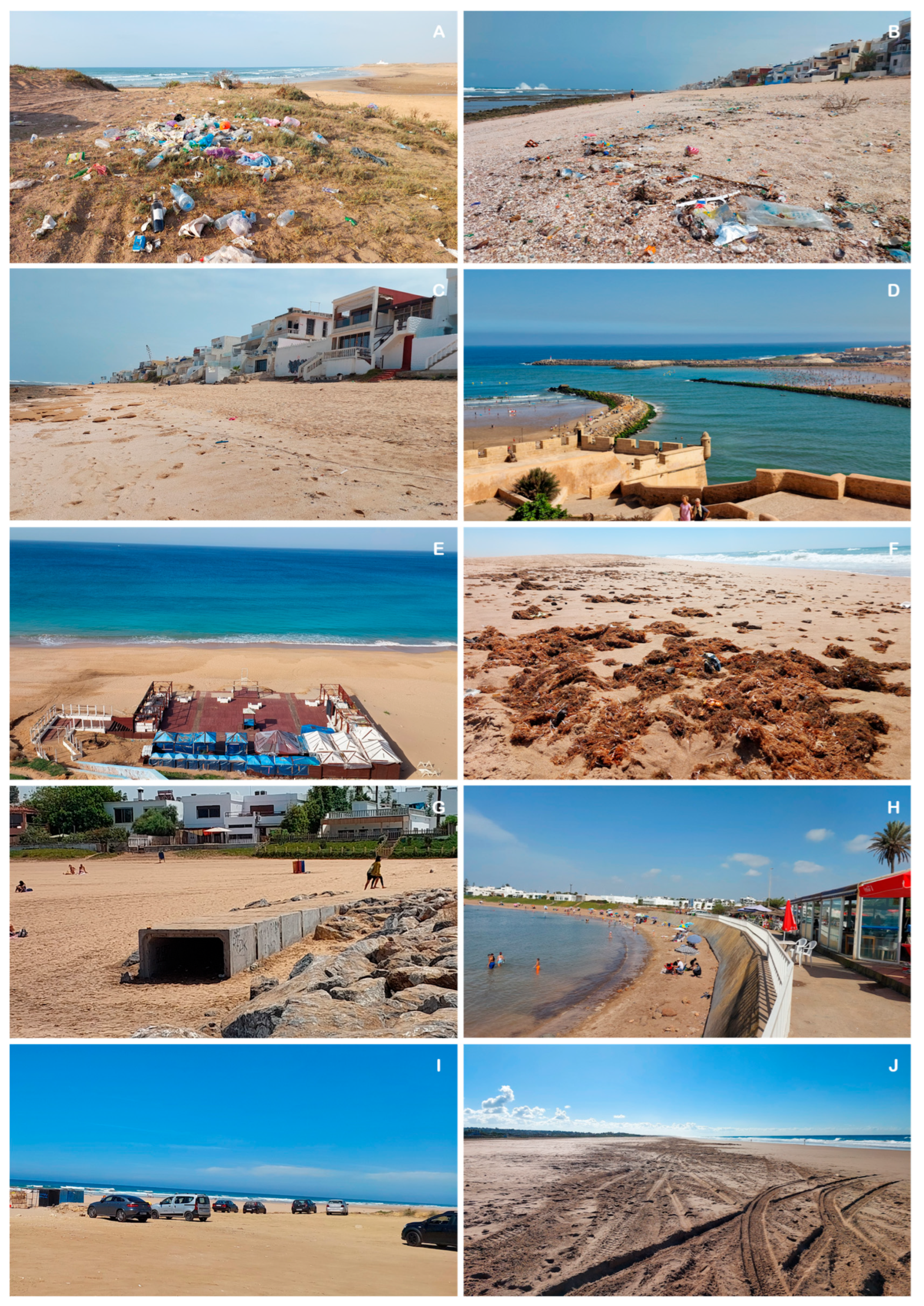
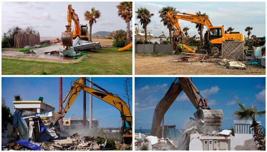
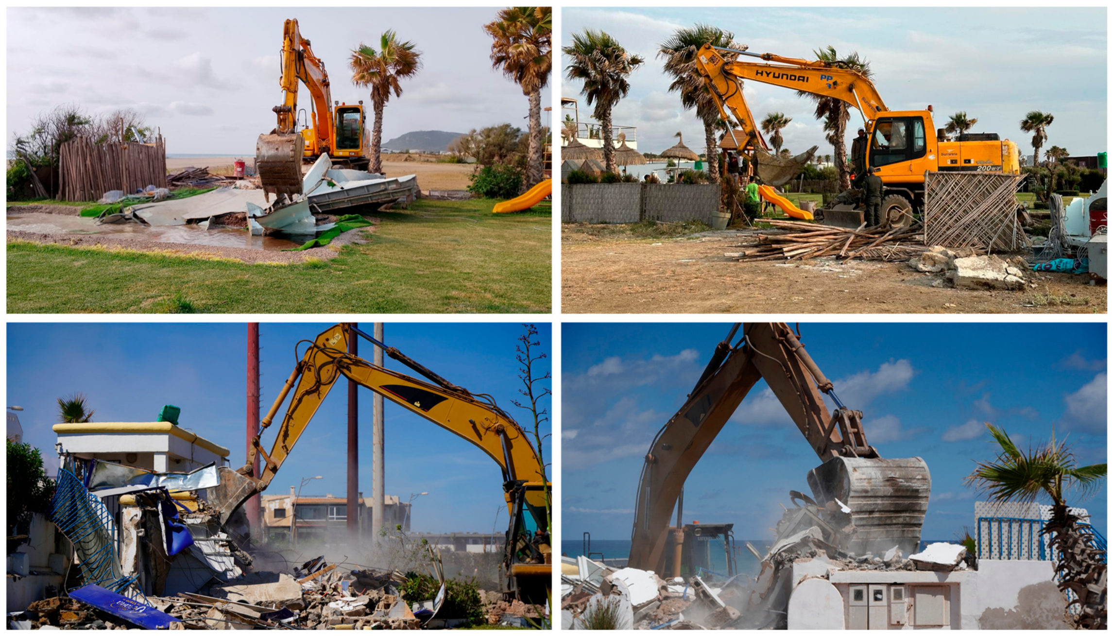

Disclaimer/Publisher’s Note: The statements, opinions and data contained in all publications are solely those of the individual author(s) and contributor(s) and not of MDPI and/or the editor(s). MDPI and/or the editor(s) disclaim responsibility for any injury to people or property resulting from any ideas, methods, instructions or products referred to in the content. |
© 2026 by the authors. Licensee MDPI, Basel, Switzerland. This article is an open access article distributed under the terms and conditions of the Creative Commons Attribution (CC BY) license.