


Abstract
Disaster and battle damage scenarios involve abrupt changes, complex environments, and rapidly changing targets, challenging the reliable perception of floods and damaged infrastructure. Optical–SAR fusion exploits complementary optical and synthetic aperture radar (SAR) information and has become an important approach for disaster monitoring and assessment. However, existing fusion methods remain limited by cross-modal registration errors, domain-specific data scarcity, inconsistent validation, and insufficient cross-region and cross-event generalization. This review jointly examines optical–SAR fusion for flood mapping and post-event damage assessment, providing a task-oriented synthesis of conventional fusion, machine learning, deep learning, transformers, self-supervised learning, and generative models. The review synthesizes fusion strategies across sensing conditions, datasets, downstream tasks, and evaluation practices, with particular attention to the applicability and limitations. The synthesis indicates that advanced fusion methods can improve multimodal representation and task-level performance, but increased model complexity does not necessarily ensure robust cross-region or cross-event generalization. Furthermore, the interchangeability between flood mapping and post-event damage evaluation is contingent upon variations in target attributes. It is selected for its supplementary perspectives on the extraction of information related to environmental disasters. Key challenges remain in registration, dataset availability, quantitative assessment, uncertainty, and computational efficiency. Future research should emphasize multimodal foundation models, physics-guided and uncertainty-aware learning, and integrated space–air–ground observation.
1. Introduction
In recent years, the increasing frequency and complexity of extreme natural hazards and other disruptive events have created an urgent need for rapid, reliable information on surface changes and impacts on critical infrastructure. Floods, landslides, earthquakes, and severe weather events can rapidly alter land-surface conditions and disrupt buildings, transportation networks, and other essential facilities. Conflict-related events may similarly cause substantial structural and functional damage to buildings, bridges, roads, and critical infrastructure. Although these events differ considerably in their physical mechanisms and operational contexts, they share an important remote sensing challenge: how to rapidly detect and characterize event-induced changes when observations are affected by cloud cover, precipitation, smoke, illumination constraints, complex terrain, or rapidly changing surface conditions [1,2]. Timely information on flood extent, damaged structures, and disrupted infrastructure is therefore essential for emergency response, post-event assessment, situational awareness, and subsequent recovery planning [3].
Benefiting from its wide spatial coverage, rapid acquisition capability, and non-contact observation characteristics, remote sensing has become one of the primary technologies for disaster monitoring and infrastructure damage assessment [4,5,6]. Optical remote sensing provides high-spatial-resolution imagery with abundant spectral and textural information, enabling accurate object recognition and scene interpretation. However, its performance is severely constrained by cloud cover, precipitation, smoke, and illumination conditions [7]. In contrast, synthetic aperture radar (SAR) uses active microwave sensing and can acquire observations under a wider range of weather and illumination conditions than optical sensors. Its sensitivity to atmospheric conditions and vegetation penetration capability depend on radar frequency, polarization, rainfall intensity, and vegetation structure. Nevertheless, SAR imagery is affected by speckle noise, geometric distortions, and imaging-geometry-dependent backscatter variations, and generally provides less direct semantic information than optical imagery [8,9]. Owing to the complementary imaging mechanisms of these two sensing modalities, optical–SAR fusion has emerged as an effective solution for robust remote sensing perception in complex environments [10]. By integrating the rich spectral and textural information of optical imagery with the structural and scattering characteristics captured by SAR, optical–SAR fusion substantially improves object recognition, change detection, and quantitative analysis [11,12]. With recent advances in deep learning, multimodal learning, and integrated space–air–ground observation systems, optical–SAR fusion has evolved from conventional pixel-level fusion toward deep feature fusion, cross-modal generative learning, and semantic-level representation, demonstrating remarkable potential in disaster monitoring, change detection, and geophysical parameter retrieval [13,14].
The development of optical–SAR fusion has progressed from traditional model-driven approaches to data-driven and intelligent fusion paradigms [15]. Early studies mainly relied on conventional techniques, such as principal component analysis (PCA) and wavelet transform, to integrate multisource remote sensing data, but their capability to represent complex scenes and semantic information remained limited [16]. More recently, deep learning models—including convolutional neural networks (CNNs), long short-term memory (LSTM) networks, transformers, and generative adversarial networks (GANs)—have significantly improved cross-modal feature extraction and nonlinear information interaction, leading to enhanced robustness and recognition performance under complex environmental conditions [17,18,19]. Furthermore, the emergence of diffusion models, vision foundation models, and multimodal large models has accelerated the transition of optical–SAR fusion toward unified representation learning, cross-modal generation, and intelligent decision support, opening new opportunities for disaster perception [20].
Against this background, this review focuses on two distinct but related application domains of optical–SAR fusion: flood mapping and post-event damage assessment. Flood mapping concerns the detection and spatial characterization of inundated areas, their temporal evolution, and, where data and models permit, quantitative characteristics such as flood depth and associated impacts [21]. Post-event damage assessment focuses on identifying structural or functional changes in buildings, transportation systems, and other critical infrastructure following disruptive events [22]. These two domains are selected because they provide complementary perspectives on disaster-related information extraction: flood mapping characterizes the spatial manifestation of a hazard, whereas post-event damage assessment characterizes its consequences for exposed assets and environments. At the same time, both rely on the complementary information provided by optical and SAR observations under complex sensing conditions, providing a common basis for examining the transferability and task-specific adaptation of fusion strategies.
Building on previous reviews of optical–SAR fusion and disaster-related remote sensing [12,13,22,23], this review examines optical–SAR fusion for flood mapping and post-event damage assessment from a unified, task-oriented perspective. Existing reviews have primarily addressed general fusion techniques or individual disaster-related applications, providing important foundations but offering limited insight into the methodological connections and task-dependent differences between these two applications. Flood mapping aims to delineate inundated areas, whereas post-event damage assessment focuses on identifying changes to buildings and infrastructure. By comparing these tasks within a common analytical framework, this review goes beyond summarizing their applications separately to examine which fusion principles and representations are shared and which information requirements are task-specific. The review traces the evolution of optical–SAR fusion from traditional and machine-learning methods to deep learning, transformers, generative models, and foundation models, evaluating their applicability and limitations across both tasks rather than treating methodological advances independently of application requirements. It further synthesizes cross-cutting challenges, including cross-modal registration, representation alignment, uncertainty, data scarcity, generalization, and computational efficiency, to identify opportunities for cross-task knowledge transfer and priorities for developing more robust and adaptable fusion methods for disaster-related remote sensing.
2. Materials and Methods
2.1. Literature Search Strategy
To establish a transparent and traceable literature foundation, this review used a structured literature identification and selection process, with the overall selection procedure summarized in a literature identification and selection flow diagram (Figure 1). The review was designed as a narrative review, aiming to synthesize and critically discuss methodological developments, application characteristics, challenges, and emerging directions in optical–SAR fusion for flood mapping and post-event damage assessment.
Figure 1.
Literature identification and selection flow diagram.
Literature searches were conducted in September 2026 across the Web of Science Core Collection, Engineering Village, and IEEE Xplore to identify relevant peer-reviewed studies published between January 2011 and July 2026. These databases were selected to provide broad coverage of remote sensing, earth observation, image processing, computer vision, artificial intelligence, and disaster-related research. Database-specific search interfaces were used, including Advanced Search in Web of Science, Expert Search in Engineering Village, and Command Search in IEEE Xplore. The search strategy combined two main dimensions: optical–SAR fusion-related concepts and target application domains. The following Boolean search string was used as the core search strategy: (“optical” AND “SAR” AND “fusion”) AND (“flood mapping” OR “flood detection” OR “flood monitoring” OR “flood inundation” OR “damage assessment” OR “building damage” OR “infrastructure damage”).
The retrieved records were screened for their relevance to the scope of this review. Studies were considered relevant when they involved the joint use or integration of optical and SAR observations and addressed flood mapping, flood detection or monitoring, flood inundation, disaster-related surface change assessment, building or infrastructure damage assessment, or conflict-related damage assessment. Records were excluded when they relied exclusively on a single data modality, were unrelated to the target applications, were conference abstracts, editorials, commentaries, or duplicate records, or lacked sufficient methodological or experimental information for meaningful analysis.
A total of 211 records were initially identified through the three database searches, including 81 records from Web of Science Core Collection, 88 from Engineering Village, and 42 from IEEE Xplore. After removing 88 duplicates, 123 records underwent title and abstract screening, of which 40 were excluded. The remaining 83 records were assessed in full text, and 18 were excluded because they did not meet the relevance or methodological eligibility criteria. The screening process identified 65 records relevant to the scope of this review for further consideration in the narrative synthesis. These records provided a core pool of literature for examining methodological developments, application characteristics, and research challenges. Additional references were cited selectively to support foundational concepts, methodological explanations, and historical context.
The literature selection was intended to provide a focused evidence base for the review rather than an exhaustive inventory of all publications related to optical–SAR fusion. The selected literature was used to examine methodological development, application characteristics, comparative performance, and emerging research directions.
2.2. AI Disclosure Statement
During the preparation of this review article, the authors used ChatGPT-5.5 (https://chatgpt.com; accessed on 3 July 2026) to assist with academic language refinement, grammatical improvement, and enhancement of scientific expression. It was also used to assist in preparing selected schematic figures illustrating scientific concepts and technical frameworks discussed in this review, specifically Figure 2, Figure 3, Figure 4 and Figure 5. AI-generated figures were used as initial visual drafts and were subsequently edited and refined by the authors using Microsoft PowerPoint (Microsoft Corporation, Redmond, WA, USA) and Adobe Photoshop (Adobe Inc., San Jose, CA, USA). These post-processing steps were carried out to improve clarity and ensure consistency with the scientific content of the manuscript. The scientific concepts, underlying information, relationships, and intended messages represented in these figures were determined and evaluated by the authors. All AI-assisted visual content was critically reviewed and revised where necessary to ensure consistency with the scientific content of the manuscript. The authors reviewed and approved the final manuscript and all figures and take full responsibility for their accuracy, integrity, and scientific validity.
Figure 2.
Optical-SAR fusion technology process.
Figure 3.
General framework of deep learning-based multimodal remote sensing data fusion.
Figure 4.
Technical framework of optical–SAR fusion for flood mapping.
Figure 5.
Technical framework of optical–SAR fusion for post-event damage assessment.
3. Fundamentals and Evolution of Optical–SAR Fusion
3.1. Fundamentals and Fusion Principles
The fundamental principle of optical–SAR fusion is to exploit the complementary information provided by optical and SAR observations. Optical imagery records reflected solar radiation and provides rich spectral, textural, and visual information, whereas SAR records microwave backscatter and provides structural and scattering information. Unlike optical sensors, SAR can acquire observations under a wider range of illumination and weather conditions, including cloud-covered conditions. However, its observation capability is not entirely independent of environmental and acquisition conditions. SAR performance is influenced by radar frequency, polarization, rainfall conditions, and imaging geometry, while its backscatter measurements may also be affected by speckle noise and complex interactions between microwaves and surface features. These differences in sensing mechanisms give optical and SAR imagery complementary strengths while introducing challenges for their joint interpretation.
Effective optical–SAR fusion therefore requires more than simply combining two data sources; it must account for their different spatial characteristics and information representations. Optical imagery is sensitive to illumination and atmospheric conditions and may be affected by cloud cover, smoke, or nighttime conditions. SAR is generally less affected by cloud cover and illumination, but its backscatter responses can be difficult to interpret, particularly in areas with complex terrain, vegetation, or built-up structures. Effective fusion consequently requires establishing correspondence between heterogeneous observations through geometric and radiometric preprocessing, spatiotemporal registration, and cross-modal feature alignment before subsequent information integration [24]. In practice, optical and SAR observations are not always acquired simultaneously. Temporal gaps between acquisitions may cause the two modalities to represent different stages of a rapidly evolving flood or different post-event surface conditions, potentially introducing inconsistencies into fused representations. Furthermore, cloud cover, smoke, or unfavorable illumination may prevent the acquisition of usable post-event optical imagery, limiting the availability of complementary information when rapid assessment is most needed.
As illustrated in Figure 2, optical–SAR fusion can be broadly organized into three stages: data preparation, multimodal alignment, and fusion-based analysis. Following preprocessing and spatiotemporal registration, optical and SAR observations can be integrated at pixel, feature, semantic, or decision levels to support downstream tasks such as flood mapping, change detection, object recognition, and damage assessment. Different fusion levels involve distinct trade-offs [12]. Pixel-level fusion is relatively straightforward but sensitive to misregistration and radiometric differences; feature-level fusion provides greater flexibility for cross-modal representation but generally requires more training data and computation; semantic- and decision-level fusion offer greater modularity but may lose low-level complementary information. Therefore, fusion performance depends on the interaction among fusion level, sensor characteristics, and downstream task rather than on the fusion level alone [25].
3.2. Traditional Fusion Methods
Traditional optical–SAR fusion methods primarily rely on pixel-level transformations and feature integration to combine complementary information from optical and radar observations. PCA, Brovey transformation, wavelet-based fusion, and other component-substitution approaches. Their application to optical–SAR data has been investigated in crop classification and land-cover mapping, where different fusion strategies can influence the preservation of image information and subsequent classification performance [26,27].
However, traditional methods rely heavily on fixed mathematical models and have limited capacity to capture complex nonlinear relationships between optical and SAR modalities. They may introduce edge blurring, spectral distortion, or noise amplification in complex scenes [12]. Their main value therefore lies in low-level information enhancement and rapid processing, whereas their applicability to fine-grained flood mapping and building damage assessment is limited.
3.3. Traditional Machine Learning-Based Fusion Methods
Traditional machine learning methods, particularly support vector machines (SVMs) and random forests (RFs), have been widely applied to the classification of multi-source remote sensing data. SVMs can effectively handle nonlinear classification problems, while RFs are well suited to integrating heterogeneous features derived from optical and SAR imagery. Studies combining Sentinel-1 SAR and optical imagery have evaluated different fusion and classification strategies for land-cover mapping, demonstrating the potential of these methods to exploit complementary information from multiple sensors [28]. Furthermore, RF-based classification integrating Sentinel-1 and Sentinel-2 data has been applied to rapid flood damage assessment, highlighting the practical value of optical–SAR integration in post-disaster applications [29].
Compared with traditional fusion methods, machine learning approaches shift the focus from pixel-level integration to feature-level fusion, extending applications from image enhancement to classification and change detection. Their practical advantages include relatively low data and computational requirements and good performance with limited labeled samples. However, their dependence on handcrafted spectral, textural, and radar features restricts their ability to learn complex cross-modal representations automatically. Performance may therefore decrease when the feature distribution, sensor configuration, or geographic environment changes.
Thus, classical machine learning remains useful for data- or resource-constrained applications, but its capacity to learn transferable multimodal representations is generally more limited than that of contemporary deep representation-learning methods.
3.4. Deep Learning-Based Fusion Methods
The emergence of deep learning has driven optical–SAR fusion from handcrafted feature engineering toward end-to-end representation learning, enabling models to automatically learn nonlinear semantic correlations between heterogeneous modalities and improving multimodal perception in complex environments.
Figure 3 illustrates a general framework for deep learning-based multimodal remote sensing data fusion. After preprocessing and spatiotemporal alignment, multi-source data are fed into encoders such as CNNs and LSTMs to extract spatial and temporal representations. These features are then fused within a unified latent space through cross-modal interaction and consistency learning, and finally used for downstream tasks including object detection, change detection and flood evolution analysis. This framework has become a widely adopted paradigm in recent optical–SAR fusion research.
3.4.1. CNN- and RNN-Based Fusion Methods
CNNs have demonstrated remarkable capability in extracting spatial features from remote sensing imagery by automatically learning texture, edge, and structural representations. Consequently, CNN-based methods have achieved high accuracy in applications such as bridge damage detection, road extraction, and flood inundation mapping. To address the substantial differences between optical and SAR data, dual-stream or multi-stream network architectures are commonly adopted to independently extract modality-specific features before performing feature interaction and fusion in a shared latent space [30]. Cheng et al. [17] systematically reviewed the application of dual-stream CNNs for optical–SAR fusion and demonstrated that modality-specific feature extraction followed by deep feature interaction substantially improves object recognition and change detection performance. Liu et al. [9] specifically reviewed deep feature fusion methods for optical and SAR image semantic segmentation, summarizing representative fusion strategies and their methodological characteristics.
CNN-based fusion strategies can generally be categorized into early fusion, intermediate fusion, and late fusion. Intermediate fusion has become particularly common because it provides a balance between modality-specific representation and cross-modal interaction. CNN-based approaches also generally provide a more favorable balance between performance and computational cost than larger Transformer architectures, contributing to their relatively high methodological maturity.
For temporal perception tasks, recurrent neural networks (RNNs), particularly LSTM networks, have been extensively employed because of their ability to model long-term temporal dependencies. LSTM-based approaches have been widely applied to landslide deformation monitoring, flood evolution analysis, and disaster prediction. However, their sequential processing structure can increase computational complexity, and their usefulness depends strongly on whether temporal information is central to the target task.
3.4.2. Attention Mechanism- and Transformer-Based Fusion Methods
Transformer architectures have further expanded optical–SAR fusion through self-attention mechanisms capable of modeling long-range spatial dependencies and cross-modal relationships. Current approaches commonly employ cross-attention, fusion attention, or gated attention to establish explicit interactions between optical and SAR representations.
Liu et al. [31] proposed SoftFormer, a Transformer-based framework for SAR–optical fusion in urban land use and land cover classification. More broadly, Transformer-based approaches can capture long-range dependencies and global contextual information, enabling interactions between heterogeneous modalities.
However, this increased modeling capacity is accompanied by higher model complexity and computational requirements. Performance is also influenced by training-data volume, pre-training strategy, input resolution, and model scale. Therefore, reported advantages of Transformers over CNNs should not be generalized across tasks or datasets without considering these factors.
3.4.3. Self-Supervised and Contrastive Learning-Based Fusion Methods
The increasing cost of manual annotation has encouraged the development of self-supervised learning (SSL) and contrastive learning (CL) for optical–SAR fusion. These approaches aim to learn transferable representations from large amounts of unlabeled or weakly labeled data and reduce dependence on manually annotated samples.
Self-supervised learning employs pretext tasks such as masked image modeling, cross-modal reconstruction, and predictive consistency learning. Contrastive learning seeks to reduce cross-modal representation differences by constructing positive and negative sample pairs. Chen et al. [32] proposed a triplet-based contrastive learning framework that introduced hard negative samples to improve multimodal discriminability.
Compared with fully supervised approaches, SSL and CL are particularly promising when labeled samples are scarce and improved cross-scene transfer is desired. However, large-scale pre-training may itself require substantial computational resources, while the quality and diversity of pre-training data strongly affect downstream performance. Therefore, reduced annotation requirements do not necessarily imply lower overall computational costs.
These methods are promising for improving data efficiency and generalization, but their practical advantages require stronger validation across independent regions, events, and sensor configurations.
3.5. Generative Fusion Methods
Recent advances in generative artificial intelligence have extended optical–SAR fusion from feature integration toward cross-modal image generation and semantic reconstruction. Generative models can learn mappings between heterogeneous modalities and reconstruct missing or degraded information, providing new opportunities for remote sensing under incomplete or adverse observation conditions.
GANs are among the most widely used generative approaches. Through adversarial optimization, GAN-based methods enable cross-modal translation and image enhancement. Pix2Pix employs conditional adversarial learning for paired image-to-image translation, whereas CycleGAN enables translation between unpaired image domains through cycle consistency [33,34]. Conditional GANs can further incorporate auxiliary information to improve semantic consistency.
More recently, diffusion models have emerged as an alternative generative paradigm. Compared with GANs, diffusion models progressively reconstruct images through iterative denoising and can provide high-quality generated representations. Latent diffusion approaches reduce part of the computational burden by performing generation in a lower-dimensional latent space.
Despite these advantages, the operational reliability of generative fusion methods for disaster assessment requires further validation. Visual realism does not necessarily translate into improved flood mapping or damage assessment, and generated images may contain visual artifacts or semantically inconsistent features. For example, a CycleGAN-based SAR-to-optical translation study for flood monitoring reported land–water semantic inversions in some model configurations, highlighting the limitations of visual inspection alone [35]. Conversely, a diffusion-based SAR-to- earth observation (EO) translation study evaluated the generated imagery through downstream flood segmentation, demonstrating the importance of task-level validation [36]. Therefore, generated imagery should be treated as auxiliary information rather than direct physical evidence unless its reliability for the intended task has been independently established.
Generative models may also impose additional computational costs, depending on the model architecture and inference strategy. For example, a diffusion-based SAR-to-EO framework used 200 sampling steps during inference [36]. Future research should therefore focus on improving computational efficiency, physical and semantic consistency, uncertainty characterization, and task-level validation. Cross-modal reconstruction and missing-information completion are promising applications, while the suitability of generated imagery for data augmentation or direct replacement of established perception models should be assessed through task-specific experiments.
3.6. Comparative Summary of Optical–SAR Fusion Methods
The evolution of optical–SAR fusion demonstrates a gradual transition from computationally efficient information integration toward task-oriented cross-modal representation and generative modeling. However, methodological advancement does not necessarily translate into universally superior performance. Differences in datasets, downstream tasks, evaluation metrics, and validation protocols limit direct comparison across studies.
To provide an evidence-based comparison, Table 1 summarizes representative optical–SAR fusion studies for flood mapping and building damage assessment. The results indicate that fusion performance varies across tasks and experimental settings. For flood mapping, optical–SAR fusion improved classification accuracy over optical-only inputs in Liu et al. [37], whereas Sanderson et al. [38] reported only marginal intersection over union (IoU) gains over optical imagery. For building damage assessment, fusion outperformed single-sensor alternatives in some experiments but did not consistently surpass optical-only inputs. Moreover, improvements achieved by advanced architectures, such as TLE-FEDformer, should not be attributed solely to sensor fusion [39]. Overall, these findings suggest that no single fusion strategy is universally superior; its effectiveness depends on the target task, sensor characteristics, data availability, and evaluation protocol.
Table 1.
Quantitative comparison of optical–SAR fusion methods for flood mapping and building damage assessment.
4. Applications and Cross-Task Synthesis of Optical–SAR Fusion
4.1. Flood Mapping and Quantitative Assessment
Floods are among the most frequent and destructive natural hazards worldwide, making rapid monitoring and dynamic assessment essential for emergency response and post-disaster recovery. Current research has progressively expanded from flood inundation mapping toward flooded-vegetation detection, temporal flood monitoring, and quantitative assessment of flood depth and impacts, as illustrated in Figure 4.
4.1.1. Flood Inundation Mapping
Flood inundation mapping represents the fundamental task in flood assessment and emergency response and is currently the most mature application of optical–SAR fusion. SAR imagery can acquire flood information under cloud cover and, depending on radar frequency, polarization, and rainfall intensity, during precipitation. X-band signals are attenuated by heavy rain, whereas C-band and L-band are less affected; HH polarization generally offers the best radiometric contrast for open water, while cross-polarization or longer wavelengths are needed for inundation beneath vegetation. Practical coverage is further constrained by imaging geometry and by satellite revisit intervals, which limit the capture of rapid flood dynamics. Optical imagery, when cloud-free, provides richer semantic information regarding land-cover boundaries, roads, and buildings. Their complementary characteristics effectively reduce false detections caused by building shadows, mountainous terrain, and vegetation occlusion, thereby improving flood boundary delineation in complex environments.
In recent years, deep learning-based approaches have become increasingly prevalent in flood mapping research. Representative approaches include U-Net and its variants, the DeepLab series of semantic segmentation networks, and encoder–decoder-based multimodal fusion architectures. The U-Net architecture proposed by Ronneberger et al. [42] provided an important foundation for encoder–decoder-based semantic segmentation and was subsequently widely adopted in remote sensing applications, whereas Chen et al. [43] developed DeepLabv3+, which significantly improved segmentation performance in complex scenes through atrous convolution and multi-scale feature aggregation. For SAR-based flood mapping, the Sen1Floods11 dataset introduced by Bonafilia et al. [44] has become a standardized benchmark for training and evaluating deep learning models. Recent studies have demonstrated the applicability of SAR–optical fusion combined with machine learning for flood detection in mountainous river basins, highlighting the value of multimodal observations under complex topographic conditions [45]. Consequently, flood inundation mapping has progressively evolved from conventional threshold-based methods toward deep learning and multimodal feature-based approaches.
4.1.2. Flood Mapping in Vegetated and Complex Environments
Flood detection becomes more challenging when inundation occurs beneath vegetation or around buildings and mountainous terrain. Cloud contamination and spectral mixing can affect optical imagery, while vegetation structure, terrain effects, and double-bounce scattering can impact SAR backscatter. Studies have therefore investigated the use of SAR observations to detect inundation beneath vegetation, particularly in environments where optical observations are limited by cloud cover or vegetation obscuration. Tsyganskaya et al. [46] developed a Sentinel-1 time-series approach for detecting temporarily flooded vegetation and demonstrated that incorporating flooded vegetation substantially reduced the underestimation of total flood extent. Plank et al. [47] further combined Sentinel-1 and ALOS-2/PALSAR-2 polarimetric observations to distinguish open water and flooded vegetation, highlighting the complementary roles of different SAR frequencies and polarizations. Moving beyond SAR-based approaches, Narin et al. [48] combined SAR and optical data with a Random Forest classifier to map floods across urban and agricultural landscapes in the Netherlands, demonstrating the potential of multi-sensor fusion for diverse environments.
Nevertheless, differences in imaging mechanisms, spatial resolution, viewing geometry, and radiometric characteristics can introduce cross-modal inconsistencies. Thus, simply combining optical and SAR features does not guarantee improved robustness. The effectiveness of fusion depends on vegetation structure, terrain conditions, sensor configuration, and the availability of temporally consistent observations. Asynchronous acquisitions and missing post-event optical data can further reduce the reliability of flood evolution analysis and damage assessment, because apparent cross-modal changes may reflect differences in acquisition time rather than actual event-induced changes. In such cases, SAR-only observations or temporally mismatched optical data may provide incomplete or potentially misleading evidence of flood extent and structural damage. Adaptive fusion strategies that account for modality reliability across different environmental conditions therefore remain an important research direction.
4.1.3. Multi-Temporal Flood Mapping and Flood Evolution
Compared with single-temporal flood mapping, multi-temporal optical–SAR fusion enables the characterization of flood initiation, expansion, and recession, extending flood mapping from static inundation delineation toward flood evolution analysis. With the continuous acquisition of high-spatiotemporal-resolution observations from Sentinel-1 and Sentinel-2 satellites, time-series remote sensing analysis has become an active research topic.
Recent studies have explored Transformer-based architectures for multi-temporal optical–SAR flood mapping. For example, Ahmadi et al. [39] proposed TLE-FEDformer, which integrates Sentinel-1 SAR and Sentinel-2 optical observations with frequency-domain temporal modeling to characterize flood dynamics, including flood onset, peak, duration, and recession. This study illustrates the potential of Transformer-based models for jointly exploiting cross-modal information and temporal dependencies in flood evolution analysis.
In parallel, Mamba-based architectures have been investigated for cross-modal flood change detection. Shen et al. [49] proposed SD-Mamba, a lightweight network designed to improve the representation of changes between optical and SAR imagery. By offering a computationally efficient mechanism for modeling long-range dependencies, these models have shown potential for large-scale remote sensing sequence analysis and may provide new opportunities for flood evolution modeling.
4.1.4. Flood Depth Retrieval and Quantitative Assessment
As flood remote sensing continues to advance, research has progressively shifted from flood extent mapping toward quantitative assessment of flood depth, water-level variation, and disaster severity. Several approaches have been developed to derive flood depth by combining remotely sensed inundation extent with topographic information. For example, Chimata et al. [50] developed an automated approach for rapid flood-depth estimation by integrating a digital elevation model (DEM) with flood inundation data derived from the EOS-04 satellite. The floodwater depth estimation tool (FwDET), developed by Cohen et al. [51], estimates floodwater depth from inundation extent and a DEM, providing a rapid approach for converting remotely sensed flood maps into spatially distributed depth information. FwDET v2.0 further improved its applicability to coastal flooding and demonstrated good agreement with physically based hydrodynamic simulations [52]. These DEM-based approaches rest on a key assumption: that the water surface is approximately horizontal, so that local depth can be estimated as the elevation difference between the flood boundary and the target cell. This assumption introduces uncertainties, as vertical errors in the DEM—particularly in flat or built-up terrain—propagate directly into depth estimates. Furthermore, the validation of FwDET has largely been conducted against physically based hydrodynamic simulations, demonstrating internal consistency with model behavior rather than independent validation against field measurements. Beyond DEM-based approaches, Liou and Hoang [53] developed a machine-learning-based flood-depth estimation framework that combined Sentinel-1-derived flood extent, DEM information, and Sentinel-2 features. Using 804 observed flood-depth records for model evaluation, they reported improved depth-prediction performance compared with the baseline estimation approach. This study illustrates the potential of integrating complementary satellite observations and terrain information for quantitative flood assessment.
Beyond direct depth estimation, SAR-derived flood extent can also be assimilated into hydrologic–hydraulic models to improve flood forecasting. Hostache et al. [54] investigated the near-real-time assimilation of SAR-derived flood maps into a coupled hydrologic–hydraulic forecasting system. Di Mauro et al. [55] further explored the assimilation of probabilistic SAR-derived flood maps, accounting for observational uncertainty in the forecasting framework. These studies demonstrate the value of SAR-derived flood observations for constraining hydraulic simulations.
Furthermore, multimodal remote sensing data can be integrated with infrastructure information, including roads, bridges, and residential areas, to support flood impact assessment, transportation accessibility analysis, and affected population estimation. These capabilities provide valuable information for emergency rescue planning and resource allocation following flood events. However, depth estimation remains sensitive to the accuracy and spatial resolution of the flood extent and DEM, while hydraulic-model assimilation is affected by observation timing, spatial coverage, and uncertainty in model inputs. Therefore, quantitative flood assessment generally requires stronger integration of physical constraints and auxiliary data than conventional inundation mapping.
4.2. Post-Event Damage Assessment
Post-event damage assessment aims to rapidly identify damaged targets, characterize damage severity, and evaluate the functional consequences of disasters or other destructive events. Current research has mainly developed along two related directions: building damage detection and road and bridge damage assessment. As shown in Figure 5, this is the technical framework of optical–SAR fusion for post-event damage assessment.
4.2.1. Building Damage Detection
Buildings are among the most important targets for post-event damage assessment because their structural condition is directly related to casualties, shelter availability, and emergency response. Optical imagery can provide detailed information on building outlines, roof texture, and visible structural changes, while SAR is sensitive to changes in scattering mechanisms and geometric structures. Their complementary characteristics make optical–SAR fusion particularly effective for assessing building damage under cloud cover, variable illumination, and complex backgrounds.
Recent studies have demonstrated the potential of multimodal data for building damage assessment. Chen et al. [56] introduced BRIGHT, a globally distributed dataset integrating very-high-resolution optical and SAR imagery for building damage assessment across multiple disaster types. For flood-related applications, Ho and Mostafavi [57] proposed Flood-DamageSense, which combines pre- and post-event SAR/InSAR observations, high-resolution optical basemaps, and flood-risk information to assess building damage and map flood extent. Russo et al. [58] investigated different fusion strategies using SAR and high-resolution optical imagery for building damage detection following the 2025 Myanmar earthquake. These studies illustrate the potential of multimodal approaches across different disaster scenarios. However, building damage assessment remains sensitive to image registration, acquisition intervals, viewing geometry, and differences in illumination and environmental conditions. Consequently, robust cross-event and cross-region generalization remains an important challenge.
4.2.2. Road and Bridge Damage Assessment
Roads and bridges are critical components of transportation networks, and their damage can directly reduce accessibility and affect emergency rescue and logistical operations. Compared with buildings, transportation infrastructure often exhibits more complex spatial structures and stronger interactions with surrounding terrain. Optical imagery provides information on road surfaces, bridge structures, and visible physical changes, whereas SAR can provide complementary observations under adverse weather and illumination conditions.
Karimzadeh et al. [59] developed a deep-learning approach for road damage detection after an earthquake using SAR imagery and field-derived road roughness data. This study demonstrates the potential of SAR-based road assessment and the value of field measurements for validation. Wang et al. [60] integrated InSAR-derived deformation information with optical-image-based semantic interpretation to support infrastructure monitoring, including bridges and railways. Their work illustrates how optical information can help associate radar-derived measurements with infrastructure objects. Direct evidence for optical–SAR fusion specifically targeting road and bridge damage remains limited. Although previous studies have explored multimodal damage assessment and optical–InSAR-based infrastructure monitoring, their integration for post-disaster road and bridge damage grading, particularly through the joint analysis of visible damage indicators and InSAR-derived deformation, remains insufficiently established. Further research is needed to evaluate whether such integration improves damage characterization against independent reference data.
4.3. Cross-Task Synthesis and Benchmark Datasets
Although flood mapping and post-event damage assessment address different targets, they share a common methodological foundation in optical–SAR fusion. Both benefit from the complementary spectral, textural, structural, and scattering information provided by optical and SAR observations, as well as from multimodal feature interaction, spatial registration, and multi-temporal change analysis. However, their information requirements remain task-specific: flood mapping primarily emphasizes water extent, inundation boundaries, temporal evolution, and, where possible, quantitative flood characteristics, whereas post-event damage assessment places greater emphasis on object-level structural changes, damage severity, deformation, and functional consequences. The major similarities and task-specific differences in information requirements, spatial characteristics, outputs, and evaluation are summarized in Table 2. These similarities and differences provide a basis for examining the transferability of optical–SAR fusion strategies across the two application domains.
Table 2.
Conceptual synthesis of optical–SAR fusion requirements for flood mapping and post-event damage assessment.
The task-specific limitations discussed above also highlight the shared methodological principles and task-specific requirements of optical–SAR fusion across different application domains. Flood mapping and post-event damage assessment share fundamental requirements for multimodal feature interaction and change characterization, but differ in target properties, temporal characteristics, and quantitative objectives. Recent studies have demonstrated the potential of optical–SAR fusion for cross-event domain adaptation in building damage assessment, showing that models can be adapted to previously unseen disaster events using unlabeled target-domain observations [56]. This synthesis highlights common methodological considerations while emphasizing that fusion strategies must be tailored to the requirements of individual tasks. The comparison highlights the importance of aligning fusion strategies with task-specific target characteristics, spatial and temporal requirements, and evaluation objectives.
Benchmark datasets provide an important basis for evaluating optical–SAR fusion methods across different tasks and geographic settings. As summarized in Table 3, existing datasets support complementary applications, including cross-modal matching and image generation (SEN1-2), multimodal land-cover mapping and semantic segmentation (SEN12MS and MultiSenGE), cloud removal and optical image reconstruction (SEN12MS-CR), flood mapping and surface-water segmentation (Sen1Floods11), cross-modal image registration (SpaceNet 9), and multimodal building-damage assessment (BRIGHT). Despite this diversity, benchmark coverage remains uneven across application domains. For optical–SAR fusion research, publicly available benchmarks remain limited for flood-depth estimation, long-term disaster evolution analysis, and surface deformation monitoring. Differences in spatial resolution, geographic coverage, temporal sampling, annotation standards, and evaluation protocols further complicate direct comparisons and cross-dataset transfer. Future benchmarks should therefore extend beyond task-specific datasets toward multi-event, multi-region, and temporally continuous observations, with more consistent annotations and transparent evaluation protocols.
Table 3.
Common public datasets for optical-SAR fusion research.
5. Challenges and Future Perspectives
The review of flood mapping and post-event damage assessment indicates that the main limitation of optical–SAR fusion is no longer the lack of fusion architectures, but the difficulty of transferring multimodal information into robust, quantitative, and operationally reliable disaster knowledge.
5.1. Cross-Modal Registration and Geometric Alignment
Accurate registration is a prerequisite for reliable optical–SAR fusion, but remains challenging because the two modalities differ substantially in imaging mechanisms, geometric characteristics, and radiometric responses. SAR-specific effects, including speckle, layover, and shadow, further complicate the identification of corresponding features. These registration errors may propagate into inaccurate flood boundaries and building or infrastructure damage delineation.
Existing optical–SAR registration methods can be broadly classified into area-based, feature-based, and learning-based approaches. Area-based methods commonly use similarity measures such as mutual information to establish correspondence between heterogeneous images, whereas feature-based methods extract modality-invariant points, edges, or structural descriptors. More recently, deep learning methods have been introduced to learn cross-modal feature representations and improve matching robustness under nonlinear radiometric differences [66]. However, their performance remains sensitive to training data, spatial resolution, and scene characteristics.
Registration accuracy is commonly evaluated using root mean square error (RMSE) and correct match ratio (CMR) [67]. However, reported RMSE values should be interpreted in the context of their respective datasets and evaluation protocols, as differences in ground sampling distance (GSD), reference-point construction, and scene characteristics can affect the results. For example, a comparative study achieved an RMSE of 0.48 pixels for multimodal remote sensing images using scale-invariant feature transform (SIFT) with motion smoothness constraints [68], while a recent high-resolution SAR–optical benchmark reported 2.79 pixels RMSE across common scenes and 3.08 pixels for unseen disaster scenes [69]. These values are reported here to illustrate the range of registration errors observed under different experimental conditions, rather than as a direct comparison of method performance. For disaster applications, registration requirements are also task-dependent: small errors may have limited effects on broad flood mapping but can substantially affect building-level damage assessment and narrow infrastructure features. Future studies should therefore incorporate registration uncertainty into downstream fusion and establish standardized benchmarks under diverse disaster conditions.
5.2. Robustness and Cross-Scene Generalization
The complementary sensing capabilities of optical and SAR data do not automatically ensure robust perception under complex conditions. Optical observations can be degraded by clouds, smoke, and insufficient illumination, while SAR observations are affected by speckle, layover, shadow, terrain effects, and complex scattering. In addition, differences in imaging geometry and radiometric characteristics make accurate cross-modal registration and feature alignment difficult [70]. Recent reviews have identified registration, multimodal feature alignment, and generalization as persistent problems in SAR–optical fusion.
These limitations have different manifestations in the two application domains. In flood mapping, vegetation, buildings, and complex terrain may obscure inundated areas, while in post-event damage assessment, structural collapse and changing scattering mechanisms can produce ambiguous cross-temporal and cross-modal responses. The evaluation protocol is therefore critical when interpreting reported performance. Random train–test splits primarily measure performance on held-out samples from the same dataset distribution and do not necessarily demonstrate generalization to unseen regions or disaster events. For example, the Sen1Floods11 benchmark includes a separately held-out Bolivia flood event, providing an evaluation setting beyond its randomly divided labelled samples [44]. A recent evaluation of open-source SAR-based flood datasets also reported performance degradation when models were applied to three independent flood disasters, highlighting the limitations of relying solely on within-dataset test results [71]. Together, these studies highlight the importance of evaluating flood mapping models on independent events rather than relying exclusively on within-dataset test results. Future studies should therefore prioritize cross-event and cross-region validation to better assess the generalizability of optical–SAR fusion methods.
5.3. Disaster-Specific Data Scarcity and Multimodal Representation Transfer
Existing benchmark datasets provide valuable resources for optical–SAR representation learning and task-specific applications. However, disaster-specific datasets remain unevenly distributed across tasks, particularly for flood depth estimation, long-term flood evolution, and structural deformation. This creates a mismatch between the increasingly data-intensive requirements of multimodal models and the limited availability of representative, consistently annotated disaster observations. Differences in geographic environment, sensor configuration, acquisition interval, and annotation standards further constrain cross-event and cross-region generalization. The performance degradation observed in independent flood-event evaluations further illustrates that success on existing benchmark samples does not guarantee reliable transfer to new disaster conditions [71].
At the model level, self-supervised and foundation-model approaches provide a promising way to exploit large amounts of unlabeled earth observation data. Satellite masked autoencoder (SatMAE) demonstrated that temporal and multispectral pre-training can improve transfer performance on downstream remote sensing tasks [72]. RemoteCLIP further introduced vision–language pre-training for remote sensing and demonstrated transfer across multiple downstream datasets [73]. More recently, AnySat explored a unified earth observation model capable of handling heterogeneous resolutions, scales, and modalities and demonstrated its applicability to tasks including change detection and flood segmentation [74]. However, the effectiveness of these approaches for disaster-specific optical–SAR fusion remains insufficiently evaluated, particularly under cross-event, cross-region, and degraded-modality conditions. Future research should therefore focus not only on increasing dataset size, but also on developing transferable multimodal representations and standardized disaster-oriented benchmarks.
5.4. From Image-Level Perception to Quantitative and Physically Consistent Assessment
The most important application-specific gap identified in this review is the transition from detecting changes to quantifying their physical and functional consequences. Flood mapping has progressed from inundation mapping toward flood depth and water-level estimation, while post-event damage assessment has increasingly considered deformation, damage severity, and infrastructure accessibility. Nevertheless, these quantitative tasks remain less mature than segmentation and change detection.
Existing studies demonstrate that remote sensing observations can be linked with physical models to overcome this limitation. For example, FwDET estimates floodwater depth by combining flood inundation maps with topography, while subsequent studies have assimilated SAR-derived flood maps into hydrologic–hydraulic forecasting systems. Cohen et al. [52] showed that FwDET can estimate floodwater depth across different flooding scenarios, while also highlighting errors caused by inconsistencies between inundation extent and DEM information. Because FwDET v2.0 was evaluated against calibrated hydrodynamic simulations, the reported agreement indicates consistency with modelled flood depths rather than independent validation against field measurements. Hostache et al. [54] further demonstrated that sequential assimilation of SAR-derived flood extents could substantially improve water-level forecasts, with forecast errors reduced by up to 50% at assimilation time steps. Their evaluation also compared predicted water levels with in situ gauge observations, providing observational evidence of forecast improvement relative to the open-loop baseline.
These examples suggest that future optical–SAR fusion should move beyond image-level objectives toward physics-guided quantitative assessment. For flood applications, topography, hydrodynamic models, and SAR-derived water information could be jointly incorporated for depth and water-level estimation. The surface water and ocean topography (SWOT) satellite mission offers additional opportunities by providing observations of inland water surface elevation and water extent, which could complement optical–SAR observations and support flood-level estimation and hydrological model validation [75]. For infrastructure assessment, InSAR deformation, structural information, and temporal observations could provide physical constraints for damage severity and structural condition assessment. Importantly, future systems should report uncertainty together with quantitative predictions, because registration errors, incomplete observations, and environmental variability can directly affect engineering decisions.
5.5. Computational Efficiency and Operational Deployment
The rapid development of transformers, generative models, and foundation models has substantially increased the representational capacity of optical–SAR fusion, but their computational requirements can create a gap between benchmark performance and operational deployment. Recent reviews have identified lightweight model design and deployability as continuing challenges in SAR–optical fusion. For emergency applications, the effective response time is determined not only by model inference but also by data acquisition, preprocessing, registration, fusion, and uncertainty assessment. In addition, optical and SAR data may become available at different times, and usable post-event optical imagery may be unavailable because of cloud cover, smoke, or illumination constraints. These delays and data gaps can hinder timely flood tracking and reduce confidence in damage estimates, even when the fusion model itself is computationally efficient.
Therefore, future research should evaluate models using a broader set of operational criteria, including accuracy, inference time, memory consumption, energy efficiency, and robustness to missing or degraded modalities. Lightweight architectures, efficient attention or state-space mechanisms, model compression, and edge–cloud collaborative processing are promising approaches. Operational systems should also incorporate asynchronous data handling, modality-specific quality assessment, and uncertainty-aware fusion to avoid treating temporally mismatched or unavailable observations as equivalent to complete, synchronized inputs. More importantly, operational systems should support adaptive observation: satellites can provide broad-area coverage, UAVs can provide high-resolution local observations, and ground measurements can provide physical validation. This would enable a transition from isolated image analysis toward an integrated operational cycle of observation, perception, quantitative assessment, and decision support.
6. Conclusions
Optical–SAR fusion has evolved from conventional image and feature integration toward multimodal representation learning and task-oriented perception, with flood mapping and post-event damage assessment as two important application domains. Although both benefit from optical–SAR complementarity, their information requirements differ, and fusion gains remain task-dependent. Liu et al. [37] reported improvements over optical-only inputs for flood mapping, whereas Sanderson et al. [38] found only marginal IoU gains. These findings highlight the importance of evaluating fusion against appropriate single-modality baselines under comparable experimental conditions.
Beyond benchmark performance, the reviewed studies reveal important differences in the evidence provided by validation protocols. TLE-FEDformer achieved an IoU of 0.9738 under a 70/15/15 training–validation–test split for a single flood event [39], but this result alone does not establish transferability to unseen regions or events. Spatially stratified validation and independent test samples [37] provide additional evidence, while Sen1Floods11 includes a separately held-out Bolivia flood event [44], and evaluations across three independent flood disasters have reported performance degradation beyond within-dataset testing [71]. For cross-modal registration, a recent benchmark also reported higher RMSE on unseen disaster scenes than on common scenes [69]. Together, these findings indicate that within-dataset performance, spatially independent evaluation, and unseen-event testing should be distinguished when assessing generalization.
These limitations extend to uncertainty and operational reliability. Although probabilistic SAR-derived flood maps have been incorporated into hydrologic–hydraulic forecasting [55], evidence for calibrated uncertainty under independent geographic and event conditions remains limited, particularly for optical–SAR fusion and post-event damage assessment. Registration errors, asynchronous acquisitions, missing modalities, and computational constraints further affect practical reliability. Future research should therefore prioritize multi-region and multi-event validation, explicit uncertainty calibration, and independent validation of quantitative disaster information, shifting the focus from benchmark accuracy alone toward reliable and transferable disaster assessment.
Author Contributions
Conceptualization, writing—original draft, formal analysis, J.S. and Y.Z.; investigation, writing—review and editing, Y.L., J.C. and S.E.; validation, supervision, A.H.; writing—review, figure preparation, M.I.G. and A.H.E. All authors have read and agreed to the published version of the manuscript.
Funding
This research was funded by the Science and Technology Projects of Xizang Autonomous Region, China (Grant No. XZ202502ZY0011); Key Research and Development Program of Shaanxi Province (Grant No. 2026NC-YBXMZX-078, 2026NC-YBXMZX-102); International Young Talent Exchange Program in China (Grant No. JC202606029D, JC202606033D); National Foreign Expert Individual Human Project (Category H) (H20260449, H20260058) and Guizhou Province Zunyi City Science and Technology Innovation Talent Team Training Program Project (Zunyi Science and Technology Cooperation RCTD (2026) No.4—Zunyi City Underground Space Intelligent Detection Science and Technology Innovation Talent Team).
Data Availability Statement
No new data were created or analyzed in this study. Data sharing is not applicable to this article.
Acknowledgments
The authors wish to thank the anonymous reviewers for their constructive comments and suggestions, which greatly improved the quality of this manuscript. During the preparation of this work, the authors utilized ChatGPT-5.5 to refine academic phrasing, improve English language grammatical clarity, and optimize the structural presentation of the comprehensive review matrices. In addition, AI-assisted tools were used in the preparation of some schematic figures to support the visual presentation of the research concepts and technical frameworks. The authors have reviewed and edited the output and take full responsibility for the content of this publication.
Conflicts of Interest
The authors declare no conflicts of interest. The funders had no role in the study design, analyses, manuscript writing, or the decision to publish the results.
References
- Zhang, M.; Chen, Z.; Wang, J.; Kar, B.; Pierce, M.; Tiampo, K.; Eguchi, R.; Glasscoe, M. Optical Remote Sensing for Global Flood Disaster Mapping: A Critical Review Towards Operational Readiness. Remote Sens. 2025, 17, 1886. [Google Scholar] [CrossRef] [Scilit]
- Al Shafian, S.; Hu, D. Integrating Machine Learning and Remote Sensing in Disaster Management: A Decadal Review of Post-Disaster Building Damage Assessment. Buildings 2024, 14, 2344. [Google Scholar] [CrossRef] [Scilit]
- Rahman, Z.U. Decadal Reconstruction of Monsoon Flood Inundation in the Kabul River Basin Using Sentinel-1 SAR and Machine Learning. J. Hazards Risk Resil. 2026, 1, 25. [Google Scholar] [CrossRef] [Scilit]
- Ahmad, Z.; Rahman, Z.U. Remote sensing and spectral indices-based rapid impact assessment of the Talidas GLOF event in Gilgit-Baltistan, Pakistan. Int. J. Remote Sens. 2026, 47, 2539–2554. [Google Scholar] [CrossRef] [Scilit]
- Druce, D.; Tong, X.; Lei, X.; Guo, T.; Kittel, C.M.M.; Grogan, K.; Tottrup, C. An Optical and SAR Based Fusion Approach for Mapping Surface Water Dynamics over Mainland China. Remote Sens. 2021, 13, 1663. [Google Scholar] [CrossRef] [Scilit]
- Tarpanelli, A.; Mondini, A.C.; Camici, S. Effectiveness of Sentinel-1 and Sentinel-2 for flood detection assessment in Europe. Nat. Hazards Earth Syst. Sci. 2022, 22, 2473–2489. [Google Scholar] [CrossRef] [Scilit]
- Zhu, X.X.; Tuia, D.; Mou, L.; Xia, G.S.; Zhang, L.; Xu, F.; Fraundorfer, F. Deep Learning in Remote Sensing: A Comprehensive Review and List of Resources. IEEE Geosci. Remote Sens. Mag. 2017, 5, 8–36. [Google Scholar] [CrossRef] [Scilit]
- Moreira, A.; Prats-Iraola, P.; Younis, M.; Krieger, G.; Hajnsek, I.; Papathanassiou, K.P. A Tutorial on Synthetic Aperture Radar. IEEE Geosci. Remote Sens. Mag. 2013, 1, 6–43. [Google Scholar] [CrossRef] [Scilit]
- Liu, C.; Sun, Y.; Xu, Y.; Sun, Z.; Zhang, X.; Lei, L.; Kuang, G. A Review of Optical and SAR Image Deep Feature Fusion in Semantic Segmentation. IEEE J. Sel. Top. Appl. 2024, 17, 12910–12930. [Google Scholar] [CrossRef] [Scilit]
- Zhang, R.; Yang, Y.; Li, Z.; Li, P.; Wang, H. Optical and SAR Image Fusion: A Review of Theories, Methods, and Applications. Remote Sens. 2026, 18, 73. [Google Scholar] [CrossRef] [Scilit]
- Samadzadegan, F.; Toosi, A.; Dadrass Javan, F. A Critical Review on Multi-Sensor and Multi-Platform Remote Sensing Data Fusion Approaches: Current Status and Prospects. Int. J. Remote Sens. 2025, 46, 1327–1402. [Google Scholar] [CrossRef] [Scilit]
- Kulkarni, S.C.; Rege, P.P. Pixel Level Fusion Techniques for SAR and Optical Images: A Review. Inf. Fusion 2020, 59, 13–29. [Google Scholar] [CrossRef] [Scilit]
- Amitrano, D.; Di Martino, G.; Di Simone, A.; Imperatore, P. Flood Detection with SAR: A Review of Techniques and Datasets. Remote Sens. 2024, 16, 656. [Google Scholar] [CrossRef] [Scilit]
- Zhang, L.; Zhang, L.; Du, B. Deep Learning for Remote Sensing Data: A Technical Tutorial on the State of the Art. IEEE Geosci. Remote Sens. Mag. 2016, 4, 22–40. [Google Scholar] [CrossRef] [Scilit]
- Pohl, C.; Van Genderen, J.L. Review Article Multisensor Image Fusion in Remote Sensing: Concepts, Methods and Applications. Int. J. Remote Sens. 1998, 19, 823–854. [Google Scholar] [CrossRef] [Scilit]
- Ghassemian, H. A Review of Remote Sensing Image Fusion Methods. Inf. Fusion 2016, 32, 75–89. [Google Scholar] [CrossRef] [Scilit]
- Cheng, F.; Fu, Z.; Huang, L.; Niu, B.; Chen, P.; Wang, L.; Ji, X. Review of Deep Learning in Optical and SAR Image Fusion. Natl. Remote Sens. Bull. 2022, 26, 1744–1756. [Google Scholar] [CrossRef] [Scilit]
- Ma, J.; Ma, Y.; Li, C. Infrared and Visible Image Fusion Methods and Applications: A Survey. Inf. Fusion 2019, 45, 153–178. [Google Scholar] [CrossRef] [Scilit]
- Zhu, X.X.; Montazeri, S.; Ali, M.; Hua, Y.; Wang, Y.; Mou, L.; Shi, Y.; Xu, F.; Bamler, R. Deep Learning Meets SAR: Concepts, Models, Pitfalls, and Perspectives. IEEE Geosci. Remote Sens. Mag. 2021, 9, 36–62. [Google Scholar] [CrossRef] [Scilit]
- Rombach, R.; Blattmann, A.; Lorenz, D.; Esser, P.; Ommer, B. High-Resolution Image Synthesis with Latent Diffusion Models. In Proceedings of the IEEE/CVF Conference on Computer Vision and Pattern Recognition (CVPR), New Orleans, LA, USA, 18–24 June 2022; IEEE: New York, NY, USA, 2022; pp. 10684–10695. [Google Scholar] [CrossRef] [Scilit]
- Ding, P.; Li, R.; Duan, C.; Zhou, H. Flood Monitoring Based on Multi-Source Remote Sensing Data Fusion Driven by HIS-NSCT Model. Water 2025, 17, 396. [Google Scholar] [CrossRef] [Scilit]
- Ge, P.; Gokon, H.; Meguro, K. A Review on Synthetic Aperture Radar-Based Building Damage Assessment in Disasters. Remote Sens. Environ. 2020, 240, 111693. [Google Scholar] [CrossRef] [Scilit]
- Gu, J.; Xie, Z.; Zhang, J.; He, X. Advances in Rapid Damage Identification Methods for Post-Disaster Regional Buildings Based on Remote Sensing Images: A Survey. Buildings 2024, 14, 898. [Google Scholar] [CrossRef] [Scilit]
- Joshi, N.; Baumann, M.; Ehammer, A.; Fensholt, R.; Grogan, K.; Hostert, P.; Jepsen, M.R.; Kuemmerle, T.; Meyfroidt, P.; Mitchard, E.T.A.; et al. A Review of the Application of Optical and Radar Remote Sensing Data Fusion to Land Use Mapping and Monitoring. Remote Sens. 2016, 8, 70. [Google Scholar] [CrossRef] [Scilit]
- Jiang, X.; Li, G.; Liu, Y.; Zhang, X.-P.; He, Y. Change Detection in Heterogeneous Optical and SAR Remote Sensing Images Via Deep Homogeneous Feature Fusion. IEEE J. Sel. Top. Appl. Earth Obs. Remote Sens. 2020, 13, 1551–1566. [Google Scholar] [CrossRef] [Scilit]
- Neetu; Ray, S.S. Evaluation of Different Approaches to the Fusion of Sentinel-1 SAR Data and Resourcesat-2 LISS III Optical Data for Use in Crop Classification. Remote Sens. Lett. 2020, 11, 1157–1166. [Google Scholar] [CrossRef] [Scilit]
- Liu, F.; Chen, T.; He, J.; Wen, Q.; Yu, F.; Gu, X.; Wang, Z. The Research on Dryland Crop Classification Based on the Fusion of Sentinel-1A SAR and Optical Images. Int. Arch. Photogramm. Remote Sens. Spat. Inf. Sci. 2018, XLII-3, 1041–1048. [Google Scholar] [CrossRef] [Scilit][Green Version]
- Singh, S.; Tiwari, K.C. Exploring the Optimal Combination of Image Fusion and Classification Techniques. Remote Sens. Appl. Soc. Environ. 2021, 24, 100642. [Google Scholar] [CrossRef] [Scilit]
- Billah, M.; Islam, A.S.; Bin Mamoon, W.; Rahman, M.R. Random Forest Classifications for Landuse Mapping to Assess Rapid Flood Damage Using Sentinel-1 and Sentinel-2 Data. Remote Sens. Appl. Soc. Environ. 2023, 30, 100947. [Google Scholar] [CrossRef] [Scilit]
- Wu, X.; Hong, D.; Chanussot, J. Convolutional Neural Networks for Multimodal Remote Sensing Data Classification. IEEE Trans. Geosci. Remote Sens. 2022, 60, 5517010. [Google Scholar] [CrossRef] [Scilit]
- Liu, R.; Ling, J.; Zhang, H. SoftFormer: SAR-optical fusion transformer for urban land use and land cover classification. ISPRS J. Photogramm. Remote Sens. 2024, 218, 277–293. [Google Scholar] [CrossRef] [Scilit]
- Chen, Z.; Zhang, C.; Zhang, B.; He, Y. Triplet Contrastive Learning Framework with Adversarial Hard-Negative Sample Generation for Multimodal Remote Sensing Images. IEEE Trans. Geosci. Remote Sens. 2024, 62, 1–15. [Google Scholar] [CrossRef] [Scilit]
- Isola, P.; Zhu, J.Y.; Zhou, T.; Efros, A.A. Image-to-Image Translation with Conditional Adversarial Networks. In Proceedings of the IEEE Conference on Computer Vision and Pattern Recognition (CVPR), Honolulu, HI, USA, 21–26 July 2017; IEEE: New York, NY, USA, 2017; pp. 1125–1134. [Google Scholar] [CrossRef] [Scilit]
- Zhu, J.Y.; Park, T.; Isola, P.; Efros, A.A. Unpaired Image-to-Image Translation Using Cycle-Consistent Adversarial Networks. In Proceedings of the IEEE International Conference on Computer Vision (ICCV), Venice, Italy, 22–29 October 2017; IEEE: New York, NY, USA, 2017; pp. 2223–2232. [Google Scholar] [CrossRef] [Scilit]
- Imdad, A.; Fithriasari, K.; Setiawan. SAR-to-Optical Image Translation Based on CycleGAN with Training Stabilization: A Sumatra Flood Case Study. ARRUS J. Math. Appl. Sci. 2026, 6, 77–89. [Google Scholar] [CrossRef]
- Seo, M.; Jung, J.; Choi, D.-G. Improved Flood Insights: Diffusion-Based SAR-to-EO Image Translation. Remote Sens. 2025, 17, 2260. [Google Scholar] [CrossRef] [Scilit]
- Liu, Y.; Wang, X.; Kong, X.; Ye, Y.; Xu, X.; Zhao, B.; Zhu, W.; Wen, Q. Machine Learning-Based Flood Inundation Mapping Using Fused Optical and SAR Remote Sensing: A Case Study of the Miyun Flood. Front. Earth Sci. 2026, 14, 1805240. [Google Scholar] [CrossRef] [Scilit]
- Sanderson, J.; Mao, H.; Abdullah, M.A.M.; Al-Nima, R.R.O.; Woo, W.L. Optimal Fusion of Multispectral Optical and SAR Images for Flood Inundation Mapping through Explainable Deep Learning. Information 2023, 14, 660. [Google Scholar] [CrossRef] [Scilit]
- Ahmadi, P.; Valadan Zoej, M.J.; Mokhtarzade, M.; Kardan, N.; Ahmadi, P.; Ghaderpour, E. TLE-FEDformer: A Frequency-Domain Transformer Framework for Multi-Sensor Multi-Temporal Flood Inundation Mapping. Remote Sens. 2026, 18, 895. [Google Scholar] [CrossRef] [Scilit]
- Febri, S.P.A.; Widyatmanti, W.; Umarhadi, D.A. Sentinel-1 and Sentinel-2 Data Fusion to Distinguish Building Damage Level of the 2018 Lombok Earthquake. Remote Sens. Appl. Soc. Environ. 2022, 26, 100724. [Google Scholar] [CrossRef] [Scilit]
- Adriano, B.; Yokoya, N.; Xia, J.; Miura, H.; Liu, W.; Matsuoka, M.; Koshimura, S. Learning from Multimodal and Multitemporal Earth Observation Data for Building Damage Mapping. ISPRS J. Photogramm. Remote Sens. 2021, 175, 132–143. [Google Scholar] [CrossRef] [Scilit]
- Ronneberger, O.; Fischer, P.; Brox, T. U-Net: Convolutional Networks for Biomedical Image Segmentation. In Proceedings of the International Conference on Medical Image Computing and Computer-Assisted Intervention (MICCAI), Munich, Germany, 5–9 October 2015; Springer: Berlin/Heidelberg, Germany, 2015; pp. 234–241. [Google Scholar] [CrossRef] [Scilit]
- Chen, L.C.; Zhu, Y.; Papandreou, G.; Schroff, F.; Adam, H. Encoder-Decoder with Atrous Separable Convolution for Semantic Image Segmentation. In Proceedings of the European Conference on Computer Vision (ECCV), Munich, Germany, 8–14 September 2018; Springer: Berlin/Heidelberg, Germany, 2018; pp. 833–851. [Google Scholar] [CrossRef] [Scilit]
- Bonafilia, D.; Tellman, B.; Anderson, T.; Issenberg, E. Sen1Floods11: A Georeferenced Dataset to Train and Test Deep Learning Flood Algorithms for Sentinel-1. In Proceedings of the IEEE/CVF Conference on Computer Vision and Pattern Recognition Workshops (CVPRW), Seattle, WA, USA, 14–19 June 2020; IEEE: New York, NY, USA, 2020; pp. 835–845. [Google Scholar] [CrossRef] [Scilit]
- Rijal, S.; Banjade, S.S.; Rai, N.; Mandal, A.K.; Parajuli, R. Improving Flood Detection in the Himalayas: Evaluating SAR-Optical Data Fusion with Machine Learning in a Mountainous River Basin of Nepal. J. Indian Soc. Remote Sens. 2026, 54, 3917–3930. [Google Scholar] [CrossRef] [Scilit]
- Tsyganskaya, V.; Martinis, S.; Marzahn, P.; Ludwig, R. Detection of Temporary Flooded Vegetation Using Sentinel-1 Time Series Data. Remote Sens. 2018, 10, 1286. [Google Scholar] [CrossRef] [Scilit]
- Plank, S.; Jüssi, M.; Martinis, S.; Twele, A. Mapping of Flooded Vegetation by Means of Polarimetric Sentinel-1 and ALOS-2/PALSAR-2 Imagery. Int. J. Remote Sens. 2017, 38, 3831–3850. [Google Scholar] [CrossRef] [Scilit]
- Narin, O.G.; Sekertekin, A.; Bayik, C.; Bektas Balcik, F.; Arıkan, M.; Sanli, F.B.; Abdikan, S. Multi-Sensor Flood Mapping in Urban and Agricultural Landscapes of the Netherlands Using SAR and Optical Data with Random Forest Classifier. Remote Sens. 2025, 17, 2712. [Google Scholar] [CrossRef] [Scilit]
- Shen, Y.; Yao, S.; Qiang, Z.; Pei, G. SD-Mamba: A lightweight synthetic-decompression network for cross-modal flood change detection. Int. J. Appl. Earth Obs. Geoinf. 2025, 136, 104409. [Google Scholar] [CrossRef] [Scilit]
- Chimata, L.A.; Anuvala Setty Venkata, S.B.; Patlolla, S.V.R.; Korada Hari Venkata, D.R.; Kandrika, S.; Chauhan, P. Automated Rapid Estimation of Flood Depth Using a Digital Elevation Model and Earth Observation Satellite (EOS-04)-Derived Flood Inundation. Nat. Hazards Earth Syst. Sci. 2025, 25, 2455–2472. [Google Scholar] [CrossRef] [Scilit]
- Cohen, S.; Brakenridge, G.R.; Kettner, A.; Bates, B.; Nelson, J.M.; McDonald, R.R.; Huang, Y.-F.; Munasinghe, D.; Zhang, J. Estimating Floodwater Depths from Flood Inundation Maps and Topography. J. Am. Water Resour. Assoc. 2018, 54, 847–858. [Google Scholar] [CrossRef] [Scilit]
- Cohen, S.; Raney, A.; Munasinghe, D.; Loftis, J.D.; Molthan, A.; Bell, J.; Rogers, L.; Galantowicz, J.; Brakenridge, G.R.; Kettner, A.J.; et al. The Floodwater Depth Estimation Tool (FwDET v2.0) for Improved Remote Sensing Analysis of Coastal Flooding. Nat. Hazards Earth Syst. Sci. 2019, 19, 2053–2065. [Google Scholar] [CrossRef] [Scilit]
- Liou, Y.-A.; Hoang, D.-V. Improved Flood Depth Estimation with SAR Image, Digital Elevation Model, and Machine Learning Schemes. J. Hydrol. Reg. Stud. 2024, 53, 101775. [Google Scholar] [CrossRef] [Scilit]
- Hostache, R.; Chini, M.; Giustarini, L.; Neal, J.; Kavetski, D.; Wood, M.; Corato, G.; Pelich, R.-M.; Matgen, P. Near-Real-Time Assimilation of SAR-Derived Flood Maps for Improving Flood Forecasts. Water Resour. Res. 2018, 54, 5516–5535. [Google Scholar] [CrossRef] [Scilit]
- Di Mauro, C.; Hostache, R.; Matgen, P.; Pelich, R.; Chini, M.; van Leeuwen, P.J.; Nichols, N.K.; Blöschl, G. Assimilation of Probabilistic Flood Maps from SAR Data into a Coupled Hydrologic–Hydraulic Forecasting Model: A Proof of Concept. Hydrol. Earth Syst. Sci. 2021, 25, 4081–4097. [Google Scholar] [CrossRef] [Scilit]
- Chen, H.; Song, J.; Dietrich, O.; Broni-Bediako, C.; Xuan, W.; Wang, J.; Shao, X.; Wei, Y.; Xia, J.; Lan, C.; et al. Bright: A Globally Distributed Multimodal Building Damage Assessment Dataset with Very-High-Resolution for All-Weather Disaster Response. Earth Syst. Sci. Data 2025, 17, 6217–6253. [Google Scholar] [CrossRef] [Scilit]
- Ho, Y.-H.; Mostafavi, A. Multimodal Mamba with Multitask Learning for Building Flood Damage Assessment Using Synthetic Aperture Radar Remote Sensing Imagery. Comput.-Aided Civ. Infrastruct. Eng. 2025, 40, 4401–4424. [Google Scholar] [CrossRef] [Scilit]
- Russo, L.; Tapete, D.; Ullo, S.L.; Gamba, P. A Deep Learning Framework for Rapid Building Damage Detection through Multimodal Data Fusion: Application to the 2025 Myanmar Earthquake. ISPRS Ann. Photogramm. Remote Sens. Spat. Inf. Sci. 2026, XI-3, 927–934. [Google Scholar] [CrossRef] [Scilit]
- Karimzadeh, S.; Ghasemi, M.; Matsuoka, M.; Yagi, K.; Zulfikar, A.C. A Deep Learning Model for Road Damage Detection After an Earthquake Based on Synthetic Aperture Radar (SAR) and Field Datasets. IEEE J. Sel. Top. Appl. Earth Obs. Remote Sens. 2022, 15, 5753–5765. [Google Scholar] [CrossRef] [Scilit]
- Wang, Y.; Zhu, X.X.; Zeisl, B.; Pollefeys, M. Fusing Meter-Resolution 4-D InSAR Point Clouds and Optical Images for Semantic Urban Infrastructure Monitoring. IEEE Trans. Geosci. Remote Sens. 2017, 55, 14–26. [Google Scholar] [CrossRef] [Scilit]
- Schmitt, M.; Hughes, L.H.; Zhu, X.X. The SEN1-2 Dataset for Deep Learning in SAR-Optical Data Fusion. ISPRS Ann. Photogramm. Remote Sens. Spat. Inf. Sci. 2018, IV-1, 141–146. [Google Scholar] [CrossRef] [Scilit]
- Schmitt, M.; Hughes, L.H.; Qiu, C.; Zhu, X.X. SEN12MS—A Curated Dataset of Georeferenced Multi-Spectral Sentinel-1/2 Imagery for Deep Learning and Data Fusion. ISPRS Ann. Photogramm. Remote Sens. Spat. Inf. Sci. 2019, IV-2/W7, 153–160. [Google Scholar] [CrossRef] [Scilit]
- Ebel, P.; Meraner, A.; Schmitt, M.; Zhu, X.X. Multisensor Data Fusion for Cloud Removal in Global and All-Season Sentinel-2 Imagery. IEEE Trans. Geosci. Remote Sens. 2021, 59, 5866–5878. [Google Scholar] [CrossRef] [Scilit]
- Wenger, R.; Puissant, A.; Weber, J.; Idoumghar, L.; Forestier, G. MultiSenGE: A Multimodal and Multitemporal Benchmark Dataset for Land Use/Land Cover Remote Sensing Applications. ISPRS Ann. Photogramm. Remote Sens. Spat. Inf. Sci. 2022, V-3, 635–640. [Google Scholar] [CrossRef] [Scilit]
- Hänsch, R.; Arndt, J.; Potnis, A.; Dias, P.; Novotný, P.; Pacifici, F.; Bacastow, T.M. SpaceNet 9—Cross-Sensor Alignment of Optical and SAR Imagery. IEEE J. Sel. Top. Appl. Earth Obs. Remote Sens. 2026, 19, 11491–11502. [Google Scholar] [CrossRef] [Scilit]
- Wang, H.; Zhuo, T.; Zhang, X.; Yin, H.; Wu, W.; Zhang, Y. SOMA: Feature Gradient Enhanced Affine-Flow Matching for SAR-Optical Registration. Proc. AAAI Conf. Artif. Intell. 2026, 40, 9757–9765. [Google Scholar] [CrossRef] [Scilit]
- Sommervold, O.; Gazzea, M.; Arghandeh, R. A Survey on SAR and Optical Satellite Image Registration. Remote Sens. 2023, 15, 850. [Google Scholar] [CrossRef] [Scilit]
- Misra, I.; Rohil, M.K.; Moorthi, S.M.; Dhara, D. Feature-Based Remote Sensing Image Registration Techniques: A Comprehensive and Comparative Review. Int. J. Remote Sens. 2022, 43, 4477–4516. [Google Scholar] [CrossRef] [Scilit]
- Yan, H.; Ma, A.; Shu, H.; Wan, Y.; Zhang, L.; Zhong, Y. Ultra-High-Resolution SAR and Optical Image Registration: From Global Benchmark Dataset to Frequency-Guided Registration Method. ISPRS J. Photogramm. Remote Sens. 2026, 235, 190–210. [Google Scholar] [CrossRef] [Scilit]
- Guo, C.; Zhang, Z.; Huang, K.; Luo, L.; Yang, Z.; Shi, S.; Shi, J. Deep Learning Methods for SAR and Optical Image Fusion: A Review. Remote Sens. 2026, 18, 1196. [Google Scholar] [CrossRef] [Scilit]
- San Jose, I.K.; Wiguna, S.; Kametaka, R.; Adriano, B.; Mas, E.; Koshimura, S. Evaluation of Open-Source SAR-Based Flood Datasets for Flood Extent Mapping in Emergency Settings. Prog. Disaster Sci. 2026, 29, 100507. [Google Scholar] [CrossRef] [Scilit]
- Cong, Y.; Khanna, S.; Meng, C.; Liu, P.; Rozi, E.; He, Y.; Burke, M.; Lobell, D.B.; Ermon, S. SatMAE: Pre-Training Transformers for Temporal and Multi-Spectral Satellite Imagery. In Advances in Neural Information Processing Systems 35 (NeurIPS 2022), New Orleans, LA, USA, 28 November–9 December 2022; Neural Information Processing Systems Foundation, Inc.: San Diego, CA, USA, 2022; pp. 197–211. [Google Scholar] [CrossRef] [Scilit]
- Liu, F.; Chen, D.; Guan, Z.; Zhou, X.; Zhu, J.; Ye, Q.; Fu, L.; Zhou, J. RemoteCLIP: A Vision Language Foundation Model for Remote Sensing. IEEE Trans. Geosci. Remote Sens. 2024, 62, 1–16. [Google Scholar] [CrossRef] [Scilit]
- Astruc, G.; Gonthier, N.; Mallet, C.; Landrieu, L. AnySat: One Earth Observation Model for Many Resolutions, Scales, and Modalities. In Proceedings of the IEEE/CVF Conference on Computer Vision and Pattern Recognition (CVPR), Nashville, TN, USA, 11–15 June 2025; IEEE: New York, NY, USA, 2025; pp. 19530–19540. [Google Scholar] [CrossRef] [Scilit]
- Zhao, Y.; Fu, J.; Pang, Z.; Jiang, W.; Zhang, P.; Qi, Z. Validation of Inland Water Surface Elevation from SWOT Satellite Products: A Case Study in the Middle and Lower Reaches of the Yangtze River. Remote Sens. 2025, 17, 1330. [Google Scholar] [CrossRef] [Scilit]
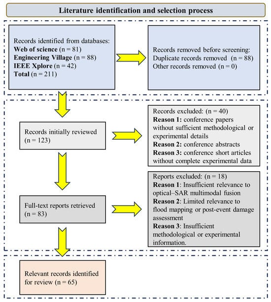
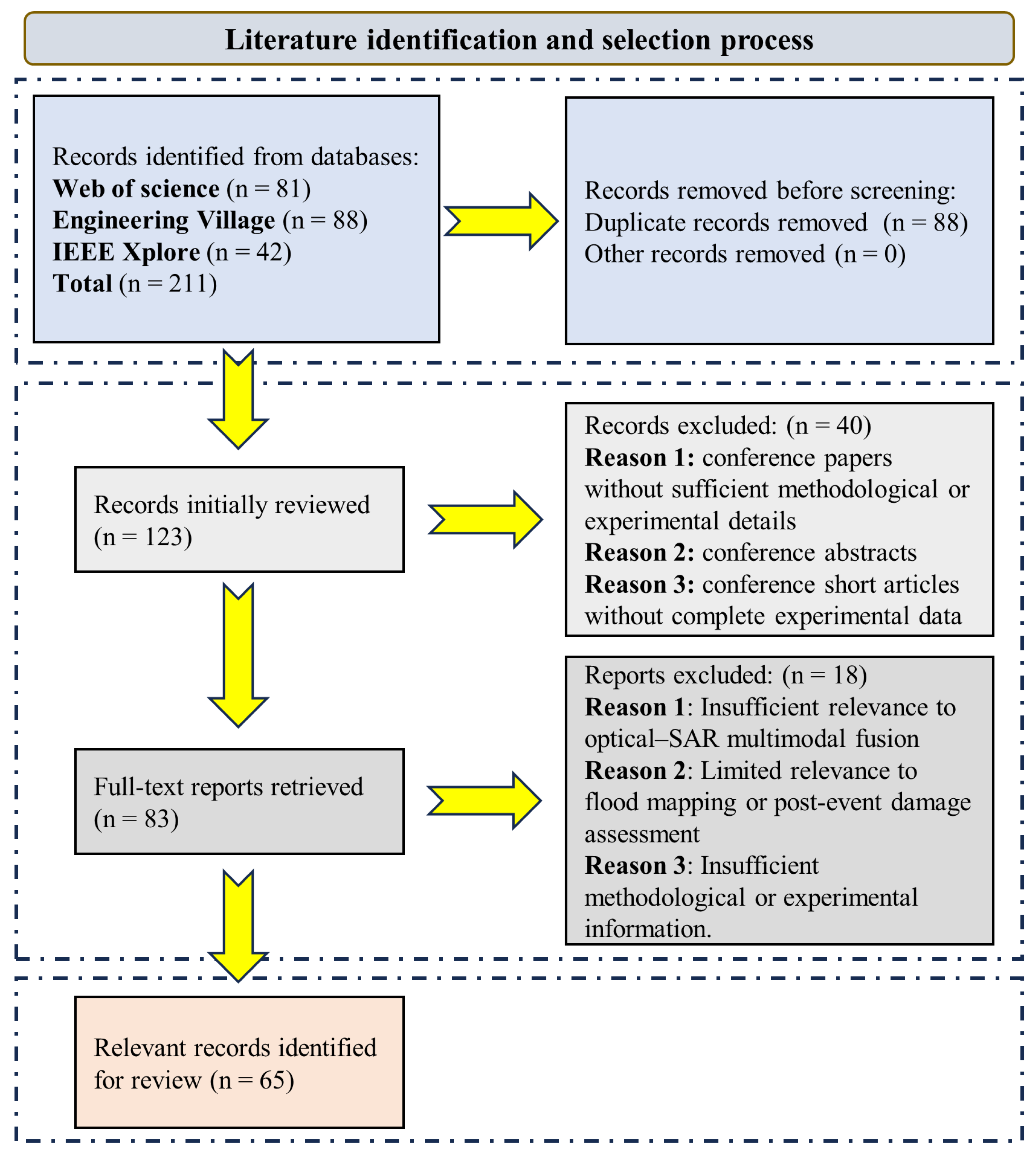
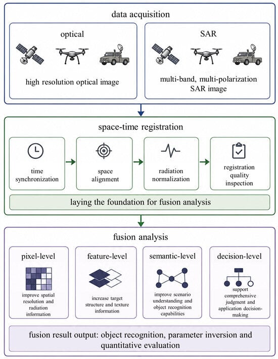
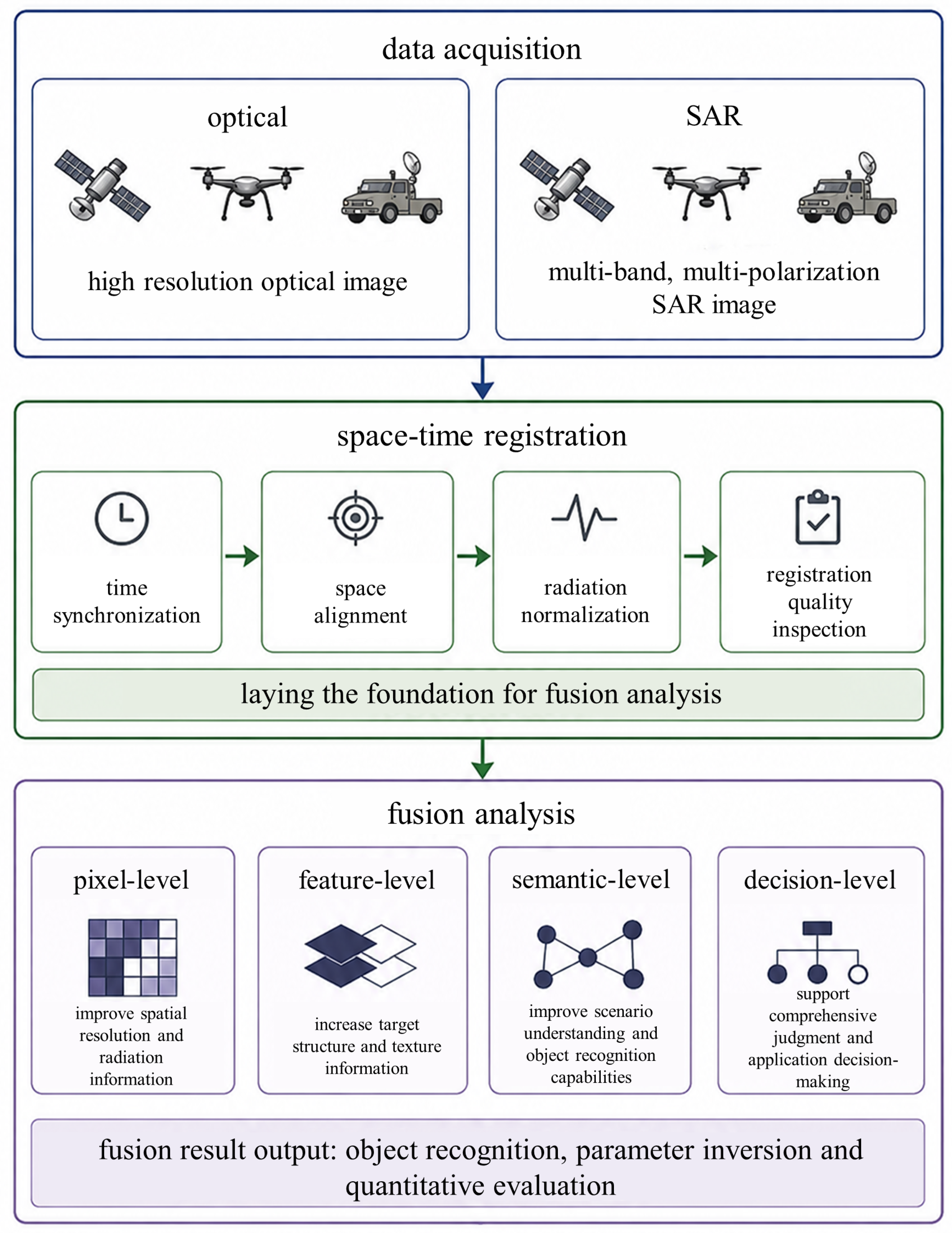
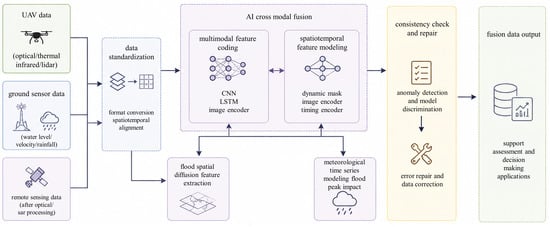
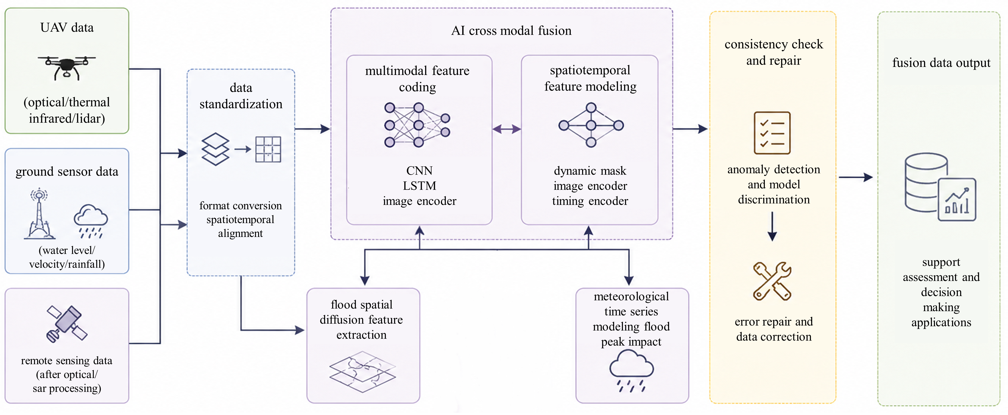
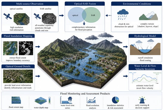
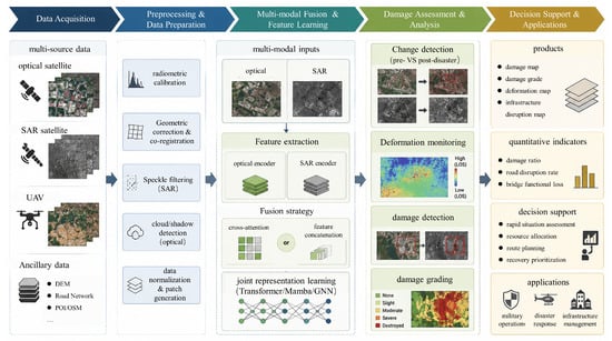
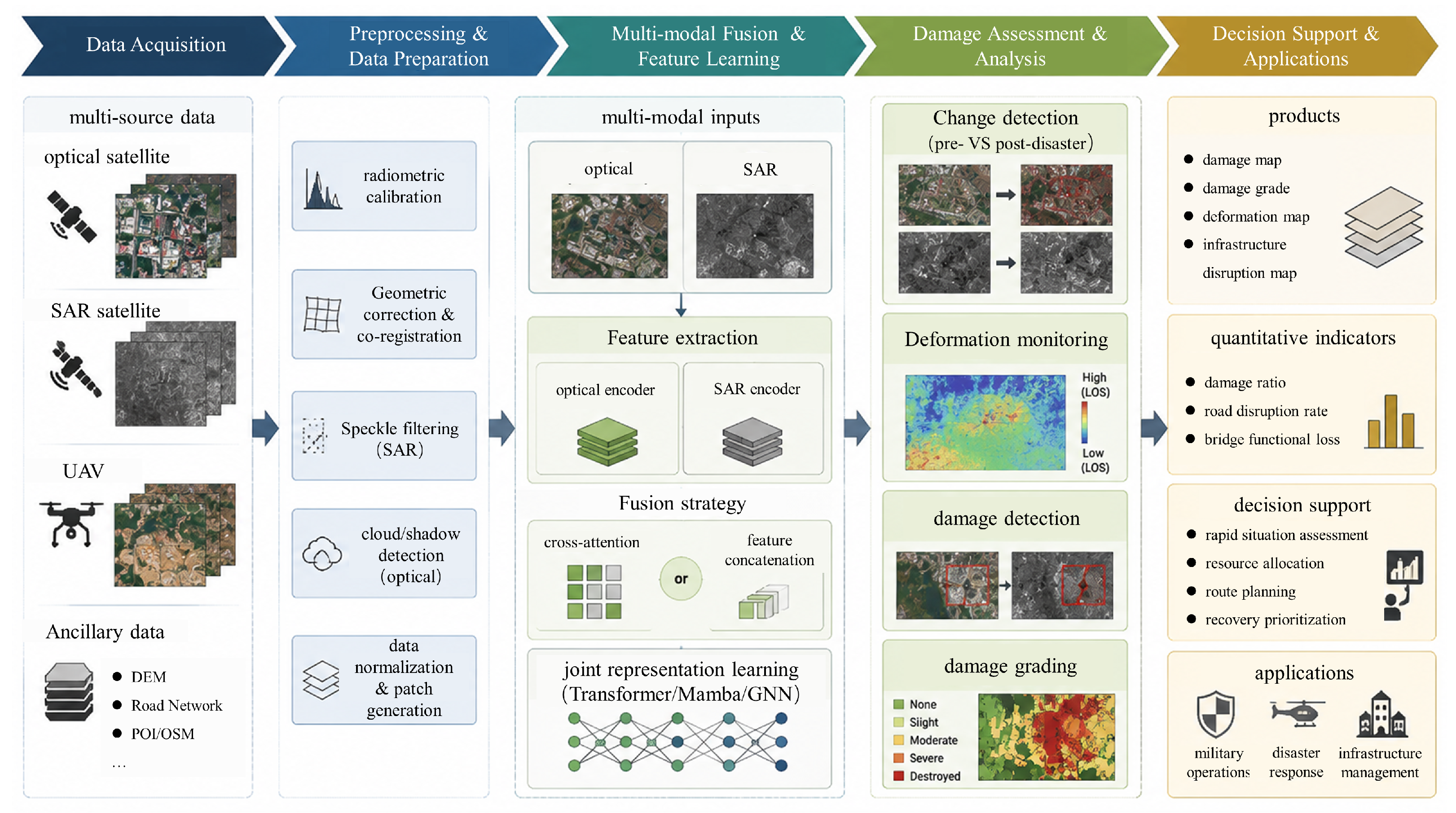

Disclaimer/Publisher’s Note: The statements, opinions and data contained in all publications are solely those of the individual author(s) and contributor(s) and not of MDPI and/or the editor(s). MDPI and/or the editor(s) disclaim responsibility for any injury to people or property resulting from any ideas, methods, instructions or products referred to in the content. |
© 2026 by the authors. Licensee MDPI, Basel, Switzerland. This article is an open access article distributed under the terms and conditions of the Creative Commons Attribution (CC BY) license.