


Abstract
The research objective is to constrain the genesis and evolution of medium–low temperature geothermal waters hosted in carbonate rocks within complex fault-controlled settings, which represent cost-effective geothermal resources yet remain poorly understood in terms of their hydrochemical behavior and recharge mechanisms. The methodology involves a comprehensive multi-isotopic and hydrogeochemical investigation of 17 geothermal water samples (13 hot springs and 4 wells) collected from southeastern Chongqing, southwestern China. Analytical techniques include ion chemistry, stable water isotopes (δDH2O, δ18OH2O), sulfate isotopes (δ34SSO4, δ18OSO4), and 87Sr/86Sr ratios, complemented by chemical geothermometry and principal component analysis. Field investigations and laboratory measurements were systematically conducted to ensure data robustness. The results, along with their implications, reveal several key trends. Isotopic altitude effects indicate that recharge occurs in mid-altitude mountains (elevations of 767–1267 m). Water–rock interactions are predominantly governed by halite and gypsum dissolution, with sulfate isotopes and 87Sr/86Sr ratios (ranging from 0.7090 to 0.7098) consistently confirming that Sr2+ and sulfate are largely derived from evaporite dissolution. Geothermometer calculations yield average reservoir temperatures of approximately 79.3 °C across the study area. Notably, during upwelling, mixing with shallow karst water results in an average cold-water fraction of 35% (up to 95% in the most diluted sample), substantially lowering its surface temperature. Based on these trends, a conceptual model is proposed wherein meteoric water infiltrates, is heated at depth, rises along fault systems, and undergoes continuous cold-water mixing during ascent. The significance of these findings lies in providing a refined understanding of geothermal water evolution in fold-thrust belts, thereby supporting the sustainable exploration and utilization of low-enthalpy geothermal resources in carbonate aquifers.
1. Introduction
The global transition toward sustainable energy systems requires the development of clean, renewable resources that minimize environmental impact [1,2,3]. Geothermal resources, which encompass heat, minerals, and geothermal water, constitute a substantial clean energy source with extensive distribution and utilization potential in China [4]. Specifically, during the energy transition, geothermal energy can serve as a feasible substitute for traditional fossil fuels, promoting energy conservation, emission reduction, and climate change mitigation. Leveraging geothermal resources to address carbon emissions, energy crises, and air quality concerns is beneficial to both human well-being and ecosystem quality [5,6,7,8]. On a global scale, carbonate-hosted geothermal systems are widely distributed in fold-thrust belts, foreland basins, and platform margins. These systems typically produce medium– to low–temperature geothermal waters and are increasingly utilized for district heating, balneology, and greenhouse agriculture. However, their exploitation is complicated by fault networks, karst heterogeneity, and cold-water mixing. Many international studies have emphasized that quantifying recharge, residence time, and water–rock interaction is essential for sustainable management, yet such knowledge remains scarce in many regions. Therefore, placing local investigations within this broader international context not only facilitates comparative analysis but also helps transfer methodological advances and conceptual models across different tectonic and climatic settings.
Carbonate rocks are globally distributed and serve as favorable reservoirs for geothermal water [9,10]. Owing to intense karstification and continuous meteoric recharge, carbonate-hosted geothermal systems often represent the most promising medium– to low–temperature resources in non-volcanic regions [5,9,10,11,12,13]. Consequently, understanding their geochemical characteristics, reservoir conditions, and formation mechanisms is crucial for rational exploitation and sustainable resource management [14].
In China, medium–low temperature geothermal systems are chiefly found in sedimentary basins. Chongqing Municipality, known as “the hot springs capital of China”, is a typical area rich in such resources. Here, geothermal water is primarily hosted in carbonate rocks [15,16]. Previous research in this region has mainly focused on the stratified thermal reservoirs hosted in Triassic carbonates in the main urban area, addressing aspects such as thermal storage conditions and water recharge [17,18,19]. However, the southeastern part of Chongqing, marked by Cambrian and Ordovician carbonate and evaporite formations, also has substantial geothermal water resources. Yet, the exploration and utilization of these resources are still at an elementary stage, with present practices limited to basic washing and bathing. Recent improvements in transportation infrastructure now bring new opportunities for geothermal development in southeastern Chongqing, emphasizing the pressing need for scientific research to direct sustainable utilization strategies. In line with national policy guidelines on ecological civilization development, it is essential to conduct research on the hot spring water resources of southeastern Chongqing.
Internationally, the combined use of multiple isotope tracers has become a standard approach. For water isotopes (δDH2O, δ18OH2O), a consistent trend observed across diverse terrains is that geothermal waters plot along or below the local meteoric water line, with shifts indicating high-temperature exchange or mixing; in carbonate systems, most data fall close to the meteoric line, allowing reliable recharge elevation estimates via altitude effects [20]. For sulfate isotopes (δ34S, δ18O), numerous studies have shown that dissolved sulfate is typically derived from evaporite dissolution or sulfide oxidation, and the dual isotopic signatures effectively discriminate between these endmembers [21,22,23,24]. For strontium isotopes (87Sr/86Sr), ratios are increasingly used to trace water–rock interaction and quantify mixing proportions, as they are conservative during mixing and sensitive to lithology. These international experiences provide a robust framework for the Chongqing area, where similar lithological and structural controls exist.
Several unresolved scientific questions persist. First, the recharge elevations and specific recharge areas for these geothermal waters remain unclear. Stable isotopes of water (δDH2O and δ18OH2O) can be used to address this [6,13,20,25,26,27,28,29]. Second, mixing between deep geothermal water and shallow cold water is a common phenomenon in carbonate aquifer systems, leading to dilution and temperature decrease in the geothermal waters [19,30]. Quantifying this mixing ratio is critical, and Sr isotopes combined with Sr2+ concentrations provide a powerful tool [6,31,32]. Third, the applicability of existing silica geothermometers is restricted in medium–low temperature geothermal systems [15,18], and they may yield unreliable results when applied independently [33,34]. To improve the accuracy and reliability of our reservoir temperature assessments, we integrated silica geothermometer measurements with calculations from the theoretical chemical geothermometer (FixAl method) in the SOLVEQ program [35], which models mineral equilibrium and is better suited for complex low–to–medium temperature systems influenced by fluid mixing or degassing processes.
To attain a more accurate assessment of the geothermal system’s potential in the study area, this research adopted a comprehensive methodology that integrated hydrochemistry, multiple stable isotopes, and theoretical geothermometry. Building upon previous work [15,18,19], this study integrated geochemical, isotopic, and topographic data to systematically investigate the hydrogeochemical processes, recharge characteristics, reservoir temperatures, and mixing dynamics of geothermal waters in southeastern Chongqing. The specific objectives were to: (1) identify the sources of major ions through statistical and isotopic analysis; (2) determine meteoric recharge origin qualitatively using δDH2O and δ18OH2O, and calculate the recharge elevations based on δDH2O; (3) estimate thermal reservoir temperatures using the FixAl geothermometer; and (4) quantify the mixing ratios of cold water in geothermal waters via 87Sr/86Sr and Sr2+ concentrations. This comprehensive approach aims to elucidate the genesis of geothermal waters and provide a scientific foundation for their sustainable development and utilization.
Notably, while the 17 geothermal water samples and their basic hydrochemical and sulfate-isotope data were reported in a prior regional study [19], the present work generates substantial new data and analyses, including 87Sr/86Sr ratios, Sr2+ concentrations, FixAl theoretical geothermometry, PCA, and a Sr-isotope-based binary mixing model. These new data enable a more comprehensive and quantitative understanding of the geothermal system than was previously possible.
2. Materials and Methods
2.1. Study Area
2.1.1. Location and Geographical Settings
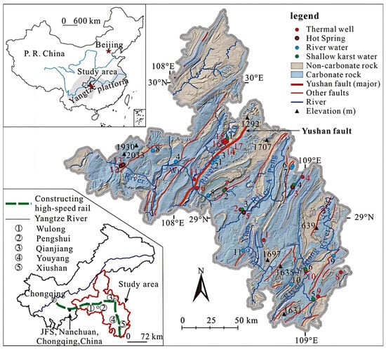
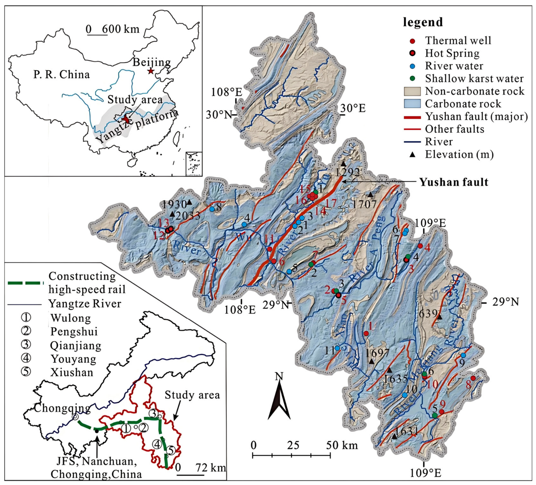
To reveal the genesis of geothermal water in southwestern China, this study focuses on an area located in the southeastern part of Chongqing (N 28°9′–30°0′, E 106°54′–109°18′) and covers an area of 19,800 km2 (Figure 1). This area accounts for 24% of the total area of Chongqing. The topography of this region is dominated by mountainous landforms, with relative altitude differences ranging from 500 to 1000 m [19].
Figure 1.
Location and geological setting of Southeast Chongqing and distribution of sampling sites, showing parallel NNE-NE trending faults. Adapted with permission from Ref. [19]. Copyright 2019 Elsevier.
The region features a typical subtropical humid monsoon climate, with annual average temperatures of 15 to 18 °C and annual average precipitation of approximately 1000 mm [36]. Rivers in the northwestern part of the study area, such as the Yu River and Zhufo River, flow into the Wu River basin, where they recharge local aquifers. In contrast, the rivers in the southeastern region, including the Xisha River, Meijiang River, and Apeng River, are part of the Yuan River basin.
2.1.2. Geological Setting
The study area is located in the Upper Yangtze Block [37] and forms part of the Southeast Chongqing Depression Fold Belt, bounded by the Qiyueshan basement fault to the northwest. The study area experienced three stages of tectono-sedimentary evolution and was subjected to intense folding, thrusting, and extensional deformation. Well-developed NNE-NE-trending folds and normal faults along anticlinal axes characterize the structural framework, and these faults serve as important conduits for the ascent of deep geothermal fluids.
According to the Geological Map and Specification of Chongqing (a scale of 1:500,000), Paleozoic strata are exposed at the surface of the study area, with Mesozoic strata underlying them. Cretaceous strata and Quaternary strata are absent across the study area. The Cambrian–Ordovician carbonate rocks and Silurian clastic rocks are the most stratigraphically significant units for the geothermal system, serving as the reservoir and caprock, respectively.
Three types of aquifers are identified within the study area, namely pore aquifer, karst aquifer, and fracture aquifer. The distribution areas of these three aquifer types are 72 km2 (0.4%), 12,852 km2 (64.9%), and 3244 km2 (16.4%), respectively [38]. Among them, the karst aquifer is the dominant type of aquifer in the study area, characterized by well-developed karst conduits and underground rivers. In total, these three categories account for 81.7% of the study area. The remaining 3631 km2 (18.3%) is composed of mudstone and shale beds, which act as a relatively continuous aquitard that separates the Upper Paleozoic and Lower Paleozoic carbonate karst aquifers, with a small amount of fissure water in clastic rocks occurring in the shallow section. However, locally developed deep-seated faults may provide cross-formational hydraulic connectivity.
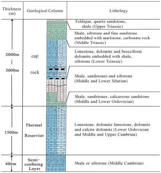
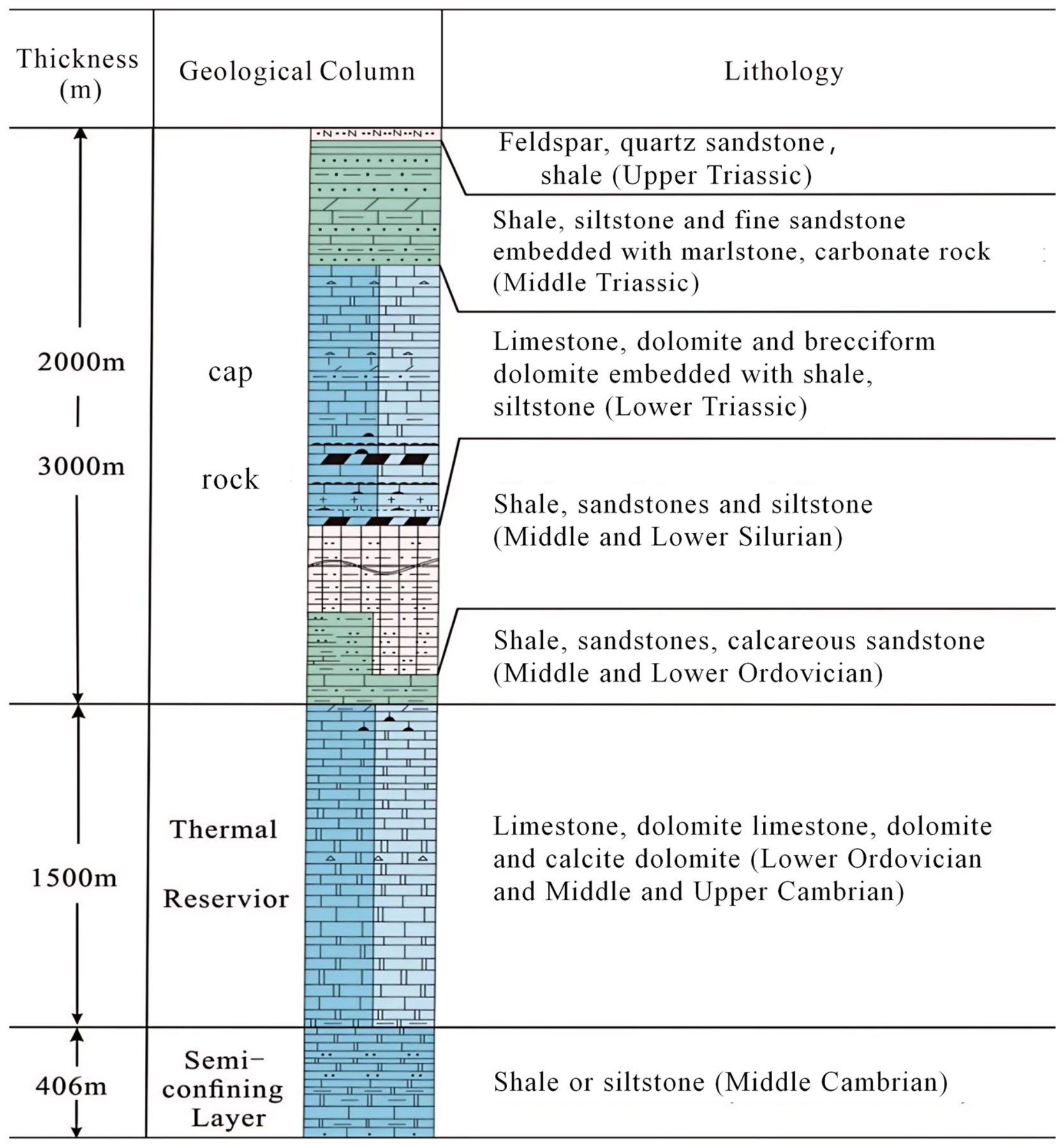
No direct terrestrial heat-flow measurements have been published for the study area. Nevertheless, the Sichuan Basin has an average heat flow of 53.7 ± 8.7 mW/m2, and the Fenghuang (Hunan) station records a value of 36.5 mW/m2 (China Heat Flow Database, http://chfdb.xyz/ (accessed on 20 August 2026)). These values are lower than the continental average of China (60.4 ± 12.3 mW/m2) [39], indicating a relatively low geothermal background consistent with the tectonically stable Upper Yangtze Craton. The thermal reservoir characteristics in the study area are summarized as follows (Figure 2): The cap rock, acting as a thermal and hydraulic barrier, is composed of Middle and Upper Ordovician, Middle and Lower Silurian, Permian, and Triassic strata that consist of shale, silty shale, siltstone, and sandstone with a thickness ranging from 2000 to 3000 m. The thermal reservoir is primarily constituted of Middle and Upper Cambrian and Lower Ordovician dolomite and limestone strata with a thickness of approximately 1500 m, which incorporate salt and gypsum layers. The semi-confining layer beneath the thermal reservoir consists of Middle Cambrian shale or siltstone strata with a thickness of 406 m.
Figure 2.
Stratigraphic column of the geothermal system in southeastern Chongqing, showing the cap rock, the thermal reservoir, and the semi-confining layer. The column is oriented with the ground surface at the top and depth increasing downward.
2.2. Field Sampling
A total of 17 geothermal water samples were collected from the study area for the analysis of major element concentrations, δDH2O, δ18OH2O, 87Sr/86Sr, δ34SSO4, and δ18OSO4. During the sampling campaign, the pre-cleaned plastic containers were rinsed three times with the water samples, which had been filtered through 0.45-μm membranes. Water samples for cation analysis were stored in 500 mL plastic containers and acidified to pH < 2 with ultrapure HNO3 immediately after sampling, in order to prevent cation adsorption onto the container walls. In contrast, the anion samples were stored in separate containers without acidification and kept at 4 °C in the dark until laboratory analysis; the concentration was determined in the field immediately after sampling, so that no preservation was required.
Samples for the analysis of δDH2O and δ18OH2O were stored in 10 mL centrifuge tubes. Samples for strontium isotope (87Sr/86Sr) and sulfur isotope (δ34SSO4 and δ18OSO4) were stored in 1.5 L and 4.5 L plastic containers, respectively. All the samples were transported to the laboratory and stored at a constant temperature (4 °C) prior to pretreatment.
The water samples comprised 13 hot springs (nos. 1, 2, 4, 6–11, 14–17) and four drilled wells (nos. 3, 5, 12, 13). The samples were collected in November 2017, December 2017, and July 2018. To facilitate a comparative analysis of the geothermal system, six river water samples were collected from four different rivers during the same field campaigns for hydrogen and oxygen isotope analyses. It should be noted that field parameters (temperature, pH), major ion concentrations, δDH2O, δ18OH2O, δ34SSO4, and δ18OSO4 for these samples were reported in [19]. The 87Sr/86Sr ratios and Sr2+ concentrations presented in this study were newly measured for the same sample set. In addition, the shallow karst water data (n = 11) utilized in this study were not collected by the authors, but were directly compiled from the previously published dataset of Pu et al. (2013) [40]. All original samples collected in this study and the compiled literature data are clearly distinguished and presented in Tables S1 and S2.
2.3. Measurement
The water temperature and pH were measured in the field by a WTW Multi3630 probe (WTW, Weilheim, Germany), with an accuracy of 0.1 °C and 0.01 pH units. The pH probe was calibrated with pH values of 7.00 and 4.01. Temperature was measured using the same probe. The concentration was determined in the field by titration with an alkalinity kit (Merck, Darmstadt, Germany), with an accuracy of 0.61 mg/L.
Major anions were determined using a UV-Vis Spectrophotometer T6, while the concentration of major cations was analyzed via a 5110 Inductively Coupled Plasma Optical Emission Spectrometer (ICP-OES, Perkin Elmer, Waltham, MA, USA) with an accuracy of 0.01 mg/L. These measurements were conducted at the Geotechnical Engineering Testing Center of Chongqing, China.
Samples for δDH2O and δ18OH2O analysis were filtered through 0.45-μm membranes and stored in 10 mL screw-cap centrifuge tubes without headspace to minimize evaporation. Two analytical facilities were used depending on the sample batch: (1) The samples (nos. 1, 2, 7, 10, and 16) for δDH2O and δ18OH2O analysis were measured by the Thermo Delta-Plus Isotope Ratio Mass Spectrometer in the Beta Analytic Inc., Miami, FL, USA. (2) The samples (nos. 3, 4, 6, 8, 9, and 13) were determined by a Liquid Water Isotope Analyzer (Los Gatos Research Inc., Mountain View, CA, USA) in the Geochemistry and Isotope Laboratory, School of Geographical Sciences, Southwest University, Chongqing, China.
The samples for analysis of δ34SSO4 and δ18OSO4 values were extracted by the BaSO4 precipitation method after degassing (CO2) with HCl (GR) (25 mL/1.5 L); then, the extracted BaSO4 precipitate was dried and mixed with excess V2O5 in a tin cup. The sulfate isotopes were measured with a DELTAV Plus isotope-ratio mass spectrometer (IRMS) with an accuracy of 0.296‰. The δ34SSO4 and δ18OSO4 values are reported relative to the Vienna Canyon Diablo Troilite standard (VCDT) and the Vienna Standard Mean Ocean Water (VSMOW), respectively. The 87Sr/86Sr ratios were measured using a multi-collector inductively coupled plasma mass spectrometer (Nu Plasma II, Nu Instruments, Wrexham, UK). Prior to analysis, water samples were acidified with ultra-pure HNO3. Both sulfate isotopic values and the 87Sr/86Sr ratios were measured at the State Key Laboratory of Biogeology and Environmental Geology in Wuhan, China.
2.4. Quality Control and Quality Assurance
Quality control and quality assurance (QC/QA) were maintained throughout the sampling and analytical procedures. Prior to sampling, all sampling bottles were soaked in a 10% HNO3 solution and thoroughly rinsed with deionized water. During sampling, the pre-cleaned containers were rinsed three times with the water sample before collecting them. All samples were carefully sealed with airtight caps, stored at 4 °C in the dark, and transported to the laboratory within one week. Cation aliquots were acidified with ultrapure HNO3 to pH < 2 immediately after sampling, whereas anion and isotope aliquots were kept unacidified to avoid matrix interference.
The analytical accuracies were 0.01 mg/L for major cations by ICP-OES and major anions by UV-Vis spectrophotometry, ±2‰ for δDH2O and ±0.3‰ for δ18OH2O (Beta Analytic Inc., Miami, FL, USA), and ±0.3‰ for δDH2O and ±0.1‰ for δ18OH2O (Los Gatos Research Inc., Mountain View, CA, USA). The analytical precision for δ34SSO4 and δ18OSO4 was ±0.296‰, and the external precision for 87Sr/86Sr was ±20 ppm (±0.00002). The ionic charge imbalance between the sum of major cations and anions was within ±5% for all samples, confirming the reliability of the hydrochemical data. Some hydrochemical and stable isotope data (major ions, δD and δ18O for selected samples) have been reported previously [19], while the strontium isotope (87Sr/86Sr) and sulfate isotope (δ34SSO4, δ18OSO4) data are newly generated in this study. All the data are presented in Table S1.
2.5. Data Processing
2.5.1. Recharge Altitude
Due to the lack of local rainwater data (δDH2O and δ18OH2O) in the study area, the recharge elevations were estimated using the commonly adopted empirical equations in China [6,26]:
where ALT is the recharge elevation (m). The δDH2O value in the equations refers to the deuterium isotope composition of the geothermal water in the study area.
2.5.2. Mixing Model Based on Sr2+ and 87Sr/86Sr
A binary mixing model between two end-members using Sr2+ and 87Sr/86Sr was employed to validate the mixing process [6,14,15,16,18,19,30,31,32]:
where, [87Sr/86Sr]m is the measured isotopic ratio; [Sr2+]m is the measured Sr2+ concentration in the mixture; and represent the isotopic ratios of the first and second end-members, respectively; [Sr2+]1 and [Sr2+]2 are the Sr2+ concentrations of the two end-members, respectively; and f is the fraction of end-member 1.
2.5.3. Theoretical Chemical Geothermometry
The principle of chemical geothermometry states that the saturation index (SI) of relevant minerals will reach equilibrium (SI = 0) at the in-situ temperature of the geothermal reservoir [41]. The SOLVEQ program (Reed, University of Oregon, USA) was used to calculate SI values over a temperature range of 25–200 °C at 5 °C increments, using the standard thermodynamic database embedded in the program. Major ions (Na+, K+, Ca2+, Mg2+, Cl−, , , SiO2) and Al were included as input species. The equilibrium temperature was identified as the temperature at which log(Q/K) values of key mineral phases (including quartz, calcite, dolomite, gypsum, anhydrite, and halite) converged toward zero. To correct for CO2 degassing during sampling, equimolar amounts (0.05 mol/L) of H+ and were added to the original input file, following the degassing correction (CO2) procedure. Additionally, the FixAl method was employed to construct precise log(Q/K)–temperature relationships and thereby reconstruct the equilibrium temperature. The method is applicable to thermal systems with temperatures ranging from 80 to 180 °C and pH values of 5.5–9 [35], which aligns with the characteristics of the study area. Dilution by shallow cold water was not corrected within the SOLVEQ simulations; instead, its effect was evaluated separately using the Sr-isotope mixing model.
2.5.4. Ground Temperature Gradient and Circulation Depth
The circulation depth was estimated using the geothermal gradient and reservoir temperature, as described by Equations (3) and (4) [37]:
where G represents the ground temperature gradient (°C/km); Tb denotes the bottom temperature of the geothermal well (°C); DW is the depth of the geothermal well (km); T0 is the local annual average air temperature (°C); Z represents the circulation depth (km); TZ denotes the geothermal reservoir temperature (°C); and Z0 indicates the thickness of the constant temperature zone (km) [18].
The parameters were determined as follows: The geothermal gradient (G) was derived from the average of three drilled wells (nos. 3, 5, and 12). Well no. 13 was excluded from this calculation because complete borehole temperature logs were not available for this well. This gradient was slightly lower than the average crustal value of 30 °C/km and fell within the range reported for the Sichuan Basin [42]. The surface temperature (T0) is 16.6 °C, and Z0 corresponds to the data from the adjacent main urban area of Chongqing. As reported by [18], Z0 is approximately 0.03 km. TZ was adopted from the FixAl geothermometer results.
The conceptual hydrogeological model was developed by integrating multiple independent lines of evidence: (1) recharge source and elevation derived from δDH2O and δ18OH2O; (2) reservoir temperature estimated from the FixAl geothermometer, cross-checked against quartz and modified SiO2 geothermometers; (3) circulation depth calculated using the measured geothermal gradient of 21.2 °C/km; (4) water–rock interaction processes inferred from major ions, 87Sr/86Sr, and δ34SSO4; and (5) structural controls interpreted from field mapping and the regional fault framework. The resulting model is presented in the Discussion.
3. Results
3.1. Hydrochemical Characterization
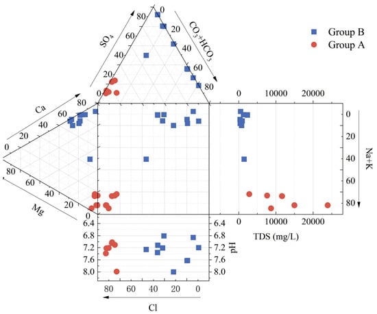
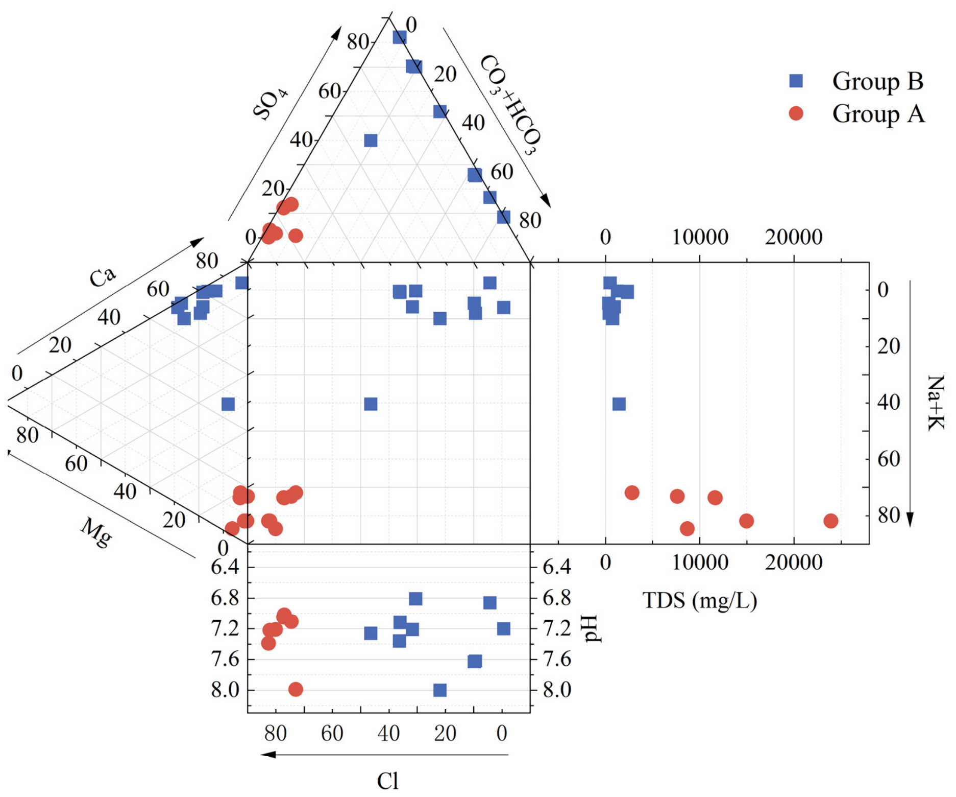
The measured physicochemical parameters of the samples are summarized in Table S1. The pH values of the water samples range from 6.81 to 8.00, indicating a near-neutral to weakly alkaline nature. Based on the distribution of sampling sites relative to the Yushan fault, the samples were divided into Group A (west of the fault, nos. 11–17) and Group B (east of the fault, nos. 1–10).
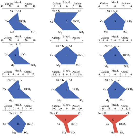
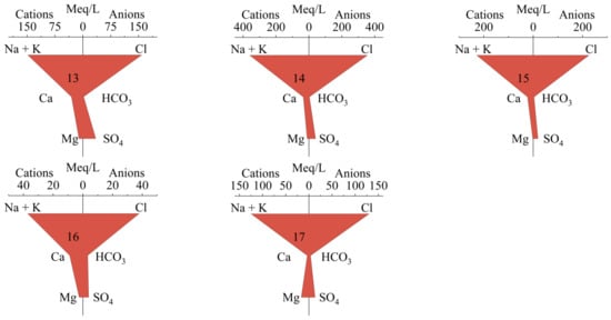
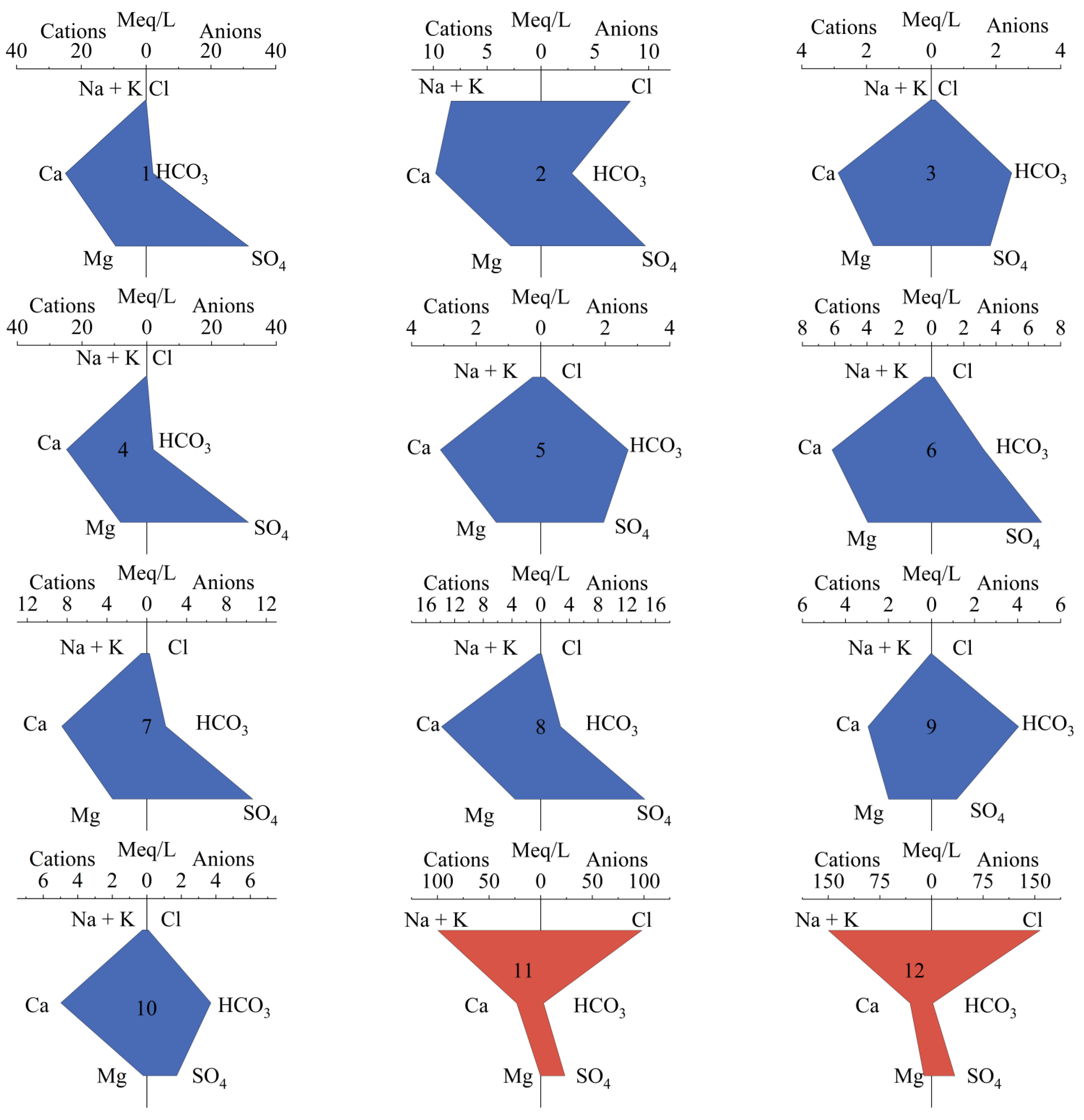
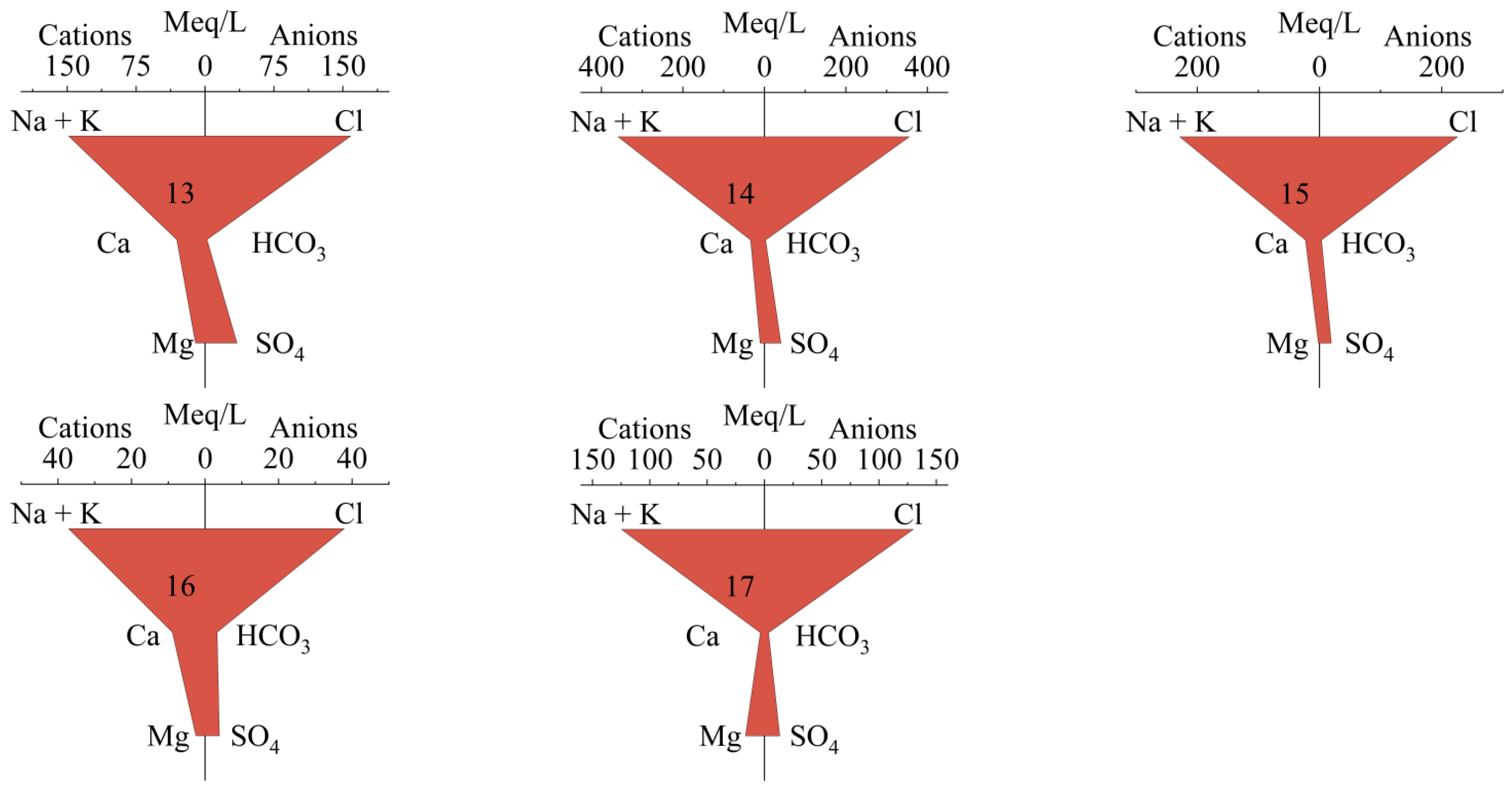
As illustrated in the Durov diagram (Figure 3) and Stiff diagrams (Figure 4), the hydrochemical facies exhibit a striking spatial dichotomy. Group A is characterized by high TDS (avg. 11,612 mg/L) and Cl-Na type water, with significantly elevated concentrations of Na+ (avg. 3721 mg/L) and Cl− (avg. 5897 mg/L). Conversely, Group B presents distinctly different hydrochemical facies, predominantly of the HCO3-Ca and SO4-Ca types, with lower TDS (avg. 1059 mg/L) and relatively higher enrichments in Ca2+ (avg. 204.6 mg/L) and (avg. 535.6 mg/L).
Figure 3.
Durov diagram comparing hydrochemical facies and characteristics of two groups of geothermal water samples (n = 17) from southeastern Chongqing, China. The cation and anion triangles show the relative proportions of major ions (Ca2+, Mg2+, Na+, K+, , , Cl−) as equivalent percentages (% meq/L) on a 0–100 scale. In the central square plot, the Na++K+ and Cl− axes also represent equivalent percentages, while TDS is presented in mg/L and pH is dimensionless.
Figure 4.
Stiff diagram showing the major ion composition of 17 geothermal water samples from southeastern Chongqing, China. Cations (Ca2+, Mg2+, Na+, K+) and anions (, , Cl−) are plotted in meq/L. Numbers correspond to sample IDs. The chemical types of geothermal waters in the study area are diverse, with SO4-Ca·Mg and HCO3·SO4-Ca·Mg as the main types, and HCO3·SO4-Ca, SO4·Cl-Ca·Na, and Cl-Na·K as secondary types. Blue and red polygons represent Group B and Group A samples, respectively.
3.2. Isotopic Compositions
The isotopic compositions of the originally collected geothermal water and river water samples (six samples from four rivers), alongside the compiled shallow karst water data from Pu et al. (2013) [40], are listed in Table S2.
All geothermal water samples plot between the Global Meteoric Water Line (GMWL) and the local Chongqing Meteoric Water Line. Using Equation (1), in addition to Sample No. 16, the recharge elevations are calculated to range from 767 to 1267 m a.s.l. (Table 1). The stable isotope compositions (δDH2O and δ18OH2O) of the geothermal waters range from −65.0‰ to −41.8‰ and −9.7‰ to −7.0‰, respectively. Notably, Sample No. 16 exhibits distinctly enriched isotopic signatures. Excluding Sample No. 16, the average δDH2O and δ18OH2O values of the remaining geothermal waters are −59.8‰ and −9.0‰, respectively, which are significantly more depleted than the average values of the four surface river waters.
Table 1.
Estimated groundwater recharge elevation (m) for southeastern Chongqing.
The geothermal waters have δ34SSO4 values varying from 18.5‰ to 37.4‰ (avg. 30.1‰), and δ18OSO4 varying from 6.8‰ to 16.2‰ (avg. 12.8‰), which are consistently higher than those of river water and shallow karst water. The 87Sr/86Sr ratios of the geothermal water samples range from 0.7090 to 0.7098 (avg. 0.7093), which are lower than those of river water and comparable to those of shallow karst water (Table S2).
3.3. Multivariate Statistical Analysis
The Pearson’s correlation coefficients of the physicochemical indices are presented in Table 2. In Group A, TDS shows strong positive correlations with Na+ and Cl−. In Group B, TDS is strongly correlated with Ca2+ and [40,43].
Table 2.
Correlation analysis of physicochemical indices of geothermal water in southeastern Chongqing.
PCA is used to identify statistical correlations (covariance relationships) between ions, rather than causal mechanisms. Principal component analysis (PCA) extracted three principal components with eigenvalues > 1 (Table 3). In Group A, PC1 accounts for 42.9% of the variance, with high positive loadings for Na+, K+, Cl−, and TDS. PC2 explains 40.2% of the variance and is dominated by Sr2+, Ca2+, and . In Group B, PC1 explains 45.6% of the variance, exhibiting high loadings for , Ca2+, Mg2+, and TDS. PC2 is characterized by high loadings of Na+, K+, and Cl−.
Table 3.
PCA results of hydrochemical indices of geothermal water in the study area. The chemical composition of the hot springs in the study area is mainly regulated by the two processes of salt dissolution and sulfate mineral dissolution.
3.4. Reservoir Temperature and Circulation Depth
The FixAl simulation reveals that the reservoir temperatures in the study area range between 50 and 100 °C (Figure 5). The mean reservoir temperatures of Group B and Group A are 78.5 °C and 80.4 °C, respectively (Table 4).
Figure 5.
Variation of temperature with Log (Q/K) values corrected for CO2 degassing and FixAl for geothermal water samples within Southeast Chongqing, China.
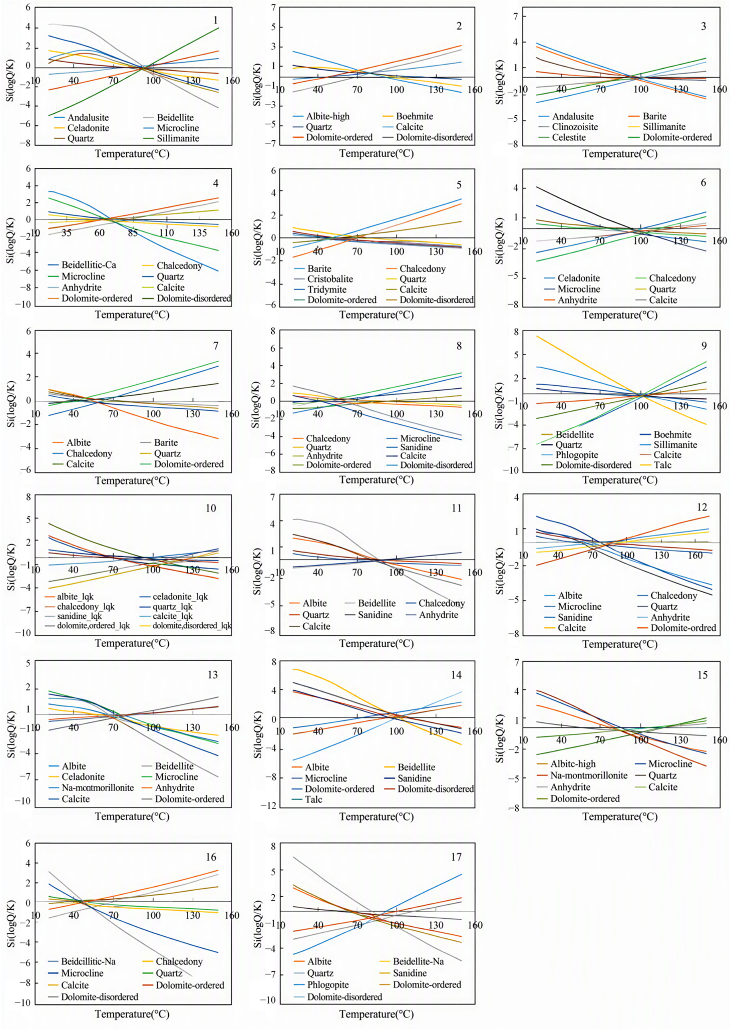
Table 4.
Estimation of thermal reservoir temperature and circulation depth in southeastern Chongqing using different geothermometers.
The geothermal gradient of wells 3, 5, and 12 was calculated via Equation (3), with an average of 21.2 °C/km (Table 5).
Table 5.
Borehole depth (km), bottom-hole temperature (°C), and geothermal gradient (°C/km) of geothermal wells in southeastern Chongqing.
The circulation depth is estimated using Equation (4). The circulation depth in Group B varied between 1.61 and 3.96 km, with an average of 2.95 km. For Group A, sample No. 16 was excluded because of its high cold-water mixing ratio (82%); the remaining Group A samples yielded circulation depths of 2.88–3.96 km, with an average of 3.28 km (Table 4).
3.5. Mixing Ratios
Based on the binary mixing model utilizing Sr2+ and 87Sr/86Sr, the calculated mixing ratios of the geothermal water are shown in Table 6. The cold-water mixing fractions for samples nos. 10, 7, and 4 are 3%, 4%, and 10%, respectively. In contrast, the cold-water fractions for samples nos. 3 and 16 reach 95% and 82%. The average cold-water mixing ratio is 35%, indicating that the geothermal waters are diluted by 35% cold water, with an average thermal water fraction of 65%.
Table 6.
Mixing fractions of the geothermal water within Southeast Chongqing.
4. Discussion
4.1. Hydrogeochemical Evolution and Water–Rock Interactions
The correlation between TDS and each index can reflect the origin of groundwater [44]. The distinct hydrochemical facies on either side of the Yushan fault reveal contrasting water–rock interaction pathways. The strong positive correlations between TDS and specific ions (e.g., Cl− and Na+ in Group A; Ca2+ and in Group B) indicate that the salinity and major ion composition in each group were dominantly controlled by the dissolution of distinct mineral phases.
In Group A, the high loadings of Na+ and Cl− in PC1 indicate that halite dissolution is the predominant geochemical process controlling the salinity of the Cl-Na type water. In Group B, the strong association of Ca2+, Mg2+, and in PC1 points to gypsum and epsomite dissolution as the dominant water–rock interaction process.
Furthermore, the negative correlation observed between and , and Ca2+ in the geothermal water can be attributed to the common ion effect [45]. The dissolution of anhydrite/gypsum increases the concentrations of Ca2+ and , driving calcite precipitation (Equation (5)) and the removal of from solution. This process subsequently promotes further dissolution of dolomite, a phenomenon consistent with the dedolomitization observed in the study area.
where is consumed and is released, which directly leads to the negative correlation between and observed in geothermal water. (n = 2 for gypsum and n = 0 for anhydrite). This distinction highlights the different dissolution reactions that are characteristic of these two minerals.
4.2. Sources of the Major Ions Revealed by Isotopic Compositions
The isotopic compositions provide robust constraints on the sources of dissolved constituents. The isotopic depletion of δDH2O and δ18OH2O in the geothermal waters compared with river water suggests that the recharge may preserve paleoclimatic signals from a colder and more humid period or originate from higher altitudes. As shown in Section 3.2, the δDH2O and δ18OH2O values of the geothermal water were plotted against the Global Meteoric Water Line (GMWL) and the Chongqing Meteoric Water Line (CLMWL). All samples fall between the two lines, indicating that the geothermal water originates from meteoric recharge without significant oxygen isotope exchange with the host rocks. The calculated recharge elevation (767–1267 m) implies that the recharge areas are the mid-altitude carbonate mountain regions close to the geothermal water outcrops. However, the calculated recharge elevations represent a preliminary estimation under modern climatic assumptions, and further verification with comprehensive local precipitation monitoring is warranted.
Sulfate () in groundwater can arise from multiple sources: (1) sulfide oxidation, (2) dissolution of gypsum/anhydrite, (3) precipitation, and (4) human activities [40,46,47,48]. In order to identify the source of elevated sulfate in geothermal waters, this study employed δ34SSO4 and δ18OSO4 to distinguish between sulfide oxidation, evaporite dissolution, and atmospheric input, because δ34SSO4 and δ18OSO4 isotopic signatures vary with sulfate source [49,50,51].
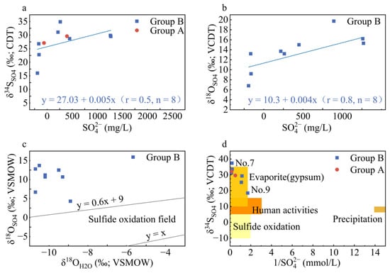
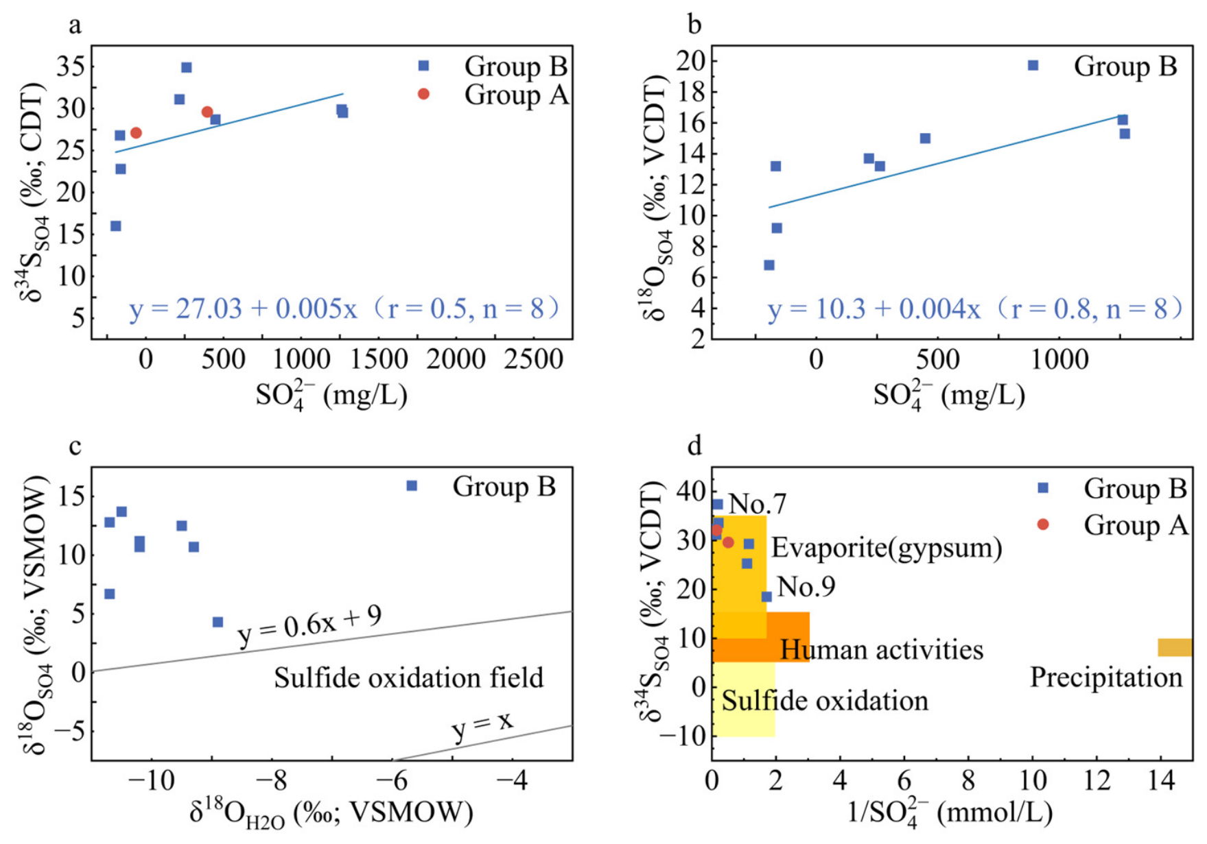
The δ34SSO4 values of geothermal water were significantly higher than those of shallow karst water and river water, indicating that sulfate in geothermal water is not predominantly derived from atmospheric or soil sources. Based on the analysis of the relationship between δ34SSO4 values and concentrations, sulfates derived from the oxidation of sulfide minerals (e.g., pyrite) typically exhibit markedly negative δ34SSO4 values alongside elevated concentrations [52]. In this study, although geothermal waters in the research area had high sulfate concentrations, they exhibited positive δ34SSO4 values and deviated from the theoretical field for sulfide oxidation (Figure 6a,c). The isotopic signatures effectively ruled out sulfide oxidation as a significant source of sulfate.
Figure 6.
Scatter plots showing sulfur isotope composition vs. sulfate concentration for identifying sulfur sources in aquatic systems in southeastern Chongqing, China. (a) δ34SSO4 (‰, VCDT) vs. (mmol/L); (b) δ18OSO4 (‰, VSMOW) vs. (mmol/L); (c) δ18OSO4 (‰, VSMOW) vs. δ34SSO4 (‰, VCDT); (d) δ34SSO4 (‰, VCDT) vs. 1/ (mmol/L). The in geothermal water in the study area mainly comes from the dissolution of evaporite salt minerals (gypsum/anhydrite).
The δ34SSO4 (18.5‰ to 37.4‰) and δ18OSO4 (6.8‰ to 16.2‰) values of the geothermal water overlap with the isotopic range of marine evaporites (10‰ to 35‰ and 7‰ to 20‰, respectively) (Figure 6a,b) [53,54,55], indicating that sulfate in the geothermal water predominantly originates from the dissolution of gypsum and anhydrite. The slightly lower δ18OSO4 value in sample no. 9 suggests possible mixing with shallow cold water, consistent with previous observations in the main urban area of Chongqing [51]. Furthermore, the relatively stable trends in concentrations and the isotopic ratios (Figure 6a,b), along with the significant correlation between high δ34SSO4 values (mostly above 25‰) and low 1/ values (Figure 6d), align with the 34S-enrichment fractionation and high solubility characteristic of evaporites. This further implies that sulfate mainly originates from the dissolution of evaporites (e.g., gypsum).
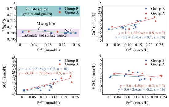
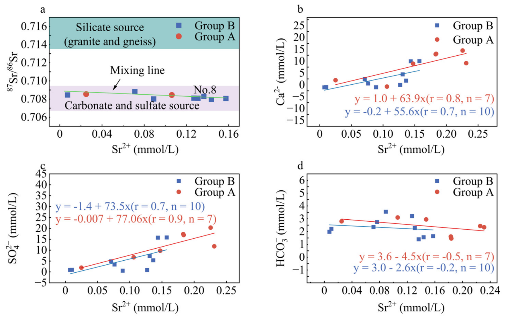
Strontium isotopes further corroborate this conclusion. Variations in 87Sr/86Sr ratios reflect mixing of Sr2+ derived from distinct lithological sources [56,57]. The 87Sr/86Sr ratio of geothermal water in the study area (0.7090 to 0.7098) falls within the range of carbonate and sulfate dissolution sources [32,58,59,60,61,62,63] (Figure 7a). A positive correlation between Sr2+ and Ca2+, as well as concentrations (Figure 7b,c), suggests that the dissolution of anhydrite/gypsum contributed to the release of Sr2+. If Sr2+ were predominantly sourced from carbonate mineral dissolution (CaCO3/SrCO3), a strong positive correlation between Sr2+ and concentrations would be theoretically expected, as carbonate dissolution proceeds via the reaction:
Figure 7.
Scatter plots showing strontium isotope and ion relationships for hydrogeochemical source identification in southeastern Chongqing, China. (a) 87Sr/86Sr vs. Sr2+ (mmol/L); (b) Sr2+ vs. Ca2+ (mmol/L); (c) Sr2+ vs. (mmol/L); (d) Sr2+ vs. (mmol/L). The primary source of Sr2+ is the dissolution of sulfate minerals (anhydrite/gypsum).
Nevertheless, the observed significant negative correlation between Sr2+ and (Figure 7d) deviates from the theoretical expectation. Specifically, in the context of the common ion effect, extensive sulfate dissolution increases the aqueous activities of Ca2+, causing a significant left-shift in the carbonate dissolution equilibrium (CaCO3 ⇌ Ca2+ + ). This inhibits carbonate dissolution and subsequently reduces the production of , resulting in the observed inverse relationship between the concentrations of Sr2+ and . Nonetheless, as the study area is characterized by a carbonate–evaporite aquifer system, carbonate dissolution is still likely to contribute a portion of the dissolved Sr to the geothermal water. Overall, the negative correlation between Sr2+ and , the positive correlation between Sr2+ and (Figure 7c), and the overlap of measured 87Sr/86Sr ratios with carbonate- and evaporite-dominant end-member signatures collectively indicate that evaporite dissolution constitutes the primary source of dissolved Sr, whereas carbonate dissolution contributes only secondarily.
4.3. Geothermal Reservoir Characteristics and Heat Source
Reservoir temperature is a key parameter for thermal resource classification and reserve assessment [9,11]. The isotopic disequilibrium between δ18OSO4 and δ18OH2O within the thermal reservoir would underestimate reservoir temperatures if isotope geothermometers were adopted. Accordingly, isotopic geothermometers were not selected for reservoir temperature estimation in this study. The reservoir temperatures derived from the FixAl simulation exhibit a slight contrast with the notable disparity suggested by silica geothermometers (63 ± 18 °C for Group A and 82 ± 15 °C for Group B) [19]. This discrepancy likely arises because silica geothermometers are highly susceptible to dilution and CO2 degassing during the upwelling process, whereas the FixAl method accounts for these confounding factors by modeling mineral equilibrium conditions. Therefore, the reservoir temperatures derived from FixAl alone were adopted as the primary estimates (Tz) for calculating the circulation depth.
We note that samples 7 and 8 yield the lowest FixAl temperatures and correspondingly shallow circulation depths, which is consistent with their position as mixed geothermal waters along the upflow pathway. The improved SiO2 geothermometer yielded higher temperatures for these samples, but these are likely overestimated because SiO2 equilibration is sluggish in low-temperature, mixed systems; the FixAl method is therefore considered more reliable here. Within Group A, sample No. 16 was excluded from the circulation-depth statistics because it has a cold-water mixing ratio of 82% (Table 6), by far the highest among the Group A samples. Its FixAl temperature and calculated circulation depth (1.61 km) are therefore substantially lower than the other Group A samples (77–100 °C and 2.88–3.96 km), reflecting dilution by shallow cold water rather than the true deep reservoir conditions.
The circulation depth in Group A and Group B (Table 4) indicates that the geothermal water is heated primarily through deep circulation along fault zones. This interpretation is further supported by the regional geological setting. The bedrock in southeastern Chongqing comprises weakly or non-magnetic Proterozoic metamorphic rocks at depths ranging from 5 to 12 km, and the study area is devoid of any magmatic activity [37]. Consequently, an anomalous magmatic heat source can be effectively ruled out, confirming that heat conduction from deep crustal circulation within the fault zones is the dominant geothermal mechanism.
4.4. Mixing Fractions
Due to the high porosity of carbonate thermal structures, the mixing of thermal and cold waters is a common occurrence within carbonate aquifers [6,18,19,51]. The geothermal waters, in which Sr2+ originated directly from the weathering of carbonate–evaporite formations, exhibit low 87Sr/86Sr ratios and relatively high Sr2+ concentrations compared with shallow karst and river waters. These distributions indicate that geothermal waters are a mixture of deep geothermal water and shallow cold water. When mixing occurs, the 87Sr/86Sr ratios and Sr2+ concentrations tend to converge towards those of the mixture [31]. It was evident that the 87Sr/86Sr ratios and Sr2+ concentrations of geothermal waters exhibited a transition toward those of shallow karst and river waters, and the overlap of 87Sr/86Sr ratios between geothermal water and shallow karst water (approximately 0.7093 to 0.7098) suggests a potential hydraulic connection or mixing process (Figure 7a).
Based on this observation, we concluded that geothermal waters mix with cold waters as the former ascend. We have identified two endmembers corresponding to the deep geothermal water and cold water. For the deep thermal endmember, hot spring sample no. 8 was selected. Its discharge temperature, measured at the spring orifice, is the highest (reaching 48.3 °C) among all the geothermal water samples with available 87Sr/86Sr ratio data, and it also exhibits a relatively high TDS (1260 mg/L). These hydrogeochemical characteristics indicate that sample no. 8 has undergone the least dilution by shallow cold water, thus best representing the deep thermal endmember. For the cold-water endmember, shallow karst water sample no. 10 (data from [40]) was selected. This sample is characterized by a low Sr2+ concentration (0.11 mg/L) and a relatively high 87Sr/86Sr ratio (0.7095), which are typical signatures of shallow, cold groundwater circulating in the carbonate aquifer. Additionally, sample no. 10 possesses complete hydrochemical and isotopic data (Table S2), ensuring the reliability of the binary mixing calculation.
The calculated mixing ratios demonstrate that geothermal waters undergo significant dilution by shallow cold water during upwelling. Based on the binary mixing model (Table 6), the average cold-water mixing fraction is 35%, leaving an average thermal water fraction of 65%. This mixing process not only lowers the temperature but also dilutes the mineral concentration of the geothermal waters. The spatial variability in mixing ratios (ranging from 3% to 95%) is primarily attributed to spatial variations in subsurface porosity, fault connectivity, and the depth of river cuts among different sites.
These significant cold-water mixing fractions highlight the importance of considering dilution effects in geothermal resource assessments. Areas with lower cold-water mixing fractions (e.g., nos. 10, 7, and 4) represent more favorable targets for geothermal exploration, as they preserve higher reservoir temperatures and more concentrated thermal fluids.
5. Conceptual Model for the Formation of Geothermal Water
Given the context of low geothermal heat flow, the southeastern region of Chongqing would appear to be an environment that is not conducive to the formation of geothermal water resources. However, the region’s substantial precipitation facilitates the formation of soluble rocks, such as underground carbonate formations, which serve as an effective reservoir and conduit system for geothermal water. The region’s topography is distinguished by a high concentration of faults, intricate river networks, and extensive low-lying terrain. These features collectively function as conduits for the drainage of geothermal water.
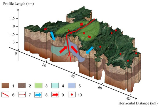
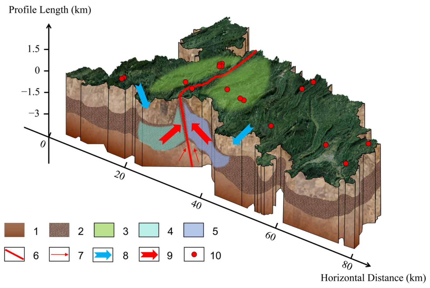
Specifically, in the conceptual model, gravity-driven rainwater is inferred to circulate to depths of approximately 3.07 km (estimated range 1.61 to 3.96 km). At this depth, conductive heating at the regional geothermal gradient could raise the water temperature to approximately 80.0 °C. Concurrently, as groundwater infiltrates and migrates, it interacts with soluble minerals (such as halite, gypsum/anhydrite, and carbonate) within the formation, leading to a significant increase in the mineral content of the geothermal water. This interaction produces mineral-rich geothermal water.
As shown in Figure 8, the geothermal water continues to flow through the formation, eventually rising and emerging at river cuts and faults, where it mixes with shallow cold water to a certain extent, leading to a reduction in temperature and dilution of mineral concentration. Consequently, it surfaces as artesian hot springs or is extracted through geothermal wells.
Figure 8.
Conceptual model for the formation of convective geothermal systems in southeastern Chongqing. 1: Aquitard. 2: Geothermal reservoir. 3: Limited recharge area. 4: Halite dissolution. 5: Gypsum dissolution. 6: Fault. 7: Deep heat source. 8: Cold water sinks. 9: Hot water rises. 10: Hot springs.
We note that the circulation depth of ~3 km is a thermometric estimate based on the average geothermal gradient and FixAl-derived reservoir temperatures, rather than a directly measured depth. The geothermal gradient (21.2 °C/km) is derived from three wells (nos. 3, 5, 12) and may vary locally. The FixAl temperatures carry an uncertainty of approximately ±20 °C [64]. Furthermore, without artificial tracer tests or numerical flow simulation, the precise flow path and the actual maximum depth reached by recharge water remain conceptual reconstructions consistent with, but not uniquely proven by, the available multi-proxy data. This interpretation follows the regional groundwater flow system concept of Tóth [65,66], in which large-scale flow systems are constrained by the spatial consistency of multi-proxy observations. The directly observed elements include the recharge elevations, reservoir temperatures, Sr isotopic compositions, and fault locations; the ~3 km circulation depth and the detailed flow path geometry are interpretive. The proposed model should therefore be regarded as a working hypothesis consistent with, but not uniquely proven by, the available evidence.
6. Conclusions
- The hydrogeochemical and multi-isotopic investigation of 17 geothermal water samples in southeastern Chongqing constrains the genesis and evolution of this medium–low temperature geothermal system. The Yushan Fault exerts a first-order control: to its west, the geothermal waters are of the Cl-Na type and are dominated by halite dissolution, whereas to its east, they are of the HCO3-Ca and SO4-Ca types and are dominated by gypsum and epsomite dissolution. This spatial dichotomy suggests that the fault architecture governs the water–rock interaction pathways within the carbonate–evaporite aquifer.
- Sulfate and strontium isotopes show that dissolved sulfate is derived mainly from the dissolution of gypsum/anhydrite, and that dissolved Sr2+ is dominated by the same evaporite source, with carbonate dissolution contributing only secondarily. This interpretation is supported by the negative correlation between Sr2+ and , the positive correlation between Sr2+ and , and the 87Sr/86Sr signatures. In addition, dedolomitization is recognized in the geothermal waters of the study area.
- The geothermal waters are of meteoric origin. Recharge elevations estimated from the δDH2O altitude effect range from 767 to 1267 m a.s.l., implying that the recharge areas are the carbonate mountains adjacent to the geothermal water outcrops.
- During upwelling, the geothermal waters mix with shallow karst water. The Sr-isotope binary mixing model indicates a mean cold-water fraction of about 35%. This cold-water fraction reaches up to 95% for the most diluted sample, which markedly lowers the discharge temperature and dilutes the mineral content.
- FixAl theoretical geothermometry, adopted as the primary method because silica geothermometers are strongly affected by dilution and CO2 degassing, yields mean reservoir temperatures of 80.4 °C (Group A) and 78.5 °C (Group B). These correspond to circulation depths of about 3.28 km (Group A) and 2.95 km (Group B) along fault zones, with heat supplied by deep crustal conduction rather than by magmatic activity.
The main contributions of this study are the identification of a fault-controlled, dual-source (halite- versus gypsum-dominated) hydrogeochemical evolution pattern and the quantitative Sr-isotope constraint on cold-water mixing, both of which extend earlier geothermometry-only assessments of the region. Several limitations nevertheless remain: no direct terrestrial heat-flow measurement is available for the study area, the recharge elevations rely on empirical altitude–isotope relationships calibrated for broader regions of China, and the deep circulation and heating mechanism are inferred rather than directly observed. Future work integrating local precipitation isotope monitoring, borehole temperature logging, and numerical modelling of coupled flow and heat transport is therefore recommended to test and refine the conceptual model proposed here.
Supplementary Materials
The following supporting information can be downloaded at: https://www.mdpi.com/article/10.3390/w18202490/s1. Table S1. Physicochemical parameters and isotopic compositions of geothermal water in southeastern Chongqing. Major ions and TDS are expressed in mg/L; δDH2O, δ18OH2O and δ18OSO4 are in ‰ (VSMOW); δ34SSO4 is in ‰ (VCDT); 87Sr/86Sr is presented as a dimensionless ratio. Table S2. Physical and isotopic data of the geothermal water, shallow karst water and river water samples within Southeast Chongqing. Discharging elevation is measured in m; The water temperature (T) is measured in °C; Sr2+ is expressed in mg/L; δDH2O, δ18OH2O and δ18OSO4 are in ‰ (VSMOW); δ34SSO4 is in ‰ (VCDT); 87Sr/86Sr is presented as a dimensionless ratio; the data of shallow karst water are reported by [40]; – means no detection. Table S3. Mineral saturation index of the geothermal waters in southeastern Chongqing. Supplementary data associated with this article can be found in the online version at https://doi.org/10.17632/bvnbrt74ft.1.
Author Contributions
Conceptualization, P.Y.; methodology, W.D.; software, W.D.; validation, W.D.; formal analysis, H.D.; investigation, H.D. and D.L.; resources, D.L.; data curation, H.D.; writing—original draft preparation, H.D.; writing—review and editing, P.Y.; visualization, H.D. and D.L.; supervision, P.Y.; project administration, P.Y.; funding acquisition, P.Y. All authors have read and agreed to the published version of the manuscript.
Funding
This research was funded by the National Training Program of Innovation and Entrepreneurship for Undergraduates (No. 202310635029).
Data Availability Statement
The data supporting the findings of this study are available within the article and its Supplementary Materials. Additional data will be made available from the corresponding author upon reasonable request.
Acknowledgments
This work was supported by the National Training Program of Innovation and Entrepreneurship for Undergraduates (No. 202310635029). We are grateful to the editors and anonymous reviewers for their constructive comments that helped improve the manuscript. During the preparation of this manuscript, the authors used Doubao (ByteDance, 2026) and WPS AI (Kingsoft Office) for the purposes of language polishing and grammar checking. The authors have reviewed and edited the output and take full responsibility for the content of this publication.
Conflicts of Interest
The authors declare that they have no known competing financial interests or personal relationships that could have appeared to influence the work reported in this paper.
References
- Hua, Y.; Oliphant, M.; Hu, E.J. Development of renewable energy in Australia and China: A comparison of policies and status. Renew. Energy 2016, 85, 1044–1051. [Google Scholar] [CrossRef] [Scilit]
- Wang, Y.; Li, B.; Chen, A. The Geochemical Characteristics and Genesis Mechanisms of the Zaozigou Geothermal Field. Sustainability 2024, 16, 6790. [Google Scholar] [CrossRef] [Scilit]
- Regenauer-Lieb, K.; Yuen, D.A.; Qi, S.; Wang, Y.; Liang, C. Foreword: Toward a quantitative understanding of the frontier in geothermal energy. J. Earth Sci. 2015, 26, 1. [Google Scholar] [CrossRef] [Scilit][Green Version]
- Xu, P.; Li, M.; Qian, H.; Zhang, Q.; Liu, F.; Hou, K. Hydrochemistry and geothermometry of geothermal water in the central Guanzhong Basin, China: A case study in Xi’an. Environ. Earth Sci. 2019, 78, 87. [Google Scholar] [CrossRef] [Scilit]
- Kong, Y.; Pang, Z.; Shao, H.; Hu, S.; Kolditz, O. Recent studies on hydrothermal systems in China: A review. Geotherm. Energy 2014, 2, 19. [Google Scholar] [CrossRef] [Scilit]
- Lu, L.; Pang, Z.; Kong, Y.; Guo, Q.; Wang, Y.; Xu, C.; Gu, W.; Zhou, L.; Yu, D. Geochemical and isotopic evidence on the recharge and circulation of geothermal water in the Tangshan Geothermal System near Nanjing, China: Implications for sustainable development. Hydrogeol. J. 2018, 26, 1705–1719. [Google Scholar] [CrossRef] [Scilit]
- Wang, S.; Yan, J.; Li, F.; Hu, J.; Li, K. Exploitation and Utilization of Oilfield Geothermal Resources in China. Energies 2016, 9, 798. [Google Scholar] [CrossRef] [Scilit]
- Zhang, R.; Wang, G.; Shen, X.; Wang, J.; Tan, X.; Feng, S.; Hong, J. Is geothermal heating environmentally superior than coal fired heating in China? Renew. Sustain. Energy Rev. 2020, 131, 110014. [Google Scholar] [CrossRef] [Scilit]
- Goldscheider, N.; Mádl-Szőnyi, J.; Erőss, A.; Schill, E. Review: Thermal water resources in carbonate rock aquifers. Hydrogeol. J. 2010, 18, 1303–1318. [Google Scholar] [CrossRef] [Scilit]
- Hao, M.; Tang, T.; Lu, C.; Jiang, Y.; Cui, Y.; Dong, F. Study on the Genetic Mechanism of Carbonate Rock Type Hot Mineral Water─A Case Study of Diaozhen, Jinan. ACS Omega 2024, 9, 26458–26471. [Google Scholar] [CrossRef] [Scilit] [PubMed]
- Kaminskaite-Baranauskiene, I.; Wang, H.; Liu, Z.; Li, H. Geothermal carbonate reservoirs and their sustainability: What can natural hydrothermal systems tell us? Geothermics 2023, 114, 102798. [Google Scholar] [CrossRef] [Scilit]
- Montanari, D.; Minissale, A.; Doveri, M.; Gola, G.; Trumpy, E.; Santilano, A.; Manzella, A. Geothermal resources within carbonate reservoirs in western Sicily (Italy): A review. Earth-Sci. Rev. 2017, 169, 180–201. [Google Scholar] [CrossRef] [Scilit]
- Wang, X.; Luo, Z.; Xu, C.; Lv, Y.; Cheng, L.; Zhang, Y. Formation mechanism of a carbonate geothermal system and calculation of the reservoir temperature under complex conditions. Geothermics 2022, 99, 102295. [Google Scholar] [CrossRef] [Scilit]
- Chen, Z.; Zhu, L.; Liu, P.; Li, C.; Zhou, Y.; Li, Y.; Xie, H.; Xiang, T. Hydrogeochemical Evolution Mechanism of Carbonate Geothermal Water in Southwest China. Arab. J. Geosci. 2021, 14, 1310. [Google Scholar] [CrossRef] [Scilit]
- Yang, P.; Dan, L.; Groves, C.; Xie, S. Geochemistry and genesis of geothermal well water from a carbonate–evaporite aquifer in Chongqing, SW China. Environ. Earth Sci. 2019, 78, 33. [Google Scholar] [CrossRef] [Scilit]
- Ta, M.; Zhou, X.; Guo, J.; Wang, X.; Wang, Y.; Xu, Y. The Evolution and Sources of Major Ions in Hot Springs in the Triassic Carbonates of Chongqing, China. Water 2020, 12, 1194. [Google Scholar] [CrossRef] [Scilit]
- Ta, M.; Zhou, X.; Guo, J.; Wang, Y.; Wang, X.; Xu, Y. Hydrogeochemical characteristics and formation of the hot springs occurring in the plunging ends of an anticline in Chongqing, Eastern Sichuan Basin, China. Environ. Earth Sci. 2019, 78, 468. [Google Scholar] [CrossRef] [Scilit]
- Yang, P.; Cheng, Q.; Xie, S.; Wang, J.; Chang, L.; Yu, Q.; Zhan, Z.; Chen, F. Hydrogeochemistry and geothermometry of deep thermal water in the carbonate formation in the main urban area of Chongqing, China. J. Hydrol. 2017, 549, 50–61. [Google Scholar] [CrossRef] [Scilit]
- Yang, P.; Luo, D.; Hong, A.; Ham, B.; Xie, S.; Ming, X.; Wang, Z.; Pang, Z. Hydrogeochemistry and geothermometry of the carbonate-evaporite aquifers controlled by deep-seated faults using major ions and environmental isotopes. J. Hydrol. 2019, 579, 124116. [Google Scholar] [CrossRef] [Scilit]
- Liu, L.; Qi, S.; Zhang, Y.; Gao, M.; Hu, J.; Wang, W. Isotopic and Hydrogeochemical Characteristics and Genesis of Warm Springs in the Jiangcang Basin, Qinghai, China. Front. Earth Sci. 2022, 10, 905852. [Google Scholar] [CrossRef] [Scilit]
- Dotsika, E.; Dalampakis, P.; Spyridonos, E.; Diamantopoulos, G.; Karalis, P.; Tassi, M.; Raco, B.; Arvanitis, A.; Kolios, N.; Michelot, J.L. Chemical and isotopic characterization of the thermal fluids emerging along the North–Northeastern Greece. Sci. Rep. 2021, 11, 16291. [Google Scholar] [CrossRef] [Scilit] [PubMed]
- Pavić, M.; Briški, M.; Pola, M.; Borović, S. Hydrogeochemical and environmental isotope study of Topusko thermal waters, Croatia. Environ. Geochem. Health 2024, 46, 133. [Google Scholar] [CrossRef] [Scilit] [PubMed]
- Pujiindiyati, E.R.; Abidin, Z. Investigation of dissolved sulphate in various geothermal fields of Sumatra using oxygen and sulphur isotopes. Indones. J. Chem. 2010, 6, 175–180. [Google Scholar]
- Ueda, A.; Kubota, Y.; Katoh, H.; Hatakeyama, K.; Matsubaya, O. Geochemical Characteristics of the Sumikawa Geothermal System, Northeast Japan. Geochem. J. 1991, 25, 223–244. [Google Scholar] [CrossRef] [Scilit]
- Jeelani, G.; Lone, S.A.; Nisa, A.U.; Deshpande, R.D.; Padhya, V. Use of stable water isotopes to identify and estimate the sources of groundwater recharge in an alluvial aquifer of Upper Jhelum Basin (UJB), western Himalayas. Hydrol. Sci. J. 2021, 66, 2330–2339. [Google Scholar] [CrossRef] [Scilit]
- Li, Y.; Dor, J.; Zhang, C.; Wang, G.; Zhang, B.; Zhang, F.; Xing, Y. Genesis of the Xifeng Low-Temperature Geothermal Field, Guizhou, SW China: Constrains From Geology, Element Geochemistry, and D-O Isotopes. Front. Earth Sci. 2021, 9, 782943. [Google Scholar] [CrossRef] [Scilit]
- Stadnyk, T.A.; Holmes, T.L. Large scale hydrologic and tracer aided modelling: A review. J. Hydrol. 2023, 618, 129177. [Google Scholar] [CrossRef] [Scilit]
- Wang, Z.; Zhou, H.; Wen, Z.; Luo, M.; Kuang, Y. A study of the thermal behaviour of exposed karst water systems in a mountainous area of Zigui County, Hubei Province, Central China. Hydrogeol. J. 2021, 29, 2821–2835. [Google Scholar] [CrossRef] [Scilit]
- West, A.G.; February, E.C.; Bowen, G.J. Spatial analysis of hydrogen and oxygen stable isotopes (“isoscapes”) in ground water and tap water across South Africa. J. Geochem. Explor. 2014, 145, 213–222. [Google Scholar] [CrossRef] [Scilit]
- Bao, Y.; Pang, Z.; Huang, T.; Li, Y.; Tian, J.; Luo, J.; Qian, T. Chemical and isotopic evidences on evaporite dissolution as the origin of high sulfate water in a karst geothermal reservoir. Appl. Geochem. 2022, 145, 105419. [Google Scholar] [CrossRef] [Scilit]
- Bakari, S.S.; Aagaard, P.; Vogt, R.D.; Ruden, F.; Johansen, I.; Vuai, S.A. Strontium isotopes as tracers for quantifying mixing of groundwater in the alluvial plain of a coastal watershed, south-eastern Tanzania. J. Geochem. Explor. 2013, 130, 1–14. [Google Scholar] [CrossRef] [Scilit]
- Négrel, P.; Petelet-Giraud, E.; Widory, D. Strontium isotope geochemistry of alluvial groundwater: A tracer for groundwater resources characterisation. Hydrol. Earth Syst. Sci. 2004, 8, 959–972. [Google Scholar] [CrossRef] [Scilit]
- Blasco, M.; Gimeno, M.J.; Auqué, L.F. Low temperature geothermal systems in carbonate-evaporitic rocks: Mineral equilibria assumptions and geothermometrical calculations. Insights from the Arnedillo thermal waters (Spain). Sci. Total Environ. 2018, 615, 526–539. [Google Scholar] [CrossRef] [Scilit] [PubMed]
- Yan, Z.; Xu, W.; Luo, X.; You, Y.; Wen, H. Sedimentation sequence of a high-temperature silica-rich hot spring: Evidence from isothermal evaporation experiments and from petrology and mineralogy of sinters. Carbonates Evaporites 2021, 36, 29. [Google Scholar] [CrossRef] [Scilit]
- Pang, Z.H.; Reed, M. Theoretical Chemical Thermometry on Geothermal Waters: Problems and Methods. Geochim. Cosmochim. Acta 1998, 62, 1083–1091. [Google Scholar] [CrossRef] [Scilit]
- China Meteorological Administration. China Meteorological Data Set; China Meteorological Press: Beijing, China, 2017. [Google Scholar]
- Zhang, J.; Yang, P.; Groves, C.; Luo, X.; Wang, Y. Influence of geological structure on the physicochemical properties and occurrence of middle-deep groundwater in Chongqing, Southwest China. J. Hydrol. 2022, 610, 127782. [Google Scholar] [CrossRef] [Scilit]
- China Geological Mining Exploration and Development Corporation (CGMEDC). Geological Map of Chongqing (1:500,000); China Geological Publishing House: Beijing, China, 2002. [Google Scholar]
- Jiang, G.; Hu, S.; Shi, Y.; Zhang, C.; Wang, Z.; Hu, D. Terrestrial heat flow of continental China: Updated dataset and tectonic implications. Tectonophysics 2019, 753, 36–48. [Google Scholar] [CrossRef] [Scilit]
- Pu, J.; Yuan, D.; Zhang, C.; Zhao, H. Hydrogeochemistry and possible sulfate sources in karst groundwater in Chongqing, China. Environ. Earth Sci. 2013, 68, 159–168. [Google Scholar] [CrossRef] [Scilit]
- Reed, M.; Spycher, N. Calculation of pH and mineral equilibria in hydrothermal waters with application to geothermometry and studies of boiling and dilution. Geochim. Cosmochim. Acta 1984, 48, 1479–1492. [Google Scholar] [CrossRef] [Scilit]
- Xu, M.; Zhu, C.Q.; Tian, Y.T.; Rao, S.; Hu, S.B. Borehole temperature measurement and present geothermal characteristics of Sichuan Basin. Chin. J. Geophys. 2011, 54, 1052–1060. [Google Scholar]
- Gomes, L.A.; Barbosa, N.S.; Debruyne, D.; Barbosa, N.; Moitinho, D.E.R.; Peixoto, R.; Santos, C.B.; Peixinho, M.A.L. Hydrogeochemical processes and groundwater evolution of the São Sebastião-Marizal aquifer system in the Tucano Central Basin, Bahia, Brazil. J. S. Am. Earth Sci. 2023, 127, 104413. [Google Scholar] [CrossRef] [Scilit]
- Chenaker, H.; Houha, B.; Vincent, V. Hydrogeochemistry and geothermometry of thermal water from northeastern Algeria. Geothermics 2018, 75, 137–145. [Google Scholar] [CrossRef] [Scilit]
- Plummer, L.N.; Busenberg, E. The solubilities of calcite, aragonite and vaterite in CO2-H2O solutions between 0 and 90 °C, and an evaluation of the aqueous model for the system CaCO3-CO2-H2O. Geochim. Cosmochim. Acta 1982, 46, 101–156. [Google Scholar] [CrossRef] [Scilit]
- Han, G.; Liu, C.Q. Water geochemistry controlled by carbonate dissolution: A study of the river waters draining karst-dominated terrain, Guizhou Province, China. Chem. Geol. 2004, 204, 1–21. [Google Scholar] [CrossRef] [Scilit]
- Hanshaw, B.B.; Back, W. Major geochemical processes in the evolution of carbonate-aquifer systems. J. Hydrol. 1979, 43, 287–312. [Google Scholar] [CrossRef] [Scilit]
- Macpherson, G.L. Hydrogeology of thin limestones: The Konza Prairie Long-Term Ecological Research Site, Northeastern Kansas. J. Hydrol. 1996, 186, 191–228. [Google Scholar] [CrossRef] [Scilit]
- Clark, I.D.; Fritz, P. Environmental Isotopes in Hydrogeology, 1st ed.; CRC Press: Boca Raton, FL, USA, 1997. [Google Scholar]
- Sack, A.L.; Sharma, S. A multi-isotope approach for understanding sources of water, carbon and sulfur in natural springs of the Central Appalachian region. Environ. Earth Sci. 2014, 71, 4715–4724. [Google Scholar] [CrossRef] [Scilit]
- Xiao, Q.; Jiang, Y.; Shen, L.; Yuan, D. Origin of calcium sulfate-type water in the Triassic carbonate thermal water system in Chongqing, China: A chemical and isotopic reconnaissance. Appl. Geochem. 2018, 89, 49–58. [Google Scholar] [CrossRef] [Scilit]
- Bottrell, S.H.; Webber, N.; Gunn, J.; Worthington, S.R.H. The geochemistry of sulphur in a mixed allogenic-autogenic karst catchment, Castleton, Derbyshire, UK. Earth Surf. Process. Landf. 2000, 25, 155–165. [Google Scholar] [CrossRef] [Scilit]
- Fu, C.; Li, X.; Ma, J.; Liu, L.; Gao, M.; Bai, Z. A hydrochemistry and multi-isotopic study of groundwater origin and hydrochemical evolution in the middle reaches of the Kuye River basin. Appl. Geochem. 2018, 98, 82–93. [Google Scholar] [CrossRef] [Scilit]
- Krouse, H.R.; Mayer, B. Sulphur and Oxygen Isotopes in Sulphate. In Environmental Tracers in Subsurface Hydrology; Cook, P.G., Herczeg, A.L., Eds.; Springer: Boston, MA, USA, 2000; pp. 195–231. [Google Scholar]
- Zhang, D.; Li, X.D.; Zhao, Z.Q.; Liu, C.Q. Using dual isotopic data to track the sources and behaviors of dissolved sulfate in the western North China Plain. Appl. Geochem. 2015, 52, 43–56. [Google Scholar] [CrossRef] [Scilit]
- Faure, G.; Mensing, T.M. Isotopes: Principles and Applications, 3rd ed.; Wiley: Hoboken, NJ, USA, 2004; p. 928. [Google Scholar]
- Faure, G. Principles of Isotope Geology; Wiley: Hoboken, NJ, USA, 1977; p. 464. [Google Scholar]
- Klaus, J.S.; Hansen, B.T.; Buapeng, S. 87Sr/86Sr ratio: A natural tracer to monitor groundwater flow paths during artificial recharge in the Bangkok area, Thailand. Hydrogeol. J. 2007, 15, 745–758. [Google Scholar] [CrossRef] [Scilit]
- Lee, S.G.; Kim, T.K.; Lee, J.S.; Lee, T.J.; Cho, B.W.; Koh, H.J. Geochemical implication of 87Sr/86Sr ratio of high-temperature deep groundwater in a fractured granite aquifer. Geochem. J. 2008, 42, 429–441. [Google Scholar] [CrossRef] [Scilit][Green Version]
- Petelet-Giraud, E.; Négrel, P.; Widory, D. Strontium isotopic characterisation of water circulation in an alluvial plain: The Ile du Chambon case (Allier, France). Houille Blanche 2006, 82–90. [Google Scholar]
- Sahib, L.Y.; Marandi, A.; Schüth, C. Strontium isotopes as an indicator for groundwater salinity sources in the Kirkuk region, Iraq. Sci. Total Environ. 2016, 562, 935–945. [Google Scholar] [CrossRef] [Scilit] [PubMed]
- Shand, P.; Darbyshire, D.P.F.; Gooddy, D. 87Sr/86Sr as an indicator of flowpaths and weathering rates in the Plynlimon experimental catchments, Wales, U.K. Chem. Geol. 2007, 236, 247–265. [Google Scholar] [CrossRef] [Scilit]
- Shand, P.; Darbyshire, D.P.F.; Love, A.J.; Edmunds, W. Sr isotopes in natural waters: Applications to source characterisation and water–rock interaction in contrasting landscapes. Appl. Geochem. 2009, 24, 574–586. [Google Scholar] [CrossRef] [Scilit]
- Tole, M.P.; Ármannsson, H.; Zhong-He, P.; Arnórsson, S. Fluid/mineral equilibrium calculations for geothermal fluids and chemical geothermometry. Geothermics 1993, 22, 17–37. [Google Scholar] [CrossRef] [Scilit]
- Tóth, J. A theoretical analysis of groundwater flow in small drainage basins. J. Geophys. Res. 1963, 68, 4795–4812. [Google Scholar] [CrossRef] [Scilit]
- Tóth, J. Hydraulic Continuity In Large Sedimentary Basins. Hydrogeol. J. 1995, 3, 4–16. [Google Scholar] [CrossRef] [Scilit]

Disclaimer/Publisher’s Note: The statements, opinions and data contained in all publications are solely those of the individual author(s) and contributor(s) and not of MDPI and/or the editor(s). MDPI and/or the editor(s) disclaim responsibility for any injury to people or property resulting from any ideas, methods, instructions or products referred to in the content. |
© 2026 by the authors. Licensee MDPI, Basel, Switzerland. This article is an open access article distributed under the terms and conditions of the Creative Commons Attribution (CC BY) license.