


Abstract
The Tan–Lu Fault Zone (TLFZ) is a lithosphere-scale fault system in eastern Asia with pronounced along-strike heterogeneity in structure and fluid activity. Previous geochemical studies have largely focused on individual segments, sample media, or single tracers, leaving the fault-zone-scale organization of fluid geochemical signals unresolved. Here, published helium-isotope data and cross-fault soil-gas CO2 and Rn observations are integrated within a common fault-parallel coordinate framework to compare source-sensitive proxies with those more responsive to transport and near-surface processes. The three proxy groups define contrasting spatial patterns. Mantle-derived He is strongest and spatially focused in Liaoning, intermediate but comparatively persistent in Anhui–Jiangsu, and generally subdued in the available Shandong dataset. Soil-gas CO2 and Rn anomalies, by contrast, are most continuous in Anhui–Jiangsu, locally enhanced in Liaoning, and subdued to intermediate in the available Shandong transects. Combining the mantle-derived He state with the soil-gas response identifies four proxy-association types. The most laterally continuous Type I interval extends for approximately 200 km in the Anhui–Jiangsu segment, whereas southern Liaoning is characterized by spatially focused, adjacent Type II and Type I intervals. These contrasting associations show that the near-surface expression of deep-derived fluids depends not only on volatile availability, but also on crustal pathway connectivity, groundwater circulation, and modification during transport and release. The integrated comparison reveals where deep-source and shallow-response signals are coupled or decoupled along the TLFZ, providing a basis for evaluating fault-zone fluid segmentation.
1. Introduction
The release of volatiles from Earth’s interior, including He, CO2, and Rn, is an important manifestation of crust–mantle interaction and lithospheric evolution [1]. Major fault zones act not only as pathways for the ascent of deep fluids, but also as major tectonic boundaries that modulate the transfer of volatiles from depth to the near surface. The spatial distribution of volatile release is commonly linked to extensional deformation, active faulting, and intracrustal permeability structure, and the structural state of a fault zone exerts a fundamental control on the efficiency of fluid migration through the lithosphere [2,3,4]. Characterizing volatile release along major fault systems therefore provides key geochemical constraints on deep fluid activity, tectono-fluid coupling, and lithosphere-scale transport architecture. However, fluid flow within large fault zones is rarely uniform along strike. Fault zones comprise fault cores, damage zones, and surrounding host rocks, all of which may differ substantially in permeability. Fracture systems may also undergo repeated opening, sealing, cementation, and reactivation during tectonic evolution, producing strong spatial variability in fluid transmissivity both laterally and vertically [5,6,7]. As a result, even within a single lithosphere-scale fault zone, the intensity of fluid activity and its near-surface manifestation may vary markedly from one segment to another. Previous studies have shown that such segment-scale differences are closely related to fault geometry, fault activity, regional thermal conditions, and hydrogeochemical setting [8].
Different geochemical tracers record different hierarchical levels of fault-zone fluid systems. Helium isotopes are chemically conservative and characterized by well-defined end-member signatures, making them particularly effective for tracing deep fluid sources and the relative contribution of mantle-derived components. Radon is sensitive to shallow fracture openness, short-distance transport, and rapid release through permeable fault-zone pathways. CO2 may record a combined signal involving source contribution, carrier-gas migration, groundwater interaction, and near-surface environmental modification [9,10]. Accordingly, the fault-zone fluid system is better evaluated through the coordinated comparison of source-sensitive and transport-sensitive proxies. A comparative analysis of multiple proxies along strike is therefore better suited to identifying hierarchical differences in fluid processes and their spatial coupling within large fault systems [11,12].
The Tan–Lu Fault Zone (TLFZ) is one of the most important lithosphere-scale fault systems in eastern continental East Asia, extending for more than 2400 km [13]. Having experienced multiple phases of tectonic reworking, it represents a key natural laboratory for investigating deep faulting, lithospheric thinning, and fluid circulation associated with long-lived tectonic boundaries [14,15,16]. Recent geophysical studies have shown that the crust–mantle structure of the TLFZ varies substantially along strike, as reflected by segment-dependent variations in crustal thickness, Moho geometry, the ratio of P-wave to S-wave velocity (Vp/Vs), lithospheric velocity anomalies, and uppermost-mantle anisotropy [16,17]. These observations suggest that the TLFZ is structurally heterogeneous along strike at the lithospheric scale. In addition, geochemical observations likewise point to strong spatial variability in fluid activity along the TLFZ. Previous studies have identified mantle-derived He input and cross-fault soil-gas CO2 and Rn anomalies in several segments of the fault zone [9,18,19,20]. Hao et al. also provided a systematic synthesis of the spatial distribution, origin, and enrichment mechanisms of He in geothermal systems across continental China [21]. However, most previous studies have evaluated individual structural segments, sample media, or geochemical tracers separately. Although these studies have documented local mantle-derived He input and soil-gas CO2 and Rn anomalies, the fault-zone-scale relationships among proxies that record different levels of the fluid system remain insufficiently defined. It therefore remains unclear whether these proxies show coherent along-strike patterns or become spatially decoupled among different structural and hydrogeological settings.
In this study, published helium-isotope and soil-gas CO2 and Rn observations are processed using proxy-specific procedures and placed within a unified fault-parallel coordinate framework. The analysis addresses three questions: (1) how the three proxy groups vary along the TLFZ; (2) where their spatial trends show agreement or mismatch; and (3) how the observed associations relate to deep volatile input, fault-zone connectivity, groundwater circulation, and near-surface gas transfer. This approach provides a fault-zone-scale framework for evaluating fluid geochemical segmentation along the TLFZ.
2. Study Area and Data
2.1. Geological Setting of the Study Area
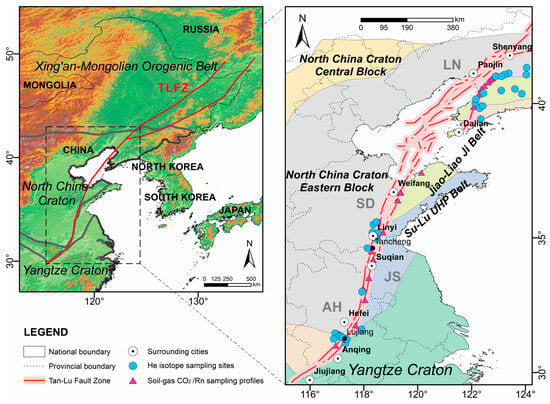
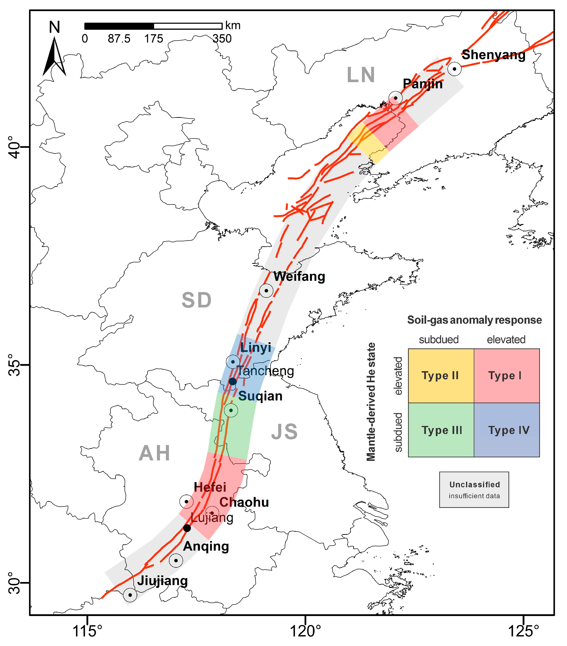
The TLFZ trends overall from north-northeast to northeast (NNE–NE) and is one of the most important deep-rooted fault systems in eastern Asia, exerting long-term control on lithospheric reworking in the eastern North China Craton, basin evolution, and regional seismicity (Figure 1) [13]. From south to north, the fault zone extends across the northern margin of the Yangtze Block, the Sulu orogenic belt, and the eastern North China Craton, and continues into the Bohai Sea and northeastern China. It is a composite fault-zone system composed of multiple principal strands, subsidiary branches, and structurally related fracture zones. Owing to its great along-strike extent, its transect across several major tectonic domains, and the pronounced contrast in tectonic setting among different segments, the TLFZ provides an excellent natural framework for investigating along-strike segmentation of fault-zone fluid activity.
Figure 1.
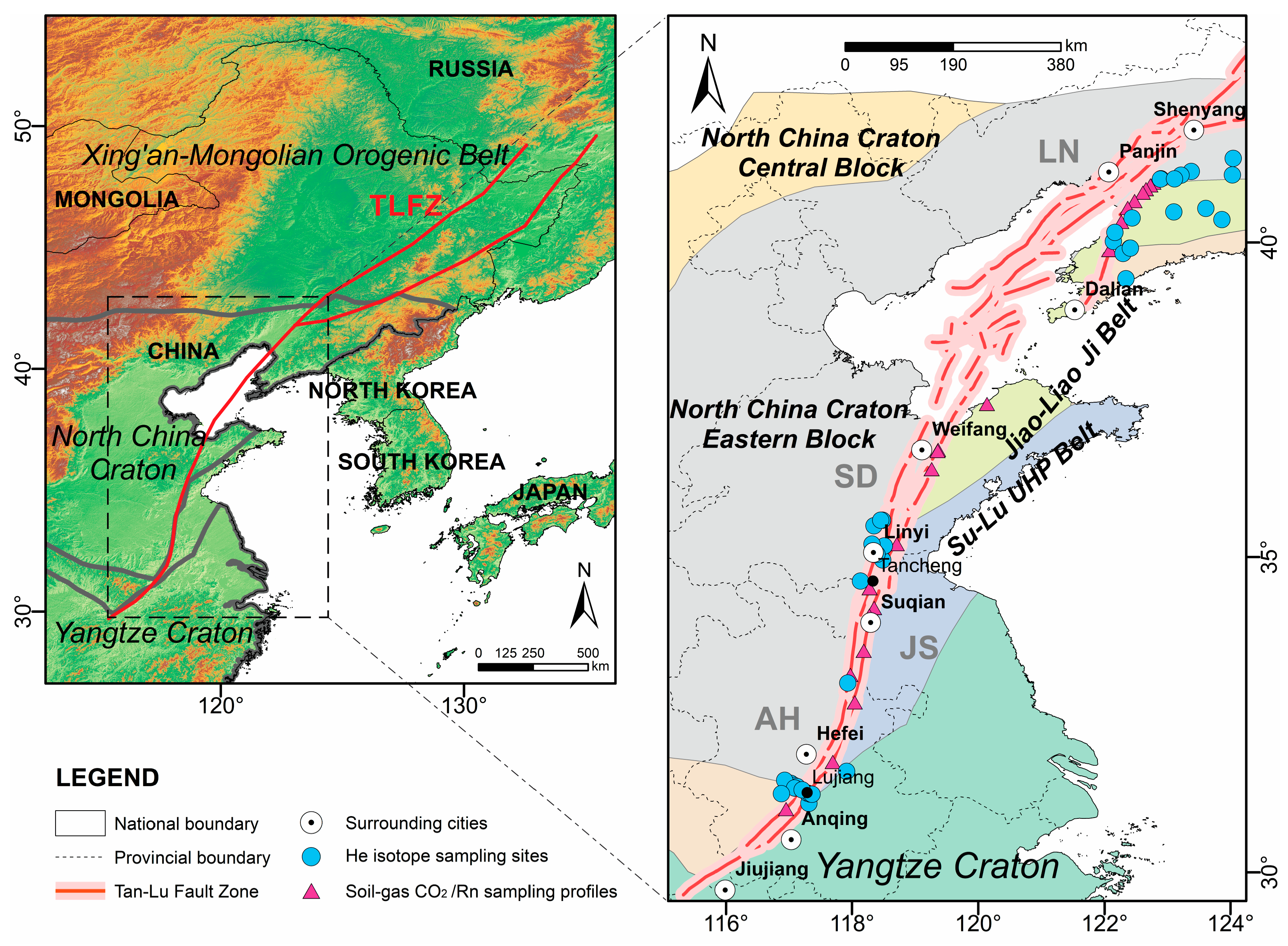
Tectonic framework of the Tan–Lu Fault Zone (TLFZ) system and spatial distribution of the compiled helium-isotope and soil-gas CO2 and Rn datasets used in this study. AH: Anhui; JS: Jiangsu; SD: Shandong; LN: Liaoning.
The formation and evolution of the TLFZ involved multiple phases of tectonic superposition and reworking, recording the complex tectonic history of plate interaction along the East Asian continental margin, intracontinental strike-slip deformation, and subsequent extensional adjustment since the Mesozoic [22,23]. Since the Cenozoic, the TLFZ has broadly evolved within a dextral strike-slip regime, although the stress field is not uniform along strike. In different segments, local transpressional, transtensional, and bend-related transfer structures are developed, as reflected by positive flower structures, thrust components, stepovers, and fault bends [22,24,25].
Marked along-strike differences also exist in shallow geological and hydrogeological conditions. In parts of the Anhui–Jiangsu segment, basement structures are relatively well exposed, and both major and subsidiary faults can be readily recognized at the surface [26]. By contrast, in parts of the Shandong segment and the adjacent Bohai Bay Basin, thick Cenozoic sedimentary successions and basin-fill deposits may mask or complicate the shallow surface trace of basement faults [27]. In such basin settings, near-surface gas anomalies are likely to be additionally filtered by fault sealing, lithologic heterogeneity, groundwater circulation, and gas migration or mixing within porous sedimentary media [28,29]. The TLFZ is therefore well suited not only for assessing differences in deep fluid input, but also for comparing how different fluid geochemical proxies respond to along-strike variation in fault-zone architecture and shallow transport conditions. In this study, the TLFZ is treated as a fault-zone system rather than a single geometrical fault trace; the principal fault trace is used as the reference line for along-strike comparison, whereas samples located on major subsidiary faults or structurally related branches are considered part of the same deformation system when their structural affiliation is clear.
2.2. Data Sources
This study uses a regional compilation of published fluid geochemical observations from the TLFZ fault-zone system. The compiled records include helium-isotope data from dissolved and free gases associated with groundwater systems, including spring waters and geothermal well waters, together with cross-fault soil-gas CO2 and Rn measurements (Figure 1; Table 1). Records were included when their sampling locations could be identified and their structural association with the TLFZ or its major subsidiary faults could be established. Helium-isotope records were retained when the parameters required for atmospheric correction and estimation of the mantle-derived He contribution were reported. Soil-gas transects were retained when the reported peak and local-background statistics were sufficient for calculation of standardized anomaly significance. Records lacking the required spatial or analytical information were excluded. The detailed records and original data sources are provided in Wang and Huang [30].
Table 1.
Literature sources of the compiled datasets.
These three proxy groups were selected because they represent complementary aspects of the fault-zone fluid system and can be compared along strike at the scale of the entire TLFZ. Helium isotopes, especially the air-corrected helium isotope ratio (Rc/Ra) and the estimated mantle He contribution, primarily constrain crustal–mantle mixing and the near-surface occurrence of mantle-derived components, thereby providing information on the deep volatile-source regime. Soil-gas Rn, owing to its short half-life, is particularly sensitive to fracture openness and rapid transport through shallow to intermediate fault-zone pathways. Soil-gas CO2 may contain a deep component, but is also susceptible to shallow migration, groundwater interaction, and near-surface environmental overprinting [23,25]. Considered together, these proxies provide a basis for examining both the commonalities and mismatches among source-sensitive, transport-sensitive, and near-surface response signals along strike.
The source records differ in spatial coverage, sample medium, sampling period, analytical procedure, and local environmental conditions. The analysis therefore focuses on relative along-strike variation rather than direct comparison of all reported absolute values. Helium-isotope records were processed using a common atmospheric-correction and two-end-member mixing procedure, whereas soil-gas anomalies were standardized relative to the local background variability of each transect. This proxy-specific processing improves comparability at the regional scale, although differences inherited from the original surveys remain.
All helium-isotope sampling sites and soil-gas transect midpoints were projected onto the principal trace of the TLFZ from south to north, and cumulative distance along the reference trace was used as the common spatial coordinate. Within this framework, the proxy groups are compared in terms of their relative spatial expression and association rather than as contemporaneous measurements of equivalent fluid fluxes.
3. Methods
3.1. Helium-Isotope Processing and Estimation of Mantle-Derived He Contribution
Helium isotope data from dissolved and free gases associated with groundwater systems, including spring waters and geothermal well waters, were used to characterize the relative strength of deep-derived He signals in near-surface fluid systems along the TLFZ. Among the available parameters, Rc/Ra and the estimated mantle He contribution were selected as the principal indicators for comparing along-strike differences in the near-surface deep-derived He signature.
3.1.1. Correction for Atmospheric Contamination
Helium is chemically inert and shows large isotopic contrasts among major geochemical reservoirs, making it a robust tracer of deep fluid sources [40]. However, fluids sampled in near-surface environments commonly contain variable mixtures of atmospheric, crustal radiogenic, and mantle-derived components. Without correcting for atmospheric contamination, measured 3He/4He ratios cannot be used directly to evaluate the relative contribution of deep end members. Atmospheric correction is therefore required before estimating mantle-derived He.
In this study, the 4He/20Ne ratio was used to assess the degree of air contamination in each sample, following previous work [41]. The air-correction factor was calculated using Equation (1):
where the atmospheric 4He/20Ne ratio, (4He/20Ne)air, is 0.318 [42], and βNe/βHe denotes the ratio of Bunsen solubility coefficients. For dissolved-gas samples, βNe/βHe was taken as 1.2 based on estimated recharge temperatures from the mean annual air temperature of the corresponding sampling areas [43,44]. For free or escaping gas samples, βNe/βHe was set to 1.0, because no aqueous solubility correction was applied to samples collected directly as gas phase.
The corrected helium isotope ratio, Rc/Ra, was then calculated using Equation (2) [45]:
where R is the measured 3He/4He ratio, and Ra is the atmospheric reference value of 3He/4He, taken as 1.38 × 10⁻⁶ [46]. After removal of the atmospheric component, Rc/Ra is interpreted to reflect mixing between crustal and mantle helium end members.
3.1.2. Estimation of Mantle Helium Contribution
The corrected Rc/Ra values were further used to estimate the proportion of mantle-derived He based on a two-end-member mixing model between crustal radiogenic He and mantle primordial He. The mantle He contribution was calculated using Equation (3):
where Xm is the fraction of mantle-derived He. The crustal end member (Rcrust/Ra) was assigned a value of 0.02 Ra, representative of radiogenic He in continental crust [40]. The mantle end member (Rmantle/Ra) was taken as 6.5 Ra, representing the continental lithospheric mantle beneath the study area, following values adopted in previous studies of comparable tectonic settings [47,48].
The estimated mantle He contribution is used here as a proxy-based indicator of relative deep fluid input, rather than as an exact measure of mantle flux.
3.2. Soil-Gas Anomaly Quantification
Among the published cross-fault soil-gas datasets, CO2 and Rn provide the most consistent spatial coverage and the strongest basis for inter-transect comparison. These two parameters were therefore selected for unified anomaly evaluation [49]. To compare the significance of soil-gas anomalies among different transects and segments while minimizing the influence of variable background levels, we used the standardized peak significance, Zpeak, as the principal index. Zpeak was calculated using Equation (4):
where denotes either CO2 or Rn, is the maximum concentration of proxy X observed along a given soil-gas transect, is the local background concentration of the same proxy, and σX is the standard deviation of the background values. The local background concentration was estimated from non-anomalous points within each transect, following the background definition used in the original datasets where available. Higher Zpeak values indicate a stronger departure of the anomaly peak from the local background range [50].
In active-fault settings, elevated soil-gas Rn and CO2 concentrations are commonly associated with fracture-controlled gas migration and enhanced shallow permeability [8,51]. Statistical criteria based on the local background mean and its standard deviation have frequently been used for operational identification of geochemical anomalies, although the resulting threshold depends on the background definition and data distribution [52]. In this study, Zpeak ≥ 3 was adopted as a conservative operational criterion for identifying a relatively elevated soil-gas anomaly response. This criterion indicates that the anomaly peak exceeds the local background concentration by at least three background standard deviations. Because Zpeak was calculated separately for each transect, the criterion represents a strong within-transect departure from local background rather than a universal absolute concentration threshold. A transect was considered anomalous when either CO2 or Rn met this criterion. This standardization reduces the influence of differences in absolute background concentration but does not eliminate temporal, analytical, or environmental variability among the original surveys.
3.3. Fault-Parallel Projection, Trend Modeling, and Interval Classification
To compare multiple fluid geochemical tracers within a common spatial framework, all sampling sites and soil-gas transect midpoints were projected onto a reference fault trace representing the principal strike of the TLFZ, and cumulative distance along this trace was used as a one-dimensional fault-parallel coordinate. The southern end of the compiled profile was used as the distance origin. For each sample or transect, the nearest point on the reference trace was identified, and the along-strike distance was calculated as the cumulative distance from the origin to that projected point. Samples located on recognized subsidiary faults or structurally related branches were retained when they could be assigned to the TLFZ deformation system. This procedure places helium isotope data and soil-gas observations on the same fault-parallel axis. For intervals with clear data gaps, such as the Bohai section, trends were fitted separately on either side of the gap. The one-dimensional coordinate preserves the along-strike position of the observations while simplifying cross-fault distance and the detailed geometry of subsidiary fault branches.
Nonlinear spatial variation was modeled using a generalized additive model (GAM), expressed as
where β0 is the intercept, s(distancei) is a penalized smoothing function, and ε is the random error term. Smoothing parameters were estimated by restricted maximum likelihood (REML), and overfitting was controlled by constraining the basis dimension and checking model diagnostics [53]. Because the mantle He contribution shows a right-skewed distribution, a log(1 + y) transformation was applied before fitting, and the predictions were then back-transformed to the original scale.
Uncertainty in the fitted trends was evaluated using bootstrap resampling to construct 90% confidence intervals [54]. Different resampling schemes were used for helium and soil-gas datasets because of their different sampling structures. For soil-gas proxies, including Zpeak (CO2) and Zpeak (Rn), pairs bootstrap resampling of (xi, yi) was adopted so that the confidence intervals incorporate both point scatter and fitting uncertainty. For the mantle He contribution, residual resampling at fixed distance was used, with wild bootstrap preferred because the distribution is right-skewed and influenced by a limited number of high-value observations. The confidence intervals represent uncertainty associated with data scatter and spatial trend fitting. They do not include the full analytical and temporal uncertainties inherited from the source studies because these components were not reported consistently. All spatial data processing, generalized additive model fitting, bootstrap resampling and classification analysis were performed using Python 3.11, NumPy 1.26.2, Pandas 2.1.4 and Matplotlib 3.8.2.
After trend fitting, the fault-parallel profile was divided into fixed 50 km intervals, and the predicted value at the midpoint of each interval was taken as the representative level for that interval. This spacing was chosen to balance sample density, smoothing resolution, and classification stability: shorter intervals would be more sensitive to locally sparse sampling, whereas longer intervals could obscure meaningful spatial variation.
The mantle-derived He state was determined from the GAM-predicted mantle-derived He contribution at the midpoint of each fixed 50 m interval. The overall median mantle-derived He contribution of the 38 compiled observations, 4.4%, was used as the classification threshold. Intervals with predicted values ≥ 4.4% were classified as relatively elevated, whereas intervals with predicted values < 4.4% were classified as relatively subdued. The subdued state may still include a minor mantle-derived component.
The soil-gas anomaly response was determined from the corresponding GAM-predicted Zpeak values at the midpoint of each 50 km interval. An interval was classified as relatively elevated when Zpeak (CO2) ≥ 3 or Zpeak (Rn) ≥ 3, and as relatively subdued when both values were <3.
Type I represents elevated mantle-derived He and an elevated soil-gas anomaly response. Type II represents elevated mantle-derived He and a subdued soil-gas anomaly response. Type III represents subdued mantle-derived He and an elevated soil-gas anomaly response. Type IV represents subdued mantle-derived He and a subdued soil-gas anomaly response. These types provide a rule-based summary of proxy agreement and mismatch and do not represent uniquely determined physical regimes.
4. Results
4.1. Along-Strike Segmentation of Deep He-Tracer Signals
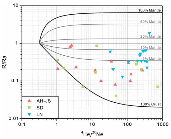
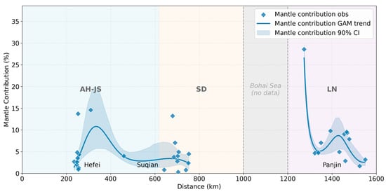
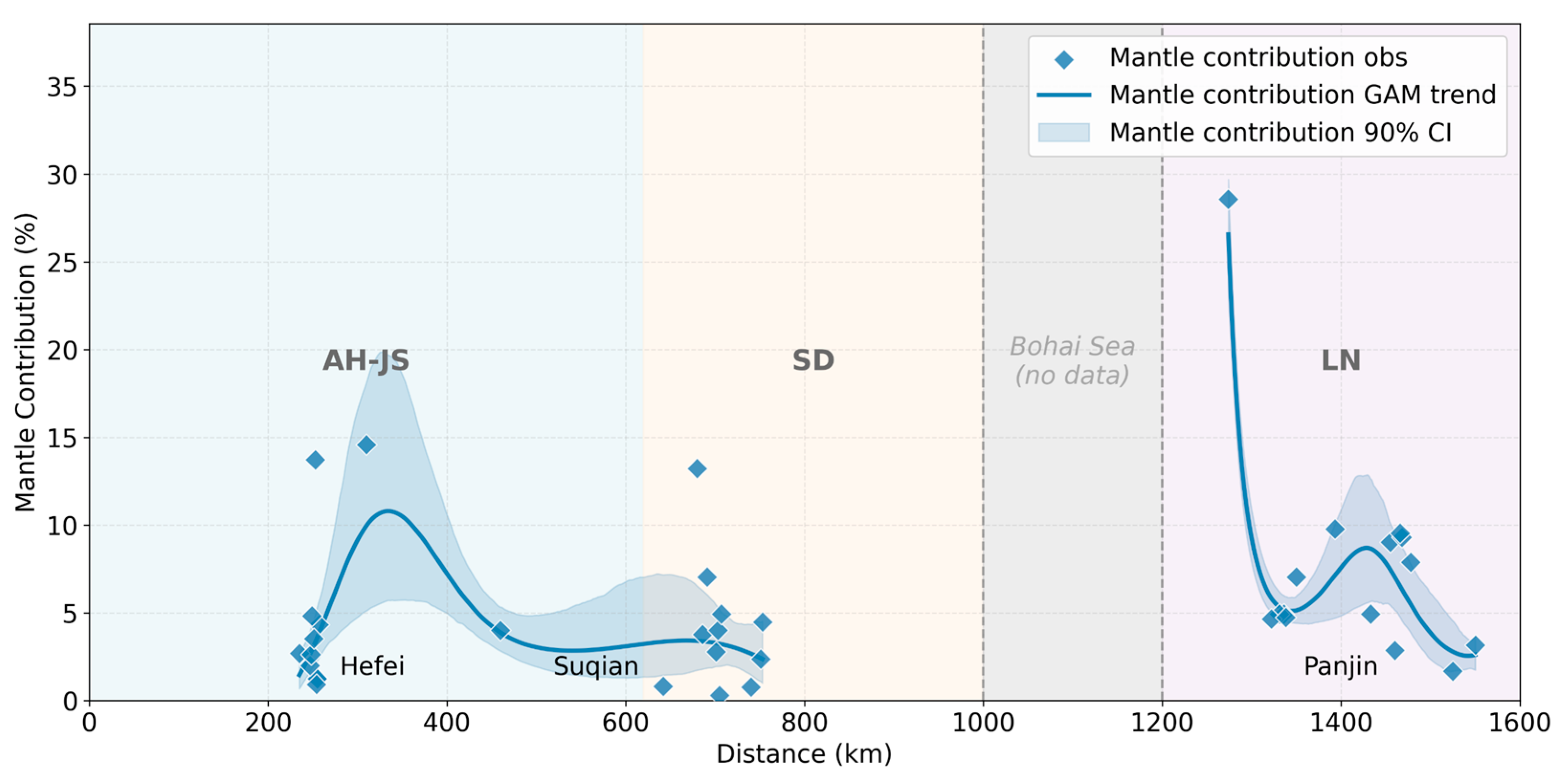
Helium isotope compositions of deep-fluid samples from the TLFZ, together with their relationships with 4He/20Ne, show marked intersample variability (Figure 2). After correction for atmospheric contamination, the estimated mantle He contribution exhibits a clear along-strike pattern, indicating pronounced segmentation in deep-derived He signals along the fault zone (Figure 3).
Figure 2.
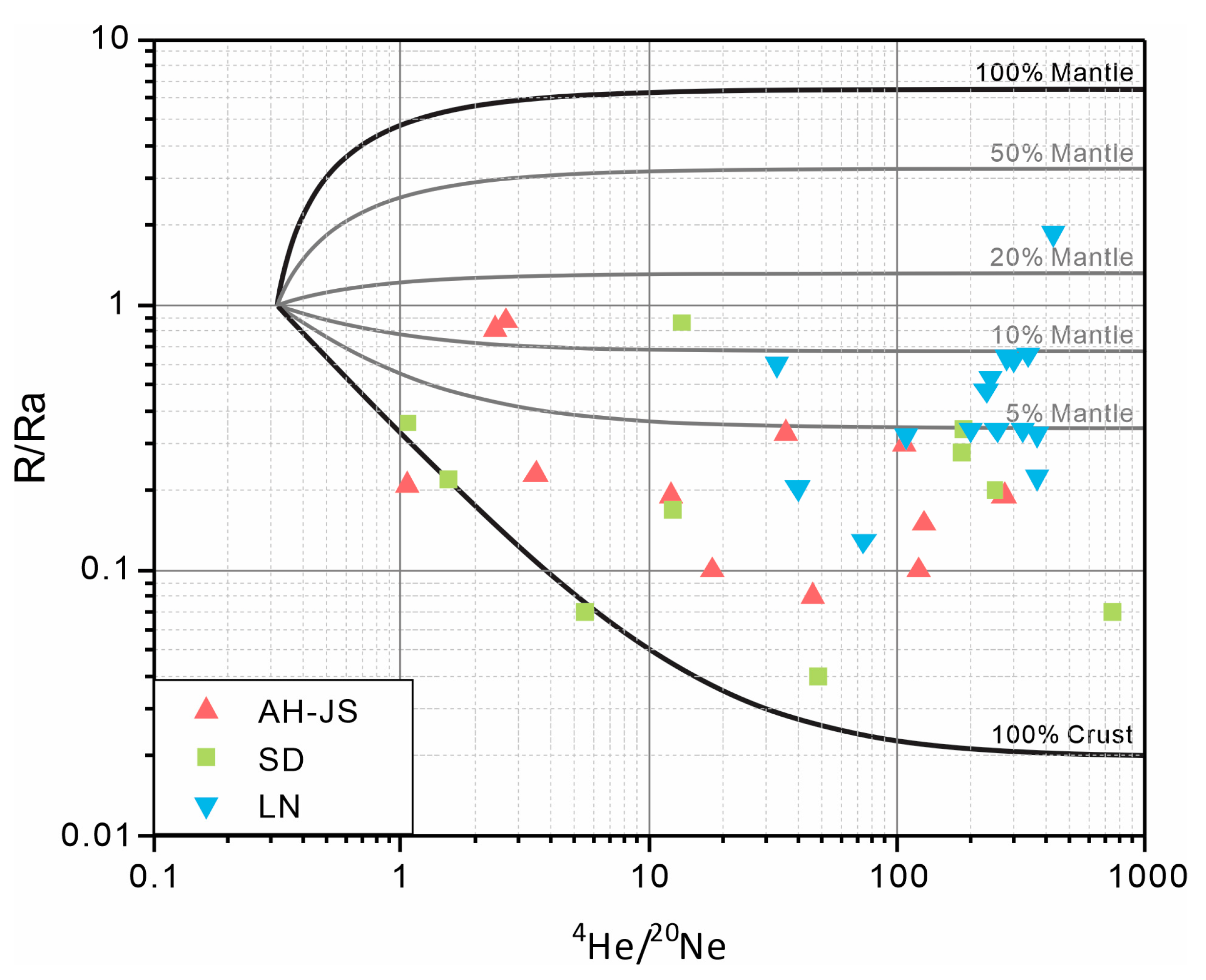
Helium isotopic compositions of dissolved-gas and free-gas samples from the TLFZ and inferred crustal–mantle mixing relationships. AH–JS (Anhui–Jiangsu), SD (Shandong), LN (Liaoning).
Figure 3.
Fault-parallel variation in estimated mantle-derived He contribution along the Tan–Lu Fault Zone, with 90% confidence intervals. AH–JS (Anhui–Jiangsu), SD (Shandong), LN (Liaoning).
In the Anhui–Jiangsu segment (ca. 200–620 km), mantle He contribution is generally moderate to moderately high, with values ranging from 0.93% to 14.59% and a median of 3.11%. A laterally persistent high-value zone occurs between approximately 300 and 400 km, where the fitted trend remains relatively stable at around 7.0–8.0%. Compared with other segments, this interval is characterized by a relatively continuous elevated background and comparatively limited along-strike fluctuation.
In the available Shandong dataset (ca. 620–1000 km), mantle He contribution is generally lower than in the Liaoning segment, ranging from 0.31% to 13.22%, with a median of 3.78%. Most observations are below the overall median of 4.4%, and only a limited number of sites yield relatively high values. The fitted trend remains subdued across the 700–800 km interval and does not define a laterally continuous deep high-value zone.
In the Liaoning segment (ca. 1200–1600 km), mantle He contribution ranges from 1.69% to 28.57%, with a median of 4.95%. The highest value across the entire fault zone (28.57%) occurs at 1274 km. Farther north, the fitted trend decreases rapidly and then rises again within the 1400–1480 km interval, where most samples fall between 7.05% and 9.79%. Relative to the Anhui–Jiangsu segment, elevated He values in Liaoning are more spatially concentrated and show stronger along-strike variability.
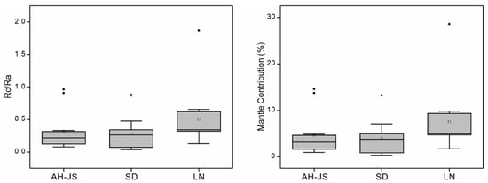
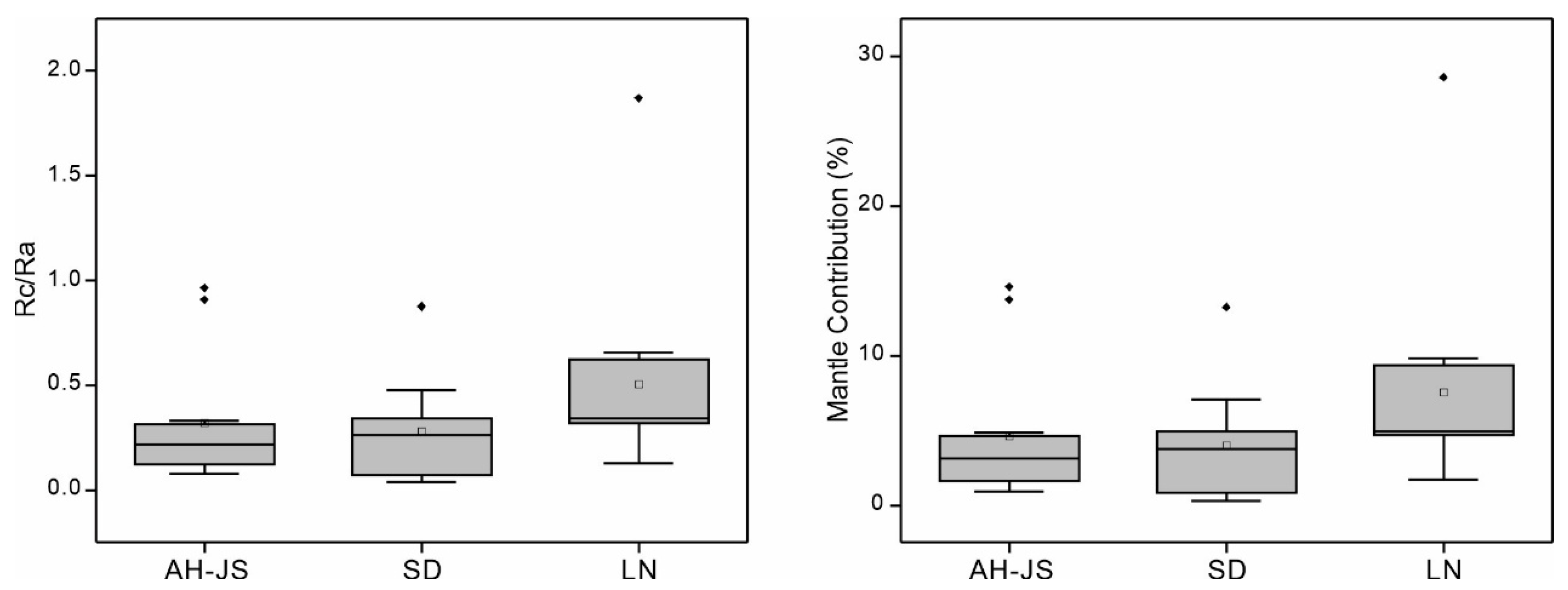
The zonal statistics are broadly consistent with the fitted along-strike trends (Figure 4). High-value points are most concentrated in the Liaoning segment, which also exhibits the highest upper bound. The Anhui–Jiangsu segment displays an overall intermediate to moderately elevated level but with substantial internal variability, whereas the Shandong segment is characterized by both a relatively low median and a narrower amplitude of variation. Taken together, the He data define an overall along-strike pattern in which mantle-derived He signatures are strongest in Liaoning, intermediate and relatively sustained in Anhui–Jiangsu, and generally subdued in the available Shandong dataset. Elevated values occur as both laterally persistent high-value intervals and localized peaks rather than as a single continuous belt along the fault zone.
Figure 4.
Segment-scale statistical distributions of corrected Rc/Ra values and estimated mantle-derived He contributions along the TLFZ. AH–JS (Anhui–Jiangsu), SD (Shandong), LN (Liaoning). Boxes indicate the 25th–75th percentiles, center lines indicate the medians, and open squares indicate the means. Whiskers extend to the most extreme observations within 1.5 × the interquartile range (IQR) from the lower and upper quartiles, and black diamonds indicate observations beyond the whiskers.
4.2. Along-Strike Segmentation of Soil-Gas Anomalies
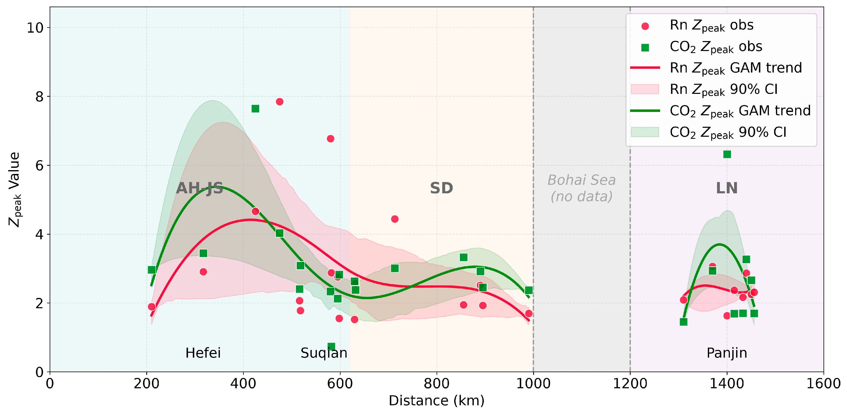
The peak significance of soil-gas CO2 and Rn also varies systematically along strike, although the positions, continuity, and amplitudes of elevated values differ between the two proxies (Figure 5 and Figure 6). At the fault-zone scale, the Anhui–Jiangsu segment contains the most pronounced and laterally continuous soil-gas anomalies, the Liaoning segment is characterized mainly by localized anomalous responses, and the available Shandong transects show generally subdued to intermediate responses.
Figure 5.
Fault-parallel variation in standardized peak significance, Zpeak, for soil-gas CO2 and Rn along the TLFZ. AH–JS (Anhui–Jiangsu), SD (Shandong), LN (Liaoning).
Figure 6.
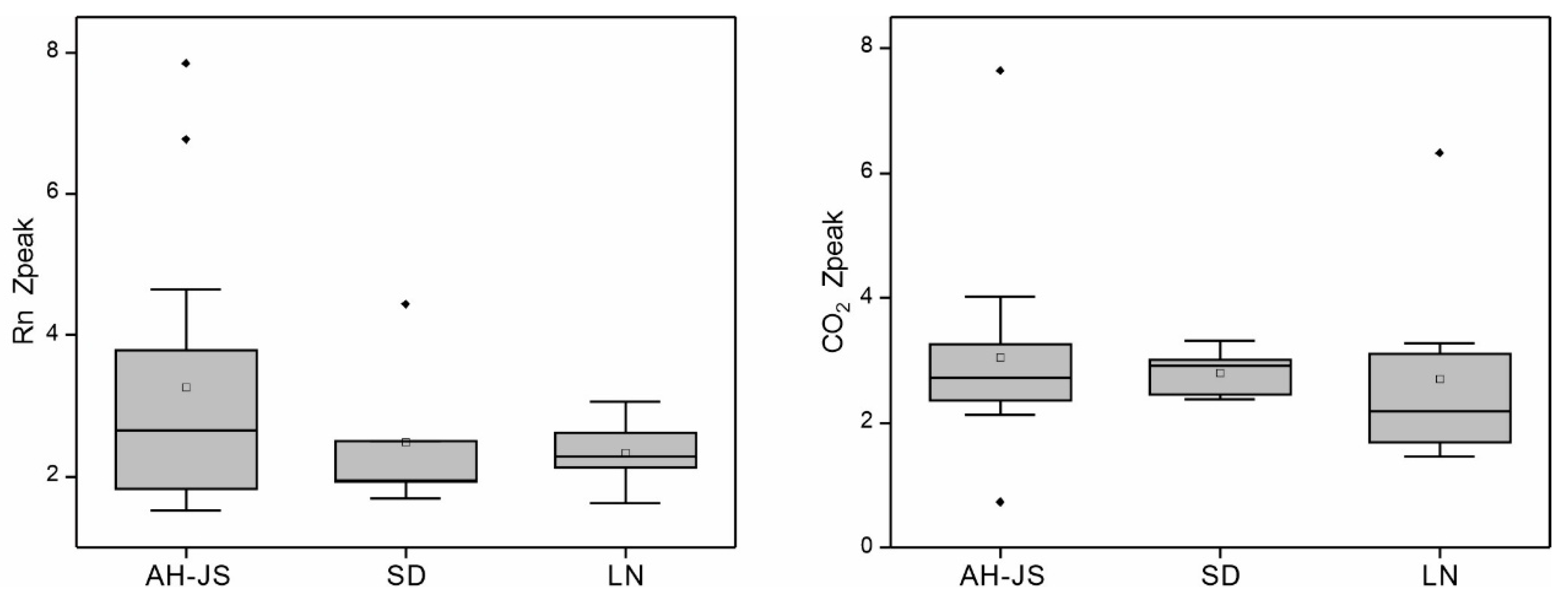
Segment-scale statistical distributions of standardized CO2 and Rn peak significance, Zpeak, along the TLFZ. AH–JS (Anhu–Jiangsu), SD (Shandong), LN (Liaoning). Boxes indicate the 25th–75th percentiles, center lines indicate the medians, and open squares indicate the means. Whiskers extend to the most extreme observations within 1.5 × the interquartile range (IQR) from the lower and upper quartiles, and black diamonds indicate observations beyond the whiskers.
For Rn, the amplitude of along-strike variation is relatively large. In the Anhui–Jiangsu segment, Zpeak(Rn) ranges from 1.55 to 7.85, with a median of 2.82. The highest value (7.85) occurs at 475 km, and another high value (6.77) occurs at 580 km. The fitted trend indicates overall elevated Rn values in the 300–500 km interval, followed by a progressive decline northward. In the Shandong segment, Zpeak(Rn) ranges from 1.70 to 4.44, with a median of 1.94. Most observations lie between 1.70 and 2.52, and only the site at 713 km reaches 4.44. In the Liaoning segment, Zpeak(Rn) ranges from 1.63 to 3.06, with a median of 2.28. Variation is comparatively limited, and only the site at 1370 km slightly exceeds 3.0.
For CO2, the along-strike amplitude is smaller than that of Rn, but the main elevated interval is likewise concentrated in the Anhui–Jiangsu segment. In this segment, Zpeak(CO2) ranges from 0.73 to 7.64, with a median of 2.89. The highest value along the entire TLFZ (7.64) occurs at 425 km, whereas values of 4.03 and 3.44 occur at 475 km and 317 km, respectively. The fitted trend shows a clear elevated interval between 300 and 400 km, followed by a gradual decrease northward. In the Shandong segment, Zpeak(CO2) ranges from 2.37 to 3.32, with a median of 2.63. The overall pattern is relatively stable, with only slight increases between 713 and 855 km. In the Liaoning segment, Zpeak(CO2) ranges from 1.45 to 6.32, with a median of 2.18. A distinct local high (6.32) occurs at 1400 km, whereas most other values fall between 1.45 and 3.27.
Considering the two soil-gas proxies together, the 300–450 km interval in the Anhui–Jiangsu segment is characterized by simultaneous elevation of CO2 and Rn, defining the most laterally continuous concentration zone of shallow anomalies along the entire fault zone. The available Shandong transects are dominated by low to intermediate values, with local increases in limited intervals. In contrast, the Liaoning segment is characterized mainly by localized CO2 highs and intermediate Rn levels. Overall, the soil-gas data define a pronounced but proxy-dependent along-strike segmentation pattern that only partly coincides with the helium-isotope pattern.
4.3. Composite Proxy-Association Types Along the Fault-Parallel Profile
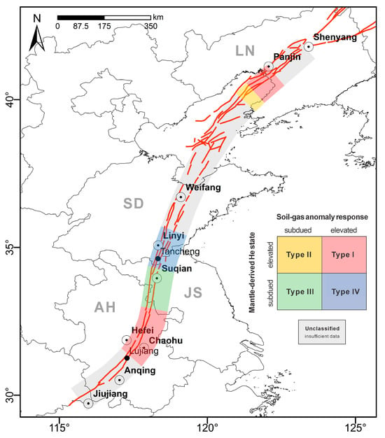
Within the unified fault-parallel coordinate framework, each fixed 50 km interval was assigned according to the classification criteria defined in Section 3.3. The resulting types represent combinations of the predicted mantle-derived He state and soil-gas anomaly response at the adopted regional comparison scale. Their spatial distribution is shown in Figure 7. The 250–450 km interval, corresponding approximately to the northern Lujiang area in the Anhui segment, is assigned to Type I because the predicted mantle-derived He contribution exceeds the median-based threshold of 4.4% and either the CO2 or Rn trend reaches the adopted anomaly threshold. It is the most laterally continuous Type I interval along the TLFZ.
Figure 7.
Fault-parallel distribution of proxy-association types derived from GAM-predicted values at the midpoints of fixed 50 km intervals. Type I: mantle-derived He contribution ≥ 4.4%, with Zpeak(CO2) ≥ 3 or Zpeak(Rn) ≥ 3; Type II: mantle-derived He contribution ≥ 4.4%, with both soil-gas Zpeak values < 3; Type III: mantle-derived He contribution < 4.4%, with Zpeak(CO2) ≥ 3 or Zpeak(Rn) ≥ 3; Type IV: mantle-derived He contribution < 4.4%, with both soil-gas Zpeak values < 3. Gray indicates no data or insufficient information for classification.
The 450–600 km interval, corresponding approximately to the Jiangsu segment, is assigned to Type III. The occurrence of Type III from 450 to 600 km reflects relatively elevated soil-gas responses under a subdued mantle-derived He state. Farther north, the 600–750 km interval is classified as Type IV, where both the He and soil-gas proxies remain at relatively low levels.
The proxy-association pattern for the 750–1000 km interval in the Shandong segment is less clearly resolved. Sparse site distribution and relatively high trend uncertainty in this interval result in limited stability of the 50 km proxy-association assignments. Considering both site distribution and fitted trends, this segment is characterized by low to intermediate He and Rn signals, with slight local CO2 increases but without a laterally persistent elevated proxy association. The 1000–1200 km interval corresponds to the Bohai data gap and is left unassigned.
In the southern Liaoning segment, the composite types are relatively clear in the 1300–1450 km interval. The 1300–1350 km interval is assigned to Type II, reflecting an elevated mantle-derived He state with a subdued soil-gas anomaly response. The 1350–1450 km interval is assigned to Type I, with the most pronounced CO2 increase near 1400 km and moderately elevated Rn values between approximately 1370 and 1450 km. Compared with the Anhui–Jiangsu segment, the elevated signals in this interval are more spatially concentrated and less laterally continuous.
Overall, the south-central part of the Anhui–Jiangsu segment is dominated by laterally continuous Type I intervals, followed successively by Type III and Type IV between 500 and 750 km. In contrast, the southern Liaoning segment is characterized by the adjacent occurrence of Type II and Type I intervals. The available Shandong data show subdued to intermediate proxy responses and no laterally persistent elevated proxy association. The along-strike alternation of different proxy-association types shows that fluid geochemical segmentation in the TLFZ involves both variations in the mantle-derived He state and intersegment differences in soil-gas anomaly response (Figure 7).
5. Discussion
5.1. Deep Controls on Volatile Supply and Fault-Zone Connectivity
Variation in mantle-derived He contribution along the TLFZ reflects spatial differences in the near-surface occurrence of deep-derived volatiles. The tectonic evolution of the fault zone is closely tied to lithospheric thinning beneath the eastern North China Craton, and the occurrence of mantle-derived volatiles in surface and near-surface samples requires both a deep volatile reservoir and effective release of those volatiles into crustal fluid systems [55]. Processes such as thermal weakening, asthenospheric upwelling, and localized partial melting may all promote volatile exsolution at depth and facilitate their entry into upward pathways [3].
Geophysical observations indicate that crust–mantle structure and thermal state vary markedly along the TLFZ. The Liaoning section differs from Anhui–Jiangsu in intracrustal velocity structure, Moho relief, and electrical anomalies [15,23,56]. The Shandong segment, especially the Yishu fault zone and adjacent Bohai Bay Basin, is characterized by a relatively high geothermal background, whereas the available He dataset does not show a laterally continuous mantle-derived He signature along this segment [57].
The relatively sustained mantle-derived He signature in the Anhui–Jiangsu segment is consistent with persistent expression of deep-derived components at the regional scale. This pattern may reflect the combined influence of principal and subsidiary fault strands, connected damage zones, and groundwater-mediated transport rather than a single continuous conduit. The localized He highs in Liaoning are compatible with more spatially focused connectivity at structurally favorable locations.
The subdued mantle-derived He signature in the available Shandong records may reflect lower deep volatile input, reduced pathway connectivity, groundwater dilution, local sealing, incomplete preservation during transport, or a combination of these processes. Their relative contributions cannot be separated using the available observations. The He distribution therefore constrains the near-surface expression of mantle-derived components but does not uniquely determine mantle volatile supply or subsurface conduit geometry.
5.2. Shallow Transport and Near-Surface Anomaly Development
Given the along-strike differences in deep-derived He signals, the development of near-surface anomalies depends largely on how efficiently fluids and gases are transferred through the fault zone. Fluid migration in major faults is commonly controlled by geometry, branch architecture, damage-zone width, fracture connectivity, and present-day activity [58,59,60]. Fault intersections, stepovers, bends, and other structurally complex sites are especially favorable for transient or focused permeability enhancement, whereas segments with more stable geometry and persistently open fracture networks are more likely to sustain broad zones of upward transfer [61,62]. Soil-gas anomalies, therefore, do not simply record deep supply; they also reflect the filtering effects of shallow permeability structure, carrier-gas migration, hydrological conditions, and near-surface modification [5,6].
At the regional comparison scale, the four proxy-association types describe contrasting relationships between the deep-derived He signal and the shallow soil-gas response. Type I represents coupled expression of relatively elevated mantle-derived He and soil-gas anomalies and is consistent with comparatively effective fluid transfer across multiple structural levels. Type II represents an elevated mantle-derived He signal with subdued shallow gas expression and is compatible with restricted, discontinuous, or locally sealed near-surface pathways. Type III represents an elevated soil-gas response without a corresponding elevation in mantle-derived He, indicating a greater contribution from shallow fracture-controlled transport, crustal gas sources, groundwater degassing, or near-surface processes. Type IV represents subdued expression of both proxy groups and may reflect weak deep-derived input, limited pathway connectivity, strong signal attenuation, or a combination of these factors. These interpretations describe tectono-fluid states but do not assign a unique mechanism to each interval.
The contrasting behavior of Rn and CO2 is particularly informative. Because of its short half-life, Rn responds rapidly to fracture openness and short-range transfer through shallow permeable pathways. CO2 follows a more complex pathway: it may rise rapidly through fault conduits, but it can also dissolve in groundwater, be re-released in the vadose zone, or migrate laterally within soils and shallow aquifers [25,51]. As a result, similar deep input may produce very different surface anomaly patterns depending on whether the shallow system favors focused ascent, broad leakage, or strong hydrological overprinting.
From a hydrogeological perspective, the TLFZ may function as a heterogeneous conduit and barrier system. Fault cores containing gouge or mineral sealing may locally restrict groundwater flow, whereas damage zones, subsidiary faults, and connected fractures may enhance fluid circulation. Groundwater can also transport, dilute, and redistribute geochemical signals. Consequently, the location of an anomaly observed near the surface may differ from the location where deep-derived fluids enter the groundwater system.
The laterally persistent soil-gas response in the Anhui–Jiangsu segment is compatible with a broadly connected shallow fault-zone network capable of sustaining diffuse leakage. Its spatial overlap with the relatively elevated mantle-derived He trend is consistent with transfer across several structural levels, although the available proxies do not resolve a single continuous migration pathway. Previous work has suggested that the modern stress field in Anhui shows a segmented pattern of “compression in the north and extension in the south”, with local transfer zones and extensional settings favoring sustained fracture openness [63]. This tectonic setting is consistent with the sustained co-occurrence of enhanced mantle-derived He signatures and soil-gas anomalies observed in this section. Taken together, these observations are consistent with a composite conduit system involving the main fault, subsidiary fractures, and multiscale permeable pathways.
Liaoning shows a more focused style of fluid transfer. Such a configuration would allow deep-derived fluids to reach the shallow crust only at structurally favorable sites. The Haicheng–Yingkou area lies within an important structural transfer zone in the northern TLFZ, where fault bends, branch convergence, and superposed active-fault structures are particularly well developed [64]. CO2 highs are more conspicuous than Rn highs, suggesting spatially focused discharge rather than a laterally continuous shallow response. The localized He and CO2 increases are compatible with fluid transfer at structurally favorable sites, although local groundwater circulation and the spatial distribution of observations may also influence the pattern [49,65,66].
The available Shandong data show a generally subdued fluid geochemical response. This attenuation may be related to stress-controlled permeability reduction or local sealing. Focal mechanism and apparent-stress studies indicate that high stress is concentrated in the Anqiu and Tancheng–Juxian subsections, and that some local intervals may currently be locked [67]. In situ stress studies across the Sulu–Shandong boundary further suggest vertical stratification between shallow and deep stress fields, but not conditions close to fault instability [68]. Together, these features may contribute to reduced pathway continuity. An additional possibility in the Shandong–Bohai Basin sector is lateral redistribution of dissolved or free gases along permeable sedimentary horizons or fault-connected aquifers, potentially including an along-strike component. Such redistribution could partly decouple the regional thermal background from the mantle-derived He signal recorded at individual sampling sites. This possibility remains hypothetical because the compiled dataset contains no hydraulic-head, aquifer-connectivity, or tracer information with which to evaluate the direction or distance of fluid migration.
The weak Rn response combined with local CO2 enhancement is compatible with slow leakage, groundwater degassing, or spatially isolated pathways rather than a broadly distributed rapid transport network. This proxy mismatch indicates a heterogeneous shallow response but does not uniquely define the connectivity of the subsurface fault system.
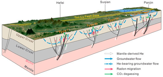
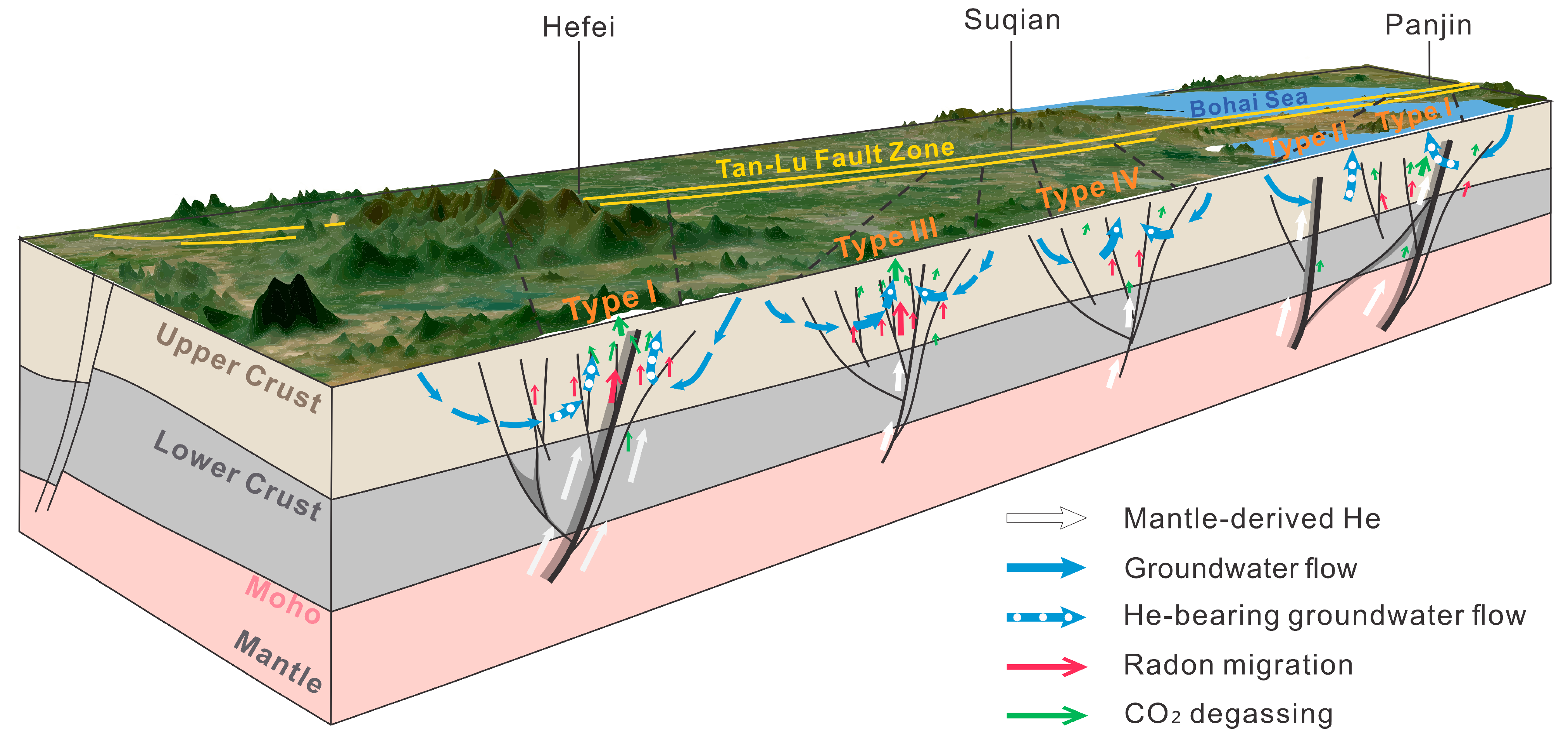
Overall, the tracer mismatches indicate differential filtering within a multi-level fault-zone fluid system: He mainly reflects the preserved deep component, Rn responds to rapid shallow transport, and CO2 is more strongly modified by groundwater and near-surface processes. These multi-level filtering processes and their along-strike variations are summarized schematically in Figure 8.
Figure 8.
Conceptual model illustrating multi-level tectono-fluid filtering along the TLFZ, from deep volatile input to crustal transfer and near-surface gas anomaly development.
5.3. Spatial Correspondence with Instrumental Seismicity
Fault-zone fluids can influence fault slip through changes in pore-fluid pressure, effective normal stress, frictional strength, and permeability evolution [7,69,70].
Near-surface geochemical observations and earthquake catalogs, however, represent processes operating over different spatial and temporal scales. The following analysis evaluates the spatial correspondence between proxy-association types and multi-decadal instrumental seismicity along the TLFZ.
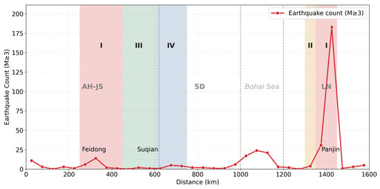
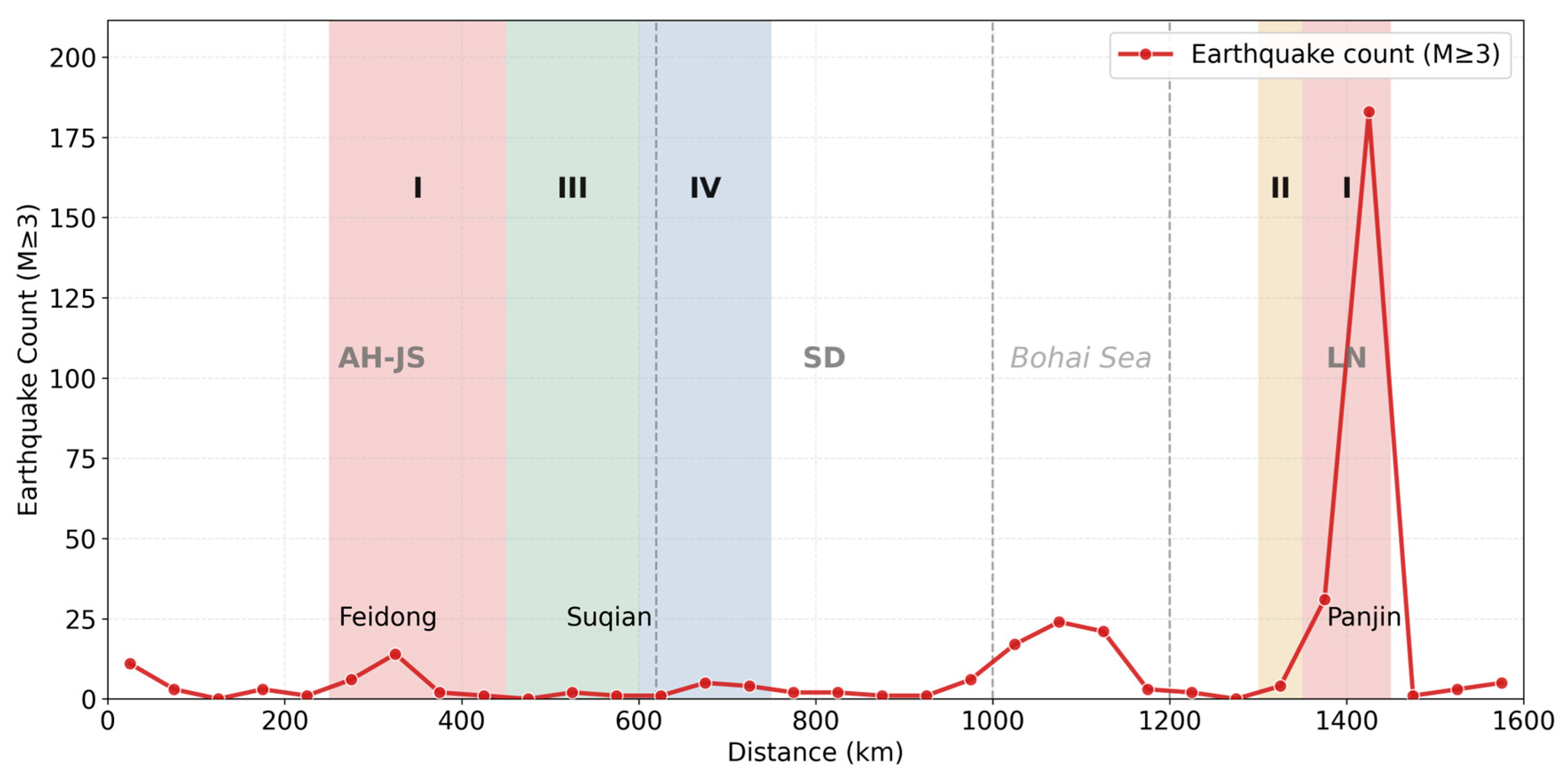
Earthquake origin times, epicentral coordinates, and magnitudes were obtained from the earthquake catalog maintained by the China Earthquake Networks Center (CENC) [71]. Instrumentally recorded earthquakes with magnitude M ≥ 3 between 1970 and 2025 and epicenters located within 50 km of the principal TLFZ trace were projected onto the same reference fault trace used for the geochemical observations. Events were counted within fixed 50 km intervals. The resulting catalog contains 360 earthquakes, whose fault-parallel distribution is shown in Figure 9.
Figure 9.
Fault-parallel distribution of instrumentally recorded earthquakes with magnitude M ≥ 3 within 50 km of the principal Tan–Lu Fault Zone trace during 1970–2025. Earthquakes were counted within fixed 50 km intervals using the CENC earthquake catalog.
Earthquakes are strongly concentrated in southern Liaoning. The 1400–1450 km interval contains 183 events, accounting for 50.8% of the catalog, whereas the broader 1350–1450 km interval contains 214 events, accounting for 59.4%. By comparison, the laterally continuous Type I interval between 250 and 450 km in Anhui–Jiangsu contains 23 events, accounting for 6.4%. The strongest seismic concentration occurs near the transition from Type II to a localized Type I interval in southern Liaoning. The 1300–1350 km interval is characterized by a relatively elevated mantle-derived He state and a subdued soil-gas anomaly response, whereas both proxy states are elevated within the 1350–1450 km interval.
Type II represents a relatively elevated mantle-derived He state without a corresponding elevation in the soil-gas anomaly response. This association is compatible with restricted shallow gas expression caused by discontinuous migration pathways, local sealing, groundwater buffering, or sedimentary and structural barriers [5,6].
These conditions share some characteristics with conceptual fault-valve systems, in which sealing, pore-pressure increase, permeability enhancement, and fluid release alternate through time [7,70]. The static spatial observations characterize this proxy association but do not resolve the temporal evolution of pore pressure and permeability.
The adjacent localized Type I interval in southern Liaoning may reflect focused shallow discharge through structurally favorable sites. Fault bends, branch intersections, and transfer structures in the Haicheng–Yingkou area provide plausible structural settings for localized fluid transfer [51,61]. The transition from Type II to localized Type I may therefore represent a spatial change from restricted shallow expression to focused discharge, or the juxtaposition of neighboring pathways with contrasting hydraulic properties. The concentration of earthquakes near this transition highlights a segment where strong structural and hydrological heterogeneity coincides with variable fluid expression and elevated seismic activity.
The continuous Type I interval in Anhui–Jiangsu provides a contrasting pattern. Its laterally persistent co-occurrence of elevated mantle-derived He and soil-gas responses is compatible with sustained fluid leakage through a comparatively open and connected fault–fracture network. Continued fluid release through such pathways may promote pressure dissipation and reduce prolonged local pore-pressure accumulation. This process may partly contribute to the absence of an earthquake concentration comparable to that in southern Liaoning. Regional stress conditions, fault geometry, structural maturity, loading history, and earthquake-catalog characteristics may also contribute to the contrasting seismic distributions.
Overall, the contrast between southern Liaoning and Anhui–Jiangsu indicates that relatively elevated geochemical states can occur under different structural, hydrological, and seismic conditions. Southern Liaoning is a priority segment for coordinated monitoring of He isotopes, CO2, Rn, groundwater chemistry, microseismicity, and crustal deformation. Synchronized observations would provide a basis for evaluating temporal relationships among fluid migration, shallow gas release, deformation, and seismic activity.
5.4. Limitations of the Study
This study provides a fault-zone-scale comparison of source-sensitive and response-sensitive geochemical signals along the TLFZ. Several limitations should be considered when interpreting the results.
First, the helium-isotope data are derived mainly from dissolved- and free-gas samples and represent integrated signals of deep-fluid contribution as preserved in near-surface fluid systems. By contrast, soil-gas CO2 and Rn were measured along cross-fault transects and are more sensitive to sampling time, shallow transport conditions, and near-surface environmental variability. Their spatial correspondence therefore compares proxies that integrate different components and timescales of the fault-zone fluid system.
Second, the sample media and spatial coverage are uneven among structural segments. The Shandong segment is dominated by dissolved-gas samples, whereas the Anhui–Jiangsu and Liaoning segments are dominated by free-gas samples. The source studies also differ in sampling period, analytical procedure, and local environmental conditions. Proxy-specific correction and standardization improve regional comparability but do not remove all inter-study differences. Data coverage remains limited in Shandong and the Bohai section, reducing the stability of intersegment comparisons and the spatial resolution of individual segment boundaries.
Third, the one-dimensional fault-parallel coordinate preserves the regional along-strike position of the observations but simplifies cross-fault distance and the detailed geometry of subsidiary fault branches. Likewise, the fixed 50 km intervals represent regional patterns rather than site-scale fluid behavior. The proxy-association types are therefore regional summaries of spatial agreement and mismatch rather than fixed natural boundaries or uniquely resolved physical regimes.
The seismicity comparison is based on catalog event counts within fixed intervals. Spatial clustering within earthquake sequences, uncertainty in catalog completeness over the 1970–2025 period, and the limited number of independent transitions among proxy-association types constrain formal evaluation of statistical association. The observed correspondence therefore characterizes regional spatial contrasts between geochemical states and instrumental seismicity.
Future work should emphasize standardized and synchronous multi-proxy observations in key segments. Coordinated measurements of He isotopes, CO2, Rn, carbon isotopes, groundwater chemistry, crustal deformation, and microseismicity would help distinguish deep-fluid input, carrier-gas transport, groundwater redistribution, and near-surface modification. Integration with crustal structure, heat flow, and stress-field information at higher spatial resolution would further constrain the controls on along-strike segmentation. Long-term monitoring in southern Liaoning and southern Anhui would also help evaluate temporal relationships among fluid migration, shallow gas release, crustal deformation, and seismic activity.
6. Conclusions
Using published helium isotope, cross-fault soil-gas CO2, and Rn datasets projected onto a unified fault-parallel coordinate framework, this study evaluates fluid geochemical variability along the full length of the Tan–Lu Fault Zone and draws the following conclusions.
- (1)
- Fluid geochemical signatures along the TLFZ show strong along-strike segmentation. However, the positions, continuity, and amplitudes of anomalous values differ among tracers, showing that each proxy records a different part of the fault-zone fluid system.
- (2)
- Helium isotopes define an overall pattern in the near-surface expression of mantle-derived He. The signature is strongest and spatially focused in Liaoning, intermediate but relatively sustained in Anhui–Jiangsu, and generally subdued in the available Shandong records. This distribution is consistent with the combined influence of deep volatile availability, crustal pathway connectivity, groundwater modification, and preservation of the He signal during transport.
- (3)
- Soil-gas CO2 and Rn primarily record soil-gas response within the fault-zone system and are shaped by permeability structure, gas migration, hydrological conditions, and near-surface modification. The most persistent anomaly belt occurs in Anhui–Jiangsu; Liaoning is dominated by focused anomalies, and the available Shandong transects show generally subdued to intermediate responses.
- (4)
- The four proxy-association types summarize contrasting relationships between the predicted mantle-derived He state and the shallow soil-gas response at the adopted 50 km scale. Type I represents coupled deep and shallow expression, Type II represents elevated mantle-derived He with restricted shallow expression, Type III represents shallow anomaly development without a corresponding elevation in mantle-derived He, and Type IV represents generally subdued expression of both proxy groups. These types describe regional proxy associations rather than uniquely resolved physical regimes.
- (5)
- Fluid geochemical segmentation along the TLFZ is consistent with the combined effects of source variability, fault-zone connectivity, groundwater circulation, gas migration, and near-surface modification. Deep volatile supply alone cannot account for the contrasting spatial patterns of He, CO2, and Rn.
Together, these results provide a regional framework for comparing tectono-fluid behavior among structurally distinct segments of a lithosphere-scale continental fault system.
Author Contributions
Conceptualization, Z.W. and T.H.; methodology, Z.W. and T.H.; writing—review and editing, X.W., F.Z., Z.L., W.H., P.Z., J.T. and Z.C.; funding acquisition, T.H. and X.W. All authors have read and agreed to the published version of the manuscript.
Funding
This study was supported by the National Science and Technology Major Project (2024ZD1000404), the Natural Science Foundation of Liaoning Province (2025JH4/480000008), and the Research Program of the Institute of Geology and Geophysics of the Chinese Academy of Sciences (IGGCAS-202204).
Data Availability Statement
The original data presented in the study are openly available in the Digital Journal of Global Change Data Repository at https://doi.org/10.3974/geodb.2026.03.06.V1 under the reference Wang and Huang (2026) [30].
Acknowledgments
During the preparation of this manuscript, the authors used DeepL Translator for Windows (version 25.12.1), Grammarly for desktop (version 1.146.0.0), and ChatGPT (GPT-5) for the purposes of grammar correction and language polishing. The authors have reviewed and edited the output and take full responsibility for the content of this publication.
Conflicts of Interest
The authors declare that they have no known competing financial interests or personal relationships that could have appeared to influence the work reported in this paper.
References
- Marty, B. The Origins and Concentrations of Water, Carbon, Nitrogen and Noble Gases on Earth. Earth Planet. Sci. Lett. 2012, 313–314, 56–66. [Google Scholar] [CrossRef] [Scilit]
- Chiodini, G.; Cardellini, C.; Di Luccio, F.; Selva, J.; Frondini, F.; Caliro, S.; Rosiello, A.; Beddini, G.; Ventura, G. Correlation between Tectonic CO2 Earth Degassing and Seismicity Is Revealed by a 10-Year Record in the Apennines, Italy. Sci. Adv. 2020, 6, eabc2938. [Google Scholar] [CrossRef] [Scilit] [PubMed]
- Kennedy, B.M.; Van Soest, M.C. Flow of Mantle Fluids through the Ductile Lower Crust: Helium Isotope Trends. Science 2007, 318, 1433–1436. [Google Scholar] [CrossRef] [Scilit] [PubMed]
- Tamburello, G.; Pondrelli, S.; Chiodini, G.; Rouwet, D. Global-Scale Control of Extensional Tectonics on CO2 Earth Degassing. Nat. Commun. 2018, 9, 4608. [Google Scholar] [CrossRef] [Scilit] [PubMed]
- Caine, J.S.; Evans, J.P.; Forster, C.B. Fault Zone Architecture and Permeability Structure. Geology 1996, 24, 1025. [Google Scholar] [CrossRef] [Scilit]
- Faulkner, D.R.; Jackson, C.A.L.; Lunn, R.J.; Schlische, R.W.; Shipton, Z.K.; Wibberley, C.A.J.; Withjack, M.O. A Review of Recent Developments Concerning the Structure, Mechanics and Fluid Flow Properties of Fault Zones. J. Struct. Geol. 2010, 32, 1557–1575. [Google Scholar] [CrossRef] [Scilit]
- Sibson, R.H. Implications of Fault-Valve Behaviour for Rupture Nucleation and Recurrence. Tectonophysics 1992, 211, 283–293. [Google Scholar] [CrossRef] [Scilit]
- Li, J.; Liu, Z.; Chen, Z.; Gao, Y.; Hao, Y.; Gu, H. The Role of Gas Emissions (He, Rn, and CO2) from Fault Zones in Understanding Fault and Seismic Activity. Front. Earth Sci. 2024, 12, 1488690. [Google Scholar] [CrossRef] [Scilit]
- Gasperini, L.; Polonia, A.; Del Bianco, F.; Etiope, G.; Marinaro, G.; Favali, P.; Italiano, F.; Çağatay, M.N. Gas Seepage and Seismogenic Structures along the North Anatolian Fault in the Eastern Sea of Marmara. Geochem. Geophys. Geosyst. 2012, 13, Q10018. [Google Scholar] [CrossRef] [Scilit]
- Wiersberg, T.; Erzinger, J. A Helium Isotope Cross-Section Study through the San Andreas Fault at Seismogenic Depths. Geochem. Geophys. Geosyst. 2007, 8, Q01002. [Google Scholar] [CrossRef] [Scilit]
- Aydin, H.; Karakuş, H.; Mutlu, H.; Güleç, N. Helium and Carbon Isotope Compositions of Thermal Fluids in the Northeastern Anatolia: Implications for the Heat Source and Volatile Flux. Chem. Geol. 2024, 668, 122349. [Google Scholar] [CrossRef] [Scilit]
- Wang, Y.; Zhou, X.; Tian, J.; Zhou, J.; He, M.; Li, J.; Dong, J.; Yan, Y.; Liu, F.; Yao, B.; et al. Volatile Characteristics and Fluxes of He-CO2 Systematics in the Southeastern Tibetan Plateau: Constraints on Regional Seismic Activities. J. Hydrol. 2023, 617, 129042. [Google Scholar] [CrossRef] [Scilit]
- Zhu, G.; Wang, Y.; Liu, G.; Niu, M.; Xie, C.; Li, C. 40Ar/39Ar Dating of Strike-Slip Motion on the Tan-Lu Fault Zone, East China. J. Struct. Geol. 2005, 27, 1379–1398. [Google Scholar] [CrossRef] [Scilit]
- Kang, Y.; Shi, Y.; Anderson, J.L.; Yang, T.; Zhang, H. Mesozoic Tectono-Magmatic Evolution of the Tan-Lu Fault Zone and Its Relationship with the Destruction of the North China Craton. Int. Geol. Rev. 2024, 66, 2001–2030. [Google Scholar] [CrossRef] [Scilit]
- Liu, Q.; Lü, Z.; Lei, J. Seismic Mapping of the Central and Southern Segments of the Tan-Lu Fault Zone Using P-Wave Receiver Functions. Sci. Rep. 2024, 14, 22388. [Google Scholar] [CrossRef] [Scilit] [PubMed]
- Ye, G.; Liu, C.; Luo, X.; Jin, S.; Wei, W.; Dong, H.; Yin, Y. Dynamical Significance of the Tan-Lu Fault Zone in the Destruction of the North China Craton: The Evidence Provided by the Three-Dimensional Magnetotelluric Array Study. Tectonophysics 2021, 813, 228910. [Google Scholar] [CrossRef] [Scilit]
- Ma, C.; Lei, J.; Wei, D.; Zhao, D. High-Resolution Lithospheric Shear Velocity Structure of the Suqian Segment of the Tan-Lu Fault Zone from Ambient Noise Tomography. J. Geophys. Res. Solid Earth 2025, 130, e2024JB030717. [Google Scholar] [CrossRef] [Scilit]
- Ciotoli, G.; Lombardi, S.; Annunziatellis, A. Geostatistical Analysis of Soil Gas Data in a High Seismic Intermontane Basin: Fucino Plain, Central Italy. J. Geophys. Res. Solid Earth 2007, 112, B05407. [Google Scholar] [CrossRef] [Scilit]
- Toutain, J.-P.; Baubron, J.-C. Gas Geochemistry and Seismotectonics: A Review. Tectonophysics 1999, 304, 1–27. [Google Scholar] [CrossRef] [Scilit]
- Guan, L.; Liu, W.; Cao, C.; Zhang, M.; Xu, S.; Zheng, G.; Sano, Y. Source, Spatial Distribution, and Geological Significance of Helium in Fluids from the Tan-Lu Fault Zone. Geochimica 2023, 52, 570–581. [Google Scholar] [CrossRef]
- Hao, Y.; Wang, Y.; Kuang, X.; Pang, Z.; Li, Y.; Feng, Y.; Zhou, H.; Li, N.; Cheng, Y.; Li, L.; et al. Occurrence and Enrichment Mechanisms of Helium in Geothermal Systems in Continental China. Gondwana Res. 2025, 141, 289–309. [Google Scholar] [CrossRef] [Scilit]
- Hsiao, L.-Y.; Graham, S.A.; Tilander, N. Seismic Reflection Imaging of a Major Strike-Slip Fault Zone in a Rift System: Paleogene Structure and Evolution of the Tan-Lu Fault System, Liaodong Bay, Bohai, Offshore China. AAPG Bull. 2004, 88, 71–97. [Google Scholar] [CrossRef] [Scilit]
- Lü, Z.; Lei, J. Seismic Evidence for Crustal Modification across the Tan-Lu Fault Zone in Eastern China. Geophys. Res. Lett. 2022, 49, e2022GL099761. [Google Scholar] [CrossRef] [Scilit]
- Shangguan, Z.; Du, J.; Zang, W.; Wang, J.; Kong, L.; Gao, S. Modern Hot Spring Geochemistry at the Tan-Lu Fault and the Jiaoliao Block in Eastern China. Sci. China Ser. D Earth Sci. 1998, 41, 87–94. [Google Scholar] [CrossRef] [Scilit]
- Tao, S.; Liu, D. Geothermal Field Characteristics, Factors Controlling Hot Spring Formation, and Gas Composition in the Tan-Lu Fault Zone and Adjacent Areas. Nat. Gas Ind. 2000, 20, 42–47. (In Chinese) [Google Scholar] [CrossRef]
- Yu, T.; Zhu, Y.; Zhang, P.; Wang, X.; Shi, K.; Xu, Z. Characteristics of Jiangsu Segment of the Tan-Lu Fault Zone and Its Adjacent Areas Revealed by Multi-Source Remote Sensing. J. Geod. Geodyn. 2022, 42, 569–576. [Google Scholar] [CrossRef]
- Yu, F.; Koyi, H. Cenozoic Tectonic Model of the Bohai Bay Basin in China. Geol. Mag. 2016, 153, 866–886. [Google Scholar] [CrossRef] [Scilit]
- Zhang, L.; Luo, X.; Vasseur, G.; Yu, C.; Yang, W.; Lei, Y.; Song, C.; Yu, L.; Yan, J. Evaluation of Geological Factors in Characterizing Fault Connectivity during Hydrocarbon Migration: Application to the Bohai Bay Basin. Mar. Pet. Geol. 2011, 28, 1634–1647. [Google Scholar] [CrossRef] [Scilit]
- Zhou, W.; Zhao, C.; Chang, H. Effect of Intensity of Sedimentary Cover Deformation on Hydrocarbon Accumulation in Dongying Sag, Bohai Bay Basin, China. Sci. Rep. 2024, 14, 677. [Google Scholar] [CrossRef] [Scilit] [PubMed]
- Wang, Z.; Huang, T. Geochemical Dataset of Volatile Compositions in Soil Gas and Groundwater Dissolved or Free Gas along the Tan-Lu Fault Zone. Digit. J. Glob. Change Data Repos. 2026. [Google Scholar] [CrossRef] [Scilit]
- Fang, Z.; Huang, X.; Wang, X.; Yang, H.; Ni, H.; Zhang, B. The Post Seismic Effect of Far-Field Strong Earthquakes of Water Radon and Its Mechanism Analysis for L01 Well of Lujiang Geothermal Hot Spring. Acta Seismol. Sin. 2020, 42, 732–744. [Google Scholar] [CrossRef]
- Li, Z.; Zhang, J.; Li, F.; Hu, C.; Kang, P.; Xiao, B.; Hu, Z.; Cheng, L.; Zhou, L.; Lu, X. Distribution Characteristics and Genetic Analysis of Water-Soluble Helium in Geothermal Water from the Linyi Segment of the Tan-Lu Fault Zone. Geol. Rev. 2025, 71, 328–340. [Google Scholar] [CrossRef]
- Xu, G.; Xu, Z.; Gong, D.; Zhou, D.; Wu, C.; Luo, X.; Li, J. Relationship between Tan-Lu Fault and Hydrocarbon Accumulation in Liaozhong Sag, Bohai Bay, Eastern China. J. Earth Sci. 2014, 25, 324–336. [Google Scholar] [CrossRef] [Scilit]
- Zheng, H.; Fang, Z.; Zhou, X.; Li, J.; Sun, Y.; Li, L. Geochemical Characteristics of Soil Gas in the Anhui Segment of the Tan-Lu Fault Zone. Earthq. Res. China 2016, 32, 642–652. [Google Scholar]
- Zhang, Y.; Dai, B.; Zhou, X. Geochemical Characteristics of Soil Gas in the Jiangsu Segment of the Tan-Lu Fault Zone. J. Seismol. Res. 2016, 39, 444–449. [Google Scholar]
- Miao, A.; Zhang, Y.; Fang, Z.; Li, F.; Wang, W.; Gao, L. Characteristics of Soil Gas Radon Activity and CO2 Concentration in the Xinyi-Sihong Segment of the Tan-Lu Fault Zone. Earthquake 2019, 39, 48–57. (In Chinese) [Google Scholar]
- Liu, Y.; Wang, H.; Wang, J.; Zhou, X.; Sun, Y.; Chen, Z. Geochemical Characteristics of Soil Gas in the Shandong Segment of the Tan-Lu Fault Zone. Seismol. Geomagn. Obs. Res. 2016, 37, 63–69. [Google Scholar]
- Kang, P.; Du, X.; Tong, Y.; Zhang, Y.; Sun, C.; Zhang, J. Geochemical Characteristics of Soil Radon and Activity Analysis of the Linyi Segment of the Tan-Lu Fault Zone. China Earthq. Eng. J. 2025, 47, 1416–1424. [Google Scholar] [CrossRef]
- Wang, X.; Jia, X.; Yang, M. Geochemical Survey of Soil Gas along the Jinzhou Fault in Liaoning Province. Earthq. Res. China 2021, 37, 767–779. (In Chinese) [Google Scholar] [CrossRef]
- Ozima, M.; Podosek, F.A. Noble Gas Geochemistry; Cambridge University Press: Cambridge, UK, 2002. [Google Scholar]
- Ballentine, C.J.; Burnard, P.G. Production, Release and Transport of Noble Gases in the Continental Crust. Rev. Mineral. Geochem. 2002, 47, 481–538. [Google Scholar] [CrossRef] [Scilit]
- Sano, Y.; Nakamura, Y.; Wakita, H.; Notsu, K.; Kobayashi, Y. 3He/4He Ratio Anomalies Associated with the 1984 Western Nagano Earthquake: Possibly Induced by a Diapiric Magma. J. Geophys. Res. Solid Earth 1986, 91, 12291–12295. [Google Scholar] [CrossRef] [Scilit]
- Weiss, R.F. Solubility of Helium and Neon in Water and Seawater. J. Chem. Eng. Data 1971, 16, 235–241. [Google Scholar] [CrossRef] [Scilit]
- Zhang, W.; Du, J.; Zhou, X.; Wang, F. Mantle Volatiles in Spring Gases in the Basin and Range Province on the West of Beijing, China: Constraints from Helium and Carbon Isotopes. J. Volcanol. Geotherm. Res. 2016, 309, 45–52. [Google Scholar] [CrossRef] [Scilit]
- Newell, D.L.; Jessup, M.J.; Cottle, J.M.; Hilton, D.R.; Sharp, Z.D.; Fischer, T.P. Aqueous and Isotope Geochemistry of Mineral Springs along the Southern Margin of the Tibetan Plateau: Implications for Fluid Sources and Regional Degassing of CO2. Geochem. Geophys. Geosyst. 2008, 9, Q08014. [Google Scholar] [CrossRef] [Scilit]
- Sano, Y.; Fischer, T.P. The Analysis and Interpretation of Noble Gases in Modern Hydrothermal Systems. In The Noble Gases as Geochemical Tracers; Springer: New York, NY, USA, 2013; pp. 249–317. [Google Scholar]
- Defourny, A.; Blard, P.-H.; Zimmermann, L.; Jobé, P.; Collignon, A.; Nguyen, F.; Dassargues, A. δ13C Values, CO2/3He and 3He/4He Ratios Reveal the Presence of Mantle Gas in the CO2-Rich Groundwaters of the Ardennes Massif (Spa, Belgium). Hydrol. Earth Syst. Sci. 2022, 26, 2637–2648. [Google Scholar] [CrossRef] [Scilit]
- Dunai, T.J.; Baur, H. Helium, Neon, and Argon Systematics of the European Subcontinental Mantle: Implications for Its Geochemical Evolution. Geochim. Cosmochim. Acta 1995, 59, 2767–2783. [Google Scholar] [CrossRef] [Scilit]
- Etiope, G.; Martinelli, G. Migration of Carrier and Trace Gases in the Geosphere: An Overview. Phys. Earth Planet. Inter. 2002, 129, 185–204. [Google Scholar] [CrossRef] [Scilit]
- Ioannides, K.; Papachristodoulou, C.; Stamoulis, K.; Karamanis, D.; Pavlides, S.; Chatzipetros, A.; Karakala, E. Soil Gas Radon: A Tool for Exploring Active Fault Zones. Appl. Radiat. Isot. 2003, 59, 205–213. [Google Scholar] [CrossRef] [Scilit] [PubMed]
- Chen, Z.; Li, Y.; Liu, Z.; Wang, J.; Zhou, X.; Du, J. Radon Emission from Soil Gases in the Active Fault Zones in the Capital of China and Its Environmental Effects. Sci. Rep. 2018, 8, 16772. [Google Scholar] [CrossRef] [Scilit] [PubMed]
- Reimann, C.; Filzmoser, P.; Garrett, R.G. Background and Threshold: Critical Comparison of Methods of Determination. Sci. Total Environ. 2005, 346, 1–16. [Google Scholar] [CrossRef] [Scilit] [PubMed]
- Wood, S.N. Fast Stable Restricted Maximum Likelihood and Marginal Likelihood Estimation of Semiparametric Generalized Linear Models. J. R. Stat. Soc. B 2011, 73, 3–36. [Google Scholar] [CrossRef] [Scilit]
- Efron, B.; Tibshirani, R.J. An Introduction to the Bootstrap; Chapman and Hall/CRC: New York, NY, USA, 1994. [Google Scholar]
- Klemperer, S.L.; Kennedy, B.M.; Sastry, S.R.; Makovsky, Y.; Harinarayana, T.; Leech, M.L. Mantle Fluids in the Karakoram Fault: Helium Isotope Evidence. Earth Planet. Sci. Lett. 2013, 366, 59–70. [Google Scholar] [CrossRef] [Scilit]
- Zhang, T.; Lei, J.; Zhao, D. Receiver-Function Imaging of the Moho Discontinuity beneath the Tan-Lu Fault Zone and Its Tectonic Implications. Geophys. J. Int. 2025, 243, ggaf298. [Google Scholar] [CrossRef] [Scilit]
- Liao, Y.; Zhang, W.; Rong, Y.; Liu, F.; Wei, S.; Li, L.; Zhao, Z.; Li, M. A High Geothermal Setting in the Linyi Geothermal Field: Evidence from the Lithospheric Thermal Structure. Energy Explor. Exploit. 2023, 41, 1899–1918. [Google Scholar] [CrossRef] [Scilit]
- Jiang, R.; Cao, K.; Zeng, J.; Liu, K.; Li, C.; Wang, A.; Yu, J.; Peng, B.; Lao, J.; Zhao, L. Late Cenozoic Tectonic Evolution of the Southern Segment of the Tan-Lu Fault Zone. J. Asian Earth Sci. 2019, 182, 103932. [Google Scholar] [CrossRef] [Scilit]
- Wan, T.; Zhu, H.; Zhao, L.; Lin, J.; Cheng, J.; Chen, J. Formation and Evolution of the Tan-Lu Fault Zone: A Review. Geoscience 1996, 10, 159–168. [Google Scholar]
- Wang, D.; Hu, J.; Zhang, Z.; Yan, J.; Hu, Y. Kinematic History of the Tan-Lu Fault Zone Constrained by the Late Mesozoic–Cenozoic Tectono-Sedimentary Evolution of Basins in the Luxi Block, Eastern North China Craton. J. Asian Earth Sci. 2022, 225, 105041. [Google Scholar] [CrossRef] [Scilit]
- Tardani, D.; Reich, M.; Roulleau, E.; Takahata, N.; Sano, Y.; Pérez-Flores, P.; Sánchez-Alfaro, P.; Cembrano, J.; Arancibia, G. Exploring the Structural Controls on Helium, Nitrogen and Carbon Isotope Signatures in Hydrothermal Fluids along an Intra-Arc Fault System. Geochim. Cosmochim. Acta 2016, 184, 193–211. [Google Scholar] [CrossRef] [Scilit]
- Zhang, M.; Xu, S.; Sano, Y. Deep Carbon Recycling Viewed from Global Plate Tectonics. Natl. Sci. Rev. 2024, 11, nwae089. [Google Scholar] [CrossRef] [Scilit] [PubMed]
- Liu, D.; Xia, R.; Liu, Z.; Shen, X.; Li, M.; Yan, S. Characteristics of Recent Seismicity and Stress Field in the Anhui Segment of the Tan-Lu Fault Zone. Chin. J. Geol. 2006, 41, 278–290. [Google Scholar] [CrossRef]
- Liu, J.; Pei, S.; Guo, Y. High-Resolution Tomography of P-Wave Velocity Structures in the Haicheng Region: Implications for the Seismogenesis of the 1975 MS 7.3 Haicheng Earthquake. Earthq. Sci. 2025, 38, 590–600. [Google Scholar] [CrossRef] [Scilit]
- Bense, V.F.; Person, M.A. Faults as Conduit-Barrier Systems to Fluid Flow in Siliciclastic Sedimentary Aquifers. Water Resour. Res. 2006, 42, W05421. [Google Scholar] [CrossRef] [Scilit]
- Zhao, X.; Fritzel, T.L.B.; Quinodoz, H.a.M.; Bethke, C.M.; Torgersen, T. Controls on the Distribution and Isotopic Composition of Helium in Deep Ground-Water Flows. Geology 1998, 26, 291–294. [Google Scholar] [CrossRef] [Scilit]
- Wang, P.; Zheng, J.; Liu, X.; Xu, C.; Li, X. Research of Source Parameters and Stress State in Shandong Segment of the Tan-Lu Fault Zone. Seismol. Geol. 2015, 37, 966–981. [Google Scholar] [CrossRef]
- Qiu, J.; Wu, M.; Fan, T.-Y.; Zhang, C.; Wang, L. Stress Accumulation Characteristics and Seismic Hazard Study in the Junction of Jiangsu and Shandong Provinces of the Tan-Lu Fault Zone. Acta Geol. Sin. 2019, 93, 3249–3258. [Google Scholar]
- Hickman, S.; Sibson, R.; Bruhn, R. Introduction to Special Section: Mechanical Involvement of Fluids in Faulting. J. Geophys. Res. 1995, 100, 12831–12840. [Google Scholar] [CrossRef] [Scilit]
- Zhu, W.; Allison, K.L.; Dunham, E.M.; Yang, Y. Fault Valving and Pore Pressure Evolution in Simulations of Earthquake Sequences and Aseismic Slip. Nat. Commun. 2020, 11, 4833. [Google Scholar] [CrossRef] [Scilit] [PubMed]
- China Earthquake Networks Center (CENC). Unified Instrumental Earthquake Catalog of Mainland China (1970–2025) [Dataset]. China Earthquake Administration. Available online: https://data.earthquake.cn (accessed on 30 April 2026).

Disclaimer/Publisher’s Note: The statements, opinions and data contained in all publications are solely those of the individual author(s) and contributor(s) and not of MDPI and/or the editor(s). MDPI and/or the editor(s) disclaim responsibility for any injury to people or property resulting from any ideas, methods, instructions or products referred to in the content. |
© 2026 by the authors. Licensee MDPI, Basel, Switzerland. This article is an open access article distributed under the terms and conditions of the Creative Commons Attribution (CC BY) license.