Analysis of 220 Years of Floodplain Population Dynamics in the US at Different Spatial Scales


Abstract
1. Introduction
- (i)
- national level, in which long-term changes in floodplain population growth rate and proportion of floodplain population were evaluated for the contiguous US;
- (ii)
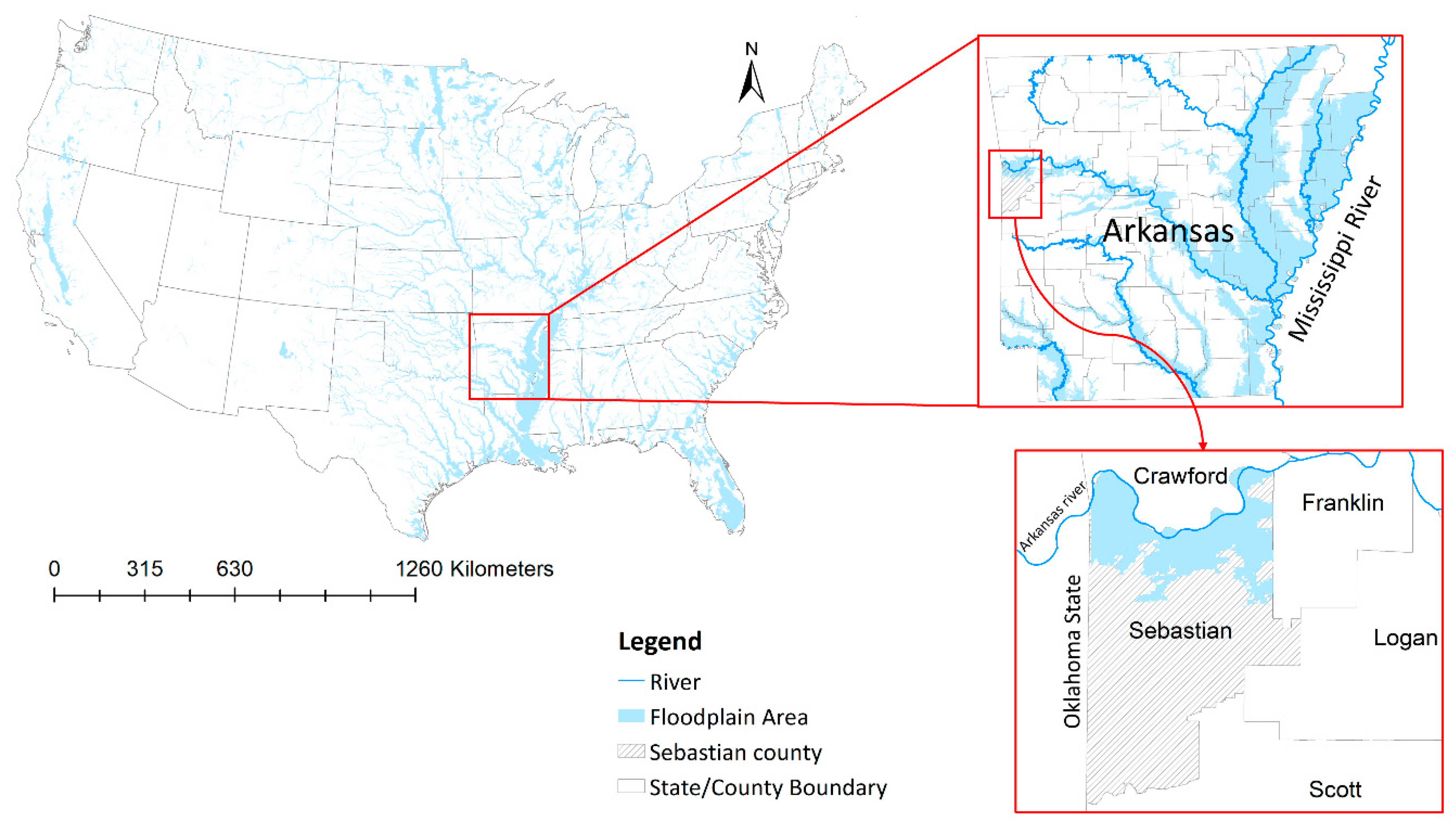
- state level, in which the relationship between floodplain population dynamics indicators and flood occurrence, flood damage, structural and nonstructural flood protection measures were evaluated for the state of Arkansas;
- (iii)
- county level, in which the relationships identified in the state-level analysis were further investigated for Sebastian county in Arkansas.
- (1)
- how do floodplain population dynamics change when the analysis is downscaled from national to state to county levels in the US, from 1790 to 2010?
- (2)
- What are the relationships between floodplain population dynamics and flood events, related damages, and flood protection measures in the selected study area?
2. Case Study and Data
3. Methods
3.1. National-Level Analysis
3.2. State-Level Analysis
3.3. County-Level Analysis
4. Results and Discussion
4.1. National-Level Analysis
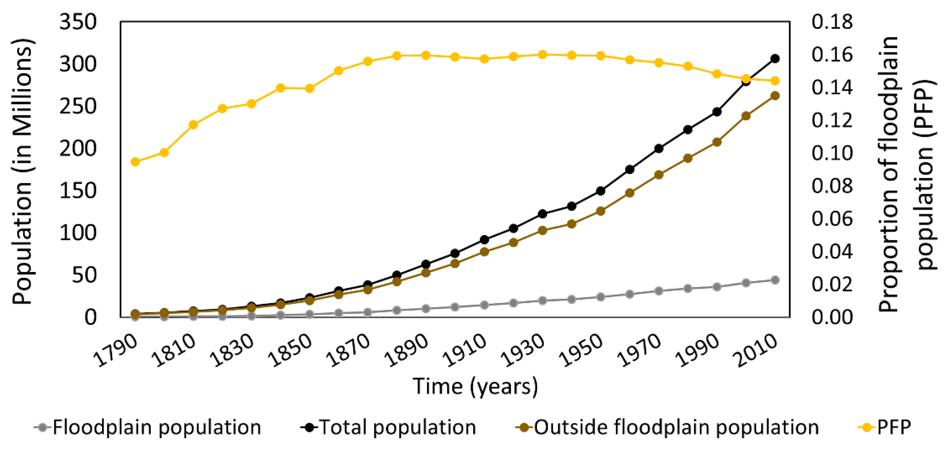
4.1.1. Floodplain Population Growth Rate
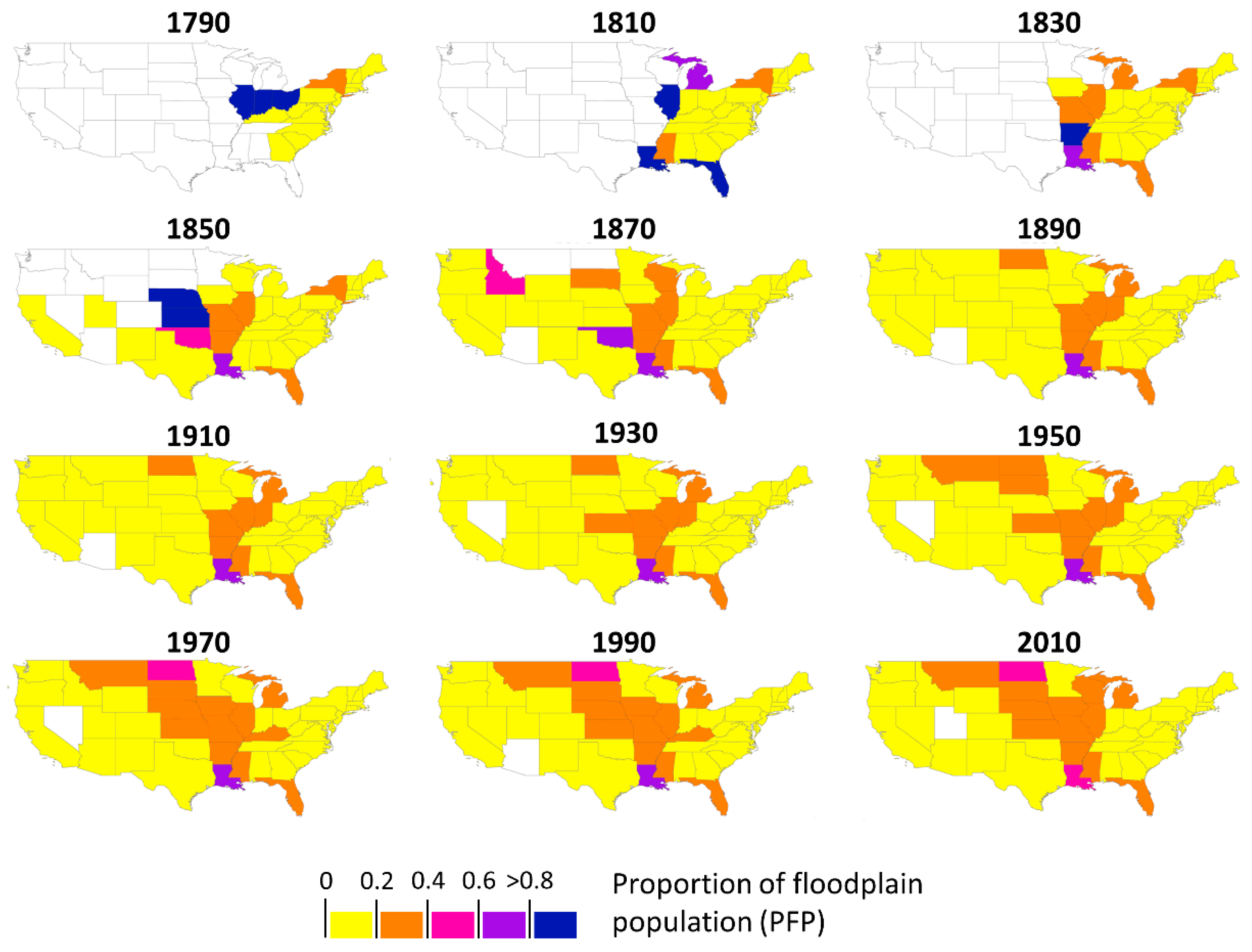
4.1.2. Spatio-Temporal Pattern of Growth Rate of Floodplain Population
4.2. State-Level Analysis
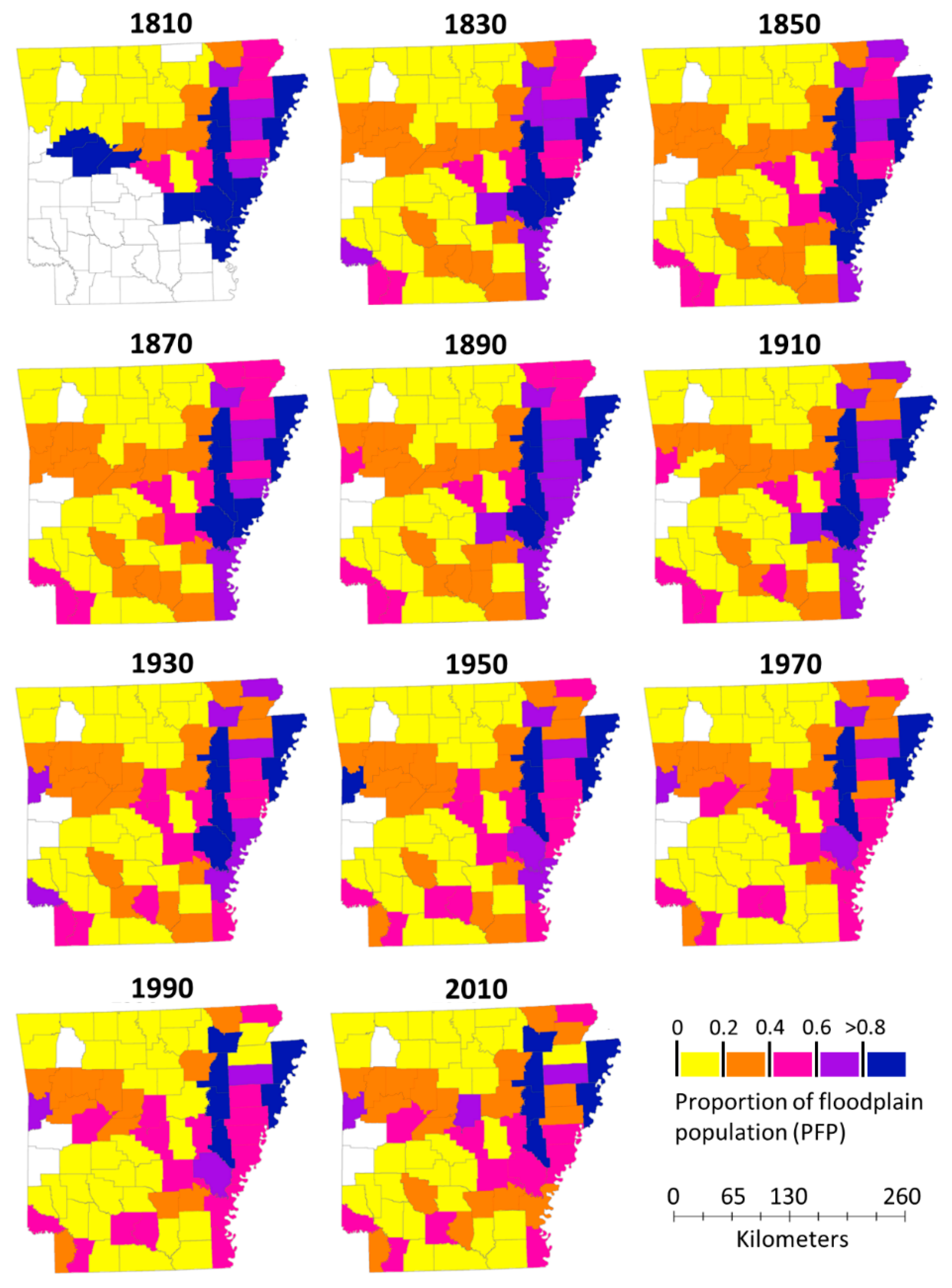
4.2.1. Spatio-Temporal Pattern of Floodplain Population Ratio
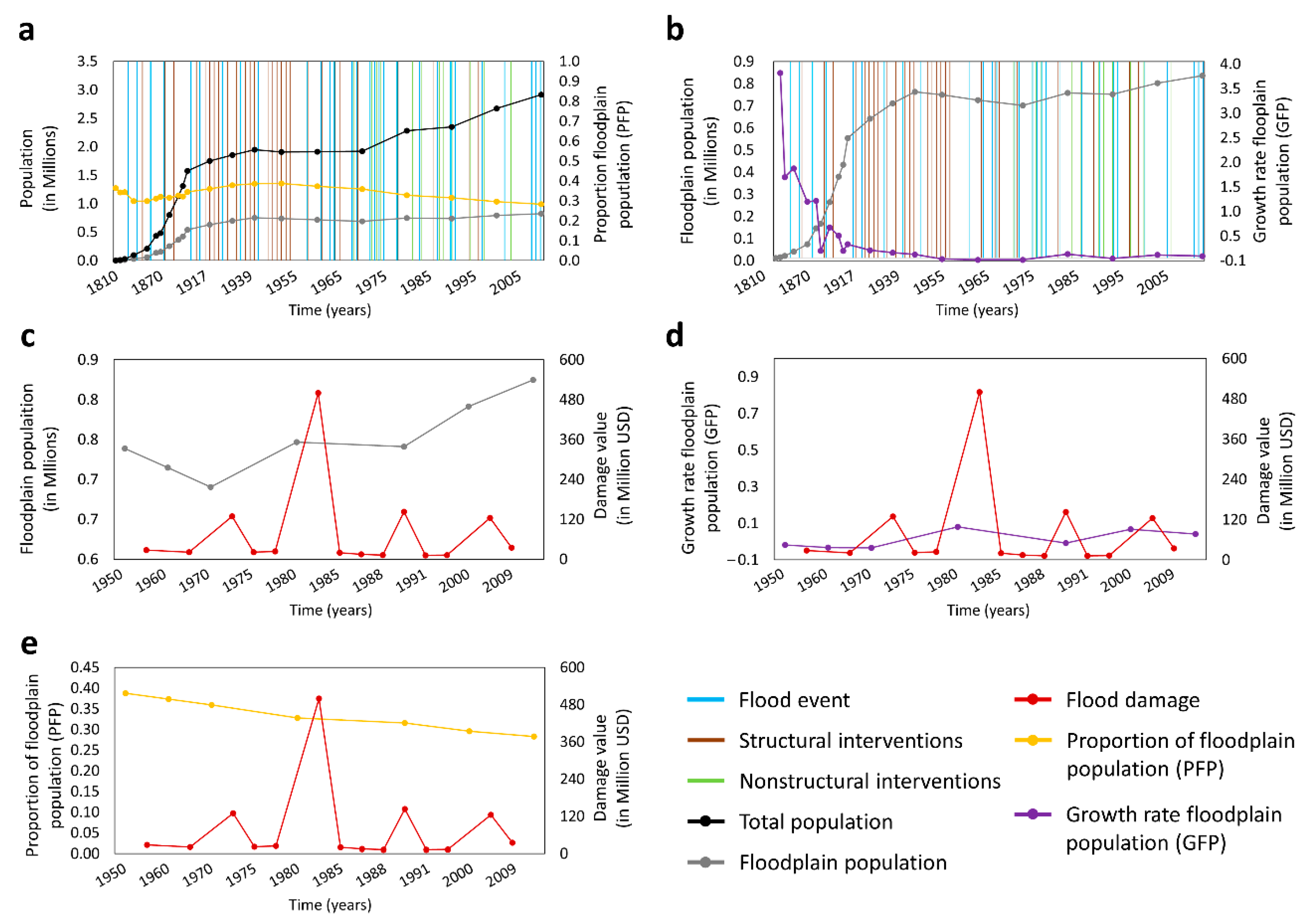
4.2.2. Temporal Analysis between Floodplain Population Dynamics and Flooding Adaptation Measures
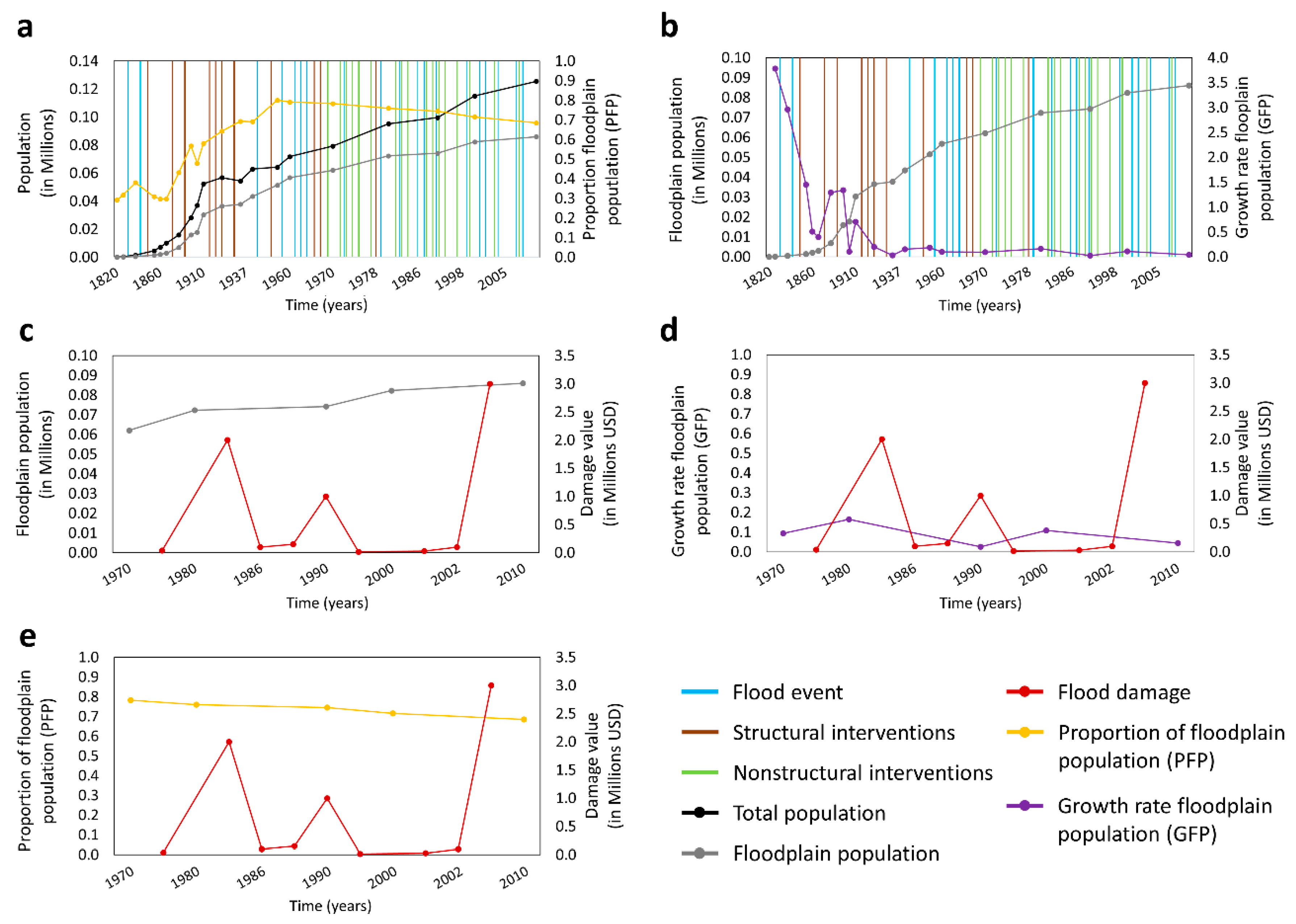
4.3. County-Level Analysis
4.4. Comparison between Spatial Scales
5. Conclusions
- (1)
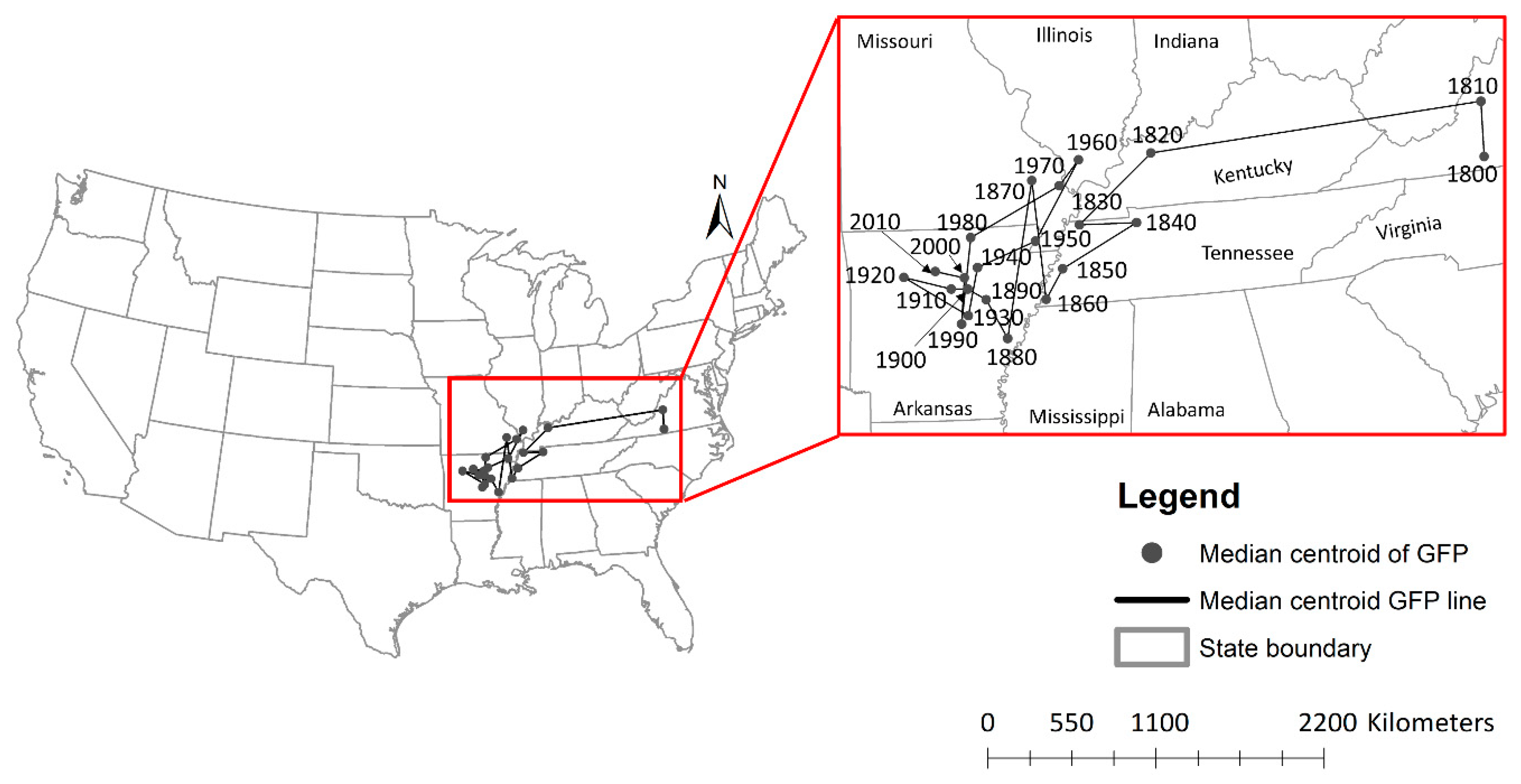
- Our long-term analysis shows that, at all spatial scales, populations settled down in floodplain areas when initially moving to a state or a county but moved outside floodplains over the years. As the floodplain population at the national scale homogenously spread within US territory, the centroid value of the GFP stabilized around the state of Arkansas and in the lower Mississippi river basin.
- (2)
- The analysis of time-series of flood occurrence, flood damage, floodplain population and mitigation measures show active dynamics of local (structural) and national (nonstructural) responses to flooding. Floodplain population dynamics changed over time, in Arkansas and in particular in Sebastian county, where intense mitigation measures took place.
- analyzing, at the national level, population dynamics of flooded and non-flooded areas, to look at how the occurrence of flood events might contribute to shaping population dynamics in different locations;
- increasing the number of local case studies, at state and county levels, to acquire a broader perspective of local dynamics and to draw more general conclusions on floodplain dynamics over time;
- analyzing, at the local scale, performance of mitigation measures (i.e., looking at levee failure and number of flood insurance over time) on floodplain population dynamics.
Supplementary Materials
Author Contributions
Funding
Institutional Review Board Statement
Informed Consent Statement
Data Availability Statement
Conflicts of Interest
References
- Di Baldassarre, G.; Brandimarte, L.; Montanari, A.; Lins, H.; Koutsoyiannis, D.; Brandimarte, L.; Blöschl, G. Flood fatalities in Africa: From diagnosis to mitigation. Geophys. Res. Lett. 2010, 37. [Google Scholar] [CrossRef]
- McGranahan, G.; Balk, D.; Anderson, B. The rising tide: Assessing the risks of climate change and human settlements in low elevation coastal zones. Environ. Urban. 2007, 19, 17–37. [Google Scholar] [CrossRef]
- Ohl, C.A. Flooding and human health. Br. Med. J. 2000, 321, 1167–1168. [Google Scholar] [CrossRef] [PubMed]
- Opperman, J.J.; Galloway, G.E.; Fargione, J.; Mount, J.F.; Richter, B.D.; Secchi, S. Sustainable Floodplains through Large-Scale Reconnection to Rivers. Science 2009, 326, 1487–1488. [Google Scholar] [CrossRef] [PubMed]
- Milly, P.C.; Wetherald, R.T.; Dunne, K.A.; Delworth, T.L. Increasing risk of great floods in a changing climate. Nat. Cell Biol. 2002, 415, 514–517. [Google Scholar] [CrossRef] [PubMed]
- Jongman, B.; Hochrainer-Stigler, S.; Feyen, L.; Aerts, J.C.J.H.; Mechler, R.; Botzen, W.J.W.; Bouwer, L.M.; Pflug, G.C.; Rojas, R.; Ward, P.J. Increasing stress on disaster-risk finance due to large floods. Nat. Clim. Chang. 2014, 4, 264–268. [Google Scholar] [CrossRef]
- Alfieri, L.; Feyen, L.; Di Baldassarre, G. Increasing flood risk under climate change: A pan-European assessment of the benefits of four adaptation strategies. Clim. Chang. 2016, 136, 507–521. [Google Scholar] [CrossRef]
- Mazzoleni, M.; Mård, J.; Rusca, M.; Odongo, V.; Lindersson, S.; Di Baldassarre, G. Floodplains in the Anthropocene: A global analysis of the interplay between human population, built environment and flood severity. Water Resour. Res. 2020. [Google Scholar] [CrossRef]
- Di Baldassarre, G.; Viglione, A.; Carr, G.; Kuil, L.; Yan, K.; Brandimarte, L.; Blöschl, G. Debates-Perspectives on socio-hydrology: Capturing feedbacks between physical and social processes. Water Resour. Res. 2015, 51, 4770–4781. [Google Scholar] [CrossRef]
- Mechler, R.; Bouwer, L.M. Understanding trends and projections of disaster losses and climate change: Is vulnerability the missing link? Clim. Chang. 2014, 133, 23–35. [Google Scholar] [CrossRef]
- Kreibich, H.; Vorogushyn, S.; Apel, H.; Chinh, D.T.; Gain, A.K.; Dung, N.V.; Schröter, K.; Merz, B.; Di Baldassarre, G.; Mård, J.; et al. Adaptation to Flood Risk: Results of International Paired Flood Event Studies. Earth’s Future 2017. [Google Scholar] [CrossRef]
- White, G.F. Human Adjustment to Floods: A Geographical Approach to the Flood Problem in the United States; Research Paper no. 29.; The University of Chicago: Chicago, IL, USA, 1945. [Google Scholar]
- Kates, R.W.; Colten, C.E.; Laska, S.; Leatherman, S.P. Reconstruction of New Orleans after Hurricane Katrina: A research perspective. Proc. Natl. Acad. Sci. USA 2006, 103, 14653–14660. [Google Scholar] [CrossRef] [PubMed]
- Montz, B.; Tobin, G.A. Livin’ Large with Levees: Lessons Learned and Lost. Nat. Hazards Rev. 2008, 9, 150–157. [Google Scholar] [CrossRef]
- Collenteur, R.; De Moel, H.; Jongman, B.; Di Baldassarre, G. The failed-levee effect: Do societies learn from flood disasters? Nat. Hazards 2014, 76, 373–388. [Google Scholar] [CrossRef]
- Ferdous, R.; Di Baldassarre, G.; Brandimarte, L.; Wesselink, A. The interplay between structural flood protection, population density, and flood mortality along the Jamuna River, Bangladesh. Reg. Environ. Chang. 2020, 20, 5. [Google Scholar] [CrossRef]
- Tobin, G.A. The levee love affair: A stormy relationship? J. Am. Water Resour. Assoc. 1995, 31, 359–367. [Google Scholar] [CrossRef]
- Di Baldassarre, G.; Saccà, S.; Aronica, G.T.; Grimaldi, S.; Ciullo, A.; Crisci, M. Human-flood interactions in Rome over the past 150 years. Adv. Geosci. 2017, 44, 9–13. [Google Scholar] [CrossRef]
- Ferdous, R.; Wesselink, A.; Brandimarte, L.; Di Baldassarre, G.; Rahman, M. The levee effect along the Jamuna River in Bangladesh. Water Int. 2019, 44, 496–519. [Google Scholar] [CrossRef]
- Xu, M.; He, C.; Liu, Z.; Dou, Y. How Did Urban Land Expand in China between 1992 and 2015? A Multi-Scale Landscape Analysis. PLoS ONE 2016, 11, e0154839. [Google Scholar] [CrossRef]
- Mård, J.; Di Baldassarre, G.; Mazzoleni, M. Nighttime light data reveal how flood protection shapes human proximity to rivers. Sci. Adv. 2018, 4, eaar5779. [Google Scholar] [CrossRef]
- Rossi, P.H.; Wright, J.D.; Wright, S.R.; Weber-Burdin, E. Are there long term effects of American natural disaster? Estimation of floods, hurricanes, and tornadoes occurring 1960 to 1970 on U.S. Census tracts in 1970. Mass Emergencies 1978, 3, 117–132. [Google Scholar]
- Schultz, J.; Elliott, J.R. Natural disasters and local demographic change in the United States. Popul. Environ. 2012, 34, 293–312. [Google Scholar] [CrossRef]
- Winsemius, H.C.; Aerts, J.C.J.H.; Van Beek, L.P.H.; Bierkens, M.F.P.; Bouwman, A.; Jongman, B.; Kwadijk, J.C.J.; Ligtvoet, W.; Lucas, P.L.; Van Vuuren, D.P.; et al. Global drivers of future river flood risk. Nat. Clim. Chang. 2016, 6, 381–385. [Google Scholar] [CrossRef]
- Willner, S.; Otto, C.; Levermann, A. Global economic response to river floods. Nat. Clim. Chang. 2018, 8, 594–598. [Google Scholar] [CrossRef]
- Smith, A.; Bates, P.; Wing, O.; Sampson, C.; Quinn, N.; Neal, J. New estimates of flood exposure in developing countries using high-resolution population data. Nat. Commun. 2019, 10, 1814. [Google Scholar] [CrossRef] [PubMed]
- Woznicki, S.A.; Baynes, J.; Panlasigui, S.; Mehaffey, M.; Neale, A. Development of a spatially complete floodplain map of the conterminous United States using random forest. Sci. Total Environ. 2019, 647, 942–953. [Google Scholar] [CrossRef] [PubMed]
- Peri, C.; Rosoff, S.; Yager, J. Data Brief: U.S. Population in Floodplains; NYU Furman Center: New York, NY, USA, 2017. [Google Scholar]
- Wing, O.E.J.; Bates, P.; Smith, A.M.; Sampson, C.C.; A Johnson, K.; Fargione, J.; Morefield, P. Estimates of present and future flood risk in the conterminous United States. Environ. Res. Lett. 2018, 13, 034023. [Google Scholar] [CrossRef]
- Fang, Y.; Jawitz, J. High-resolution reconstruction of the United States human population distribution, 1790 to 2010. Sci. Data 2018, 5, 180067. [Google Scholar] [CrossRef]
- Nardi, F.; Annis, A.; Di Baldassarre, G.; Vivoni, E.R.; Grimaldi, S. GFPLAIN250m, a global high-resolution dataset of Earth’s floodplains. Sci. Data 2019, 6, 180309. [Google Scholar] [CrossRef]
- USA State Boundaries. Available online: https://www.arcgis.com/home/item.html?id=540003aa59b047d7a1f465f7b1df1950 (accessed on 11 December 2020).
- Arkansas GIS Office. Available online: https://gis.arkansas.gov/ (accessed on 11 December 2020).
- U.S. Geological Survey (USGS). Available online: https://www.sciencebase.gov/catalog/ (accessed on 11 December 2020).
- Federal Emergency Management Agency (FEMA). Available online: www.fema.gov (accessed on 11 December 2020).
- Park, H. The Arkansas River Floods of 1943. Ark. Hist. Q. 1943, 2, 202–213. [Google Scholar] [CrossRef]
- Barry, J.M. Rising Tide: The Great Mississippi Flood of 1927 and How it Changed America, 6th ed.; Simon & Schuster: New York, NY, USA, 1997. [Google Scholar]
- Rogers, J.D. Evolution and Development of Flood Control Engineering (GE 4001). Available online: https://web.mst.edu/~rogersda/umrcourses/ge301/ (accessed on 11 December 2020).
- Federal Emergency Management Agency (FEMA). History of Levees. Available online: https://www.fema.gov/sites/default/files/2020-08/fema_history-of-levees_fact-sheet_0512.pdf (accessed on 11 December 2020).
- USACE. National levee database of USACE: 1938–2010. Available online: https://levees.sec.usace.army.mil (accessed on 11 December 2020).
- The American Institutes for Research. A Chronology of Major Events Affecting the National Flood Insurance Program; FEMA: Hyattsville, MD, USA, 2005.
- Pielke, R.A., Jr.; Downton, M.W.; Barnard Miller, J.Z. Flood Damage in the United States, 1926–2000: A Reanalysis of National Weather Service Estimates; UCAR: Boulder, CO, USA, 2002; Available online: https://sciencepolicy.colorado.edu/flooddamagedata/full_report.html (accessed on 11 December 2020).
- Hazards and Vulnerability Research Institute. The Spatial Hazard Events and Losses Database for the United States, Version 9.0. Available online: http://www.sheldus.org (accessed on 11 December 2020).
- Median Center (Spatial Statistics)—ArcMap|Documentation. Available online: https://desktop.arcgis.com/en/arcmap/latest/tools/spatial-statistics-toolbox/median-center.htm (accessed on 10 December 2020).
- Gallman, R.E. Economic Growth and Structural Change in the Long Nineteenth Century; Cambridge University Press: Cambridge, UK, 2000; Volume 2, pp. 1–56. [Google Scholar] [CrossRef]
- Arkansas Crops & Commercial Horticulture|Production & Verification. Available online: https://www.uaex.edu/farm-ranch/crops-commercial-horticulture/ (accessed on 7 June 2020).
- Bubeck, P.; Botzen, W.J.W.; Kreibich, H.; Aerts, J.C.J.H. Long-term development and effectiveness of private flood mitigation measures: An analysis for the German part of the river Rhine. Nat. Hazards Earth Syst. Sci. 2012, 12, 3507–3518. [Google Scholar] [CrossRef]


| No. | Data Description | Spatial Resolution | Temporal Resolution | Source |
|---|---|---|---|---|
| 1 | Population data for the whole US | Raster (Res.: 1 km) | 1790–2010 | [30] |
| 2 | Floodplain boundary of US | Raster (Res.: 250 m) | - | [31] |
| 3 | Administrative boundary (Country, state, county) | Polygon Shape file | - | [32] [33] |
| 4 | River Shapefile (US) | Polyline | - | [34] |
| 5 | Flood events | [35]: 1953–2010 [36,37]: 1833–1950 | [35] [36] [37] | |
| 6 | Structural intervention (Levee construction, related policy formulation) (1849–2010) | CSV | [38]: 1849–1950 [39,40]: 1950–2010 | [38] [39] [40] |
| 7 | Flood insurance program | Official documents | 1968–2005 | [41] |
| 10 | Flood damage data 1 | PDF, CSV | 1955–2010 [42]: State level [43]: County level | [42,43] |
Publisher’s Note: MDPI stays neutral with regard to jurisdictional claims in published maps and institutional affiliations. |
© 2021 by the authors. Licensee MDPI, Basel, Switzerland. This article is an open access article distributed under the terms and conditions of the Creative Commons Attribution (CC BY) license (http://creativecommons.org/licenses/by/4.0/).
Share and Cite
Akhter, F.; Mazzoleni, M.; Brandimarte, L. Analysis of 220 Years of Floodplain Population Dynamics in the US at Different Spatial Scales. Water 2021, 13, 141. https://doi.org/10.3390/w13020141
Akhter F, Mazzoleni M, Brandimarte L. Analysis of 220 Years of Floodplain Population Dynamics in the US at Different Spatial Scales. Water. 2021; 13(2):141. https://doi.org/10.3390/w13020141
Chicago/Turabian StyleAkhter, Firoza, Maurizio Mazzoleni, and Luigia Brandimarte. 2021. "Analysis of 220 Years of Floodplain Population Dynamics in the US at Different Spatial Scales" Water 13, no. 2: 141. https://doi.org/10.3390/w13020141
APA StyleAkhter, F., Mazzoleni, M., & Brandimarte, L. (2021). Analysis of 220 Years of Floodplain Population Dynamics in the US at Different Spatial Scales. Water, 13(2), 141. https://doi.org/10.3390/w13020141