


Abstract
Accurate estimation of the effective operational area of automatic transplanters is essential for evaluating machinery productivity, improving field management efficiency, and supporting digital agricultural applications. However, operational-area estimation based on low-cost BeiDou trajectories remains challenging because raw trajectories are often affected by positioning uncertainty, trajectory discontinuities, and non-productive machine movements, including headland turning, road transportation, empty transfer, and seedling loading/unloading operations. Directly using all recorded trajectories may therefore introduce considerable area overestimation, whereas excessive trajectory filtering may remove valid productive operations. This study proposes a state-aware hierarchical trajectory fusion framework coupled with a low-cost BeiDou-based monitoring system for automatic operation-state recognition and operational-area estimation of transplanters. Unlike conventional trajectory-processing approaches that mainly focus on geometric smoothing or spatial clustering, the proposed framework jointly considers positioning reliability, motion consistency, spatiotemporal continuity, and operational semantics to extract productive transplanting trajectories from noisy GNSS observations. Three field datasets containing more than 49,000 trajectory points (approximately 30,000 valid records after preprocessing) were collected from automatic transplanters operating in Xinjiang, China. The proposed framework integrated adaptive trajectory filtering, motion-consistency screening, spatiotemporal continuity optimization, and operation-state recognition to classify five operation states, including field transplanting, headland turning, empty transfer, road travel, and seedling loading/unloading. After productive transplanting trajectories were identified, coordinate transformation was applied to convert the retained trajectories into a local coordinate system for operational-area estimation using the effective working width of 1.2 m obtained from overlap and pass-spacing correction of the nominal 1.4 m width. The estimated operational areas were validated against RTK-derived reference measurements. Across the three datasets, the proposed framework achieved F1-scores ranging from 0.94 to 0.95, trajectory continuity rates of 94.2–96.5%, and effective trajectory-length retention above 99.5%. The estimated operational-area bias was limited to 0.9–1.5%, compared with 12.8–18.4% obtained from direct calculation using raw trajectories. These results demonstrate that integrating motion consistency, spatiotemporal continuity, and operational-state recognition can effectively reduce operational-area overestimation caused by non-productive trajectories. The proposed framework provides a low-cost and interpretable approach for agricultural machinery operational monitoring and operational-area estimation. Although low-cost GNSS positioning alone cannot satisfy centimeter-level autonomous navigation requirements, the proposed approach provides a practical foundation for future integration with multi-sensor perception, edge-intelligent processing, and digital agricultural management systems.
1. Introduction
With the rapid development of precision agriculture, quantitative monitoring of agricultural machinery operations has become increasingly important for evaluating machine utilization, field coverage efficiency, and operational service performance. Among various operational indicators, effective operational area is one of the most important parameters because it directly reflects machinery productivity and provides essential information for operation accounting, scheduling optimization, and digital farm management [1,2]. For large-scale automatic transplanters, accurate estimation of the productive working area is particularly valuable because transplanting operations involve frequent transitions among different working states, which may substantially influence the reliability of operational assessment.
The Global Navigation Satellite System (GNSS)-based monitoring approach has become one of the most widely adopted methods for agricultural machinery operation analysis due to its continuous spatial information acquisition capability and relatively low deployment cost. Previous studies have investigated trajectory-based operational-area estimation methods using spatial trajectory buffering, geometric reconstruction, and boundary extraction approaches. For example, buffer-based methods estimate operational coverage by extending machine trajectories according to predefined working widths, while improved geometric methods such as Alpha Shapes have been developed to improve area estimation under irregular field conditions [3,4,5]. In addition, the combination of GNSS positioning and trajectory analysis has further promoted the application of digital monitoring systems for agricultural machinery.
However, most existing GNSS-based operational-area estimation methods implicitly assume that recorded trajectories accurately represent productive agricultural operations. This assumption is often unsuitable for large-field automatic transplanter applications, where machine trajectories contain not only productive transplanting movements but also various non-operational or transitional behaviors.
Low-cost BeiDou positioning systems provide an economically attractive solution for large-scale agricultural monitoring; however, their trajectories are inevitably affected by multiple sources of uncertainty. Positioning uncertainty caused by multipath effects, satellite visibility variation, electromagnetic interference, and communication interruptions may introduce trajectory drift, abnormal positioning points, and missing segments. In addition, agricultural machinery operations introduce motion uncertainty because machines frequently experience acceleration, deceleration, headland turning, temporary stopping, and transportation movements. Furthermore, operational semantic uncertainty exists because different machine states may occur within similar spatial environments and may exhibit partially overlapping velocity and heading characteristics.
Therefore, reliable operational-area estimation requires not only improving trajectory geometric quality but also identifying whether individual trajectory segments correspond to productive agricultural operations.
Previous studies have explored various approaches to address trajectory uncertainty and operation-state recognition. Filtering-based methods, such as Kalman filtering and adaptive trajectory smoothing approaches, have been widely used to suppress GNSS positioning noise and improve trajectory continuity [6,7]. However, these methods mainly focus on geometric correction and generally cannot determine whether a trajectory segment represents productive operation.
Trajectory clustering and feature-based recognition methods have also been applied to agricultural machinery monitoring by integrating velocity, heading, spatial distribution, and temporal characteristics [8,9,10]. These approaches can distinguish different movement patterns but often depend on manually selected thresholds and may have difficulty handling complex state transitions. More recently, deep learning-based trajectory representation methods, including spatiotemporal classification networks and trajectory encoding models, have been investigated for agricultural machinery operation recognition [11,12]. Although these methods provide powerful pattern recognition capabilities, their practical deployment on low-cost agricultural monitoring terminals may be constrained by the requirement for large labeled datasets, computational resources, and limited interpretability [13,14].
For automatic transplanters, these challenges are particularly significant because productive transplanting, headland turning, empty transfer, road travel, and seedling loading/unloading frequently occur within similar field environments. If all recorded trajectories are directly used for operational-area calculation, non-productive movements may result in systematic overestimation; across the three field datasets of this study, direct accumulation of raw trajectories produced area biases of 12.8–18.4% (see Section 3.4). Conversely, excessive trajectory removal may eliminate valid productive paths and reduce estimation accuracy. Therefore, a lightweight, interpretable, and state-aware framework that simultaneously considers positioning uncertainty, motion consistency, spatiotemporal continuity, and operational characteristics is still required for reliable operational-area estimation using low-cost BeiDou trajectories.
To address these challenges, this study proposes a state-aware hierarchical trajectory fusion framework for automatic transplanter monitoring using low-cost BeiDou positioning data. The proposed framework does not simply combine independent trajectory-processing algorithms; instead, it integrates multiple levels of trajectory information to transform noisy GNSS observations into reliable productive operation trajectories. The framework includes adaptive trajectory filtering for positioning uncertainty reduction, motion-consistency analysis for abnormal trajectory identification, spatiotemporal continuity optimization for trajectory reconstruction, and operation-state recognition for distinguishing productive and non-productive movements.
The main contributions of this study are summarized as follows:
- A low-cost BeiDou-based onboard monitoring system was developed for continuous acquisition and wireless transmission of automatic transplanter trajectories under field conditions, providing a practical data source for agricultural operation monitoring.
- A state-aware hierarchical trajectory fusion framework was proposed to jointly address positioning uncertainty, motion inconsistency, trajectory fragmentation, and operational-state ambiguity. The proposed framework integrates trajectory reliability analysis and operational semantics to extract productive transplanting trajectories from noisy GNSS observations.
- The proposed framework was comprehensively evaluated using three field datasets and RTK-derived reference measurements. The evaluation included trajectory retention analysis, operational-area bias assessment, and operation-state recognition performance comparison under different trajectory-noise and operational scenarios.
2. Materials and Methods
2.1. Experimental Platform and Data Acquisition
2.1.1. Automatic Transplanter and Monitoring Terminal
The experimental platform consisted of a 2ZB-2J automatic transplanter manufactured by Bazhou Liangjia Agricultural Machinery Manufacturing Co., Ltd. (Yanqi, China). The transplanter was operated under large-field conditions with a nominal transplanting width of 1.4 m; the effective working width actually used for area estimation was derived from the measured spacing between adjacent productive passes, as described in Section 2.5. A tractor with a rated power output of ≥55 hp was used to provide the required traction power during field operations.
To acquire operational trajectory information, a low-cost BeiDou-based monitoring terminal was installed on the transplanter. The monitoring terminal was designed for continuous acquisition of machine position and motion information under agricultural field conditions. The system consisted of four functional modules: a GNSS positioning module, embedded processing unit, wireless communication module, and power supply interface.
The GNSS module continuously collected geographic position, velocity, heading angle, and timestamp information. The embedded controller based on an STM32 microcontroller was responsible for data acquisition, preprocessing, packet organization, and communication control. The wireless communication module transmitted trajectory records to a remote server for storage and subsequent trajectory analysis.
The overall hardware composition and data-flow process of the operational monitoring system are illustrated in Figure 1.
Figure 1.
Schematic diagram of the equipment composition and workflow of the transplanter operational-area monitoring system.Arrows indicate the direction of data flow, and different colors denote the four functional modules of the monitoring terminal.
2.1.2. GNSS Positioning and Wireless Communication
The monitoring terminal integrated a SIMCom A7670C communication module with a BeiDou positioning unit for trajectory acquisition and wireless transmission. The positioning module provided single-point BeiDou positioning solutions with an accuracy of approximately 3–10 m and an internal solution rate of 1 Hz [15].
During operation, the terminal continuously recorded: geographic coordinates; velocity; heading angle; timestamp; machine operation status information. The GNSS receiver solved positions internally at 1 Hz, whereas the onboard terminal uploaded only one positioning record per 5 s through LTE Cat.1 communication in order to reduce the communication load; the intermediate 1 Hz solutions were neither buffered nor transmitted. Consequently, the trajectory sequence received and stored on the remote server has a nominal record interval of 5 s, and it is this uploaded record sequence that serves as the input to the subsequent trajectory processing. This distinction between the internal 1 Hz solution rate and the 5 s uploaded record interval is important for interpreting the temporal parameters of the proposed framework, which are defined with respect to the uploaded record sequence rather than to the internal solution rate. The main technical parameters of the BeiDou monitoring terminal are summarized in Table 1.
Table 1.
Technical parameters of the BeiDou positioning terminal and RTK receiver.
2.1.3. RTK Reference Measurement and Trajectory Synchronization
The RTK reference system consisted of a CHCNAV i93 GNSS receiver (Shanghai Huace Navigation Technology Ltd., Shanghai, China) operating in network RTK mode with differential corrections provided through a continuously operating reference station (CORS) service. According to the manufacturer specifications, the receiver provides an RTK positioning accuracy of 8 mm + 1 ppm RMS in the horizontal direction and 15 mm + 1 ppm RMS in the vertical direction under favorable GNSS observation conditions. The RTK antenna was installed on the same transplanter platform as the BeiDou monitoring terminal, with the two antennas positioned as close as practicable to minimize the influence of relative displacement between the positioning systems.
The RTK system recorded trajectory information at a sampling frequency of 10 Hz, whereas the BeiDou monitoring terminal provided one uploaded positioning record per 5 s, so the two sequences differ in temporal resolution. Temporal synchronization between the BeiDou and RTK trajectories was achieved using GNSS timestamps. The timestamps of both positioning systems were first converted to a common time reference. RTK positions corresponding to each BeiDou record epoch were then obtained through nearest-timestamp matching against the 10 Hz RTK sequence, with linear interpolation of the RTK positions used where a BeiDou epoch fell between two consecutive RTK epochs. Because the RTK record interval is far finer than the BeiDou record interval, no resampling of the BeiDou sequence was required: each BeiDou record was compared at its own epoch against the RTK position interpolated to that epoch. BeiDou records whose corresponding RTK observation did not satisfy the predefined positioning-quality criteria were excluded from the trajectory comparison and from the reference-area calculation. The RTK-derived trajectories were used as spatial references for:
- Evaluating effective trajectory retention;
- Calculating operational-area estimation bias;
- Assessing the spatial reliability of the extracted productive trajectories.
The RTK-derived reference areas of the three datasets, computed from the synchronized RTK trajectories within the 08:00–22:00 working window, were 13,416.0 m2 (20.12 mu), 8347.1 m2 (12.52 mu) and 9880.2 m2 (14.82 mu) for Datasets 1, 2 and 3, respectively. All operational areas in this study are expressed in square metres, with the mu value given in parentheses only for convenience (1 mu = 666.67 m2). These reference areas are the denominators of the operational-area estimation bias reported in Section 3.3 and Section 3.4, whereas the corresponding areas estimated by the proposed framework under the effective working-width definition of Section 2.5 are listed in Section 2.2.2; the two are therefore distinct quantities and are not interchangeable. The reference areas are stated here in square metres to one decimal place, which is the full precision of the RTK-derived values; the mu equivalents are rounded to two decimals for readability (the mu value therefore carries a coarser resolution of approximately 7 m2). Every operational-area bias of the proposed framework reported in Section 3.2 and Section 3.4 is therefore directly reproducible from the values stated in this section and from the covered areas given in Section 2.2.2; for Dataset 1, for example, (13,583.0 − 13,416.0)/13,416.0 = 1.2%.
RTK measurements were not directly used as operation-state labels. Instead, operation-state ground truth was generated through manual trajectory annotation, as described in Section 2.3.
2.1.4. Data Transmission Architecture
The collected trajectory information was transmitted from the onboard terminal to a remote server through LTE Cat.1 wireless communication. Each transmitted data packet contained spatial information (latitude, longitude, altitude), motion information (velocity and heading angle), timestamp information, and operation-status information.
The remote server was responsible for trajectory storage, reconstruction, preprocessing, and subsequent trajectory-fusion analysis. The overall communication architecture is illustrated in Figure 2.
Figure 2.
Data transmission architecture between the onboard terminal and remote server.
2.2. Experimental Dataset Description
Three field datasets were collected from automatic transplanter operations conducted in Xinjiang, China.
2.2.1. Dataset Characteristics and Operational Statistics
Three datasets were selected to represent different transplanting operation conditions, including regular transplanting operations (Dataset 1), complex trajectory conditions (Dataset 2), and a different field operation scenario (Dataset 3). The basic characteristics of the datasets, including the number of raw and valid positioning records, operation duration, movement duration, travel distance, and field count, are summarized in Table 2.
Table 2.
Trajectory and time statistics of the three datasets.
After trajectory preprocessing, the numbers of valid positioning records for Datasets 1, 2, and 3 were 10,750, 9685, and 9556, respectively. The corresponding operation durations were 875.32, 629.10, and 523.83 min, while the movement durations were 515.78, 290.52, and 319.83 min.
In Table 2, operation duration denotes the total recorded time after excluding long stops and is identical to the sum of the five annotated operation states. Movement duration is a separate kinematic statistic: it is the accumulated time over those records whose instantaneous velocity indicated that the machine was actually in motion, and is therefore computed from the velocity sequence of the uploaded records rather than from the operation-state labels. The velocity criterion used for this descriptive statistic is the relative low-speed discrimination described in Section 2.4.5 and Section 2.6, and is deliberately not expressed as an absolute threshold.
The two quantities are consequently not expected to coincide. The annotated moving states—field transplanting, headland turning, empty transfer and road travel—also contain short low-speed and near-stationary intervals, such as the dwell at the end of each transplanting pass, the slow crawling during headland turning, and the brief halts within transfer segments. These intervals fall below the motion criterion although the enclosing segments are semantically labelled as moving, so the kinematic movement duration is systematically smaller than the total duration of the moving states.
For Dataset 3, the annotated moving states total 368.08 min (field transplanting 343.00 + headland turning 12.33 + empty transfer 12.75 + road travel 0.00) whereas the kinematic movement duration is 319.83 min; the 48.25 min difference, equal to 13.1% of the moving-state time, corresponds to these sub-threshold intervals. The analogous differences are 135.20 min for Dataset 1 (20.8% of its 650.98 min of moving-state time) and 97.95 min for Dataset 2 (25.2% of its 388.47 min); these per-state durations are obtained by applying the proportions given in Section 2.2.2 to the operation durations of Table 2, whereas the Dataset 3 durations are taken directly from the detailed statistics in Section 2.2.3. The larger relative value for Dataset 2 is consistent with its characterization as the complex-trajectory dataset: it has the highest share of headland turning (7.06%), during which the machine moves at very low speed while changing direction, and its single-field layout produces frequent pass-end dwells. Dataset 1 shows the largest absolute difference because it has the longest moving-state time of the three datasets, including road travel (7.09%) and empty transfer (17.22%) segments that contain intermittent halts at field entrances and at the seedling supply point. Dataset 3 shows the smallest relative difference because 65.48% of its operation time is sustained field transplanting, the most uniform of the five states. In all three datasets, the five operation states defined in Table 3 are mutually exclusive and jointly exhaustive categories of the operation duration by construction, and this closure is verified explicitly for Dataset 3 in Table 5, where the five state durations sum to 343.00 + 12.33 + 12.75 + 0.00 + 155.75 = 523.83 min, exactly the operation duration reported in Table 2. For Datasets 1 and 2, the per-state durations are not tabulated in minutes and are derived from the proportions of Table 3, and the corresponding sums therefore agree with the operation durations up to rounding at the last displayed digit. The state-level accounting of Table 3 and Table 5 is consequently internally closed, and the movement duration of Table 2 remains a distinct, velocity-based quantity.
Dataset 1 covered three fields and had the longest operation duration and operation distance (12.330 km). In contrast, Datasets 2 and 3 each involved one field, with operation distances of 7.066 and 8.307 km, respectively. These differences provide a basis for evaluating trajectory characteristics and operational performance under different field conditions.
The estimated covered areas were 13,583.0 m2 for Dataset 1, 8476.3 m2 for Dataset 2, and 9965.3 m2 for Dataset 3. Although Dataset 1 had the longest operation duration and the largest covered area, the three datasets differed in field count, travel distance, and operation-state composition. Therefore, the datasets provide complementary observations for analyzing transplanting operations rather than representing directly equivalent operating conditions.
2.2.2. Operation-State Distribution and Comparative Analysis
The proportions of the five identified operation states—field transplanting, headland turning, empty transfer, road travel, and seedling loading/unloading—are presented in Table 3. The percentages were calculated relative to the operation duration reported in Table 2, which excludes long-duration stops; the five operation states therefore sum to the operation duration, as illustrated for Dataset 3 in Section 2.2.3. Field transplanting accounted for 44.14%, 52.76%, and 65.48% of the operation duration in Datasets 1, 2, and 3, respectively. Dataset 3 had the highest proportion of field transplanting, whereas Dataset 1 had the lowest. This difference indicates that the relative contribution of field transplanting to the recorded operation time varied across datasets. Seedling loading/unloading accounted for 25.63% of the operation duration in Dataset 1, 38.24% in Dataset 2, and 29.73% in Dataset 3. Dataset 2 exhibited the highest proportion of seedling loading/unloading, indicating that this activity represented a relatively large share of its recorded operation time. The proportions of headland turning were 5.92%, 7.06%, and 2.35%, respectively, while empty transfer accounted for 17.22%, 1.93%, and 2.43%. Road travel accounted for 7.09% of the operation duration in Dataset 1 but was not detected in Datasets 2 and 3.
Overall, the operation-state distributions differed substantially among the three datasets. Dataset 1 exhibited a relatively high proportion of empty transfer and road travel, whereas Dataset 2 had the highest proportion of seedling loading/unloading and headland turning. Dataset 3 had the highest proportion of field transplanting and relatively low proportions of headland turning and empty transfer. These differences highlight the variability in operational composition across datasets and provide a basis for subsequent analyses of trajectory patterns and operational efficiency.
Table 3.
Area estimates and operation-state distribution.
2.2.3. Detailed Operation-State Statistics for Dataset 3
To further examine the temporal composition of transplanting operations, the duration and number of positioning records associated with each operation state in Dataset 3 are analysed in detail below.
Field transplanting accounted for 343.00 min, corresponding to 65.48% of the operation duration, with 4100 positioning records assigned to this state. Seedling loading/unloading accounted for 155.75 min (29.73%), with 1870 records. Headland turning and empty transfer accounted for 12.33 min (2.35%) and 12.75 min (2.43%), respectively. No road-travel records were identified in this dataset. The five operation states collectively accounted for 523.83 min and 6271 positioning records, which equals the operation duration reported for Dataset 3 in Table 2. The additional 273.75 min of long stops (3285 records) is excluded from the operation duration and is reported separately, so that the total recorded duration of 797.58 min (9556 records) equals the sum of the five operation states and the long-stop period.
These results show that field transplanting and seedling loading/unloading dominated the recorded operation time in Dataset 3, together accounting for approximately 95.21% of the total operation duration. The remaining states contributed relatively small proportions. This state-level breakdown provides a more detailed description of the operational process and supports subsequent analyses of time allocation and trajectory-based performance indicators.
2.3. Trajectory Representation and Ground Truth Generation
2.3.1. Trajectory Representation and Preprocessing
Agricultural machinery trajectories consist of ordered spatiotemporal positioning points generated by GNSS observations. These trajectories have been widely used for machinery behavior analysis, operation-state recognition, and operational-area estimation.
The original BeiDou positioning sequence was represented as
where ti denotes the timestamp of trajectory point i, loni and lati represent longitude and latitude coordinates, vi represents velocity, and θi represents heading angle.
Pi = (ti, loni, lati, vi, θi)
The complete trajectory was defined as
where n denotes the total number of recorded trajectory points.
T = {P1, P2, …, Pn}
Before trajectory analysis, basic quality-control procedures were performed to remove invalid records and maintain trajectory continuity.
The preprocessing procedures included:
- Missing trajectory reconstruction;
- Duplicate record removal;
- Coordinate validity checking;
- Chronological trajectory organization.
The preprocessing procedures are summarized in Table 4.
Short-duration missing intervals (≤15 s, corresponding to at most two consecutive missing records at the 5 s record interval of the uploaded sequence) were reconstructed using linear interpolation according to the temporal characteristics of the trajectory data. Longer missing intervals were retained as trajectory discontinuities because excessive interpolation may introduce artificial movement patterns.
It should be noted that these preprocessing procedures were only used for data quality control. Trajectory denoising, abnormal movement removal, and operation-state identification were performed subsequently using the proposed state-aware trajectory fusion framework.
Table 4.
Trajectory preprocessing procedures.
2.3.2. Ground-Truth Generation and Operation-State Annotation
Ground truth for operation-state recognition was generated through manual trajectory annotation.
The annotation process was performed by two researchers with experience in agricultural machinery operation analysis. During annotation, the following information was considered: BeiDou trajectory geometry; velocity variation; heading changes; spatial continuity; RTK reference trajectory; machine operation records. The five operation states were defined according to the physical operating behavior of the transplanter rather than a single velocity threshold: field transplanting was assigned to segments showing sustained low-speed forward motion along approximately parallel passes inside the field boundary; headland turning to short segments of direction reversal at the field ends; empty transfer to travel between fields or between the field and the seedling supply point with no planting activity; road travel to sustained higher-speed movement along the road network outside the field boundary; and seedling loading/unloading to near-stationary periods co-located with the seedling supply point and corroborated by the machine operation records. The machine operation records were used as the primary corroborating evidence for distinguishing productive transplanting from stationary loading activity, since the two can present similar trajectory geometry. The velocity-based discrimination criteria applied by the framework itself are given in Section 2.4.5 and are expressed relative to the cluster statistics of each dataset rather than as absolute thresholds. The annotated five-state distribution obtained with these criteria is summarized in Table 5.
Table 5.
Operation-state statistics for Dataset 3.
Ambiguous trajectory segments were reviewed by the annotators through repeated examination of trajectory patterns and operational context until a consensus label was reached. The number of segments that required such joint review was not logged separately during the annotation campaign and is therefore not reported.
Inter-annotator agreement can be quantified with the Cohen kappa coefficient, defined as
where Po represents the observed agreement and Pe represents the expected agreement by chance. In the present study the two annotators labelled the trajectories independently and disagreements were resolved through the joint review described above; because the per-annotator label records were not archived, the observed kappa value could not be computed retrospectively and is not reported. This is acknowledged as a limitation of the ground-truth generation procedure in Section 4.4, where the retention of independent per-annotator labels and the reporting of the resulting agreement coefficient are identified as part of future work.
The WorkStatus field transmitted by the monitoring terminal was used only as an auxiliary reference because automatic machine-status signals may contain delays or classification errors. Therefore, manually annotated operation states were used as the ground truth for evaluating recognition performance.
2.4. State-Aware Hierarchical Trajectory Fusion Framework
2.4.1. Framework Overview
The objective of the proposed framework is to transform noisy low-cost BeiDou trajectories into reliable productive transplanting trajectories by jointly considering positioning reliability, motion consistency, spatiotemporal continuity, and operational semantics.
Unlike conventional trajectory-processing methods that perform independent filtering or clustering, the proposed framework adopts a hierarchical fusion strategy consisting of four sequential stages:
- 1.
- Adaptive trajectory filtering.
- 2.
- Velocity-heading-based motion consistency analysis.
- 3.
- Spatiotemporal trajectory continuity optimization.
- 4.
- Operation-state recognition.
The complete processing workflow is shown in Figure 3.
Figure 3.
Overall workflow of the proposed state-aware hierarchical trajectory fusion framework.
The processing sequence is: Raw GNSS trajectory → Kalman filtering → VH-RANSAC → T-L-DBSCAN-E → σ-K-means → Productive trajectory → Area estimation.
To evaluate the contribution of each module, three progressive algorithms were constructed. Algorithm A (Kalman filtering + σ-K-means) was used for trajectory smoothing and preliminary motion-state separation. Algorithm B (Kalman filtering + VH-RANSAC + σ-K-means) was used to remove motion-inconsistent trajectory points. Algorithm C (Kalman filtering + VH-RANSAC + T-L-DBSCAN-E + σ-K-means) is the complete state-aware trajectory fusion framework proposed in this study.
2.4.2. Adaptive Kalman Filtering
Low-cost BeiDou trajectories inevitably contain positioning fluctuations caused by satellite geometry variation, multipath effects, and communication disturbances [16].
Therefore, an adaptive Kalman filter was applied as the first trajectory optimization stage.
The state vector was defined as
where xk and yk represent planar coordinates, and vx,k and vy,k represent velocity components.
The state transition equation was
where F is the state transition matrix and Wk represents process noise.
Xk = FXk−1 + Wk
The observation equation was
where Zk denotes GNSS observations, H represents the observation matrix, and Vk represents measurement noise.
Zk = HXk + Vk
The innovation residual was calculated as
The innovation covariance was
Sk = HPk|k−1HT + Rk
The Kalman gain was calculated as
The observation covariance matrix Rk was adaptively adjusted according to the innovation characteristics.
A larger innovation residual indicates increased positioning uncertainty. Therefore, adaptive adjustment of Rk enables the filter to suppress random GNSS fluctuations while preserving actual trajectory changes caused by turning and speed transitions.
2.4.3. VH-RANSAC Motion Consistency Analysis
After Kalman filtering, VH-RANSAC was applied to identify trajectory points inconsistent with local motion characteristics.
Unlike conventional RANSAC approaches that only consider spatial residuals, VH-RANSAC integrates velocity and heading information [17,18].
The motion residual was defined as
where vi is the observed velocity, vm is the model-estimated velocity, Δθi is heading deviation, and λ is the velocity-heading weighting coefficient.
ri = λ|vi − vm| + (1 − λ)|Δθi|
In this study, λ = 0.5 was adopted to balance velocity and heading consistency.
Trajectory points whose residual was smaller than the inlier threshold were retained, while inconsistent points were removed. The inlier threshold was not a fixed constant: it was determined adaptively for each dataset as three times the root-mean-square velocity of the low-speed cluster obtained in the preceding velocity clustering, so that the threshold scaled with the velocity dispersion of the non-productive movements present in the data. The residual itself was evaluated as the perpendicular distance from each velocity-component pair to the fitted motion-direction line in the velocity plane. The adaptive rule and the threshold values obtained for the three datasets are reported in Section 2.6.
2.4.4. T-L-DBSCAN-E Spatiotemporal Continuity Optimization
After motion-consistency filtering, the remaining trajectory points were optimized using a spatiotemporal clustering method.
Traditional DBSCAN mainly considers spatial distance, which may incorrectly merge different operation states occurring in adjacent regions.
Therefore, T-L-DBSCAN-E introduces temporal continuity constraints.
The joint distance metric was defined as
where Ds is the normalized spatial distance, Dt is the normalized temporal interval, Dv is the velocity difference, and Dh is the heading difference. The coefficients α, β, γ, and δ represent the contribution weights of different trajectory characteristics.
D = αDs + βDt + γDv + ΔDh
The parameter settings of T-L-DBSCAN-E are summarized in Table 6.
Table 6.
Parameters used in T-L-DBSCAN-E.
After clustering, trajectory segments were sorted chronologically. Segments containing severe discontinuities, insufficient duration, or non-operational movement patterns were removed.
2.4.5. σ-K-Means Operation-State Recognition
Following spatiotemporal optimization, σ-K-means clustering was applied to classify trajectory segments according to velocity variation characteristics.
The local velocity variance weighting was calculated using
where σv,i represents velocity standard deviation within a sliding window, and ε = 0.01 prevents division by zero.
A ten-point sliding window was used to calculate local velocity variation, which corresponds to a time span of approximately 50 s at the 5 s record interval of the uploaded sequence. The trajectory points were divided into three motion regimes: low-speed movement; moderate-speed movement; high-speed movement. The three regimes were obtained by an iterative weighted partition in which the low-speed centre was fixed at zero, the moderate-speed and high-speed centres were the means of their respective clusters, and each point was assigned to the cluster minimising the variance-normalised squared distance to the three centres. Points lying more than three standard deviations above the high-speed centre were labelled as outliers and excluded. Where the upper bound of the moderate-speed cluster (its centre plus three standard deviations) reached or exceeded the high-speed centre, the two clusters were merged, which prevents an over-segmented partition when the velocity distribution is unimodal. The moderate-speed cluster corresponding to stable transplanting operation was selected as the candidate productive trajectory.
The final productive trajectory extraction considered: motion consistency; spatiotemporal continuity; operation-state constraints.
Within each retained segment, points whose velocity fell below the moderate-speed centre minus three standard deviations were discarded, and a segment was rejected altogether when its median velocity exceeded the moderate-speed centre plus three standard deviations or when it contained fewer than four times the minimum cluster size, which removes fast transfer movements and fragments too short to represent a productive pass. Because these bounds are expressed in units of the cluster standard deviation, they adapt to the velocity distribution of each dataset rather than relying on a fixed speed threshold. Therefore, velocity clustering was not directly equivalent to operation-state classification but served as an intermediate motion-pattern recognition step, and the quantitative discrimination criteria are those stated above rather than absolute velocity cut-offs.
2.5. Operational-Area Estimation
After productive transplanting trajectories were identified through the proposed state-aware trajectory fusion framework, coordinate transformation was performed to convert geographic coordinates from the WGS-84 coordinate system into a local projected coordinate system for distance and area calculation [19,20,21].
It should be noted that coordinate transformation was not used as an initial preprocessing step. Instead, it was conducted after productive trajectory extraction to ensure that only valid transplanting trajectories contributed to operational-area estimation.
The effective trajectory length was calculated by summing the distances between consecutive productive trajectory points:
where L represents the effective operational trajectory length and di represents the distance between two adjacent productive trajectory points.
The initial operational area was estimated as
where A represents the estimated operational area and W represents the effective working width of the transplanter.
A = L × W
The nominal working width of the experimental transplanter was 1.4 m. However, repeated transplanting passes may contain overlap or spacing variation due to machine operation conditions. Therefore, an effective-width correction strategy was introduced.
Neighboring productive trajectories were identified according to: spatial proximity; approximately parallel movement direction; continuous operational sequence.
The average perpendicular spacing between adjacent productive trajectories was calculated. When the measured spacing was within ±0.05 m of the nominal working width (1.4 m), the nominal width was retained. Otherwise, the measured average spacing was adopted as the effective working width. In the three field datasets the measured average spacing between adjacent productive passes was approximately 1.2 m, which lies outside the ±0.05 m tolerance of the nominal width; the measured spacing was therefore adopted, and an effective working width Wᴄ = 1.2 m was used for all operational-area calculations reported in this study. The nominal width of 1.4 m characterises the implement, whereas the effective width of 1.2 m reflects the spacing actually achieved in the field, and only the latter enters the area estimation.
The corrected operational area was calculated as
where Wc denotes the corrected operational width.
Ac = L × Wc
The ±0.05 m tolerance was selected considering the mechanical working-width tolerance and trajectory-spacing variation observed during preliminary field operations. This correction strategy reduces area estimation bias caused by pass overlap or uneven trajectory spacing. In Dataset 1, which comprised three adjacent fields, productive pass bands from neighbouring fields overlapped at the shared boundaries; the area of these overlapped bands was counted once only. This boundary de-overlapping is applied at the polygon level and does not change the effective width itself, which explains why the implied width of Dataset 1 is marginally below 1.2 m whereas the single-field datasets match it exactly.
2.6. Parameter Configuration and Reproducibility
To improve reproducibility, all important parameters used in the proposed framework are summarized in Table 7, and the complete step-by-step processing procedure is given as Algorithm 1 at the end of this section.
The parameters were determined based on three considerations:
- Positioning characteristics of the low-cost BeiDou receiver.
- The temporal resolution of the uploaded record sequence (one positioning record per 5 s) and the motion characteristics of automatic transplanter operations.
- Preliminary analysis of representative field trajectories. Given the 5 s record interval of the uploaded sequence, the temporal discontinuity threshold E = 15 s corresponds to three consecutive record intervals, so that a trajectory is treated as discontinuous only where the gap between successive retained records exceeds this value. The VH-RANSAC inlier threshold is data-adaptive rather than a fixed constant: it equals three times the root-mean-square velocity of the low-speed cluster of the same dataset, and therefore differs between datasets in proportion to the velocity dispersion of their non-productive movements. The effective working width of 1.2 m was obtained from the measured spacing between adjacent productive passes according to the correction rule of Section 2.5.
The parameters were not individually optimized on each evaluation dataset. Instead, a unified parameter configuration was applied to all three datasets to evaluate the general applicability of the proposed framework.
However, because this study involved a limited number of field experiments, adaptive parameter optimization under different machinery types and operating environments remains an important direction for future research.
Table 7.
Parameter configuration of the proposed trajectory fusion framework.
| Algorithm 1 State-aware hierarchical trajectory fusion framework |
| Input: Raw BeiDou trajectory sequence T = {(P1, P2, …, Pn)} |
| Output: Productive transplanting trajectory Tp |
| 1: Trajectory preprocessing |
| 1.1: Sort trajectory points according to timestamp. |
| 1.2: Remove duplicated and invalid records. |
| 1.3: Interpolate short missing intervals (≤3 s). |
| 2: Adaptive Kalman filtering |
| 2.1: Initialize the trajectory state vector. |
| 2.2: Apply adaptive Kalman filtering. |
| 2.3: Obtain smoothed trajectory sequence Ts. |
| 3: Motion-consistency analysis |
| 3.1: Apply VH-RANSAC to Ts. |
| 3.2: Calculate velocity–heading residual ri. |
| 3.3: Remove motion-inconsistent points. |
| 3.4: Obtain trajectory sequence Tr. |
| 4: Spatiotemporal continuity optimization |
| 4.1: Calculate joint distance D = αDs + βDt + γDv + δDh. |
| 4.2: Perform T-L-DBSCAN-E clustering. |
| 4.3: Remove fragmented trajectory segments. |
| 4.4: Retain continuous trajectory segments Tc. |
| 5: Operation-state recognition |
| 5.1: Calculate local velocity variance. |
| 5.2: Apply σ-K-means clustering. |
| 5.3: Identify productive transplanting motion cluster. |
| 5.4: Extract productive trajectory Tp. |
| 6: Operational-area estimation |
| 6.1: Transform productive trajectories into local coordinates. |
| 6.2: Calculate effective trajectory length. |
| 6.3: Apply working-width correction. |
| 6.4: Estimate operational area. |
3. Results
3.1. Trajectory Quality Improvement Under the Proposed Framework
Raw BeiDou trajectories contained considerable non-productive and unreliable information, including positioning drift, stationary periods, redundant observations, and trajectory deviations caused by signal disturbances. As illustrated in Figure 4a, directly recorded trajectories exhibited fragmented structures and excessive path complexity, which may introduce substantial bias when operational area is estimated using cumulative trajectory length.
Figure 4.
Comparison of trajectory quality before and after trajectory fusion processing. (a) Raw BeiDou trajectories; (b) trajectories after Kalman filtering, VH-RANSAC outlier removal, and continuity optimization; (c) productive transplanting trajectories extracted by the complete framework (Algorithm C).
After adaptive trajectory processing using Algorithms A and B, redundant trajectory components were partially removed and the main operational patterns were preserved. However, some discontinuous trajectory segments remained, particularly in regions involving headland turning, temporary stopping, and acceleration/deceleration transitions (Figure 4b). These discontinuities occurred because trajectory filtering and motion-consistency constraints alone cannot fully characterize the temporal continuity and operational semantics of agricultural machinery movements.
In contrast, the proposed state-aware trajectory fusion framework (Algorithm C) generated more continuous and physically consistent productive trajectories (Figure 4c). The extracted trajectories showed improved spatial regularity and closer agreement with actual transplanting paths. The moderate-speed trajectory cluster mainly corresponded to productive transplanting operations, whereas low-speed and high-speed trajectories were primarily associated with temporary stopping, turning, and transfer movements.
These results indicate that the proposed framework effectively integrates trajectory quality enhancement and operation-state recognition, thereby reducing non-productive trajectory components while preserving valid transplanting paths.
3.2. Quantitative Comparison of Trajectory-Processing Algorithms
Table 8 summarizes the quantitative performance of different trajectory-processing strategies across the three field datasets.
The raw trajectory method calculated operational area directly from all valid recorded BeiDou observations without any operation-state discrimination: the complete raw trajectory was buffered with the nominal implement width of 1.4 m, and the buffered segments were merged into a single polygon so that self-overlaps between adjacent passes were counted only once. The area of this merged polygon is the baseline estimate reported in Table 8. It should be distinguished from the swath area listed in Table 3, which is the arithmetic product of the total recorded travel distance and the effective working width of 1.2 m defined in Section 2.5 and therefore counts every overlap repeatedly; the swath area is reported only to quantify the redundancy contained in the raw records and is not used in any bias calculation. Because merging the overlapping buffered bands removes the repeated coverage inherent in a distance-times-width product, the resulting baseline biases (12.8–18.4%) are far below the deviations that an unmerged distance-times-nominal-width calculation would produce. Although this approach requires minimal computation, it cannot distinguish productive transplanting movements from non-operational behaviors, resulting in considerable trajectory redundancy and area overestimation.
Although this approach requires minimal computation, it cannot distinguish productive transplanting movements from non-operational behaviors, resulting in considerable trajectory redundancy and area overestimation.
Algorithm A improved trajectory quality through adaptive Kalman filtering and velocity-based clustering. Compared with raw trajectory calculation, Algorithm A reduced redundant trajectory components and improved operation-state recognition performance. However, because spatial continuity and motion consistency were not explicitly considered, some abnormal trajectory points and fragmented operational segments remained.
Algorithm B further incorporated velocity-heading consistency analysis through VH-RANSAC. The improved continuity and lower area bias demonstrated that motion constraints provided additional capability for identifying abnormal positioning deviations and inconsistent movement patterns.
Algorithm C achieved the best overall performance by integrating trajectory smoothing, motion-consistency screening, spatiotemporal continuity optimization, and operation-state recognition. Across the three field datasets, the mean operational-area bias decreased from 15.6% for the raw-trajectory baseline to 1.2% for Algorithm C. Algorithm C also achieved a mean effective trajectory-length retention of 99.7% and a mean F1-score of 0.95. The corresponding dataset-specific results are reported in Section 3.4.
Although Algorithm C introduced additional processing modules, the average processing time remained below one second for the evaluated trajectory datasets, indicating its potential suitability for agricultural operational monitoring applications.
Table 8.
Overall comparison of different trajectory-processing strategies averaged across three field datasets.
3.3. Ablation Study of Individual Fusion Modules
To investigate the contribution of each module within the proposed state-aware trajectory fusion framework, an ablation experiment was conducted by progressively removing individual components from Algorithm C.
The complete framework consists of four major modules:
- (1)
- Adaptive Kalman filtering for positioning-noise suppression;
- (2)
- VH-RANSAC for motion-consistency-based anomaly removal;
- (3)
- T-L-DBSCAN-E for spatiotemporal continuity optimization;
- (4)
- σ-K-means for operation-state recognition.
Five configurations were evaluated:
- •
- Algorithm C (Full): Complete framework including all modules;
- •
- C − KF: Removal of adaptive Kalman filtering;
- •
- C − VH-RANSAC: Removal of motion-consistency-based anomaly detection;
- •
- C − T-L-DBSCAN-E: Removal of spatiotemporal continuity optimization;
- •
- C − σ-K-means: Removal of operation-state recognition.
All ablation experiments were conducted using the three field datasets. The same evaluation metrics were used, including trajectory-length retention, area bias, F1-score, continuity rate, and processing time.
As shown in Table 9, removing any individual module resulted in reduced performance, demonstrating that each component contributes to reliable productive trajectory extraction.
Table 9.
Ablation analysis of individual modules in the proposed trajectory fusion framework.
Removing Kalman filtering caused a decrease in continuity performance because short-term GNSS fluctuations were retained during subsequent processing. The removal of VH-RANSAC increased area bias because positioning drift and abrupt heading changes were less effectively eliminated.
Among all modules, removing T-L-DBSCAN-E produced the largest reduction in trajectory continuity. The continuity rate decreased from 95.5% to 82.7%, demonstrating that spatiotemporal constraints play an important role in preserving complete operational segments under frequent turning and start–stop conditions.
Removing σ-K-means resulted in the largest reduction in F1-score because geometric continuity alone cannot completely distinguish productive transplanting trajectories from other movements with similar spatial characteristics.
Overall, the ablation results demonstrate that the performance improvement of Algorithm C originates from the complementary contribution of trajectory smoothing, anomaly detection, continuity optimization, and operation-state recognition.
The field data additionally revealed three representative failure modes that delimit the operating envelope of the framework. First, multipath-induced trajectory deviation near field boundaries and obstacles could cause productive segments to be removed incorrectly, which corresponds to the increase in area bias observed when VH-RANSAC was excluded (Table 9). Second, at headlands with frequent turning, the transitions between productive and non-productive states became blurred and short productive segments were occasionally discarded, consistent with the reduction in trajectory continuity after removing T-L-DBSCAN-E. Third, operation states with similar velocity and heading characteristics could be confused during motion-pattern recognition, in agreement with the largest reduction in F1-score observed when σ-K-means was removed. These observations indicate that the robustness of the framework degrades progressively once the corresponding constraint is relaxed, and they motivate the limitations discussed in Section 4.4.
3.4. Multi-Scenario Field Validation
Table 10 summarizes the performance of the proposed framework across three field datasets collected under different operational conditions.
Dataset 1 represented relatively regular transplanting operations with stable trajectory patterns. Dataset 2 contained more complex trajectory disturbances, including increased positioning drift and mixed operational behaviors. Dataset 3 represented another field condition with different trajectory distributions and operational characteristics.
Across all datasets, Algorithm C achieved stable performance in trajectory extraction, operation-state recognition, and operational-area estimation.
The effective trajectory-length retention remained above 99.5%, while F1-scores ranged from 0.94 to 0.95. The operational-area bias was maintained between 0.9% and 1.5%.
Dataset 2 presented the most challenging condition because of increased trajectory disturbance and mixed operation states. Nevertheless, Algorithm C maintained a continuity rate of 94.2% and an F1-score of 0.94, indicating robustness under more complex trajectory conditions.
Compared with direct calculation from raw trajectories, the proposed framework substantially reduced operational-area overestimation caused by turning, transportation, and stationary periods.
These results demonstrate that reliable operational-area estimation for automatic transplanters requires not only geometric trajectory measurement but also identification of productive operational states.
Table 10.
Multi-scenario validation of the proposed trajectory fusion framework.
3.5. Statistical Analysis and Experimental Unit
To evaluate whether the observed performance differences among trajectory-processing algorithms were statistically meaningful, the experimental unit and the statistical analysis procedure were explicitly defined.
The experimental unit was defined as an independent trajectory segment extracted from the field operation records, rather than an individual GNSS epoch, because consecutive epochs of a single field operation are strongly autocorrelated and treating them as independent samples would inflate the apparent sample size. Repeated segments obtained from the same field operation were not treated as independent unless they represented physically separated operational segments.
All performance metrics were computed at the trajectory-segment level and then aggregated, so that the per-dataset values reported in Table 10 are segment-based statistics rather than single-operation summaries. Because this study comprised three independent field operations, a formal null-hypothesis significance test with adequate statistical power could not be established across a larger number of repeated experiments, and the manuscript therefore does not claim significance-test results.
Instead, the consistency of the reported improvement was examined across the three independent field scenarios. Averaged over the three datasets, Algorithm C achieved an area bias of 1.2 ± 0.3%, an F1-score of 0.95 ± 0.01, a trajectory continuity rate of 95.5 ± 1.2%, and an effective trajectory-length retention of 99.7 ± 0.2%, compared with 15.6 ± 2.8% area bias and 61.7 ± 3.5% continuity for the raw-trajectory baseline, with the standard deviations computed across the three independent field scenarios. The direction and magnitude of the improvement were consistent in all three datasets, indicating that the reported gains of the complete framework were not driven by a single field condition.
This consistency-based interpretation is stated as a deliberate limitation: the number of independent field operations was limited, and a larger operation-level sample with formal significance testing is identified as part of future work in Section 4.4.
4. Discussion
4.1. Advantages of the Proposed State-Aware Hierarchical Trajectory Fusion Framework
Automatic transplanters generate trajectory data with complex characteristics, including low-speed movement, repeated parallel working patterns, frequent turning transitions, temporary stops, and mixed productive/non-productive behaviors. These characteristics distinguish agricultural operational monitoring from conventional vehicle trajectory analysis, where continuous movement assumptions are often adopted.
The main challenge for operational-area estimation is therefore not only trajectory positioning accuracy but also the ability to determine whether individual trajectory segments correspond to productive agricultural operations.
The proposed state-aware hierarchical trajectory fusion framework addresses this challenge by integrating four complementary aspects of trajectory information: positioning reliability, motion consistency, spatiotemporal continuity, and operational semantics. Instead of treating trajectory filtering and operation-state recognition as independent procedures, the framework progressively transforms noisy GNSS observations into physically meaningful productive trajectories.
The adaptive Kalman filtering module provides an initial improvement in trajectory reliability by reducing short-term positioning fluctuations while preserving overall movement trends. This is particularly important for low-cost BeiDou positioning systems because random observation deviations may otherwise be interpreted as actual machine movement and directly influence operational-area calculation.
Following trajectory smoothing, VH-RANSAC introduces motion-consistency constraints based on velocity and heading characteristics. Unlike approaches relying only on spatial distance thresholds, this strategy considers the physical behavior of agricultural machinery. Productive transplanting operations generally exhibit relatively stable speed and directional continuity, whereas positioning drift and abnormal trajectory points often violate these motion patterns.
The T-L-DBSCAN-E module further improves trajectory extraction by incorporating temporal continuity constraints. Agricultural machinery operations frequently contain spatially close but behaviorally different trajectories, such as headland turning and productive transplanting. Therefore, spatial proximity alone is insufficient for reliable trajectory segmentation. The improved continuity performance observed in the ablation experiment confirms the importance of considering temporal consistency in agricultural trajectory analysis.
Finally, σ-K-means contributes operation-state discrimination by incorporating velocity variability information. The results demonstrate that trajectory geometry and continuity alone cannot completely distinguish productive transplanting trajectories from other movements with similar spatial characteristics. Integrating motion-state information provides additional semantic understanding of agricultural machinery behavior.
Therefore, the proposed framework should not be considered as a simple combination of several algorithms. Instead, it represents a hierarchical trajectory interpretation strategy designed according to the multiple uncertainty sources existing in low-cost BeiDou agricultural monitoring systems.
4.2. Applicability to Low-Speed Agricultural Machinery
Agricultural machinery monitoring differs from conventional GNSS navigation applications because the objective is not only accurate positioning but also reliable interpretation of operational behavior.
Automatic transplanters typically operate at relatively low speeds and repeatedly follow approximately parallel paths. Meanwhile, non-productive activities, including headland turning, transportation, and loading operations, frequently occur within the same field environment. These characteristics create challenges for methods that rely only on geometric trajectory measurement.
The proposed framework is suitable for low-speed agricultural machinery because it combines multiple trajectory characteristics rather than relying on a single feature. Velocity, heading variation, spatial distribution, and temporal continuity are jointly considered to distinguish productive operations from non-productive movements.
The validation experiments using three field datasets demonstrated consistent performance under different operational conditions. However, this robustness should be interpreted within the tested experimental scenarios. The transferability of the framework to other agricultural machinery types, crops, operating speeds, and field geometries may require parameter adaptation because trajectory characteristics are strongly influenced by machine configuration and operating conditions. It should be noted that the framework operates on generic trajectory observables—position, velocity, heading variation, spatial distribution, and temporal continuity—rather than on any BeiDou-specific signal property. Its inputs are therefore in principle available from other GNSS sources, including GPS, Galileo, GLONASS, QZSS, and RTK-GNSS; transferring the framework to such sources requires re-tuning of the neighborhood, continuity, and clustering parameters to the receiver quality and acquisition frequency of the new setting, together with re-validation under the corresponding operating conditions.
For example, working speeds, turning radius, and trajectory density may differ substantially between transplanting, harvesting, spraying, and tillage operations. Therefore, future applications should investigate adaptive parameter adjustment strategies rather than directly transferring fixed thresholds.
4.3. Comparison with Existing Trajectory Processing Approaches and Engineering Implications
Traditional operational-area estimation methods generally calculate coverage by accumulating GNSS trajectory length and multiplying it by a predefined working width. Although computationally efficient, these approaches assume that all recorded trajectory segments represent productive operations.
The experimental results demonstrate that this assumption is problematic for automatic transplanters. Direct calculation using raw trajectories produced area biases of 12.8–18.4%, mainly because stationary periods, turning movements, transportation trajectories, and positioning deviations were incorrectly included as productive operation.
Compared with simple geometric approaches, trajectory filtering and clustering methods provide improved capability for removing abnormal trajectory components. However, methods based only on trajectory smoothing or velocity clustering may still encounter difficulties when different operation states exhibit similar motion characteristics.
The proposed framework improves upon these approaches by introducing state awareness into trajectory processing. Instead of only optimizing trajectory geometry, the framework incorporates operational semantics to identify whether trajectory segments represent productive transplanting activities.
From an engineering perspective, the proposed framework is designed primarily for operational monitoring, area estimation, and digital agricultural management. It is not intended to provide the safety-related functions specified in ISO 18497 [22] for highly automated agricultural machinery, nor to replace the high-precision positioning systems required for safety-critical autonomous vehicle control.
Low-cost BeiDou positioning with meter-level accuracy is sufficient for identifying operational patterns and estimating field coverage when combined with trajectory interpretation strategies; however, it cannot independently satisfy centimeter-level requirements associated with autonomous navigation systems.
Therefore, the proposed approach should be considered as a complementary monitoring solution rather than a substitute for high-precision navigation systems.
4.4. Limitations and Future Perspectives
Although the proposed framework achieved reliable operational trajectory extraction and area estimation under the tested field conditions, several limitations remain.
First, several algorithm parameters, including spatial neighborhood thresholds, temporal continuity constraints, and feature weighting coefficients, were determined according to the characteristics of the experimental datasets. Although the selected parameters achieved stable performance in the current experiments, different agricultural machinery, crops, field geometries, and operating speeds may require adaptive parameter optimization. In addition, because the present study comprised three independent field operations, a larger operation-level sample with formal significance testing will be required to strengthen the statistical basis of the reported algorithm comparisons.
Future studies may investigate automatic parameter optimization methods, including Bayesian optimization, reinforcement learning, and online adaptive learning strategies, to improve the adaptability of the framework under changing operating conditions.
Second, the current framework relies primarily on GNSS trajectory information. Although multi-stage trajectory processing improves robustness against positioning uncertainty, low-cost BeiDou positioning remains affected by multipath effects, signal obstruction, and communication disturbances.
For autonomous agricultural machinery applications requiring higher positioning reliability, future studies should investigate multi-sensor fusion strategies integrating:
- GNSS/RTK positioning;
- Inertial measurement units (IMU);
- Wheel odometry;
- Visual perception systems.
In particular, crop-row recognition and machine vision technologies may provide additional spatial constraints for trajectory correction. Recent object detection models, such as YOLO-based real-time perception frameworks, combined with agricultural image datasets and GAN-based data augmentation techniques, may improve perception robustness under different illumination, crop growth stages, and field environments.
Third, the current implementation mainly adopts remote-server-based trajectory processing. Although this architecture is suitable for offline operational analysis, communication delay may limit its application in real-time control scenarios.
Future research should investigate edge-cloud collaborative architectures, where initial trajectory filtering, state recognition, and abnormal-event detection are performed locally on the monitoring terminal, while more computationally intensive analysis is conducted on remote servers. Such architectures may reduce latency and provide more timely operational information for intelligent agricultural machinery systems.
Fourth, the validation experiments were conducted using three datasets from automatic transplanting operations in Xinjiang, China. Additional validation involving different regions, crop systems, machinery platforms, and GNSS conditions is necessary before broader deployment.
Fifth, the ground truth for operation-state recognition was generated by two annotators who labelled the trajectories independently and resolved disagreements through joint review; because the per-annotator label records were not archived, the inter-annotator agreement could not be quantified with the Cohen kappa coefficient defined in Section 2.3.2. The reported F1-scores should therefore be interpreted as performance against a consensus reference rather than against an independently validated label set, and future studies should retain the per-annotator labels and report the resulting agreement coefficient together with the proportion of ambiguous segments.
Future studies should therefore focus on:
- Cross-machine validation;
- Multi-region field experiments;
- Adaptive parameter transfer;
- Integration with intelligent perception systems.
These developments may further extend the proposed framework from operational-area monitoring toward more comprehensive intelligent agricultural machinery management.
5. Conclusions
This study investigated effective operational trajectory extraction and operational-area estimation for automatic transplanters using low-cost BeiDou positioning data. To address the challenges caused by positioning uncertainty, abnormal trajectory deviations, frequent operation-state transitions, and mixed productive/non-productive movements, a state-aware hierarchical trajectory fusion framework was developed.
The proposed framework integrates adaptive Kalman filtering, velocity-heading consistency-based anomaly detection, spatiotemporal continuity optimization, and operation-state recognition to transform raw BeiDou observations into physically consistent productive transplanting trajectories. Unlike conventional trajectory-processing methods that mainly focus on geometric smoothing or trajectory clustering, the proposed framework incorporates operational semantics into trajectory interpretation, enabling more reliable identification of productive operation segments.
The proposed framework was evaluated using three field datasets collected from automatic transplanter operations. The results demonstrated that Algorithm C achieved an average effective trajectory-length retention of 99.7%, an F1-score of 0.95, a trajectory continuity rate of 95.5%, and an operational-area bias of 1.2%. Compared with direct calculation from raw trajectories, the proposed framework substantially reduced area overestimation caused by non-productive movements, including turning, transportation, and stationary periods.
The ablation experiments further demonstrated that the individual modules contributed differently to the overall performance. Spatiotemporal continuity optimization played an important role in preserving complete operational segments, while operation-state recognition improved the discrimination between productive transplanting trajectories and typical non-productive machine movements. These results confirm that reliable operational-area estimation requires both trajectory quality enhancement and machine behavior understanding.
Although the current study focused on automatic transplanting operations and low-cost BeiDou trajectory monitoring, the proposed framework provides a potential methodological foundation for broader agricultural machinery monitoring applications. Nevertheless, low-cost GNSS positioning alone cannot satisfy the high-precision requirements of autonomous navigation and safety-critical machine control. Future research should investigate adaptive parameter optimization, multi-sensor fusion, edge-based real-time processing, and validation across different machinery platforms and agricultural environments.
Author Contributions
Conceptualization, G.L. and J.Z.; methodology, G.L.; software, G.L.; validation, G.L. and Y.X.; formal analysis, G.L.; investigation, G.L. and Y.X.; resources, C.H.; data curation, Y.X. and G.L.; writing—original draft preparation, G.L.; writing—review and editing, M.C., C.H. and J.Z.; visualization, G.L.; supervision, C.H., C.G. and X.M.; project administration, C.H.; funding acquisition, C.H. All authors have read and agreed to the published version of the manuscript.
Funding
This research was funded by the Key Research and Development Program of Xinjiang Uygur Autonomous Region (Grant No. 2023B02021-2); the Vegetable Industry Technology System of the Xinjiang Agriculture Research System (Grant No. XARS-07); the Tian Shan Innovation Team Project of Xinjiang Uygur Autonomous Region (Grant No. 2021D14010); the “Tian Shan Talents” Cultivation Program of Xinjiang Uygur Autonomous Region (Grant No. 2024TSYCCX0035); the Central Government Guidance Funds for Local Science and Technology Development (Grant No. ZYYD2026CG05); the Science and Technology Aid to Xinjiang Project (Grant Nos. 2025E02029 and 2025E02030); the Science and Technology Research Program of Bayingolin Mongol Autonomous Prefecture (Grant No. 202618).
Data Availability Statement
The raw trajectory data and preprocessing codes generated and analyzed during this study are not publicly available due to commercial confidentiality and ongoing research related to agricultural machinery subsidy applications. However, the derived data supporting the findings of this study are available from the corresponding author upon reasonable request, subject to appropriate approval.
Acknowledgments
The authors would like to express their sincere gratitude to Bazhou Liangjia Agricultural Machinery Manufacturing Co., Ltd. for providing the traction-type automatic transplanter and technical support during the field experiments. We also thank the staff of the Agricultural Machinery Experiment Station for their assistance with field testing and data collection.
Conflicts of Interest
The authors declare no conflicts of interest.
References
- Wu, C.C.; Chen, Y.; Yang, W.Z.; Yang, L.; Qiao, P.; Ma, Q.; Zhai, W. Construction of a BeiDou-based big data system for agricultural machinery operation. Trans. Chin. Soc. Agric. Eng. 2022, 38, 1–8. (In Chinese) [Google Scholar] [CrossRef]
- Zhang, L.; Wu, B.T.; Xie, J.X. Design and experiment of a BeiDou navigation-based agricultural machinery operational area management system. J. Chin. Agric. Mech. 2020, 41, 139–146. (In Chinese) [Google Scholar]
- Liu, H.; Meng, Z.J.; Wang, P. Buffer algorithm for operation area calculation based on agricultural machinery spatial trajectories. Trans. Chin. Soc. Agric. Eng. 2015, 31, 180–184. (In Chinese) [Google Scholar]
- Sun, Y.Z.; Li, J.; Liu, B.; Xie, Y.; Gong, H. Agricultural machinery operation area measurement based on an improved Alpha Shapes algorithm. J. Chin. Agric. Mech. 2019, 40, 144–148. (In Chinese) [Google Scholar] [CrossRef]
- Shi, Y.M.; Wu, H.R.; Miao, Y.S. Research on operation area measurement based on agricultural machinery spatial trajectories. J. Agric. Mech. Res. 2026, 48, 167–173. (In Chinese) [Google Scholar]
- Cui, B.; Zhang, J.; Wei, X.; Cui, X.; Sun, Z.; Zhao, Y.; Liu, Y. Improved Information Fusion for Agricultural Machinery Navigation Based on Context-Constrained Kalman Filter and Dual-Antenna RTK. Actuators 2024, 13, 160. [Google Scholar] [CrossRef] [Scilit]
- Wang, P.; Meng, Z.J.; Yin, Y.X. Experiment on automatic identification of agricultural machinery operation states based on spatial trajectories. Trans. Chin. Soc. Agric. Eng. 2015, 31, 56–61. (In Chinese) [Google Scholar] [CrossRef]
- Bettucci, F.; Lindia, P.; Trunfio, P.; Sartori, L. Operational state classification of agricultural machinery using GNSS data: A minimal-input approach for field efficiency assessment. Comput. Electron. Agric. 2026, 240, 111193. [Google Scholar] [CrossRef] [Scilit]
- Zhang, S.; Liu, H.; Cao, X.; Meng, Z. Agricultural machinery movement trajectory recognition method based on two-stage joint clustering. Agriculture 2024, 14, 2294. [Google Scholar] [CrossRef] [Scilit]
- Pan, C.; Zhai, W. AMGFormer: A multilevel GNSS recording autoencoder for agricultural machinery trajectory operation mode identification. Comput. Electron. Agric. 2025, 237, 110638. [Google Scholar] [CrossRef] [Scilit]
- Zhai, W.; Luo, Y.; Liu, J.; Pan, J.; Wu, C. An adaptive spatiotemporal two-branch network in time series classification for identifying agricultural machinery trajectory operation modes. Appl. Soft Comput. 2026, 192, 114753. [Google Scholar] [CrossRef] [Scilit]
- Li, B.Z.; Wang, W.P.; Zhou, G.M.; Xu, P.; Shen, J. Operation state identification method and experiment based on multidimensional features of agricultural machinery trajectory points. Trans. Chin. Soc. Agric. Mach. 2025, 56, 150–157. (In Chinese) [Google Scholar] [CrossRef]
- Wang, F.A.; Wang, B.Y.; Zhang, Z.G.; Liu, X.Q.; Ni, C.; Liang, J.H. Research on an improved GNSS positioning algorithm based on pseudorange and Doppler shift. Trans. Chin. Soc. Agric. Mach. 2024, 55, 51–60. (In Chinese) [Google Scholar] [CrossRef]
- Poteko, J.; Eder, D.; Noack, P.O. Identifying operation modes of agricultural vehicles based on GNSS measurements. Comput. Electron. Agric. 2021, 185, 106105. [Google Scholar] [CrossRef] [Scilit]
- SIMCom Wireless Technology Co., Ltd. A7672X/A7670X Series Hardware Design V1.03. Available online: https://files.waveshare.com/wiki/A7670E-Cat-1-GNSS-HAT/A7672X_A7670X_Series_Hardware_Design_V1.03.pdf (accessed on 2 June 2026).
- Wu, Q.Y.; Wu, Z.F.; Zhang, L.P. Taxi GPS trajectory clustering and refined road network extraction. Acta Geod. Cartogr. Sin. 2019, 48, 502–511. (In Chinese). Available online: http://html.rhhz.net/CHXB/html/2019-4-502.htm (accessed on 2 June 2026). [CrossRef]
- Zhang, X.; Chen, Y.; Jia, J.; Kuang, K.; Lan, Y.; Wu, C. Multi-view density-based field-road classification for agricultural machinery: DBSCAN and object detection. Comput. Electron. Agric. 2022, 200, 107263. [Google Scholar] [CrossRef] [Scilit]
- Yang, L.; Wang, X.; Li, Y.; Xie, Z.; Xu, Y.; Han, R.; Wu, C. Identifying Working Trajectories of the Wheat Harvester In-Field Based on K-Means Algorithm. Agriculture 2022, 12, 1837. [Google Scholar] [CrossRef] [Scilit]
- Fischler, M.A.; Bolles, R.C. Random Sample Consensus: A Paradigm for Model Fitting with Applications to Image Analysis and Automated Cartography. Commun. ACM 1981, 24, 381–395. [Google Scholar] [CrossRef] [Scilit]
- Peng, X.Q.; Gao, J.X.; Wang, J. Research of the coordinate conversion between WGS84 and CGCS2000. J. Geod. Geodyn. 2015, 35, 219–221. (In Chinese) [Google Scholar] [CrossRef]
- Li, B.; Feng, Y.; Zhou, G.; Xu, P.; Wang, W. Agricultural machinery operation trajectory identification and operation area estimation for cloud-platform deployment. Front. Plant Sci. 2026, 17, 1874057. [Google Scholar] [CrossRef] [Scilit] [PubMed]
- ISO 18497:2018; Agricultural machinery and tractors—Safety of highly automated agricultural machines—Principles for design. International Organization for Standardization: Geneva, Switzerland, 2018.
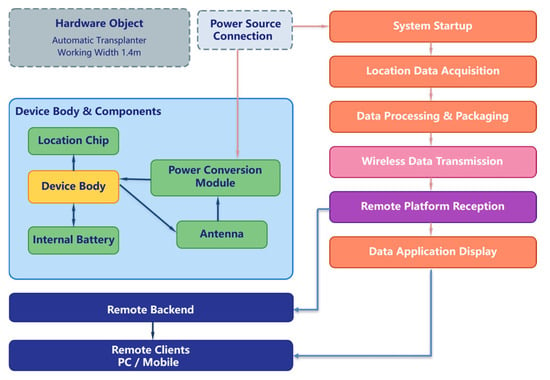
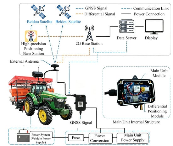
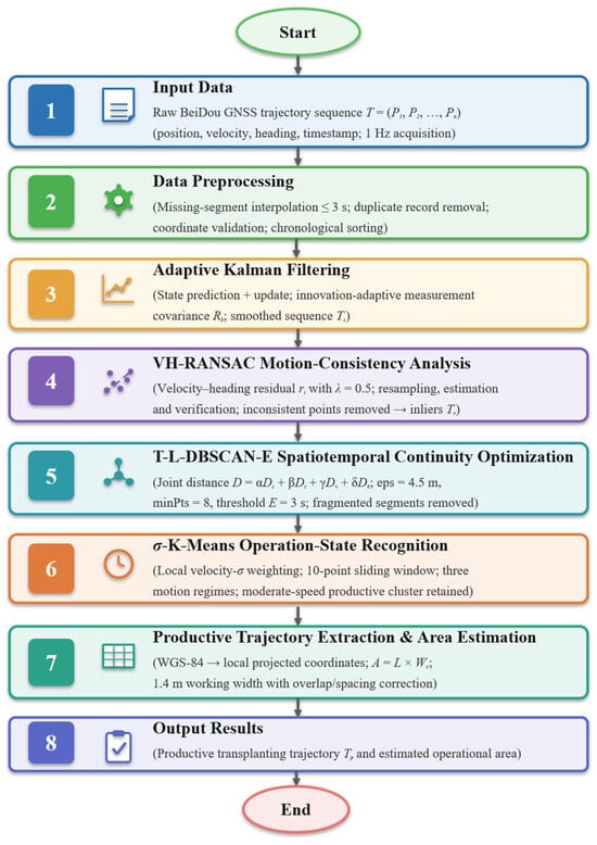
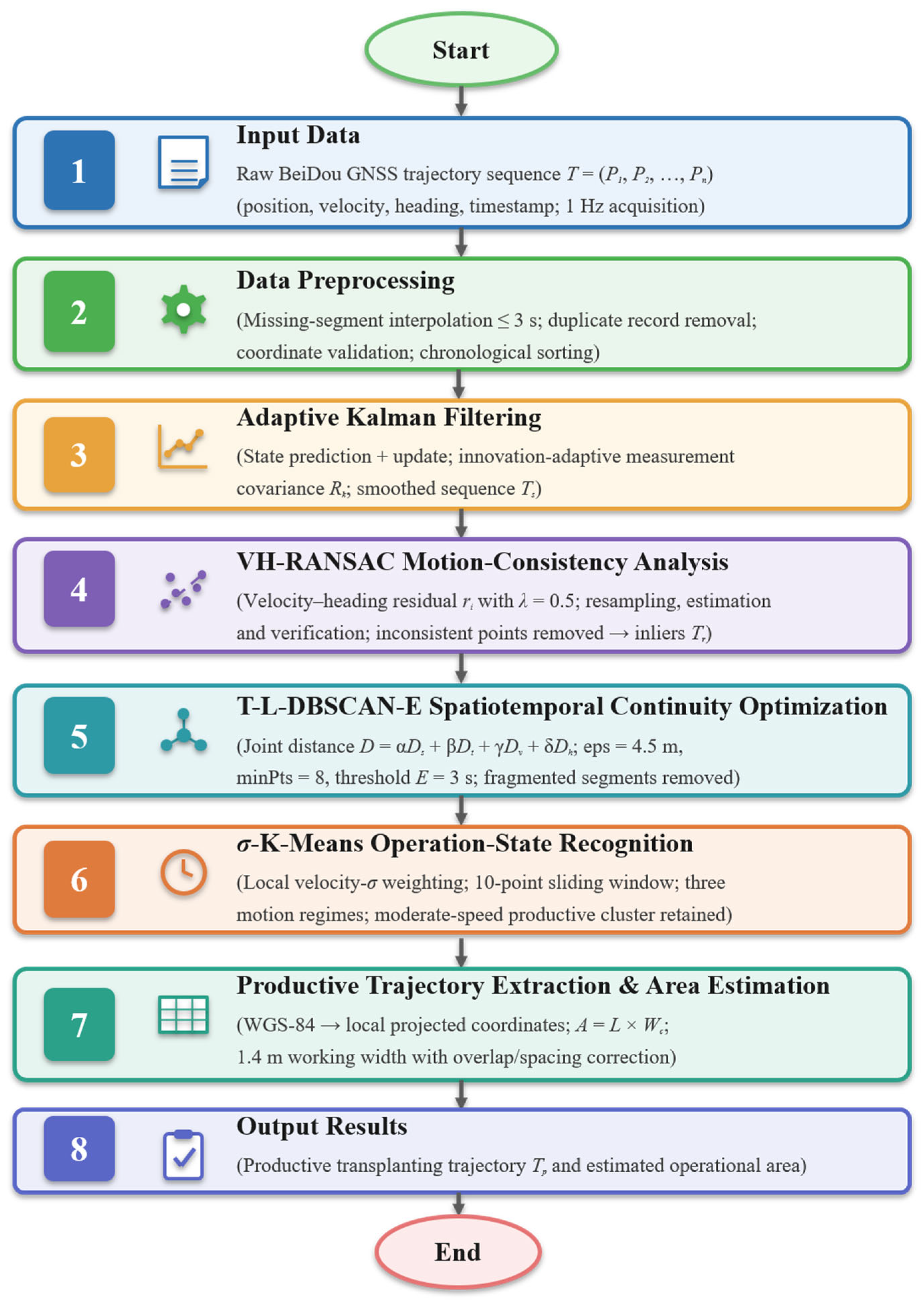
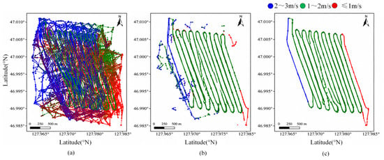
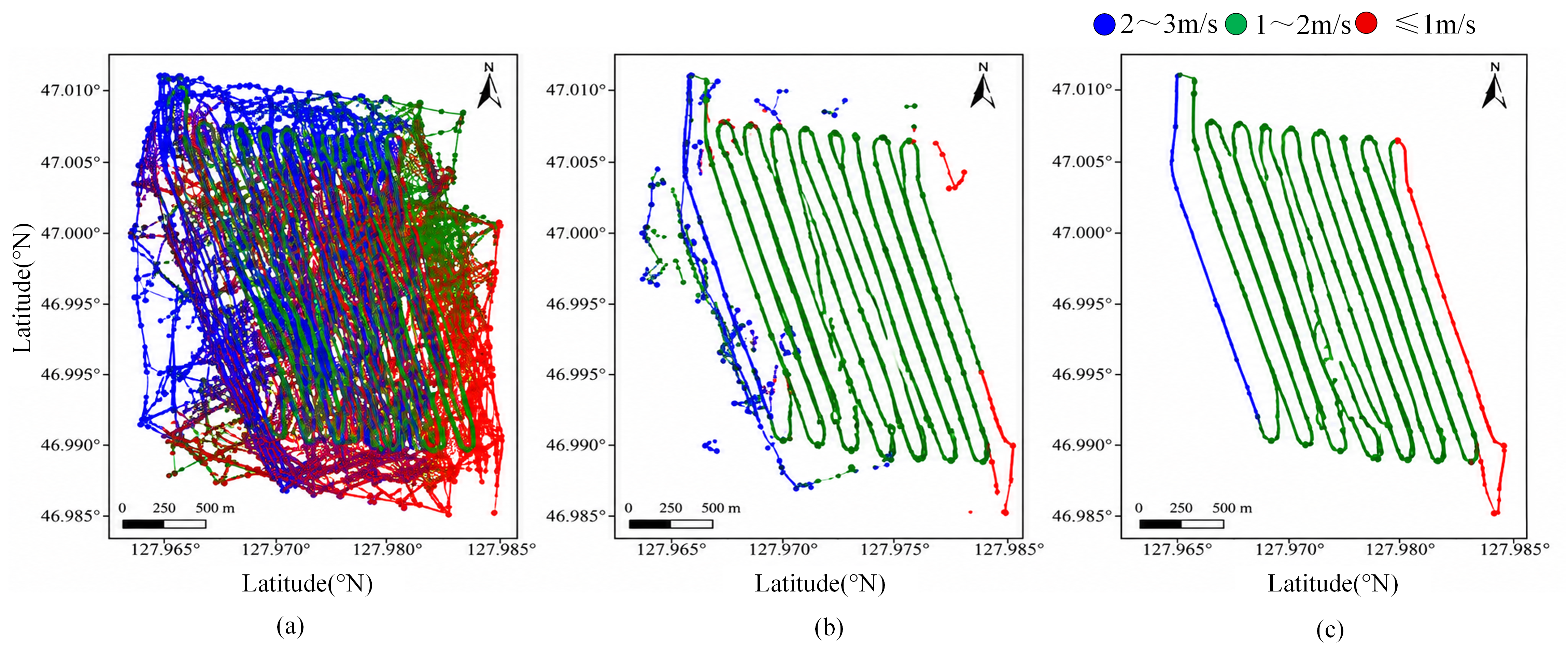

Disclaimer/Publisher’s Note: The statements, opinions and data contained in all publications are solely those of the individual author(s) and contributor(s) and not of MDPI and/or the editor(s). MDPI and/or the editor(s) disclaim responsibility for any injury to people or property resulting from any ideas, methods, instructions or products referred to in the content. |
© 2026 by the authors. Licensee MDPI, Basel, Switzerland. This article is an open access article distributed under the terms and conditions of the Creative Commons Attribution (CC BY) license.