


Highlights
What are the main findings?
- An unsupervised deep learning framework is developed for large-scale 3D aeromagnetic inversion, enabling high-resolution imaging of subsurface magnetization without labeled training data.
- The inversion reveals two dominant deep magnetic systems in the Panxi region, controlled by N–S and NNE-trending fault structures, corresponding to the Anninghe and Panzhihua rift systems.
What are the implications of the main findings?
- The results demonstrate that deep fault-controlled rift systems play a fundamental role in guiding magma emplacement and controlling the spatial distribution of mafic–ultramafic intrusions.
- The identified high-magnetization zones provide reliable geophysical indicators for deep exploration targeting of Panzhihua-type V–Ti magnetite deposits.
Abstract
Panzhihua-type V–Ti magnetite deposits in the Panxi region are hosted in mafic–ultramafic intrusions, and their exploration potential depends strongly on the deep distribution of ore-bearing intrusions. High-resolution 3D magnetic inversion is an effective tool to image the geometry of these intrusions. Using 1:50,000 aeromagnetic data, we applied an unsupervised deep learning inversion to obtain the 3D magnetic susceptibility structure of related intrusions. The results show that magnetic anomalies are mainly NS and NEE trending, with minor NNW-trending features. NS-trending sources occur in the Baima–Miyi–Hongge zone between the Xigeda–Yuanmou and Anninghe faults, while NEE-trending anomalies lie west of the Xigeda–Yuanmou fault and east of the Chenghai fault. Integrated geological analysis reveals two Late Variscan rift systems: the Anninghe rift and the Panzhihua rift. Deep fault-controlled magma ascent and emplacement, forming the Emeishan large igneous province, are associated with strongly magnetic intrusions. Mantle plume-derived magmas, differentiated in shallow and deep magma chambers, generate well-differentiated layered complexes at depths < 10 km with magnetic intensities of 5–10 A/m. Shear structures within paleorifts provide favorable emplacement conditions and controlled ore localization. We propose a three-in-one ore-controlling mechanism involving rift systems, intrusive rocks, and shear structures for Panzhihua-type V–Ti magnetite mineralization.
1. Introduction
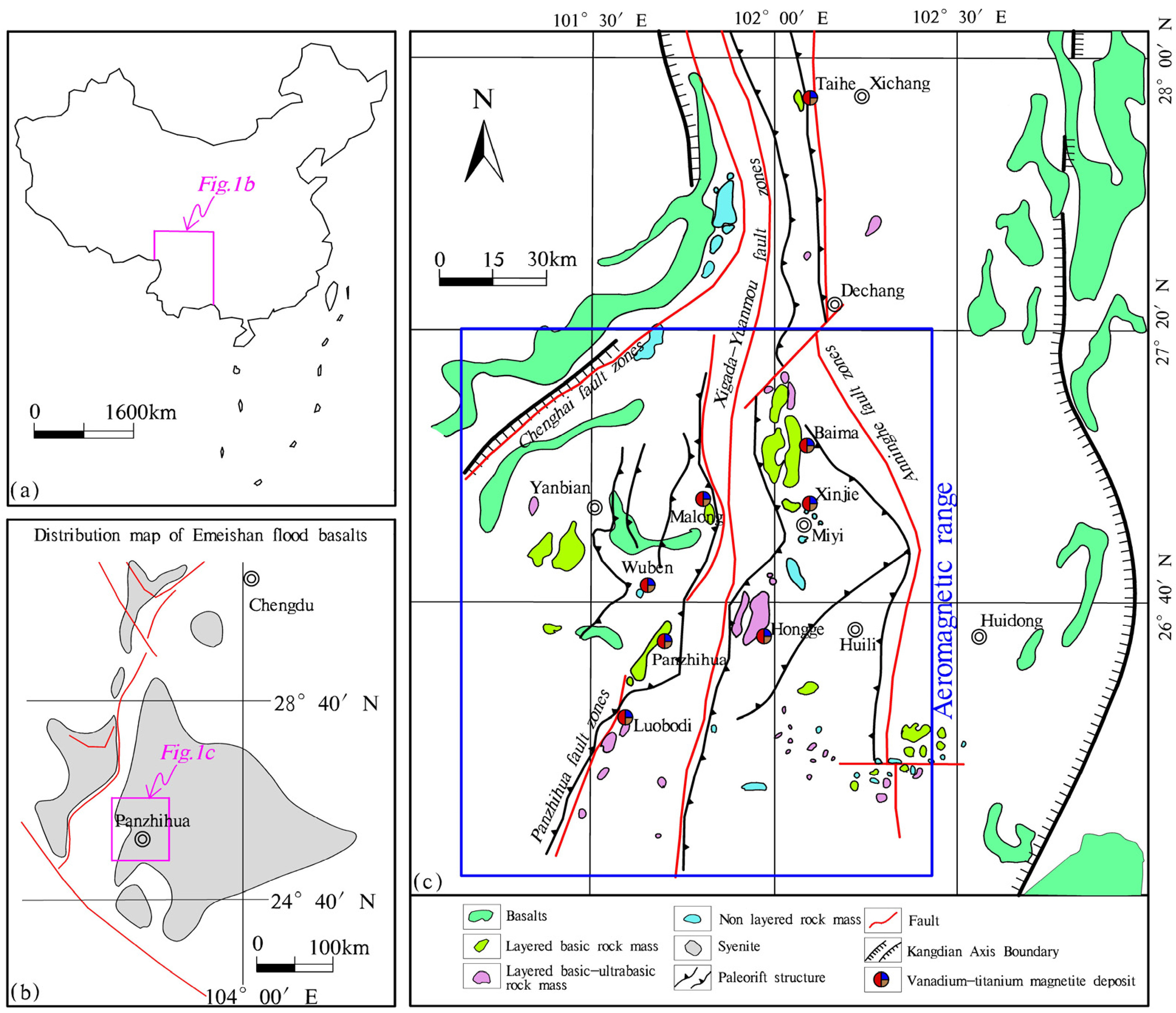
The “Panzhihua-type” vanadium–titanium magnetite deposit refers to magmatic V–Ti magnetite deposits widely hosted in Late Permian mafic–ultramafic intrusions within the Panxi region of Southwest China [1]. Representative deposits include the Panzhihua, Taihe, and Baima deposits hosted in mafic intrusions such as gabbro and pyroxenite, as well as the Xinjie and Hongge deposits hosted in ultramafic intrusions of mafic to ultramafic composition [2,3] (Figure 1). Mafic–ultramafic intrusions constitute an important component of the Emeishan large igneous province and provide critical insights into the metallogenic evolution of the Panxi region [4,5,6,7,8].
The Emeishan large igneous province in the Panxi region has attracted considerable attention from the geological community worldwide. Extensive studies have been carried out on the flood basalts in this area, whereas the deep structural characteristics of mafic–ultramafic intrusions and the ore-forming mechanisms of the Fe–Ti–V deposits hosted in them have long been under debate. The main controversial viewpoints focus on liquid immiscibility of Fe–Ti-rich melts [9,10], fractional crystallization [11,12,13], and the influence of oxygen fugacity variations [14]. Therefore, the genesis of the “Panzhihuatype” vanadium–titanium magnetite deposit remains not fully understood. It may be related to random generations of mantle plumes associated with global plate tectonics, or may be connected with the tectonic activities of the North China and South China plates [15].
Since the mantle plume hypothesis was proposed and has gradually gained wide acceptance, increasing attention has been paid to interpreting the petrogenesis of mafic–ultramafic rocks and associated mineralization in Panxi from a mantle plume perspective [16,17,18,19,20]. Studies by Xu Yigang et al. [21] and Zhaochong, Ying, Li, and Yu [16] on the temperature of peridotite at the mantle plume tail, as well as investigations by Zhou Meifu [22] and Song Xieyan et al. [2], have proposed close genetic relationships among high-Ti basalts, Fe-rich gabbroic intrusions, granitic intrusions, and super-large Fe–Ti–V oxide deposits. These findings collectively indicate that the formation of V–Ti magnetite deposits in the Panxi region is controlled by deep geodynamic processes and provides important implications for mineral exploration.
Figure 1.
Outline map of geological structure in the study area (revised from Guo Daojun, 2014 [23] and Jian et al. [24]). (a) Is the map of the Chinese region, (b) is the actual work area location map of Panzhihua, (c) is the regional geological map.
Significant progress has been achieved in the exploration of surface and shallow mineral resources within the Panzhihua mafic–ultramafic iron ore cluster through decades of integrated exploration. With the implementation of the new national strategic action for mineral exploration breakthroughs, and the continuous improvement in the understanding of metallogenic theories related to mafic–ultramafic intrusions in the Panxi region, delineating the spatial distribution and deep high-resolution structural characteristics of Late Permian mafic–ultramafic intrusions is now regarded as a fundamental prerequisite for expanding exploration potential and achieving breakthroughs in deep mineral exploration [25,26]. High-resolution magnetic anomaly imaging and inversion play a unique role in revealing the geological significance of magmatic metal deposits associated with mafic–ultramafic rocks. The ore-hosting intrusions, ore-controlling structures, and basement units of the Panzhihua-type V–Ti magnetite deposits exhibit distinct magnetic contrasts. Therefore, conducting deep high-resolution magnetic structural studies based on large-scale aeromagnetic data in the Panxi region represents an efficient and indispensable approach.
Aeromagnetic data are highly sensitive to mafic–ultramafic rocks and represent an important source of remote sensing and geophysical information for delineating the distribution of deep-seated intrusions and regional tectonic frameworks [27,28]. With the rapid development of inversion theory and high-performance computing, three-dimensional magnetic anomaly inversion has evolved from early smoothness-constrained approaches toward more advanced strategies, including focusing inversion, sparse-constraint inversion, and multi-physics joint inversion, leading to substantial improvements in model resolution and boundary definition [28,29,30,31]. Nevertheless, due to the intrinsic volume effect of magnetic anomalies and the strong non-uniqueness of magnetic inversion, conventional methods still commonly suffer from a limited resolution, strong dependence on prior parameters, and insufficient computational efficiency at regional scales, making it difficult to meet the requirements of large-area high-resolution imaging.
In recent years, deep learning techniques have been increasingly introduced into remote sensing and geophysical inversion, offering new solutions for complex nonlinear problems [32]. Previous studies have demonstrated that convolutional neural networks (CNNs), fully connected neural networks (FNNs), and generative adversarial networks (GANs) exhibit considerable potential in gravity inversion, magnetic inversion, seismic imaging, and remote sensing parameter retrieval [33,34]. According to different training strategies, existing studies can generally be classified into two categories. The first category comprises supervised learning-based inversion methods trained on large volumes of synthetic or labeled data, which are computationally efficient but whose generalization capability largely depends on the representativeness of the training datasets [35,36]. The second category includes the emerging physics-informed or unsupervised deep learning approaches, which explicitly incorporate forward operators and physical constraints into the loss function, thereby achieving an effective integration of data-driven learning and physical mechanisms [37,38]. These methods reduce the dependence on large labeled datasets while improving the physical consistency of inversion results. However, their application to regional-scale three-dimensional aeromagnetic inversion remains limited, and their stability, effectiveness, and geological interpretability still require further systematic validation.
Although supervised deep learning methods have shown promise in gravity and magnetic inversion, they heavily rely on large volumes of labeled training data, which are difficult to obtain for real-world 3D problems. In contrast, fully unsupervised inversion frameworks that integrate geophysical forward operators directly into the loss function are still in their infancy, particularly for regional-scale 3D aeromagnetic data. The present study advances this frontier by proposing an unsupervised FNN-based framework that incorporates integrated depth weighting, L0 focusing, and rock physics boundary constraints. These components collectively address key limitations of traditional smoothness-constrained inversions, such as over-smoothing, poor deep resolution, and violation of physical bounds. Furthermore, the application to the Panxi region yields new geological insights into the deep architecture of two Late Variscan rift systems and their control on Panzhihua-type deposits.
Based on the above background, this study builds upon previous geological knowledge and uses high-resolution 1:50,000-scale aeromagnetic data from the Panxi region as the primary dataset. We propose and apply an unsupervised deep learning-based three-dimensional magnetization inversion method to image the deep magnetic structure of the study area down to a depth of 10 km. By integrating rock magnetic properties, regional tectonic frameworks, and the spatial distribution of representative deposits, we systematically analyze the spatial characteristics of deep magnetic bodies and their relationships with ore-hosting and ore-controlling structures. Furthermore, we explore the implications of the results for the metallogenic background and deep exploration potential of Panzhihua-type V–Ti magnetite deposits. This study aims to provide a new technical framework for intelligent inversion of regional-scale aeromagnetic data under a geology-driven paradigm, and to further promote the integration of remote sensing and geophysical approaches in mineral resource prediction. Emerging spin-wave-based magnetometers, which enable voltage-controlled reconfiguration of magnetic sensitivity with sub-nT resolution and CMOS compatibility [39], represent a promising direction for acquiring higher-fidelity input data for inversion frameworks such as the one presented here.
2. Geological Background
The Panxi area is located in the southwest of Sichuan Province, China (Figure 1), at the southwestern margin of the Upper Yangtze continental block. It is adjacent to the Songpan–Ganzi orogenic belt in the west. It comprises three tectonic units: the Xianyuan–Lijiang foreland reverse-subduction belt, the Kang-Dian block, and the Upper Yangtze block. From west to east, it successively develops the Qinghai deep large fault belt, the Panzhihua deep large fault belt, the Xigeda–Yuanmou deep large fault belt, and the Anning River deep large fault belt (Figure 1c). The sedimentation and magmatic activities are significantly controlled by the fault belts [40]. The ore-bearing basic–ultrabasic rock bodies in the Panxi area are mainly distributed in the magmatic province of Emeishan, and the mineralization process is closely related to the tectonic activities [2].
Due to the activity of the Meiyu mantle bulge, in the Late Middle Permian period, a large-scale activity of basic–ultrabasic magmas occurred in the Panxi area [4,17,18,20,41]. Controlled by deep major faults, the ore-bearing basic–ultrabasic rock bodies in the Panxi area mostly occur in the western side of the Anning River fault zone and the restricted narrow area of the Xigeda fault zone, forming basic–ultrabasic rock belts that are either north–eastward or north–southward oriented [42,43]. The rock types include ore-bearing magnesium–iron- and ultramagnesian-layered rocks, as well as Meiyu Mountain effusive basalt, granodiorite, and granite, which constitute a unique “trinity” rock combination and become important markers for mineral exploration in the area [2].
Based on the distribution characteristics of the basic–ultrabasic rock masses in the Panxi area, the rock masses can be divided into two branches: the eastern one and the western one [44]. Among them, the eastern branch is located near the Anning River fault zone and is distributed in a north–south band-like pattern. It starts from the Tahe ore body in the north and passes through the Baima and Xinjie ore bodies to the Hongge ore body in the south. The western branch is distributed along the north–eastward Panzhihua fault, forming basic ore-bearing peridotite bodies such as Maling, Wuben, Panzhihua, and Rabodi (Figure 1b). The occurrence mode of the ore-bearing rock masses is consistent with the strike direction of the regional deep and large faults, which is nearly north–south. However, in some local areas, it is controlled by later secondary faults, resulting in a stepped feature [23].
3. Materials and Methods
3.1. Unsupervised Deep Learning Inversion Framework
To address the limitations of traditional inversion methods, such as low resolution, low computational efficiency, and excessive smoothing of results, this paper proposes a fully unsupervised deep learning inversion framework. It does not require labeled training datasets (i.e., paired samples of magnetic anomaly data and corresponding real underground magnetization models). Unlike supervised learning methods that rely on learning the data-model to map relationships from large-scale labeled samples, this framework integrates prior geophysical knowledge and directly optimizes the consistency between observed and predicted magnetic anomalies, transforming the conventional grid-based inversion into an optimization problem over the weights of a neural network with embedded physical forward constraints.
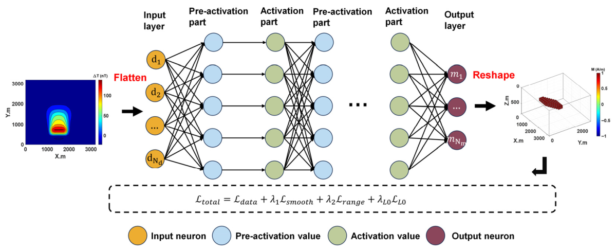
A fully connected neural network (FNN) is adopted as the implicit parameterization carrier of the underground magnetization model (Figure 2). This network takes the 2D aeromagnetic anomaly data (spatially formatted as a 64 × 64 matrix and flattened into a 4096-dimensional vector) as the input feature and outputs the corresponding 3D magnetization intensity distribution in a 1D vector format of 8000 × 1. Specifically, the 8000-dimensional output vector is pre-defined to map to a 3D grid of the subsurface model (e.g., 20 × 20 × 20 grid divisions in directions, totaling 8000 grid cells), where each element in the output vector corresponds to the magnetization intensity value of a single 3D grid cell. This design makes the neural network a continuous and flexible representation tool for the underground model, and the network parameters implicitly encode the three-dimensional magnetization intensity distribution information. Specifically, the magnetization model generated by the network is denoted as , and applying the forward operator to this model can obtain the predicted magnetic anomaly data:
where the matrix is a forward modeling operator that represents the linear relationship between the magnetic intensity and the forward magnetic anomaly . The core objective of inversion is to optimize the network parameters θ by minimizing the loss function (as detailed in Section 3.2) solely using the observed aeromagnetic data , without requiring any labeled underground models. This framework fully leverages the powerful fitting capabilities of deep learning to capture complex underground structures while ensuring that the inversion results conform to the geophysical forward modeling laws.
Figure 2.
Schematic diagram of FNN structure.
The proposed framework differs fundamentally from conventional inversion in three aspects: (i) implicit neural representation instead of discrete grid parameterization, (ii) built-in physics-informed constraints rather than external regularization, and (iii) fully unsupervised training without any labeled “true model” data in contrast to supervised deep learning inversions.
Network Structure
In this study, a fully connected neural network (FNN) was employed as the implicit parameterization carrier for the underground magnetization intensity model. The network structure consisted of an input layer, five hidden layers, and an output layer. The input was a 4096-dimensional vector obtained by flattening a 64 × 64 aeromagnetic anomaly grid; the number of neurons in each hidden layer was 2048, 1024, 1024, and 2048, all using the ReLU activation function; and the output layer was 8000-dimensional (corresponding to a 20 × 20 × 20 three-dimensional grid), using the ReLU activation function to ensure that the magnetization intensity was non-negative, as shown in Table 1.
Table 1.
Network structure.
3.2. Loss Function
The total loss function is constructed by integrating the data fitting term with multiple geophysical regularization terms, achieving a balance between the consistency of predicted data and observed data while ensuring the geological rationality of the inversion model:
where is the data fitting term, is the model smoothing constraint term, is the physical boundary constraint term (used to limit the magnetization intensity within a reasonable range), is the depth weighting term, and L0 is the focusing term; , , and are the parameters that balance the contributions of different loss terms, and they are finally determined through training (Section 3.3).
3.2.1. Data Fitting Term
The data fitting term is used to measure the difference between the observed magnetic anomaly and the predicted magnetic anomaly and is defined as the weighted norm.
where represents the data weighting matrix. This matrix assigns greater weights to data points with a higher signal-to-noise ratio, effectively reducing the influence of observational noise on the inversion results.
3.2.2. Model Smoothing Constraint Term
To prevent the inversion model from experiencing drastic fluctuations without geological significance and to enhance the spatial continuity and stability of the model, a smoothing constraint term is introduced to constrain the spatial gradient of the magnetization intensity. Considering that the magnetic source bodies (such as basic–ultrabasic rocks) usually have continuous geological characteristics in three-dimensional space, the L1 norm is used to constrain the gradients of the magnetization intensity in the x, y, and z spatial directions. The definition is as follows:
In the above, , , and represent the first-order spatial derivative operators of magnetization intensity in the x (east–west direction), y (north–south direction), and z (vertical) directions, respectively. This is a three-dimensional magnetization intensity model. represents the L1 norm. The L1 norm constraint is more capable of preserving the edge features of the model compared to the L2 norm. It can suppress random fluctuations while avoiding excessive smoothing that causes the boundary of the magnetic source body to become blurred. This ensures that the inversion results not only conform to the continuous distribution law of the geological body but also clearly depict the spatial shape boundary of the magnetic source body.
3.2.3. Physical Boundary Constraint Term
To ensure that the inversion results have physical significance, the magnetization intensity is constrained within the range of the measured magnetization intensity of the rocks and minerals in the study area (Table 1). The physical boundary constraint term is defined as:
where and represent the lower and upper limits of the magnetization intensity, which were determined based on the statistical analysis of the magnetic parameters of rocks and minerals in the Panxi area. This term imposes penalties on magnetization intensity values that exceed the physically reasonable range, thereby avoiding the occurrence of unconstrained and geologically unreliable inversion results.
3.2.4. Depth Weighting Term and the L0 Focusing Term
The sensitivity of aeromagnetic data decays exponentially with depth, which leads to problems such as overly smooth results and low resolution of deep magnetic structures in traditional inversions. To address this, this paper constructs a sparse depth-weighted joint constraint term, which not only enhances the structural focus of the inversion model but also compensates for the loss of sensitivity of deep magnetic signals, thereby improving the overall inversion accuracy.
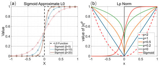
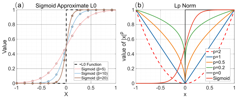
Using the Sigmoid function to construct a differentiable approximation of the L0 norm (the L0 norm itself is non-differentiable, making it difficult to directly optimize), which enhances the spatial sparsity and boundary clarity of the magnetic source as:
where represents the Sigmoid activation function, which approximates the step function as ; is the steepness coefficient (set to 10 in this paper), as the larger the value, the closer it is to the step characteristic of the norm; is the non-zero determination threshold (set to 0.01 in this paper), used to distinguish between “zero” and “non-zero” density values; and is the mean operation, normalizing the loss to the range [0, 1] and adapting to the magnitude of other loss terms, as shown in Figure 3.
Figure 3.
Graphs of the Sigmoid function approximating the L0 norm: (a) image of the Sigmoid function with different beta values; (b) image of different norms and the Sigmoid approximation function.
To address the issue of the decrease in aeromagnetic sensitivity with depth, a depth-weighted term is introduced to enhance the inversion resolution of deep magnetic sources:
where represents the depth-weighted matrix; is the depth of the model grid; is the reference depth, which is used to avoid singularity at the shallow depth; and controls the rate at which the weights increase with depth, and is generally set to 3. This sub-item gives greater weight to the deep model grid, effectively compensating for the loss of sensitivity of the deep magnetic signal, and enabling the inversion results to maintain high resolution both in the shallow and deep areas.
3.3. Optimization Strategies and Hyperparameter Tuning
The network parameters were optimized using the Adam optimizer, which is highly efficient in deep learning optimization tasks. The initial learning rate was set to 10−4, and a learning rate decay strategy (decreasing by 50% every 200 epochs) was adopted to stabilize the convergence process. The total number of training cycles was 1000, and the optimization process would terminate when the relative change in the total loss function was less than 10−6.
To achieve the best inversion results, this study systematically optimized the hyperparameters for each regularization balance parameter () and the depth weighting scheme. Through ablation experiments, we tested the impact of different parameter combinations on the inversion results (RMSE, R2, SSMI) within a large parameter space, and ultimately determined the current optimal parameter values. The selection of these parameters took into account the statistical results of rock magnetic parameters in the study area, the test effect of the synthetic model, and the convergence stability of the actual data inversion.
The selection of the depth weighting index = 3 mainly referred to the classic potential field depth weighting theory of Li and Oldenburg [29], and its effectiveness in compensating for the problem of magnetic anomaly attenuation with depth within a 10 km depth range was verified through experiments. The specific parameter settings are shown in Table 2.
Table 2.
Unsupervised deep learning hyperparameter tuning.
Each training iteration requires a full three-dimensional forward modeling to compute the predicted magnetic anomaly . Nevertheless, the overall computational efficiency remains significantly higher than that of conventional grid-based inversion. This is achieved through three key advantages: (i) only the network weights θ are updated via a single forward–backward pass, implicitly optimizing the entire 3D field in a coordinated manner; (ii) the implicit neural representation avoids the computational redundancy of fine discretization grids required by traditional methods; and (iii) the network converges faster due to its strong nonlinear fitting capability, requiring substantially fewer iterations overall. All hyperparameters were determined based on classical potential field theory, rock magnetic measurements, and synthetic tests, ensuring the robustness and reliability of the inversion framework in regional-scale applications.
4. Synthetic Studies
Two comprehensive models, namely the double cube model and the trapezoidal model, were employed to evaluate the performance of the algorithm under different geological conditions. The double cube shape model simulates aggregated and independent ore bodies, thereby testing the algorithm’s ability to accurately interpret complex boundaries. In contrast, the trapezoidal model represents layered or blocky ore bodies, enabling the assessment of the algorithm’s effectiveness in distinguishing multiple magnetic susceptibility intensity contrasts and their interactions. These comprehensive examples collectively verified the stability, adaptability, and practicality of this method for imaging both regular and irregular ore deposits.
4.1. Double Cube Model
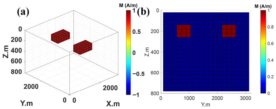
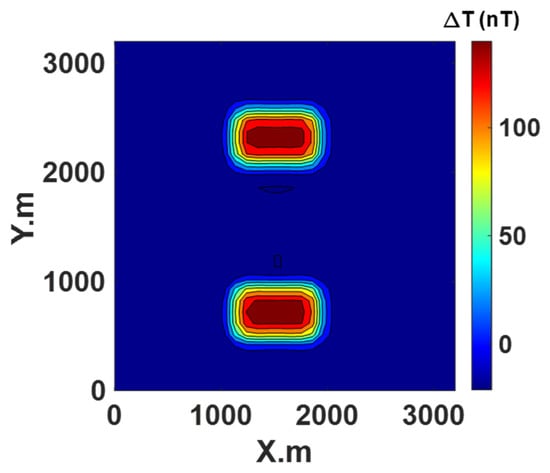
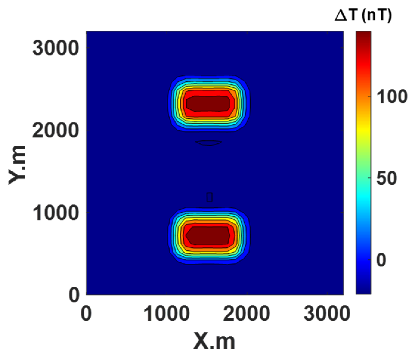
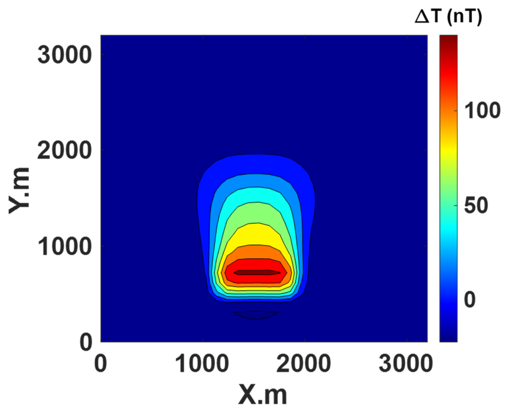
The underground space is evenly divided into a 20 × 20 × 20 grid, resulting in a total of 8000 units. These two cubes are located within this area (Figure 4). The entire depth of this area is 800 m, divided into 20 units each of 40 m, where in the x-axis direction, the area extends 3200 m, with 20 units each of 160 m, while in the y-axis direction, it spans 3200 m and is divided into 20 units each of 160 m. The top depth of these two cubes is 160 m, extending 480 m in the x direction and 800 m in the y direction. The magnetic susceptibility intensity is 1 A/m. The selected forward and inverse parameters are the component (Figure 5).
Figure 4.
Forward modeling results of double cube model; (a) 3D magnetic susceptibility intensity model; (b) − cross-section at x = 1600 m.
Figure 5.
Forward component field of double cube model.
4.2. Inversion Configrations and Results for Double Cube Model
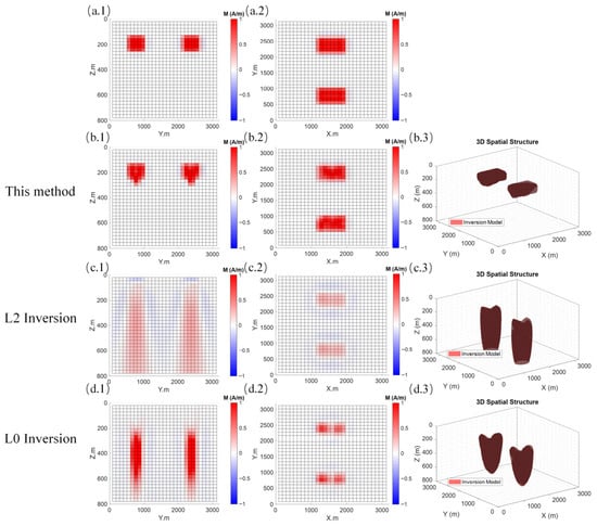
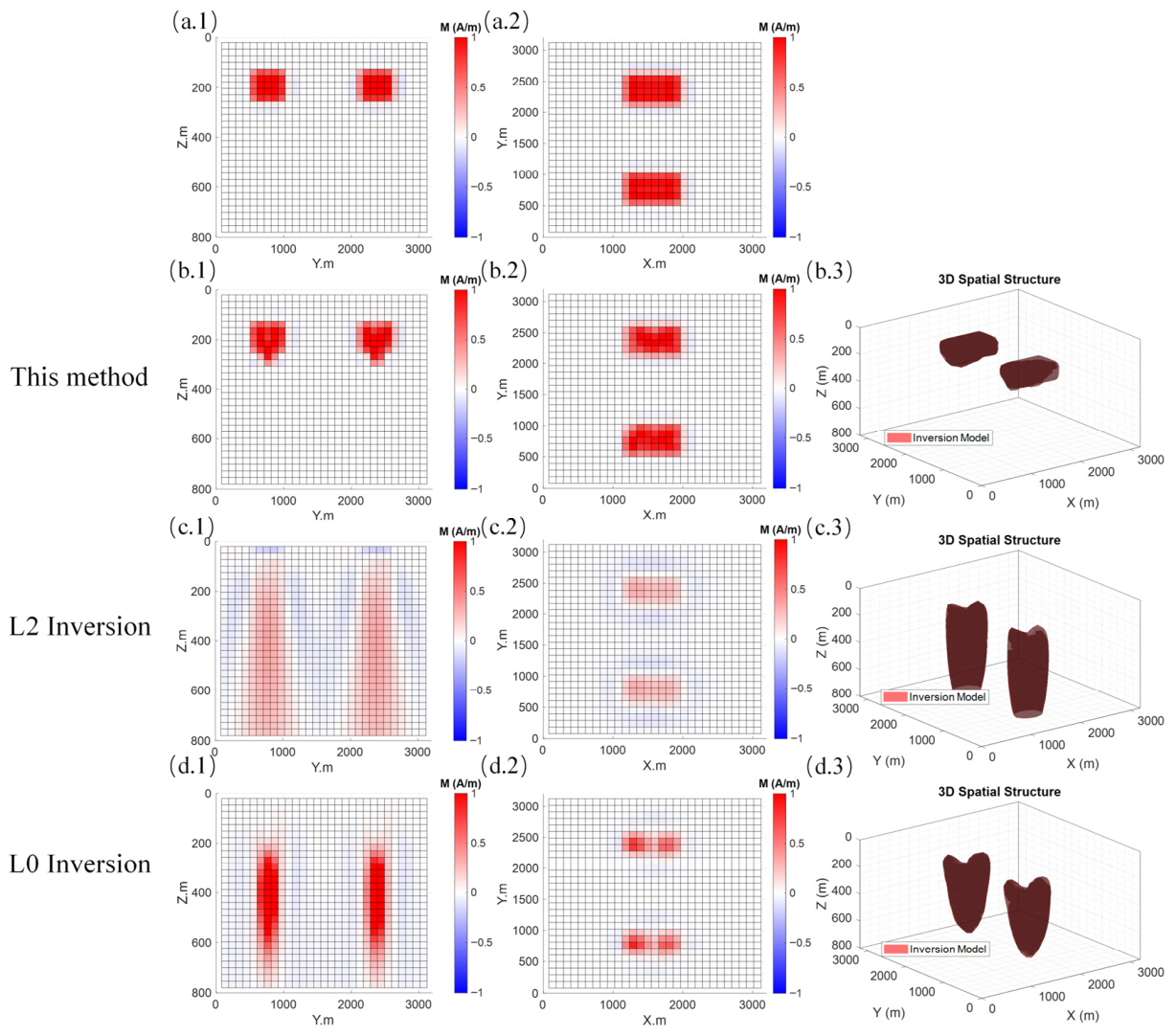
To ensure the reliability and comparability of the three-dimensional magnetic inversion results, this inversion calculation adopts a grid configuration that is exactly the same as the forward modeling, ensuring strict matching in terms of spatial resolution and coordinate system. Figure 6 illustrates the distribution characteristics of the inversion results for the double cube model on the x = 1600 m vertical profile and the z = 220 m horizontal slice, along with the corresponding y–z vertical and x–y horizontal profiles. As can be clearly seen, the anomaly reconstructed by the proposed method shows a high degree of consistency with the true model in terms of spatial location, geometric shape, and boundary contour. In particular, the proposed method achieves significantly higher accuracy in delineating the boundaries of the anomaly compared to the L2 and L0 inversion methods, which suffer from noticeable shape blurring and boundary distortion, respectively. Quantitative analysis (Table 3) further validates this conclusion: the proposed method achieves a root mean square error (RMSE) of 0.085, a coefficient of determination (R2) of 1.00, and a structural similarity index (SSIM) of 0.9792. These metrics are superior to those of the L2 inversion (RMSE = 0.11, R2 = 0.99, SSIM = 0.6368) and the L0 inversion (RMSE = 0.10, R2 = 0.99, SSIM = 0.6577). Furthermore, the inversion time is only 2.2 min, demonstrating a substantial improvement in computational efficiency over the L2 inversion (5.21 min) and L0 inversion (7.13 min). These results indicate that the proposed method not only maintains high inversion accuracy but also offers excellent computational performance, providing reliable technical support for the fine imaging of complex geological bodies.
Figure 6.
Comparison of the inversion results of the dual cube model. (a.1) Diagram of y–z plane at the vertical slice x = 1600 m of the real model; (a.2) diagram of x–y plane at the horizontal slice z = 220 m of the real model; (b.1) diagram of y–z plane at the vertical slice x = 1600 m of the unsupervised learning inversion; (b.2) diagram of x–y plane at the horizontal slice z = 220 m of the unsupervised learning inversion; (b.3) three-dimensional space isosurface diagram of the unsupervised learning inversion; (c.1) diagram of y–z plane at the vertical slice x = 1600 m of the L2 traditional inversion; (c.2) diagram of x–y plane at the horizontal slice z = 220 m of the L2 traditional inversion; (c.3) three-dimensional space isosurface diagram of the L2 traditional inversion; (d.1) diagram of y–z plane at the vertical slice x = 1600 m of the L0 focused inversion; (d.2) diagram of x–y plane at the horizontal slice z = 220 m of the L0 focused inversion; (d.3) three-dimensional space isosurface diagram of the L0 focused inversion.
Table 3.
Statistical parameters of the inversion results of the double cube model.
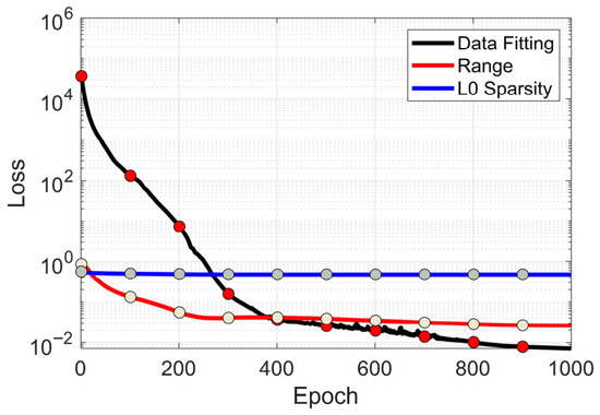
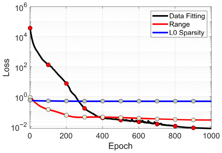
Figure 7 illustrates the evolution characteristics and composition distribution of the loss function of this method. Through the analysis of the contribution ratio and dynamic change trend of the loss terms, it can be seen that the data fitting term loss dominates throughout the training stage. This feature indicates that the model takes fitting the real observed data as the core objective in the optimization process, which is a key constraint condition to ensure that the model’s output results are consistent with the actual physical laws. The contribution of the range constraint term loss is second. The loss component shows a small oscillation with parameter iterations in the early training stage and gradually stabilizes and converges to a lower level in the later stage. Its core function lies in effectively constraining the values of model parameters, avoiding prediction distortion caused by parameter deviations from reasonable intervals, and providing important support for the stability of model training. The L0 regularization term loss remains at an extremely low level and has a weak fluctuation amplitude. It mainly plays an auxiliary optimization role in the loss function system, imposing a sparse penalty on redundant model parameters, effectively suppressing overfitting without significantly increasing the overall loss, and thereby improving the generalization performance of the model.
Figure 7.
The training error curve graph of the double cube model.
4.3. Trapezoidal Model
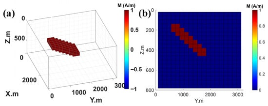
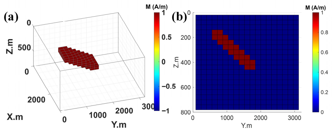
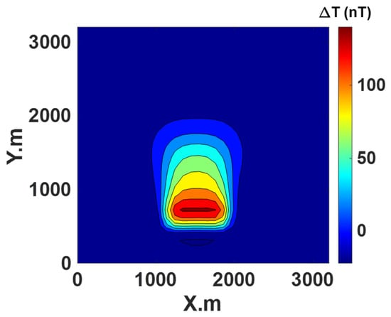
Model 2 adopts the same 20 × 20 × 20 spatial grid as the double cube model, but its feature is a trapezoidal anomaly (Figure 8). This trapezoidal model has a top depth of 160 m, extends 800 m in the x direction, and 320 m in the y direction, with a magnetic susceptibility intensity of 1 A/m. For forward modeling and inversion, the component was used (Figure 9).
Figure 8.
Forward simulation results of the trapezoidal model; (a) three-dimensional density model; (b) y–z section at x = 1600 m.
Figure 9.
Forward component field of trapezoidal model.
4.4. Inversion Configrations and Results Trapezoidal Model
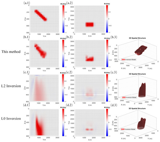
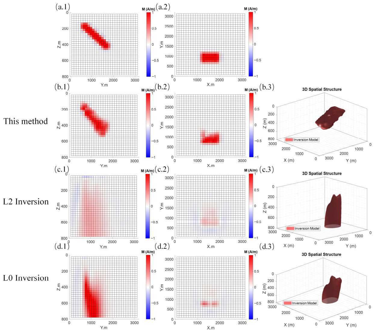
The three-dimensional inversion calculation for this model follows the same grid parameter configuration as the forward simulation, ensuring strict correspondence between the inversion and the forward simulation processes in terms of spatial resolution and coordinate system. Figure 10 illustrates the spatial distribution characteristics of the inversion results obtained from different methods across the vertical profile at , the horizontal slice at , and the corresponding and profiles. Qualitatively, the proposed method clearly reconstructs the spatial location and geometric morphology of the anomalous body, exhibiting sharp boundaries and good focusing properties while effectively suppressing spurious anomalies in the background. In contrast, the traditional L2 inversion results display a pronounced smoothing effect, leading to blurred boundaries and lower resolution. Although the L0 inversion improves focusing to some extent, its accuracy in morphological reconstruction remains inferior to that of the proposed method.
Figure 10.
Comparison of the inversion results of the Trapezoidal model. (a.1) Diagram of y-z plane at the vertical slice x = 1600 m of the real model; (a.2) diagram of x–y plane at the horizontal slice z = 220 m of the real model; (b.1) diagram of y–z plane at the vertical slice x = 1600 m of the unsupervised learning inversion; (b.2) diagram of x–y plane at the horizontal slice z = 220 m of the unsupervised learning inversion; (b.3) three-dimensional space isosurface diagram of the unsupervised learning inversion; (c.1) diagram of y–z plane at the vertical slice x = 1600 m of the L2 traditional inversion; (c.2) diagram of x–y plane at the horizontal slice z = 220 m of the L2 traditional inversion; (c.3) three-dimensional space isosurface diagram of the L2 traditional inversion; (d.1) diagram of y–z plane at the vertical slice x = 1600 m of the L0 focused inversion; (d.2) diagram of x–y plane at the horizontal slice z = 220 m of the L0 focused inversion; (d.3) three-dimensional space isosurface diagram of the L0 focused inversion.
To further quantitatively evaluate the inversion performance, Table 4 lists the root mean square error (RMSE) of the observed data, the coefficient of determination (), the structural similarity index (SSIM) of the model, and the computational time for each method. The data indicate that the proposed method achieves the lowest RMSE (0.085) and an () of 1.00, demonstrating the highest goodness-of-fit to the observed data. Regarding model reconstruction accuracy, the proposed method yields an SSIM of 0.9545, which is significantly higher than that of the L2 inversion (0.7331) and the L0 inversion (0.8852). This confirms that the model reconstructed by our method has a much higher structural consistency with the true model. Furthermore, the computational time of the proposed method is only 1.9 min, showing a significant efficiency advantage over the L2 inversion (5.43 min) and L0 inversion (5.72 min). In summary, the proposed method achieves high-precision imaging while maintaining superior computational efficiency, highlighting its excellent potential for practical engineering applications.
Table 4.
Statistical parameters of the inversion results of the Trapezoidal Model.
Once the network is trained on a specific aeromagnetic dataset, it is not directly applicable to a new dataset. For each new survey area or dataset, the network must be retrained from random initialization using only the new observed data. This process follows exactly the same unsupervised workflow as before—no labeled models, no change in network architecture, and no manual prior models are required. Although this retraining step is analogous to re-running conventional inversion on new data, the fully unsupervised and automated nature of the framework ensures high consistency and practicality across different regions.
Although the loss function shares similarities with conventional inversion, the superior high-resolution imaging capability of the proposed method stems primarily from the fundamental change in model parameterization. Instead of discretizing the subsurface into independent grid cells (which requires strong smoothing to stabilize the solution and often blurs boundaries), we employ a neural network as an implicit continuous function. This representation naturally preserves sharp edges and complex structures while allowing the L0 focusing, and depth weighting constraints to act more effectively. Synthetic tests (Figure 6 and Figure 10) and quantitative metrics (Table 3 and Table 4) demonstrate that the method achieves significantly sharper boundaries and better recovery of deep and small-scale anomalies compared with conventional smooth-constrained and focusing inversions.
5. Case Study
5.1. Data Sources
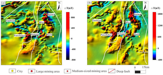
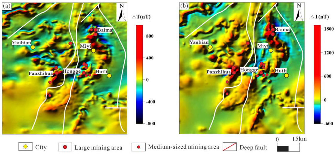
The aeromagnetic data used in this study were obtained from the 1:50,000 scale aeromagnetic survey map of Panzhihua–Anyi area completed by the China Aerial Survey and Remote Sensing Center in 2015. The terrain clearance was 648–762 m, the average flight altitude was 626 m, the flight line spacing was 500 m with a tolerance of ±22.0 m, and the data observation accuracy was better than 2 nT. The grid cell size of the resulting grids was 64 × 64. The original aeromagnetic data after ground correction and the corresponding reduction-to-pole magnetic anomaly results are shown in Figure 11. Analyzing the spatial distribution pattern of the anomalies, the main aeromagnetic anomalies in the study area extend in the north–south, northeast–southwest, and north–west directions. This distribution feature clearly indicates that the magnetic anomaly pattern in the region is significantly controlled by regional fault structures. In addition, compared with the original aeromagnetic anomaly field, the negative anomaly amplitude of the aeromagnetic reduction-to-pole magnetic anomaly in the study area (Figure 11b) shows a significant attenuation trend, and the spatial distribution pattern of the anomaly tends to be simple and regular. This phenomenon indicates that the magnetic anomaly response at the regional scale in the study area is dominated by the induced magnetization intensity. It is worth noting that the eastern and northwestern areas of the study area still have relatively strong negative magnetic anomaly bodies. This feature reveals that the magnetic anomaly field in local sections of the study area is superimposed with strong remanent magnetization intensity, suggesting that such areas may contain complex geological bodies or have undergone complex tectonic transformation processes.
Figure 11.
Panxi Area 1:500,000 Magnetic Anomaly and Magnetic Anomaly Polarization Map. (a) Magnetic Anomaly ΔT; (b) Magnetic Anomaly Polarization ΔT. (revised from Jian et al. [24]).
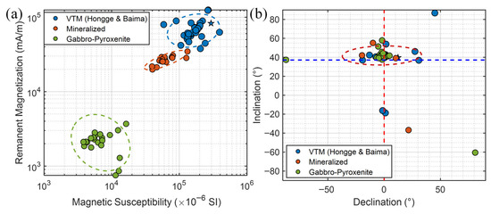
Based on the systematic rock magnetic measurements (Figure 12), it is reasonable not to conduct in-depth quantitative analysis of remanent magnetization in this study. Remanent magnetization contributes weakly to the total regional magnetic anomaly of the main magnetic geological bodies, and the magnetization directions of samples are generally consistent with the modern geomagnetic field without obvious deviation or reversal. This study focuses on regional deep magnetic structures and mineralization-related anomalies rather than paleomagnetic reconstruction; ignoring weak remanence without systematic demagnetization constraints avoids increasing model non-uniqueness and better meets the needs of regional-scale interpretation.
Figure 12.
Statistical diagram of magnetic parameters for main rocks and ores in the study area: (a) scatter diagram of magnetic susceptibility versus remanent magnetization intensity; and (b) scatter diagram of magnetic inclination versus magnetic declination.
Combined with the above analysis of the distribution characteristics of aeromagnetic anomalies, the main body of aeromagnetic anomalies in the study area comprised the east and west abnormal zones, and its spatial distribution is strictly controlled by the regional fault structure; the Middle Eastern branch of the anomalous belt is mainly trapped between the Xiegeda–Yuanmu fault and the Anning River fault, and is distributed as a strip along the Bema, Miyi and Hongge lines. The main trend is in the south–north direction, and the partial section is faulted by the cutting action of the north–east direction fault. The western branch is mainly distributed in the area east of Chenghai fault and west of Panzhihua fault, covering the Malong, Wuben, Panzhihua, and Yanbian areas. The main body of the western branch is distributed in the northeast direction, and the partial truncated deformation is affected by the northwest fault activity. The above two aeromagnetic anomaly zones are located in the central part of the Kang–Yunnan axis basal uplifting belt, and the outcrops in the region are mainly pre-Sinian crystalline basement and Sinian strata, and there are basic–ultrabasic rock masses widely distributed. The geological background provides an important material basis for the interpretation of aeromagnetic anomalies.
The Panxi area is located in the key area of Kang–Yunnan axis, regional geological structure is complex, rock ore types are diverse, magnetic differences are significant. In addition to the magnetite, the mafic and some intermediate igneous rocks distributed in the area show moderate magnetic properties. In order to clarify the distribution rules and magnetic differences in magnetic geological bodies in the study area, this paper systematically collected the magnetic parameter test results of the 1:50,000 regional comprehensive geological survey (2013–2015) project in the vanadium–titanium magnetite integrated exploration area of Panzhihua vanadium–titanium magnetite ore in Sichuan. The test and analysis showed that the strongest magnetic geological bodies in the study area were vanadium–titanium magnetite and magnetite, followed by ultrabasic rock–basic rock mass, while metamorphic rocks and medium acid rocks had relatively weak magnetic properties, mostly showing weak magnetic or non-magnetic properties. It is worth noting that most of the strong magnetic rocks in the area were accompanied by strong remanent magnetization, and the magnetic parameters of vanadium–titanium magnetite, magnetite, and basic-ultrabasic rocks are significantly different, and the magnetic strength of the former can reach more than 10 times that of the latter. The existence of such obvious magnetic differences not only provides a key physical support for the genetic analysis of aeromagnetic anomalies, but also lays a solid physical foundation for the delineation and evaluation of regional ore-prospecting potential areas.
5.2. 3D Magnetization Inversion Results
The 1:50,000 aeromagnetic pole anomaly in the study area (Figure 11b) clearly reveals the spatial differentiation characteristics of regional tectonic units, and reflects three main tectonic units from west to east: Lijiang foreland thrust nappe belt as the salt source is characterized by the relative magnetostatic zone; the Kang–Yunnan platform anticline belt is centered by the magnetic basement uplift in the near-NNE to NSE direction; and the Upper Yangtze block is dominated by the non-magnetic cap layer. The Kang–Yunnan–Tai anticline uplifting belt, whose spatial distribution is strictly controlled by the north–south direction fault zone, is the main concentrated display zone of regional aeromagnetic anomalies, and its magnetic anomaly response mainly stems from the widely distributed mafic–ultramafic intrusions and Panzhihua-type vanadium–titanium magnetite ore bodies in the region.
The spatial distribution of Panzhihua-type vanadium–titanium magnetite distributed in Kang–Yunnan–Tai anticline uplift zone is mostly constrained by obvious north–south or northeast trending fault structures, and the mineralization process of the deposit is closely related to the Emeishan large igneous province triggered by the Late Permian mantle plume activity [18,20,41]. At present, the previous studies mainly focus on the magmatic evolution process and genetic mechanism of typical ore deposits, and have carried out a lot of basic and targeted research work [42,45,46,47,48,49]. However, no systematic and in-depth research has been carried out on the constraint and control effect of deep structural characteristics and spatial distribution law of rock mass on the formation and distribution of ore fields in the region where the ore deposits are located. To a certain extent, the shortcomings of this research limit the accurate cognition of the deep ore-forming law in the study area, and then limit the further exploration and evaluation of the regional deep ore-prospecting potential.
To obtain the spatial distribution of deep structural features and magmatic activities in the study area, this paper conducted a three-dimensional inversion of magnetic susceptibility within 10 km using 1:50,000 aeromagnetic data of the study area. Considering the strong overall magnetism and large area of the study area, a background field of 15 A/m was selected. Combined with the rock magnetic test parameters, the upper and lower limit constraints of magnetic susceptibility were set at 0 and 10 A/m respectively. The number of iterations was 1000, and the fitting accuracy was 1.25. The distribution structure of magnetic susceptibility in the study area was obtained by using the unsupervised deep learning method introduced above.
The maximum imaging depth was set to 10 km, consistent with the primary depth range of ore-bearing mafic–ultramafic intrusions in the Panxi region and the effective penetration depth of 1:50,000 aeromagnetic data. The background magnetization of 15 A/m was chosen based on the statistical results of rock magnetic measurements in the study area (Table 5) and regional background field analysis.
Table 5.
Statistical table of magnetic parameter test of rocks and ores in the Panxi area.
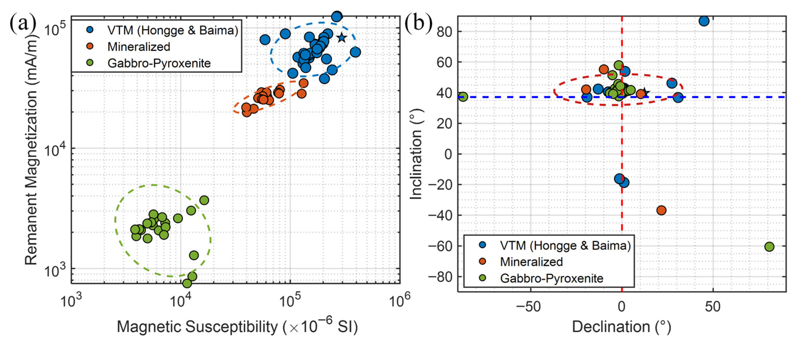
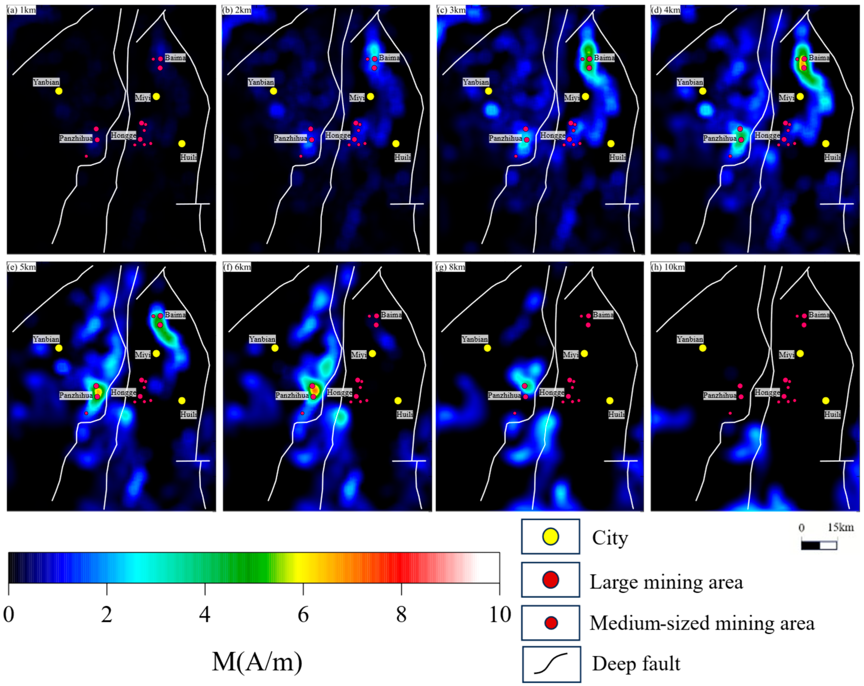
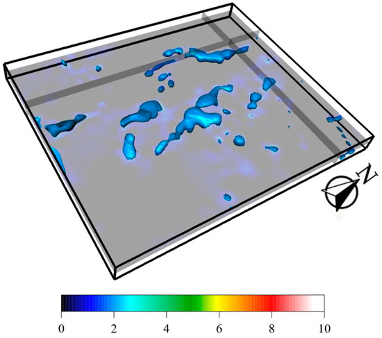
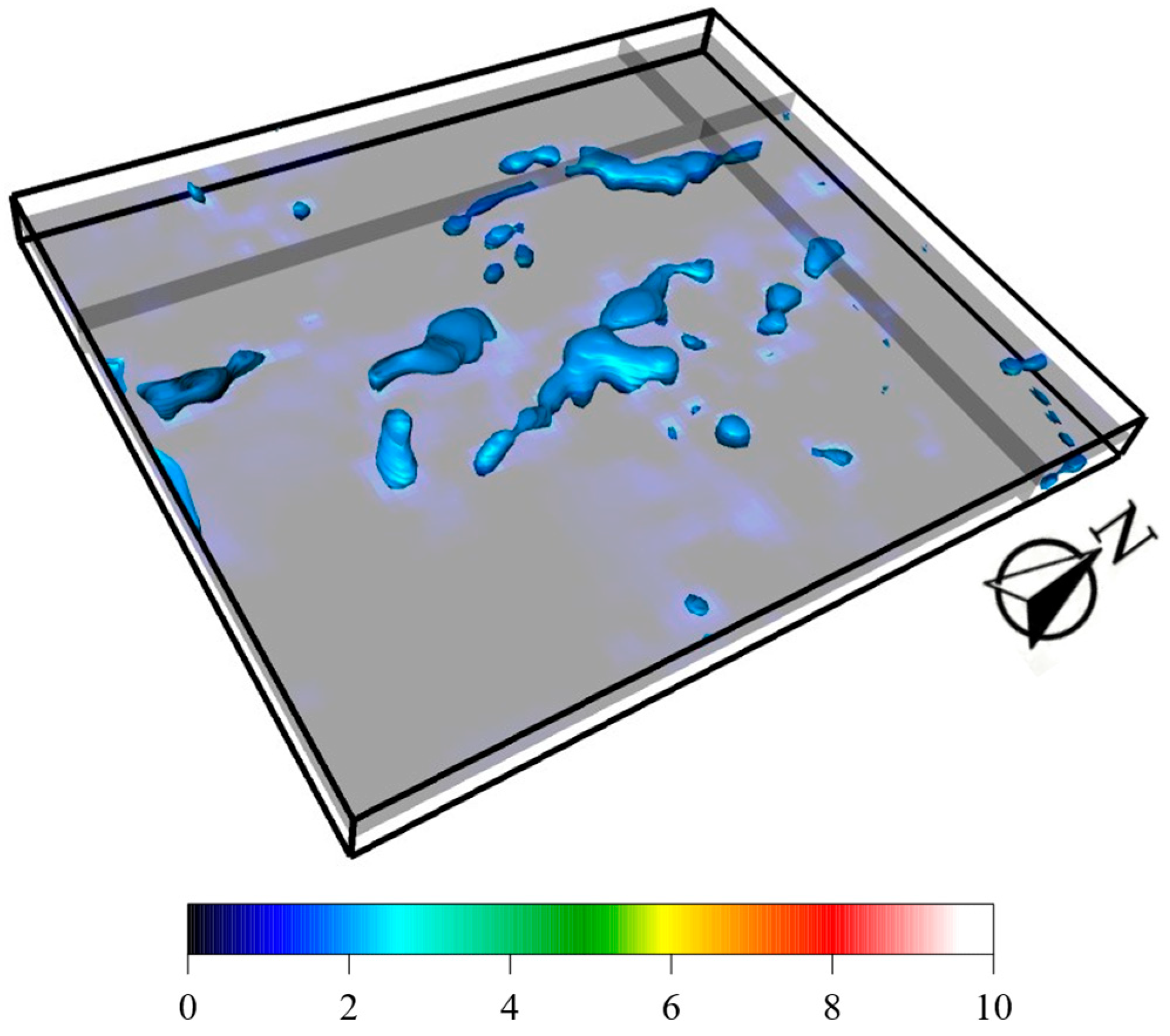
Based on the above parameters, horizontal slices (Figure 13) and three-dimensional diagrams (Figure 14) of different depths were obtained through inversion. The results effectively revealed the distribution characteristics of deep magnetic bodies in the study area, where the main body of the regional magnetic source is oriented in the north–south direction, while local magnetic source anomalies are mainly oriented in the north–south direction, north–east direction, and north–west direction. Among them, the magnetic source oriented in the north–south direction is the most obvious, and it is mostly cut by the north–east and north–west structures; the magnetic anomalies oriented in the north–south direction are mainly distributed in the Baimei–Miyi–Hongge area east of the Xigeda–Yuanmu fault and west of the Anning River fault; and the deep strong magnetization intensity anomalies with a local north–east orientation are mainly distributed west of the Xigeda–Yuanmu fault, are significantly controlled by the Panzhihua fault in the east, and are limited to the east of the Chenghai fault in the west. From the different depth slices (Figure 13), the strong magnetic anomaly sources with a bottom boundary depth of 3–5 km are mainly distributed in the east of the Xigeda–Yuanmu fault, showing a north–south direction feature, and the anomaly gradually weakens and disappears with depth. Local magnetic source anomalies oriented in the north–east direction mainly occur west of the Xigeda–Yuanmu fault, the magnetic source anomaly near Panzhihua fault is the deepest, and most can reach 10 km. Overall, the distribution of magnetic bodies is significantly controlled by fault structures.
Figure 13.
A 1:50,000-point magnetic field three-dimensional inversion of magnetic susceptibility slices at different depths.
Figure 14.
Three-dimensional distribution map of 1:500,000 magnetic field strength of magnetization intensity.
The north–south trending faults in the study area are deep and significant faults that reflect the activities of the lithosphere. Their main development stages occurred during the Jining period, the Neo-Tethyan period, and the Indo-Paratian-Yanshanian periods [50]. The aeromagnetic anomalies and the distribution characteristics of the magnetic sources mainly respond to the faults, including the Chenghai fault, Panzhihua fault, Xigeda–Yuanmou fault, Anning River fault, and their secondary faults. The north–south-trending structural belts in the area have a very significant controlling effect on various minerals in the area, especially on the occurrence conditions and distribution patterns of the ferro-ferroan ultrabasic rock bodies containing vanadium–titanium magnetite [16]. Combined with the inversion results (Figure 14) and the magnetic parameter table (Table 5), the authors of this paper propose that the three-dimensional inversion structure is clear, and the magnetic source anomalies with obvious trends are mostly responses of the basic–ultrabasic complex bodies that repeatedly intruded along the deep and significant faults in the study area.
5.3. Discussion on the Characteristics of Deep Magnetic Sources and Their Relationship with Ore Fields
The back-tilted uplift of the Kun-Dian paleo-continent basement platform, which began in the Middle Ordovician and continued until the end of the Mississippian and the beginning of the Carboniferous, was accompanied by the upwelling of a large amount of mantle material. The upper crust gradually thinned. In the uplift zone of the back-tilted axis of the Kun-Dian platform, the lithosphere suffered severe fractures [18]. The authors of the present article suggest that under the action of this mantle uplift, the basement, under the influence of the pre-existing north–south main fault system and the north–northeast and north–northwest shear fault grid, may have formed two north–south tracking fault-type rifts, namely the eastern branch of the Anning River rift and the western branch of the Panzhihua rift. Among them, the eastern branch of the Anning River rift between the Xigeda–Yuanmou and Anning River boundary faults, the anomaly of the three-dimensional magnetization intensity inversion, is the ultrabasic rock body intruded along the boundary faults of the rift; the layered distribution is in line with the central axis of the rift while the main distribution of the anomaly is controlled by the north–south boundary faults obviously, and it is in a north–south direction, forming the famous Baima–Miyi–Hongge ultrabasic–superbasic strong magnetic rock mass group in this area. Conversely, the Panzhihua rift sandwiched between the two boundary faults of Panzhihua and Chenghai, the inversion of the three-dimensional magnetization intensity anomaly, is mainly distributed on the west side of the Panzhihua fault zone and the eastern side of the Chenghai fault; it is distributed in the north–east direction, forming the Maoling, Wuben, Panzhihua, and Yianbian ultrabasic–superbasic strong magnetic rock mass group.
The magnetization intensities of the three-dimensional inversion results are mostly in the range of 2–10 A/m. According to the petrological test parameters of the study area (Table 5), the authors of the present article suggest that these magnetic sources are mainly intrusive basic–ultrabasic complex rocks. The Baishan–Miyi–Hongge rock group and Panzhihua rock group in the study area all show strong magnetism. Among them, the Baishan–Miyi–Hongge rock group is the largest, with a north–south orientation. In the southern section, it is interrupted by NE-trending faults, but the main part is oriented north–south, and the maximum magnetization intensity is close to 10 A/m with anomalies mainly distributed within 5 km. The Maoling–Wuben–Panzhihua and Yanbian rock group have a main orientation oNE andnd are significantly controlled by the Panzhihua fault in the west. Among them, the anomaly intensity of Maoling–Wuben–Panzhihua increases with depth, and it has the rock mass with the deepest extension in the study area, reaching up to 8–10 km deep. It is worth noting that in the southern section of the Baishan–Miyi–Hongge rock group, the rock group in the Hongge area has relatively complex magnetic characteristics. The three-dimensional inversion results show that it is composed of three groups of smaller-scale, nearly north–south-distributed local rock masses, with most of the magnetization intensities less than 5 A/m, and the anomaly intensity is relatively weak. The bottom boundary of the rock mass is less than 5 km.
Zhang Yunxiang et al. [44] proposed that the early basic–ultrabasic intrusions in the Haisi area intruded along two rift zones, forming two nearly north–south oriented vanadium–titanium magnetite belts spatially and symmetrically distributed. Due to the extensional tectonic environment of the rift and intermittent expansion activities, the basaltic magma from the upper mantle showed pulsating recharge effect, forming layered basic–ultrabasic intrusions with rhythmic cycles; especially in the non-arc rift zone, the quiet tectonic environment enabled the magma to fully crystallize, forming gravity segregation differentiation resulting in large rock groups and rich vanadium–titanium magnetite deposits [51,52]. These ultramagnesian basic–ultrabasic rock groups reversed the three-dimensional magnetization intensity, which could reach up to 2–10 A/m. The structural features in the deep part of the Kangdian–Taibei area are very clear in the north–south direction, as the magnetic intensity anomaly band from the Baihe–Miyi–Hongge in the north reflects the ultramagnesian basic–ultrabasic rock group, showing a north-strong–south-weak and north-deep–south-shallow distribution feature, with the base boundary depth mostly ranging from 4 to 6 km; conversely, the basic–ultrabasic rock group in the north–eastward-distributed rift of Panzhihua generally shows a west-weak–east-strong and north-shallow–south-deep distribution feature, and some rock bodies are controlled by the Panzhihua faults, mostly showing north–eastward and north–south orientations.
Based on the view that the continental rift structure controls rock and mineral deposits and the distribution pattern of the “Panzhihua-type” vanadium–titanium magnetite deposits, we believe that the north–south trending Kangdian–Tai reverse fold uplift zone restricts the distribution of the vanadium–titanium magnetite ore-producing area (zone), having a significance of primary structural control of rocks. The high magnetization intensity rock group belt of the Tai reverse fold, that is, the ancient rift axis zone, controls the distribution of the “Panzhihua-type” vanadium–titanium magnetite. The typical exploration of “Panzhihua-type” vanadium–titanium magnetite deposits indicates that the ore-bearing basic–ultrabasic complex has the characteristics of zone distribution and symmetrical occurrence. The ore-bearing layered complex bodies seen are not directly produced on a certain fault zone, but are located on the high magnetization intensity rock group within the axis part of the rift, beyond the range of the high magnetization source anomaly, then there is no ore-bearing rock body exposed. For example, the Baihua–Miyi–Hongge basic–ultrabasic complex group in the ancient rift of the Dongji branch of the Anning River in the east has mineral fields such as Baihua and Hongge, whereas the Panzhihua mineral field and other mineral points in the west branch of the Panzhihua ancient rift all have a high degree of coincidence with the distribution of the inverted magnetization intensity anomaly. Based on this, we can predict the deep ore-forming potential areas of vanadium–titanium magnetite in the two rift belts according to the distribution characteristics of the magnetization intensity anomaly inverted in this paper.
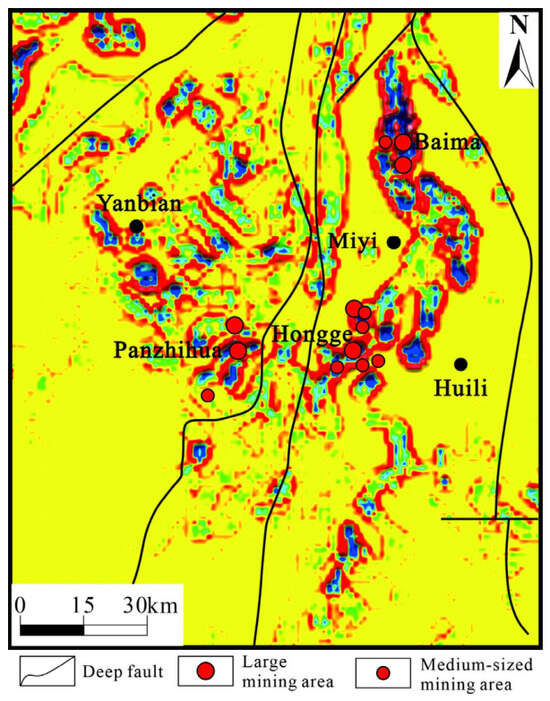
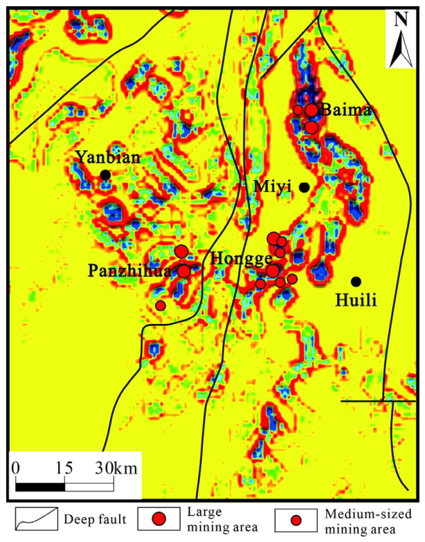
In addition, the NE- and NW-trending shear structures within the ancient rift zone also play a decisive role in determining the specific output of the vanadium–titanium magnetite deposit field. The three-dimensional magnetization intensity inversion results indicate that the ore-bearing layered complex rocks in the rift zone are not uniformly distributed but occur intermittently, in segments and concentrated. This is related to the widespread distribution of multiple shear structures in various directions within the area. Several large vanadium–titanium magnetite deposits in the area, without exception, are located within the specific shear fracture zone of the rift zone. For example, the Baima and Hongge mining fields are distributed in the zigzag shear tension sections of the NE- and NNE-trending shear faults within the ancient rift zone of the Anning River, while the Panzhihua mining field is located in the NNE tension section. This is consistent with the regional linear structural characteristics obtained from the 1:50,000 aeromagnetic anomaly gradient modulus (Figure 15). It reflects that the north–northwest and north–northeast shear actions in the study area have an insignificant but non-negligible effect on the formation and enrichment of the deposits. Clearly, the shear tensile faults are structurally conducive to opening larger spaces and relatively stable rock-hosting environments. On the one hand, they provide a vast space for magma intrusion; on the other hand, they facilitate the crystallization and gravity accumulation of basic–ultrabasic magmas, forming well-differentiated and rhythmic-layered intrusive bodies. Therefore, this shear tension structure plays a positioning role for the output of the vanadium–titanium magnetite deposit field and has the structural significance of controlling the deposit at local level.
Figure 15.
Identification map of linear structures of magnetic anomalies.
Therefore, we suggest that the mineralization of the Panzhihua-type V–Ti magnetite deposit is closely associated with the magmatic conduit system. The primitive magma from the mantle plume may have evolved in both deep and shallow magma chambers, and the deposit was likely formed in the ascent channel of voluminous high-Ti basaltic magma [26]. Petrological and geochemical evidence shows that its formation was jointly controlled by parental magma composition, oxygen fugacity, magma recharge, and fluid activity, requiring relatively high oxygen fugacity for either immiscibility or fractional crystallization of Fe–Ti oxide melts [51,53].
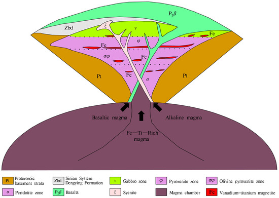
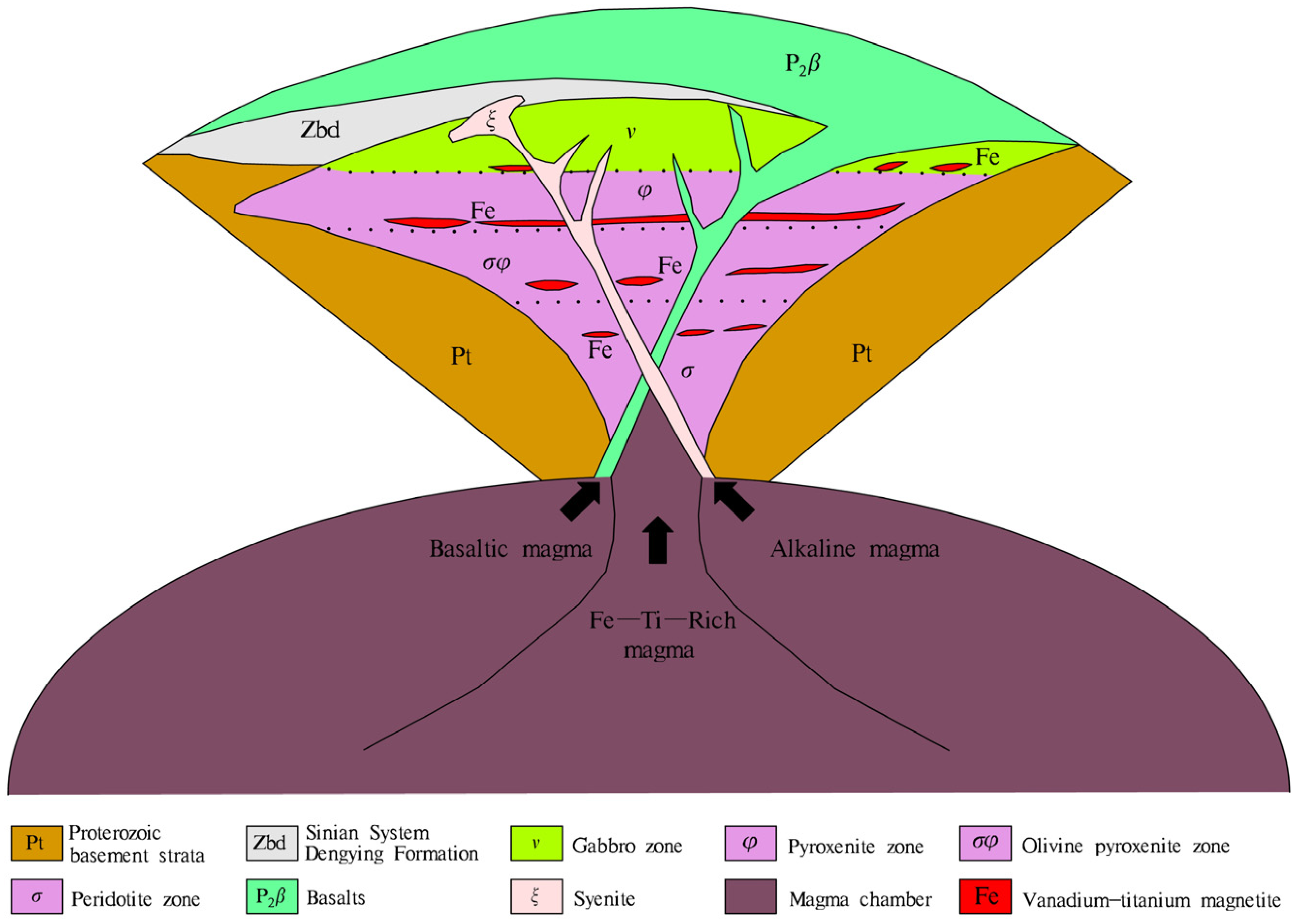
The 3D magnetic structure inverted from 1:50,000 aeromagnetic data reveals that highly magnetic mafic–ultramafic ore-related intrusions are located in the middle Kangdian basement fault uplift zone, which are obviously controlled by the NS-trending Panzhihua and Anninghe rift systems. We conclude that Variscan rifting was a key metallogenic event: mantle magma ascended along extensional basement faults, underwent intensive differentiation and convection, and finally formed well-differentiated layered intrusions with rhythmic cumulate textures. V–Ti–Cu–Ni–PGE sulfide ores are distributed along sheared basement fault zones. Its metallogenic model is shown in Figure 16.
Figure 16.
Metallogenic model of the Panzhihua-type V–Ti magnetite deposit.
Quantitative validation using independent borehole and seismic data, as well as a rigorous probabilistic petrophysical classification scheme linking inverted magnetization to lithologies, will be systematically conducted in future studies.
6. Conclusions
This study utilized high-resolution 1:50,000 aeromagnetic data from the Panxi region and developed an unsupervised deep learning framework to achieve 3D magnetization intensity inversion. The results effectively delineate the deep geometry and spatial distribution of mafic–ultramafic intrusions associated with Panzhihua-type vanadium–titanium magnetite deposits.
The Kangdian tectonic uplift belt, characterized by strong north–south trending magnetic anomalies, represents a first-order structural control on magmatism and mineralization in the region. It hosts two major Late Variscan rift systems: the Anning River rift (eastern branch) and the Panzhihua rift (western branch). These rift systems, bounded by deep-seated faults (Chenghai, Panzhihua, Xigeda–Yuanmou, and Anning River faults), provided primary pathways for mantle-derived magma ascent and emplacement. Furthermore, secondary NE–NNE- and NW-trending shear structures within the rifts exerted important third-order controls on the localization of ore-bearing intrusions by creating favorable dilatational sites for magma emplacement and differentiation.
The present results demonstrate that deep fault-controlled rift systems played a fundamental role in guiding the emplacement of mafic–ultramafic intrusions and the formation of Panzhihua-type V–Ti magnetite deposits. The identified high-magnetization zones provide reliable geophysical targets for future deep exploration in the Panxi region.
Despite the advantages of the proposed unsupervised framework, potential uncertainties remain from observational noise, inherent non-uniqueness of magnetic inversion, and neural network parameterization. In this study, the valid data range is strictly determined by regular grid interpolation, and the inversion within the observation range is fully constrained by the forward matrix, which effectively reduces uncertainty interference. All computations are conducted on a GPU platform, and thus memory consumption refers mainly to GPU memory usage. For irregular or non-square survey areas, the framework can be adapted via flexible grid resampling and boundary-constrained forward matrix construction. Comprehensive uncertainty and scalability validation will be further explored in future work.
Future work will focus on integrating higher-resolution magnetic datasets and multi-physics constraints to further improve inversion accuracy and refine the metallogenic model. Further validation with independent subsurface data and quantitative petrophysical modeling will also be performed to establish a reliable mathematical relationship between the inversion model and real measured physical properties. Emerging spin-wave-based magnetometers, which enable voltage-controlled reconfiguration of magnetic sensitivity with sub-nT resolution and CMOS compatibility [39], represent a promising direction for acquiring higher-fidelity input data for inversion frameworks such as the one presented here.
Author Contributions
Conceptualization, Y.Z.; Methodology, Y.Z.; Algorithm, Y.Z., Z.C., Z.X. and C.S.; Validation, C.J. and J.L.; Formal analysis, Z.C.; Investigation, C.J. and C.S.; Resources, C.J.; Data curation, Y.Z., Z.C. and J.L.; Writing—original draft, Y.Z.; Writing—review and editing, Z.X.; Supervision, J.L.; Project administration, C.J.; Funding acquisition, C.J. All authors have read and agreed to the published version of the manuscript.
Funding
This work was supported by the Sichuan Bureau of Geology & Mineral Resources 2026 Science and Technology Project (SCDZ-KJXM 202602).
Data Availability Statement
The data presented in this study are available on request from the corresponding author due to the confidentiality agreement stipulated by the data.
Conflicts of Interest
The authors declare no conflicts of interest.
References
- Bailin, C. Formation and Evolution of the Panxi Ancient Rift; Science Press: Beijing, China, 1988. [Google Scholar]
- Song, X.; Chen, L.; Yu, S.; Tao, Y.; She, Y.; Luan, Y.; Zhang, X.; He, H. Geological features and genesis of the V-Ti magenetite deposits in the Emeishan large igneous province, southwest China. Bull. Mineral. Petrol. Geochem. 2018, 37, 1003–1018. [Google Scholar]
- Chen, L.; Yi, J.; Song, X.; Yu, S.; She, Y.; Jie, W.; Luan, Y.; Xiang, J. Petrogenesis of the Heigutian Ti-Vmagnetite ore-bearing layered intrusion, the inner zone of the Emeishan large igneous province. Acta Petrol. Sin. 2014, 30, 1415–1431. [Google Scholar]
- Pirajno, F. Ore Deposits and Mantle Plumes; Springer Science & Business Media: New York, NY, USA, 2013. [Google Scholar]
- Xu, Y. Mantle plumes, large igneous provinces and their geological consequences. Earth Sci. Front. 2002, 9, 341–352. [Google Scholar]
- Hu, R.; Tao, Y.; Zhong, H.; Huang, Z.; Zhang, Z. Mineralization systems of a mantle plume: A case study from the Emeishan igneous province, southwest China. Earth Sci. Front. 2005, 12, 42–54. [Google Scholar]
- Xu, Y.; He, B.; Huang, X.; Luo, Z.; Zhu, D.; Ma, J.; Shao, H. Late Permian Emeishan flood basalts in southwestern China. Earth Sci. Front. 2007, 14, 1–9. [Google Scholar] [CrossRef] [Scilit]
- Zhang, Z.; Tong, H.; Li, H.; Li, J.; Zhang, Z.; Song, X. Enrichment mechanism of iron in magmatic-hydrothermal system. Acta Petrol. Sin. 2014, 30, 1189–1204. [Google Scholar]
- Philpotts, A. Origin of certain iron-titanium oxide and apatite rocks. Econ. Geol. 1967, 62, 303–315. [Google Scholar] [CrossRef] [Scilit]
- Reynolds, I.M. Contrasted mineralogy and textural relationships in the uppermost titaniferous magnetite layers of the Bushveld Complex in the Bierkraal area north of Rustenburg. Econ. Geol. 1985, 80, 1027–1048. [Google Scholar] [CrossRef] [Scilit]
- Emslie, R.; Ermanovics, I. Major Rock Units of the Morin Complex, Southwestern Quebec; Geological Survey of Canada (Department of Energy, Mines and Resources, Ottawa): Ottawa, ON, Canada, 1975; pp. 48–74. [Google Scholar]
- Ashwal, L. Petrogenesis of Inassif-Type Anorthosite, Crystallization History and Liquid Line of Descent of the Adirondack and Morin Complexes: Unpubl. Ph.D. Thesis, University of Massachusetts, Amherst, MA, USA, 1978. [Google Scholar]
- Charlier, B.; Duchesne, J.-C.; Vander Auwera, J. Magma chamber processes in the Tellnes ilmenite deposit (Rogaland Anorthosite Province, SW Norway) and the formation of Fe–Ti ores in massif-type anorthosites. Chem. Geol. 2006, 234, 264–290. [Google Scholar] [CrossRef] [Scilit]
- Cawthorn, R.G.; Ashwal, L.D. Origin of anorthosite and magnetitite layers in the Bushveld Complex, constrained by major element compositions of plagioclase. J. Petrol. 2009, 50, 1607–1637. [Google Scholar] [CrossRef] [Scilit]
- Shellnutt, J.G.; Zhou, M.; Yan, D.; Wang, Y. Longevity of the Permian Emeishan mantle plume (SW China): 1 Ma, 8 Ma or 18 Ma? Geol. Mag. 2008, 145, 373–388. [Google Scholar] [CrossRef] [Scilit]
- Zhang, Z.; Ying, L.; Li, Z.; Yu, A. Geochemistry of three layered mafic-ultramafic intrusions, in the Panxi area and constraints on their sources. Acta Petrol. Sin. 2007, 23, 2339–2352. [Google Scholar]
- Song, X.; Zhou, M.; Hou, Z.; Cao, Z.; Wang, Y.; Li, Y. Geochemical constraints on the mantle source of the upper Permian Emeishan continental flood basalts, southwestern China. Int. Geol. Rev. 2001, 43, 213–225. [Google Scholar] [CrossRef] [Scilit]
- He, B.; Xu, Y.; Chung, S.; Xiao, L.; Wang, Y. Sedimentary evidence for a rapid, kilometer-scale crustal doming prior to the eruption of the Emeishan flood basalts. Earth Planet. Sci. Lett. 2003, 213, 391–405. [Google Scholar] [CrossRef] [Scilit]
- Zhang, Z. A discussion on some important problems concerning the Emeishan large igneous province. Geol. China 2009, 36, 634–646. [Google Scholar]
- Xu, Y.; Chung, S.; Jahn, B.; Wu, G. Petrologic and geochemical constraints on the petrogenesis of Permian–Triassic Emeishan flood basalts in southwestern China. Lithos 2001, 58, 145–168. [Google Scholar] [CrossRef] [Scilit]
- Xu, Y.; Chung, S. The Emeishan large igneous province: Evidence for mantle plume activity and melting conditions. Geochimica 2001, 30, 1–9. [Google Scholar]
- Zhou, M.; Wang, C.; Pang, K.; Shellnutt, G.J.; Ma, Y. Origin of giant Fe-Ti-V oxide deposits in layered gabbroic intrusions, Pan-Xi district, Sichuan Province, SW China. In Proceedings of the Mineral Deposit Research: Meeting the Global Challenge; Springer: Berlin/Heidelberg, Germany, 2005; pp. 511–513. [Google Scholar]
- Guo, D.; Yu, H.; Xue, W. Geological features and prospecting potential of the Panzhihua vanadic titanomagnetite deposit. Acta Geol. Sichuan. 2014, 34, 523–528. [Google Scholar]
- Jian, C.; Li, J.; Xu, Z.; Tian, X.; Cheng, Z.; Deng, J.; Lan, M.; Sun, Y. Magnetic Characteristics of Deep-Seated ‘Panzhihua-Type’Vanadium-Titanium Magnetite Based on 3D Aeromagnetic Inversion. IEEE Geosci. Remote Sens. Lett. 2025, 22, 7503605. [Google Scholar] [CrossRef] [Scilit]
- Li, H.; Wang, D.; Li, L.; Chen, J.; Yang, X.; Liu, M. Metallogeny of iron deposits and resource potential of major iron minerogenetic units in China. Geol. China 2012, 39, 559–580. [Google Scholar]
- Chen, Y.; Pei, R.; Wang, D.; Wang, P. Natural classification of mineral deposits: Discussion on minerogenetic series of mineral deposits (IV). Miner. Depos. 2015, 34, 1092–1106. [Google Scholar]
- Abubakar, F.; Abir, I.A. High-resolution airborne magnetic detection of iron ore deposits. Geosystems Geoenvironment 2025, 4, 100349. [Google Scholar]
- Shi, K.; Liu, S.; Jian, X.; Xu, F.; Mao, Y.; Liu, X. 3D joint inversion of borehole, surface, and airborne magnetic anomaly. Pure Appl. Geophys. 2025, 182, 1489–1511. [Google Scholar] [CrossRef] [Scilit]
- Li, Y.; Oldenburg, D.W. 3-D inversion of magnetic data. Geophysics 1996, 61, 394–408. [Google Scholar] [CrossRef] [Scilit]
- Portniaguine, O.; Zhdanov, M.S. 3-D magnetic inversion with data compression and image focusing. Geophysics 2002, 67, 1532–1541. [Google Scholar] [CrossRef] [Scilit]
- Rezaie, M. 3D inversion of magnetic amplitude data with sparseness constraint. Pure Appl. Geophys. 2021, 178, 2111–2126. [Google Scholar] [CrossRef] [Scilit]
- Liu, S.; Jin, S. 3-D gravity anomaly inversion based on improved guided fuzzy C-means clustering algorithm. Pure Appl. Geophys. 2020, 177, 1005–1027. [Google Scholar] [CrossRef] [Scilit]
- Zhou, X.; Chen, Z.; Lv, Y.; Wang, S. 3-D gravity intelligent inversion by U-Net network with data augmentation. IEEE Trans. Geosci. Remote Sens. 2023, 61, 5902713. [Google Scholar] [CrossRef] [Scilit]
- Yadav, A.; Yadav, K.; Sircar, A. Feedforward neural network for joint inversion of geophysical data to identify geothermal sweet spots in Gandhar, Gujarat, India. Energy Geosci. 2021, 2, 189–200. [Google Scholar] [CrossRef] [Scilit]
- Zhang, Y.; Xu, Z.; Xian, M.; Zhdanov, M.S.; Lai, C.; Wang, R.; Mao, L.; Zhao, G. 3-D basement relief and density inversion based on efficientNetV2 deep learning network. IEEE Trans. Geosci. Remote Sens. 2024, 62, 4508915. [Google Scholar] [CrossRef] [Scilit]
- Zhang, Y.; Xu, Z.; Xian, M.; Zhdanov, M.S.; Wang, X. Gravity Gradient Field Transformation by Enhanced Physics-Guided Multi-task Network. IEEE Trans. Geosci. Remote Sens. 2026, 64, 5905016. [Google Scholar]
- Karhunen, J.; Raiko, T.; Cho, K. Unsupervised deep learning: A short review. In Advances in Independent Component Analysis and Learning Machines; Academic Press: Cambridge, MA, USA, 2015; pp. 125–142. [Google Scholar]
- Chukwu, C.; Betts, P.; Moore, D.; Munukutla, R.; Armit, R.; McLean, M.; Grose, L. Unsupervised machine learning and depth clusters of Euler deconvolution of magnetic data: A new approach to imaging geological structures. Explor. Geophys. 2024, 55, 223–245. [Google Scholar] [CrossRef] [Scilit]
- Sadovnikov, A.V.; Zyablovsky, A.A.; Dorofeenko, A.V.; Nikitov, S.A. Exceptional-Point Phase Transition in Coupled Magnonic Waveguides. Phys. Rev. Appl. 2022, 18, 024073. [Google Scholar] [CrossRef] [Scilit]
- Zhang, Z.; Qin, J.; Lai, S.; Long, X.; Ju, Y.; Wang, X.; Zhu, Y.; Zhang, F. Origin of Late Permian syenite and gabbro from the Panxi rift, SW China: The fractionation process of mafic magma in the inner zone of the Emeishan mantle plume. Lithos 2019, 346, 105160. [Google Scholar] [CrossRef] [Scilit]
- Chung, S.; Jahn, B. Plume-lithosphere interaction in generation of the Emeishan flood basalts at the Permian-Triassic boundary. Geology 1995, 23, 889–892. [Google Scholar] [CrossRef] [Scilit]
- Zhong, H.; Yao, Y.; Prevec, S.A.; Wilson, A.H.; Viljoen, M.J.; Viljoen, R.P.; Liu, B.; Luo, Y. Trace-element and Sr–Nd isotopic geochemistry of the PGE-bearing Xinjie layered intrusion in SW China. Chem. Geol. 2004, 203, 237–252. [Google Scholar] [CrossRef] [Scilit]
- Zhou, M.; Robinson, P.T.; Lesher, C.M.; Keays, R.R.; Zhang, C.; Malpas, J. Geochemistry, petrogenesis and metallogenesis of the Panzhihua gabbroic layered intrusion and associated Fe–Ti–V oxide deposits, Sichuan Province, SW China. J. Petrol. 2005, 46, 2253–2280. [Google Scholar] [CrossRef] [Scilit]
- Zhang, Y.; Liu, B. Collected Papers on the Panxi Rift, China; Geology Press: Bejing, China, 1988. [Google Scholar]
- Zhong, H.; Campbell, I.H.; Zhu, W.; Allen, C.M.; Hu, R.; Xie, L.; He, D. Timing and source constraints on the relationship between mafic and felsic intrusions in the Emeishan large igneous province. Geochim. et Cosmochim. Acta 2011, 75, 1374–1395. [Google Scholar] [CrossRef] [Scilit]
- Zhou, M.; Arndt, N.T.; Malpas, J.; Wang, C.; Kennedy, A.K. Two magma series and associated ore deposit types in the Permian Emeishan large igneous province, SW China. Lithos 2008, 103, 352–368. [Google Scholar] [CrossRef] [Scilit]
- Shellnutt, J.G.; Zhou, M. Permian, rifting related fayalite syenite in the Panxi region, SW China. Lithos 2008, 101, 54–73. [Google Scholar] [CrossRef] [Scilit]
- Shellnutt, J.G.; Zhou, M.; Zellmer, G.F. The role of Fe–Ti oxide crystallization in the formation of A-type granitoids with implications for the Daly gap: An example from the Permian Baima igneous complex, SW China. Chem. Geol. 2009, 259, 204–217. [Google Scholar] [CrossRef] [Scilit]
- Pang, K.; Zhou, M.; Qi, L.; Shellnutt, G.; Wang, C.; Zhao, D. Flood basalt-related Fe–Ti oxide deposits in the Emeishan large igneous province, SW China. Lithos 2010, 119, 123–136. [Google Scholar] [CrossRef] [Scilit]
- Zhang, X.; Zhang, J.; Song, X.; Deng, Y.; Guan, J.; Zheng, W. Implications of compositions of plagioclase and olivine on the formation of the Panzhihua V-Ti magnetite deposit, Sichuan Province. Acta Petrol. Sin. 2011, 27, 3675–3688. [Google Scholar]
- Song, X.; Qi, H.; Hu, R.; Chen, L.; Yu, S.; Zhang, J. Formation of thick stratiform Fe-Ti oxide layers in layered intrusion and frequent replenishment of fractionated mafic magma: Evidence from the Panzhihua intrusion, SW China. Geochem. Geophys. Geosystems 2013, 14, 712–732. [Google Scholar] [CrossRef] [Scilit]
- Li, Y.; Liu, S.; Liu, W. Preliminary Exploration of Metallogenic Geological Characteristics and Metallogenic Regularities of Vanadium-Titanium Magnetite in Panzhihua. World Nonferrous Met. 2017, 469, 95–97. [Google Scholar]
- Cao, Y.; Wang, C.Y.; Huang, F.; Zhang, Z. Iron isotope systematics of the Panzhihua mafic layered intrusion associated with giant Fe-Ti oxide deposit in the Emeishan large igneous province, SW China. J. Geophys. Res. Solid Earth 2019, 124, 358–375. [Google Scholar] [CrossRef] [Scilit]

Disclaimer/Publisher’s Note: The statements, opinions and data contained in all publications are solely those of the individual author(s) and contributor(s) and not of MDPI and/or the editor(s). MDPI and/or the editor(s) disclaim responsibility for any injury to people or property resulting from any ideas, methods, instructions or products referred to in the content. |
© 2026 by the authors. Licensee MDPI, Basel, Switzerland. This article is an open access article distributed under the terms and conditions of the Creative Commons Attribution (CC BY) license.