


Highlights
What are the main findings?
- The field has grown rapidly since 2018, revealing a clear geographical divergence: domestic (Chinese) research heavily targets practical agricultural applications for staple crops, while international studies focus on broader environmental systems and physical mechanisms.
- Methodologies have fundamentally shifted from early indirect estimations using single indices to high-precision direct inversions that utilize multi-source data fusion (e.g., hyperspectral, thermal) and advanced machine learning algorithms.
What are the implications of the main findings?
- This divergence in research focus underscores the urgent need for international and interdisciplinary collaboration to effectively bridge the gap between fundamental mechanism exploration and practical agricultural technology.
- Future technological development must integrate physical laws into machine learning models to improve applicability and construct multi-scale, space–air–ground observation networks to enable real-time precision water management.
Abstract
Soil moisture critically governs terrestrial energy and water cycles. Precise monitoring of soil water content is essential for precision agriculture, drought early warning, and water resource management. Ground-based observations offer limited spatial coverage, and satellite remote sensing generally lacks high spatial resolution. Unmanned aerial vehicle (UAV) remote sensing, which provides centimeter-level spatial detail, can effectively address this gap and has therefore attracted considerable attention in soil moisture inversion research. Using CiteSpace, we performed a bibliometric analysis of 97 Chinese papers from the China National Knowledge Infrastructure (CNKI) and 321 English papers from the Web of Science Core Collection (2014–2025). The field has expanded rapidly since 2018, with China occupying a leading role. Domestically, Northwest A&F University represents a major research cluster, while the Chinese Academy of Sciences leads internationally. Key research topics include UAVs, soil moisture, machine learning, hyperspectral sensing, canopy temperature, and precision agriculture. Research themes have progressed from reliance on vegetation indices and temperature data toward the integration of hyperspectral and thermal infrared measurements, and toward the use of machine learning approaches to improve inversion models and achieve more accurate estimations. This study delineates the classification and developmental context of a knowledge system for soil moisture inversion using UAV remote sensing. Current work concentrates on integrating multi-sensor data with machine learning, while future efforts will emphasize coupling physical mechanisms with deep learning. These findings offer researchers a clear view of the field’s frontiers and a basis for planning future studies.
1. Introduction
Soil moisture is pivotal to the interactions among surface hydrology, ecosystems, and the atmosphere and significantly impacts agricultural production, climate change research, drought monitoring, and hydrological studies [1,2]. Rapid, accurate, and widespread acquisition of soil moisture data is essential for precise farmland irrigation, enhancing crop water use efficiency, and ensuring food security [3,4,5].
Traditional soil moisture monitoring techniques, such as the oven-drying method and TDR probes, are highly accurate but are also time-consuming, labor-intensive, and limited in spatial coverage, which limits their ability to capture spatial heterogeneity on a regional scale [6]. Conversely, satellite remote sensing, particularly using microwave satellites such as SMAP and SMOS, enables extensive and regularly repeated surface observations. However, their spatial resolution, typically at the kilometer or tens-of-meters level, often falls short of the needs for fine-scale spatial management, such as field-scale precision agriculture and small watershed hydrology [7,8].
In recent years, unmanned aerial vehicles (UAVs) have bridged the scale gap left by traditional monitoring technologies because of their unique advantages [9,10]. These include centimeter-level high spatio-temporal resolution, high mobility, low cost, and the ability to fly below clouds [11]. UAVs can deliver ultra-high-spatial-resolution data, ranging from centimeter to meter levels, at field or small watershed scales. They can also conduct revisits as needed, thereby combining spatial and temporal resolution effectively. Equipped with various sensors, such as visible light, multispectral, hyperspectral, and thermal infrared sensors, UAVs offer diverse data sources for the detailed inversion of soil moisture [12,13].
The rapid advancements in sensor technology and machine learning algorithms have significantly increased research on soil moisture retrieval using unmanned aerial vehicle (UAV) remote sensing [14,15,16]. Earlier studies primarily depended on a single vegetation index or canopy temperature for indirect estimation [17]. In contrast, current approaches employ multi-source data fusion to develop high-precision models [18,19]. Despite these advancements, research topics in this field remain scattered, and the technical approaches are varied. Currently, there is a notable absence of systematic reviews and quantitative analyses addressing the development context, research hotspots, and future trends in this area.
This study utilized bibliometric methods and CiteSpace visualization software to analyze literature on soil moisture inversion using unmanned aerial vehicles (UAVs) from the China National Knowledge Infrastructure (CNKI) and Web of Science (WOS) databases, covering the period from 2014 to 2025. By mapping scientific knowledge graphs, we systematically identified core authors, institutions, and research clusters in this field. Additionally, we quantitatively analyzed research hotspots and frontiers to provide scientific references for future researchers, facilitating a quick understanding of the field’s development and highlighting cutting-edge directions. This analysis also offers theoretical support for advancing UAV-based soil moisture inversion technology.
2. Data and Methods
2.1. Data
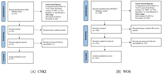
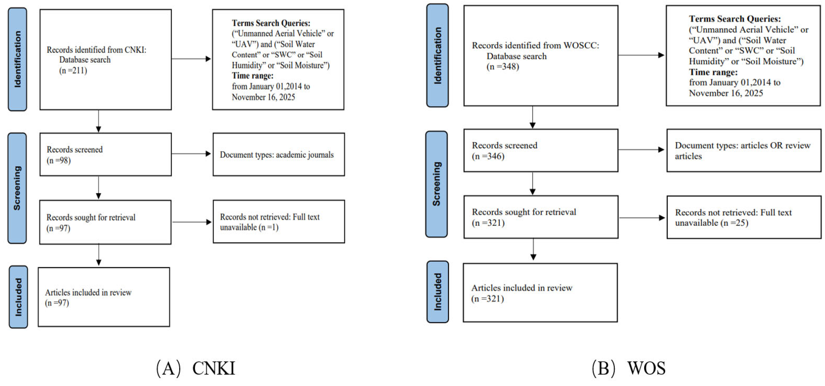
This bibliometric analysis followed the PRISMA 2020 guidelines for its literature search and screening process [20]. Chinese literature was obtained from the CNKI database, while the English literature was sourced from the Web of Science (WOS) Core Collection. The search spanned from 2014 to 2025, with the retrieval date set for 16 November 2025. The search terms were (“Unmanned Aerial Vehicle” or “UAV”) and (“Soil Water Content” or “SWC” or “Soil Humidity” or “Soil Moisture”). The literature types were limited to academic journal articles, research papers, and review articles, excluding non-research documents such as notices, newspapers, and conference abstracts. Ultimately, 97 academic journal articles from the CNKI database were selected and exported in RefWorks format, whereas 321 research papers or reviews from the WOS database were exported in plain text format. The detailed literature selection process is illustrated in Figure 1.
Figure 1.
Flowchart of the literature screening in the CNKI and WOS databases.
2.2. Methods
CiteSpace is a visualization analysis tool that transforms complex knowledge units, such as authors, institutions, countries, and keywords, into intuitive knowledge graphs [21]. This process clearly reveals the development history, structural relationships, and emerging trends within a research field. In this study, we utilized CiteSpace software (version 6.3.R1) to perform a visualization analysis of the retrieved literature data. This analysis included publication trends, subject classification, countries and institutions, author and co-citation analysis, keyword analysis, and the literature and journal co-citation analysis. Our goal is to explore research progress and emerging directions in the field of soil moisture retrieval using unmanned aerial vehicles. To ensure the clarity and scientific rigor of the knowledge maps, the analysis parameters were configured as follows: a time span of 2014–2025 with a one-year slice, and node selection by the g-index with scale factor k = 25. To improve clarity and interpretability, the merged networks were pruned using the pathfinder algorithm.
3. Results and Analysis
3.1. Trend Analysis of the Number of Published Papers
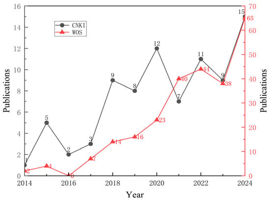
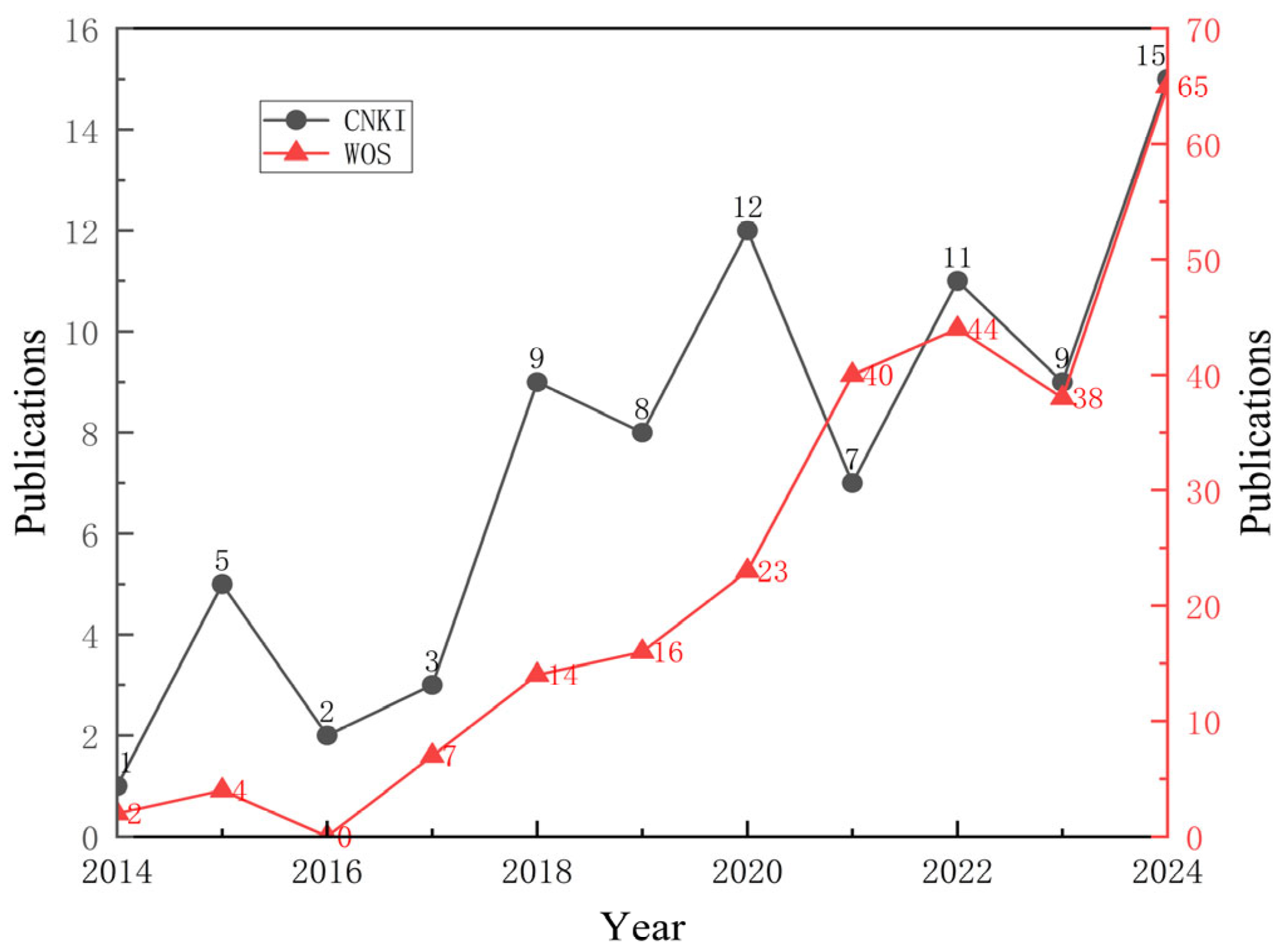
Figure 2 illustrates that before 2017, the number of publications in both Chinese and English was limited, with slow growth and annual publications remaining below 10, suggesting an exploratory phase. However, since 2018, the field has experienced significant growth due to the widespread adoption of unmanned aerial vehicle (UAV) platforms, advancements in sensor technologies such as hyperspectral and thermal infrared, and the integration of machine learning algorithms. Notably, after 2021, the number of papers in the WOS database exhibited an accelerated growth pattern. In 2024, publications reached a peak of 65 articles, accounting for 20.2% of the total international dataset, with a remarkable growth rate of 62.5% compared to 2021. Similarly, the CNKI database reached its historical maximum of 15 papers in the same year, representing 15.5% of the total domestic literature. Research on UAV remote sensing technology for soil moisture inversion is rapidly expanding, highlighting that UAV remote sensing is an increasingly important complement to traditional satellite and ground-based station monitoring, because of its high spatio-temporal resolution, flexibility, and cost-effectiveness. The ongoing enhancement of remote sensing data processing algorithms further accelerated the application of this technology in precision agriculture, water resource management, and environmental monitoring [22].
Figure 2.
Changes in the number of articles published in English and Chinese in the field of soil moisture inversion by UAVs between 2014 and 2024.
3.2. Analysis of Discipline Categories
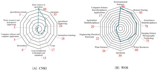
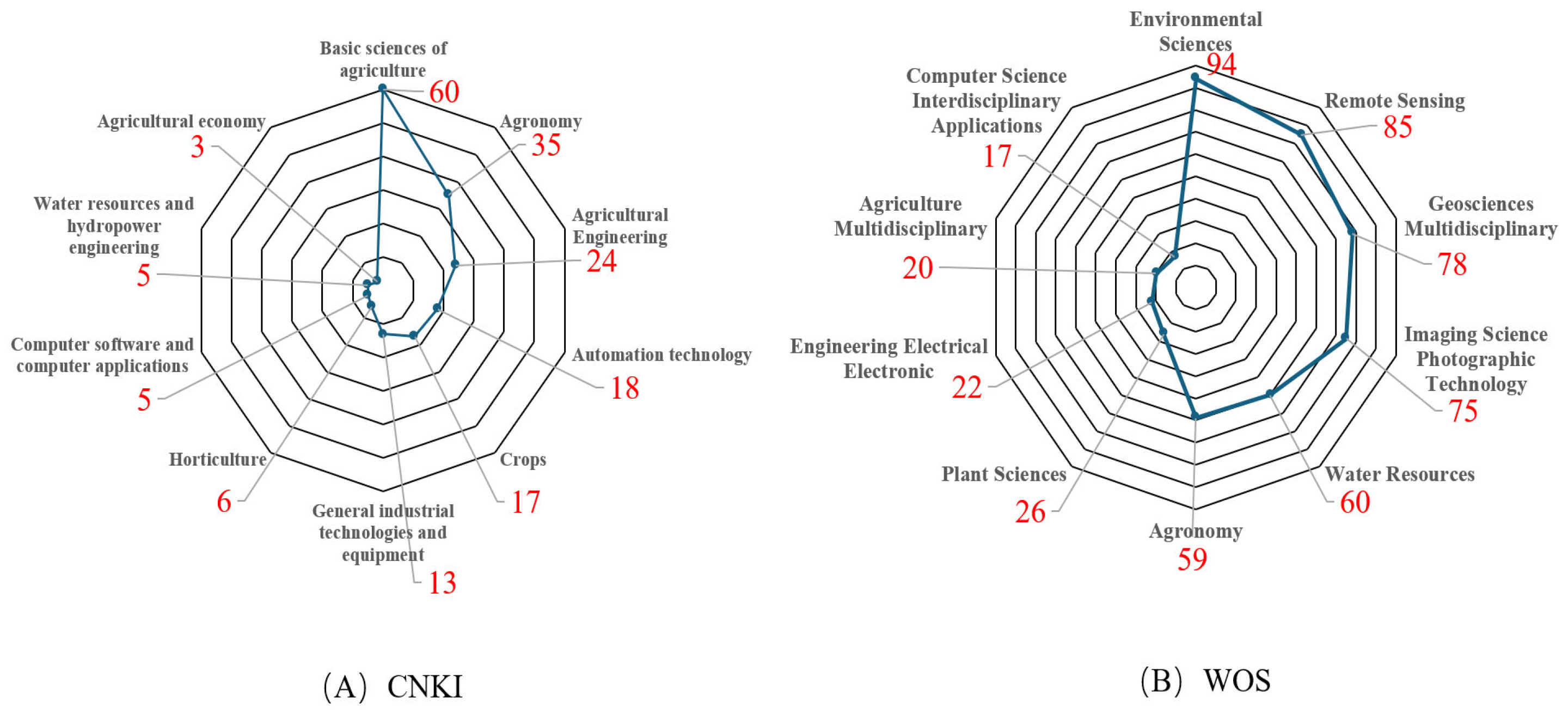
Figure 3A reveals that studies in the CNKI database are predominantly found in agricultural basic sciences (60 papers) and agronomy (35 papers), followed by agricultural engineering (24 papers). This distribution suggests that domestic research is focused on practical applications and solving real-world agricultural production issues. In contrast, Figure 3B illustrates a broader subject distribution in the WOS database. The primary subjects are environmental sciences (94 papers) and remote sensing (85 papers), followed by geosciences multidisciplinary (78 papers), imaging science photographic technology (75 papers), and water resources (60 papers). This indicates that international research prioritizes soil moisture as a crucial component of the Earth’s environmental system, emphasizing remote sensing principles, imaging technology, and computer modeling methodologies. Both databases exhibit distinct interdisciplinary characteristics, suggesting that using UAVs for soil moisture inversion integrates agricultural application needs, remote sensing techniques, and intelligent computer algorithms [23].
Figure 3.
Disciplinary category distribution maps in the CNKI and WOS databases.
3.3. Analysis of Countries and Institutions
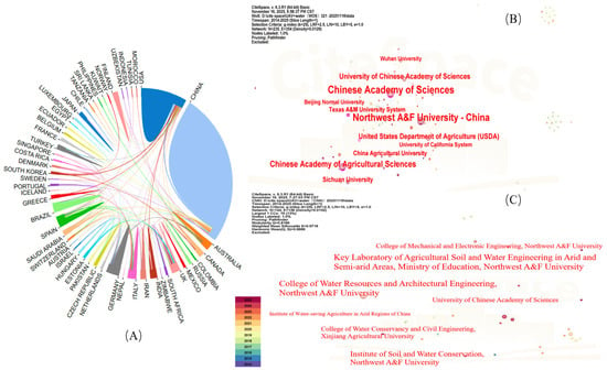
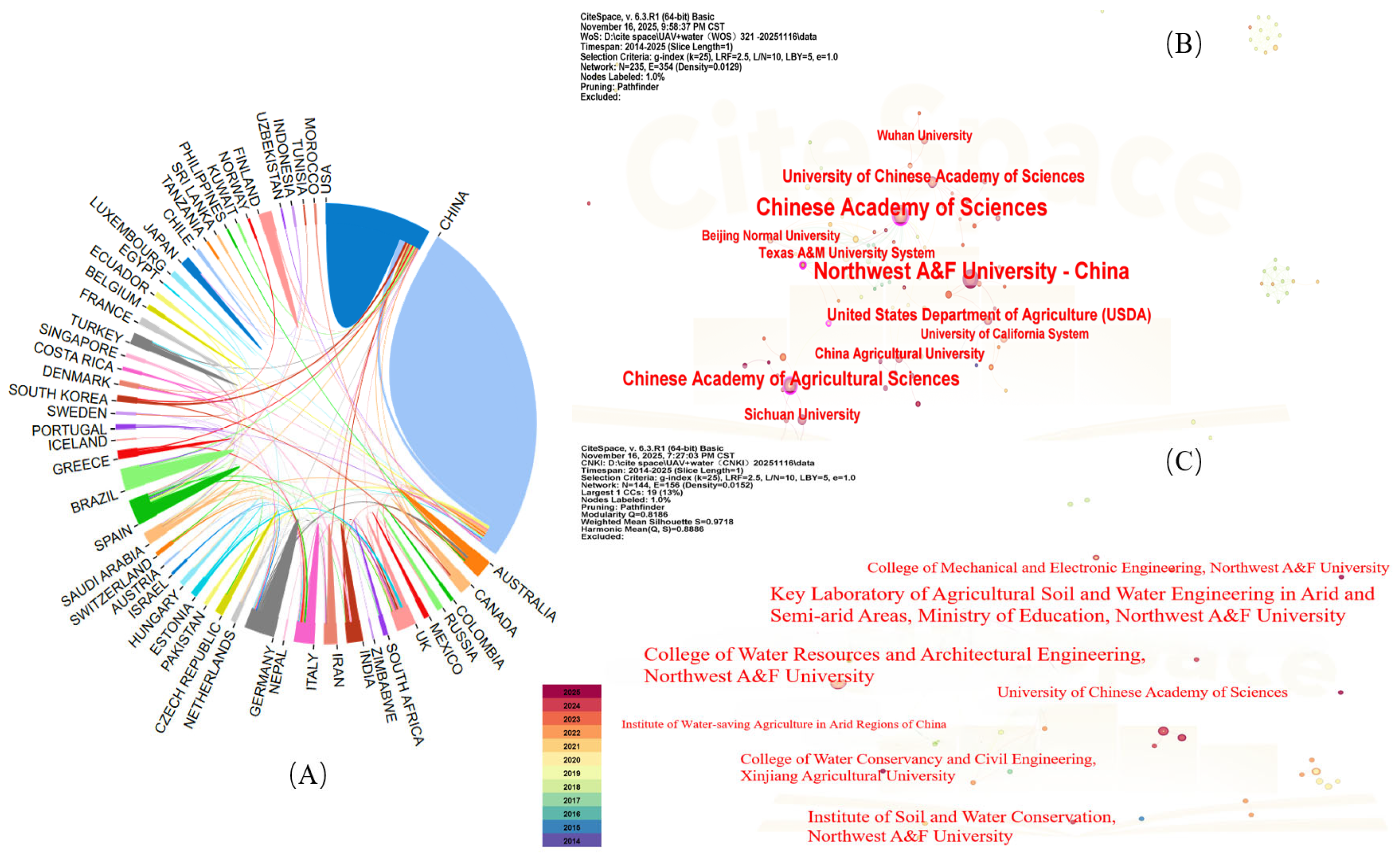
The national cooperation network map (Figure 4A) illustrates China’s central role in UAV soil moisture inversion research, with its publication count far surpassing that of other countries. On the map, China is depicted as the largest blue sector. The United States, Australia, Canada, Spain, Germany, and the United Kingdom are also key contributors in this field and have established robust cooperation networks with China. The WOS institution map (Figure 4B) indicates that the Chinese Academy of Sciences and its affiliated universities lead in international publications. Northwest A&F University, Sichuan University, and the Chinese Academy of Agricultural Sciences also demonstrated significant research accomplishments and strong scientific capabilities. The CNKI institution map (Figure 4C) further affirms Northwest A&F University’s leading position in China. Notably, institutions such as the Key Laboratory of Agricultural Soil and Water Engineering in Arid and Semiarid Areas, Ministry of Education, have formed a distinct research group. This is quantitatively supported by a local network density (D) of 0.0152, which is significantly higher than the overall network average, indicating robust internal collaboration. Additionally, a high silhouette score (S = 0.9718) for this institutional cluster further confirms its high thematic homogeneity and structural independence from other research groups.
Figure 4.
(A) National map in the WOS database. (B) Institutional map in the WOS database. (C) Institutional map in the CNKI database.
3.4. Author and Co-Citation Analysis
3.4.1. Author Analysis of CNKI Database
Table 1 reveals that Zhang Zhitao from Northwest A&F University is the most prolific author, with 10 publications and a centrality of 0.05. Another key contributor is Bian Jiang, with six papers and a centrality of 0.03. Notably, most of the top ten authors, ranked by publication frequency and centrality, are affiliated with Northwest A&F University. This suggests that large-scale, cohesive cooperation networks have yet to develop in domestic research. Consequently, most studies are conducted by independent teams, which hinders the in-depth advancement of research in this field.
Table 1.
Top ten authors in terms of counts and centrality in the CNKI database.
3.4.2. Author Analysis in the WOS Database
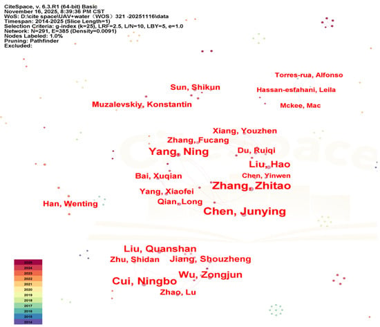
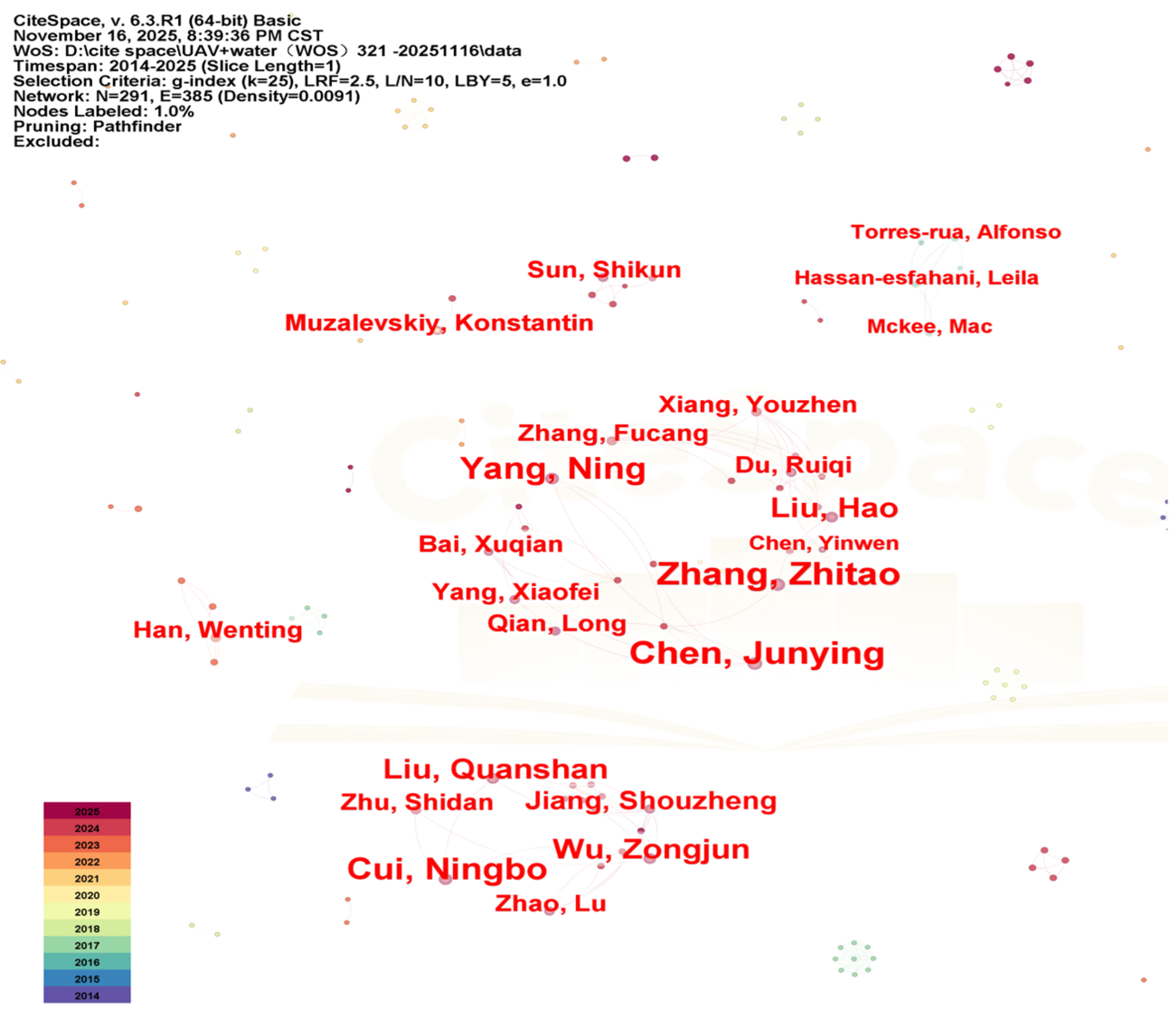
Figure 5 illustrates that the WOS author cooperation network exhibits some dispersion. The scholars with the highest publication frequencies are Chen Junying (nine papers, 2020) and Zhang Zhitao (nine papers, 2024). Additionally, Du Ruiqi and Chen Yinwen from Northwest A&F University are key contributors in this area (Table 2). All authors have notably low betweenness centrality values, with the highest being just 0.01 (Table 2) and the rest being zero. In CiteSpace theory, a centrality score of zero indicates a node is either isolated or on the periphery of a small cluster, lacking a bridging role. The near-zero centrality throughout the dataset highlights a highly fragmented collaboration landscape. This suggests that research in UAV-based soil moisture retrieval is currently led by independent groups with minimal interaction across clusters. The top three authors with a centrality of 0.01 signal the early emergence of academic intermediaries, yet the field as a whole has not developed a mature, integrated global collaborative network.
Figure 5.
Author mapping in the WOS database.
Table 2.
The top ten authors ranked by counts in the WOS database.
3.4.3. Co-Citation Analysis of Authors
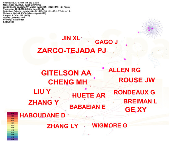
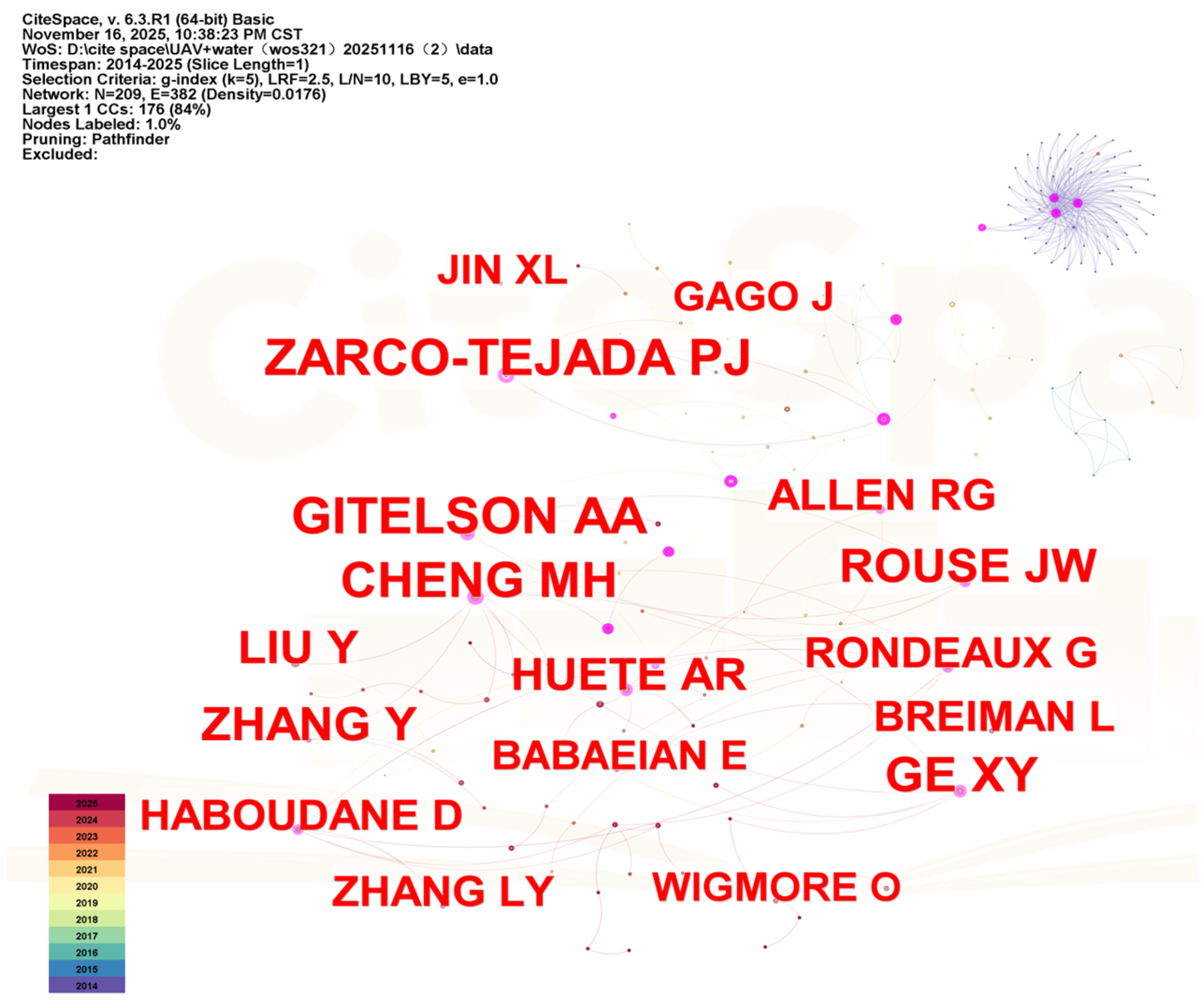
Author co-citation analysis highlights the academic foundation and influential figures in this field. As shown in Figure 6 and Table 3, ZARCO-TEJADA PJ boasts the highest centrality (0.64) and a significant citation frequency (45), establishing him as a key scholar. His research primarily focused on the fields of vegetation remote sensing, hyperspectral remote sensing, radiative transfer models, and physiological parameter inversion [24,25,26,27,28]. GITELSON AA, with the highest co-citation frequency (47) and a centrality of 0.28, is a leading authority on vegetation indices, deepening the understanding of vegetation spectral responses and proposing a series of vegetation indices with strong practicality and high anti-interference ability, providing important tools and methodological foundations for the remote sensing quantitative inversion of vegetation physiological parameters [29,30,31]. CHENG MH, with a frequency of 41 and centrality of 0.35, is another influential scholar who has contributed significantly to the field’s rapid development in recent years. The work of these scholars has established a theoretical basis for soil moisture retrieval using unmanned aerial vehicles (UAVs), particularly in constructing vegetation indices, thermal infrared remote sensing, and applying machine learning algorithms.
Figure 6.
Co-cited author map in the WOS database.
Table 3.
The top ten co-cited authors in terms of counts and centrality rankings.
3.5. Keyword Co-Occurrence and Burst Analysis
3.5.1. CNKI Database
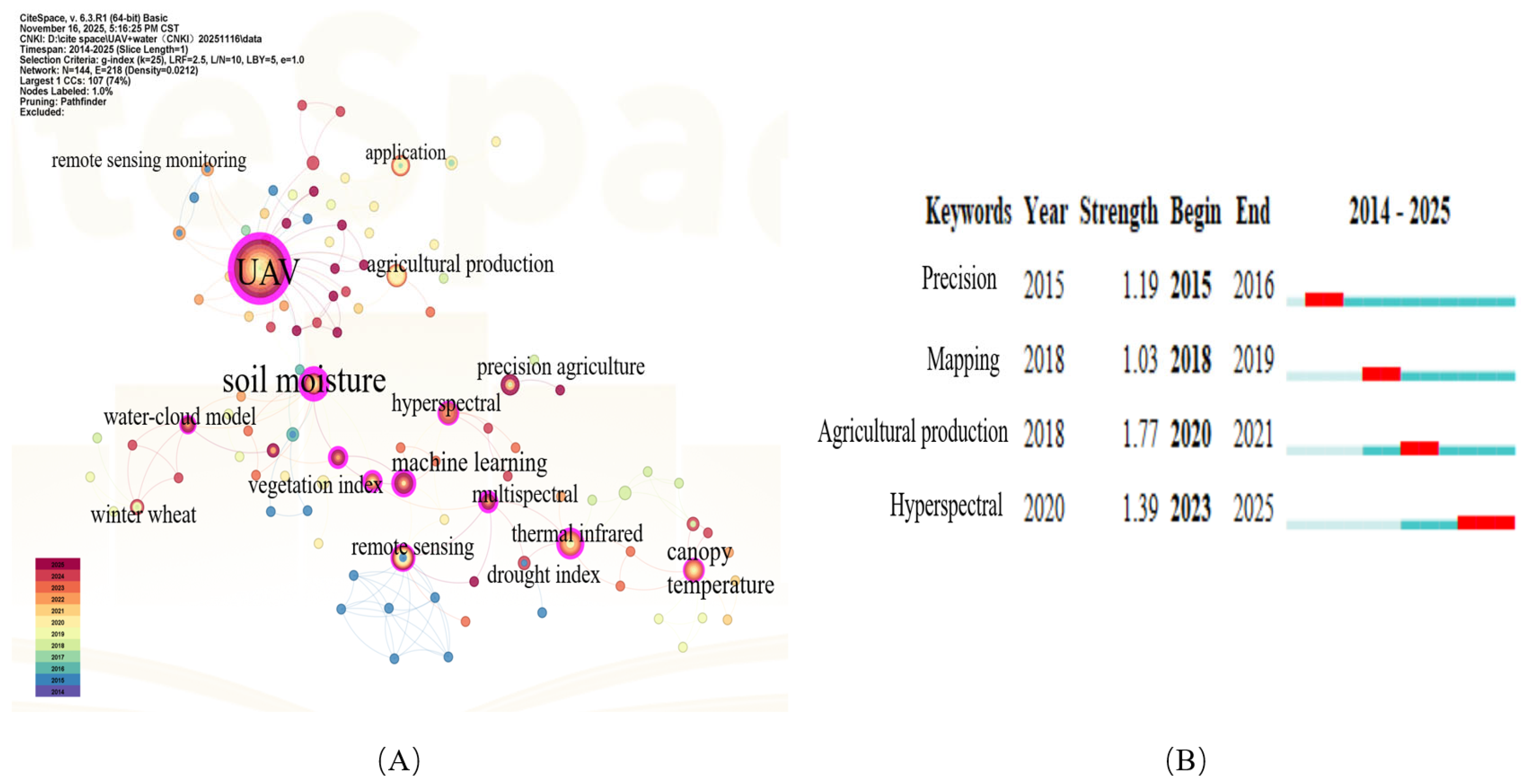
Keyword co-occurrence and burst analysis can illuminate the evolution of research hotspots in this field [32,33]. Figure 7A and Table 4 identify UAV (frequency 44, centrality 0.7) and soil moisture (frequency 10, centrality 0.68) as core nodes and keywords. Surrounding these nodes are associated terms such as remote sensing, monitoring, and identification. For data acquisition, thermal infrared, multispectral, and hyperspectral methods are the primary technical approaches [34]. Although multispectral does not rank in the top ten by frequency, its centrality is 0.39, placing it third, and it is closely linked to nodes such as vegetation index and drought index. This suggests that multispectral technology serves as a crucial bridge between raw image data and moisture inversion models, because of its comprehensive advantages in capturing crop physiological information and cost-effectiveness [35,36,37]. Additionally, nodes such as canopy temperature and canopy–air temperature difference indicate that diagnosing crop water stress using thermal infrared temperature data remains a key research focus. The emergence of machine learning as a high-frequency node in 2020 (frequency six, centrality 0.29) suggests a shift from traditional linear regression models to non-linear, high-dimensional data mining algorithms such as random forests and neural networks, addressing the complexities of farmland environments [38]. Among these methods, random forest (RF) and support vector machines (SVM) have become the most widely used models because they effectively fuse multi-source data and reduce overfitting in small-sample UAV experiments. To better address farmland complexity, recent studies have combined machine learning algorithms with the water–cloud model (WCM), a semi-empirical radiative transfer model. The WCM represents the vegetation canopy as a uniform “cloud” of water droplets and decomposes the total signal, such as backscattering or reflectance, into vegetation and soil components, thereby mitigating the shielding effect of crops. The WCM, which appeared in 2022 (centrality 0.13), indicates that cutting-edge research is delving into soil moisture signal unmixing under vegetation cover, aiming to mitigate canopy effects through physical models and address the limitations of single empirical models. This reflects a trend of integrating data-driven and physical mechanism approaches. Nodes such as winter wheat, maize, precision agriculture, and agricultural production on the map’s periphery highlight a focus on the critical water-demanding periods of major northern food crops. The goal is to inform practical production decisions, such as variable irrigation and drought monitoring, through high-precision inversion, underscoring the application-oriented nature of this research field [15,16].
Figure 7.
(A) Keyword co-occurrence map. (B) Keyword burst detection map in the CNKI database.
Table 4.
The top ten keywords ranked by counts and centrality in the CNKI database.
Figure 7B illustrates the evolution of research trends from an early focus on precision (2015–2016) to agricultural production (2018–2021), with the current frontier (2020–2025) being hyperspectral. This shift indicates a transition from macro-level applications to high-precision, multidimensional spectral mechanism inversion [39]. In the early stages, UAV technology was introduced to agriculture primarily to meet the demands of precision management in modern farming. Research during this period was largely theoretical and experimental, aiming to validate the feasibility of using UAVs as low-altitude platforms to acquire high-resolution farmland information for precision agriculture. The emergence of mapping in 2018 reflected the maturation of foundational spatial information acquisition technologies, such as UAV image stitching and orthophoto generation, providing essential spatial data support for subsequent moisture inversion [40]. The term agricultural production, which appeared in 2020 with the highest burst intensity (1.77), indicates a shift from isolated technical validation to integration with actual agricultural activities, focusing on how UAV monitoring data can guide specific agricultural practices such as irrigation management and crop yield estimation. The latest burst term, hyperspectral, which began in 2023 and continues to the present, clearly marks the current and future research frontiers. As multispectral technology becomes more widespread, the limitations of traditional broadband data in capturing subtle physiological changes in crops have become increasingly apparent. Hyperspectral remote sensing, with its advantage of combining imaging and spectroscopy, can capture fine spectral features related to moisture, serving as a critical breakthrough for enhancing inversion accuracy. This suggests that future UAV-based moisture inversion will advance toward higher spectral resolution and more complex data mining.
3.5.2. WOS Database
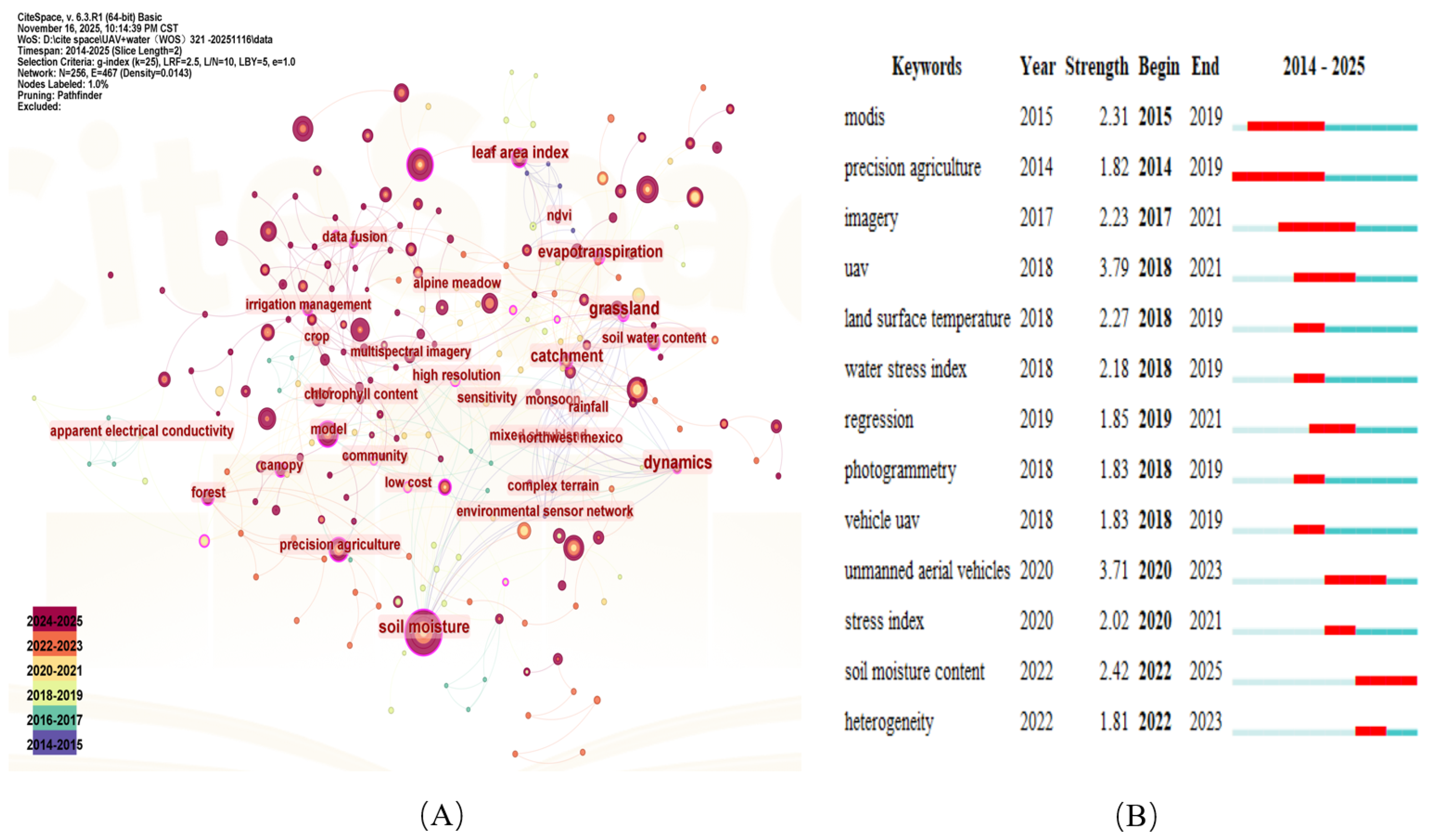
Figure 8A and Table 5 reveal that the core keywords are soil moisture (frequency 114, centrality 0.19) and vegetation index (frequency 55, centrality 0.12). This indicates a significant international focus on the impact and use of the vegetation canopy in moisture inversion research [41]. Unmanned aerial vehicle (UAV, frequency 35) and remote sensing (frequency 42) serve as foundational platforms. The keyword of the model (frequency 33) suggests that international research prioritizes constructing models based on physical mechanisms and parameterization over simple empirical statistics. Machine learning (frequency 33), which represents algorithm-driven approaches, is a current international hot topic. According to Table 5, grassland (centrality 0.24) and evapotranspiration (centrality 0.21) have the highest centrality, which contrasts with domestic research that has focused primarily on winter wheat farmland crops. This indicates that international research places greater emphasis on ecosystems such as grasslands and forests, as well as water fluxes, highlighting the regional circulation of water and eco-hydrological effects [42,43]. Additionally, leaf area index (centrality 0.2) is a high-centrality term. As a vegetation structure parameter, it links vegetation remote sensing with water models and is a crucial input for physical models such as the water–cloud model. Data fusion (centrality 0.17) reflects the efforts of the international research communities to integrate data from various sensors or scales to enhance the accuracy and spatio-temporal continuity of moisture inversion.
Figure 8.
(A) Keyword co-occurrence map. (B) Keyword burst detection map in the WOS database.
Table 5.
The top ten keywords ranked by counts and centrality in the WOS database.
Figure 8A illustrates that the terms of grassland, evapotranspiration, and catchment link rainfall and soil water content, establishing the core of eco-hydrological remote sensing in global research. The association of high resolution and multispectral imagery with low cost suggests that international research prioritizes not only high-precision technology but also the practicality and affordability of UAV systems. Keywords such as complex terrain and dynamics indicate a focus on addressing water monitoring challenges in geographically complex environments, such as mountainous areas and deserts, while also capturing the spatio-temporal variations in water.
In the keyword burst diagram shown in Figure 8B, precision agriculture (intensity 1.82) first emerged in 2014, establishing the role of UAV remote sensing in agricultural management. The burst of modis (intensity 2.31) highlights early efforts to integrate low-altitude UAV data with high-altitude satellite data to address scale issues, a classic remote sensing research approach. In 2017, the burst of imagery (intensity 2.23) signaled a shift in research focus toward the collection and processing of UAV image data. The simultaneous bursts of UAV (intensity 3.79) and photogrammetry (intensity 1.83) in 2018 indicated the widespread application of UAV platform technology during this period. The bursts of land surface temperature (intensity 2.27) and water stress index (intensity 2.18) in 2018 and 2019 confirmed a strong international focus on using thermal infrared remote sensing to diagnose crop physiological stress, directly impacting the accuracy of water inversion models. The burst of regression (intensity 1.85) in 2019 showed a systematic use of statistical methods to establish quantitative relationships between remote sensing parameters and groundwater. Unmanned aerial vehicles (intensity 3.71) surged again in 2020, continuing until 2023, with their intensity among the highest, indicating that research on UAV systems had reached a stage of standardization, diversification, and multi-sensor integration. The burst of heterogeneity (intensity 1.81) in 2022 is linked to the significant spatial heterogeneity of soil moisture, a major factor limiting inversion accuracy. The latest keyword burst, lasting until 2025, is soil moisture content (intensity 2.42), suggesting that despite technological advancements, accurately determining the soil moisture content remains a critical challenge and ongoing focus in current research.
3.5.3. Comparison of Hot-Spot Evolution at Home and Abroad
A comprehensive analysis reveals a shift in research focus within this field from feasibility exploration to high-precision optimization. Techniques such as random forest and support vector regression are now commonly employed, and multi-source data fusion remains a crucial technical direction [44]. A comparison of domestic and international research hotspots (Table 6) indicates that domestic research emphasizes practical agricultural applications, whereas international research prioritizes mechanism analysis and interdisciplinary integration.
Table 6.
Comparison of the evolution of research hotspots in the field of UAV-based soil moisture inversion at home and abroad.
3.6. Keyword Clustering Analysis
3.6.1. CNKI Database
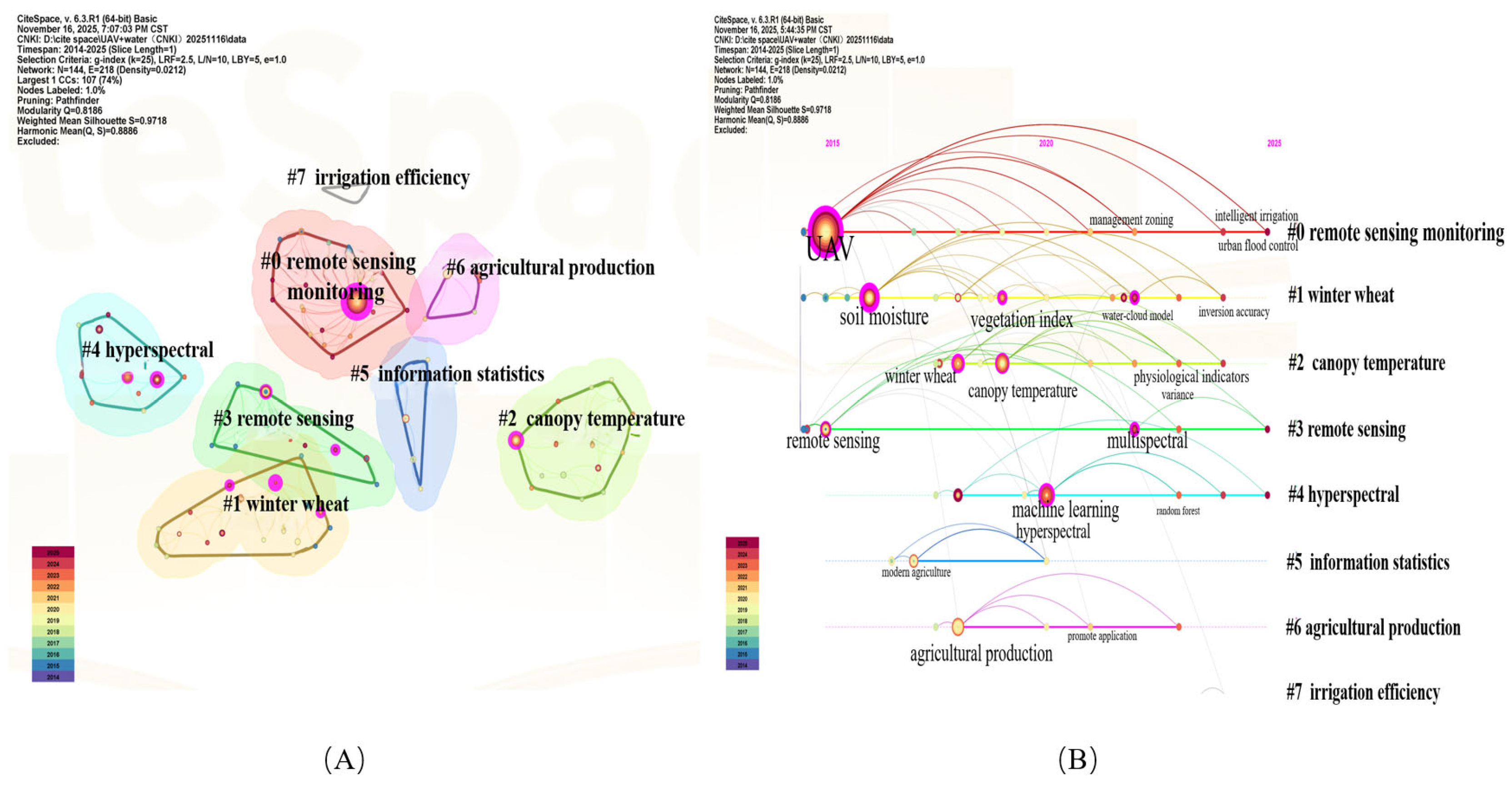
Keyword clustering highlights the primary research topics and emerging trends in this field [32]. In the keyword clustering map, network topology is assessed using modularity (Q) and the mean silhouette coefficient (S). Modularity Q quantifies the strength of the network’s community structure; a Q value greater than 0.3 indicates a significant, nonrandom community organization. The silhouette coefficient S measures the average homogeneity of keywords within clusters; values closer to one denote greater internal consistency. Typically, S values above 0.7 indicate that the clustering results are highly reliable. Figure 9A displays eight keyword clusters (Table 7), with Q = 0.8186 and S = 0.9718, confirming the clustering reliability. Cluster #0 remote sensing monitoring is the largest. It includes keywords such as UAV, multispectral image, and precision operation, suggesting that UAVs with multispectral sensors are currently the most prevalent technology for large-scale monitoring. Cluster #1 winter wheat was identified as the main research subject. This cluster features soil moisture, inversion accuracy, and satellite remote sensing, indicating that the focus for crops like winter wheat is on verifying cross-scale moisture inversion accuracy. Cluster #2 canopy temperature focuses on thermal infrared remote sensing mechanisms. It includes crops such as maize and walnut, and emphasizes physiological indicators and variance, suggesting that diagnosing crop physiological water shortages based on canopy temperature is a significant technical route independent of optical remote sensing. Cluster #3 remote sensing is another substantial method-related cluster, concentrating on the precise acquisition and management of farmland information using UAV hyperspectral and multispectral images. Cluster #4 hyperspectral represents the technology’s advanced direction. This cluster includes machine learning, least squares support vector machine, and hyperspectral, indicating that researchers are employing artificial intelligence algorithms to process high-dimensional spectral data for moisture inversion in complex backgrounds. The term optimal flight altitude suggests research into optimizing specific data collection parameters. Cluster #5 information statistics primarily involve research related to grassland ecosystems and field prospects, which are crucial for domestic ecological applications. Cluster #6, agricultural production, focuses on the practical application of UAV remote sensing technology in agricultural production and engineering practices, such as remote control. Cluster #7 irrigation efficiency emerged in 2024. Although small, it includes farmland irrigation and water resource waste, indicating a shift from simple moisture monitoring to water-saving-oriented irrigation decision-making management.
Figure 9.
(A) Keyword clustering map. (B) Timeline graph in the CNKI database.
Table 7.
Eight keyword clusterings in the CNKI database based on the LLR algorithm.
The evolution of UAV-based soil moisture research can be divided into three stages by technical sophistication and application depth. The initial Stage (2014–2017) emphasized macro-scale monitoring and relied on broadband sensors and simple linear regression to establish baseline feasibility, as exemplified by Cluster #3. The developmental stage (2018–2020) shifted toward crop-specific optimization, emphasizing the integration of multimodal data and non-linear machine learning to mitigate environmental noise in particular agro-ecosystems, such as Clusters #1 and #5. The refined stage (2021–present) marks the current frontier of high-precision management. It is characterized by the adoption of hyperspectral inversion and by coupling inversion results with irrigation-efficiency metrics, reflecting a shift from pure monitoring to intelligent water resource management, as exemplified by Clusters #4 and #7.
The timeline in Figure 9B illustrates that remote sensing monitoring of Cluster #0 covered the entire research period, beginning with core nodes such as UAV and remote sensing monitoring. The research gradually expanded from basic data acquisition to backend management zoning, eventually targeting specific applications such as intelligent irrigation and urban flood control from 2024 to 2025, highlighting the ultimate goal of technology serving production. Cluster #1, focused on winter wheat, clearly shows the process of enhancing inversion accuracy. Initially, the emphasis was on broad concepts such as soil moisture and precision. By the middle stage (approximately 2019 to 2021), the emergence of the key node water–cloud model indicated a deeper exploration into the physical mechanism for mitigating the influence of the vegetation canopy. Cluster #2, concerning canopy temperature, began with thermal infrared and progressed to analyze physiological indicators and variance in later stages, signifying the maturation of technology for diagnosing crop physiological states based on temperature. Cluster #4, related to the hyperspectrum, is closely linked to machine learning and ensemble learning. This suggests that as sensor spectral resolution improves, traditional statistical methods struggle with massive amounts of data, making artificial intelligence algorithms such as ensemble learning crucial for processing hyperspectral data and enhancing inversion accuracy. Nodes such as intelligent irrigation, inversion accuracy, and satellite remote sensing appear on the far right of the timeline, indicating a focus in this field on directly converting high-precision inversion results into automated irrigation decisions.
3.6.2. WOS Database
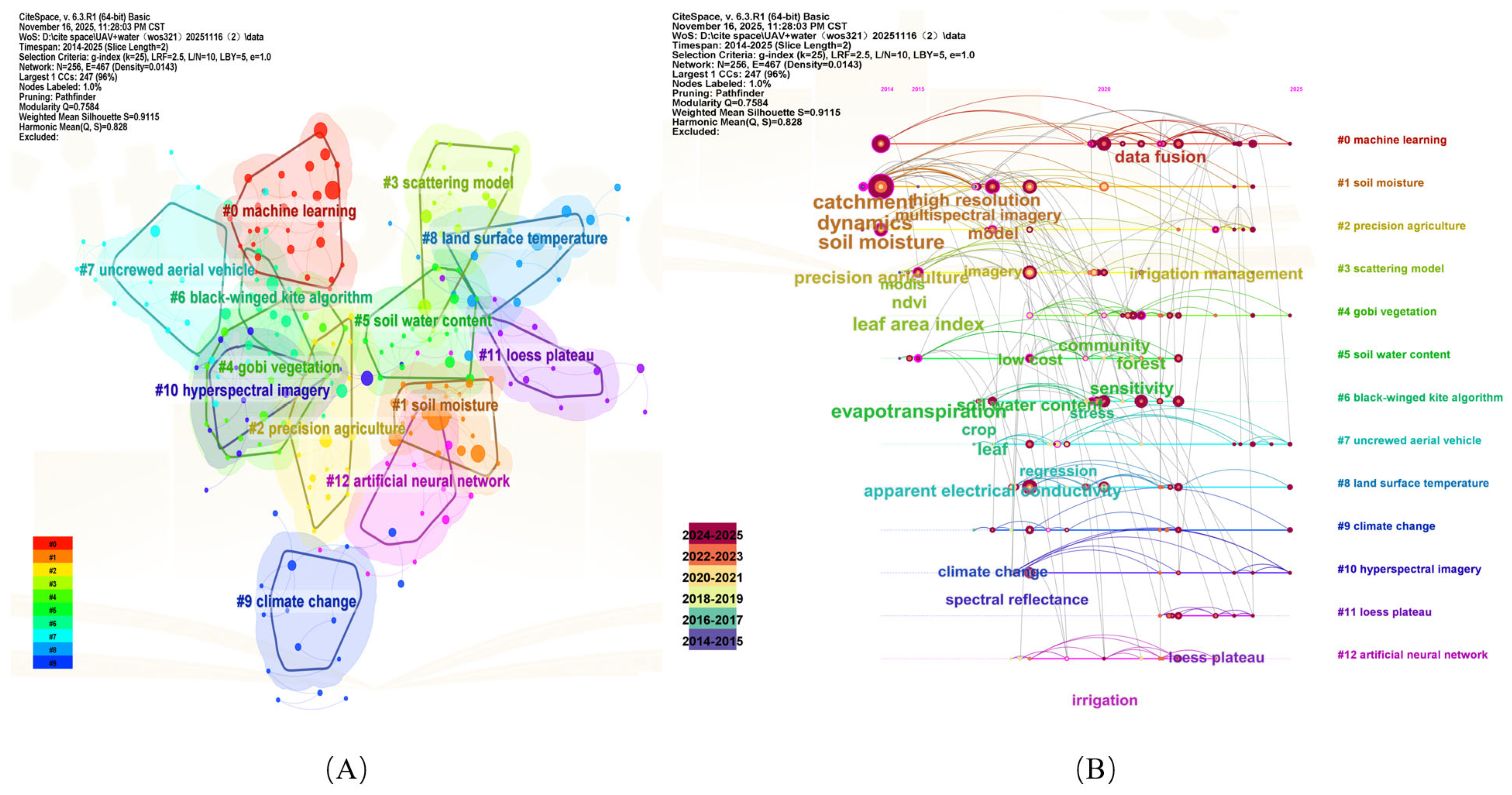
In the keyword clustering map shown in Figure 10A, with Q = 0.7584 and S = 0.9115, the clustering is both reliable and clearly structured, forming 13 keyword clusters (Table 8). Cluster #0 machine learning (size 27) is the largest, highlighting the dominance of machine learning algorithms in this field. Keywords such as machine learning, vegetation indices, and mapping suggest that international research heavily relies on these algorithms for processing multidimensional remote sensing data to achieve high-precision regional mapping in moisture inversion. Cluster #1 soil moisture is an early foundational cluster, focusing on basic parameters such as remote sensing of soil moisture and vegetation coverage. Cluster #2 precision agriculture encompasses traditional precision agriculture and integrates the latest concepts of artificial intelligence and agriculture 4.0, indicating a shift in moisture inversion research from monitoring to decision-making, enabling data-driven intelligent management. Cluster #3 scattering model, with core keywords scattering model and shuttle radar topography mission, focuses on using microwave or optical scattering models to address the interference of vegetation canopy on soil moisture signals. Cluster #4 gobi vegetation, targets ecosystems in arid and semiarid regions, with keywords like gobi vegetation and soil and plant analyzer development, highlighting the importance of moisture monitoring in extreme environments. Cluster #5 soil water content represents the core research object in moisture inversion, emphasizing the accurate acquisition of moisture parameters. Cluster #6 black-winged kite algorithm, a metaheuristic optimization algorithm, is used for complex non-linear optimization problems. Keywords such as grain yield and soil moisture content indicate their application in improving moisture inversion accuracy and predicting crop yield, linking moisture data to economic benefits. Cluster #7 uncrewed aerial vehicle focuses on platform standardization and application, with keywords such as uncrewed aerial vehicle (UAV), autonomous aerial vehicles, and crop phenotyping, reflecting a shift from drone availability to autonomous and efficient crop phenotyping. Cluster #8 land surface temperature focuses on the thermal infrared mechanism, with keywords of land surface temperature, vegetation index, and dielectric model, representing an independent research direction in moisture inversion through energy balance and thermodynamics. Cluster #9 climate change, with keywords of climate change, smart water management, and real-time analytics, elevates moisture monitoring to a strategic level in macro-climate response and resource management. Cluster #10, hyperspectral imagery, includes technical terms, but keywords such as soil nutrients and nitrogen content focus on collaborative monitoring of moisture and nutrients. Cluster #11, the loess plateau, as a significant geographical area, has keywords of segmentation and tree mortality, indicating the role of UAV-based moisture monitoring in soil and water conservation and ecological restoration. Cluster #12 artificial neural network, a specific form of machine learning, includes keywords such as artificial neural network, leaf area index, and nearest neighbor algorithm, showing the application of advanced algorithms such as deep learning to process vegetation structure parameters and enhance moisture inversion accuracy.
Figure 10.
(A) Keyword clustering map. (B) Timeline graph in the WOS database.
Table 8.
Thirteen keyword clusterings in the WOS database based on the LLR algorithm.
Figure 10B illustrates that research in this field can be divided into three distinct periods. During the initial phase (2014–2016), the focus was primarily on foundational research. Soil moisture (#1) and soil water content (#5) spanned the entire timeline, underscoring the centrality of accurately acquiring moisture parameters. Precision agriculture (#2) established the early application goals of this technology. Between 2014 and 2015, land surface temperature (#8) emerged, highlighting the early maturity of inversion methods based on thermal infrared and energy balance principles. Uncrewed aerial vehicle (#7) also formed during this period, providing the technical foundation for subsequent research. The middle phase (2017–2021) marked a period of rapid technological advancement and deeper knowledge integration. Machine learning (#0) became prominent between 2017 and 2019, quickly dominating the field with numerous connections to soil moisture (#1) and precision agriculture (#2). These findings indicate that machine learning has become the primary tool for enhancing moisture inversion accuracy and achieving precise management. The scattering model (#3) was active during this time, reflecting in-depth research into the complex physical mechanisms of microwave and optical technologies, which are essential for addressing vegetation canopy interference. Around 2020, data fusion emerged as a key node, linking clusters such as machine learning (#0), soil moisture (#1), and hyperspectral imagery (#10). This shift marked a transition from reliance on single sensors to the use of multi-source heterogeneous data, including visible light, thermal infrared, and radar, for collaborative inversion. The emergence of irrigation management around 2020, branching directly from precision agriculture (#2), signaled a shift in application goals from general precision to practical field decision-making. In recent research from 2022 to 2025, gobi vegetation (#4) and the loess plateau (#11) have remained active since 2021. Notably, the relatively red color of the node loess plateau (#11) indicates sustained international focus on moisture monitoring in complex and fragile ecological environments, such as arid and soil erosion-prone areas. Climate change (#9) also remained active. Artificial neural network (#12) highlights the ongoing optimization of algorithms as a core driver of accuracy improvements. The inclusion of autonomous aerial vehicles in uncrewed aerial vehicle (#7) suggests a trend toward more intelligent and automated platform operations.
3.6.3. Comparison of Keyword Clustering Between the Two Major Databases
Table 9 presents the keyword clustering results from the CNKI and WOS databases concerning UAV moisture inversion research. Notably, there are distinct differences in research directions and focuses between domestic and international scholars. Domestic studies primarily utilize multispectral technology and focus extensively on staple crops. In contrast, international research emphasizes constructing physical mechanism models and monitoring applications in extreme ecological environments. The divergence in research focus reflects not only geography but also differing methodological priorities. The CNKI database prioritizes operational precision agriculture, favoring fast, cost-effective empirical regression models for irrigation scheduling of staple crops. By contrast, the WOS database emphasizes process-based understanding of water–energy cycles across diverse ecosystems. Consequently, international studies more frequently employ multi-source data fusion to separate the complex effects of canopy structure and soil background in heterogeneous environments. These two research paths are complementary. Moving forward, fostering two-way integration between practical applications and theoretical mechanisms is essential.
Table 9.
Comparative analysis of keyword clustering differences between CNKI and WOS databases.
3.7. Co-Citation Analysis of Literature
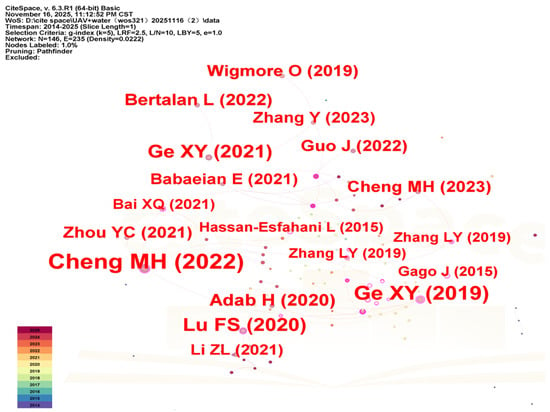
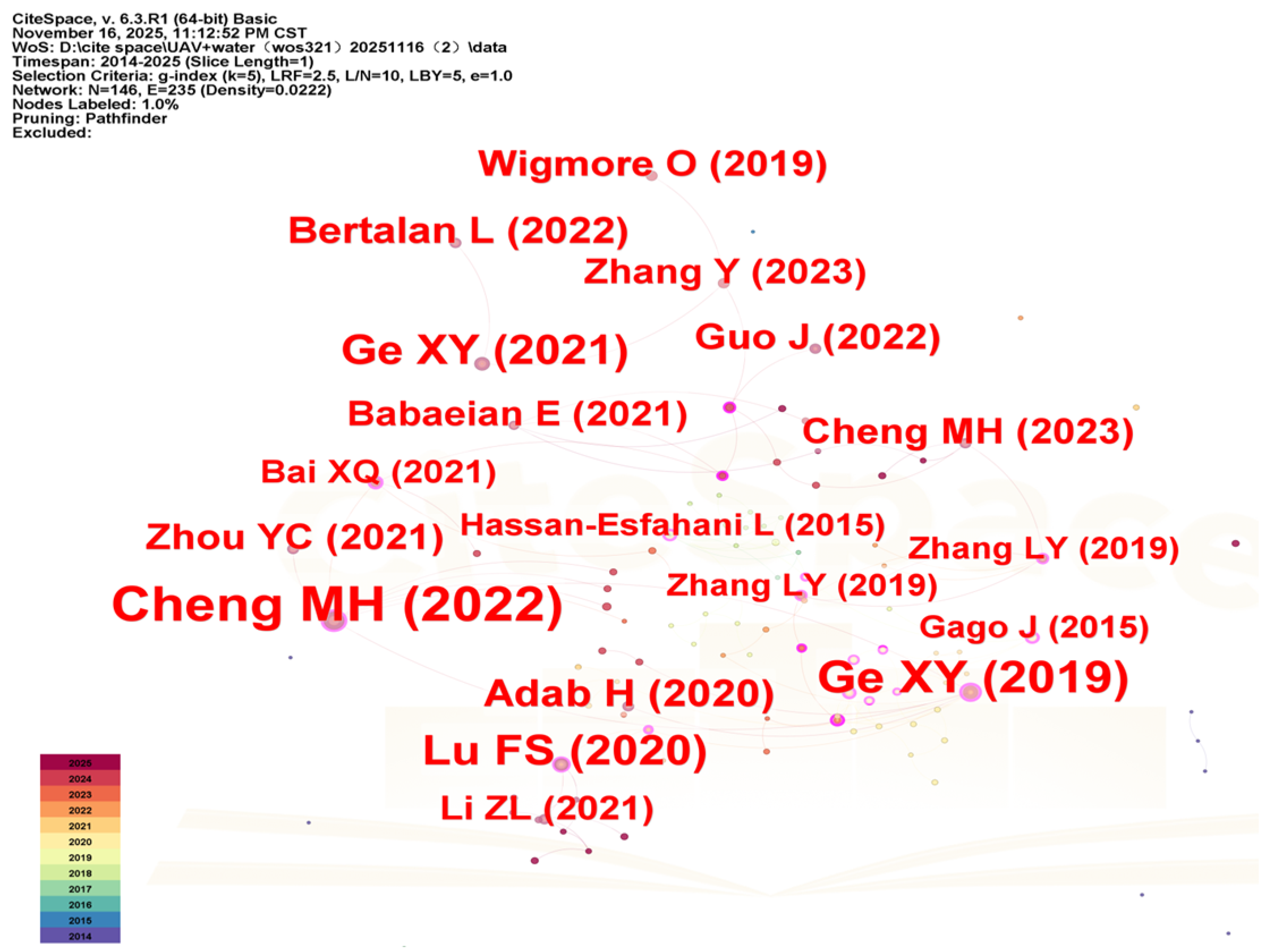
The literature co-citation map identifies key turning points and milestone studies in this field [45]. As shown in Figure 11 and Table 10, Ge XY (2019) [14] has the highest centrality (0.55) and frequency (22). This study primarily monitors the soil moisture content (SMC) in arid farmland using UAV hyperspectral imaging technology and machine learning algorithms. The research team developed an optimal model, PIR, to create a high-precision SMC spatial distribution map, offering robust scientific support for agricultural management in arid regions.
Figure 11.
Co-citation map of studies in the WOS database.
Table 10.
Top ten co-cited studies in terms of counts and centrality in the WOS database.
Cheng MH (2022) [15] has the highest frequency (31) and significant centrality (0.30), which primarily utilizes multimodal data gathered by UAVs, integrating machine learning techniques to assess the prediction accuracy of soil moisture content in cornfields with dense canopy cover. The findings indicate that employing the random forest regression algorithm, combined with data from three sensors, yields the most precise soil moisture content estimates. Additionally, the study highlights that this approach maintains stable performance at soil depths of 10 cm and 20 cm across varying crop cover conditions, suggesting its strong potential for dynamic soil moisture monitoring and the development of precise irrigation strategies.
Between 2019 and 2022, numerous highly cited papers with high-centrality characteristics have highlighted that this discipline is undergoing a pivotal phase of rapid knowledge accumulation and concentrated development. Notably, in recent years, a new research framework and theoretical foundation have been developed.
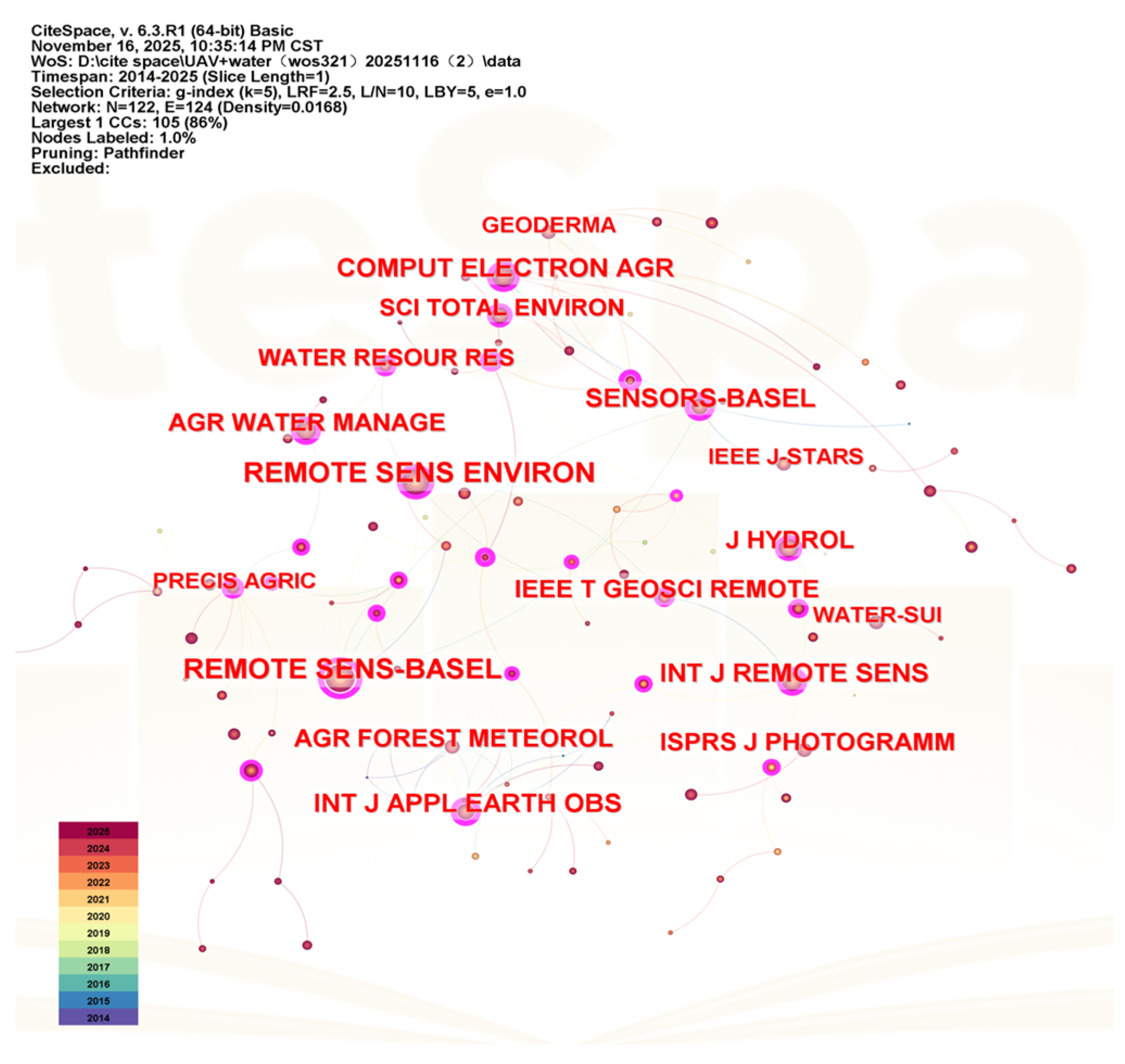
3.8. Co-Citation Analysis of Journals
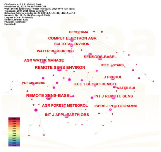
As illustrated in Figure 12 and Table 11, Remote Sens-Basel leads in both frequency (264) and centrality (0.67), establishing it as the primary journal in this domain. Remote Sens Environ, with a frequency of 251 and a notable centrality of 0.36, follows closely. Journals such as Agr Water Manage (frequency 129), J Hydrol (frequency 135), and Water Resour Res (centrality 0.31) indicate that UAV moisture inversion research is a cross-disciplinary field driven by remote sensing technology, benefiting water resources and agricultural engineering. Comput Electron Agr (frequency 162) highlights the crucial role of computer technologies, including automation, machine learning, and algorithm integration, in achieving precise moisture management.
Figure 12.
Co-citation map of journals in the WOS database.
Table 11.
The top ten co-cited journals in the WOS database.
4. Discussion
4.1. Research Status
China excels in the number of publications and the involvement of research institutions. Notably, Northwest A&F University and the Chinese Academy of Sciences have developed a significant research cluster. However, both domestically (CNKI) and internationally (WOS), author cooperation networks remain fragmented, with only small-scale aggregations. Most research is conducted by independent groups, and cross-institutional and cross-border collaborations are still uncommon. Moving forward, there should be an emphasis on strengthening international cooperation, particularly with teams in the United States, Australia, and Europe, which have strengths in remote sensing mechanism research. Simultaneously, fostering the integration of domestic research teams from diverse disciplinary backgrounds is crucial to forming interdisciplinary research teams.
The disciplinary distribution indicates that domestic research primarily targets specific applications in agriculture, whereas international research delves into comprehensive analyses of environmental systems and remote sensing mechanisms. This divergence is largely shaped by the focus of scientific research investment and application needs. Driven by the practical demands of food security and precision agriculture, domestic research prioritizes the practical promotion and implementation of technologies. In contrast, international research, grounded in the broader framework of Earth system science, seeks to deepen the understanding of the internal mechanisms of the water cycle. There is a complementary relationship between domestic and international research approaches. Moving forward, it is crucial to enhance the interaction between application-level research and mechanism exploration to prevent a disconnect between technology development and fundamental research.
4.2. Research Hotspots and Evolution
The research paradigm in this field has evolved significantly, transitioning from indirect inference to direct measurement and from reliance on single technologies to the integration of multiple sources. Between 2014 and 2018, the primary driving force was the application requirements of precision agriculture [22,57]. At that time, sensor performance and algorithm capabilities were limited, prompting numerous studies to focus on indirect inversion methods. For instance, researchers have used indicators such as vegetation indices and canopy temperature to assess crop water stress and infer soil moisture status. This technical approach largely mirrored satellite remote sensing strategies. However, unmanned aerial vehicles (UAVs) provide more detailed monitoring at the farmland scale because of their high spatial resolution.
Since 2019, research priorities have shifted toward direct inversion and multi-source data fusion. The advancements in unmanned aerial vehicle (UAV) payload technology have positioned hyperspectral and thermal infrared technologies among the most cutting-edge techniques. Additionally, machine learning algorithms such as random forest (RF), support vector machine (SVM), and neural networks (NNs) have increasingly supplanted traditional statistical regression methods because of their strengths in processing high-dimensional data and modeling non-linear inversions [49,58]. This shift in technical approaches reflects a scientific innovation logic centered on problem orientation, technological breakthroughs, and deepening applications.
Machine learning is the dominant analytical framework for UAV-based soil moisture inversion, yet its application varies widely. RF is the most commonly used model for multi-source feature fusion; it resists overfitting and suits typical UAV campaigns that have very few ground-truth samples. Support vector regression is favored for highly non-linear problems with very sparse data, since its structural risk minimization often yields superior performance.
As high-dimensional hyperspectral datasets become available, NNs and deep learning are increasingly prominent. NNs provide the most accurate separation of vegetation interference from soil signals, but they are constrained by their black-box nature and by the need for large, multi-temporal training datasets. Current strategies favor ensemble methods such as XGBoost and physics-informed machine learning, which aim to combine the predictive power of NNs with greater robustness and interpretability for agricultural applications.
4.3. Technical Bottlenecks and Limitations in Current UAV Applications
Bibliometric mapping shows rapid growth in UAV applications, but a critical analysis of the underlying physical and physiological mechanisms reveals persistent bottlenecks in obtaining reliable soil moisture data.
First, the challenge of instantaneous observation and environmental noise. UAV flights generally capture instantaneous snapshots of fields, whereas indicators like thermal infrared temperature change rapidly and exhibit pronounced diurnal patterns. Additionally, infrared temperature is highly sensitive to transient environmental factors such as wind speed, air temperature, and variations in solar radiation. Isolating the genuine soil water signal from these confounding effects remains difficult. Many empirical models do not address this temporal mismatch, which produces unstable inversion accuracy across different dates or times of day.
Second, the physiological threshold of crop transpiration limits canopy temperature-based inversion. When soil moisture exceeds a threshold, stomata remain fully open, and transpiration is controlled by atmospheric demand rather than by soil water. Under these energy-limited conditions, canopy temperature decouples from soil moisture, making thermal indices insensitive to changes in soil water. Consequently, current thermal and vegetation index-based UAV methods detect moderate to severe water stress effectively but cannot precisely estimate soil moisture under well-watered conditions.
4.4. Limitations
This study has certain limitations. One limitation of the study is the methodological disparity in the comparative analysis. Co-citation analysis, which unveils the intellectual progression and the pivotal literature, was solely conducted using the WOS database due to software limitations. In contrast, the CNKI database relied predominantly on citation counts and keyword clustering to identify key research foundations. This disparity in methodology may result in a more nuanced comprehension of the international research landscape compared to the domestic one. Future research endeavors could enhance their methodologies by integrating multi-tool workflows, such as combining CiteSpace with VOSviewer or Bibliometrix. This integration could lead to a more harmonized bibliometric approach across databases that are based on different languages. The selection of search terms was intentionally restricted to direct soil moisture terminology to maintain a focused research scope. However, this approach may have unintentionally excluded the pertinent literature that addresses soil moisture inversion indirectly, particularly studies indexed under related hydro- and chemical-induced soil moisture terms. For instance, processes such as evapotranspiration estimation and water balance are frequently employed in UAV-based soil moisture investigations. Our analysis successfully identified key papers in this domain, as evidenced by the high centrality of “evapotranspiration” within the WOS keyword network. Nevertheless, studies lacking explicit “soil moisture” tags were not included. Future research could broaden the search criteria to encompass these indirect physiological and hydrological terms, thereby providing a more comprehensive overview. Moreover, since data for 2025 were only collected up to November, the analysis of publication trends lacks complete data for that year, potentially introducing bias in assessing recent hot-spot evolution. Future studies should consider using multiple bibliometric tools for complementary analysis, expanding the search scope, and extending the data collection period to achieve a more comprehensive understanding.
Several key research gaps remain in UAV-based soil moisture inversion. Most drone-mounted sensors, including optical, thermal infrared, and multispectral instruments, sample only the surface soil layer (0–5 cm). Inferring root-zone soil moisture, which more directly controls crop growth, therefore remains a major challenge. A related problem is the scale-mismatch between centimeter-scale UAV pixels and point-scale ground-truth measurements. Current models also generally lack spatio-temporal portability: models calibrated for a specific field or growth stage often fail when applied to different soil types or crop varieties. These limitations impede meaningful comparisons across studies.
4.5. Research Prospects
4.5.1. Deepening of Mechanisms and Models
Current research predominantly utilizes black-box models in machine learning. In the future, greater emphasis should be placed on integrating physical mechanisms, such as scattering models and the principles of spectral formation. The incorporation of fundamental physical laws, such as the law of conservation of energy, the principle of water balance, and the radiative transfer equation, into machine learning systems can help develop inversion models with broader applicability. This approach would better address the varied requirements of different geographical regions, crop types, and growth stages. For example, coupling water–cloud models with machine learning has enhanced model robustness and physical interpretability. Nonetheless, this integration faces several bottlenecks. First, physical models require strict parameterization, and acquiring high-resolution parameters at UAV scales is difficult and labor-intensive. Second, a scale-mismatch arises because physical laws are typically formulated at point or satellite pixel scales and must be downscaled to the centimeter resolution of drone images. Third, tightly coupling complex radiative transfer models with deep-learning algorithms substantially increases computational cost, which constrains real-time applications in precision agriculture.
To overcome the limitations associated with instantaneous, threshold-affected UAV observations, future research should transition from empirical statistics to process-based dynamic modeling. Instead of relying on isolated UAV snapshots, studies should integrate high-spatial-resolution UAV data into continuous agro-hydrological or energy-balance models, such as SWAP. By combining UAV-derived spatial fields with continuous, point-based ground sensors, researchers can develop robust models that account for diurnal variation and environmental noise inherent in single-flight measurements.
Furthermore, to overcome the physiological threshold at which optical and thermal sensors fail under high moisture, synergistic multimodal sensing is essential. Future frameworks should prioritize integrating UAV-borne active and passive microwave sensors, which penetrate the canopy and directly probe the soil dielectric constant, with thermal and hyperspectral optical sensors.
4.5.2. Full-Scale Data Fusion
By seamlessly integrating centimeter-level high-precision data from unmanned aerial vehicles (UAVs) with meter-level remote sensing data from satellites such as Sentinel and Landsat, and incorporating them into high-resolution land surface or hydrological models, a digital twin system for a specific watershed or farmland can be developed [59]. This dynamic virtual model can accurately reflect real-world moisture conditions in real time and possesses predictive capabilities. Over time, it contributes to the formation of an integrated air–space–ground network for soil moisture monitoring, simulation, and forecasting.
4.5.3. Technological and Application Innovation
Creating a multi-sensor integrated payload system for UAVs that is both cost-effective and compact can significantly increase the adoption of technological applications and expand their range of uses. In addition to traditional methods such as precision agriculture and drought monitoring, this technology can be applied to new fields such as ecological restoration, soil and water conservation, and climate change response [60,61,62,63]. By incorporating 5G communication and edge computing, the system can enable real-time soil moisture estimation and provide intelligent decision-making support, thereby effectively advancing technological applications.
In China, UAV-based soil moisture inversion has progressed from laboratory experiments to regional demonstrations. In the North China Plain, multispectral UAVs generated irrigation-prescription maps for winter wheat that reduced water use while producing lower yields. In the desert northwest, UAV drought monitoring rapidly identifies extensive farmland under water stress, enables point-to-point irrigation, and markedly improves water use efficiency. The upfront cost of high-end thermal and multispectral sensors remains relatively high for smallholder farmers. Automated cloud platforms or UAV service models offered by agricultural cooperatives could reduce usage costs and accelerate the adoption of high-quality precision agriculture.
5. Conclusions
In this study, we employed CiteSpace to visually analyze the literature on soil moisture inversion using unmanned aerial vehicles (UAVs) from the CNKI and WOS databases, covering the period from 2014 to 2025. The analysis led to the following conclusions:
(1) This field is experiencing rapid development, marked by its interdisciplinary nature, which integrates disciplines such as agricultural science, environmental science, remote sensing technology, and computer science.
(2) China leads in this research field, with significant contributions from institutions such as the Chinese Academy of Sciences and Northwest A&F University. Key journals, including Remote Sens-Basel, Remote Sens Environ, and Comput Electron Agr, highlight the field’s core focus on the intersection of technology-driven innovation and application services.
(3) The research focus has gradually transitioned from early indirect inversion methods, which utilized vegetation indices and canopy temperature, to a new paradigm of direct inversion. This contemporary approach integrates hyperspectral multi-source data with machine learning techniques.
(4) Future research will increasingly emphasize integrating multi-source data and applying deep learning algorithms. Additionally, constructing a multi-scale intelligent observation network that combines space–air–ground elements will be prioritized to better address the practical demands of precision agriculture and efficient water resource management.
Author Contributions
L.W., conceptualization, methodology, formal analysis, writing—original draft preparation; T.Z., conceptualization, methodology, writing—review and editing, funding acquisition; W.D., software, validation, writing—review and editing; F.L., software, formal analysis, resources; C.Y., investigation, visualization; P.X., investigation, project administration; X.F., software, data curation; Y.H., software, visualization, supervision; W.X., visualization, project administration. All authors have read and agreed to the published version of the manuscript.
Funding
This research was supported and funded by the National Natural Science Foundation of China (Grant No. 42001232), Science and Technology Research Project of the Education Department of Jiangxi Province (Grant No. GJJ2200419) and Natural Science Foundation of Jiangxi Province (20232BAB213092).
Data Availability Statement
The original contributions presented in this study are included in the article. Further inquiries can be directed to the corresponding author.
Conflicts of Interest
The authors declare no conflicts of interest.
References
- Guo, J.; Bai, Q.; Guo, W.; Bu, Z.; Zhang, W. Soil Moisture Content Estimation in Winter Wheat Planting Area for Multi-Source Sensing Data Using CNNR. Comput. Electron. Agric. 2022, 193, 106670. [Google Scholar] [CrossRef] [Scilit]
- Meng, X.; Wang, H.; Chen, J.; Yang, M.; Pan, Z. High-Resolution Simulation and Validation of Soil Moisture in the Arid Region of Northwest China. Sci. Rep. 2019, 9, 17227. [Google Scholar] [CrossRef] [Scilit]
- Wang, X.; Liu, H.; Sun, Z.; Han, X. Soil Moisture Inversion Based on Multiple Drought Indices and RBFNN: A Case Study of Northern Hebei Province. Heliyon 2024, 10, e37426. [Google Scholar] [CrossRef] [Scilit] [PubMed]
- Chatterjee, S.; Desai, A.R.; Zhu, J.; Townsend, P.A.; Huang, J. Soil Moisture as an Essential Component for Delineating and Forecasting Agricultural Rather than Meteorological Drought. Remote Sens. Environ. 2022, 269, 112833. [Google Scholar] [CrossRef] [Scilit]
- Morchid, A.; Qjidaa, H.; Alami, R.E.; Mobayen, S.; Skruch, P.; Bossoufi, B. Smart Irrigation-Based Internet of Things and Cloud Computing Technologies for Sustainable Farming. Sci. Rep. 2026, 16, 5293. [Google Scholar] [CrossRef] [Scilit] [PubMed]
- Ma, S.; Liu, S.; Gao, Z.; Wang, X.; Ma, S.; Wang, S. Water Deficit Diagnosis of Winter Wheat Based on Thermal Infrared Imaging. Plants 2024, 13, 361–372. [Google Scholar] [CrossRef] [Scilit]
- Shen, Z.; Yang, Y.; Fu, X.; Adams, K.H.; Biondi, E.; Zhan, Z. Fiber-Optic Seismic Sensing of Vadose Zone Soil Moisture Dynamics. Nat. Commun. 2024, 15, 6432. [Google Scholar] [CrossRef] [Scilit]
- Tahmouresi, M.S.; Niksokhan, M.H.; Ehsani, A.H. Enhancing Spatial Resolution of Satellite Soil Moisture Data through Stacking Ensemble Learning Techniques. Sci. Rep. 2024, 14, 25454. [Google Scholar] [CrossRef] [Scilit]
- Li, Y.; Li, C.; Cheng, Q.; Chen, L.; Li, Z.; Zhai, W.; Mao, B.; Chen, Z. Precision Estimation of Winter Wheat Crop Height and Above-Ground Biomass Using Unmanned Aerial Vehicle Imagery and Oblique Photoghraphy Point Cloud Data. Front. Plant Sci. 2024, 15, 1437350. [Google Scholar] [CrossRef] [Scilit]
- Sagan, V.; Maimaitijiang, M.; Sidike, P.; Eblimit, K.; Peterson, K.; Hartling, S.; Esposito, F.; Khanal, K.; Newcomb, M.; Pauli, D.; et al. UAV-Based High Resolution Thermal Imaging for Vegetation Monitoring, and Plant Phenotyping Using ICI 8640 P, FLIR Vue pro R 640, and thermoMap Cameras. Remote Sens. 2019, 11, 330–359. [Google Scholar] [CrossRef] [Scilit]
- Acharya, B.S.; Bhandari, M.; Bandini, F.; Pizarro, A.; Perks, M.; Joshi, D.R.; Wang, S.; Dogwiler, T.; Ray, R.L.; Kharel, G.; et al. Unmanned Aerial Vehicles in Hydrology and Water Management: Applications, Challenges, and Perspectives. Water Resour. Res. 2021, 57, e2021WR029925. [Google Scholar] [CrossRef] [Scilit]
- Vidana Gamage, D.N.; Biswas, A.; Strachan, I.B. Scale and Location Dependent Time Stability of Soil Water Storage in a Maize Cropped Field. Catena 2020, 188, 104420. [Google Scholar] [CrossRef] [Scilit]
- Vahidi, M.; Shafian, S.; Frame, W.H. Deep Fusion Approach: Combining Hyperspectral Imaging and Ground Penetrating Radar for Accurate Cornfield Soil Moisture Mapping. Agric. Water Manag. 2025, 317, 109615. [Google Scholar] [CrossRef] [Scilit]
- Ge, X.; Wang, J.; Ding, J.; Cao, X.; Zhang, Z.; Liu, J.; Li, X. Combining UAV-Based Hyperspectral Imagery and Machine Learning Algorithms for Soil Moisture Content Monitoring. PeerJ 2019, 7, e6926. [Google Scholar] [CrossRef] [Scilit]
- Cheng, M.; Jiao, X.; Liu, Y.; Shao, M.; Yu, X.; Bai, Y.; Wang, Z.; Wang, S.; Tuohuti, N.; Liu, S.; et al. Estimation of Soil Moisture Content under High Maize Canopy Coverage from UAV Multimodal Data and Machine Learning. Agric. Water Manag. 2022, 264, 107530. [Google Scholar] [CrossRef] [Scilit]
- Zhang, Y.; Han, W.; Zhang, H.; Niu, X.; Shao, G. Evaluating Soil Moisture Content under Maize Coverage Using UAV Multimodal Data by Machine Learning Algorithms. J. Hydrol. 2023, 617, 129086. [Google Scholar] [CrossRef] [Scilit]
- Moradizadeh, M.; Srivastava, P.K.; Petropoulos, G.P. Synergistic Evaluation of Passive Microwave and Optical/IR Data for Modelling Vegetation Transmissivity towards Improved Soil Moisture Retrieval. Sensors 2022, 22, 1354. [Google Scholar] [CrossRef] [Scilit]
- Adab, H.; Morbidelli, R.; Saltalippi, C.; Moradian, M.; Ghalhari, G.A.F. Machine Learning to Estimate Surface Soil Moisture from Remote Sensing Data. Water 2020, 12, 3223. [Google Scholar] [CrossRef] [Scilit]
- Babaeian, E.; Sadeghi, M.; Franz, T.E.; Jones, S.; Tuller, M. Mapping Soil Moisture with the OPtical TRApezoid Model (OPTRAM) Based on Long-Term MODIS Observations. Remote Sens. Environ. 2018, 211, 425–440. [Google Scholar] [CrossRef] [Scilit]
- Page, M.J.; McKenzie, J.E.; Bossuyt, P.M.; Boutron, I.; Hoffmann, T.C.; Mulrow, C.D.; Shamseer, L.; Tetzlaff, J.M.; Akl, E.A.; Brennan, S.E.; et al. The PRISMA 2020 Statement: An Updated Guideline for Reporting Systematic Reviews. BMJ 2021, 372, n71. [Google Scholar] [CrossRef] [Scilit]
- Chen, C. CiteSpace II: Detecting and Visualizing Emerging Trends and Transient Patterns in Scientific Literature. J. Am. Soc. Inf. Sci. Technol. 2006, 57, 359–377. [Google Scholar] [CrossRef] [Scilit]
- Khanal, S.; Fulton, J.; Shearer, S. An Overview of Current and Potential Applications of Thermal Remote Sensing in Precision Agriculture. Comput. Electron. Agric. 2017, 139, 22–32. [Google Scholar] [CrossRef] [Scilit]
- Mohsan, S.A.H.; Othman, N.Q.H.; Li, Y.; Alsharif, M.H.; Khan, M.A. Unmanned Aerial Vehicles (UAVs): Practical Aspects, Applications, Open Challenges, Security Issues, and Future Trends. Intell. Serv. Rob. 2023, 16, 109–137. [Google Scholar] [CrossRef] [Scilit]
- Riano, D.; Vaughan, P.; Chuvieco, E.; Zarco-Tejada, P.J.; Ustin, S.L. Estimation of Fuel Moisture Content by Inversion of Radiative Transfer Models to Simulate Equivalent Water Thickness and Dry Matter Content: Analysis at Leaf and Canopy Level. IEEE Trans. Geosci. Remote Sens. 2005, 43, 819–826. [Google Scholar] [CrossRef] [Scilit]
- Zarco-Tejada, P.J.; Rueda, C.A.; Ustin, S.L. Water Content Estimation in Vegetation with MODIS Reflectance Data and Model Inversion Methods. Remote Sens. Environ. 2003, 85, 109–124. [Google Scholar] [CrossRef] [Scilit]
- Zarco-Tejada, P. Chlorophyll Fluorescence Effects on Vegetation Apparent Reflectance I. Leaf-Level Measurements and Model Simulation. Remote Sens. Environ. 2000, 74, 582–595. [Google Scholar] [CrossRef] [Scilit]
- Zarco-Tejada, P. Chlorophyll Fluorescence Effects on Vegetation Apparent Reflectance II. Laboratory and Airborne Canopy-Level Measurements with Hyperspectral Data. Remote Sens. Environ. 2000, 74, 596–608. [Google Scholar] [CrossRef] [Scilit]
- Suárez, L.; Zarco-Tejada, P.J.; Sepulcre-Cantó, G.; Pérez-Priego, O.; Miller, J.R.; Jiménez-Muñoz, J.C.; Sobrino, J. Assessing Canopy PRI for Water Stress Detection with Diurnal Airborne Imagery. Remote Sens. Environ. 2008, 112, 560–575. [Google Scholar] [CrossRef] [Scilit]
- Gitelson, A.A.; Gritz, Y.; Merzlyak, M.N. Relationships between Leaf Chlorophyll Content and Spectral Reflectance and Algorithms for Non-Destructive Chlorophyll Assessment in Higher Plant Leaves. J. Plant Physiol. 2003, 160, 271–282. [Google Scholar] [CrossRef] [Scilit] [PubMed]
- Gitelson, A.A.; Kaufman, Y.J.; Stark, R.; Rundquist, D. Novel Algorithms for Remote Estimation of Vegetation Fraction. Remote Sens. Environ. 2002, 80, 76–87. [Google Scholar] [CrossRef] [Scilit]
- Gitelson, A.A.; Kaufman, Y.J.; Merzlyak, M.N. Use of a Green Channel in Remote Sensing of Global Vegetation from EOS-MODIS. Remote Sens. Environ. 1996, 58, 289–298. [Google Scholar] [CrossRef] [Scilit]
- Moraes, H.M.F.E.; Furtado Júnior, M.R.; Vitória, E.L.D.; Martins, R.N. A Bibliometric and Scientometric Analysis on the Use of UAVs in Agriculture, Livestock and Forestry. Ciêncial Rural 2023, 53, e20220130. [Google Scholar] [CrossRef] [Scilit]
- Yang, Z.; Yu, X.; Dedman, S.; Rosso, M.; Zhu, J.; Yang, J.; Xia, Y.; Tian, Y.; Zhang, G.; Wang, J. UAV Remote Sensing Applications in Marine Monitoring: Knowledge Visualization and Review. Sci. Total Environ. 2022, 838, 155939. [Google Scholar] [CrossRef] [Scilit]
- Zhang, W.; Zhao, L. The Track, Hotspot and Frontier of International Hyperspectral Remote Sensing Research 2009–2019—A Bibliometric Analysis Based on SCI Database. Measurement 2022, 187, 110229. [Google Scholar] [CrossRef] [Scilit]
- Farhad, M.M.; Senyurek, V.; Rafi, M.A.S.; Baray, S.B.; McCraine, C.; Hathcock, L.A.; Adeli, A.; Yanbo, H.; Gurbuz, A.C.; Kurum, M. Integrating UAS-Based GNSS-R, LiDAR, and Multispectral Data for Soil Moisture Estimation: Summary of Results from a Three-Year-Long Field Campaign. IEEE J. Sel. Top. Appl. Earth Obs. Remote Sens. 2025, 18, 16896–16915. [Google Scholar] [CrossRef] [Scilit]
- Grubinger, S.; Coops, N.C.; O’Neill, G.A.; Degner, J.C.; Wang, T.; Waite, O.J.M.; Riofrío, J.; Koch, T.L. Seasonal Vegetation Dynamics for Phenotyping Using Multispectral Drone Imagery: Genetic Differentiation, Climate Adaptation, and Hybridization in a Common-Garden Trial of Interior Spruce (Picea engelmannii × glauca). Remote Sens. Environ. 2025, 317, 114512. [Google Scholar] [CrossRef] [Scilit]
- Memon, M.S.; Chen, S.; Guo, J.; Iqbal, B.; Du, Z.; Taha, M.F.; Memon, N. Estimating Rice Yield under Different Wheat Residue Coverage Levels Using Multispectral Gaofen Satellite Data and Remote Sensing Indices. J. Agric. Eng. 2025, 56, 1698. [Google Scholar] [CrossRef] [Scilit]
- Hussain, S.; Arshad, M.; Cheema, M.J.M.; Qamar, M.U.; Wajid, S.A.; Daccache, A. Advancing Soil Moisture Prediction Using Satellite and UAV-Based Imagery with Machine Learning Models. Earth Syst. Environ. 2025. [Google Scholar] [CrossRef] [Scilit]
- Zhang, X.; Ram, B.; Vullaganti, N.; Aderholdt, W.; Overby, P.; Sun, X. Soil Moisture Classification Using Hyperspectral Imaging and Deep Learning Models on Ground Robot Vehicles. Smart Agric. Technol. 2025, 12, 101413. [Google Scholar] [CrossRef] [Scilit]
- Khose, S.B.; Mailapalli, D.R. Spatial Mapping of Soil Moisture Content Using Very-High Resolution UAV-Based Multispectral Image Analytics. Smart Agric. Technol. 2024, 8, 100467. [Google Scholar] [CrossRef] [Scilit]
- Gago, J.; Douthe, C.; Coopman, R.E.; Gallego, P.P.; Ribas-Carbo, M.; Flexas, J.; Escalona, J.; Medrano, H. UAVs Challenge to Assess Water Stress for Sustainable Agriculture. Agric. Water Manag. 2015, 153, 9–19. [Google Scholar] [CrossRef] [Scilit]
- Manfreda, S.; McCabe, M.F.; Miller, P.E.; Lucas, R.; Pajuelo Madrigal, V.; Mallinis, G.; Ben Dor, E.; Helman, D.; Estes, L.; Ciraolo, G.; et al. On the Use of Unmanned Aerial Systems for Environmental Monitoring. Remote Sens. 2018, 10, 641. [Google Scholar] [CrossRef] [Scilit]
- Seneviratne, S.I.; Corti, T.; Davin, E.L.; Hirschi, M.; Jaeger, E.B.; Lehner, I.; Orlowsky, B.; Teuling, A.J. Investigating Soil Moisture–Climate Interactions in a Changing Climate: A Review. Earth Sci. Rev. 2010, 99, 125–161. [Google Scholar] [CrossRef] [Scilit]
- Haokip, S.C.; Rajwade, Y.A.; Rao, K.V.R.; Kumar, S.P.; Marak, A.B.; Srivastava, A. Approaches for Assessment of Soil Moisture with Conventional Methods, Remote Sensing, UAV, and Machine Learning Methods—A Review. Water 2025, 17, 2388. [Google Scholar] [CrossRef] [Scilit]
- Zhang, Y.; Li, C.; Ji, X.; Yun, C.; Wang, M.; Luo, X. The Knowledge Domain and Emerging Trends in Phytoremediation: A Scientometric Analysis with CiteSpace. Environ. Sci. Pollut. Res. 2020, 27, 15515–15536. [Google Scholar] [CrossRef] [Scilit]
- Bian, J.; Zhang, Z.; Chen, J.; Chen, H.; Cui, C.; Li, X.; Chen, S.; Fu, Q. Simplified Evaluation of Cotton Water Stress Using High Resolution Unmanned Aerial Vehicle Thermal Imagery. Remote Sens. 2019, 11, 267. [Google Scholar] [CrossRef] [Scilit]
- Lu, F.; Sun, Y.; Hou, F. Using UAV Visible Images to Estimate the Soil Moisture of Steppe. Water 2020, 12, 2334. [Google Scholar] [CrossRef] [Scilit]
- Ge, X.; Ding, J.; Jin, X.; Wang, J.; Chen, X.; Li, X.; Liu, J.; Xie, B. Estimating Agricultural Soil Moisture Content through UAV-Based Hyperspectral Images in the Arid Region. Remote Sens. 2021, 13, 1562. [Google Scholar] [CrossRef] [Scilit]
- Bertalan, L.; Holb, I.; Pataki, A.; Négyesi, G.; Szabó, G.; Kupásné Szalóki, A.; Szabó, S. UAV-Based Multispectral and Thermal Cameras to Predict Soil Water Content—A Machine Learning Approach. Comput. Electron. Agric. 2022, 200, 107262. [Google Scholar] [CrossRef] [Scilit]
- Bhardwaj, A.; Sam, L.; Akanksha; Martín-Torres, F.J.; Kumar, R. UAVs as Remote Sensing Platform in Glaciology: Present Applications and Future Prospects. Remote Sens. Environ. 2016, 175, 196–204. [Google Scholar] [CrossRef] [Scilit]
- Cheng, M.; Sun, C.; Nie, C.; Liu, S.; Yu, X.; Bai, Y.; Liu, Y.; Meng, L.; Jia, X.; Liu, Y.; et al. Evaluation of UAV-Based Drought Indices for Crop Water Conditions Monitoring: A Case Study of Summer Maize. Agric. Water Manag. 2023, 287, 108442. [Google Scholar] [CrossRef] [Scilit]
- Bai, X.; Chen, Y.; Chen, J.; Cui, W.; Tai, X.; Zhang, Z.; Cui, J.; Ning, J. Optimal Window Size Selection for Spectral Information Extraction of Sampling Points from UAV Multispectral Images for Soil Moisture Content Inversion. Comput. Electron. Agric. 2021, 190, 106456. [Google Scholar] [CrossRef] [Scilit]
- Hassan-Esfahani, L.; Torres-Rua, A.; Jensen, A.; McKee, M. Assessment of Surface Soil Moisture Using High-Resolution Multi-Spectral Imagery and Artificial Neural Networks. Remote Sens. 2015, 7, 2627–2646. [Google Scholar] [CrossRef] [Scilit]
- Zhou, Y.; Lao, C.; Yang, Y.; Zhang, Z.; Chen, H.; Chen, Y.; Chen, J.; Ning, J.; Yang, N. Diagnosis of Winter-Wheat Water Stress Based on UAV-Borne Multispectral Image Texture and Vegetation Indices. Agric. Water Manag. 2021, 256, 107076. [Google Scholar] [CrossRef] [Scilit]
- Amani, M.; Salehi, B.; Mahdavi, S.; Masjedi, A.; Dehnavi, S. Temperature-Vegetation-Soil Moisture Dryness Index (TVMDI). Remote Sens. Environ. 2017, 197, 1–14. [Google Scholar] [CrossRef] [Scilit]
- Wigmore, O.; Mark, B.; McKenzie, J.; Baraer, M.; Lautz, L. Sub-Metre Mapping of Surface Soil Moisture in Proglacial Valleys of the Tropical Andes Using a Multispectral Unmanned Aerial Vehicle. Remote Sens. Environ. 2019, 222, 104–118. [Google Scholar] [CrossRef] [Scilit]
- Sishodia, R.P.; Ray, R.L.; Singh, S.K. Applications of Remote Sensing in Precision Agriculture: A Review. Remote Sens. 2020, 12, 3136. [Google Scholar] [CrossRef] [Scilit]
- Seo, M.-G.; Shin, H.-S.; Tsourdos, A. Soil Moisture Retrieval from Airborne Multispectral and Infrared Images Using Convolutional Neural Network. IFAC-Pap. 2020, 53, 15852–15857. [Google Scholar] [CrossRef] [Scilit]
- Yu, X.; Yin, Q.; Qian, L.; Zhang, C.; Shao, L.; Ran, D.; Wang, W.; Zhang, B.; Hu, X. Cross-Scale Soil Moisture Content Monitoring of Winter Wheat by Integrating UAV and Sentinel-1/2 Data. Agric. Water Manag. 2025, 320, 109831. [Google Scholar] [CrossRef] [Scilit]
- Zeng, Y.; Meng, X.; Wang, B.; Li, M.; Chen, D.; Ran, L.; Fang, N.; Ni, L.; Shi, Z. Effects of Soil and Water Conservation Measures on Sediment Delivery Processes in a Hilly and Gully Watershed. J. Hydrol. 2023, 616, 128804. [Google Scholar] [CrossRef] [Scilit]
- Zhang, Y.; Shen, H.; Xia, C. Automatic Identification of Soil and Water Conservation Measures from Centimeter-Resolution Unmanned Aerial Vehicle Imagery. J. Soil Water Conserv. 2020, 75, 472–480. [Google Scholar] [CrossRef] [Scilit]
- Meinen, B.U.; Robinson, D.T. Agricultural Erosion Modelling: Evaluating USLE and WEPP Field-Scale Erosion Estimates Using UAV Time-Series Data. Environ. Modell. Softw. 2021, 137, 104962. [Google Scholar] [CrossRef] [Scilit]
- Kim, K.T.; Kim, H.; Jeong, S.; Lee, Y.S.; Choi, E.; Kim, J.Y. Quantification of Greenhouse Gas Emissions from a Municipal Solid Waste Incinerator Using an Uncrewed Aerial Vehicle. Environ. Int. 2025, 198, 109396. [Google Scholar] [CrossRef] [Scilit] [PubMed]

Disclaimer/Publisher’s Note: The statements, opinions and data contained in all publications are solely those of the individual author(s) and contributor(s) and not of MDPI and/or the editor(s). MDPI and/or the editor(s) disclaim responsibility for any injury to people or property resulting from any ideas, methods, instructions or products referred to in the content. |
© 2026 by the authors. Licensee MDPI, Basel, Switzerland. This article is an open access article distributed under the terms and conditions of the Creative Commons Attribution (CC BY) license.