


Fine-Grained 3D Building Reconstruction and Floor Height Estimation from Ultra-High-Resolution TomoSAR Data Using Geometric Constraints




Highlights
- A physics-aware inverse projection strategy combined with global coherent integration achieves robust side-lobe suppression and sub-meter floor height estimation from airborne TomoSAR data.
- A directional morphological reconstruction algorithm, leveraging a separation-of-axes strategy and LOS-based geometric correction, effectively recovers orthogonal roof contours and fine semantic substructures.
- The study validates the capability of high-resolution TomoSAR to discern internal architectural hierarchies (e.g., floor levels), proving its potential for all-weather, fine-grained urban mapping beyond surface representation.
- The proposed integration of imaging geometry constraints with geometric priors offers a robust solution for regularized LOD2 modeling, overcoming the sparsity and noise limitations inherent in radar point clouds.
Abstract
1. Introduction
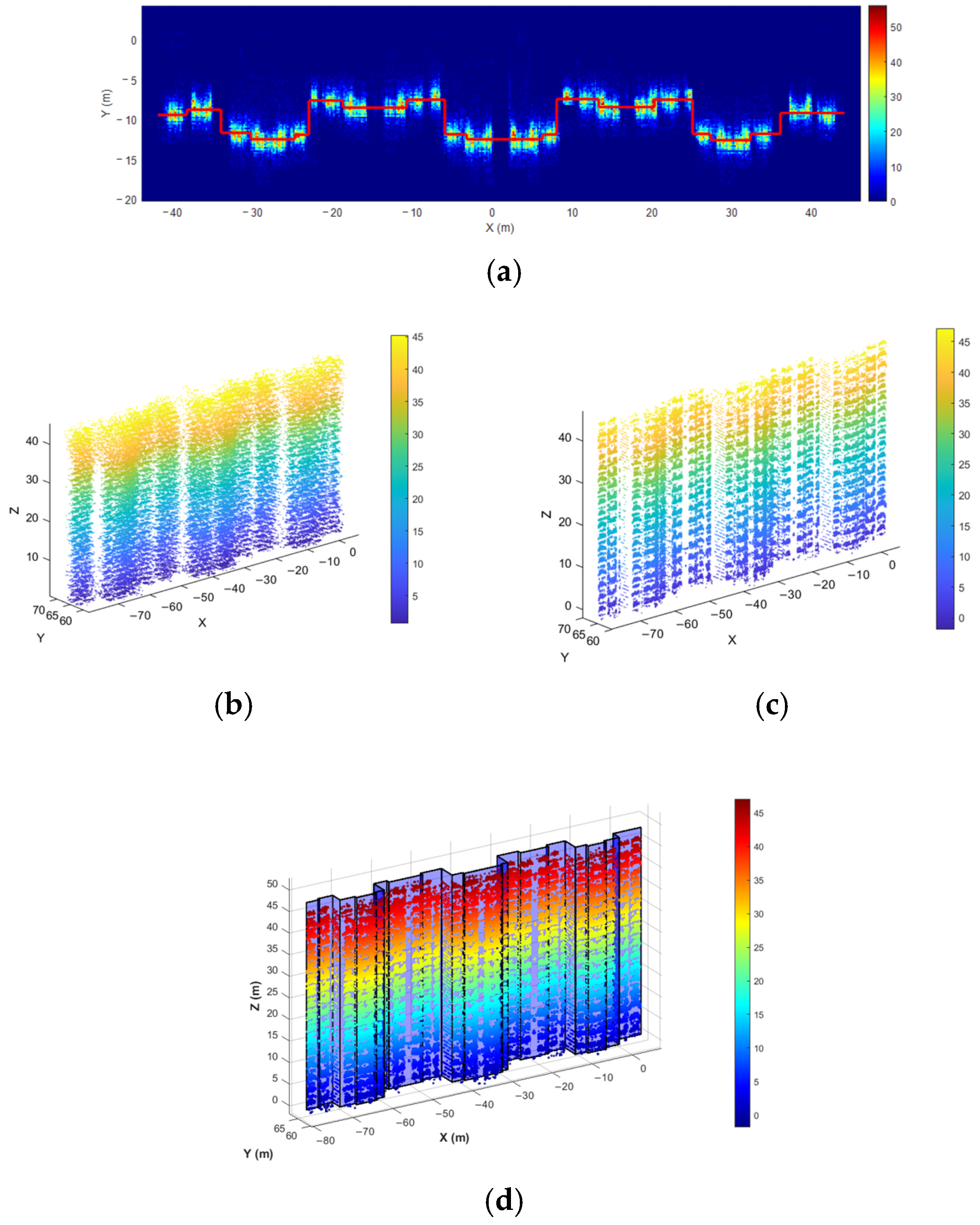
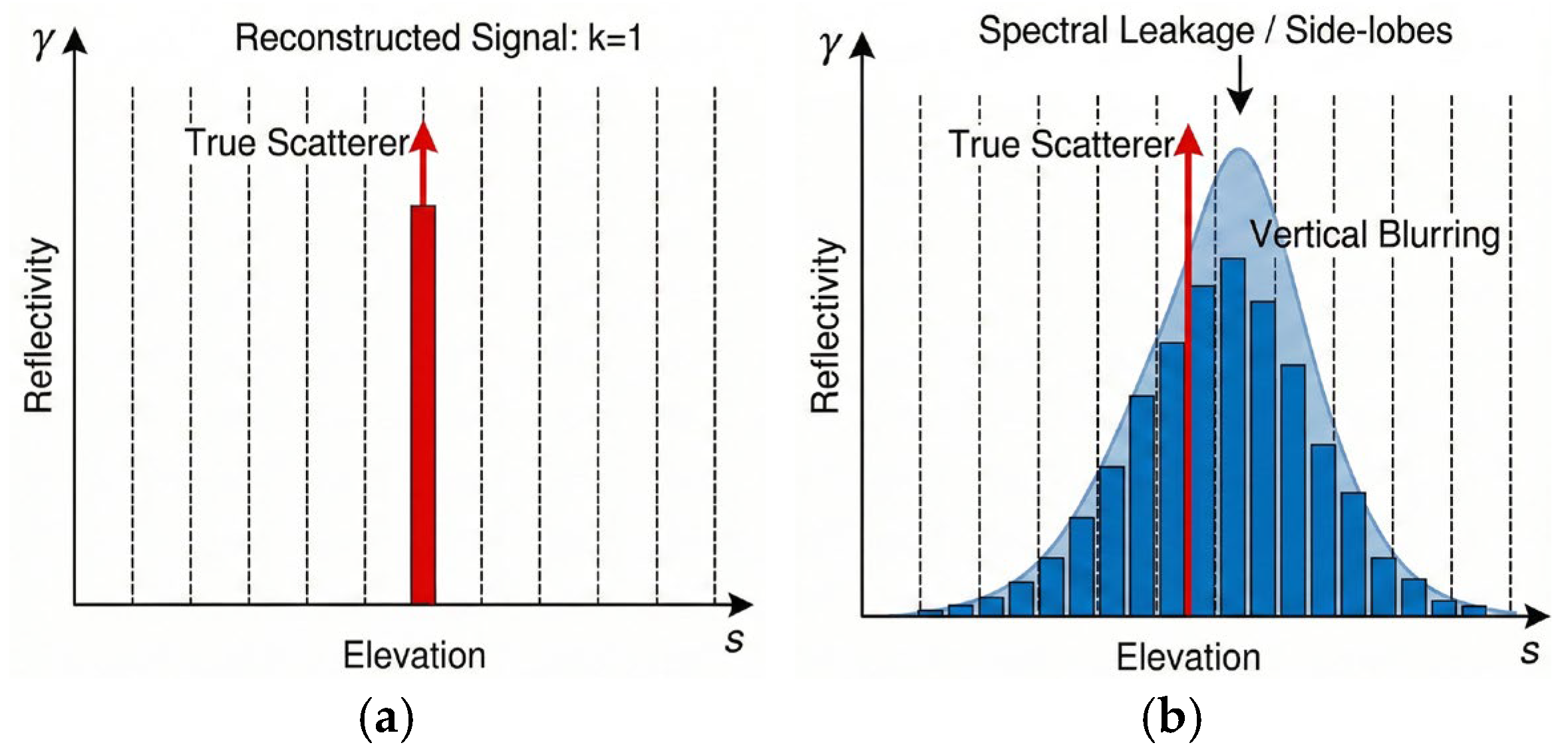
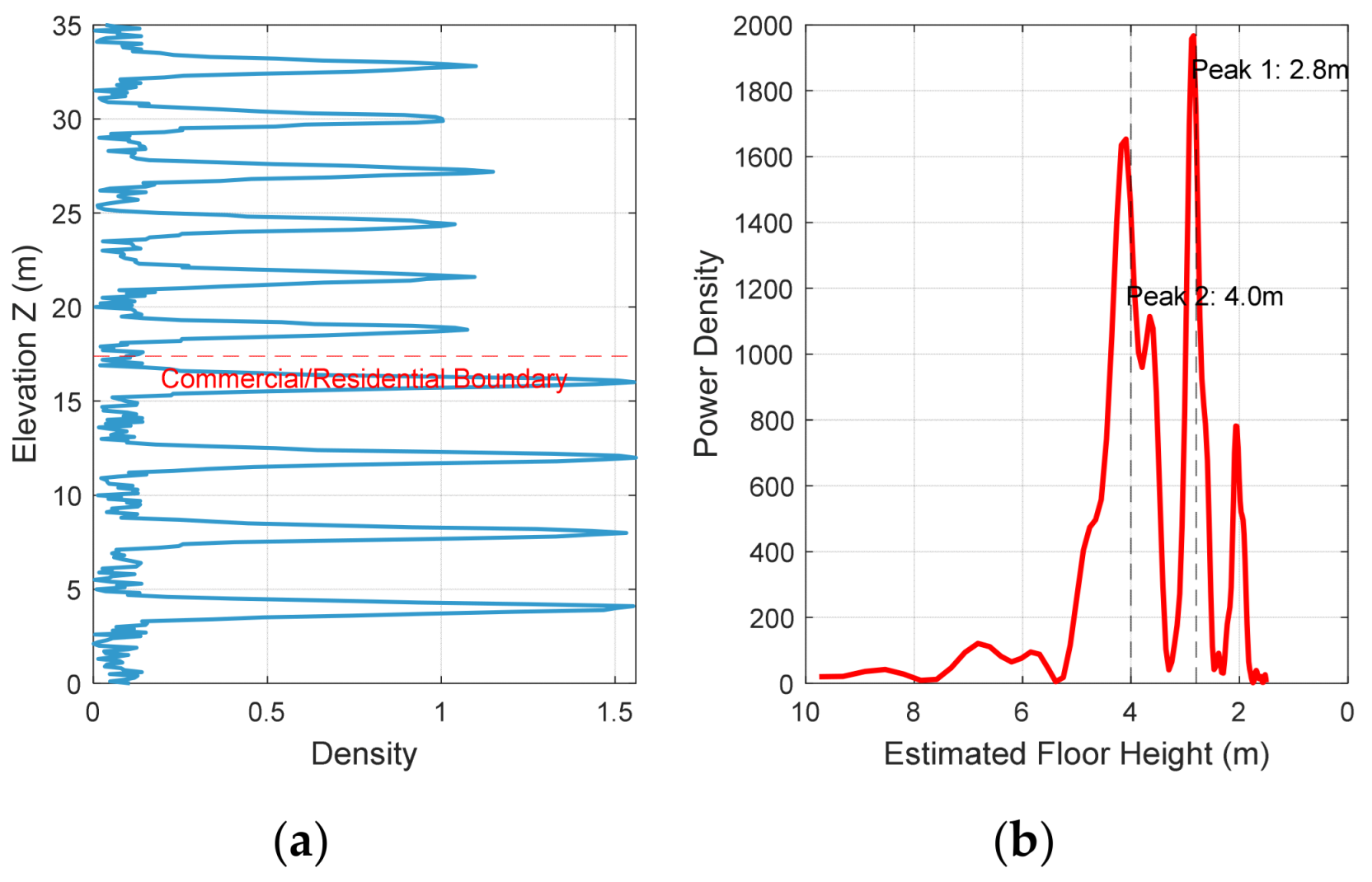
- For fine-grained vertical reconstruction, we propose a unified strategy combining inverse projection focusing with Global Coherent Integration. By inverse-transforming point clouds to the radar coordinate system and projecting them onto refined façades, we concentrate scattering energy to effectively suppress side-lobe dispersion. Leveraging this focused signal, we construct a global vertical density function and apply spectral analysis to robustly recover periodic floor patterns, achieving sub-meter accuracy in floor height estimation.
- For roof reconstruction, we propose a directional morphological method. Using orthogonal linear structuring elements to perform closing operations in horizontal and vertical directions respectively, we preserve building orthogonality. Additionally, we resolve layover displacement through Line-of-Sight (LOS) projection correction, successfully recovering fine structural details such as parapet walls.
2. Materials and Methods
2.1. Principles of SAR Tomography
2.2. Projection-Based Elevation Compression and Spectral Analysis
2.2.1. Refined Façade Footprint Reconstruction
2.2.2. Side-Lobe Mitigation via Geometric Regularization

2.2.3. Floor Height Estimation via Global Coherent Integration and Spectral Analysis
2.3. Roof Geometric Correction and Linear Feature Extraction
2.4. Orthogonal Contour Extraction via Directional Morphology
3. Results
3.1. Dataset Description and Experimental Setup
3.2. Vertical Structure Reconstruction and Floor Height Estimation

3.3. Roof Geometric Correction and Contour Extraction


3.4. 3D Modeling and Verification

4. Discussion
4.1. The Decisive Role of the High-Resolution Ku-Band System
4.2. Regularization Effect of Geometric Priors on Sparse Data
4.3. Limitations and Future Improvements
4.4. Cross-Sensor Validation Bias
5. Conclusions
Author Contributions
Funding
Data Availability Statement
Acknowledgments
Conflicts of Interest
References
- Biljecki, F.; Stoter, J.; Ledoux, H.; Zlatanova, S.; Çöltekin, A. Applications of 3D City Models: State of the Art Review. ISPRS Int. J. Geo-Inf. 2015, 4, 2842–2889. [Google Scholar] [CrossRef] [Scilit]
- Kolbe, T.H.; Gröger, G.; Plümer, L. CityGML: Interoperable Access to 3D City Models. In Geo-Information for Disaster Management; van Oosterom, P., Zlatanova, S., Fendel, E.M., Eds.; Springer: Berlin/Heidelberg, Germany, 2005; pp. 883–899. [Google Scholar]
- Agugiaro, G.; Benner, J.; Cipriano, P.; Nouvel, R. The Energy Application Domain Extension for CityGML: Enhancing interoperability for urban energy simulations. Open Geospat. Data Softw. Stand. 2018, 3, 2. [Google Scholar] [CrossRef] [Scilit]
- Yao, Z.; Nagel, C.; Kunde, F.; Hudra, G.; Willkomm, P.; Donaubauer, A.; Adolphi, T.; Kolbe, T.H. 3DCityDB—A 3D geodatabase solution for the management, analysis, and visualization of semantic 3D city models based on CityGML. Open Geospat. Data Softw. Stand. 2018, 3, 5. [Google Scholar] [CrossRef] [Scilit]
- Esch, T.; Heldens, W.; Hirner, A.; Keil, M.; Marconcini, M.; Roth, A.; Zeidler, J.; Dech, S.; Strano, E. Breaking new ground in mapping human settlements from space—The Global Urban Footprint. ISPRS J. Photogramm. Remote Sens. 2017, 134, 30–42. [Google Scholar] [CrossRef] [Scilit]
- Zhou, Q.-Y.; Neumann, U. 2.5D Dual Contouring: A Robust Approach to Creating Building Models from Aerial LiDAR Point Clouds. In Proceedings of the Computer Vision—ECCV 2010, Heraklion, Greece, 5–11 September 2010; pp. 115–128. [Google Scholar]
- Van Genderen, J.L. Airborne and terrestrial laser scanning. Int. J. Digit. Earth 2011, 4, 183–184. [Google Scholar] [CrossRef] [Scilit]
- Fornaro, G.; Lombardini, F.; Serafino, F. Three-dimensional multipass SAR focusing: Experiments with long-term spaceborne data. IEEE Trans. Geosci. Remote Sens. 2005, 43, 702–714. [Google Scholar] [CrossRef] [Scilit]
- Zhu, X.X.; Bamler, R. Very High Resolution Spaceborne SAR Tomography in Urban Environment. IEEE Trans. Geosci. Remote Sens. 2010, 48, 4296–4308. [Google Scholar] [CrossRef] [Scilit]
- Reigber, A.; Moreira, A.; Papathanassiou, K.P. First demonstration of airborne SAR tomography using multibaseline L-band data. In Proceedings of the IEEE 1999 International Geoscience and Remote Sensing Symposium, IGARSS’99 (Cat. No.99CH36293), Hamburg, Germany, 28 June–2 July 1999; Volume 41, pp. 44–46. [Google Scholar]
- Fornaro, G.; Lombardini, F.; Pauciullo, A.; Reale, D.; Viviani, F. Tomographic Processing of Interferometric SAR Data: Developments, applications, and future research perspectives. IEEE Signal Process. Mag. 2014, 31, 41–50. [Google Scholar] [CrossRef] [Scilit]
- Reale, D.; Fornaro, G.; Pauciullo, A.; Zhu, X.; Bamler, R. Tomographic Imaging and Monitoring of Buildings with Very High Resolution SAR Data. IEEE Geosci. Remote Sens. Lett. 2011, 8, 661–665. [Google Scholar] [CrossRef] [Scilit]
- Wang, Y.; Zhu, X.X.; Bamler, R. Retrieval of phase history parameters from distributed scatterers in urban areas using very high resolution SAR data. ISPRS J. Photogramm. Remote Sens. 2012, 73, 89–99. [Google Scholar] [CrossRef] [Scilit]
- Li, X.; Zhang, F.; Liang, X.; Li, Y.; Guo, Q.; Wan, Y.; Bu, X.; Liu, Y. Fourfold Bounce Scattering-Based Reconstruction of Building Backs Using Airborne Array TomoSAR Point Clouds. Remote Sens. 2022, 14, 1937. [Google Scholar] [CrossRef] [Scilit]
- Qiu, X.; Jiao, Z.; Peng, L.; Chen, J.; Guo, J.; Zhou, L.; Chen, L.; Ding, C.; Xu, F.; Dong, Q.; et al. SARMV3D-1.0: Synthetic Aperture Radar Microwave Vision 3D Imaging Dataset. J. Radars 2021, 10, 485–498. [Google Scholar]
- Dong, S.; Jiao, Z.; Zhou, L.; Yan, Q.; Yuan, Q. A Novel Filtering Method of 3D Reconstruction Point Cloud from Tomographic SAR. Remote Sens. 2023, 15, 3076. [Google Scholar] [CrossRef] [Scilit]
- Zhao, J.; Yu, A.; Zhang, Y.; Zhu, X.; Dong, Z. Spatial Baseline Optimization for Spaceborne Multistatic SAR Tomography Systems. Sensors 2019, 19, 2106. [Google Scholar] [CrossRef] [Scilit]
- D’Hondt, O.; López-Martínez, C.; Guillaso, S.; Hellwich, O. Nonlocal Filtering Applied to 3-D Reconstruction of Tomographic SAR Data. IEEE Trans. Geosci. Remote Sens. 2018, 56, 272–285. [Google Scholar] [CrossRef] [Scilit]
- Zhu, X.X.; Bamler, R. Tomographic SAR Inversion by L_1 -Norm Regularization—The Compressive Sensing Approach. IEEE Trans. Geosci. Remote Sens. 2010, 48, 3839–3846. [Google Scholar] [CrossRef] [Scilit]
- Wei, L.; Balz, T.; Zhang, L.; Liao, M. A Novel Fast Approach for SAR Tomography: Two-Step Iterative Shrinkage/Thresholding. IEEE Geosci. Remote Sens. Lett. 2015, 12, 1377–1381. [Google Scholar]
- Zhu, X.X.; Ge, N.; Shahzad, M. Joint Sparsity in SAR Tomography for Urban Mapping. IEEE J. Sel. Top. Signal Process. 2015, 9, 1498–1509. [Google Scholar] [CrossRef] [Scilit]
- Shi, Y.; Bamler, R.; Wang, Y.; Zhu, X.X. SAR Tomography at the Limit: Building Height Reconstruction Using Only 3–5 TanDEM-X Bistatic Interferograms. IEEE Trans. Geosci. Remote Sens. 2020, 58, 8026–8037. [Google Scholar] [CrossRef] [Scilit]
- Zhu, X.X.; Shahzad, M. Facade Reconstruction Using Multiview Spaceborne TomoSAR Point Clouds. IEEE Trans. Geosci. Remote Sens. 2014, 52, 3541–3552. [Google Scholar] [CrossRef] [Scilit]
- Shahzad, M.; Zhu, X.X. Robust Reconstruction of Building Facades for Large Areas Using Spaceborne TomoSAR Point Clouds. IEEE Trans. Geosci. Remote Sens. 2015, 53, 752–769. [Google Scholar] [CrossRef] [Scilit]
- Wang, W.; Xu, H.; Wei, H.; Dong, Q. Progressive building facade detection for regularizing array InSAR point clouds. J. Radars 2022, 11, 144–156. [Google Scholar]
- Guo, Z.; Liu, H.; Pang, L.; Fang, L.; Dou, W. DBSCAN-based point cloud extraction for Tomographic synthetic aperture radar (TomoSAR) three-dimensional (3D) building reconstruction. Int. J. Remote Sens. 2021, 42, 2327–2349. [Google Scholar] [CrossRef] [Scilit]
- Wang, S.; Guo, J.; Zhang, Y.; Hu, Y.; Ding, C.; Wu, Y. TomoSAR 3D Reconstruction for Buildings Using Very Few Tracks of Observation: A Conditional Generative Adversarial Network Approach. Remote Sens. 2021, 13, 5055. [Google Scholar] [CrossRef] [Scilit]
- Shi, M.; Chen, L.; Zhang, F.; Li, W.; Cui, C.; Liu, Y. Building point cloud reconstruction in TomoSAR based on deep learning semantic segmentation. Electron. Lett. 2024, 60, e13208. [Google Scholar] [CrossRef] [Scilit]
- Chen, Z.; Wang, Y.; Shi, Y.; Zhu, X.X. Reconstructing Building Height from Spaceborne TomoSAR Point Clouds Using a Dual-Topology Network. IEEE Trans. Geosci. Remote Sens. 2026, in press. [Google Scholar] [CrossRef] [Scilit]
- Ma, C.; Zhang, Y.; Guo, J.; Zhou, G.; Geng, X. FusionHeightNet: A Multi-Level Cross-Fusion Method from Multi-Source Remote Sensing Images for Urban Building Height Estimation. Remote Sens. 2024, 16, 958. [Google Scholar] [CrossRef] [Scilit]
- Chen, L.; Zhao, S.; Han, W.; Li, Y. Building detection in an urban area using lidar data and QuickBird imagery. Int. J. Remote Sens. 2012, 33, 5135–5148. [Google Scholar] [CrossRef] [Scilit]
- Franceschetti, G.; Iodice, A.; Riccio, D. A canonical problem in electromagnetic backscattering from buildings. IEEE Trans. Geosci. Remote Sens. 2002, 40, 1787–1801. [Google Scholar] [CrossRef] [Scilit]
- Brunner, D.; Lemoine, G.; Bruzzone, L. Earthquake Damage Assessment of Buildings Using VHR Optical and SAR Imagery. IEEE Trans. Geosci. Remote Sens. 2010, 48, 2403–2420. [Google Scholar] [CrossRef] [Scilit]
- Schnabel, R.; Wahl, R.; Klein, R. Efficient RANSAC for Point-Cloud Shape Detection. Comput. Graph. Forum 2010, 26, 214–226. [Google Scholar] [CrossRef] [Scilit]
- Donoho, D.L. Compressed sensing. IEEE Trans. Inf. Theory 2006, 52, 1289–1306. [Google Scholar] [CrossRef] [Scilit]
- Chi, Y.; Pezeshki, A.; Scharf, L.; Calderbank, R. Sensitivity to basis mismatch in compressed sensing. In Proceedings of the 2010 IEEE International Conference on Acoustics, Speech and Signal Processing, Dallas, TX, USA, 14–19 March 2010; pp. 3930–3933. [Google Scholar]
- Chen, H.; Liu, W.; Xing, M. Method of Refined Facade Model Extraction Based on TOMOSAR Point Cloud. In Proceedings of the 2025 10th International Conference on Signal and Image Processing (ICSIP), Wuxi, China, 12–14 July 2025; pp. 541–545. [Google Scholar]
- Fischler, M.A.; Bolles, R.C. Random Sample Consensus: A Paradigm for Model Fitting with Applications to Image Analysis and Automated Cartography. In Readings in Computer Vision; Fischler, M.A., Firschein, O., Eds.; Morgan Kaufmann: San Francisco, CA, USA, 1987; pp. 726–740. [Google Scholar]
- Coughlan, J.M.; Yuille, A.L. Manhattan World: Compass direction from a single image by Bayesian inference. In Proceedings of the Seventh IEEE International Conference on Computer Vision, Corfu, Greece, 20–27 September 1999; Volume 942, pp. 941–947. [Google Scholar]
- Edelsbrunner, H.; Kirkpatrick, D.; Seidel, R. On the shape of a set of points in the plane. IEEE Trans. Inf. Theory 1983, 29, 551–559. [Google Scholar] [CrossRef] [Scilit]
- Pingel, T.J.; Clarke, K.C.; McBride, W.A. An improved simple morphological filter for the terrain classification of airborne LIDAR data. ISPRS J. Photogramm. Remote Sens. 2013, 77, 21–30. [Google Scholar] [CrossRef] [Scilit]
- Ester, M.; Kriegel, H.-P.; Sander, J.; Xu, X. A density-based algorithm for discovering clusters in large spatial databases with noise. In Proceedings of the Second International Conference on Knowledge Discovery and Data Mining, Portland, OR, USA, 2–4 August 1996; pp. 226–231. [Google Scholar]


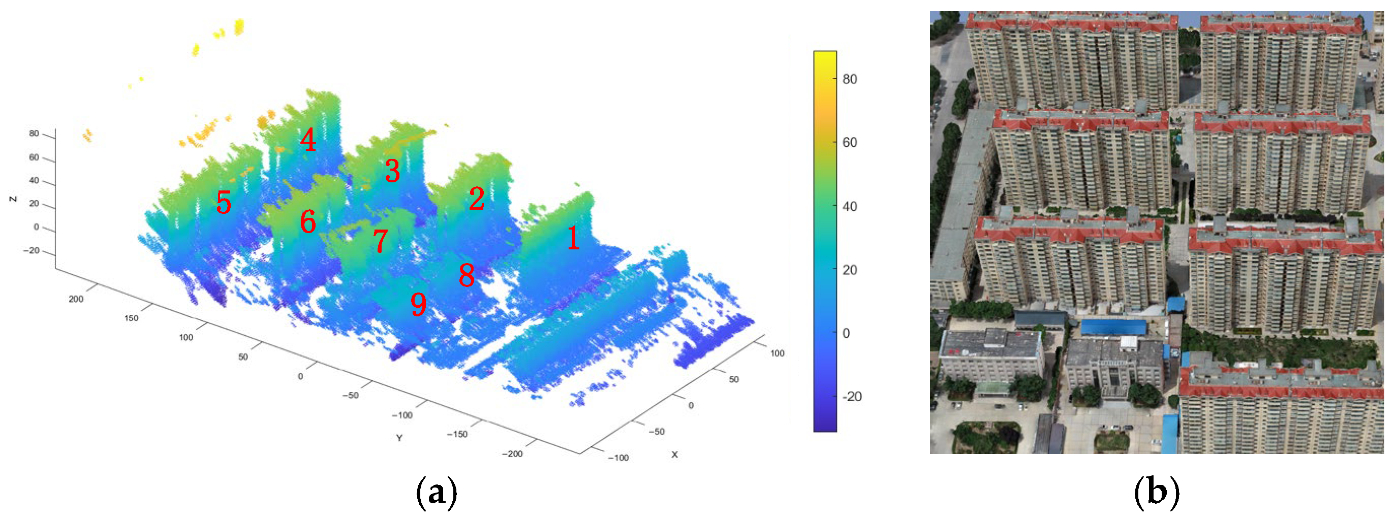



| Building ID | Estimated Floor Height (m) | Reference Floor Height (m) | Absolute Error (m) | Relative Error (%) | Roof Contour IoU (%) |
|---|---|---|---|---|---|
| 1 | 2.57 | 2.83 | 0.26 | 9.19 | 70.4 |
| 2 | 2.69 | 2.83 | 0.14 | 4.95 | 89.7 |
| 3 | 2.67 | 2.83 | 0.16 | 5.65 | 94.5 |
| 4 | 2.80 | 2.83 | 0.03 | 1.06 | 93.9 |
| 5 | 2.71 | 2.83 | 0.12 | 4.24 | 91.2 |
| 6 | 2.76 | 2.83 | 0.07 | 2.47 | 92.7 |
| 7 | 2.80 | 2.83 | 0.03 | 1.06 | 93.6 |
| 8 | 3.45 | 3.50 | 0.05 | 1.43 | 91.6 |
| 9 | 3.41 | 3.50 | 0.09 | 2.57 | 92.2 |
| Overall Mean | - | - | 0.106 | 3.62 | 89.98% |
Disclaimer/Publisher’s Note: The statements, opinions and data contained in all publications are solely those of the individual author(s) and contributor(s) and not of MDPI and/or the editor(s). MDPI and/or the editor(s) disclaim responsibility for any injury to people or property resulting from any ideas, methods, instructions or products referred to in the content. |
© 2026 by the authors. Licensee MDPI, Basel, Switzerland. This article is an open access article distributed under the terms and conditions of the Creative Commons Attribution (CC BY) license.
Share and Cite
Chen, H.; Liu, W.; Chen, Q.; Cui, L.; Xing, M. Fine-Grained 3D Building Reconstruction and Floor Height Estimation from Ultra-High-Resolution TomoSAR Data Using Geometric Constraints. Remote Sens. 2026, 18, 1073. https://doi.org/10.3390/rs18071073
Chen H, Liu W, Chen Q, Cui L, Xing M. Fine-Grained 3D Building Reconstruction and Floor Height Estimation from Ultra-High-Resolution TomoSAR Data Using Geometric Constraints. Remote Sensing. 2026; 18(7):1073. https://doi.org/10.3390/rs18071073
Chicago/Turabian StyleChen, Haoyuan, Wenkang Liu, Quan Chen, Lei Cui, and Mengdao Xing. 2026. "Fine-Grained 3D Building Reconstruction and Floor Height Estimation from Ultra-High-Resolution TomoSAR Data Using Geometric Constraints" Remote Sensing 18, no. 7: 1073. https://doi.org/10.3390/rs18071073
APA StyleChen, H., Liu, W., Chen, Q., Cui, L., & Xing, M. (2026). Fine-Grained 3D Building Reconstruction and Floor Height Estimation from Ultra-High-Resolution TomoSAR Data Using Geometric Constraints. Remote Sensing, 18(7), 1073. https://doi.org/10.3390/rs18071073



