


Highlights
What are the main findings?
- Fusion of SLAM-based LiDAR with aerial LiDAR provides a comprehensive description of the forest.
- LiDAR-based forest road design achieved sub-0.12 m DTM accuracy using fused ALS+HLS point clouds.
What are the implications of the main findings?
- AI-assisted least-cost path optimization systematically identifies low-earthwork alignments.
- The integrated workflow eliminates a separate pre-construction timber cruise, reducing field time and cost.
Abstract
Efficient planning of forest roads is essential to sustaining uninterrupted forestry activities and supporting sustainable forest management. Roads must be designed in concert with existing infrastructure while conforming to operational requirements for timber extraction, accessibility, and environmental compliance. Advances in high-resolution remote sensing and computational geomatics enable acquisition of high-precision, three-dimensional descriptions of forest structure integrable into geographic information systems (GISs) for route optimization and terrain modeling. Despite this progress, a formal procedure for designing forest roads from point clouds derived by combining aerial and terrestrial laser scanning is not yet established. This study addresses that gap by presenting a complete, reproducible workflow for forest road design using fused airborne and near-ground laser scanning point clouds. The workflow encompasses three stages: LiDAR acquisition and derivation of topographic and vegetation attributes, optimal route identification, and estimation of standing timber volume within the proposed corridor. The procedure is demonstrated on a 200 m test section within the McDonald-Dunn Research Forest of Oregon State University, where 133 trees were inventoried and cut and fill volumes quantified. The results confirm that LiDAR-based planning achieves sub-0.12 m accuracy while enabling precise quantification of standing stock to be removed, reducing field time, improving cost efficiency, and supporting data-driven environmental decision-making.
1. Introduction
Forest roads constitute the foundational infrastructure upon which all operational forestry activities depend, governing access for timber harvesting, silvicultural treatments, fire management, and ecological monitoring [1]. Road planning follows a sequential multi-criteria evaluation in which topography, accessibility, environmental constraints, and cost-minimizing routes are evaluated spatially [2,3]. Because networks must balance economic efficiency, environmental impact, and natural hazard resilience [4], the quality and accuracy of underlying land surface data directly dictate the quality of resulting alignments and earthwork estimates.
Traditional forest road surveys rely on manual field traverses using total stations, GPS positioning, and cross-section measurements. These methods are labor-intensive and increasingly difficult to justify in steep or remote terrain. Over the past two decades, Unmanned Aerial Systems (UASs) and LiDAR technology have provided an effective remote sensing alternative, leveraging dense three-dimensional point clouds to penetrate closed forest canopies [5,6]. LiDAR-derived digital elevation models (DEMs) had earlier been shown to enhance road design [2,7], streamline alignment selection algorithms [8], and produce accurate earthwork calculations compared to field methods [9]. Furthermore, high-resolution DEMs have quantified sediment reduction costs for low-volume roads [10]. For road network management, LiDAR enables road mapping in steep terrain [11], landscape-level semi-automatic extraction [12], hybrid classification for detection [13], surface damage monitoring [14], and single-photon network-scale inventory updates [15]. In dense canopy environments, point density must be configured carefully as insufficient penetration significantly degrades road detection reliability [16].
Direct comparisons confirm that LiDAR delivers superior terrain accuracy over UAV photogrammetry or tachymetry, especially in closed-canopy environments [17,18]. When airborne (ALS) and terrestrial (TLS) scans are fused, the resulting point cloud captures the complete vertical forest profile [19]. In particular, SLAM-based handheld LiDAR systems have emerged as a rapid tool for linear corridors, continuously capturing micro-topographic drainage paths and slope instabilities where the GNSS is restricted, without requiring complex static setups [20].
Concurrently, LiDAR workflows have evolved from stand-level metrics to individual tree attributes, including detection [21,22], height estimation [23,24], diameter at breast height (DBH) [25,26], and volume [27,28]. These structural attributes guide optimized field sampling [29], and power statistical models for stand-level inventories [30,31]. In the Pacific Northwest, tree volume calculation relies heavily on log rules such as the Scribner rule, which converts stem dimensions into merchantable board-foot volume [32,33]. Combining LiDAR-derived DBH and height with the Scribner formula enables non-destructive pre-construction timber valuation directly within a proposed corridor.
Despite the technological maturity of individual components—terrain modeling, route optimization, and tree volume estimation—studies integrating all three into a single, operational workflow remain scarce. Recent work has addressed Amazonian forest gaps and roads [16], cable-road optimization [34], sensor comparisons [18], multi-platform fusion [19], and macro-level network optimization [4]. However, no study demonstrates a practical sub-network design procedure translating fused ALS and TLS point clouds into a full road engineering package coupling earthwork volume computations with pre-construction standing timber valuation. This technical note addresses this operational gap by presenting a comprehensive, streamlined procedure for forest road design using a case study from Oregon on which the aerial and terrestrial LiDAR data were fused. Specifically, the workflow demonstrates how multi-platform point clouds can be leveraged to optimize cut and fill earthwork calculations while simultaneously estimating the merchantable volume and economic value of standing timber within the right-of-way corridor. We hypothesize that the integrated workflow (i) produces a more accurate terrain model and a more earthwork-efficient alignment than single-source point clouds, (ii) yields tree attributes unavailable from either sensor alone, and (iii) allows corridor timber removal to be considered during route selection.
2. Materials and Methods
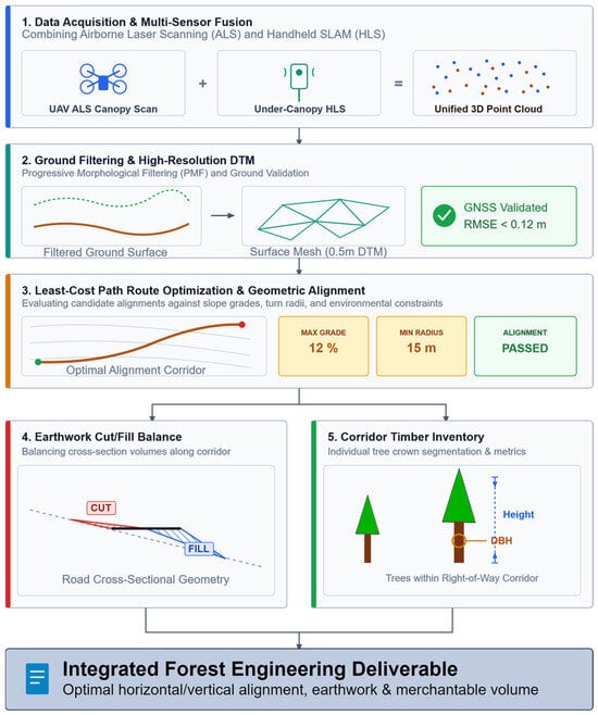
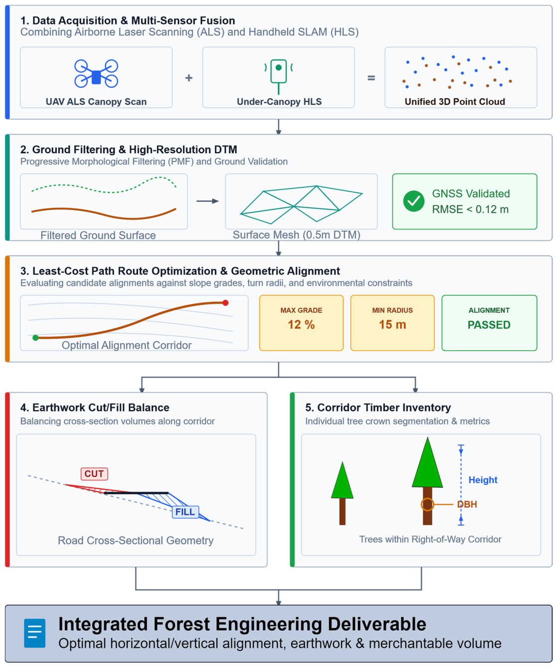
In this study we propose a methodology that integrates high-density LiDAR point clouds, spatial optimization, and biometric modeling into an end-to-end framework for forest engineering. Airborne Laser Scanning captures high-density canopy and upper-terrain structure, while Handheld SLAM maps under-canopy detail. Merging these point clouds yields a comprehensive 3D spatial dataset. A Progressive Morphological Filter separates ground returns from vegetation, generating a high-precision 0.5 m Digital Terrain Model. We verified the accuracy of DTM against GNSS field controls by computing the root mean square error (RMSE), which was <0.12 m. Considering the accuracy of the GNSS elevation measurements, the mean vertical bias was approximately −0.10 m; RMSE was decomposed as RMSE2 = Bias2 + Variance2. The least-cost path algorithms evaluate candidate alignments against design constraints to establish the optimal road centerline. The cross-sectional analysis balances cut and fill volumes to minimize soil displacement and haul distance. Individual tree crowns within the road corridor are segmented from the point cloud to extract height and DBH metrics. Merged with Scribner Decimal C log-rules, this yields precise merchantable volume estimates (Figure 1).
Figure 1.
Fused ALS+HLS forest-road design workflow: (1) multi-sensor acquisition and fusion (blue represents ALS and brown is HLS); (2) ground filtering and 0.5 m DTM generation/validation; (3) Path Explorer AI route optimization; (4) cut and fill estimation; and (5) corridor tree segmentation with DBH/height-based merchantable-volume estimation.
2.1. Study Area
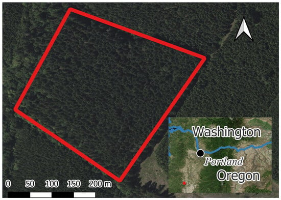
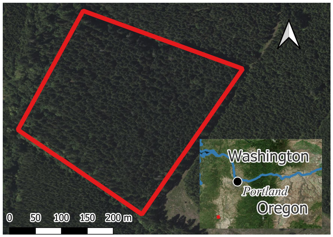
The study was conducted within the McDonald-Dunn Research Forest, owned and managed by Oregon State University (Figure 2). The specific study area covers approximately 10 hectares within the Dunn Forest unit and is located between UTM coordinates 476,272E–4,949,846N and 476,423E–4,949,537N (Zone 10N, WGS84—EPSG 32610). The forest stand is dominated by Douglas fir (Pseudotsuga menziesii (Mirb.) Franco), with a minor component of grand fir (Abies grandis (Douglas ex D. Don) Lindl.), Western hemlock (Tsuga heterophylla (Raf.) Sarg.), and Western red cedar (Thuja plicata Donn ex D. Don). The Dunn Forest unit has an average slope of 8.5%, ranging from 0% to 27.5%, with a mean elevation of 205.48 m (range: 74–581.6 m). The study area itself is more varied in local relief, with an average slope of 20.8%, a minimum of 8.7%, and a maximum of 159.2%, and an average elevation of 170.21 m (range: 137.55–191.64 m). This topographic complexity, combined with the absence of an existing road network within the study polygon, makes the area well suited to demonstrating a complete LiDAR-based road design workflow. All calculations within this study were executed on a sample forest road project corridor measuring 200 m in length and 20 m in width.
Figure 2.
Location of study area.
2.2. Data Acquisition
Aerial LiDAR data were collected using a DJI Matrice 300 RTK (DJI, Shenzhen, China) unmanned aerial system equipped with a DJI Zenmuse L1 LiDAR (DJI, Shenzhen, China) sensor during the spring of 2024 (a snow-free time). The DJI Zenmuse L1 (DJI, Shenzhen, China) integrates a Livox LiDAR module (Livox Technology Co, Shenzhen, China), a high-accuracy inertial measurement unit, and a 20-megapixel RGB camera, delivering a point density suitable for high-resolution terrain and canopy modeling. Flight planning and primary point cloud generation were performed in DJI suite of software (i.e., Pilot 2 ver. 9.0.5.31 and Terra ver. 2.3.3), which executes point cloud classification, colorization, and initial accuracy assessment. The aerial laser scanning (ALS) was designed to achieve complete coverage of the 10 ha study area and its immediate surroundings to avoid edge-effect artifacts during the creation of the digital terrain model (DTM). The ALS survey was conducted at a flight altitude of 91 m (approx. 300 feet) above ground level using adaptive (terrain-following) flight mode, with 80% front overlap and 50% side overlap. The resulting point cloud achieved a mean point density of 1220 points/m2, providing sufficient ground return density for reliable morphological filtering and DTM generation at 0.5 m resolution.
Ground-level structural data were acquired with an FJ Dynamics Trion S1 handheld terrestrial LiDAR scanner (HLS). The Trion S1 uses SLAM (Simultaneous Localization and Mapping) algorithms to produce georeferenced point clouds without the need for fixed control targets in every scan position, making it well suited for forested terrain where traditional static laser scans are constrained by vegetation and operational feasibility. Point clouds from multiple scan trajectories within the study area were processed in FJD Trion Model software to produce classified, color-attributed point clouds representing the lower bole and understory environments that are often under-sampled by ALS.
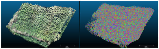
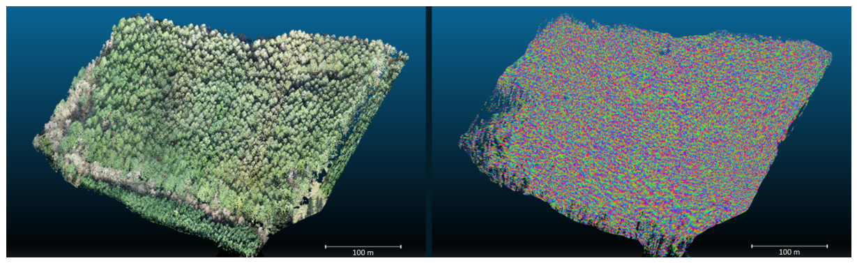
The ALS and HLS point clouds were co-registered and fused in Quick Terrain Modeler (QTM). Co-registration aligned the two datasets by minimizing the offset between common ground features visible in both ALS and HLS scans (Figure 3). We assessed the point cloud co-registration using the RMSE of the difference between the DTMs created from each laser scan and the average distance between the points before and after merging. The fused point cloud captures the complete vertical profile of the stand: an accurate crown-level geometry and a spatially continuous ground model (i.e., a DTM without holes), while the HLS component adds high-density stem and understory detail. All subsequent processing, ground classification, DTM generation, and individual tree segmentation were executed on the fused, co-registered point cloud.
Figure 3.
Perspective view of the raw LiDAR point clouds ALS (true color, left) and HLS (colored by elevation, right).
2.3. Digital Terrain Model Generation
Accurate terrain modeling is prerequisite to forest road design. The primary challenge in deriving DTM from a forested LiDAR point cloud is separating ground returns from vegetation, building, and other above-ground returns. In the present study, a morphology-based filtering approach [35] was used to classify the merged point clouds (i.e., aerial and handheld laser scans).
Mathematical morphology provides a rigorous framework for this task. The two primary operations are erosion and dilation, expressed respectively as
where f(x, y) is the elevation value at point (x, y) and B is a structuring element, a predefined geometric shape used to probe the data. Morphological opening (erosion followed by dilation) removes small high-elevation objects such as vegetation and buildings, leaving ground points:
fopen(x,y) = (ferode⊕B)⊗B
Morphological closing (dilation followed by erosion) fills small gaps in the resulting ground surface. Progressive morphological filtering applies these operations with increasingly large structuring elements, enabling the removal of objects at multiple scales, from individual shrubs to tall trees, while preserving natural terrain undulations [36,37,38]. Outliers, including global outliers (points at anomalously low elevations across the scene) and local outliers (points lower than their immediate neighborhood), were removed prior to ground classification to prevent bias in the baseline filtering step [36].
Ground points identified through morphological filtering were interpolated to a continuous DTM using the Triangulated Irregular Network (TIN) method followed by conversion to a regular grid at 0.5 m resolution. This resolution was selected to match the point density of the ALS dataset and is consistent with recommendations for forest road design applications [7,9]. The resulting DTM was validated visually against the raw point cloud and against the known terrain features visible in high-resolution aerial imagery available for the study area.
In addition to visual assessment, quantitative accuracy evaluation was performed by comparing DTM-derived elevations at a set of seven check points against corresponding field measurements. The coordinates of the check points are computed using transects connected to three points located in a nearby meadow (approximately 40 m from the proposed road) whose coordinates were recorded with an Emlid Reach RS2+ multi-band RTK GNSS receiver (L1/L2/L5; RTK vertical accuracy: 14 mm + 1 ppm). The transects were measured with a Nikon DT-310 Total Station (Nikon – Trimble, Tokyo, Japan), which has an angular accuracy 5 arcseconds. Check points were distributed across the study area encompassing the proposed road corridor, covering the range of slope and terrain conditions represented in the dataset.
2.4. Forest Road Route Optimization
Route selection is among the most consequential decisions in forest road design, with direct implications for construction cost, environmental disturbance, and operational safety. In the present study, route identification was performed using the Path Explorer AI module within RoadEng V11 software [39]. Path Explorer AI [40] implements a least-cost path algorithm that searches the cost surface derived from the LiDAR-based DTM to identify routes minimizing a composite cost function incorporating earthwork volume, gradient violations, and curve radius violations.
Three alternative routes between the predetermined start and end points were generated, each satisfying the geometric standards for a primary forest road under Turkish forest road design specifications [41] and broadly consistent with international practice [1]. We chose the details regulating road design from a jurisdiction different from the one on which the data was collected to show the generality of the approach (i.e., the procedure can be applied irrespective of the region). This choice also reflects the broader aim of the parent research program, a Türkiye–USA (Oregon) collaborative project supported by the Scientific and Technological Research Council of Türkiye (TÜBİTAK) International Postdoctoral Research Fellowship Programme (2219), which sought to establish a LiDAR-based forest road design workflow that is directly transferable to, and readily usable within, the Turkish forestry sector. The geometric constraints included a maximum longitudinal grade of 12%, a minimum horizontal curve radius of 15 m, and a standard formation width, which incorporates the running surface, shoulder, and ditch, appropriate for slopes up to 40%. The route with the lowest cumulative Path Explorer cost, based on the specified cut, fill, and surfacing unit costs, was selected for further engineering design. This AI-assisted approach is consistent with emerging practice in smart forestry, where optimization algorithms replace manual trial-and-error in route selection [8,34].
Once the optimal horizontal alignment was established, geometry details were computed. Horizontal curves govern direction changes in the plan view of the road, whereas vertical curves provide smooth parabolic transitions between successive road grades. The relationships defining the horizontal and vertical parameters are implemented in RoadEng through a graphical design interface where the engineer specifies curve radii, gradients, and curve lengths. The software computes the resulting alignment geometry and displays it in both plan and profile views for review and adjustment.
2.5. Earthwork Volume Calculation
Earthwork calculations quantify the volumes of material to be excavated (cut) and placed as fill along the selected alignment. These computations determine construction cost, haul planning, and whether the road will be in net cut or net fill, an important consideration for both budget and sediment risk [10]. In the present study, cut and fill volumes were computed using the Mass Haul Diagram (MHD) functionality within RoadEng V11. The MHD integrates the running volume surplus or deficit along the road profile, enabling identification of the most efficient haul direction and distance for each earthwork section.
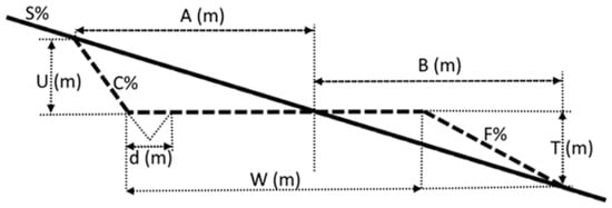
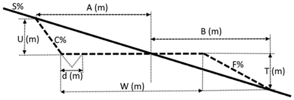
The road cross-section applied in areas with slopes up to 40% followed the standard dimensions prescribed in Turkish forest road design guidelines (Figure 4), with a cut slope of 200%, a fill slope of 70%, and standard formation width W. For the B-type secondary forest road class applied in this study, W = 5 m, comprising a 4 m running surface and a 1 m ditch. Cross-section areas were computed at 20 m stations along the 200 m test section (i.e., at 0, 20, 40 … 200 m, yielding 11 cross-sections in total), and prismoidal volumes were computed between successive stations. The offset distances and depth multipliers used to define cut and fill boundaries as fractions of the formation width W at each slope class follow current Turkish practices [41] and are consistent with other jurisdictions, like Canada [42].
Figure 4.
Typical forest road cross sections layout according to Turkish regulations and practices [41], with dotted line the road and the solid line the terrain. W is the full formation width in meters and includes the road, shoulder and ditch (d) widths; S% is the side slope of natural ground in percent; C% is the cut slope in percent; F% is the fill slope in percent; A is the offset distance along natural ground on uphill or cut side in meters; and B is the offset distance along natural ground on downhill or fill side in meters.
2.6. Individual Tree Inventory and Volume Estimation
Estimation of the timber volume within the proposed road corridor was executed by first segmenting individual trees from the point cloud, followed by the extraction of biometric attributes (height and DBH) for each tree, and concluding with the computation of the Scribner volume. We delineated individual tree trunks within the FJD Trion Model software, which identify individual crowns and trunks by clustering points according to spatial proximity and height. Given the interactive interface of the Trion model, trees in the dominant, codominant, and dominated Kraft crown classes can be identified with 100% completeness. The high rate of success that can be achieved by FJD Trion Model is highly dependent on the operator, who successively merges or divides sections of the point clouds that are either multiple trees or portions of the same tree. The significant operator effort makes the package unsuitable for large areas but is appropriate for smaller areas. The suppressed trees below the LiDAR detection threshold were not included. For each segmented tree, height (measured as the vertical distance from the DTM surface to the highest point return in the tree cluster), DBH (measured as the diameter of the fitted cylinder at breast height, 1.30 m above ground), and crown width (measured as the mean diameter of the convex hull of the crown returns) were computed. The Scribner formula approximates the board-foot volume of a log of small-end diameter d (inches) and length L (feet) as [32,43]:
where the term d2/16 approximates the board feet per foot of log length for a cylinder of diameter d, and 2d/3 deducts for saw kerf and taper losses [43]. Because the Scribner rule operates on log-length segments, each tree was divided into 16-foot (4.88 m) merchantable log sections from stump height to the minimum merchantable top diameter (approximately 20 cm, or 8 inches). Volumes were summed across sections to obtain total merchantable trunk volume per tree. The cumulative volume of all trees within the 200 m corridor was then aggregated to provide the total merchantable timber volume estimate for the proposed road section. For reporting purposes, board-foot volumes were converted to cubic meters using the factor 1 bf = 0.002360 m3 (1 m3 = 423.776 bf), consistent with the conversion standard applied in Pacific Northwest timber assessments [32].
V_Scribner ≈ (d2/16 − 2d/3) × L
3. Results
3.1. Digital Terrain Model
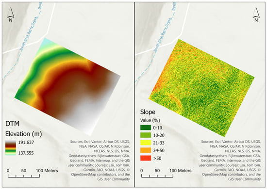
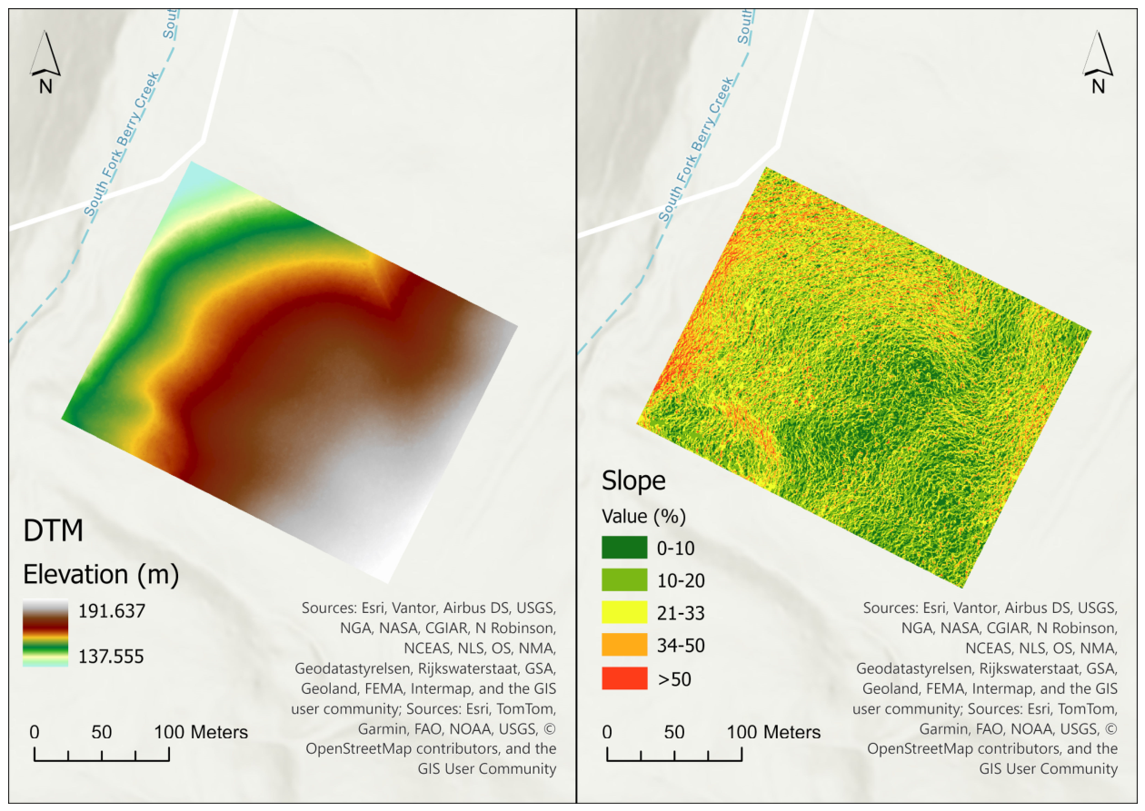
The DTM was created from a point cloud that has a ground point density (i.e., the number of points per square meter that are classified as ground) of 1348 points/m2, out of which 178 points/m2 was from the ALS and 1170 points/m2 from HLS. The average elevation within the study area is 170.21 m (range: 137.55–191.64 m). The average slope is 20.8% (range: 8.7–159.2%), with the steepest sections concentrated on the eastern and southern margins of the study polygon (Figure 5). The slope map is classified according to IUFRO slope classes [44]. The DTM faithfully reproduces drainage channels, ridgelines, and meso-topographic features that govern cut and fill volumes. Comparison of DTM-derived ground elevations with seven check points measured by a high-accuracy GNSS in the field revealed an RMSE of less than 0.12 m. This accuracy level is consistent with values reported for comparable ALS-based terrain models in forested environments as [9] reported RMSE values of 0.08–0.15 m for LiDAR-based forest road alignment mapping and [45] obtained 0.09–0.14 m under similar canopy conditions (Figure 5).
Figure 5.
DTM (left) and slope (right) of the study area.
3.2. Route Selection and Horizontal Geometry
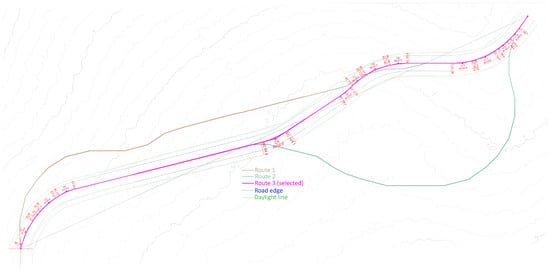
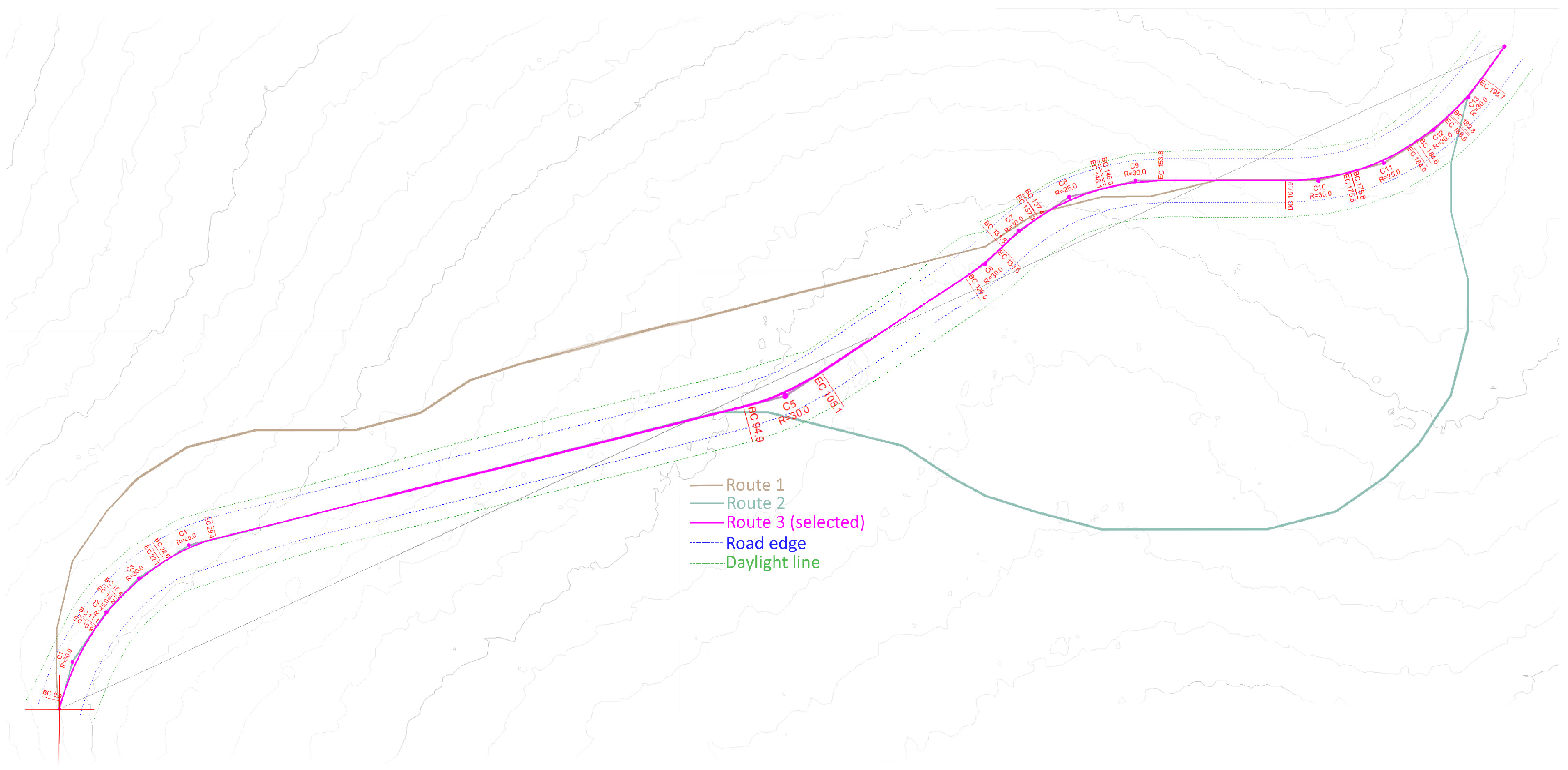
Each of the three alternate routes satisfies the minimum geometric standards for the road class (i.e., a maximum longitudinal grade of 12%, a minimum horizontal curve radius of 15 m, and the required formation width for the applicable slope range), as presented in Table 1. Route 1 followed the most direct path between start and end points but required extensive cut sections on a steep spur ridge. Route 2 contoured around the lower portion of the study area, reducing cut volume but making it 16.8% longer than the selected Route 3 alignment (233.5 vs. 200.0 m). Route 3, which was selected as optimal, achieved a balance between alignment length (200 m) and cumulative earthwork cost, skirting steep terrain while maintaining grades within design limits (Figure 6). The selected route traverses predominantly south-facing terrain at elevations between 163 and 176 m, with an average longitudinal grade of 7.1%. This value is computed dynamically by RoadEng along the actual station-by-station alignment, which includes horizontal curvature, rather than from the straight-line chord distance between the endpoints; a calculation based on net elevation change over the 200 m plan (chord) distance alone would yield the lower value of approximately 6.5%, which does not account for the as-built alignment length.
Table 1.
Comparison of alignment length, earthwork volumes, cumulative Path Explorer cost, and timber volume within the corridors of three candidate forest road routes.
Figure 6.
Plan view of the three alternative road alignments generated by the Path Explorer AI module overlaid on topographic contours. The selected alignment (Route 3) achieved the optimal balance between total road length and cumulative Path Explorer cost.
As an additional terrain-source sensitivity check, the Path Explorer AI route-optimization procedure was independently re-run using identical start and end coordinates on four terrain surfaces: the fused ALS+HLS DTM, HLS-only DTM, ALS-only DTM, and the reference DEM. For each terrain source, the best-ranked candidate alignment was identified and its length, cut and fill volumes, total earthwork, and cumulative Path Explorer cost were estimated (Table 2). The resulting alignments differed in both geometry and earthwork requirements, demonstrating that the terrain-data source affected the route identified by the optimization procedure.
Table 2.
Sensitivity of optimized alignment and earthwork estimates, and cumulative Path Explorer cost to terrain-data source.
To isolate the impact of the route selection process from differences in the underlying terrain representation, each optimized alignment was subsequently evaluated on the same fused ALS+HLS DTM. Under this common evaluation surface, the alignment derived from the fused ALS+HLS data required the least earthwork (521.7 m3), compared with 543.6 m3 for the HLS-only alignment, 543.9 m3 for the ALS-only alignment, and 588.2 m3 for the reference-DEM alignment. Because each terrain source produced a deterministic optimized alignment rather than replicated observations, inferential statistical testing was not applicable. Considering that no a priori threshold was defined; the differences are interpreted as case-specific sensitivity indicators. We found that all surfaces based on individual laser scanners increased the earthwork relative to fused ALS+HLS, HLS-only by 4.2%, ALS-only by 4.3%, the Reference DEM by 12.7%. The comparisons demonstrate that data fusion influenced not only the representation of the terrain but also the specific route selected by Path Explorer AI. The fused ALS+HLS dataset therefore produced a more inherently earthwork-efficient alignment, even when all candidate routes were compared on the same high-resolution terrain model (Figure 6).
Horizontal curve calculations for the selected alignment yielded three significant direction changes. The sharpest curve has a radius R = 20 m and a central angle Δ = 35°, producing an arc length L = 12.2 m and a tangent length T = 6.3 m. These values are consistent with the standard curve-geometry relations (L = RΔ, with Δ in radians, and T = R·tan(Δ/2)); their comparatively small magnitude follows from the modest 35° central angle combined with a curve radius close to the 15 m design minimum, not from a computational error.
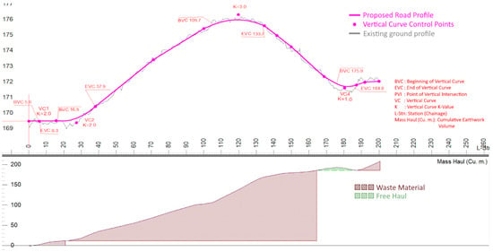
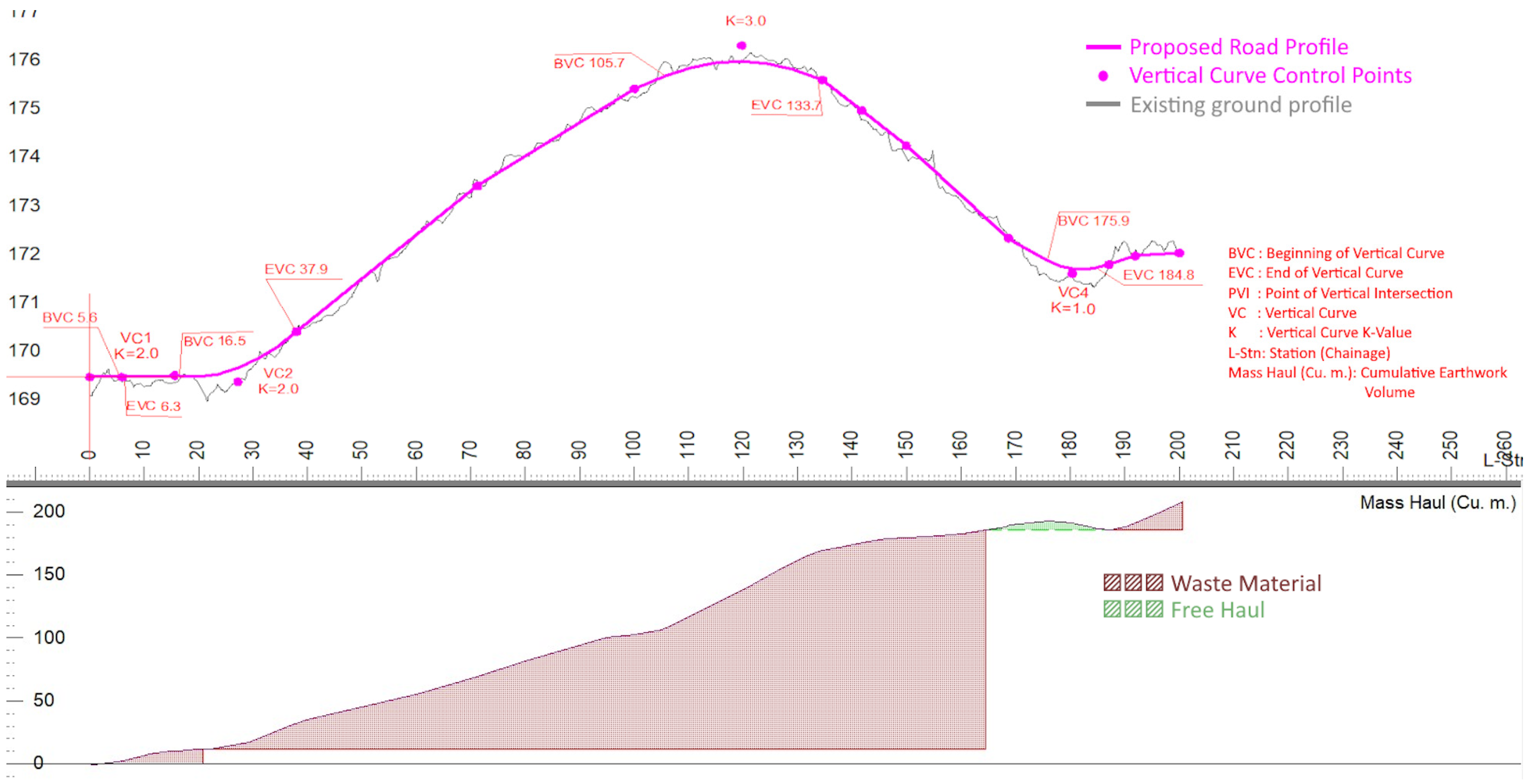
The vertical alignment of the selected route was designed to connect successive grade breaks with parabolic vertical curves of sufficient length to ensure safe vehicle operation and adequate sight distance (Figure 7). The maximum grade encountered on the alignment is 11.3%, slightly below the 12% design limit. The vertical curve at the steepest grade break has a length of 25 m, providing a smooth transition from a +8.1% upgrade to a −2.4% downgrade. The resulting profile, computed at 20 m stations, forms the input for earthwork calculations.
Figure 7.
Vertical alignments and profile calculation of selected forest road route (note: the vertical axis is exaggerated relative to the horizontal axis for readability; grade values should be read from the reported percentages rather than estimated visually from the plotted profile).
3.3. Earthwork Volumes
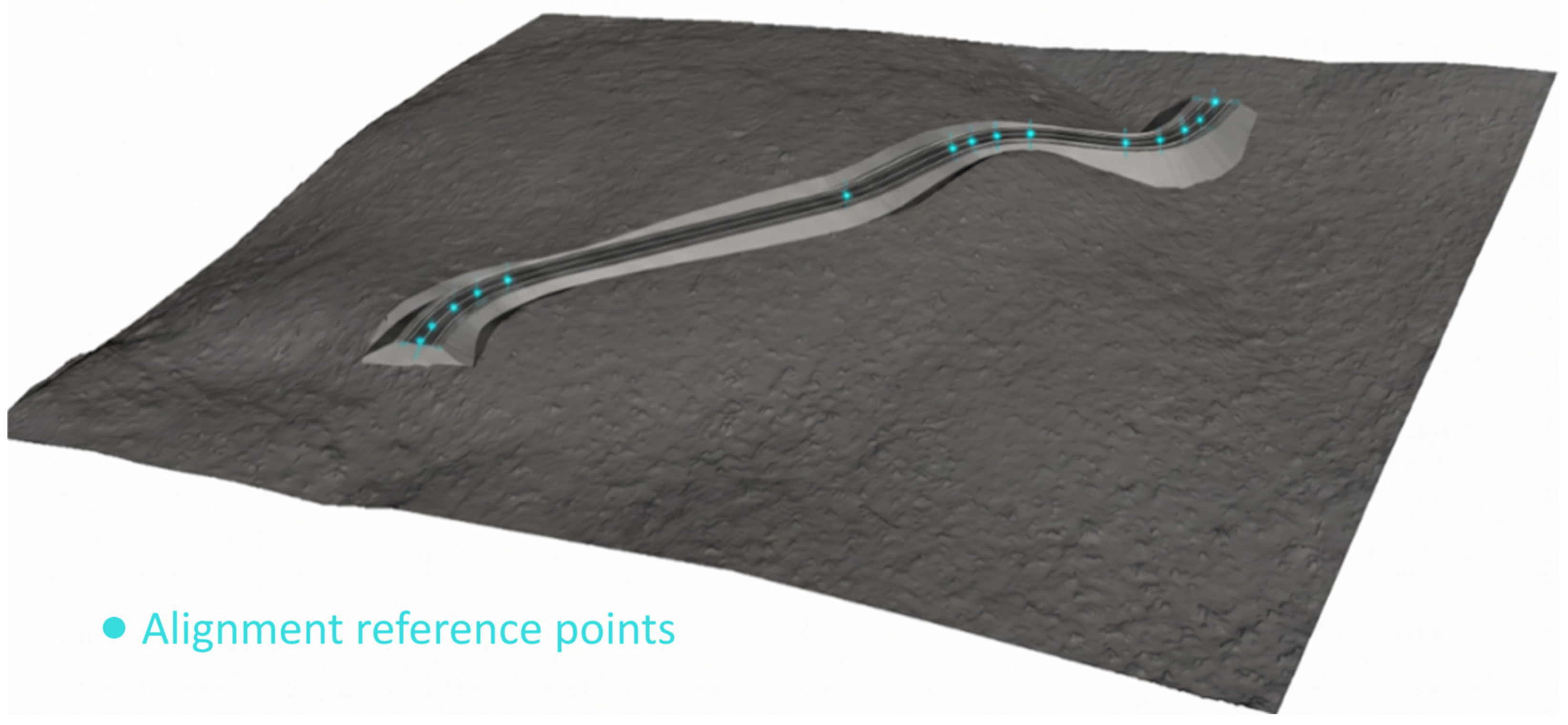
The total excavation (cut) volume is 365.1 m3, and the total fill volume is 156.6 m3. The net imbalance of 208.5 m3 indicates that the alignment is in net cut; the surplus material is either used as fill elsewhere in the project, wasted in approved disposal areas, or transported offsite. Cut volumes are highest at stations 0–40 m, where the alignment crosses a pronounced spur at moderate gradient, and taper in the 40–100 m section as the road contours into lower-gradient terrain. Fill demand increases again at stations 140–180 m where the road crosses a shallow depression (Figure 8).
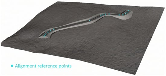
Figure 8.
Selected forest road route of the study (3D).
These results are broadly consistent with cut and fill volumes reported in comparable UAS-assisted forest road projects on terrain with similar slope characteristics [46]. The use of LiDAR-derived DTM data, rather than photogrammetric or GNSS survey inputs, contributes to the high fidelity of these estimates as LiDAR-based terrain models have been shown to more accurately represent the ground surface beneath forest canopy than photogrammetric point clouds, which frequently fail to describe the ground [10,45].
3.4. Individual Tree Inventory and Volume
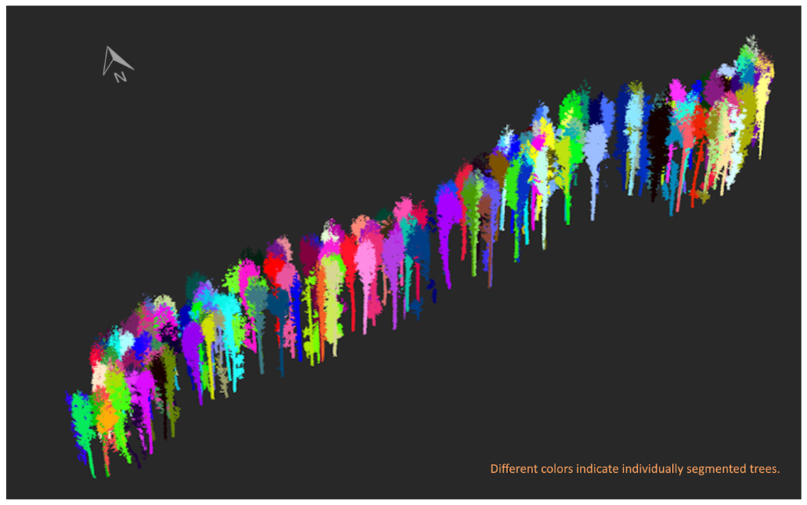
The interactive segmentation approach used in FJD Trion Model software allowed the identification of individual trees within each candidate road corridor. The semi-automated tree identification from the point cloud is highly dependent on operator input but can achieve a Dice coefficient, usually called F1 score, of 100% (i.e., no commission and omission errors). The fused ALS+HLS point cloud enabled the estimation of potential timber removal for each alternative alignment before route selection. The estimated merchantable timber volumes were 252.8 m3 for Route 1, 283.0 m3 for Route 2, and 242.4 m3 for Route 3 (Table 1). For the selected Route 3 alignment, detailed tree-attribute characterization identified 133 individual trees within the 200 m road corridor (Figure 9), with an average tree height of 42.9 m, a mean DBH of 0.55 m, and a mean crown width of 6.5 m. The integration of terrain modeling and tree inventory from the same co-registered point cloud allows timber impacts to be incorporated into the route-selection process rather than assessed after alignment finalization.
Figure 9.
Tree segmentation using FJ Dynamic Trion model.
The tree size distribution reflects the mature, multi-aged Douglas fir stands typical of the McDonald-Dunn Forest. Several large-diameter trees (DBH > 0.80 m) account for a disproportionate share of total volume: the ten largest trees by volume range from 3.38 to 7.16 m3 per stem and collectively account for approximately 17% of the corridor total. Conversely, the smallest trees (DBH < 0.25 m) contribute minimally to merchantable volume. This right-skewed volume distribution is characteristic of Pacific Northwest old-growth and mature second-growth Douglas fir stands [47] and underscores the importance of individual-tree inventory as aggregate stand metrics would obscure the concentration of value in the largest stems.
To contextualize these results relative to conventional field-based surveying and to support the efficiency gains implied by the present remote-sensing-based workflow, we compared our findings with the published time and cost figures for forest road inventory. Ref. [48] compared Mobile Laser Scanning, Total Station, and GNSS surveys for forest road mapping in the Republic of Korea and reported unit mapping costs of 175.2 USD/km, 201.9 USD/km, and 82.5 USD/km, respectively. Total Station survey required the largest field crew (i.e., four), and the GNSS the smallest (i.e., two), the MLS being in-between. Nevertheless, in dense canopy forests, the GNSS lacks accuracy, which severely limits its applicability. A formal head-to-head time-and-manpower trial of the present integrated workflow against conventional survey methods was beyond the scope of this technical note; nonetheless, these published figures support the general expectation [18] that LiDAR-based data acquisition reduces field time and labor requirements relative to traditional total-station and GNSS surveying.
Because the terrain model and the tree inventory share a single co-registered point cloud, the timber that each candidate alignment would remove can be quantified before a route is selected. This is not possible when the timber cruise follows the design.
4. Discussion
4.1. LiDAR-Based DTM Generation and Road Design
DTM accuracy meets the thresholds recommended for engineering-grade road design applications [7]. The slope map derived from the DTM confirms that most of the study area falls in the 10–40% slope class, appropriate for the standard road cross-section applied in this study.
Even though the road is relatively short (i.e., 200 m), the study empirically proves that fusing airborne and terrestrial laser scans produces a terrain model of sufficient accuracy and resolution to support engineering-grade forest road design. The ALS component provided spatially continuous coverage of the study area, including the canopy structure, while the HLS component supplied high-density ground returns that are critical for resolving terrain in areas where ALS ground penetration is limited by canopy closure. The sub-0.12 m RMSE achieved in DTM accuracy validation is consistent with the findings of [9], who reported similar accuracy levels for LiDAR-based road alignment mapping in forested terrain, and exceeds the precision achievable with conventional GNSS-only surveys in dense canopy [49]. These findings are reinforced by [18], who compared LiDAR, UAS photogrammetry, and tachymetric survey approaches for forest road design and found that LiDAR consistently outperformed alternatives in terrain representation accuracy, particularly in areas with dense overstory that prevents photogrammetric ground reconstruction. The fused ALS+HLS approach pursued in the present study extends this advantage further by combining the broad spatial coverage of airborne data with the stem-level resolution of ground-based scanning, a combination validated for road monitoring applications by [19].
The morphological filtering approach applied for ground point classification is well established in the LiDAR literature [37,38] and performed robustly across the terrain conditions encountered in the study area, including the steep slopes on the eastern margin where simple slope-based filters often generate commission errors. Progressive morphological filtering with structuring elements scaled to the local terrain variability removed vegetation effectively without eroding the sharpness of terrain features relevant to road design, such as drainage channels and ridge crests. The point density achieved by the DJI Zenmuse L1 sensor in this study was sufficient to maintain ground classification reliability throughout the study area; as documented by [16], insufficient point density under closed-canopy conditions can degrade ground extraction and road detection substantially.
The least-cost path optimization performed by the Path Explorer AI module produced three feasible alternative alignments in a fraction of the time required for manual trial-and-error route exploration. This mirrors the efficiency gains reported by [8] and demonstrates that AI-assisted route optimization is not merely an academic concept but a practically applicable tool for forest road practitioners. The selected route reduced earthwork relative to the most direct alignment by avoiding steep spur terrain, consistent with the principle, articulated by [2], that optimal road design balances alignment length against excavation cost. The net-cut condition of the selected route (365.1 m3 cut vs. 156.6 m3 fill) is typical for forest road construction in hilly terrain and aligns with values reported by [46] for UAS-assisted road projects of comparable scope.
From an environmental management perspective, the ability to quantify earthwork volumes precisely before construction has direct implications for sediment risk assessment. Ref. [10] demonstrated that LiDAR-derived cut and fill volumes can be used to estimate sediment delivery to streams from low-volume forest roads, enabling proactive identification of high-risk segments and the design of mitigation measures. These earthwork estimates serve as a reliable foundation for implementing mitigation strategies and minimizing potential risks.
4.2. Road Network Context and Existing Infrastructure
Although the present study focuses on a single 200 m road section, the practical application of the workflow is most powerful when embedded in a broader network planning context. Remote sensing approaches, including LiDAR-based detection [11,13], semi-automatic extraction from low-density data [12], and network updating from single-photon LiDAR [15], now provide the tools to maintain current, spatially accurate road network inventories. Ref. [15] achieved approximately 0.4 m positional accuracy in road centerline extraction across northern boreal forests and demonstrated that road width and surface condition attributes can be simultaneously updated from a single LiDAR campaign, providing the complete network inventory needed to evaluate where new roads would add most value. Road condition monitoring, demonstrated by [14,50] using multiple remote sensing modalities, further enables adaptive management of existing infrastructure by detecting wearing-course damage before it escalates into structural failure.
At the strategic network planning level, the design of individual road alignments must ultimately be evaluated against network-wide performance objectives. Ref. [4] illustrated this challenge by applying a resilient Markov Monte Carlo framework to optimize forest road networks simultaneously against economic efficiency, environmental impact, and exposure to natural hazards. The spatial data inputs to such frameworks, such as terrain models, slope maps, hydrological networks, and existing road inventories, are the products generated by LiDAR-based workflows, like the one presented here. Integrating short road alignments—such as this 200 m segment—with network optimization tools and forest harvesting strategies [51] enables planners to evaluate localized connection points against broader network demands, avoiding unnecessary road lengthening in sensitive watersheds. Rather than a standalone framework for major infrastructure, the workflow demonstrated in this study serves as a site-level module for short access links within a larger, hierarchically structured planning system.
4.3. Individual Tree Inventory and Volume Estimation
This result is consistent with the findings of [52], who validated individual tree inventory from airborne LiDAR against felled tree measurements in a mixed conifer forest in the Pacific Northwest, and with studies on terrestrial laser scans-based stem detection in Douglas fir [25,28]. Relying on either platform alone would have biased the corridor timber estimate: HLS-only heights underestimated fused heights by 4.5 m on average, which reduced the merchantable volume by approximately 12% relative to the fused ALS+HLS estimate, while DBH could not be derived from the ALS returns.
The consistency between LiDAR-extracted tree metrics and field measurements observed in this and comparable studies [24,26,30] confirms that the data quality needed for operational timber assessment is achievable with current sensor technology. The integration of structurally guided sampling approaches, as developed by [29] for airborne LiDAR-based inventories, could further enhance the efficiency of the pre-construction timber assessment by prioritizing field verification effort on segments with high uncertainty or high timber value. Beyond individual tree measurement accuracy, the integration of tree inventory with terrain modeling provides an additional operational advantage for forest road planning. Because both datasets originate from the same co-registered ALS+HLS point cloud, potential timber removal can be quantified for each candidate alignment before the final route is selected. This enables timber impacts to be considered together with earthwork requirements and construction costs during the optimization process, rather than being evaluated after the alignment has been finalized.
4.4. Limitations and Future Directions
Several limitations qualify for the generalizability of these findings. First, the 200 m corridor is short relative to operational forest road projects, which commonly extend several kilometers. While the individual components of the workflow (i.e., DTM generation, route optimization, tree inventory) scale in principle, the computational load and the cost of data acquisition increase with project extent. High point-density ALS and HLS data remain relatively expensive to acquire over large areas, although costs are declining rapidly as the sensor market matures. Second, the workflow was demonstrated in a single Douglas-fir-dominated stand on moderately steep terrain (average slope 20.8%), surveyed under snow-free spring conditions, and its performance in other forest types has not been tested. In stands with dense or tall understory, multi-layered canopies, or extensive windthrow or beetle mortality, HLS trajectories are harder to walk, and lower boles are more occluded. Third, the applicability of the Scribner log rule is geographically specific; in jurisdictions using different volume standards, the volume estimation module would require substitution of the appropriate local rule or taper equation. Another limitation is that the results are tied to a specific equipment and software configuration: a DJI Zenmuse L1 flown at 91 m above ground with terrain-following, an FJD Trion S1 handheld SLAM scanner, co-registration in Quick Terrain Modeler, interactive segmentation in FJD Trion Model, and route optimization in RoadEng Path Explorer AI. Other sensors, flight parameters, or SLAM systems would produce point clouds with different density, noise, and penetration characteristics [5]. The reported DTM accuracy and tree metrics should therefore not be assumed to transfer directly. Because SLAM trajectories accumulate drift with distance and loop closure is more difficult along linear corridors, co-registration accuracy on multi-kilometer routes may be lower than over the compact area mapped here, and additional ground control may be needed. Tree segmentation relied on operator interaction, so completeness and attribute accuracy depend partly on operator experience, which limits reproducibility and scalability unless automated segmentation is adopted. Finally, although the procedure is not tied to a jurisdiction, the selected alignment and its earthwork volumes depend on the design standards and cost parameters adopted.
Point cloud density is a critical parameter that directly affects the quality of both ground classification and road extraction. In the present study the DJI Zenmuse L1 sensor achieved point densities (above 500 points/m2, with ground described with more than 100 points/m2) that are adequate for many algorithms identifying the ground points, like the one used in this study (i.e., the progressive morphological filter). However, the findings of [16] suggest that practitioners should explicitly verify density requirements before designing LiDAR acquisition campaigns in structurally complex or high-basal-area stands. Adaptive mission planning that dynamically increases point density over areas with high canopy closure, or supplements ALS with targeted TLS transects, represents a practical mitigation strategy. Similarly, the two-platform fusion strategy employed here (ALS and HLS) could be extended to a three-platform configuration incorporating a SLAM-based mobile scanner, as demonstrated by [19], which would further improve stem-level resolution along the road corridor without substantially increasing flight or data processing time.
The progressive morphological filtering applied for ground classification performs well on the terrain encountered in this study but may require parameter adjustment for forest stands with dense understory vegetation and high canopy closure on steep slopes, where the distinction between low vegetation and ground points is difficult. For dense, tall forests, inclusion of adaptive structuring element sizes, as recommended by [37], addresses some of the limitations of the progressive morphological filters. The integration of machine learning classifiers for ground point identification, trained on high-quality, manually labeled point clouds, represents a promising direction for improving robustness across diverse terrain types.
The workflow presented here, while demonstrated as a sequential procedure, lends itself to partial automation and integration with existing forest management information systems. The road alignment and earthwork outputs are directly compatible with standard GIS formats, and the tree inventory data can be imported into forest management databases. As autonomous construction equipment incorporating LiDAR-based guidance becomes available (a development already underway among major equipment manufacturers), workflows that produce machine-readable road design specifications from aerial survey data will become increasingly important.
5. Conclusions
This study presents and validates a complete, practical workflow for forest road design using fused airborne and terrestrial LiDAR point clouds, demonstrated on a 200 m section of the McDonald-Dunn Research Forest at Oregon State University. The workflow integrates five sequential components: multi-sensor data acquisition and fusion; high-accuracy digital terrain model generation via morphological filtering of the fused ALS+HLS point cloud; AI-assisted least-cost path route optimization; horizontal and vertical alignment design with cut and fill volume calculation; and individual tree detection and Scribner-rule merchantable volume estimation for the proposed road corridor.
The demonstrated approach offers several advantages over conventional forest road survey methods. LiDAR-derived terrain data provides sub-0.12 m accuracy in elevation representation even under closed forest canopy, enabling precise earthwork calculations that reduce uncertainty in construction cost estimates and sediment risk assessments. AI-assisted route optimization replaces iterative manual exploration with systematic evaluation of the full solution space, consistently identifying low-cost alignments. Automated individual tree segmentation and volume estimation from the co-registered same point cloud used for terrain modeling enables timber removal to be quantified for alternative road alignments before route selection, reducing the need for a separate pre-construction timber cruise and improving the integration of timber considerations into road planning. Taken together, these advantages make the workflow a rational and technologically mature replacement for traditional methods in contexts where the capital cost of LiDAR data acquisition is justified by project scale or complexity.
The integration of forest road design with individual tree inventory within a unified LiDAR-based workflow is, to our knowledge, the first demonstration that connects infrastructure planning with timber resource assessment. This connection is particularly valuable for forest managers who must simultaneously plan road construction, schedule timber harvests, and comply with regulatory requirements for pre-disturbance resource inventories. The workflow is compatible with the forest road design standards and timber volume estimation conventions of multiple jurisdictions, recommending straightforward substitution of locally appropriate standards and volume models, although its accuracy and efficiency remain to be verified in other forest types, terrain conditions, and sensor configurations. Future work should explore extending the workflow to multi-platform sensing configurations [19], embedding it within network-level optimization frameworks [4], and validating it across a wider range of forest types and terrain conditions.
Author Contributions
Conceptualization, E.B. and B.M.S.; methodology, E.B. and B.M.S.; software, E.B.; validation, E.B. and B.M.S.; formal analysis, E.B.; investigation, E.B.; resources, E.B. and B.M.S.; data curation, E.B.; writing—original draft preparation, E.B.; writing—review and editing, B.M.S.; visualization, E.B.; supervision, B.M.S.; project administration, B.M.S.; funding acquisition, E.B. and B.M.S. All authors have read and agreed to the published version of the manuscript.
Funding
This research was funded by the Scientific and Technological Research Council of Türkiye (TÜBİTAK), grant number 1059B192202858, and by the Agriculture and Food Research Initiative, project award no. 2022-67021-37857, from the US Department of Agriculture’s National Institute of Food and Agriculture.
Data Availability Statement
The data supporting the reported results are available upon reasonable request from the corresponding author.
Conflicts of Interest
The authors declare no conflicts of interest. The funders had no role in the design of the study; in the collection, analyses, or interpretation of data; in the writing of the manuscript; or in the decision to publish the results.
Abbreviations
The following abbreviations are used in this manuscript: ALS, Airborne Laser Scanning; DBH, Diameter at Breast Height; DEM, Digital Elevation Model; DTM, Digital Terrain Model; GIS, Geographic Information System; GNSS, Global Navigation Satellite System; HLS, Handheld Laser Scanning; LiDAR, Light Detection and Ranging; MHD, Mass Haul Diagram; RMSE, Root Mean Square Error; RTK, Real-Time Kinematic; SLAM, Simultaneous Localization and Mapping; TLS, Terrestrial Laser Scanning; UAS, Unmanned Aerial System.
References
- Lyons, C.K.; Borz, S.A.; Harvey, C.; Ramantswana, M.; Sakai, H.; Visser, R. Forest roads: Regional perspectives from around the world. Int. J. For. Eng. 2023, 34, 190–203. [Google Scholar] [CrossRef] [Scilit]
- Akay, A.E. A New Method of Designing Forest Roads. Turk. J. Agric. For. 2004, 28, 273–279. [Google Scholar]
- Xing, J.; Sun, S.; Huang, Q.; Chen, Z.; Zhou, Z. Application of Geoinformatics in Forest Planning and Management. Forests 2024, 15, 439. [Google Scholar] [CrossRef] [Scilit]
- Tampekis, S. Optimizing forest road networks for economic environmental and hazard impacts using a resilient Markov Monte Carlo approach. Discov. For. 2025, 1, 26. [Google Scholar] [CrossRef] [Scilit]
- Bauwens, S.; Bartholomeus, H.; Calders, K.; Lejeune, P. Forest Inventory with Terrestrial LiDAR: A Comparison of Static and Hand-Held Mobile Laser Scanning. Forests 2016, 7, 127. [Google Scholar] [CrossRef] [Scilit]
- Buonocore, L.; Yates, J.; Valentini, R. A Proposal for a Forest Digital Twin Framework and Its Perspectives. Forests 2022, 13, 498. [Google Scholar] [CrossRef] [Scilit]
- Saito, M.; Aruga, K.; Matsue, K.; Tasaka, T. Development of the Forest Road Design Technique using LiDAR Data of the Funyu Experimental Forest (Silvilaser). J. For. Plan. 2008, 13, 147–156. [Google Scholar] [CrossRef] [Scilit] [PubMed]
- Speirs, C.; Mills, D.; Guigue, A. Rethinking Road Planning and Design Workflows: Unlocking the Potential of LiDAR with New Optimization Technology; Softree Technical Systems: North Vancouver, BC, Canada, 2016. [Google Scholar]
- Matinnia, B.; Parsakhoo, A.; Mohamadi, J.; Shataee Jouibary, S. Study of the LiDAR accuracy in mapping forest road alignments and estimating the earthwork volume. J. For. Sci. 2018, 64, 469–477. [Google Scholar] [CrossRef] [Scilit]
- Akay, A.E.; Wing, M.G.; Sessions, J. Estimating sediment reduction cost for low-volume forest roads using a lidar-derived high-resolution DEM. Balt. J. Road Bridge Eng. 2014, 9, 52–57. [Google Scholar] [CrossRef] [Scilit]
- White, R.A.; Dietterick, B.C.; Mastin, T.; Strohman, R. Forest Roads Mapped Using LiDAR in Steep Forested Terrain. Remote Sens. 2010, 2, 1120–1141. [Google Scholar] [CrossRef] [Scilit]
- Prendes, C.; Buján, S.; Ordoñez, C.; Canga, E. Large scale semi-automatic detection of forest roads from low density LiDAR data on steep terrain in Northern Spain. iForest-Biogeosci. For. 2019, 12, 366–374. [Google Scholar] [CrossRef] [Scilit]
- Buján, S.; Guerra-Hernández, J.; González-Ferreiro, E.; Miranda, D. Forest Road Detection Using LiDAR Data and Hybrid Classification. Remote Sens. 2021, 13, 393. [Google Scholar] [CrossRef] [Scilit]
- Hrůza, P.; Mikita, T.; Tyagur, N.; Krejza, Z.; Cibulka, M.; Procházková, A.; Patočka, Z. Detecting Forest Road Wearing Course Damage Using Different Methods of Remote Sensing. Remote Sens. 2018, 10, 492. [Google Scholar] [CrossRef] [Scilit]
- Morley, I.D.; Coops, N.C.; Roussel, J.-R.; Achim, A.; Dech, J.; Meecham, D.; McCartney, G.; Reid, D.E.B.; McPherson, S.; Quist, L.; et al. Updating forest road networks using single photon LiDAR in northern Forest environments. For. An. Int. J. For. Res. 2024, 97, 38–47. [Google Scholar] [CrossRef] [Scilit]
- Spiazzi Favarin, J.; Sabadi Schuh, M.; Marchesan, J.; Alba, E.; Soares Pereira, R. Identification and characterization of gaps and roads in the Amazon rainforest with LiDAR data. iForest-Biogeosci. For. 2024, 17, 229–235. [Google Scholar] [CrossRef] [Scilit]
- Lovrinčević, M.; Papa, I.; Popovic, M.; Hodak, L.; Pentek, T.; Đuka, A. Forest Road Design Based on Different Methods of Field Data Survey. Croat. J. For. Eng. 2026, 47, 21. [Google Scholar] [CrossRef] [Scilit]
- Lovrinčević, M.; Papa, I.; Janeš, D.; Hodak, L.; Pentek, T.; Đuka, A. New Possibilities of Field Data Survey in Forest Road Design. Sensors 2025, 25, 4192. [Google Scholar] [CrossRef] [Scilit] [PubMed]
- Siafali, E.; Tsioras, P.A. An Innovative Approach to Surface Deformation Estimation in Forest Road and Trail Networks Using Unmanned Aerial Vehicle Real-Time Kinematic-Derived Data for Monitoring and Maintenance. Forests 2024, 15, 212. [Google Scholar] [CrossRef] [Scilit]
- Trybała, P.; Morelli, L.; Remondino, F.; Farrand, L.; Couceiro, M.S. Under-Canopy Drone 3D Surveys for Wild Fruit Hotspot Mapping. Drones 2024, 8, 577. [Google Scholar] [CrossRef] [Scilit]
- Lian, X.; Zhang, H.; Xiao, W.; Lei, Y.; Ge, L.; Qin, K.; He, Y.; Dong, Q.; Li, L.; Han, Y.; et al. Biomass Calculations of Individual Trees Based on Unmanned Aerial Vehicle Multispectral Imagery and Laser Scanning Combined with Terrestrial Laser Scanning in Complex Stands. Remote Sens. 2022, 14, 4715. [Google Scholar] [CrossRef] [Scilit]
- Picos, J.; Bastos, G.; Míguez, D.; Alonso, L.; Armesto, J. Individual Tree Detection in a Eucalyptus Plantation Using Unmanned Aerial Vehicle (UAV)-LiDAR. Remote Sens. 2020, 12, 885. [Google Scholar] [CrossRef] [Scilit]
- Fekry, R.; Yao, W.; Cao, L.; Shen, X. Ground-based/UAV-LiDAR data fusion for quantitative structure modeling and tree parameter retrieval in subtropical planted forest. For. Ecosyst. 2022, 9, 100065. [Google Scholar] [CrossRef] [Scilit]
- Yu, S.; Chen, X.; Huang, X.; Chen, Y.; Hu, Z.; Liu, J.; Yu, K. Research on the Estimation of Chinese Fir Stand Volume Based on UAV-LiDAR Technology. Forests 2023, 14, 1252. [Google Scholar] [CrossRef] [Scilit]
- Fang, R.; Strimbu, B. Stem Measurements and Taper Modeling Using Photogrammetric Point Clouds. Remote Sens. 2017, 9, 716. [Google Scholar] [CrossRef] [Scilit]
- Liao, K.; Li, Y.; Zou, B.; Li, D.; Lu, D. Examining the Role of UAV Lidar Data in Improving Tree Volume Calculation Accuracy. Remote Sens. 2022, 14, 4410. [Google Scholar] [CrossRef] [Scilit]
- Fang, R.; Strimbu, B.M. Comparison of stem volume estimates from terrestrial point clouds for mature Douglas-fir (Pseudotsuga menziessi (Mirb.) Franco). Inf. Process. Agric. 2023, 10, 334–346. [Google Scholar] [CrossRef] [Scilit]
- Garms, C.G.; Strimbu, B.M. Impact of stem lean on estimation of Douglas-fir (Pseudotsuga menziesii) diameter and volume using mobile lidar scans. Can. J. For. Res. 2021, 51, 1117–1130. [Google Scholar] [CrossRef] [Scilit]
- Goodbody, T.R.H.; Coops, N.C.; Queinnec, M.; White, J.C.; Tompalski, P.; Hudak, A.T.; Auty, D.; Valbuena, R.; LeBoeuf, A.; Sinclair, I.; et al. SgsR: A structurally guided sampling toolbox for LiDAR-based forest inventories. Forestry 2023, 96, 411–424. [Google Scholar] [CrossRef] [Scilit]
- Stolle, L.; Corte, A.P.D.; Sanquetta, C.R.; Behling, A.; Hentz, Â.M.K.; Eisfeld, R.D.L. Predicting Stand Volume by Number of Trees Automatically Detected in UAV Images: An Alternative Method for Forest Inventory. Forests 2021, 12, 1508. [Google Scholar] [CrossRef] [Scilit]
- Strîmbu, V.F.; Strîmbu, B.M. A graph-based segmentation algorithm for tree crown extraction using airborne LiDAR data. ISPRS J. Photogramm. Remote Sens. 2015, 104, 30–43. [Google Scholar] [CrossRef] [Scilit]
- CAR. Volume Estimation for the PNW-FIA Integrated Database; Climate Action Reserve: Los Angeles, CA, USA, 2009; Available online: https://www.climateactionreserve.org/wp-content/uploads/2015/04/Volume-Equations-Update-5-13-2009.pdf (accessed on 23 June 2024).
- Fowler, G.W. Individual Tree Volume Equations for Red Pine in Michigan. North. J. Appl. For. 1997, 14, 53–58. [Google Scholar] [CrossRef] [Scilit]
- Retzlaff, C.O.; Gollob, C.; Nothdurft, A.; Stampfer, K.; Holzinger, A. Multi-objective optimization of cable-road layouts in smart forestry. Int. J. For. Eng. 2024, 35, 444–455. [Google Scholar] [CrossRef] [Scilit] [PubMed]
- Zhang, K.; Chen, S.-C.; Whitman, D.; Shyu, M.-L.; Yan, J.; Zhang, C. A progressive morphological filter for removing nonground measurements from airborne LIDAR data. IEEE Trans. Geosci. Remote Sens. 2003, 41, 872–882. [Google Scholar] [CrossRef] [Scilit]
- Chen, Z.; Gao, B.; Devereux, B. State-of-the-Art: DTM Generation Using Airborne LIDAR Data. Sensors 2017, 17, 150. [Google Scholar] [CrossRef] [Scilit] [PubMed]
- Lu, X.J.; Luo, L.; Zhou, B.; Huang, Y.H.; Wu, C.L. LIDAR Data Filtering Based on the Improved Window Size of Progressive Mathematical Morphology. Int. Arch. Photogramm. Remote Sens. Spat. Inf. Sci. 2020, XLII-3/W10, 221–228. [Google Scholar] [CrossRef] [Scilit][Green Version]
- Meng, X.; Currit, N.; Zhao, K. Ground Filtering Algorithms for Airborne LiDAR Data: A Review of Critical Issues. Remote Sens. 2010, 2, 833–860. [Google Scholar] [CrossRef] [Scilit]
- RoadEng. RoadEng Tutorial for Resource Road Applications; Softree Technical Systems: North Vancouver, BC, Canada, 2024; Available online: https://softree.sharefile.com/public/share/web-s551cc121fc5b462399f1571e990470ab (accessed on 30 August 2026).
- RoadEng. Path Explorer AI: Powerful Route Exploration for Road Design; Softree Technical Systems: North Vancouver, BC, Canada, 2025; Available online: https://www.softree.com/products/path-explorer (accessed on 30 August 2026).
- Anonymous. Forest Road Design Manual (Official Regulation No. 292); General Directorate of Forestry: Ankara, Türkiye, 2008. Available online: https://www.ogm.gov.tr/tr/e-kutuphane-sitesi/mevzuat-sitesi/Tebligler/Orman%20Yollar%C4%B1%20Planlamas%C4%B1,%20Yap%C4%B1m%C4%B1%20ve%20Bak%C4%B1m%C4%B1%20(292%20Say%C4%B1l%C4%B1%20Tebli%C4%9F).pdf (accessed on 5 November 2024).
- Mellgren, P.G. Terrain Classification for Canadian Forestry; FERIC, Canadian Pulp and Paper Association: Montreal, QC, Canada, 1980; pp. 1–13. [Google Scholar]
- Patterson, D.W.; Armstrong, J.P. Prediction equations for determining board foot recovery from bolter saw bolts. For. Prod. J. 1994, 44, 40. [Google Scholar]
- Tuček, J.; Suchomel, J. Technological requirements for the location of forest roads in Slovak conditions. In Proceedings of the Seminar on Environmentally Sound Forest Roads and Wood Transport, Sinaia, Romania, 17–22 June 1996; FAO: Rome, Italy, 1998; pp. 118–129. [Google Scholar]
- Polat, N.; Uysal, M. An Experimental Analysis of Digital Elevation Models Generated with Lidar Data and UAV Photogrammetry. J. Indian Soc. Remote Sens. 2018, 46, 1135–1142. [Google Scholar] [CrossRef] [Scilit]
- Lepoglavec, K.; Šušnjar, M.; Pandur, Z.; Bačić, M.; Kopseak, H.; Nevečerel, H. Correct Calculation of the Existing Longitudinal Profile of a Forest/Skid Road Using GNSS and a UAV Device. Forests 2023, 14, 751. [Google Scholar] [CrossRef] [Scilit]
- Gonzalez-Benecke, C.A.; Flamenco, H.N.; Wightman, M.G. Effect of Vegetation Management and Site Conditions on Volume, Biomass and Leaf Area Allometry of Four Coniferous Species in the Pacific Northwest United States. Forests 2018, 9, 581. [Google Scholar] [CrossRef] [Scilit]
- Kweon, H.; Seo, J.I.; Lee, J.-W. Assessing the Applicability of Mobile Laser Scanning for Mapping Forest Roads in the Republic of Korea. Remote Sens. 2020, 12, 1502. [Google Scholar] [CrossRef] [Scilit]
- Taş, İ.; Kaska, M.S.; Akay, A.E. Assessment of Using UAV Photogrammetry Based DEM and Ground-Measurement Based DEM in Computer-Assisted Forest Road Design. Eur. J. For. Eng. 2023, 9, 1–9. [Google Scholar] [CrossRef] [Scilit]
- Hrůza, P.; Mikita, T.; Krausková, D. Automatic Detection of Surface Damage on Forest Roads Using Mobile LiDAR and GIS Processing Tools. Croat. J. For. Eng. J. Theory Appl. For. Eng. 2026, 47, 117–130. [Google Scholar] [CrossRef] [Scilit]
- Strimbu, B.M.; Innes, J.L.; Strimbu, V.F. A deterministic harvest scheduler using perfect bin-packing theorem. Eur. J. For. Res. 2010, 129, 961–974. [Google Scholar] [CrossRef] [Scilit]
- Sparks, A.M.; Corrao, M.V.; Keefe, R.F.; Armstrong, R.; Smith, A.M.S. An Accuracy Assessment of Field and Airborne Laser Scanning–Derived Individual Tree Inventories using Felled Tree Measurements and Log Scaling Data in a Mixed Conifer Forest. For. Sci. 2024, 70, 228–241. [Google Scholar] [CrossRef] [Scilit]

Disclaimer/Publisher’s Note: The statements, opinions and data contained in all publications are solely those of the individual author(s) and contributor(s) and not of MDPI and/or the editor(s). MDPI and/or the editor(s) disclaim responsibility for any injury to people or property resulting from any ideas, methods, instructions or products referred to in the content. |
© 2026 by the authors. Licensee MDPI, Basel, Switzerland. This article is an open access article distributed under the terms and conditions of the Creative Commons Attribution (CC BY) license.