


Highlights
What are the main findings?
- A training-free damage grading of pre-localized building instances framework (SCTSC-VLM) was developed by integrating external building-footprint spatial priors, hierarchical chain-of-thought reasoning, self-correction, and ensemble decision-making into Qwen3-VL-30B.
- On the full Dingri evaluation dataset comprising Areas A–C (n = 398), SCTSC-VLM achieved a Macro-F1 of 88.2%; the corresponding value for the Eaton Fire evaluation dataset (n = 386) was 83.8%. In separate five-run ablations, the complete framework increased mean Macro-F1 from 74.5 ± 0.9% to 89.8 ± 0.2% in Dingri Area C and from 71.2 ± 0.7% to 83.7 ± 0.1% in the Eaton Fire study area.
What are the implications of the main findings?
- Structured reasoning and self-correction were associated with higher classification performance without requiring task-specific model training, reducing dependence on annotated post-disaster datasets.
- The combination of external building-footprint priors and instance-level visual prompting supports targeted damage grading of pre-localized buildings using only post-disaster imagery.
Abstract
Accurate mapping of building damage after destructive natural disasters is essential for emergency response and recovery planning. However, annotated post-disaster samples are often scarce, and conventional supervised models usually generalize poorly across scenes and hazard types. These constraints limit the operational use of remote sensing-based damage assessment during emergency response. To address this problem, this study proposes SCTSC-VLM, a training-free framework for damage grading of pre-localized building instances, implemented using a locally deployed Q4_K_M 4-bit quantized version of the Qwen3-VL-30B vision–language model. The framework has three main components. First, an instance-level visual input construction strategy integrates independent assessment of building instances localized by the supplied footprint data without a dedicated instance segmentation model. Second, a hierarchical reasoning mechanism decomposes the assessment into four progressive stages: multi-view structured feature extraction, independent visual description, cross-validation, and rule-constrained classification. This design is intended to reduce hallucination and visually ungrounded reasoning. Third, a multi-sampling ensemble decision mechanism mitigates the randomness of autoregressive generation. The framework was evaluated using post-disaster optical imagery from the 2025 Dingri earthquake and the 2025 Eaton Fire in California. On the full Dingri evaluation dataset comprising Areas A–C (n = 398), SCTSC-VLM achieved a Macro-F1 score of 88.2% and a Kappa coefficient of 0.806. On the separate full California evaluation dataset (n = 386), it achieved a Macro-F1 score of 83.8% and a Kappa coefficient of 0.800. Separate ablation experiments were conducted on explicitly defined analysis populations to examine the contributions of the framework components. In both full-dataset evaluations, the fully damaged and undamaged classes obtained higher F1-scores than the partially damaged class. These results provide case-level evidence that structured reasoning can support training-free damage grading of pre-localized buildings, although broader generalization and large-area operational efficiency remain to be established.
1. Introduction
Sudden natural disasters, including destructive earthquakes and large wildfires, can cause widespread building damage and severe casualties within a short period [1]. Whether the damage appears as earthquake-induced structural collapse or wildfire-induced thermal destruction, timely and accurate information on building damage distribution and severity is essential for emergency response, rescue resource allocation, and reconstruction planning [2]. Conventional field surveys are often constrained by disrupted transport, aftershocks, continuing fire risk, and limited personnel, so they may not meet the time requirements of large-scale assessment during the critical rescue window [3]. High-resolution remote sensing imagery has therefore become an important data source for rapid post-disaster assessment because it provides broad spatial coverage and frequent revisits [4]. Beyond post-disaster mapping, remote sensing supports a wide range of environmental and hazard-monitoring applications, including global XCO2 observations from spaceborne lidar, operational early warning of low-level turbulence based on radar wind profiler observations, and UAV LiDAR point-cloud completion for forest parameter estimation [5,6,7]. Even so, extracting instance-level damage information for individual buildings from complex debris fields and burned scenes remains a central challenge in disaster remote sensing [8].
Deep learning has substantially advanced building damage assessment from remote sensing imagery [9]. Convolutional neural networks and semantic segmentation models have been widely used for change detection with pre- and post-disaster bi-temporal imagery, where damaged buildings are identified through pixel-level or object-level feature comparisons [10]. Geographic Object-Based Image Analysis (GEOBIA) further incorporates spectral, geometric, and textural information at the image-object level, reducing salt-and-pepper noise and improving building-level damage classification [11]. More recently, Vision Transformers (ViTs) [12] and the Segment Anything Model (SAM) [13,14] have introduced new possibilities for post-disaster damage assessment. For example, S2AC-Net replaces conventional multiresolution segmentation with SAM and combines frozen pretrained visual encoders with lightweight adapter modules. On the 2023 Jishishan earthquake dataset, it achieved an overall assessment accuracy of 0.882, demonstrating the potential of foundation models for building localization and damage assessment [15]. Singh et al. (2025) proposed a metadata-enhanced Transformer framework that integrates high-resolution post-earthquake satellite imagery with building-specific metadata, including seismic intensity indicators and soil properties [16]. The method demonstrated promising performance for multiclass building damage recognition after the 2023 Türkiye-Syria earthquake. Supported by large annotated datasets such as xBD, these supervised approaches have achieved high classification accuracy in damage assessment tasks [17,18].
However, these approaches still depend heavily on large, high-quality annotated datasets [19]. Because disasters are sudden and geographically specific, building types, damage patterns, and imaging conditions can vary substantially across events. Models trained for one disaster scenario therefore often generalize poorly to newly emerging disasters [20]. Post-disaster annotation also requires expert knowledge and considerable time, which limits practical deployment during real emergencies [21]. This dependency is further complicated by the limitations of bi-temporal approaches. Besides requiring temporally consistent pre-disaster baseline imagery, bi-temporal change detection must address geometric misregistration, illumination variation, and seasonal vegetation changes [22,23]. Even when these requirements are met, new disasters usually lack sufficient training samples, and annotation cannot keep pace with emergency response timelines. Thus, despite advances in network architecture, dependence on annotated data remains a key bottleneck for operational post-disaster assessment [24].
The rapid development of vision–language models (VLMs) offers a promising alternative [25]. Large-scale VLMs, including GPT-4V [26], Qwen-VL [27], and InternVL [28], are pretrained on large-scale image–text pairs and show strong cross-modal semantic alignment and visual reasoning capability. Compared with conventional supervised methods, VLMs can perform zero-shot reasoning on unseen tasks and cross-domain scenarios, reducing dependence on task-specific annotated data [29]. Recent studies have started to examine VLMs in remote sensing. Chacón-Albero et al. (2025) investigated zero-shot and few-shot assessment of post-disaster structural damage using pretrained VLMs and reported promising performance without task-specific supervised training [30]. Rumiantsev and Oliinyk (2025) explored the feasibility and limitations of applying LLaVA-1.5-7B to infrastructure damage detection from satellite imagery under zero-shot settings [31]. More recently, Qu et al. (2026) applied a zero-shot VLM framework to rapid damaged bridge extraction after the 2025 Myanmar earthquake, showing that VLMs can support emergency infrastructure assessment when annotated training samples are unavailable [32]. Together, these studies suggest that VLMs may enable damage interpretation from single post-disaster imagery without task-specific fine-tuning.
Nevertheless, directly applying VLMs to building damage assessment remains challenging, especially for fine-grained remote sensing interpretation. First, general-purpose VLMs often lack disaster-specific reasoning capability and may produce coarse or ambiguous judgments under direct prompting, which is insufficient for damage assessment in emergency response [33]. Second, VLMs can hallucinate when processing remote sensing imagery by generating descriptions that are inconsistent with the actual image content [34]. In the H2RSVLM study, Pang et al. (2024) argued that the weak performance of general VLMs in remote sensing is mainly related to the specialized characteristics of remote sensing imagery and the limited spatial perception ability of current VLMs [35]. They further constructed the RSSA dataset to improve self-reflection on unanswerable questions and suppress hallucinated outputs. Shao et al. (2025) identified a related phenomenon termed “pseudo-reasoning”, in which the model describes a reasoning process without grounding the decision in visual evidence [36]. Third, autoregressive generative models are inherently stochastic during inference. The same building may receive inconsistent predictions across inference rounds, indicating limited stability in single-pass inference [37]. Fourth, general-purpose VLMs used without an explicit grounding mechanism may not reliably isolate individual buildings in dense remote-sensing scenes. Grounded remote-sensing VLMs such as GeoChat have demonstrated related spatial referring and grounding capabilities [38], but these capabilities do not by themselves provide the footprint-based, damage-specific assessment workflow. These limitations prevent VLMs from fully realizing their potential in practical building damage assessment.
To address these limitations, this study proposes SCTSC-VLM (Structured Chain-of-Thought with Self-Correction for Vision–Language Models), a training-free framework for damage grading of pre-localized building instances using Qwen3-VL-30B. The framework reformulates the building-by-building workflow used by remote sensing interpreters into a structured reasoning pipeline that Qwen3-VL-30B can execute without updating model parameters. Chain-of-thought prompting, repeated sampling, and spatial prompting are established concepts rather than individually new techniques introduced by this study. The methodological contribution lies in their task-specific integration with a geometric, surface, and structural feature schema, cross-stage contradiction correction, and deterministic damage-grade mapping. The main contributions are as follows. (1) A hierarchical chain-of-thought reasoning mechanism is proposed to decouple assessment into four progressive stages: feature observation, independent visual description, cross-validation, and rule-constrained classification. This mechanism is designed to reduce visually inconsistent outputs and pseudo-reasoning in complex post-disaster scenes. (2) An instance-level visual input construction strategy based on external building footprints and hard visual prompts is designed to assess pre-localized buildings without requiring dedicated instance segmentation. (3) Systematic quantitative evaluation and cross-scenario validation are conducted on two real-world disaster scenarios with different damage mechanisms, the 2025 Dingri earthquake and the 2025 Eaton Fire in California, providing case-level evidence of the framework’s behavior under two contrasting damage contexts.
2. Study Areas and Data
2.1. Study Areas and Disaster Scenarios
Two disaster events were examined. The Mw 6.8 Dingri earthquake struck Dingri County, Tibet, China, on 7 January 2025; the BJ-3 image used in this study was acquired on 11 January, four days after the earthquake. The Eaton Fire in Los Angeles County, California, began on 7 January 2025; the WV-3 image was acquired on 14 January, seven days after ignition, when extensive building damage was visible in the selected area and no active flames or smoke obscured the targets. Figure 1 shows the geographic locations of the two study areas and the spatial distribution of buildings within each region.
Figure 1.
Geographic overview of the two study areas. Upper panel: the 2025 Eaton Fire study area in California, USA, with building footprints indicated. Lower panel: Dingri earthquake-affected region in the Tibet Autonomous Region, China (2025), with building footprints indicated. Building footprints used for instance localization are indicated in both panels.
The two disaster events differ fundamentally in both disaster mechanisms and building damage characteristics. The earthquake scenario is primarily dominated by structural collapse, whereas the wildfire scenario is characterized by fire-induced thermal destruction. As a result, building damage in the two scenarios exhibits substantially different visual characteristics in remote sensing imagery. Conventional supervised learning methods typically rely on annotated samples from specific disaster types and therefore often exhibit limited cross-hazard robustness. In contrast, the reasoning mechanism of SCTSC-VLM is designed to assess damage based on generalizable structural and visual attributes, including building geometry, surface conditions, and structural integrity. The two scenarios therefore provide contrasting cases for examining how the proposed framework behaves under different damage manifestations.
The Dingri earthquake struck the central Qinghai–Tibet Plateau, with the epicenter located in Dingri County. Villages and towns surrounding the epicentral region suffered severe structural damage. Buildings in this area mainly consist of Tibetan-style dwellings and brick–concrete buildings, with some villages exhibiting densely clustered settlement patterns. In post-disaster high-resolution imagery, building damage is typically characterized by roof collapse, deformation of previously regular building outlines, and extensive rubble and debris scattered around damaged structures. Meanwhile, overlapping building shadows and collapsed structural debris often blur the visual boundaries of damaged buildings, posing significant challenges for accurately identifying structural deformation and debris distribution in complex post-disaster scenes.
The Eaton Fire study area comprises suburban residential communities surrounded by dense vegetation. Unlike the physical collapse caused by earthquakes, wildfire damage generally does not manifest as large-scale collapsed rubble in remote sensing imagery. Instead, it is primarily characterized by pronounced spectral and texture variations. Roof surfaces are often heavily blackened and carbonized, while completely burned buildings may leave behind gray-white ash residues and exposed foundation outlines at their original locations. In addition, burned background surfaces and tree canopy occlusion further complicate the identification of damage characteristics in post-disaster imagery.
2.2. Post-Disaster Remote Sensing Imagery and Spatial Prior Data
The experimental dataset comprises two components: post-disaster high-resolution optical remote sensing imagery and open-source spatial vector data. For the Dingri earthquake scenario, post-disaster Beijing-3 (BJ-3) optical imagery was acquired. The imagery was supplied by the Land Satellite Remote Sensing Application Center, with a ground pixel size of 0.75 m. For the Eaton Fire case, high-resolution WorldView-3 (WV-3) satellite imagery provided by Maxar Open-data program (https://www.maxar.com/open-data accessed on 11 December 2025) was used, and the imagery has a spatial resolution of 0.31 m. By the acquisition date, widespread fire-induced building damage was already evident across the selected study area. No active flames or smoke plumes were visible within the image-covered area. We therefore used the imagery to assess the damage left by the fire without obvious obstruction from active fire or smoke. Both images were used as received, without additional pansharpening, atmospheric correction, or spatial resampling. Detailed dataset specifications are presented in Table 1.
Table 1.
Detailed specifications of the experimental datasets.
Precise spatial localization of individual buildings is fundamental to instance-level building damage grading. Building footprints were obtained separately for the two study areas. For the Eaton Fire scenario, the footprints were obtained from Microsoft US Building Footprints; the latest value of the source attribute ‘capture_da’ in the downloaded shapefile was 13 April 2019. For the Dingri earthquake scenario, the footprints were downloaded from OpenStreetMap on 9 April 2025. The downloaded OSM attributes did not provide a reliable latest capture date. Missing OSM footprints were supplemented by comparing the ESRI satellite basemap with the post-disaster BJ-3 image. The resulting footprint data provide the geographic coordinates and polygon geometries of individual buildings. During preprocessing, the footprint building data and post-disaster remote sensing imagery were aligned within a unified projected coordinate system and accurately co-registered, providing the spatial basis for subsequent automated bounding-box extraction and hard visual prompt generation.
2.3. Assessment Reference and Damage Grading
To enable objective evaluation of model performance while accounting for the distinct visual characteristics of earthquake-induced structural collapse and wildfire-induced thermal destruction in remote sensing imagery, this study established a three-level building damage classification scheme with reference to the EMS-98 building damage grading standard [39] and the remote sensing damage categories defined in the xBD dataset. The damage state of each individual building was categorized into the following three levels in Figure 2:
Figure 2.
Typical visual characteristics of building damage levels.
(1). Undamaged. The building remains intact in geometric, surface, and structural terms. In remote sensing imagery, it retains a clear rectangular or regular polygonal shape, with straight edges and recognizable right-angle corners. The roof surface appears continuous and intact, with relatively uniform coloration. The overall structure remains stable, with no visible deformation, collapse, or burn damage.
(2). Partially damaged. The building retains part of its geometric form or residual structural integrity, but clear damage is visible. Portions of straight edges may remain recognizable, although the overall outline shows distortion. The roof may show localized disruption or burn-related discoloration, but it has not fully collapsed or become completely fragmented. The overall structure shows varying degrees of deformation but has not undergone complete collapse or total burn destruction.
(3). Fully damaged. The original structural integrity and geometric characteristics of the building are no longer discernible. In remote sensing imagery, straight edges and corner features disappear, and the building appears as irregular shapes, debris, or rubble. The continuous roof surface is absent, and the remaining surface is highly heterogeneous. The structure has either collapsed into ruins or burned completely, leaving exposed foundation outlines and gray-white ash residues.
Before damage annotation, candidate buildings were checked for complete coverage in the post-disaster imagery. Only buildings whose target footprints were fully contained within the available image extent were annotated. Reference labels were generated by two interpreters with experience in remote-sensing interpretation. Before formal annotation, the interpreters reviewed the three-level classification criteria and jointly examined representative examples to establish a consistent interpretation protocol. Each building was then independently assigned to the undamaged, partially damaged, or fully damaged class based on geometric integrity, roof-surface continuity, structural deformation, and visible collapse or burn evidence.
Disagreements were identified through cross-checking and resolved by an independent third interpreter. Samples for which the available imagery did not provide sufficient evidence were resolved through consensus. 31 buildings were reviewed through consensus because the available imagery was insufficient for a confident classification. Of these, 24 were ultimately classified as partially damaged and seven as undamaged; none were classified as fully damaged. The final reference label assigned to each building was the reconciled label produced through this quality-control procedure.
3. Method
3.1. Overall Framework
Qwen3-VL-30B is an open-source vision–language model with visual reasoning and cross-modal alignment capabilities. It also shows zero-shot transferability across multimodal benchmarks. Qwen3-VL-30B can be quantized for local deployment on a single GPU, offering potential for network-independent inference in disaster-response settings. For these reasons, Qwen3-VL-30B was selected as the core reasoning engine for SCTSC-VLM.
The framework is built upon the idea of formalizing the expert workflow used for building-by-building damage interpretation in remote sensing imagery into a structured reasoning mechanism that can be followed by a vision–language model. In this way, automated building-level damage grading can be achieved without task-specific fine-tuning or reliance on annotated post-disaster samples.
The overall SCTSC-VLM framework is illustrated in Figure 3 and consists of three interconnected components. First, instance-level visual inputs are constructed using external building-footprint spatial priors. Open-source building footprint data are employed to automatically extract local image patches centered on individual buildings from large-scale post-disaster imagery. Hard visual prompts increase target-background contrast and provide an explicit spatial cue for the specified building, allowing complex disaster scenes to be decomposed into independently assessable building instances. Hierarchical chain-of-thought reasoning is then introduced to emulate the expert interpretation process. The reasoning procedure is organized into four sequential and mutually constrained stages, including structured feature extraction, independent visual description, cross-validation, and rule-constrained classification. Through this design, expert interpretation logic is transformed into a structured reasoning workflow that can be executed consistently by the model. To further improve inference stability, a multi-sampling ensemble decision is applied to each building instance. Multiple independent inference runs are performed, and their outputs are aggregated through a consensus mechanism to suppress the stochasticity inherent in single-pass autoregressive reasoning, thereby producing the final damage grading result.
Figure 3.
Overall framework of Structured Chain-of-Thought with Self-Correction for Vision–Language Models (SCTSC-VLM) for damage grading of pre-localized buildings.
3.2. Instance-Level Visual Prompt Construction Based on Building-Footprint Spatial Priors
Fine-grained instance-level building damage grading requires the target building to be explicitly identified within each visual input. However, Qwen3-VL-30B lacks the capability to perform building instance segmentation in complex remote sensing scenes and therefore cannot reliably isolate individual buildings from densely distributed post-disaster building environments. To overcome this limitation, external building-footprint data are used as spatial priors to specify the building instance presented to the model. Accordingly, SCTSC-VLM performs damage grading for pre-localized buildings rather than end-to-end building detection and localization.
Among the buildings included in the evaluation, 14 of 398 buildings in Dingri and 5 of 386 buildings in the Eaton Fire study area had bounding-box areas below 196 px2 and activated the small-target protection rule. The rule was therefore mainly relevant to the smaller buildings in the Dingri imagery.
During preprocessing, the building footprint layer and the post-disaster high-resolution remote sensing imagery were aligned within a unified projected coordinate system and co-registered after visual inspection. Each building footprint was subsequently processed, and the minimum bounding rectangle of its geometric outline was extracted as the initial localization box. Adaptive crop expansion was applied to the initial bounding box to preserve sufficient local spatial context. Specifically, proportional padding corresponding to 15% of the target building size was combined with a fixed padding of 15 pixels to determine the cropping window. For small targets with an original pixel area below the predefined threshold of 196 px2, the minimum side length of the cropping window was constrained to three times the maximum side length of the target building. This design ensures that sufficient contextual cues are retained for reliable interpretation in small-object scenarios. The proportional and fixed padding terms serve complementary purposes: the proportional term adapts the retained context to building size, whereas the fixed term prevents the margin from becoming excessively narrow for small footprints. The threshold of 196 px2 corresponds approximately to a 14 × 14 pixel region and activates the small-target protection rule. The three-times-side constraint then provides a lower bound on the visible context for targets represented by relatively few pixels. These values were empirically specified as engineering defaults after inspection of representative crops with different target sizes and their local sensitivity is evaluated in Section 4.4.
Before damage annotation, each candidate building was checked to determine whether its footprint was fully contained within the post-disaster image. All 398 candidate buildings in the three Dingri sub-regions met this condition and were retained. In the Eaton Fire study area, 21 of 407 candidate buildings were intersected by the image boundary and were therefore excluded, leaving 386 buildings for annotation and evaluation. No buildings were excluded for other reasons. A hard visual prompting strategy was then applied to make the target building spatially explicit in the visual input and reduce interference from adjacent non-target regions. In each image patch, the spatial boundary of the target building was highlighted with a bright red contour, while the region inside the bounding box retained its original brightness and texture. Contextual regions outside the bounding box were attenuated with alpha = 0.35, preserving 35% of the original pixel intensity. The default value therefore retains part of the surrounding context while increasing the visual separation between the target building and its surroundings. This pixel-level contrast preserves background context while reducing interference from adjacent non-target regions during interpretation of the target building, as illustrated in Figure 4.
Figure 4.
Typical examples of the instance-level visual prompt construction in the Dingri earthquake scenario. The green box indicates the extent of the input image after cropping, while the red box encloses the target building.
3.3. Hierarchical Chain-of-Thought Reasoning and Multi-Sampling Decision Mechanism
In complex post-disaster remote sensing scenes, directly prompting a vision–language model to generate an end-to-end damage label can be strongly affected by shadow occlusion, texture confusion, debris distribution, and interference from adjacent structures. This direct strategy often produces reasoning that is insufficiently constrained and difficult to trace. To address this issue, a Hierarchical Chain-of-Thought (H-CoT) reasoning mechanism was designed to formalize the cognitive workflow of remote sensing interpretation into four sequential and mutually constrained stages. This design reduces the accumulation of perceptual bias along the inference chain. The relationships among these stages are shown in Figure 5.
Figure 5.
Hierarchical Chain-of-Thought (H-CoT) Reasoning with Three-Sample Ensemble Decision Mechanism.
Step 1 performs multi-view structured feature extraction. At this stage, the model is restricted to objective visual observation and is not allowed to assign a damage category. For each target building, structured features are extracted from three independent dimensions: geometric morphology, surface characteristics, and structural condition. The geometric dimension describes contour regularity, including straight edges, rectangular enclosure, overall shape, and identifiable right-angle corners. The surface dimension characterizes roof consistency and texture continuity, including color uniformity, surface state, and the presence of a continuous roof plane. The structural dimension evaluates the overall building outline and categorizes structural degradation as intact, slightly deformed, severely deformed, or collapsed. By separating low-level visual observation from high-level semantic classification, this stage requires the model to complete feature extraction before damage classification, thereby reducing premature category commitment caused by locally salient cues.
Step 2 generates an independent visual description. Without referring to the structured responses from Step 1, the model re-examines the same target region through a holistic visual inspection. It then produces a concise two- to three-sentence description covering the dominant color pattern, roof integrity, and boundary clarity. This stage provides an independent perceptual branch that serves as a reference for subsequent cross-validation.
Step 3 conducts cross-validation and consistency correction. The structured features from Step 1 are compared with the independent description from Step 2 through four checks. First, internal consistency within the geometric dimension is examined by comparing edge straightness, rectangular outline, overall shape, and corner count. Second, consistency between surface and structural dimensions is assessed. For example, a uniform and continuous roof should not be simultaneously interpreted as extensively fragmented. Third, cross-stage consistency is checked between the structured observations and the independent description. If the independent description reports an intact and uniform roof while the structured response marks the surface as fully fragmented, the conflict is flagged and corrected using the remaining visual evidence. Fourth, the model verifies that the analyzed target is the building inside the red bounding box rather than a surrounding structure. When conflicts are detected, the model identifies the source of inconsistency and revises the conflicting observations based on global visual context to construct a self-consistent feature representation.
Step 4 applies rule-constrained damage classification. After the model-generated consistency-checking stage, the parsed observations and label were passed through a fixed evidence-correction procedure. The prompt supplied Rule A–C as decision guidance, while the implementation checked whether the predicted label was compatible with the corrected geometric, surface, and structural observations and revised incompatible endpoint labels when necessary. The final label was then determined from the corrected outputs and, in the ensemble configuration, from the three sampled predictions and their cross-sample evidence. Thus, the reported decision process combines prompt-level guidance with programmatic post-processing and is not equivalent to assigning every remaining feature combination to “Partially Damaged”.
Within SCTSC-VLM, Self-Correction is a joint stage comprising cross-stage consistency checking and rule-constrained classification. The consistency checks reconcile conflicting observations, after which the rule-constrained step applies the corrected evidence to the damage label. Accordingly, Self-Correction was treated as a single component in the ablation analysis, and the reported performance change reflects the contribution of the stage as a whole.
The complete operational prompt specification, including the system prompt and the prompt templates for the four reasoning stages, is presented in Figure 6. It defines the target constraints, practical instructions, response options, consistency checks, and decision rules used during inference. For each sampling pass, the target image and the complete four-stage prompt were submitted together in a single model request. The four stages were generated sequentially within one response. The later stages therefore had access to the earlier stage outputs in the same response context, which allowed Phase III to compare the structured observations from Phase I with the independent description from Phase II. No separate API call, additional user message, or cross-building conversational history was introduced between stages. Each building was processed independently, and the image was provided once per sampling pass.
Figure 6.
Operational prompt specification used by SCTSC-VLM for building damage grading.
To examine whether all eight observations in the full schema were required, we constructed a reduced structured prompt with four questions. The reduced prompt retained two complementary geometry observations, namely visible straight building-edge lines (Q1) and a closed rectangular building outline (Q2), together with the overall surface condition (Q6) and structural state (Q8). Questions concerning overall target shape, right-angle corners, roof-color uniformity, and a continuous roof plane were removed. All image inputs, model settings, decoding parameters, output-parsing rules, and damage categories were identical between the reduced and complete Structured CoT variants.
To further improve inference stability, three inference passes were performed for each building, each following the complete four-stage reasoning process. Within each pass, the observations were first checked for consistency, and Rules A–C were then applied to the corrected evidence to obtain a pass-level label. The three pass-level labels were combined by majority voting. If all three labels differed, the corrected observations were compared across the three passes, and the final label was determined from the structural condition most consistently observed. Repeated evidence of severe fragmentation and collapse supported “Fully Damaged”, whereas repeated evidence of a regular outline, continuous roof surface, and intact structure supported “Undamaged”. When neither endpoint was consistently supported, the building was classified as “Partially Damaged”.
3.4. Experimental Settings and Evaluation Metrics
The experiments were conducted in the study areas described in Section 2. Reference ground-truth labels were obtained through cross-checked visual interpretation, and the damage condition of each building was consistently categorized into one of three levels: undamaged, partially damaged, or fully damaged.
For the Dingri earthquake scenario, three spatially separated subregions, Areas A, B, and C, were selected from the affected scene. All candidate buildings within these subregions were included, yielding 51, 122, and 225 buildings, respectively, and 398 buildings in total. For the Eaton Fire scenario, a study region containing approximately the same number of buildings as the three Dingri subregions combined was randomly selected from the available imagery. The selected region contained 407 candidate buildings. A total of 21 buildings whose footprints intersected the image boundary were excluded, leaving 386 buildings for evaluation.
The Qwen3-VL-30B model was deployed locally through LM Studio using a GGUF Q4_K_M checkpoint. All reported experiments used this deployment configuration and the GGUF file was obtained through LM Studio’s Model Search function. Unless stated otherwise, all remaining model-loading options in LM Studio were left at their default values. The hardware consisted of an NVIDIA GeForce RTX 5070 Ti GPU with 16 GB of physical dedicated VRAM. Partial GPU offloading was used: the GPU-offload parameter was set to 24, indicating that 24 discrete model layers were assigned to GPU acceleration; the maximum configurable value was 48. The CPU thread-pool size was set to 10, meaning that 10 CPU threads were allocated to model computation. The context length was set to 4096 tokens. No context truncation occurred in any of the four reasoning stages during the reported experiments. The sampling temperature was fixed at 0.1 and top-p was set to 0.9. Three inference passes were conducted for each building instance to derive the final consensus label. No higher-precision model comparison was performed; therefore, the reported classification results characterize the Q4_K_M-quantized implementation. Detailed software, hardware, and inference settings are provided in Table 2.
Table 2.
Configuration of hardware, software, and core parameters for the experiment.
Under this 4-bit GGUF deployment through the LM Studio inference interface, the reported pipeline did not provide access to visual-encoder intermediate features, image-token attention matrices, or back-propagated gradients. Moreover, the generative damage-grading pipeline does not contain a task-specific image-classification head to which conventional Grad-CAM can be directly applied. Consequently, the effect of the hard visual prompt was evaluated through controlled input-level comparisons rather than interpreted from unavailable internal attention maps.
To evaluate the robustness of the visual-input construction strategy, a limited sensitivity analysis was conducted on a fixed stratified subset of 120 buildings. The subset contained 60 buildings from the Dingri earthquake and 60 from the Eaton Fire in California. Target size was also considered during sampling. The same building IDs, reference labels, textual prompts, model configuration, decoding parameters, three-run ensemble procedure, and output-parsing rules were used for every configuration. The analysis was designed as a local robustness check and was not used to retune the default parameters or recalculate the main results in Section 4.1 and Section 4.2.
The proportional and fixed padding terms were evaluated jointly because they form a single context-margin rule. Similarly, the footprint-area threshold and minimum crop scale were evaluated jointly because the scale constraint is activated only for buildings below the specified threshold. Context margins of ‘10% + 10 px’, ‘15% + 15 px’, and ‘20% + 20 px’ were compared. Small-target settings of ‘100 px2 + 2×’, ‘196 px2 + 3×’, and ‘400 px2 + 4×’ were examined, and the background attenuation coefficient was evaluated at ‘alpha = 0.20’, ‘0.35’, and ‘0.50’. To separate the contributions of the two hard-prompt components, a 2 × 2 controlled design was used: red contour with attenuation, no red contour with attenuation, red contour without attenuation, and neither red contour nor attenuation. All four configurations retained the same crop extent.
For quantitative evaluation, multiple metrics derived from the confusion matrix were employed to comprehensively assess classification performance. Overall accuracy (OA) measures the proportion of correctly classified buildings among all samples. Precision and recall respectively evaluate the reliability of predicted damage categories and the capability of correctly identifying buildings belonging to a specific damage level. The F1-score, defined as the harmonic mean of precision and recall, provides an integrated assessment of category-level classification performance. Macro-F1 is computed as the arithmetic mean of the F1-scores across all categories, assigning equal importance to both minority and majority classes. Compared with OA, it provides a more representative evaluation in post-disaster scenarios characterized by imbalanced class distributions. In addition, the Kappa coefficient measures the consistency between predicted results and reference labels while compensating for agreement arising by chance.
The adoption of this multi-metric evaluation framework is motivated by the inherently imbalanced distribution of damage categories in post-disaster scenes. Under such conditions, Macro-F1 and Kappa offer a more reliable reflection of the model’s capability to identify minority categories, particularly partially damaged and fully damaged buildings. To describe the sampling uncertainty of the class-specific results, 95% confidence intervals for precision and recall were calculated from the final confusion-matrix counts using the Wilson score method. F1-scores are retained as point estimates because they are harmonic combinations of precision and recall rather than single binomial proportions.
4. Experimental Results
4.1. Experimental Results for the Dingri Earthquake Scenario
To systematically evaluate the applicability of the proposed SCTSC-VLM framework under complex post-earthquake building scenarios, three experimental regions (A, B, and C) exhibiting substantial differences in building density and damage morphology were selected from the Dingri earthquake-affected area. Their spatial distribution and building layouts are illustrated in Figure 7.
Figure 7.
Schematic diagram showing the locations of the A, B, and C experimental areas in Dingri.
The three areas contained 398 reference buildings in total. Area A comprised 51 buildings, including 28 fully damaged (54.9%), 9 partially damaged (17.6%), and 14 undamaged buildings (27.5%). Area B comprised 122 buildings, including 9 fully damaged (7.4%), 77 partially damaged (63.1%), and 36 undamaged buildings (29.5%). Area C comprised 225 buildings, including 10 fully damaged (4.4%), 81 partially damaged (36.0%), and 134 undamaged buildings (59.6%). Performance also varied across the three areas. Area A achieved a Macro-Precision of 95.1%, a Macro-Recall of 95.1%, a Macro-F1 of 95.1%, an OA of 96.1%, and a Kappa coefficient of 0.934. The corresponding values were 74.0%, 81.3%, 75.5%, 77.9%, and 0.612 for Area B, and 89.7%, 90.4%, 89.8%, 92.4%, and 0.849 for Area C. Performance was not uniform across the three Dingri areas. Area B had the largest proportion of partially damaged buildings (77 of 122; 63.1%) and the lowest Macro-F1 (75.5%) and Kappa (0.612). By comparison, partially damaged buildings accounted for 17.6% of Area A and 36.0% of Area C, where Macro-F1 was 95.1% and 89.8%, respectively. The lower performance in Area B is consistent with the greater prevalence of the visually ambiguous partially damaged class.
Figure 8 and Table 3 summarize the results for the 398 buildings across Dingri Areas A–C. Across all 398 Dingri buildings, Macro-F1 was 88.2%, overall accuracy was 88.4%, and Kappa was 0.806. The pooled result, however, masks substantial spatial heterogeneity: Area B had a Kappa of 0.612, corresponding to moderate agreement. At the category level, the proposed framework exhibited strong discrimination capability for the fully damaged and undamaged classes, both of which possess relatively distinctive structural characteristics. For the 47 fully damaged buildings, recall was 91.5% (95% CI: 80.1–96.6%). The point estimate was high, but the interval remains relatively wide because of the limited class size. For the undamaged category, the precision and recall respectively reached 85.0% and 98.4%.
Figure 8.
Confusion matrix and per-class evaluation metrics for the 398 buildings across Dingri Areas A–C.
Table 3.
Per-class performance of SCTSC-VLM for the 398 buildings across Dingri Areas A–C, with Wilson 95% confidence intervals for precision and recall.
In contrast, the partially damaged category showed high precision (94.8%) but lower recall (76.6%). The confusion matrix shows that 32 reference partially damaged buildings were classified as undamaged, accounting for the main source of error in this class. Rules A–C were applied within each inference pass, whereas the final building label was determined from the three pass-level outputs. Thus, a reference partially damaged building was classified as undamaged when at least two corrected passes produced the undamaged label. If the three pass-level labels differed, the final decision was instead based on the corrected structural observations, as described in Section 3.3. The errors from partially damaged to undamaged reduced the recall of the partially damaged class. Conversely, relatively few reference undamaged or fully damaged buildings were assigned to the partially damaged class, which maintained its high precision.
These quantitative results demonstrate the complementary effect of hierarchical chain-of-thought reasoning and self-correction. On the one hand, multidimensional feature decomposition and rule-constrained classification enable the model to reliably distinguish categories with clear structural characteristics, namely undamaged and fully damaged buildings. On the other hand, for the intermediate partially damaged class, which is weakly separable in remote sensing imagery, the combined effect of consistency verification and decision mechanisms mitigates overly confident predictions and yields a physically interpretable trade-off between precision and recall. This reflects the inherent ambiguity of this category in remote sensing observations.
4.2. Experimental Results for the Eaton Fire Scenario
To examine the performance of SCTSC-VLM under a contrasting damage context, an additional evaluation was conducted on 386 buildings in the selected Eaton Fire study area. The selected experimental regions and their spatial distribution are illustrated in Figure 9. As described in Section 2.2, widespread fire-induced building damage was evident in the WorldView-3 image, while no active flames or smoke were visible within the image-covered area. The observed damage signatures included carbonized roofs, gray-white ash and foundation remnants, and heterogeneous burned surroundings.
Figure 9.
Selected study area affected by the 2025 Eaton Fire in California, USA.
Figure 10 and Table 4 summarize the results from one evaluation run on the 386 buildings in the selected Eaton Fire sub-region. SCTSC-VLM achieved a Macro-F1 of 83.8%, an overall accuracy (OA) of 87.8%, and a Kappa coefficient of 0.800, showing that the framework retained good classification performance in a setting dominated by fire-related damage rather than earthquake-induced structural collapse.
Figure 10.
Confusion matrix and per-class evaluation metrics for the selected Eaton Fire sub-region (n = 386).
Table 4.
Per-class performance of SCTSC-VLM in the selected Eaton Fire study area (n = 386), with Wilson 95% confidence intervals for precision and recall.
At the class level, the fully damaged category achieved the best recognition performance, with a precision of 87.2%, a recall of 93.5%, and an F1-score of 90.3%. This improvement stems from the presence of extensive carbonization and ash residues after complete burning, which provide physically meaningful visual cues comparable to those observed in structural collapse scenarios. The undamaged category achieved a precision of 94.4%, a recall of 88.5%, and an F1-score of 91.4%, indicating that the model can still effectively identify structurally intact buildings with stable surface characteristics under interference from fire-scarred backgrounds.
The partially damaged class was also challenging to reliably distinguish in the wildfire scenario, with an F1-score of only 69.6%, markedly lower than those of the other two classes. This performance degradation can be attributed to several factors. First, partially damaged buildings in wildfire scenes often exhibit only localized burning or slight carbonization, while the overall structure remains largely intact, resulting in limited feature-level separability from undamaged buildings. Second, this class is under-represented in the dataset, making stable feature realizing and inference more difficult. Third, fire-scarred backgrounds, charred vegetation residues, and shadows further reduce the visibility of local abnormal patterns. Collectively, these factors lead to a bi-directional misclassification tendency, where samples from this class are frequently confused with either undamaged or fully damaged categories.
The California evaluation contains 55 partially damaged reference samples, compared with 167 in the Dingri evaluation. In the representative Eaton Fire run, 39 partially damaged buildings were correctly identified, while 9 were classified as fully damaged and 7 as undamaged; the corresponding Dingri counts were 128, 7, and 32, respectively. The Eaton Fire recall was therefore 70.9% (95% CI: 57.9–81.2%), lower than the corresponding Dingri recall of 76.6% (95% CI: 69.7–82.4%). The lower Eaton Fire F1-score was also associated with false-positive assignments to the partially damaged class: 18 of the 57 buildings predicted as partially damaged originated from the fully damaged or undamaged reference classes, resulting in a precision of 68.4% (95% CI: 55.5–79.0%).
Comparison of the two scenarios revealed a similar class-level pattern. Although earthquake and wildfire damage differ in their physical mechanisms and image manifestations, SCTSC-VLM showed comparable behavior in the two evaluated datasets: fully damaged and undamaged buildings were identified more reliably, whereas partially damaged buildings remained more difficult to distinguish. This similarity indicates that the framework produced a comparable class-wise response in these two cases.
4.3. Ablation Results
To systematically assess the contributions of the main reasoning and decision stages in SCTSC-VLM, six controlled ablation variants were constructed. (1) The w/o H-CoT baseline used the same building IDs, footprint-derived crop extents, model checkpoint, and decoding parameters as the full method, but without hard visual prompting, including the red target contour and background attenuation. It directly classified each building without the structured feature schema, self-correction, or majority voting. (2) Reduced Structured CoT retains only Q1, Q2, Q6, and Q8 from the observation schema and does not include consistency checking, rule-constrained classification, or multi-sampling ensemble. (3) Structured CoT introduces the complete eight-question feature schema across geometry, surface characteristics, and structural state, but likewise does not include consistency checking, rule-constrained classification, or multi-sampling ensemble. (4) Structured CoT + Majority Voting performs three independently sampled inference passes for each building within one evaluation run and aggregates their predicted labels by majority voting, without introducing Self-Correction. (5) Structured CoT + Self-Correction incorporates cross-stage consistency checking and rule-constrained classification into a single inference run, but does not use Majority Voting. (6) The full model, SCTSC-VLM, further incorporates consistency checking, rule-constrained classification, and multi-sampling ensemble to form the complete reasoning framework.
To assess run-to-run variability under visually complex conditions, Area C in the Dingri earthquake-affected region was selected for the ablation experiment. The area was selected because of its high building density and complex visual background, including dense building clusters, shadow occlusion, post-earthquake debris, and heterogeneous surface textures. Each configuration was evaluated in five independent runs on the same 225 buildings. Precision, Recall, and F1-Score were macro-averaged within each run, and Table 5 reports the mean ± standard deviation across the five runs.
Table 5.
Ablation results in Dingri Area C (n = 225). “×” indicates exclusion, while “√” indicates inclusion.
In the Dingri Area C ablation, the baseline model (w/o H-CoT) exhibited limitations under complex background conditions, achieving a Macro-F1 of only 74.5% and a Kappa coefficient of 0.725. Due to the absence of an intermediate reasoning process, the model tended to make direct category predictions based on locally salient regions, such as shadows, debris textures, or anomalous color patches. This led to systematic overestimation or underestimation of damage severity, particularly for the partially damaged class.
Reduced Structured CoT achieved a Macro-F1 of 78.8% and a Kappa coefficient of 0.762, placing it between direct classification and the complete eight-question Structured CoT. The four retained questions captured part of the benefit of structured observation, while the complete schema provided a further Macro-F1 gain of 3.8 percentage points.
After Full Structured CoT was introduced, a substantial performance gain was observed, with Macro-F1 increasing to 82.6% and Kappa rising from 0.725 to 0.800. Structured feature decomposition guided the model to focus on geometric regularity, roof continuity, and structural integrity of the building body. This performance pattern is consistent with the intended role of structured feature decomposition: directing the assessment toward geometric regularity, roof continuity, and structural integrity. However, when inconsistencies arose across different feature dimensions, this variant still lacked internal consistency verification and correction mechanisms. For example, in some cases, the main building structure remained largely intact, but surrounding debris or high-frequency textures biased the model toward higher damage estimation, leading to overestimation of the damage level.
When majority voting was added to Structured CoT, Macro-F1 increased to 83.9%, while OA and Kappa reached 90.7% and 0.816, respectively. This result is consistent with the expected effect of aggregating repeated predictions, which can reduce part of the stochastic variation associated with single-pass inference. However, because this variant does not verify conflicts among intermediate observations, inconsistent visual evidence may still propagate to the final decision. The Structured CoT + Self-Correction variant, which uses a single inference pass without Majority Voting, achieved a Macro-F1 of 86.1%, an OA of 91.6%, and a Kappa coefficient of 0.836. In this setting, Self-Correction achieved a higher mean Macro-F1 than Majority Voting alone.
Adding the three-sample ensemble to Self-Correction produced the full SCTSC-VLM result, which further improved the overall performance and reached an OA of 92.4% and a Kappa coefficient of 0.849. Compared with the two intermediate variants, the full model increased F1 from 83.9% and 86.1% to 89.8%, respectively. Within the overall SCTSC-VLM design, consistency checking and rule-constrained classification operate together as the Self-Correction stage: the former reconciles conflicting observations, and the latter applies the corrected evidence to the damage label. Multi-sampling ensemble mitigates stochastic fluctuations across individual inference runs. These mechanisms are designed to complement one another by combining structured observation, evidence checking, self-correction, and repeated prediction. The present ablation supports the performance of the integrated configuration.
To examine whether the ordering of the six configurations was limited to Area C, the same six ablation variants were further evaluated in the Eaton Fire scenario. All variants used the same building instances, image inputs, model configuration, and decoding parameters. Each configuration was evaluated in five independent runs on the same 386 buildings, and the mean ± standard deviation results are reported in Table 6.
Table 6.
Ablation results in the selected Eaton Fire sub-region (n = 386). “×” indicates exclusion, while “√” indicates inclusion.
The Eaton Fire ablation results exhibited a pattern similar to that observed in Area C. The baseline model achieved an F1 of 71.2% and a Kappa coefficient of 0.639. The reduced prompt achieved a Macro-F1 of 76.0%, while the complete schema reached 79.7% under the same inference settings. The complete schema therefore exceeded the reduced prompt by 3.7 percentage points. Introducing Full Structured CoT increased Kappa to 0.743, confirming that structured feature decomposition remained effective under wildfire-induced damage characteristics. Adding majority voting produced a smaller improvement, with F1 reaching 80.1%. By comparison, the single-run self-correction variant achieved a Macro-F1 of 81.1% and a Kappa coefficient of 0.764.
The full SCTSC-VLM configuration achieved the highest mean performance in the Eaton Fire study area (n = 386), with a Macro-F1 of 83.7%, an OA of 87.8%, and a Kappa coefficient of 0.798. The reduced and complete prompt variants occupied the same relative positions in both ablation experiments, suggesting that the additional observations provided useful information in the two evaluated damage contexts. The subsequent gains from Self-Correction and Majority Voting support their combined use in the complete framework.
To complement the aggregate ablation metrics, Figure 11 presents prediction transitions for six representative buildings, including three from Area C of the Dingri earthquake and three from the Eaton Fire scenario. Each example combines the contextual image, an enlarged view of the target building, the reference label, and the predictions produced by three model variants. The selected cases cover several challenging conditions, including shadow or partial occlusion, weak and localized damage cues, and debris- or texture-related interference. The model without H-CoT misclassified all six cases, whereas Structured CoT corrected two and the full method corrected five. Across these examples, adding the structured reasoning and correction components was associated with more predictions matching the reference labels, including cases containing shadows, fragmented textures, or weak local damage cues. Nevertheless, one visually ambiguous case remained incorrectly classified by the full method, indicating that the added components did not resolve every difficult case. Further discussion is provided in Section 5.1.
Figure 11.
Representative prediction results across three ablation variants from the Dingri earthquake and Eaton Fire scenarios. The red "×" indicates an incorrect inference result, while the green "√" indicates a correct inference result.
The ablation results show that the complete SCTSC-VLM configuration achieved higher classification accuracy than direct classification in both evaluated settings. This pattern supports the integrated design, which combines structured observation, Self-Correction, and repeated sampling. Within the framework, Self-Correction operates as a single stage that applies consistency checking followed by rule-constrained classification. The resulting output records preserve the observations and rule checks associated with each prediction, making the generated decision path inspectable at the response level.
4.4. Sensitivity Analysis and Functional Evaluation of Visual Input Construction
The construction of instance-level visual inputs determines both the amount of contextual information retained around each building and the visual separation between the target and its surroundings. To determine whether the reported behavior depended strongly on individual manually specified values, three parameter groups were examined: the context-margin rule, the small-target protection rule, and the background attenuation coefficient. A paired comparison with and without the complete hard visual prompt was also included. Only one parameter group was changed at a time, while all other settings remained at their default values.
As shown in Table 7, the default configuration achieved a Macro-F1 of 82.8% on the fixed stratified subset of 120 buildings. Partially damaged buildings had the lowest class-level F1-score (72.2%), consistent with their lower performance in the main evaluation. The comparisons were used as a local sensitivity check of the selected visual-input construction settings. Macro-F1 was 79.3% for the narrow context margin (‘10% + 10 px’), 82.8% for the default margin (‘15% + 15 px’), and 80.8% for the wide margin (‘20% + 20 px’). The default margin produced the highest observed value among the three settings evaluated on this subset.
Table 7.
Descriptive sensitivity of SCTSC-VLM to numerical visual-input construction parameters on the fixed 120-building subset.
The small-target protection settings showed the largest numerical variation. Macro-F1 was 78.5% with ‘100 px2 + 2×’ and 79.9% with ‘400 px2 + 4×’, corresponding to differences of 4.3 and 2.9 percentage points, respectively, from the default value of 82.8%.
For background attenuation, Macro-F1 was 80.4% (76.3–84.2%) at ‘alpha = 0.20’, 82.8% at the default ‘alpha = 0.35’, and 81.1% (77.0–84.9%) at ‘alpha = 0.50’. Across the tested alternatives, the default configuration produced the highest Macro-F1 on this fixed subset, while the magnitude of the observed differences varied among the three parameter groups.
As shown in Table 8, the 2 × 2 ablation experiment demonstrates the complementary effects of spatial prompting and background attenuation. Removing the red contour while retaining attenuation reduced Macro-F1 from 82.8% to 78.1%, mainly due to decreased performance on undamaged and partially damaged buildings, indicating that the contour provides effective instance-level spatial grounding. In comparison, removing background attenuation caused a smaller decline (Macro-F1: 80.8%), with degradation across all categories, suggesting that attenuation mainly reduces interference from surrounding roofs, shadows, and debris. When both components were removed, Macro-F1 further decreased to 75.2%, confirming that the two strategies contribute jointly to damage grading. These results provide prediction-level evidence that explicit spatial localization and contextual interference suppression improve VLM-based damage grading, although they do not imply direct changes to internal attention mechanisms.
Table 8.
Component-level ablation of the red contour and background attenuation on the buildings subset. The “×” indicates exclusion, while the “√” indicates inclusion.
The default Macro-F1 of 82.8% reported in Table 7 and Table 8 was obtained from a fixed stratified subset of 120 buildings, with 60 buildings drawn from each disaster scenario. Because this subset combines imagery from different sensors and spatial resolutions and has its own class composition, its results are not directly comparable with those of the full-scene evaluations.
4.5. Computational Efficiency and Cost Analysis
To quantify the computational cost introduced by multi-sampling, an efficiency analysis was conducted on Area C of the Dingri earthquake scenario. Both settings used the same quantized model on a single GPU, and the model was loaded once and kept in memory throughout the experiment. The three runs were executed sequentially; parallel inference was not evaluated. Table 9 summarizes the resulting classification performance and inference efficiency.
Table 9.
Inference efficiency and Macro-F1 trade-off between single-run and three-run prediction in Dingri Area C (n = 225).
As shown in Table 9, single-run inference required approximately 10 s per building and achieved a Macro-F1 of 86.1 ± 1.4%. Applying three sequential inference runs increased the processing time to approximately 30 s per building and reduced throughput from approximately six to two buildings per minute. However, the ensemble increased Macro-F1 to 89.8 ± 0.2%, corresponding to an improvement of 3.7 percentage points.
The three pass-level labels were identical for 187 of the 225 buildings in Dingri Area C (83.1%). A 2:1 split occurred for 37 buildings (16.4%), and all three labels differed for one building (0.4%). Thus, label disagreement occurred for 38 buildings (16.9%), for which the ensemble decision procedure was required to determine the final label. The single three-way tie was resolved by the deterministic evidence-based procedure described in Section 3.3.
The model was loaded once before the sequential evaluation. Per-building time was measured from the start of building-crop generation to the final damage label; the one-time model-loading step was excluded from this per-building average. This interval included crop extraction, visual-prompt rendering, prompt construction, model inference, repeated sampling, output parsing, and final voting.
For the run logged for the computational analysis, the Qwen3-VL-30B model was loaded locally in LM Studio. Three sequential API requests were issued for each building using fresh contexts, and the final label was obtained by local majority voting; this local voting step used no model tokens. The LM Studio API reported a mean of 1549.73 prompt tokens (the multimodal input count reported by the server), 410.08 completion tokens, and 1959.81 total tokens per request. The corresponding maxima were 1590, 515, and 2064 tokens. Thus, the largest single-request context usage in this logged run was 2064 of the configured 4096 tokens. Token counts summed over the three requests for one building describe computational usage only and do not represent the length of a single context.
System monitoring showed that GPU utilization reached a maximum of approximately 52% during model loading, while a representative utilization of approximately 14% was observed during inference. CPU utilization during a representative inference run was approximately 38%, compared with approximately 3% when the inference code was not running. Because the three inference calls were executed sequentially using the same resident model, multi-sampling did not require three simultaneous model copies.
5. Discussion and Analysis
5.1. Cross-Scenario Analysis
The Dingri and Eaton cases were acquired with different sensors and spatial resolutions: BJ-3 imagery was used at 0.75 m, whereas WV-3 imagery was used at approximately 0.31 m. The observed similarity in class-wise performance may therefore partly reflect resolution effects, and the comparison cannot separate sensor and resolution effects from disaster type. This is a limitation of the present cross-scenario comparison. Earthquakes mainly cause structural collapse and geometric deformation, whereas wildfires leave spectral anomalies, carbonized surfaces, and burn scars. Under these different physical signatures, the model identified the fully damaged and undamaged categories reliably in both scenarios, with F1-scores of 0.88–0.93 and 0.91–0.93, respectively. The partially damaged class remained the main bottleneck, with F1-scores of 0.848 for the earthquake and 0.694 for the wildfire. The error patterns also differed: earthquake misclassifications were mainly biased toward the undamaged class, whereas wildfire errors were distributed toward both ends of the damage spectrum.
Within the scope of these two cases, the observed similarity is compatible with the intended feature-based design of SCTSC-VLM, which organizes the assessment around building geometry, surface continuity, and structural integrity. The model performed best when these dimensions provided clear and mutually consistent evidence, while uncertainty increased when the features conflicted or represented transitional damage states. These observations provide behavioral support for the hierarchical CoT design in the evaluated datasets.
Figure 12 illustrates representative correct classifications from both disaster scenarios. The examples show that the model is most reliable when observable features support one another across multiple dimensions. For fully damaged buildings, destructive signatures are aligned across geometric disorder, surface fragmentation, and structural collapse. This alignment appears in both earthquake-induced roof collapse with debris and wildfire-induced burning with residual ash, allowing the reasoning stages to converge on the same conclusion. For undamaged buildings, regular outlines, uniform roof textures, and intact morphology provide a consistent basis for identification. The model can also remain accurate when buildings are moderately obscured by shadows or vegetation. By spatially highlighting the target region, the hard visual prompt reduces background interference, supporting the attention-guidance strategy described in Section 3.2.
Figure 12.
Typical correct interpretation cases in two disaster scenarios.
As illustrated in Figure 13, interpretation errors were concentrated in the partially damaged class and generally fell into three types. First, shadow interference can distort visual cues. When roofs are heavily shaded by neighboring structures or tall vegetation, the model may confuse low-brightness regions with roof collapse or charred remnants, leading to overestimation of damage severity. Second, weak damage signals can cause underestimation. If the structural outline and roof remain largely intact and show only minor localized deformation or surface anomalies, the visual evidence may be too subtle, and the model may classify the building as undamaged. Third, texture confusion can blur the boundary between the target and its surroundings. Post-earthquake debris, scorched ground, and heterogeneous vegetation may resemble structural defects. The model may then struggle to determine whether these textures belong to the building or the background, resulting in misclassification.
Figure 13.
Typical incorrect interpretation cases in two disaster scenarios.
Fundamentally, these three error archetypes expose two distinct categories of challenges within complex post-disaster scenes. Shadow interference is an issue of visual distortion driven by external observation conditions. In contrast, weak damage signals and texture confusion represent intrinsic discrimination bottlenecks, stemming from insufficient target evidence and overwhelming background noise, respectively.
These phenomena were observed in both the earthquake and wildfire datasets. Within the two evaluated cases, the results show that similar reasoning strengths and failure modes can arise under different damage contexts. Nevertheless, the current evidence is insufficient to conclude that the model’s decision logic is independent of disaster type. Instead, the observed performance is consistent with the prompt framework’s emphasis on the target building’s geometry, surface characteristics, and structural state. The model performs consistently when these multidimensional features are clear and mutually aligned, but uncertainty increases when they are weak or contradictory. Structured feature decomposition, consistency checking, and rule-constrained classification regulate this process in sequence. They reduce reliance on isolated visual cues, limit the propagation of erroneous intermediate observations, and anchor the final decision to explicit criteria. This constraint system helps explain the robust performance for the undamaged and fully damaged classes.
Taken together, the visual diagnostics and quantitative metrics indicate that the reduced performance for partially damaged buildings is consistent across scenarios. This category represents a transitional condition: the main outline and roof may remain recognizable while localized deformation, burning, or surface disruption is present. Its visual evidence can therefore overlap with both neighboring categories and is particularly sensitive to resolution, shadow, viewing geometry, and image-based label interpretation. SCTSC-VLM can correct contradictions within the generated reasoning chain, but it cannot recover damage evidence that is absent or obscured in a single optical view. Under these conditions, some ambiguity cannot be eliminated by reasoning constraints alone.
5.2. Comparison with Existing Studies
To clarify the differences between SCTSC-VLM and existing methods, this section compares the proposed method with supervised deep learning models and currently applied VLM-based remote sensing methods in terms of data requirements and reasoning mechanisms. The results are summarized in Table 10. Because these studies were evaluated on different datasets, disaster events, class definitions, and task settings, their reported numerical results are not directly comparable. Table 10 therefore provides a qualitative comparison.
Table 10.
Comparison of representative building damage assessment methods across learning type, data requirements, and reasoning structure.
To provide a controlled cross-model comparison, InternVL3.5-30B was evaluated on the same 225 buildings in Dingri Area C using the same footprint-derived crops, damage categories, three-pass inference protocol, and majority-voting procedure. The comparison was conducted separately from the literature-based comparison in Table 10, because the latter involves different datasets and task settings. Qwen3-VL-30B achieved a Macro-F1 of 89.8%, an OA of 92.4%, and a Kappa of 0.849, whereas InternVL3.5-30B-A3B achieved a Macro-F1 of 81.4%, an OA of 83.9%, and a Kappa of 0.678, respectively.
InternVL3.5-30B showed a pronounced reduction in performance across all evaluated accuracy metrics. The difference may partly reflect the distinct architectures and pretraining of the two models. It may also reflect a closer match between Qwen3-VL-30B and the current observation schema, prompt wording, and classification rules, which were originally developed with this model and kept unchanged for the comparison. Under the matched evaluation protocol, the change in performance after replacing the backbone shows that the reported accuracy depends on both the SCTSC-VLM procedure and the VLM used to implement it.
In terms of data dependency, S2AC-Net and MetaFormer both require annotated post-disaster training samples, and S2AC-Net also requires pre-disaster imagery for bi-temporal change detection. ViPDE is categorized as a zero-shot method, but it still depends on pre- and post-disaster image pairs to train its visual prompt generator.
By contrast, LLaVA-1.5-7B and SCTSC-VLM operate on single-temporal post-disaster imagery during inference, which improves deployment flexibility. Their limitations and strengths, however, are different. In the cited LLaVA-1.5-7B setting, general prompt-based interpretation is performed without a dedicated building-instance localization mechanism. SCTSC-VLM instead integrates external building footprints with hard visual prompts to construct instance-level inputs and anchor the assessment to a specified building. This design improves spatial grounding, but it also means that SCTSC-VLM performs training-free damage assessment on pre-localized buildings rather than end-to-end building detection and damage assessment. Spatial grounding itself is not unique to SCTSC-VLM; grounded VLMs, such as GeoChat [38], have demonstrated related capabilities. SCTSC-VLM builds on this broader line of work by using supplied building footprints to define the assessed instance and by coupling that localization with a damage-specific reasoning and correction procedure.
The methods also differ in reasoning structure. S2AC-Net, MetaFormer, and LLaVA-1.5-7B rely mainly on end-to-end mapping or basic prompt engineering to produce outputs directly from imagery, so their intermediate reasoning processes are not explicit. ViPDE improves traceability to some extent through contrastive learning at the feature-matching level. However, its decision logic still operates mainly within an embedding space.
SCTSC-VLM makes the assessment process more explicit by using a hierarchical Chain-of-Thought framework. It separates the assessment into four stages: structured feature extraction, independent visual description, cross-validation, and rule-constrained classification. As a result, each final prediction can be traced back to concrete observable features. The contribution of SCTSC-VLM lies in integrating instance-level spatial grounding with a damage-specific geometric, surface, and structural feature schema, cross-stage consistency correction, and rule-constrained severity classification. The revised ablation results in two disaster scenarios support this design.
Overall, the main practical distinction of SCTSC-VLM is that it reduces dependence on task-specific damage labels while providing explicit spatial grounding and a traceable reasoning process for pre-localized buildings. Compared with supervised models such as S2AC-Net, it does not require annotated post-disaster samples for model training. Compared with general prompt-based VLMs, it introduces explicit target localization and structured decision constraints. A unified cross-model benchmark and an evaluation of sensitivity to missing or spatially offset building footprints remain necessary.
The local GGUF implementation can operate without network connectivity once the model and input data have been prepared, which may be useful when communication infrastructure is limited. However, local execution should not be equated with demonstrated field readiness. The present evaluation used a desktop GPU under laboratory power and cooling conditions, whereas disaster-site deployment would additionally depend on portable power, thermal management, equipment protection, data-transfer capacity, and trained personnel. Operational use also remains conditional on the availability and spatial accuracy of external building footprints, because missing or offset polygons may omit part of the target, include neighboring structures, or specify the wrong building instance. At the measured sequential throughput of approximately two buildings per minute, the current implementation is more appropriate for targeted assessment of selected, pre-localized buildings. We did not evaluate concurrent inference or multi-GPU scaling. Future work should therefore examine parallel execution, end-to-end processing time per unit area, deployment-oriented hardware, and performance under incomplete or displaced building footprints.
6. Conclusions
This study addresses two practical barriers in rapid post-disaster assessment: the scarcity of annotated data and the limited cross-scenario generalization of conventional supervised learning. We proposed SCTSC-VLM, a training-free framework for damage grading of pre-localized buildings built on Qwen3-VL-30B. Evaluation in two event-specific case studies, the Dingri earthquake and the Eaton Fire, supports the following conclusions:
(1). Across five independent runs, the complete SCTSC-VLM configuration improved mean Macro-F1 from 74.5 ± 0.9% to 89.8 ± 0.2% in Dingri Area C (n = 225), and from 71.2 ± 0.7% to 83.7 ± 0.1% in the selected Eaton Fire study area (n = 386). Mean Kappa increased from 0.725 ± 0.009 to 0.849 ± 0.004 in Dingri Area C and from 0.639 ± 0.006 to 0.798 ± 0.002 in the Eaton Fire study area. The repeated ablations support the integrated configuration across the two evaluated disaster contexts.
(2). The instance-level visual input strategy based on external building-footprint priors and hard visual prompts enables Qwen3-VL-30B to focus on and independently assess pre-localized buildings without dedicated instance segmentation. Performance varied across the three Dingri areas, and the lower result in Area B indicates that the strategy’s robustness in dense building clusters should be interpreted with caution. The approach therefore provides a potential workflow for targeted building-level damage assessment when accurate footprint data are available.
(3). Cross-scenario evaluation showed that SCTSC-VLM achieved Macro-F1 scores of 88.2% and 83.8% for the Dingri earthquake and Eaton Fire scenarios, respectively. The two case studies showed a similar class-wise pattern: undamaged and fully damaged buildings were classified more reliably than partially damaged buildings. This observation is compatible with the intended feature-based design, but it does not establish generalization across disaster types or imaging conditions because hazard type, sensor, and spatial resolution were not controlled independently.
Several limitations should be addressed in future work. First, partially damaged buildings constitute an inherently transitional category: localized roof deformation, surface disruption, or burn scars may coexist with a largely preserved outline and main structure. Their visual evidence therefore overlaps with both the undamaged and fully damaged classes and can vary with spatial resolution, viewing geometry, shadow, and interpreter judgement. The lower F1-scores should consequently be understood as reflecting not only model error, but also limited visual separability and uncertainty in image-based reference labels. The observation-schema ablation also showed that the complete eight-question prompt achieved higher Macro-F1 than the reduced four-question version in both ablation settings. This result supports the contribution of the additional observations within the evaluated framework. However, the reference-label protocol and the prompt criteria both draw on geometric regularity, roof continuity, and structural integrity to describe damage severity. The reported agreement may therefore partly reflect this shared operational definition. Second, the framework depends on the availability and positional accuracy of building footprints. The Eaton layer was obtained from Microsoft US Building Footprints; the latest ‘capture_da’ value in the downloaded shapefile was 13 April 2019. The Dingri layer was downloaded from OpenStreetMap on 9 April 2025 and supplemented in areas missing from OSM by comparing the ESRI satellite basemap with the post-disaster image. We did not perform a separate displacement or random-omission perturbation experiment; therefore, the present results do not quantify sensitivity to footprint misregistration, missing polygons, or outdated geometries. Evaluation on additional disaster events, sensors, and deployment-oriented hardware is also required before broader operational use can be established. Because the prompt wording and question order were fixed throughout the experiments, the present study does not establish whether the same performance would be retained under alternative formulations of the observation schema. The comparison with InternVL3.5-30B was limited to Dingri Area C under the fixed prompt and inference protocol used in this study. Broader comparisons across VLM backbones, together with model-specific prompt adaptation, are needed to determine whether the observation schema and decision rules transfer consistently across models.
Author Contributions
Conceptualization, Z.W., W.W. and C.Q.; methodology, Z.W., W.W. and C.Q.; validation, Z.W. and C.Q.; formal analysis, Z.W. and W.W.; investigation, Z.W. and C.Q.; resources, K.L.; data curation, Z.W. and C.Q.; writing—original draft preparation, Z.W.; writing—review and editing, Z.W. and W.W.; visualization, Z.W.; supervision, W.W.; project administration, W.W. and Z.M.; funding acquisition, W.W. and H.T. All authors have read and agreed to the published version of the manuscript.
Funding
This study was supported by the National Key Research and Development Programs (2023YFE0208000). We are also grateful to the Land Satellite Remote Sensing Application Center, MNR, for providing the high-resolution satellite images used here.
Data Availability Statement
The post-disaster imagery and derived annotations available for this study are described in the Figshare record at https://doi.org/10.6084/m9.figshare.32397129. The Eaton Fire footprints were obtained from Microsoft US Building Footprints (https://github.com/microsoft/USBuildingFootprints accessed on 11 December 2025); the latest ‘capture_da’ value in the downloaded shapefile was 13 April 2019. The Dingri footprints were downloaded from OpenStreetMap on 9 April 2025. OSM attributes did not provide a single, reliable latest capture date, and missing polygons were supplemented by comparing the ESRI satellite basemap with the post-disaster image. The original Dingri vector layer is not redistributed; the released footprint-derived products and their formats are described in the repository record.
Acknowledgments
During the preparation of this manuscript, we used ChatGPT 5.6 (OpenAI) for English translation and language polishing. The authors have reviewed and edited the output and take full responsibility for the content of this publication.
Conflicts of Interest
The authors declare no conflicts of interest.
References
- Wiguna, S.; Adriano, B.; Mas, E.; Koshimura, S. Evaluation of deep learning models for building damage mapping in emergency response settings. IEEE J. Sel. Top. Appl. Earth Obs. Remote Sens. 2024, 17, 5651–5667. [Google Scholar] [CrossRef] [Scilit]
- Du, Y.-N.; Feng, D.-C. A rapid and quantitative post-wildfire damage assessment of buildings in the 2025 Palisades fire in California based on InSAR. Int. J. Disaster Risk Reduct. 2025, 129, 105809. [Google Scholar] [CrossRef] [Scilit]
- Liu, C.; Sui, H.; Zeng, S. Efficient building damage assessment from post-disaster aerial video using lightweight deep learning models. Int. J. Remote Sens. 2023, 44, 6954–6980. [Google Scholar] [CrossRef] [Scilit]
- Xia, H.; Wu, J.; Yao, J.; Zhu, H.; Gong, A.; Yang, J.; Hu, L.; Mo, F. A deep learning application for building damage assessment using ultra-high-resolution remote sensing imagery in Turkey earthquake. Int. J. Disaster Risk Sci. 2023, 14, 947–962. [Google Scholar] [CrossRef] [Scilit]
- Ge, H.; Zhang, H.; Huang, Y.; Chen, W.; Mao, H.; Zhang, X.; Ma, X.; Li, S.; Haowei, Z.; Liu, J.; et al. First global XCO2 observations from spaceborne lidar: Methodology and initial result. Remote Sens. Environ. 2025, 330, 114954. [Google Scholar] [CrossRef] [Scilit]
- Guo, J.; Liu, B.; Dong, H.; Chen, T.; Yu, M.; Xu, H.; Xiaoran, G.; Zhang, F.; Meng, D.; Yang, H. An Operational Early-Warning Model for Low-Level Turbulence Based on Radar Wind Profiler Observations. J. Meteorol. Res. 2026, 40, 1304–1316. [Google Scholar] [CrossRef] [Scilit]
- Luo, B.; Yang, J.; Shi, S.; Gan, R.; Wu, Z.; Wang, S.; Wang, A.; Du, L.; Gong, W. InceptionFormer: A deep learning framework for UAV LiDAR point cloud completion to improve tree parameters estimation in dense forests. Remote Sens. Environ. 2026, 338, 115348. [Google Scholar] [CrossRef] [Scilit]
- Yu, C.; Hu, B.; Cheng, X.; Yin, G.; Wang, Z. Remote sensing building damage assessment with a multihead neighbourhood attention transformer. Int. J. Remote Sens. 2023, 44, 5069–5100. [Google Scholar] [CrossRef] [Scilit]
- Al Shafian, S.; Hu, D. Integrating machine learning and remote sensing in disaster management: A decadal review of post-disaster building damage assessment. Buildings 2024, 14, 2344. [Google Scholar] [CrossRef] [Scilit]
- Zheng, Z.; Zhong, Y.; Wang, J.; Ma, A.; Zhang, L. Building damage assessment for rapid disaster response with a deep object-based semantic change detection framework: From natural disasters to man-made disasters. Remote Sens. Environ. 2021, 265, 112636. [Google Scholar] [CrossRef] [Scilit]
- Chen, G.; Weng, Q.; Hay, G.J.; He, Y. Geographic object-based image analysis (GEOBIA): Emerging trends and future opportunities. GIScience Remote Sens. 2018, 55, 159–182. [Google Scholar] [CrossRef] [Scilit]
- Han, K.; Wang, Y.; Chen, H.; Chen, X.; Guo, J.; Liu, Z.; Tang, Y.; Xiao, A.; Xu, C.; Xu, Y. A survey on vision transformer. IEEE Trans. Pattern Anal. Mach. Intell. 2022, 45, 87–110. [Google Scholar] [CrossRef] [Scilit]
- Ravi, N.; Gabeur, V.; Hu, Y.-T.; Hu, R.; Ryali, C.; Ma, T.; Khedr, H.; Rädle, R.; Rolland, C.; Gustafson, L. Sam 2: Segment anything in images and videos. In Proceedings of the International Conference on Learning Representations, Singapore, 24–28 April 2025; pp. 28085–28128. [Google Scholar]
- Kirillov, A.; Mintun, E.; Ravi, N.; Mao, H.; Rolland, C.; Gustafson, L.; Xiao, T.; Whitehead, S.; Berg, A.C.; Lo, W.-Y.; et al. Segment Anything. In Proceedings of the IEEE/CVF International Conference on Computer Vision; IEEE: New York, NY, USA, 2023; pp. 4015–4026. [Google Scholar]
- Yang, R.; Qi, Y.; Zhang, J.; Wang, H.; Zhang, J.; Wang, L. Rapid post-earthquake building damage mapping with object-oriented SAM fine-tuning: A case study of the 2023 Jishishan earthquake. preprint 2025. [Google Scholar] [CrossRef] [Scilit]
- Singh, D.K.; Hoskere, V.; Milillo, P. Multiclass post-earthquake building assessment integrating high-resolution optical and SAR satellite imagery, ground motion, and soil data with transformers. Earthq. Spectra 2025, 41, 3365–3392. [Google Scholar] [CrossRef] [Scilit]
- Gupta, R.; Goodman, B.; Patel, N.; Hosfelt, R.; Sajeev, S.; Heim, E.; Doshi, J.; Lucas, K.; Choset, H.; Gaston, M. Creating xBD: A dataset for assessing building damage from satellite imagery. In Proceedings of the IEEE/CVF Conference on Computer Vision and Pattern Recognition Workshops; IEEE: New York, NY, USA, 2019; pp. 10–17. [Google Scholar]
- Tsai, F.J.; Lin, S.-Y. A Class Distance Penalty Deep Learning Method for Post-disaster Building Damage Assessment. KSCE J. Civ. Eng. 2024, 28, 2005–2019. [Google Scholar] [CrossRef] [Scilit]
- Kuo, W.-N.; Lin, S.-Y. Multimodal models for assessing earthquake-induced building damage using metadata and satellite imagery. J. Build. Eng. 2025, 111, 113467. [Google Scholar] [CrossRef] [Scilit]
- Li, Y.; Yan, Y.; Wang, X. Post-disaster building damage detection using multi-source variational domain adaptation. J. Intell. Fuzzy Syst. 2024, 46, 389–404. [Google Scholar] [CrossRef] [Scilit]
- Lyu, H.; Oshio, H.; Matsuoka, M. Deep Learning-Based Collapsed Building Mapping from Post-Earthquake Aerial Imagery. Remote Sens. 2025, 17, 3116. [Google Scholar] [CrossRef] [Scilit]
- Ge, P.; Gokon, H.; Meguro, K. A review on synthetic aperture radar-based building damage assessment in disasters. Remote Sens. Environ. 2020, 240, 111693. [Google Scholar] [CrossRef] [Scilit]
- Wu, M.; Huang, Q.; Sui, T.; Peng, B.; Yu, M. A remote sensing spectral index guided bitemporal residual attention network for wildfire burn severity mapping. IEEE J. Sel. Top. Appl. Earth Obs. Remote Sens. 2024, 17, 17187–17206. [Google Scholar] [CrossRef] [Scilit]
- Xiao, Y.; Mostafavi, A. DamageCAT: A deep learning transformer framework for typology-based post-disaster building damage categorization. Int. J. Disaster Risk Reduct. 2025, 128, 105704. [Google Scholar] [CrossRef] [Scilit]
- Li, X.; Wen, C.; Hu, Y.; Yuan, Z.; Zhu, X.X. Vision-Language Models in Remote Sensing: Current progress and future trends. IEEE Geosci. Remote Sens. Mag. 2024, 12, 32–66. [Google Scholar] [CrossRef] [Scilit]
- Achiam, J.; Adler, S.; Agarwal, S.; Ahmad, L.; Akkaya, I.; Aleman, F.L.; Almeida, D.; Altenschmidt, J.; Altman, S.; Anadkat, S. Gpt-4 technical report. arXiv 2023, arXiv:2303.08774. [Google Scholar]
- Bai, J.; Bai, S.; Yang, S.; Wang, S.; Tan, S.; Wang, P.; Lin, J.; Zhou, C.; Zhou, J. Qwen-vl: A frontier large vision-language model with versatile abilities. arXiv 2023, arXiv:2308.12966. [Google Scholar]
- Chen, Z.; Wu, J.; Wang, W.; Su, W.; Chen, G.; Xing, S.; Zhong, M.; Zhang, Q.; Zhu, X.; Lu, L. Internvl: Scaling up vision foundation models and aligning for generic visual-linguistic tasks. In Proceedings of the IEEE/CVF Conference on Computer Vision and Pattern Recognition; IEEE: New York, NY, USA, 2024; pp. 24185–24198. [Google Scholar]
- Liu, F.; Chen, D.; Guan, Z.; Zhou, X.; Zhu, J.; Ye, Q.; Fu, L.; Zhou, J. RemoteCLIP: A Vision Language Foundation Model for Remote Sensing. IEEE Trans. Geosci. Remote Sens. 2024, 62, 5622216. [Google Scholar] [CrossRef] [Scilit]
- Chacón-Albero, O.; Jordán, J.; Botti, V.; Julian, V. Zero-Shot and Few-Shot Learning with Vision-Language Models for Post-disaster Structural Damage Assessment. In Proceedings of the International Conference on Hybrid Artificial Intelligence Systems, Salamanca, Spain, 16–17 October 2025; pp. 64–76. [Google Scholar]
- Rumiantsev, O.; Oliinyk, Y. Evaluation of the effectiveness of two approaches to building damage detection with satellite imagery. Inf. Comput. Intell. Syst. 2025, 61–71. [Google Scholar] [CrossRef] [Scilit]
- Qu, C.; Wang, W.; Wu, Z.; Wang, L.; Liu, K.; Wu, L.; Miao, Z. Zero-Shot Vision-Language Model for Rapid Damaged Bridge Extraction in Emergency Response: A Case Study of the 2025 Myanmar Earthquake. IEEE Geosci. Remote Sens. Lett. 2026, 23, 6006805. [Google Scholar] [CrossRef] [Scilit]
- Chen, Z.; Asadi Shamsabadi, E.; Jiang, S.; Shen, L.; Dias-da-Costa, D. Integration of large vision language models for efficient post-disaster damage assessment and reporting. Nat. Commun. 2026, 17, 1481. [Google Scholar] [CrossRef] [Scilit]
- Liu, H.; Xue, W.; Chen, Y.; Chen, D.; Zhao, X.; Wang, K.; Hou, L.; Li, R.; Peng, W. A survey on hallucination in large vision-language models. arXiv 2024, arXiv:2402.00253. [Google Scholar]
- Pang, C.; Wu, J.; Li, J.; Liu, Y.; Sun, J.; Li, W.; Weng, X.; Wang, S.; Feng, L.; Xia, G.-S.; et al. H2RSVLM: Towards Helpful and Honest Remote Sensing Large Vision Language Model. arXiv 2024. [Google Scholar] [CrossRef] [Scilit]
- Shao, R.; Li, Z.; Zhang, Z.; Xu, L.; He, X.; Yuan, H.; He, B.; Dai, Y.; Yan, Y.; Chen, Y.; et al. Asking like Socrates: Socrates helps VLMs understand remote sensing images. arXiv 2025. [Google Scholar] [CrossRef] [Scilit]
- Wang, X.; Wei, J.; Schuurmans, D.; Le, Q.; Chi, E.; Narang, S.; Chowdhery, A.; Zhou, D. Self-consistency improves chain of thought reasoning in language models. arXiv 2022, arXiv:2203.11171. [Google Scholar]
- Kuckreja, K.; Danish, M.S.; Naseer, M.; Das, A.; Khan, S.; Khan, F.S. Geochat: Grounded large vision-language model for remote sensing. In Proceedings of the IEEE/CVF Conference on Computer Vision and Pattern Recognition; IEEE: New York, NY, USA, 2024; pp. 27831–27840. [Google Scholar]
- Grünthal, G. European Macroseismic Scale 1998 (EMS-98); European Centre for Geodynamics and Seismology: Luxembourg, 1998. [Google Scholar]
- Zhao, F.; Zhang, C.; Zhang, R.; Wang, T. Visual prompt learning of foundation models for post-disaster damage evaluation. Remote Sens. 2025, 17, 1664. [Google Scholar] [CrossRef] [Scilit]
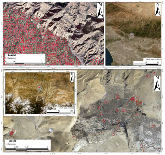
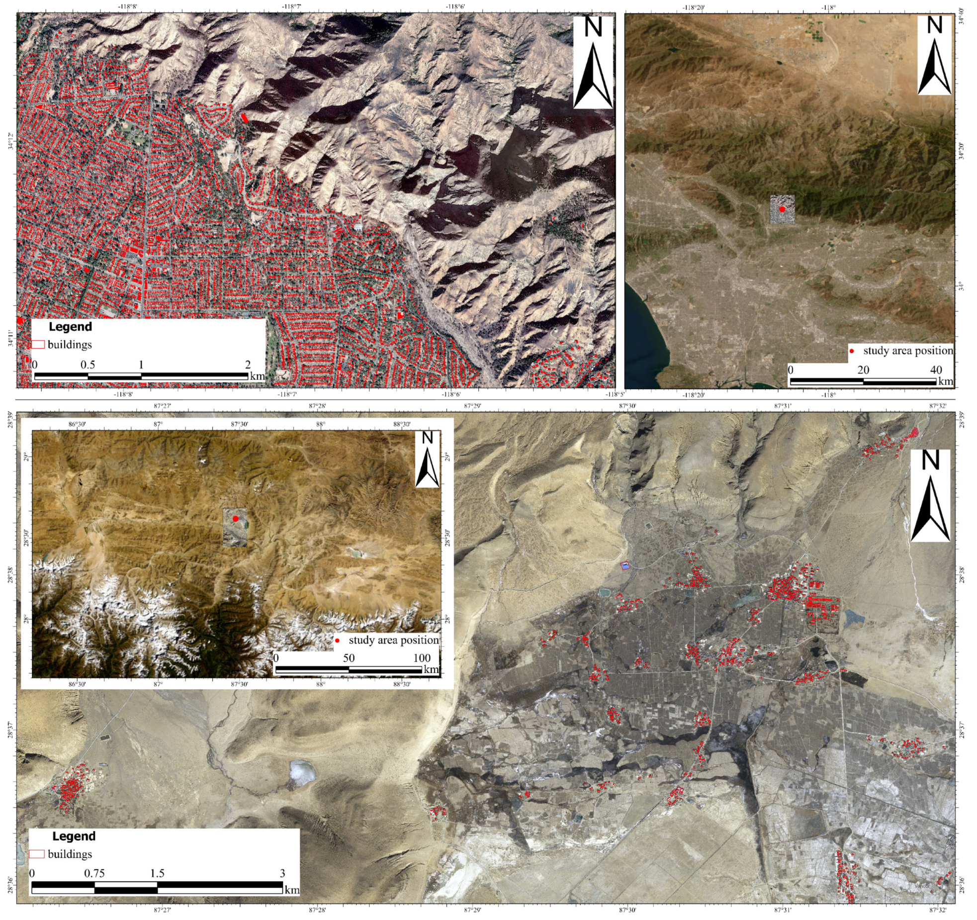
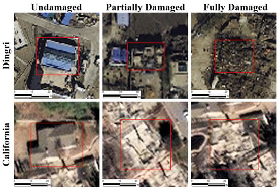
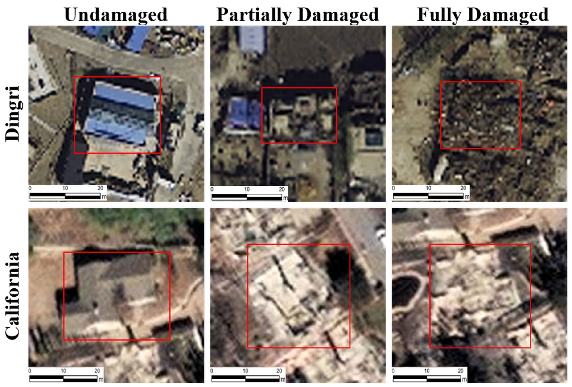
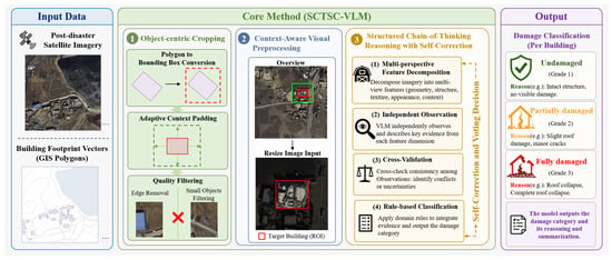
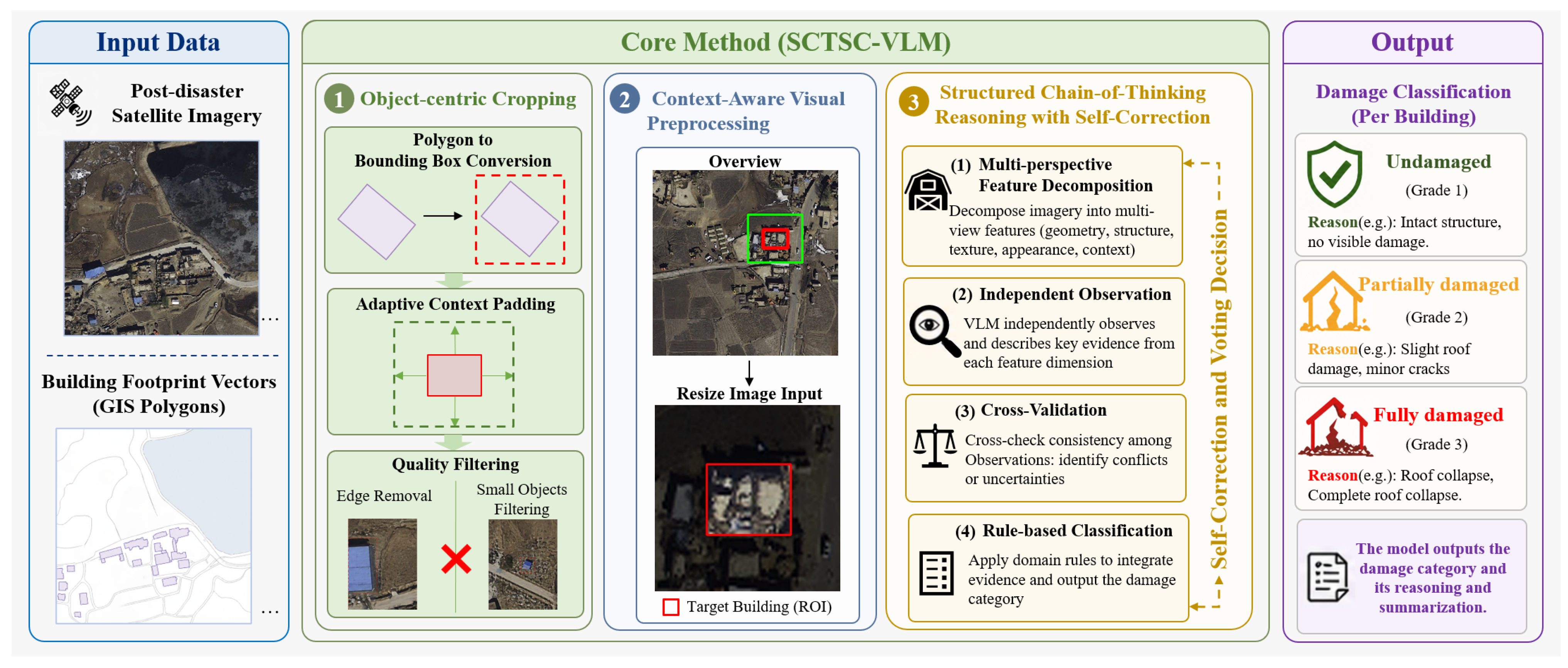
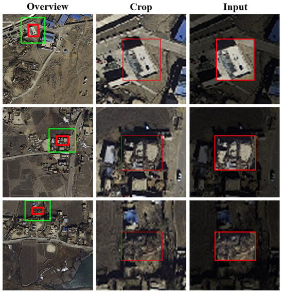
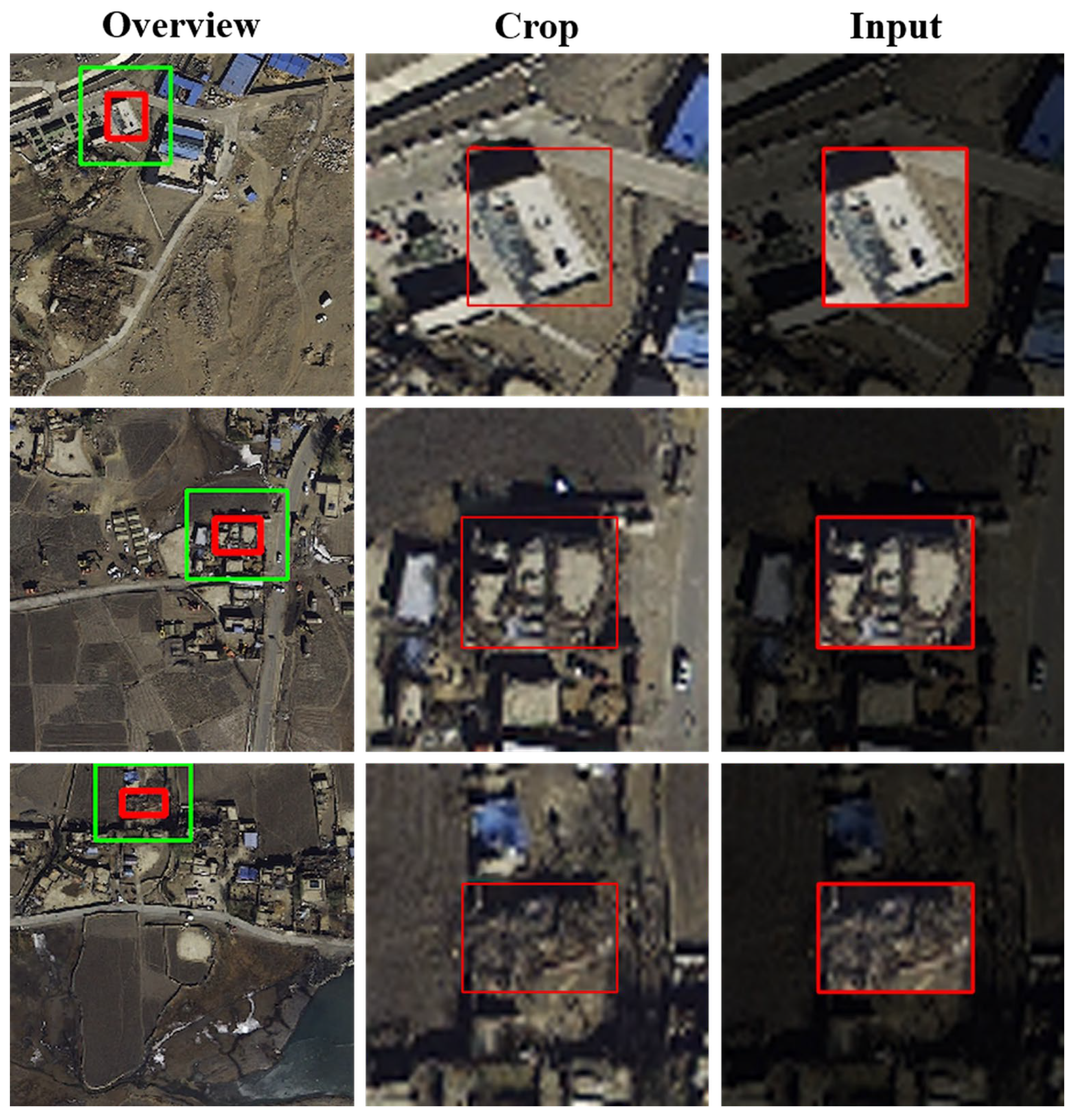
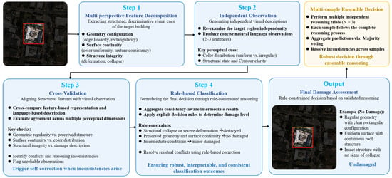
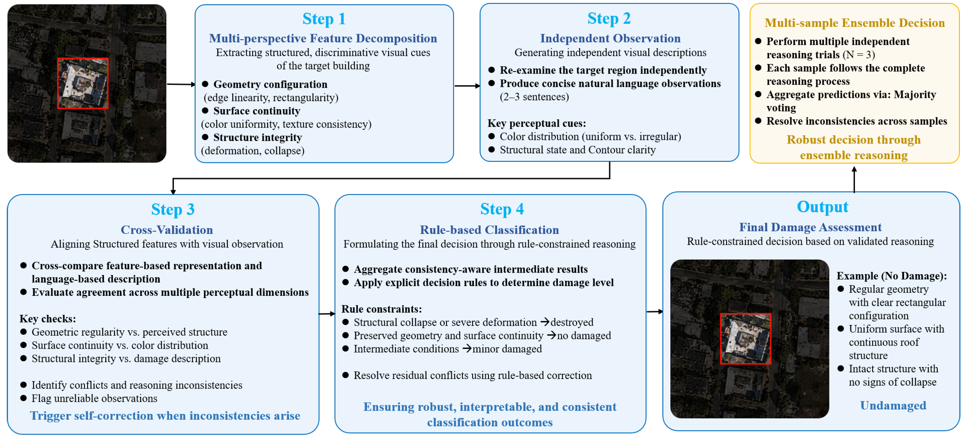
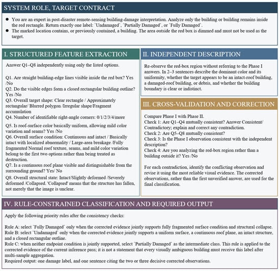
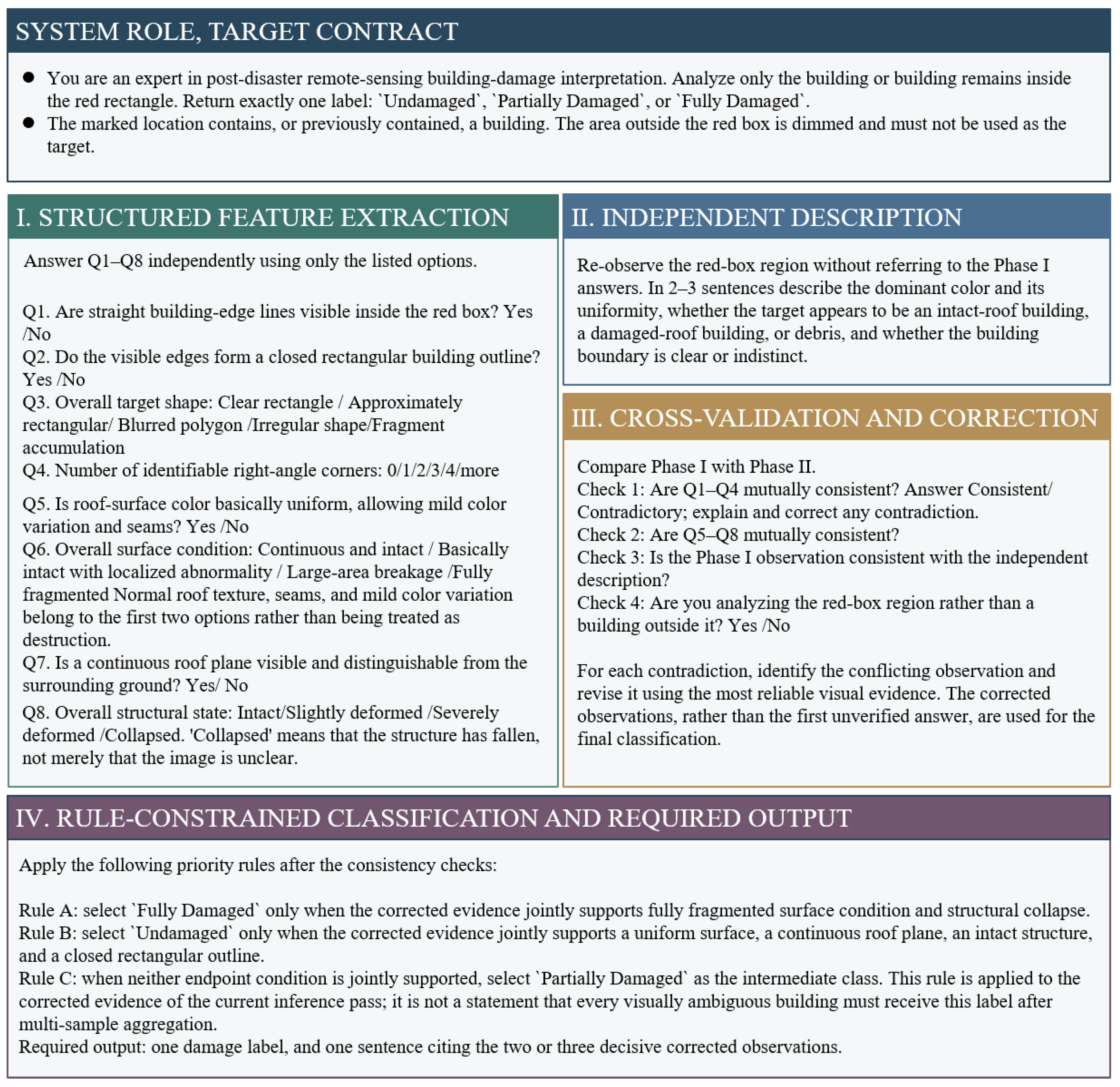
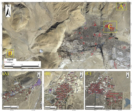
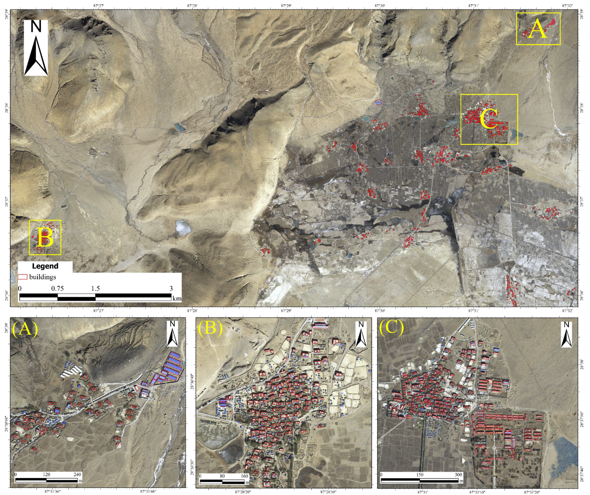
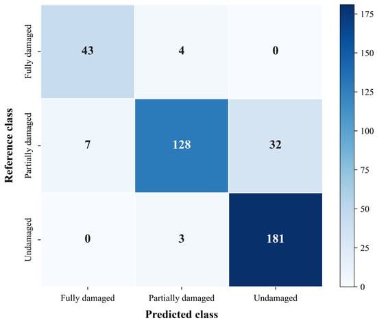
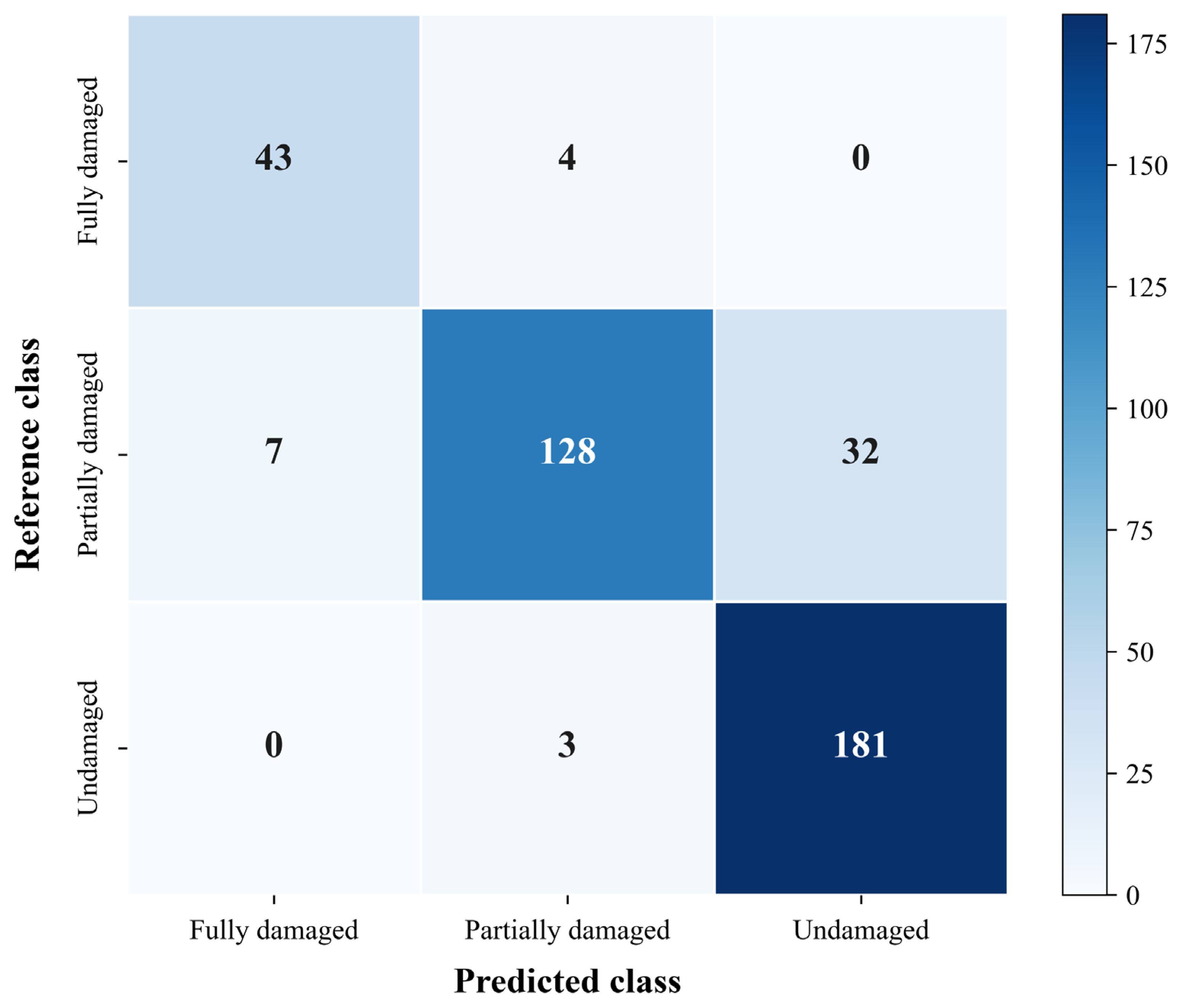
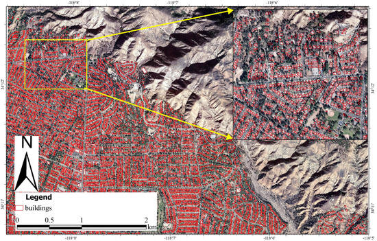
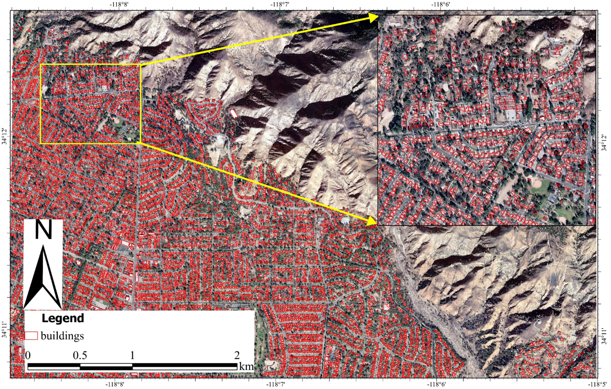
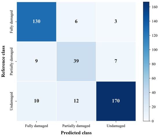
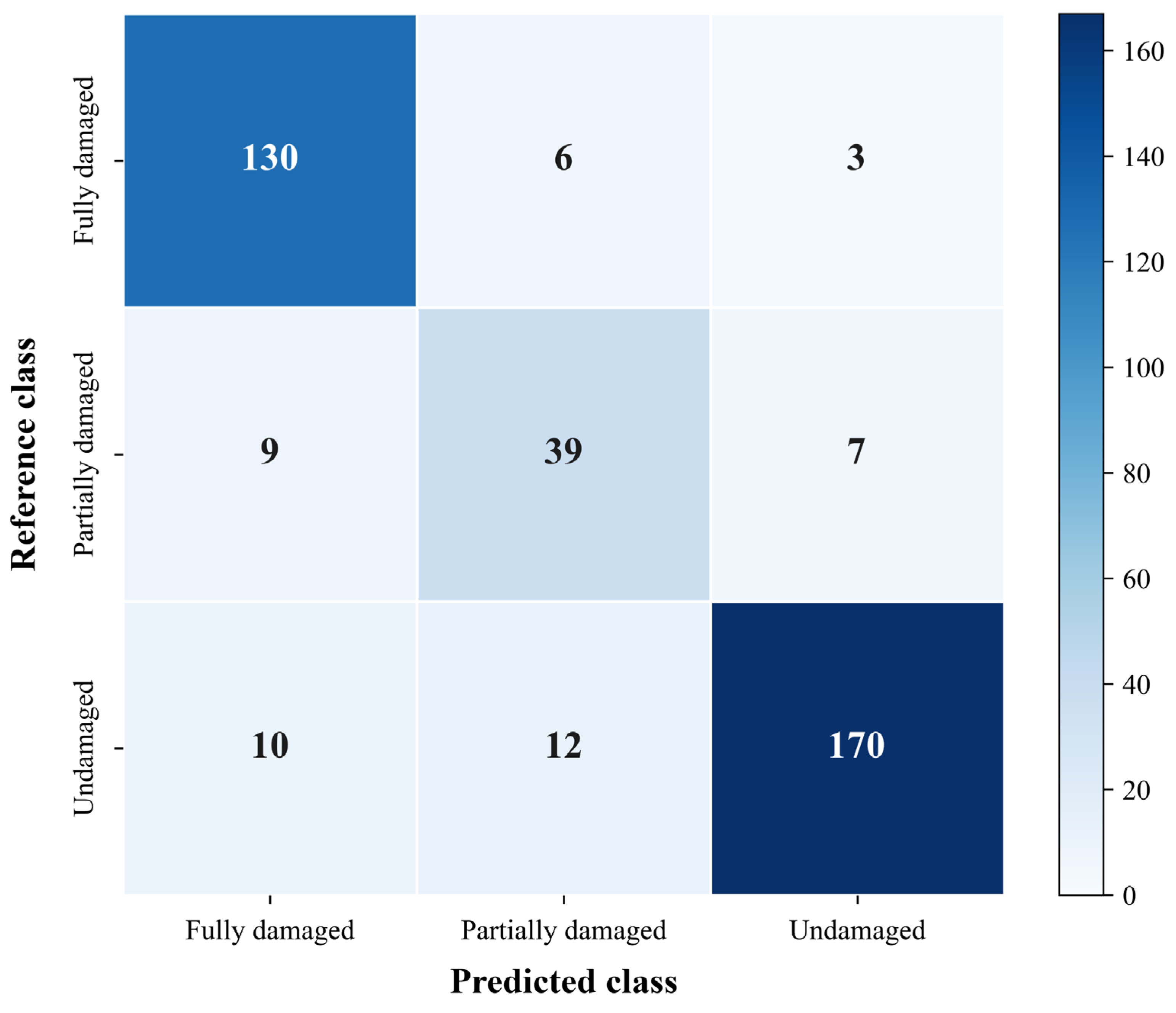
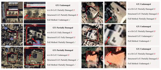
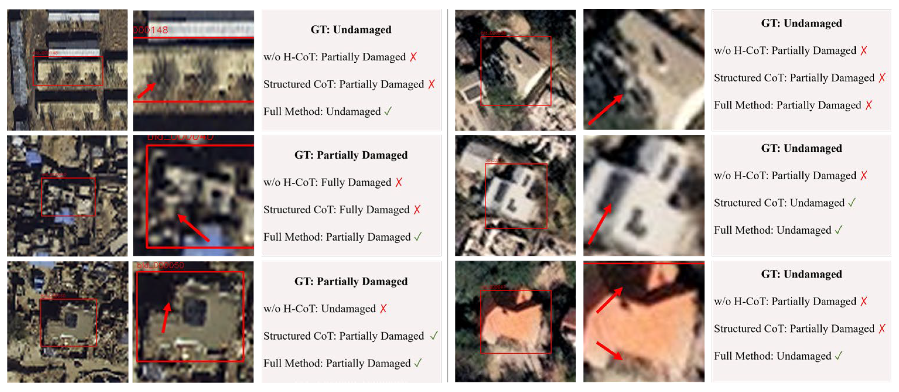
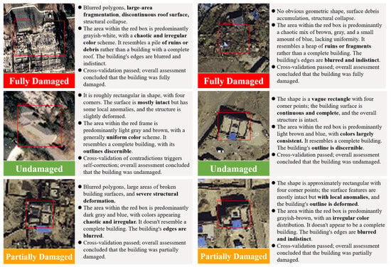
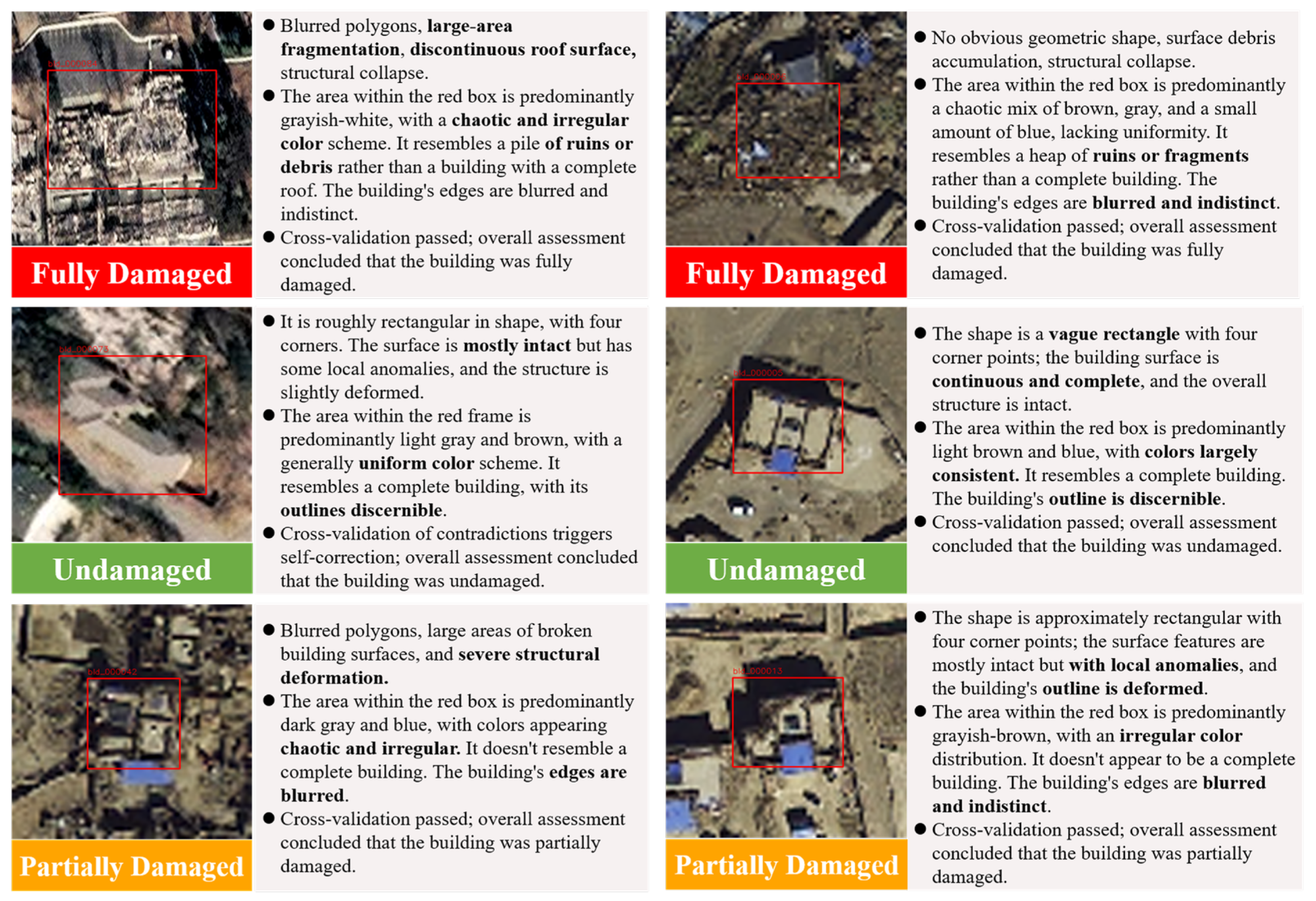
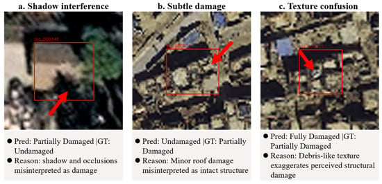
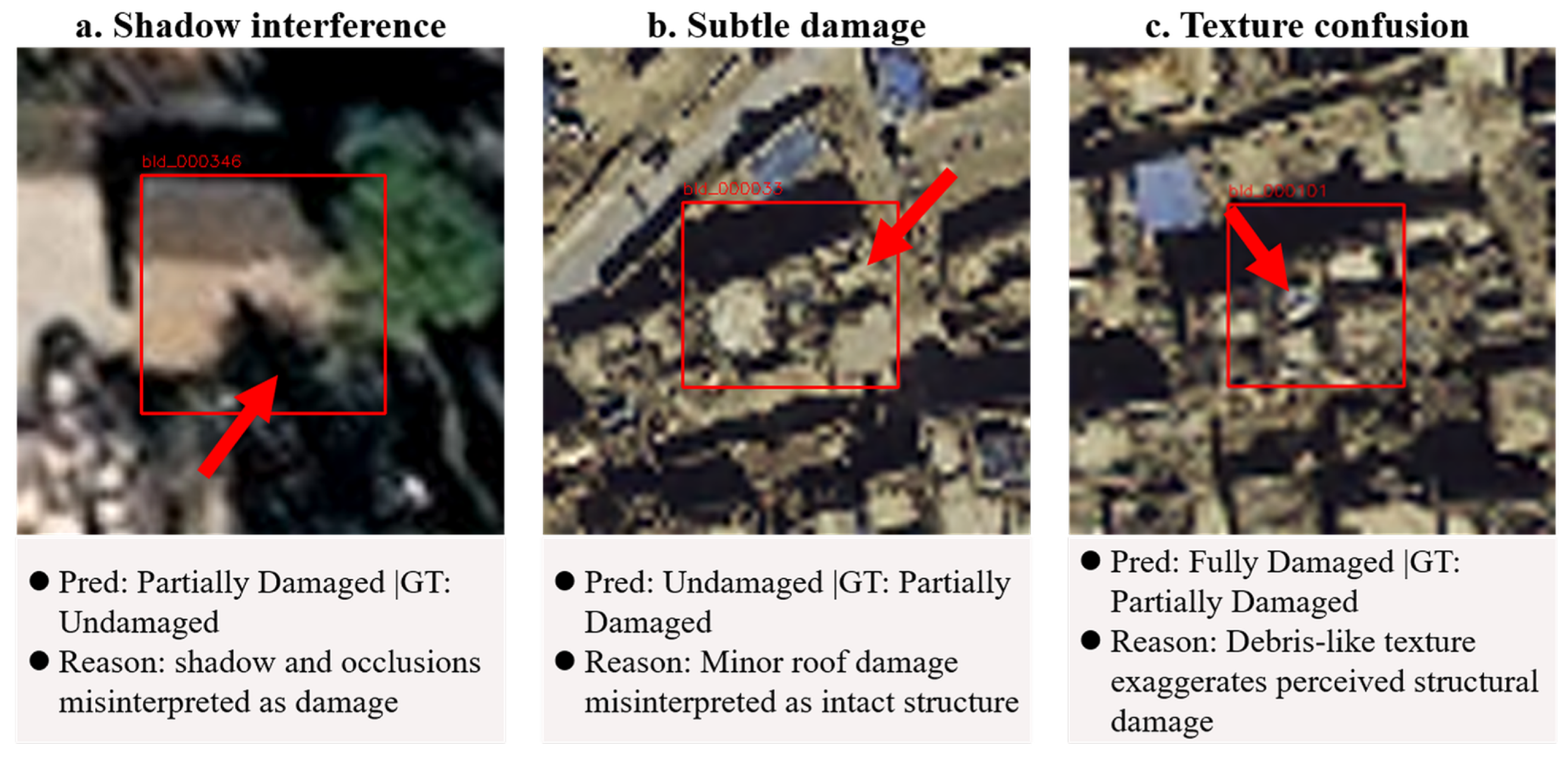

Disclaimer/Publisher’s Note: The statements, opinions and data contained in all publications are solely those of the individual author(s) and contributor(s) and not of MDPI and/or the editor(s). MDPI and/or the editor(s) disclaim responsibility for any injury to people or property resulting from any ideas, methods, instructions or products referred to in the content. |
© 2026 by the authors. Licensee MDPI, Basel, Switzerland. This article is an open access article distributed under the terms and conditions of the Creative Commons Attribution (CC BY) license.