


Highlights
What are the main findings?
- Girth-identity anchors co-register handheld SLAM and UAV-LiDAR without per-tree GNSS, giving each tree a ground-measured diameter and an air-measured height in closed tropical canopy.
- Canopy-only diameter inference fails while SLAM-measured diameter recovers it—“ground for diameter, air for height.”
What are the implications of the main findings?
- Under closed canopy, reliable per-tree carbon for MRV requires ground-measured diameter; UAV/satellite height-based inference truncates the large, carbon-dense stems.
- SLAM–UAV fusion without per-tree GNSS enables scalable individual-tree carbon mapping across the open-to-closed gradient (DDF 22.8 vs. DEF 129.0 Mg C ha−1).
Abstract
Exploiting the complementary views of ground-based and aerial laser scanning requires co-registering their point clouds, which is difficult in closed tropical forest where Global Navigation Satellite System (GNSS) reception fails. We co-registered handheld Simultaneous Localization and Mapping (SLAM) LiDAR and UAV LiDAR without per-tree GNSS, using girth-identity anchors inherited from a companion inventory, over an open dry dipterocarp forest (DDF) and a closed dry evergreen forest (DEF) at the SERS, northeastern Thailand. Coarse-to-fine registration reduced the residual to a mean absolute distance of 0.17–0.18 m, and the clouds sampled complementary strata-stems and understory to about 25–30 m, emergent canopy to about 37 m. The co-registered data give each tree a ground-measured stem diameter and an aerially measured height, which we used to test whether diameter can instead be inferred from the canopy. It cannot: both a height-based and a best-case crown-and-height model saturated near 50 cm while measured stems reached about 100 cm, so UAV-only individual-tree carbon did not track the field reference; supplying the ground-measured diameter restored agreement (R2 = 0.91), validated against reflective-tape anchor trees. The horizontal offset between a stem base and its crown apex further explains why position-only stem-to-crown matching fails and why girth-identity linkage is needed. We conclude that credible individual-tree carbon in closed tropical forest requires ground measurement of stem diameter, made possible by GNSS-independent SLAM-UAV co-registration; the aerial platform contributes height and coverage, not diameter.
1. Introduction
Forests hold the majority of terrestrial carbon, and quantifying the aboveground carbon (AGC) they store is fundamental to climate-change mitigation, sustainable forest management, and the international monitoring, reporting, and verification (MRV) frameworks that underpin REDD+ and the voluntary carbon market [1,2]. Tropical forests are both the largest and the most uncertain component of this stock, and reducing the uncertainty of their carbon estimates—particularly at the fine spatial scales relevant to project-level crediting—has become a priority for the remote-sensing community [3].
Traditional inventories estimate AGC from field measurements of diameter at breast height (DBH) and total height (H) inserted into allometric equations [4]. The field component is laborious, and the destructive harvesting required to build or validate the equations is costly and ecologically undesirable [5]. Light detection and ranging (LiDAR) has transformed this picture by enabling non-destructive, three-dimensional reconstruction of forest structure. Terrestrial laser scanning (TLS) and quantitative structure models recover stem volume and biomass with accuracy approaching destructive sampling, and recent work in Thai teak plantations has shown that locally calibrated, LiDAR-derived allometric models outperform generalized regional equations. However, stationary TLS is occluded in the upper canopy and is slow to deploy across the many plots required for operational monitoring.
Two newer platforms address complementary limitations. Handheld and backpack SLAM LiDAR maps stems and DBH as an operator walks through the forest, covering a hectare in under an hour and resolving the understory that aerial sensors cannot see, but it is occluded toward the treetops and cannot measure total height reliably under a closed canopy [6,7,8]. UAV LiDAR, conversely, characterizes the upper canopy and total height from above but cannot resolve understory stems or DBH in dense stands [9,10,11]. The structural complementarity of ground-based and aerial LiDAR is therefore well recognized, and a number of fusion studies have demonstrated improved completeness of tree reconstruction and modest gains in derived height, volume, and crown metrics when the two are combined [9,12,13].
Despite this progress, two problems specific to closed tropical canopies remain inadequately resolved. The first is geolocation. Per-tree positions are needed to link ground and aerial observations, yet GNSS reception beneath multi-layered evergreen canopies degrades to errors of 5–15 m, far exceeding the mean inter-tree spacing, so direct positional matching of stems to crowns fails [6,14,15,16]. Existing fusion workflows largely sidestep this by relying on real-time-kinematic GNSS or distributed ground-control points, or by registering point clouds through tree-position graph matching or canopy-shape analysis [17,18]. None of these is designed for the situation in which the ground positions themselves are unreliable. The second problem is the treatment of allometric predictors. Because no single platform measures both DBH and H well in a closed canopy, most individual-tree studies infer one from the other—typically DBH from LiDAR height [19], and this inference is the single largest contributor to the uncertainty of the resulting carbon estimate [20,21]. Carbon accounting for MRV demands that this uncertainty be quantified, yet it is frequently left implicit.
These two problems are coupled, and addressing them jointly is the contribution of this study. In a companion paper, we showed that a handheld SLAM inventory can recover stem position and girth in GNSS-denied dry dipterocarp and dry evergreen forest by anchoring a sparse set of reflective-tape trees and matching the remaining stems by girth similarity, without per-tree GNSS [6]. That work deliberately reserved tree height, and therefore biomass and carbon, for the present analysis. Here, we use the same girth-based linkage to bring the SLAM stem inventory—whose DBH is measured directly but whose field positions and heights are unreliable—into registration with UAV-LiDAR, from which we extract measured canopy height. The result is a set of individual trees for which both allometric predictors, DBH and H, derive from independent measurement rather than mutual inference.
We frame the objective as an assessment of where the carbon-relevant information resides across platforms, rather than as a demonstration that fusion improves accuracy, because the latter is already established [9,12]. Specifically, we (i) link the SLAM inventory and UAV LiDAR through girth-based association under GNSS denial; (ii) estimate individual-tree AGC with forest-type-specific Thai allometric equations [22]; (iii) compare two UAV-only diameter-inference baselines (height-based and a best-case crown-and-height model) against the combined measured-diameter configuration; and (iv) quantify how UAV individual-tree detection, and the carbon it represents, degrades from open to closed canopy when checked against the ground SLAM stem map. The assessment spans the structural extremes of a tropical dry-forest gradient-open DDF and closed DEF-at the Sakaerat Environmental Research Station (SERS), where canopy closure rises from 40–60% to over 90%. Against a ground stem map under GNSS-denied closed tropical canopy, we show that inferring stem diameter from the air fails on the large stems and misses the understory, which together dominate the carbon [23,24], a quantification that is rarely available where unreliable field positions preclude direct stem-to-crown matching.
This study is the third in a coordinated series at the SERS and builds directly on two earlier papers [6,25]. The first established the girth-based anchor framework that maps stems and diameters from handheld SLAM without per-tree GNSS [6]. The second mapped wall-to-wall aboveground carbon from multitemporal PlanetScope satellite imagery and UAV-LiDAR using machine learning, inferring stem diameter from canopy height [25]. Here we reuse the girth anchors as input, without re-deriving them, to supply at the individual-tree level the ground-measured diameter and aerially measured height that the earlier mapping did not measure directly, and we use these measured predictors to test how far canopy-based diameter inference can be trusted under closed tropical canopy. The girth-based anchor framework used here, inherited from the companion study [6], relocates GNSS-degraded field stems onto the internally consistent SLAM stem map by matching directly measured girths at reflective-tape anchors, without per-tree GNSS; registration methods that do not rely on individual-tree detection form a complementary line of work [26].
2. Materials and Methods
2.1. Study Area
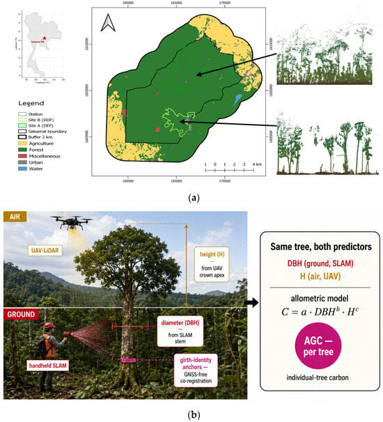
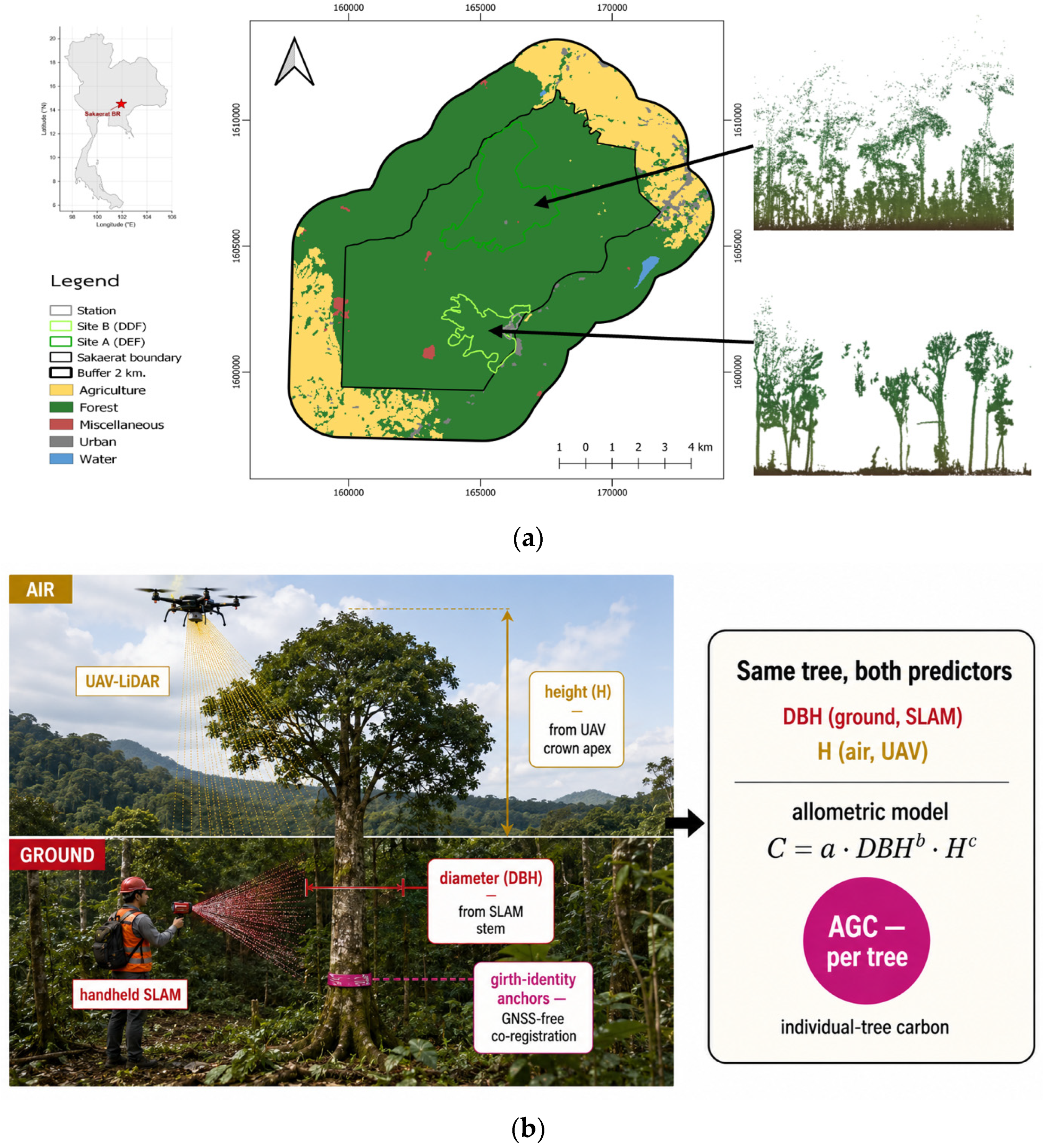
The study was conducted at the SERS, a UNESCO Biosphere Reserve on the western edge of the Khorat Plateau in Nakhon Ratchasima Province, northeastern Thailand. The reserve has supported long-term ecological monitoring since 1967, including an eddy-covariance flux tower in the dry evergreen forest. Mean annual rainfall is approximately 1200 mm, concentrated in a May–October wet season under the Southeast Asian monsoon, and mean annual temperature is approximately 26 °C. Two permanent 1-ha (100 m × 100 m) plots were selected to span the structural range of the reserve (Figure 1).
Figure 1.
Study area (a) and concept of the approach (b). SERS, NE Thailand (inset), with Site A (closed DEF) and Site B (open DDF) over land cover; arrows link each site to its LiDAR cross-section (DEF top, DDF bottom). SLAM (ground) gives stem diameter (DBH), UAV-LiDAR (air) gives height (H); girth-identity anchors co-register both clouds without per-tree GNSS, and AGC follows from a forest-type allometric model.
The dry dipterocarp forest (DDF) plot is a fire-maintained open woodland (canopy cover 40–60%, canopy height 15–25 m, stem density approximately 280 trees ha−1) dominated by Shorea obtusa and Shorea siamensis [27]. The dry evergreen forest (DEF) plot is a species-rich, multi-layered closed stand (canopy cover > 90%, emergent canopy 35–45 m, stem density approximately 1054 trees ha−1) dominated by Hopea ferrea and Dipterocarpus alatus, where GNSS reception is systematically degraded—conditions that motivate the present approach (Table 1). The two types were chosen because they bracket the open-to-closed canopy continuum of Southeast Asian seasonal forests, providing a stringent test of GNSS-denied co-registration under contrasting canopy densities.
Table 1.
Characteristics of the two permanent plots at the SERS. Values follow the companion SLAM inventory.
2.2. Data Acquisition
Three datasets were assembled for each plot: a field subplot inventory providing ground-measured DBH, a handheld SLAM point cloud providing the stem map, and a UAV LiDAR point cloud providing canopy height. Field and SLAM data were collected concurrently in the leaf-bearing condition during 17–18 April 2026; UAV LiDAR was acquired over the same plots.
2.2.1. Field Subplot Inventory
Within each plot, all stems with girth ≥15 cm at breast height (1.3 m) were measured with a diameter tape, identified to species by a certified botanist, and assigned a serial number; a balanced subplot of trees spanning the full diameter range was retained for the present analysis. DBH in this subplot was measured directly and was treated as accurate. By contrast, tree height in the subplot was estimated only approximately, and the per-tree positions were recorded with a handheld GNSS whose error under canopy is large; both the height and the position are therefore regarded as unreliable inputs to be corrected (Section 2.3 and Section 2.4). For buttressed stems, girth was taken at the lowest sound point above the buttress.
2.2.2. Handheld SLAM LiDAR
Stem geometry was acquired with a LiGrip H120 handheld SLAM scanner (Green Valley International, Beijing, China), which records up to 320,000 points s−1 at a maximum range of 120 m with a stated single-point accuracy of +/−1 cm over a 280° × 360° field of view, and weighs 1.83 kg. Data were collected in post-processed-kinematic (PPK) SLAM mode with corrections from a nearby base station, yielding absolute accuracy ≤ 5 cm and relative accuracy ≤ 1 cm; the SLAM trajectory loop-closure residuals were 3.2 cm (DDF) and 4.7 cm (DEF). Each hectare was walked in a meandering pattern in approximately 40 min and exported as LAS in UTM Zone 47N (WGS 84). Stem positions and girth were extracted following the four-step pipeline of the companion paper (ground filtering, breast-height slicing, density-based clustering [28], and robust circle fitting [29].
2.2.3. UAV LiDAR
Canopy data were acquired with a DJI Matrice 300 RTK quadcopter carrying a CHCNAV AlphaAir 450 system integrating a Livox Avia non-repetitive scanner (up to 720,000 points s−1 in triple-return mode). Flights were conducted at 60–80 m aboveground level with 30–50% side lap. A digital terrain model (DTM) and a digital surface model (DSM) were produced by ground filtering, and a canopy height model (CHM) was derived as DSM-DTM. Pulse penetration to the ground was quantified per plot to document the inability of the UAV sensor to resolve understory stems under the DEF canopy.
2.3. Girth-Based Positional Adjustment
Because the field subplot positions are GNSS-degraded, each field stem was relocated to its true position by anchoring it to the SLAM stem map, which is internally consistent to the centimeter level. Following the companion framework [6], a sparse set of reflective-tape anchor trees with approximate GNSS locations was used first to remove the systematic GNSS-SLAM offset (median bias correction), after which the remaining field stems were assigned to SLAM stems by quadrant-partitioned optimal assignment (the Hungarian algorithm [30]) using a girth-based cost subject to a spatial admissibility gate (Equation (1)), where gi and gj are the girths of field stem i and SLAM stem j, q(i) and q(j) denote the plot quadrants in which they fall, and τ_g is the girth tolerance; the assignment cost is their absolute girth difference, |gi – gj|, and a pair is admissible only when both stems lie in the same plot quadrant and their girth difference is within τ_g, so that the spatial information acts as a gate rather than as a weighted term. The girth term exploits the directly measured DBH to disambiguate neighboring stems where position alone is insufficient. The output is a field inventory whose DBH is measured and whose position is corrected to the SLAM frame, ready for linkage to the UAV canopy.
2.4. Point-Cloud Co-Registration and Crown Delineation
The handheld SLAM and UAV-LiDAR point clouds were co-registered with a three-stage coarse-to-fine scheme that decouples vertical from horizontal alignment, so that the natural stratification between understory and canopy is preserved rather than minimized away [31,32,33]. The scheme adapts a biological-structure registration framework to closed forest, with the girth-identity anchors substituted for the trunk-to-canopy grid search at the coarse horizontal step (see Stage 3).
Stage 1—ground-constrained vertical alignment. Ground points were extracted from both clouds with a cloth-simulation filter [13] implemented here as a 0.5 m grid-minimum surface relaxed under a smoothness-and-collision constraint. The SLAM ground was then aligned to the UAV ground by a constrained iterative closest point (ICP) step [34] that minimizes the point-to-plane residual while restricting the transform to a vertical translation and the two tilt angles (, ), with azimuthal rotation about the Z-axis excluded (Equation (2)). Here is a SLAM ground point, its nearest UAV ground point, is the surface normal at , and is the tilt rotation built from rotations about the X and Y axes only (Equation (3)). Excluding the azimuthal term keeps the overstory and understory layers from collapsing into one another and leaves the horizontal offset to Stage 3. Vertical accuracy is reported as the ground-surface RMSE (Equation (4)).
Stage 2—registration features. The features were the SLAM stem positions (Section 2.3) and the UAV canopy maxima, the latter taken as local maxima of a 0.5 m, Gaussian-smoothed (sigma = 1 m) canopy height model (CHM) above a 5 m threshold. Individual crowns were then delineated from the co-registered UAV CHM by marker-controlled watershed segmentation [35] with these maxima as markers; for each crown, the apex height above the DTM was taken as the tree total height H and assigned to the underlying SLAM stem through the stem-to-crown association (Section 2.5). The registration is a global-initialization-then-local-refinement scheme: the girth-anchor step supplies a global coarse alignment, after which the RANSAC/ICP fine step converges locally within a crown radius.
Stage 3—horizontal registration. Horizontal alignment was fixed as a 2D rigid transform that maps each SLAM stem position to its UAV crown apex by a planar rotation theta and translation (Equation (5), with the rotation matrix of Equation (6)). The forestry framework drives this step by an automated trunk-to-canopy grid search that selects the translation maximizing the count of stem–crown pairs falling within a match radius (Equation (7)); but that search is poorly constrained under a closed canopy where crowns are dense (about 0.24 per square meter in the DEF) and a stem displaced by several meters still finds a crown within the match radius. According to our data, it locked onto a spurious 4.6 m peak in the closed DEF while recovering the correct near-zero shift in the open DDF. We therefore seed the coarse horizontal step with the girth-identity anchors of the companion inventory detailed in Kaewjampa et al. (2026) [6]—labeled correspondences that remain reliable under GNSS denial—and refine it with 2D RANSAC on the stem-to-crown correspondences (match radius 2.0 m, inlier threshold 0.8 m, 3000 iterations; Equation (8)), reporting the inlier RMSE (Equation (9)), the inlier ratio (Equation (10)), and the residual rotation. The complete registered SLAM cloud is obtained by composing the vertical and horizontal transforms (Equation (11)). The fine point-cloud overlap was additionally verified by ICP on the overlapping ground and lower-canopy returns (0.3–20 m), quantified as the mean absolute distance (MAD) and RMSE of nearest-neighbor correspondences at convergence. Whereas existing methods drive the coarse step with Fast Point Feature Histograms [36,37], canopy-shape projection [18,38], the Normal Distributions Transform [39], or untagged tree-position graph matching [40], the girth-identity anchors used here provide labeled correspondences that survive the GNSS denial of a closed tropical canopy.
2.5. Stem-to-Crown Matching
Positionally adjusted stems (Section 2.3) were linked to UAV crowns (Section 2.4) by a second quadrant-partitioned optimal assignment, with a cost based on horizontal distance between the stem location and the crown apex projection, subject to a plausibility constraint that a taller crown must correspond to a larger stem. The assignment was forced one-to-one and deduplicated. The procedure partitions the stems into a matched set, for which both measured DBH and measured H are available, and two residual sets: understory stems with no corresponding UAV crown, and canopy crowns with no SLAM stem. The match rate is reported by forest type and is treated as an empirical result rather than an assumption, because crown overlap in the closed DEF is expected to limit it.
2.6. Height Assignment for Unmatched Understory Stems
For SLAM understory stems that could not be matched to a UAV crown, height was imputed from a site-specific DBH-H relationship fitted to the matched trees using a Michaelis–Menten model (Equation (12)), where Hmax is the asymptotic height and k the half-saturation diameter. Keeping the curve endogenous to the site avoids the bias introduced by transferring a foreign regional height model, and the proportion of trees whose height is imputed rather than measured is reported and propagated into the uncertainty budget (Section 2.8). The Michaelis–Menten curve H = a·DBH/(b + DBH) was fitted to the matched canopy owners by nonlinear least squares; the imputation residual (RMSE) was 4.0 m in the DEF and 2.9 m in the DDF, and keeping the curve endogenous to each site avoids transferring a foreign height model.
2.7. Aboveground Carbon Estimation
Individual-tree AGC was computed with the forest-type-specific standing-tree carbon equations of Duangsathaporn et al. (2023) [22], which were developed for northern Thai dry forests by combustion-based carbon-fraction analysis and which output carbon directly (the carbon fraction is embedded in the coefficients; C is in kg C per tree, DBH in cm, H in m). Each equation has the general power-law form of Equation (13), with the forest-type coefficients a, b, c listed in Table 2:
Table 2.
Standing-tree aboveground carbon equations applied in this study. The DEF equation is valid to 147 cm DBH, covering the full range of the DEF subplot; DDF stems exceeding 66.8 cm DBH were assigned the general NDF equation to avoid extrapolation.
Where biomass is required, it was recovered from carbon with the combustion-measured carbon fractions of the same study (Equation (14); CF = 0.4717 for DEF, 0.4750 for DDF). Carbon dioxide equivalent was obtained from the molar mass ratio (Equation (15)), and stand-level AGC (Mg C ha−1) by summing per-tree carbon over the plot area (Equation (16)).
2.8. Uncertainty Decomposition
The per-tree carbon uncertainty is specified, following the biomass literature [19,20,21], as four additive variance contributions (Equation (17)): measurement error in DBH, measurement error in H (or imputation error for unmatched stems), allometric parameter error, and allometric residual error. Distributions for the DBH and H errors follow the per-platform validation (Section 2.9), and the allometric parameter and residual errors follow the standard errors reported by Duangsathaporn et al. (2023) [22]. Because carbon scales as DBH2.14 against H0.68, the diameter term is expected to dominate analytically; the input configurations (Section 2.9) are therefore compared to test whether supplying measured rather than inferred predictors reduces this dominant term, with the full numeric Monte Carlo propagation of all four components identified as the remaining quantitative step (Section 4.4).
2.9. Experimental Design and Validation
Individual-tree AGC was compared among three estimation methods on the canopy owner trees: (i) UAV-only with diameter inferred from canopy height by a power law (DBH = a*Hb), the existing single-platform approach; (ii) UAV-only with diameter from a crown-diameter-and-height model fitted in-sample to the field diameters, which gives canopy inference its best possible case; and (iii) the combined configuration using ground-measured diameter (SLAM) with UAV-measured height. Inferred and measured diameters were each evaluated against the field diameters, and the resulting carbon against the field allometric reference. SLAM DBH had been validated against tape measurements. UAV height has no independent field reference here (Section 3.2). Because no destructive harvest was available at the site, the comparison is reported as cross-method consistency, not validation against felled trees, and is stratified by forest type across the open-to-closed gradient. A non-allometric QSM cross-check is identified as future work (Section 4.4).
2.10. Wall-to-Wall Individual-Tree Carbon Mapping
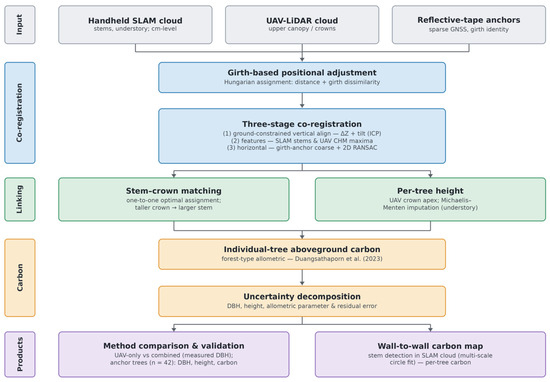
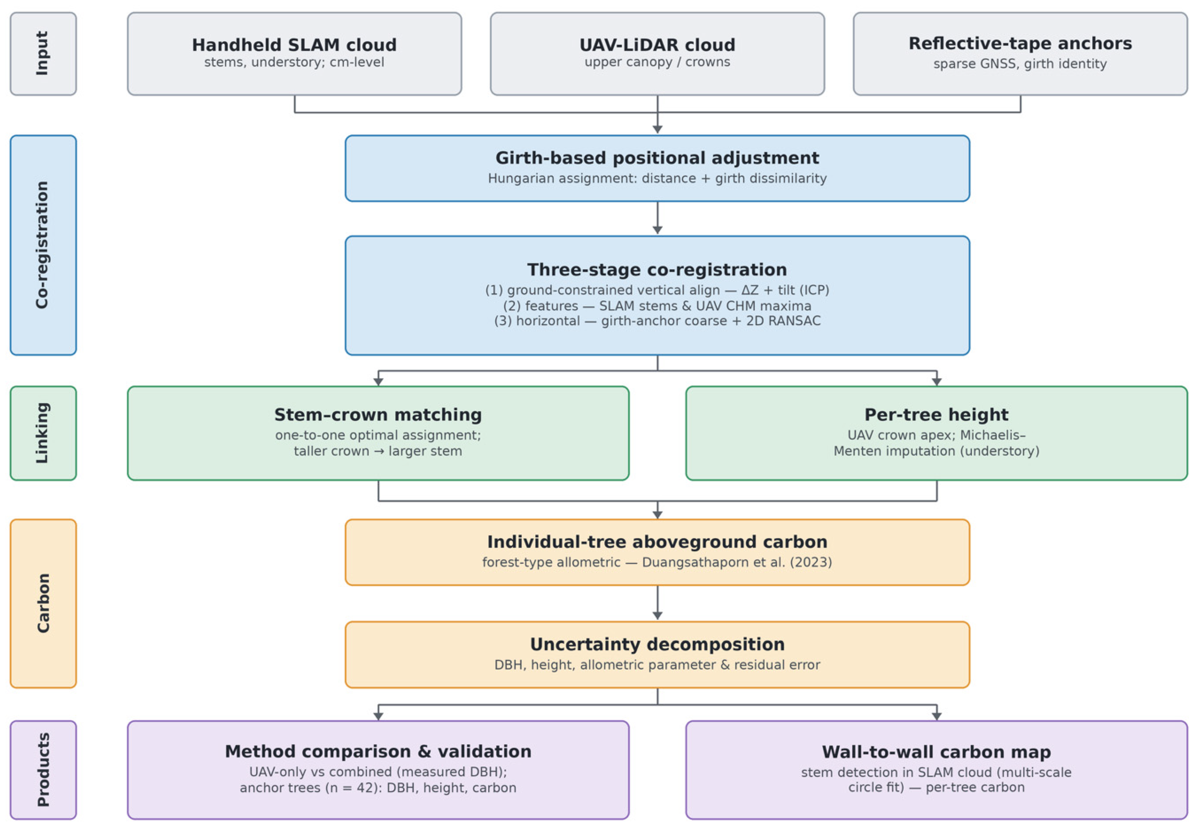
To show the spatial distribution of carbon that the co-registration makes possible, we mapped carbon for every stem in each hectare directly from the point clouds, independently of the field inventory. Stems were detected in the co-registered handheld SLAM cloud by extracting a 0.2 m slice at breast height (1.2–1.4 m above a 1 m cloth-simulation ground surface), clustering the slice with DBSCAN, and fitting each cluster with an algebraic circle at several neighborhood scales so that both small understory stems and large buttressed trunks were recovered; a cluster was accepted only when its radial residual and angular coverage indicated a genuine stem ring, and diameter was taken as twice the fitted radius [28,29]. Each stem was assigned a height from the LiDAR-the apex of the local UAV CHM where the stem reached the canopy, otherwise the top of its own SLAM returns for occluded understory stems-and per-tree carbon followed the same forest-type equations used throughout. The resulting wall-to-wall stem map reproduced the field-based stand carbon of Section 3.5 to within about 15% (DEF) and 6% (DDF). It is offered as a spatial demonstration of the co-registered product rather than as a replacement for the field-validated estimate, because the cloud-derived diameters are not individually validated against tape measurement. The complete processing workflow is summarized in Figure 2.
Figure 2.
Overall processing workflow. Co-registered handheld SLAM and UAV-LiDAR clouds, anchored by girth identity, are linked into individual trees that each carry a ground-measured diameter and a LiDAR-measured height; per-tree carbon then feeds two products: the method comparison and anchor validation and the wall-to-wall stem-level carbon map [22].
3. Results
3.1. Point-Cloud Co-Registration and Stem-to-Crown Association
The two clouds shared the same UTM Zone 47N georeferencing, so the coarse horizontal offset between the SLAM stem map and the UAV crown map was already small: 0.26 m in the DEF and 0.22 m in the DDF. Stage 1 aligned the ground surfaces to a vertical RMSE (RMSEground) of 0.119 m in the DEF and 0.224 m in the DDF, correcting a vertical translation of −0.14 m (DEF) and −0.05 m (DDF) and a platform tilt below 0.4 °C, while explicitly leaving the horizontal offset to Stage 3. Stage 3 refined the horizontal alignment by RANSAC on the stem-to-crown correspondences to an inlier RMSE (RMSEfinal) of 0.57 m (DEF) and 0.61 m (DDF), with residual rotation below 0.4 °C and an inlier ratio of 32% (DEF) and 36% (DDF); this sub-meter feature residual is governed by the biological stem-to-crown offset (a crown apex does not sit exactly above the stem base) rather than by misregistration. The fine point-cloud overlap, checked by ICP on the overlapping ground and lower-canopy returns, converged at a MAD of 0.175 m (DEF) and 0.167 m (DDF) (RMSE 0.211 and 0.200 m) (Table 3).
Table 3.
Three-stage co-registration performance at Sakaerat. Stage 1 establishes vertical alignment (ground-to-ground RMSE); Stage 3 refines horizontal alignment by RANSAC on stem-to-crown correspondences; the cloud-overlap MAD verifies the fine point-cloud fit.
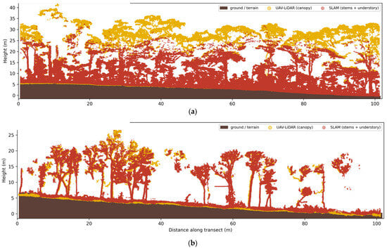
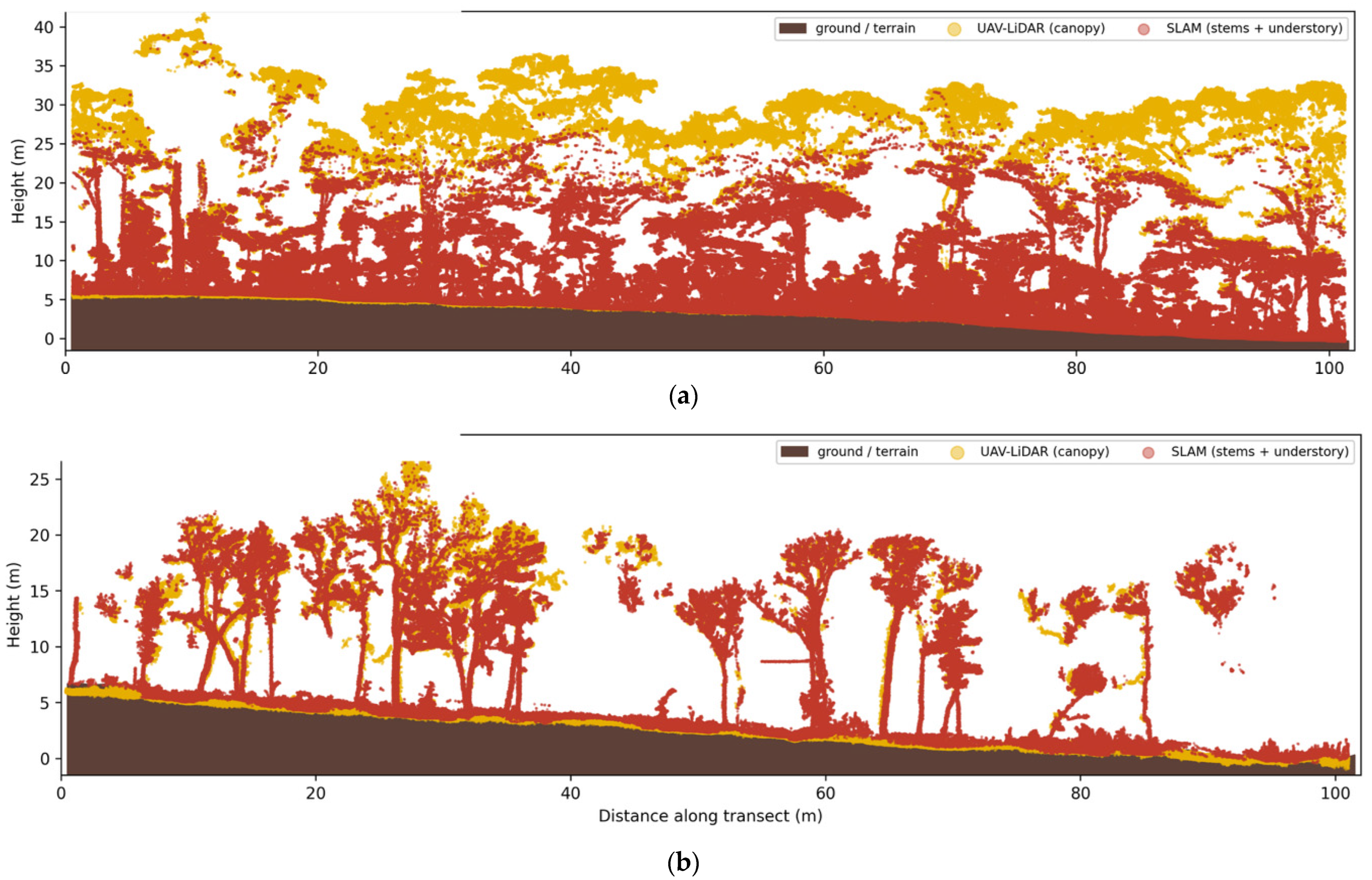
The horizontal step also gives a controlled test of why the coarse alignment must be anchored on girth identity rather than on canopy geometry. Applied unmodified, the automated trunk-to-canopy grid search recovered the correct near-zero shift in the open DDF but locked onto a spurious 4.6 m peak in the closed DEF, where the crown density (about 0.24 per m2) lets a stem match some crown at almost any displacement. Position-only stem-to-crown matching is therefore unreliable in exactly the closed-canopy setting this study targets, and the labeled girth-identity anchors are what keep the coarse step robust. The co-registered clouds are complementary in the vertical: handheld SLAM resolves stems and understory to about 25–30 m, whereas UAV-LiDAR captures the emergent canopy to about 37 m that SLAM cannot see from below (Figure 3).
Figure 3.
Co-registered SLAM and UAV-LiDAR cross-sections (2 m transects) for the closed DEF (a) and open DDF (b). Handheld SLAM (red) resolves stems and understory to about 25–30 m; UAV-LiDAR (yellow) captures the upper canopy and emergent crowns to about 37 m. The two platforms sample complementary strata of the same trees after co-registration.
The cloud-overlap residual is larger than the centimeter-level values reported for feature-based registration in temperate stands (Table 4) because our fine step operates on raw, heterogeneous, occlusion-affected canopy returns under GNSS denial rather than on extracted trunk or terrain features; it nonetheless remains well within a crown radius and is sufficient for stem-to-crown association.
Table 4.
Co-registration residual of this study compared with published multi-platform forest registration methods. Our residual is higher because it is computed on raw canopy returns under GNSS denial rather than on extracted trunk/terrain features, and across a closed tropical canopy rather than temperate plantations. This comparison is indicative rather than a controlled benchmark, because the cited studies use different sensors, sites and canopy conditions; a like-for-like evaluation on a shared dataset is left to future work.
Crown-radius association linked 66.4% of SLAM stems to a UAV crown in the closed DEF (511 of 769) and 64.8% in the open DDF (173 of 267). Of these, 56 (DEF) and 57 (DDF) were canopy owners—the dominant stem beneath a crown that legitimately carries the UAV-measured apex height; the remaining 455 (DEF) and 116 (DDF) were understory stems sharing a crown, for which height was imputed (Section 2.6). The large understory fraction in the DEF directly quantifies what aerial sensors cannot resolve under closed canopy: roughly eight understory stems per canopy owner (Table 5). The counts used differ by purpose—769/267 stems detected at breast height (DEF/DDF), 511/173 stem–crown links, 56/57 canopy owners, and 42 anchor trees. Linkage is robust to the girth tolerance τ_g: tightening it from 30% to 10% leaves the DDF linkage essentially unchanged (>96% of matches within 10%) but reduces the DEF linkage from 511 to 294 stems and the retained carbon by about 18%, reflecting the greater matching difficulty under closed canopy.
Table 5.
Stem-to-crown association by forest type. Canopy owners carry UAV-measured height; understory stems receive imputed height.
3.2. Diameter from the Canopy: Two Inference Baselines
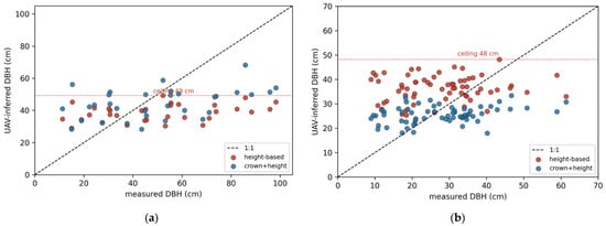
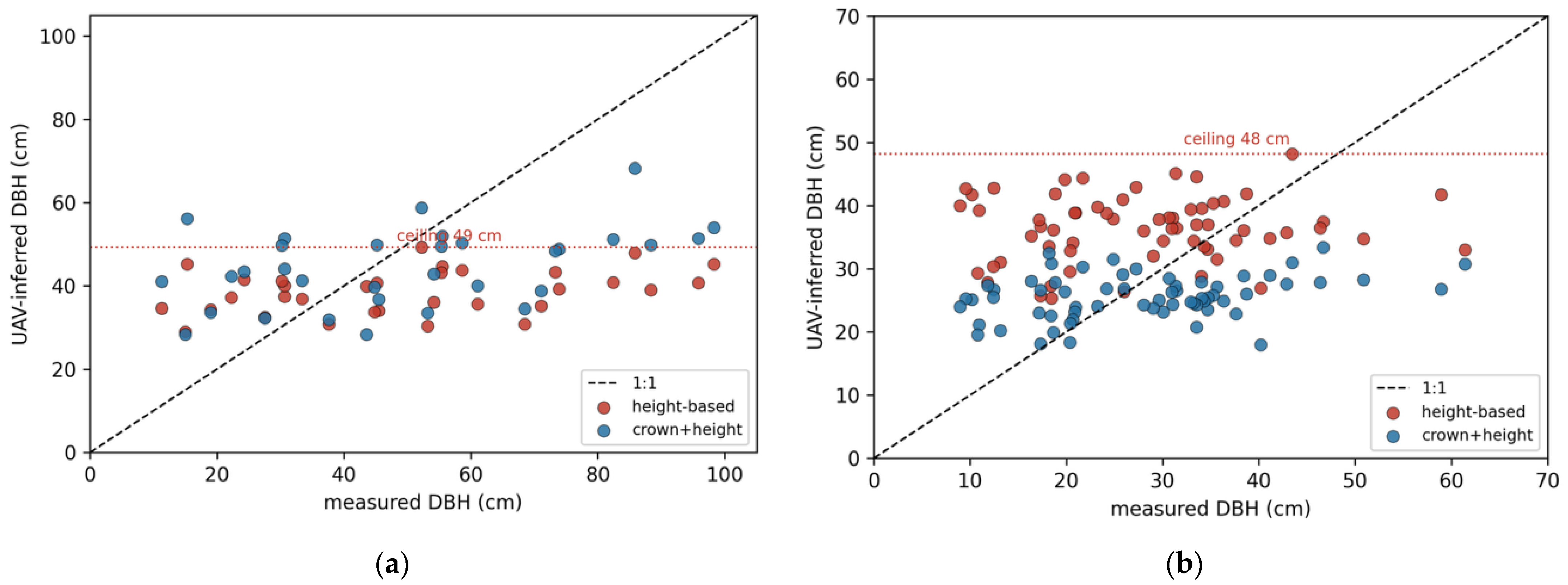
Restricting the comparison to canopy owner trees-the stems, a UAV can legitimately detect (DEF n = 56; DDF n = 57)—we tested two ways of inferring diameter from above: a height-only power law (the existing pipeline, DBH = a*Hb) and a crown-based model fitted in-sample to the field diameters (log DBH on log crown diameter and log height), which gives canopy inference its best possible case. Both failed. Height-only inferred diameter saturated at 49.0 cm in the DEF (48.1 cm in the DDF), whereas the measured stems reached 98.3 cm (61.4 cm in the DDF) (Figure 4); on the reflective-tape anchors, the UAV-inferred diameter was essentially uncorrelated with the field value (R2 = 0.04, Section 3.3). Because the largest stems are systematically truncated at the inference ceiling—precisely the stems that hold most of the carbon—the failure is a structural limit of canopy-only inference, not an artifact of a weak model. Biologically, crown geometry decouples from stem diameter in closed canopy because crown expansion is light-limited and saturates once neighbors interlock, so the largest, carbon-dense stems share indistinguishable crowns and are truncated at the inference ceiling.
Figure 4.
UAV-inferred versus field-measured diameter for canopy trees. Both inference baselines—height-based (red) and crown + height best-case (blue)—saturate at an inference ceiling about 49 cm in the DEF (a), 48 cm in the DDF (b), and fall below the 1:1 line for large stems, underestimating the diameters that hold most of the carbon.
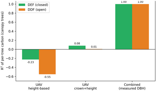
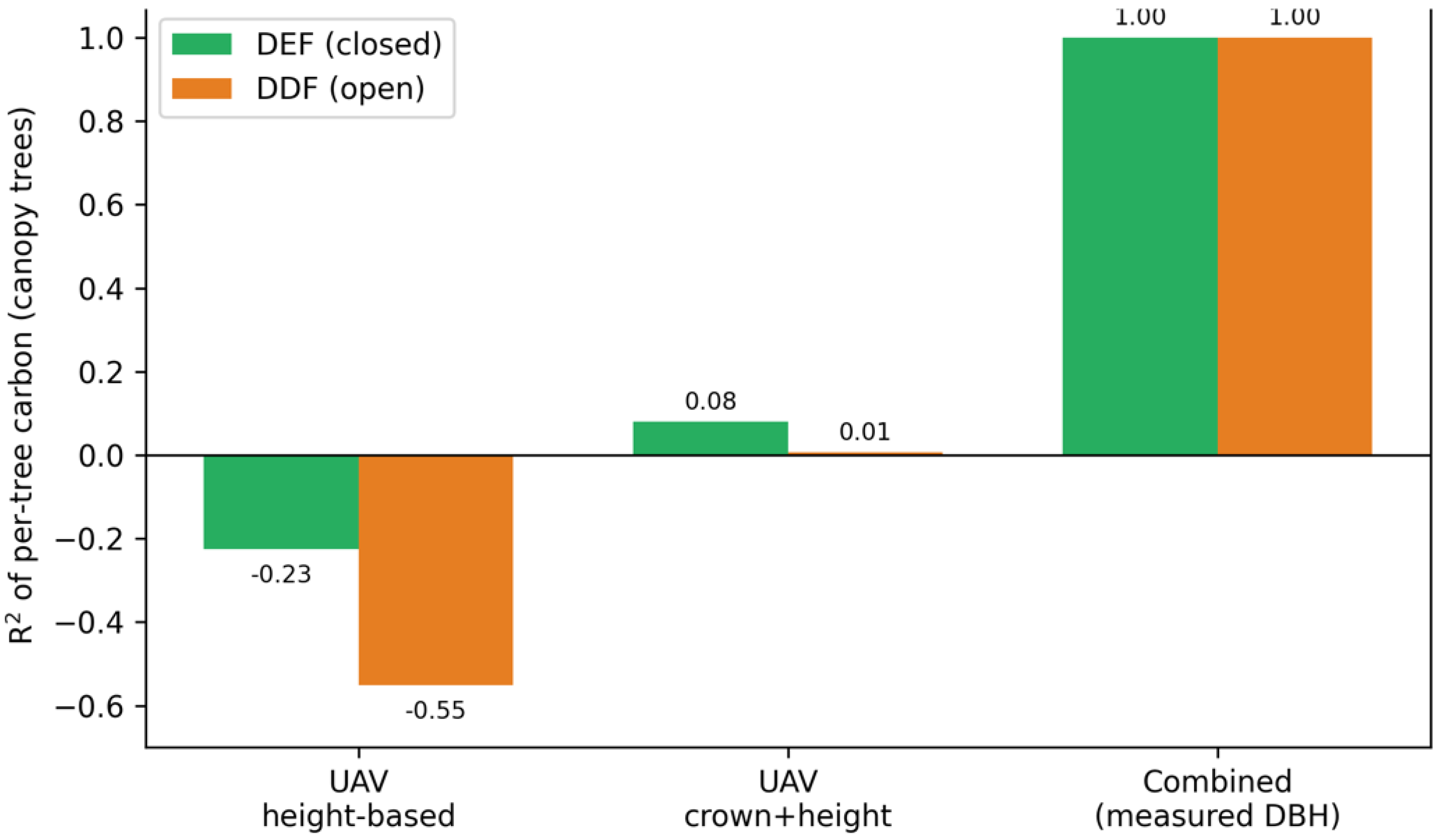
This propagated directly into carbon (Table 6). For the canopy trees, both UAV inference baselines produced carbon that did not track the field reference (R2 of −0.23 and 0.08 in the DEF; −0.55 and 0.01 in the DDF) (Figure 5). Supplying the ground-measured diameter recovered it, as validated independently against the field-measured anchor trees (R2 = 0.91; Section 3.3). Because carbon scales with diameter far more strongly than with height, it is the measured diameter-available only from the ground-that governs the estimate.
Table 6.
Individual-tree AGC accuracy (kg C) for canopy owner trees (DEF n = 56; DDF n = 57) against the field allometric reference.
Figure 5.
Coefficient of determination of per-tree carbon against the field reference, by method and forest type (canopy trees). Both UAV diameter-inference baselines fail (R2 ≤ 0.08); only the combined configuration with ground-measured diameter recovers carbon, validated against the field anchor trees (R2 = 0.91).
The field inventory is not an unqualified ground truth; its two predictors carry very different reliability. Tape-measured diameter is accurate, and the SLAM estimate reproduced it on the 42 reflective-tape anchor trees (R2 = 0.975, RMSE 3.3 cm; Section 3.3), whereas the UAV-inferred diameter did not (R2 = 0.04). Field height, by contrast, is measured from the ground with a clinometer and is well documented to underestimate tall tropical trees [41]. Accordingly, the UAV apex height exceeded the field height by 4.6 m on the anchors. We therefore interpret this offset as a limitation of the field height rather than a UAV error. The two platforms thus each supply the variable the conventional field inventory measures poorly: diameter from the ground (SLAM), height from the air (UAV).
The crown-and-height model was fitted in-sample, giving canopy inference its best possible case; it still fails. RMSE in kg C; negative R2 means the method does not track true carbon (Table 6). The combined configuration is validated independently against the 42 field-measured anchor trees (Section 3.3); at the owner level, it coincides with the allometric reference by construction, so the independent anchor value is reported instead, and the DDF field inventory lacks measured heights for an equivalent check. A non-allometric QSM cross-check (TreeQSM/AdQSM) is left to future work (Section 4.4).
3.3. Per-Tree Validation Against Field Anchors
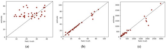
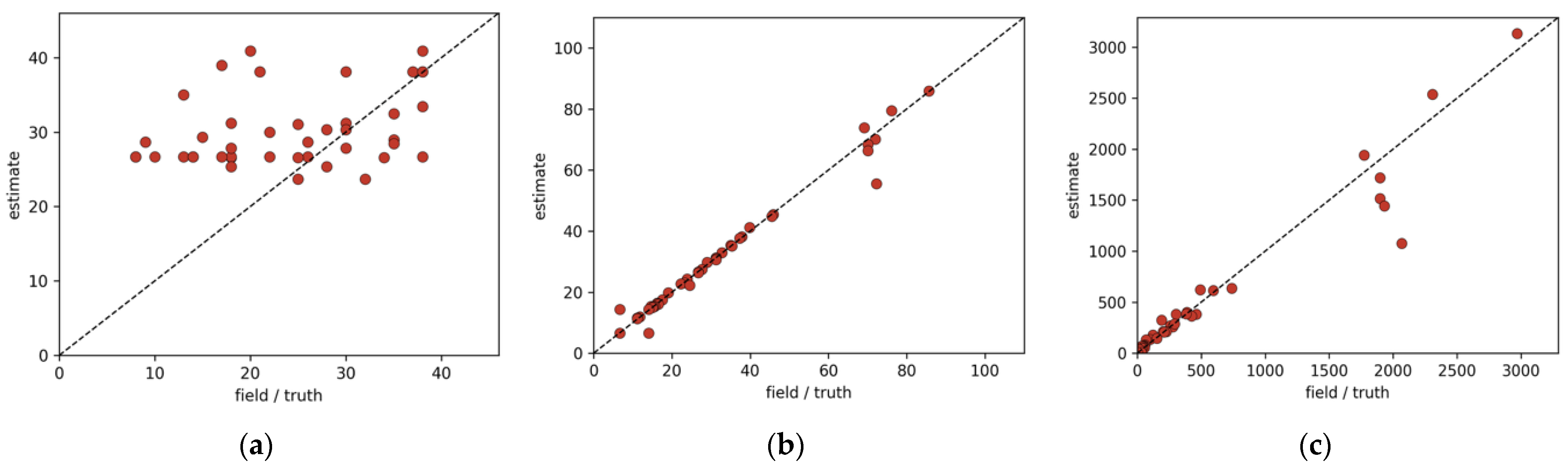
The 42 reflective-tape anchor trees in the DEF carry both field-measured diameter and field-measured height, providing a direct per-tree check that does not depend on the allometric reference (all uncertainties are 95% bootstrap intervals, 2000 resamples). Ground diameter was recovered almost exactly by SLAM (R2 = 0.975, 95% CI 0.94–1.00; RMSE 3.3 cm, bias −0.4 cm), whereas UAV-inferred diameter was only weakly related to the field value (R2 = 0.04; RMSE 20.7 cm, bias +1.9 cm). Per-tree carbon from the combined configuration (SLAM diameter + UAV height) tracked the field-anchor carbon at R2 = 0.913 (95% CI 0.83–0.97; RMSE 223 kg C), against R2 = 0.00 (95% CI −0.20 to 0.19; RMSE 756 kg C) for the UAV-only configuration. This anchor test, which uses independently field-measured diameter and height as the reference, is the rigorous one: the canopy-owner comparison of Section 3.2 coincides with the allometric reference by construction wherever that reference contains the SLAM diameter, whereas the anchor reference is fully independent. Height was the only predictor where the field value and the UAV value diverged (R2 = −0.21; RMSE 10.2 m, bias +4.6 m, field lower), which is consistent with the documented underestimation of tall-tree height by ground clinometry. We attribute this to the field measurement rather than to the UAV (Figure 6).
Figure 6.
Per-tree validation against the 42 reflective-tape anchor trees (DEF). (a): UAV apex height exceeds the ground-measured field height (bias +4.6 m), consistent with field underestimation of tall-tree height rather than UAV error. (b): SLAM versus field diameter (R2 = 0.975) confirms the ground diameter chain. (c): combined-configuration carbon versus field-anchor carbon (R2 = 0.913).
3.4. Uncertainty Budget
Because the allometric equations scale carbon as DBH2.14 against H0.68, a relative error in diameter propagates roughly three times more strongly than the same relative error in height; the diameter is therefore the dominant uncertainty term, and it is precisely the predictor the UAV inference cannot supply for large stems but ground SLAM measures directly (Equation (17)). Consistent with this sensitivity, the carbon comparison (see Table 6) shows the diameter governs the outcome: configurations that differ only in how the diameter is obtained span the full range from no skill to close agreement with the field reference. The full numeric Monte Carlo propagation of the four variance components is identified, together with the QSM cross-check, as the immediate quantitative next step (Section 4.4).
We propagated these components by Monte Carlo (N = 5000), drawing the diameter error from the SLAM–field anchor residual (σ = 3.3 cm), the height error from the UAV apex precision for canopy owners (σ = 2.5 m) and the Michaelis–Menten imputation RMSE for understory stems (4.0 m DEF, 2.9 m DDF), and a per-tree allometric model error (CV = 0.15). The stand-level estimate had a coefficient of variation of 2.1% (DEF) and 3.0% (DDF), and the variance decomposed into diameter, height, and allometric components of 34.9%, 9.6%, and 55.5% (DEF) and 51.3%, 16.6%, and 32.1% (DDF). Height is the smallest uncertainty source in both forests, reinforcing that the measured diameter—not the aerially derived height—governs the estimate.
3.5. Stand-Level Carbon
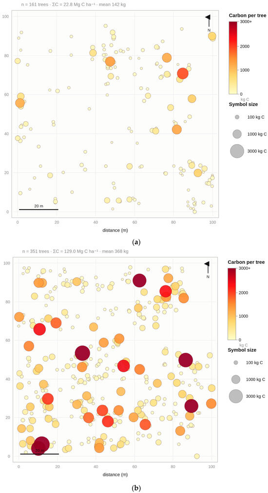
Aggregated over the field inventory with the verified equations, plot aboveground carbon was 111.9 Mg C ha−1 in the closed DEF (bootstrap 95% CI 92.4–133.7; 513 stems within the allometric diameter range), equivalent to 237 Mg ha−1 biomass and 410 Mg ha−1 CO2-equivalent, and 21.6 Mg C ha−1 in the open DDF (95% CI 19.1–24.5; 79 Mg ha−1 CO2e), the latter using heights imputed from a site diameter-height curve because the DDF field inventory lacks measured heights. These stocks are consistent with a tall, dense dry evergreen stand and a sparse dry dipterocarp stand, respectively. On the independent anchor trees, the combined configuration tracked the per-tree field-anchor carbon with a bias of −52 kg C, whereas the UAV-only baseline was biased by over 140 kg C per tree. All comparisons are cross-method against the field allometric reference, not validation against destructive harvest. Mapping carbon for every stem directly from the co-registered clouds (Section 2.10) reproduced these stand totals to within about 15% (DEF) and 6% (DDF) and resolved their spatial structure, with the largest, carbon-dense stems distributed across the closed DEF (Figure 7).
Figure 7.
Individual-tree aboveground carbon across the two 1-ha plots, mapped directly from the co-registered point clouds (Section 2.10). Each symbol is a stem detected in the handheld SLAM cloud; color and size encode per-tree carbon from the SLAM-measured diameter and the LiDAR-derived height. (a) open dry dipterocarp forest (n = 161 stems, 22.8 Mg C ha−1); (b) closed dry evergreen forest (n = 351 stems, 129.0 Mg C ha−1). The largest, carbon-dense stems dominate DEF.
The stems whose height is imputed rather than measured (the 455 DEF and 116 DDF understory stems of Table 5) carry a substantial share of the stand carbon—58.6% (DEF) and 42.5% (DDF)—because they are numerous. Their influence is nonetheless bounded: because their diameter is measured (not imputed) and carbon scales only as H0.68, perturbing the imputed heights by ±1 imputation RMSE changes the stand total by +1.6%/−8.5% (DEF) and about ±5% (DDF), and replacing them with the owner-median height shifts the DEF total by −3.5%; the imputed-height subset therefore introduces little systematic bias.
4. Discussion
4.1. Measured Versus Inferred Predictors
The central result is that obtaining both allometric predictors by direct measurement—DBH from terrestrial SLAM and H from UAV LiDAR—rather than inferring one from the other reduces the dominant component of individual-tree carbon uncertainty. This addresses a limitation that is widely acknowledged but rarely quantified: in single-platform tropical studies, the allometric equation and the height it depends on constitute the largest share of biomass uncertainty. By replacing the height-to-diameter inversion with a measured diameter, the combined configuration removes a structured source of error rather than merely averaging two noisy estimates.
4.2. Platform Complementarity Across the Gradient
The contribution of each platform varied predictably with canopy closure. In the open DDF, the two sensors were partly redundant, because height is more observable from the ground and stems are more visible from the air. In the closed DEF, the platforms were strongly complementary: the UAV supplied the height that SLAM could not see past the occluding upper canopy, while SLAM supplied the understory stems and diameters invisible to the UAV. This pattern explains why the largest accuracy gain occurred in the DEF and supports deploying the combined approach where it matters most—structurally complex, carbon-dense closed forests.
4.3. Implications for MRV
MRV under the Paris Agreement and the voluntary carbon market increasingly requires explicit, defensible uncertainty estimates at fine scale. The workflow presented here is GNSS-independent, requires no destructive harvest, and yields a per-tree uncertainty budget, making it suitable for repeat project-level carbon assessment in tropical forests where high-grade positioning is unavailable. The girth-based linkage, inherited from the companion inventory, is the enabling step that allows ground and aerial measurements to be combined despite unreliable field positions. Operationally, each hectare required about 40 min of handheld scanning plus a short UAV flight and no per-tree GNSS, keeping the approach tractable for plot networks; scaling to wall-to-wall MRV is nonetheless bound by walking effort and the need for periodic anchor trees.
4.4. Limitations and Future Work
Four limitations bound the interpretation. First, the carbon reference is allometric, not destructive; the comparison is therefore cross-method consistency rather than validation against felled trees, and absolute accuracy is bounded by the underlying equations. Second, the canopy-inference failure is demonstrated against an allometric truth and on the matched canopy stratum; we strengthened it by giving canopy inference its best case (an in-sample crown-and-height model) and showing it still underestimates large stems by about 30 cm, but a destructive subset would close the argument fully. Third, we lack a felled-tree reference for height; the +4.6 m gap between UAV and field height on the anchors is interpreted, on the strength of the literature, as field underestimation rather than UAV error, but a direct height reference (e.g., total-station or destructive) would confirm this. Fourth, the assessment covers two plots along one dry-forest gradient, and transferability to moist evergreen or montane systems remains to be tested. The clearest next step is a non-allometric quantitative structure modeling (QSM) cross-check [42,43] on cleanly segmented stems, which would provide an allometry-independent verification of the large-stem volumes; the per-tree clouds and scripts are prepared. Completing the full numeric Monte Carlo uncertainty budget across the four variance components (Section 2.8) is the parallel quantitative step. Each limitation identifies a concrete next step rather than undermining the central finding. Because the method depends only on co-visible stems and an aerial canopy, it should transfer to other open-to-closed forests with sufficient stem density, although humid-tropical, montane and mixed-species sites—and a destructive or QSM reference for the allometry—remain to be tested.
5. Conclusions
Co-registering handheld SLAM and UAV LiDAR without per-tree GNSS, through girth-identity anchors, allows individual-tree aboveground carbon across the open-to-closed tropical dry-forest gradient to be built from measured rather than inferred predictors. The two platforms each supply the variable that a conventional field inventory measures poorly: stem diameter from the ground, where SLAM reproduced field tape to R2 = 0.975 and aerial inference failed (R2 = 0.04), and tree height from the air, where UAV exceeded the clinometer-based field height by 4.6 m in line with the documented underestimation of tall-tree height. Per-tree carbon from the combined data agreed with field anchors at R2 = 0.91, while canopy-only inference did not track carbon at all. Credible individual-tree carbon in dense tropical forest therefore requires the ground for diameter and the air for height, combined without high-grade positioning—a practical and transferable basis for fine-scale tropical-forest carbon MRV.
Author Contributions
Conceptualization, S.M. and N.K.; methodology, S.M.; software, S.M.; validation, N.K., P.T., R.K. and S.W.; formal analysis, S.M.; investigation, S.M.; resources, R.K., S.W. and H.T.K.; data curation, P.T.; writing—original draft preparation, S.M.; writing—review and editing, N.K., P.T., R.K. and S.W.; visualization, S.M.; supervision, N.K. and H.T.K.; project administration, N.K.; funding acquisition, N.K. All authors have read and agreed to the published version of the manuscript.
Funding
This research was funded by the Extra Budgetary Contribution from the Republic of Korea (EBC-K) 2024 of Asia-Pacific Telecommunity, Bangkok, Thailand (APT/2025/EBC-K/2025/03).
Data Availability Statement
The data presented in this study are available on request from the corresponding author due to ongoing related analyses within the same research project.
Acknowledgments
The authors thank the Sakaerat Environmental Research Station (SERS), Thailand Institute of Scientific and Technological Research (TISTR), for site access and field logistical support, and the field crew for stem tagging and caliper measurements. During the preparation of this manuscript, the authors used Claude (Anthropic) for the purposes of language editing and figure-generation scripting. The authors have reviewed and edited the output and take full responsibility for the content of this publication.
Conflicts of Interest
The authors declare no conflicts of interest.
References
- GFOI. Integration of Remote-Sensing and Ground-Based Observations for Estimation of Emissions and Removals of Greenhouse Gases in Forests, 2nd ed.; Group on Earth Observations: Geneva, Switzerland, 2016. [Google Scholar]
- Gibbs, H.K.; Brown, S.; Niles, J.O.; Foley, J.A. Monitoring and Estimating Tropical Forest Carbon Stocks: Making REDD a Reality. Environ. Res. Lett. 2007, 2, 045023. [Google Scholar] [CrossRef] [Scilit]
- Duncanson, L.; Armston, J.; Disney, M.; Avitabile, V.; Barbier, N.; Calders, K.; Carter, S.; Chave, J.; Herold, M.; Crowther, T.W.; et al. The Importance of Consistent Global Forest Aboveground Biomass Product Validation. Surv. Geophys. 2019, 40, 979–999. [Google Scholar] [CrossRef] [Scilit] [PubMed]
- Moukomla, S.; Srestasathiern, P.; Siripon, S.; Wasuhiranyrith, R.; Kooha, P. Estimating above Ground Biomass for Eucalyptus Plantation Using Data from Unmanned Aerial Vehicle Imagery. In Proceedings of the Remote Sensing for Agriculture, Ecosystems, and Hydrology XX, Berlin, Germany, 10 October 2018; SPIE: Bellingham, WA, USA, 2018; Volume 10783, pp. 39–44. [Google Scholar]
- Na Takuathung, C.; Yingdee, J.; Chumsangsri, T.; Jumwong, N.; Meunpong, P.; Sangvisitpirom, P.; Kaewgrajang, T.; Sriarkarin, S.; Tuankrua, V.; Chonlapap, N.; et al. Non-Destructive Aboveground Biomass Estimation in Teak Plantations: Validating Terrestrial Laser Scanning and Quantitative Structure Models against Destructive Sampling. Trees For. People 2026, 25, 101305. [Google Scholar] [CrossRef] [Scilit]
- Kaewjampa, N.; Tongdeenok, P.; Klabsuk, R.; Waengsothorn, S.; Kim, H.T.; Moukomla, S. Girth-Based Anchor Matching for Handheld SLAM LiDAR Forest Inventory Under Closed Tropical Canopies. Remote Sens. 2026, 18, 1920. [Google Scholar] [CrossRef] [Scilit]
- Hyyppa, E.; Kukko, A.; Kaijaluoto, R.; White, J.C.; Wulder, M.A.; Pyörälä, J.; Liang, X.; Yu, X.; Wang, Y.; Kaartinen, H.; et al. Accurate Derivation of Stem Curve and Volume Using Backpack Mobile Laser Scanning. ISPRS J. Photogramm. Remote Sens. 2020, 161, 246–262. [Google Scholar] [CrossRef] [Scilit]
- Bauwens, S.; Bartholomeus, H.; Calders, K.; Lejeune, P. Forest Inventory with Terrestrial LiDAR: A Comparison of Static and Hand-Held Mobile Laser Scanning. Forests 2016, 7, 127. [Google Scholar] [CrossRef] [Scilit]
- Terryn, L.; Calders, K.; Bartholomeus, H.; Bartolo, R.E.; Brede, B.; D’Hont, B.; Disney, M.; Herold, M.; Lau, A.; Shenkin, A.; et al. Quantifying Tropical Forest Structure through Terrestrial and UAV Laser Scanning Fusion in Australian Rainforests. Remote Sens. Environ. 2022, 271, 112912. [Google Scholar] [CrossRef] [Scilit]
- Mîzgaciu, L.; Tudoran, G.M.; Ciocan, A.E.; Stăncioiu, P.T.; Nită, M.D. A Comparing UAV LiDAR and Mobile Laser Scanning for Tree Height and DBH Estimation in a Structurally Complex Mixed-Species Natural Forest. Forests 2025, 16, 1481. [Google Scholar] [CrossRef] [Scilit]
- Dalla Corte, A.P.; Rex, F.E.; de Almeida, D.R.A.; Sanquetta, C.R.; Silva, C.A.; Moura, M.M.; Wilkinson, B.; Zambrano, A.M.A.; da Cunha Neto, E.M.; Veras, H.F.P.; et al. Measuring Individual Tree Diameter and Height Using GatorEye High-Density UAV-Lidar in an Integrated Crop-Livestock-Forest System. Remote Sens. 2020, 12, 863. [Google Scholar] [CrossRef] [Scilit]
- Tupinambá-Simões, F.; Pascual, A.; Guerra-Hernández, J.; Ordóñez, C.; Barreiro, S.; Bravo, F. Combining Hand-Held and Drone-Based Lidar for Forest Carbon Monitoring: Insights from a Mediterranean Mixed Forest in Central Portugal. Eur. J. For. Res. 2025, 144, 925–940. [Google Scholar] [CrossRef] [Scilit]
- Zhang, W.; Qi, J.; Wan, P.; Wang, H.; Xie, D.; Wang, X.; Yan, G. An Easy-to-Use Airborne LiDAR Data Filtering Method Based on Cloth Simulation. Remote Sens. 2016, 8, 501. [Google Scholar] [CrossRef] [Scilit]
- Wing, M.G.; Eklund, A.; Kellogg, L.D. Consumer-Grade Global Positioning System (GPS) Accuracy and Reliability. J. For. 2005, 103, 169–173. [Google Scholar] [CrossRef] [Scilit]
- Merry, K.; Bettinger, P.; Hepinstall, J. Influence of Overhead Canopy on GPS Signal Reception for Community Forestry Applications. Indian For. 2007, 133, 43–52. [Google Scholar] [CrossRef] [Scilit]
- Brach, M.; Zasada, M. The Effect of Mounting Height on GNSS Receiver Positioning Accuracy in Forest Conditions. Croat. J. For. Eng. 2014, 35, 245–253. [Google Scholar]
- Fekry, R.; Ali, E.; Sani-Mohammed, A.; Abdallah, M.; Amr, D. Target-Less Registration of UAV-LiDAR Point Clouds Based on Graph Matching of Tree Locations in Forest Environments. Sci. Rep. 2026, 16, 12373. [Google Scholar] [CrossRef] [Scilit] [PubMed]
- Chen, Z.; Yang, X.; Pan, X.; Wu, T.; Lei, J.; Chen, X.; Li, Y.; Chen, Y. Estimating Forest Aboveground Biomass in Tropical Zones by Integrating LiDAR and Sentinel-2B Data. Sustainability 2025, 17, 3631. [Google Scholar] [CrossRef] [Scilit]
- Lin, J. Biomass Estimation and Uncertainty Quantification from Tree Height. IEEE Trans. Geosci. Remote Sens. 2023, 61, 4406213. [Google Scholar]
- Chave, J.; Condit, R.; Aguilar, S.; Hernandez, A.; Lao, S.; Perez, R. Error Propagation and Scaling for Tropical Forest Biomass Estimates. Philos. Trans. R. Soc. Lond. B Biol. Sci. 2004, 359, 409–420. [Google Scholar] [CrossRef] [Scilit] [PubMed]
- Molto, Q.; Rossi, V.; Blanc, L. Error Propagation in Biomass Estimation in Tropical Forests. Methods Ecol. Evol. 2012, 4, 175–183. [Google Scholar] [CrossRef] [Scilit]
- Duangsathaporn, K.; Sangram, N.; Omule, Y.; Prasomsin, P.; Palakit, K.; Lumyai, P. Formulating Equations for Estimating Forest Stand Carbon Stock for Various Tree Species Groups in Northern Thailand. Forests 2023, 14, 1584. [Google Scholar] [CrossRef] [Scilit]
- Slik, J.W.F.; Paoli, G.; McGuire, K.; Amaral, I.; Barroso, J.; Bastian, M.; Blanc, L.; Bongers, F.; Boundja, P.; Clark, C.; et al. Large Trees Drive Forest Aboveground Biomass Variation in Moist Lowland Forests across the Tropics. Glob. Ecol. Biogeogr. 2013, 22, 1261–1271. [Google Scholar] [CrossRef] [Scilit]
- Bastin, J.-F.; Rutishauser, E.; Kellner, J.R.; Saatchi, S.; Pélissier, R.; Hérault, B.; Slik, F.; Bogaert, J.; De Cannière, C.; Marshall, A.R.; et al. Pan-Tropical Prediction of Forest Structure from the Largest Trees. Glob. Ecol. Biogeogr. 2018, 27, 1366–1383. [Google Scholar] [CrossRef] [Scilit]
- Kaewjampa, N.; Tongdeenok, P.; Klabsuk, R.; Waengsothorn, S.; Kim, H.T.; Moukomla, S. Phenology-Informed Multitemporal PlanetScope and UAV-LiDAR Fusion for Above-Ground Carbon Mapping in Tropical Dry Forests of Sakaerat Biosphere Reserve, Thailand. Remote Sens. 2026, 18, 1903. [Google Scholar] [CrossRef] [Scilit]
- Castorena, J.; Dickman, L.T.; Killebrew, A.J.; Gattiker, J.R.; Linn, R.; Loudermilk, E.L. ForestAlign: Automatic Forest Structure-Based Alignment for Multi-View TLS and ALS Point Clouds. Sci. Remote Sens. 2025, 11, 100194. [Google Scholar] [CrossRef] [Scilit]
- Marod, D.; Kutintara, U.; Tanaka, H.; Nakashizuka, T. The Effects of Drought and Fire on Seed and Seedling Dynamics in a Tropical Seasonal Forest in Thailand. Plant Ecol. 2002, 161, 41–57. [Google Scholar] [CrossRef] [Scilit]
- Ester, M.; Kriegel, H.-P.; Sander, J.; Xu, X. A Density-Based Algorithm for Discovering Clusters in Large Spatial Databases with Noise. In Proceedings of the Second International Conference on Knowledge Discovery and Data Mining (KDD-96); AAAI Press: Portland, OR, USA, 1996; pp. 226–231. [Google Scholar]
- Kasa, I. A Circle Fitting Procedure and Its Error Analysis. IEEE Trans. Instrum. Meas. 1976, 25, 8–14. [Google Scholar] [CrossRef] [Scilit]
- Kuhn, H.W. The Hungarian Method for the Assignment Problem. Nav. Res. Logist. Q. 1955, 2, 83–97. [Google Scholar] [CrossRef] [Scilit]
- Liu, Z.; Ling, Q.; Zhao, W.; Feng, Z.; Pei, H.; Grimaldi, P.; Qiu, Z. Spatiotemporal Dynamics of Forest Biomass in the Hainan Tropical Rainforest Based on Multimodal Remote Sensing and Machine Learning. Forests 2026, 17, 85. [Google Scholar] [CrossRef] [Scilit]
- Cheng, X.; Zhou, L.; Liu, S.; He, C.; Teng, Y. Improving Forest Above-Ground Biomass Estimation Using UAV LiDAR and RGB with Machine Learning Algorithm. Forests 2025, 16, 1819. [Google Scholar] [CrossRef] [Scilit]
- Zhang, W.; Zhao, L.; Li, Y.; Shi, J.; Yan, M.; Ji, Y. Forest Above-Ground Biomass Inversion Using Optical and SAR Images Based on a Multi-Step Feature Optimized Inversion Model. Remote Sens. 2022, 14, 1608. [Google Scholar] [CrossRef] [Scilit]
- Arun, K.S.; Huang, T.S.; Blostein, S.D. Least-Squares Fitting of Two 3-D Point Sets. IEEE Trans. Pattern Anal. Mach. Intell. 1987, 9, 698–700. [Google Scholar] [CrossRef] [Scilit] [PubMed]
- Meyer, F. Topographic Distance and Watershed Lines. Signal Process. 1994, 38, 113–125. [Google Scholar] [CrossRef] [Scilit]
- Zhang, S.; Wang, H.; Wang, C.; Wang, Y.; Wang, S.; Yang, Z. An Improved RANSAC-ICP Method for Registration of SLAM and UAV-LiDAR Point Cloud at Plot Scale. Forests 2024, 15, 893. [Google Scholar] [CrossRef] [Scilit]
- Zhang, T.; Shen, X.; Cao, L. Terrain and Individual Tree Vertical Structure-Based Approach for Point Clouds Co-Registration by UAV and Backpack LiDAR. Int. J. Appl. Earth Obs. Geoinf. 2025, 139, 104544. [Google Scholar] [CrossRef] [Scilit]
- Shao, J.; Yao, W.; Wan, P.; Luo, L.; Wang, P.; Yang, L.; Lyu, J.; Zhang, W. Efficient Co-Registration of UAV and Ground LiDAR Forest Point Clouds Based on Canopy Shapes. Int. J. Appl. Earth Obs. Geoinf. 2022, 114, 103067. [Google Scholar] [CrossRef] [Scilit]
- Wang, F.; Wang, J.; Wu, Y.; Xue, Z.; Tan, X.; Yang, Y.; Lin, S. A Method Coupling NDT and VGICP for Registering UAV-LiDAR and LiDAR-SLAM Point Clouds in Plantation Forest Plots. Forests 2024, 15, 2186. [Google Scholar] [CrossRef] [Scilit]
- Polewski, P.; Yao, W.; Cao, L.; Gao, S. Marker-Free Coregistration of UAV and Backpack LiDAR Point Clouds in Forested Areas. ISPRS J. Photogramm. Remote Sens. 2019, 147, 307–318. [Google Scholar] [CrossRef] [Scilit]
- Larjavaara, M.; Muller-Landau, H.C. Measuring Tree Height: A Quantitative Comparison of Two Common Field Methods in a Moist Tropical Forest. Methods Ecol. Evol. 2013, 4, 793–801. [Google Scholar] [CrossRef] [Scilit]
- Raumonen, P.; Kaasalainen, M.; Åkerblom, M.; Kaasalainen, S.; Kaartinen, H.; Vastaranta, M.; Holopainen, M.; Disney, M.; Lewis, P. Fast Automatic Precision Tree Models from Terrestrial Laser Scanner Data. Remote Sens. 2013, 5, 491–520. [Google Scholar] [CrossRef] [Scilit]
- Gonzalez de Tanago, J.; Lau, A.; Bartholomeus, H.; Herold, M.; Avitabile, V.; Raumonen, P.; Martius, C.; Goodman, R.C.; Disney, M.; Manuri, S.; et al. Estimation of Above-ground Biomass of Large Tropical Trees with Terrestrial LiDAR. Methods Ecol. Evol. 2017, 9, 223–234. [Google Scholar] [CrossRef] [Scilit]

Disclaimer/Publisher’s Note: The statements, opinions and data contained in all publications are solely those of the individual author(s) and contributor(s) and not of MDPI and/or the editor(s). MDPI and/or the editor(s) disclaim responsibility for any injury to people or property resulting from any ideas, methods, instructions or products referred to in the content. |
© 2026 by the authors. Licensee MDPI, Basel, Switzerland. This article is an open access article distributed under the terms and conditions of the Creative Commons Attribution (CC BY) license.