


Highlights
What are the main findings?
- This study proposes a UAV-driven edge-based lane-detection framework and a lightweight lane line semantic segmentation model, LSLNet; this integrates the strip-aware multi-branch depthwise operator (SMDO) and the Sobel-based feature-fusion scheme (SFFS) to enhance lane line extraction under limited onboard computing resources.
- On the UAV-Laneline3K dataset, LSLNet achieves 82.73% F1-score and 72.06% mIoU at 82 FPS with only 0.09M parameters for lane line semantic segmentation, while the proposed road-region-detection method attains 97.62% mIoU on the UAV-Roadregion200 dataset.
What is the implication of the main finding?
- The proposed framework provides an effective solution for real-time lane-level road perception and road region detection on UAV edge platforms, which is beneficial for traffic monitoring, incident analysis, and intelligent transportation applications.
- The lightweight network design and structured lane modeling strategy can also be extended to other UAV-based semantic segmentation and geometric reconstruction tasks in resource-constrained scenarios.
Abstract
UAV-based road traffic state monitoring and analysis have become a hotspot in current research, where road region detection serves as the prerequisite for the aforementioned applications. This paper proposes a UAV-driven edge-based lane-detection system, and a lane line semantic segmentation, modeling and road-region-detection method. Firstly, a lightweight lane line semantic segmentation model LSLNet is presented, where the strip- aware multi-branch depthwise operator (SMDO) and the Sobel-based feature-fusion scheme (SFFS) are used in conjunction to improve feature representation ability under low computational overheads. Furthermore, the segmented lane line mask is quantified into a parametric form and the lane-level road regions are constructed by lane line spatial geometric distribution. Finally, to evaluate the performance of the proposed method, an experiment is conducted using the self-constructed UAV-Laneline3K and UAV-Roadregion200 datasets. The experimental results show that LSLNet achieves 82.73% F1-score and 72.06% mIoU on the lane line semantic segmentation task, which runs at 82 FPS with merely 0.09M parameters and 13.0 GFLOPs. For road region detection, the mIoU and F1-score reach 97.62% and 98.86%, respectively. The results demonstrate that the proposed method enables accurate and robust road region detection in complex road environments with low computational costs.
1. Introduction
High-precision and real-time detection of lane regions is the prerequisite of road environment perception for applications in intelligent transportation and autonomous driving systems [1,2,3], such as the incident management, congestion detection and navigation decision. Traditional detection methods have inherent limitations in terms of data acquisition, either constrained by the field of view and thus unable to cover large-scale road networks or restricted by spatial resolution, therefore failing to capture road details with high precision [4,5,6,7]. As a result, few data sources can simultaneously achieve the large-scale, high-precision and real-time lane region detection which is crucial for meso-level traffic management such as traffic guidance, congestion detection and incident response [8,9,10,11].
Owing to the advantages in wide imaging coverage, high spatial resolution, flexible payload deployment and strong maneuverability, the unmanned aerial vehicle (UAV) has been increasingly adopted as a mobile sensing platform for traffic monitoring [12], especially in urban scene analysis and road environment modeling [13,14]. In a typical cloud-based lane-detection architecture, road images are acquired through low-altitude cruising UAV and further uploaded to the cloud, where deep learning models are applied to perform semantic segmentation of lane regions. However, affected by complex road environments, diverse road structures and lane line types, as well as frequent occlusions caused by vehicles or roadside structures, the lane-level semantic segmentation of road regions based on UAV images still suffers from issues including recognition fragmentation, incomplete boundaries, and misclassification with the background [15,16].
Under cloud-based lane-detection architecture, existing segmentation solutions can be roughly divided into three categories: diversified road targets segmentation (DRTS), single road region segmentation (SRRS) and lane-line-based road region segmentation (LRRS). Regarding the DRTS, all the road targets including the lane regions are segmented using an enhanced feature extraction network by integrating multiscale global context in UAV images [17,18]. However, the lane region segmentation results are susceptible to the interference from other targets. Pertaining to the SRRS, since the road region dataset is the only training dataset of the network, it can effectively address the problem of diversified target interferences existing in DRTS, but the accuracy is still affected by similar backgrounds [19,20]. Considering that lane lines in complex road scenarios have more distinct semantic features, as regular structure and high color contrast, the LRRS segments road regions based on the extraction of lane lines in an indirect yet highly accurate manner [21]. By virtue of the advantages of cloud-based architecture in computing resources and model capacity, the aforementioned methods present good testing performance in offline UAV image analysis. However, constrained by the limitation of UAV transmission network performance, images are usually subject to substantial compression, leading to obvious reduction in target features and degradation of the algorithm performance in practical applications.
With the development of edge computing and UAV embodied intelligence technologies, the edge-based lane-detection architecture has emerged as a crucial research direction. Under this new architecture, real-time and high-resolution images captured by UAV cameras can be directly processed using the UAV’s onboard computing resources, and the lane region semantic segmentation can be achieved locally on the UAV. Compared with traditional cloud-based architectures, edge-based architectures can perform inference using the original images without information loss caused by data compression, which improves data fidelity and reduces latency [22,23]. However, the lane-line-extraction algorithms based on high-resolution images and the post-processing algorithms for lane area segmentation are generally with high computational complexity. Meanwhile, the onboard embedded edge computing power of UAVs is limited, which will bring severe challenges to the lightweight design of lane-region-detection network models.
Under edge-based architecture, this paper proposes a lightweight lane-line-based road-region-segmentation method. The contributions are summarized as follows:
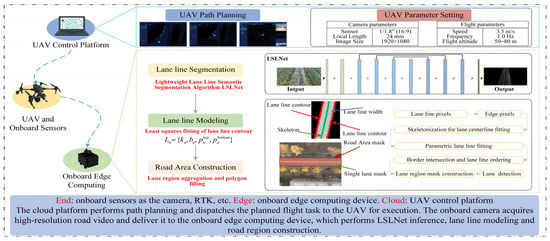
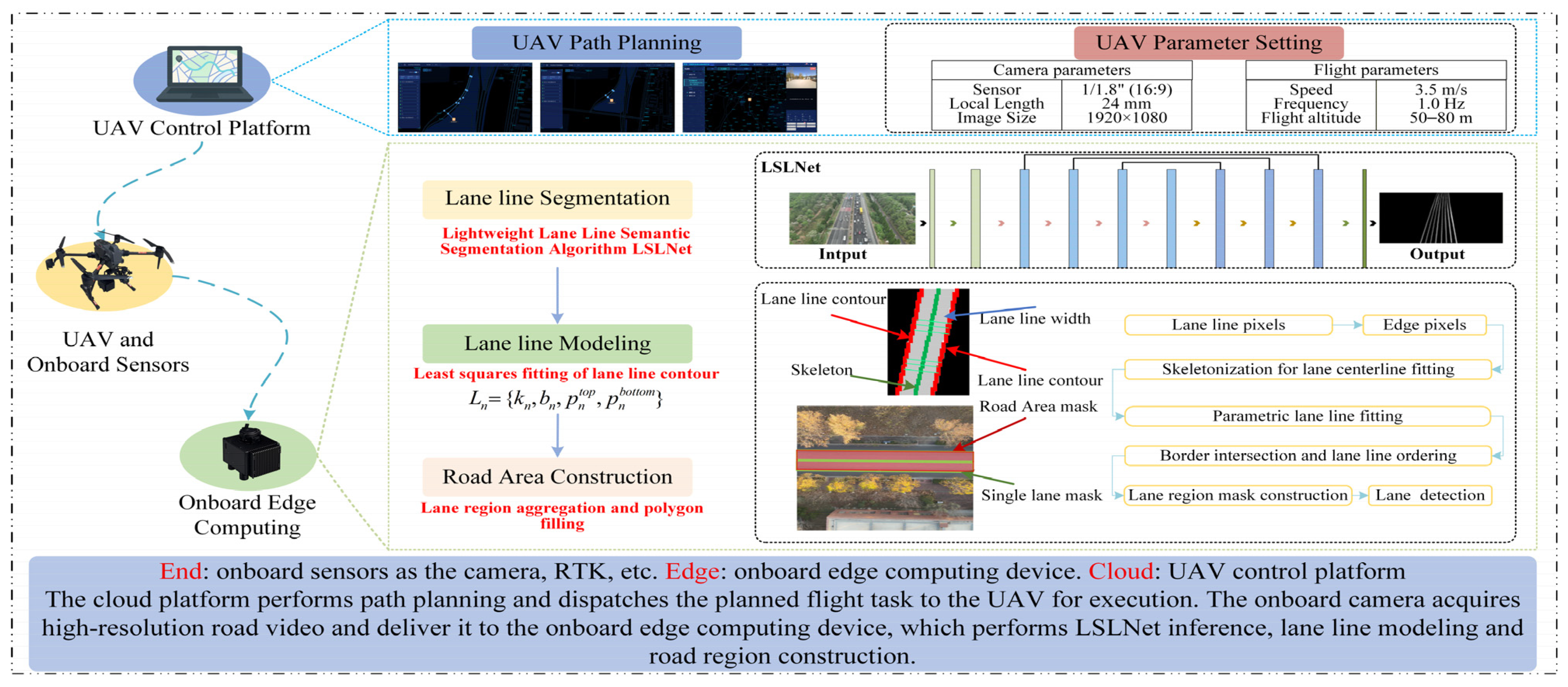
- A UAV-driven edge-based lane-detection system is presented by integrating UAV data acquisition, onboard inference and structured road modeling, serving lane line segmentation, modeling and road region detection, as shown in Figure 1.
- A lightweight lane line semantic segmentation model LSLNet is proposed. In the LSLNet, the strip-aware multi-branch depthwise operator (SMDO) and the Sobel-based feature-fusion scheme (SFFS) are applied to improve the feature representation ability while maintaining low computational overheads.
- A lane-line-modeling and road-region-detection scheme is developed. The lane-line-segmentation pixel-wise masks are transformed into a compact geometric representation, and the lane-line-based road region detection is finely achieved.
Figure 1.
UAV-driven edge-based lane-detection system.
The rest of this paper is organized as follows: Section 1 provides an overview of the research motivation, the state of the art, and the key contributions presented in this paper. In Section 2, related work on road region segmentation across different data sources, deep-learning-based road region segmentation and lightweight research for UAV deployment is reviewed. The LSLNet, including its architecture design and training strategy for efficient lane line segmentation, is presented in Section 3. In Section 4, the lane line masks obtained by semantic segmentation are quantized into parametric representations, which are then used to reconstruct the road regions. The experimental settings and results are reported in Section 5. Finally, in Section 6, the main work of this paper is concluded, and the future research is presented.
2. Related Work
Building on existing road-region-detection methods, this section reviews the literature from three perspectives: road region segmentation across different data sources, deep-learning-based road region segmentation and lightweight research for UAV deployment.
2.1. Road Region Segmentation Across Different Data Sources
Existing methods for road region segmentation across different data sources can be broadly grouped into three categories: point-cloud-based, image–point cloud fusion, and image-based approaches. Each category involves inherent trade-offs between computational accuracy and deployment cost.
Point-cloud-based methods: Point-cloud-based methods leverage the scale-invariant and geometrically precise nature of LiDAR data to perform segmentation and analysis directly in 3D space. This direct approach offers strong robustness against challenging illumination and occlusion; however, it also brings substantial computational cost. Representative work such as CENet emphasizes a “concise and efficient” network design and achieves significant mIoU gains on publicly available benchmarks: SemanticKITTI and SemanticPOSS [24]. Furthermore, the authors of [25] propose a novel multi-level feature-optimization network, namely MFPNet, and further introduce two-point cloud benchmarks: RdmkNet and Toronto-Rdmk. The experimental results demonstrate that MFPNet achieves favorable performance, while the two newly developed point cloud datasets are of great significance for research on road marking classification and segmentation.
Image–point cloud fusion methods: By integrating the color and texture information of images with the spatial and geometric information of point clouds, the accuracy of road segmentation tasks is significantly improved [26]. However, the computational complexity has increased further. The authors of [27] propose a road segmentation solution by integrating data from multiple sensors within a multi-task learning architecture and utilizes RGB and LiDAR depth images as its inputs. In addition, the authors of [28] propose a recurrent conditional random field (R-CRF) model to fuse images and point clouds for road detection. On the public KITTI dataset, both methods provide high-performance solutions for road region segmentation.
Image-based methods: Given the low cost of image capture and the rich inherent semantics in visual data, image-based approaches represent the most extensively utilized paradigm for road region detection [29,30]. The authors of [31] propose a road extraction algorithm based on Dual Encoder–Decoder U-Net (DEDU-Net). By employing a dual encoder–decoder structure to extract multiscale features and a dual decoder module to restore feature maps to the original image resolution, their method achieves superior performance on both the CHN6-CUG dataset and the Gansu Mountain Road dataset. Furthermore, the authors of [32] propose RUW-Net, a network with a dual encoder–decoder structure. By employing residual U-blocks and a decoder–encoder combination (DEC) module, their method enhances road extraction performance from remote sensing images. Experimental results on the public DeepGlobe dataset demonstrate that RUW-Net effectively alleviates the issues of road fragmentation and misclassification in road extraction.
2.2. Deep-Learning-Based Road Region Segmentation in UAV Images
Deep-learning-based road-region-segmentation methods in UAV images can be divided into two main lines. The one focuses on the direct segmentation of road regions [33]. The other approach first segments and parameterizes lane markings and then reconstructs the road region by exploiting the geometric and topological constraints of the lane lines [34]. The disparities between road-region-detection methods fundamentally govern their respective focuses throughout semantic segmentation.
Direct road areas segmentation in UAV images: The proposed method directly implements pixel-level semantic segmentation of road regions in UAV images, yielding outputs with reliable connectivity and accuracy. However, this method still exhibits certain limitations in lane-level road region detection. For example, it is susceptible to interference from negative non-road samples, fails to stably extract the continuity of intact road surfaces, and is severely affected by perspective distortion caused by low-altitude oblique-view imaging. To solve these problems, the authors of [35] propose an enhanced U-Net network to extraction road regions using UAV images. The improved model boosts the road extraction capability of the original UNet by strengthening feature extraction and leveraging global context information. Furthermore, a UAV-specific segmentation network, UAV-YOLOv12, is presented in [36]. By incorporating the SKNet and PConv modules, this network enhances spatial adaptability and feature discrimination for road segmentation in UAV imagery.
Lane line segmentation, modeling and geometry-based road region reconstruction in UAV images: This method first segments lane markings and then quantifies them into linear equation representations, thereby reconstructing complete road regions under geometric constraints. However, the performance of this method for lane region detection heavily relies on the quality of lane line markings semantic segmentation. Existing UAV-based lane line detection networks are still challenged by severe scale variations, shadows, occlusions, and cluttered roadside backgrounds. Furthermore, as lane markings account for only a tiny fraction of the total image pixels, such class imbalance tends to result in background-dominant optimization during network training, thereby leading to insufficient recall in lane line marking detection. To solve these problems, the authors of [37] propose BT-RoadNet, which employs a coarse-to-fine design (CMPM/FMPM) to mitigate road discontinuities caused by shadows and occlusions and enables multiscale road extraction. The authors of [38] propose the SC-RoadDeepNet model by integrating recurrent residual modeling and boundary learning, as well as introducing the connectivity-preserving centerline Dice (CP_clDice) loss derived from mask–skeleton intersections. Experimental results demonstrate that their method further mitigates the discontinuity of segmentation results while improving road shape quality and topological connectivity. In addition, numerous studies have addressed the class imbalance problem in semantic segmentation by enhancing network architectures or optimizing loss functions [39,40].
In summary, this paper proposes a deep learning network for lane line semantic segmentation in UAV images. The proposed model achieves accurate and robust lane line semantic segmentation in complex road environments at a low computational cost. Implementation details are provided in Section 3. Furthermore, in-depth discussions on the lightweight design of network models and system architecture are presented in Section 2.3.
2.3. Lightweight Research for UAV Deployment
Compared with mature vehicle-based pipelines and conventional remote-sensing mapping methods [41,42], edge-side deployment for low-altitude UAV imagery remains relatively under-explored in existing research [43,44]. This can be mainly attributed to three factors: constrained onboard resources, severe scale variations in UAV images, and the lack of a well-established end–edge–cloud computing framework. Accordingly, this section summarizes the lightweight design strategies for models and edge computing frameworks, aiming to improve the efficiency of UAV-based road region detection while maintaining detection accuracy.
Lightweight model design: For UAV edge deployment, current research focuses on developing lightweight network models. The primary goal is to minimize their parameter count, memory footprint, and computational load without significantly compromising detection and segmentation performance. FasterX [45], derived from YOLOX, has achieved real-time detection on edge GPUs, while STDC-CT [46] enables real-time semantic segmentation for UAV-based applications. These studies validate the efficacy of lightweight design strategies, providing a practical foundation for real-time perception on resource-constrained UAV platforms.
End–edge–cloud collaborative computing framework: The end–edge–cloud collaborative computing framework significantly improves the efficiency of real-time processing for UAV images. The authors of [44] propose using aerial nodes as mobile edge computing base stations to provide near-source computational support. When deploying on resource-constrained UAV platforms, prioritizing edge processing strategies can significantly reduce data transmission waiting times. Compared to pure cloud processing, the delay per frame can be reduced from seconds to milliseconds [47]. In addition, the Fed4UL framework proposed by the authors of [48], based on a cloud–edge–end collaboration architecture and aims to protect the privacy of UAV logistics operations while reducing the negative impact of Non-IID data on the UAV logistics operations. Under this framework, edge nodes perform local model updates, while the cloud conducts adaptive aggregation, thereby improving overall system scalability while preserving data privacy.
Building on the aforementioned research advances in lightweight deployment for UAV platforms, this paper innovatively proposes a UAV-driven edge computing system for lane detection. By integrating UAV data acquisition, on-board inference and structured road modeling techniques, the system achieves efficient lane line segmentation, modeling and road region detection. The detailed methodology is presented in Section 3 and Section 4.
3. LSLNet for Lane Line Semantic Segmentation from UAV Perspective
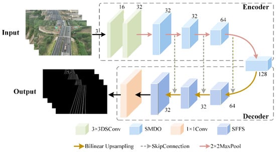
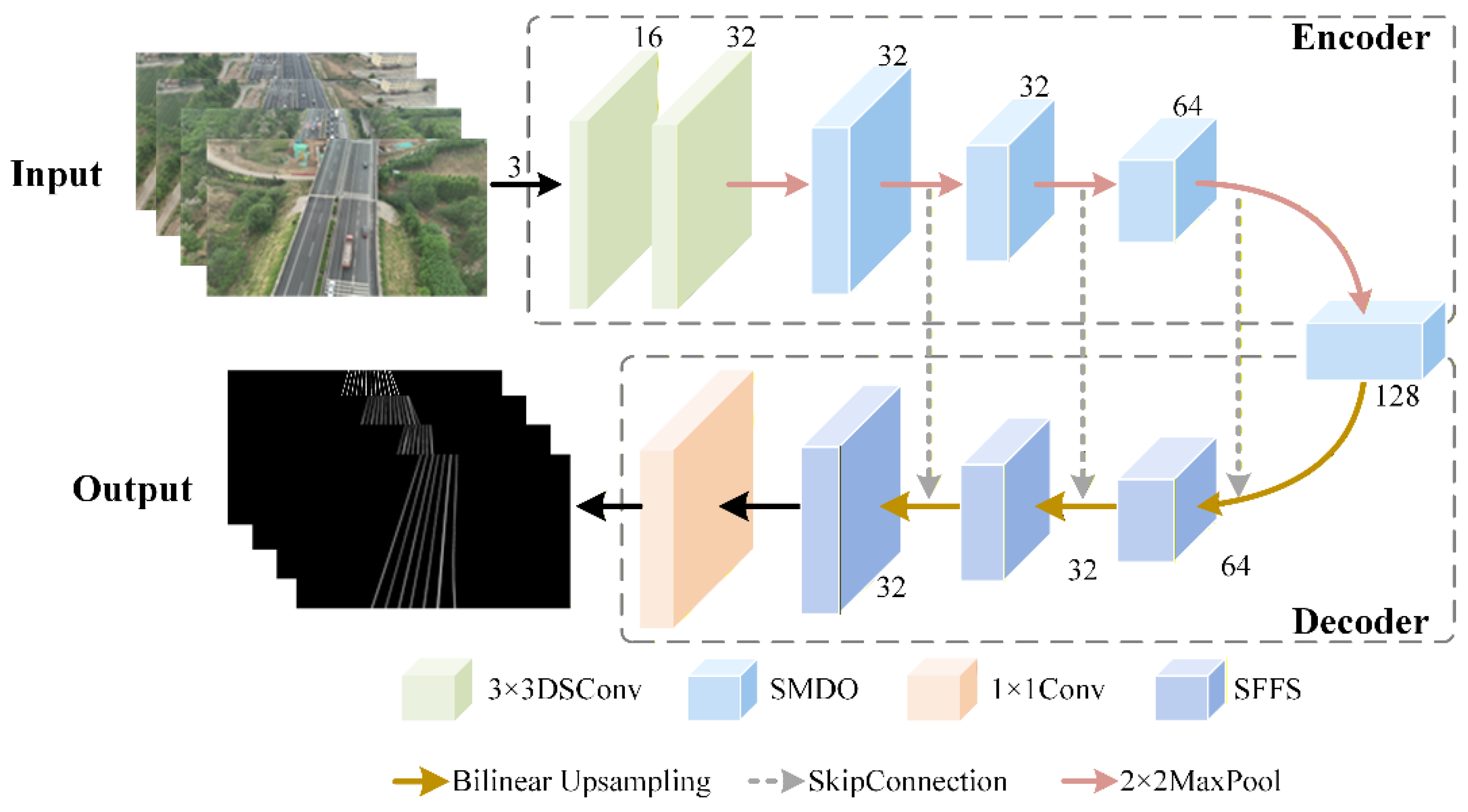
Based on the widely adopted encoder–decoder backbone paradigm for semantic segmentation [49,50,51], the LSLNet model for lane line segmentation in low-altitude UAV images is proposed, the structure of which is illustrated in Figure 2.
Figure 2.
LSLNet lane line semantic segmentation model.
Generally, the proposed LSLNet architecture is composed of an encoder, a decoder and skip connections. Compared with traditional network, the model proposed in this paper employs fewer channels at each layer to reduce the computational overheads of the network. In the early stage of the encoding process, LSLNet adopts two successive 3 × 3 depthwise separable convolutions with Batch Normalization and ReLU, to maintain fine textures and slender boundary cues while keeping the training stable. In the later stages, the strip-aware multi-branch depthwise operator (SMDO) is applied to capture the semantic information of the long, continuous, strip-like features of the lane lines. In the decoder process, bilinear interpolation is employed as the default upsampling method to reconstruct high-resolution details smoothly while maintaining computational efficiency. Subsequently, a Sobel-based feature-fusion scheme (SFFS) is introduced to efficiently conduct the fusion of upsampled decoder features and skip-connected encoder features at a lower computational cost. Finally, a 1 × 1 convolution is applied to produce the lane line prediction map.
3.1. Strip-Aware Multi-Branch Depthwise Operator
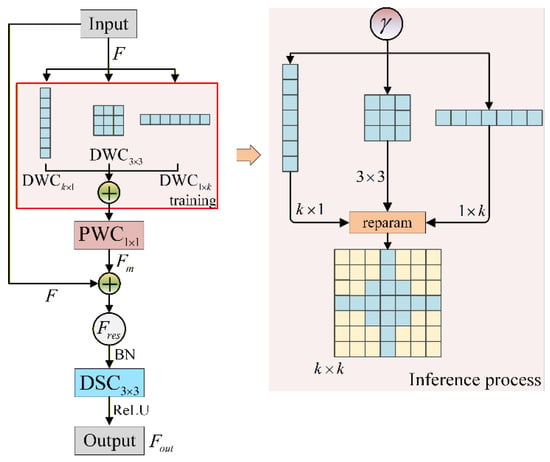
The strip-aware multi-branch depthwise operator (SMDO) employs depthwise convolutional branches with various kernel sizes to capture multidimensional semantic information. During the inference period, the SMDO can reparameterize the distinct depthwise convolutional branches into a single large-kernel convolutional branch to further boost the model’s efficiency. In addition, a depthwise separable convolution is introduced to achieve model lightweighting while compensating for multidimensional semantic information to enhance model stability. The SMDO is illustrated in Figure 3.
Figure 3.
Schematics of the SMDO.
As shown in Figure 3, the input, F, is processed through three parallel depthwise convolutional branches with kernel sizes of 1 × k, k × 1 and 3 × 3, respectively, to capture features at different scales and dimensions. For details, the asymmetric kernels (1 × k and k × 1) are designed to capture horizontal and vertical strip-shaped features of images to form lane line region boundaries. A larger k can expand the directional receptive field but may introduce redundant background responses and higher computational cost. A smaller k may be insufficient to capture long and continuous lane line patterns. In this paper, k is set to 7 by experience to balance feature representation capability and computational efficiency. Meanwhile, the standard 3 × 3 square kernel is used to extract more general local spatial features, providing refined supplements to the lane line regions. The outputs of the three branches are concatenated and processed by a 1 × 1 pointwise convolution, achieving cross-channel heterogeneous feature fusion for the accuracy detection of lane lines. Following the above processing steps, the preliminary multiscale fusion features can be obtained and expressed by Equation (1).
Furthermore, element-wise addition between the multiscale fused feature and the initial input feature, F, is applied to yield the residual connection feature , as shown in Equation (2).
The residual connection expressed by Equation (2) can improve the gradient propagation performance throughout the proposed network and stabilize the training process.
The stacked features, , are further processed through operations as Batch Normalization (BN), a 3 × 3 depthwise separable convolution (DSC3 × 3) and an ReLU activation function. The final output features, , can be expressed by Equation (3).
The operation in Equation (3) can further extract features from the residual feature flow and accelerate model convergence.
Although the aforementioned three parallel depthwise convolutional branches have significant advantages in feature extraction capability, they still bring additional branch scheduling overheads during the inference process. To solve this issue, a structural reparameterization scheme is incorporated into the SMDO. In the training period, the weight, g, is defined to describe the importance of the three different DWC branches in lane line semantic segmentation, expressed by Equation (4).
where is a learnable parameter.
In Equation (4), softmax is a normalization function for guaranteeing and . The computed weights , and represent the weights of the 1 × k, k × 1, and 3 × 3 convolutional kernel branches, respectively.
Finally, the kernels of the three different convolutional branches are reposited to the same location and reparameterized into a single k × k convolutional kernel. The sampling weight of the synthesized kernel, , is calculated by Equation (5):
The weight of synthesized kernel, , expressed by Equation (5), is directly applied to convolve the input features during inference process.
3.2. Sobel-Based Feature-Fusion Scheme
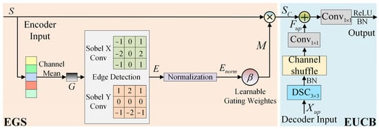
Considering that the Sobel operator can explicitly capture the horizontal and vertical gradient responses of slender lane line boundaries with very low computational cost, a Sobel-based feature-fusion scheme (SFFS) is introduced in the decoding stage to further enhance the capability of LSLNet in lane line boundary detection and multi-channel feature fusion, as shown in Figure 4.
Figure 4.
Schematics of the SFFS.
As shown in Figure 4, the proposed SFFS includes edge-guided skip connection (EGS) and an efficient up-convolution block (EUCB) [52]. In the EGS, the model takes the skip connection feature map, , as the input, where B is the batch size, C is the number of channels, and H and W are the spatial height and width, respectively. For further processing, the multi-channel, S, is converted into a single-channel grayscale image, G, as shown in Equation (6).
The Sobel operator is further used to calculate the strong gradient features in both the horizontal and vertical directions of the image, as shown in Equation (7).
where and are the strong gradient features in horizontal and vertical directions, respectively; represents the convolution operation. By combining the features from both directions, the edge feature map, E, is obtained.
To enhance numerical stability and ensure consistency across samples, min–max normalization is further applied to E and a normalized edge intensity feature map, , is generated, as shown in Equation (8).
where maxh,w and minh,w represent the maximum and minimum operations along the spatial dimensions, respectively. is a small constant introduced to prevent division by zero.
Subsequently, a learnable gating weight parameter, , is introduced to adjust the sensitivity of , and the edge-guided attention mask, M, is generated, as shown in Equation (9).
Finally, in EGS, the input features, S, are weighted by M to obtain the final output skip connection feature map, , as shown in Equation (10).
To mitigate the information loss caused by channel pruning in lightweight network design, the efficient up-convolution block (EUCB) is introduced to fully exploit the plentiful semantic features contained within these limited channels. In EUCB, the channel shuffle is applied to incorporate relationships among channels during upsampling to improve the capability of information exchange between different channels. Taking the upsampled features, , obtained through bilinear interpolation as the input, the enhanced upsampled feature, , can be acquired by Equation (11).
Finally, the and the skip connection feature, , are concatenated and processed by a convolution to reduce the channels to match with the next stage. Subsequently, the BN and ReLU are applied to promote model convergence. The final output of SFFS can be expressed by Equation (12).
4. Lane Line Modeling and Road Region Detection
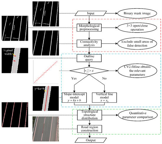
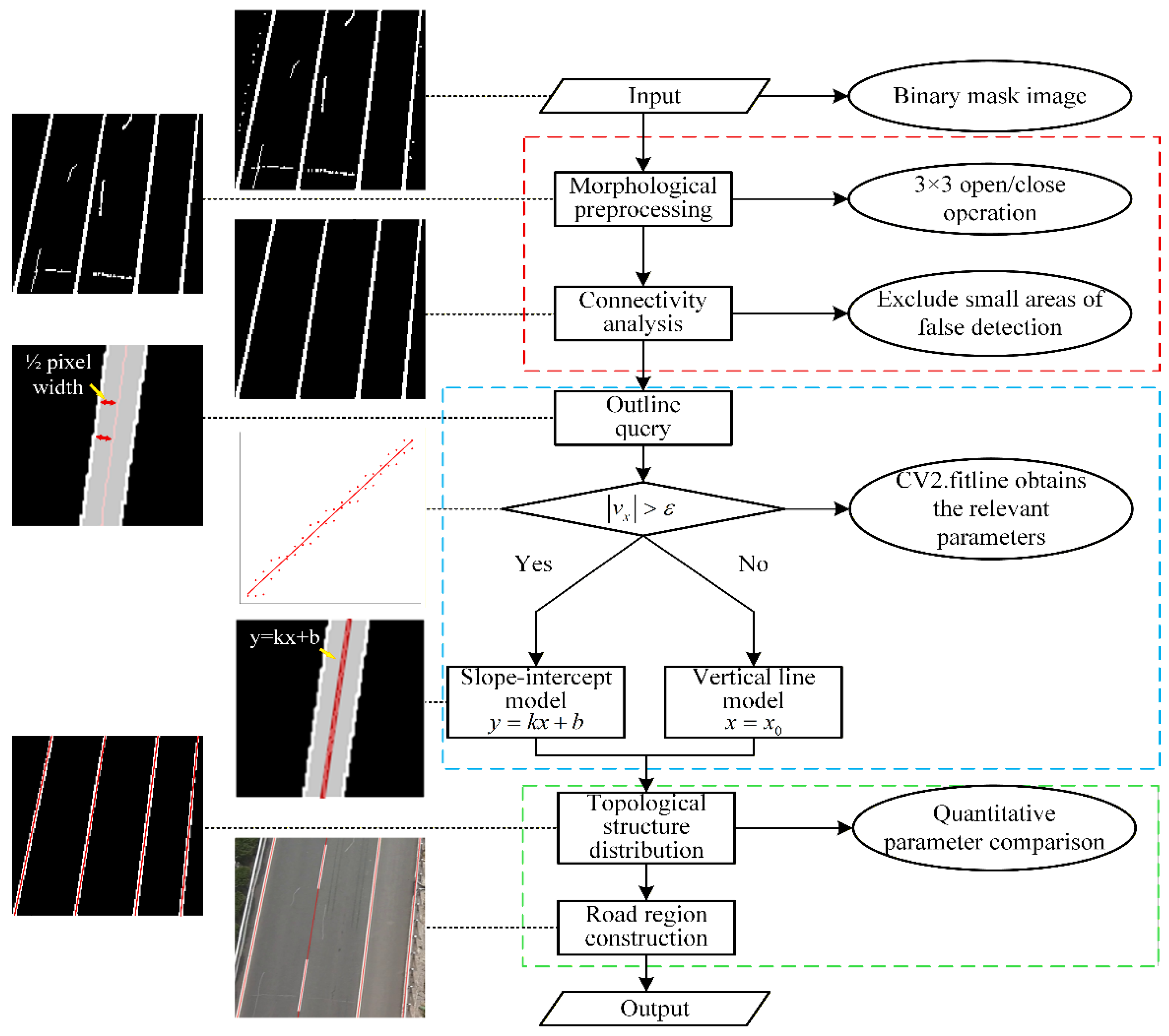
Following the semantic segmentation, lane lines are represented as binary masks composed of dense pixels. The research scenario in this paper is limited to straight road areas, without considering special scenarios such as curves. To support the subsequent lane region extraction, geometric topology of each lane line is modeled using the linear equations or . All lane lines in the image are modeled, and the road region is consequently constructed therefrom. The whole process of lane line modeling and road region detection can be described as shown in Figure 5.
Figure 5.
Flowchart of lane line modeling and road region detection.
4.1. Ablation Experiments and Analysis
Firstly, we take a binarized semantic segmentation mask as the input, where lane line pixels are set as 255 and background pixels are set as 0. To suppress isolated noise and bridge small gaps along the lane line markings, morphological opening and closing are performed sequentially using a 3 × 3 structuring element. Subsequently, connected-component analysis is performed on the processed mask to further remove falsely detected regions where the areas are smaller than a preset threshold. Each remaining component is treated as an individual lane line region and processed independently in the next steps.
Furthermore, the contour pixel points of each individual lane line region are retrieved to fit the region into a linear equation. In general, the distance from each contour pixel points of a lane line region to its fitted center line should be half of the width of the corresponding lane line region. Based on this inherent property of the image, this paper employs the least squares method to fit the contour pixel points. Specifically, considering the contour of each valid region, OpenCV’s is used to estimate a direction vector and a point lying on the best-fit line. When , the line is converted into the slope–intercept form linear equation , where the computation of k and b is given in Equation (13).
For near-vertical cases (), the vertical line form linear equation is adopted.
Subsequently, the spatial distribution and geometric relationships of the derived linear equation in the image are analyzed to further construct a complete geometric model of the road region. For each lane line linear equation, candidate intersections with the four borders , , , and are computed and retained. In general, there are only two intersection points between each linear equation and the image edges. The distribution of all lane lines within the image can be obtained by connecting and sorting the intersection coordinates between each lane line and the image boundaries.
Following the above procedure, each individual lane line region can be encoded as , where denotes the slope and intercept (or the corresponding parameter in the vertical case), and and are the border intersection endpoints. The proposed method characterizes the spatial geometric properties of the lane lines with a small number of floating-point parameters, which effectively enhances the model robustness and parsing efficiency. As illustrated in Figure 5, the recovered straight centerlines align closely with the midlines of lane markings when mapped back to the original UAV imagery, even under slight discontinuities or blurred edges.
4.2. Road Region Detection
Once all lane lines have been quantified as , each single-road region is constructed analytically from a pair of adjacent lane lines and their boundary endpoints. Consider an image of width W and height H, where the top and bottom borders are defined as and , respectively.
Given two adjacent lane lines, and , a quadrilateral polygon that defines the single-road region is then obtained by connecting their boundary endpoints in a consistent order (e.g., clockwise):
For horizontal lane regions, geometric modeling is performed based on the left and right boundary endpoints of lane lines within the image.
By explicitly establishing the association between lane line modeling and the geometric characteristics of road regions, this approach enables the construction of road regions with a well-defined structure and robust topological properties.
The overall pipeline is summarized in Algorithm 1.
| Algorithm 1 Lane line modeling from segmentation masks and single road region construction. |
| Input: Grayscale/RGB lane line mask after segmentation (black background, white lanes) Original UAV image |
| Output: Original Image overlaid with centerlines and single-road regions, Lane list Ln, Road-region list Rn |
|
5. Experiments and Discussion
5.1. Experimental Conditions and Real UAV Datasets
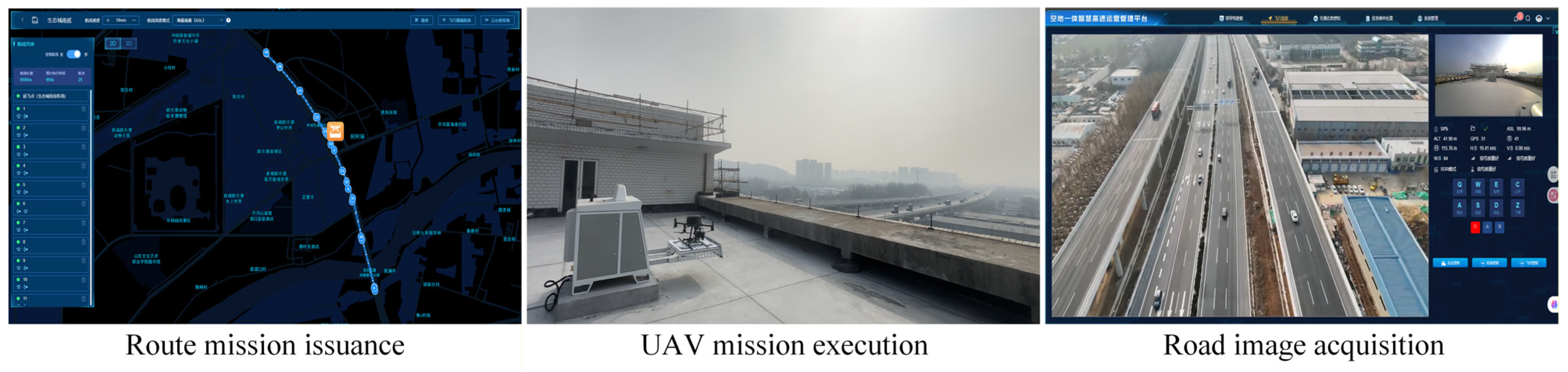
This paper conducts experiments in real highway scenarios located in Shandong Province, China. A DJI M350 UAV (DJI, Shenzhen, China) equipped with AI edge computing terminal is adopted as the experimental device. The UAV flies along a specific flight path issued by the cloud platform. During the cruise, it collects video data of the road and performs real-time lane region extraction on the edge computing terminal.
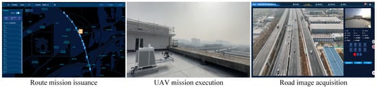
The experimental scenario is shown in Figure 6. In addition, the flight environmental conditions, UAV hardware configurations, edge deployment conditions and computing power configurations are presented in Table 1.
Figure 6.
Experimental scenario. The non-English text shown in this figure is the original content from the UAV control system interface, which is primarily used for formulating UAV flight routes, adjusting flight attitudes and other related operations.
Table 1.
Parameters of the experiment.
Based on the above experimental scenarios and conditions, more than 3000 UAV aerial images were collected; a lane line semantic segmentation dataset named UAV-Laneline3K was built. The scenarios in the dataset include multi-lane straight sections, curves and merge zones with different road markings, and shadow interference. In addition, a dataset of 200 images from 20 different road segments named UAV-Roadregion200 was further created for the verification of road region detection. To ensure the consistency of the comparative experiments, all models were trained and evaluated using 960 × 540 resolution images. This slight non-cropping downscaling scheme preserved both the original aspect ratio of UAV images and the fine lane line details.
In the experiments, five indicators were applied to evaluate the segmentation performance including precision, recall, F1-sCoRe, mean intersection over union (mIoU) and mean pixel accuracy (mPA). The formulations of the indictors are elaborated by Equations (15)–(19).
In Equations (15)–(19), TP denotes the number of pixels that are correctly predicted as lane lines. FP denotes the number of pixels that are incorrectly predicted. FN denotes the number of pixels that are misclassified as background. TN denotes the number of pixels that are correctly predicted as non-lane line regions. n represents the number of categories in semantic segmentation. Precision and recall in Equations (15)–(17) measure the false detections and missed detections of lane pixels. The F1-score in Equation (17) is the harmonic mean of precision and recall, providing a balanced indicator of detection quality.
The mIoU in Equation (18) denotes the average IoU of the lane line region and reflects the overall overlap between prediction and ground truth. The mPA in Equation (19) is the mean of the per-class pixel accuracies for the lane and background, denoting the correctness of pixel-wise classification.
5.2. Lane Line Semantic Segmentation Experiments and Analysis
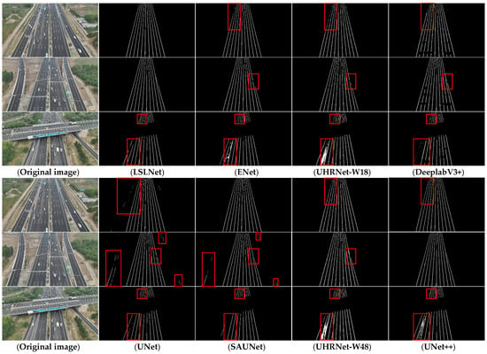
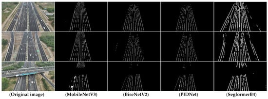
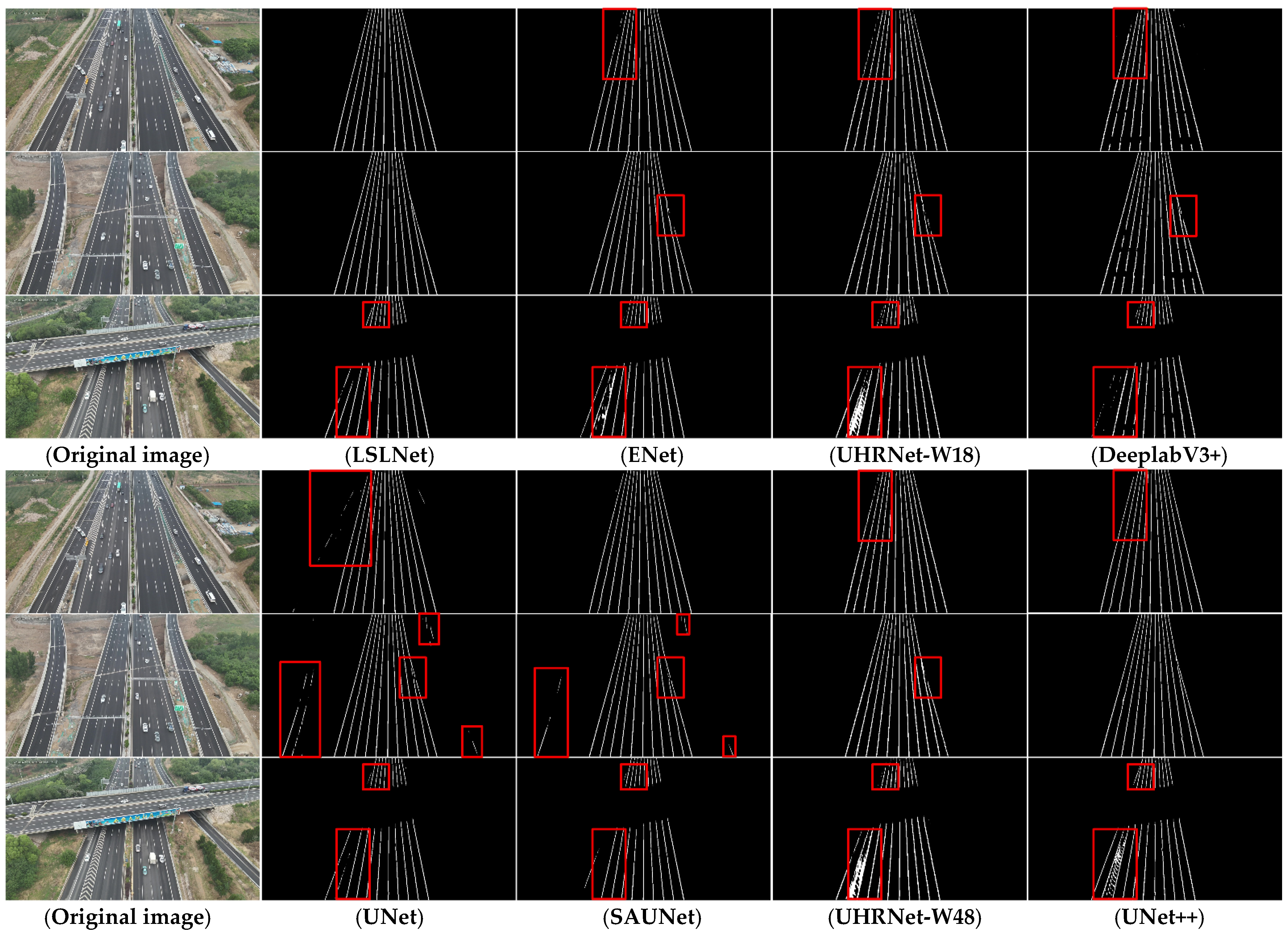
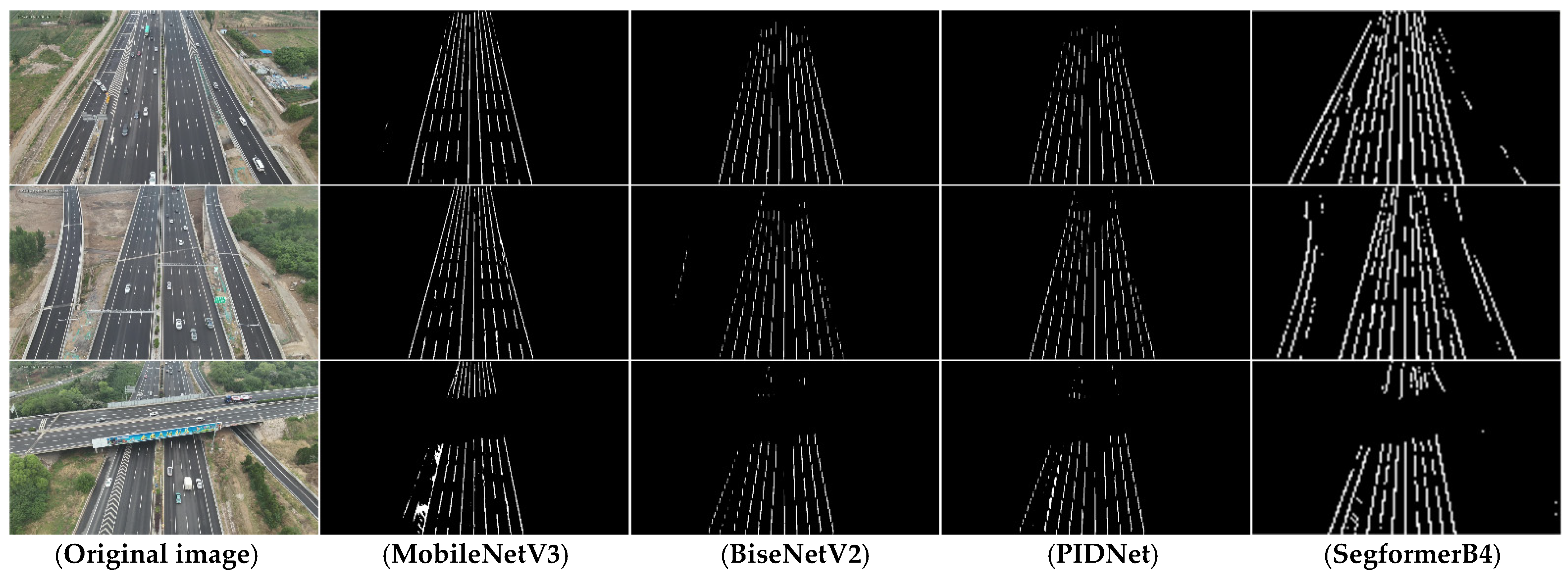
The UAV-Laneline3K dataset is divided into training, validation, and test subsets at a ratio of 8:1:1. Using the dataset, the experiment results of the proposed LSLNet, together with twelve representative semantic segmentation networks for comparation, are presented in Table 2. Correspondingly, partial lane line extraction results are shown in Figure 7.
Table 2.
Experimental results (%) for different semantic segmentation networks.
Figure 7.
Visualization results with the UAV lane line dataset.
In Figure 7, it is noted that the annotations of UAV-Laneline3K are generated according to the target road segments that are consistent with the UAV flight route and the direction of the case road. Therefore, the segmentation scope only covers the road areas along the planned UAV cruising path. The surrounding ramps, crossing roads and other non-target road areas are treated as background. Referring to Table 2 and Figure 7, the LSLNet presents the best performance in lane line semantic segmentation. Owing to the advantages of the targeted lightweight network structure design, the MobileNetV3, BiseNetV2 and PIDNet demonstrate excellent running speed (with FPS all above 250). However, affected by the small lane targets, insignificant contrast and aerial image distortion, these lightweight models suffer from a prominent missing detection issue. While SegFormer can capture the long-range dependency features of lane lines, its excessively strong generalization capability results in spurious detections within non-ROI regions, thereby reducing the accuracy and mIoU of lane line semantic segmentation. In addition, UNet, UNet++, SAUNet and UHRNet-W48 boast higher capabilities in feature extraction and fusion, and have demonstrated favorable lane line segmentation accuracy in experiments. However, these methods are deficient in the detailed description of lane lines and entail high computational complexity (with FPS less than 50), causing difficulties in deploying and implementing edge computing terminals.
The ENet, UHRNet-W18 and DeeplabV3+ achieve an overall balance between semantic segmentation accuracy and computational complexity performance. As shown in Figure 6, lane line discontinuities and spurious responses occurred in the edge areas and the areas with interferences. By contrast, the LSLNet proposed in this paper depicts superior performance in detecting the slender structures of lane lines and capturing the fine-grained details of lane line edges. In addition, it achieves 82 FPS with only 0.09 M parameters and 13.0 GFLOPs. It is noted that although LSLNet has significantly fewer parameters and lower GFLOPs than most compared methods, its FPS is not obviously higher than that of some more complex models, such as DeeplabV3+. This is because FPS is not strictly proportional to the number of parameters or theoretical GFLOPs. In practical inference, the running speed is also affected by the operator type, memory access pattern, kernel launch overhead, GPU parallelism and the optimization degree of different operations in the deep learning framework. Although LSLNet greatly reduces the model size and theoretical computational cost, its internal depthwise separable convolutions, multi-branch operations, bilinear upsampling and Sobel-based feature fusion may affect the actual FPS performance to some extent. From the overall experimental results, LSLNet achieves a better balance among segmentation accuracy, parameter number, computational cost and edge deployment feasibility.
To validate the effectiveness of the proposed SMDO and SFFS modules of LSLNet in semantic segmentation tasks, an ablation experiment is conducted, and the results are summarized in Table 3. In the ablation experiment, the baseline model is the plain encoder–decoder without the proposed modules.
Table 3.
Ablation experiment results (%) on the UAV dataset of LSLNet. ✘ denotes that the module is not incorporated in the baseline, while ✔ denotes that the module is incorporated.
As shown in Table 3, the ablation experiment results show that both SMDO and SFFS modules will improve the segmentation performance compared with the baseline model. For detailed, when only the SMDO module is incorporated, the model’s F1-score increases from 77.89% to 81.08%, the mIoU from 65.13% to 69.96% and the precision from 83.59% to 88.43%. Meanwhile, the number of parameters only slightly increases from 0.08M to 0.09M, and the GFLOPs remain at a comparable level. Although the FPS decreases from 237 to 165 due to the introduction of multi-branch depthwise convolution operations, the model still maintains high inference efficiency. This demonstrates that the SMDO significantly enhances the lane line feature extraction capability and reduces false responses in non-lane line regions with only limited additional model complexity.
While only incorporating the SFFS, the model’s F1-score and mIoU reach 80.72% and 68.87%, respectively, together with higher mPA and recall values. Compared with the baseline model, SFFS introduces a relatively larger computational overhead, with the parameters increasing to 0.18M and the GFLOPs increasing to 29.5, while the FPS decreases to 91. This is primarily because SFFS improves the preservation of thin lane line markings and mitigates the influence of background noise by integrates edge-guided skip connection and efficient up-convolution block.
When both SMDO and SFFS are used simultaneously, the full LSLNet achieves the best segmentation performance as F1-score of 82.73%, mIoU of 72.06% and mPA of 91.16%, with improvements of 4.84%, 6.93% and 3.67% compared with the baseline model, respectively. In terms of efficiency, the full model maintains a compact scale with only 0.09M parameters and 13.0 GFLOPs, while still achieving 82 FPS. Overall, the integration of these two modules significantly improves lane line detection performance by generating a positive synergistic effect. That is, the SMDO enhances the model’s ability in extraction of strip-wise features, whereas the SFFS refines the skip connection encoder features with EGS and fully utilizes the upsampling decoder features with EUCB. Their combination strikes an excellent balance between segmentation accuracy, model complexity, computational overhead and inference speed.
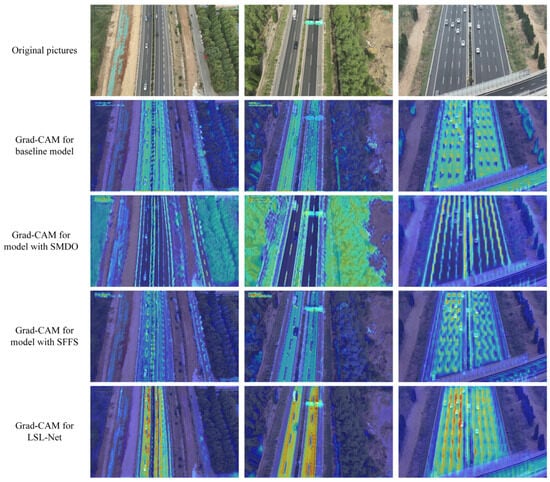
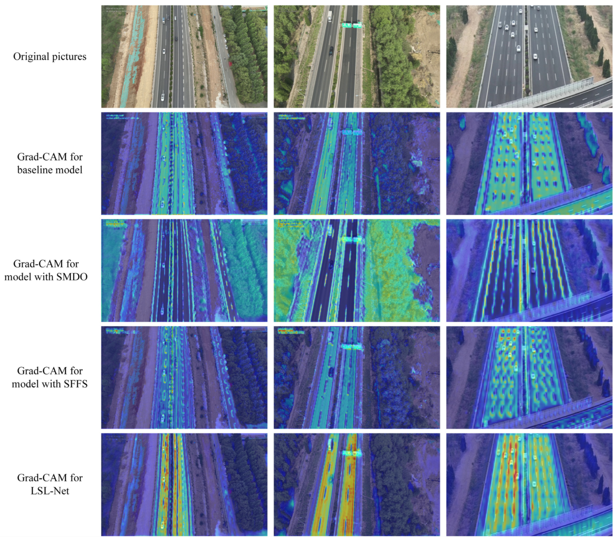
To further validate the effectiveness of the proposed module in LSLNet, the class activation maps (CAMs) of UAV aerial road images are presented in Figure 8. Considering the good capacity in reflecting the model’s attention over lane regions at a high semantic level, the Grad-CAM target stage is selected as the deepest encoder layer in the experiment. Since the spatial resolution of deep feature maps is generally low, the generated heatmaps can only describe a coarse semantic area focus and the overall trend of attention distribution.
Figure 8.
Grad-CAM experiments.
The Grad-CAM analysis results further demonstrate the complementarity of SMDO and SFFS in the semantic segmentation of lane line regions. The SMDO enhances the feature extraction capability for the slender structures of lane lines, enabling the heatmap to exhibit a strip-like distribution. However, it also introduces interference from non-road linear targets such as road edges and medians. Meanwhile, the SFFS enhances and further fuses the skip-connected encoder features with upsampling features, which effectively suppress background interference and concentrate the responses on the areas around the lane lines. The integration of SMDO and SFFS achieve an obvious mutual complementarity of advantages.
In addition, the deployment efficiency of LSLNet on the edge device (NVIDIA Jetson Orin NX) is experimented. The results of reparameterization in the SMDO are presented in Table 4.
Table 4.
Ablation experiment results of reparameterization in the SMDO for edge deployment. ✘ denotes that the reparameterization operation is adopted in SMDO, while ✔ denotes that it is not adopted.
From Table 4, we can see that the reparameterization accelerates the inference speed of the model. The throughput increases from 51.82 qps to 55.76 qps, with a 7.6% improvement. The average latency per frame is reduced from 19.29 ms to 17.96 ms, with a 6.9% reduction. The measured GPU compute time decreases from 19.18 ms to 17.83 ms, with a 7.0% reduction. These gains are obtained with negligible overhead, where the model size grows slightly from 0.923 MiB to 0.960 MiB due to the fused kernel parameters.
5.3. Road Region Detection Experiments and Analysis
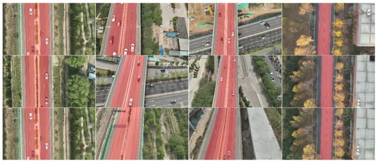
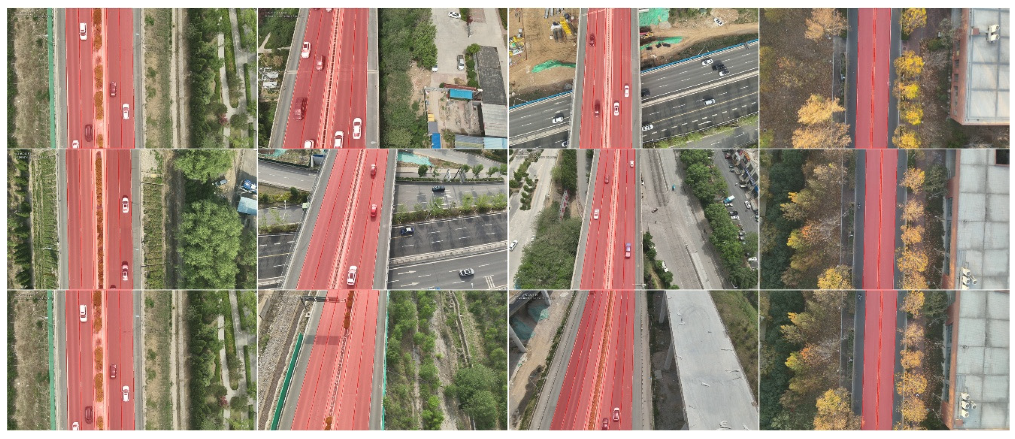
To evaluate the performance of the proposed road-region-detection method, this paper further conducts experiments on the UAV-Roadregion200 dataset. The results of four cases and total 200 samples are presented in Table 5 and Figure 9. These road cases are highly representative, covering a variety of road scenarios, including different aerial photography perspectives, interchange occlusions, roadside environmental interferences and contrast differences induced by light variations.
Table 5.
Experimental results on road region detection for different road sections.
Figure 9.
Visualization of road area detection.
As shown in Table 5 and Figure 9, the proposed method achieves satisfied performance on road region detection, where the mIoU, F1-score, precision and recall are higher than 97%, 98%, 99% and 97% for the four road cases, respectively, and the average indicator values for all 200 samples reach 97.62%, 98.86%, 99.76%, 98.32%, respectively. Especially, road Section 2 yields the best comprehensive performance, demonstrating that the proposed method can detect road regions much more accurately in the scenarios with oblique UAV viewing angles. The reason is that under oblique viewing angles lane lines can be readily fitted to the slope–intercept form equations, which has higher accuracy compared with lane lines in the vertical direction. In addition, although the road region of Section 4 is small (covering only a two-way four-lane area) and the background interferences are abundant, the mIoU still reaches 97.29%, with the F1-score remaining above 98.6%. All these results demonstrate that the method proposed in this paper can accurately detect road regions in complex environments and exhibits favorable robustness.
6. Conclusions and Future Work
This paper proposes a UAV-driven, edge-based lane-detection system for lane line semantic segmentation, modeling, and single-frame road region detection. The proposed lightweight lane line semantic segmentation model, LSLNet, preserves the integrity of slender lane line structures from a UAV viewpoint while meeting the real time requirements of onboard UAV deployment. Meanwhile, based on the predicted mask, the lane line mask regions are further fitted into parametric equations, and a lane level road region with geometric topology is then constructed by analyzing the spatial distribution of lane line positions. Experiments on the UAV-Laneline3K and UAV-Roadregion200 datasets demonstrate that the proposed method achieves efficient lane line semantic segmentation while achieving excellent road region detection accuracy. Overall, this framework provides an effective solution for lane level road scene perception and real time road region detection in UAV-enabled intelligent transportation applications.
However, it should be noted that the current geometric modeling strategy mainly targets straight or approximately straight highway lane line segments under low-altitude UAV views. In these scenarios, lane markings usually present strong linear structures within a single frame, and their centerlines can be efficiently approximated by linear equations. For slightly curved lane markings, the proposed method can still provide an approximate local representation when the curvature within the image is not significant. However, for roads with strong curvature, a single linear equation may be insufficient to accurately describe the lane geometry.
Future work will focus on the following: (1) extending the current linear geometric modeling strategy to polynomial or piecewise curve representations, so as to better handle curvilinear lane geometries and more complex road topologies; (2) integrating temporal and multi-frame fusion to enhance structural continuity and robustness under occlusions, motion blur and viewpoint-induced disturbances.
Author Contributions
Conceptualization, Y.W. and H.L.; methodology, Y.W.; software, Y.W.; validation, Y.W., H.L. and L.Y.; formal analysis, Y.W. and H.L.; investigation, Y.W. and D.M.; resources, L.Y. and M.Z.; data curation, Y.W. and D.M.; writing—original draft preparation, Y.W.; writing—review and editing, Y.W., H.L. and L.Y.; visualization, Y.W. and M.Z.; supervision, Y.W. and H.L.; project administration, H.L., M.Z. and L.Y.; funding acquisition, H.L., M.Z. and L.Y. All authors have read and agreed to the published version of the manuscript.
Funding
The research is partially supported by Shandong Natural Science Foundation Innovation and Development Joint Fund under Grant ZR2024LZN008 and Jinan City’s Self-Developed Innovative Team Project for Higher Educational Institutions under Grant 20233040.
Data Availability Statement
The original contributions presented in this study are included in the article. Further inquiries can be directed to the corresponding author.
Conflicts of Interest
The authors declare no conflicts of interest.
Abbreviations
The following abbreviations are used in this manuscript:
| SMDO | Strip-aware Multi-branch Depthwise Operator |
| SFFS | Sobel-based Feature-fusion scheme |
References
- Zhou, J.; Yu, M.; Guo, Y.; Li, B.; Ying, S.; Li, Z. A high-definition map architecture for transportation digital twin system construction. Int. J. Appl. Earth Obs. Geoinf. 2025, 144, 104822. [Google Scholar] [CrossRef] [Scilit]
- Elghazaly, G.; Frank, R.; Harvey, S.; Safko, S. High-definition maps: Comprehensive survey, challenges, and future perspectives. IEEE Open J. Intell. Transp. Syst. 2023, 4, 527–550. [Google Scholar] [CrossRef] [Scilit]
- Wei, Y.; Mahnaz, F.; Bulan, O.; Mengistu, Y.; Mahesh, S.; Loew, M.A. Creating semantic HD maps from aerial imagery and aggregated vehicle telemetry for autonomous vehicles. IEEE Trans. Intell. Transp. Syst. 2022, 23, 15382–15395. [Google Scholar] [CrossRef] [Scilit]
- Zhang, R.; Kum, L.C.; Wang, H.; Cai, K. Lane marking detection: A survey. IEEE Trans. Intell. Transp. Syst. 2022, 23, 5976–5992. [Google Scholar] [CrossRef] [Scilit]
- Azimi, S.M.; Fischer, A.; Körner, M.; Reinartz, P. Aerial LaneNet: Lane-marking semantic segmentation in aerial imagery using wavelet-enhanced cost-sensitive symmetric fully convolutional neural networks. IEEE Trans. Geosci. Remote Sens. 2019, 57, 2920–2938. [Google Scholar] [CrossRef] [Scilit]
- Guan, H.; Lei, X.; Yu, Y.; Zhao, H.; Peng, D.; Marcato Junior, J.; Li, J. Road marking extraction in UAV imagery using attentive capsule feature pyramid network. Int. J. Appl. Earth Obs. Geoinf. 2022, 107, 102677. [Google Scholar] [CrossRef] [Scilit]
- Lu, X.; Weng, Q. Deep learning-based road extraction from remote sensing imagery: Progress, problems, and perspectives. ISPRS J. Photogramm. Remote Sens. 2025, 228, 122–140. [Google Scholar] [CrossRef] [Scilit]
- Chen, Z.; Deng, L.; Luo, Y.; Li, D.; Marcato Junior, J.; Gonçalves, W.N.; Nurunnabi, A.A.M.; Li, J.; Wang, C.; Li, D. Road extraction in remote sensing data: A survey. Int. J. Appl. Earth Obs. Geoinf. 2022, 112, 102833. [Google Scholar] [CrossRef] [Scilit]
- Gupta, A.; Anpalagan, A.; Guan, L.; Khwaja, A.S. Deep learning for object detection and scene perception in self-driving cars: Survey, challenges, and open issues. Array 2021, 10, 100057. [Google Scholar] [CrossRef] [Scilit]
- Seif, H.G.; Hu, X. Autonomous driving in the iCity—HD maps as a key challenge of the automotive industry. Engineering 2016, 2, 159–162. [Google Scholar] [CrossRef] [Scilit]
- Yan, X.; Lyu, H.; Chen, Z.; Peng, R.; Chen, J.; Zou, J.; Dong, W.; Wang, Q. Real-time remote sensing for sudden surface anomalies: A review of principles and challenges. Space Sci. Technol. 2025, 5, 0362. [Google Scholar] [CrossRef] [Scilit]
- Cheng, J.; Deng, C.; Su, Y.; An, Z.; Wang, Q. Methods and datasets on semantic segmentation for unmanned aerial vehicle remote sensing images: A review. ISPRS J. Photogramm. Remote Sens. 2024, 211, 1–34. [Google Scholar] [CrossRef] [Scilit]
- Byun, S.; Shin, I.-K.; Moon, J.; Kang, J.; Choi, S.-I. Road traffic monitoring from UAV images using deep learning networks. Remote Sens. 2021, 13, 4027. [Google Scholar] [CrossRef] [Scilit]
- Ouyang, J.; Wang, Q.; Shang, Y.; Jin, P.; Zhong, H.; Zhou, L.; Shen, T. An RGB-TIR dataset from UAV platform for robust urban traffic scenes semantic segmentation. Sci. Data 2025, 12, 1701. [Google Scholar] [CrossRef] [Scilit]
- Osco, L.P.; Junior, J.M.; Ramos, A.P.M.; de Castro Jorge, L.A.; Fatholahi, S.N.; de Andrade Silva, J.; Matsubara, E.T.; Pistori, H.; Gonçalves, W.N.; Li, J. A review on deep learning in UAV remote sensing. Int. J. Appl. Earth Obs. Geoinf. 2021, 102, 102456. [Google Scholar] [CrossRef] [Scilit]
- Yu, Y.; Li, Y.; Liu, C.; Wang, J.; Yu, C.; Jiang, X.; Wang, L.; Liu, Z.; Zhang, Y. MarkCapsNet: Road marking extraction from aerial images using self-attention-guided capsule network. IEEE Geosci. Remote Sens. Lett. 2022, 19, 1–5. [Google Scholar] [CrossRef] [Scilit]
- Zhang, Z.; Li, G. UAV imagery real-time semantic segmentation with global–local information attention. Sensors 2025, 25, 1786. [Google Scholar] [CrossRef] [Scilit]
- Han, X.; Liu, Y.; Liu, G.; Lin, Y.; Liu, Q. LOANet: A lightweight network using object attention for extracting buildings and roads from UAV aerial remote sensing images. PeerJ Comput. Sci. 2023, 9, e1467. [Google Scholar] [CrossRef] [Scilit] [PubMed]
- Xiao, R.; Wang, Y.; Tao, C. Fine-grained road scene understanding from aerial images based on semisupervised semantic segmentation networks. IEEE Geosci. Remote Sens. Lett. 2022, 19, 3001705. [Google Scholar] [CrossRef] [Scilit]
- Ling, M.; Cheng, Q.; Peng, J.; Zhao, C.; Jiang, L.; Ranjbarzadeh, R. Image semantic segmentation method based on deep learning in UAV aerial remote sensing image. Math. Probl. Eng. 2022, 2022, 5983045. [Google Scholar] [CrossRef] [Scilit]
- Wang, J.; He, G.; Dai, X.; Wang, F.; Zhang, Y. Vision-based highway lane extraction from UAV imagery: A deep learning and geometric constraints approach. Electronics 2025, 14, 3554. [Google Scholar] [CrossRef] [Scilit]
- Ahmed, S.; Hamza, M.; Khalid, M.H.; Farhat, D. Mobile edge computing. arXiv 2024, arXiv:2404.17944. [Google Scholar]
- Pesonen, J.; Hakala, T.; Karjalainen, V.; Koivumäki, N.; Markelin, L.; Raita-Hakola, A.-M.; Suomalainen, J.; Pölönen, I.; Honkavaara, E. Detecting wildfires on UAVs with real-time segmentation trained by larger teacher models. In Proceedings of the IEEE/CVF Winter Conference on Applications of Computer Vision (WACV), Tucson, AZ, USA, 28 February–4 March 2025; pp. 5166–5176. [Google Scholar] [CrossRef] [Scilit]
- Cheng, Z.; Han, P.; Xiao, X. CENet: Toward concise and efficient LiDAR semantic segmentation for autonomous driving. In Proceedings of the IEEE International Conference on Multimedia Expo (ICME), Taipei, Taiwan, 18–22 July 2022; pp. 1–6. [Google Scholar] [CrossRef] [Scilit]
- Du, J.; Ma, L.; Li, J.; Qin, N.; Zelek, J.; Guan, H. RdmkNet & Toronto-RDMK: Large-scale datasets for road marking classification and segmentation. IEEE Trans. Intell. Transp. Syst. 2024, 25, 13467–13482. [Google Scholar] [CrossRef] [Scilit]
- Liu, Y.; Yuan, T.; Wang, Y.; Wang, Y.; Zhao, H. VectorMapNet: End-to-end vectorized HD map learning. In Proceedings of the 40th International Conference on Machine Learning (ICML), Honolulu, HI, USA, 23–29 July 2023; pp. 22352–22369. [Google Scholar]
- Milli, E.; Erkent, Ö.; Yılmaz, A.E. Multi-modal multi-task (3MT) road segmentation. IEEE Robot. Autom. Lett. 2023, 8, 5408–5415. [Google Scholar] [CrossRef] [Scilit]
- Wang, L.; Huang, Y. LiDAR–camera fusion for road detection using a recurrent conditional random field model. Sci. Rep. 2022, 12, 11320. [Google Scholar] [CrossRef] [Scilit] [PubMed]
- Liu, R.; Wu, J.; Lu, J.; Miao, W.; Zhang, Q.; Liu, H.; Lu, X.; Li, Z.; Li, L. A review of deep learning-based methods for road extraction from high-resolution remote sensing images. Remote Sens. 2024, 16, 2056. [Google Scholar] [CrossRef] [Scilit]
- Wang, X.; Jin, X.; Dai, Z.; Wu, Y.; Chehri, A. Deep learning-based methods for road extraction from remote sensing images: A vision, survey, and future directions. IEEE Geosci. Remote Sens. Mag. 2025, 13, 55–78. [Google Scholar] [CrossRef] [Scilit]
- Ding, T.; Wang, X. DEDU-Net: Dual-encoder-decoder-U-Net for road extraction from high-resolution remote sensing images. Int. J. Remote Sens. 2024, 45, 3231–3247. [Google Scholar] [CrossRef] [Scilit]
- Yang, J.; Gu, Z.; Wu, T.; Ahmed, Y.A.E. RUW-Net: A dual codec network for road extraction from remote sensing images. IEEE J. Sel. Top. Appl. Earth Obs. Remote Sens. 2024, 17, 1550–1564. [Google Scholar] [CrossRef] [Scilit]
- Majidzadeh, A.; Hasani, H.; Jafari, M. Semantic segmentation of UAV images based on U-Net in urban area. ISPRS Ann. Photogramm. Remote Sens. Spat. Inf. Sci. 2023, X-4/W1-2022, 451–457. [Google Scholar] [CrossRef] [Scilit]
- Kurz, K.; Azimi, S.; Sheu, M.; Sheu, C.-Y.; D’Angelo, P. Deep learning segmentation and 3D reconstruction of road markings using multiview aerial imagery. ISPRS Int. J. Geo-Inf. 2019, 8, 47. [Google Scholar] [CrossRef] [Scilit]
- Liu, Z.; Wu, W.; Wang, D.; Cui, B.; Gu, X. Automatic extraction and 3D modeling of real road scenes using UAV imagery and deep learning semantic segmentation. Int. J. Digit. Earth 2024, 17, 2365970. [Google Scholar] [CrossRef] [Scilit]
- Cui, B.; Liu, Z.; Yang, Q. UAV-YOLO12: A multi-scale road segmentation model for UAV remote sensing imagery. Drones 2025, 9, 533. [Google Scholar] [CrossRef] [Scilit]
- Zhou, M.; Sui, H.; Chen, S.; Wang, J.; Chen, X. BT-RoadNet: A boundary and topologically-aware neural network for road extraction from high-resolution remote sensing imagery. ISPRS J. Photogramm. Remote Sens. 2020, 168, 288–306. [Google Scholar] [CrossRef] [Scilit]
- Abdollahi, A.; Pradhan, B.; Alamri, A. SC-RoadDeepNet: A new shape and connectivity-preserving road extraction deep learning-based network from remote sensing data. IEEE Trans. Geosci. Remote Sens. 2022, 60, 5617815. [Google Scholar] [CrossRef] [Scilit]
- Mosinska, A.; Marquez-Neila, P.; Kozinski, M.; Fua, P. Beyond the pixel-wise loss for topology-aware delineation. In Proceedings of the IEEE/CVF Conference on Computer Vision and Pattern Recognition (CVPR), Salt Lake City, UT, USA, 18–23 June 2018; pp. 3136–3145. [Google Scholar] [CrossRef] [Scilit]
- Shit, S.; Paetzold, J.C.; Sekuboyina, V.; Ezhov, I.; Unger, A.; Zhylka, B.; Pluim, J.P.W.; Menze, B.H. clDice—A novel topology-preserving loss function for tubular structure segmentation. In Proceedings of the IEEE/CVF Conference on Computer Vision and Pattern Recognition (CVPR), Nashville, TN, USA, 20–25 June 2021; pp. 16555–16564. [Google Scholar] [CrossRef] [Scilit]
- Sheng, X.; Zhang, J.-Z.; Wang, Z.; Duan, Z.-T. EdgeUNet: Edge-guided multi-loss network for drivable area and lane segmentation in autonomous vehicles. IEEE Trans. Intell. Transp. Syst. 2024, 26, 2530–2542. [Google Scholar] [CrossRef] [Scilit]
- Lu, P.; Cui, C.; Xu, S.; Peng, H.; Wang, F. SUPER: A novel lane detection system. IEEE Trans. Intell. Veh. 2021, 6, 583–593. [Google Scholar] [CrossRef] [Scilit]
- McEnroe, P.; Wang, S.; Liyanage, M. A survey on the convergence of edge computing and AI for UAVs: Opportunities and challenges. IEEE Internet Things J. 2022, 9, 15435–15459. [Google Scholar] [CrossRef] [Scilit]
- Song, Z.; Qin, X.; Hao, Y.; Hou, T.; Wang, J.; Sun, X. A comprehensive survey on aerial mobile edge computing: Challenges, state-of-the-art, and future directions. Comput. Commun. 2022, 191, 233–256. [Google Scholar] [CrossRef] [Scilit]
- Zhou, W.; Min, X.; Hu, R.; Long, Y.; Luo, H.; Yi, J. FasterX: Real-time object detection based on edge GPUs for UAV applications. arXiv 2022, arXiv:2209.03157. [Google Scholar] [CrossRef] [Scilit]
- Jiang, B.; Chen, Z.; Tan, J.; Qu, R.; Li, C.; Li, Y. A real-time semantic segmentation method based on STDC-CT for recognizing UAV emergency landing zones. Sensors 2023, 23, 6514. [Google Scholar] [CrossRef] [Scilit] [PubMed]
- Albanese, A.; Nardello, M.; Brunelli, D. Low-power deep learning edge computing platform for resource constrained lightweight compact UAVs. Sustain. Comput. Inform. Syst. 2022, 34, 100725. [Google Scholar] [CrossRef] [Scilit]
- Zhang, C.; Liu, X.; Yao, A.; Bai, J.; Dong, C.; Pal, S.; Jiang, F. Fed4UL: A cloud–edge–end collaborative federated learning framework for addressing the non-IID data issue in UAV logistics. Drones 2024, 8, 312. [Google Scholar] [CrossRef] [Scilit]
- Ronneberger, O.; Fischer, P.; Brox, T. U-Net: Convolutional networks for biomedical image segmentation. In Medical Image Computing and Computer-Assisted Intervention—MICCAI 2015; Navab, N., Hornegger, J., Wells, W.M., Frangi, A.F., Eds.; Springer: Cham, Switzerland, 2015; Volume 9351, pp. 234–241. [Google Scholar] [CrossRef] [Scilit]
- Badrinarayanan, V.; Kendall, A.; Cipolla, R. SegNet: A deep convolutional encoder-decoder architecture for image segmentation. IEEE Trans. Pattern Anal. Mach. Intell. 2017, 39, 2481–2495. [Google Scholar] [CrossRef] [Scilit] [PubMed]
- Chen, L.-C.; Zhu, Y.; Papandreou, G.; Schroff, F.; Adam, H. Encoder-decoder with atrous separable convolution for semantic image segmentation. In Computer Vision—ECCV 2018; Ferrari, V., Hebert, M., Sminchisescu, C., Weiss, Y., Eds.; Springer: Cham, Switzerland, 2018; Volume 11211, pp. 833–851. [Google Scholar] [CrossRef] [Scilit]
- Rahman, M.M.; Munir, M.; Marculescu, R. EMCAD: Efficient multi-scale convolutional attention decoding for medical image segmentation. In Proceedings of the IEEE/CVF Conference on Computer Vision and Pattern Recognition (CVPR), Seattle, WA, USA, 17–21 June 2024; pp. 11769–11779. [Google Scholar] [CrossRef] [Scilit]

Disclaimer/Publisher’s Note: The statements, opinions and data contained in all publications are solely those of the individual author(s) and contributor(s) and not of MDPI and/or the editor(s). MDPI and/or the editor(s) disclaim responsibility for any injury to people or property resulting from any ideas, methods, instructions or products referred to in the content. |
© 2026 by the authors. Licensee MDPI, Basel, Switzerland. This article is an open access article distributed under the terms and conditions of the Creative Commons Attribution (CC BY) license.