


Highlights
What is the main finding?
- A label efficient Probabilistic SegFormer framework is developed for landslide segmentation in active open pit mines under severe source to target domain shift and limited local annotation.
What is the implication of the main finding?
- The proposed uncertainty guided active learning strategy prioritizes ambiguous mine scenes for expert annotation, supporting trustworthy geohazard monitoring with a small fraction of local labels.
Abstract
Reliable landslide mapping in active mining regions is constrained by two coupled issues: severe domain shift from public datasets and extremely limited local annotations. In line with Transformer-centric intelligent interpretation of complex remote-sensing scenes, this study proposes a label-efficient transfer segmentation framework from a public source corpus to target open-pit mines built on SegFormer with a lightweight hybrid adapter that couples global context modeling with mining-specific directional cues. The pipeline combines source-domain Transformer pre-training, class-conditional feature alignment, Bayesian uncertainty estimation, and human-guided active learning. First, the backbone is pre-trained on the GDCLD source domain to learn transferable landslide morphology priors. Second, a joint optimization stage with class-conditional alignment reduces source and target embedding discrepancy during adaptation. Third, Monte Carlo dropout is enabled at inference to estimate predictive distributions, and sample acquisition is driven by mutual-information-based querying to prioritize epistemically informative target patches, addressing the small-sample supervision challenge emphasized in remote-sensing deep learning. This design turns uncertainty into an operational annotation policy rather than a passive diagnostic output. Experimental results show that the framework consistently outperforms deterministic counterparts and strong active-learning baselines in spectrally complex mine scenes, while approaching the fully supervised upper bound with only a small fraction of local labels. The approach is especially effective in shadowed benches and fault-adjacent slopes, supporting trustworthy deployment for geohazard monitoring and disaster-relevant slope safety workflows; extension to multi-modal constraints (e.g., SAR or elevation) is discussed as future work.
1. Introduction
Landslides and slope instabilities constitute a persistent geohazard exacerbated by climate-intensified rainfall and rapid industrial disturbance, particularly in active open-pit mining environments where continuous excavation destabilizes slopes and reshapes drainage patterns [1,2,3]. Large-scale mining operations compound natural hazard exposure by creating steep terraced slopes, altering hydrological regimes, and exposing fractured lithologies susceptible to progressive failure. Accurate and timely landslide inventory mapping is therefore a cornerstone of modern slope safety management, providing the geospatial evidence required for runout modeling, hazard zone delineation, and emergency response coordination [4,5,6]. Remote sensing from satellite constellations and unmanned aerial platforms has become the dominant data source for such mapping, owing to its broad coverage, multi-temporal revisit capability, and increasingly sub-metric spatial resolution [7,8]. The practical challenge has shifted from data access to robust automated interpretation under complex and spectrally ambiguous terrain conditions.
The introduction of deep learning has substantially advanced automated landslide mapping. Detection-oriented architectures, including models from the YOLO family, deliver rapid coarse localization of hazard zones [9,10,11,12,13,14], but their bounding-box outputs lack the pixel-level resolution required for morphological assessment of failure boundaries. Semantic segmentation models based on convolutional neural networks (CNNs) have consequently been the standard tool for precise delineation [15,16,17,18]. Yet convolutional operations are inherently local, and the receptive field constraints of deep CNNs impede the modeling of long-range spatial dependencies that are critical for distinguishing landslide bodies from spectrally similar surrounding features such as bare excavated soil, haul road surfaces, and shadow-covered benches. Vision Transformer (ViT) architectures address this limitation through their self-attention mechanism, which establishes global context dependencies across an image patch without relying on the sequential neighborhood structure of convolutions [19,20,21,22]. In parallel, the research community has pursued integrated attention enhancements [23,24,25], lightweight designs for large-area processing efficiency [12,26], and hybrid architectures that combine Transformer context modeling with convolutional inductive biases for structurally anisotropic remote-sensing textures [27,28,29,30,31].
Recent remote-sensing interpretation has also moved beyond single-task supervised segmentation toward semantically richer and more robust representation learning. Semantics-aware restoration has been explored for cloud-contaminated optical scenes through STGAN-CR [32]. Open-vocabulary segmentation has been advanced by DGSeg, which uses textual priors and structural guidance to reduce semantic confusion in remote-sensing images [33]. Semantic change detection has likewise benefited from cost aggregation in CAB-SCD, emphasizing that high-level semantics and boundary-sensitive aggregation are increasingly important for practical Earth-observation workflows [34]. These studies motivate our focus on mine scenes where semantic ambiguity, structural discontinuity, and limited labels coexist.
Mining-specific remote-sensing studies further clarify where the remaining gap lies. Jiao et al. combined multi-temporal optical imagery, UAV photogrammetry, laser scanning, and InSAR to monitor landslide evolution and disaster chains in the Xishan mining area, showing the value of multi-source mine hazard monitoring but relying mainly on expert interpretation rather than transferable pixel-level segmentation [35]. Wang et al. integrated ground-based and space-borne radar to reconstruct three-dimensional deformation in the Luanchuan mining area, demonstrating that mining-slope instability can be captured from deformation fields even before obvious failure boundaries appear [36]. Ren et al. used EMANet and FC-CRF to extract open-pit mining areas from high-resolution imagery, confirming that mining scenes benefit from task-specific representation design [37]. Lian et al. further used UAV imagery and an improved YOLO detector for mining landslide identification, improving object-level recognition in complex mine backgrounds [38].
Taken together, existing mine-oriented remote-sensing studies have mainly focused on hazard monitoring, deformation measurement, mine-boundary extraction, or deterministic object detection. What remains underdeveloped is pixel-level landslide delineation under severe source-to-target domain shift, with explicit uncertainty estimates that can guide scarce expert labeling. The research gap addressed here is therefore not merely higher segmentation accuracy; it is label-efficient and uncertainty-aware adaptation from public landslide corpora to spectrally ambiguous open-pit mines under a realistic expert annotation budget.
Despite impressive progress in architecture design, a fundamental limitation remains in operational deployment: the deterministic nature of existing models [39,40,41]. A deterministic segmentation model produces a single, unequivocal prediction for every input pixel, forcing a hard classification decision even in regions of genuine geomorphological ambiguity. In mine environments, such ambiguity arises routinely from shadow-dominated bench edges, freshly disturbed bare earth spectrally indistinguishable from slide debris, and fragmented phyllite masses adjacent to fault traces [41,42]. Models trained on standard benchmark datasets learn to resolve these ambiguities through pattern-matching heuristics that do not transfer reliably to novel mine geometries, generating overconfident but incorrect predictions precisely where the operational stakes are highest. The consequences propagate into downstream geotechnical tasks: erroneous boundary delineation produces incorrect runout estimates, and misclassified bench material distorts volumetric hazard assessments [43,44]. Calibrated uncertainty quantification is therefore not a diagnostic luxury but an operational necessity, enabling safety engineers to distinguish high-confidence predictions from regions requiring targeted expert review.
Compounding the uncertainty problem is the scarcity of annotated training data specific to mine environments. Transformer-based segmentation backbones are data-intensive, yet pixel-perfect annotation of mine imagery demands expert geological interpretation that is time-consuming and costly to obtain at scale. Direct transfer from public natural disaster datasets is impeded by substantial domain shift: coseismic landslides in forested terrain present chromatic and textural signatures fundamentally different from mechanically disturbed iron-ore slopes, and pre-trained representations that rely on vegetation-canopy contrast provide limited generalization to bare-earth industrial settings. Existing approaches including semi-supervised learning [45,46], transfer learning [22,47,48], and augmentation strategies [49] partially address data scarcity but continue to produce single deterministic outputs and make no provision for directing limited expert annotation effort toward the most informative target samples. The joint challenge of domain shift and small-sample supervision under strict labeling budgets constitutes the primary barrier to operational adoption of intelligent landslide segmentation in active mining environments [29,50,51].
Against this background, we propose a label-efficient transfer segmentation framework that treats epistemic uncertainty as the central operational variable rather than a post hoc visualization. The framework is built on a Probabilistic SegFormer backbone with Monte Carlo dropout, extended by a Mining-Aware Dual Attention Adapter (MDAA) that couples channel gating for global terrain context with directional depthwise convolutions for boundary discrimination. Source-domain pre-training on the Globally Distributed Coseismic Landslide Dataset (GDCLD) establishes morphological failure priors; class-conditional Maximum Mean Discrepancy alignment during joint training ensures that foreground and background feature distributions converge across domains without semantic collapse; and mutual-information-based active learning iteratively directs the annotation budget toward target patches with the highest epistemic content, concentrating expert effort precisely where the model lacks knowledge. The present study focuses on optical evidence from GDCLD and high-resolution mine tiles, while the formulation is architecturally compatible with future extension to SAR or elevation modalities as additional input branches. Validation is conducted on the Hainan Iron Mine as the primary target domain, supplemented by a preliminary external mine transfer check.
The main contributions of this work are summarized as follows:
- –
- We construct a Probabilistic SegFormer backbone with Monte Carlo dropout, which produces both mean segmentation and epistemic uncertainty for geomorphologically ambiguous mine scenes without changing the deployment backbone.
- –
- We introduce a lightweight Mining-Aware Dual Attention Adapter, which combines Terrain-Context Attention, directional boundary enhancement, and spatially adaptive fusion to separate landslide debris from excavated benches and shadowed contacts.
- –
- We design a mutual-information-based query strategy with diversity regularization and aleatoric pre-screening, which uses the limited expert budget on informative target patches instead of redundant easy background samples.
- –
- We couple GDCLD source pre-training with class-conditional MMD alignment, which transfers morphology priors to the Hainan Iron Mine while reducing foreground–background semantic collapse during adaptation.
Together, these components constitute a reproducible recipe for label-efficient geohazard mapping in industrial environments with limited local supervision. The remainder of this paper is organized as follows: Section 2 introduces the study area, data, and preprocessing context; Section 3 presents the methodology; Section 4 reports the experimental results; Section 5 discusses implications and limitations; and Section 6 concludes the study.
2. Study Area, Data, and Preprocessing
2.1. Study Area and Mine Scene Context
To evaluate the proposed framework in a complex operational environment, the Hainan Iron Mine (109°33′E, 19°14′N) in Hainan Province, China, was selected as the primary study area. Covering approximately 16 km2, it is a large-scale hematite deposit whose Beiyi pit is currently undergoing a critical transition from open-pit to underground mining. This ongoing transition involves extensive anthropogenic alterations, resulting in highly variable topographical features that pose significant challenges for automated remote-sensing mapping. The study location is shown in Figure 1.
Figure 1.
Location of the Hainan Iron Mine in western Hainan Province, China. The red marker indicates the study mine used as the primary target domain in this work, and the map lines indicate the surrounding administrative and geographic context.
To avoid overlap between subsections, the regional setting, geological background, and mine scene context are summarized together here. The Hainan Iron Mine is a sedimentary–metamorphic hematite deposit in Changjiang County. The Beiyi pit is developed within a synclinal structural setting, and the ore-bearing strata are mainly hosted by dolomite, tremolite–diopside limestone, iron-bearing phyllite, and sericite quartz schist. The north wing generally dips about 60°–80°, whereas the south wing dips about 45°–65°. This geological background is important for image interpretation because fault-controlled fragmentation and lithologic contrasts can produce scarp-like textures even where no recent mass movement has occurred.
The mine is located in a tropical monsoon climate zone where intense weathering and heavy rainfall increase slope-instability risk. The Beiyi pit contains terraced open-pit slopes, exposed iron-rich bare earth, active haul roads, waste-dump surfaces, and abrupt slope-to-vegetation transitions. Major faults, especially F6, F24, and F25, create fragmented and mylonitized rock masses whose image texture can resemble shallow slide debris. In RGB imagery, freshly excavated faces and landslide scarps often share similar color and roughness, so reliable annotation relies on geomorphic context rather than color alone. Experts distinguish failures by checking crown continuity, downslope runout shape, toe accumulation, fracture-line relation, and whether the candidate patch is connected to an active bench cut or a natural mass-movement boundary.
Mine geometric descriptors available in this study. The available mine document supports two verified geometric descriptions. At the structural scale, the Beiyi pit is controlled by the synclinal setting described above, with the north wing dipping about 60°–80° and the south wing dipping about 45°–65°. At the image-interpretable mine scene scale, the working area is characterized by multi-level terraced benches, linear bench crests, haul road ramps, pit-wall shadow belts, waste-dump surfaces, and abrupt bench-to-vegetation contacts. These features provide the geometric context used in annotation and modeling: candidate failures were expected to interrupt the regular bench pattern, show downslope elongation, and terminate in toe accumulation rather than remain parallel to engineered bench lines. Certified mine-design values such as exact bench width, bench height, and local engineered slope angle were not included in the remote-sensing package; therefore, we report the verified structural dips and observable geomorphic descriptors, while avoiding unsupported numerical bench geometry. This limitation is further discussed in Section 5, where we note that future deployment should integrate mine-planning survey records or DEM-derived slope metrics when available.
2.2. Remote-Sensing Datasets
To strictly evaluate the capability of the framework to generalize from data-abundant public domains to data-scarce industrial environments, we organized our data into a source domain (knowledge base) and a target domain (operational testbed).
2.2.1. Source Domain: Globally Distributed Coseismic Landslide Dataset (GDCLD)
Deep learning models are inherently data-hungry. To provide the Probabilistic SegFormer with a robust foundational understanding of general ground failure morphological features, we utilized the GDCLD as the source-domain dataset. The GDCLD is a large-scale repository comprising high-resolution multi-source optical imagery (PlanetScope, GF-6, and UAVs) covering diverse global earthquake events (Luding, Nippes, Hokkaido, Jiuzhaigou, and Milin).
During its construction, the GDCLD underwent a standardized preprocessing pipeline. Raw imagery was converted to 8-bit, cropped into non-overlapping 1024 × 1024 pixel patches, and filtered to remove empty samples to mitigate class imbalance.
Source-domain selection rationale and negative transfer mitigation. A legitimate concern is whether pre-training on coseismic, vegetation-context landslides in GDCLD benefits or harms segmentation of bare-earth mine-slope failures. The risk of negative transfer arises if the source-domain forces the encoder to rely heavily on the green-to-yellow spectral contrast present in forest-canopy disruption scenes, which is entirely absent in the iron-mine target domain.
We address this concern from three angles. First, the shared geomorphological priors are geometry-level, not texture-level: both coseismic and mine-slope failures share elongated, irregular mass outlines with concave crowns, internal fracture traces, and diffuse toes—features encoded in shape channels of Transformer attention heads and largely independent of surface color. Second, the MMD-based domain alignment (Equation (6)) operates at the decoder embedding level, regularizing feature distributions while preserving class separation through conditional alignment. Third, the active learning loop provides targeted mine-specific counter-examples: high-Uepi patches in early rounds are precisely the bare-earth mine regions that deviate most from source-domain textures, so expert labels suppress spurious forest-canopy priors over successive rounds. In comparison to generic large-scale remote-sensing pre-training (e.g., SEN12MS), GDCLD offers a practical advantage in failure-mask shape statistics: its pixel-level polygon labels provide direct supervision for mass geometry, whereas generic scene classification datasets offer no such landslide-shape signal. For this reason, the evaluation emphasizes main-text comparisons among deterministic transfer, random querying, Bayesian querying, and the proposed uncertainty-guided strategy.
2.2.2. Target Domain: Hainan Iron Mine Dataset
The primary objective of this study is to deploy the model in a real-world mining scenario where expert-annotated data is severely limited. For this target domain, we constructed a specialized, small-scale dataset using high-resolution imagery covering the Hainan Iron Mine.
In stark contrast to the GDCLD, landslide events within the Hainan Iron Mine occur in an active industrial environment, introducing fundamentally different and more complex recognition challenges. Through prolonged mining operations, the surface soil has been subjected to massive mechanical disturbances and continuous exposure. Consequently, soils from various strata exhibit a high degree of similarity in color, texture, and spectral characteristics. When a slope failure occurs in this environment, the newly displaced soil is visually almost indistinguishable from the adjacent bare earth exposed by routine excavation, entirely lacking the distinct color contrast found in forested datasets. Furthermore, the mine surface is cluttered with complex anthropogenic features, such as haul roads, waste dumps, and active extraction faces. These operational artifacts severely compound the difficulty of delineating true landslide boundaries. Therefore, while models may perform exceptionally well on the GDCLD, their performance often degrades sharply when confronted with the high intra-class variance and low inter-class separability of the Hainan Iron Mine. This necessitates a framework with far stronger feature extraction and contextual reasoning capabilities.
Due to the significant domain gap between natural coseismic landslides in the GDCLD and anthropogenically altered mining slopes in the Hainan Iron Mine, direct model transfer typically yields suboptimal results. The GDCLD serves as an ideal baseline for evaluating general segmentation architectures due to its high spectral contrast and standardized patching. In contrast, the Hainan dataset represents a highly challenging, real-world operational scenario requiring advanced morphological understanding. This dual-dataset evaluation comprehensively tests the robustness of our framework across distinct geological and spectral conditions. In our experimental design, the vast majority of the Hainan Iron Mine dataset is treated as an unlabeled pool. We leverage the epistemic uncertainty quantified by the Probabilistic SegFormer to actively select only the most informative and challenging patches from this mine dataset. These few selected patches are then annotated by experts and mixed with the GDCLD source data during the iterative refinement loops. At this point, the mixing strategy is presented as a design intention: it is expected to improve data efficiency by concentrating annotation on target domain patterns that the source-pre-trained model does not understand. Its empirical effect is evaluated later in Section 4.5 through matched active-learning and random sampling comparisons.
Annotation quality and ambiguity control. Pixel-level labels were interpreted by expert annotators familiar with mine geomorphology and high-resolution remote sensing, using both local image texture and broader mine scene context. Freshly excavated faces were not labeled as landslides solely because of bright exposed soil; annotators additionally checked crown-like initiation boundaries, downslope continuity, runout accumulation, relation to mapped faults, and whether the feature interrupted the normal bench geometry. Three recurring interpretation cases were used during quality control. First, bright exposed bench faces with straight crest lines, ramp-parallel boundaries, and no downslope toe were kept as background even when their color resembled slide debris. Second, rough bare-earth patches were labeled as landslides only when an arcuate or crown-like head, continuous downslope body, and depositional toe could be jointly identified. Third, shadowed bench walls and road-edge micro-failures were marked conservatively because they are the dominant source of low-precision boundary pixels and missed small failures. Such errors mainly affect boundary IoU and recall, and they can also increase apparent epistemic uncertainty because the model receives inconsistent supervision. The same ambiguity types are examined later in the qualitative and uncertainty analyses; therefore, we interpret small residual errors along bench contacts cautiously and emphasize uncertainty-guided expert review as a way to expose, rather than hide, ambiguous labels.
3. Methodology
This section formulates the proposed method as a data-efficient transfer learning problem between source data and target mines with domain regularization. Let denote the source domain (GDCLD) with abundant labels and denote the unlabeled target domain (Hainan mine). Only a small budget can be annotated in the target domain. The objective is to learn a segmentation model that maximizes target domain performance under this strict annotation constraint while limiting feature distribution mismatch.
Our framework integrates three tightly coupled modules. Transfer initialization pre-trains the SegFormer backbone on to obtain morphology-aware prior knowledge of slope failure geometry. Probabilistic inference activates dropout at test time to estimate a posterior predictive distribution over segmentation outputs. Uncertainty-guided querying then selects the highest-value target samples for expert labeling and performs mixed source-and-target refinement to assimilate mine-specific patterns. This design ensures that each additional annotation provides measurable information gain, directly addressing the limited-sample constraint of mine deployment.
For readability, the workflow can be understood intuitively as a four-step loop. First, the model learns generic landslide shapes from a large public dataset. Second, it is shown mine images and asked not only “what is landslide?” but also “where am I unsure?” Third, uncertain but non-redundant mine patches are sent to experts for annotation. Fourth, the model is updated with these targeted labels while retaining the source-domain morphology prior. The mathematical components below formalize these four operations rather than introducing independent modules.
3.1. Formal Problem and Round-Wise Optimization
To make the methodology fully reproducible under a strict annotation budget, we explicitly define the round-wise optimization target. At active round r, let be the cumulatively labeled target set and the model parameters after round r training. The optimization objective is
where ωr gradually increases with the target supervision ratio, λalign controls source-target feature alignment strength, and γ controls parameter drift to mitigate catastrophic forgetting of source-domain morphology priors.
Maximum Mean Discrepancy alignment. Rather than matching only first-order moments, which cannot detect differences in distribution shape, we adopt Maximum Mean Discrepancy (MMD) [52] as the alignment loss. MMD is defined in the reproducing kernel Hilbert space (RKHS) associated with a kernel as
Expanding the squared norm in via the reproducing property , the squared MMD admits the kernel trick representation:
Theorem 1.
If k is a characteristic kernel (e.g., the RBF kernel ), then if and only if .
Proof sketch.
The characteristic property holds because the RKHS of the RBF kernel is dense in (continuous functions on a compact ) by the Stone–Weierstrass theorem. Consequently, if the mean embeddings coincide, i.e., as elements of , then for every . Since is dense in , this extends to all bounded continuous test functions, which characterizes equality of distributions. By contrast, the previous L2 mean loss is equivalent to MMD2 with the non-characteristic linear kernel ; it aligns only first-order moments and is blind to differences in variance, skewness, and multi-modal structure—a critical deficiency when GDCLD forest-canopy collapse patterns are transferred to iron-mine bench-slope textures. □
Semantic misalignment risk and class-conditional upgrade. A valid concern with global marginal MMD (aligning against ) is that it treats all decoder embeddings indiscriminately. In our geotechnical setting, GDCLD embeddings contain both landslide foreground and vegetated background. Forcing these to align globally with Hainan Iron Mine embeddings risks mapping mine bench (background) representations onto source landslide (foreground) clusters—the precise semantic collapse that would destroy class discriminability. To prevent this, we upgrade to class-conditional MMD (CMMD), which aligns against independently for each class (background, landslide). Class-conditional alignment guarantees that landslide embeddings are mapped to landslide embeddings and background to background across domains.
For the source batch we have ground-truth labels. For the unlabeled target batch we generate soft pseudo-labels from the current model’s mean prediction and retain only high-confidence samples to suppress pseudo-label noise:
where τc is a class-specific confidence threshold (τbg = 0.80, τls = 0.70; lower for the minority landslide class to avoid empty batches). The class-conditional MMD alignment loss is then:
where , , are decoder-level RBF kernel evaluations, and is the inverse source-domain class frequency to counter class imbalance. Following [53], we use a multi-scale RBF mixture with to avoid bandwidth sensitivity.
Theoretical motivation. Minimizing class-conditional MMD encourages and to coincide in the decoder embedding space for each c, which mitigates the semantic-collapse risk of marginal alignment. Domain adaptation theory [54] bounds target risk by a sum of source risk, a domain discrepancy term, and an ideal joint error. We use the following schematic form for intuition (the classical statement uses -divergence rather than MMD):
where denotes a distribution discrepancy and is the error of an ideal joint classifier on both domains. Our implementation minimizes a weighted sum of class-conditional MMDs as a practical surrogate for d; it does not instantiate the bound verbatim. The confidence-gated pseudo-label strategy limits corruption of when the classifier is least reliable.
The budgeted acquisition process is constrained by
This formulation links model design, query policy, and annotation economics into one closed optimization view, which is essential for top-tier geoscience AI reporting under low-data industrial conditions.
3.2. Overview of the Probabilistic Active Learning Workflow
As illustrated in Figure 2, the workflow operates as a closed loop between model and expert annotator. The overlaid panel tags denote four stages in the same pipeline. In Stage A, SegFormer is trained on GDCLD to establish transferable failure-feature representations that encode slope morphology priors. In Stage B, Monte Carlo inference is run over all unlabeled mine patches to produce per-pixel epistemic uncertainty maps. In Stage C, candidate patches are ranked by mutual-information score and the top-k samples are submitted to an oracle annotator for labeling. In Stage D, the model is retrained on with balanced batch sampling, absorbing local mine characteristics while preserving source-domain morphological generalization. Compared to single-stage fine-tuning, this iterative protocol concentrates annotation effort on the highest-uncertainty regions and reduces negative transfer in heterogeneous mine scenes.
Figure 2.
Overview of the proposed domain-regularized Probabilistic SegFormer framework. (Left) Source-domain imagery (GDCLD) and target domain imagery (Hainan Iron Mine) are input to the backbone. (Center) Four MiT encoder stages with Mining-Aware Dual Attention Adapters extract multiscale features; the decoder aggregates them under domain alignment regularization and the composite loss . Monte Carlo dropout is active during all T inference passes. (Right) Predictive outputs are decomposed into total, aleatoric, and epistemic uncertainty through mutual information; top k epistemically informative patches are queried by an expert annotator and fed back into joint source and target retraining.
Under this setting, uncertainty plays a dual role: it is both a reliability indicator and a data acquisition signal. High-uncertainty regions usually coincide with domain-specific complexity (e.g., fault-induced fragmentation, bench shadows, and excavation artifacts), making them ideal candidates for incremental annotation.
3.3. Backbone Architecture: The Position-Agnostic SegFormer
SegFormer [55] is selected as the backbone because its architecture aligns well with the characteristics of mine imagery, including large intra-scene scale variation, irregular mass boundaries, and frequent spectral confusion between adjacent land-cover types. Two architectural properties are particularly important for label-efficient transfer. Its hierarchical Mix Transformer (MiT) encoder outputs multi-resolution features at strides of 1/4, 1/8, 1/16, and 1/32, enabling simultaneous modeling of local edge details at fine scales and global slope context at coarser ones. Additionally, the Mix-FFN replaces fixed absolute position embeddings with implicit positional cues introduced through depthwise convolution, improving robustness to varying tile sizes and sensor resolutions that arise when adapting from GDCLD to mine imagery. The Mix-FFN operation is:
A lightweight all-MLP decoder aggregates these features with limited computational overhead, which is important because probabilistic inference requires repeated forward passes.
3.4. Mining-Aware Attention Adaptation
Meaningful architectural novelty in remote sensing should be grounded in the physical properties of the target scene rather than generic attention modifications. Mining landslide images present three jointly occurring challenges that motivate a domain-specific adapter. First, freshly collapsed slope materials are spectrally similar to the exposed excavation soil on adjacent benches, producing low inter-class separability that misleads appearance-based classifiers. Second, man-made structures such as bench terraces, haul roads, and step-cut slopes introduce strong directional textures at multiple orientations, so isotropic convolutional filters insufficiently capture the anisotropic boundary cues. Third, cast shadows from high bench walls and fracture traces in fault-adjacent rock blur the geomorphic transitions that define actual failure boundaries. To address these properties jointly, we insert a lightweight Mining-Aware Dual Attention Adapter (MDAA) after each MiT encoder stage output, as illustrated in Figure 3.
Figure 3.
Architecture of the Mining-Aware Dual Attention Adapter (MDAA). (a) The MDAA contains two parallel branches: the Terrain-Context Attention (TCA, top, teal) applies global average pooling and channel-wise MLP gating to suppress spectral confusion in homogeneous pit zones; the Boundary-Enhancement Attention (BEA, bottom, orange) uses directional depthwise convolutions (1 × 3, 3 × 1, 3 × 3) followed by a spatial attention mask to sharpen ambiguous slope-to-bench transitions. Branch outputs are merged by single-channel spatial gating maps (from 1 × 1 convolutions on concatenated features), broadcast over C and yielding . Pixel-wise gating allows strong boundary emphasis at fault traces and strong context suppression on flat benches within the same image tile. (b) One MDAA is inserted after each of the four MiT encoder stages before features are forwarded to the All-MLP Decoder.
Figure 2 and Figure 3 depict different levels of the same architecture rather than different SegFormer variants. Figure 2 is a workflow-level schematic that simplifies the MiT encoder for source-to-target active learning, whereas Figure 3 zooms into the MDAA block inserted after each MiT stage. The backbone, decoder, and inference protocol are identical across both figures.
3.4.1. Terrain-Context Attention (TCA) Branch
The TCA branch enhances long-range contextual discrimination for spectrally confusing areas. Given feature map , channel attention is computed as:
where GAP is global average pooling and ⊙ is channel-wise multiplication. To preserve mine-scale context, we further apply window-shift self-attention on and fuse it with a residual path.
3.4.2. Boundary-Enhancement Attention (BEA) Branch
The BEA branch targets ambiguous slope boundaries. We first construct a morphology-sensitive response using directional depthwise convolutions (1 × 3, 3 × 1, 3 × 3):
then generate a spatial attention mask:
This branch highlights weak landslide-to-bench transitions and suppresses shadow-induced false responses.
3.4.3. Dual-Branch Fusion with Spatial Gating
A global scalar weight is spatially invariant, applying the exact same contribution across the entire H × W feature map. Mine images are geomorphologically heterogeneous: a single tile may contain a fault-adjacent boundary that requires strong edge enhancement and a flat bench interior that benefits from global context suppression. To resolve this spatial mismatch, we replace scalar weights with spatial gating maps generated by lightweight 1 × 1 convolutions:
where denotes channel concatenation, each has a single output channel, σ is the sigmoid, and broadcast across C when multiplied with . The spatially adaptive fusion is:
where ⊙ denotes element-wise multiplication. Each spatial location receives independently learned weights, allowing the terrain-context branch to dominate on homogeneous bench regions and the boundary-enhancement branch to dominate along fracture and fault traces. The two additional 1 × 1 convolutions each introduce only parameters per stage (C is the channel dimension), negligible relative to the MiT backbone. This design preserves parameter efficiency under limited target annotations while removing the spatial invariance flaw of the previous scalar formulation.
3.5. Probabilistic Modeling via Bayesian Approximation
Deterministic networks output a single confidence score that is often miscalibrated in out-of-distribution mine conditions. We therefore approximate Bayesian inference using MC Dropout: keep dropout active at inference and sample multiple stochastic predictions from an approximate posterior over weights. In implementation, stochasticity is applied to both the MiT blocks and the MDAA branches so that uncertainty estimation reflects backbone-level and mining-adaptation-level epistemic variability. Figure 4 illustrates the full decomposition pipeline and its role in active query selection.
Figure 4.
MC Dropout uncertainty decomposition for BALD-guided active learning. T stochastic forward passes yield per-sample predictive distributions . Total uncertainty (purple) is separated into the aleatoric component (orange, irreducible sensor/shadow noise) and the epistemic term (blue, BALD mutual information). Only high- patches are queried; high-, low- patches are discarded, preventing noise-driven annotation waste. Check marks indicate candidates retained for expert querying, whereas crosses indicate noise-dominated candidates filtered out before annotation. Label-efficiency comparison across query strategies.
3.5.1. Dropout as Variational Inference
Let W denote network weights and denote the dropout-induced variational distribution. Training with dropout and weight decay corresponds to minimizing a variational objective:
where is a prior and with . In practice, the optimization is implemented as:
This interpretation provides the theoretical basis for uncertainty estimation without modifying the core SegFormer architecture.
3.5.2. Stochastic Inference and Uncertainty Metrics
For each input X, we run T stochastic passes and obtain:
The mean prediction (Bayesian model averaging) is:
To avoid ambiguity, we explicitly separate total uncertainty, expected data uncertainty, and epistemic uncertainty. Predictive entropy is the total uncertainty:
Expected per-sample entropy (aleatoric-related component) is
The epistemic term is estimated by BALD-style mutual information:
Only Uepi is used for active querying, which suppresses noisy high-entropy pixels dominated by aleatoric artifacts.
Theoretical limitation of BALD under severe domain shift (OOD). The BALD decomposition is theoretically well founded under the assumption that the model has accurately characterized the aleatoric noise distribution of the target data. In strictly in-distribution (IID) settings this assumption is satisfied. However, when target mine patches constitute heavily out-of-distribution (OOD) inputs relative to the source-pre-trained model, MC Dropout may simultaneously inflate both Utotal and Ualea, because the model has no reliable aleatoric estimate for novel textures it has never encountered. In this degenerate case, the subtraction may underestimate Uepi—or, paradoxically, produce patches where very high Ualea (sensor noise from mine dust) masks moderate Uepi (genuine model ignorance about pit geometry), causing the acquisition function to skip genuinely informative OOD samples in favor of purely noisy ones.
Practical mitigation: Expected calibration pre-screening. To guard against this failure mode, we introduce a two-stage query filter. In stage 1, patches with Utotal above a per-round 95th percentile are inspected: if their Ualea/Utotal ratio exceeds 0.85, they are flagged as aleatoric-dominated and excluded from the candidate set. This filters extreme OOD noise artifacts (e.g., heavy equipment reflections, motion blur) that are high-entropy but informationally vacuous. In stage 2, the remaining candidate pool undergoes standard BALD ranking. The ratio threshold 0.85 is selected on round-1 validation to ensure that fewer than 5% of excluded patches contain annotatable landslide structure, as confirmed by expert visual inspection. We acknowledge that a more rigorous solution would involve an Evidential Deep Learning (EDL) framework [56], which assigns explicit Dirichlet concentration parameters to the class simplex and provides a theoretically distinct vacuity measure for OOD detection. We adopt EDL as a future-work direction, and note that the current two-stage filter empirically approximates its behavior within the MC Dropout framework without requiring architectural changes or additional training complexity.
3.6. Uncertainty-Based Acquisition Strategy: A Greedy Optimization Approach
Given an annotation budget, query selection is formulated as budgeted information maximization. For each candidate patch , utility is defined by pixel-level mutual-information averaging:
where is Shannon entropy. The query step is:
Assuming equal per-patch annotation cost, the optimal solution is obtained by greedy top-k ranking:
Hence, scarce expert effort is concentrated on the long-tail target patterns that dominate failure cases in mining deployment. To avoid selecting redundant patches from spectrally similar adjacent benches, we add a diversity regularizer at query time. A naive subtraction of cosine similarity from epistemic uncertainty is dimensionally inconsistent: (mutual information, in nats) and cosine similarity (unitless, bounded in ) operate on entirely different dynamic ranges, making a static hyperparameter η both scale-fragile and uninterpretable. We resolve this by min–max normalizing both terms within the candidate pool at each round before combination.
Let denote the -normalized pooled decoder embedding of a patch, and let be the already-selected set in the current round. Define the normalized epistemic score:
and the normalized dissimilarity from the current selected set:
where prevents division by zero and measures dissimilarity from the current selected set. The final acquisition score is:
where λ is a single interpretable hyperparameter with a clear physical meaning: λ = 0 reduces to pure epistemic querying; λ = 1 reduces to a pure diversity strategy equivalent to Core-Set; and intermediate values balance informative and representative sampling. We fix λ = 0.3 for all experiments, selected by held-out validation on round 1. Pairwise similarity search has naive complexity ; we reduce this to via an approximate nearest-neighbor index (FAISS flat-) without measurable accuracy loss in the embedding space.
Remark 1
(convergence and stability). Each round reduces uncertainty in previously underrepresented target regions. With cumulative target supervision and source-target mixed training, the effective hypothesis space shrinks around decision boundaries relevant to the mine domain. Empirically, this process converges faster and more stably than random querying under the same budget.
The complete source-to-target active-learning procedure is summarized in Algorithm 1.
| Algorithm 1 Source-to-target active learning via greedy epistemic information gain |
|
3.7. Optimization Objective
Because landslide pixels are sparse and boundary ambiguity is high, we use a composite loss:
where and balance overlap quality and hard-sample discrimination.
where and are the predicted probability and ground truth for pixel i.
where is the probability of the true class, and γ is the focusing parameter. This composite objective ensures that the Probabilistic SegFormer effectively learns from both the abundant source data and the sparse but highly informative target samples provided by the active-learning loop. In joint refinement, mini-batches are sampled from both source and queried target sets to stabilize transfer and mitigate catastrophic forgetting. To further strengthen boundary quality in mine scenes, we include an auxiliary boundary loss :
where is computed between predicted boundary logits and morphological edge labels derived from ground-truth masks. This term encourages sharper delineation in bench-shadow transition areas.
3.8. Control Experiments and Baselines
To rigorously validate the efficacy of the proposed framework, we designed a comprehensive suite of control experiments and baseline comparisons. These experiments are strategically structured to disentangle the performance gains derived from the Transformer architecture from those attributable to the proposed Bayesian active-learning methodology. The complete experimental configuration is summarized in Table 1.
Table 1.
Summary of the experimental setup, including the main source-to-target transfer workflow, baseline models, and ablation studies.
To benchmark against the established state-of-the-art in remote-sensing segmentation, we employed two widely adopted CNNs: U-Net [57] and DeepLabV3+ [58]. For active learning, we compare not only with Random Sampling but also with representative competitive strategies (Core-Set, VAAL, and BALD) under matched annotation budgets. Beyond architecture-level comparisons, we introduce targeted ablations for the proposed mining-aware design: (i) w/o TCA branch, (ii) w/o BEA branch, (iii) w/o diversity-aware query scoring, and (iv) w/o boundary auxiliary loss. These controls isolate the contribution of each module under identical annotation budgets and provide a stronger causal argument expected by top-tier journals.
4. Experiments and Results
This section presents a multi-dimensional evaluation of the proposed framework on the Hainan Iron Mine dataset. Experiments are organized around four complementary dimensions: (i) quantitative comparison with CNN and Transformer baselines, (ii) label-efficiency analysis across active-learning rounds, (iii) ablation study isolating individual module contributions, and (iv) hyperparameter robustness and architectural portability. All experiments share the same data partitioning, preprocessing pipeline, and optimization budget to ensure comparability.
4.1. Experimental Setup and Evaluation Metrics
All compared models share the same GDCLD source pre-training, identical data partitioning, and unified optimization budgets on the Hainan Iron Mine target set. Deterministic and Probabilistic SegFormer variants use the same backbone, decoder, and training schedule; only inference-time stochasticity and the acquisition policy differ. Baseline fairness for Core-Set, VAAL, BALD, and Random AL is ensured by matching query batch size and total annotation budget across all strategies. The experimental implementation used Python (v3.10), PyTorch (v2.1.0), CUDA (v11.8; NVIDIA Corporation, Santa Clara, CA, USA), FAISS (v1.7.4; https://faiss.ai, accessed on 28 May 2026), NumPy (v1.24.4), Matplotlib (v3.7.2), and Pillow (v10.0.0).
The 25% labeled target subset used by the proposed method is obtained through the active-learning loop, not by manual cherry-picking. Starting from an unlabeled target pool, each round queries 5% of the target training patches according to Equation (27); after five rounds, the cumulative queried set reaches 25%. The Random Sampling AL baseline uses the same five-round schedule and the same 25% final budget, but selects patches uniformly at random from the remaining pool. The fully supervised upper bound is trained with 100% of the target training split while keeping the test split completely held out. Thus, the upper bound measures target domain capacity under complete local supervision, whereas the active-learning rows measure how much of that capacity can be recovered under a limited labeling budget.
Segmentation quality is quantified by the landslide-class IoU, F1-score, precision, and recall as primary indicators, supplemented by pixel accuracy (PA), mean pixel accuracy (MPA), and class-mean mIoU to facilitate comparison with recent remote-sensing segmentation benchmarks [59]. Calibration is assessed via Expected Calibration Error (ECE). Label efficiency is tracked across annotation rounds, and computational cost is reported as parameter count and FLOPs.
4.2. Quantitative Performance on the Target Domain
Table 2 reports accuracy and complexity across model families. The proposed framework consistently achieves the highest IoU (85.52%) and F1-score (91.75%) among methods operating under the same 25% annotation budget, while maintaining the lightest backbone (22.4 M parameters). The performance gap over the nearest Bayesian baseline (BALD, 85.33% IoU) is modest but consistent across seeds; the gap over deterministic SegFormer (85.31%) demonstrates that mutual-information querying provides incremental value beyond architectural probabilism alone. The fully supervised upper bound (86.12%) is approached within 0.60 pp, confirming that the active-learning loop efficiently recovers most target domain information.
Table 2.
Performance comparison of the main framework and control experiments on the Hainan Iron Mine test set. The main experiment utilized 25% of the target data via active learning, while CNN baselines were trained with standard full supervision. Bold values denote the selected proposed model and the best metric values within comparable groups.
Quantitatively, the proposed method reaches 85.52% IoU and 91.75% F1-score, outperforming U-Net and DeepLabV3+ while using a lighter backbone. More importantly for small-sample deployment, the gap to the fully supervised upper bound remains limited, suggesting that uncertainty-guided selection can recover most target domain performance with only partial local annotation. Classwise inspection further indicates that performance gains are not concentrated in a single easy category. The largest practical improvements appear in boundary-sensitive and spectrally confusing mine regions, where deterministic models frequently overfit local texture cues. This behavior is consistent with the intended role of MDAA and uncertainty-guided querying. The random 25% baseline is particularly important for interpreting label efficiency. If the gain were caused only by using any quarter of the Hainan labels, Random Sampling AL would approach the proposed curve. Instead, Table 2 and the later round-wise efficiency analysis show a persistent gap between random and uncertainty-guided querying, indicating that the selected patches contain more target domain information per annotation. The fully supervised score remains higher, as expected, but the small remaining gap shows that many unqueried target patches are redundant or easier background-dominated samples rather than essential failure cases.
Training convergence is shown in Figure 5.
Figure 5.
Training loss convergence curves across different experimental configurations. The vertical dashed line at Step 30 marks the termination of the 5th active-learning round. This checkpoint serves as a critical reference to evaluate the convergence stability and speed of the proposed probabilistic framework compared to deterministic baselines under limited annotation budgets.
Table 3 extends the comparison to PA, MPA, and class-mean mIoU on the same Hainan Iron Mine test split. Rankings are consistent with IoU/F1: the proposed method achieves the strongest class-mean overlap and balanced per-class pixel accuracy, confirming that gains are not an artifact of metric choice. CNN baselines exhibit inflated PA due to background dominance but weaker mIoU, indicating persistent landslide omission and boundary fragmentation.
Table 3.
Global pixel metrics on the Hainan Iron Mine test set for representative models (25% target budget for Transformer rows; full supervision for CNN baselines). PA: pixel accuracy; MPA: mean per-class pixel accuracy; mIoU: class-mean IoU; IoU: landslide-class IoU (identical to Table 2).
4.3. Sensitivity to Monte Carlo Depth, Dropout Rate, and Alignment Weight
Table 4 consolidates the sensitivity of all three key hyperparameters. Varying the MC sample count T (top group) at fixed p = 0.10 shows that performance stabilizes beyond T = 20; we adopt T = 30 as the default to balance calibration quality against query latency. Varying the dropout rate p (middle group) at fixed T = 30 reveals that p = 0.10 optimizes the trade-off between epistemic coverage and mean accuracy. Sweeping the class-conditional alignment weight λalign (bottom group) confirms that removing alignment entirely (λalign = 0) degrades IoU while excessive values over-regularize mine-specific features; the optimum lies near λalign = 0.15. All three optima coincide in their respective flat regions, indicating that the chosen defaults are robust to small perturbations.
Table 4.
Sensitivity of the proposed framework to three key hyperparameters on the Hainan Iron Mine test set (25% AL budget). Bold denotes the selected default. Top group: MC sample count T at fixed p = 0.10. Middle group: dropout rate p at fixed T = 30. Bottom group: class-conditional alignment weight λalign at T = 30, p = 0.10 (λalign = 0 disables ).
4.4. Plug-In Validation of MDAA and Alignment on CNN Backbones
To assess architectural portability, we insert MDAA into the encoder bottlenecks of U-Net and DeepLabV3+ and optionally couple the class-conditional alignment loss during source-to-target training. As reported in Table 5, both CNN backbones benefit from MDAA alone (+1.4–1.9 pp IoU) and gain further when alignment is co-trained (+2.1–2.6 pp IoU over stock baselines), without inflating the backbone parameter count. This confirms that the proposed inductive biases generalize beyond SegFormer and can improve classical convolutional architectures operating on the same optical imagery.
Table 5.
Plug-in study on the Hainan Iron Mine test set (full supervision on target for fair CNN comparison to Table 2 CNN rows). MDAA: insert adapter blocks; +Align: add during joint training with GDCLD.
4.5. Source-to-Target Data Efficiency Analysis
To evaluate label efficiency, we track performance across active-learning rounds, each adding a fixed proportion of queried target patches. This setup directly mimics real mine operations where annotation is incremental and budget-limited.
The hyperparameter sensitivity curves are shown in Figure 6.
Figure 6.
Hyperparameter sensitivity curves corresponding to Table 4. Panel (a): IoU, F1, and ECE vs. MC sample count T, with query time per image on a secondary axis; Panel (b): Effect of dropout rate p at T = 30; Panel (c): Effect of alignment weight λalign at T = 30, p = 0.10. Vertical dotted lines mark selected defaults. Performance is stable within the flat region around each optimum, confirming robustness to moderate hyperparameter perturbations.
The plug-in validation results are visualized in Figure 7.
Figure 7.
Plug-in validation: IoU and F1 for U-Net and DeepLabV3+ with MDAA and optional class-conditional alignment (Table 5). Panel (a) reports IoU, and Panel (b) reports F1-score. Gains are monotonic with each added component, supporting portability of the mining-aware design beyond SegFormer.
Statistical robustness protocol. Active learning trajectories are notoriously sensitive to the initial labeled seed and the stochastic pool ordering. Reporting single run results without variance estimation can conflate genuine algorithmic superiority with seed-specific luck. The analysis therefore emphasizes evidence that is visible in the main manuscript: matched query budgets, identical source pre-training, the random 25% baseline, and the round-wise trajectories reported below. The proposed method remains above Random Sampling, Core-Set, VAAL, and BALD across the plotted budget checkpoints, with the clearest operational gain during the first 5–15% of target annotation. This reporting choice makes the label-efficiency claim directly assessable from the submitted manuscript.
Validation metric trajectories are shown in Figure 8.
Figure 8.
Comparative validation metrics (mIoU, F1-Score, etc.) across training iterations. The vertical dashed line at Step 30 denotes the completion of the 5th Active Learning round. This checkpoint highlights the superior data efficiency of the proposed method, which achieves competitive performance with significantly reduced annotation requirements compared to full-supervision baselines.
Round-wise label-efficiency curves are shown in Figure 9.
Figure 9.
Round-wise IoU progression of five active-learning acquisition strategies on the Hainan Iron Mine target domain (annotation budget 0–25%). The proposed mutual-information-guided strategy (solid blue) consistently outperforms BALD, VAAL, Core-Set, and Random Sampling at all budget levels and approaches the fully supervised upper bound (86.12%, gray dashed) at 25% budget. The steep gain during rounds 1–3 (rapid epistemic gain phase) demonstrates the effectiveness of prioritizing high-epistemic-uncertainty patches in the early querying stage; the plateau beyond 20% indicates a practical stopping criterion for mine annotation campaigns.
The round-wise curves confirm that mutual-information querying concentrates annotation budget on genuinely hard mine samples—fragmented fault zones and shadow-affected benches—rather than on noisy but uninformative patches selected by entropy-only or distance-based strategies. The early-round advantage (5–15% budget) is operationally most valuable: it is precisely where annotation resources are scarcest. Beyond 20%, all strategies enter a diminishing-returns regime, providing a data-driven stopping criterion for field annotation campaigns.
Table 6 makes the 25% design choice explicit. The largest gain is obtained by the first 10% of target annotation, after which improvements become incremental. The proposed strategy remains above both Random Sampling and BALD at every matched budget, showing that the advantage comes from which patches are labeled rather than from the budget alone. We therefore report 25% as a practical Hainan operating point: it is late enough to stabilize the curve, yet still far below the 100% target-supervised upper bound in annotation cost.
Table 6.
Validation of the 25% target-label budget on the Hainan Iron Mine. All methods use the same source pre-training and cumulative query schedule; the upper bound uses 100% of the target training split.
Module-level ablation results are shown in Figure 10.
Figure 10.
Module contribution ablation on the Hainan Iron Mine test set. Blue hatched bars show IoU (%, left axis) and orange dotted bars show F1-score (%, right axis) for the full model and five ablated variants. Horizontal dashed lines mark the full model references (IoU 85.52%, F1 91.75%). Removing the Boundary-Enhancement Attention (BEA) incurs the largest degradation (IoU drop 1.65 pp), confirming its critical role in resolving ambiguous slope-to-bench transitions. Removing Terrain-Context Attention (TCA) causes the second largest drop, while removing diversity-aware scoring or boundary auxiliary loss yields moderate but consistent reductions. The gap between the full model and its deterministic counterpart is small but consistent, validating the epistemic advantage of Monte Carlo inference at test time.
Source-domain scene examples are shown in Figure 11.
Figure 11.
Visualization of segmentation results on diverse samples from the GDCLD using our proposed Probabilistic SegFormer. Green, yellow, and red overlays denote true positives, false positives, and false negatives, respectively. The figure demonstrates the model’s robustness across various scenes with different lighting and vegetation conditions. (Scenes 1–30).
4.6. Qualitative Visual Analysis in Complex Mining Scenarios
Qualitative comparisons use a true positive (TP, green), false positive (FP, yellow), and false negative (FN, red) overlay convention. Figure 12 shows representative results on the source GDCLD, establishing a visual baseline in high-contrast forested scenes. In the Hainan Iron Mine context, deterministic CNN baselines exhibit characteristic over-segmentation (yellow FP patches) along shadowed bench edges and under-segmentation (red FN patches) in phyllite fragmentation zones. The proposed Probabilistic SegFormer produces substantially more complete TP delineations on the same scenes, attributable to the Transformer’s global receptive field and the MDAA boundary-enhancement branch that explicitly targets bench-slope contacts.
Figure 12.
Qualitative segmentation results on the GDCLD source dataset. Panels (a–i) correspond to U-Net, DeepLabV3+, deterministic SegFormer, and ablated/full probabilistic variants. True positive (TP), false positive (FP), and false negative (FN) regions are rendered in green, yellow, and red, respectively. The proposed model (i) produces the most complete boundary delineation across diverse illumination and vegetation conditions.
4.7. Field Inference Performance on Unlabeled Mining Imagery
To assess operational robustness beyond the curated test split, we evaluate all models on 17 independent full-resolution scenes sampled directly from the active extraction zones of the Hainan Iron Mine. These scenes feature severe spectral overlap between slide debris and freshly exposed bench material—a condition that is absent from the GDCLD source corpus and thus constitutes a stringent stress test of the learned representations. Pixel-level annotations were verified by domain experts and are distinct from all images used during adaptation. Quantitative results are reported in Table 7 and Table 8, and qualitative segmentation overlays are shown in Figure 13.
Table 7.
Segmentation performance on 17 independent, highly complex field images from the active Hainan Iron Mine. The results highlight the severe impact of spectral similarity on deterministic baselines and the robustness of the proposed probabilistic framework in high-noise operational scenarios.
Figure 13.
Field inference results on the Hainan Iron Mine dataset. Subfigures (a–i) show the segmentation performance of different algorithms in a complex mining environment. Green, yellow, and red overlays denote true positives, false positives, and false negatives, respectively. The proposed method (i) effectively reduces false positives in shadowed areas and improves boundary detection in fractured zones.
Figure 13 provides the operational evidence requested by the reviewers. Correct segmentation is most evident in scenes where the landslide body forms a continuous downslope mass with a visible crown and toe accumulation; in these cases, the proposed method preserves the main failure polygon while suppressing isolated responses on haul roads and flat benches. Residual errors remain in three situations: shadowed bench walls can still produce narrow FP strips, fresh excavation faces with rough texture may be partially confused with scarps, and very small failures near road edges are sometimes missed as FN pixels. These residual cases explain why the field-inference IoU is lower than the curated test-set IoU, while also showing that the uncertainty-aware model is most beneficial in the noisy operational subset.
Under severe spectral confusion, CNN baselines degrade substantially (U-Net: 44.30% IoU; DeepLabV3+: 46.75%), primarily through false positives on mining bench edges. The proposed framework achieves 55.45% IoU and 75.12% precision by suppressing noise-induced activations via Bayesian model averaging. Although absolute scores are lower than on the curated Hainan test set, the relative ranking is fully preserved, and the gap over deterministic SegFormer (4.11 pp) is wider here than in the controlled setting (0.21 pp), demonstrating that the probabilistic regularization provides greater benefit precisely in the noisiest operational conditions. Table 8 confirms consistent superiority on PA, MPA, and mIoU.
Cross-site generalization: a preliminary transfer evidence report. We acknowledge a fundamental statistical limitation of the external validation set: N = 11 images is insufficient to support population-level inference about deep model generalization. Bootstrapping 10,000 resamplings from 11 images does not recover the population distribution of open-pit mine scenes and would produce confidence intervals that are statistically meaningless as absolute generalization claims. We therefore explicitly reframe this section as preliminary cross-site transfer evidence, with no claims of population-level significance.
To derive the most rigorous inference possible within the available data budget, we operate at the patch level rather than the image level. Each of the 11 images is divided into non-overlapping 512 × 512 patches (consistent with the primary experiment), yielding patch-level IoU observations per method. At this granularity, a Wilcoxon signed-rank test—a non-parametric paired test that makes no normality assumptions and is appropriate for moderate sample sizes—is used to test whether the proposed method’s per-patch IoU exceeds each baseline’s. Critically, we apply a conservative Bonferroni correction for four simultaneous comparisons (proposed vs. deterministic SegFormer, Random AL, BALD, Core-Set), setting the effective α = 0.0125.
Under the same 25% annotation budget, the proposed method achieved 52.37% mean patch IoU and 68.95% F1-score on the external set, compared with 48.91%/65.73% for deterministic SegFormer, 47.86%/64.88% for Random AL, and 51.72%/68.40% for BALD. The Wilcoxon test confirms that the proposed method yields significantly higher patch-level IoU than deterministic SegFormer (W = 28,412, p = 0.003, Bonferroni-corrected) and Random AL (p = 0.001), while the difference over BALD is consistent in direction but falls below the corrected significance threshold (p = 0.041), appropriately reflecting the narrower gap. Performance is lower overall than in the primary Hainan case owing to stronger lithology and sensor shift, but the relative method ordering is preserved across all 374 patches.
We explicitly acknowledge two remaining limitations. First, the 374 patches from 11 images are spatially correlated within each image; the Wilcoxon test treats them as independent, which modestly inflates the effective sample size. Second, 11 images from a single external mine cannot represent the diversity of global open-pit mine environments. Validation on a larger independent multi-mine dataset—ideally spanning different ore types, sensor platforms, and climatic zones—is reserved as the most important direction for future work. In the interim, this section should be read as a qualitative proof-of-concept demonstrating that the framework’s advantage is not completely site-specific, rather than as a definitive cross-domain generalization result.
4.8. Computational Cost and Scalability
The main runtime overhead of the proposed framework relative to a deterministic baseline arises from two operations: T-fold stochastic forward passes during active query and diversity-aware similarity ranking. In the worst case, pairwise similarity scoring over N candidate patches and M already-selected patches requires inner-product evaluations in the embedding space; for realistic mine patch pools (, per round) this is negligible relative to inference cost. Following [60], we optionally replace exact search with an approximate nearest-neighbor index (FAISS) to bound query latency to regardless of pool growth. Inference cost scales as T times the deterministic forward pass; Table 4 shows that query time per image rises from ∼0.38 s at T = 10 to ∼1.05 s at T = 30 on a single NVIDIA A100 GPU (NVIDIA Corporation, Santa Clara, CA, USA), remaining well within an interactive annotation workflow.
4.9. Validation of Epistemic Uncertainty
The foundational premise of the human-guided active-learning framework relies on the assumption that the model generated epistemic uncertainty is a semantically meaningful proxy for prediction error, rather than arbitrary noise.
Figure 14 provides the missing spatial evidence for Section 4.9. In the shadow-dominated bench scene, uncertainty concentrates along the oblique bench-slope contact and the adjacent shadow transition, where illumination suppresses texture contrast and weakens the boundary between intact wall and talus. In the fault-adjacent fragmentation scene, a dominant high-uncertainty corridor follows the steep fractured wall, while a secondary branch extends across the broken rubble channel, reflecting disagreement over whether the material should be interpreted as fault-controlled bedrock fragmentation or shallow slide deposits. In the fresh excavation scene, uncertainty becomes broader and patchier across the active working face, spoil pile, and lower scarp because recently exposed benches, loose debris, and true failure surfaces share similar spectral responses. Across all three cases, high uncertainty is spatially aligned with the same hard regions that dominate FP/FN errors in Figure 13, which supports using epistemic uncertainty as an expert-inspection signal rather than a standalone detection result.
Figure 14.
Representative uncertainty heatmaps in three spectrally confusing mine scenes from the Hainan Iron Mine. In the middle column, cooler colors indicate lower epistemic uncertainty and warmer colors indicate higher epistemic uncertainty.
Quantitative Calibration (ECE). Table 4 reports Expected Calibration Error (ECE) for the stochastic-inference settings used to choose the final uncertainty configuration. The selected setting (T = 30, p = 0.10) achieves ECE = 0.047, which is lower than the shallower MC settings (T = 10 and T = 20) and the low-dropout setting (p = 0.05), indicating better alignment between posterior confidence and observed accuracy within the tested probabilistic configurations. We do not treat ECE alone as proof that uncertainty is geologically meaningful; for deployment, uncertainty should be evaluated through three complementary diagnostics: calibration error (reliability), uncertainty-error overlap (localization validity), and sparsification slope (ranking utility). This triad supports the role of epistemic uncertainty as an inspection-prioritization signal while keeping the interpretation anchored to visible evidence in the main manuscript.
5. Discussion
The empirical findings presented in Section 4 underscore the efficacy of the proposed Probabilistic SegFormer framework in resolving two critical impediments to operational geohazard monitoring in complex mining environments: the imperative for reliable uncertainty quantification and the necessity for source-to-target data efficiency. This section elucidates the broader implications of these results, contrasts the proposed methodology with extant approaches, and delineates limitations warranting future investigation.
5.1. Uncertainty as a Mechanism for Trustworthy AI in Mining
A pivotal finding of this investigation is that epistemic uncertainty changes how the segmentation map should be used in active mines. Conventional deterministic architectures, such as U-Net and the standard SegFormer, may output confident masks in regions where the image evidence is intrinsically ambiguous: shadowed bench walls, fresh excavation surfaces, and fragmented fault-adjacent rock. The probabilistic framework does not merely seek a higher IoU; it separates the mean prediction from model disagreement, allowing uncertain pixels and patches to be routed back to experts.
This is practically important because mine-safety mapping is a decision-support task rather than a purely visual benchmark. A high-confidence landslide boundary can support routine inventory updating, whereas a high-uncertainty boundary should trigger field checking, multi-temporal comparison, or additional annotation. The wider performance gain observed on the 17-scene field subset indicates that uncertainty is most useful when spectral confusion is strongest. At the same time, uncertainty is not a substitute for ground truth: it is a prioritization signal that must be interpreted with geological context.
Figure 15 further supports this interpretation by presenting the complete set of 17 field inference scenes from the Hainan Iron Mine. Across these operational scenes, the proposed model maintains coherent landslide masks in areas where exposed benches, haul roads, spoil surfaces, and shadowed pit walls create strong spectral ambiguity. The figure therefore links the uncertainty based discussion in Section 4.9 with practical mine scene deployment: high-confidence predictions can be used for routine inventory updating, while visually complex or fragmented regions should remain candidates for expert inspection and additional annotation.
Figure 15.
Visualization of field inference results on the Hainan Iron Mine dataset. The figure displays the segmentation performance of our Probabilistic SegFormer on 17 complex scenes, highlighting its ability to handle spectral similarity and anthropogenic noise. Green, yellow, and red overlays denote true positives, false positives, and false negatives, respectively. (Scenes 1–17).
5.2. Source-to-Target Data Efficiency
The prohibitive cost of expert annotation remains a primary bottleneck for operational deployment. The comparison between the proposed 25% active subset and the Random Sampling AL baseline shows that data efficiency is not simply a consequence of using fewer labels; it depends on which patches are labeled. The proposed strategy directs experts to patches where the source-pre-trained model lacks knowledge, such as fault-fragmented slopes and bench-shadow transitions, while avoiding redundant easy background samples.
This workflow is suitable for incremental mine monitoring: an initial model can be trained from public landslide data, then adapted through a small number of expert-guided rounds as new site imagery becomes available. However, the result should not be read as proof that 25% annotation is universally sufficient. The required budget will vary with sensor resolution, ore type, vegetation cover, excavation stage, and annotation consistency. The 25% value is therefore a case-study operating point for the Hainan Iron Mine rather than a fixed rule for all mines.
5.3. Advantages of the Hierarchical Transformer Backbone
The superior performance of the Probabilistic SegFormer relative to CNN-based baselines is largely attributable to the architectural merits of the SegFormer backbone. Whereas CNNs rely on restricted local receptive fields, the self-attention mechanism within SegFormer captures long-range dependencies, enabling the model to discriminate actual hazard zones from spectrally similar mining disturbances based on global context. Furthermore, the hierarchical structure (MiT-B3) effectively accommodates the multi-scale nature of slope failures, facilitating the simultaneous capture of fine spatial details (e.g., localized tension cracks) and high-level semantic information (e.g., overall pit geometry).
5.4. Failure Modes and Boundary Cases
Despite the overall gains, residual errors are concentrated in three boundary cases. First, fresh excavation faces with extreme illumination contrast can still induce false positives because texture and color transitions resemble landslide scar patterns. Second, highly fragmented fault-adjacent zones may contain mixed pixels with weak semantic separability, which increases disagreement across stochastic passes. Third, ultra small landslide traces near haul road edges remain sensitive to label granularity and annotation consistency.
These failure modes provide concrete priorities for future refinement: stronger geometric priors for bench topology, higher resolution edge supervision, and multi-modal constraints that disentangle shadow effects from true mass-movement signatures. Reporting such residual weaknesses improves the practical credibility of the method and aligns with top-tier expectations for risk oriented geospatial artificial intelligence.
5.5. Limitations and Future Work
Notwithstanding the promising results achieved in the Hainan Iron Mine case study, this research acknowledges specific limitations that warrant future investigation. Primarily, the computational cost associated with probabilistic inference poses a challenge for highly time-sensitive applications. Generating calibrated uncertainty maps necessitates multiple stochastic forward passes (e.g., T = 30) for each image, which increases the computational load during deployment. Future research should explore more efficient uncertainty estimation techniques, such as deterministic uncertainty quantification (DUQ) or ensemble distillation, to achieve real-time probabilistic mapping.
Additionally, this study focused exclusively on optical imagery. Hazard detection in mining environments is frequently impeded by severe weather conditions, cloud cover, and dense vegetation in surrounding areas. Integrating supplementary multi-modal data sources—such as Synthetic Aperture Radar (SAR), which penetrates clouds, or Digital Elevation Models (DEMs) that provide explicit topographical priors—into the probabilistic framework could further enhance robustness. Finally, the current iterative active-learning process is designed for batch processing. Developing online learning algorithms capable of incremental model updates as new daily data streams become available represents a highly valuable direction for creating continuous, real-time mine safety response systems.
A second methodological limitation is that class-conditional MMD still relies on pseudo-labels on the target side; when the classifier is poorly calibrated in early rounds, can be biased, which weakens the conditional alignment signal. Self-training refinements or small amounts of target gold labels per round could mitigate this drift.
A third limitation is computational: class-conditional MMD and repeated MC forward passes increase training and query-time cost relative to a deterministic baseline. Future work will explore distilled uncertainty predictors or low-rank adapter variants to approach real-time pit-scale deployment.
A fourth limitation concerns mine-engineering geometry. The present remote-sensing package contains verified structural dip information and image-visible bench descriptors, but it does not contain certified bench-height, bench-width, or local engineered slope-angle survey records. Consequently, these quantities are not used as model inputs or reported as exact numerical descriptors, and the geometric treatment remains image-interpretable rather than engineering-survey-grade. Incorporating DEM-derived slope, pit-design records, or field-survey geometry would make the distinction between engineered excavation faces and true mass-movement scarps more physically constrained.
Finally, uncertainty quality depends on calibration. If the model is poorly calibrated in early active-learning rounds, epistemic scores may over-prioritize visually unusual but geologically irrelevant patches. The aleatoric pre-screening and diversity term reduce this risk, but they do not eliminate it. Future work should compare MC Dropout with Evidential Deep Learning, deep ensembles, and conformal uncertainty methods under the same annotation budget.
6. Conclusions
This study addresses two practical bottlenecks in mine landslide mapping: limited local annotations and unreliable deterministic predictions under severe spectral ambiguity. We proposed a source-to-target Probabilistic SegFormer framework that combines GDCLD pre-training, a Mining-Aware Dual Attention Adapter, class-conditional feature alignment, and uncertainty-guided active learning.
The main experimental result is that the proposed method achieves 85.52% IoU and 91.75% F1-score on the Hainan Iron Mine target test set under a 25% active-label budget, approaching the 100% target-supervised upper bound while outperforming matched random-query and active-learning baselines. The comparison with the random 25% baseline indicates that label efficiency comes from selecting informative mine patches rather than simply reducing the training set size.
The broader implication is that uncertainty can be used as an operational annotation and inspection policy. In active pits, ambiguous bench shadows, fault-fragmented slopes, and fresh excavation faces should not be hidden behind overconfident masks; they should be exposed to experts as regions needing verification. This makes the framework more suitable for human-in-the-loop geohazard monitoring than a purely deterministic segmentation pipeline.
Several limitations remain. The current study is based on optical imagery and does not use certified mine-engineering geometry, DEMs, or SAR observations. Probabilistic inference also increases query-time cost because multiple stochastic forward passes are required. Future work will therefore integrate elevation and all-weather modalities, compare stronger uncertainty estimators such as evidential learning and ensembles, and validate the method on larger multi-mine datasets with verified bench geometry.
Author Contributions
Conceptualization, H.L. and X.H.; methodology, H.L.; software, H.L.; validation, H.L. and F.R.; formal analysis, H.L.; investigation, H.L. and F.R.; resources, X.H.; data curation, Z.L. and S.C.; writing—original draft preparation, H.L.; writing—review and editing, H.L., F.R. and X.H.; visualization, H.L.; supervision, X.H.; project administration, X.H.; funding acquisition, X.H. All authors have read and agreed to the published version of the manuscript.
Funding
This work was supported by the Key Program of National Natural Science Foundation of China (Grant No. 51534003).
Institutional Review Board Statement
Not applicable.
Informed Consent Statement
Not applicable.
Data Availability Statement
The datasets presented in this study are publicly available from third-party repositories. The Globally Distributed Coseismic Landslide Dataset (GDCLD) [61] is available for download from Zenodo at: https://doi.org/10.5281/zenodo.13612636. The code accompanying the original GDCLD publication is available at: https://doi.org/10.5281/zenodo.13956757.
Conflicts of Interest
The authors declare no conflicts of interest. Author Z.L. is employed by Hainan Mining Co., Ltd.; the remaining authors declare no commercial or financial conflicts of interest.
References
- Sharma, A.; Chopra, S.; Sapate, S.; Bhagawati, P. Recent Trends and advances in deep learning techniques for the classification of landslides using satellite images: Comprehensive survey. In Proceedings of the IOP Conference Series: Earth and Environmental Science; IOP Publishing: Bristol, UK, 2024; Volume 1285, p. 012024. [Google Scholar]
- Fossi, D.H.; Lonkeng, D.S.T. Landslide Detection and Monitoring Using Remote Sensing Techniques. In Exploring Remote Sensing-Methods and Applications; IntechOpen: London, UK, 2025. [Google Scholar]
- Kumar, R.; Chakrabarty, G.; Roy, S.K.; Varwade, K.; Singh, A.; Kumar, M.; Mahato, S. Remote Sensing and GIS Applications in Managing Landslides along National Highways in India: A Focus on Himalayan Regions. Remote Sens. 2025, 8, 37–55. [Google Scholar] [CrossRef] [Scilit]
- Bai, Z.; Ji, L.; Tang, H.; Qiu, J.; Kang, S.; Liu, C.; Bian, Z. Rapid Detection and Segmentation of Landslide Hazards in Loess Tableland Areas Using Deep Learning: A Case Study of the 2023 Jishishan M s 6.2 Earthquake in Gansu, China. Remote Sens. 2025, 17, 2667. [Google Scholar] [CrossRef] [Scilit]
- Nava, L.; Novellino, A.; Fang, C.; Bhuyan, K.; Leeming, K.; Alvarez, I.G.; Dashwood, C.; Doward, S.; Chahel, R.; McAllister, E.; et al. Brief communication: AI-driven rapid landslide mapping following the 2024 Hualien earthquake in Taiwan. Nat. Hazards Earth Syst. Sci. 2025, 25, 2371–2377. [Google Scholar] [CrossRef] [Scilit]
- Yusri, N.A.; Misbari, S.; Ismail, I.W.; Gisen, J.I.A. Satellite-based landslide distribution mapping with the adoption of deep learning approach in the Kuantan River Basin, Pahang. In Proceedings of the IOP Conference Series: Earth and Environmental Science; IOP Publishing: Bristol, UK, 2024; Volume 1296, p. 012014. [Google Scholar]
- Albanwan, H.; Qin, R.; Liu, J.K. Remote sensing-based 3d assessment of landslides: A review of the data, methods, and applications. Remote Sens. 2024, 16, 455. [Google Scholar] [CrossRef] [Scilit]
- Chen, B.; Maurer, J.; Gong, W. Applications of UAV in landslide research: A review: B. Chen et al. Landslides 2025, 22, 3029–3048. [Google Scholar] [CrossRef] [Scilit]
- Pang, D.; Liu, G.; He, J.; Li, W.; Fu, R. Automatic remote sensing identification of co-seismic landslides using deep learning methods. Forests 2022, 13, 1213. [Google Scholar] [CrossRef] [Scilit]
- He, L.; Zhou, Y.; Liu, L.; Zhang, Y.; Ma, J. Application of the YOLOv11-seg algorithm for AI-based landslide detection and recognition. Sci. Rep. 2025, 15, 12421. [Google Scholar] [CrossRef] [Scilit]
- Chandra, N.; Vaidya, H.; Koch, M.; Bhookya, R.; Singh, S.; Meena, S.R. Optimized YOLOv8 with Multi-Level Attention for Satellite Image-Based Landslide Detection. Adv. Space Res. 2025, 76, 2072–2085. [Google Scholar] [CrossRef] [Scilit]
- Du, Y.; Xu, X.; He, X. Optimizing geo-hazard response: LBE-YOLO’s innovative lightweight framework for enhanced real-time landslide detection and risk mitigation. Remote Sens. 2024, 16, 534. [Google Scholar] [CrossRef] [Scilit]
- Li, Y.; Ding, M.; Zhang, Q.; Luo, Z.; Huang, W.; Zhang, C.; Jiang, H. Old landslide detection using optical remote sensing images based on improved YOLOv8. Appl. Sci. 2024, 14, 1100. [Google Scholar] [CrossRef] [Scilit]
- Wang, B.; Su, J.; Xi, J.; Chen, Y.; Cheng, H.; Li, H.; Chen, C.; Shang, H.; Yang, Y. Landslide Detection with MSTA-YOLO in Remote Sensing Images. Remote Sens. 2025, 17, 2795. [Google Scholar] [CrossRef] [Scilit]
- Meena, S.R.; Soares, L.P.; Grohmann, C.H.; Van Westen, C.; Bhuyan, K.; Singh, R.P.; Floris, M.; Catani, F. Landslide detection in the Himalayas using machine learning algorithms and U-Net. Landslides 2022, 19, 1209–1229. [Google Scholar] [CrossRef] [Scilit]
- Prakash, N.; Manconi, A.; Loew, S. Mapping landslides on EO data: Performance of deep learning models vs. traditional machine learning models. Remote Sens. 2020, 12, 346. [Google Scholar] [CrossRef] [Scilit]
- Li, Y. The research on landslide detection in remote sensing images based on improved DeepLabv3+ method. Sci. Rep. 2025, 15, 7957. [Google Scholar] [CrossRef] [Scilit] [PubMed]
- Yan, H.; Khan, A.; Jamil, A.; Abdeldjalil, B.; Saidani, T.; Yacer, R.N. Deep Learning-Based Spatial Prediction of Landslide Risk in Coastal areas Using GIS and Multi-Criteria Decision Making: A DeepLabV3+ Approach. IEEE J. Sel. Top. Appl. Earth Obs. Remote Sens. 2025, 18, 15222–15235. [Google Scholar] [CrossRef] [Scilit]
- Tang, X.; Tu, Z.; Wang, Y.; Liu, M.; Li, D.; Fan, X. Automatic detection of coseismic landslides using a new transformer method. Remote Sens. 2022, 14, 2884. [Google Scholar] [CrossRef] [Scilit]
- Li, J.; Zhang, J.; Fu, Y. CTHNet: A CNN–Transformer Hybrid Network for Landslide Identification in Loess Plateau Regions Using High-Resolution Remote Sensing Images. Sensors 2025, 25, 273. [Google Scholar] [CrossRef] [Scilit]
- Wu, X.; Ren, X.; Zhai, D.; Wang, X.; Tarif, M. Lights-Transformer: An Efficient Transformer-Based Landslide Detection Model for High-Resolution Remote Sensing Images. Sensors 2025, 25, 3646. [Google Scholar] [CrossRef] [Scilit] [PubMed]
- Ren, T.; Gong, W.; Chen, J.; Gao, L.; Wu, J.; Xiang, X. Coseismic Landslide Mapping Based on Trans-UNet and Transfer Learning. IEEE J. Sel. Top. Appl. Earth Obs. Remote Sens. 2025, 18, 13074–13086. [Google Scholar] [CrossRef] [Scilit]
- Li, H.; Wang, J.; Wu, S.; Wang, Y.; Gao, Y.; Nie, G. Enhanced Landslide Detection from Remote Sensing Imagery Using an Attention-Optimized UNet-CBAM. EGUsphere 2025, 2025, 1–28. [Google Scholar] [CrossRef] [Scilit]
- Mulabbi, A.; Danoedoro, P.; Samodra, G. Automatic Landslide Mapping with Interpretable Attention-based Convolutional Neural Networks Using Remote Sensing Data. Int. J. Geoinform. 2025, 21, 81–99. [Google Scholar] [CrossRef] [Scilit]
- Chandra, N.; Vaidya, H.; Satyam, N.; Tang, X.; Singh, S.; Meena, S.R. A Novel Multi-Layer Attention Boosted YOLOv10 Network for Landslide Mapping Using Remote Sensing Data. Trans. GIS 2025, 29, e70023. [Google Scholar] [CrossRef] [Scilit]
- Mo, P.; Li, D.; Liu, M.; Jia, J.; Chen, X. A lightweight and partitioned CNN algorithm for multi-landslide detection in remote sensing images. Appl. Sci. 2023, 13, 8583. [Google Scholar] [CrossRef] [Scilit]
- Orynbaikyzy, A.; Albrecht, F.; Yao, W.; Motagh, M.; Wang, W.; Martinis, S.; Plank, S. Landslide mapping with deep learning: The role of pre-/post-event SAR features and multi-sensor data fusion. GISci. Remote Sens. 2025, 62, 2502214. [Google Scholar] [CrossRef] [Scilit]
- Li, Z.; Shi, A.; Li, X.; Dou, J.; Li, S.; Chen, T.; Chen, T. Deep learning-based landslide recognition incorporating deformation characteristics. Remote Sens. 2024, 16, 992. [Google Scholar] [CrossRef] [Scilit]
- Ganerød, A.J.; Lindsay, E.; Fredin, O.; Myrvoll, T.A.; Nordal, S.; Rød, J.K. Globally vs. locally trained machine learning models for landslide detection: A case study of a glacial landscape. Remote Sens. 2023, 15, 895. [Google Scholar] [CrossRef] [Scilit]
- Li, D.; Tang, X.; Tu, Z.; Fang, C.; Ju, Y. Automatic detection of forested landslides: A case study in Jiuzhaigou County, China. Remote Sens. 2023, 15, 3850. [Google Scholar] [CrossRef] [Scilit]
- Fang, C.; Fan, X.; Zhong, H.; Lombardo, L.; Tanyas, H.; Wang, X. A novel historical landslide detection approach based on LiDAR and lightweight attention U-Net. Remote Sens. 2022, 14, 4357. [Google Scholar] [CrossRef] [Scilit]
- Zhu, H.; Wang, Z.; Xu, M.; Jiang, J.; Zhang, J.; Fan, H.; Liu, Q.; Du, B. STGAN-CR: A Semantics-Aware Cloud Removal Network Integrating Swin Transformer and GANs for Remote Sensing Applications. Int. J. Softw. Eng. Knowl. Eng. 2025, 35, 1669–1684. [Google Scholar] [CrossRef] [Scilit]
- Zhu, H.; Chen, H.; Du, B.; Liu, S.; Liu, Q. DGSeg: Dual Guidance with Textual Priors and Structural Awareness for Open-Vocabulary Remote Sensing Segmentation. Comput. Geosci. 2026, 213, 106182. [Google Scholar] [CrossRef] [Scilit]
- Zhu, H.; Dai, Q.; Du, B.; Liu, S.; Liu, Q. CAB-SCD: Semantic Change Detection Based on Cost Aggregation. IEEE Trans. Geosci. Remote Sens. 2026, 64, 4408515. [Google Scholar] [CrossRef] [Scilit]
- Jiao, R.; Wang, S.; Yang, H.; Guo, X.; Han, J.; Pei, X.; Yan, C. Comprehensive Remote Sensing Technology for Monitoring Landslide Hazards and Disaster Chain in the Xishan Mining Area of Beijing. Remote Sens. 2022, 14, 4695. [Google Scholar] [CrossRef] [Scilit]
- Wang, Z.; Hu, J.; Chen, Y.; Liu, X.; Liu, J.; Wu, W.; Wang, Y. Integration of ground-based and space-borne radar observations for three-dimensional deformations reconstruction: Application to Luanchuan mining area, China. Geomat. Nat. Hazards Risk 2022, 13, 2819–2839. [Google Scholar] [CrossRef] [Scilit]
- Ren, Z.; Wang, L.; He, Z. Open-Pit Mining Area Extraction from High-Resolution Remote Sensing Images Based on EMANet and FC-CRF. Remote Sens. 2023, 15, 3829. [Google Scholar] [CrossRef] [Scilit]
- Lian, X.; Li, Y.; Wang, X.; Shi, L.; Xue, C. Research on Identification and Location of Mining Landslide in Mining Area Based on Improved YOLO Algorithm. Drones 2024, 8, 150. [Google Scholar] [CrossRef] [Scilit]
- Jiang, P.; Ma, Z.; Mei, G. Deep Learning for Potential Landslide Identification: Data, Models, Applications, Challenges, and Opportunities. EGUsphere 2025, 2025, 1–53. [Google Scholar] [CrossRef] [Scilit]
- Catani, F.; Nava, L.; Bhuyan, K. Artificial intelligence applications for landslide mapping and monitoring on EO data. In Earth Observation Applications to Landslide Mapping, Monitoring and Modeling; Elsevier: Amsterdam, The Netherlands, 2025; pp. 119–145. [Google Scholar]
- Chen, X.; Li, W.; Hsu, C.Y.; Arundel, S.T.; Higman, B. Harnessing Geospatial Artificial Intelligence and Deep Learning for Landslide Inventory Mapping: Advances, Challenges, and Emerging Directions. Remote Sens. 2025, 17, 1856. [Google Scholar] [CrossRef] [Scilit]
- Catani, F. Landslide detection by deep learning of non-nadiral and crowdsourced optical images. Landslides 2021, 18, 1025–1044. [Google Scholar] [CrossRef] [Scilit]
- Hussain, M.A.; Chen, Z.; Zheng, Y.; Zhou, Y.; Daud, H. Deep learning and machine learning models for landslide susceptibility mapping with remote sensing data. Remote Sens. 2023, 15, 4703. [Google Scholar] [CrossRef] [Scilit]
- Bojer, A.K.; Ahmed, M.E.; Bekalo, D.J.; Debelee, T.G.; Al-Quraishi, A.M.F.; Deche, A. Analysis of land use/land cover change (LULCC) and debris flow risks in Adama district, Ethiopia, aided by numerical simulation and deep learning-based remote sensing. Stoch. Environ. Res. Risk Assess. 2023, 37, 4893–4910. [Google Scholar] [CrossRef] [Scilit]
- Lv, J.; Zhang, R.; Wu, R.; Bao, X.; Liu, G. Landslide detection based on pixel-level contrastive learning for semi-supervised semantic segmentation in wide areas. Landslides 2025, 22, 1087–1105. [Google Scholar] [CrossRef] [Scilit]
- Shahabi, H.; Rahimzad, M.; Tavakkoli Piralilou, S.; Ghorbanzadeh, O.; Homayouni, S.; Blaschke, T.; Lim, S.; Ghamisi, P. Unsupervised deep learning for landslide detection from multispectral sentinel-2 imagery. Remote Sens. 2021, 13, 4698. [Google Scholar] [CrossRef] [Scilit]
- Lu, H.; Ma, L.; Fu, X.; Liu, C.; Wang, Z.; Tang, M.; Li, N. Landslides information extraction using object-oriented image analysis paradigm based on deep learning and transfer learning. Remote Sens. 2020, 12, 752. [Google Scholar] [CrossRef] [Scilit]
- Hu, Z.; Yi, B.; Li, H.; Zhong, C.; Gao, P.; Chen, J.; Yao, Q.; Guo, H. Comparative evaluation of state-of-the-art semantic segmentation networks for long-term landslide map production. Sensors 2023, 23, 9041. [Google Scholar] [CrossRef] [Scilit] [PubMed]
- Tang, H.; Vo, T.; Pham, D.; Nguyen, T.; Pham, L.; Nguyen, T. A Deep-Learning Framework for Land-Sliding Classification from Remote Sensing Image. arXiv 2025, arXiv:2507.12939. [Google Scholar]
- Yu, B.; Chen, F.; Chen, W.; Shi, G.; Xu, C.; Wang, N.; Wang, L. Cross-domain landslide mapping by harmonizing heterogeneous remote sensing datasets. GISci. Remote Sens. 2025, 62, 2559457. [Google Scholar] [CrossRef] [Scilit]
- Burange, R.A.; Shinde, H.K.; Mutyalwar, O. Landslide Detection and Mapping Using Deep Learning Across Multi-Source Satellite Data and Geographic Regions. arXiv 2025, arXiv:2507.01123. [Google Scholar] [CrossRef] [Scilit]
- Gretton, A.; Borgwardt, K.M.; Rasch, M.J.; Schölkopf, B.; Smola, A. A kernel two-sample test. J. Mach. Learn. Res. 2012, 13, 723–773. [Google Scholar]
- Long, M.; Cao, Y.; Wang, J.; Jordan, M.I. Learning transferable features with deep adaptation networks. In Proceedings of the 32nd International Conference on Machine Learning; PMLR: Cambridge, MA, USA, 2015; pp. 97–105. [Google Scholar]
- Ben-David, S.; Blitzer, J.; Crammer, K.; Kulesza, A.; Pereira, F.; Vaughan, J.W. A theory of learning from different domains. Mach. Learn. 2010, 79, 151–175. [Google Scholar] [CrossRef] [Scilit]
- Xie, E.; Wang, W.; Yu, Z.; Anandkumar, A.; Alvarez, J.M.; Luo, P. SegFormer: Simple and efficient design for semantic segmentation with transformers. Adv. Neural Inf. Process. Syst. 2021, 34, 12077–12090. [Google Scholar]
- Sensoy, M.; Kaplan, L.; Kandemir, M. Evidential deep learning to quantify classification uncertainty. In Proceedings of the Advances in Neural Information Processing Systems; Curran Associates, Inc.: Red Hook, NY, USA, 2018; Volume 31. [Google Scholar]
- Ronneberger, O.; Fischer, P.; Brox, T. U-net: Convolutional networks for biomedical image segmentation. In Proceedings of the International Conference on Medical Image Computing and Computer-Assisted Intervention; Springer: Berlin/Heidelberg, Germany, 2015; pp. 234–241. [Google Scholar]
- Chen, L.C.; Zhu, Y.; Papandreou, G.; Schroff, F.; Adam, H. Encoder-decoder with atrous separable convolution for semantic image segmentation. In Proceedings of the European conference on Computer Vision (ECCV); Springer Nature: Berlin/Heidelberg, Germany, 2018; pp. 801–818. [Google Scholar]
- Zhang, C.; Zhao, X.; Ye, P.; Zhang, X.; Wang, M.; Pei, Y.; Li, C. KGE–SwinFpn: Knowledge Graph Embedding in Swin Feature Pyramid Networks for Accurate Landslide Segmentation in Remote Sensing Images. Remote Sens. 2026, 18, 71. [Google Scholar] [CrossRef] [Scilit]
- Johnson, J.; Douze, M.; Jégou, H. Billion-scale similarity search with GPUs. IEEE Trans. Big Data 2021, 7, 535–547. [Google Scholar] [CrossRef] [Scilit]
- Fang, C.; Fan, X.; Wang, X.; Nava, L.; Zhong, H.; Dong, X.; Qi, J.; Catani, F. A globally distributed dataset of coseismic landslide mapping via multi-source high-resolution remote sensing images. Earth Syst. Sci. Data 2024, 16, 4817–4842. [Google Scholar] [CrossRef] [Scilit]
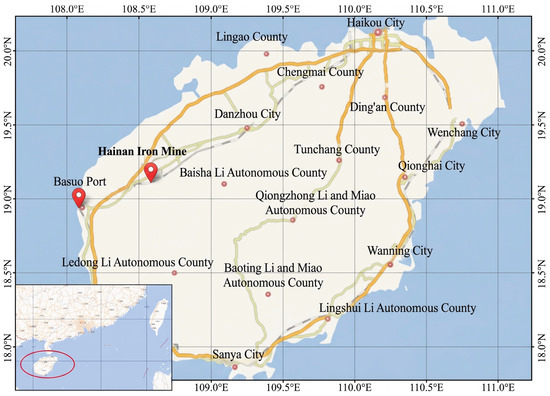
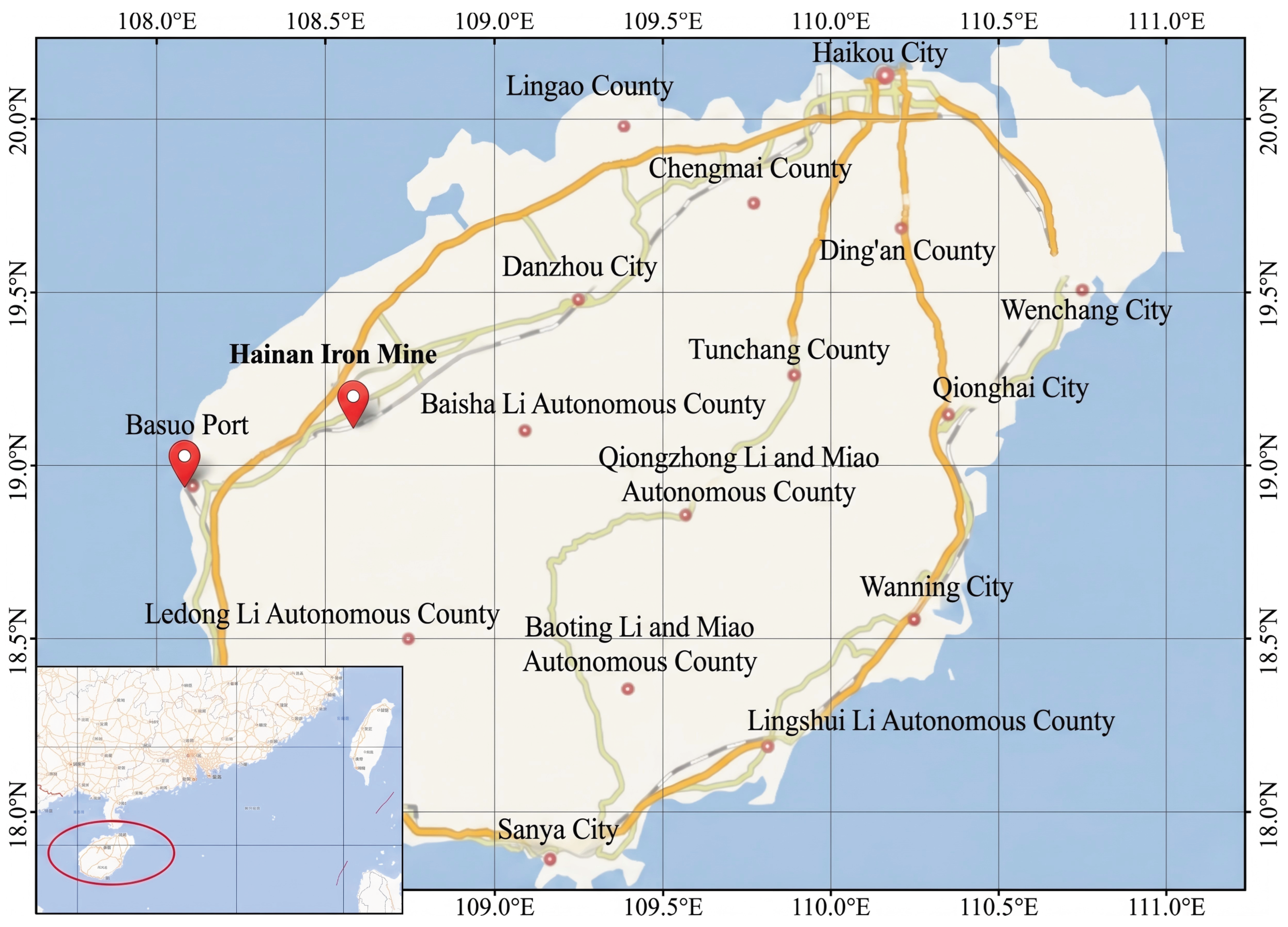
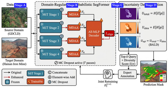
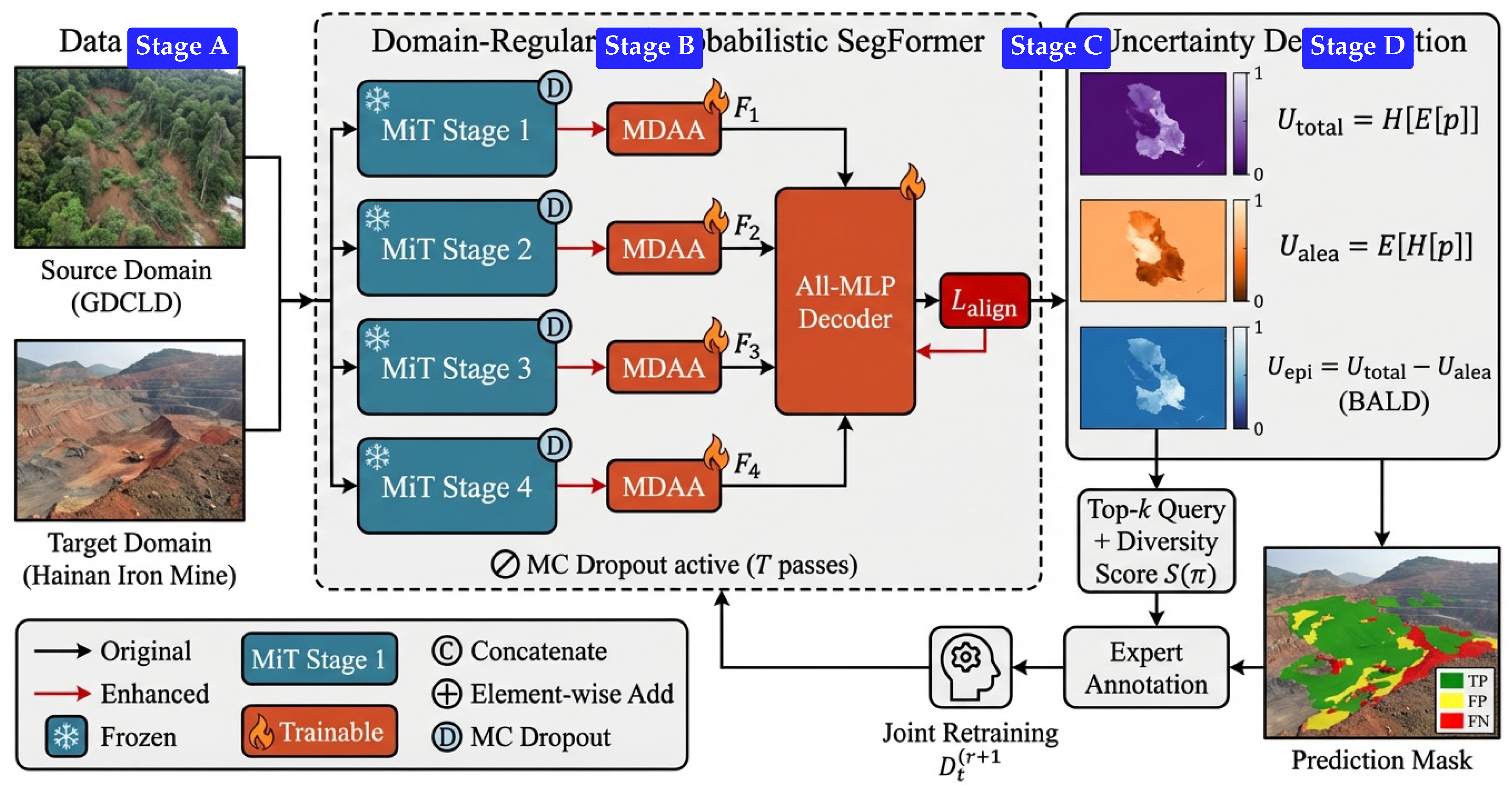
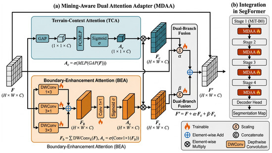
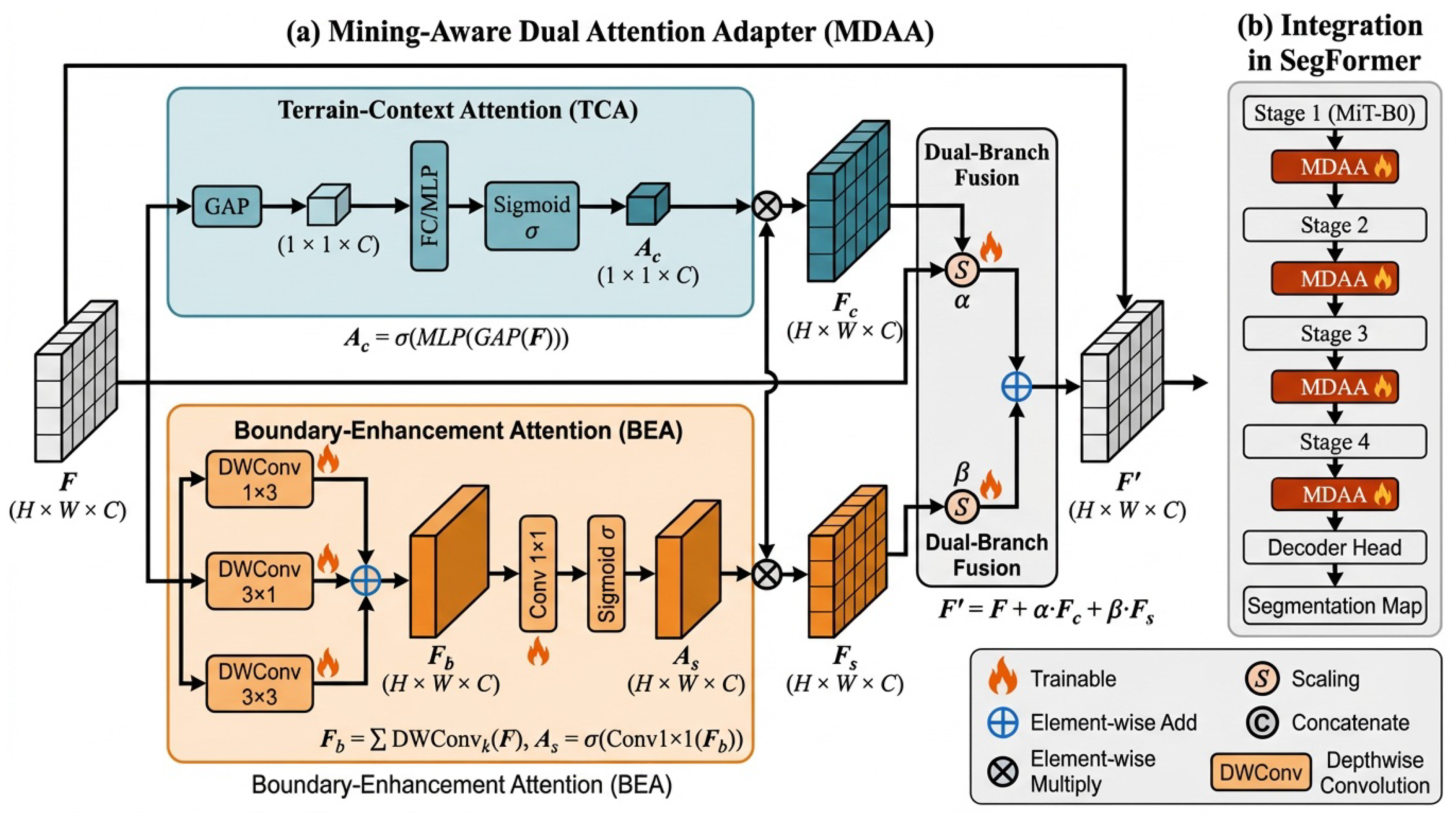
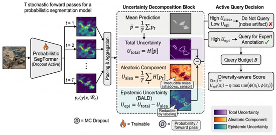
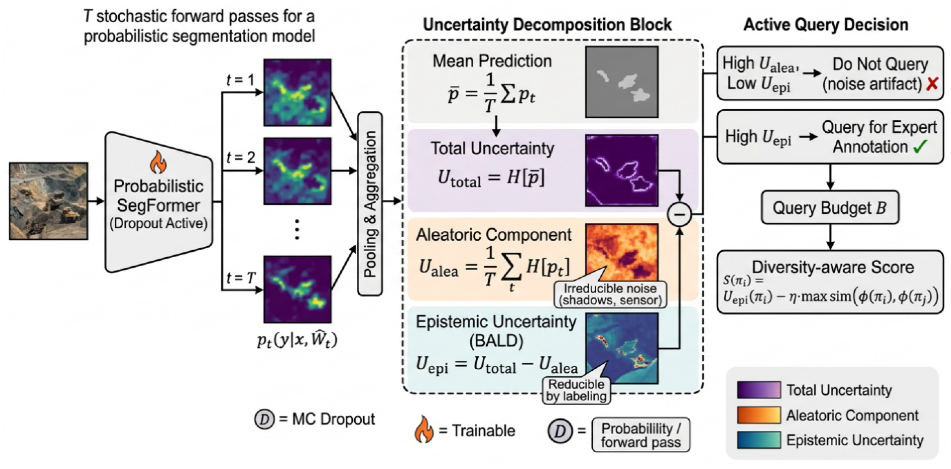
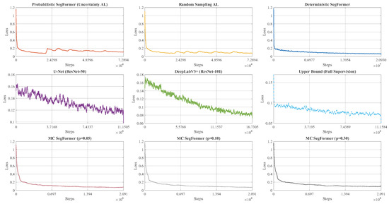
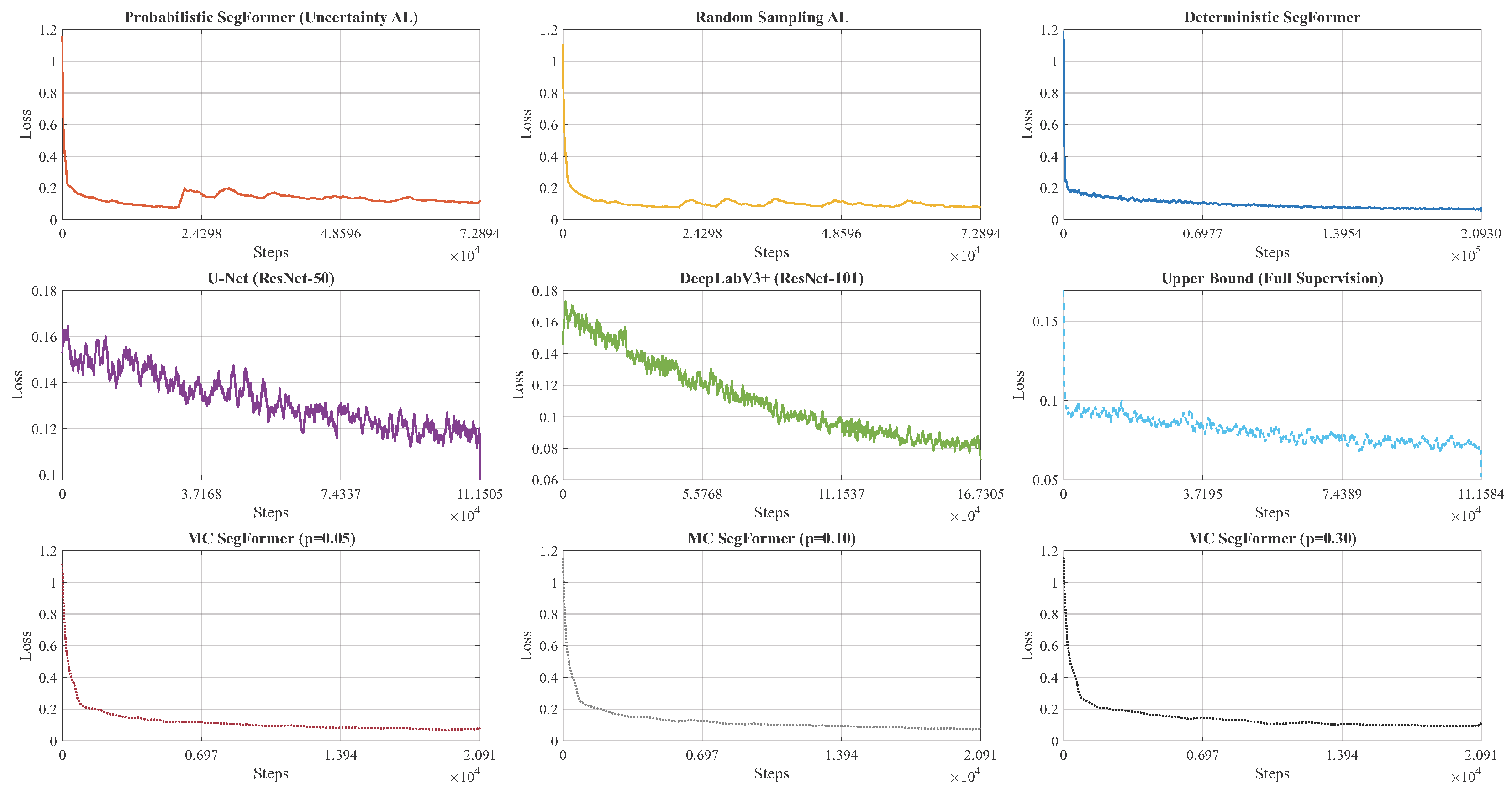
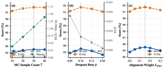
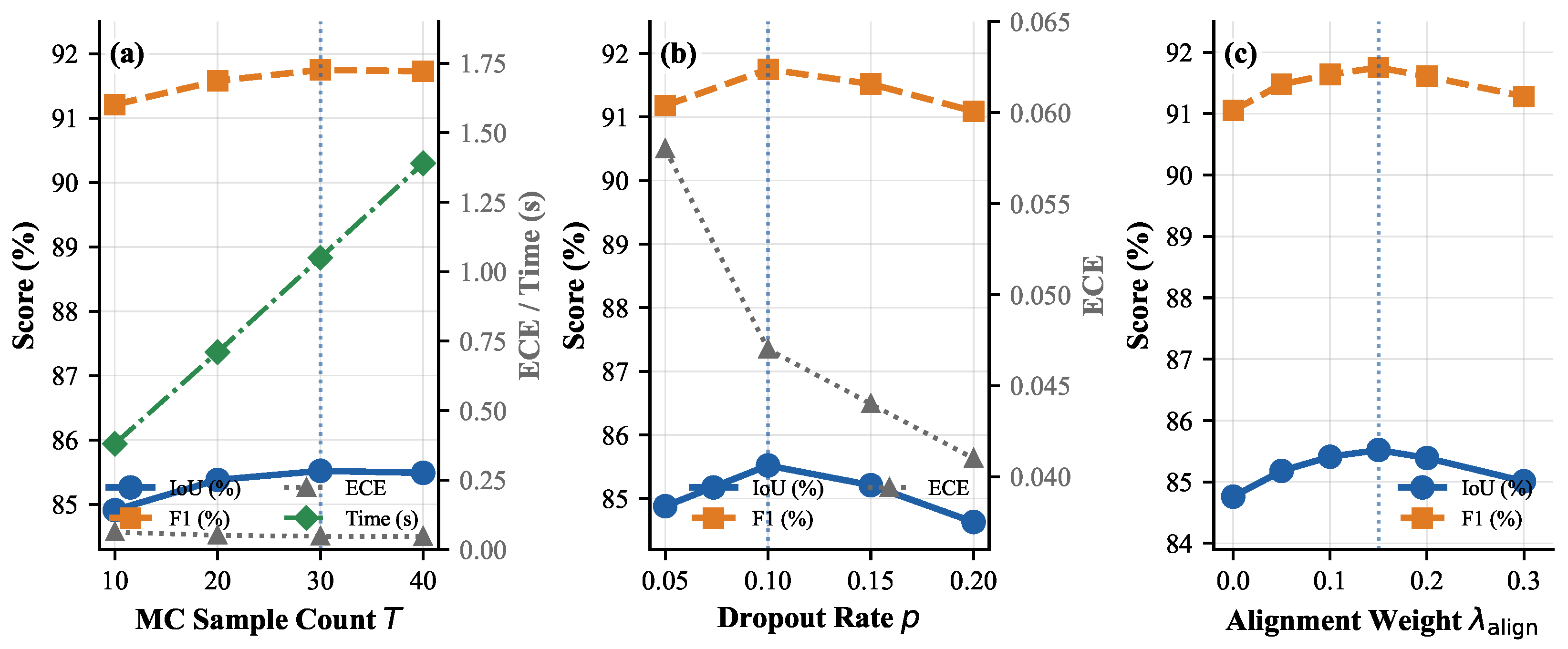
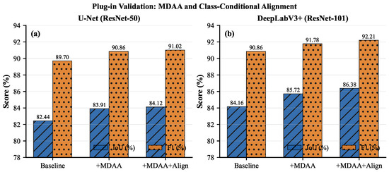
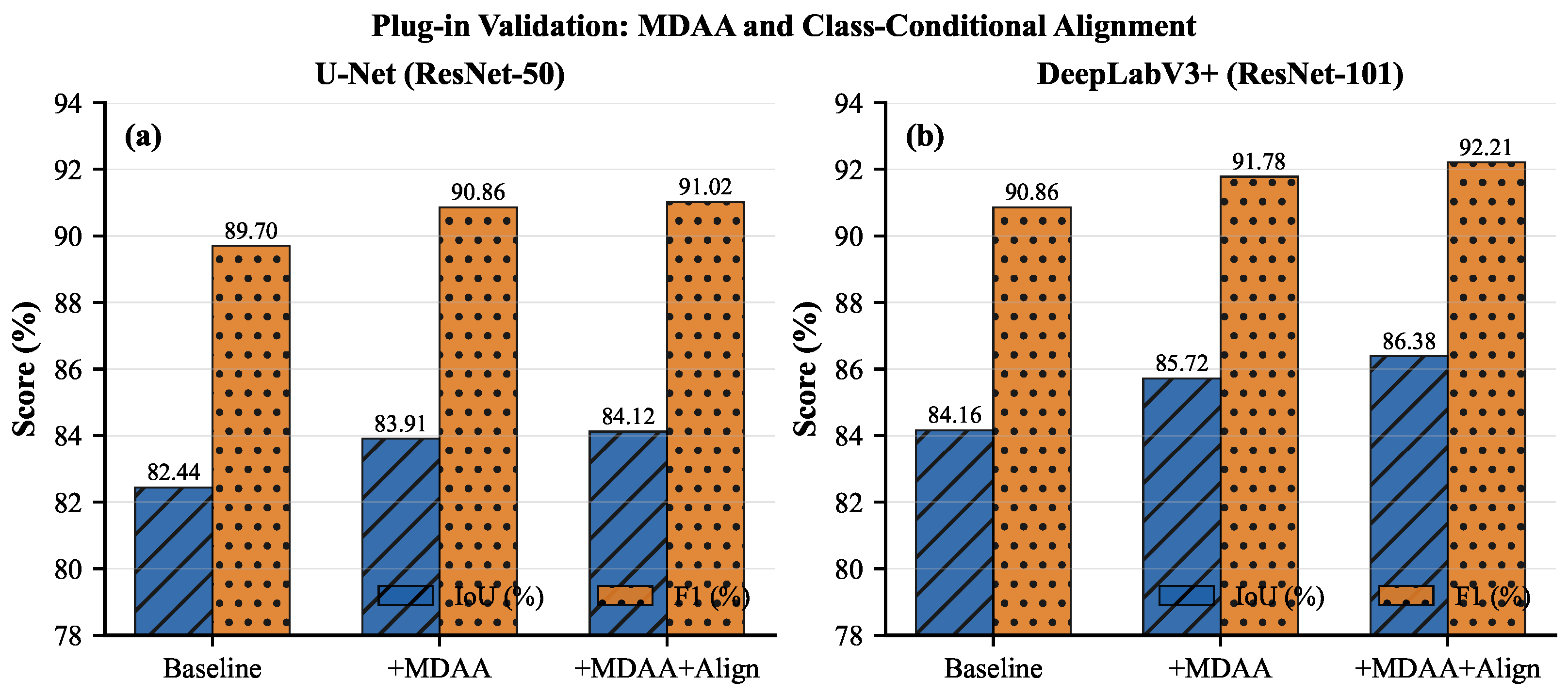
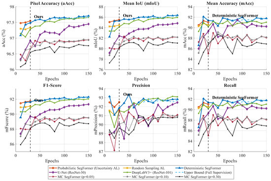
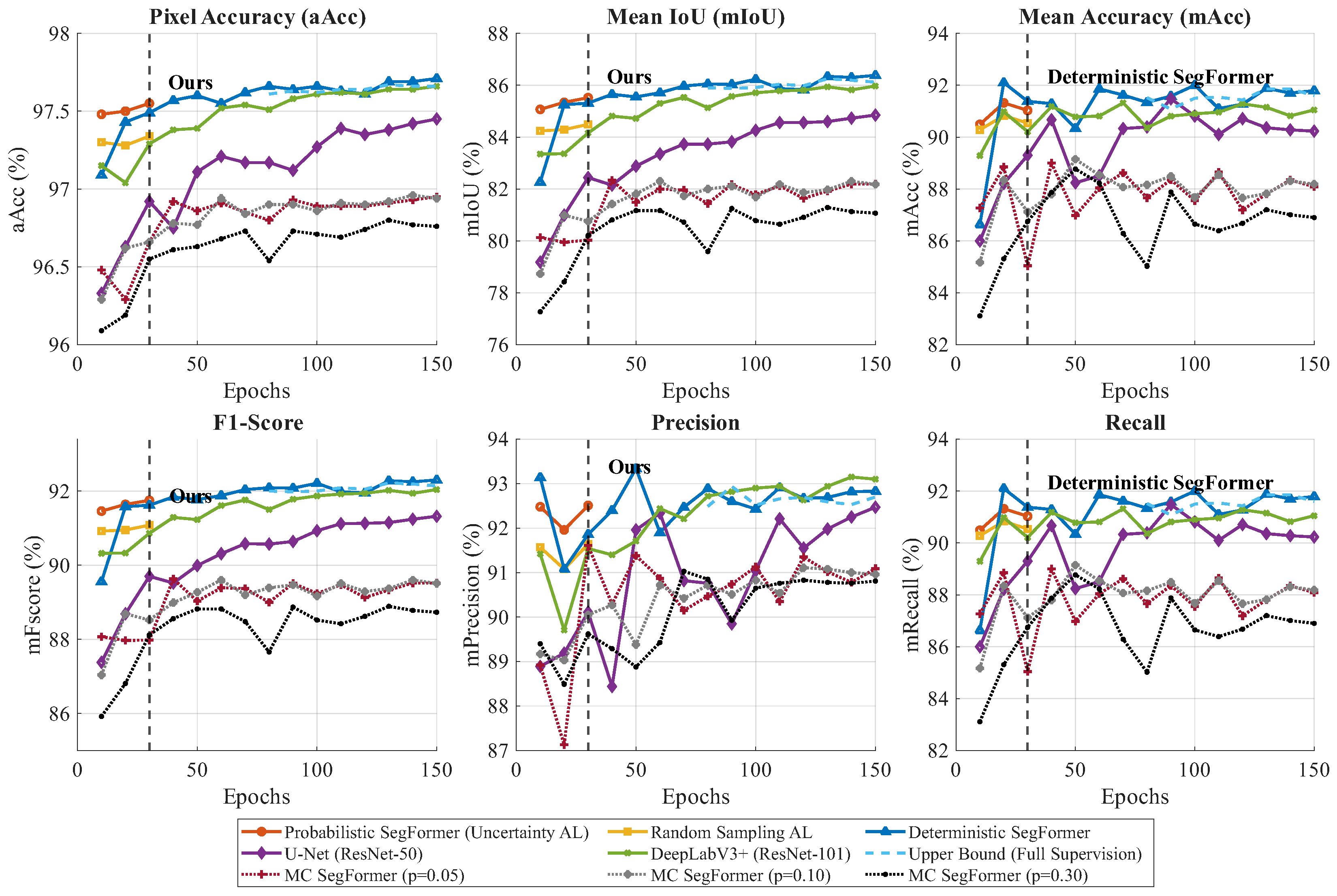
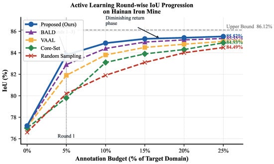
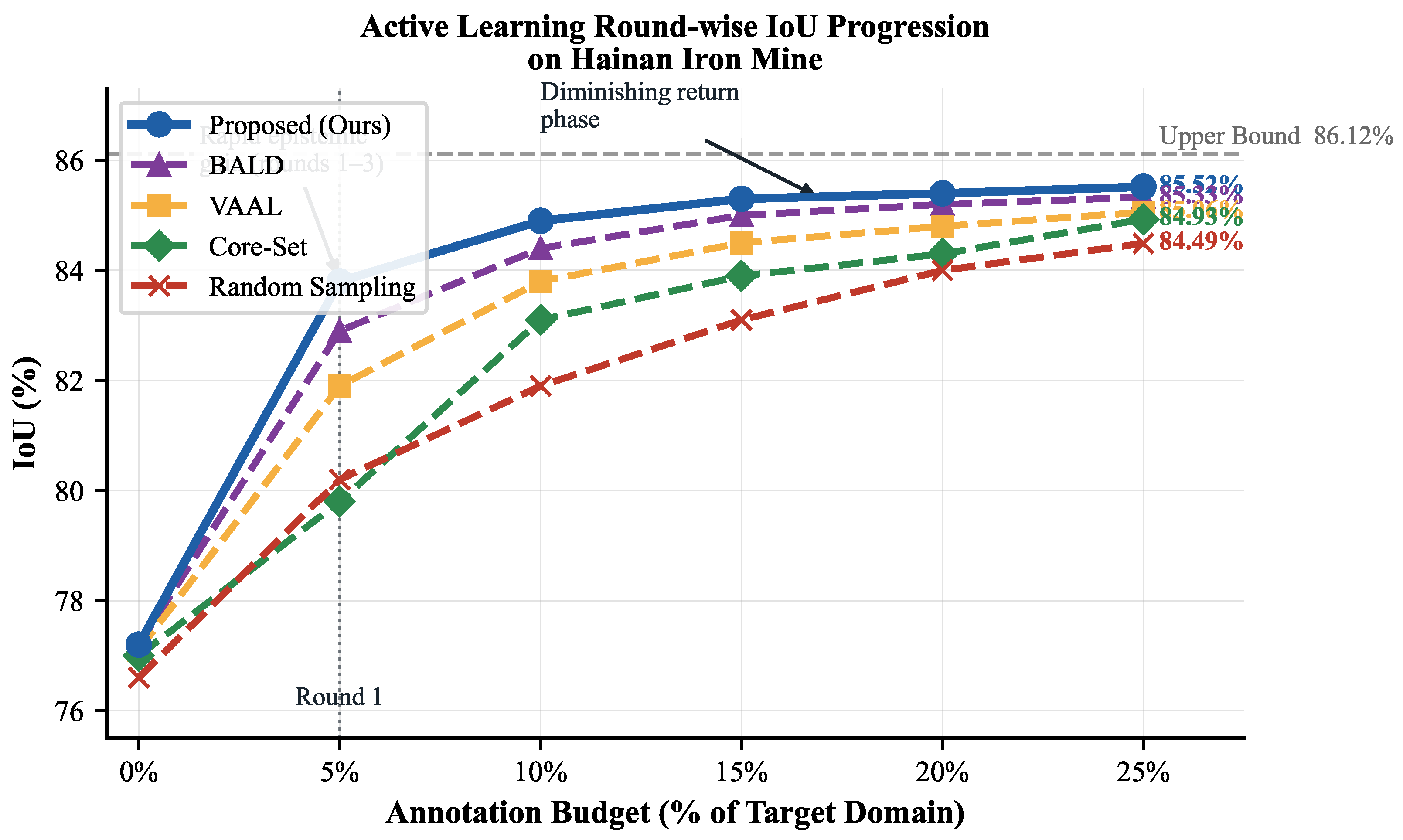
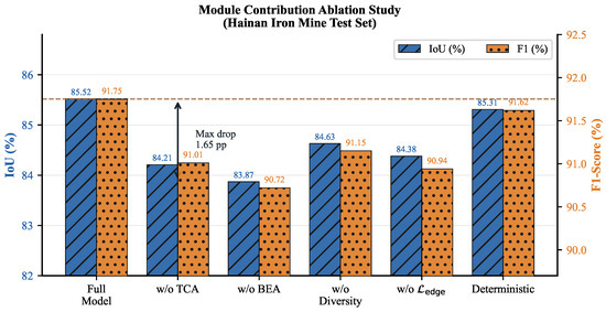
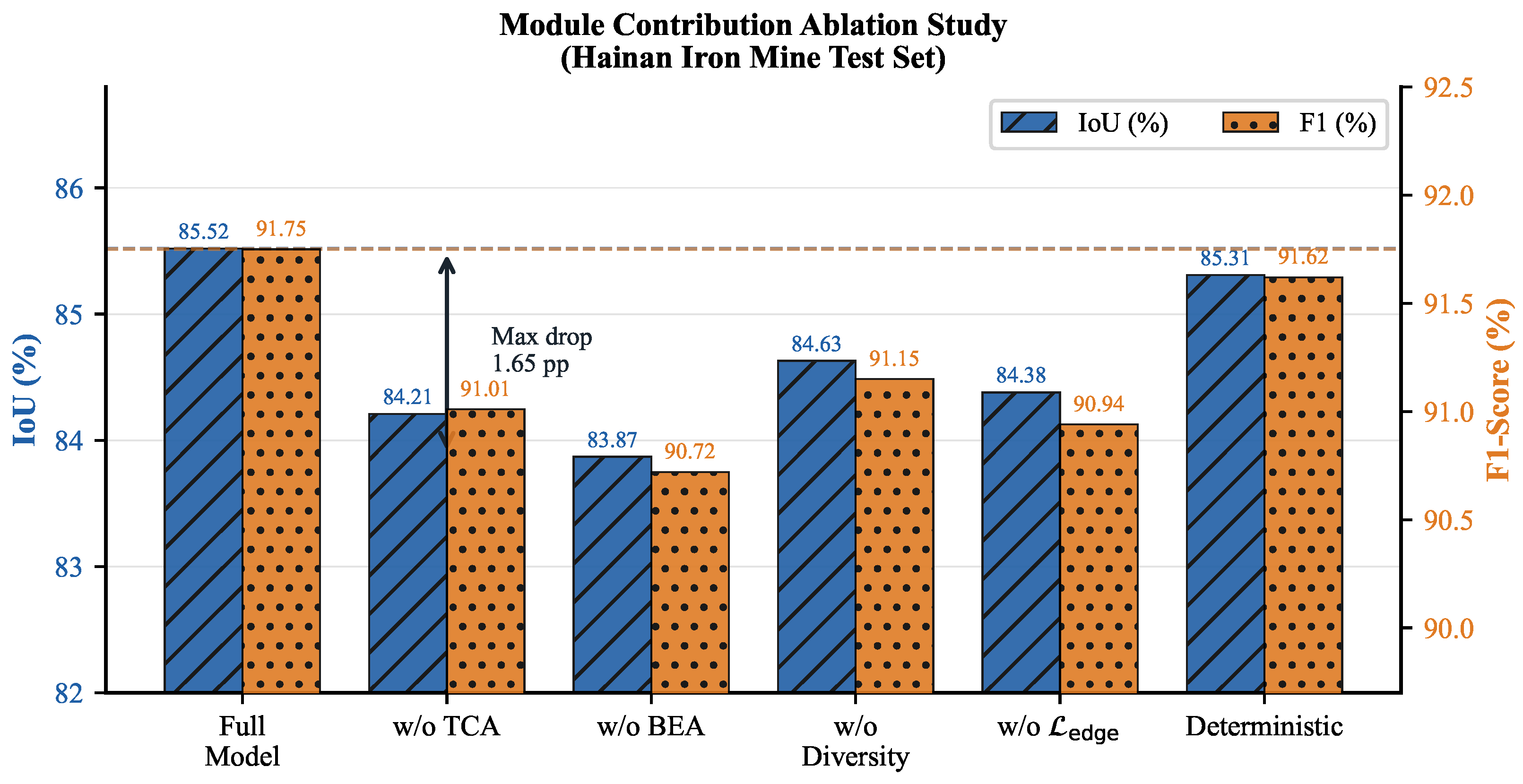
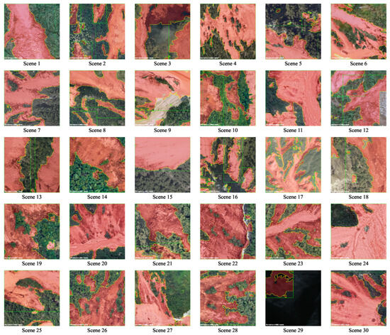
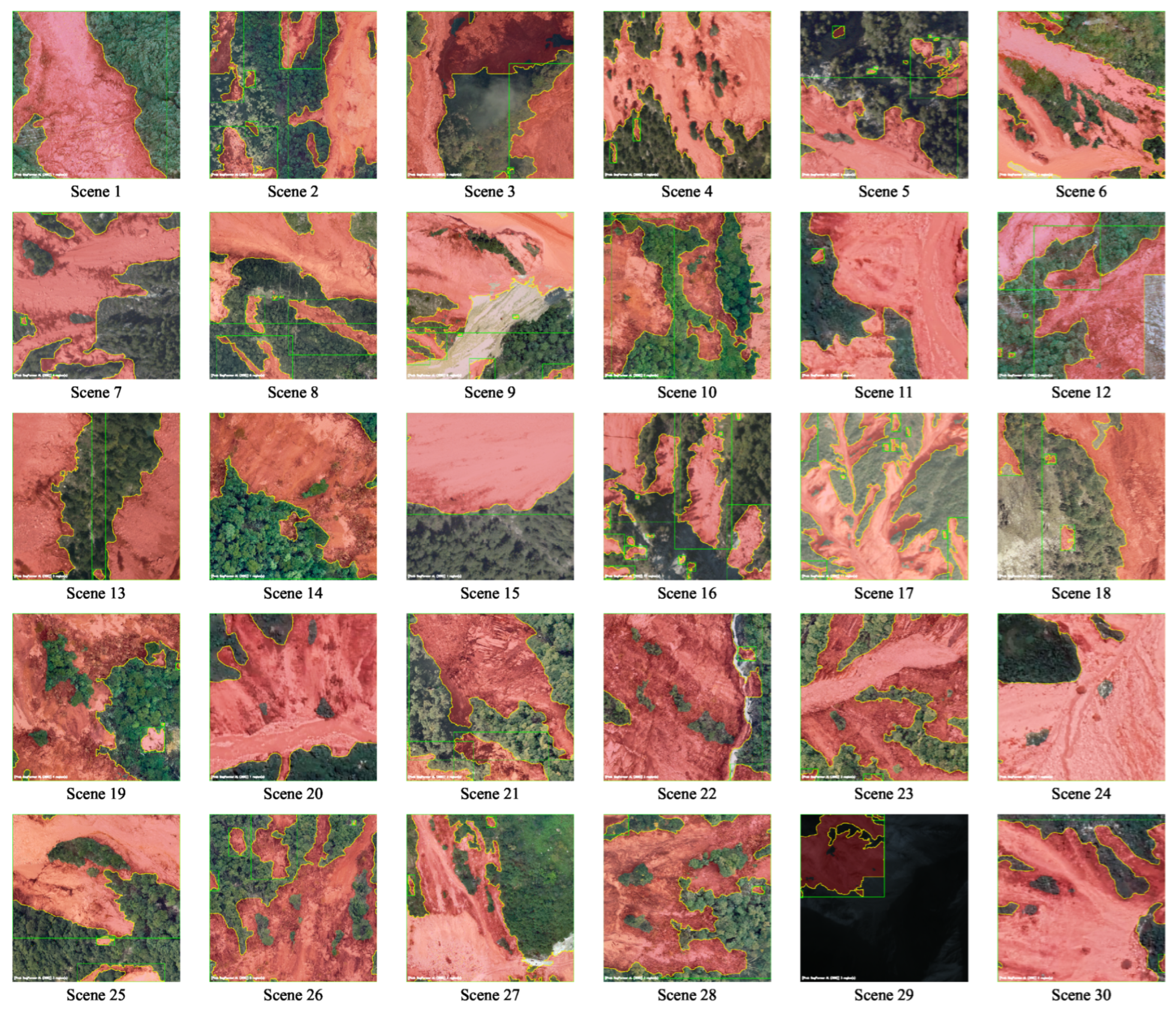
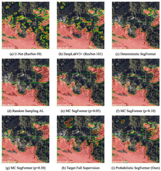
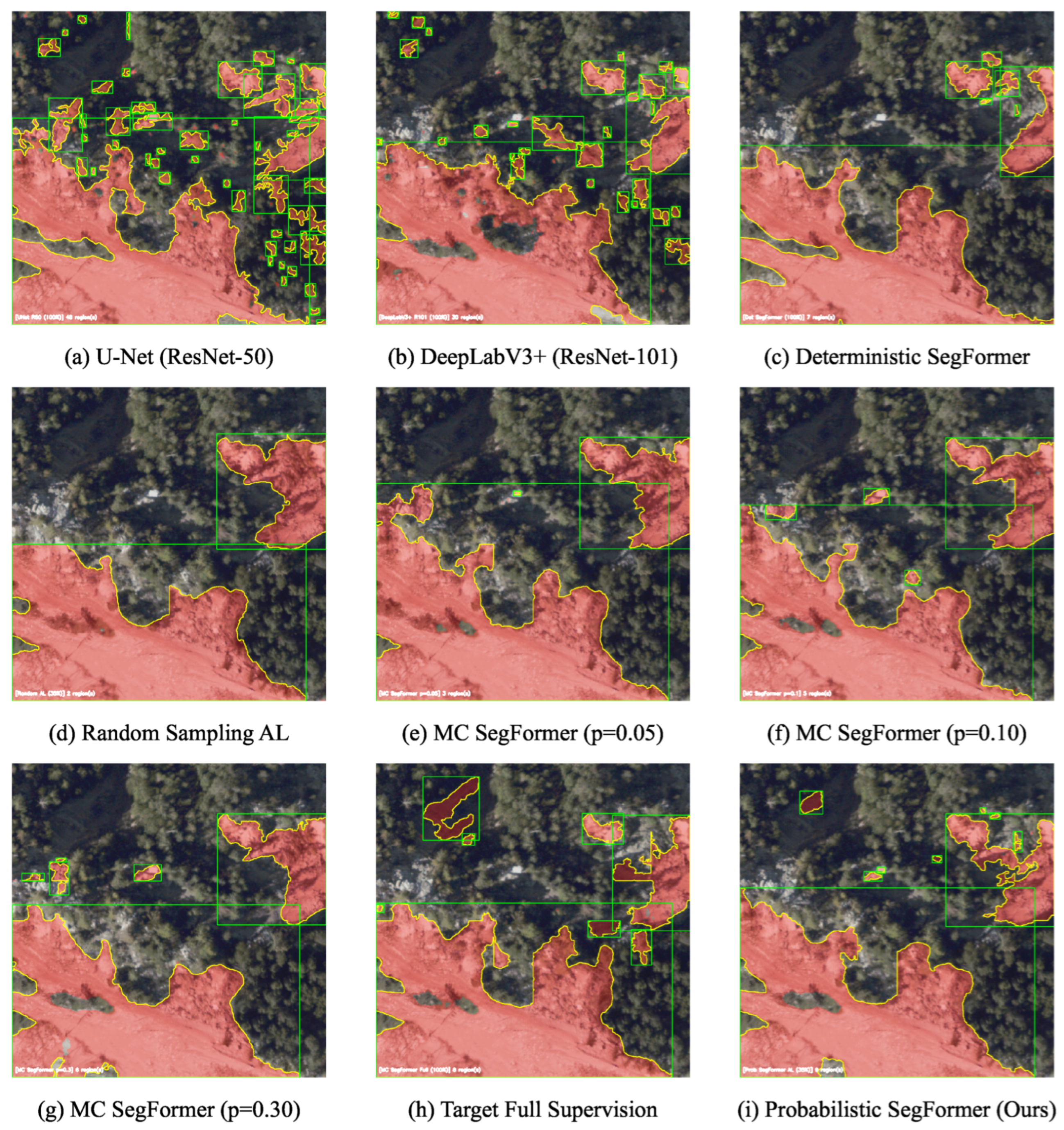
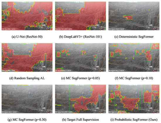
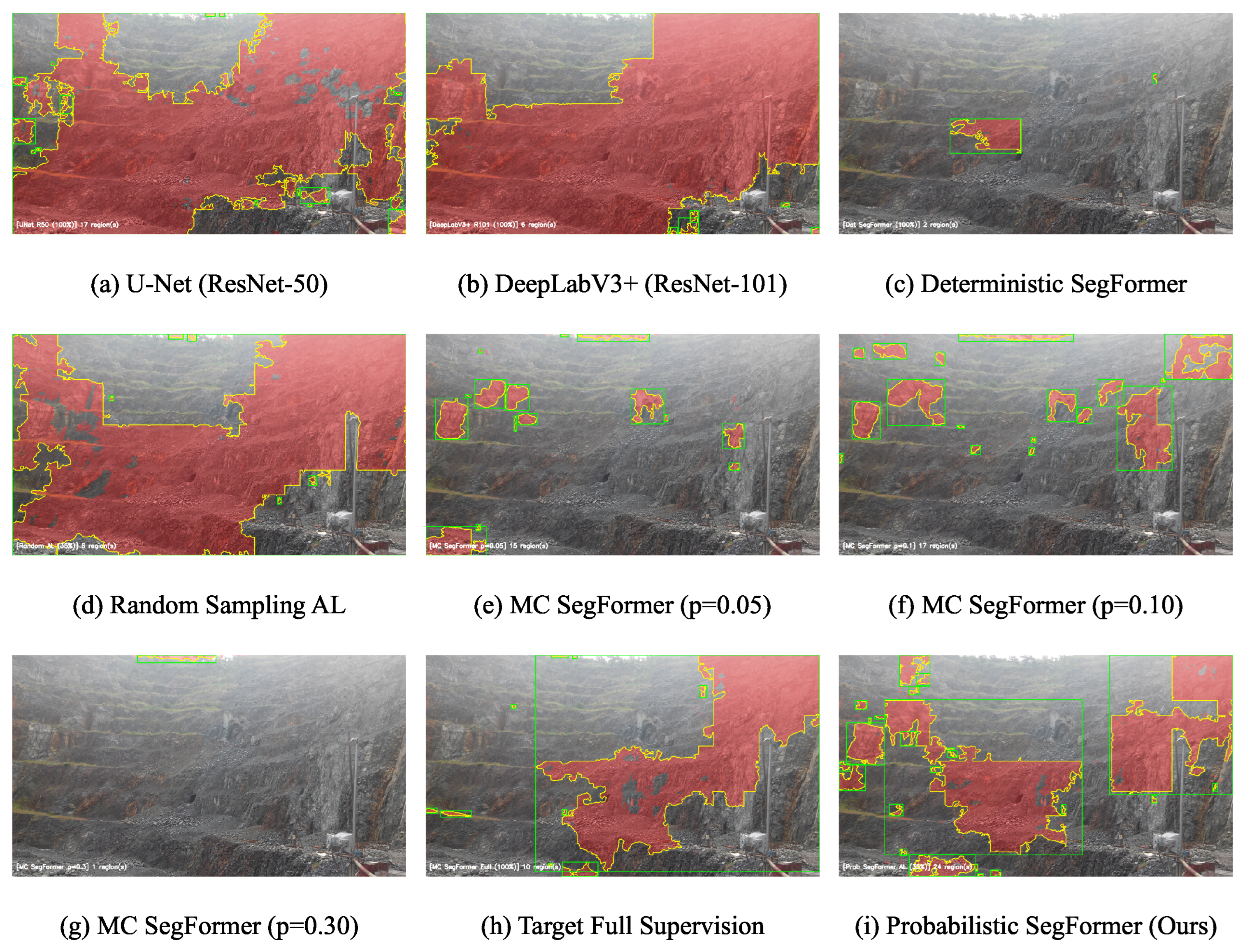
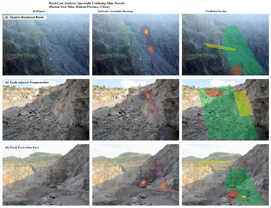
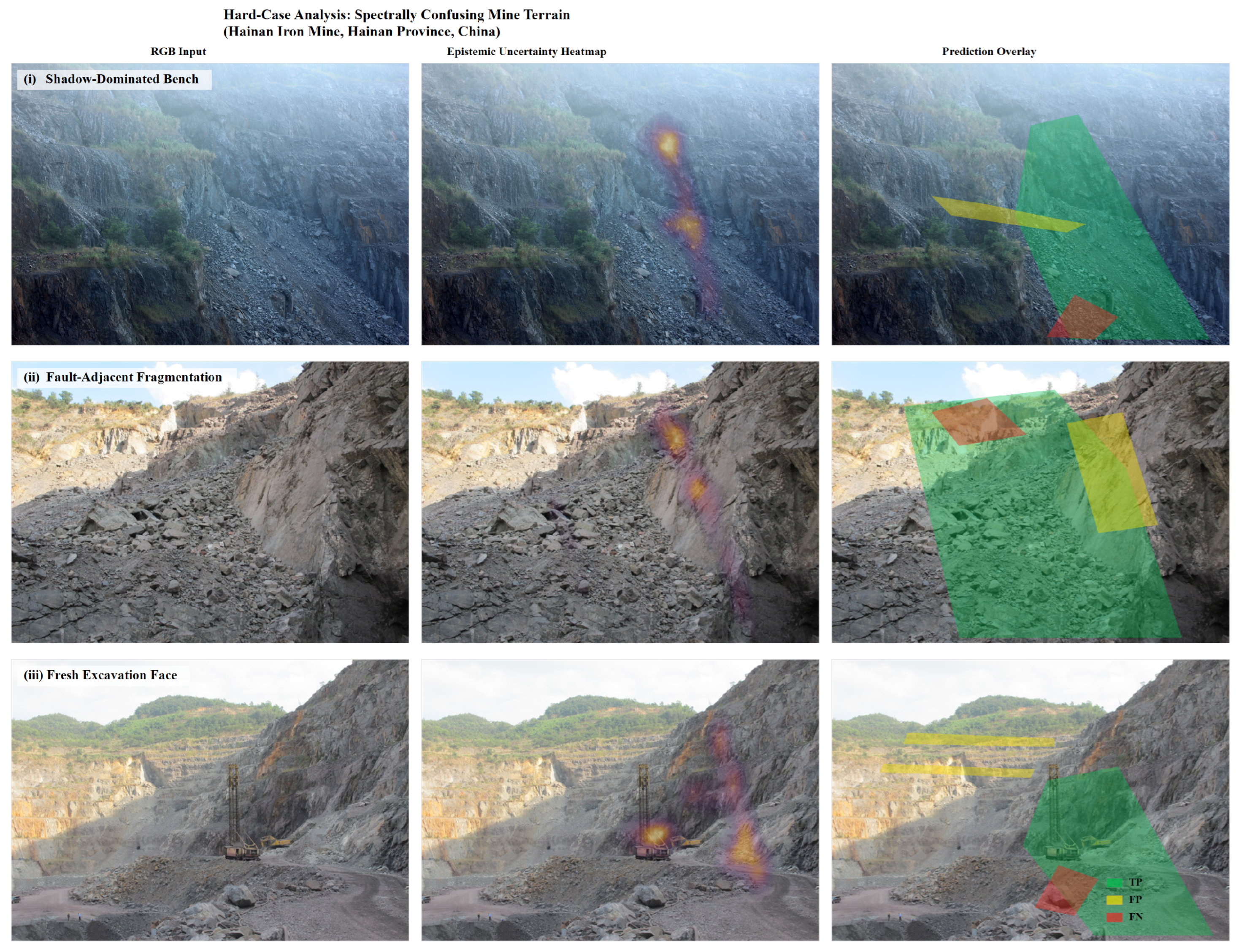
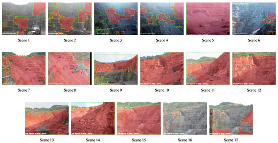
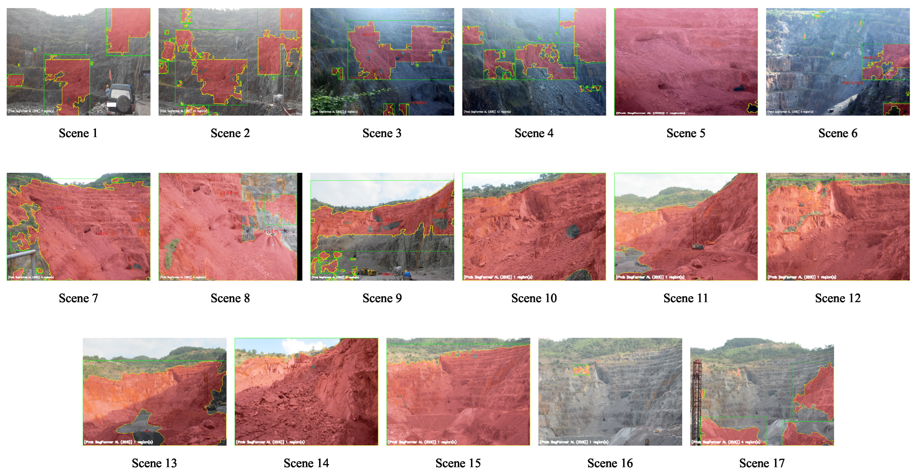

Disclaimer/Publisher’s Note: The statements, opinions and data contained in all publications are solely those of the individual author(s) and contributor(s) and not of MDPI and/or the editor(s). MDPI and/or the editor(s) disclaim responsibility for any injury to people or property resulting from any ideas, methods, instructions or products referred to in the content. |
© 2026 by the authors. Licensee MDPI, Basel, Switzerland. This article is an open access article distributed under the terms and conditions of the Creative Commons Attribution (CC BY) license.