Skip to Content
You are currently on the new version of our website. Access the old version .

Remote Sensing, Volume 16, Issue 19

2024 October-1 - 209 articles

Cover Story: 
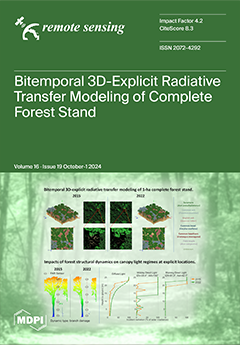
This study provides the first 3D-explicit forest model with bitemporal structural representations, which is one of the most realistic forest scenes for bitemporal 3D radiative transfer (RT) modeling to date. We demonstrate for the first time the potential of bitemporal 3D-explicit forest RT modeling on the forward modeling and quantitative interpretation of remote sensing observations of leaf area index, FAPAR, and canopy light regimes. The results show that this bitemporal 3D-explicit forest RT modeling allows for spatially explicit modeling over time under fully controlled experimental conditions in one of the most realistic virtual environments, thus delivering a powerful tool for studying canopy light regimes as impacted by the dynamics of forest structures and developing remote sensing inversion schemes for structural changes in forests. View this paper
  • Issues are regarded as officially published after their release is announced to the table of contents alert mailing list .
  • You may sign up for email alerts to receive table of contents of newly released issues.
  • PDF is the official format for papers published in both, html and pdf forms. To view the papers in pdf format, click on the "PDF Full-text" link, and use the free Adobe Reader to open them.

Articles (209)

  • Article
  • Open Access
2 Citations
3,175 Views
21 Pages

9 October 2024

Gridless direction of arrival (DOA) estimation methods have garnered significant attention due to their ability to avoid grid mismatch errors, which can adversely affect the performance of high-resolution DOA estimation algorithms. However, most exis...

  • Article
  • Open Access
1 Citations
1,699 Views
17 Pages

Discriminating between Biotic and Abiotic Stress in Poplar Forests Using Hyperspectral and LiDAR Data

  • Quan Zhou,
  • Jinjia Kuang,
  • Linfeng Yu,
  • Xudong Zhang,
  • Lili Ren and
  • Youqing Luo

9 October 2024

Sustainable forest management faces challenges from various biotic and abiotic stresses. The Asian longhorned beetle (ALB) and drought stress both induce water shortages in poplar trees, but require different management strategies. In northwestern Ch...

  • Article
  • Open Access
4 Citations
4,056 Views
16 Pages

High-Visibility Edge-Highlighting Visualization of 3D Scanned Point Clouds Based on Dual 3D Edge Extraction

  • Yuri Yamada,
  • Satoshi Takatori,
  • Motoaki Adachi,
  • Brahmantara,
  • Kyoko Hasegawa,
  • Liang Li,
  • Jiao Pan,
  • Fadjar I. Thufail,
  • Hiroshi Yamaguchi and
  • Satoshi Tanaka

9 October 2024

Recent advances in 3D scanning have enabled the digital recording of complex objects as large-scale point clouds, which require clear visualization to convey their 3D shapes effectively. Edge-highlighting visualization is used to improve the comprehe...

  • Article
  • Open Access
5 Citations
2,592 Views
23 Pages

9 October 2024

Numerical weather prediction (NWP) models are indispensable for studying severe convective weather events. Research demonstrates that the outcomes of convective precipitation simulations are profoundly influenced by the choice between single or doubl...

  • Article
  • Open Access
3 Citations
2,152 Views
17 Pages

Melt Pond Evolution along the MOSAiC Drift: Insights from Remote Sensing and Modeling

  • Mingfeng Wang,
  • Felix Linhardt,
  • Victor Lion and
  • Natascha Oppelt

9 October 2024

Melt ponds play a crucial role in the melting of Arctic sea ice. Studying the evolution of melt ponds is essential for understanding changes in Arctic sea ice. In this study, we used a revised sea ice model to simulate the evolution of melt ponds alo...

  • Article
  • Open Access
1 Citations
2,173 Views
17 Pages

Evaluating the Prediction Performance of the WRF-CUACE Model in Xinjiang, China

  • Yisilamu Wulayin,
  • Huoqing Li,
  • Lei Zhang,
  • Ali Mamtimin,
  • Junjian Liu,
  • Wen Huo and
  • Hongli Liu

9 October 2024

Dust and air pollution events are increasingly occurring around the Taklimakan Desert in southern Xinjiang and in the urban areas of northern Xinjiang. Predicting such events is crucial for the advancement, growth, and prosperity of communities. This...

  • Article
  • Open Access
1 Citations
1,542 Views
18 Pages

Quantifying Creep on the Laohushan Fault Using Dense Continuous GNSS

  • Wenquan Zhuang,
  • Yuhang Li,
  • Ming Hao,
  • Shangwu Song,
  • Baiyun Liu and
  • Lihong Fan

9 October 2024

The interseismic behavior of faults (whether they are locked or creeping) and their quantitative kinematic constraints are critical for assessing the seismic hazards of faults and their surrounding areas. Currently, the creep of the eastern segment o...

  • Article
  • Open Access
1 Citations
2,505 Views
33 Pages

9 October 2024

Rivers convey a broad range of materials, such as sediment, nutrients, and contaminants. Much of this transport can occur during or immediately after an episodic, pulsed event like a flood or an oil spill. Understanding the flow processes that influe...

  • Article
  • Open Access
2 Citations
1,625 Views
24 Pages

9 October 2024

Low carbon management and policies should refer to local long-term inter-annual carbon uptake. However, most previous research has only focused on the quantity and spatial distribution of gross primary product (GPP) for the past 50 years because most...

  • Technical Note
  • Open Access
2 Citations
1,826 Views
14 Pages

9 October 2024

Strong salinity stratification induced by large freshwater fluxes in the northern Bay of Bengal (BOB) results in the formation of a quasi-permanent barrier layer (BL) that covers almost the entire BOB and leads to a unique temperature inversion withi...

  • Article
  • Open Access
2 Citations
2,122 Views
22 Pages

LiOSR-SAR: Lightweight Open-Set Recognizer for SAR Imageries

  • Jie Yang,
  • Jihong Gu,
  • Jingyu Xin,
  • Zhou Cong and
  • Dazhi Ding

9 October 2024

Open-set recognition (OSR) from synthetic aperture radar (SAR) imageries plays a crucial role in maritime and terrestrial monitoring. Nevertheless, numerous deep learning-based SAR classifiers struggle with unknown targets outside of the training dat...

  • Article
  • Open Access
2,714 Views
19 Pages

9 October 2024

The Qinzhou fold belt, situated at the contact zone between the Yangtze and Cathaysia blocks in South China, was affected by the 1936 Lingshan M6¾ earthquake and the 1958 Lingshan M5¾ earthquake, both of which occurred within the conjug...

  • Article
  • Open Access
1 Citations
2,058 Views
23 Pages

8 October 2024

In this paper, an end-to-end system framework is proposed for the Digital Twin study of spaceborne ATI-SAR ocean current velocity inversion. Within this framework, a fitting inversion approach is proposed to enhance the conventional spaceborne ATI-SA...

  • Article
  • Open Access
3 Citations
2,347 Views
22 Pages

8 October 2024

Land use and cover change (LUCC) is directly linked to the sustainability of ecosystems and the long-term well-being of human society. The Helong Region in the Loess Plateau has become one of the areas most severely affected by soil and water erosion...

  • Article
  • Open Access
2 Citations
2,936 Views
21 Pages

Estimating Vertical Distribution of Total Suspended Matter in Coastal Waters Using Remote-Sensing Approaches

  • Hailong Zhang,
  • Xin Ren,
  • Shengqiang Wang,
  • Xiaofan Li,
  • Deyong Sun and
  • Lulu Wang

8 October 2024

The vertical distribution of the marine total suspended matter (TSM) concentration significantly influences marine material transport, sedimentation processes, and biogeochemical cycles. Traditional field observations are constrained by limited spati...

  • Article
  • Open Access
6 Citations
2,323 Views
32 Pages

Analyzing Temporal Characteristics of Winter Catch Crops Using Sentinel-1 Time Series

  • Shanmugapriya Selvaraj,
  • Damian Bargiel,
  • Abdelaziz Htitiou and
  • Heike Gerighausen

8 October 2024

Catch crops are intermediate crops sown between two main crop cycles. Their adoption into the cropping system has increased considerably in the last years due to its numerous benefits, in particular its potential in carbon fixation and preventing nit...

  • Article
  • Open Access
1 Citations
1,434 Views
18 Pages

A New NDSA (Normalized Differential Spectral Attenuation) Measurement Campaign for Estimating Water Vapor along a Radio Link

  • Luca Facheris,
  • Fabrizio Cuccoli,
  • Ugo Cortesi,
  • Samuele del Bianco,
  • Marco Gai,
  • Giovanni Macelloni and
  • Francesco Montomoli

8 October 2024

The Normalized Differential Spectral Attenuation (NDSA) technique was proposed years ago as an active method for measuring integrated water vapor (IWV) along a Ku/K-band radio link immersed (totally or partially) in the troposphere. The approach is o...

  • Article
  • Open Access
6 Citations
2,663 Views
22 Pages

Evaluating Ecological Drought Vulnerability from Ecosystem Service Value Perspectives in North China

  • Tianliang Jiang,
  • Yanping Qu,
  • Xuejun Zhang,
  • Lanshu Jing,
  • Kai Feng,
  • Gengxi Zhang and
  • Yu Han

8 October 2024

Existing studies on the vulnerability assessment of ecological drought often focus on analyzing vegetation phenotypic characteristics, overlooking the impact of drought on ecosystem services. This study proposes an ecosystem vulnerability assessment...

  • Article
  • Open Access
5 Citations
4,668 Views
18 Pages

Satellite-Based Detection of Algal Blooms in Large Alpine Lake Sevan: Can Satellite Data Overcome the Unavoidable Limitations in Field Observations?

  • Shushanik Asmaryan,
  • Anahit Khlghatyan,
  • Azatuhi Hovsepyan,
  • Vahagn Muradyan,
  • Rima Avetisyan,
  • Gor Gevorgyan,
  • Armine Hayrapetyan,
  • Mayada Mohamed Alshahat Arafat Eissa,
  • Hendrik Bernert and
  • Karsten Rinke
  • + 1 author

8 October 2024

Lake Sevan in Armenia is a unique, large, alpine lake given its surface, volume, and geographic location. The lake suffered from progressing eutrophication and, since 2018, massive cyanobacterial blooms repeatedly occurred. Although the lake is compa...

  • Article
  • Open Access
3 Citations
3,640 Views
30 Pages

A Remote-Sensing-Based Method Using Rockfall Inventories for Hazard Mapping at the Community Scale in the Arequipa Region of Peru

  • Cassidy L. Grady,
  • Paul M. Santi,
  • Gabriel Walton,
  • Carlos Luza,
  • Guido Salas,
  • Pablo Meza and
  • Segundo Percy Colque Riega

8 October 2024

Small communities in the Arequipa region of Peru are susceptible to rockfall hazards, which impact their lives and livelihoods. To mitigate rockfall hazards, it is first necessary to understand their locations and characteristics, which can be compil...

  • Article
  • Open Access
2 Citations
6,085 Views
28 Pages

8 October 2024

Remote sensing and process-coupled ecological models are widely used for the simulation of GPP, which plays a key role in estimating and monitoring terrestrial ecosystem productivity. However, most such models do not differentiate the C3 and C4 photo...

  • Article
  • Open Access
9 Citations
3,093 Views
19 Pages

Testing the Impact of Pansharpening Using PRISMA Hyperspectral Data: A Case Study Classifying Urban Trees in Naples, Italy

  • Miriam Perretta,
  • Gabriele Delogu,
  • Cassandra Funsten,
  • Alessio Patriarca,
  • Eros Caputi and
  • Lorenzo Boccia

8 October 2024

Urban trees support vital ecological functions and help with the mitigation of and adaption to climate change. Yet, their monitoring and management require significant public resources. remote sensing could facilitate these tasks. Recent hyperspectra...

  • Article
  • Open Access
2 Citations
1,515 Views
21 Pages

8 October 2024

The significance of detecting faint and diminutive space targets cannot be overstated, as it underpins the preservation of Earth’s orbital environment’s safety and long-term sustainability. Founded by the different response characteristic...

  • Article
  • Open Access
2 Citations
1,610 Views
19 Pages

7 October 2024

It is usually hard to obtain adequate annotated data for delivering satisfactory scene classification results. Semi-supervised scene classification approaches can transfer the knowledge learned from previously annotated data to remote sensing images...

  • Article
  • Open Access
5 Citations
3,327 Views
22 Pages

Automated Recognition of Snow-Covered and Icy Road Surfaces Based on T-Net of Mount Tianshan

  • Jingqi Liu,
  • Yaonan Zhang,
  • Jie Liu,
  • Zhaobin Wang and
  • Zhixing Zhang

7 October 2024

The Tianshan Expressway plays a crucial role in China’s “Belt and Road” strategy, yet the extreme climate of the Tianshan Mountains poses significant traffic safety risks, hindering local economic development. Efficient detection of...

  • Communication
  • Open Access
1,306 Views
15 Pages

Analysis of the Grid Quantization for the Microwave Radar Coincidence Imaging Based on Basic Correlation Algorithm

  • Yiheng Nian,
  • Mengran Zhao,
  • Die Li,
  • Ming Zhang,
  • Anxue Zhang,
  • Tong Li and
  • Shitao Zhu

7 October 2024

In Microwave Radar Coincidence Imaging (MRCI), the imaging region is typically discretized into a fine grid. In other words, it assumes that the equivalent scatterers of the target are precisely located at the centers of these pre-discretized grids....

  • Article
  • Open Access
4 Citations
2,811 Views
27 Pages

From Polar Day to Polar Night: A Comprehensive Sun and Star Photometer Study of Trends in Arctic Aerosol Properties in Ny-Ålesund, Svalbard

  • Sandra Graßl,
  • Christoph Ritter,
  • Jonas Wilsch,
  • Richard Herrmann,
  • Lionel Doppler and
  • Roberto Román

7 October 2024

The climate impact of Arctic aerosols, like the Arctic Haze, and their origin are not fully understood. Therefore, long-term aerosol observations in the Arctic are performed. In this study, we present a homogenised data set from a sun and star photom...

  • Article
  • Open Access
4 Citations
2,487 Views
17 Pages

7 October 2024

The increased intensity and frequency of extreme climate events (ECEs) have significantly impacted vegetation phenology, further profoundly affecting the structure and functioning of terrestrial ecosystems. However, the mechanisms by which ECEs affec...

  • Article
  • Open Access
8 Citations
3,131 Views
21 Pages

7 October 2024

Gross primary productivity (GPP) is vital for ecosystems and the global carbon cycle, serving as a sensitive indicator of ecosystems’ responses to climate change. However, the impact of future climate changes on GPP in the Tibetan Plateau, an e...

  • Article
  • Open Access
6 Citations
3,100 Views
21 Pages

7 October 2024

In the production of high-definition maps, it is necessary to achieve the three-dimensional instantiation of road furniture that is difficult to depict on traditional maps. The development of mobile laser measurement technology provides a new means f...

  • Article
  • Open Access
2 Citations
3,839 Views
22 Pages

6 October 2024

Ensuring the safety of autonomous vehicles (AVs) in complex and high-risk traffic scenarios remains a critical unresolved challenge. Current AV planning methods exhibit limitations in generating robust driving trajectories that effectively avoid coll...

  • Article
  • Open Access
5 Citations
3,876 Views
21 Pages

Estimation of Forage Biomass in Oat (Avena sativa) Using Agronomic Variables through UAV Multispectral Imaging

  • Julio Urquizo,
  • Dennis Ccopi,
  • Kevin Ortega,
  • Italo Castañeda,
  • Solanch Patricio,
  • Jorge Passuni,
  • Deyanira Figueroa,
  • Lucia Enriquez,
  • Zoila Ore and
  • Samuel Pizarro

6 October 2024

Accurate and timely estimation of oat biomass is crucial for the development of sustainable and efficient agricultural practices. This research focused on estimating and predicting forage oat biomass using UAV and agronomic variables. A Matrice 300 e...

  • Article
  • Open Access
2,514 Views
19 Pages

6 October 2024

Misusing image tampering software makes it easier to manipulate satellite images, leading to a crisis of trust and security concerns in society. This study compares the inconsistencies between heterogeneous images to locate tampered areas and propose...

  • Article
  • Open Access
2 Citations
2,166 Views
28 Pages

6 October 2024

Several studies proposed relationships linking irradiances in the photosynthetically active radiation (PAR) range and broadband irradiances. A previous study published in 2024 by the same authors proposes a linear model relating clear-sky indices in...

  • Article
  • Open Access
1 Citations
2,001 Views
17 Pages

6 October 2024

An accurate and historical land cover monitoring dataset for Alaska could provide fundamental information for a range of studies, such as conservation habitats, biogeochemical cycles, and climate systems, in this distinctive region. This research add...

  • Article
  • Open Access
6 Citations
2,527 Views
23 Pages

6 October 2024

Online maps are of great importance in modern life, especially in commuting, traveling and urban planning. The accessibility of remote sensing (RS) images has contributed to the widespread practice of generating online maps based on RS images. The pr...

  • Article
  • Open Access
15 Citations
7,993 Views
20 Pages

Study on the Relationship between Groundwater and Land Subsidence in Bangladesh Combining GRACE and InSAR

  • Liu Ouyang,
  • Zhifang Zhao,
  • Dingyi Zhou,
  • Jingyao Cao,
  • Jingyi Qin,
  • Yifan Cao and
  • Yang He

6 October 2024

Due to a heavy reliance on groundwater, Bangladesh is experiencing a severe decline in groundwater storage, with some areas even facing land subsidence. This study aims to investigate the relationship between groundwater storage changes and land subs...

  • Article
  • Open Access
5 Citations
6,293 Views
21 Pages

Methods for Assessing the Effectiveness of Modern Counter Unmanned Aircraft Systems

  • Konrad D. Brewczyński,
  • Marek Życzkowski,
  • Krzysztof Cichulski,
  • Kamil A. Kamiński,
  • Paraskevi Petsioti and
  • Geert De Cubber

6 October 2024

Given the growing threat posed by the widespread availability of unmanned aircraft systems (UASs), which can be utilised for various unlawful activities, the need for a standardised method to evaluate the effectiveness of systems capable of detecting...

  • Article
  • Open Access
2 Citations
2,001 Views
17 Pages

Vertical Distribution of Water Vapor During Haze Processes in Northeast China Based on Raman Lidar Measurements

  • Tianpei Zhang,
  • Zhenping Yin,
  • Yubin Wei,
  • Yaru Dai,
  • Longlong Wang,
  • Xiangyu Dong,
  • Yuan Gao,
  • Lude Wei,
  • Qixiong Zhang and
  • Yifan Zhou
  • + 1 author

6 October 2024

Haze refers to an atmospheric phenomenon with extremely low visibility, which has significant impacts on human health and safety. Water vapor alters the scattering properties of atmospheric particulate matter, thus affecting visibility. A comprehensi...

  • Article
  • Open Access
7 Citations
5,274 Views
14 Pages

5 October 2024

Rising food demands require new techniques to achieve higher genetic gains for crop production, especially in regions where climate can negatively affect agriculture. Wheat is a staple crop that often encounters this challenge, and ideotype breeding...

  • Article
  • Open Access
29 Citations
7,143 Views
21 Pages

5 October 2024

Accurate detection of transportation objects is pivotal for enhancing driving safety and operational efficiency. In the rapidly evolving domain of transportation systems, the utilization of unmanned aerial vehicles (UAVs) for low-altitude detection,...

  • Article
  • Open Access
8 Citations
2,770 Views
19 Pages

Automatic Landslide Detection in Gansu, China, Based on InSAR Phase Gradient Stacking and AttU-Net

  • Qian Sun,
  • Cong Li,
  • Tao Xiong,
  • Rong Gui,
  • Bing Han,
  • Yilun Tan,
  • Aoqing Guo,
  • Junfeng Li and
  • Jun Hu

5 October 2024

Landslides are the most serious geological disaster in our country, causing economic losses. Because they go undetected, a large number of landslides that have caused disasters are not in the catalogue. At present, Interferometric Synthetic Aperture...

  • Article
  • Open Access
5 Citations
3,968 Views
25 Pages

Estimation, Spatiotemporal Dynamics, and Driving Factors of Grassland Biomass Carbon Storage Based on Machine Learning Methods: A Case Study of the Hulunbuir Grassland

  • Qiuying Zhi,
  • Xiaosheng Hu,
  • Ping Wang,
  • Ming Li,
  • Yi Ding,
  • Yuxuan Wu,
  • Tiantian Peng,
  • Wenjie Li,
  • Xiao Guan and
  • Junsheng Li
  • + 1 author

5 October 2024

Precisely estimating the grassland biomass carbon storage is vital for evaluating grassland carbon sequestration potential and the monitoring and management of grassland resources. With the increasing intensity of climate change (CC) and human activi...

  • Article
  • Open Access
7 Citations
2,876 Views
17 Pages

Stronger Impact of Extreme Heat Event on Vegetation Temperature Sensitivity under Future Scenarios with High-Emission Intensity

  • Han Yang,
  • Chaohui Zhong,
  • Tingyuan Jin,
  • Jiahao Chen,
  • Zijia Zhang,
  • Zhongmin Hu and
  • Kai Wu

5 October 2024

Vegetation temperature sensitivity is a key indicator to understand the response of vegetation to temperature changes and predict potential shifts in ecosystem functions. However, under the context of global warming, the impact of future extreme heat...

  • Article
  • Open Access
2 Citations
1,303 Views
21 Pages

5 October 2024

Synthetic aperture radar tomography (TomoSAR) has gained significant attention for three-dimensional (3D) imaging in urban environments. A notable limitation of traditional TomoSAR approaches is their primary focus on persistent scatterers (PSs), dis...

  • Article
  • Open Access
1 Citations
2,543 Views
20 Pages

Desertification Mitigation in Northern China Was Promoted by Climate Drivers after 2000

  • Haohui Li,
  • Kai Yang,
  • Yang Cui,
  • Lingyun Ai,
  • Chenghai Wang,
  • Zhenting Wang and
  • Caixia Zhang

5 October 2024

Desertification greatly threatens the ecological environment and sustainable development over approximately 30% of global land. In this study, the contributions of climate drivers and human activity in shaping the desertification process from 1984 to...

  • Article
  • Open Access
6 Citations
3,456 Views
23 Pages

Synergistic Potential of Optical and Radar Remote Sensing for Snow Cover Monitoring

  • Jose-David Hidalgo-Hidalgo,
  • Antonio-Juan Collados-Lara,
  • David Pulido-Velazquez,
  • Steven R. Fassnacht and
  • C. Husillos

5 October 2024

This research studies the characteristics of snow-covered area (SCA) from two vastly different sensors: optical (Moderate-Resolution Imaging Spectroradiometer, or MODIS, equipped on board the Terra satellite) and radar (Synthetic Aperture Radar (SAR)...

  • Article
  • Open Access
10 Citations
2,079 Views
24 Pages

On the Capabilities of the IREA-CNR Airborne SAR Infrastructure

  • Carmen Esposito,
  • Antonio Natale,
  • Riccardo Lanari,
  • Paolo Berardino and
  • Stefano Perna

5 October 2024

In this work, the airborne Synthetic Aperture Radar (SAR) infrastructure developed at the Institute for Electromagnetic Sensing of the Environment (IREA) of the National Research Council of Italy (CNR) is described. This infrastructure allows IREA-CN...

  • Article
  • Open Access
1 Citations
1,923 Views
19 Pages

The Characteristics of Precipitation with and without Bright Band in Summer Tibetan Plateau and Central-Eastern China

  • Liu Yang,
  • Nan Sun,
  • Ming Ma,
  • Chunguang Cui,
  • Bin Wang,
  • Xiaofang Wang and
  • Yunfei Fu

5 October 2024

The bright band (BB) is an important symbol of the ice–water transition zone in stratiform precipitation, and the presence or absence of BB will lead to different microphysical processes. In this paper, the characteristics of BB and precipitati...

of 5

Get Alerted

Add your email address to receive forthcoming issues of this journal.

XFacebookLinkedIn
Remote Sens. - ISSN 2072-4292