Cloud Detection Algorithm for Multi-Satellite Remote Sensing Imagery Based on a Spectral Library and 1D Convolutional Neural Network

Abstract
1. Introduction
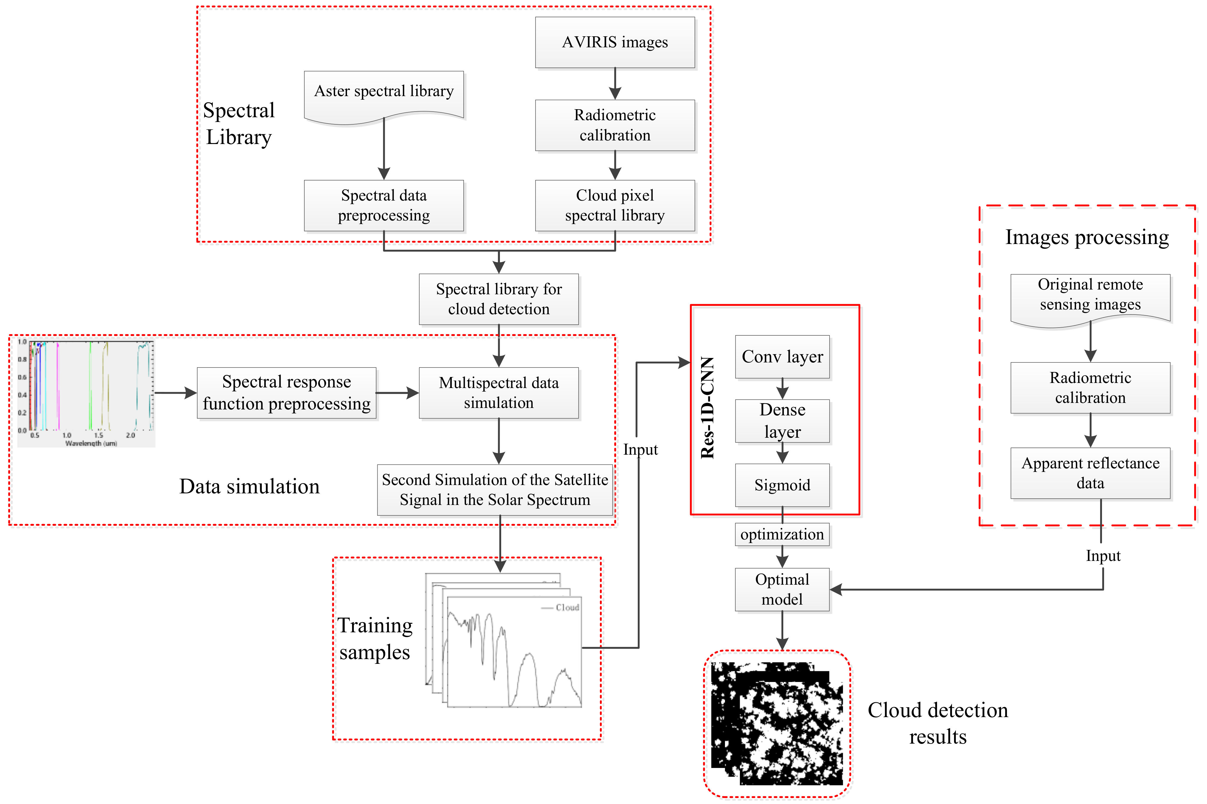
2. Method
2.1. Establishment of the Spectral Library
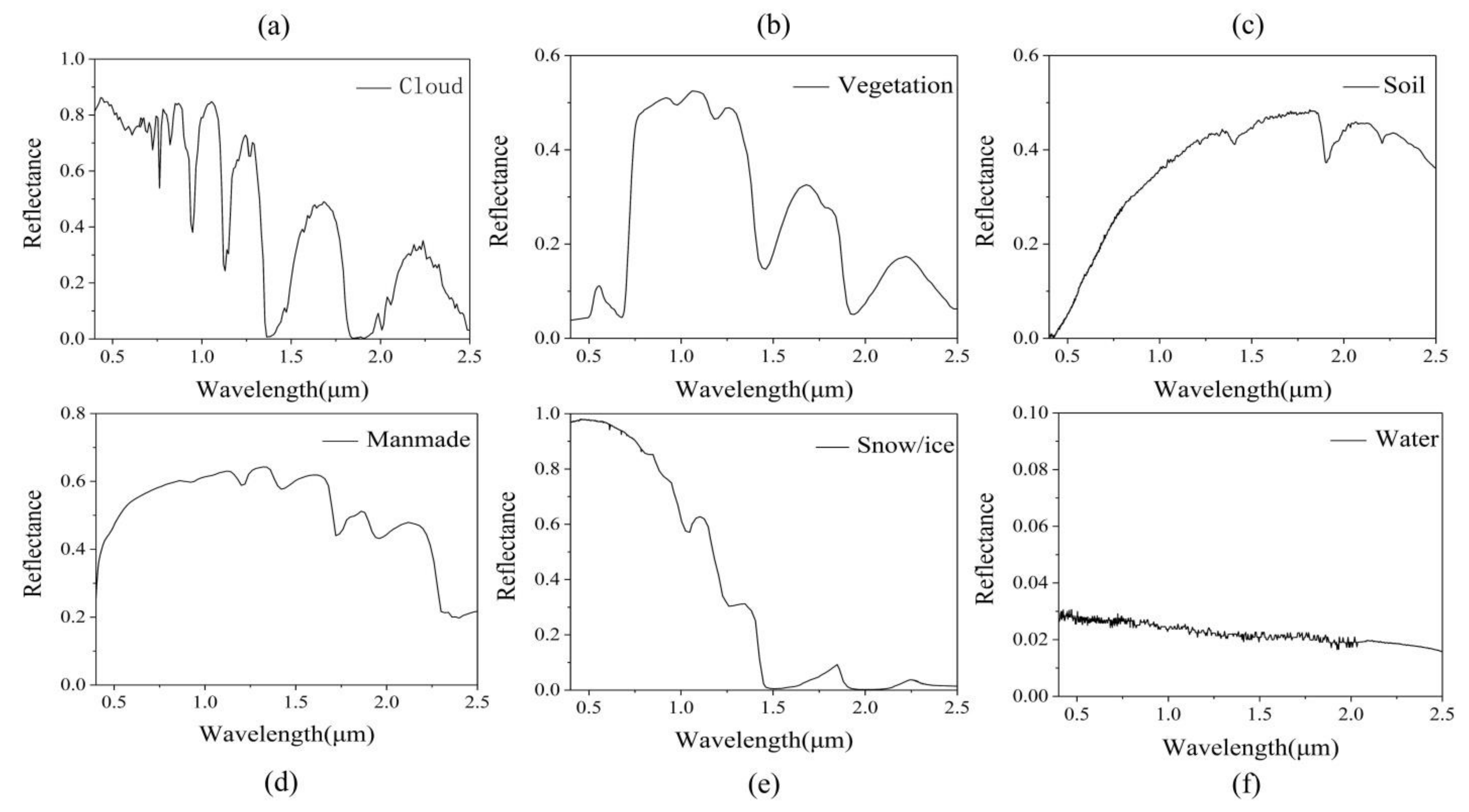
2.1.1. ASTER Spectral Library
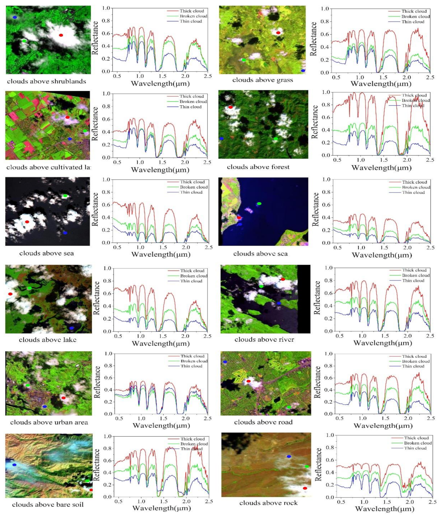
2.1.2. Cloud Pixel Spectral Library
2.2. Data Simulation
2.2.1. SRF Pre-Processing
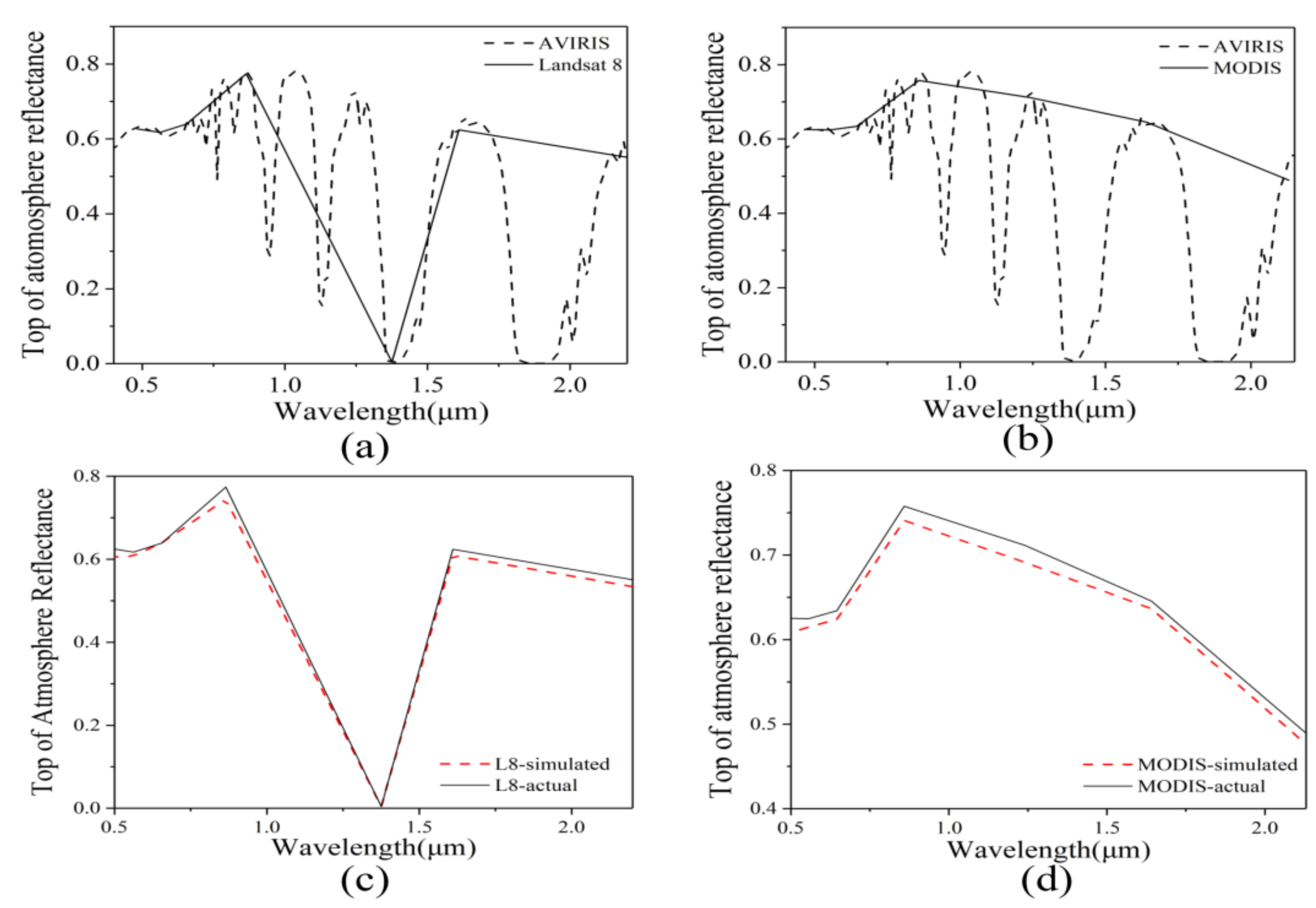
2.2.2. Simulation of Spectral Library
2.3. Cloud Detection Based on the Res-1D-CNN
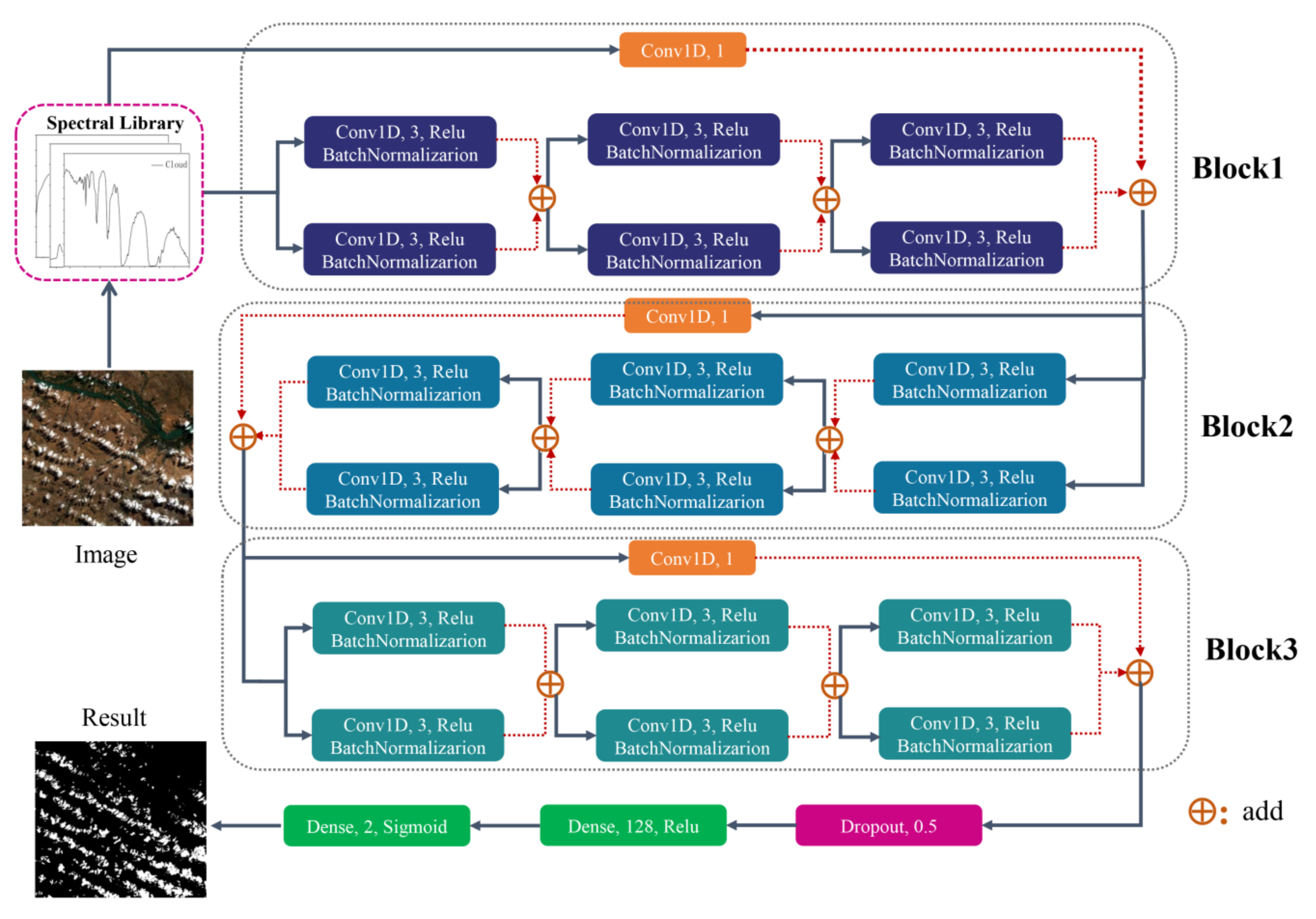
2.3.1. Network Structure
2.3.2. Network Training
3. Experiment and Results
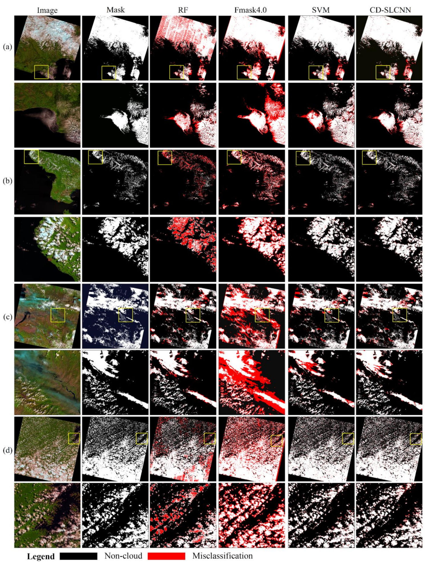
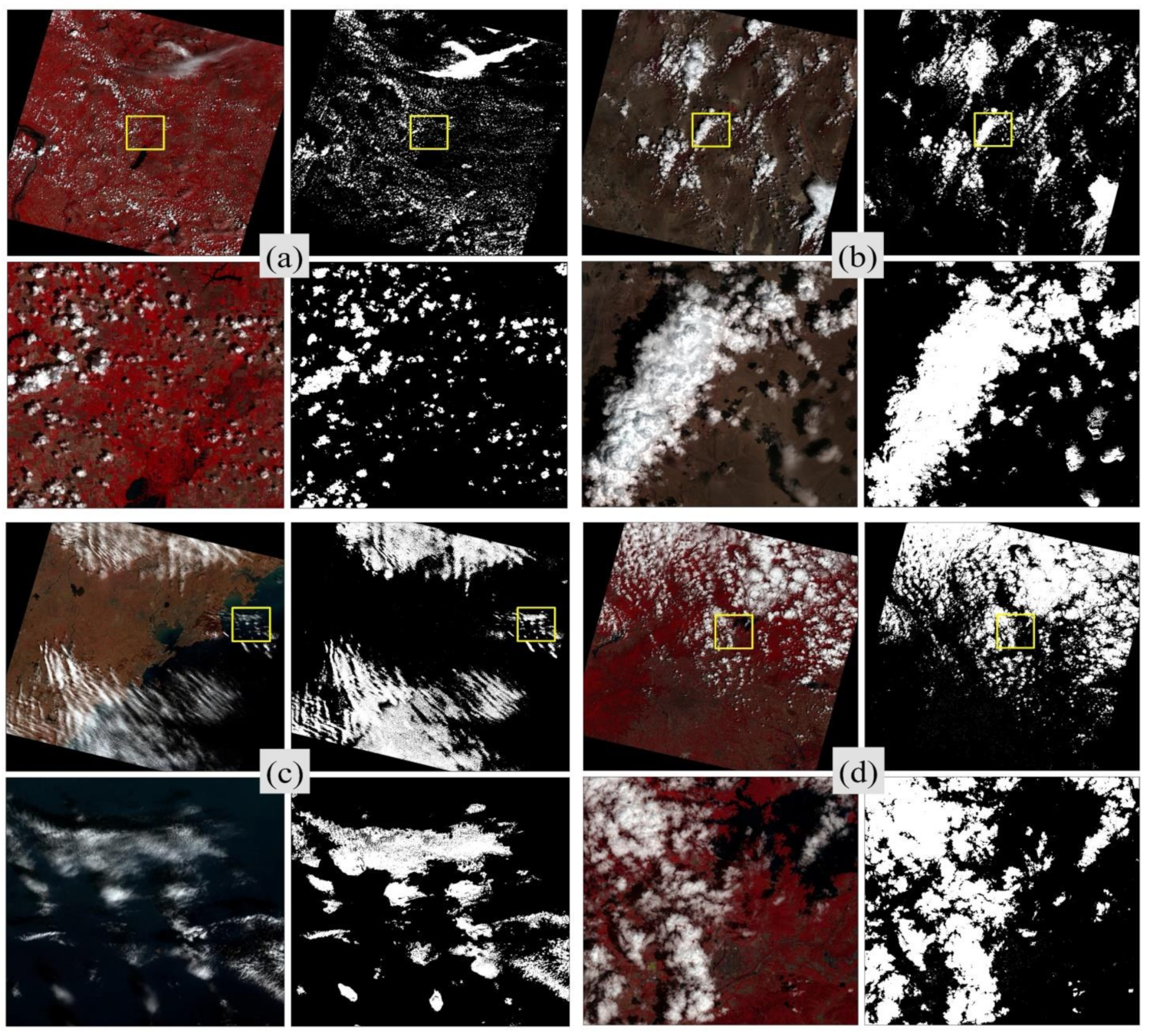
3.1. Detection Performance on Landsat-8 Data
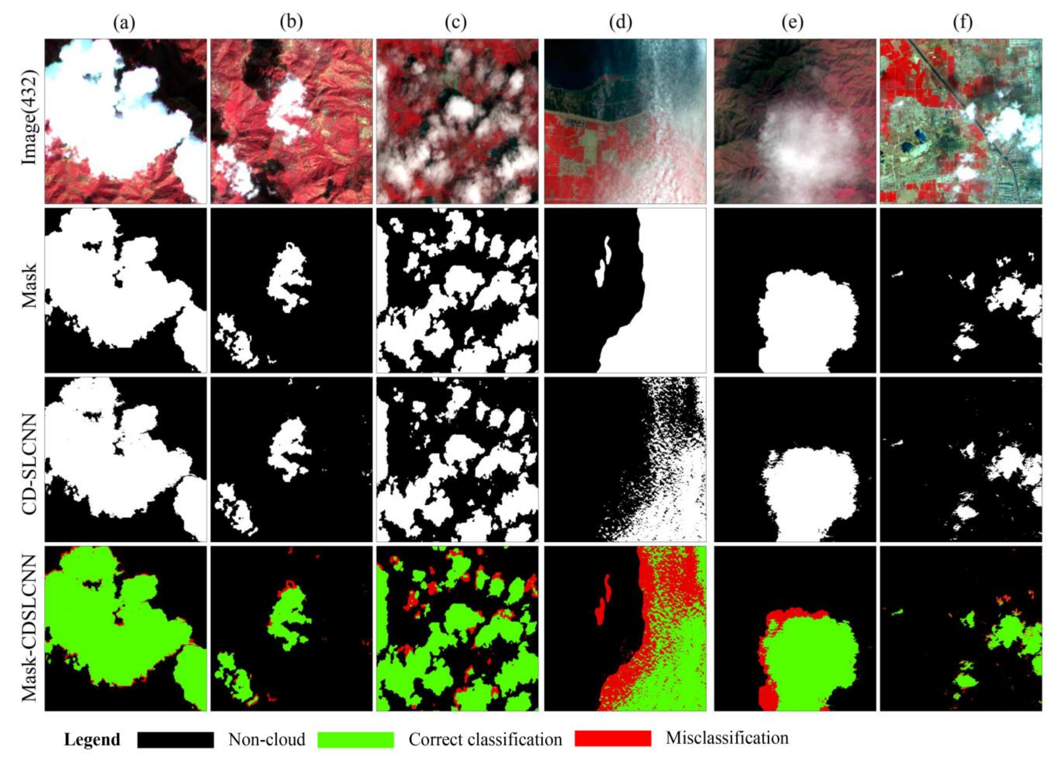
3.2. Detection Performance on MODIS and Sentinel-2 Data
3.3. Quantitative Analysis
3.3.1. Landsat-8 Biome
3.3.2. MODIS and Sentinel-2
3.4. Discussion
4. Conclusions
Author Contributions
Funding
Acknowledgments
Conflicts of Interest
References
- Wei, J.; Huang, W.; Li, Z.; Sun, L.; Zhu, X.; Yuan, Q.; Liu, L.; Cribb, M. Cloud detection for Landsat imagery by combining the random forest and superpixels extracted via energy-driven sampling segmentation approaches. Remote Sens. Environ. 2020, 248, 112005. [Google Scholar] [CrossRef] [Scilit]
- Yang, J.; Guo, J.; Yue, H.; Liu, Z.; Hu, H.; Li, K. CDnet: CNN-Based Cloud Detection for Remote Sensing Imagery. IEEE Trans. Geosci. Remote Sens. 2019, 57, 6195–6211. [Google Scholar] [CrossRef] [Scilit]
- Li, X.; Zheng, H.; Han, C.; Zheng, W.; Chen, H.; Jing, Y.; Dong, K. SFRS-Net: A Cloud-Detection Method Based on Deep Convolutional Neural Networks for GF-1 Remote-Sensing Images. Remote Sens. 2021, 13, 2910. [Google Scholar] [CrossRef] [Scilit]
- Sun, L.; Wei, J.; Wang, J.; Mi, X.; Guo, Y.; Lv, Y.; Yang, Y.; Gan, P.; Zhou, X.; Jia, C.; et al. A universal dynamic threshold cloud detection algorithm (UDTCDA) supported by a prior surface reflectance database. J. Geophys. Res. Atmos. 2016, 121, 7172–7196. [Google Scholar] [CrossRef] [Scilit]
- Wei, J.; Sun, L.; Peng, Y.; Wang, L.; Zhang, Z.; Bilal, M.; Ma, Y. An improved high-spatial-resolution aerosol retrieval algorithm for MODIS images over land. J. Geophys. Res. Atmos. 2018, 123, 12291–12307. [Google Scholar] [CrossRef] [Scilit]
- Zhang, Q.; Yuan, Q.; Li, Z.; Sun, F.; Zhang, L. Combined deep prior with low-rank tensor SVD for thick cloud removal in multitemporal images. ISPRS J. Photogramm. Remote Sens. 2021, 177, 161–173. [Google Scholar] [CrossRef] [Scilit]
- Sun, L.; Zhou, X.; Wei, J.; Wang, Q.; Liu, X.; Shu, M.; Chen, T.; Chi, Y. A New Cloud Detection Method Supported By GlobeLand30 Data set. IEEE J. Sel. Top. Appl. Earth Obs. Remote Sens. 2018, 11, 3628–3645. [Google Scholar] [CrossRef] [Scilit]
- Zhu, Z.; Woodcock, C.E. Automated cloud, cloud shadow, and snow detection in multitemporal Landsat data: An algorithm designed specifically for monitoring land cover change. Remote Sens. Environ. 2014, 152, 217–234. [Google Scholar] [CrossRef] [Scilit]
- Zhu, Z.; Wang, S.; Woodcock, C.E. Improvement and expansion of the Fmask algorithm: Cloud, cloud shadow, and snow detection for Landsats 4–7, 8, and sentinel 2 images. Remote Sens. Environ. 2015, 159, 269–277. [Google Scholar] [CrossRef] [Scilit]
- Ackerman, S.A.; Strabala, K.I.; Menzel, W.P. Discriminating clear sky from clouds with MODIS. J. Geophys. Res. 1998, 103, 32141–32157. [Google Scholar] [CrossRef] [Scilit]
- Frey, R.A.; Ackerman, S.A.; Liu, Y. Cloud detection with MODIS. Part I: Improvements in the MODIS cloud mask for collection 5. J. Atmos. Oceanic Technol. 2008, 25, 1057–1072. [Google Scholar] [CrossRef] [Scilit]
- Sun, L.; Yang, X.; Jia, S.; Jia, C.; Zhou, X. Satellite data cloud detection using deep learning supported by hyperspectral data. Int. J. Remote Sens. 2019, 41, 1349–1371. [Google Scholar] [CrossRef] [Scilit]
- Yuan, Q.; Shen, H.; Li, T.; Li, Z.; Zhang, L. Deep learning in environmental remote sensing: Achievements and challenges. Remote Sens. Environ. 2020, 241, 111716. [Google Scholar] [CrossRef] [Scilit]
- Hagolle, O.; Huc, M.; Pascual, D.V.; Dedieu, G. A multi-temporal method for cloud detection, applied to FORMOSAT-2, VENµS, LANDSAT and SENTINEL-2 images. Remote Sens. Environ. 2010, 114, 1747–1755. [Google Scholar] [CrossRef] [Scilit]
- Mateo-García, G.; Gómez-Chova, L.; Amorós-López, J.; Muñoz-Marí, J.; Camps-Valls, G. Multitemporal cloud masking in the Google Earth Engine. Remote Sens. 2018, 10, 1079. [Google Scholar] [CrossRef] [Scilit]
- Lyapustin, A.; Wang, Y.; Frey, R. An automatic cloud mask algorithm based on time series of MODIS measurements. J. Geophys. Res. 2008, 113, D16207. [Google Scholar] [CrossRef] [Scilit]
- Wieland, M.; Li, Y.; Martinis, S. Multi-sensor cloud and cloud shadow segmentation with a convolutional neural network. Remote Sens. Environ. 2019, 230, 111203. [Google Scholar] [CrossRef] [Scilit]
- Walder, P.; Maclaren, I. Neural network based methods for cloud classification on AV.HRR images. Int. J. Remote Sens. 2010, 21, 1693–1708. [Google Scholar] [CrossRef] [Scilit]
- Li, P.; Dong, L.; Xiao, H.; Xu, M. A cloud image detection method based on SVM vector machine. Neurocomputing 2014, 169, 34–42. [Google Scholar] [CrossRef] [Scilit]
- Chai, D.; Newsam, S.; Zhang, H.; Qiu, Y.; Huang, J. Cloud and cloud shadow detection in landsat imagery based on deep convolutional neural networks. Remote Sens. Environ. 2019, 225, 307–316. [Google Scholar] [CrossRef] [Scilit]
- Li, Z.; Shen, H.; Cheng, Q.; Liu, Y.; You, S.; He, Z. Deep learning based cloud detection for medium and high resolution remote sensing images of different sensors. ISPRS J. Photogramm. Remote Sens. 2019, 150, 197–212. [Google Scholar] [CrossRef] [Scilit]
- Guo, J.; Yang, J.; Yue, H.; Tan, H.; Hou, C.; Li, K. CDnetV2: CNN-Based Cloud Detection for Remote Sensing Imagery With Cloud-Snow Coexistence. IEEE Trans. Geosci. Remote Sens. 2021, 59, 700–713. [Google Scholar] [CrossRef] [Scilit]
- Ma, N.; Sun, L.; Wang, Q.; Yu, Z.; Liu, S. Improved cloud detection for landsat 8 images using a combined neural network model. Remote Sens. Lett. 2020, 11, 274–282. [Google Scholar] [CrossRef] [Scilit]
- Segal-Rozenhaimer, M.; Li, A.; Das, K.; Chirayath, V. Cloud detection algorithm for multi-modal satellite imagery using convolutional neural-networks (cnn). Remote Sens. Environ. 2020, 237, 111446. [Google Scholar] [CrossRef] [Scilit]
- Shao, Z.; Pan, Y.; Diao, C.; Cai, J. Cloud detection in remote sensing images based on multiscale features-convolutional neural network. IEEE Trans. Geosci. Remote Sens. 2019, 57, 4062–4076. [Google Scholar] [CrossRef] [Scilit]
- Ronneberger, O.; Fischer, P.; Brox, T. U-Net: Convolutional Networks for Biomedical Image Segmentation. Medical Image Computing and Computer-Assisted Intervention; Springer: Cham, Switzerland, 2015. [Google Scholar]
- Jeppesen, J.H.; Jacobsen, R.H.; Inceoglu, F.; Toftegaard, T.S. A cloud detection algorithm for satellite imagery based on deep learning. Remote Sens. Environ. 2019, 229, 247–259. [Google Scholar] [CrossRef] [Scilit]
- Francis, A.; Sidiropoulos, P.; Muller, J.P. Cloudfcn: Accurate and robust cloud detection for satellite imagery with deep learning. Remote Sens. 2019, 11, 2312. [Google Scholar] [CrossRef] [Scilit]
- Gómez-Chova, L.; Muñoz-Marí, J.; Amorós-López, J.; Izquierdo-Verdiguier, E.; Camps-Valls, G. Advances in synergy of AATSR-MERIS sensors for cloud detection. In Proceedings of the 2013 IEEE International Geoscience and Remote Sensing Symposium (IGARSS), Melbourne, VIC, Australia, 21–26 July 2013; pp. 4391–4394. [Google Scholar]
- Baldridge, A.M.; Hook, S.J.; Grove, C.I.; Rivera, G. The aster spectral library version 2.0. Remote Sens. Environ. 2009, 113, 711–715. [Google Scholar] [CrossRef] [Scilit]
- Sun, L.; Mi, X.; Wei, J.; Wang, J.; Tian, X.; Yu, H.; Gan, P. A cloud detection algorithm-generating method for remote sensing data at visible to short-wave infrared wavelengths. ISPRS J. Photogramm. Remote Sens. 2017, 124, 70–88. [Google Scholar] [CrossRef] [Scilit]
- Kotchenova, S.Y.; Vermote, E.F.; Matarrese, R.K.F., Jr. Validation of a vector version of the 6s radiative transfer code for atmospheric correction of satellite data, part i: Path radiance. Appl. Opt. 2006, 45, 6762–6774. [Google Scholar] [CrossRef] [Scilit]
- Vane, G.; Green, R.O.; Chrien, T.G.; Enmark, H.T.; Hansen, E.G.; Porter, W.M. The airborne visible/infrared imaging spectrometer (AVIRIS). Remote Sens. Environ. 1993, 44, 127–143. [Google Scholar] [CrossRef] [Scilit]
- Baugh, W.M.; Kruse, F.A.; Atkinson, W.W. Quantitative geochemical mapping of ammonium minerals in the southern cedar mountains, Nevada, using the airborne visible/infrared imaging spectrometer (AVIRIS). Remote Sens. Environ. 1998, 65, 292–308. [Google Scholar] [CrossRef] [Scilit]
- Wei, J.; Ming, Y.F.; Han, L.S.; Ren, Z.L.; Guo, Y.M. Method of remote sensing identification for mineral types based on multiple spectral characteristic parameters matching. Spectrosc. Spect. Anal. 2015, 35, 2862–2866. [Google Scholar]
- Thompson, D.; Gao, B.; Green, R.; Roberts, D.; Dennison, P.; Lundeen, S.; Mouradi, Y. Level 2 Processing of AVIRIS HyspIRI Preparatory Campaign Measurements. Available online: http://hyspiri.jpl.nasa.gov/downloads/2014_Symposium/day2/-0900_pres_HyspIRI_level2_140604c.pdf (accessed on 17 March 2014).
- Xie, F.; Shi, M.; Shi, Z.; Yin, J.; Zhao, D. Multilevel cloud detection in remote sensing images based on deep learning. IEEE J. Sel. Top. Appl. Earth Obs. Remote Sens. 2017, 10, 3631–3640. [Google Scholar] [CrossRef] [Scilit]
- Zhan, Y.; Wang, J.; Shi, J.; Cheng, G.; Yao, L.; Sun, W. Distinguishing cloud and snow in satellite images via deep convolutional network. IEEE Geosci. Remote Sens. Lett. 2017, 14, 1785–1789. [Google Scholar] [CrossRef] [Scilit]
- Shendryk, Y.; Rist, Y.; Ticehurst, C.; Thorburn, P. Deep learning for multi-modal classification of cloud, shadow and land cover scenes in PlanetScope and Sentinel-2 imagery. ISPRS J. Photogramm. Remote Sens. 2019, 157, 124–136. [Google Scholar] [CrossRef] [Scilit]
- Zhong, L.; Hu, L.; Zhou, H. Deep learning based multi-temporal crop classification. Remote Sens. Environ. 2018, 221, 430–443. [Google Scholar] [CrossRef] [Scilit]
- Foga, S.; Scaramuzza, P.L.; Guo, S.; Zhu, Z.; Dilley, R.D.; Beckmann, T.; Schmidt, G.L.; Dwyer, J.L.; Hughes, M.J.; Laue, B. Cloud detection algorithm comparison and validation for operational Landsat data products. Remote Sens. Environ. 2017, 194, 379–390. [Google Scholar] [CrossRef] [Scilit]
- Levy, R.C.; Mattoo, S.; Munchak, L.A.; Remer, A.; Sayer, M.; Hsu, N.C. The collection 6 MODIS aerosol products over land and ocean. Atmos. Meas. Tech. Discuss. 2013, 6, 159–259. [Google Scholar]
- Mateo-García, G.; Laparra, V.; López-Puigdollers, D.; Gómez-Chova, L. Transferring deep learning models for cloud detection between Landsat-8 and Proba-V. ISPRS J. Photogramm. Remote Sens. 2020, 160, 1–17. [Google Scholar] [CrossRef] [Scilit]
- Sun, L.; Liu, X.; Yang, Y.; Chen, T.; Wang, Q.; Zhou, X. A cloud shadow detection method combined with cloud height iteration and spectral analysis for landsat 8 oli data. ISPRS J. Photogramm. Remote Sens. 2018, 138, 193–207. [Google Scholar] [CrossRef] [Scilit]
- Zou, Z.; Li, W.; Shi, T.; Shi, Z.; Ye, J. Generative Adversarial Training for Weakly Supervised Cloud Matting. In Proceedings of the 2019 IEEE/CVF International Conference on Computer Vision (ICCV), Seoul, Korea, 27 October–2 November 2019; pp. 201–210. [Google Scholar]
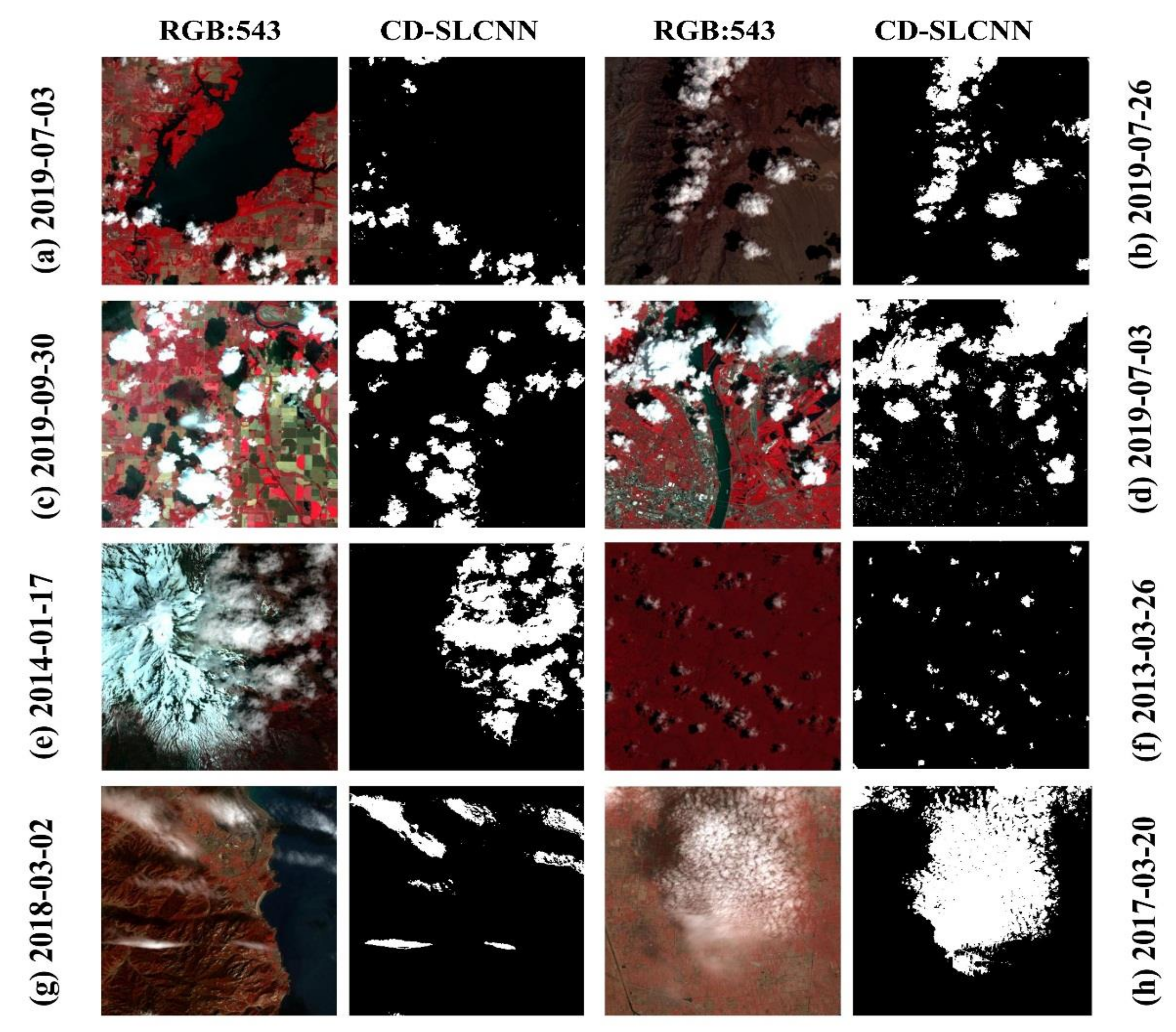

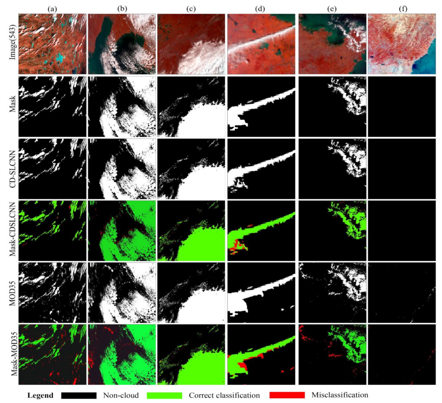


| Method | OA | PA | UA | Kappa | MIoU |
|---|---|---|---|---|---|
| RF | 93.90% | 77.82% | 91.30% | 79.20% | 71.80% |
| Fmask | 92.71% | 92.78% | 79.59% | 82.16% | 77.53% |
| SVM | 95.26% | 80.40% | 94.82% | 83.50% | 77.44% |
| CD-SLCNN | 95.60% | 83.21% | 96.43% | 84.27% | 77.82% |
| Method | OA | PA | UA | Kappa | MIoU |
|---|---|---|---|---|---|
| RF | 90.46% | 88.76% | 92.15% | 78.56% | 71.35% |
| MOD35 | 92.44% | 85.24% | 99.63% | 80.16% | 74.75% |
| SVM | 93.32% | 88.96% | 98.07% | 83.08% | 77.40% |
| CD-SLCNN | 95.36% | 92.16% | 98.74% | 83.78% | 77.94% |
| Method | OA | PA | UA | Kappa | MIoU |
|---|---|---|---|---|---|
| RF | 90.05% | 83.29% | 97.52% | 72.46% | 70.12% |
| SVM | 92.44% | 86.04% | 96.91% | 80.39% | 76.29% |
| CD-SLCNN | 94.27% | 91.61% | 96.84% | 81.17% | 77.23% |
Publisher’s Note: MDPI stays neutral with regard to jurisdictional claims in published maps and institutional affiliations. |
© 2021 by the authors. Licensee MDPI, Basel, Switzerland. This article is an open access article distributed under the terms and conditions of the Creative Commons Attribution (CC BY) license (https://creativecommons.org/licenses/by/4.0/).
Share and Cite
Ma, N.; Sun, L.; Zhou, C.; He, Y. Cloud Detection Algorithm for Multi-Satellite Remote Sensing Imagery Based on a Spectral Library and 1D Convolutional Neural Network. Remote Sens. 2021, 13, 3319. https://doi.org/10.3390/rs13163319
Ma N, Sun L, Zhou C, He Y. Cloud Detection Algorithm for Multi-Satellite Remote Sensing Imagery Based on a Spectral Library and 1D Convolutional Neural Network. Remote Sensing. 2021; 13(16):3319. https://doi.org/10.3390/rs13163319
Chicago/Turabian StyleMa, Nan, Lin Sun, Chenghu Zhou, and Yawen He. 2021. "Cloud Detection Algorithm for Multi-Satellite Remote Sensing Imagery Based on a Spectral Library and 1D Convolutional Neural Network" Remote Sensing 13, no. 16: 3319. https://doi.org/10.3390/rs13163319
APA StyleMa, N., Sun, L., Zhou, C., & He, Y. (2021). Cloud Detection Algorithm for Multi-Satellite Remote Sensing Imagery Based on a Spectral Library and 1D Convolutional Neural Network. Remote Sensing, 13(16), 3319. https://doi.org/10.3390/rs13163319