Article

An Analysis of Urbanisation Dynamics with the Use of the Fuzzy Set Theory—A Case Study of the City of Olsztyn

1
Department of Socio-Economic Geography, Institute of Spatial Management and Geography, Faculty of Geoengineering, University of Warmia Mazury in Olsztyn, 10-720 Olsztyn, Poland
2
Department of Geoinformation and Cartography, Institute of Geodesy and Civil Engineering, Faculty of Geoengineering, University of Warmia Mazury in Olsztyn, 10-720 Olsztyn, Poland
*
Author to whom correspondence should be addressed.
Remote Sens. 2020, 12(11), 1784; https://doi.org/10.3390/rs12111784
Submission received: 9 May 2020 / Revised: 28 May 2020 / Accepted: 29 May 2020 / Published: 1 June 2020

Abstract

:
Quantitative, qualitative and structural changes in land use that occur in a given location over time are a manifestation and a measure of urban development. Urbanisation is a process of spatial diffusion that spreads from the urban core to peripheral areas. Urban development is linked with human activities in a specific location and in a given period of time. In the context of spatial management, urbanisation is a process where less intensive land-use types are replaced by more intensive forms of land use. The demand for new land for residential development, the search for alternative locations for housing construction and the development of sustainable land management plans require new methods that support decision-making in the process of land conversion in peri-urban areas. The aim of this study was to develop a methodology for identifying and localising the boundaries of urban development with the use of the fuzzy set theory and to analyse the rate of changes in land use based on data for 2005–2010–2017. The proposed method supports the identification and localisation of urbanised areas and an evaluation of the degree of urbanisation in the interval [0,1]. The case study was conducted in the Polish city of Olsztyn.

Graphical Abstract

1. Introduction

Urbanisation is one of the most visible manifestations of global change processes [1]. In recent decades, urbanisation has been progressing at an alarming rate, which could reach 70% by the end of 2050 [2,3,4]. This highly complex and multi-faceted process can be analysed in several dimensions, including demographic, social, economic, spatial, environmental and legal [5]. At present, urbanisation is regarded as a multi-dimensional manifestation of processes and phenomena that accelerate urban growth, increase the urban population, increase the concentration of the urban population in the largest cities, contribute to urban land expansion and increase the significance of cities as hubs of business and administration. These processes lead to the emergence of a new cultural identity associated with the urban lifestyle, landscape and architecture [6].
Urbanisation induces profound changes in landscape, and it gradually modifies the spatial structure of land use. This spatial diffusion process is driven by the interactions between numerous factors, and it contributes to the development of new landscape patterns [7].
Urbanisation is a process that occurs in the spatial dimension in both urban and rural areas. In the past century, the rapid growth of cities exerted strong pressure on land, local resources and, in particular, rural areas in the immediate vicinity of urban centres [8,9]. The concentration of human activities in specific locations and regions promotes the development of large cities and other forms of urban settlement [10]. The growth and transformation of cities are driven by the forces of attraction between specific locations. These changes are accelerated by the development of transport networks as well as the benefits that arise from the spatial agglomeration of resources, including human resources. Urbanisation is perceived as an organic growth process that begins in the urban core and leads to the spontaneous formation of mini urban areas, in particular along the transport network [11]. Most of these processes are highly dynamic, and they induce rapid changes in the structure and organisation of land use [7].
All cities continue to evolve. The underlying elements of a city and the relations between these elements change. Urban development is a continuous process, and a single “ideal” level of development does not exist. The attained level of development is only a transient state which constitutes the point of venture for the next stage of growth. Suburbanisation, namely residential development in a city’s peripheral zone, plays a very important role during the rapid growth of cities. Suburban areas can be developed simultaneously with the existing urban structures, or they can form small and dispersed residential estates in the fringe areas of a city. In the literature, areas that are directly affected by urbanisation pressure are referred to as the rural-urban transition zone [12,13], the rural-urban continuum [14,15,16,17,18] or the suburban zone [19,20,21,22]. Studies investigating suburbia focus not only on the incorporation of new areas into the urban influence zone, but also on changes in land use, infrastructure and the environmental impact of urbanisation [11]. Changes in land use are also analysed in the rural-urban fringe [23,24,25,26,27,28], which constitutes a “green belt” around a city [29,30,31], as well as in areas that are referred to as “urban villages” [32]. The areas experiencing suburbanisation pressure are also analysed to determine their attractiveness to investors [33,34] and to evaluate the potential of local real estate markets [35,36,37,38].
The urbanisation of peripheral areas is driven by urban development, and the associated processes are collectively referred to as urban sprawl. Urban sprawl is regarded as a natural process which is fuelled by the dynamic and chaotic growth of cities and the resulting socio-economic changes [39]. The directions, extent and rate of urbanisation have to be closely monitored. Urban sprawl is frequently measured based on the population density gradient, namely changes in the spatial distribution of population over distance from the urban core [39], or based on the size of an urban area [40]. The results of these analyses indicate that the increase in the size of urbanised areas is not proportional to the increase in the urban population [41].
Research on urbanisation generally relies on demographic data and statistical data on land use in local administration units. These data provide valuable information about the extent of urbanisation, but the direction, scope and range of spatial changes cannot be directly inferred from statistical resources. Geographic information system (GIS) tools and databases, such as land cover databases, and various data processing and modelling techniques are used by researchers to fill in these knowledge gaps. GIS and remote sensing (RS) tools offer a useful platform for identifying changes in land use in suburban zones [42]. These systems and tools provide accurate information about land use and changes in land cover. At present, Copernicus and Landsat satellites are the main sources of data, and the images captured by Copernicus satellites provide a higher level of detail for nearly the entire planet. Remote sensing products are used to monitor urbanisation processes [43,44], generate high-resolution images of land cover [45,46], identify changes in land use in urban and suburban areas [47,48,49], monitor changes resulting from human activity [50,51], analyse the proportions of undeveloped land with vegetation cover in urban areas (UELC) [52] and develop crisis management protocols (by supplying valuable data for generating maps, monitoring the natural environment, managing natural disasters and supporting the operations of military and civilian intelligence) [53]. The degree of urbanisation is also determined based on synthetic-aperture radar (SAR) data [54], very high resolution (VHR) satellite imagery [55,56], night-time light (NTL) data [57,58,59], data on greenhouse gas emissions [60,61] and changes in vegetation, including with the use of the normalised difference vegetation index (NDVI) [62].
The rapid growth of cities and the resulting environmental challenges require accurate mapping techniques to present complex land cover characteristics in sufficient detail [44]. The Urban Atlas and the CORINE Land Cover (CLC) repository are widely used to identify and monitor anthropogenic and natural changes in land use [63,64,65,66,67,68,69]. The applied methods and techniques differ in the availability of data, ease of classification of selected land-use types, labour intensity, cost and spatial and temporal continuity. They require specialist knowledge and dedicated data processing algorithms.
Analyses of urbanisation pressure are complex and laborious due to the large number of the evaluated attributes and significant volumes of data. In such studies, the main limitations are associated with the multidimensional and imprecise character of land-use data. Areas with complex land-use structures could be effectively analysed with the use of fuzzy logic, which is applied to describe complex phenomena and vague concepts that are difficult to define with the involvement of classical models. According to the classical set theory, an element either belongs (true) or does not belong (false) to a set—all sets have crisp boundaries, and there are no grey areas. In the fuzzy set theory, intermediate values (half true and half false) represented by fractions are permitted in addition to true (1) and false (0) values. An element can belong, not belong or half belong to a given set, and the degree of membership in a set is expressed by a real number interval [0,1]. Based on the degree of membership, every element in a fuzzy set is assigned a value in the range [0,1]. The real unit interval denotes the degree to which a given element belongs to a fuzzy set [70]. Fuzzy logic is the main concept in the fuzzy set theory, and it is applied to model and control systems characterised by incomplete or imprecise data [71].
Land-use types can be defined as sets of attributes that are responsible for the multidimensional character of space. Spatial information is often fuzzy and vague; therefore, every spatial event and land cover status can be assigned a fuzzy measure to determine their membership in a given category. The fuzzy set theory can be applied to assess the membership of different land-use types in a set of specific functions in the interval [0,1]. The aim of this study was to develop a methodology for identifying and localising the boundaries of urban development with the use of the fuzzy set theory and to analyse the rate of changes in land use based on data for 2005, 2010 and 2017. The proposed method supports the identification and localisation of urbanised areas and an evaluation of the degree of urbanisation in the interval [0,1]. The case study was conducted in the Polish city of Olsztyn.

2. Materials and Methods

2.1. Study Area

The analysed area is the city of Olsztyn (Poland). The city is the capital of Warmińsko-Mazurskie Voivodeship and a major urban centre in north-eastern Poland (Figure 1).
The studied area is characterised by a large number of lakes and smaller water bodies, as well as an abundance of forests. There are 15 lakes within the administrative boundaries of Olsztyn, 13 of which are larger than 1 ha. The lakes have a combined area of 725 ha, which accounts for more than 8% of the city’s area. Forests cover more than 21% of Olsztyn’s area, and the Municipal Forest is the largest collection of trees in the city. Olsztyn is enclosed by natural barriers, including lakes, forests and rivers, on all sides. In the past, these barriers played an important role as security perimeters, but at present, they hinder the city’s development, excluding in the south-east part of the city.

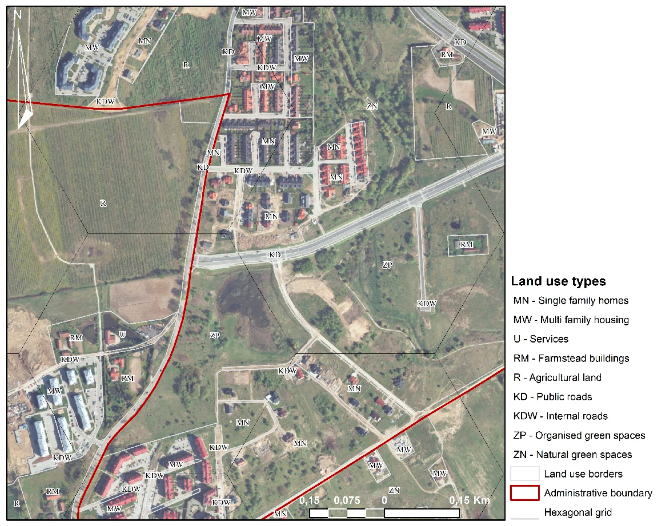
2.2. The Use of the Fuzzy Set Theory for the Identification of Urban Development Boundaries
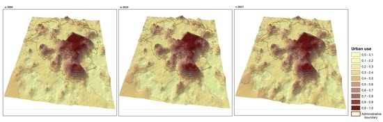
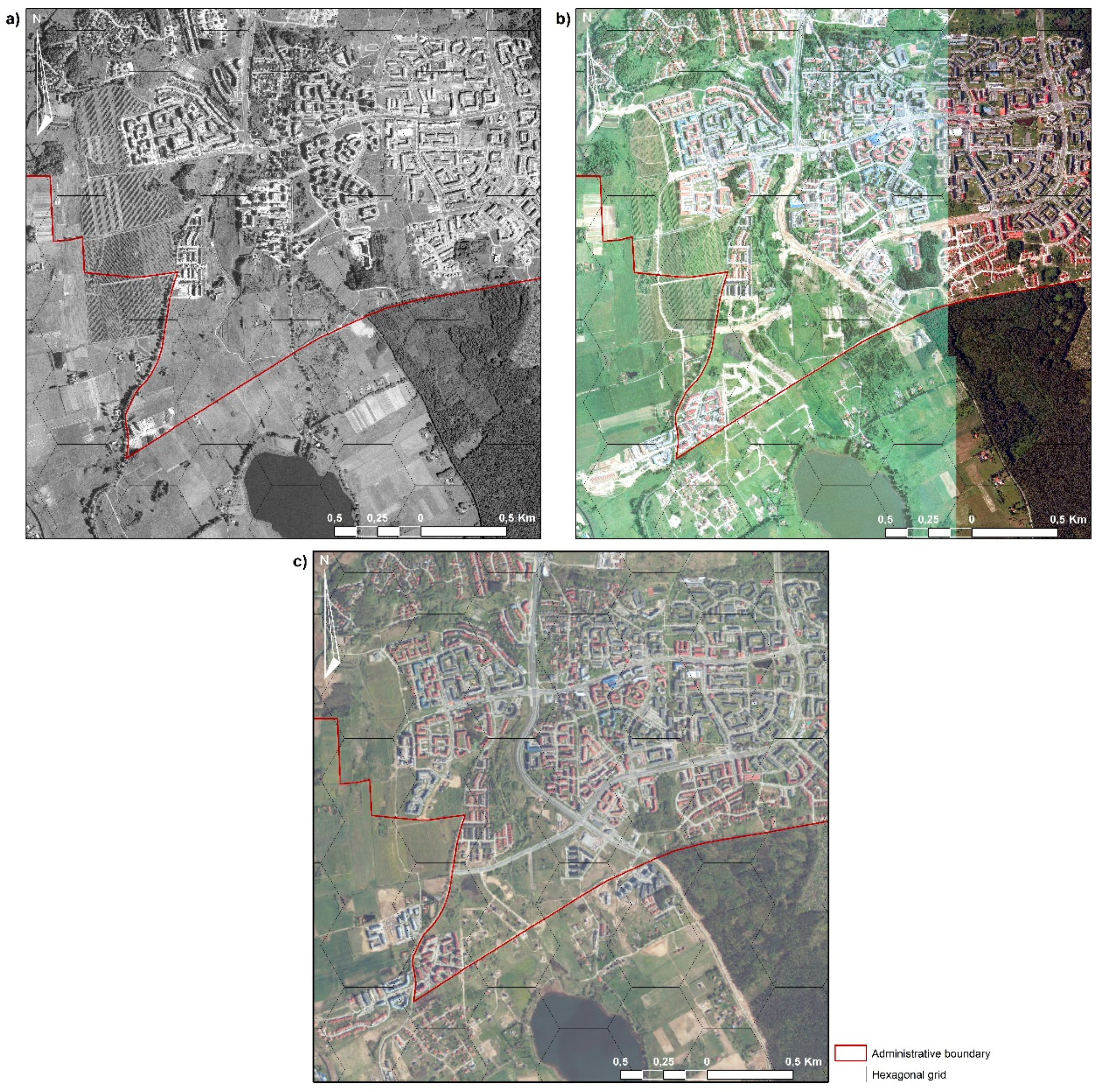
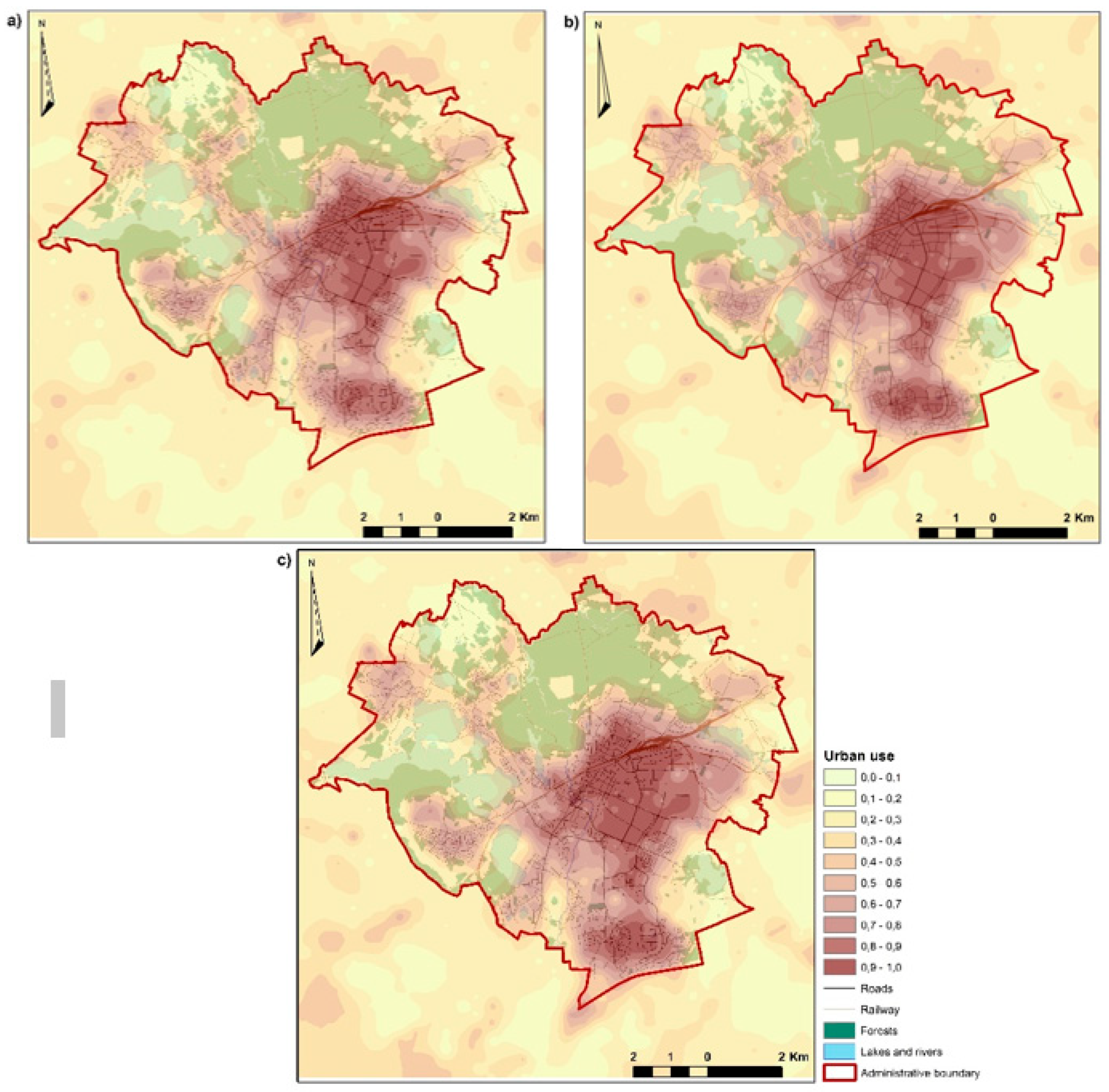
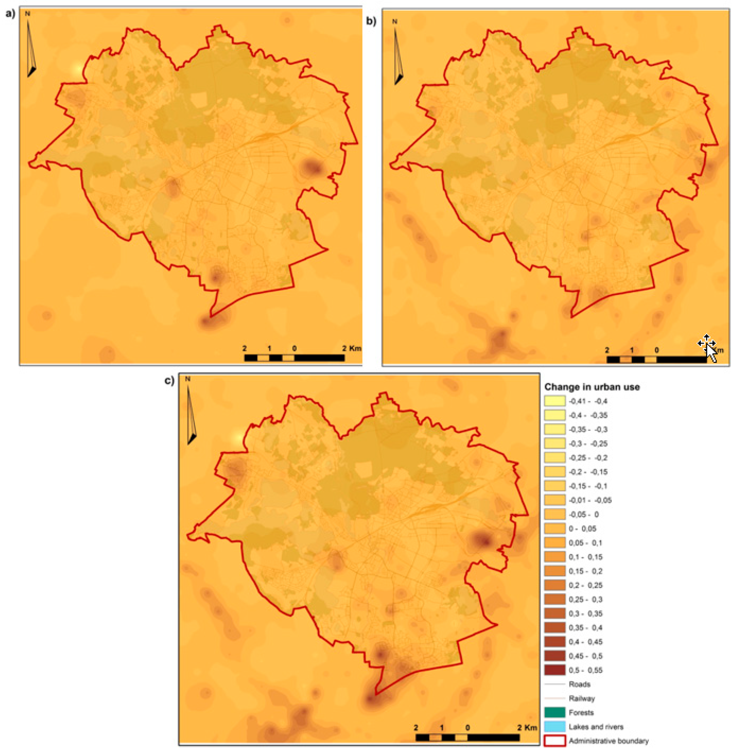
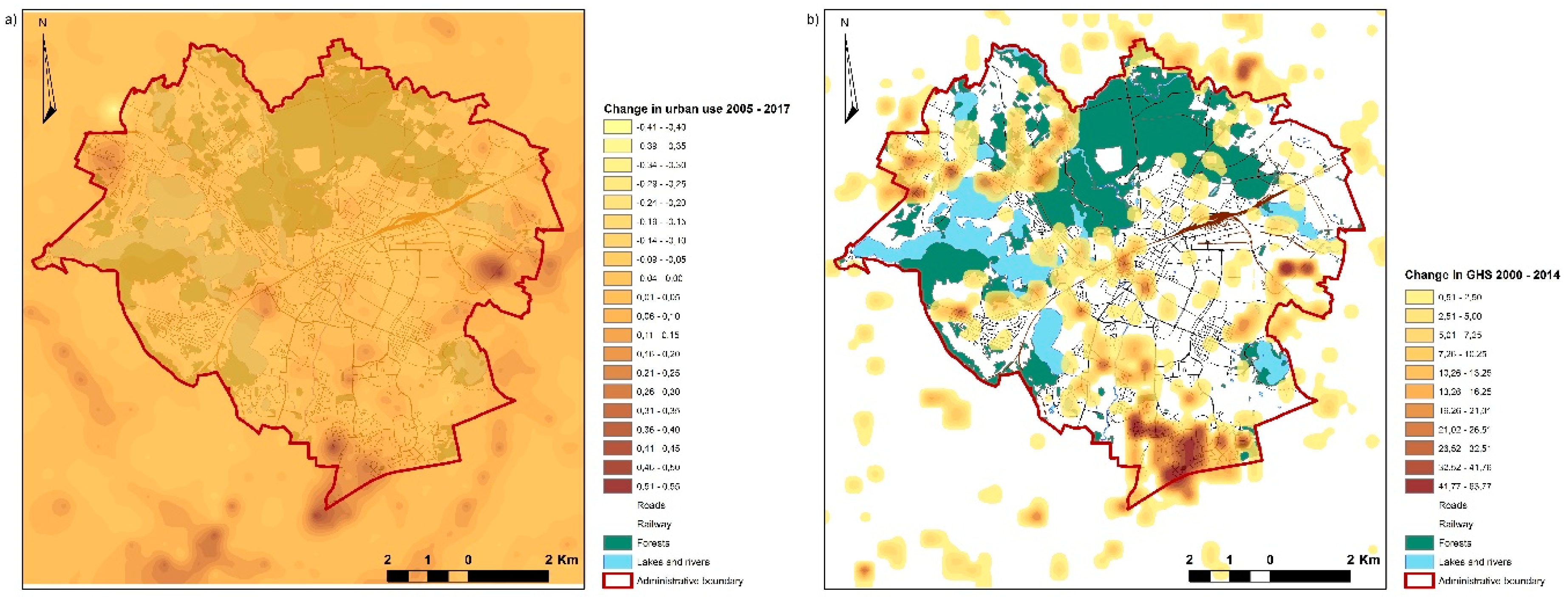
The main aim of this study was to propose a methodology for identifying and localising the boundaries of urban development with the use of the fuzzy set theory, determining the degree of urbanisation in the interval [0,1] and describing the rate of changes in land use between 2005 and 2017. The extent of urbanisation processes and the rural-urban transition zone were identified using the fuzzy set theory [12,13]. The study was conducted on the assumption that different land-use types in the city are associated with urban functions to a varied degree. The fuzzy set theory was applied to propose fuzzy measures for different land-use types and to determine the degree of the analysed area’s membership in a set of urban functions in the interval [0,1]. An analysis of urbanisation dynamics with the use of the fuzzy set theory is conducted according to the procedure presented in Figure 2.
An element’s degree of membership in a set is difficult to define unambiguously. Such assessments are usually subjective and context-dependent, and an exact degree of membership does not exist in itself. The degree of membership reflects the extent to which the evaluated object can be associated with a set of specific attributes [70]. This parameter can be defined based on the results of questionnaire surveys or expert interviews [72]. In this study, 24 land-use types were used to identify the boundaries of urbanisation and determine the level and rate of urban development (Table 1). The degree of membership in a set of urban functions was determined for each of the evaluated land-use types. The analysis involved a questionnaire survey [13] during which the respondents were asked to indicate which of the following land-use types were “more urban” than the others. The results of the survey were used to develop a fuzzy model of the city. The questionnaire was composed of three diagrams (in matrix form), and the respondents relied on a set of symbols (“←”, “O”, or “↑”, and the adopted range of values: 2-1-0) to indicate (by direct comparison) which of the following were characterised by a greater number of urban features:
1. The existing types of development, including single-family homes, multi-family housing, residential and commercial services, commercial services, industrial plants and warehouses, technical infrastructure, recreational areas and farmsteads;
2. Land use functions in zoning plans, including low-density residential development, high-density residential development, residential and commercial services (city centre), commercial services, commercial facilities with a sales area larger than 2000 m2, sports and recreational areas, industry and business, special areas (military, police), parks and organised green spaces, unorganised and natural green spaces, gardens, orchards and horticulture farms, cemeteries, forest parks, forests, arable land, meadows and pastures, open waters, hydraulic structures, technical infrastructure, public roads and mining areas;
3. Landscape types, including scenic and aesthetic landscapes (typically encountered in urban areas) in the following areas: multi-family housing, single-family homes, commercial services, industry and storage, technical infrastructure, farmsteads, recreational areas, organised green spaces, unorganised and natural green spaces, forests, gardens, orchards and horticulture farms, arable land, open waters and hydraulic structures.
The survey was conducted among the employees of the Faculty of Geodesy, Spatial Engineering and Construction of the University of Warmia and Mazury in Olsztyn, the Municipal Office in Olsztyn, as well as planning and real estate experts. To ensure that various urban land-use types were accurately characterised, some land-use types were described based on data from three diagrams, whereas others, such as inland surface waters, were described with the use of data from diagrams two and three only. A fuzzy measure, i.e., the degree of membership of urban land-use types was developed and normalised within the [0,1] interval to process the results of the questionnaire for each of the 24 analysed land-use types.
The boundaries of urban development were determined in the city of Olsztyn and the rural-urban fringe with a combined area of 202.4 km2. The study relied on the orthophotomaps for 2005, 2010 and 2017, which were acquired from the Olsztyn City Office. The studied area was divided into hexagonal primary fields with an area of 200,000 m2 each (Figure 3).
Orthophotomaps were visually interpreted during expert interviews to identify and classify the existing forms of land use in all 1012 fields in the analysed time periods. The inventory was performed with the use of cartographic resources from national databases, including aerial photographs and data from the land and building register. Field surveys were conducted when land-use types were difficult to identify. Datasets in geotiff format and data acquired from web services such as the Web Map Service (WMS) were integrated and analysed in ArcGIS 10.7. The expert method of visual interpretation of the orthophotomaps [7,73,74,75] and other sources of information were used to identify the existing forms of land use in all 1012 primary fields. The identified land-use types were classified. The proportions (percentage) of each of the 24 land-use types in every field were determined for 2005, 2010 and 2017 (the inventory for 2017 data is presented in Figure 4).
The results of the inventory were used to generate a geospatial database containing vector data for each analysed year.

3. Result

The calculated degree of membership in a set of urban functions (Table 1) and the results of the land-use inventory for 2005, 2010 and 2017 were used to develop a fuzzy model of the analysed city. In each field, the degree of membership in a set of urban functions was calculated as the sum of products of the respective land-use types in the evaluated area and the degree of membership indicated in Table 1.
The geostatistical methods available in ArcGIS software were used to model the spatial distribution of the degree of membership in each area based on the values assigned to each field. A preliminary analysis of data was performed with the use of simple cokriging. The selected interpolation method was deployed by assigning the value of a primary field to its geometric centre. An additional variable, namely the distance between the centre of the primary field and the city centre, was taken into account to ensure that the generated model fit the data as closely as possible. The adopted method was characterised by the lowest error values relative to the remaining geostatistical approaches. The analysis produced rasters with a resolution of 56.6 m/pix for each year. The developed model was used to identify the processes contributing to the formation of the rural-urban transition zone.
The degree of urbanisation in the studied area in 2005, 2010 and 2017, the administrative boundaries of Olsztyn, the road and railway network, forests and lakes are presented in Figure 5.
The dynamics of city growth is determined mainly by the urban morphology (form of urban development) and the extent to which it corresponds with the city’s size, functions as well as economic, social, technical and environmental determinants of growth. Olsztyn features natural barriers, such as forests and lakes, which cannot be physically overcome and which inhibit urban development. The degree of membership in urban functions, which is equal to the sum of land-use type indicators in the primary field (Table 1) and accounts for the proportions of each land-use type in the total area of the primary field, was calculated for each of the 1012 fields with the use of Formula (1):
D M U i = j = 1 m M U j i × A S j i
where:
DMUidegree of membership of the i-th field
M U j i degree of membership of the j-th land-use type in field i
m—number of land-use types
A S j i proportions of the j-th land-use type in the area of the i-th field
The above procedure was repeated for the data from the orthophotomaps for 2005, 2010 and 2017. The results of the analysis were used to develop a fuzzy model of urbanised space. The evaluated area is characterised by considerable variations in spatial continuity. The highest degree of urbanisation on the adopted scale was noted in the centre of the city and in areas with a predominance of multi-family housing, services and industrial facilities. In the analysis based on 2005 data, only 156 primary fields were classified in the set of urban functions in the interval [0.50–1.00], and these fields accounted for 15.41% of the analysed area (31.2 km2). The changes in the degree of urbanisation in the remaining years of the study are presented in Table 2.
The area of land-use types with a predominantly urban character is relatively low in Olsztyn due to a prevalence of green spaces, forests, lakes, farm fields and orchards in the city. Olsztyn has never been an industrial hub, and industrial sites accounted for only 5.12%, 5.81% and 5.95% of the city’s area in 2005, 2010 and 2017, respectively. In recent years, urban development has proceeded rapidly in the southern part of the city where most development projects have been initiated. The area and shape of the urban zone in the western part of Olsztyn are determined mainly by the presence of natural barriers (forests, lakes) and the predominance of single-family homes. The external boundary of the urban zone does not match the city’s administrative boundaries, in particular in the southern part of Olsztyn. The above can be attributed to progressing suburbanisation and new residential construction in the suburban zone.

4. Discussion

Geospatial data constitute a rich source of knowledge and a reference for developing new tools for identifying and monitoring urbanisation processes. The above applies particularly to areas experiencing urbanisation pressure which cannot be unambiguously classified as urban or rural. These discrepancies are reflected in the existing land-use and land cover types. Therefore, the degree and rate of urbanisation can be most effectively analysed by monitoring changes in land cover. The interpretation of satellite images is time-consuming and requires a team of several researchers. However, automatic classification can produce errors during the identification and delimitation of different land-use types when a large number of similar and overlapping land cover types, such as single-family homes and multi-family housing, are processed. Due to the diversity of colours, structures and textures in urban areas, spatial factors in the vicinity of the identified areas should also be considered. Unlimited access to land cover data in current and historical orthophotomaps and geospatial databases, as well as modern GIS tools that support rapid processing of geospatial data, considerably facilitate analyses of urbanisation. In the long term, such analyses are less time-consuming, and they can be performed on a large number of cities to generate ample data for formulating conclusions about the degree and character of urbanisation. A simple urban growth indicator, calculated based on changes in land cover with the use of GIS tools and the fuzzy set theory, supports rational land management and effective planning of urban development. The visual interpretation of land-use types supported the generation of a catalogue of test areas which can be used for automating the identification process in the future.
The boundaries of urban areas determined with the use of the proposed method and the fuzzy set theory based on 2005, 2010 and 2017 data support evaluations of the degree of urbanisation in the interval [0,1] and the rate of changes in urbanisation processes in 2005–2010–2017. These changes were determined in each of the 1012 primary fields based on DMU values calculated from 2005, 2010 and 2017 data. The calculated differences were assigned to the geometric centre of hexagonal fields, and they were used to generate isoline maps of changes in land use in 2005–2010 and 2010–2017 and to determine the overall rate of the changes in 2005–2017. The observed changes were regarded as significant at 0.05, which supported the identification of significant changes between 2005 and 2010 that were evenly distributed over time without sudden fluctuations in the corresponding values.
In 2005–2010, the greatest increase was observed in the following land-use types: single-family homes, multi-family housing, industrial plants and warehouses. The greatest decrease was noted in the areas of agricultural land, natural green spaces, forests, orchards and horticulture farms. The following land-use categories were characterised by the greatest increase in 2010–2017: construction sites, single-family homes, public roads, multi-family housing and services. The greatest decrease was observed in the areas of agricultural land, forests and natural green spaces. In the entire period of the study (2005–2017), the greatest increase was noted in the following land-use categories: single-family homes, construction sites, multi-family housing and public roads, whereas the greatest decrease was observed in the areas of agricultural land, forests and natural green spaces. The percentage changes in each land-use type in the analysed periods are presented in Table 3.
The land-use models developed based on the fuzzy set theory and the identified changes in land use were validated by comparison with real-world data in the last stage of the study. The identified changes in land use in 2005–2010, 2010–2017 and 2005–2017, the administrative boundaries of Olsztyn, road and railway networks, forests and lakes are presented in Figure 6.
The highest number of changes characteristic of urban growth was observed in the southern and western parts of Olsztyn. These areas are characterised by an abundance of farmland and relatively few natural barriers; therefore, they can be easily converted to other land-use types. The southern segment of the Olsztyn ring road was commissioned for use in 2019, which increased the popularity of residential construction projects in these parts of the city (Figure 6b,c).
In this study, the fuzzy set theory was applied to identify and localise the boundaries of urban development and to determine the degree of urbanisation in the interval [0,1] and the urbanisation dynamics. The boundaries of urbanised areas and land-use intensity determined in the interval [0,1] with the use of the proposed method differed across the studied area. Some boundaries were clearly defined (dichotomy), whereas others were stretched in space (continuum). Fuzzy logic can be widely applied to identify and localise the boundaries of urban development due to the imprecise and vague character of land-use data, in particular in areas that directly experience urbanisation pressure. The boundaries identified with the use of the proposed method accurately delineate urbanised areas and correctly identify the intensity of land use in the interval [0,1], which can be largely attributed to the precise character of the analysed data and the number and type of land-use attributes. The source materials for 2005 and 2010 had a resolution of 50 cm/pix. The orthophotomap for 2017 had a much higher resolution of 5 cm/pix. High-resolution data and the number and type of the analysed spatial features supported the precise identification of land-use types and urban boundaries. The identified boundary is more consistent and spatially adjacent to urbanised areas. The adopted methodology relies on detailed land-use data that are not taken into account by remote sensing methods, as demonstrated by the presented list of HRL, CLC and fuzzy model methods [13]. The results were also validated by comparison with the Global Human Settlement Layer (GHSL) framework for 2000 and 2014. The identified and validated boundaries of urban areas were consistent with urban development trends (Figure 7).
Regardless of the time frame of Global Human Settlement Layer (GHSL) data and spatial resolution, the adopted method identified the main trends in urban development with greater accuracy than other approaches.

5. Conclusions

Geographic space is composed of numerous elements which are characterised by various change dynamics. Urbanisation accelerates the rate of changes in land use, which leads to gradual changes in land-use structure. These processes modify the existing structure of geographic space and induce changes in land use. For this reason, analyses of urbanisation processes have to account for the specific character of the evaluated components and attributes, as well as the frequency, rate and magnitude of the observed changes. In this study, attempts were made to describe various land-use types in detail, in particular in areas experiencing direct urbanisation pressure. The proposed method can be used in the process of identifying land-use types with the use of remote sensing data and the fuzzy set theory.
The present study was conducted on the assumption that land-use type, determined based on the existing forms of land development, the provisions of local zoning plans and local landscapes, is the key criterion in the process of estimating the degree of urbanisation. The proposed methodology supports analyses of the level and rate of urban growth by comparing the degree to which the evaluated land-use types belong to a set of urban functions in different periods of time. The degree of membership is a robust indicator of the external boundaries of urban development, and it can be used to diagnose the spatial distribution of various land-use types that serve urban functions. A detailed analysis of 24 land-use types and their proportions in primary fields supported the identification and localisation of urbanised areas and the corresponding degrees of urbanisation in the interval [0,1]. The analytical process can be simplified or expanded by adding other land-use types. The precision of the proposed method is determined mainly by the size of primary fields and the accuracy with which the proportions of various land-use types are calculated in the studied area. The proposed method will generate repeatable results in studies analysing 24 land-use types which, in the described case, were selected based on spatial planning laws and requirements. However, the described methodology has a largely universal character, and it can be deployed in analyses of other land-use types by calculating the corresponding degrees of membership.
The use of fuzzy logic in spatial planning can facilitate decision-making, eliminate problems in the interpretation of the results generated by classical approaches and support the identification of the optimal planning functions in the rural-urban transition zone. The results of this study constitute valuable inputs for further research on the development of urban centres as well as the search for the optimal locations for municipal development projects.

Author Contributions

Conceptualization, A.B.; Data curation, A.B., S.C.; Formal analysis, A.B.; Methodology, A.B.; Project administration, I.C., S.C.; Supervision, I.C.; Visualization, S.C.; Writing—original draft, A.B., S.C.; Writing—review & editing, A.B. All authors have read and agreed to the published version of the manuscript.

Funding

This research received no external funding.

Conflicts of Interest

The authors declare no conflict of interest.

References

  1. Janeczko, E.; Dąbrowski, R.; Budnicka-Kosior, J.; Woźnicka, M. Influence of Urbanisation Processes on the Dynamics and Scale of Spatial Transformations in the Mazowiecki Landscape Park. Sustainability 2019, 11, 3007. [Google Scholar] [CrossRef] [Green Version]
  2. Mangi, M.; Yue, Z.; Kalwar, S.; Lashari, Z. Comparative Analysis of Urban Development Trends of Beijing and Karachi Metropolitan Areas. Sustainability 2020, 12, 451. [Google Scholar] [CrossRef] [Green Version]
  3. Aziz, A.; Ahmad, I.; Mayo, S.M.; Hameed, R.; Nadeem, O. Urbanisation and Its Impacts on Founded Areas of Big Cities in Pakistan: Case Studies of “Ichra” and “Sanda” Areas in Lahore. Tech. J. Univ. Eng. Technol. Taxila Pak. 2015, 20, 71–75. [Google Scholar]
  4. Zhang, X.Q. The Trends, Promises and Challenges of Urbanisation in the World. Habitat Int. 2016, 54, 241–252. [Google Scholar] [CrossRef]
  5. Szymańska, D.; Biegańsk, J. The phenomenon of urbanisationand processes connected with it. Studia Miejskie 2011, 4, 13–38. (In Polish) [Google Scholar]
  6. Węcławowicz, G. Social Geography of Cities. SOCIO-Spatial Diversity; Wyd. Naukowe PWN SA: Warsaw, Poland, 2003. (In Polish) [Google Scholar]
  7. Antrop, M. Changing patterns in the urbanised countryside of Western Europe. Landsc. Ecol. 2000, 15, 257–270. [Google Scholar] [CrossRef]
  8. Abass, K.; Adanu, S.K.; Agyemang, S. Periurbanisation and loss of arable land in Kumasi Metropolis in three decades: Evidence from remote sensing image analysis. Land Use Policy 2018, 72, 470–479. [Google Scholar] [CrossRef]
  9. Hoogstra, M.A.; Schanz, H.; Wiersum, K.F. The future of European forestry—Between urbanisation and rural development. For. Policy Econ. 2004, 6, 441–445. [Google Scholar] [CrossRef]
  10. Liszewski, S. Urban Space and Its Organization; Institute of Geography, Jagiellonian University Kraków: Krakow, Poland, 1997. [Google Scholar]
  11. Acevedo, W.; Masuoka, P. Time-series animation techniques for visualizing urban growth. Computer Geosci. 1997, 23, 423–435. [Google Scholar] [CrossRef]
  12. Biłozor, A. Urban land use changes forecasting. In Proceedings of the 9th International Conference on Environmental Engineering. Section: Sustainable Urban Development, Vilnius, Lithuania, 22–23 May 2014; ISBN 978-609-457-640-9. [Google Scholar]
  13. Biłozor, A.; Czyża, S.; Bajerowski, T. Identification and Location of a Transitional Zone between an Urban and a Rural Area Using Fuzzy Set Theory, CLC, and HRL Data. Sustainability 2019, 11, 7014. [Google Scholar] [CrossRef] [Green Version]
  14. Simon, D. Urban Environments: Issues on the Peri-Urban Fringe. Annual Review of Environment and Resources. 2008, 33, 167–185. [Google Scholar] [CrossRef]
  15. Siemiński, J. Rural-urban continuum and some of its infrastructural problems. Infrastruct. Ecol. Rural Areas 2010, 2, 215–228. [Google Scholar]
  16. Sobotka, S. Transformation of the historical spatial arrangements of the villages in the suburban area of Olsztyn, with particular emphasis on Brąswałd, Dorotowo and Jonkowo. Acta Sci. Pol. Administratio Locorum 2014, 13, 39–68. (In Polish) [Google Scholar]
  17. Szmytkie, R. Methods of Analysis of the Morphology and Physiomic of Sedate Units. Scientific Hearings of the Institute of Geography and Regional Development of the University of Wrocław no. 35 Wrocław 2014. Available online: http://www.geogr.uni.wroc.pl/data/files/publikacje-rozprawy-naukowe-igrr/rozprawy_35.pdf (accessed on 9 May 2020).
  18. Konecka-Szydłowska, B. The smallest cities in Poland in terms of the concept of urban-rural continuums. Regional Dev. Reg. Policy 2018, 41, 151–165. (In Polish) [Google Scholar]
  19. Degórska, B. Spatial Urbanisation of Rural Areas in the Metropolitan Area of Warsaw. Ecological and Landscape Context; Geographic Work, no 262; Institute of Geography and Spatial Development im. Stanisława Leszczyckiego, Polish Academy of Sciences: Warsaw, Poland, 2017. (In Polish) [Google Scholar]
  20. Ravetz, J.; Warhurst, P. Manchester: Re-Inventing the Local–Global in the Peri-Urban City-Region. In Peri-Urban Futures: Scenarios and Models for Land Use Change in Europe; Nilsson, K., Pauleit, S., Bell, S., Aalbers, C., Sick Nielsen, T., Eds.; Springer: Berlin/Heidelberg, Germany, 2013. [Google Scholar] [CrossRef]
  21. Loibl, W.; Piorr, A.; Ravetz, J. Concepts and methods. In Peri-Urbanisation in Europe: Towards a European Policy to Sustain Urban-Rural Futures; Piorr, A., Ravetz, J., Tosics, I., Eds.; University of Copenhagen, Academic Books Life Sciences: Denmark, Copenhagen, 2011; pp. 24–29. [Google Scholar]
  22. Labbé, D. Facing the Urban Transition in Hanoi: Recent Urban Planning Issues and Initiatives; Institut national de la reherche scientifique Centre—Urbanisation Culture Société: Montréal, QC, Canada, 2010; Available online: http://espace.inrs.ca/id/eprint/4986/1/HanoiUrbanization.pdf (accessed on 2 April 2020).
  23. Csatári, B.; Farkas, J.Z.; Lennert, J. Land Use Changes in the Rural-Urban Fringe of Kecskemét after the Economic Transition. J. Settlements Spatial Plann. 2013, 4, 153–159. [Google Scholar]
  24. Nabielek, K.; Kronberger-Nabielek, P.; Hamers, D. The rural-urban fringe in the Netherlands: Recent developments and future challenges. SPOOL 2013, 1, 1–18. [Google Scholar] [CrossRef]
  25. Simon, D.; McGregor, D.; Nsiah-Gyabaah, K. The changing urban–rural interface of African cities: Definitional issues and an application to Kumasi, Ghana. Environ. Urban. 2004, 16, 235–248. [Google Scholar]
  26. Tacoli, C. The links between rural and urban development. Environ. Urban. 2003, 15, 3–12. [Google Scholar] [CrossRef]
  27. Hoffmann, E.; Jose, M.; Nölke, N.; Möckel, T. Construction and Use of a Simple Index of Urbanisation in the Rural–Urban Interface of Bangalore, India. Sustainability 2017, 9, 2146. [Google Scholar] [CrossRef] [Green Version]
  28. Gallent, N. The Rural–Urban fringe: A new priority for planning policy? Plann. Pract. Res. 2006, 21, 383–393. [Google Scholar] [CrossRef]
  29. Hao, P.; Geertman, S.; Hooimeijer, P.; Sliuzas, R. The land-use diversity in urban villages in Shenzhen. Environ. Plann. 2012, 44, 2742–2764. [Google Scholar] [CrossRef]
  30. Gallent, N.; Shaw, D. Spatial planning, area action plans and the rural-urban fringe. J. Environmental Plann. Manage. 2001, 50, 617–638. [Google Scholar] [CrossRef]
  31. Gant, R.; Robinson, G.; Shahab, F. Land-use change in the ‘edgelands’: Policies and pressures in London’s rural–urban fringe. Land Use Policy 2011, 28, 266–279. [Google Scholar] [CrossRef]
  32. Datta, R. Territorial Integration: An Approach to address Urbanising Villages in the Planning for Delhi Metropolitan Area, India. In Proceedings of the Territorial Integration of Urbanising Villages 40th ISoCaRP Congress, Geneva, Switzerland, 18–22 September 2004. [Google Scholar]
  33. Bilozor, A.; Renigier-Bilozor, M. Procedure of Assessing Usefulness of the Land in the Process of Optimal Investment Location for Multi-Family Housing Function. Proc. Eng. 2016, 161, 1868–1873. [Google Scholar] [CrossRef] [Green Version]
  34. Biłozor, A.; Renigier-Biłozor, M.; Cellmer, R. Assessment Procedure of Suburban Land Attractiveness and Usability for Housing. In Proceedings of the Baltic Geodetic Congress, Olsztyn, Poland, 21–23 June 2018. [Google Scholar] [CrossRef]
  35. Renigier-Bilozor, M.; Bilozor, A. Optimization of the Variables Selection in the Process of Real Estate Markets Rating. Oeconomia Copernic. 2015, 6, 139–157. [Google Scholar] [CrossRef]
  36. Ready, R.; Abdalla, C. GIS Analysis of Land Use on the Rural-Urban Fringe: The Impact of Land Use and Potential Local Disamenities on Residential Property Values and on the Location of Residential Development in Berks County, Pennsylvania. Final Report. Staff Paper 364 June 2003. Available online: https://www.rosemonteis.us/files/references/ready-abdalla-2003.pdf (accessed on 30 May 2020).
  37. Renigier-Bilozor, M.; Wisniewski, R.; Bilozor, A. Rating attributes toolkit for the residential property market. Int. J. Strategic Property Manag. 2017, 21, 307–317. [Google Scholar] [CrossRef]
  38. Renigier-Bilozor, M. Modern classification system of real estate markets. Geodetski Vestnik 2017, 61, 441–460. [Google Scholar] [CrossRef]
  39. Mils, E. Studiesin fhe Structureofthe Urban Economy; Johns Hopkins Press: Baltimore, MD, USA, 1972. [Google Scholar]
  40. O’sullivan, A. Urban Economics; McGraw-Hill/Irwin: New York, NY, USA, 2007; pp. 225–226. [Google Scholar]
  41. Geshkov, M. Urban sprawl in Eastern Europe: The Sofia City example. Econ. Altern. 2015, 2, 101–116. [Google Scholar]
  42. Hussam, Al-Bilbisi Spatial Monitoring of Urban Expansion Using Satellite Remote Sensing Images: A Case Study of Amman City. Jordan Sustain. 2019, 11, 2260. [CrossRef] [Green Version]
  43. Zhang, M.; Chen, F.; Tian, B.; Liang, D. Multi-temporal SAR image classification of coastal plain wetlands using a new feature selection method and random forests. Remote Sens. Lett 2019, 10, 312–321. [Google Scholar] [CrossRef]
  44. Lisini, G.; Salentinig, A.; Du, P.; Gamba, P. SAR-Based Urban Extents Extraction: From ENVISAT to Sentinel-1. IEEE J. Sel. Top. Appl. Earth Observations Remote Sens. 2018, 11, 268–2691. [Google Scholar] [CrossRef]
  45. Balz, T.; Washaya, P.; Jendryke, M. Urban change monitoring using globally available SENTINEL-1 imagery. In Proceedings of the 2018 International Workshop on Big Geospatial Data and Data Science (BGDDS), Wuhan, China, 22–23 September 2018. [Google Scholar] [CrossRef]
  46. Lefebvre, A.; Sannier, C.; Corpetti, T. Monitoring Urban Areas with Sentinel-2A Data: Application to the Update of the Copernicus High Resolution Layer Imperviousness Degree. Remote Sens. 2016, 8, 606. [Google Scholar] [CrossRef] [Green Version]
  47. Liu, X.; Hub, G.; Chenb, Y.; Lib, X.; Xua, X.; Lic, S.; Peid, F.; Wanga, S. High-resolution multi-temporal mapping of global urban land using Landsat images based on the Google Earth Engine Platform. Remote Sens. Environ. 2018, 209, 227–239. [Google Scholar] [CrossRef]
  48. Schuga, F.; Okujenia, A.; Hauera, J.; Hosterta, P.; Nielsena, J.; van der Lindena, S. Mapping patterns of urban development in Ouagadougou, Burkina Faso, using machine learning regression modeling with biseasonal Landsat time series. Remote Sens. Environ. 2018, 210, 217–228. [Google Scholar] [CrossRef]
  49. Benedetti, A.; Picchiani, M.; Del Frate, F. SENTINEL-1 and SENTINEL-2 data fusion for urban change detection. In Proceedings of the IGARSS 2018—2018 IEEE International Geoscience and Remote Sensing Symposium, Valencia, Spain, 22–27 July 2018. [Google Scholar] [CrossRef]
  50. Che, M.; Gamba, P. Intra-Urban Change Analysis Using Sentinel-1 and Nighttime Light Data. IEEE J. Sel. Top. Appl. Earth Observations Remote Sens. 2019, 12, 1134–1142. [Google Scholar] [CrossRef]
  51. Akay, S.S.; Sertel, E. Urban land cover/use change detection using high resolution spot 5 and spot 6 images and urban atlas nomenclature. Int. Arch. Photogramm. Remote Sens. Spatial Inf. Sci. 2016, XLI-B8, 789–796. [Google Scholar] [CrossRef]
  52. Luoa, X.; Tonga, X.; Qianb, Z.; Pana, H.; Liu, S. Detecting urban ecological land-cover structure using remotely sensed imagery: A multi-area study focusing on metropolitan inner cities. Int. J. Appl. Earth Obs. Geoinf. 2019, 75, 106–117. [Google Scholar] [CrossRef]
  53. Benz, U.C.; Hofmann, P.; Willhauck, G.; Lingenfelder, I.; Heynen, M. Multi-resolution, object-oriented fuzzy analysis of remote sensing data for GIS-ready information. ISPRS J. Photogramm. Remote Sens. 2004, 58, 239–258. [Google Scholar] [CrossRef]
  54. Washaya, P. Balz, T. SAR coherence change detection of urban areas affected by disasters using sentinel-1 imagery. Int. Arch. Photogramm. Remote Sens. Spatial Inf. Sci. 2018, XLII-3, 1857–1861. [Google Scholar] [CrossRef] [Green Version]
  55. Kuc, G.; Chormański, J. Sentinel-2 imagery for mapping and monitoring imperviousnessin urban areasg. Int. Arch. Photogramm. Remote Sens. Spatial Inf. Sci. 2019, XLII-1/W2, 43–47. [Google Scholar] [CrossRef] [Green Version]
  56. Liu, Z.; He, C.; Zhang, Q.; Huang, Q.; Yang, Y. Extracting the dynamics of urban expansion in China using DMSP-OLS nighttime light data from 1992 to 2008. Landsc. Urban Plan. 2012, 106, 62–72. [Google Scholar] [CrossRef]
  57. Ma, T.; Zhou, C.; Pei, T.; Haynie, S.; Fan, J. Quantitative estimation of urbanisation dynamics using time series of DMSP/OLS nighttime light data: A comparative case study from China’s cities. Remote Sens. Environ. 2012, 124, 99–107. [Google Scholar] [CrossRef]
  58. Gao, B.; Huang, Q.; He, C.; Dou, Y. Similarities and differences of city-size distributions in three main urban agglomerations of China from 1992 to 2015: A comparative study based on nighttime light data. J. Geogr. Sci. 2017, 27, 533–545. [Google Scholar] [CrossRef]
  59. 59. Li, X.; Zhou, Y. Urban mapping using DMSP/OLS stable night-time light: A review. Int. J. Remote Sens. 2017, 38, 6030–6046. [Google Scholar] [CrossRef]
  60. Zhao, J.; Ji, G.; Yue, Y.; Lai, Z.; Chen, Y.; Yang, D.; Yang, X.; Wang, Z. Spatio-temporal dynamics of urban residential CO2 emissions and their driving forces in China using the integrated two nighttime light datasets. Appl. Energy 2019, 235, 612–624. [Google Scholar] [CrossRef]
  61. Jones, C.; Kammen, D. Spatial Distribution of U.S. Household Carbon Footprints Reveals Suburbanisation Undermines Greenhouse Gas Benefits of Urban Population Density Environ. Sci. Technol. 2014, 48, 895–902. [Google Scholar] [CrossRef]
  62. Cao, Y.; Wang, Y.; Li, G.; Fang, X. Vegetation Response to Urban Landscape Spatial Pattern Change in the Yangtze River Delta, China. Sustainability 2020, 12, 68. [Google Scholar] [CrossRef] [Green Version]
  63. Cieślak, I.; Biłozor, A.; Szuniewicz, K. The Use of the CORINE Land Cover (CLC) Database for Analyzing Urban Sprawl. Remote Sens. 2020, 12, 282. [Google Scholar] [CrossRef] [Green Version]
  64. Cieślak, I.; Szuniewicz, K.; Pawlewicz, K.; Czyża, S. Land Use Changes Monitoring with CORINE Land Cover Data. IOP Conf. Series: Mater. Sci. Eng. 2017, 245, 052049. [Google Scholar] [CrossRef] [Green Version]
  65. Amato, F.; Tonini, M.; Murgante, B.; Kanevski, M. Fuzzy definition of Rural Urban Interface: An application based on land use change scenarios in Portugal. Environ. Model. Softw. 2018, 104, 171–187. [Google Scholar] [CrossRef]
  66. Titisari, T.; Maheshwari, D.B.; Hagare, D. Defining rural–urban interfaces for understanding ecohydrological processes in West Java, Indonesia: Part II. Its application to quantify rural–urban interface ecohydrology. Ecohydrol. Hydrobiol. 2018, 18, 37–51. [Google Scholar] [CrossRef]
  67. Treitz, P. Remote sensing for mapping and monitoring land-cover and land-use change. Prog. Plan. 2004, 61, 267. [Google Scholar] [CrossRef]
  68. Alqurashi, A.F.; Kumar, L. Investigating the Use of Remote Sensing and GIS Techniques to Detect Land Use and Land Cover Change. Adv. Remote Sens. 2013, 2, 193–204. [Google Scholar] [CrossRef] [Green Version]
  69. Rogan, J.; Chen, D.M. Remote Sensing Technology for Mapping and Monitoring Land-Cover and Land-Use Change. Prog. Plan. 2004, 61, 301–325. [Google Scholar] [CrossRef]
  70. Łachwa, A. Fuuzy World of Collections, Numbers, Relationships, Facts, Rules and Decisions; Academic Publishing Offcer Exit: Warsaw, Poland, 2001. (In Polish) [Google Scholar]
  71. Piegat, A. Fuzzy Modeling and Control; Academic Publishing Officer Exit: Warsaw, Poland, 1999. [Google Scholar]
  72. Molecki, B. Genetic Algorithms and Fuzta Logic; Wrocław University of Science and Technology: Wrocław, Poland, 1998. (In Polish) [Google Scholar]
  73. Antrop, M.; Van Eetvelde, V. Holistic aspects of suburban landscapes: Visual image interpretation and landscape metrics. Landsc. Urban Plan. 2000, 50, 43–58. [Google Scholar] [CrossRef]
  74. Vermeulen, F.; Antrop, M.; Hageman, B.; Wiedemann, T. Ancient Roads and Fields in Northwestern Gaul—A GIS-Based Analysis. In Proceedings of the Computing Archaeology for Understanding the Past. CAA 2000. Computer Applications and Quantitative Methods in Archaeology, Ljubljana, Slovenia, 18–21 April 2020. [Google Scholar]
  75. Bieda, A. Increase in the number of submitted maps for design purposes as a determinant of proper spatial planning policy. J. Water Land Dev. 2017, 34, 65–75. [Google Scholar] [CrossRef] [Green Version]
Figure 1. Location of the study area.
Remotesensing 12 01784 g001
Figure 2. Procedure for the analysis of urbanisation dynamics with the use of the fuzzy set theory.
Remotesensing 12 01784 g002
Figure 3. Fragments of the studied area divided into hexagonal fields: (a) 2005; (b) 2010; (c) 2017.
Remotesensing 12 01784 g003
Figure 4. Inventory of the existing land-use types based on 2017 data.
Remotesensing 12 01784 g004
Figure 5. Urban land-use functions in the studied area expressed by the degree of membership in the interval [0.00–1.00]: (a) 2005; (b) 2010; (c) 2017.
Remotesensing 12 01784 g005
Figure 6. Changes in land use: (a): 2005–2010; (b): 2010–2017; (c): 2005–2017.
Remotesensing 12 01784 g006
Figure 7. Urban development and GHSL data: (a): fuzzy set theory 2005–2017; (b): GHSL 2000–2014.
Remotesensing 12 01784 g007
Table 1. Survey results.
NoLand-Use Types Degree of Membership in a Set of Urban Functions (MU)
1Single-family homes0.69
2Multi-family housing1.00
3Services 0.92
4Sports and recreational areas0.66
5Commercial facilities with a sales area larger than 2000 m2 0.90
6Agricultural land 0.09
7Orchards and horticulture farms0.26
8Auxiliary services for farms, breeding centres, horticulture farms, forests and fish farms0.10
9Farmstead buildings in crop, livestock and horticulture farms 0.16
10Industrial plants and warehouses0.97
11Mining areas0.34
12Forests0.20
13Organised green spaces 0.68
14Natural (unorganised) green spaces0.35
15Gardens 0.45
16Cemeteries0.51
17Marine surface waters0.20
18Inland surface waters 0.20
19Public roads0.82
20Internal roads0.80
21Water transport routes0.52
22Technical infrastructure0.66
23Special areas—military, police0.76
24Construction sites0.64
Table 2. The degree of membership in the set of urban functions in the interval [0.50–1.00] in each year of the study.
YearNumber of Primary Fields with Urban FunctionsPercentage of Primary Fields with Urban FunctionsTotal Area Characterised by Urban Functions
200515615.41 %3120 ha
201017217.00 %3440 ha
201718518.28 %3700 ha
Table 3. Changes in land-use types in the studied area in 2005–2017.
NoLand-Use Type 2005–2010
(%)
2010–2017
(%)
2005–2017
(%)
1Single-family homes9.388.8718.25
2Multi-family housing3.012.895.90
3Services 0.491.081.57
6Agricultural land −9.34−19.92−29.26
7Orchards and horticulture farms−1.28−0.27−1.55
10Industrial plants and warehouses1.840.512.35
12Forests−2.43−7.56−9.99
13Organised green spaces −1.09−0.23−1.32
14Natural (unorganised) green spaces−3.12−6.69−9.81
15Gardens −0.19−1.43−1.62
19Public roads0.973.44.37
20Internal roads0.750.521.27
24Construction sites0.3315.5515.88

