

Remote Sens., Volume 11, Issue 10 (May-2 2019) – 115 articles
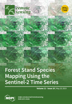
Cover Story (view full-size image):
With the launch of the Sentinel-2 mission, new opportunities have arisen for mapping tree species, owing to its spatial, spectral, and temporal resolution. We evaluated the utility of the Sentinel-2 time series for mapping tree species in the complex, mixed forests of the Polish Carpathian Mountains. We used 18 Sentinel-2 images from 2018. Different combinations of Sentinel-2 imagery were selected based on the mean decrease in accuracy and mean decrease in Gini measures, in addition to temporal phonological pattern analysis. Tree species discrimination was performed using the random forest classification algorithm. Our results show that the use of the Sentinel-2 time series instead of single date imagery significantly improved forest tree species mapping, by approximately 5–10% of overall accuracy. In particular, combining images from spring and autumn resulted in better species discrimination. View
[...] Read more.
- Issues are regarded as officially published after their release is announced to the table of contents alert mailing list.
- You may sign up for e-mail alerts to receive table of contents of newly released issues.
- PDF is the official format for papers published in both, html and pdf forms. To view the papers in pdf format, click on the "PDF Full-text" link, and use the free Adobe Reader to open them.
Previous Issue
Next Issue