


Abstract
This paper adopts field theory and the concept of regionalization in structuration theory as an integrated framework to conduct a diachronic socio-spatial comparative study on the origin and development of three historic cultural districts in Guangzhou: Enning Road, Shamian, and Xinhepu. Through diachronic analysis, the study identifies mechanisms of socio-spatial evolution in these districts, provides a comparative basis for research and policy on diversity, modern transformation, and sustainable renewal in China’s historic cultural districts, and proposes appropriate recommendations for further conservation and renewal. Finding shows that Enning Road represents an endogenous commercial field, Shamian an externally implanted colonial field, and Xinhepu a capital-driven elite field. Despite their different origins and social attributes, all three experienced capital rupture and spatial decline after 1949 and revived in the twenty-first century through different modes of capital conversion. The study further argues that spatial development is a spatialized strategy through which dominant capital competes for resources and maintains position. Conservation and renewal are essentially actors’ renegotiation of field rules and reconversion of capital forms under macro institutional rules. Sustainable development in historic cultural districts depends on interpreting and creatively transforming the dominant capital of the field and treating renewal as a spatial reproduction process of a multi-actor “social contract.”
1. Introduction
Guangzhou was one of China’s earliest treaty ports opened to foreign trade. Its urban space records a history that spans feudal society, colonial encounters, and the construction of a modern nation-state. Over its long urban development, it formed several cultural districts with distinctive features and historical significance. Among these historic cultural districts, three are particularly notable: Enning Road, Shamian, and Xinhepu. Although they originated at different times, all three were located outside Guangzhou’s city walls at that time and underwent large-scale development in a similar period. During the Republican period, a folk saying emerged: “Xiguan young ladies and Dongshan (Xinhepu) young gentlemen.” They were designated historic cultural districts because of the building complexes and local culture produced during that period. The three districts differ in architectural style: Enning Road has Xiguan mansions and arcade buildings, Shamian has a European-style building complex, and Xinhepu has red-brick Western-style houses. They also carry different historical memories and social relations. Therefore, the distinct resources and capitals each district possesses, and the ways actors use and transform the capitals, determine their development directions and modes, which differ substantially.
Early research on historic cultural districts began with discussions of conservation and renewal strategies and principles. These studies focused on preserving traditional urban landscapes and styles [1,2,3], safeguarding historical context [4,5], exploring approaches to district conservation and governance [6,7,8], and updating research methodologies [9,10]. Subsequently, as cities entered an era of urban renewal, researchers recognized that districts are not static relics but living, organic entities. The focus of research on historic cultural districts shifted toward identifying district culture [11,12,13], restoring buildings [14], shaping spaces [15,16,17], uncovering the modern value of districts [18,19], and coordinating the interests of stakeholders [20,21,22,23]. Some research has shifted its focus to a people-centered perspective, examining how key neighborhood elements impact different participants [24,25,26,27]. Research focusing on three historic cultural districts as case studies centers on the preservation and renewal of spaces and buildings [28,29,30], district revitalization strategies [31,32,33,34,35], and activation methods [36,37,38]. Scholars tend to adopt perspectives aligned with contemporary development to explore new conservation and renewal approaches, ultimately aiming to evaluate and enhance specific buildings or spaces. Three areas have similar origins but eventually developed into completely different historic cultural districts. They also have their own uniqueness and rich historical humanities and material elements, which are very suitable for being used as cases in the study.
For a long time, research on historic cultural districts has lacked systematic comparative studies that place them within a unified theoretical framework to deeply reveal the underlying social logic of their differentiation. There has been a shortage of theoretical analysis explaining the deep mechanisms of “how they came to be” and “why they differ.” Yet these three districts—which experienced their modern rise, mid-20th-century transformation, and 21st-century revival almost simultaneously—have followed distinctly divergent developmental paths. This phenomenon raises the core question of this study: Why did these three districts develop such distinct spatial forms and social attributes despite sharing similar historical contexts? What divergent internal logics guided their historical evolution? And how do these differences influence their contemporary preservation and renewal approaches?
In recent years, the notion of context-sensitive urban regeneration has gained increasing prominence in sustainable urban development discourse. It emphasizes that regeneration strategies should be grounded in the specific historical, social, and cultural contexts of each place, rather than relying on standardized or market-driven templates. However, existing studies often treat historic cultural districts in isolation or focus narrowly on physical conservation, failing to explain how locally embedded social structures and capital dynamics shape divergent regeneration outcomes. Addressing this gap, this study develops an integrated framework combining Bourdieu’s field theory and Giddens’ regionalization concept, which enables the identification of site-specific game rules and capital transformation mechanisms underlying each district’s development path. This comparative lens offers a way to understand what constitutes context-sensitive regeneration and how it can be achieved sustainably.
Moving beyond fragmented, isolated narratives of three distinct districts (Figure 1), placing them within a comparative framework to reinterpret the complex landscape of Guangzhou’s modern urbanization. It reveals the distinct patterns of influence and interplay among external forces, local society, and emerging social strata in shaping the city’s spatial development. Through an in-depth exploration of historical contexts, this study reveals the historical roots and inherent contradictions of current preservation and renewal models for historic cultural districts. It thereby offers a critical perspective and recommendations grounded in social mechanisms for reflecting on, and ultimately optimizing the practice of new vitality for old cities, with the aim of providing theoretical references and practical insights for the sustainable development of historic cultural districts in the new era. This paper attempts to explore the evolution logic of historic cultural districts from a new perspective, and the ultimate goal is to discover the core logic and elements of district development, in order to provide sustainable development recommendations for the future development of the districts.
Figure 1.
Location of Historic Cultural Districts: The left shows the administrative location of Yuexiu and Liwan Districts in Guangzhou. The right shows the specific locations of Enning Road, Shamian, and Xinhepu within these districts (Source: Drawn by the author).
2. Method
2.1. Theoretical Basis and Construction
To address the questions, this study introduces and integrates Pierre Bourdieu’s Field Theory with the concept of “regionalization” from Anthony Giddens’s Social Structuration Theory, thereby constructing a dynamic framework for analyzing social space. Bourdieu conceives of the social world as a universe composed of various relatively autonomous “fields,” each serving as a competitive arena for the acquisition of specific forms of capital, these fields possess historically formed “rules of the game” that are internalized by their actors [39,40]. Capital is the most important factor in a field. Bourdieu argues that actors’ behavior is interest-oriented, the distribution of capital reflects objective social relations, while capitals interact and convert into each other to form a field [41]. The field emphasizes reflection on the research object and its environment and stresses practical logic. Its scope covers social problems, public space, and public behavior, which it treats as basic objects of study [42]. The physical environment of public space is the result of field construction [43]. For historic cultural districts, we can view them as continuously operating “social fields.” Each major transformation in their spatial form corresponds to shifts in the dominant capital types within the field and intense struggles among its actors. Field theory emphasizes relationalism, which focuses on internal relations rather than entities, highlights constraint, and does not give equal attention to actors [44,45].
Research on historic cultural districts should ultimately focus on people, society, and the environment. People continuously exercise agency while subject to various constraints, thereby shaping society and producing different social structures. Therefore, incorporating Giddens’s theory of structuration allows a more comprehensive analysis of how actors shape the formation and development paths of historic cultural districts. Giddens sought to reconcile the dualism of structure and agency in sociology by proposing the principle of “structural duality”: social structures are both the mediators of practice and its outcomes [46]. Within this theory, the organization of time and space carries constitutive significance. The “regionalization” he proposed refers not only to the division of physical space but also emphasizes how social interactions are “zoned and demarcated” across temporal and spatial dimensions, and the result of social interaction will be reflected in the physical space. Regionalization serves as the foundation for the stable unfolding of routine social practices, enabling abstract social structures to become “solidified” within concrete contexts. Simultaneously, it functions as a site where power relations are enacted [46]. For district analysis, “regionalization” provides an analytical tool for decoding abstract field rules into concrete spatial strategies and rhythms of daily life.
The two theories are connected in two ways. First, field theory emphasizes the internal spatial composition or configuration of social elements, whereas structuration theory emphasizes their spatial dynamics and processual character. Second, field theory emphasizes the objective constraints of the geographical environment, whereas structuration theory emphasizes actors’ subjective agency. In this study, field is geographically anchored in the historic cultural district, mainly referring to the objective relationship space of the district, but the boundary of the field may change over time. These relations are formed among different positions according to the amount and proportion of capital held by different actors. The field also constructs actors’ action logic and spatial positioning in social space. Capital in historic cultural districts includes four types, social, cultural, economic, and symbolic capital, which are further differentiated into analytical sub-categories, such as political, military, commercial, creative, aesthetic, and spatial capital, to capture the concrete resources and conversion processes involved. A sub-category may belong primarily to one foundational form or function across two forms during conversion. Capital is not simply a label attached to historical elements; rather, it is treated as a dynamic element. Our analysis focuses more on tracing how different forms of capital were accumulated, converted, and devalued across different historical periods, and how these conversion processes shaped spatial forms.
Regionalization in the social structure of historic cultural districts provides a framework for residents’ actions, leading them to act in accordance with district culture. In their daily life in these districts, residents reproduce the district’s social structure through various practices. Integrating the two theories allows analysis of the internal composition and constraints of a district. It further allows analysis of the process through which actors, based on their understanding of existing field rules, use and transform the resources and capital available in their district. This process is also how actors exercise agency to shape district space.
This paper regards the form and changes in historic cultural districts as historical process of continuous dialectical interaction between “field rules” and “regionalization practice”. By using two theoretical frameworks, we arrive at a dynamic analytical model: First, humans may gradually develop fixed behavioral patterns in a specific location due to particular rules and resource demands. As certain human activities continue to gather in this place, the area also advances its regionalization process. Specific, stable patterns of spatiotemporal organization (regionalization) gradually solidify and become institutionalized into a set of specific social relations, resource allocation mechanisms, and behavioral expectations, generating a “social field” characterized by relatively stable rules and a logic of capital competition. Once a field is established, its inherent rules structurally guide newly entering actors to adopt strategic spatial practices, they consolidate or elevate their position within the field, continuously reproducing or attempting to alter existing patterns of territorialization through actions such as investment, construction, use, modification, and even destruction. While the dramatic shifts in external macro forces will disrupt the existing spatial equilibrium like a storm, rendering old rules obsolete while giving rise to new ones. This will trigger a fresh round of intense struggles over spatial (re)regionalization, forming a continuous, bidirectional cycle of construction. The unique advantage of this framework lies in its simultaneous consideration of structural constraints and the agency of action, integrating historical depth with spatial sensitivity. It avoids both the “structural determinism” that simplistically reduces neighborhood forms to economic imperatives or power projections, and the “voluntarism” that focuses solely on individual interactions while neglecting broader historical conditions (Figure 2).
Figure 2.
Theoretical Framework (Source: Drawn by the author).
Within this framework, “capital” emerges as the pivotal concept linking field rules to regionalized practices. Capital encompasses not only economic resources but also diverse forms such as political power, social relations, and cultural symbols. An actor’s position within the field depends on the quantity and structure of capital they command, while their competitive strategies revolve around accumulating, transforming, and monopolizing capital. Spatial regionalization, in turn, represents the material crystallization and manifestation of this capital competition. Building upon this framework, this paper will successively analyze the historical evolution of Xinhepu, Enning Road, and Shamian based on extant historical records, comparing their similarities and differences while extracting theoretical insights.
2.2. Data Sources and Analysis Routes
This study collects textual, visual, and material documents related to the three historic cultural districts, including official materials issued by government departments and other official institutions, such as documents, historical records, statistical data, newspapers and periodicals, and photographs, as well as personal materials held by research participants, such as diaries and photographs. Visited the subdistrict office, district government, and library of each district to collect national laws and policies, municipal and prefectural gazetteers, government management regulations and rules, community news releases, and letters from residents reporting problems. All materials involving individuals are publicly available or publicly accessible, which are used to understand district development and the spatial formation process at different periods and stages.
This study conducts diachronic and comparative analysis based on the collected materials, by using the field–regionalization framework to explain and analyze the formation and development of the three historic cultural districts. For each district, analyze the field rules, dominant capital, and modes of capital conversion, also analyze how actors shape district space and the resulting outcomes under the combined effects of field rules and capital. Then conduct a cross-case comparison of the field and regionalization patterns of the three districts, to summarize and examine the social logic of the formation, development, and spatial evolution of historic cultural districts. Based on this logic, also predict future trajectories and possible difficulties, further provide more feasible and practical recommendations for the sustainable development of these districts. The diachronic analysis begins with the earliest materials found for each historic cultural district, examining the origin, large-scale development, and transformation nodes of each district. The paper first narrates the development of the districts at key historical junctures, then applies the field–regionalization theoretical framework to identify and analyze the capital, capital conversion, and forms of regionalization at each juncture, examining the operational logic among these elements in order to reconstruct the districts’ development. In this study, the sustainable development of the districts hinges on understanding their developmental logic and on the effective utilization of their capital. We argue that only by grasping the internal determining factors of district development can these districts achieve long-term sustainability.
In this study, sustainable development is not defined as a static end-state, but rather as the dynamic adaptive capacity of a historic cultural district to maintain socio-spatial vitality across historical ruptures. By applying the field–regionalization framework, we link sustainability to the continuous re-coupling of dominant capital with macro-historical rules. Therefore, a district is considered to possess sustainable potential when its dominant capital can successfully adapt to epochal shifts and manifest this adaptation spatially. Contemporary predicaments, in turn, reveal the extent to which this sustainable potential is constrained. This study analyzes the underlying logic of these potentials and proposes targeted recommendations to restore the districts’ sustainable renewal pathways.
3. Field and Regionalization Analysis of Historic Cultural Districts
3.1. Enning Road Historic Cultural District: The Evolutionary Logic of Endogenous Commercial Spaces
3.1.1. The Origin and Development of Enning Road Historic Cultural District
The development of the Enning Road Historic Cultural District is inseparable from that of Xiguan, its large-scale regionalization practices across time and space can be traced back to the establishment of the Thirteen Hongs. In the Song dynasty, only a few people chose to live in seclusion there [47]. By the early Qing dynasty, water transport in Xiguan facilitated the circulation of goods, and a proto-market took shape [48,49]. From 1757 onward, the Thirteen Hongs became the sole officially licensed foreign trade organization, Xiguan thereby gained a monopoly advantage in foreign trade. As a trade intermediary with official-merchant status, the Thirteen Hongs performed the political function of “controlling merchants through officials and foreigners through merchants.” They served both as a bridge for Chinese-foreign trade and as an institutional barrier between Chinese and foreign merchants [50]. Enning Road combined commercial and cultural functions, during the Tongzhi and Guangxu reigns (1862–1908), it had already become a densely built area of grand residences and reached its peak. The Thirteen Hongs gave silver donations back to the imperial court, between 1773 and 1835, it alone donated 4.6 million taels of silver and consequently received a special edict of consideration from Emperor Jiaqing [51]. At that time, most operators adopted the “shop in front, residence behind” or “shop below, residence above” model. Within the same district, or even the same building, residential, commercial, handicraft, and social functions were often mixed [50,52]. This prosperity continued into the Republican period, when Enning Road gradually developed into a residential district for wealthy merchants. Commercial activity in the surrounding area was frequent, shops lined the streets, and the commercial atmosphere was strong. The area concentrated many commercial establishments—silk shops, pawnshops, native banks, and teahouses—that traded goods such as silk, tea, medicinal materials, and ceramics, attracting large numbers of merchants and customers. Its copperware, woodwork, embroidery, and other products not only met local market demand but were also sold to other parts of China and overseas [50,53].
After the founding of the People’s Republic of China (PRC), the state promoted public ownership and a planned economy. During this period, the architectural fabric of the arcade streets and Xiguan mansions was largely preserved, but many arcade shops and Xiguan mansions were placed under state-managed leasing or nationalized [54]. At the same time, Cantonese opera troupes changed from commercial to public welfare organizations. As a landmark building of the Cantonese opera industry, the Bahe Guild Hall continued to function as an industry organization in the early years of the People’s Republic. However, in 1957, the Bahe Guild Hall on Enning Road ceased operation, and Cantonese opera culture on Enning Road entered a silent period [55]. The district’s function shifted from a mixed commercial and residential area to a residential area dominated by standardized collective living units. Streets became venues for political propaganda and collective activities [56]. After reform and opening up, the spread of the newly introduced market economy encouraged some Enning Road residents to use street-facing homes for small-scale family businesses, such as snack shops and barbershops. Coppersmiths, barbers, and other craftsmen regained market recognition through their distinctive skills. However, as the younger generation moved out, the district gradually declined.
In the 1990s, the government comprehensively promoted the socialist market economy and shifted Guangzhou’s urban development eastward. As a result, the development and renovation of Enning Road, located in the western part of the city, was shelved. A large number of houses became “dangerous, dilapidated, and old,” further weakening the willingness of external investors and elite residents to return [57]. The properties of remaining residents turned from assets into burdens that were difficult to dispose of. In addition, rumors of district renovation rose and fell repeatedly, leading residents to adopt a temporary mentality of “waiting for demolition.” This reduced their willingness to maintain and invest in their houses and allowed the physical environment to deteriorate [58].
In the early 21st century, Enning Road continued the renewal logic of “large-scale demolition and construction” from the end of the previous century, aiming to achieve economic balance. However, it fell into a renovation deadlock due to residents’ opposition [59]. Starting in 2010, the government introduced regulations on historic cultural preservation and inheritance and micro-renovation, and the renewal of the Enning Road Historic Cultural District gradually entered the right track. Enterprises became the main actors in investment, construction, and operation. At the same time, the establishment of the first “Co-creation Committee” in nationwide old city renewal brought residents, merchants, experts, and other multiple actors into the decision-making process in an institutionalized manner. The government took on the role of coordinator, guiding business formats by formulating “positive and negative lists” for industries. Through the “Co-creation Committee” platform, it transformed potential zero-sum games that could cause conflict into positive-sum games in which multiple parties “consult to form consensus” [60].
3.1.2. The Field–Regionalization Analysis of the Enning Road Historic Cultural District
In the early Qing dynasty, Enning Road began to concentrate resources. The district followed free trade rules, and resources were mainly commodity-based economic resources. After the single-port trade policy (the Canton System) was implemented, the Thirteen Hongs navigated between political bargaining and economic interests, thereby accumulating both economic and social capital (Figure 3).
Figure 3.
The Evolution of Social Capital in Enning Road during the Late Qing Dynasty (Source: Drawn by the author).
Enning Road’s space showed organically mixed regionalization, and the mixed character increased spatial use efficiency and enriched street life. Xiguan mansions and arcade buildings both reflected adaptation to the Lingnan climate and commercial needs. The “cold alley” design of the mansions facilitated ventilation and cooling, and the continuous arcades of the qilou provided pedestrians with shade and shelter from rain and expanded commercial frontage. The street network also evolved naturally through long-term use, which was winding and at a pleasant human scale. Because of the uniqueness of the Thirteen Hongs, Enning Road also developed into an “acquaintance society.” Frequent information exchange among chambers of commerce and neighbors created a locally specific social capital. This was not only an achievement accumulated through the development of the Thirteen Hongs; abundant social capital itself also brought substantial economic capital to the district, they converted into and accumulated with each other. Xiguan mansions and arcade buildings, designed and built to fit the living habits of the time, provided conditions for the formation of cultural capital.
After the founding of the People’s Republic of China, Enning Road’s field rules underwent a discontinuous change. The state governance logic centered on public ownership and the planned economy replaced the old rules of multi-actor bargaining among officials, merchants, gentry, and commoners, while capital types, conversion paths, and competition logic were completely reshaped within the field. In the new field, political capital became the dominant capital, when the former core capital—private economic capital—not only plummeted in value but could also become negative capital because of the label “tail of capitalism.” Former wealthy merchants converted economic and cultural capital into new political capital. The survival logic of cultural capital such as Cantonese opera shifted from market preferences and guild rules to ideological requirements of serving workers, peasants, and soldiers and promoting new ideas. The closure of the Bahe Guild Hall also marked the dissolution of the traditional guild self-governance field. The change in field rules simultaneously triggered a drastic reorganization of spatial structure, while private property rights underwent socialist transformation, and the commodity attribute and exchange value of space were strictly suppressed. The standardized and de-differentiated regionalization of district space was a spatial manifestation of state power formatting social life, which aimed to eliminate the soil in which the old field generated “non-socialist” practices.
After reform and opening up, field rules loosened to a limited extent as the state shifted its focus to economic construction and the legitimacy of economic capital gradually recovered. Enning Road, as a core area of the old city, displayed a transitional pattern in which old and new rules intertwined and conflicted. Craftsmen’s revival through skill capital constituted an informal regionalization practice, but that was fragile and marginal, lacking institutional safeguards and operating in a gray zone, and it could not reverse the district’s overall decline. For original residents, local social capital and cultural capital formed the core of identity, and they valued the everyday street life in which “neighbors were like family”. This capital, although unable to generate economic advantage, served as a spiritual barrier against spatial decline. But the outflow of young people to new urban areas broke intergenerational transmission of local social capital and weakened social reproduction.
Entering the 1990s, against the macro background of advancing the socialist market economy and Guangzhou’s eastward urban development, Enning Road fell into “field disorder”: old planned-economy rules had become ineffective, new rules had not yet been established, and district development fell into stagnation and a vicious cycle. Spatial economic capital continued to depreciate because of the deteriorated physical environment, and this image of decline generated negative symbolic capital as the area was seen as “backward” and a “problem area.” Physical decline solidified regionalization features, with public space encroached upon, infrastructure failing, and traditional patterns of social interaction difficult to sustain, while its latent cultural capital—historic buildings and district texture—remained dormant because it had not been incorporated into mainstream value cognition.
After 2010, Enning Road’s field rules underwent substantive change, centered on a shift in development concepts at national and city levels, as historical and cultural preservation and inheritance and micro-renovation became supreme principles above economic development. The government changed from demolition leader to rule-maker and coordinator, while enterprises invested financial and operational capital to activate the district’s dormant historical and cultural capital and convert it into sustainable commercial and symbolic capital (Figure 4). The rigid constraints of micro-renovation instead forced enterprises to undertake refined, high-cost innovation and, through household interviews and other methods, align with diverse needs so that renovation plans reached multi-party consensus and reduced social risks in long-term operation. Original residents’ and craftsmen’s long-accumulated local knowledge, skills, and life forms were recognized under the new rules as living cultural capital, and they converted “negative assets” into income-generating assets through housing renovation and property rental (Figure 5). Enning Road’s revival was essentially a creative transformation of the cultural logic of the local commercial field: it did not completely sever history but, on the premise of acknowledging historical rupture, sought new forms and values for traditional capital in a modern context.
Figure 4.
New Field Rules for Enning Road District and the Implementation after 2010. (In this context, “social capital” refers to external social networks and relational resources brought in from outside the district. External operators (such as enterprises) introduce these external social networks into the district. Through continuous interaction with the existing local networks, these external resources can gradually integrate and transform into endogenous social capital within the district.) (Source: Drawn by the author.)
Figure 5.
Field Formation of Enning Road District after 2010 (Source: Drawn by the author).
3.2. Shamian Historic Cultural District: The Imprint of Power in Externally Implanted Colonial Domains
3.2.1. The Origin and Development of Shamian Historic Cultural District
Shamian Historic Cultural District is a special district that is an island created by land reclamation from the river by the Qing government to meet the living needs of colonists, connected to the mainland by four bridges, which origin and development carried strong colonial privilege. Colonialists’ possession of extraterritoriality made Shamian a “lawless place” on Chinese territory, allowing them to concentrate political power, military force, and commercial interests entirely on the island [61,62]. To solidify their privileges and status, they artificially excavated the 40-m-wide Shaji Chung, turning Shamian into an isolated island and achieving separation of Chinese and foreigners. In addition, the entire island was subjected to grid planning and functional zoning, with the north bank as the consulate area, the south bank as the commercial firm area, while churches, clubs, and parks placed in the core zone [63]. The functional zoning completely excluded street life and mixed functions and served only the administrative and living needs of foreign residents, while neoclassical and other Western-style buildings were constructed, forming a sharp contrast with the shore.
During the Republican period, construction and management on Shamian Island became increasingly complete. The Municipal Council, as a self-governing body, improved municipal administration, law (applying Hong Kong law), and armed force (establishing a police station), making Shamian operate like a miniature colonial city: racial segregation rules were strictly enforced, Chinese people needed permits to pass at night, and Chinese property ownership and residence rights were restricted [64]. Banks such as HSBC and Standard Chartered and the headquarters or important branches of foreign firms such as Swire and Jardine also gathered on Shamian, which had by then become the nerve center for remote financial and trade control in South China [62]. Foreign firms purchased large numbers of warehouses and wharves along Shaji Road outside the island near Shamian, British and French consuls repeatedly interfered in navigation, public security, and municipal affairs in the Shaji area. Guangzhou government was often on the defensive in negotiations and, under long-term oppression and stimulated by the anti-imperialist patriotic movement triggered by the “May 30th Massacre” in Shanghai, finally led to the “Shaji Massacre.” In spatial terms at that time, Shamian Island and its surrounding areas presented an adversarial juxtaposition: Shaji, separated from the tranquil Western-style district of Shamian by a single waterway, was a typical noisy Chinese street market, forming a strong spatial contrast [65].
After 1949, the state issued decrees to recover sovereignty over Shamian and carried out socialist public ownership transformation. Buildings were redistributed as state-owned assets: banks and consulates were converted into government offices, work-unit dormitories, ordinary housing, residents obtained residence rights through work-unit allocation; and a new social network based on the work-unit system formed. Population growth completely broke the segregation created during the colonial period, while building interiors were partitioned and extended, original layouts were damaged. Shamian became a high-density, functionally mixed “socialist living community.” After reform and opening up, many investors entered Shamian and provided new forces for its renovation and renewal. The most representative was the White Swan Hotel built by Henry Fok; its massive 28-story volume visually and physically broke Shamian’s low, complete historic skyline and spatial scale. At the same time, “development-induced destruction” occurred inside many buildings: the historic Green Tile Pavilion was demolished to build an access road, and an elevated bridge was built over Shajiyong, bringing noise and exhaust and blocking river breezes [62]. In 1996, the Shamian building complex was listed as a Major Historical and Cultural Site Protected at the National Level, but early conservation practice was full of errors: management departments painted facades and added fake roofs to “beautify” the city—measures of “protective destruction”; the government tried to use historic buildings for commercial development, but its renovation methods caused secondary damage; and at this stage, multiple actors formally recognized the contradiction between protection and use [66].
The 2000 “Shamian Modern Historical and Cultural Protection Area Renovation Plan” proposed: first, allowing modern interior renovation and functional renewal under strict protection of building exteriors; second, except for a few buildings used as museums, encouraging the transfer of buildings by agreement to institutions, which would invest funds and obtain use rights [67]. Shamian then entered a stage of overall transformation driven by key projects: restoration of historic buildings became more refined; building functions began large-scale replacement; and some former sites were revitalized into fashionable commercial forms. Shamian was positioned as “Guangzhou’s historic cultural exhibition area and an international foreign-related business and tourism area,” with plans to relocate residents and restore business and office functions, marking a conscious transition from a chaotic “residential + work-unit mixed area” to a high-end cultural and business district [67]. In 2025, Guangzhou municipal government upgraded Shamian’s positioning to “International Historical and Cultural Conference Living Room Lingnan Cultural and Business Tourism Integration Model”. In addition to the most basic building protection and environmental construction, the government collects and integrates decentralized housing use rights, formulates business access standards, and reorganizes transportation and space to gradually realize the ‘car-free slow island’ [68,69].
3.2.2. The Field–Regionalization Analysis of the Shamian Historic Cultural District
The field rules of Shamian were established at one stroke by unequal treaties: Britain and France divided and occupied the concession, held perpetual leases, consular jurisdiction, and independent municipal administrative power. Colonial capital became the overriding meta-capital, while all other capital, including the Qing government’s administrative capital, was invalidated there. Western political and commercial capital achieved monopolistic concentration and produced an isolated and exclusionary regionalized space that segregated power and race inside and outside the island. This spatial form in turn consolidated the colonial order and continuously spilled influence into surrounding Chinese-administered areas, triggering rule conflicts and capital competition. Its specific rules were threefold: colonial privilege supremacy, including consular jurisdiction, the right to station troops, and independent municipal administration; racial segregation, which long restricted Chinese property ownership and free residence; and capital monopoly, with institutions serving only foreign firms, banks, and consular agencies. The military capital of the powers was the core guarantee maintaining these rules. The neoclassical and other Western buildings they constructed displayed colonial cultural superiority and the presence of power, forming a hegemonic visual and cultural contrast with the Chinese urban fabric across the water. Shamian completed its transformation from a sandbar into a segregated regionalized space under a colonial-privilege field; it was no longer simply part of Guangzhou’s space but a heterogeneous node of power embedded within Guangzhou.
During the Republican period, changes in Chinese political power did not weaken the colonial rules of Shamian’s field, instead, its “safe island” character amid turmoil made them more entrenched. Capital operations within the field and rule spillover outward led to more intense conflict, while inside Shamian Island rules remained entrenched and capital highly concentrated. Under colonial privilege, Shamian became a safe harbor for international capital, with economic capital deeply tied to colonial political capital. The field’s influence controlled the entire island, and its capital and rules were strongly expansionary, seeking to encroach on surrounding Shaji and Xidi. It not only sought to link economic lifelines along Shaji Road closely to Shamian’s international capital and use capital to gradually weaken physical geographical boundaries, but also sought to negate and replace Chinese state sovereignty rules with colonial field rules. The sharp contrast between inside and outside the island constantly reminded Chinese people of incomplete national sovereignty, accumulating enormous social tension in the border zone and producing a violent impulse to break through existing rules by force. The violent confrontation turned the physical boundary of Shaji Chung into a symbolic signifier of national humiliation and anti-imperialist struggle, changing the socio-psychological relationship between Shamian and Guangzhou. This regionalization created a panoptic space of power: colonists lived on the island, maintaining a safe distance from Chinese society while able to observe and control the opposite bank at any time. Chinese people looking toward Shamian constantly felt the humiliation of incomplete sovereignty and the impact of modernity, and spatial isolation and difference were themselves core components of colonial power.
From 1949 to the end of the 20th century, although Shamian’s physical form largely survived, its spiritual value was muted: it had lost its status as a colonial power center but had not been integrated into New China’s urban cultural system. Its historical meaning was blurred, the practical functions were disordered, and the spatial capital remained suspended, neither properly defined nor effectively converted. After 1949, the state used political capital to shift the island’s field rules from colonial privilege to a pragmatic orientation of serving the people, clearing colonial financial and legal capital, amplifying the use value of building space, and temporarily suspending or ignoring historical and cultural value, so that historic buildings served merely as physical carriers for high-density residence and mixed community functions.
During reform and opening up, international and commercial capital regained legitimacy and entered Shamian forcefully. Although Henry Fok’s White Swan Hotel carried dual symbolic meaning of national sentiment and economic development, economic capital during this period converted historical space into modern commercial assets in a strong but extensive manner, and the long-term model of exchanging destructive behavior for development produced many irreversible consequences. After Shamian became protected cultural relics, attempts to directly exchange cultural capital for economic capital, together with inexperienced protection measures, caused authenticity as cultural capital to be covered and damaged by simplified “aesthetic” symbolic capital.
At the turn of the century, Shamian was trapped in the dual predicament of physical decay and functional dysfunction. The field rules were vague and contradictory: it had the name of protection but lacked effective implementation paths and funds. The Plan issued in 2000 on the one hand provided technical legitimacy for the adaptive reuse of historic buildings, replacing the rule of static frozen protection with the rule of dynamic adaptive reuse; on the other hand, Shamian shifted from a rule of government fiscal capital input to a rule of cooperation between the government and multiple social capitals. This process converted historical and cultural capital into economic capital through design and operation. Shamian also gradually changed from a closed office and dormitory area into an “open-air architectural museum” open to the public and filled with leisure and consumption scenes.
3.3. Xinhepu Historic Cultural District: The Construction and Transformation of Capital-Driven Elite Fields
3.3.1. The Origin and Development of Xinhepu Historic Cultural District
During the Ming and Qing dynasties, Xinhepu Historic Cultural District remained on the geographical and administrative periphery outside the Great East Gate of ancient Guangzhou, while the field character was that of a low-development rural area in which agriculture and religious activity were mixed [70,71,72]. The earliest systematic development and symbolic production in the area originated from Buddhism. During the Chenghua reign of the Ming dynasty (1465–1487), Dongshan Temple, built by the eunuch Wei Juan, not only gave the place the name “Dongshan” but also made it a regional center of religious belief. The temple attracted pilgrims and dependent populations from surrounding villages, leading to a noticeable increase in Dongshan’s population. The area’s core material spatial base consisted of rolling hills, overgrown grass, and scattered natural villages, while its economy was oriented toward dispersed farming and handicraft production and lacked the functional characteristics of a commercial town. The main actors in the area were monks, peasant households, and a small number of residents attached to temples and monasteries, whose practices were deeply governed by the habitus of traditional rural life, their social relations were relatively simple and homogeneous, and spatial competition was weak [70] (Figure 6).
Figure 6.
Xinhepu in 1860 (Source: Map OF THE CITY AND ENTIRE SUBURB’S OF CANTON 1860).
Entering the 20th century, in less than thirty years, Xinhepu rose rapidly from a secluded suburb to a high-end residential area as famous as Xiguan. Western churches represented by the American Southern Baptist Convention purchased land and built Western-style schools and churches such as Pui To Girls’ School and Pui Ching Academy, letting the district formally entered the starting point of its development. After the Xinhai Revolution, overseas Chinese raised funds to purchase land, leveled land and built roads, and sold land in parcels to develop the district. The opening of the Guangzhou–Kowloon Railway also gave Xinhepu the dual advantages of suburban quiet and commuting convenience [73,74]. At the same time, the government incorporated the spontaneous development of overseas Chinese into a standardized system through municipal planning and attracted military and political dignitaries to build official residences, so the saying “those with power live in Dongshan” gradually spread throughout Guangzhou (Figure 7). By the Republican period, more overseas Chinese purchased land, built Western-style houses, and sent their children to elite schools such as Pui Ching, thereby networking with powerful figures or directly entering politics in search of closer ties to political power. The Western-style houses built by overseas Chinese were separated by walls, courtyards, and public alleys, and overall featured spacious planning and strong privacy. At this time the district also became increasingly complete: it had rigorous functional zoning that divided the district into three functions—residential, educational, and commercial services; regular road construction made the district accessible in all directions; and internal infrastructure also became increasingly complete, providing sufficient conditions for daily activities for different actors in the district [74,75].
Figure 7.
Xinhepu in 1937 (The red word indicates the Dongshan Police Branch) (Source: The latest map of Guangzhou in 1937).
After 1949, some private Western-style houses were placed under state-managed leasing, trusteeship, or expropriation, and were allocated to Party and government organs and cultural units as offices or staff dormitories. Overseas Chinese, churches, and bureaucrats lost their advantages and withdrew from the district one after another, while ordinary people took their place. Detached garden villas were divided into multi-household dormitories in the style of “72 tenants,” ancillary spaces such as courtyards and garages were extended into kitchens or living quarters. Customized commerce serving elites during the Republican period declined and was replaced by state-run department stores, grain and oil shops, or supply and marketing cooperatives that met basic needs, while commercial activity shifted from a market behavior to part of the planned supply system. After reform and opening up, some overseas Chinese properties were returned to their original owners, but many Western-style houses remained public housing shared by several households. During this period, individually owned businesses began to appear, and street-facing residences on Miaoqian Zhi Street and Guigang Avenue were converted into shops [71,75]. At that time, owing to population growth and lagging housing reform, most historic buildings remained overused and poorly maintained, but their historical and cultural value—the aesthetic value of Republican-period architecture and the cultural significance of revolutionary sites—gradually entered public and government attention [76].
In the first decade of the new century, Guangzhou Municipality and Yuexiu District established the renewal strategy of “old city, new vitality” and micro-renovation, prohibiting large-scale demolition and construction and encouraging functional renewal under the premise of protection, and the government issued the “Conservation and Utilization Plan for the Xinhepu Historic Cultural District” in 2006 [76]. By 2019, the district had formed a development model of “government guidance + enterprise operation + public participation”: the Yuexiu District government built an institutional framework through planning guidance and policy support; state-owned enterprises invested financial capital to renovate and attract investment for contiguous properties; and new actors such as artists, designers, and brand managers also entered, opening galleries, select shops, and other stores in a scattered pattern to revitalize the district. Since then, the Xinhepu Historic Cultural District has entered a new stage of development and has continued to develop to the present [77,78].
3.3.2. The Field–Regionalization Analysis of the Xinhepu Historic Cultural District
During the Ming and Qing dynasties, the regionalization of Xinhepu Historic Cultural District showed characteristics of natural formation, mixed functions, and blurred boundaries. The spatial organization centered on temples and scattered village houses, which were distributed in a point pattern among hillocks, and it had not yet formed a clear street network or property parcels. This state of regionalization reflected the limited total capital in the field and failed to trigger intense spatial competition and reconstruction.
In the 20th century, especially after the establishment of the Republic of China, the field character of the district changed sharply. Western churches, represented by the American Southern Baptist Convention, not only introduced Western architectural forms but also injected the symbolic capital of modern education. Relying on the education-missionary system, the church regionalized Xinhepu into a modern-civilization enclave distinct from the traditional old city, laying a cultural-symbolic foundation for later development. After the Xinhai Revolution, overseas Chinese returned with substantial economic capital and Western lifestyle habitus, initiating the commodification of space in Xinhepu. This practice fundamentally changed the field’s spatial production logic, shifting it from natural growth to planned development oriented toward real-estate profit, and established the embryonic form of a modern property-rights system and district fabric. During this period, government forces intervened deeply: on the one hand, they provided institutional capital; on the other, they gave political-capital endorsement. The concentration of political power elevated Xinhepu’s field value from mere economic wealth to a symbol of power and status, completing the value lock-in of a top-tier elite field (Figure 8).
Figure 8.
Field Formation of Xinhepu During the Republic of China Period (Source: Drawn by the author).
This development gradually formed a competition rule centered on “economic capital as foundation, cultural capital as embellishment, and political capital as coronation.” The economic capital held by overseas Chinese and local political capital were mutually converted, and competition within the field was expressed as struggles over prime plots, the most fashionable Western-style houses, and high-end social relationships. While mutually competing, they simultaneously formed an exclusive “alliance” impervious to external capital, thereby shaping a Competitive Alliance-Style Circle Power. Driven by these new rules, Xinhepu achieved highly modernized and socially stratified spatial differentiation, forming a villa zone whose functional purity far exceeded that of the Ming and Qing periods. The villa zone was relatively separated from education and commercial-service zones, created “Dongshan Western-style houses” as material symbols displaying owners’ “Chinese-Western hybrid” modern identity and aesthetic capital, also forming a spatial experience sharply different from Xiguan’s dense mixed commercial–residential area and effectively reproducing the social boundaries of the elite class. Converted capital gave rise to a new elite community transcending native place and kinship, while the regionalization shaped a “suburbanized” lifestyle based on automobiles, private houses, modern schools, and clubs, which was pioneering in Chinese urban development. Xinhepu was not only a residential place but also a spatial production vehicle for the cultural identity and social status of the new elite class.
The social revolution of 1949 rapidly dismantled the core capital system supporting Xinhepu: overseas Chinese capital flowed out or went into hiding, bureaucratic capital became invalid, and church capital withdrew. The district began a drastic equalization process from an “elite enclave” to an “ordinary neighborhood.” The private economic capital and individual political capital accumulated during the Republican period rapidly depreciated, and housing use rights allocated by the state and individual political status within the work-unit system became the new core forms of capital. The redistribution process realized a one-way conversion from spatial property-rights capital to political-organizational capital and status-qualification capital: what actors competed for was no longer real estate and wealth but qualification to enter the state allocation system and work-unit status. During this process, Xinhepu’s spatial fabric underwent silent but profound change: the original design aesthetics and cultural-symbolic meanings of buildings were obscured by pragmatism, and the community structure shifted from an old neighborhood network based on blood and locality to a new work-unit community, which replaced or overlapped with the former. Residents’ social interaction and identity became bound to their work units, and the district’s regionalization characteristics shifted from high-end and refined to universal and homogeneous.
After reform and opening up, the field rules dominated by a single political capital began to loosen, multiple capital forms re-emerged and entered competition, and Xinhepu entered a transitional stage in which old and new elements were mixed. The legitimacy of economic capital was partially restored, a small number of overseas Chinese regained real-estate capital, and small-scale commercial capital represented by individually owned businesses directly activated the district’s street economy, but the district was still dominated by powerful work-unit welfare capital. At the same time, a new form of capital—historic cultural capital—began to emerge, but it remained mainly at the cognitive level and had not yet been effectively converted into economic or social capital. Moreover, because the physical decay of buildings in the district intensified, their historical value and exchange value were severely suppressed. The district was no longer the private domain of the powerful but a stage for citizens’ daily life: the noise of the vegetable market, the everyday life of herbal tea shops, and the flood of students leaving school together constituted Xinhepu’s new street-level regionalization landscape. During this period, cultural images such as “those with power live in Dongshan” and “Dongshan young gentlemen” began to revive in popular discourse. This nostalgic symbolic capital formed a huge tension with the dilapidated reality of physical space. Although it had not yet dominated contemporary renewal practice, it laid the groundwork for the next stage of field-rule transformation oriented toward historical preservation and cultural consumption.
At the beginning of the new century, although the buildings in the district were architecturally refined, most Western-style houses had long been neglected and were in disrepair, and their functions were mainly residential and low-end commercial, so their historical and cultural value remained dormant. The transformation of field rules was driven jointly by top-down conceptual innovation and bottom-up practical exploration, and the Plan issued in 2006 marked the formal establishment of official recognition and a value assessment system for the district’s historic cultural capital. New actors relied on creative and cultural capital to rent space at low cost and carried out spontaneous “acupuncture-style” regionalization experiments, embedding new cultural functions in selected spaces. At this stage, the path of capital conversion was preliminary and direct: actors used limited economic capital to rent space, invested creative capital in renovation, converted latent historic cultural capital into cultural consumption capital. The behaviors achieved niche-market returns and verified that historical culture had market-conversion potential. The first-phase renovation of the “Yifang Dongshan” Cultural and Creative Park in 2019 marked a turning point, and Xinhepu’s field transformation entered a systematic and scaled stage, which dominated by market forces and creative capital under government guidance: the logic of capital conversion became increasingly complex and regionalization characteristics took shape. The new logic of capital operation required actors to excavate historical and cultural capital precisely, introduce cutting-edge creative capital, and select superior commercial formats. Their goal was no longer simply to open shops but to build a diversified integrated ecosystem of “culture + art + commerce + sports” and cultivate a pioneer brand incubator (Figure 9). This process successfully transformed the architectural aesthetics and historical imagery of Western-style buildings into trendy symbolic capital and consumer scenario capital, ultimately evolving Xinhepu into a vibrant youth fashion consumption field. Xinhepu’s renewal is a case in which market forces and the creative class keenly captured and amplified historical and cultural value and converted it into an engine of the contemporary consumer economy, showing that in the information age, cultural capital and creative capital can generate economic and social energy, also can even surpass the influence of traditional politics and capital on spatial shaping.
Figure 9.
Capital Transformation in Xinhepu after 2019 (Source: Drawn by the author).
4. Discussion
Based on the preceding analysis, the paper has summarized the capital and regionalization attributes of the three historic cultural districts (Table 1), which correspond to the discussion below.
Table 1.
Comparison of Field, Capital, and Regionalization Features Identified through the analyses of Three Historic Cultural Districts.
4.1. The Root of the Discrepancy: The Decisive Role of Field Origins and Capital Endowment
The rise and development of a field related to historic culture district involve two key elements. The first is the macro historical context. The prosperity of a field essentially occurs when the type of capital it has accumulated and excels in aligns perfectly with the “game rules” most recognized and rewarded by society at that time. Through laws, policies, and ideologies, macro rules demarcate the boundaries between legal and illegal spatial practices. They fundamentally determine which types of capital hold value in a specific period, providing both an opportunity structure and constraints for actors. Participants in the local field adapt to, exploit, and even partially rewrite the macro rules through strategic practices, which are ultimately materialized in the spatial form of the district. During the late Qing dynasty and the early Republican period, the capitals in these districts were highly coupled with the “meta-rules” of their respective eras, leading to their peak prosperity. The socialist transformation in 1949, as a fundamental rule change, invalidated the original capital systems of all three districts simultaneously, plunging them together into a period of decline. Their 21st-century revival stems from each district finding a new path to revalue and convert their own accumulated historical capitals under the new meta-rules of cultural heritage protection, national image construction, and the experience consumption economy. The vitality of historic cultural districts lies precisely in this cross-era capacity for capital conversion.
Second, the most profound differences among the three historic cultural districts originate from their distinctly different internal operational logics of the field, that is, the most fundamental forces that shaped their initial spatial forms and social relations (Table 1).
Enning Road Historic Cultural District exhibits an endogenous field-generation logic. Its historical core capital centers on commercial and economic capitals, forming an internal circulation intertwined with guild social capital and local political capital. Bourdieu posits that a field is a relational space where actors practice according to their habitus and capitals, and the boundaries shift dynamically with historical contexts [40], and this is also true for Enning Road. Its developmental momentum stems from the centuries-long accumulation and evolution of Guangzhou’s local commercial civilization, and the national single-port trade policy (Canton System) activated the pre-existing commercial traditions and potential of the Xiguan. These rules constitute a set of informal institutions concerning credit, trade regulations, neighborhood relations, and spatial usage, which were spontaneously formed by Thirteen Hongs merchants, brokers, artisans, and citizens through transactions, negotiations, competition, and compromise over long-term daily life. This presents an organic, functionally mixed form deeply rooted in local culture. This endogeneity endows the district with strong resilience and a sense of local identity, but it also makes its adaptation and transformation particularly difficult and slow when facing radical changes in external rules.
Shamian Historic Cultural District, in contrast, exhibits an implanted logic. Colonial political and military capitals serve as its primary capitals, from which international financial capital is derived. The emergence of Shamian was driven by powerful external invasive forces. It had nothing to do with the natural needs or historical accumulation of the local society, but was rather a compulsory mark on the map imposed by the global strategy of colonial empires. Its field rules were not negotiated but unilaterally stipulated by the unequal “Shamian Lease Agreement,” and rigidly enforced through the municipal regulations of the Municipal Council, the armed force of the police station, and the legal doctrine of consular jurisdiction. Consequently, the space of Shamian Island presents itself as a “work” planned and constructed strictly in accordance with the colonial rulers’ rationality and racial segregation ideology. From the artificially excavated moat to the grid-like road network, and from the functionally pure zoning to the uniformly styled European architecture, it embodies absolute exclusivity, an exhibition of order, and the spatialization of power. It is a meticulously designed “enclave,” whose primary significance lies in its difference and isolation from the surrounding Chinese society. This also creates a tense relationship between Shamian Island and the consistent urban fabric, leaving citizens with complex and contradictory feelings regarding its historical value and emotional identity.
The development trajectory of the Xinhepu Historic Cultural District represents a capital-driven model of modernity. It is neither purely endogenous evolution nor direct external imposition, but rather a new district actively chosen and shaped by multiple actors of that era, who brought their capitals and aspirations. The American Southern Baptist Convention brought religious and cultural capitals, seeking a foothold to spread the gospel and modern education; overseas Chinese brought substantial economic capital and entirely new lifestyle habits, eager to invest in their hometown and recreate a modern, respectable way of life; and prominent military and political figures of the Republic of China brought political capital and prestige, attempting to establish residences of power that matched the new era. These three forces jointly negotiated a new set of field rules: a new order based on real estate development, aesthetic taste, elite social networking, and a modern lifestyle. The space of Xinhepu embodies planning, functional zoning, and an emphasis on private residences as symbols of identity. It is an investment in and a declaration of an ideal life for the future.
4.2. The Distinct Logics of Capital Operations: Circulation, Monopoly, and Exchange
The differences in these three generative logics fundamentally predetermined the core capital configurations, social relational structures, and vulnerabilities to historical changes in the three historic cultural districts (Table 1). The capital operations in the Enning Road Historic Cultural District exhibit characteristics of inward circulation and localized transformation. Commercial and economic capital was undoubtedly the engine, but its operational success was highly dependent on local social capital (family, native-place, and guild credit networks) and cultural capital (Cantonese commercial ethics and local customs). After merchants earned profits, their preferred capital conversion was not to leave the locality. Instead, they completed the value cycle and consolidated their status by purchasing land to build Xiguan mansions (converting into real estate and symbolic capital), donating to obtain official positions for political protection (converting into political capital), and funding clans and public welfare projects (strengthening social capital). Such capital was highly embedded in local social networks, forging a local fusion of wealth and nobility, as well as merchants and gentry. However, a tight closed loop between culture and the economy can easily lead to the dissolution of social capital and the deprivation of cultural rights for original residents [79]. Furthermore, the tight embeddedness in Enning Road also means that once drastic changes in the external environment cause the local commercial network to collapse, the entire capital circulation system will stagnate, falling into a predicament of losing the very foundation for its development.
Shamian Historic Cultural District, in contrast, reflect a logic of vertical dependency and monopolistic exclusivity capital operations. The meta-capital here was colonial political capital, founded upon the violence of naval guns and the legal authority of unequal treaties. The appreciation and security of all other forms of capital were entirely dependent on the protection of this political privilege, constituting a one-way, parasitic relationship. Capitals associated with the Chinese were strictly excluded from this system and could not gain access through market competition or cultural assimilation. Therefore, the capital in Shamian was highly closed and rigid. Its prosperity depended entirely on the stability of colonial privilege itself. Once that privilege was stripped away, the entire edifice of capital built upon it instantly lost its value foundation, and those magnificent buildings swiftly transformed from symbols of privilege into empty, ambiguous shells.
Xinhepu Historic Cultural District’s capital operations demonstrate the vitality of diverse exchanges and flexible transformations. No single form of capital held absolute dominance here; rather, the economic capital of overseas Chinese, the cultural capital of the church, and the political capital of bureaucrats coexisted. There was also an active and legitimate market for exchange among these capitals. Overseas Chinese could enhance their social reputation by funding schools (economic capital → cultural capital); their children could more easily enter political or professional spheres through receiving quality education (accumulation of cultural capital → political or professional capital); and the concentration of bureaucrats brought security and prestige to the community, boosting property values (political capital → economic capital). This convertibility of capital gave rise to a relatively open “new elite” class based on shared tastes, educational backgrounds, and lifestyles, and membership in this class could be attained through the effective management and conversion of capital. This also renders Xinhepu’s field more resilient and adaptable; even if one form of capital declined, other forms could still provide support or opportunities for transformation.
4.3. The Production and Reproduction of Space: Hybridity, Isolation, and Segregation
The distinct generative and operational logics of the three fields inevitably materialize into radically different spatial forms and regionalization strategies. Locale spaces are subdivided into zones that hold meaning for different time-space activities. The three districts embody three distinct spatial aesthetics and technologies of power, dynamically reflecting the zoning and demarcation of their respective social interactions across time and space [46]. The three districts respectively exhibit characteristics of organic hybridity, isolation planning, and class-based segregation (Table 1). Each has its unique development trajectory, with significant differences among them in terms of district fabric, architectural style, and the groups of active people. From a field–regionalization perspective, however, the formation of these differences follows a highly similar operational logic. First, due to their different geographical locations, the districts possessed different resources and neighbors, and thus attracted different participants and capitals from the outset. After entering the districts, these actors engaged in resource appropriation and spatial transformation of the undeveloped historic cultural districts in accordance with their own interests and logics. This series of actions is essentially a spatialization strategy adopted by dominant capitals to occupy and maintain their dominant positions, as well as a strategic spatial defense solution adopted by dominant capital types in response to specific “historical threats,” ultimately shaping the differences in spatial forms among the three districts.
Enning Road Historic Cultural District’s “maze-like fabric” represents a functionalist hybridity and a naturally formed defensive fortification of local social capital. Its regionalization follows the logic of practical efficiency and social relations. On the one hand, commerce required street-facing interfaces, thus giving rise to arcades; families required privacy and residential dignity, thus giving rise to deep-set Xiguan mansions; handicrafts required production and storage spaces, thus creating rear workshops and warehouses; and communities required public nodes, thus forming ancestral halls, teahouses, and plazas. All these functions were not strictly separated but were intertwined with astonishing density and complexity, forming an efficient urban ecosystem shaped by long-term trial and error. Its power relations are diffuse, concealed within the bargaining at teahouses, the rulings of guilds, and the casual chats among neighbors; space itself exists primarily to serve this every day, networked social life. On the other hand, its winding alleys, dense “shop below, residence above” buildings, and acquaintance-society interactions served as a means to resist external powerful intervention and protect internal trading networks. This organic hybrid regionalization made it difficult for clear legal property-rights definition and vertical state power management to penetrate, thereby protecting the operating field of local social capital centered on acquaintance credit and guild rules. Its space is a “defensive” means used to resist the deep intervention of state power and external capital.
Shamian’s rule-island morphology was a physical isolation instrument of colonial political capital. Its space was a symbolic segregation, and its regionalization was a meticulously designed spatial political district. The artificial canal, regular road network, functional zoning, and restricted interactions at the racial and class levels were far more than simple Western planning concepts; they were the most extreme spatial shaping carried out by colonial political capital to maintain its purity and security. The artificial canal served as a trench demarcating friend from foe; the grid roads and functional zoning symbolized rationality and order; and the grand classical and neo-Gothic architecture acted as tangible declarations of European civilization and power. The design of the entire island aimed to create a visual landscape starkly contrasting with the backward and chaotic Chinese city across the water, thereby consolidating the colonizers’ sense of superiority and the legitimacy of their rule both psychologically and physically. Space here was an instrument of discipline and an object of surveillance. It did not permit the existence of any spontaneous, hybrid, or uncontrollable elements; everything had to conform to a predetermined script. The core purpose of spatial production was to manufacture and maintain differences and distances. By creating absolute difference and distance, this regionalization physically blocked the penetration of Chinese social capital and symbolically asserted an insurmountable hierarchy. Its core function was to ensure that the isolation-display logic, upon which colonial rule depended, was not diluted by daily interactions. Its space was jointly created by coercive power and arrogance.
The spatial aesthetics of the Xinhepu Historic Cultural District represented an identity-based segregation. Its low-density garden was an exclusive expression of the cultural capital of the emerging elite, and its regionalization served the needs of this emerging elite class to construct identity recognition and ideal lifestyles. It eschewed the congestion of the old city, adopting low-density, courtyard-style detached residences to ensure privacy, hygiene, and tranquility. The spacious and clean district, detached Western-style houses with private courtyards, and diverse social activities were not merely for residential comfort, but constituted a new apparatus for identity screening and reproduction. Architecturally, it deliberately blended Chinese and Western elements, striking a balance between modernity and tradition while embodying both international sophistication and local character. The district’s layout was also exceptionally well-defined, with residential, educational, and commercial service zones distinctly separated, pursuing a tranquil, elegant, and culturally refined “suburbanized” lifestyle. Through high land costs (the threshold of economic capital) and specific aesthetic tastes (the threshold of cultural capital), it separated the emerging classes of overseas Chinese, bureaucrats, and intellectuals from the general public, enabling internal identity confirmation and social circulation within a relatively enclosed space. Its space was a greenhouse intended to cultivate and consolidate an emerging aristocratic class. Space here used the physical environment to segregate the masses outside the class, and to mark the shared tastes and status of its internal members, thereby creating a force that attracted like-minded individuals and defined the social circle.
4.4. Divergent Paths in Contemporary Urban Renewal: Governance, Modern Narratives, and Marketization
Entering the 21st century, amid the new macro-environment and the wave of urban renewal, the three historic cultural districts have embarked on three significantly divergent paths of revitalization due to their distinct historical heritages and internal structures. This reflects new modes of strategic competition in which different actors jointly utilize their capitals. This process is never merely technical restoration, but a profound political-economic process. Multiple actors—including the government, developers, local residents, merchants, cultural elites, and tourists—enter a complex field of contestation, bringing their respective interest demands and their distinct understandings and expectations of the meaning of historical space. Moreover, different geographical locations lead to significant differences in historical–cultural accumulation and spatial regeneration costs, thereby determining the plasticity and typicality of renewal development [80]. The co-creation of Enning Road, the state-led approach of Shamian, and the market-spontaneous approach of Xinhepu represent three different negotiation mechanisms and balances of power operating respectively. The material spatial forms ultimately produced are the present manifestations resulting from the spatialized reproduction of this multi-party “social contract” (Table 1).
The regeneration path of the Enning Road Historic Cultural District, in contrast, is a government-led model emphasizing community governance and social equity. Its core challenge lies in achieving the district’s conservation and development under conditions of severe physical decay, complex property rights, and a dense original resident population (1950 households [81]). The micro-renovation and co-creation of Enning Road in the 21st century are essentially an extremely arduous project of social capital archaeology and reconstruction, attempting to reweave community identity and participation networks in a modern city. Its spatial morphology presupposes a strong tendency toward incremental and acupuncture-style renewal, automatically screening for participants who are patient, locally rooted, and adept at handling complex social relationships. The Guangzhou Municipal Government and Liwan District Government have innovatively assumed the roles of platform builders and rule makers. They introduced the concept of micro-renovation for refined district renewal, established the “Co-creation Committee” to integrate residents, merchants, experts, and operating enterprises into the consultative decision-making process, and attracted external capital to solve funding issues for renewal through the BOT (Build–Operate–Transfer) model. This process revitalizes the district’s historical and cultural capital while repairing and enhancing the community’s social capital. Its success is indicated not only by tourist numbers, but more importantly, by the retention of original residents (30% retention rate [82]), the improvement of living conditions, and the revitalization and inheritance of local indigenous culture. This is an incremental renewal paradigm deeply rooted in political wisdom and humanistic care. Space here imposes considerable constraints on capital, forcing it to adapt to local logic. The core of Enning Road’s modern regional reproduction is not large-scale physical replacement, but the repair of social relations and community networks through governance and negotiation.
Shamian Historic Cultural District’s regeneration is a state-led image reconstruction serving broader strategic objectives. The fundamental obstacle to its redevelopment stems not from material deprivation or community decline, but from the ambiguity of its historical identity and the loss of its functional purpose. Its clear property rights, complete road network, and orderly building clusters presuppose and favor a top-down, highly controlled managerial role, while rejecting spontaneous, fragmented, and grassroots utilization. Space here restricts the freedom of renewal directions, locking renewal approaches onto the path of overall upgrading and image building for the district. Because its dominant capital is high-value but “negative-assetized” political symbolic capital, its transformation relies entirely on the strong intervention and repricing by higher-level state political capital. Since the 1990s, through minimalist narratives and aestheticization strategies, Shamian has softened and diluted the political tensions of its colonial history, effectively invalidating its original capital characteristics [83]. Through “re-narrating” Shamian, the government has redefined it from a symbol of national humiliation into a “historical witness to Sino-Western cultural exchange” and a “cultural living room for China’s opening up to the world.” On this basis, through robust planning controls, property rights consolidation, environmental remediation, and business format upgrades, the government has comprehensively developed Shamian into a high-end, pristine, and elegant “national cultural showcase” and an “international engagement platform.” The modern reproduction of Shamian thus manifests as overall upgrading and image building dominated by state narratives. The substantial investment and exacting standards of its renewal aim to present an impeccable, ritualized spatial image. The logic of reproduction leverages political narratives to drive spatial production, and market forces are carefully selected and integrated to serve the overarching goal of shaping the district’s symbolic image.
Xinhepu Historic Cultural District is a development model driven transformation spontaneously by market and creative capitals, embodying both aesthetic creativity and economic value. Its independent property-right units perfectly accommodate the entry of creative individuals. Each independent Western-style house represents a natural “creative container” with a unique personality, and this spatial morphology welcomes participants carrying “light capital” (creativity, aesthetics, brands) at extremely low thresholds. The reproduction of the district began when the creative class was first attracted by the rents and unique architectural aesthetics here, spontaneously moving in to open studios and shops. Relying on their keen aesthetic intuition, they transformed dilapidated Western-style houses into highly stylish spaces, and rapidly amplified their appeal through social media, attracting a large and affluent young consumer base. Participants can independently renovate and operate a building without dealing with complex overall coordination. This inevitably leads to a renewal model that is decentralized, market-driven, and aesthetics-led independent operation. Space here screens and empowers flexible, keen individual entrepreneurs. The district’s transformation can be market-driven precisely because its core capital form has a natural affinity and extremely high conversion efficiency with the “game rules” of contemporary consumer society. In this process, the government plays more of a role of post-event validation and environmental empowerment, rather than leading the planning. The core mechanism of this transformation is that historical and cultural capital, mediated by creative capital, is converted into potent economic capital and social capital. It is brimming with bottom-up vitality, rapid iteration, and a keen grasp of fashion, but it inevitably faces classic challenges of “gentrification” such as soaring rents, homogenization of business formats, and community disruption.
The path of modern regional reproduction further indicates that district development should seek “layered memory” rather than “purified memory.” Historic cultural districts often face a moral dilemma: should the authentic appearance of their peak period be preserved intact, or should the traces of their changes and even decline be faithfully recorded? The practices of the three districts suggest a more dialectical approach: capital continuously accumulates and transforms without being reset or overwritten. Enning Road did not erase the traces of additions but carefully treated them as part of history; Shamian did not completely conceal the marks of its use in different periods when restoring buildings; and the new business formats in Xinhepu directly engage in dialogue with the old buildings. This “layered” conservation acknowledges that history is a continuous process containing both glory and hardship. It makes space a readable, story-rich “time capsule,” rather than a monotonous, backdrop-like setting, nor an impurity that must be erased. Perhaps our concept of authenticity should also shift from pursuing the material authenticity of a specific point in time to respecting the process authenticity of its continuous evolution as a living entity, which represents a greater respect for history as a temporal-spatial concept.
Furthermore, the conservation and renewal of historic cultural districts cannot merely focus on physical space restoration or the enhancement of single economic indicators. The supplementation and calibration of the aforementioned paths indicate that the repair of social processes takes precedence over physical space renewal. Many failed renewal projects stem from treating historic districts merely as clusters of old houses in need of repair, investing heavily in facade improvement and infrastructure upgrades while neglecting their internal social structures, economic networks, and local identity [84]. The cases of the aforementioned historic cultural districts demonstrate that the decline of the physical environment is often the result of the breakdown of social capital. Therefore, successful intervention must begin with an in-depth social diagnosis: understanding the field’s traditional rules, capital networks, actor composition, and their interactive relationships with space. The primary goal of renewal is to repair or rebuild a healthy and vibrant social ecology, with physical renovation serving merely as the means and carrier for achieving this goal.
4.5. Contemporary Predicaments and Transformation Bottlenecks: Hollowing-Out, Narrative Disconnection, and the Creative Paradox
The space of an established historic cultural district is not only the result of past competition but also an unwritten constraint shaping future competition. A specific regionalization pattern pre-screens and attracts specific types of actors, setting a set of latent behavioral rules for them. The contemporary development path of a historic cultural district is not entirely the result of free choices made by contemporary people, but to a large extent a pre-screening and setting of potential future participants and the “rules of the game” by the historical spatial form shaped through its regionalization. Past spatial structures continuously and silently pull the district’s modern development toward a certain direction. Different historic cultural districts cannot imitate one another, nor can they become other historic cultural districts.
The stickiness and conversion rate of the dominant types of capital in established districts determine their path dependence and contemporary predicaments in field transformation. Whether a historic cultural district can undergo a fundamental transformation depends on the physical-social nature of its dominant historical capital: whether it is easy to carry and exchange, or heavy and dependent on specific networks, or whether its value attributes may undergo a fundamental reversal. This also determines whether the district’s development in the new era is flexible and adaptable, or stagnant and obstructed.
Enning Road Historic Cultural District’s core capital is highly embedded social capital, which is difficult to rebuild once dismantled (Table 1). Its social capital is deeply embedded in local acquaintance networks, industry norms, and street life; this form of capital has extremely high stickiness and is difficult to carry or migrate. When its traditional commercial guilds and clan networks were dismantled in the early years of the People’s Republic of China, this social capital could not be hidden or transferred like gold or silver; it could only instantly “evaporate.” Consequently, its decline was the most thorough, and its transformation has been the most difficult. At present, however, the core obstacle to the district’s future development lies in the fact that its greatest asset—deep local social capital and a living street-life network—is being eroded by standardized, commercialized cultural tourism development. The current micro-renovation has successfully initiated renewal, but the next phase faces the risks of internet-fame-driven commodification and community hollowing-out. Future district development needs to elevate from spatial transformation to the reproduction of social relationships; its core should transcend architectural renovation, focusing instead on designing new institutions that strengthen community bonds. Enning Road can develop a limited, high-quality model of cultural-tourism integration, where tourists act more as visitors to the community rather than a flood of consumers, with the focus of their experience being authentic, in-depth Cantonese living culture. Its field rules can further evolve from “government-enterprise-resident negotiation” into a mature, community-led cultural heritage self-governance charter.
The dominant capital of the Shamian Historic Cultural District is high-value but “negative-assetized” political symbolic capital (Table 1). Its former core was colonial political capital, which once generated enormous derived economic and cultural value. However, with the recovery of sovereignty, the nature of this capital underwent a complete value reversal, transforming from a symbol of privilege into a symbol of national humiliation. Consequently, Shamian’s grand architecture, as materialized cultural capital, has long been in a state of value freezing or even “negative asset.” The core of its transformation lies in how to reset this batch of high-value “negative assets”—that is, to find a new narrative and political framework to redefine them as positive national assets. More specifically, the Shamian Historic Cultural District is currently facing the risks of inefficient capital conversion, a disconnection between national ceremonies and urban life, and the absence of rule enforcers. The current positioning as an “International Reception Hall” may lead to an exquisite but sterile backdrop, lacking sustained internal vitality and emotional connection with the citizens. Shamian’s future does not depend on more facilities, but on whether it can design and implement a new, interlocking set of field rules centered on its premium positioning to achieve profound capital conversion. If such new rules can be established, Shamian will become a meaningful space capable of continuously producing national-level cultural discourse, diplomatic concepts, and high-end aesthetic standards, proactively attracting and screening participants who match its level of influence. Shamian creatively transforms its complex historical heritage, forging it from a negative example of colonial history into a positive model of a future-oriented platform for civilizational dialogue, and its physical space will become a living apparatus carrying this new-era narrative.
Xinhepu Historic Cultural District possesses aesthetic cultural capital with high “mobility” and “convertibility.” Its core heritage—the “modern aesthetics combining Chinese and Western elements” carried by overseas Chinese Western-style houses—as a form of cultural capital, has extremely high mobility, recognizability, and convertibility (Table 1). In the era of globalization and consumerism, this unique architectural aesthetic can be “converted” almost without loss, or even with added value, into tourism attractiveness, fashion brand value, and high-end consumption scenes. At the same time, however, the Xinhepu Historic Cultural District is facing the “creative paradox” common to global creative districts. The clustering of creative individuals brings unique charm and economic value, but it simultaneously drives up rents. Since 2019, rent levels in Xinhepu have risen sharply, with annual increases of 5000–10,000 RMB per unit [85], and the “Yifang Dongshan” creative park alone saw a nearly 100% increase in rental income after renovation [86]. This gentrification pressure has been documented in recent urban studies [87]. The rising rent would ultimately displace the original creative force, and lead to ecosystem homogenization and the depletion of vitality. Moreover, the continuous influx of external actors gradually creates friction with local residents, and residents’ everyday life capital lacks sufficient exchange space and a value positioning, threatening the harmony of the district. Its ideal future can evolve into an open field with a core, or a symbiotic organism: the core is a meticulously maintained residential community enjoying a high degree of autonomy, where residents’ quality of life is safeguarded and they retain enduring influence over the district’s development; externally, it manifests as a vibrant creative-consumer ecosystem whose operational rules explicitly respect and bypass the core’s need for tranquility. The two need to be closely interlocked through institutionalized consultation mechanisms, economic feedback loops, and cultural connection projects, forming a virtuous interaction.
5. Conclusions and Recommendation
5.1. Conclusions
This study demonstrates that the contemporary differences among the three historic cultural districts in Guangzhou are not caused by a single cultural preference or policy choice, but are the result of long-term interactions among field origins and development, capital endowments, capital operation logics, and spatialization strategies. Due to their different initial field positions and dominant capital types, the three historic cultural districts developed different capital conversion capacities: some relied on highly embedded and immobile social capital, some were constrained by political symbolic capital whose value underwent a reversal, and others were based on highly mobile aesthetic cultural capital. These capital attributes became solidified into distinct regionalization forms through spatialization processes, which in turn screened actors and constrained renewal directions. In the contemporary era, the three have further diverged along governance, narrative, and marketization paths, and are respectively facing challenges such as the erosion of social capital, narrative disconnection, and the imbalance of the creative ecology. Therefore, the key to the sustainable development of historic cultural districts does not lie in the simple restoration of physical shells, but in the re-coupling of dominant capitals with contemporary rules, the enhancement of capital conversion capacities, and the coordinated adjustment of spatial–institutional paths.
Theoretically, the field–regionalization framework of this study provides a relational and processual mode of deep decoding. It reveals how, beneath material changes in historic cultural districts, capital logics act upon space through actors’ structuration behaviors, as well as the hidden mechanisms by which space in turn “counter-disciplines” social action. It emphasizes the interactions among macro rules, capital conversion, and spatial screening, providing a comparative explanatory tool for understanding the path dependence and differentiated renewal of historic cultural districts. This framework not only reveals the formation and differentiation paths of historic cultural districts but also provides an operational analytical tool for their comparative study.
5.2. Recommendations and Potential Applications
Based on this analytical framework, this study assesses the sustainable potential of the three districts by examining the extent to which contemporary predicaments constrain their dynamic adaptive capacity. The findings indicate that the sustainable potential of Enning Road is constrained by the severe erosion of its embedded social capital, making the reconstruction of community networks highly challenging; Shamian’s sustainable potential is limited by the inefficiency of capital conversion and the disconnection between grand state narratives and everyday urban life; and Xinhepu’s sustainable potential is challenged by the “creative paradox,” where soaring rents and homogenization threaten its creative vitality. Therefore, achieving sustainable development in historic cultural districts requires overcoming these constraints through the strategic management of capital conversion, thereby enabling dominant capitals to successfully adapt to and manifest within new epochal shifts.
To overcome these, this study proposes recommendations for the future development of the three historic cultural districts, aiming to provide references for conservation and renewal practices.
5.2.1. Enning Road: Community-Led Regeneration
- Implement a community planner residency system to ground renewal decisions more deeply in everyday needs.
- Support community enterprises led by original residents to ensure that economic benefits circulate more equitably within the local area.
- Transform intangible cultural heritage capital into community identity capital and creative economic capital, avoiding the reduction in heritage to mere tourist performances.
- Introduce courses on intangible cultural heritage crafts in local schools to enhance intergenerational identity and sense of place.
- Develop a limited, high-quality model of cultural-tourism integration, positioning tourists more as community visitors than a flood of consumers.
5.2.2. Shamian: Narrative Reconstruction and Strategic Governance
- Implement strategic thematic zoning to construct the entire island as a narrative space with a clear beginning, development, and conclusion, supported by strict regulatory controls.
- Establish a capital access and conversion mechanism, prioritizing the introduction of cultural and commercial institutions that can enhance Shamian’s overall symbolic capital.
- Shift the development focus from daily foot traffic to landmark events, bidding for or creating permanent projects with international influence.
- Establish a substantive governing body that transcends existing administrative tiers, integrating functions such as planning, culture and tourism, and foreign affairs, and incorporating representatives from property owners, curators, scholars, and residents.
- Establish a subordinate operational entity to take unified charge of investment promotion, marketing, property management, and public space operations across the entire area, thereby ending fragmented management.
- Reconstruct the colonial historical heritage from a negative example into a future-oriented platform for civilizational dialogue.
5.2.3. Xinhepu: Creative Ecology and Community Balance
- Establish mechanisms for creative capital protection and rent regulation, exploring new benefit-sharing models among property owners, operators, and brand managers.
- Provide targeted rent subsidies or tax incentives for key creative business formats that align with the district’s character, treating them as cultural infrastructure worthy of protection.
- Upgrade the district’s character from a cluster of businesses to a creative incubation platform, deepening the dialogue between historical context and contemporary creation.
- Design refined zoning rules and designated quiet hours to mitigate conflicts between commercial activities and residents’ daily lives.
- Provide institutionalized compensation and value-appreciation paths for residents’ damaged capital, such as community management committees, commercial tax funds, and resident participation in decision-making.
- Build emotional and cultural bonds by shifting away from narratives dominated solely by media and businesses, and juxtaposing residents’ neighborhood stories with architectural history and trendy businesses.
Although the paths differ, the shared core of sustainable development for the three districts is to transcend the simple utilization of historical physical shells and delve into the creative maintenance, transformation, and reproduction of their inherent socio-cultural capitals. The future of Xinhepu hinges on its creative ecology, that of Enning Road on community, and that of Shamian on narrative. Consequently, the conservation and development of historic districts can truly achieve a continuous shift from preserving heritage to empowering the future.
Based on the comparative cases of three historic cultural districts in Guangzhou, the conclusions of this study possess certain contextual specificity. Furthermore, the study focuses on the combination of historical processes and contemporary cross-sections, and lacks continuous tracking of the long-term effects of renewal policies, the dynamic interactions between residents and the creative class, and the subsequent evolution of capital conversion. Future research could conduct comparative studies across cities, regions, and even institutional environments to test the applicability of the field–regionalization framework in different political-economic contexts. Alternatively, longitudinal tracking and multi-temporal data could be introduced to observe the long-term evolution of processes such as social capital repair, political symbolic capital re-narration, and aesthetic cultural capital conversion, especially the actual effects following the implementation of renewal policies. The research framework could also be extended to other types of heritage spaces, such as industrial heritage, rural heritage, historical water systems, and campus heritage, to test its explanatory power and boundaries.
Overall, this study aims to provide comparative explanations and practical references for the sustainable renewal of historic cultural districts, and it also represents a positive attempt in applying the field–regionalization framework. The renewal paths of different districts still need to be contextually designed based on their own field, capital, and regionalization conditions. If future research can be conducted across a broader scope, over a longer time span, and from the perspectives of more actors, it will help to further deepen the understanding of the sustainable spatial reproduction of historic cultural districts.
Author Contributions
Conceptualization, X.C. and W.H.; methodology, formal analysis, investigation, resources, X.C.; writing—original draft preparation, X.C.; writing—review and editing, visualization, X.C. and Q.R.; supervision, Q.R. and W.H. All authors have read and agreed to the published version of the manuscript.
Funding
This research was funded by EXPLORING THE LOGICS OF EMBEDDING CULTURAL GEOGRAPHY INTO HUMAN GEOGRAPHY SYSTEM, General Project of National Natural Science Foundation of China, grant number 42571291.
Institutional Review Board Statement
Not applicable.
Informed Consent Statement
Not applicable.
Data Availability Statement
All data generated or analyzed during this study are included in this published article.
Acknowledgments
Thanks Shangyi Zhou and several professors for giving advices for the article.
Conflicts of Interest
The authors declare no conflicts of interest.
References
- Ruan, Y.; Sun, M. Research on Several Issues Concerning the Preservation and Planning of Historic Cultural Districts in China. City Plan. Rev. 2001, 25, 25–32. [Google Scholar]
- Wang, D.; Wang, J. Protected Areas in the Planning of Historic Cultural Cities. City Plan. Rev. 1982, 6, 19–24. [Google Scholar]
- Wu, L. Planning Structure, Old City Renewal, and Urban Design of Historic Cultural Cities. City Plan. Rev. 1983, 2–12, 35. [Google Scholar]
- Wang, R. Several Issues in the Master Planning of Historic Cities Abroad (Part One)—The Relationship Between Old and New Cities: Urban Layout and Spatial Development Patterns. City Plan. Rev. 1992, 16, 54–59. [Google Scholar]
- Wang, J. The Preservation for the Historic District: Concept and the Method. City Plan. Rev. 1998, 22, 34–36. [Google Scholar]
- Wang, J. Some Consideration on the Public Participation in the Urban Renewal. City Plan. Rev. 2002, 26, 43–46. [Google Scholar]
- Wu, L. Abstract Inheritance and Ingenious Transformation: Preservation, Development, and New Architectural Creation in Historic Districts. Archit. J. 1993, 10, 21–24. [Google Scholar]
- Zhang, J. The Application of Urban Morphological Theory in the Planning of Urban Conservation Areas. Urban Plan. Forum 2004, 58–66, 96. [Google Scholar]
- Hu, M.; Dong, W. Studies on the Application of the GIS Technology to the Preservation Planning for Historic Blocks. Archit. J. 2004, 63–65. [Google Scholar] [CrossRef]
- Chen, Z.G.; Xu, J.G.; Jiang, H.B. Multi-Scale Spatial Analysis of Historic District Based on Syntax: Taking Three Lanes and Seven Alleys in Fuzhou as an Example. City Plan. Rev. 2009, 33, 92–96. [Google Scholar]
- Huang, H.; Bert, S.; Jos, V. Conservation and Renewal Research of Historic District under Cultural Ecology Concept: A Case Study of Qingdao Road Historic District in Wuhan. Planners 2010, 26, 61–67. [Google Scholar] [CrossRef]
- Li, Z.; Wang, Q. Exploring Historic District Inheritance Context in Perspective of Cultural Memory Theory. Design 2015, 28, 76–77. [Google Scholar] [CrossRef]
- Sun, X.P.; Niu, W.D.; Yin, Y. Modern Transformation Strategy of Spatial Functions of Buildings Under Control and Protection at Historic Block. J. Huaqiao Univ. Nat. Sci. 2016, 37, 461–464. [Google Scholar]
- Zhang, J.; Zhang, J.; Yu, S.; Zhou, J. The sustainable development of street texture of historic cultural districts—A case study in Shichahai District, Beijing. Sustainability 2018, 10, 2343. [Google Scholar] [CrossRef] [Scilit]
- Deng, Z.Y.; Liu, A.L.; Chen, H.K. Semantic Analysis for the Soundscape of Historic Cultural Areas: An Approach of Human Geography. Hum. Geogr. 2014, 29, 35–42. [Google Scholar] [CrossRef]
- Guo, R.; Zheng, B. Quantitative Research on the Material Carrier of Urban Cultural Features. Econ. Geogr. 2020, 40, 208–214, 224. [Google Scholar] [CrossRef]
- Li, S.; Wang, C. Hangzhou Canal: A Case Study of the Historical District of Dadou Road, Hangzhou. Urban Stud. 2021, 28, 10–15, 21. [Google Scholar] [CrossRef]
- Bi, L.; Zhong, Y. Study on Pan-Social Values of Historic District Preservation and Development: A Case Study on Chengdu. City Plan. Rev. 2012, 36, 44–52, 59. [Google Scholar]
- Zheng, X.H.; Shen, J.; Ma, Y.Y. The Establishment and Application of General Evaluation System for Historic Building Based on GIS—Case Study of “Regulations of Santiaoying Historic Conservation Area in Nanjing”. Mod. Urban Res. 2011, 26, 19–23. [Google Scholar] [CrossRef]
- Davison, K.; Russell, J. Disused Religious Space: Youth Participation in Built Heritage Regeneration. Religions 2017, 8, 107. [Google Scholar] [CrossRef] [Scilit]
- Capolongo, S.; Sdino, L.; Dell’Ovo, M.; Moioli, R.; Della Torre, S. How to Assess Urban Regeneration Proposals by Considering Conflicting Values. Sustainability 2019, 11, 3877. [Google Scholar] [CrossRef] [Scilit]
- Chahardowli, M.; Sajadzadeh, H.; Aram, F.; Mosavi, A. Survey of Sustainable Regeneration of Historic Cultural Cores of Cities. Energies 2020, 13, 2708. [Google Scholar] [CrossRef] [Scilit]
- Wang, H.; Zhao, Y.; Gao, X. Collaborative decision-making for urban regeneration: A literature review and bibliometric analysis. Land Use Policy 2021, 107, 105479. [Google Scholar] [CrossRef] [Scilit]
- Jiang, L.; Xiong, Y. Influencing factors of tourists’ satisfaction level in historical culture streets: Taking Huishan Ancient Town for example. Urban Probl. 2015, 27–33. [Google Scholar] [CrossRef]
- Guo, L.; Zhou, P. Evaluation of Tourist Satisfaction and Analysis of Influencing Factors in Urban Historic District from the Perspective of Cultural Imagery. J. Sichuan Norm. Univ. Soc. Sci. Ed. 2018, 45, 102–110. [Google Scholar] [CrossRef]
- Hu, G.; Zheng, H.; Yu, H.; Li, F. Research of Urban Riverfront Park Optimization Strategy Based on Recreationist Satisfaction Survey—Taking Fuzhou Jinan River Park as an example. Fujian Constr. Sci. Technol. 2020, 1–3, 16. [Google Scholar]
- Li, Y.; He, Y.; Zhao, W. Tourist Satisfaction of Historic Cultural District Based on Structural Equation Model: Taking the Broad and Narrow Alley in Chengdu as an Example. Huazhong Archit. 2022, 40, 130–135. [Google Scholar] [CrossRef]
- Chen, X.; Cui, Y. Study on the Conservation of Historical Buildings and Spatial Regeneration in Xinhepu Driven by Cultural Consumption. Archit. Des. Manag. 2025, 42, 90–96. [Google Scholar]
- Wu, Z.; Wei, Z. A Study on Tourist Perceptions of Historic Cultural Districts Based on Online Reviews: The Case of Shamian Island, Guangzhou. South China Univ. Technol. 2025, 2–13. [Google Scholar] [CrossRef]
- Zou, B.; Wang, H. A Preliminary Study on Informal Space Utilization Strategies in Historic Districts: The Case of Enning Road, Guangzhou. Future City Des. Manag. 2025, 44–48. [Google Scholar]
- Yuan, Q.; Li, P. Crises and Responses in the Preservation of Shamian Historic District, Guangzhou. Archit. J. China 2001, 57–58, 60. [Google Scholar]
- Zhang, S. Characteristics of Shamian Architecture and Preservation Issues in Urban Development. Guangdong Build. Mater. 2006, 98–99. [Google Scholar]
- Ma, J. Old Streets, New Dreams: Exploring the Revitalization of Guangzhou’s Historic Districts from a Youth Perspective—The Case of Xinhepu Historic District; Guangzhou Urban Planning Survey and Design Institute Co., Ltd.: Guangzhou, China, 2024; pp. 577–592. [Google Scholar] [CrossRef]
- Shi, Y.; Xu, H.; Pan, Y. Current Status and Conservation-Renovation Strategies for Public Open Spaces in the Shamian Historic Cultural District, Guangzhou. Real Estate World 2025, 5–9. [Google Scholar]
- Huang, Z. Research on the Renovation of Historic Cultural Districts from the Perspective of Cultural Continuity: The Case of Enning Road Historic Cultural District in Guangzhou. Constr. Sci. Technol. 2025, 25–28, 32. [Google Scholar] [CrossRef]
- Wen, Z.; Xie, X. Preservation and Revitalization of Historic Cultural Districts in Liwan District, Guangzhou City. Exploration 2017, 96–101, 108. Available online: https://qikan.cqvip.com/Qikan/Article/Detail?id=671490283 (accessed on 21 September 2026).
- Yuan, J.; Ye, Y. Research on Historic Cultural Districts as Living Museums: The Cases of Enning Road and Xinhepu in Guangzhou. Exploration 2022, 85–91, 103. [Google Scholar] [CrossRef]
- Wen, R. Strengthening the Preservation and Revitalization of Guangzhou’s Xinhepu Historic Cultural District. Talent Wisdom 2016, 27, 206–207. [Google Scholar]
- Bourdieu, P. The Forms of Capita. In Handbook of Theory and Research for Sociology of Education; Richardson, J.G., Ed.; Greenwood Press: New York, NY, USA, 1986. [Google Scholar]
- Bourdieu, P. The Logic of Practice; Nice, R., Translator; Stanford University Press: Stanford, CA, USA, 1990. [Google Scholar]
- Song, Q.; Yang, Z. Field: A New Perspective of Tourism Research. Tour. Trib. 2015, 30, 111–118. [Google Scholar] [CrossRef]
- Zhao, W. Review of Bourdieu’s theory of practice. Theor. Explor. 2009, 32–34. Available online: https://max.book118.com/html/2015/0805/22590315.shtm#1 (accessed on 21 September 2026).
- Bourdieu, P. Social Space and Symbolic Power. Sociol. Theory 1989, 7, 14–25. [Google Scholar] [CrossRef] [Scilit] [PubMed]
- Zhu, W. Beyond the subjective and objective binary opposition—Bourdieu ‘s sociological epistemology and his concept of “habitus”. Zhejiang J. 2005, 3, 174–178. [Google Scholar] [CrossRef]
- Liu, W. Breaking the binary opposition of “structure-activity “: Comparing Giddens and Bourdieu ‘s theoretical attempts. J. Baicheng Norm. Univ. 2014, 106–109. [Google Scholar]
- Giddens, A. The Constitution of Society: Outline of the Theory of Structuration; University of California Press: Berkeley, CA, USA, 1984. [Google Scholar]
- Huang, F. Guangzhou City Square Records; Jinan University Press: Jinan, China, 1994. [Google Scholar]
- Zheng, M.; Liang, S. Tongzhi Nanhai County Annals. Copy of Qianhanyuanlou of Yangcheng College in the 11th year of Tongzhi Qing Dynasty; Guangzhou Liuxiangzhai: Guangzhou, 1872. [Google Scholar]
- Tan, Z. Continuation of the Si Ku Quan Shu: Licun Cottage Poetry Notes; Shanghai Chinese Classics Publishing House: Shanghai, China, 2002. [Google Scholar]
- Cao, Z. General History of Guangzhou: Ancient Volume; Zhonghua Book Company: Shanghai, China, 2010. [Google Scholar]
- Chen, G. A Thousand Years in East Asian Seas: Maritime China and Foreign Trade in History; Shandong Pictorial Press: Jinan, China, 2006. [Google Scholar]
- Xie, D.; Zhu, X. Social conflict, interest game and renovation of historical blocks-Taking Enning Road in Guangzhou as an example. Urban Dev. Res. 2014, 21, 86–92. [Google Scholar] [CrossRef]
- Pan, Y. ‘Historic’ and ‘Historical’—Thinking on the continuation and protection of the historic district of Enning Road in Guangzhou. Archit. Herit. 2021, 116–123. [Google Scholar]
- New Express. Enning Road: The Application Process of Overseas Chinese Housing Has Not Been Completed, and the Workers Have Been Opened. Available online: https://news.sina.com.cn/c/2011-01-09/011521784185.shtml (accessed on 21 September 2026).
- New Express. Centennial Arcade Street or to be Demolished? Available online: https://news.sina.cn/sa/2007-06-07/detail-ikkntiam9186980.d.html (accessed on 21 September 2026).
- Information Times. Architectural Experts Support the ‘Global Collection Scheme’. Available online: https://news.sina.com.cn/o/2007-08-02/062312312632s.shtml (accessed on 21 September 2026).
- Guangzhou Daily. Here Leave Memories for the City to Retain Homesickness. Available online: https://www.gz.gov.cn/zt/qzzggcdcl100zn/fdbnl/dsxx/content/mpost_7272017.html (accessed on 21 September 2026).
- Central News. The 8-Year Unfinished Plan for the Reconstruction of Enning Road in Guangzhou Has Been Questioned. Available online: https://china.cnr.cn/ygxw/201406/t20140623_515708283.shtml (accessed on 21 September 2026).
- Huang, D. How People Are Involved in Public Participation Events Based on the Analysis of Citizen Action in the Reconstruction of Enning Road in Guangzhou. J. Soc. 2013, 33, 131–158. [Google Scholar]
- District Planning Resources Branch. The Ministry of Housing and Urban-Rural Development Has Promoted the Protection and Utilization of Historic Cultural Districts Throughout the Country. The Only Two Selected Blocks in Guangzhou ARE All in Liwan. Available online: https://www.lw.gov.cn/zzzs/zwyw/content/post_9843790.html (accessed on 21 September 2026).
- Guangzhou Liwan District Local Chronicles Compilation Committee. Records of Liwan District, Guangzhou; Guangdong People’s Publishing House: Guangzhou, China, 1998. [Google Scholar]
- Zhong, J. Shamian: The Mysterious Veil of the Past Century; Guangdong People’s Publishing House: Guangzhou, China, 1999. [Google Scholar]
- Mai, S., Translator; Harold Stopples-Smith Shamian Diary (1859–1938); Huacheng Publishing House: Guangzhou, China, 2020. [Google Scholar]
- Party History Literature Research Office of Guangzhou Municipal Party Committee. The Chinese Communist Party Branch in the British-French Concession-Guangzhou Shamian Foreign Affairs Branch. Available online: https://www.gzsqw.org.cn/c/sdfzpc/ztyj/6506.jhtml (accessed on 21 September 2026).
- National Archives of Liwan District, Guangzhou. The Governance Model of the Sand Surface During the Concession Period: The Great Powers Without the People ‘s Resistance Crossed the Concession Long Ago. Available online: https://www.lw.gov.cn/zzzs/bmdt/content/post_10078430.html (accessed on 21 September 2026).
- Southern Metropolis Daily. Development vs Old-Fashioned: Where Does the Sand Go? Available online: https://news.sina.com.cn/o/2007-06-12/093212005929s.shtml (accessed on 21 September 2026).
- Architecture Forum. Guangzhou Sand Finishing, White Swan Dedicated Elevated Driveway Will Be Considered Demolition. Available online: https://abbs.com.cn/m/read.php?cate=3&recid=35 (accessed on 21 September 2026).
- Guangzhou Municipal People’s Government. Guangzhou Municipal People’s Government’s Reply to the Proposal No. 20250525 of the Third Session of the Thirteenth CPPCC. Available online: https://www.gz.gov.cn/ztwzq/szl/gzszfjytablgz/szxtabljggk/content/post_10277828.html (accessed on 21 September 2026).
- District Housing Construction Garden Bureau. Improvement of Shamian Island. Available online: https://www.lw.gov.cn/yshj/sdpt/wslhlq/ptfc/content/post_9053218.html (accessed on 21 September 2026).
- Zeng, Z. Guangzhou Historical Geography; Guangdong People’s Publishing House: Guangzhou, China, 2024. [Google Scholar]
- Guangzhou Dongshan District Donghu Street Office. East Lake Street Records (1840–1990); Donghu Street Office: Guangzhou, China, 1994.
- Ruan, Y. Guangdong Annals. Engraved Version; Fu Wenzhai: Guangzhou, China, 1822. [Google Scholar]
- Cheng, M.; Chen, Y.; Chen, G. A Preliminary Study on the Characteristics of Dongshankou Historic Cultural District in Guangzhou; Literature and Art Life Literary Theory: Shanghai, China, 2019. [Google Scholar] [CrossRef]
- Guangdong Provincial Archives. Tracing the Ancient Monuments Dongshankou-From Desolate Country to Powerful Land. Available online: https://mp.weixin.qq.com/s/6Lwe6cYM-qZi6bOTC3T5CQ (accessed on 22 September 2026).
- Feng, P. The Vicissitudes of Guangzhou (1911–1949); Huacheng Publishing House: Guangzhou, China, 2020. [Google Scholar]
- Guangdong Institute of Architectural Cultural Heritage Protection. A Survey and Evaluation Report on the Historic Cultural Heritage of the Renovation and Upgrading Project of Xinhepu Historic Cultural District. Available online: https://www.yuexiu.gov.cn/attachment/7/7648/7648990/9812168.pdf (accessed on 22 September 2026).
- Guangzhou Daily. Dongshankou Business District Has Added a New ‘Tide’ Position. Available online: https://www.gz.gov.cn/zlgz/wlzx/content/post_10464631.html (accessed on 22 September 2026).
- Guangzhou Daily. Dongshankou Business District Has Become a Provincial Characteristic Pedestrian Street. Available online: https://www.yuexiu.gov.cn/tzyx/jmdt/content/post_10558587.html (accessed on 22 September 2026).
- Wang, D.; Rui, D. Exploring the Evolution of Social Space Renewal in Culture-Oriented Cities through the Lens of Field Theory: A Case Study of the Qingguoxiang Historical and Cultural District in Changzhou. Chin. Stud. 2025, 91, 465–484. [Google Scholar] [CrossRef] [Scilit]
- Liu, Y.; Zhu, T.; Cao, X. Everyday Life and Social Space Evolution of Culture-Led Regeneration Based on Field Theory: A Case Study of Pingjiang and Xietang Districts in Suzhou. Trop. Geogr. 2023, 43, 1787–1799. [Google Scholar] [CrossRef]
- China National Radio Network. The Old Residents of ‘Enning Road‘ in Guangzhou Have Waited for 8 Years for the Reconstruction of the Old Street to be Completed. Available online: https://news.sina.cn/sa/2014-06-23/detail-ikmyaawa5985154.d.html?from=wap (accessed on 23 October 2026).
- Hu, Q. Research on the Landscape Space of Enning Road Historical and Cultural Block in Guangzhou from the Perspective of Organic Renewal; Zhejiang Agriculture and Forestry University: Hangzhou, China, 2025. [Google Scholar] [CrossRef]
- Zhu, Y.; Shen, C.; Li, X. Reconfiguring colonial legacies: A performative framework for heritage tourism in urban spaces. J. Herit. Tour. 2026, 1–21. [Google Scholar] [CrossRef] [Scilit]
- Cui, P.; Qiu, Y.; Chen, Z. Research on the Preservation of the Authenticity of Life in Residential Historical and Cultural Districts: A Case of Nanhuaxi District in Guangzhou City. Urban. Archit. 2026, 23, 123–125. [Google Scholar] [CrossRef]
- Jiemian News. Guangzhou Dongshankou: A Community Business Experiment of More Than 600 Old Villas. Available online: https://www.jiemian.com/article/6469263_toutiao.html (accessed on 23 October 2026).
- Yangcheng Evening News. ‘Inheritance + Innovation’ Integrated Development, Yifang Dongshan Reshapes Dongshan Impression. Available online: https://6nis.ycwb.com/app/template/displayTemplate/news/newsDetail/120401/51890666.html (accessed on 23 October 2026).
- Huang, W.; Wang, P. The style construction of Xinhepu historical and cultural block under the influence of gentrification. Shanxi Archit. 2024, 50, 23–27. [Google Scholar] [CrossRef]
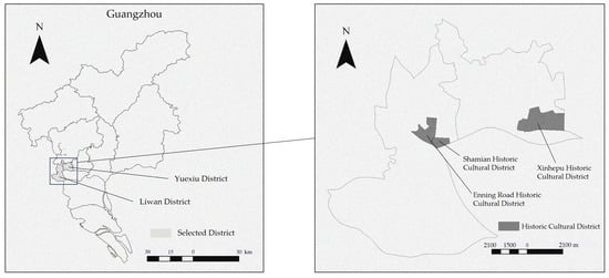
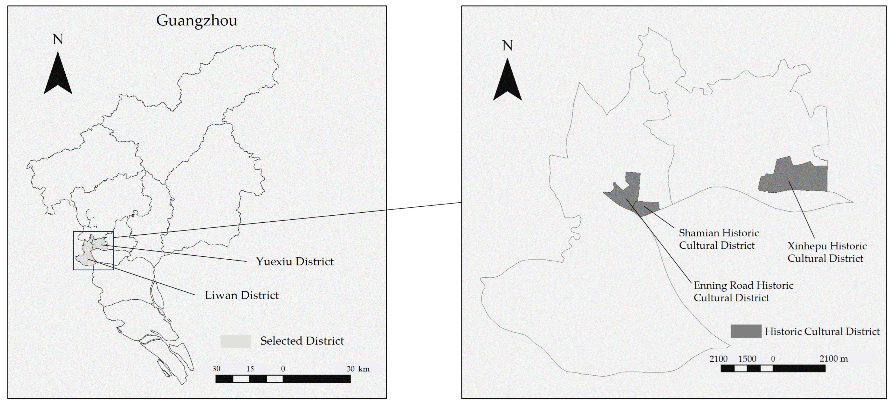
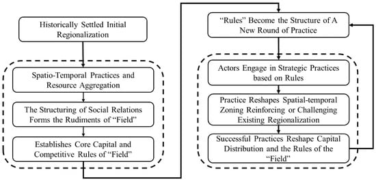
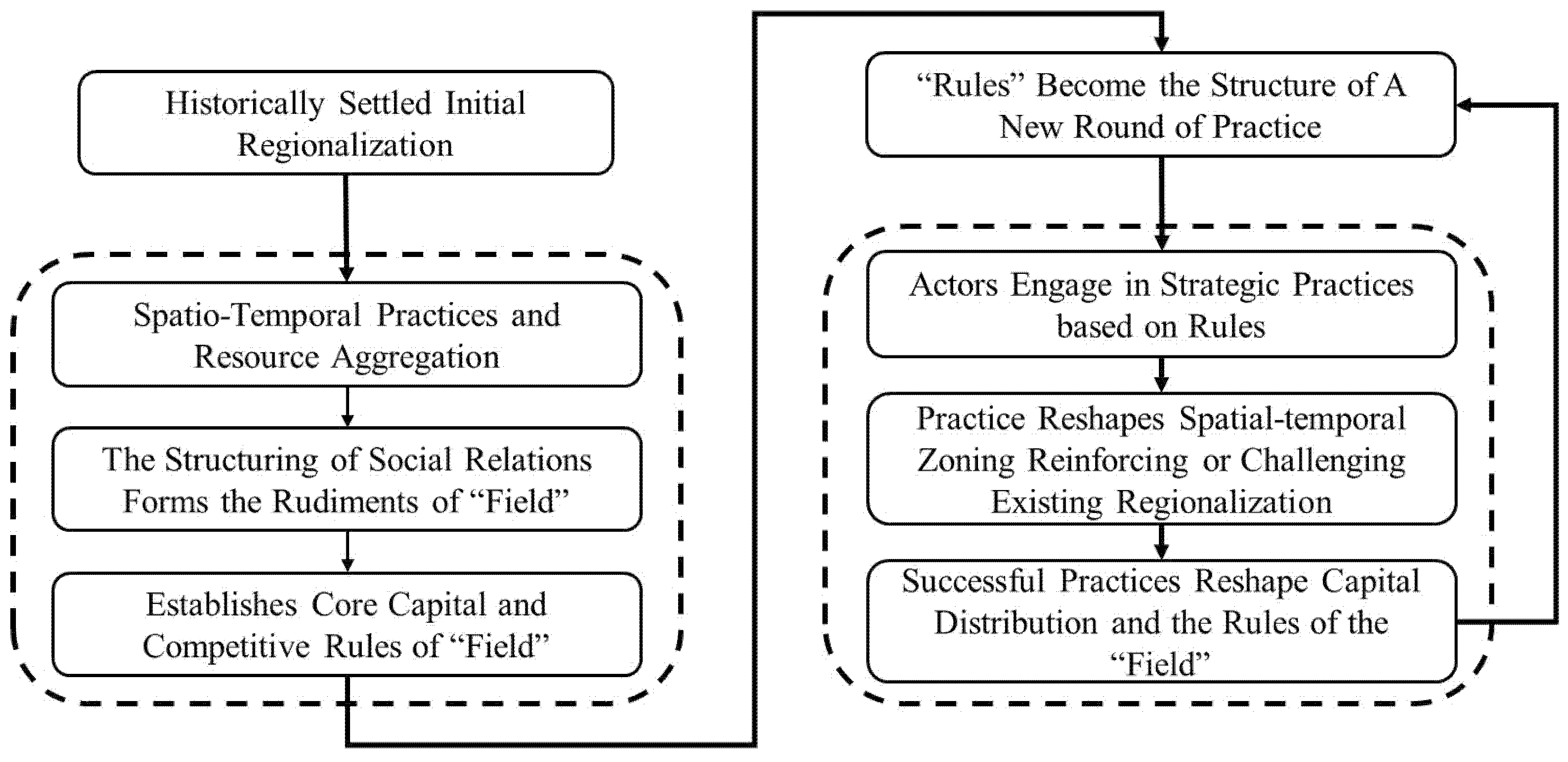
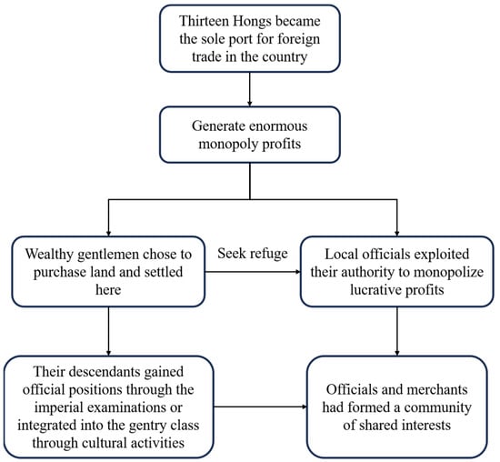
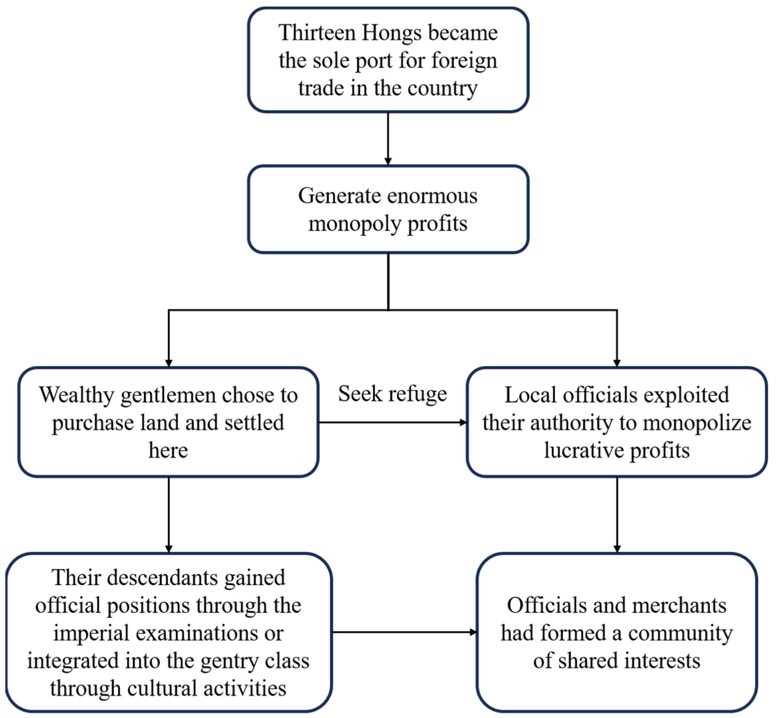
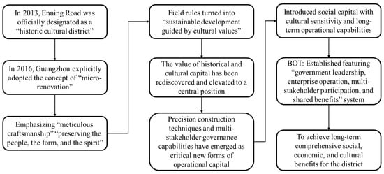
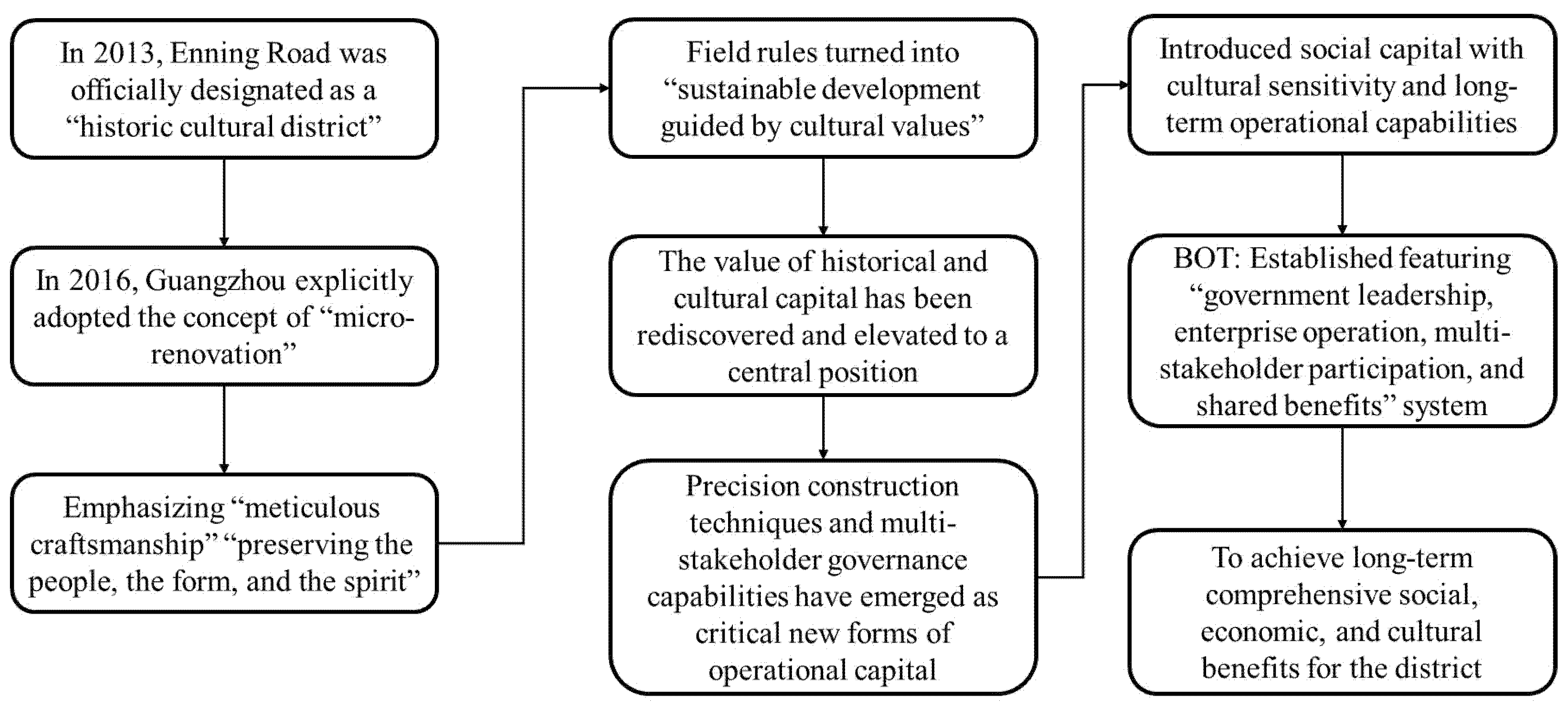
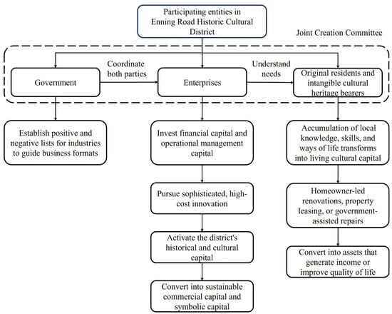
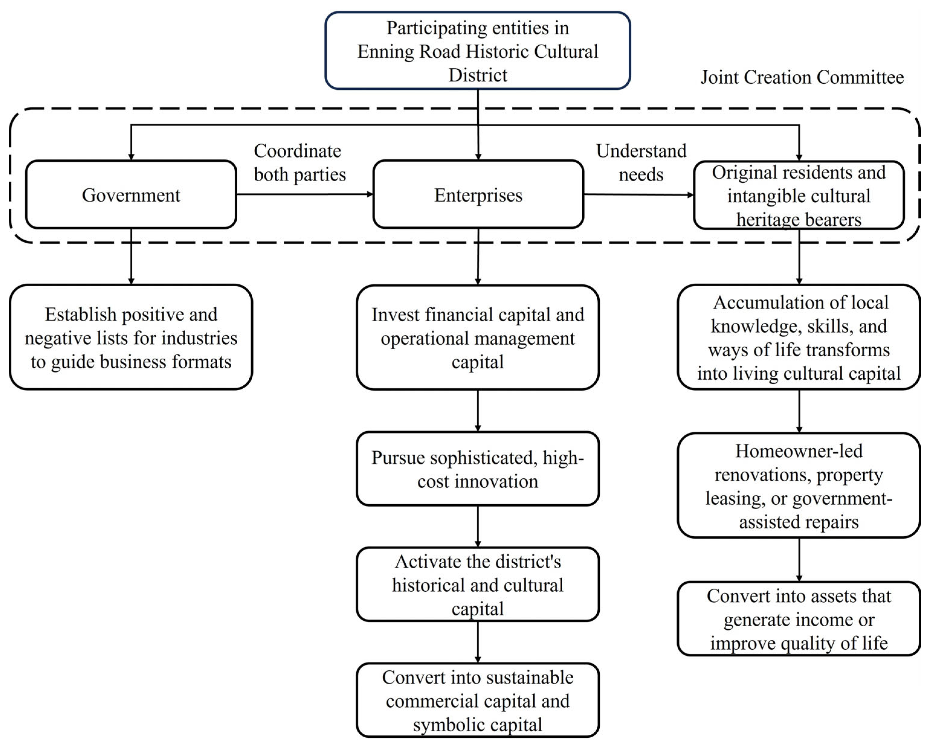
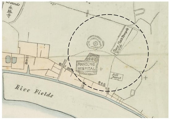
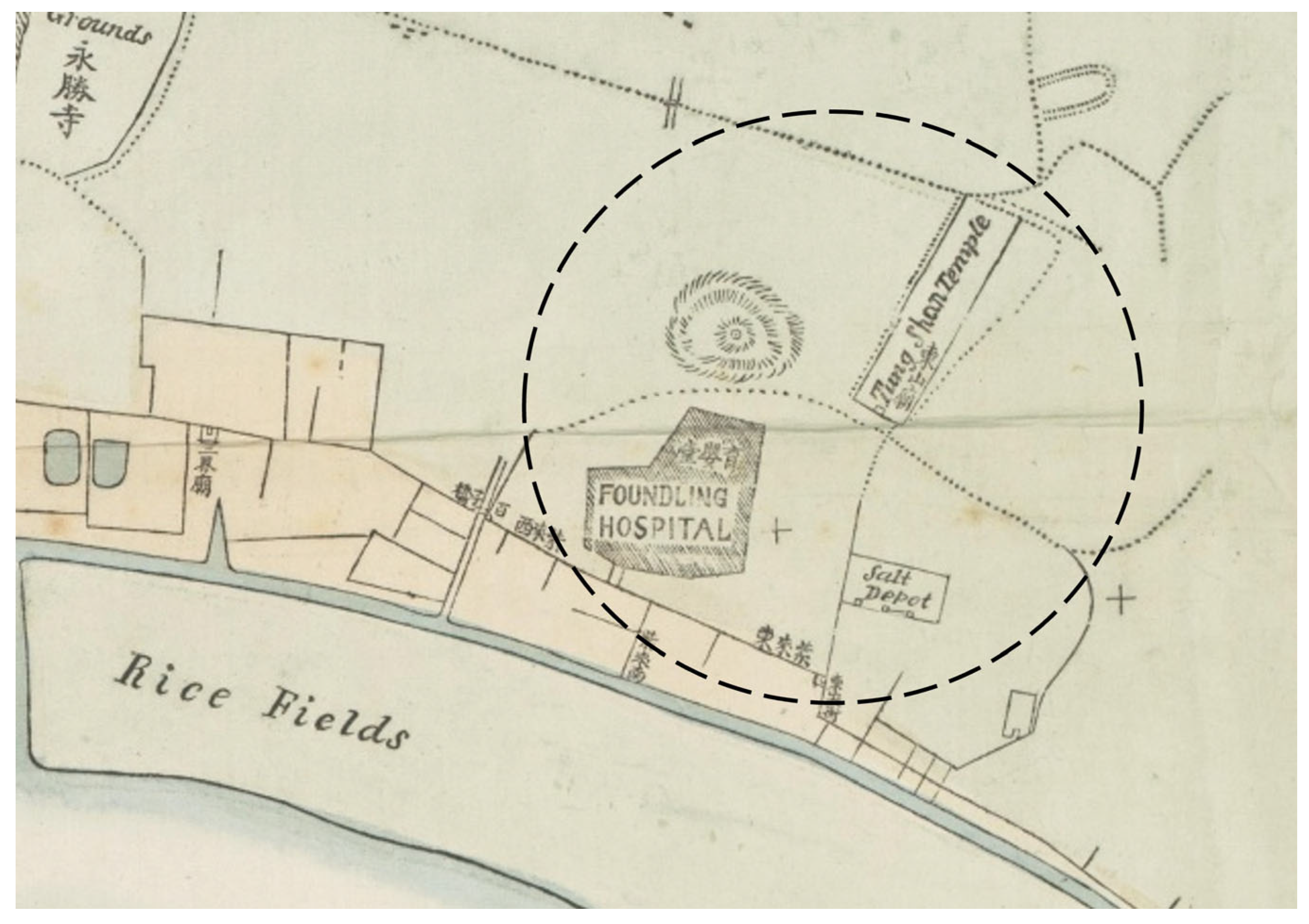
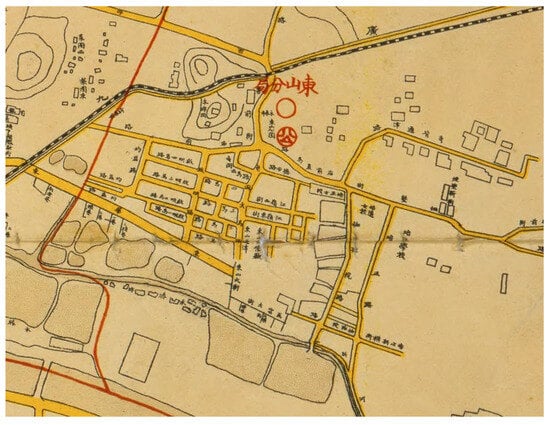
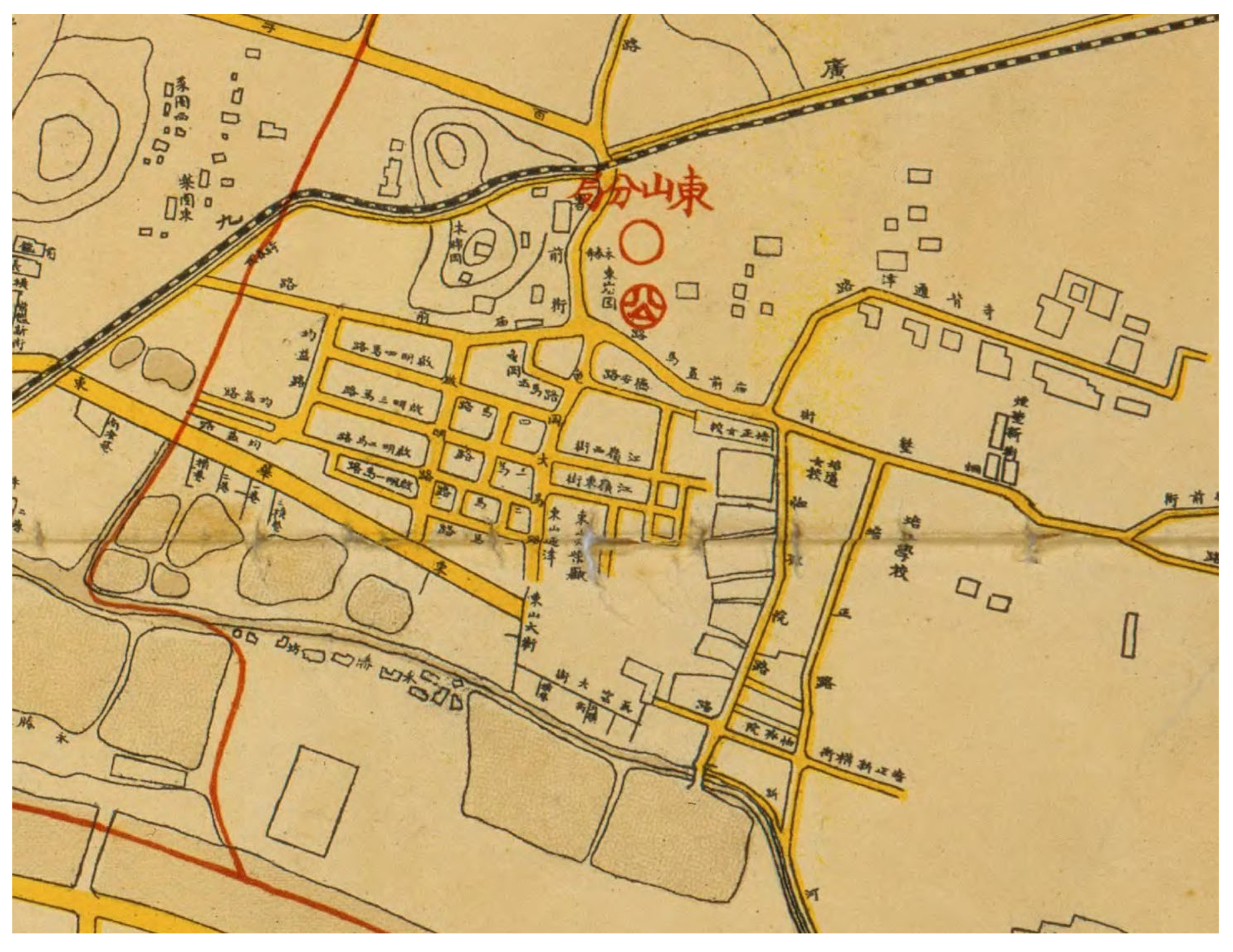
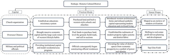
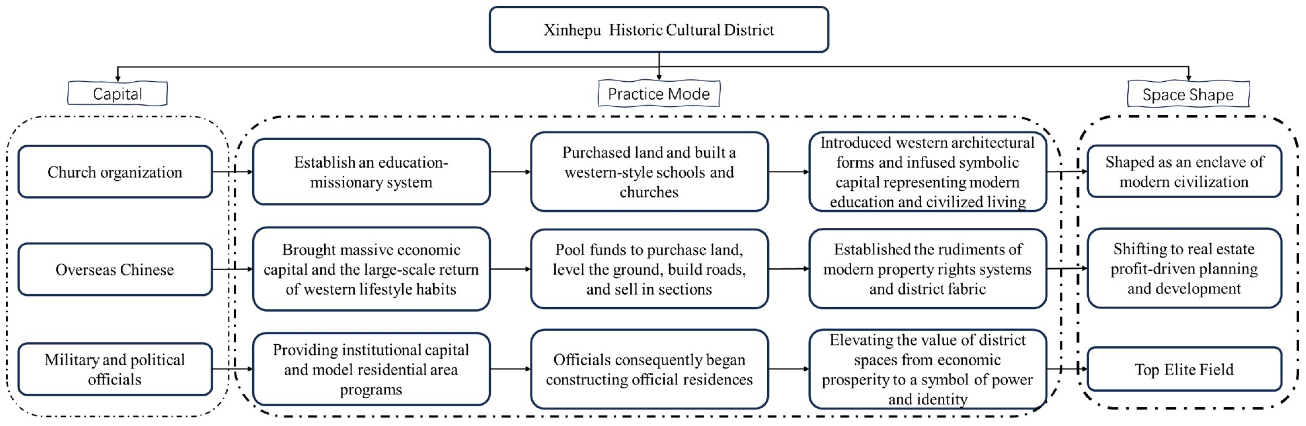
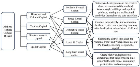
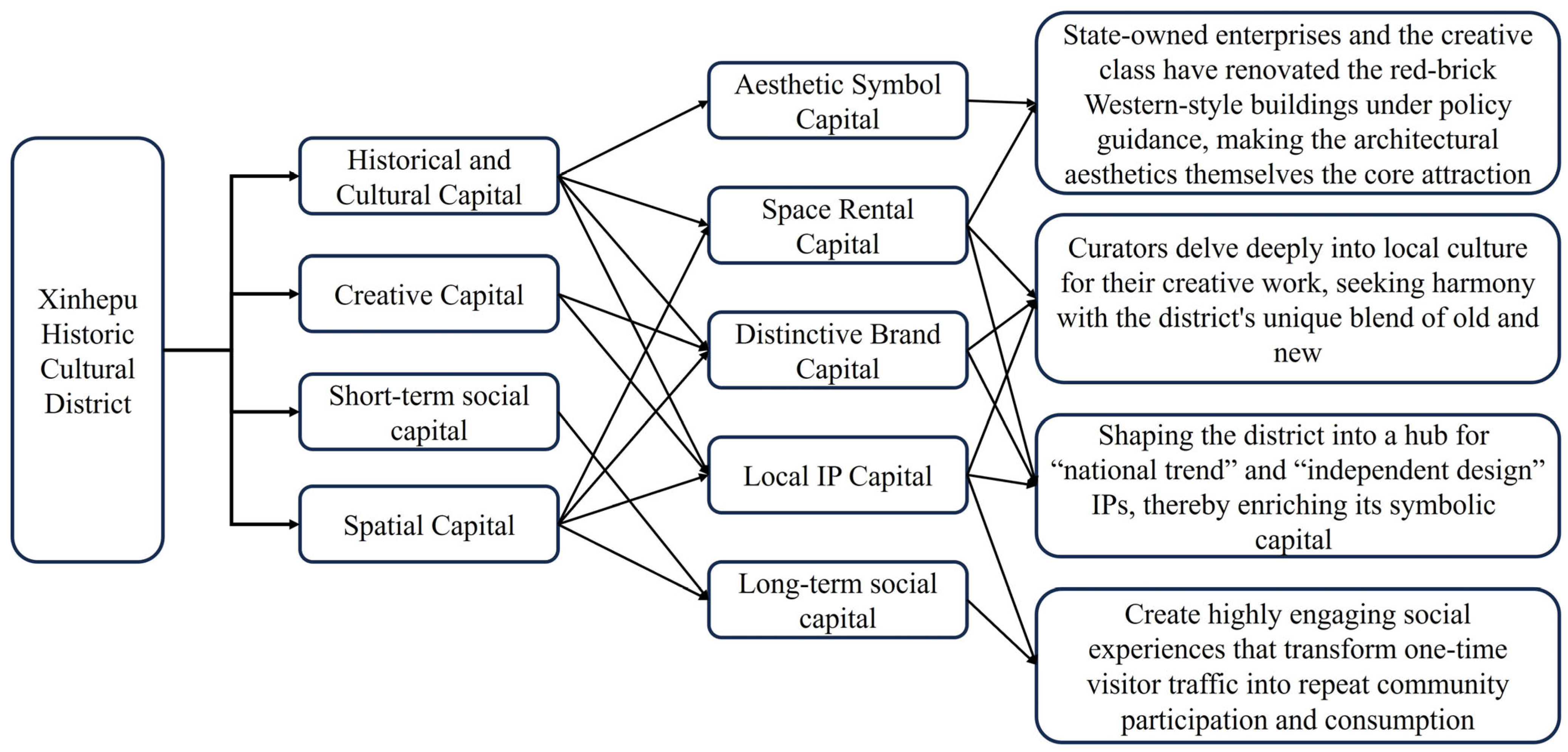

Disclaimer/Publisher’s Note: The statements, opinions and data contained in all publications are solely those of the individual author(s) and contributor(s) and not of MDPI and/or the editor(s). MDPI and/or the editor(s) disclaim responsibility for any injury to people or property resulting from any ideas, methods, instructions or products referred to in the content. |
© 2026 by the authors. Licensee MDPI, Basel, Switzerland. This article is an open access article distributed under the terms and conditions of the Creative Commons Attribution (CC BY) license.