


Abstract
Debris flows in alpine canyon regions pose serious threats to infrastructure and human settlements due to their abrupt onset and high mobility, yet the interactions among topographic complexity, sediment supply, and mitigation performance remain insufficiently understood. This study integrates field investigations, hydro-meteorological analysis, and dynamic numerical simulations to investigate the “8·03” event in Ridi Gully, eastern Qinghai–Tibet Plateau. The results indicate that the initiation and subsequent evolution of the debris flow were jointly controlled by intense localized rainfall, abundant unconsolidated sediment, and steep channel gradients, with local blockage-breaching processes further amplifying flow velocity and impact energy. Mitigation simulations further show that the single slit-dam configuration reduced the debris flow deposition volume and area by 14.29% and 16.23%, respectively, whereas the combined slit-dam/rigid-check-dam configuration achieved reductions of 65.54% and 44.97% relative to the no-protection scenario. These results highlight the potential contribution of temporary blockage-breaching to downstream hazard amplification and demonstrate the different regulating effects of the tested mitigation configurations on flow intensity and sediment deposition. The findings provide case-specific insights into debris flow hazard evolution and staged structural mitigation in alpine mountainous environments.
1. Introduction
Debris flows are notably destructive geological hazards in mountainous regions, characterized by rapid initiation, intense movement, and substantial impacts [1,2,3,4]. In alpine canyon environments, steep terrain and abundant unconsolidated sediments facilitate the development of debris flow, while erosion, flow acceleration, and blockage-breaching processes during transport can further amplify their effects [5]. The catastrophic debris flow and flood event that occurred along the Nepal–China border on 26 August 2026, reportedly triggered by a rapid slope failure involving glacier ice, further highlights the potential for high-mountain slope failures to evolve into destructive channelized flows and floods over long downstream distances [6]. Identifying the dominant controls on debris flow evolution and exploring corresponding mitigation strategies are critical for improving hazard assessment and informing the design of mitigation strategies.
The disaster mechanisms of debris flows have been extensively investigated in mountainous regions. Previous studies have demonstrated that rainfall intensity, rainfall duration, and sediment availability jointly influence debris flow initiation and subsequent development [7,8,9]. Intense rainfall provides the primary hydrological forcing for triggering slope and channel sediment mobilization, while the availability and spatial distribution of loose sediment influence the magnitude and persistence of subsequent flow development [10,11,12]. Once initiated, debris flows in steep alpine channels undergo rapid downstream propagation accompanied by erosion, entrainment, and deposition [13]. Steep longitudinal gradients promote flow acceleration, whereas channel-width variations, bends, and local topographic discontinuities regulate flow velocity, spreading, erosion, and deposition patterns [14,15,16]. These processes may locally modify sediment concentration and flow mobility, thereby influencing the downstream hazard footprint. Under strong topographic confinement and high sediment availability, local deposition and obstruction of the channel may further develop into blockage, followed by breaching and renewed downstream release, potentially amplifying local flow intensity and sediment transport [17,18]. However, the extent to which such blockage-breaching processes contribute to downstream hazard amplification remains difficult to quantify because they are highly localized and transient.
Engineering mitigation constitutes a crucial approach to reducing debris flow hazards. Various structures, including slit dams and rigid check dams, have been widely used to regulate debris flow transport and deposition [19,20]. Slit dams can preferentially retain large boulders and woody debris while maintaining part of the channel conveyance capacity, making them useful for coarse-sediment interception and flow-intensity regulation [21,22]. Rigid check dams, in contrast, primarily reduce downstream sediment transport by promoting deposition upstream of the structure [23]. These distinct functions also imply different limitations when individual structures are subjected to large-volume debris flows with abundant sediment supply and strong topographic confinement. A single slit dam, for example, may intercept coarse materials while leaving substantial fine-to-medium sediment available for downstream transport, whereas a check dam may provide stronger sediment storage but can also require sufficient upstream deposition capacity [24,25]. Multi-stage systems combining different structural functions have therefore been increasingly considered for regulating debris flows progressively along the channel. However, the comparative effects of individual and combined configurations on flow intensity and downstream deposition have not been sufficiently quantified for well-documented large-volume debris flow events.
On 3 August 2024, a large-scale debris flow occurred in Ridi Gully, Kangding County, situated on the eastern margin of the Qinghai–Tibet Plateau. The catchment is characterized by a steep alpine canyon environment, substantial elevation differences, and abundant loose sediment sources distributed along hillslopes and channels. During the event, intense channel erosion, local deposition, and blockage-breaching processes occurred, causing severe damage on bridges, residential buildings, industrial facilities, and transportation infrastructure. Zou et al. [26] previously investigated the hazard-prone conditions of the Ridi Gully and assessed its potential disaster risks. More recently, Cheng et al. [27] investigated the “8·03” debris flow from the perspective of landslide-induced initiation, with particular emphasis on the transformation of shallow hillslope landslides into channelized debris flows and the contribution of landslide-derived sediment to debris flow initiation. Their study provided important insights into the initiation mechanism and the effects of geomorphological and hydro-meteorological conditions on debris flow occurrence in alpine regions. Nevertheless, these studies did not examine how intense rainfall, abundant sediment supply, steep topography, and in-channel blockage–breaching processes collectively contributed to the subsequent disaster evolution of the event. Furthermore, in the aftermath of the disaster, slit dams and rigid check dams were proposed and subsequently constructed in the middle and lower reaches of the channel as mitigation measures to reduce future debris flow risks. However, a comprehensive quantitative assessment of these structural measures remains lacking.
In this study, the “8·03” debris flow in Ridi Gully, Kangding, is investigated to examine its triggering background, downstream dynamic evolution, and principal disaster-causing processes. Particular attention is given to the potential hazard amplification associated with in-channel blockage and breaching. Through field investigation, hydro-meteorological analysis, and dynamic numerical simulation, the roles of rainfall, sediment supply, steep topography, and blockage–breaching processes in the disaster evolution are examined. Different mitigation scenarios are further evaluated to compare the regulating effects of single and combined structural measures on debris flow intensity, coarse-sediment transport and downstream deposition. Based on the stage-dependent characteristics of debris flow initiation, transportation, and deposition, implications for integrated mitigation strategies are discussed. The results are used to discuss the applicability of staged mitigation strategies for large-volume debris flows in alpine canyon environments.
2. Study Area and Disaster Overview
2.1. Geological and Meteorological Background of the Watershed
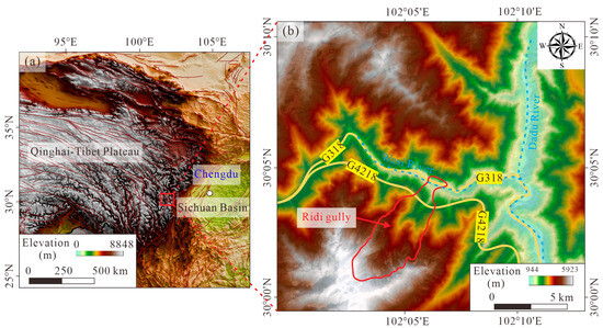
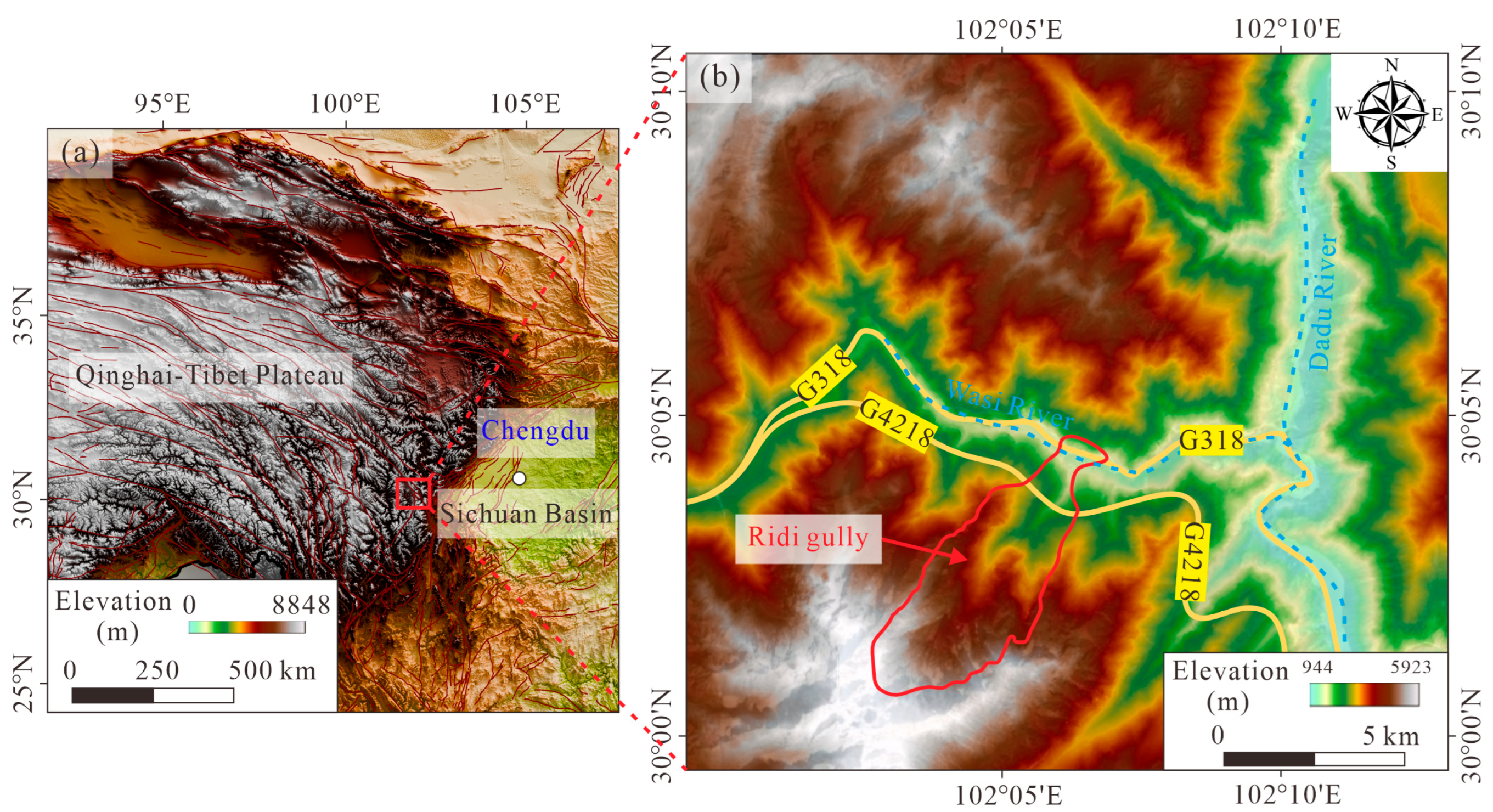
Ridi Gully, Kangding, China, is situated within the transitional zone between the eastern Qinghai–Tibet Plateau and the Sichuan Basin (Figure 1). It lies on the right bank of the Wasi River, a tributary of the Dadu River, and features steep slopes, high mountains, and deeply incised river valleys. The G318 national highway traverses the gully outlet, whereas the G4218 Yaan-Kangding expressway crosses the central part of the watershed via a combination of tunnels and bridges. This distinctive transportation configuration renders the area a critical control node within the regional transportation network.
Figure 1.
Geographical overview of the Ridi gully. (a) Geographical location; (b) Watershed characteristics.
The catchment exhibits a typical alpine canyon landscape with deeply incised V-shaped valleys. The overall terrain gradient descends from southwest to northeast, and elevation ranges from 1700 to 5700 m a.s.l. The catchment covers a total area of approximately 26.12 km2, and consists of a main channel and a tributary channel. The main channel extends for 10.48 km, drains an area of 17.14 km2, and exhibits an average longitudinal gradient of 376‰, with a relative elevation difference of 3782 m. The right tributary channel extends for 4.50 km, drains an area of 4.83 km2, and exhibits an extremely steep average longitudinal gradient of 616‰, with a relative elevation difference of 2771 m. These pronounced topographic gradients have promoted long-term fluvial incision of the hillslopes and channels, resulting in the development of a deeply incised canyon landscape and creating favorable topographic conditions for debris flow initiation and subsequent development. According to field investigations and interviews with local residents, debris flows have repeatedly occurred in the Ridi Gully, including events documented in 1952, 1963, 1966, and 1982, posing serious threats to the lives and property [26].
The regional geological setting is characterized by a complex tectonic regime. Three major active fault systems, comprising the NW-trending Xianshuihe Fault Zone, the NE-trending Longmenshan Fault Zone, and the nearly N-S-trending Sichuan-Yunnan Fault Zone, traverse this region. The activity of these faults has contributed to pronounced seismicity, including three earthquakes exceeding magnitude 7.0 recorded over the past century. The most recent event, the Ms 6.8 Luding earthquake, occurred on 5 September 2022. Repeated seismic activity has weakened the integrity of rock masses and promoted the development of faults, joints, and fractures, thereby generating abundant loose sediment that can serve as sediment sources for subsequent debris flows.
Bedrock exposures are sparsely distributed within the catchment, and the dominant lithology consists of granite and diorite. Owing to intense tectonic stresses and long-term weathering processes, the granitic rocks are susceptible to the development of heterogeneous weathering crusts and abundant clastic deposits. Together with the tectonic fracture systems, these weathered materials constitute substantial sediment sources on hillslopes and within gullies. In addition, widespread Quaternary surficial deposits (Q4c+dl), including landslide deposits, glacial sediments, moraines and fluvial-alluvial sediments, are extensively distributed along slopes and riverbanks. These deposits constitute a persistent reservoir of loose solid materials that can be repeatedly mobilized within the catchment. This combination of geological and surficial sediment sources ensures abundant sediment availability and continuous material replenishment, thereby contributing to the high susceptibility of Ridi Gully to debris flows.
The Ridi Gully is characterized by a plateau continental monsoon climate, marked by relatively dry conditions, abundant sunshine, pronounced diurnal temperature variations, long winters with prolonged snow and ice cover, and short but hot summers. The mean annual precipitation is approximately 803.8 mm, with a highly uneven seasonal distribution. Precipitation during the rainy season from May to September accounts for 60–85% of the annual total, and both intense rainfall events and prolonged wet spells are common. The maximum recorded daily rainfall is 65.9 mm, while the longest continuous rainfall duration can last up to 58 days, with a cumulative precipitation of 542.9 mm during this interval. In addition to atmospheric precipitation, glacier meltwater originating from high-altitude zones within the catchment constitutes another important water source. During the snow and glacier melting season, meltwater provides persistent baseflow or episodic runoff to the channel system, whereas concentrated rainfall can sharply increase peak discharge over short durations. The combined effects of glacier meltwater and rainfall can enhance runoff generation and sediment-transport capacity, thereby providing important hydrodynamic conditions for debris flow initiation and subsequent amplification.
2.2. Disaster Characteristics of the Ridi Debris Flow
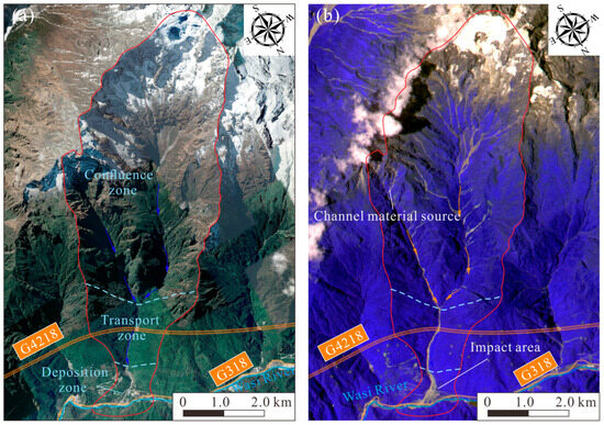
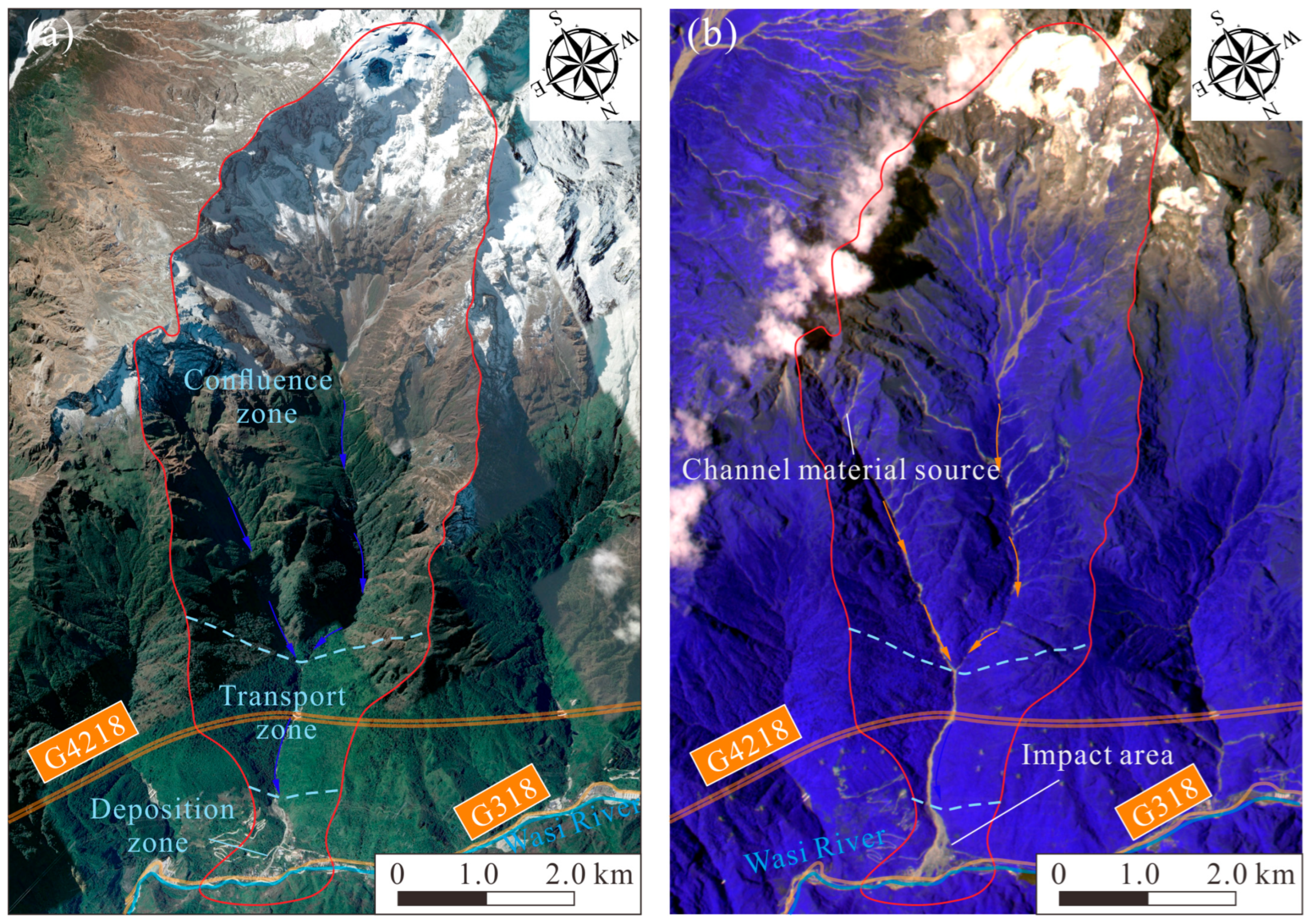
Field investigations revealed that the Ridi Gully debris flow occurred at around 03:30 a.m. on 3 August 2024. The event was accompanied by pronounced rumbling noises and perceptible ground vibrations, and persisted for more than 30 min. Figure 2 presents a comparison of the pre- and post-event surface conditions within the catchment. Numerous linear and banded disturbance signatures observed in the upper and middle reaches suggest that the debris flow involved multiple localized slope failures and extensive erosion of hillslopes and channels. Intense rainfall generated surface runoff, which mobilized abundant loose materials that subsequently converged along the channels to form a typical channelized debris flow. During its downstream movement, the flow continuously entrained materials from the channel bed, valley banks, and other loose deposits along its transport path, leading to progressive increases in flow volume, peak discharge, and kinetic energy. Such erosion and entrainment substantially increased the event magnitude and enlarged the affected area.
Figure 2.
Comparison of satellite images of the Ridi gully before and after the debris flow: (a) pre-event image acquired on 10 September 2022 from Google Earth; (b) post-event image acquired on 5 August 2024 from CBERS-04.
Based on geomorphic units and the dynamic characteristics governing disaster development, the Ridi debris flow can be classified into three major zones: the confluence zone, transportation zone, and deposition zone. Rainfall-induced runoff generation and concentration mainly occurred in the upstream catchment, above the confluence of the main and tributary channels in Ridi Gully. As cumulative precipitation increased, the water level and flow velocity in the upstream main channel and the right tributary channel rose continuously, progressively entraining loose solid materials from the channel system and transporting them downstream. After mixing and converging, the solid–liquid mixture from the main and tributary channels continued downstream as an integrated debris flow. During this process, the flow further entrained channel-bed materials, triggered local slope failure, and caused overbank flooding as it advanced downstream. Finally, the debris flow reached Ridi Village and deposited on the downstream fan.
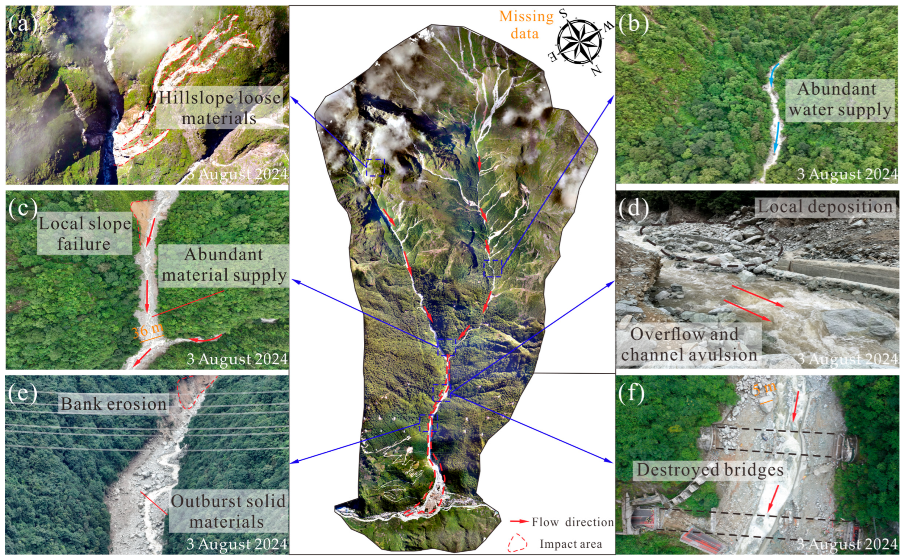
Within the confluence zone, the upstream main channel was primarily characterized by a rapid increase in water discharge over short time scales, while channel bed erosion and deposition processes remained relatively limited. Therefore, this area can be identified as the primary water-supply zone of the debris flow (Figure 3b). In contrast, the right tributary channel exhibited extensive surficial sliding scars, with shallow landslides observed locally (Figure 3a,c). Pronounced channel-bed erosion, local blockage, and overbank flooding were also observed along the tributary channel. Intense erosional processes considerably enhanced the sediment entrainment capacity of tributary runoff, enabling substantial quantities of loose solid materials to be transported downstream. At the confluence of the main and tributary channels, erosion-induced widening of the tributary channel reached approximately 36 m, indicating that the tributary channel acted as the primary sediment-source zone and provided abundant materials for the downstream debris flow.
Figure 3.
Post-disaster overview of the middle and lower reaches of the Ridi Gully based on UAV aerial imagery acquired on 3 August 2024. The uppermost part of the catchment is not covered by the UAV imagery because of the large elevation differences and complex alpine terrain. (a) Loose materials in the tributary gully; (b) abundant water supply in the main gully; (c) local slope failure; (d) local blockage, and overbank flooding; (e) erosion along the channel; (f) destroyed bridges.
Within the transportation zone, abundant loose solid materials supplied by the main and tributary channels mixed with floodwater to form a hyperconcentrated flow, which rapidly propagated downstream along the channel. Under the constraints imposed by local topography and engineering structures, deposition and temporary blockage developed in the upstream section of the G4218 Expressway. When the accumulated deposit volume and potential energy reached a certain threshold, the blockage body failed catastrophically, releasing a rapidly moving water–sediment mixture. The resulting surge exerted intense impact forces on the bridge piers and ultimately caused bridge failure (Figure 3d,f). Following the blockage failure, the debris flow continued to propagated downstream and progressively eroded soil masses along its transport path. Obvious lateral erosion traces are visible on the hillsides flanking the debris flow transport path downstream of the expressway bridge, indicating strong erosional effects during flow propagation (Figure 3e).
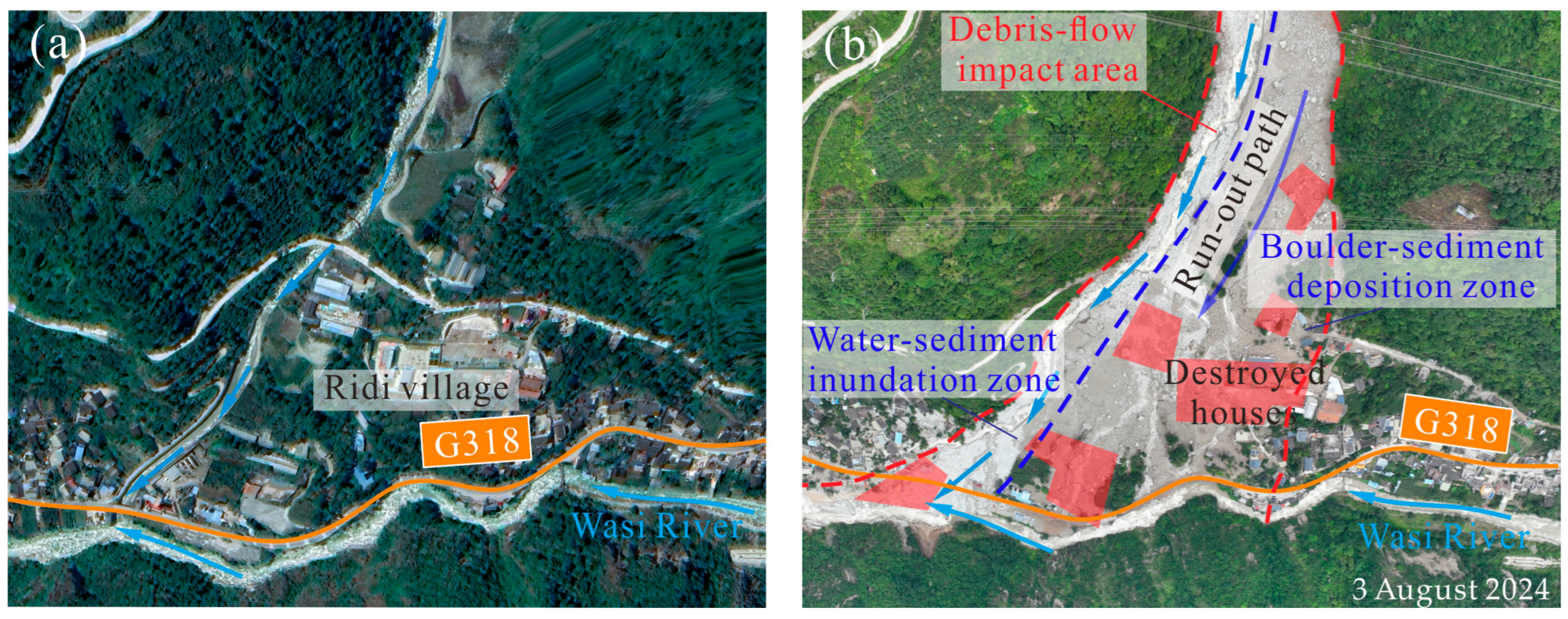
After exiting the channel outlet, the rapid debris flow deposited a large volume of loose sediment on the alluvial fan of Ridi Gully, burying numerous houses, factories, and sections of the G318 national highway (Figure 4). Based on field investigations and site-based volume estimations, the volume of transported solid materials during this event was approximately 5.8 × 10⁵ m3. The debris flow carried numerous large boulders, with maximum boulder sizes reaching approximately 6 m in diameter. Most transported boulders had diameters ranging from several decimeters to 1 m. The impact force of individual boulders could exceed 500 kN, while the cumulative impact force along the flow path reached several hundred tons, indicating the exceptionally high destructive capacity of the event.
Figure 4.
Comparison of images of Ridi Village before and after the debris flow: (a) pre-event satellite image acquired on 10 September 2022 from Google Earth; (b) post-event UAV image acquired on 3 August 2024, with the debris flow impact areas highlighted.
Within the deposition zone, the geomorphic setting of the alluvial fan promoted pronounced water-sediment separation and spatially differentiated hazard characteristics. Based on differences in sediment composition and flow dynamics, the deposition zone can be further divided into two sub-zones: the water-sediment inundation zone and the boulder-sediment deposition zone. The former zone was mainly characterized by fine sediments transported with floodwater along the existing channel on the right side of the fan, which eventually entered the Wasi River. This process caused partial blockage of the river channel and resulted in the formation of fan-shaped deposits. This zone exhibited relatively high moisture content and abundant fine particles, with sediment accumulation as the dominant process. In contrast, the latter zone was closely associated with debris flow overflow and lateral surges triggered by local blockage near the channel outlet. Constrained by local topography, the overflowing sediments and boulders were transported downstream along the left side of the channel, forming extensive deposits of coarse solid material. The resulting deposits caused severe damage to numerous residential buildings, making this zone the primary impact area of the debris flow.
3. Analysis of Cascading Mechanism
3.1. Dynamic Propagation Process
Controlled by the deeply incised canyon terrain of Ridi Gully, the debris flow exhibited highly complex propagation and deposition processes. Numerical back-analysis provides an effective means of investigating the potential dynamic behavior and disaster mechanisms of debris flows in alpine valleys. As highly concentrated solid–liquid mixtures, debris flows involve complex interactions among particle friction, interparticle adhesion, fluid drag, pore-fluid pressure, and fine-particle effects. To represent the granular contact behavior, this study adopted the Hertz-Mindlin contact model combined with the Johnson-Kendall-Roberts (JKR) adhesion theory implemented within the EDEM platform [28,29]. The Hertz–Mindlin formulation represents normal and tangential particle contacts, whereas JKR describes adhesive interactions between contacting particles. However, pore-fluid pressure, lubrication effects, and fine-particle-controlled rheological behavior are not explicitly resolved by this formulation. Accordingly, the adopted approach is regarded as a calibrated granular-contact approximation rather than a physically complete representation of debris flow behavior.
The Ridi debris flow occurred over a large catchment area, involving complex processes that include rainfall-runoff, sediment supply, channel erosion, and local blockage-breaching within the main and tributary channels. Direct numerical reproduction of the complete event would require a large computational domain and a complex parameter system, while constraints on initial and boundary conditions would remain difficult to obtain. Moreover, the associated computational burden would significantly reduce simulation efficiency. Therefore, an equivalent simplification strategy was adopted to focus the simulation on the downstream transport and deposition zones, which are particularly relevant to engineering-oriented hazard assessment. In the numerical model, upstream runoff generation and sediment initiation processes were represented in a lumped manner, and all solid materials were assumed to be instantaneously released from a resting state at the confluence of the main and tributary channels. This location was defined as the release point, from which downstream propagation, spreading, and deposition on the alluvial fan were simulated.
The adopted simplification inevitably limits the representation of several complex natural processes, including the spatiotemporal variability of upstream rainfall-runoff, progressive sediment supply, and amplification mechanisms within the confluence zone. Additionally, DEM smoothing in the simulation may partially eliminate small-scale topographic irregularities and complex channel morphologies. Uncertainties also arise from the adopted microscopic contact parameters, which could not be directly measured during the event. These limitations may particularly affect peak discharge timing, local erosion and sediment-supply processes, blockage development, and the precise propagation of the debris flow front. By contrast, the simulation is primarily intended to investigate the downstream transport and deposition behavior under the observed topographic and bulk sediment-volume conditions. Therefore, the simulated velocity distribution and deposition characteristics should be interpreted as model-based estimates of potential flow behavior rather than fully validated reconstructions of the natural event.
The numerical simulation was conducted using EDEM 2024. The computational domain was constructed based on the surveyed channel geometry and downstream alluvial-fan morphology, and the DEM terrain was preprocessed by Rhino 7. Based on the volume of solid materials estimated from field surveys, a total volume of 5.8 × 10⁵ m3 of loose sediments was incorporated into the DEM model in the form of spherical particles. These particles were uniformly distributed along the gully upstream of the main-tributary confluence. Two particle sizes, with radii of 0.5 m and 1.0 m, were adopted, each accounting for 50% of the total particle volume, resulting in a total of approximately 623,100 particles. These particle sizes and proportions were adopted as a simplified representation of the bulk sediment volume rather than as a direct reconstruction of the complete field grain-size distribution. This bimodal scheme cuts computational cost substantially, enabling watershed-scale debris flow numerical simulations while retaining the key bulk structural characteristics. It should be noted that the absence of fine particles may cause the simulated behavior to more closely resemble a granular debris avalanche than a typical debris flow, because fine-particle effects on pore-pressure evolution and rheological behavior are not explicitly represented. The sensitivity of the simulated results to alternative particle-size distributions was not systematically examined in this study and therefore remains an important source of modelling uncertainty.
The overall numerical model configuration was calibrated through iterative comparison between the simulated deposition area and the field-measured deposition extent, with a timestep of dt = 2 s. This procedure represents a back-analysis based on the final deposition footprint rather than an independent validation. Because no supplementary field measurements of flow velocity or impact forces were available for verification, Therefore, the present simulation should be interpreted as a calibrated numerical reconstruction for investigating the potential transport and deposition behavior of the event, rather than as an independently validated reproduction of its dynamic evolution. Because the available field observations were insufficient for independent dynamic validation, quantitative goodness-of-fit metrics for independently observed flow velocity, arrival time, flow depth, or impact force could not be established. Correspondingly, the microscopic contact parameters used in the EDEM simulation were therefore treated as adopted model inputs rather than directly measured event-specific properties. For particle-particle contacts, the Poisson’s ratio was set to 0.25, particle density to 2500 kg/m3, Young’s modulus to 1 × 10⁸ Pa, restitution coefficient to 0.12, sliding friction coefficient to 0.65, rolling friction coefficient to 0.18, and JKR surface energy to 5.0 J/m2. For particle-wall contacts, the corresponding values were 0.30, 8000 kg/m3, 5 × 10⁸ Pa, 0.20, 0.32, 0.12, and1.8 J/m2, respectively. These values were selected based on the material/contact assumptions adopted in the present EDEM framework and previous numerical studies of granular and geological flows. Because direct measurements of these microscopic contact properties during the event were unavailable, their statistical uncertainty ranges could not be constrained from field observations. Accordingly, the reported values should be regarded as model inputs for reproducing the dominant transport and deposition behavior rather than as uniquely determined physical properties of the natural debris flow. In addition, systematic sensitivity analyses of contact parameters, particle-size distribution, and release conditions were beyond the scope of the present simulation. These factors therefore constitute important sources of modelling uncertainty and should be considered when interpreting the numerical results.
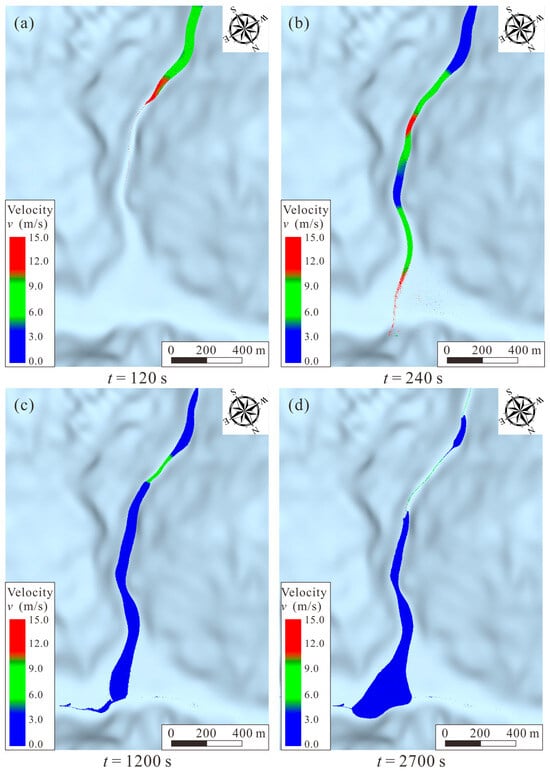
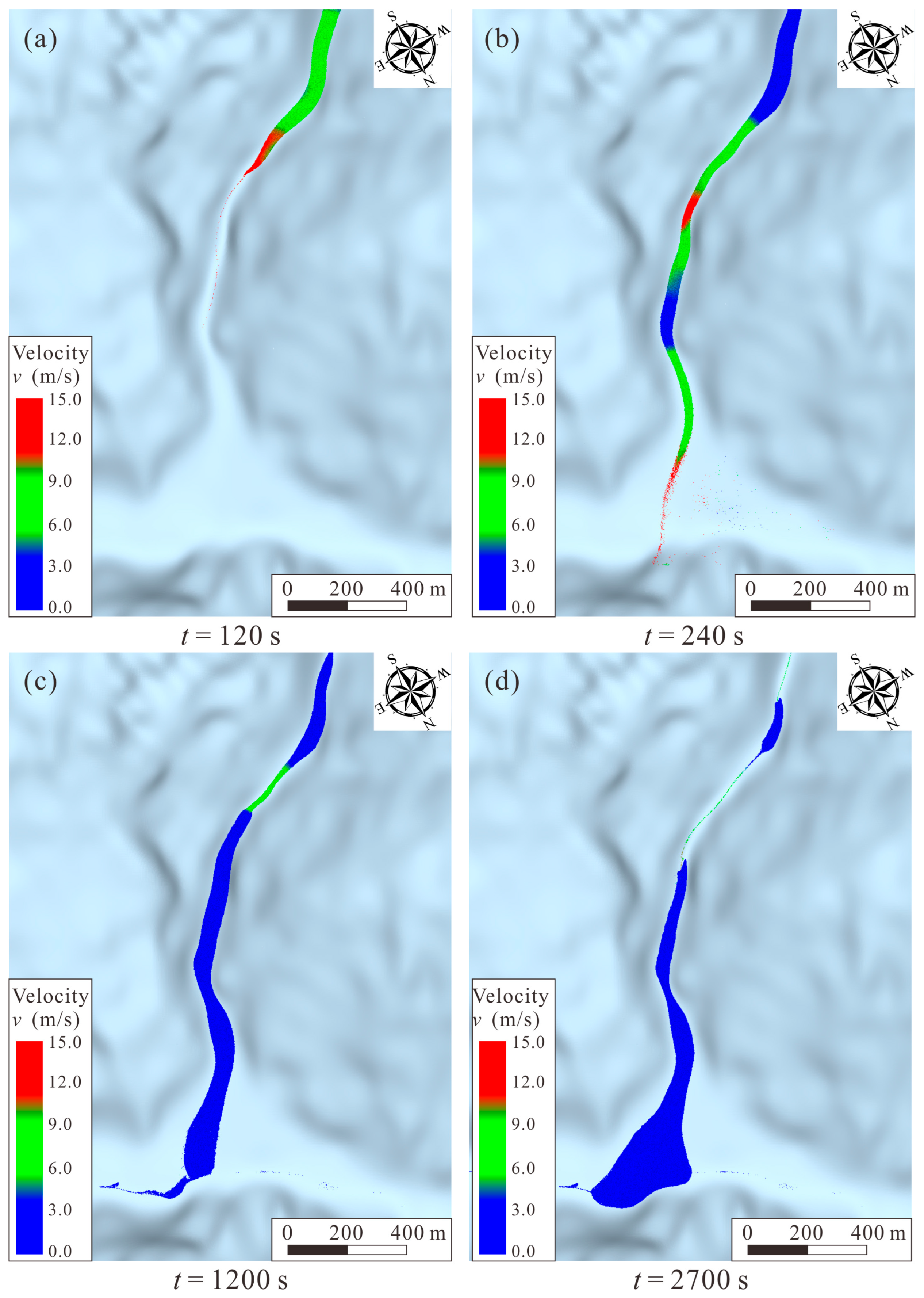
The numerical results (Figure 5) indicate pronounced spatial and temporal heterogeneity in the velocity field during downstream propagation. The simulated maximum velocity reached approximately 15 m/s in the transport zone, but high velocities were not uniformly distributed along the channel. Instead, localized high-velocity regions were concentrated in steep and laterally confined channel segments, particularly near pronounced bends and abrupt morphological transitions. These patterns indicate that the conversion of gravitational potential energy into flow motion was strongly modulated by local channel geometry. Steep channel segments favored flow acceleration, whereas channel widening, reduced longitudinal gradients, and increased depositional space promoted flow deceleration and sediment accumulation. Thus, the velocity field reflects a dynamic balance between gravitational driving forces and topographic constraints, which changes along the downstream channel.
Figure 5.
Numerical simulation of debris-flow evolution processes in Ridi Gully. (a) t = 120 s; (b) t = 240 s; (c) t = 1200 s; (d) t = 2700 s.
At t = 120 s, the debris flow was mainly confined within the upper transport channel, where the velocity field exhibited elongated high-velocity zones along steep and geometrically constrained reaches. The locally elevated velocities near sharp bends and morphological transitions indicate that channel geometry imposed strong spatial controls on flow acceleration rather than producing a uniform increase in velocity along the channel. By t = 240 s, the flow front had reached the lower, more open part of the gully, where the reduction in channel gradient and increase in flow width were accompanied by a general attenuation of velocity. At the same time, localized higher-velocity regions remained upstream, indicating that the flow did not decelerate synchronously along the entire channel. This asynchronous response suggests that local topographic confinement and temporary sediment storage could maintain locally intensified flow even after the leading front entered the deposition zone (Figure 5b).
The transient high-velocity regions observed during downstream propagation may also be related to temporary sediment storage and subsequent release. In locally constricted or morphologically irregular reaches, deposition can reduce the effective flow passage and promote temporary accumulation of flowing and deposited materials. Subsequent remobilization of these stored materials may generate a renewed downstream surge, resulting in temporally non-uniform flow propagation. Although the present simulation does not directly quantify the critical conditions for blockage formation and breaching, the spatial persistence of localized high-velocity zones and the temporal changes in the flow pattern are consistent with the potential influence of transient blockage–breaching on downstream flow amplification. This process provides a plausible mechanism linking local sediment storage to renewed downstream transport and helps explain the non-steady propagation characteristics of the simulated debris flow.
At t = 1200 s, the flow had entered a deposition-dominated stage, with low-velocity regions progressively expanding around the gully outlet and the depositional body spreading laterally across the alluvial fan (Figure 5c). Compared with the confined transport stage, the open fan surface provided greater lateral space and weaker topographic confinement, favoring flow spreading, particle settling, and progressive dissipation of flow momentum. By t = 2700 s, the main flow had largely stabilized and the depositional body had reached a relatively stable configuration (Figure 5d). The transition from a confined channel to an open depositional surface therefore represented a fundamental change in flow regime: longitudinal gravitational acceleration became less dominant, while lateral spreading and sediment deposition increasingly controlled the downstream evolution. The simulated volume of deposited solid materials on the downstream alluvial fan was approximately 4.426 × 10⁵ m3, covering a deposition area of approximately 1.103 × 10⁵ m2. The simulated deposition pattern was generally consistent with the observed depositional extent.
Overall, the simulated velocity field demonstrates that debris flow dynamics in the Ridi Gully were strongly controlled by longitudinal changes in channel gradient, lateral confinement, and local morphological conditions. Steep and confined reaches favored localized acceleration, whereas channel widening and the transition to the alluvial fan promote deceleration, lateral spreading, and deposition. The temporal persistence of localized high-velocity regions during downstream evolution further suggests that temporary sediment storage and subsequent remobilization may contribute to non-steady flow propagation and downstream hazard amplification. Although the present simulation does not quantitatively resolve the critical conditions or detailed dynamics of blockage formation and breaching, the results highlight the potential importance of this transient process in modifying downstream flow intensity.
3.2. Key Coupled Factors Triggering Catastrophic Debris Flow
The initiation and evolution of debris flows are governed by complex interactions among hydro-meteorological conditions, sediment availability, and geomorphic characteristics [30]. In alpine and gorge regions, the interplay among these factors can promote rapid flow development and increase the potential for downstream hazard amplification. As a typical deeply incised alpine canyon, Ridi Gully possesses substantial elevational relief, steep terrain, and abundant reserves of loose sediment, providing favorable conditions for the rapid initiation, acceleration, and downstream propagation of debris flows. Based on field observations, meteorological analyses, and numerical simulation results, the hazard evolution of the Ridi debris flow can be attributed to the combined effects of localized intense rainfall, abundant sediment supply, topographically constrained acceleration, and potential amplification associated with transient blockage-breaching processes.
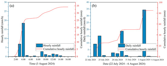
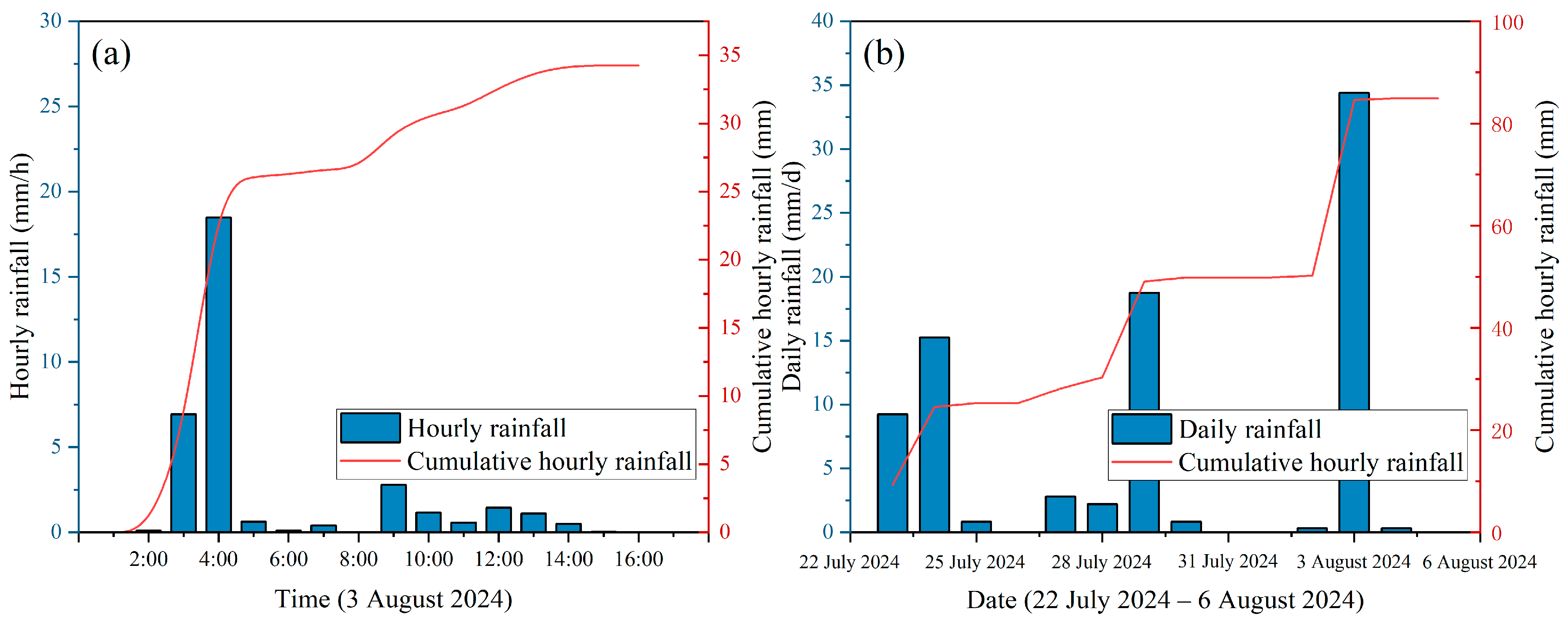
Localized short-duration intense rainfall was an important hydro-meteorological factor associated with the initiation of the Ridi debris flow. According to records from the Ridi meteorological station, situated approximately 591 m from Ridi Village, only 30.7 mm of cumulative rainfall was recorded at the gully outlet between 03:00 and 10:00 on August 3, with a maximum hourly rainfall intensity of 18.6 mm (Figure 6). These relatively limited rainfall amounts at the gully outlet alone may not adequately explain the occurrence of such a large-scale debris flow. However, the Ridi Gully exhibits an elevation range exceeding 4000 m, and precipitation distribution is strongly modulated by topographic uplift, resulting in pronounced vertical heterogeneity. Data from four meteorological stations within a 20 km radius of the catchment show that the 2020–2023 multi-year average precipitation increased from 701.4 mm at 1813 m a.s.l. (S8002) to 854.3 mm at 2558 m (S56347) and 1004.0 mm at 3220 m (S8344), before slightly decreasing to 874.3 mm at 3805 m (S8342). This pattern indicates that precipitation within the surrounding region generally increases with elevation and reached a maximum at approximately 3500 m, corresponding closely to the primary sediment source area of the debris flow. Furthermore, radar echo observations from the China Meteorological Administration revealed the development of a high-intensity rainfall system upstream of Ridi Gully at around 02:30 on 3 August. The strong echo zone migrated eastward and spatially expanded before rapidly weakening after 03:24, providing observational evidence of localized intense rainfall in the upper catchment shortly before the documented debris flow event. Taken together, these hydro-meteorological observations support the potential role of high-elevation rainfall in promoting sediment mobilization and debris flow initiation, despite the relatively limited rainfall recorded at the gully outlet. However, the present numerical model does not explicitly simulate rainfall-runoff generation or glacier meltwater contributions. Further studies incorporating these hydrological processes are needed to better quantify their respective roles in debris flow initiation.
Figure 6.
Rainfall records from the Ridi meteorological station. (a) hourly rainfall; (b) daily rainfall.
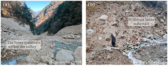
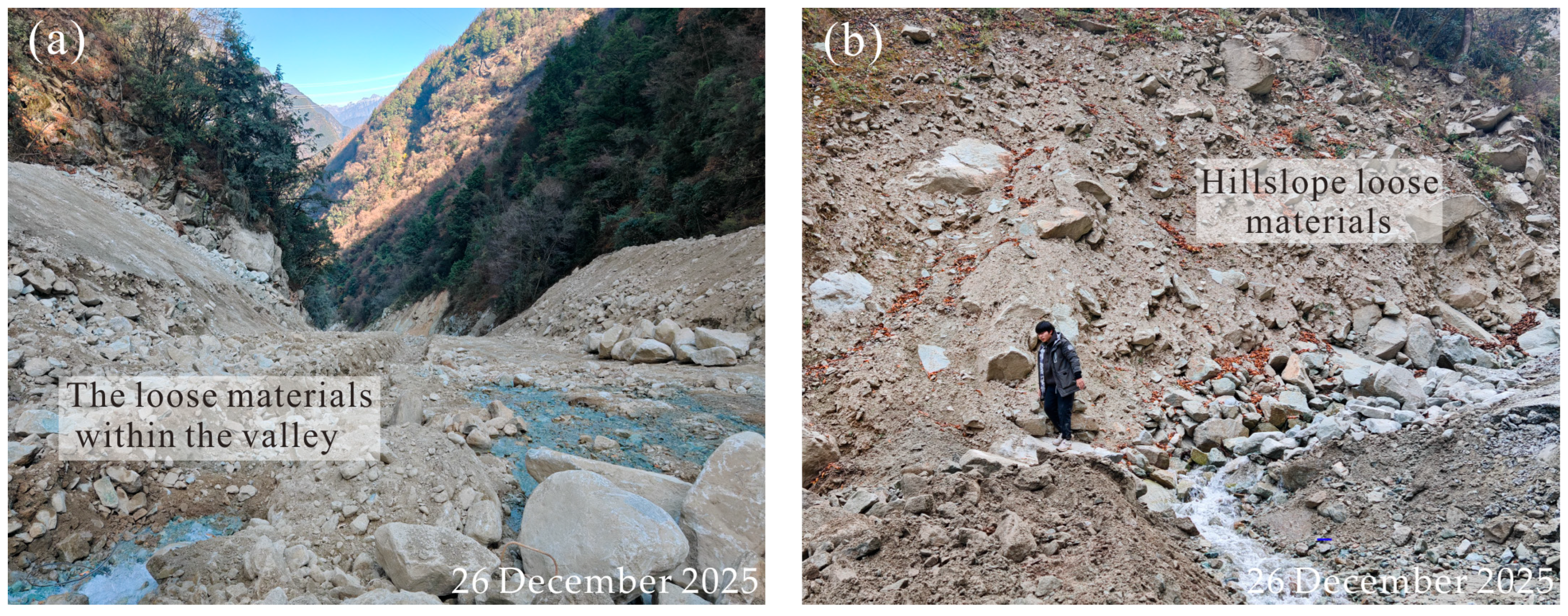
Owing to long-term tectonic activities in the region, Ridi Gully is characterized by highly fractured rock masses and widespread accumulations of loose materials on slopes and within channels. These deposits exhibit unfavorable mechanical characteristics, including low shear strength and weak structural stability, and can be readily destabilized and mobilized under intense rainfall (Figure 7). Previous analyses revealed that the primary sediment sources of the debris flow were concentrated in the right tributary channel, where large quantities of boulders, gravel, and loose colluvium were stored. During the extreme rainfall event, these highly erodible deposits were potentially mobilized by concentrated runoff, mixed with floodwater, and incorporated into a high-sediment-concentration flow. Therefore, the abundant and readily mobilized loose materials provided the essential supply for debris flow initiation and continued downstream development.
Figure 7.
Overview of debris flow material sources in the Ridi gully: (a) abundant loose material sources in the channel bed; (b) hillslope loose materials.
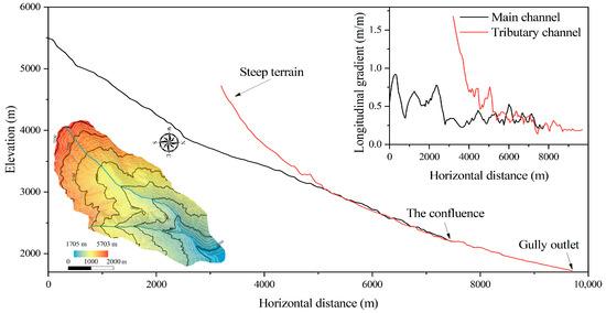
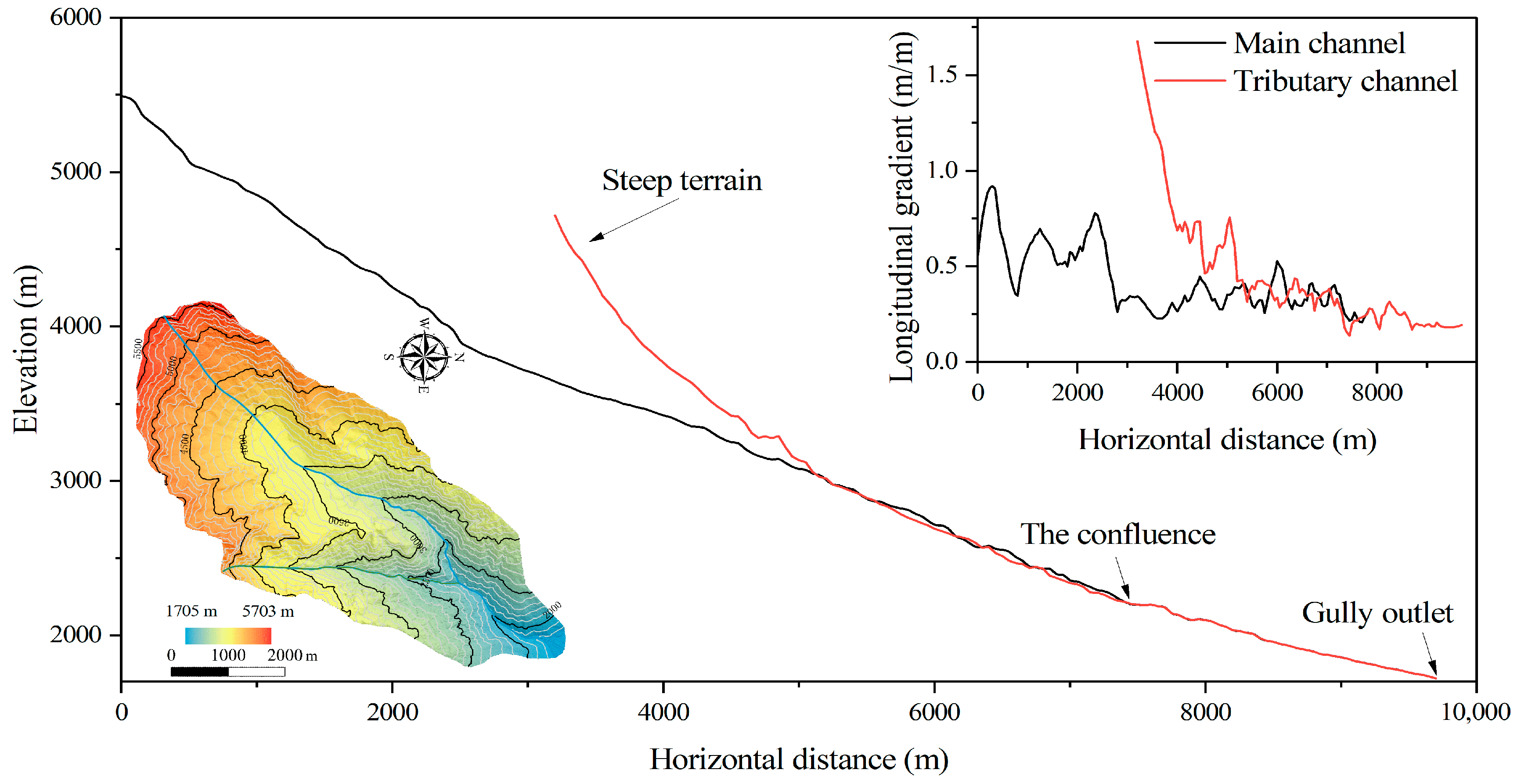
In addition to rainfall triggering and sediment availability, the steep alpine terrain of Ridi Gully constitutes a fundamental factor controlling debris flow acceleration and downstream amplification. The catchment exhibits a typical deeply incised mountain canyon morphology, characterized by substantial elevational relief, steep slopes, high channel gradients, and strong longitudinal variations in channel geometry, generally featuring steep upper reaches and gentler lower reaches. The gradients of both the main and right tributary channels increase considerably toward the upper reaches, reaching average values of 0.43 and 0.56, respectively, above their confluence (Figure 8). Furthermore, hillslopes over 500 m high with average inclinations of approximately 40° are widely developed on both sides of the gully. Such extreme geomorphic conditions not only accelerate surface runoff concentration but also provide sufficient gravitational potential energy for rapid slope failure and debris flow propagation. Meanwhile, localized steep slopes and abrupt topographic transitions further intensify flow acceleration and may enhance erosion of channel banks and adjacent unconsolidated deposits. Consequently, sediment entrainment and flow mobility may increase progressively along the transport pathway, contributing to the development of a highly destructive flow.
Figure 8.
The elevations and topographic changes in the main and tributary channels.
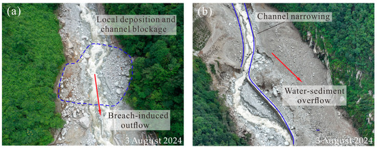
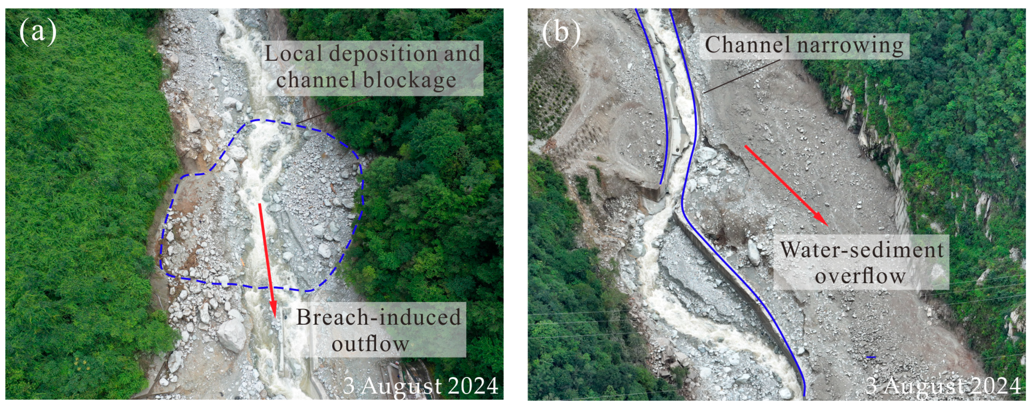
Meanwhile, channel morphology and engineering constraints further regulated debris flow dynamics and intensified localized disaster impacts. Both field investigations and numerical simulations revealed evident deposition and overflow traces in the middle reach of the channel at abrupt topographic transitions, indicating that geomorphic confinement promoted local sediment accumulation and flow concentration (Figure 9a). Although engineering structures, such as the drainage channel at the outlet of Ridi Gully, provided some flow guidance and mitigation benefits, the large sediment volume could still promote temporary accumulation at locally narrow sections when the debris flow magnitude exceeded the available conveyance capacity (Figure 9b). Under continued upstream supply, such confined sections may act as temporary storage zones, allowing sediments to accumulate before being remobilized downstream. The subsequent release of stored materials may generate renewed downstream surges and contribute to temporally non-uniform flow propagation. Although the present simulation does not explicitly define a failure criterion for blockage formation or breaching, the observed deposition and overflow features, together with the simulated temporal and spatial variations in flow velocity, support the potential role of transient blockage–breaching in downstream flow amplification. This process is therefore considered a potential mechanism contributing to the impulsive and highly non-steady behavior of the Ridi debris flow.
Figure 9.
Local blockage-breaching phenomena during the debris flow transport process: (a) local blockage-breaching occurring at the upper part of the expressway bridge piers due to topographic constraints; (b) local blockage-breaching occurring at the gully outlet due to engineering structure constraints.
4. Discussion of Mitigation Measures
4.1. Debris Flow Mitigation Measures and Their Benefit
Given the abundant water supply, steep terrain, and extensive sediment storage in Ridi Gully, a multi-level mitigation system comprising slit dams and rigid check dams was constructed at critical locations within the lower transport zone and the outlet deposition area following the disaster. These structures were designed to reduce the potential impacts of future debris flows on downstream communities and infrastructure.
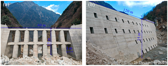
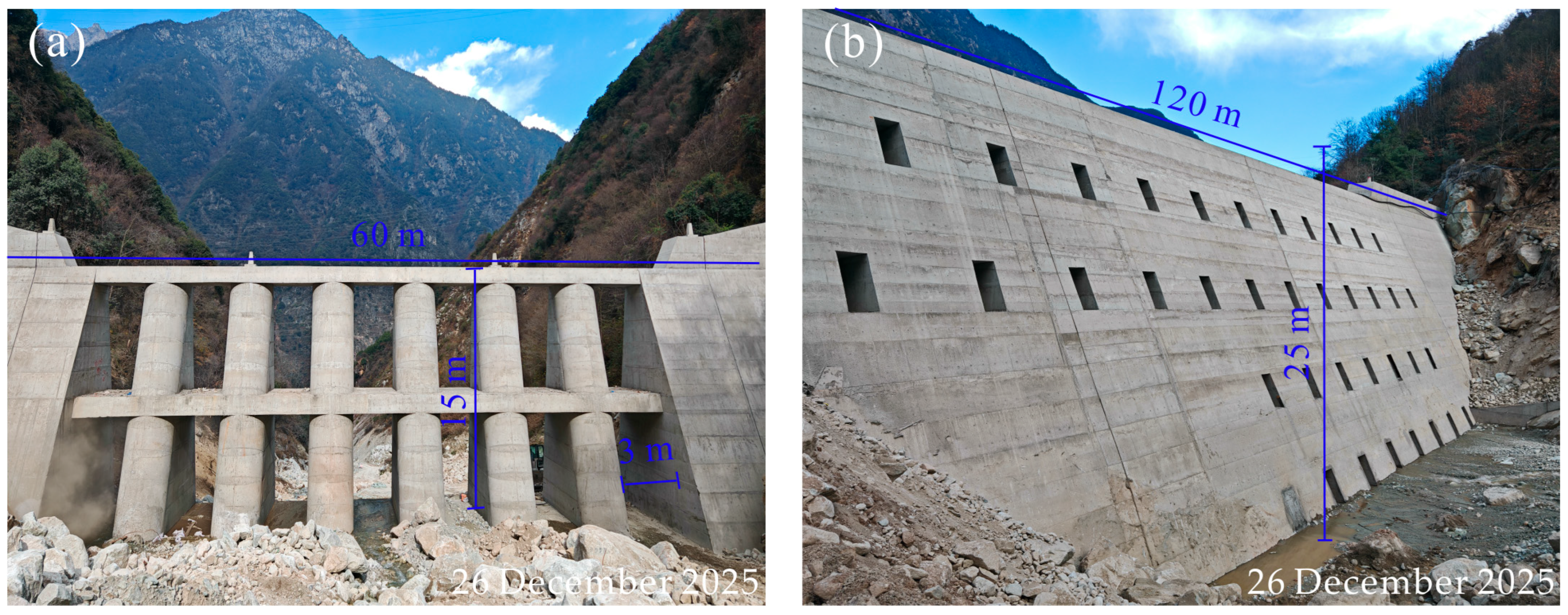
The slit dam was constructed approximately 1000 m upstream of the gully outlet, with a transverse width of about 60 m, a height of 15 m, and vertical slits spaced 3 m apart (Figure 10a). This structure primarily functions to filter and retain coarse particles while maintaining drainage capacity, thereby reducing sediment discharge and attenuating peak flow intensity. The rigid check dam was located approximately 400 m downstream of the slit dam, with a width of about 120 m and a height of 25 m. Drainage openings were provided to allow normal water release. As the final control structure within the downstream vulnerable area, this dam mainly serves to intercept transported sediments and limit the downstream spreading and deposition of debris flows.
Figure 10.
Overview of the retaining measures for post-disaster reconstruction in the Ridi gully (photographed on 26 December 2025): (a) slit dam; (b) rigid check dam.
However, for steep alpine gullies such as Ridi Gully, characterized by large elevational relief, abundant sediment supply, and highly energetic flow conditions, a single mitigation structure is generally insufficient to achieve both energy dissipation and downstream impact control [31,32]. Therefore, based on the previous EDEM model, three scenarios, including no protection, slit dam alone, and a combined slit dam-rigid check dam configuration, were simulated to compare the effects of different mitigation configurations on debris flow propagation, velocity response, and deposition characteristics.
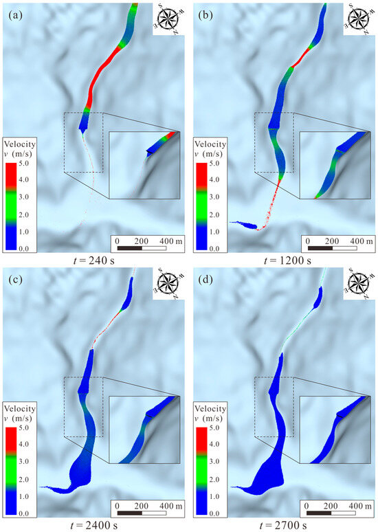
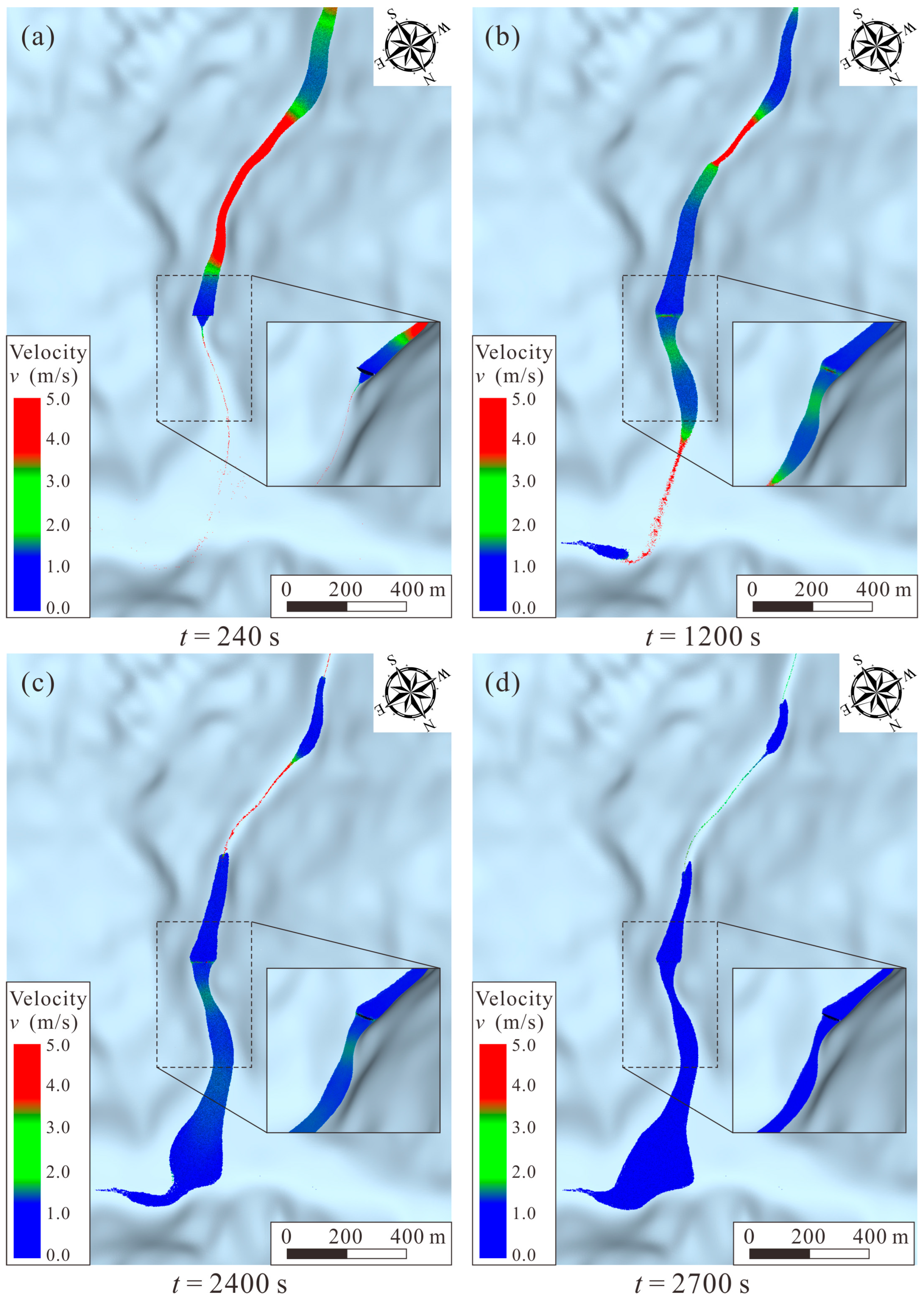
The simulation results show that the slit dam significantly modified the dynamic behavior of the debris flow during its downstream propagation. When the flow front reached the slit dam, most coarse particles were selectively retained and accumulated upstream of the structure, whereas finer particles and water continued to pass through the slits [33,34]. Owing to particle collisions, structural obstruction, and local energy dissipation, the flow velocity decreased rapidly, with local velocities falling below 2 m/s and temporary stagnation occurring (Figure 11a). With continuous sediment supply from upstream, the deposited materials accumulated and eventually overtopped the dam. Nevertheless, owing to the preceding interception and energy dissipation effects, the overtopping flow maintained a relatively low velocity and exhibited lower simulated flow intensity and sediment transport potential than those in the no-protection case [35]. Furthermore, the slit dam delayed the arrival of the flow front at the outlet fan, providing an extended time window for downstream evacuation and emergency response [36]. At approximately t = 2400 s, the depositional body was largely formed, and the flow front had gradually expanded laterally under continuous upstream supply (Figure 11c,d). These results suggest that the primary function of the slit dam is not the complete blockage of debris flows but the regulation of flow dynamics through coarse-particle retention, peak-flow attenuation, and local energy dissipation.
Figure 11.
The transport and deposition process of debris flow under the protection of a slit dam. (a) t = 240 s; (b) t = 1200 s; (c) t = 2400 s; (d) t = 2700 s.
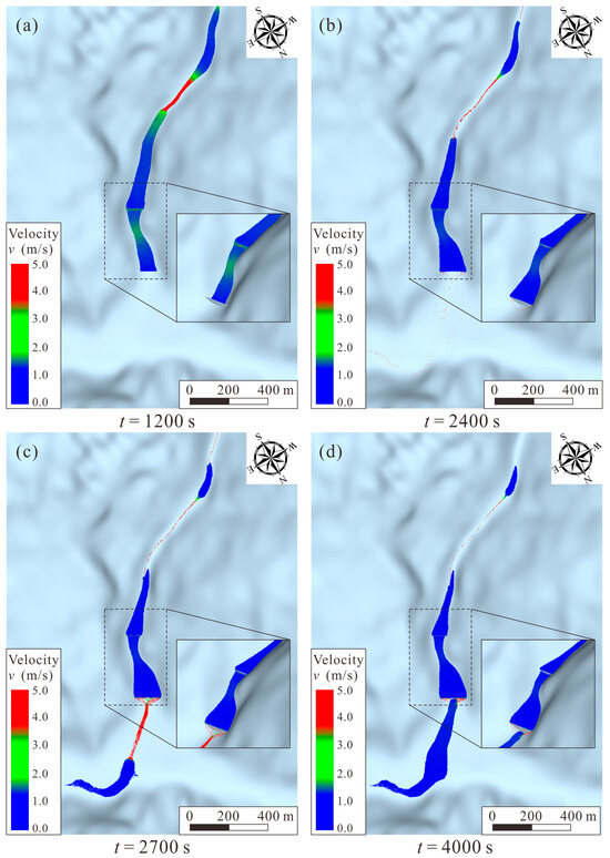
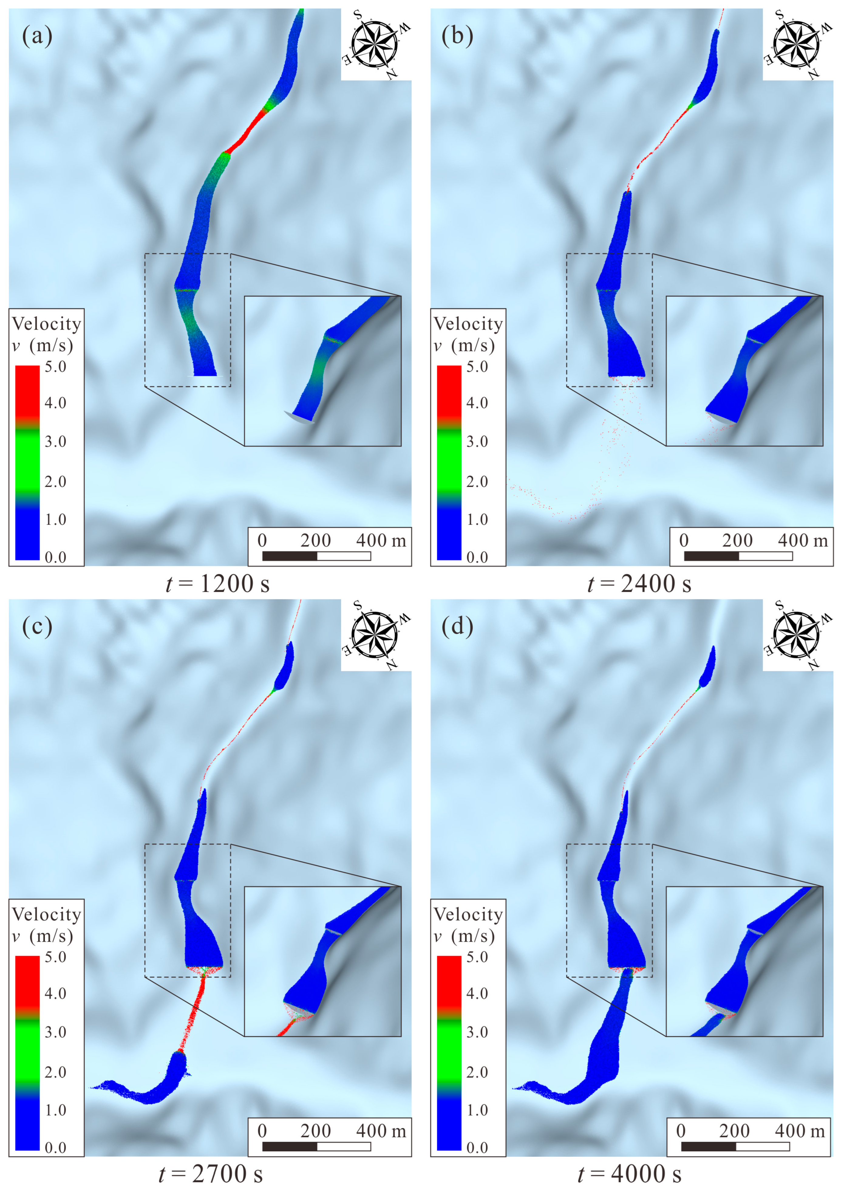
The combined slit dam-rigid check dam system exhibited more pronounced multi-stage regulation through sequential energy dissipation and sediment storage. The upstream slit dam first attenuated the initial flow momentum by retaining coarse particles, resulting in a lower-energy flow entering the downstream rigid check dam. Subsequently, the rigid dam further limited sediment transport and facilitated sediment accumulation and deposition upstream of the structure (Figure 12a). Although local overtopping occurred as the storage capacity was reached (approximately t = 2400 s), the released material exhibited lower simulated velocity and reduced sediment transport intensity than those observed in the no-protection and slit-dam-alone scenarios. Instead, the overtopping process was dominated by low-velocity, low-solid-concentration flow, resulting in reduced downstream sediment supply and flow intensity. By t = 4000 s, the debris flow had almost entirely deposited (Figure 12d). The combined mitigation system substantially reduced the amount of sediment entering the outlet fan and effectively limited deposition expansion, thereby reducing the potential extent of burial and impact on Ridi Village and surrounding transportation infrastructure.
Figure 12.
The transport and deposition process of debris flow under the protection of a slit dam and a rigid check dam. (a) t = 1200 s; (b) t = 2400 s; (c) t = 2700 s; (d) t = 4000 s.
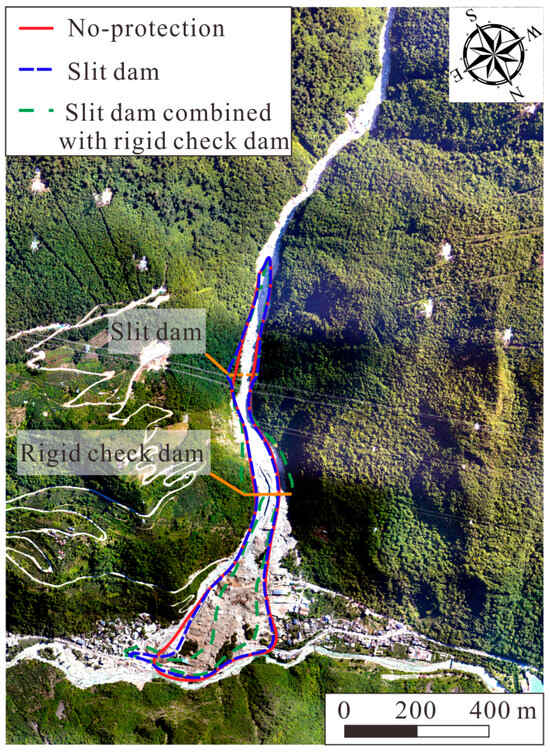
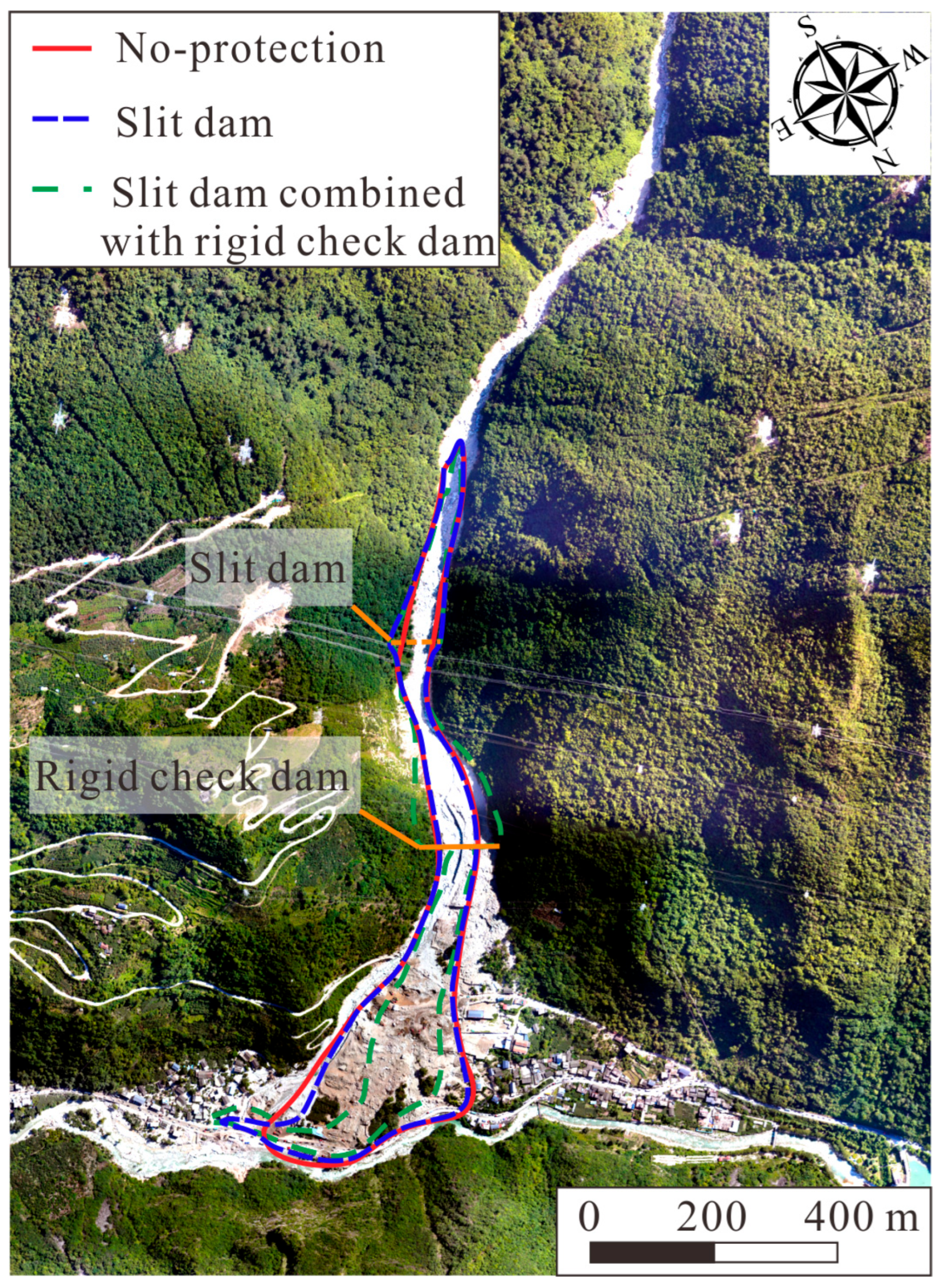
The depositional extent and quantitative indicators under different protection scenarios are presented in Figure 13 and Table 1. Without protection, the debris flow deposit spread extensively across the alluvial fan. The installation of the slit dam reduced the depositional extent to some degree; however, substantial downstream transport and deposition still occurred. Compared with the unprotected condition, the slit dam reduced the deposited sediment volume from 4.426 × 10⁵ m3 to 3.794 × 10⁵ m3 (a 14.29% reduction) and decreased the deposition area from 1.103 × 10⁵ m2 to 0.924 × 10⁵ m2 (a 16.23% reduction). These results indicate that the slit dam effectively attenuated flow dynamics and sediment transport, but had limited capability in controlling the final deposition scale. In contrast, the combined slit dam–rigid check dam system produced a larger reduction in both deposited sediment volume and deposition area. The deposited sediment volume declined to 1.525 × 10⁵ m3, representing a reduction of 65.54%, while the depositional area decreased to 0.607 × 10⁵ m2, corresponding to a reduction of 44.97%. Together, these results demonstrate the complementary regulating effects of multi-level and multi-type engineering structures. Specifically, the upstream slit dam mainly contributed to peak-flow attenuation and energy dissipation, whereas the downstream rigid check dam provided additional sediment storage and spatial containment of downstream deposition.
Figure 13.
The deposition extent under different protection scenarios.
Table 1.
Deposition volume and inundation area of debris flow under different protection conditions.
Therefore, for steep alpine debris flow channels such as Ridi Gully, where extreme rainfall, abundant sediment supply, and high channel gradients prevail simultaneously, different structural configurations may provide different levels of regulation for flow dynamics and downstream deposition. In the present case, the multi-level mitigation system integrating upstream coarse-material interception and downstream sediment retention showed stronger regulation of debris flow dynamics and depositional extent than that of the single slit-dam configuration. These results provide case-specific support for considering multi-stage structural arrangements in debris flow risk reduction in complex mountainous environments. It should be noted that the present comparison was based on the actual post-disaster engineering configuration of Ridi Gully and was intended to examine the relative regulating effects of different protection scenarios rather than to identify an optimal design. The effects of individual structural parameters, such as dam location, height, spacing, and opening characteristics, were not systematically investigated in this study. Further parametric and sensitivity analyses are therefore needed to evaluate how these design factors influence debris flow regulation and to support engineering optimization [37].
4.2. Implications for Disaster Prevention and Control
Natural debris flows are not governed by a single process but result from nonlinear interactions among hydrological forcings, sediment availability, topographic constraints, and boundary conditions. From a dynamic perspective, a debris flow generally involves three interconnected but fundamentally different stages: initiation, transport, and deposition. Each stage is characterized by different dominant processes and hazard modes, and therefore requires stage-specific mitigation measures [38].
During the initiation stage, external triggers such as intense rainfall, glacier meltwater, or seismic disturbances can alter the stability of loose slope materials and channel deposits. The generation of debris flows is primarily controlled by the availability of water and erodible sediment. Once initiated, the debris flow enters the transport stage, where gravitational acceleration and channel confinement drive rapid movement with high velocity, strong impact energy, and intense erosive capability. During this stage, the flow continuously entrains bed sediments, erodes channel banks, and incorporates additional materials, resulting in progressive changes in flow volume, mobility, and destructive potential [39]. Meanwhile, complex processes, including particle segregation, flow regime transition, and local blockage-breaching, may occur, further enhancing the spatial and temporal variability of debris flow propagation [40,41]. In the deposition stage, decreasing channel gradients and reduced lateral confinement lead to rapid energy dissipation, flow spreading, channel avulsion, and sediment accumulation. Consequently, the dominant hazard mode gradually shifts from high-energy impact damage to burial, inundation, and overflow. The Ridi debris flow demonstrates that these stages are not simply connected linearly but involve complex transitions and potential downstream amplification under specific geomorphic and engineering interventions [27]. For example, local channel constrictions and structural obstacles during transport may induce temporary blockage, while sudden breaching of accumulated materials can produce short-duration increases in downstream flow velocity and impact intensity. Therefore, mitigation measures based only on individual structures or localized reinforcements may not adequately address the different controlling mechanisms and hazard modes throughout the debris flow process.
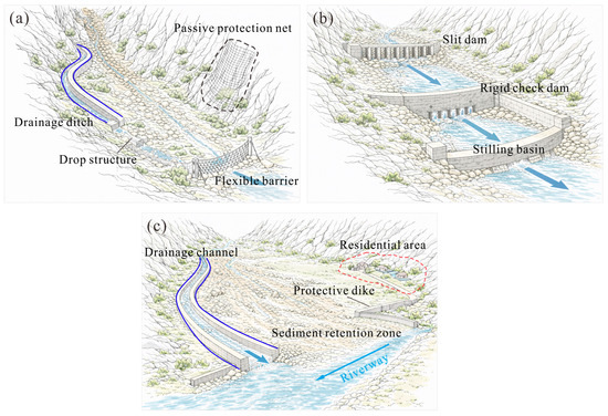
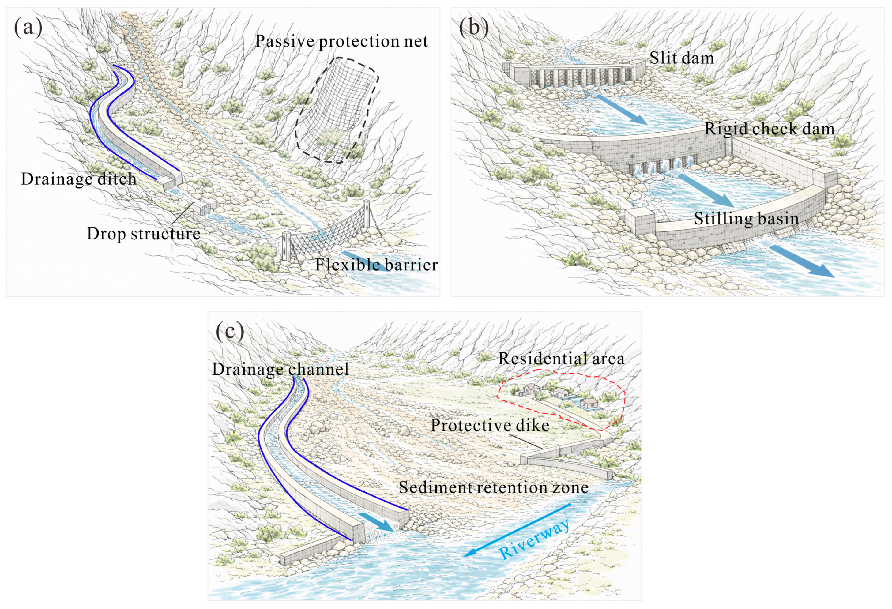
Based on the stage-dependent evolution characteristics of debris flows, future mitigation strategies for alpine canyon regions should extend beyond localized structural intervention toward integrated regulation across the entire hazard chain. In general, the mitigation of debris flows should follow the principle of “reducing sediment availability in initiation zones, regulating flow energy and sediment transport in transport zones, and providing flow conveyance and spatial protection in deposition zones.” Such a hierarchical strategy aims to interrupt key amplification processes at different stages and reduce their downstream propagation.
Specifically, source zones serve as the primary sediment supply for debris flow initiation and are highly susceptible to triggering factors such as rainfall and glacial meltwater. Consequently, mitigation strategies in these areas should focus on reducing sediment availability and enhancing slope stability rather than attempting to eliminate natural sediment sources completely (Figure 14a). For hydrologically triggered debris flows, interception and drainage systems along slopes can effectively regulate surface runoff pathways, reduce rainfall infiltration, and diminish hydraulic erosion of unstable deposits [42]. On steep, fractured, or highly weathered slopes, countermeasures such as ecological restoration, surface reinforcement, and anchoring systems can enhance shallow stability and mitigate progressive erosion, as well as small-scale slope failures. Additionally, flexible barriers deployed near landslide outlets or channel entrances can intercept large boulders, woody debris, and other coarse-grained materials, thereby reducing the amount of coarse material available for downstream transport and potential flow amplification [43].
Figure 14.
Mitigation strategies for debris flows in alpine canyon regions based on the stage-dependent evolution characteristics: (a) initiation zone; (b) transport zone; (c) deposition zone.
Transport zones in alpine valleys are typically characterized by steep gradients, narrow channels, and highly concentrated flow energy. Therefore, the objective of mitigation in these areas should not be complete blockage of debris flows, but the regulation of flow energy, reduction in sediment transport, and progressive attenuation of flow intensity (Figure 14b). The simulation results presented herein demonstrate that permeable retaining structures can effectively modify debris flow dynamics through selective retention of coarse particles, promotion of local deposition, and velocity reduction. Consequently, slit dams or other permeable barriers can be strategically deployed in the upstream transport zone to retain coarse particles while allowing water and finer materials to pass through, thereby promoting energy dissipation [44,45]. In the downstream reaches, rigid check dams can further create depositional storage zones, reduce the effective channel gradient, and enhance energy dissipation. In addition, downstream protective structures, such as energy dissipation facilities and bank protection systems, should be incorporated to mitigate local scour and structural damage. It is also worth noting that the interaction between rapidly moving flows and protective structures may involve complex erosion and damage processes. Under high-velocity hydraulic conditions, hydrodynamic cavitation erosion may also occur and contribute to structural deterioration, as reported in previous studies [46]. Such potential flow–structure interactions should therefore be considered in the design and durability assessment of debris flow mitigation structures.
Deposition zones, commonly located at gully outlets and alluvial fans, constitute the primary areas directly exposed to debris flow impacts on settlements, transportation corridors, and infrastructure. Although debris flow velocity generally decreases in these areas, the widespread deposition of sediments often causes extensive damage. Therefore, mitigation strategies should focus on controlled discharge and spatial management rather than merely on resisting flow impact forces (Figure 14c). Compared with passive defense relying solely on rigid retaining walls, an integrated approach combining flow guidance with designated deposition space management can provide a more systematic means of controlling downstream spreading [47]. Drainage channels and diversion structures can guide debris flows toward designated discharge areas and curb uncontrolled overflow and lateral spreading. Meanwhile, designated sediment deposition zones offer controlled space for unavoidable sediment accumulation [48,49]. Protective embankments or retaining walls may be installed around critical infrastructure and residential areas to confine local overflow and erosion; however, these structures should serve as supplemental protection rather than the sole or primary mitigation measure.
Overall, the mitigation of debris flow in alpine canyon regions should transition from single-structure protection to comprehensive hazard-chain regulation. The Ridi debris flow demonstrates that effective debris flow risk reduction depends not only on improving the resisting capacity of individual structures but also on developing multi-scale and multi-functional systems tailored to various stages of debris flow evolution. By reducing sediment supply in source areas, regulating flow dynamics in transport zones, and controlling depositional expansion in downstream areas, integrated mitigation strategies can provide more comprehensive regulation of debris flow hazards across different stages of the disaster process and offer valuable guidance for risk reduction in complex mountainous environments. Although the present study focuses on the “8·03” debris flow in Ridi Gully, the identified downstream flow amplification associated with channel blockage–breaching and the complementary functions of staged mitigation structures provide a case-specific reference for understanding and managing high-mountain flow hazards. These implications may also be relevant to other alpine environments where rapid slope failure, abundant sediment supply, channel confinement, and temporary blockage interact, although their application to glacier-related rock–ice avalanche and flood events requires consideration of their distinct source conditions and hydrological processes.
5. Conclusions
This study investigated the “8·03” debris flow in Ridi Gully, on the eastern margin of the Qinghai–Tibet Plateau, by combining field surveys, hydro-meteorological analysis, numerical simulations, and mitigation performance evaluations. The available field and hydro-meteorological evidence indicates that intense localized rainfall, abundant unconsolidated sediment, and steep channel gradients jointly contributed to the occurrence and downstream development of the event. During downstream propagation, local deposition and overflow at confined channel sections, together with the simulated spatial and temporal variations in flow velocity, suggest that temporary sediment storage and subsequent remobilization may have contributed to non-steady flow propagation and potential downstream hazard amplification. However, the detailed critical conditions and failure dynamics of blockage–breaching were not explicitly resolved in the present model.
The mitigation simulations showed clear differences among the tested configurations. Compared with the no-protection scenario, the single slit-dam configuration reduced the simulated deposition volume and area by 14.29% and 16.23%, respectively. The combined slit-dam/rigid-check-dam configuration produced greater reductions of 65.54% and 44.97%, respectively. These results indicate that the upstream slit dam mainly contributed to coarse-particle interception and flow-intensity attenuation, while the downstream rigid check dam provided additional sediment storage and downstream containment under the tested conditions.
The comparison of the three tested scenarios provides case-specific evidence that different structural configurations can exert different effects on debris flow intensity and downstream deposition. The present results therefore support consideration of staged and combined structural measures in similar alpine debris flow settings, particularly where coarse-material interception and downstream sediment retention are required. However, the present analysis was based on the actual post-disaster engineering configuration of Ridi Gully. The engineering implications should therefore be interpreted as case-specific rather than as a general optimization rule, and further parametric analyses and independent dynamic observations are needed to assess the broader applicability of the findings.
Author Contributions
Conceptualization, C.L. and D.L.; methodology, C.L.; software, C.L.; validation, S.S., Y.Q. and J.Z.; formal analysis, S.S.; investigation, Z.F. and G.F.; resources, J.Z.; data curation, Z.F.; writing—original draft preparation, C.L.; writing—review and editing, C.L.; visualization, D.L.; supervision, S.S.; project administration, S.S.; funding acquisition, J.Z. All authors have read and agreed to the published version of the manuscript.
Funding
This research was funded by the National Key R&D Program of China (2025YFF0520004), the Sichuan Science and Technology Program (2026JDKP0037), and the National Science Foundation for Young Scientists of China (42601166).
Institutional Review Board Statement
Not applicable.
Informed Consent Statement
Not applicable.
Data Availability Statement
The field survey data and numerical simulation results are available from the corresponding author on reasonable request. UAV and satellite imagery were provided by third parties (as acknowledged) and are subject to their permissions.
Acknowledgments
The authors are grateful to Qiang Chen from Sichuan Provincial Highway Planning, Survey, Design and Research Institute Co., Ltd. for providing the UAV and remote-sensing datasets, which offered essential data support for this study. The debris flow numerical simulations in this work were carried out using the EDEM 2024 software.
Conflicts of Interest
Authors Congjiang Li, Yang Qin and Shihan Shan were employed by the company PowerChina Chengdu Engineering Corporation Limited. The remaining authors declare that the research was conducted in the absence of any commercial or financial relationships that could be construed as a potential conflict of interest.
References
- Iverson, R.M. The Physics of Debris Flows. Rev. Geophys. 1997, 35, 245–296. [Google Scholar] [CrossRef] [Scilit]
- McArdell, B.W.; Bartelt, P.; Kowalski, J. Field Observations of Basal Forces and Fluid Pore Pressure in a Debris Flow. Geophys. Res. Lett. 2007, 34, 2006GL029183. [Google Scholar] [CrossRef] [Scilit]
- Liu, J.; You, Y.; Chen, X.; Chen, X. Mitigation Planning Based on the Prediction of River Blocking by a Typical Large-Scale Debris Flow in the Wenchuan Earthquake Area. Landslides 2016, 13, 1231–1242. [Google Scholar] [CrossRef] [Scilit]
- Wetter, C.; Walter, F.; McArdell, B.W.; Blumenschein, F.; Spielmann, R.; Aaron, J.; Gray, J.M.N.T.; Obermann, A.; Fichtner, A. Formation, Propagation, and Annihilation of Surge Waves in Debris Flows. Eng. Geol. 2026, 367, 108648. [Google Scholar] [CrossRef] [Scilit]
- Wang, J.; Wang, H.; Jiang, Y.; Zhang, G.; Zhao, B.; Lei, Y. Geomorphic Controls on Debris Flow Activity in the Paraglacial Zone of the Southeast Tibetan Plateau. Nat. Hazards 2023, 117, 917–937. [Google Scholar] [CrossRef] [Scilit]
- Zhang, H.; Xu, M. The 2026 Nepal–China Disaster Exposes Missing Links in Mountain Early Warning. Intell. Clim. Eco-Environ. 2026, 1, 100017. [Google Scholar] [CrossRef] [Scilit]
- Ni, H.Y.; Zheng, W.M.; Tie, Y.B.; Su, P.C.; Tang, Y.Q.; Xu, R.G.; Wang, D.W.; Chen, X.Y. Formation and Characteristics of Post-Earthquake Debris Flow: A Case Study from Wenjia Gully in Mianzhu, Sichuan, SW China. Nat. Hazards 2012, 61, 317–335. [Google Scholar] [CrossRef] [Scilit]
- Ouyang, C.; Wang, Z.; An, H.; Liu, X.; Wang, D. An Example of a Hazard and Risk Assessment for Debris Flows—A Case Study of Niwan Gully, Wudu, China. Eng. Geol. 2019, 263, 105351. [Google Scholar] [CrossRef] [Scilit]
- Wang, Y.; Nie, L.; Liu, C.; Zhang, M.; Xu, Y.; Teng, Y.; Bao, C.; He, Y.; Kong, F.; Rui, X.; et al. Rainfall Warning Model for Rainfall-Triggered Channelized Debris Flow Based on Physical Model Test—A Case Study of Laomao Mountain Debris Flow in Dalian City. Water 2021, 13, 1083. [Google Scholar] [CrossRef] [Scilit]
- Yu, B.; Ma, Y.; Wu, Y. Case Study of a Giant Debris Flow in the Wenjia Gully, Sichuan Province, China. Nat. Hazards 2013, 65, 835–849. [Google Scholar] [CrossRef] [Scilit]
- Liu, F.Z.; Xu, Q.; Dong, X.J.; Yu, B.; Frost, J.D.; Li, H.J. Design and Performance of a Novel Multi-Function Debris Flow Mitigation System in Wenjia Gully, Sichuan. Landslides 2017, 14, 2089–2104. [Google Scholar] [CrossRef] [Scilit]
- Zhou, Y.; He, K.; Hu, X.; Gong, X. Early Post-fire Debris-flow Initiation Following the March 2024 Yajiang Fire, Sichuan, China. Earth Surf. Process. Landf. 2026, 51, e70380. [Google Scholar] [CrossRef] [Scilit]
- Baggio, T.; Martini, M.; Bettella, F.; D’Agostino, V. Debris Flow and Debris Flood Hazard Assessment in Mountain Catchments. CATENA 2024, 245, 108338. [Google Scholar] [CrossRef] [Scilit]
- Simoni, A.; Bernard, M.; Berti, M.; Boreggio, M.; Lanzoni, S.; Stancanelli, L.M.; Gregoretti, C. Runoff-generated Debris Flows: Observation of Initiation Conditions and Erosion–Deposition Dynamics along the Channel at Cancia (Eastern Italian Alps). Earth Surf. Process. Landf. 2020, 45, 3556–3571. [Google Scholar] [CrossRef] [Scilit]
- Zhan, J.; Yao, Z.; Shen, Y.; Huang, D.; Yu, Z.; Peng, J. Sediment Transport Evolution and Impact on Vegetation Recovery in the Hanping Village Landslide–Debris Flow Disaster Chain in Shaanxi, China. Ecol. Eng. 2025, 219, 107718. [Google Scholar] [CrossRef] [Scilit]
- Qiao, Z.; Li, T.; Simoni, A.; Gregoretti, C.; Bernard, M.; Wu, S.; Shen, W.; Berti, M. Numerical Modelling of an Alpine Debris Flow by Considering Bed Entrainment. Front. Earth Sci. 2023, 10, 1059525. [Google Scholar] [CrossRef] [Scilit]
- Cui, H.; He, Q.; Liang, W.; Li, Y.; Xie, Q. Dynamics Assessment of the Landslide–Debris Flow Hazard Chain Based on Post-Disaster Geomorphological and Depositional Evidence: A Case Study from Xujiahe, Sichuan, China. Quaternary 2026, 9, 21. [Google Scholar] [CrossRef] [Scilit]
- Hou, W.; Yu, G. Debris-flow Fan Development and Geomorphic Effects in Alpine Canyons under a Changing Climate. Earth Surf. Process. Landf. 2023, 48, 3330–3346. [Google Scholar] [CrossRef] [Scilit]
- Yu, F.; Su, L.; Li, X.; Zhao, Y. Impact Dynamics of Granular Flow on Rigid Barriers: Insights from Numerical Investigation Using Material Point Method. J. Mt. Sci. 2024, 21, 4083–4111. [Google Scholar] [CrossRef] [Scilit]
- Luo, H.; Zhang, L.; He, J.; Zhou, J. Performance of Debris Flow Barriers: An Energy Perspective. Acta Geotech. 2025, 20, 987–1000. [Google Scholar] [CrossRef] [Scilit]
- Kong, Y.; Guan, M. Hydro-Mechanical Simulations Aid Demand-Oriented Design of Slit Dams for Controlling Debris Flows, Debris Avalanches and Rock Avalanches. Eng. Geol. 2023, 326, 107314. [Google Scholar] [CrossRef] [Scilit]
- Shang, Y.; Liu, J.; Sun, H.; Wang, D.; Zhang, W.; Yang, H. Regulation Mechanisms of Woody Debris Flows by Slit Check Dams. Landslides 2026. Online First. [Google Scholar] [CrossRef] [Scilit]
- Fang, J.; Cui, Y.; Liu, H.; Zhang, L.; Zhou, G.G.D.; Fan, H. Influences of Deposition Upslope the Barrier on the Dynamic Impact of Dry Granular Flow. Eng. Geol. 2023, 323, 107212. [Google Scholar] [CrossRef] [Scilit]
- Ng, C.W.W.; Leonardi, A.; Majeed, U.; Pirulli, M.; Choi, C. A Physical and Numerical Investigation of Flow-Barrier Interaction for the Design of a Multiple-Barrier System. J. Geotech. Geoenviron. Eng. 2023, 149, 04022122. [Google Scholar] [CrossRef] [Scilit]
- Wang, X.; Chen, J.; Bao, H.; Yan, C.; Li, X.; Wang, C.; Wang, J. Evolution of Sediment-Trapping Effectiveness of Check Dams under Multiple Debris Flows: An Experimental Study. Geomat. Nat. Hazards Risk 2026, 17, 2699014. [Google Scholar] [CrossRef] [Scilit]
- Zou, Q.; Zhou, G.G.D.; Li, S.; Ouyang, C.; Tang, J. Dynamic Process Analysis and Hazard Prediction of Debris Flow in Eastern Qinghai-Tibet Plateau Area—A Case Study at Ridi Gully. Arct. Antarct. Alp. Res. 2017, 49, 373–390. [Google Scholar] [CrossRef] [Scilit]
- Cheng, Q.; Liu, T.; Lei, H.; Zhang, H.; Yang, X.; Guo, C. Investigation of a Shallow High-Locality Landslide-Induced Debris Flow in an Alpine Valley: A Case Study of the Ridi Debris Flow, Kangding, Sichuan Province, China (August 3, 2024). Landslides 2025, 22, 3065–3079. [Google Scholar] [CrossRef] [Scilit]
- Hærvig, J.; Kleinhans, U.; Wieland, C.; Spliethoff, H.; Jensen, A.L.; Sørensen, K.; Condra, T.J. On the Adhesive JKR Contact and Rolling Models for Reduced Particle Stiffness Discrete Element Simulations. Powder Technol. 2017, 319, 472–482. [Google Scholar] [CrossRef] [Scilit]
- Huynh, T.Q.; Nguyen, T.T.; Indraratna, B.; Doan, T. Influence of Different Cohesive Contact Models on Micro-to-Macro Response of Geomaterials: A DEM Investigation. Int. J. Numer. Anal. Methods Geomech. 2025, 49, 3944–3969. [Google Scholar] [CrossRef] [Scilit]
- Peng, D.; Zhang, L.; Jiang, R.; Zhang, S.; Shen, P.; Lu, W.; He, X. Initiation Mechanisms and Dynamics of a Debris Flow Originated from Debris-Ice Mixture Slope Failure in Southeast Tibet, China. Eng. Geol. 2022, 307, 106783. [Google Scholar] [CrossRef] [Scilit]
- Gan, B.; Liu, X.; Yang, X.; Wang, X.; Zhou, J. The Impact of Human Activities on the Occurrence of Mountain Flood Hazards: Lessons from the 17 August 2015 Flash Flood/Debris Flow Event in Xuyong County, South-Western China. Geomat. Nat. Hazards Risk 2018, 9, 816–840. [Google Scholar] [CrossRef] [Scilit]
- Li, Y.; Hu, W.; Wasowski, J.; Zheng, Y.; McSaveney, M. Rapid Episodic Erosion of a Cohesionless Landslide Dam: Insights from Loss to Scour of Yangjia Gully Check Dams and from Flume Experiments. Eng. Geol. 2021, 280, 105971. [Google Scholar] [CrossRef] [Scilit]
- Zhou, G.G.D.; Hu, H.S.; Song, D.; Zhao, T.; Chen, X.Q. Experimental Study on the Regulation Function of Slit Dam against Debris Flows. Landslides 2019, 16, 75–90. [Google Scholar] [CrossRef] [Scilit]
- Vagnon, F. Design of Active Debris Flow Mitigation Measures: A Comprehensive Analysis of Existing Impact Models. Landslides 2020, 17, 313–333. [Google Scholar] [CrossRef] [Scilit]
- Fang, J.; Wang, L.; Hong, Y.; Zhao, J. Influence of Solid–Fluid Interaction on Impact Dynamics against Rigid Barrier: CFD–DEM Modelling. Géotechnique 2022, 72, 391–406. [Google Scholar] [CrossRef] [Scilit]
- Huang, T.; Ding, M.; Gao, Z.; Téllez, R.D. Check Dam Storage Capacity Calculation Based on High-Resolution Topogrammetry: Case Study of the Cutou Gully, Wenchuan County, China. Sci. Total Environ. 2021, 790, 148083. [Google Scholar] [CrossRef] [Scilit] [PubMed]
- Mohammadizadeh, S.; Dalfré Filho, J.G.; Sampaio Descovi, C.; Genovez, A.I.B.; Teixeira Buttignol, T.E. Experimental Analysis of Cavitation Erosion: Parameter Sensitivity and Testing Protocols. Coatings 2024, 14, 1288. [Google Scholar] [CrossRef] [Scilit]
- Cui, P.; Guo, X.; Yan, Y.; Li, Y.; Ge, Y. Real-Time Observation of an Active Debris Flow Watershed in the Wenchuan Earthquake Area. Geomorphology 2018, 321, 153–166. [Google Scholar] [CrossRef] [Scilit]
- Li, P.; Hu, K.; Zhao, J. Energy Dissipation of Debris Flows over Stepped Gradients and Erodible Beds in Open Channel. J. Hydraul. Eng. 2020, 146, 06020008. [Google Scholar] [CrossRef] [Scilit]
- Chen, Q.; Song, D.; Chen, X.; Zhong, W. Visco-Collisional Scaling Law of Flow Resistance and Its Application in Debris-Flow Mobility. J. Geophys. Res. Earth Surf. 2023, 128, e2022JF006712. [Google Scholar] [CrossRef] [Scilit]
- Bilal, M.; Kumar, R. Physical Modelling to Map the Rheological and Morphological Dynamics along with Entrainment Mechanics of Debris Flow: A Comprehensive Review of the State of the Art. Geoenviron. Disasters 2025, 12, 45. [Google Scholar] [CrossRef] [Scilit]
- Li, S.; Chen, X.; Chen, J.; Tang, H.; You, Y.; Chen, H.; Zhao, W.; Geng, X. Small-Scale Flume Investigation of the Performance of Step-Baffle Drainage Channels in Mitigating Debris Flows. Front. Earth Sci. 2022, 10, 921716. [Google Scholar] [CrossRef] [Scilit]
- Luo, L.-R.; Yu, Z.-X.; Yang, X.-Y.; Guo, Q. A Coupled ICFD-DEM-FEM Approach for Modeling of Debris Flow Impacts on Flexible Barriers. Acta Geotech. 2026. Online First. [Google Scholar] [CrossRef] [Scilit]
- Li, S.; Wang, J.; Wang, F.; Li, P. Experimental Study on a Debris Flow Water-Sediment Separation Structure of a Funnel-Type Grating and Its Sorting Characteristics. Bull. Eng. Geol. Environ. 2023, 82, 148. [Google Scholar] [CrossRef] [Scilit]
- Choi, C.E.; Liang, Z. Segmentation and Deep Learning to Digitalize the Kinematics of Flow-Type Landslides. Acta Geotech. 2024, 19, 6337–6356. [Google Scholar] [CrossRef] [Scilit]
- Mohammadizadeh, S.; Dalfre Filho, J.G.; Teixeira Buttignol, T.E. Hydrodynamic Cavitation Erosion Resistance of UHPC and UHPFRC Assessed Using a Cavitation-Jet Apparatus: A Case Study. Case Stud. Constr. Mater. 2026, 25, e06396. [Google Scholar] [CrossRef] [Scilit]
- Gao, X.; Li, L.; Pan, L.; Yang, X.; Zhou, H.; Liu, J.; Wang, M.; Rao, P. Experimental Study on Diversion Dike to Mitigate Debris Flow Blocking River Disaster. Water 2025, 17, 1736. [Google Scholar] [CrossRef] [Scilit]
- Bernard, M.; Barbini, M.; Boreggio, M.; Biasuzzi, K.; Gregoretti, C. Deposition Areas: An Effective Solution for the Reduction of the Sediment Volume Transported by Stony Debris Flows on the High-sloping Reach of Channels Incising Fans and Debris Cones. Earth Surf. Process. Landf. 2024, 49, 664–683. [Google Scholar] [CrossRef] [Scilit]
- Boreggio, M.; Barbini, M.; Bernard, M.; Degetto, M.; Gregoretti, C. Proposed Solution for Stony Debris-Flow Control Works in Two Headwater Basins with Morphological Changes. GeoHazards 2024, 5, 1346–1369. [Google Scholar] [CrossRef] [Scilit]

Disclaimer/Publisher’s Note: The statements, opinions and data contained in all publications are solely those of the individual author(s) and contributor(s) and not of MDPI and/or the editor(s). MDPI and/or the editor(s) disclaim responsibility for any injury to people or property resulting from any ideas, methods, instructions or products referred to in the content. |
© 2026 by the authors. Licensee MDPI, Basel, Switzerland. This article is an open access article distributed under the terms and conditions of the Creative Commons Attribution (CC BY) license.