


Abstract
This study examines the evolutionary characteristics and potential influencing factors of production–living–ecological spaces (PLES) in resource-exhausted cities, using Zaozhuang City in Shandong Province—the first coal-based resource-exhausted city in eastern China—as a case study. A territorial spatial transition matrix, dynamic degree model, Geo-information Tupu, chord diagram visualization, and Pearson correlation analysis were integrated to examine PLES evolution from 2000 to 2020. The results show the following: (1) Spatial conversions were relatively frequent during 2000–2010 but slowed markedly after 2010, indicating clear stage-specific characteristics. (2) Urban living space, rural living space, and industrial and mining production space continued to expand, while water ecological space increased with fluctuations. In contrast, agricultural production space and terrestrial ecological space continued to decline. Urban living space expanded mainly around the built-up areas of Shizhong District, Xuecheng District, and Tengzhou City and around major industrial parks, while conversions between rural living space and agricultural production space were particularly frequent. (3) PLES changes showed varying degrees of association with resource endowment, economic and industrial development, population and transport, and planning and policy, with differentiated responses among spatial types. Zaozhuang’s designation as a resource-exhausted city in 2009 occurred shortly before spatial evolution became more stable after 2010, providing important contextual evidence for understanding this stage transition. Overall, PLES evolution shifted from outward expansion under resource development toward spatial stabilization and stock-based restructuring during the resource-exhausted stage. These findings provide empirical insights for resource-exhausted cities with similar coal-dependent development trajectories and transformation contexts.
1. Introduction
Since the 1950s, resource depletion and urban shrinkage have become increasingly evident in resource-based towns and cities across Europe and North America. Research in this field has therefore focused primarily on urban spatial transformation under conditions of population decline, housing vacancy, ecological degradation, urban decay, and cultivated land contamination [1,2]. Existing studies have emphasized the regeneration of declining urban spaces through the reuse of abandoned mining sites, brownfield redevelopment, and ecological restoration [2]. More recently, increasing attention has been paid to the transformation of underutilized spaces, particularly brownfields, into green infrastructure in cities of the Global South [3].
In China, resource-based cities are generally defined as cities whose core functions are the production and export of resource products. There are currently 262 resource-based cities in China, of which 69 are classified as resource-exhausted cities (RECs) [4,5]. For a long time, the development model of resource-based cities has been heavily dependent on energy- and resource-intensive industries. This path-dependent model has generated a series of severe territorial spatial problems, including progressive resource depletion, degradation of ecological space, large-scale contraction of production space, and disorderly expansion of living space [6,7,8,9]. In response, China has introduced a series of policies related to the sustainable development of resource-based cities, the comprehensive transformation of RECs, the high-quality development of resource-based regions, and the integrated governance of coal-mining subsidence areas and independent industrial and mining districts. These policies aim to guide the comprehensive transformation and sustainable development of resource-based cities.
A review of the global development history of RECs shows that territorial spatial evolution refers, in essence, to the processes through which production, living, and ecological spaces are transformed and reorganized as resources move from abundance to exhaustion under the combined influence of complex urban self-organizing forces and external interventions [10,11]. As China enters a new stage of urban development oriented toward improving the quality and efficiency of existing built-up spaces, clarifying the spatiotemporal characteristics and influencing factors of territorial spatial evolution in RECs has become a critical issue for their sustainable transformation. Guiding high-quality territorial spatial development in RECs is therefore particularly important for advancing modern people-centered urban development in China.
As an interdisciplinary and integrative research field, the evolution of production–living–ecological spaces (PLES) has attracted increasing scholarly attention. International studies have continued to expand. Existing evidence shows that, since the beginning of the 21st century, living space has continued to expand across Europe, Africa, and Asia, while mutual conversions between agricultural production space and ecological space have been particularly pronounced in Europe and Africa. In Asia, the expansion of living space in Kuwait has encroached extensively upon agricultural activity areas and oil extraction zones. Overall, PLES evolution in international contexts is characterized by pronounced cyclicity and temporal fluctuations [12,13,14,15,16]. In recent years, extensive research on PLES evolution has also been conducted in China. In terms of research scale, regional-level studies have focused mainly on the Yellow River Basin [17], Huaihe River Basin [18], Dongliao River Basin [19], Liaoning Coastal Economic Belt [20], and Guangdong–Hong Kong–Macao Greater Bay Area [21]. At the provincial level, attention has primarily been given to Sichuan [22], Gansu [23], Jilin [24], Shaanxi [25], and Guangdong [26]. In terms of research content, existing studies have examined the mutual transformation characteristics, migration trajectories, spatial structural evolution, spatiotemporal differentiation, obstacle factors, influencing factors, and driving mechanisms of PLES [27,28,29,30]. Methodologically, commonly used approaches include the land-use transition matrix, dynamic degree model, entropy-weighted TOPSIS method, standard deviational ellipse, kernel density analysis, Geodetector, bivariate analysis, and coupling coordination model [29,31,32,33].
As a distinctive type of city in China, resource-based cities exhibit particular patterns of PLES evolution. Driven by mining activities, the encroachment of production space upon ecological space is especially prominent in these cities [11]. Underground mineral resource extraction also exerts substantial impacts on urban, agricultural, and ecological spaces [34]. However, existing studies have mostly examined the transformation characteristics, regional differences, influencing factors, and driving mechanisms of PLES in resource-based cities from a macro-level perspective. RECs represent a particularly problematic and transformation-challenged subtype of resource-based cities. Few studies have investigated the transformation characteristics of PLES in RECs at a fine-grained scale, and even fewer have systematically examined their evolutionary patterns and influencing factors. Accordingly, taking Zaozhuang City, the first coal-based REC in eastern China, as a case study, this research explores the spatiotemporal characteristics, and influencing factors of PLES evolution in RECs. This study seeks to provide a scientific reference for the high-quality transformation of resource-based cities in China and to support the construction of modern people-centered cities.
This study provides three main contributions to the understanding of PLES evolution in resource-exhausted cities. First, it examines PLES restructuring from the perspective of the stage-based evolution of resource-based cities, thereby extending the research perspective on the stage-specific evolution of PLES under conditions of resource exhaustion. Second, by integrating resource dependence, path lock-in, and mining legacy effects, it identifies the spatial response characteristics of Zaozhuang in the context of resource-exhausted urban transformation. Third, it develops an integrated analytical framework encompassing change intensity, conversion relationships, spatial locations, and influencing factors, thereby establishing an analytical logic of “development stage–spatial response–influencing factors”. This framework provides case-based evidence for understanding territorial spatial restructuring and urban transformation under conditions of resource exhaustion.
2. Theoretical Basis and Analytical Framework
2.1. Theoretical Basis
The life-cycle theory of resource-based cities provides the core logical framework for interpreting the territorial spatial evolution of RECs. Having developed over nearly a century, this theory has gradually evolved from stage-based classification toward path differentiation and has become a relatively systematic framework. In 1929, Howatt proposed a five-stage model of mining areas based on the degree of resource processing and utilization. In 1971, Lucas developed a four-stage model for single-industry towns, comprising the construction, recruitment, transition, and maturity stages. Building on this framework, Bradbury further introduced the stages of decline and disappearance, thereby forming the classic six-stage model [35,36]. In recent years, a broad scholarly consensus has emerged that the life cycle of resource-based cities generally involves four major stages: formation, growth, prosperity, and transformation or decline.
Spatial evolution in resource-based cities exhibits pronounced stage-specific characteristics while also following general patterns of urban development. These stage-specific characteristics are closely associated with the level of mineral resource exploitation, the development status of the resource-based economy, and the process of urban transformation. (1) During the formation stage, mineral resources are abundant; however, owing to limited extraction capacity and a low level of economic development, PLES evolution remains relatively slow. (2) During the growth stage, accelerated mineral resource exploitation and rapid urban economic development occur simultaneously and reinforce each other. Their synergistic growth directly promotes rapid urban spatial expansion and accelerates PLES evolution. (3) During the prosperity stage, mineral resource exploitation and economic development gradually become more stable. The rapid urban spatial expansion initiated during the growth stage continues for a certain period, but the pace of spatial expansion gradually stabilizes toward the later part of the prosperity stage. (4) During the transformation/recession stage, as mineral resources approach exhaustion, the overall scale of resource extraction declines, the growth momentum of the traditional resource-based economy weakens, and urban spatial expansion slows. Under the combined effects of industrial transformation, ecological restoration, and policy intervention, different cities subsequently follow differentiated trajectories, including continued transformation or contraction and decline. Overall, as resource development shifts from expansion to decline, PLES evolution in resource-exhausted cities progresses from low-intensity transformation to rapid expansion and then gradually toward slower expansion and stock-based spatial restructuring, demonstrating a clear stage-specific response.
The life cycle of resource-based cities is closely intertwined with the development trajectory of resource-based economies. Central to this theory is the assumption that, because mineral resources are non-renewable, resource-based economies inevitably move from low-intensity extraction to rapid exploitation, decline, and eventual depletion. If resource-based cities can cultivate new economic growth drivers before resource exhaustion occurs—particularly during or even before the prosperity stage—they can maintain urban vitality and economic growth, avoid the predicament in which mine depletion leads to urban decline, and achieve urban revitalization, thereby entering the transformation stage. Examples include Houston in the United States and the coal-mining region of Kitakyushu in Japan [37]. Conversely, if no effective transformation is achieved, resource-based cities are likely to move toward decline and enter the recession stage, as illustrated by the oil city of Baku in the former Soviet Union, the Calmas oil region in Venezuela, and Yumen City in Gansu Province, China.
2.2. Analytical Framework
On the basis of the above theoretical discussion, territorial spatial evolution in resource-exhausted cities can be understood as an integrated spatial response to the life-cycle progression of resource-based cities and changes in resource development. As mineral resource development gradually shifts from initial extraction and accelerated exploitation to decline and eventual exhaustion, the evolutionary intensity, conversion relationships, and restructuring modes of production, living, and ecological spaces exhibit corresponding stage-specific differences. During the initial stage of resource development, demand for urban space remains limited, and PLES generally undergoes low-intensity conversion. As resource exploitation accelerates and the resource-based economy expands, demand for production and living spaces increases rapidly, resulting in more active PLES expansion and spatial type conversion. After entering the stages of resource decline and urban transformation, the momentum for conventional incremental expansion weakens, and PLES evolution gradually shifts toward slower expansion, with greater emphasis on stock-based spatial adjustment, functional conversion, and ecological restoration. Meanwhile, this spatial evolutionary process is associated with multiple factors, including resource endowment, economic development, population change, industrial structure, transport infrastructure, planning and policy interventions, and institutional reforms.
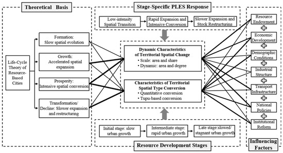
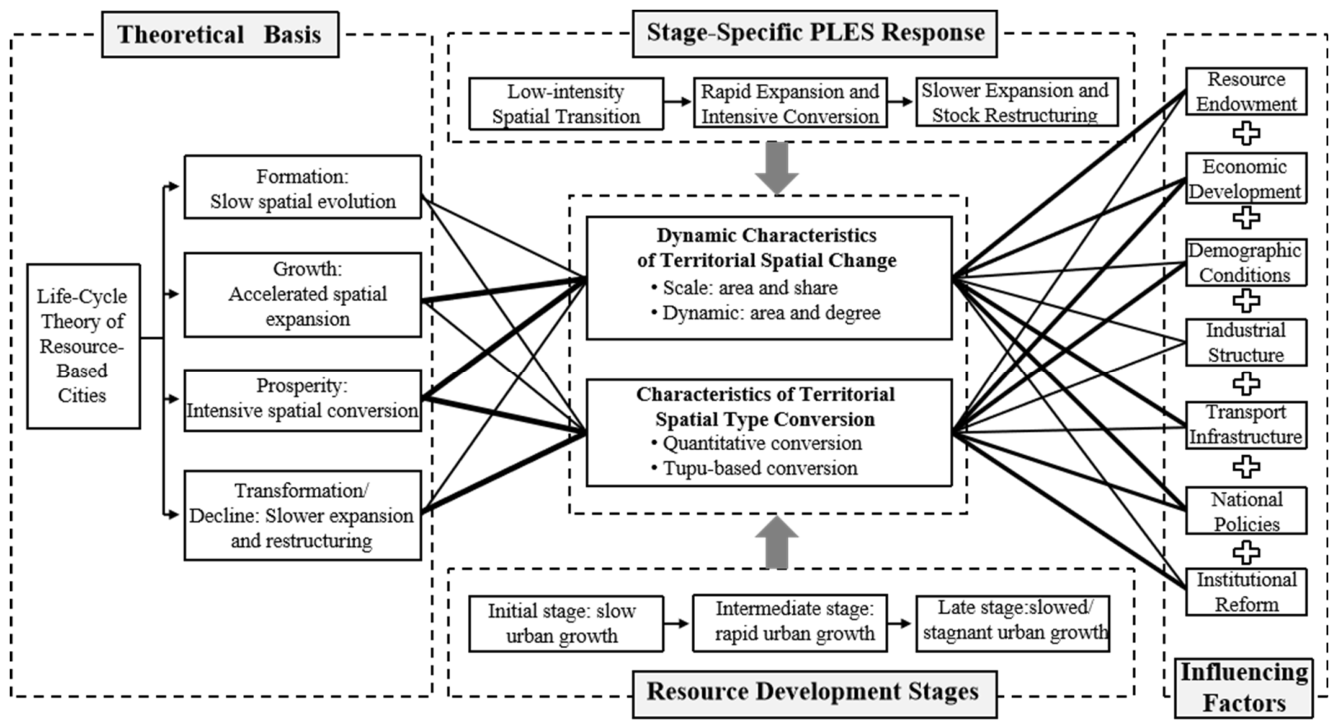
Building on this theoretical basis, this study develops a theoretical analytical framework of “life cycle–resource development–stage-specific PLES responses–influencing factors” (Figure 1). Taking the life-cycle stages as the temporal context, the framework characterizes PLES evolution in resource-exhausted cities from two dimensions—dynamic change and type conversion—and further examines its associations with resource-related, socioeconomic, and institutional factors. Specifically: (1) In terms of dynamic changes in territorial space, during the formation, growth, and prosperity stages, production and living spaces are dominated by expansion and generally exhibit positive dynamic degrees, whereas ecological space contracts rapidly. During the transformation or recession stage, the expansion of production and living spaces slows or may even give way to contraction, while ecological space expands following restoration. (2) In terms of territorial spatial type conversion, before the prosperity stage, large-scale mineral resource development results in the conversion of substantial areas of ecological space and agricultural production space into industrial and mining production space and living space. During the transformation or recession stage, production space is mainly converted into ecological space and living space, while some production and living spaces become abandoned or idle.
Figure 1.
Theoretical Analytical Framework for Territorial Spatial Evolution in Resource-Exhausted Cities.
Notably, this study adopts the life cycle of resource-based cities as a temporal framework for interpreting PLES evolution, rather than using observed changes in PLES to retrospectively define stages of urban development. The different development stages of Zaozhuang City are identified primarily on the basis of the status of resource development, changes in the resource-based economy, and major policy milestones. On this basis, the study examines the spatial response relationship between PLES changes and different stages of urban development. Accordingly, the purpose of this study is to identify the characteristics of PLES evolution associated with different development stages in the later phases of the life cycle of resource-based cities, rather than to empirically test the complete life-cycle trajectory.
3. Study Area, Data Sources, and Methods
3.1. Study Area
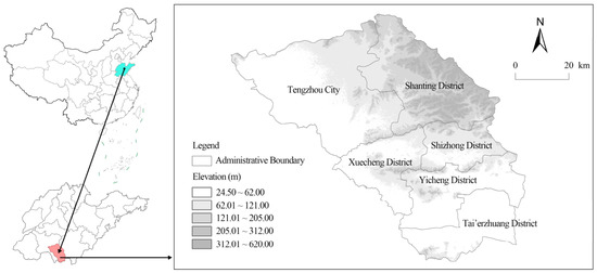
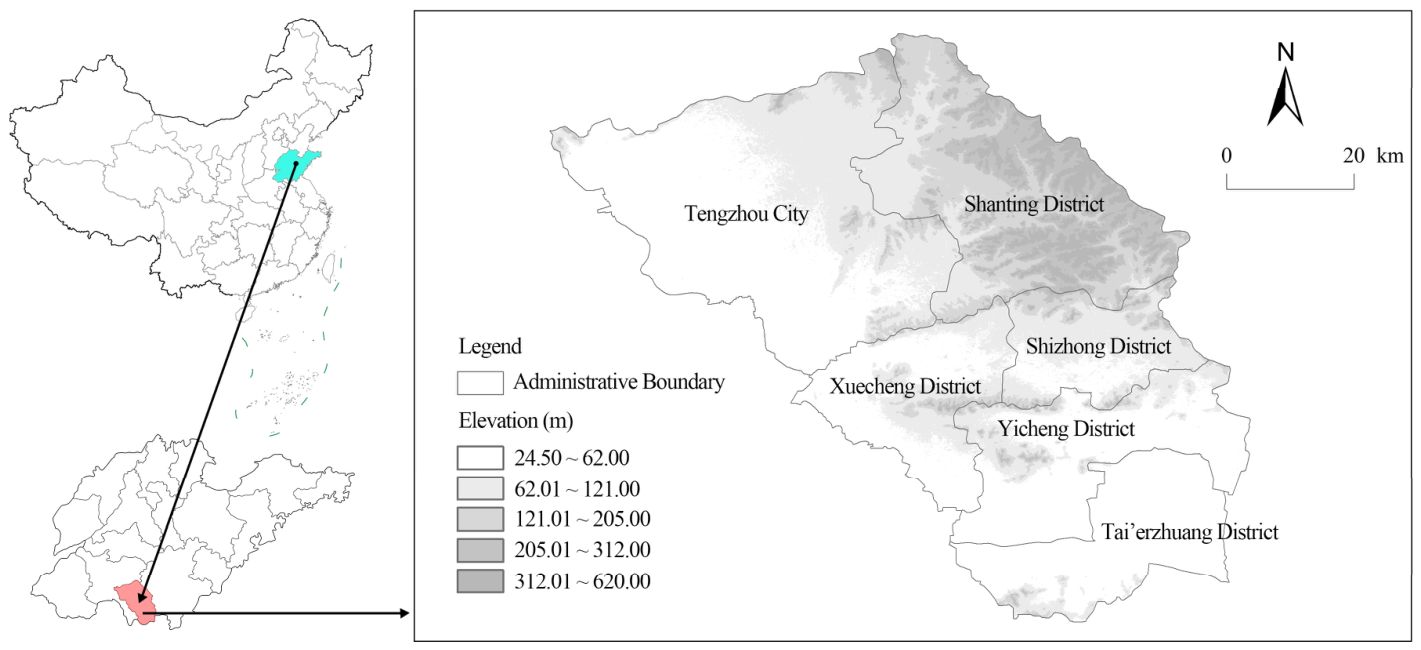
Zaozhuang City is located in southern Shandong Province and borders Xuzhou City, Jiangsu Province, to the south, making it an interprovincial border area. It currently administers five districts and one county-level city, namely Shizhong District, Xuecheng District, Yicheng District, Shanting District, Tai’erzhuang District, and Tengzhou City (Figure 2). The terrain and geomorphology of Zaozhuang are relatively complex, consisting of low mountains, hills, plains, floodplains, and depressions. Low mountains are mainly distributed in the northeastern part of the city, with elevations ranging from 24.5 to 620 m. Zaozhuang is a typical coal-based resource-exhausted city in eastern China, and its urban development has long been closely associated with coal resource exploitation. Coal development historically provided an important foundation for local industrialization, population agglomeration, and urban spatial expansion. In 1878, China’s first coal-mining enterprise wholly owned and operated by domestic capital was established in Zaozhuang. Raw coal output was approximately 10.02 million tonnes in 1980, increased to 18.08 million tonnes in 2000, and reached a historical peak of approximately 32.82 million tonnes in 2007. Thereafter, as coal resources gradually declined, raw coal output fell continuously to 11.84 million tonnes by 2020. On 2 March 2009, Zaozhuang was included in the second national list of resource-exhausted cities and was subsequently classified as a resource-declining city in the National Sustainable Development Plan for Resource-Based Cities (2013–2020). Following resource exhaustion, numerous low-productivity and high-cost coal mines were gradually closed, while the development momentum of the traditional coal industry weakened markedly. This process was accompanied by a range of spatial challenges, including inefficient industrial and mining land, coal-mining subsidence, and the governance of mining legacy spaces. Zaozhuang therefore exhibits a relatively complete development trajectory from resource abundance and intensive exploitation to resource decline and transformation-oriented governance, making it a representative case for examining the stage-specific responses of production–living–ecological spaces to coal resource exhaustion.
Figure 2.
Location of the Study Area.
From an evolutionary perspective, Zaozhuang exhibits relatively clear stage transitions in resource development, industrial structure, and urban spatial change. From around 2000 to 2009, coal output and the share of the secondary industry generally remained at relatively high levels, while the resource-based economy and rapid urbanization jointly drove the continued expansion of urban space. After Zaozhuang was designated as a resource-exhausted city in 2009, both coal output and the share of the secondary industry declined markedly. The industrial structure gradually shifted from being dominated by the secondary industry to being dominated by the service sector, while the pace of urban spatial expansion slowed accordingly and spatial development increasingly shifted toward stock-based adjustment, redevelopment of inefficient land, and ecological restoration. Accordingly, around 2010 can be regarded as an important temporal turning point marking Zaozhuang’s transition from resource prosperity to resource-exhausted transformation. The period from 2000 to 2020 was therefore selected as the study period because it covers both the late prosperity stage and the resource-exhausted transformation stage, allowing comparison of changes in the intensity, direction, and spatial distribution of PLES conversions under different development contexts. Notably, the representativeness of Zaozhuang lies primarily in its status as a resource-exhausted city in eastern China characterized by long-term dependence on coal resources, pronounced mining legacy effects, and an active process of industrial transformation. Its evolutionary characteristics should therefore not be directly generalized to all types of resource-exhausted cities.
3.2. Data Sources
The basic socioeconomic data used in this study, including population, industrial, economic, and transport data, were mainly obtained from the Zaozhuang Statistical Yearbook, the Shandong Statistical Yearbook, and the fifth, sixth, and seventh national population census datasets. Spatial raster data were primarily derived from the China Multi-period Land Use/Land Cover Remote Sensing Monitoring Dataset (CNLUCC) developed by the Resource and Environment Science and Data Center of the Chinese Academy of Sciences, with a spatial resolution of 30 m. Previous nationwide validation results showed that the interpretation accuracy of land-use change patches exceeded 96.67%, while the accuracy of first-level land-use categories exceeded 95.41% [38]. For Shandong Province, quality inspection results based on the Chinese Academy of Sciences’ technical scheme for national land use/cover change mapping showed that the overall interpretation accuracy of land-use dynamics reached 97.45% during 2000–2005, with an accuracy of 100% for cultivated land; during 2005–2008, the corresponding accuracies were 98.78% and 100%, respectively. These validation results indicate that CNLUCC satisfies the basic accuracy requirements for regional-scale land-use change analysis.
Nevertheless, multi-temporal land-use transition analysis may still be affected by the propagation of classification errors, and classification accuracy is not entirely consistent across different land-cover types. Previous independent validation studies have shown that class-transition zones, fragmented landscapes, and mixed pixels are important sources of classification discrepancies in 30 m land-cover products, with relatively greater uncertainty reported for certain categories such as grassland [39]. Therefore, for the conversion types identified in this study that involve relatively small areas and highly fragmented patches, particularly small-scale bidirectional conversions between agricultural production space and rural living space, the observed results may reflect both actual land-use changes and a certain degree of classification uncertainty.
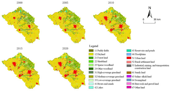
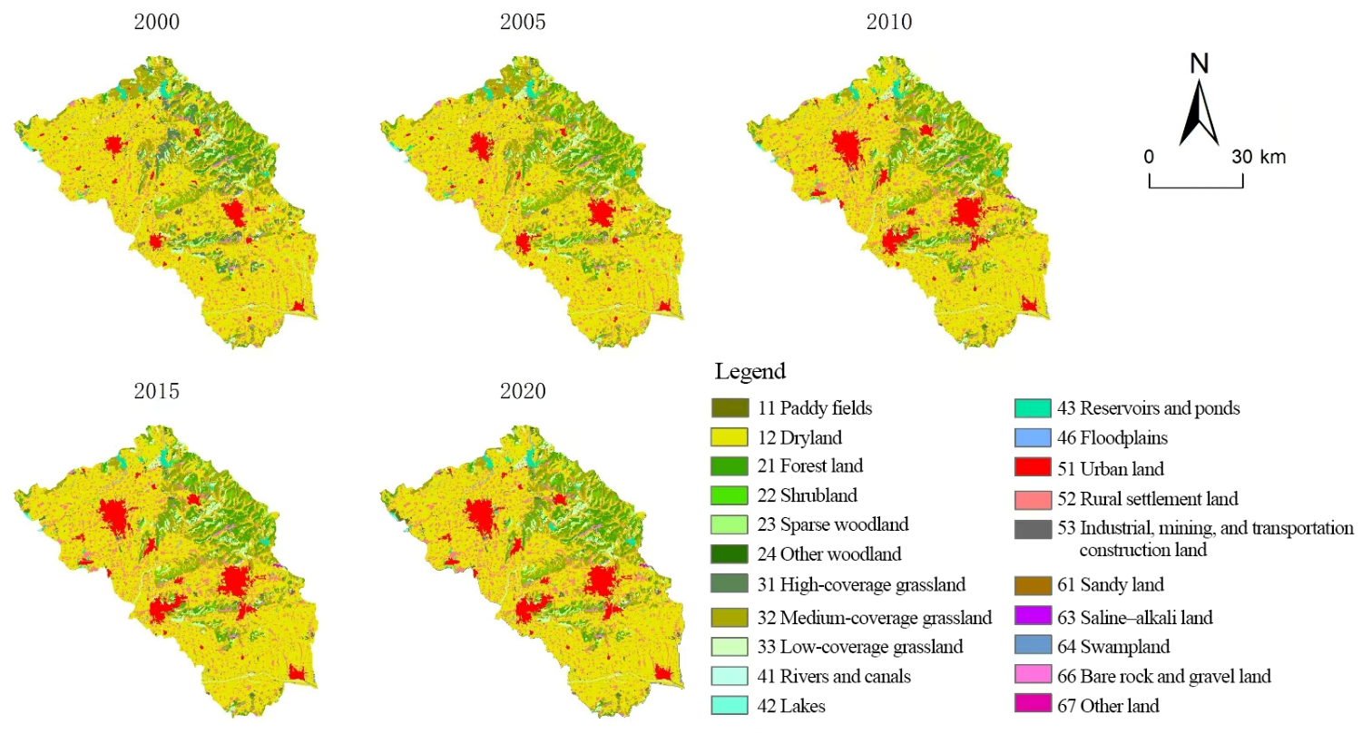
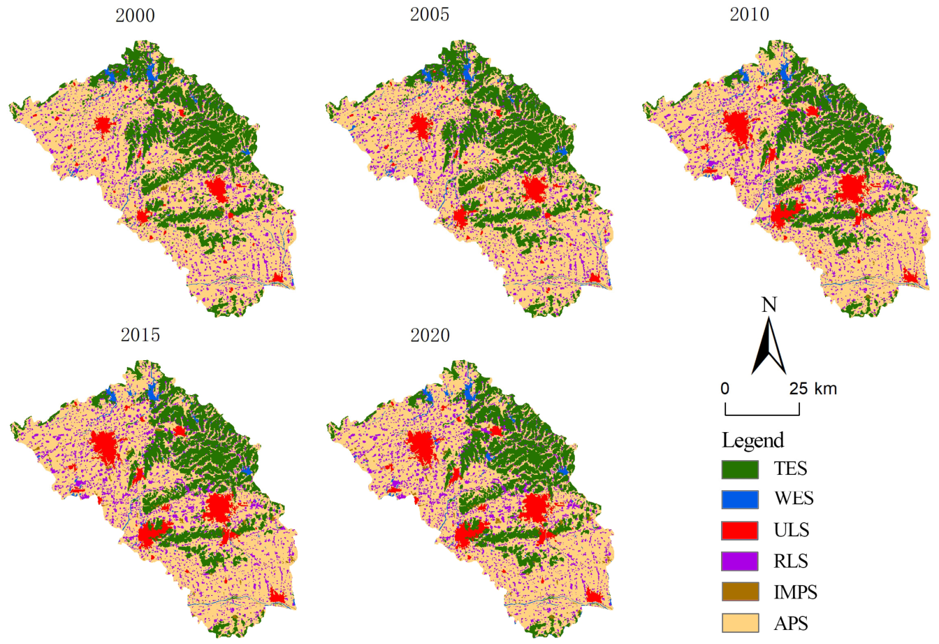
Based on the CNLUCC datasets for 2000, 2005, 2010, 2015, and 2020, and following previous studies, land-use categories were reclassified using ArcGIS 10.7. On this basis, the territorial space of Zaozhuang City was further divided within the PLES framework into six subcategories: agricultural production space (APS), industrial and mining production space (IMPS), urban living space (ULS), rural living space (RLS), terrestrial ecological space (TES), and water ecological space (WES) (Table 1 and Figure 3).
Table 1.
Classification of Territorial Spatial Types and Their Correspondence with Land-Use Categories.
Figure 3.
Distribution of Production–Living–Ecological Spaces in Zaozhuang City from 2000 to 2020.
3.3. Methods
3.3.1. Methods for Analyzing the Evolutionary Characteristics of PLES
This study analyzes PLES evolution following the logic of “change magnitude and intensity–spatial type conversion–spatial localization of conversions”. First, the territorial spatial transition matrix and dynamic degree model are used to identify the overall changes and conversion intensity across different stages. Second, chord diagrams are employed to reveal the directions and magnitudes of conversions among different spatial types. Finally, Geo-information Tupu is used to locate the major spatial conversions, thereby establishing a progressive analytical sequence from quantitative change and conversion relationships to spatial location.
- Territorial spatial transition matrix
The territorial spatial transition matrix can visually present the composition of territorial space at the beginning and end of the study period and reveal the conversion characteristics among different territorial spatial types. In this study, Sankey diagrams were used to visualize changes in the quantity and structure of PLES in Zaozhuang City across different periods from 2000 to 2020 [31]. The calculation formula is as follows:
where S denotes area, n represents the number of territorial spatial types, and denotes the total area converted from territorial spatial type i at the beginning of the study period to territorial spatial type j at the end of the study period.
- 2.
- Dynamic degree model
The dynamic degree model is an important method for measuring the rate and magnitude of spatial transformation among different land-use types within territorial space over a given period. It can be divided into the single dynamic degree and the comprehensive dynamic degree [31,40]. The single dynamic degree is mainly used to examine the rate and magnitude of change in a specific land-use type during the study period. The calculation formula is as follows:
where denotes the dynamic degree of land-use type i during the study period; and represent the areas of land-use type i at time points a and b, respectively; and and denote the initial time point a and the final time point b of the study period, respectively.
- 3.
- Chord diagram visualization model
A chord diagram is a visualization tool used to display complex conversion relationships among different data types within a circular coordinate system. It clearly presents the conversion proportions among different territorial spatial types. The longer the arc length, the larger the area of the corresponding land-use type; the wider the connecting line, or chord, between any two nodes on the circle, the greater the scale of conversion between the corresponding land-use types [41]. To reveal the magnitude and direction of conversions among different territorial spatial types in Zaozhuang City more clearly, this study first extracted the conversion areas among the six territorial spatial types and then used Origin 2024 to generate chord diagram visualizations.
- 4.
- Geo-information Tupu
Geo-information Tupu enables a clearer representation of changes in territorial spatial types and their spatial distribution by integrating spatial, attribute, and process data into a unified visual framework. First, TES, WES, ULS, RLS, IMPS, and APS were assigned codes of 1, 2, 3, 4, 5, and 6, respectively. In this coding system, 12 denotes the conversion from TES to WES, 13 denotes the conversion from TES to ULS, and 14 denotes the conversion from TES to RLS; the remaining conversion types were coded in the same manner. Second, gain and loss Tupu maps were generated to identify the spatial locations of increases and decreases in different territorial spatial types [42].
3.3.2. Exploratory Analysis of Factors Associated with PLES Evolution
Bivariate correlation analysis can be used to examine the degree of linear association between variables, with Pearson’s correlation coefficient commonly employed to characterize the linear relationship between two variables [43]. Given the limited number of spatial units in the study area, the correlation analysis in this study is used primarily to identify potential associations between PLES evolution and relevant socioeconomic factors, including the direction and strength of these associations. It is not intended to establish causal relationships in a strict sense or to determine the decisive effect of any single factor.
Considering data availability and the consistency of administrative divisions and statistical records over the study period, the five municipal districts and one county-level city of Zaozhuang were used as the basic spatial units. Changes in relevant socioeconomic indicators for each spatial unit over the entire study period from 2000 to 2020 were matched with the corresponding changes in production, living, and ecological spaces, and Pearson correlation analysis was subsequently conducted.
The explanatory variables were selected on the basis of three main considerations. First, factors commonly examined in previous studies of resource-based urban transformation and territorial spatial evolution were considered. Second, the actual development trajectory of Zaozhuang as a typical resource-based city was taken into account, particularly changes in resource exploitation, industrial transformation, population, transport infrastructure, urban planning, and policy adjustments. Third, the availability of relevant statistical data during the study period and their comparability across spatial units were considered. On this basis, 12 candidate influencing factors were selected to represent resource development, economic development, industrial structure, population change, transport infrastructure, investment, and public governance. These factors include raw coal output (X1), gross domestic product (GDP) (X2), resource-based economy (X3), mining-industry employment (X4), added value of the secondary industry (X5), added value of the tertiary industry (X6), urban population (X7), rural population (X8), road network density (X9), fixed asset investment (X10), public fiscal expenditure (X11), and urbanization rate (X12).
4. Results
To balance stage-level comparison with process-oriented analysis, this study adopts two temporal scales. The periods 2000–2010 and 2010–2020 are used primarily to compare the overall differences between the late prosperity stage and the resource-exhausted transformation stage, whereas the four subperiods of 2000–2005, 2005–2010, 2010–2015, and 2015–2020 are used to further identify specific spatial conversion processes within each stage. The former focuses on revealing the overall evolutionary characteristics associated with different development stages, while the latter is used to characterize intra-stage dynamic changes and the corresponding spatial conversion processes.
4.1. Temporal Dynamic Changes in PLES in Zaozhuang City
4.1.1. Characteristics of Scale Change
APS and TES decreased markedly, whereas the other four territorial spatial types showed an increasing trend (Figure 4). First, the contraction of APS and TES was mainly concentrated in the 2000–2010 period. From 2000 to 2020, the areas of APS and TES decreased by 93.26 km2 and 178.98 km2, respectively, and their shares of the total territorial space of Zaozhuang City declined by 2.06 and 3.93 percentage points, respectively. Specifically, APS and TES decreased by 68.46 km2 and 171.02 km2 during 2000–2010, respectively, but by only 24.71 km2 and 7.91 km2 during 2010–2020.
Figure 4.
Distribution of Production–Living–Ecological Space Types in Zaozhuang City across Different Periods from 2000 to 2020.
Second, the expansion of ULS, RLS, and IMPS was also mainly concentrated in the 2000–2010 period, whereas the increase in WES occurred primarily during 2010–2020. During 2000–2010, the areas of ULS, RLS, and IMPS increased by 154.22 km2, 58.37 km2, and 24.11 km2, respectively, and their shares of the city’s total territorial space rose by 3.38, 1.29, and 0.53 percentage points, respectively. By contrast, during 2010–2020, these three types of space increased by only 11.35 km2, 7.96 km2, and 6.38 km2, respectively, with their shares rising by merely 0.25, 0.17, and 0.14 percentage points. This indicates a substantial slowdown in expansion. The area of WES changed only slightly, increasing by 9.86 km2 over the 20-year period; most of this increase occurred during 2010–2020, when WES expanded by 7.31 km2.
4.1.2. Characteristics of Dynamic Change
From the perspective of the single land-use dynamic degree, APS and TES continued to shrink, while ULS, RLS, and IMPS continued to expand. By contrast, WES showed a fluctuating pattern of growth (Table 2). First, the dynamic degrees of APS and TES were negative across all five study periods, indicating that these two types of space were continuously encroached upon by other territorial spatial types and therefore remained in a state of persistent contraction. APS recorded its lowest dynamic degree during 2000–2005 (−0.37%), suggesting that APS was most severely affected during this period. TES reached its lowest dynamic degree during 2005–2010 (−2.76%); during this period, 168.72 km2 of TES disappeared, accounting for 94.29% of the total loss of this spatial type over the entire study period.
Table 2.
Area Changes and Single Dynamic Degrees of Different Territorial Spatial Types in Zaozhuang City from 2000 to 2020.
Second, the dynamic degrees of IMPS, ULS, and RLS were positive across all five study periods, indicating continuous expansion throughout the study period. The dynamic degrees of IMPS, ULS, and RLS all peaked during 2005–2010, reaching 21.04%, 13.49%, and 2.60%, respectively. These values were substantially higher than those in other periods, suggesting that these three types of space expanded particularly rapidly during this stage. Third, the dynamic degree of WES fluctuated between positive and negative values across the five study periods, indicating an overall pattern of fluctuating growth.
4.2. Type Conversion Characteristics of PLES in Zaozhuang City
4.2.1. Quantitative Characteristics of Spatial Type Conversion
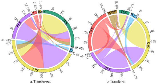
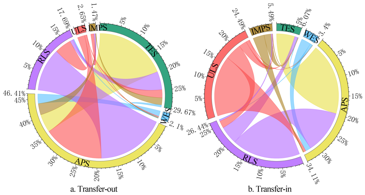
From 2000 to 2020, the most evident transfer-out relationships were observed in APS, TES, and RLS. Together, these three types were converted out of 711.03 km2, accounting for 93.78% of the total converted area (Table 3 and Figure 5a). Among them, APS showed the largest transfer-out area, reaching 351.91 km2 and accounting for 46.41% of the total converted area; it was mainly converted into RLS and ULS. TES ranked second, with a transfer-out area of 224.99 km2, accounting for 29.67% of the total converted area; it was mainly converted into APS and RLS. The transfer-out of RLS was also notable, with a total area of 134.13 km2, accounting for 17.69% of the total converted area; it was mainly converted into APS and ULS.
Table 3.
Territorial Spatial Transition Matrix of Zaozhuang City from 2000 to 2020 (km2).
Figure 5.
Transfer-Out and Transfer-In Relationships among Different Production–Living–Ecological Space Types in Zaozhuang City from 2000 to 2020.
From 2000 to 2020, the most evident transfer-in relationships were observed in APS, RLS, and ULS. Together, these three types received 644.80 km2 of transferred area, accounting for 85.04% of the total converted area (Table 3 and Figure 5b). APS recorded the largest transfer-in area, reaching 258.65 km2 and accounting for 34.11% of the total converted area; it was mainly converted from TES and RLS. RLS ranked second, with a transfer-in area of 200.45 km2, accounting for 26.44% of the total converted area; it was mainly converted from APS and TES. The transfer-in of ULS was also notable, reaching 185.70 km2 and accounting for 24.49% of the total converted area; it was mainly converted from APS and RLS.
4.2.2. Tupu Characteristics of Spatial Type Conversion
- Basic change Tupu
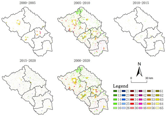
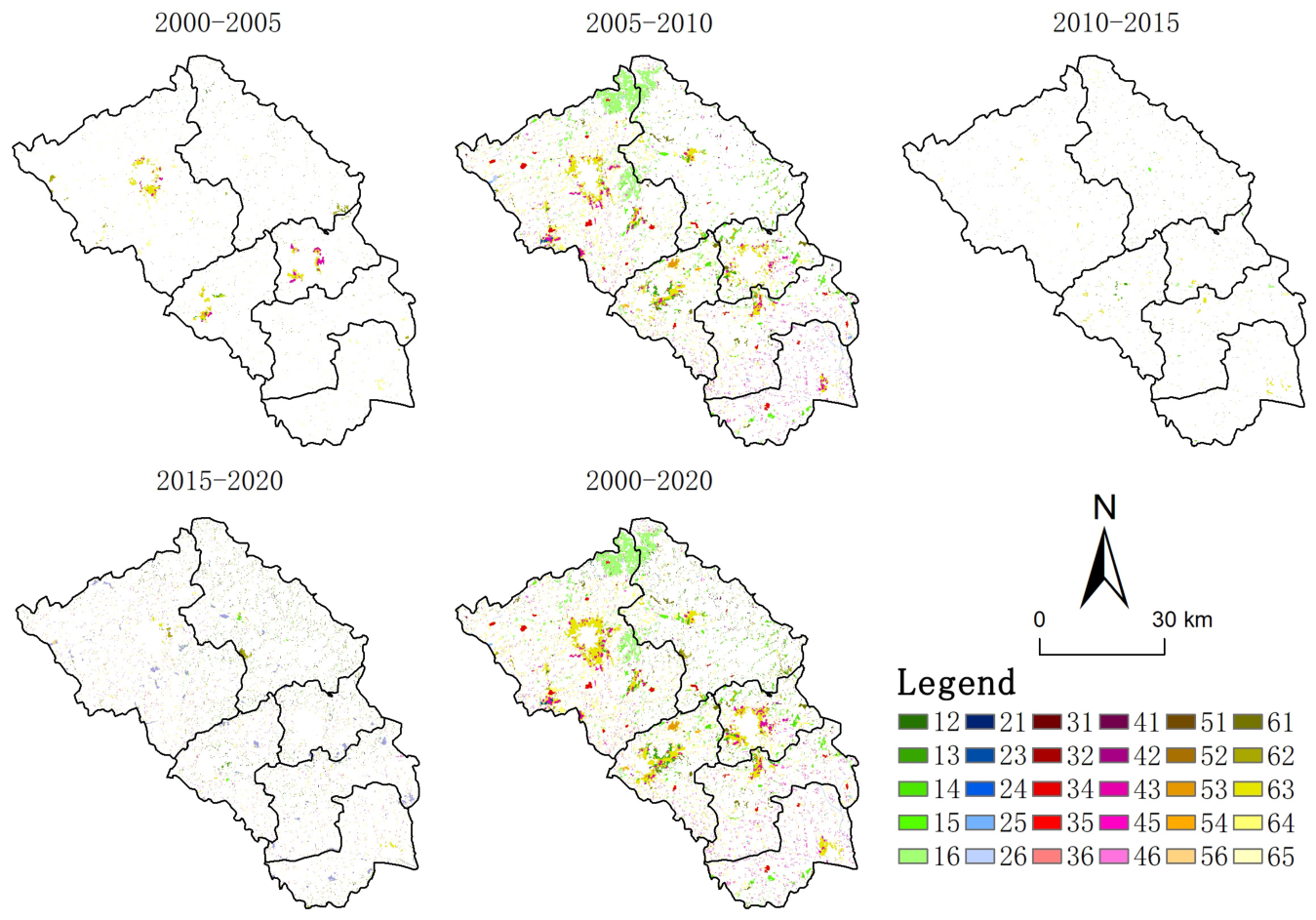
As shown in Figure 6, during 2000–2005, some APS and RLS around the built-up areas of Shizhong District, Xuecheng District, and Tengzhou City was converted into ULS. During 2005–2010, conversion patches around the built-up areas of Shizhong District, Xuecheng District, and Tengzhou City became more densely distributed than in the previous stage. Meanwhile, a number of conversion patches began to appear around the built-up areas and key towns of Shanting District, Yicheng District, and Tai’erzhuang District. Particularly evident was the emergence of large block-shaped conversion patches in the border area between Tengzhou City and Shanting District. In addition, densely distributed conversion patches were widely observed across the municipal area. During 2010–2020, conversions among different territorial spatial types weakened markedly compared with the previous two stages, and large concentrated conversion patches became less frequent across the city.
Figure 6.
Spatial Distribution of Changed Patches of PLES Types in Zaozhuang City from 2000 to 2020. Note: Code 12 denotes the conversion from TES to WES, and the other codes are interpreted in the same manner.
Overall, from 2000 to 2020, ULS expanded markedly around the built-up areas of Shizhong District, Xuecheng District, Yicheng District, Tengzhou City, Shanting District, and Tai’erzhuang District, as well as around major industrial parks and key town centers. A relatively large amount of newly increased APS appeared in the border area between Tengzhou City and Shanting District, while mutual conversions between RLS and APS occurred frequently across the municipal area.
- 2.
- Gain and Loss Tupu Maps
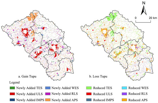
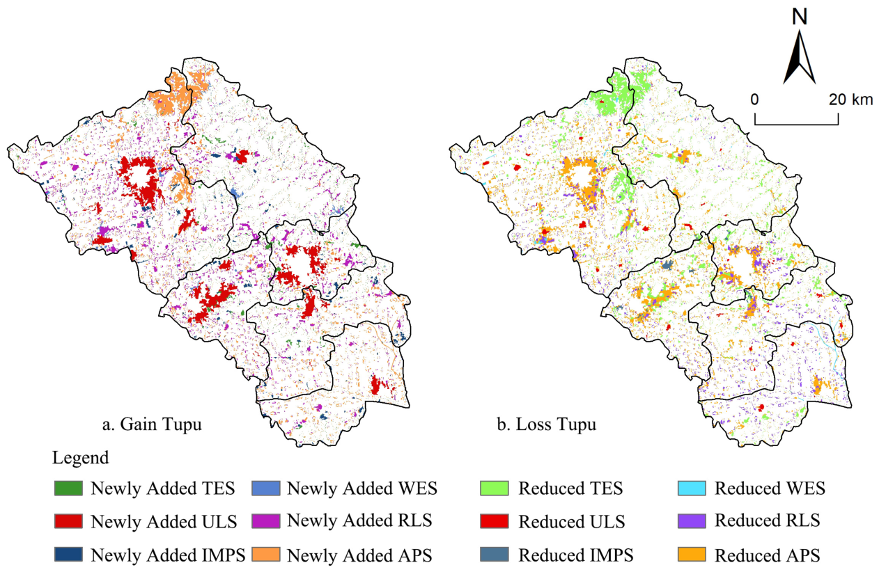
As shown in the gain Tupu map in Figure 7a, APS exhibited the most pronounced increase over the entire study period. Newly added APS was mainly distributed in the northern and central border areas between Tengzhou City and Shanting District. In addition, a large amount of scattered and underutilized RLS was converted into APS. The increase in RLS was slightly lower than that in APS, and newly added RLS was mainly dispersed across townships in the form of block-shaped patches. The increase in ULS was highly concentrated around the built-up areas of the five districts and one county-level city, as well as around major industrial parks.
Figure 7.
Gain and Loss Tupu Maps of Different PLES Types in Zaozhuang City from 2000 to 2020.
As shown in the loss Tupu map in Figure 7b, APS also experienced the most evident decline during the study period. The expansion of ULS around the five districts, the county-level city, and major industrial parks encroached upon a substantial amount of APS. Meanwhile, widespread functional conversion between APS and RLS further contributed to the transfer-out of APS. The loss of TES was also prominent. On the one hand, corresponding to the gain patches of APS, large block-shaped patches of TES were converted into APS. On the other hand, scattered TES within the municipal area was gradually encroached upon by RLS, ULS, and IMPS. The loss of RLS was also notable and spatially concentrated. This was attributable partly to the encroachment caused by the expansion of urban built-up areas and partly to the reclamation of idle and abandoned rural homesteads into cultivated land, driven by the implementation of China’s strictest cultivated land protection system and the improvement of intensive land use in RLS.
4.3. Analysis of Influencing Factors of PLES Evolution in Zaozhuang City
4.3.1. Exploratory Quantitative Analysis of Potential Influencing Factors
Pearson correlation analysis was employed to conduct an exploratory examination of the associations between changes in PLES and changes in relevant socioeconomic factors in Zaozhuang City during 2000–2020. Given that the analysis included only six county-level administrative units (N = 6), the correlation results are used primarily to identify the direction and strength of the associations between different factors and PLES changes. The results show that changes in ecological space were significantly correlated with changes in GDP, the resource-based economy, added value of the secondary industry, mining-industry employment, urban population, rural population, fixed asset investment, and public fiscal expenditure, whereas raw coal output, added value of the tertiary industry, road network density, and urbanization rate did not reach statistical significance. Changes in living space were significantly correlated with changes in raw coal output, GDP, the resource-based economy, mining-industry employment, added values of the secondary and tertiary industries, urban population, fixed asset investment, and public fiscal expenditure, whereas rural population, road network density, and urbanization rate did not reach statistical significance. For production space, only the change in road network density showed a significant negative correlation (r = −0.940, p < 0.01), while none of the other factors reached statistical significance (Table 4).
Table 4.
Pearson correlations between influencing factors and PLES changes in Zaozhuang City, 2000–2020.
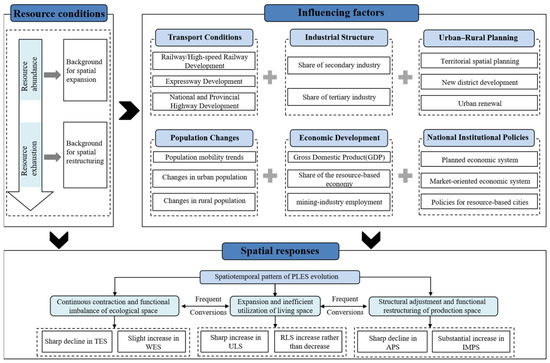
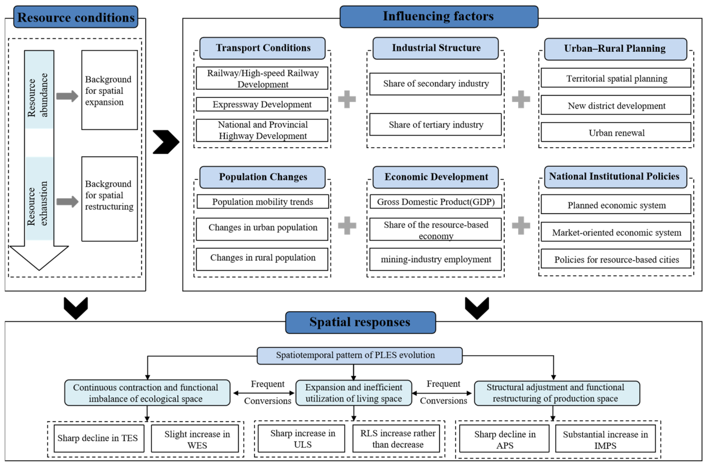
In terms of the direction and strength of the correlations, economic development, industrial structure, population change, and public investment showed relatively pronounced associations with changes in living and ecological spaces, whereas production space was only weakly correlated with most factors, reflecting differentiated responses among different spatial types under conditions of resource exhaustion. These correlations should not be interpreted as independent causal effects of individual factors; rather, they provide potential associative evidence for understanding PLES evolution. Against the life-cycle background of Zaozhuang’s transition from resource abundance to resource exhaustion, and in conjunction with the observed transfer and conversion characteristics among different PLES types, these associations and their spatial responses are further interpreted qualitatively from the perspectives of resource conditions, economic development and industrial structure, population and transport, urban–rural planning, and policy adjustments (Figure 8).
Figure 8.
Influencing Factors and Spatial Responses of PLES Evolution in Zaozhuang City.
4.3.2. Integrated Interpretation of Influencing Factors
- (1)
- Resource Endowment and the Resource Life-Cycle Context
During the period of abundant coal resources, Zaozhuang maintained a relatively high level of raw coal output, and its resource-based economy developed rapidly. The Pearson correlation results in Table 4 show that changes in raw coal output were positively, but not significantly, correlated with changes in ecological space (r = 0.794). In contrast, they were significantly negatively correlated with changes in living space (r = −0.896, p < 0.05). These results suggest that the relationship between resource development and spatial evolution is complex. During 2000–2010, 88.22% of the total TES transfer-out over the study period occurred, while 93.14% of the total ULS transfer-in occurred during the same period. This pattern indicates pronounced spatial expansion under conditions of intensive resource development.
After Zaozhuang entered the resource-exhausted stage, coal resources approached exhaustion and economic growth slowed. The city promoted industrial transformation through emerging industries, including the lithium battery industry. However, the overall rate of territorial spatial evolution declined markedly, and spatial development increasingly shifted toward internal restructuring. Spatial conversions during 2010–2020 accounted for only 26.45% of the total converted area over the entire study period. This stage-specific difference indicates a clear association between the transition from resource abundance to resource exhaustion and the restructuring of territorial space.
- (2)
- Economic Development and Industrial Structure
During the period of abundant coal resources, Zaozhuang showed a high degree of resource dependence. GDP, the added value of the secondary industry, and the share of the resource-based economy increased rapidly. Economic growth was closely associated with resource-based industries, resulting in a certain degree of path dependence. During this stage, industrialization and urbanization advanced simultaneously. Industrial and mining production space and urban living space expanded, while agricultural production space and TES were increasingly converted to other land-use types. Spatial development therefore showed a strong tendency toward outward expansion.
After Zaozhuang entered the coal resource-exhausted stage, its economic and industrial structures gradually adjusted. The share of the resource-based economy declined, while the tertiary industry developed more rapidly. At the same time, spatial expansion slowed and increasingly shifted toward internal restructuring. Shantytown redevelopment, inefficient land redevelopment, and industrial restructuring were accompanied by spatial optimization. This reflects a transition from outward expansion to stock-based spatial restructuring. The correlations of GDP, the resource-based economy, and the added value of the secondary industry with changes in ecological and living spaces in Table 4 also provide quantitative indications of these spatial responses.
- (3)
- Population Change and Transport Conditions
During the period of abundant coal resources, territorial spatial evolution in Zaozhuang was accompanied by population agglomeration and improvements in transport conditions. From 2000 to 2010, the permanent resident population and registered population increased by 183,500 and 354,400 persons, respectively. The urban population increased by 649,600 persons. During the same period, transport infrastructure, including railways and national and provincial highways, continued to improve. ULS expanded rapidly and showed a clear tendency to extend along major transport corridors.
After Zaozhuang entered the resource-exhausted stage, both the registered population and permanent resident population declined, while the rural population continued to decrease. The opening of the Beijing–Shanghai High-Speed Railway and broader changes in regional transport conditions were accompanied by the spatial reorganization of population. Outward spatial expansion slowed, and spatial development gradually shifted toward stock-based optimization. Table 4 shows that urban population was significantly negatively correlated with changes in ecological space and significantly positively correlated with changes in living space. Rural population was significantly positively correlated with changes in ecological space. These results indicate differentiated associations between population change and different spatial types. However, the specific roles of population and transport conditions need to be interpreted in conjunction with spatial conversion patterns and the broader context of urban development.
- (4)
- Planning and Policy Context
Urban planning and policy are closely associated with the evolution of spatial patterns in resource-exhausted cities through regulation, guidance, and governance. National policies, local supporting measures, and successive versions of the Zaozhuang City Master Plan have continuously influenced resource development, economic transformation, population distribution, and urban construction. Changes in Zaozhuang’s spatial form have also accompanied adjustments in its policy and institutional systems. From the planned economy period to the transformation of the resource-exhausted city, Zaozhuang experienced several institutional stages, including centralized administration, integration of government and enterprise, separation of government and enterprise, and transfer of service functions. During this process, the urban spatial form gradually evolved from a mixed city–mine pattern and work-unit compounds toward greater city–mine integration.
Since 2010, central and provincial special transfer payments, local fixed asset investment, and public fiscal expenditure have increased. These inputs have supported urban renewal, including shantytown redevelopment and infrastructure improvement. They have also been accompanied by adjustments to some inefficient spaces and improvements in public services. Table 4 shows that fixed asset investment and public fiscal expenditure were significantly positively correlated with changes in living space. These results provide quantitative indications of the association between policy-related investment and the expansion of living space.
5. Discussion
5.1. International Commonalities and Regional Differences in Land-Use Transition in Resource-Exhausted Regions
From an international perspective, resource exhaustion and urban transformation do not simply involve the withdrawal of traditional production space. They are often accompanied by the reuse of existing spaces, the reorganization of spatial functions, and ecological restoration. Evidence from the lignite-mining regions of eastern Germany and post-mining regions in Poland and the Czech Republic shows that mine reclamation, brownfield redevelopment, and regional planning can gradually integrate spaces left by resource exploitation into new land-use systems [44,45,46]. Research on the Paris metropolitan region further shows that urban land-use transition is spatially complex. Urban compaction, urban sprawl, and the protection of natural spaces may occur simultaneously. Spatial planning therefore plays an important role in coordinating different land-use demands [47]. In North American Rust Belt cities, transformation is more often associated with population decline and increasing vacant land. These cities have sought to improve the use of existing urban space through vacant-land reuse, land banking, and green infrastructure [48,49]. Taken together, these studies indicate several common trends across different regional contexts. One is a shift from incremental expansion toward stock-based adjustment. Another is the reorganization of spatial functions through planning and governance. However, specific transition pathways still depend on regional conditions, including resource type, degree of decline, population change, and governance institutions.
Compared with non-resource-based cities, RECs tend to experience more frequent and larger-scale losses of ecological and production spaces. In RECs, ecological space is often extensively encroached upon, leading to a sharp reduction in ecological source areas and an increase in fragmented ecological spaces, such as barrier points and breakpoints [6,7,50]. The continuous and substantial decline in ecological space in Zaozhuang City further supports this pattern. Production space has also been severely damaged. On the one hand, APS has been extensively encroached upon; on the other hand, many deteriorated independent industrial and mining districts and abandoned coal-mining subsidence areas remain [8]. Meanwhile, the extensive expansion and disorderly sprawl of living space are also widespread. ULS expands outward through both concentric sprawl and leapfrog development, while RLS frequently encroaches upon farmland through scattered and opportunistic expansion [51]. During the study period, a large rural population in Zaozhuang City migrated to urban areas, resulting in a continuous decline in the rural population. However, owing to persistent problems in rural areas, such as “multiple homesteads for one household”, “housing retained after population outmigration”, and “new houses built without demolishing old ones”, RLS increased rather than decreased. This further indicates the high degree of extensive expansion of living space in Zaozhuang City.
5.2. Stage-Specific and Distinctive Responses of PLES in Zaozhuang Under Resource Exhaustion
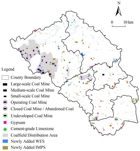
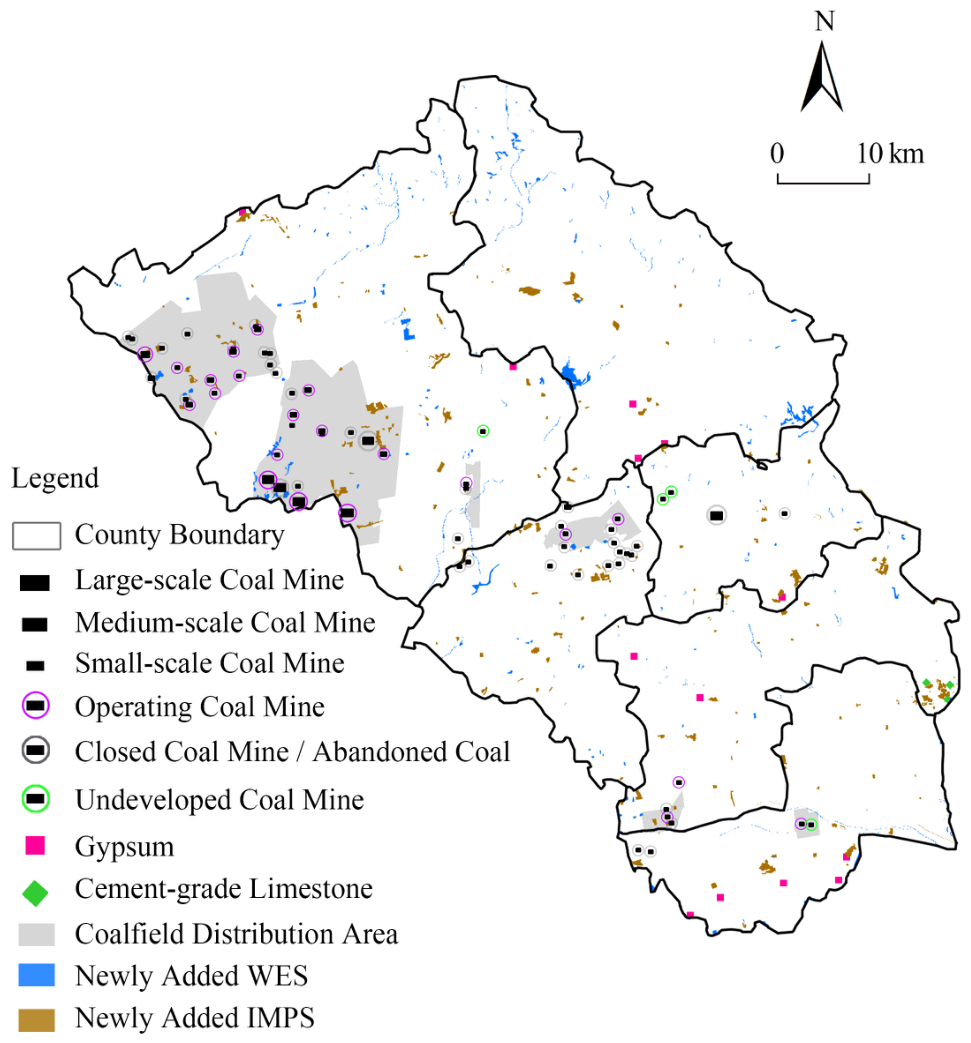
Notably, territorial spatial evolution in Zaozhuang during the resource-exhausted stage shows several features that differ from those commonly observed in other cities. After Zaozhuang was designated as a resource-exhausted city in 2009, IMPS still increased by 6.38 km2. This pattern does not fully conform to the expectation of contraction in traditional industries after resource exhaustion. A spatial comparison between newly added IMPS and the distribution of mineral resource development areas provides further insight (Figure 9). The newly added IMPS was concentrated mainly in coalfield development areas and in areas associated with the exploitation of gypsum and limestone for cement production. This suggests that the observed changes may reflect both the continued presence of spaces inherited from coal development and ongoing exploitation of non-coal mineral resources. However, the 30 m land-use data cannot further distinguish active mining areas, closed mines, and abandoned mining land. The observed changes may therefore include the continued retention of mining legacy spaces. They may also reflect the complex adjustment of industrial and mining space under the path dependence of resource-based industries.
Figure 9.
Spatial Relationships among Newly Added Water Bodies, Industrial and Mining Production Space, and Mineral Resource Development Areas.
During the same period, WES increased by 7.31 km2. Some newly added water patches spatially overlapped with coal resource development areas (Figure 9). This suggests that water accumulation caused by coal-mining subsidence may have been an important source of the increase. However, the expansion of WES may also have been associated with mining-area rehabilitation, water-system adjustment, and land consolidation. Therefore, the observed increase cannot be attributed simply to either mining-induced damage or ecological improvement. Accordingly, an increase in ecological space during the resource-exhausted stage does not necessarily indicate an improvement in ecological quality. Instead, it may reflect a process of spatial restructuring under the combined influence of long-term resource-development disturbances and transformation-oriented governance. This further indicates that PLES evolution in resource-exhausted cities involves more than urban expansion or contraction. It also reflects the combined effects of the resource-development life cycle, mining legacy effects, and ecological governance.
5.3. High-Frequency PLES Conversions and Governance Implications
This study found that PLES conversions in Zaozhuang were relatively frequent during 2000–2010 but slowed markedly after 2010. This indicates a strong temporal correspondence between the period of high-frequency PLES conversion and changes in the stages of resource development and urban development. Compared with related studies of non-resource-based cities in the Yellow River Basin, the period of high-frequency PLES conversion in Zaozhuang occurred earlier. ULS and IMPS also expanded relatively rapidly during the later stage of resource development. These findings suggest that resource development and the accompanying processes of industrialization and urbanization may be closely associated with intensive PLES conversions. However, these relationships are also influenced by economic development, population change, planning, and policy. They therefore cannot be attributed to any single factor.
This study also found frequent bidirectional conversions between RLS and APS in Zaozhuang. This pattern is associated with the interspersed distribution of rural settlements and agricultural production space. It may also be related to settlement expansion, reclamation of idle rural homesteads, and adjustments to agricultural production space. From the perspective of resource-exhausted urban transformation, coordination among PLES involves more than the adjustment of land-use structure. It also reflects a broader transformation in the urban development model. Therefore, disorderly expansion of living space should be controlled. At the same time, greater attention should be given to the reuse of mining legacy spaces, the consolidation of rural settlements, and the restoration of ecological space. These measures can promote the coordinated allocation of production, living, and ecological functions and improve the efficiency of existing land use. They can also provide spatial support for resource-based transformation and sustainable development.
6. Conclusions and Future Research
6.1. Conclusions
(1) PLES evolution in Zaozhuang exhibited clear stage-specific characteristics. Conversions among different spatial types were relatively frequent during 2000–2010 but slowed markedly during 2010–2020. Zaozhuang was designated as a national resource-exhausted city in 2009. Around 2010, coal output, the share of the secondary industry, and the rate of spatial expansion also changed simultaneously. This indicates a strong temporal correspondence between the transition in PLES evolution and the broader context of resource exhaustion and urban transformation. Over the study period, ULS, RLS, and IMPS continued to expand, while WES increased with fluctuations. In contrast, APS and TES continued to decline.
(2) Spatial conversions in Zaozhuang showed clear regional differences. ULS expanded markedly around the built-up areas of Shizhong District, Xuecheng District, and Tengzhou City, as well as around major industrial parks. Most of this expansion occurred through the conversion of APS and RLS. APS increased notably along the border between Tengzhou City and Shanting District. Across the municipal area, conversions between RLS and APS were particularly frequent. During the resource-exhausted stage, newly added IMPS showed spatial associations with some mineral resource development areas. Newly added WES also overlapped with some coal development areas. These patterns reflect spatial restructuring under the combined influence of mining legacy effects, continued resource development, and transformation-oriented governance.
(3) Changes in PLES in Zaozhuang were associated to varying degrees with resource conditions, economic and industrial development, population and transport, and planning and policy. Pearson correlation analysis showed that economic development, industrial structure, population change, and public investment were relatively strongly associated with changes in living and ecological spaces. By contrast, production space was weakly correlated with most factors. Considering resource development, spatial conversions, and stages of urban development, the relevant factors can be grouped into four dimensions: resource endowment, economic development and industrial structure, population and transport, and planning and policy. Notably, the limited number of spatial units constrains the interpretation of these results. The findings therefore mainly reflect potential associations and their spatial responses. They cannot be used to establish the decisive role of any single factor or strict causal relationships. Overall, Zaozhuang gradually shifted from spatial expansion during the period of resource abundance toward more stable spatial development and stock-based restructuring during the resource-exhausted stage. This transition may provide a useful reference for resource-exhausted cities with similar dependence on coal resources and comparable transformation contexts.
6.2. Limitations and Future Research
(1) The representativeness of the case study is limited to some extent. Resource-exhausted cities differ considerably in resource type, locational conditions, urban scale, and transformation pathways. This study focuses only on Zaozhuang City. Its findings therefore mainly reflect the characteristics of a coal-dependent city with pronounced mining legacy effects and an active transformation process. The results should not be directly generalized to all resource-exhausted cities. Future research could conduct multi-case comparisons across different regions, resource types, and city sizes. Comparisons with non-resource-based cities should also be strengthened to further test the observed evolutionary patterns.
(2) The analysis of influencing factors is subject to statistical limitations. This study used the five municipal districts and one county-level city of Zaozhuang as the basic spatial units (N = 6). Pearson correlation analysis was used mainly to identify potential associations between PLES changes and socioeconomic factors. However, the small sample size limits statistical power. In addition, some socioeconomic indicators followed similar temporal trends, which may introduce common-trend effects. These limitations make it difficult to identify independent causal effects. Future research could use finer spatial units, longer time series, panel-data models, or spatial econometric methods. These approaches would help improve the robustness of influencing-factor identification.
(3) Zaozhuang may further shift from incremental expansion toward stock-based optimization in the future. Since 2010, PLES conversions in Zaozhuang have slowed markedly. As resource development continues to contract and industrial transformation advances, future urban spatial adjustment may focus increasingly on the redevelopment of inefficient land, the governance of mining legacy spaces, and ecological restoration. Population change, industrial transformation, and resource and environmental constraints may also lead to differentiated spatial restructuring pathways across different areas. Future research could use data with higher spatial and temporal resolution to continuously track changes in mining legacy spaces, coal-mining subsidence areas, rural settlements, and ecological space. This would help reveal the long-term spatial responses of resource-exhausted cities after their transition from “expansion” to “restructuring.”
Author Contributions
Conceptualization, W.W., S.Z. and Z.L.; methodology, W.W., S.Y. and Z.L.; software, L.Y. and S.Y.; data curation, H.W., Z.X. and L.N.; writing—review and editing, W.W., L.Y. and L.N.; visualization, W.W. and L.Y.; supervision, W.W. and S.Z.; funding acquisition, W.W. All authors have read and agreed to the published version of the manuscript.
Funding
This research was supported by the Henan Provincial Philosophy and Social Science Planning Project (Grant No. 2025BZH008), the Humanities and Social Sciences Research Planning Fund Project of the Ministry of Education of China (Grant No. 25YJAZH047), and the General Project of Humanities and Social Sciences Research of Henan Provincial Universities (Grant No. 2026-ZZJH-114).
Institutional Review Board Statement
Not applicable.
Informed Consent Statement
Not applicable.
Data Availability Statement
The data presented in this study are available on request from the corresponding author.
Conflicts of Interest
The authors declare no conflicts of interest.
Abbreviations
The following abbreviations are used in this manuscript:
| PLES | Production–living–ecological spaces |
| RECs | Resource-exhausted cities |
| APS | Agricultural production space |
| IMPS | Industrial and mining production space |
| ULS | Urban living space |
| RLS | Rural living space |
| TES | Terrestrial ecological space |
| WES | Water ecological space |
References
- Schilling, J.; Logan, J. Greening the Rust Belt: A green infrastructure model for right sizing America’s shrinking cities. J. Am. Plan. Assoc. 2008, 74, 451–466. [Google Scholar] [CrossRef] [Scilit]
- Mallach, A. What we talk about when we talk about shrinking cities: The ambiguity of discourse and policy response in the United States. Cities 2017, 69, 109–115. [Google Scholar] [CrossRef] [Scilit]
- Al Hothaufi, A.S.M.; Hu, Y.; Alabsi, A.A.N.; Ben Ameur, N.E.H.; Alssadah, G.A.; Ashah, H.A. Transforming underutilized urban spaces into green infrastructure in Global South cities: A systematic review. Sustain. Cities Soc. 2025, 132, 106816. [Google Scholar] [CrossRef] [Scilit]
- Yu, J.; Li, J.; Zhang, W. Identification and classification of resource-based cities in China. J. Geogr. Sci. 2019, 29, 1300–1314. [Google Scholar] [CrossRef] [Scilit]
- He, S.Y.; Lee, J.; Zhou, T.; Wu, D. Shrinking cities and resource-based economy: The economic restructuring in China’s mining cities. Cities 2017, 60, 75–83. [Google Scholar] [CrossRef] [Scilit]
- Wang, F.; Tong, S.; Chu, Y.; Liu, T.; Ji, X. Spatio-temporal evolution of key areas of territorial ecological restoration in resource-exhausted cities: A case study of Jiawang District, China. Land 2023, 12, 1733. [Google Scholar] [CrossRef] [Scilit]
- Wang, C.; Zhang, Y.; Wu, X.; Yang, W.; Qiang, H.; Lu, B.; Wang, J. R-IMNet: Spatial-temporal evolution analysis of resource-exhausted urban land based on residual-intelligent module network. Remote Sens. 2022, 14, 2185. [Google Scholar] [CrossRef] [Scilit]
- Tao, Y.; Dai, L.; Hu, Z.; Witlox, F. Exploring the spatial morphological evolution of mineral resource-based cities. Appl. Spat. Anal. Policy 2025, 18, 39. [Google Scholar] [CrossRef] [Scilit]
- Li, H.D.; Xu, X.J.; Shen, H.Q.; Li, Z.; Zhai, F.; Li, C.; Zhang, Y. Study on the spatial patterns, evolution characteristics and driving mechanism of green spaces in a typical resource-exhausted city in China. Appl. Ecol. Environ. Res. 2024, 22, 4207–4226. [Google Scholar] [CrossRef] [Scilit]
- Polívka, J.; Rademacher, E.; Schubert, C. Format-oriented regional development as a strategy for proactive transformation in the Rhenish Mining Area. disP–Plan. Rev. 2022, 58, 50–59. [Google Scholar] [CrossRef] [Scilit]
- Yang, X.; Wang, J.; Qiao, N.; Bai, Z. Spatiotemporal variation pattern of production-living-ecological space and land use ecological risk and their relationship analysis: A case study of Changzhi City, China. Environ. Sci. Pollut. Res. 2023, 30, 66978–66993. [Google Scholar] [CrossRef] [Scilit] [PubMed]
- Herrmann, S.M.; Brandt, M.; Rasmussen, K.; Fensholt, R. Accelerating land cover change in West Africa over four decades as population pressure increased. Commun. Earth Environ. 2020, 1, 53. [Google Scholar] [CrossRef] [Scilit]
- Bullock, E.L.; Healey, S.P.; Yang, Z.; Oduor, P.; Gorelick, N.; Omondi, S.; Ouko, E.; Cohen, W.B. Three decades of land cover change in East Africa. Land 2021, 10, 150. [Google Scholar] [CrossRef] [Scilit]
- Bueno-Suárez, C.; Coq-Huelva, D. Sustaining what is unsustainable: A review of urban sprawl and urban socio-environmental policies in North America and Western Europe. Sustainability 2020, 12, 4445. [Google Scholar] [CrossRef] [Scilit]
- Csorba, P.; Bánóczki, K.; Túri, Z. Land use changes in peri-urban open spaces of small towns in Eastern Hungary. Sustainability 2022, 14, 10680. [Google Scholar] [CrossRef] [Scilit]
- Al-Shaar, W.; Bonin, O.; Lehmann, X.; Al-Shaar, M.; Youssef, D. Assessing urban morphological dynamics and landscape fragmentation in Kuwait using integrated fractal analysis from 1985 to 2100. Discov. Cities 2026, 3, 70. [Google Scholar] [CrossRef] [Scilit]
- Li, J.; Li, H.; Cao, A.; Chen, J.; Zhu, S.; Chen, Y. Ecosystem service evaluation and influencing factors based on production-living-ecological spaces: A case study of the Lower Yellow River. Pol. J. Environ. Stud. 2025, 34, 7993–8006. [Google Scholar] [CrossRef] [Scilit] [PubMed]
- Yu, T.; Jia, S.; Zhang, Y.; Cui, X. How can urban expansion and ecological preservation be balanced? A simulation of the spatial dynamics of production-living-ecological spaces in the Huaihe River Eco-Economic Belt. Ecol. Indic. 2025, 171, 113192. [Google Scholar] [CrossRef] [Scilit]
- Wang, A.; Liao, X.; Tong, Z.; Du, W.; Zhang, J.; Liu, X.; Liu, M. Spatial-temporal dynamic evaluation of the ecosystem service value from the perspective of “production-living-ecological” spaces: A case study in Dongliao River Basin, China. J. Clean. Prod. 2022, 333, 130218. [Google Scholar] [CrossRef] [Scilit]
- Ke, L.; Wang, L.; Wang, Q.; Ren, Z.; Lu, Y.; Yin, S.; Zhao, Y.; Tan, Q.; Li, Y. Production-living-ecological functions measurement and spatio-temporal evolution of the coastal zone under the perspective of land-sea coordination: A case study of Liaoning Coastal Economic Belt. Front. Environ. Sci. 2025, 12, 1513656. [Google Scholar] [CrossRef] [Scilit]
- Gao, K.; Yang, X.; Wang, Z.; Zhang, H.; Huang, C.; Zeng, X. Spatial sustainable development assessment using fusing multisource data from the perspective of production-living-ecological space division: A case of Greater Bay Area, China. Remote Sens. 2022, 14, 2772. [Google Scholar] [CrossRef] [Scilit]
- Fu, Y.; Li, Q.; Li, J.; Zeng, K.; Wang, L.; Wang, Y. Multi-scenario simulation of the production-living-ecological spaces in Sichuan Province based on the PLUS model and assessment of its ecological and environmental effects. Sustainability 2024, 16, 10322. [Google Scholar] [CrossRef] [Scilit]
- Xie, B.; Wang, Q.; Huang, B.; Chen, Y.; Yang, J.; Qi, P. Coordinated state analysis and differential regulation of territorial spatial functions in underdeveloped regions: A case study of Gansu Province, China. Sustainability 2022, 14, 950. [Google Scholar] [CrossRef] [Scilit]
- Qin, Y.; Wang, L.; Yu, M.; Meng, X.; Fan, Y.; Huang, Z.; Luo, E.; Pijanowski, B. The spatio-temporal evolution and transformation mode of human settlement quality from the perspective of “production-living-ecological” spaces: A case study of Jilin Province. Habitat Int. 2024, 145, 103021. [Google Scholar] [CrossRef] [Scilit]
- Li, C.; Wu, J. Land use transformation and eco-environmental effects based on production-living-ecological spatial synergy: Evidence from Shaanxi Province, China. Environ. Sci. Pollut. Res. 2022, 29, 41492–41504. [Google Scholar] [CrossRef] [Scilit] [PubMed]
- Deng, Y.; Yang, R. Influence mechanism of production-living-ecological space changes in the urbanization process of Guangdong Province, China. Land 2021, 10, 1357. [Google Scholar] [CrossRef] [Scilit]
- Song, Y.; Xia, S.; Xue, D.; Luo, S.; Zhang, L.; Wang, D. Land space change process and its eco-environmental effects in the Guanzhong Plain Urban Agglomeration of China. Land 2022, 11, 1547. [Google Scholar] [CrossRef] [Scilit]
- Deng, T.; Hou, D.; Li, C. Spatial identification and evolutionary analysis of production–living–ecological space—Taking Lincang City as an example. Land 2026, 15, 179. [Google Scholar] [CrossRef] [Scilit]
- Cao, H.; Liu, W.; Liu, M. Evolution and driving factors of “production-living-ecological spaces” in mountainous counties: A case study of Tongdao County, Hunan Province. Front. Environ. Sci. 2025, 13, 1503023. [Google Scholar] [CrossRef] [Scilit]
- Zhang, S.; Fang, Y.; Zhao, X. POI data-driven identification and representation of production–living–ecological spaces at the urban and peri-urban scale: A case study of the Hohhot–Baotou–Ordos–Yulin Urban Agglomeration. Sustainability 2025, 17, 2235. [Google Scholar] [CrossRef] [Scilit]
- Hu, M.; Yigitcanlar, T.; Li, F.; Deng, S.; Yang, Y. Sustainable development of production–living–ecological spaces: Insights from a 30-year remote sensing analysis. Sustainability 2024, 16, 9585. [Google Scholar] [CrossRef] [Scilit]
- Huang, T.; Wang, N.; Luo, X.; Xu, J. Landscape ecological risks assessment of the China–Vietnam border area: The perspective of production-living-ecological spaces. Reg. Environ. Change 2024, 24, 103. [Google Scholar] [CrossRef] [Scilit]
- Chen, Z. Spatiotemporal dynamics of production-living-ecological space coordination in Ganzhou City from 2000 to 2020. Sci. Rep. 2025, 15, 37016. [Google Scholar] [CrossRef] [Scilit] [PubMed]
- Li, G.; Hu, Z.; Li, P.; Yuan, D.; Wang, W.; Han, J.; Yang, K. Optimal layout of underground coal mining with ground development or protection: A case study of Jining, China. Resour. Policy 2022, 76, 102639. [Google Scholar] [CrossRef] [Scilit]
- Lucas, R.A. Minetown, Milltown, Railtown: Life in Canadian Communities of Single Industry; University of Toronto Press: Toronto, ON, Canada, 1971. [Google Scholar]
- Bradbury, J.H. Towards an alternative theory of resource-based town development in Canada. Econ. Geogr. 1979, 55, 147–166. [Google Scholar] [CrossRef] [Scilit]
- Zhao, Z.; Liu, Z. Development path of industrial heritage tourism: A case study of Kitakyushu (Japan). Sustainability 2021, 13, 12099. [Google Scholar] [CrossRef] [Scilit]
- Zhang, Z.; Wang, X.; Zhao, X.; Liu, B.; Yi, L.; Zuo, L.; Wen, Q.; Liu, F.; Xu, J.; Hu, S. A 2010 update of National Land Use/Cover Database of China at 1:100000 scale using medium spatial resolution satellite images. Remote Sens. Environ. 2014, 149, 142–154. [Google Scholar] [CrossRef] [Scilit]
- Olofsson, P.; Foody, G.M.; Herold, M.; Stehman, S.V.; Woodcock, C.E.; Wulder, M.A. Good practices for estimating area and assessing accuracy of land change. Remote Sens. Environ. 2014, 148, 42–57. [Google Scholar] [CrossRef] [Scilit]
- Li, G.; Wang, J.; Wang, Y.; Wei, H.; Ochir, A.; Davaasuren, D.; Chonokhuu, S.; Nasanbat, E. Spatial and temporal variations in grassland production from 2006 to 2015 in Mongolia along the China–Mongolia Railway. Sustainability 2019, 11, 2177. [Google Scholar] [CrossRef] [Scilit]
- Li, H.; Shi, D. Spatio-temporal variation in soil erosion on sloping farmland based on the integrated valuation of ecosystem services and trade-offs model: A case study of Chongqing, southwest China. Catena 2024, 236, 107693. [Google Scholar] [CrossRef] [Scilit]
- Long, H.; Yuan, L.; Yin, Z.; Wu, X. Spatiotemporal of ecosystem service values response to land use/cover change based on geo-informatic Tupu: A case study in Tianjin, China. Ecol. Indic. 2023, 154, 110511. [Google Scholar] [CrossRef] [Scilit]
- Hou, Y.; Chang, J.; Yang, Y.; Yao, Y. Research on the characteristics and influencing factors of spatial integration of resource-based coal cities—A case study of the central urban area of Huaibei. Sustainability 2025, 17, 6024. [Google Scholar] [CrossRef] [Scilit]
- Schädler, S.; Morio, M.; Bartke, S.; Rohr-Zänker, R.; Finkel, M. Designing sustainable and economically attractive brownfield revitalization options using an integrated assessment model. J. Environ. Manag. 2011, 92, 827–837. [Google Scholar] [CrossRef] [Scilit] [PubMed]
- Martinat, S.; Dvorak, P.; Frantal, B.; Klusacek, P.; Kunc, J.; Navratil, J.; Osman, R.; Tureckova, K.; Reed, M. Sustainable urban development in a city affected by heavy industry and mining? Case study of brownfields in Karvina, Czech Republic. J. Clean. Prod. 2016, 118, 78–87. [Google Scholar] [CrossRef] [Scilit]
- Worden, S.; Svobodova, K.; Côte, C.; Bolz, P. Regional post-mining land use assessment: An interdisciplinary and multi-stakeholder approach. Resour. Policy 2024, 89, 104680. [Google Scholar] [CrossRef] [Scilit]
- Al-Shaar, W.; Lehmann, X.; Bonin, O.; Frankhauser, P.; Seregina, T.; Al-Shaar, M. Decoding the geometry of growth: Unveiled urban complexity, fractality and spatial dynamics in Île-de-France. Earth Syst. Environ. 2025, 9, 2867–2899. [Google Scholar] [CrossRef] [Scilit]
- Meerow, S.; Newell, J.P. Spatial planning for multifunctional green infrastructure: Growing resilience in Detroit. Landsc. Urban Plan. 2017, 159, 62–75. [Google Scholar] [CrossRef] [Scilit]
- Tu, T.; Wang, X.; Long, Y. Spatiotemporal changes of urban vacant land and its distribution patterns in shrinking cities on the globe. Sci. Total Environ. 2024, 947, 174424. [Google Scholar] [CrossRef] [Scilit] [PubMed]
- Li, X.; Zhuang, X. Eco-city problems: Industry–city–ecology, urbanization development assessment in resource-exhausted cities. Sustainability 2023, 15, 166. [Google Scholar] [CrossRef] [Scilit]
- Fu, Q.; Han, Y.; Xiang, S.; Zhu, J.; Zhang, L.; Zheng, X. Spatial characteristics of brownfield clusters and “city-brown” patterns: Case studies of resource-exhausted cities in China. Land 2024, 13, 1251. [Google Scholar] [CrossRef] [Scilit]


Disclaimer/Publisher’s Note: The statements, opinions and data contained in all publications are solely those of the individual author(s) and contributor(s) and not of MDPI and/or the editor(s). MDPI and/or the editor(s) disclaim responsibility for any injury to people or property resulting from any ideas, methods, instructions or products referred to in the content. |
© 2026 by the authors. Licensee MDPI, Basel, Switzerland. This article is an open access article distributed under the terms and conditions of the Creative Commons Attribution (CC BY) license.