


Abstract
Access to essential services is a key determinant of quality of life, social inclusion, and territorial cohesion in rural areas, where low population density and spatial dispersion often limit service provision. Ensuring equitable service accessibility represents an important component of sustainable rural development, as it contributes to the resilience and long-term viability of rural communities. Although access to services has gained increasing attention over recent decades, the conceptualization, measurement, and operationalization of accessibility in rural contexts remain fragmented across regions and disciplines. This paper presents a systematic review of the scientific literature on access to services in rural areas of Europe, aiming to synthesize existing knowledge, identify dominant methodological approaches, and highlight key research gaps. The review examines the types of services and transport modes considered to reach them, the indicators and metrics used to assess accessibility, and the spatial scales of analysis. The results reveal a strong focus on a limited range of services, a predominant reliance on car-based travel time measures, and substantial heterogeneity in data sources and analytical methods. The paper concludes by outlining a hierarchical framework for service accessibility to support future analysis and evidence-based policymaking aimed at promoting sustainable and inclusive development in rural Europe.
1. Introduction
Rural areas across Europe encompass a wide variety of territorial contexts, ranging from per-urban villages closely connected to metropolitan centres to remote, mountainous, island and sparsely populated regions. As a result, they do not represent a homogeneous territorial category but rather differ considerable in terms of settlement patterns, population density, economic activities, infrastructures availability and accessibility. Despite this diversity, rural regions face persistent and multidimensional challenges that compromise their long-term sustainability, including demographic decline, population ageing, economic fragility, and limited access to services and infrastructure [1,2,3,4]. Many of these regions are characterised by sparse population density, long distances between settlements, and reliance on low value-added economic activities [5,6]. Consequently, they often experience lower productivity and employment rates compared to urban or peri-urban counterparts [7]. The cumulative effect of these structural disadvantages contributes to a cycle of decline, in which the outmigration of younger generations further undermines economic vitality, social sustainability and service provision [1,7].
Access to essential services—defined as services necessary to support everyday activities, social inclusion, and the well-being of rural populations, such as healthcare, education, retail, and public transport—plays a critical role in promoting quality of life, supporting sustainable rural development, and mitigating rural decline [5,8,9,10]. Their availability and accessibility represent key components of territorial cohesion and long-term territorial sustainability, particularly in rural areas where long distances, dispersed settlements, and limited population density can increase the challenges associated with service provision. Yet, delivering these services efficiently in remote territories remains difficult due to high per-capita costs, logistical constraints, and spatial fragmentation. Despite recent technological advances, significant disparities persist, especially in high-speed broadband coverage and physical accessibility to core services [11,12]. These factors not only shape individual life opportunities but also condition the potential for rural areas to diversify their economies, maintain sustainable communities, or retain and attract population [10,13,14].
Recognising the central role of accessibility in addressing these challenges, recent European policy initiatives have placed increasing emphasis on improving access to essential services as a prerequisite for sustainable rural development. In particular, the Long-Term Vision for the EU’s Rural Areas identifies connectivity, both physical and digital, as one of the key pillars for creating stronger, more connected, resilient, and prosperous rural areas. The policy framework highlights the need for enhancing quality of life of rural communities and reducing territorial disparities by improving transport networks, expanding digital infrastructure, and ensuring equitable access to essential facilities [10].
Within this context, understanding how access to services in rural areas is conceptualised and assessed becomes essential for supporting evidence-based planning and informing policies aimed at strengthening territorial cohesion and the long-term sustainability of European rural areas. Over the past decade, researchers and policymakers have developed a variety of methodologies to assess service accessibility across European rural contexts. These study methods include the development of model-based approaches to estimate service accessibility patterns [15], the definition of acceptable accessibility thresholds [16,17], the consideration of different travel modes in accessibility assessments [18] and the use of GIS-based proximity measures to evaluate access to different service categories [19,20]. However, comprehensive synthesis specifically examining the wide range of service categories and how their accessibility is measured in rural European contexts remains limited. Such a review can support the identification of effective, context-sensitive strategies for improving service accessibility in rural areas.
Accordingly, this paper presents a systematic review of the scientific literature focused on access to services in European rural areas. This research adopts a cross-sectoral perspective, considering different categories of essential services and analysing the methodological approaches used to assess their accessibility. It further examines the accessibility thresholds and transport modes adopted across studies, providing an integrated overview of how rural service accessibility has been evaluated in the European context. Specifically, this review addresses the following research questions:
- What are the services considered in European rural areas, and which are identified as essential?
- What are the modes of transportation considered to reach the services in rural Europe?
- How is access to services assessed in European rural regions?
2. Materials and Methods
This research aims to review the latest scientific literature on approaches that measure the access to services and collect the services identified as essential in European rural areas. The study followed different phases, including defining research questions; finding relevant studies which align with inclusion criteria and study purpose; study selection and searching; and finally, collecting, summarising and reporting the findings aligned with the study questions [21,22,23].
2.1. Search Technique and Record Selection Criteria
The literature review was conducted in January 2025 according to the Preferred Reporting Items for Systematic Reviews and Meta-Analysis (PRISMA) guidelines [24] and using the electronic database of Scopus.
The concepts of interest focused on scientific publications addressing approaches for measuring access to services and identifying essential services for rural communities in Europe. Accordingly, publications were selected based on the explicit inclusion of methods for assessing service accessibility, including measurements of distance or travel time to reach facilities, with particular emphasis on rural areas in the Europe. Given the absence of a universally accepted definition of rurality across Europe [25,26,27], the review adopted an inclusive approach to the identification of rural contexts. Studies were therefore included when the study area was explicitly defined as rural by the original authors, irrespective of the specific classification framework adopted. This choice was made to ensure broad coverage of the existing evidence, as restricting the review to a single definition of rurality would have imposed a strong selection criterion and potentially excluded relevant studies conducted in rural contexts identified according to frameworks. Additionally, to ensure comprehensive coverage and avoid limitations related to administrative boundaries, the search was not restricted to the European Union but extended to the broader European continent, thereby capturing evidence from both EU and non-EU countries with comparable geographic rural contexts.
The string used to search the titles, abstracts and keywords of scientific publications published in English from 2000 onwards was as follows: “rural AND (access* W/3 (essential OR primary OR basic OR secondary OR gener* OR level) W/3 service*)”.
Studies were included if they reported on the delivery of any service and distance or time travelled to reach facilities in European rural regions. In records reporting both rural and urban results, only data from rural areas were considered, and studies with applications out from Europe were excluded.
Identified titles were screened and excluded those deemed not to meet the inclusion criteria. All titles accepted progressed to abstract screening to determine relevance. Publications that pass the abstract screening stage were then subjected to full-text analysis, leading to the final selection of relevant records.
The record selection process was carried out manually, with RStudio (version 2024.09) employed to enhance consistency and transparency in the filtering procedure.
2.2. Data Extraction and Analysis
Data were extracted from the final set of studies and included: author names; title; year of publication; country and case study location; type of services; measurement of distance or travel time; and mode(s) of transportation.
The extracted information was systematically organized into a structured dataset to facilitate comparison across studies. This process enabled the identification of recurring patterns and differences in study characteristics, as well as the grouping of evidence according to key thematic dimensions relevant to the research objectives.
3. Results
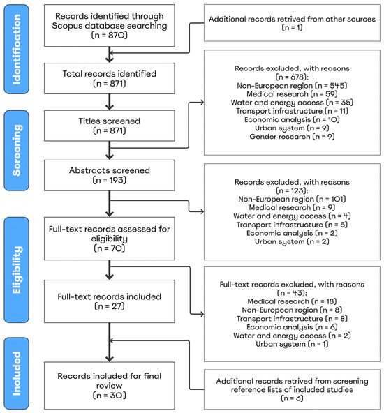
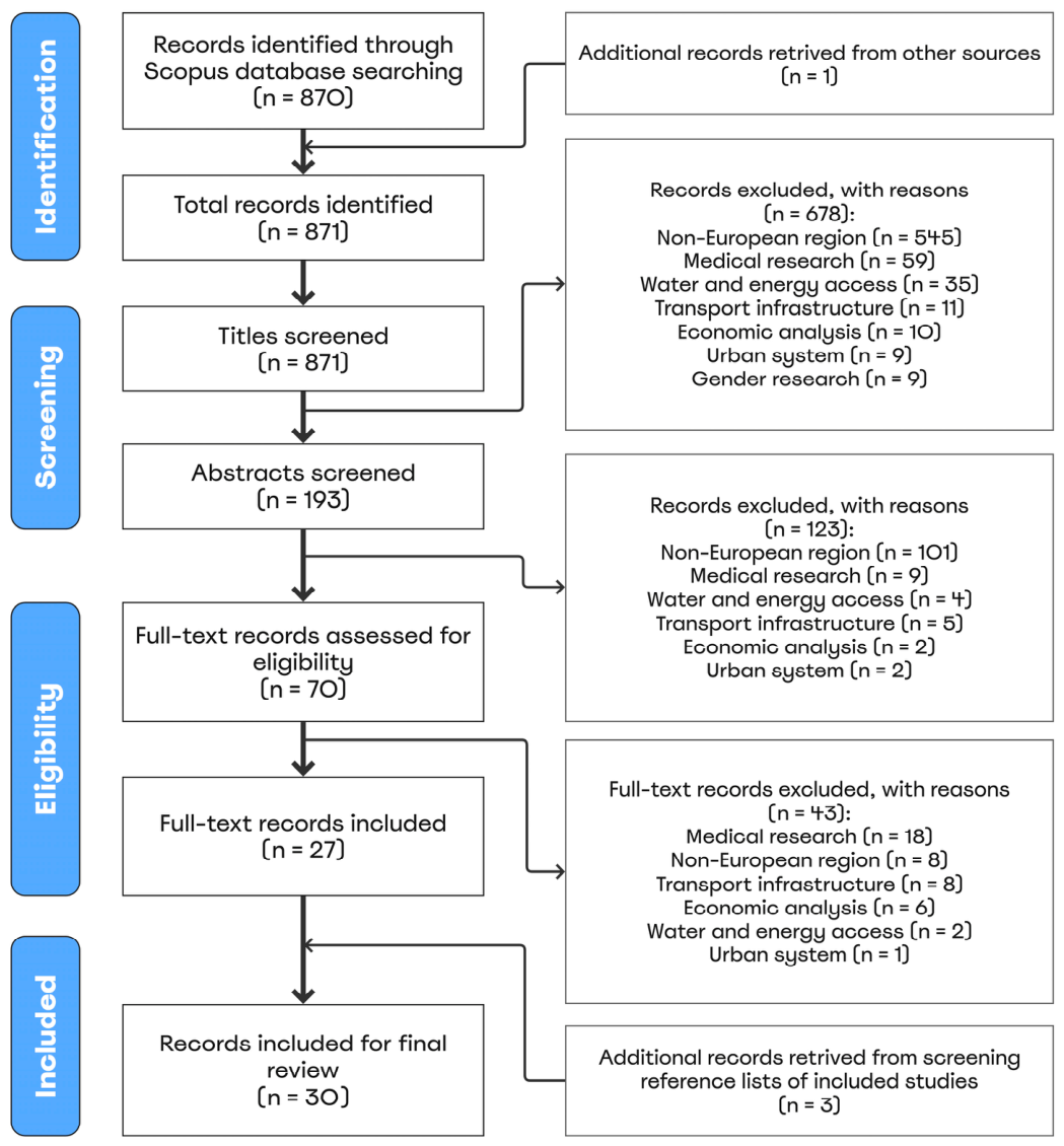
The research process, conducted in accordance with the PRISMA guidelines [24], is presented in the flow diagram (Figure 1). The PRISMA checklist is provided as Supplementary Material.
Figure 1.
PRISMA flow diagram of included records.
A total of 870 records were initially identified through Scopus database searching, and one additional record was retrieved through a snowball approach, bringing the total to 871.
After title screening, 678 records were excluded based on predefined criteria, such as geographic scope (non-European region, n = 545), focus on medical research (n = 59), and topic irrelevance (e.g., access to water or energy, economic analysis, infrastructure, or urban system). The remaining 193 abstracts were reviewed, leading to the exclusion of an additional 123 records that were out of scope. Of the 70 articles that underwent full-text review, 43 were excluded, most commonly due to being medical research (n = 18), focusing on a non-European region (n = 8), or involving research on transport infrastructure (n = 8). Ultimately, 27 full-text articles met all inclusion criteria and were included in the analysis. An additional three studies were identified through reference list screening, resulting in a final sample of 30 studies included in the review.
Table 1 summarizes the characteristics of 871 records retrieved, highlighting their geographical distribution, key countries, publication periods, and main research topics.
Table 1.
Characteristics of total records retrieved (n = 871).
Most records originate from Asia (28.8%) and Africa (25.9%), followed by North America (13.5%) and Oceania (13.3%), with Europe and South America contributing smaller shares. At the country level, Australia, China, India and the United States stand out as the most frequently recurring case studies, reflecting diverse geographic interests.
Regarding publication trends, a large share of records (39.6%) was published between 2021 and 2025, suggesting a recent increase in research activity, alongside consistent contributions from earlier periods.
Medical research clearly dominates the recurring fields of study, accounting for 71.2% of the studies, while records on distance or time travelled to access services represent a smaller share (3.6%).
3.1. Main Features
Table 2 presents the characteristics of the 30 final records included for final review. Most records feature country-specific case studies within Europe, with the United Kingdom being the most frequently represented (n = 6), followed by Spain and broader regional studies covering the whole of Europe (n = 4). Additional countries such as Germany, Italy, the Netherlands, and Romania also appear multiple times, reflecting a well-distributed geographic representation across the continent. Only 2 records out of 30 did not include a specific case study.
Table 2.
Characteristics of final records analyzed (n = 30).
In terms of publication year, half of the selected studies (n = 15) were published between 2021 and 2025, indicating a recent surge in interest on the topic. The remaining records are distributed across earlier periods, with a notable share (23.3%) from 2016 to 2020.
A detailed overview of the relevant records is provided in Table A1 in Appendix A.
3.2. Type of Services
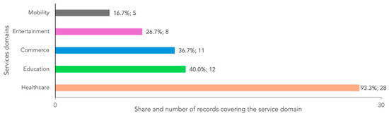
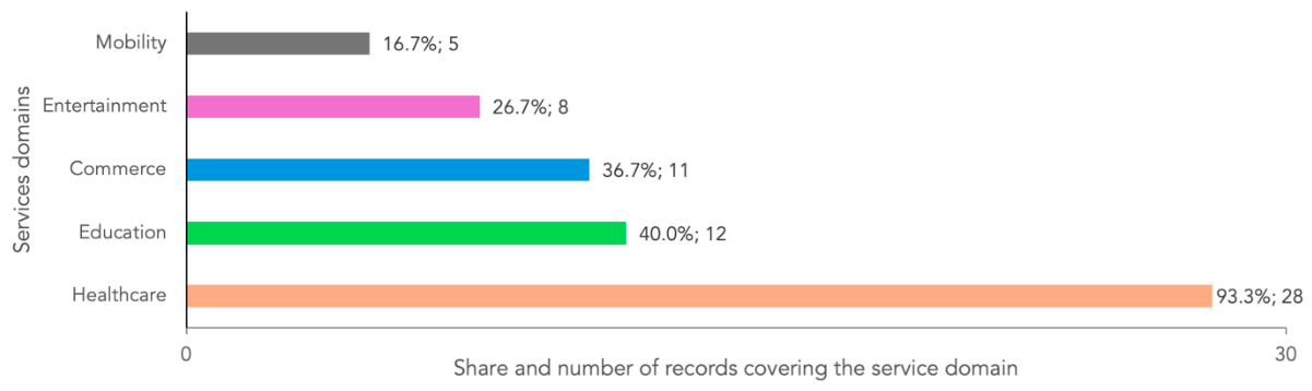
The types of services mentioned in the gathered records belong to five main domains: healthcare, education, commerce, entertainment, and mobility (Figure 2).
Figure 2.
Services’ domains covered in the final selected studies.
As anticipated in previous sections, most studies focus on healthcare, which is covered in 93.3% of the records (28 out of 30), indicating a dominant research interest in health-related services, such as hospitals [28,29,30,31], clinics [15,32] and pharmacies [33]. Other domains are less represented but still significant: educational facilities appear in 40.0% of the studies, commercial services in 36.7%, leisure facilities in 26.7% and mobility services in only 16.7%. This distribution suggests that, while various service domains are explored, healthcare remains the central concern, reflecting its critical role in rural settings.
Table 3 presents a detailed breakdown of the specific services addressed in the 30 final records, organized into five domains: healthcare, education, commerce, entertainment, and mobility.
Table 3.
Services covered in the final set of analyzed records, by domain.
Healthcare facilities are the most frequently examined, particularly general practitioners [34,35] and primary healthcare facilities [36], each featured in 46.7% of the studies. Hospitals (33.3%) and pharmacies (26.7%) are also well represented, while more specialized or less common services such as dentists [37], specialty clinics [22] and retirement homes [38] appear less frequently. This confirms healthcare’s central role in the literature, with a strong focus on every day and primary care services. In the education domain, primary schools [39,40] are the most studied (40%), followed by secondary schools (23.3%), while institutions such as universities [19,33], childcare facilities [41], and kindergartens [33] appear more occasionally. Commerce-related services show an even distribution, with banks [42,43,44], post offices [18,41,42,43], and supermarkets [15,39,45] included in 20% of the studies each, and grocery stores [15,21,42] in 16.7%. Entertainment services are the least represented, but still diverse, covering a wide range of community and cultural facilities such as cultural centers [41,43,44], libraries [33,41,43], restaurants [43,46], and sport facilities [15,43]. Mobility-related services were rarely included in the studies, with train stations mentioned in 4 papers [19,29,43,45], while buses, airports, highways [19], and public transport to urban areas [44] were each considered in one study only.
The broad but uneven distribution highlights a stronger focus on essential daily services—particularly healthcare and primary education—compared to leisure or other non-essential services.
3.3. Modes of Transport
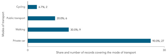
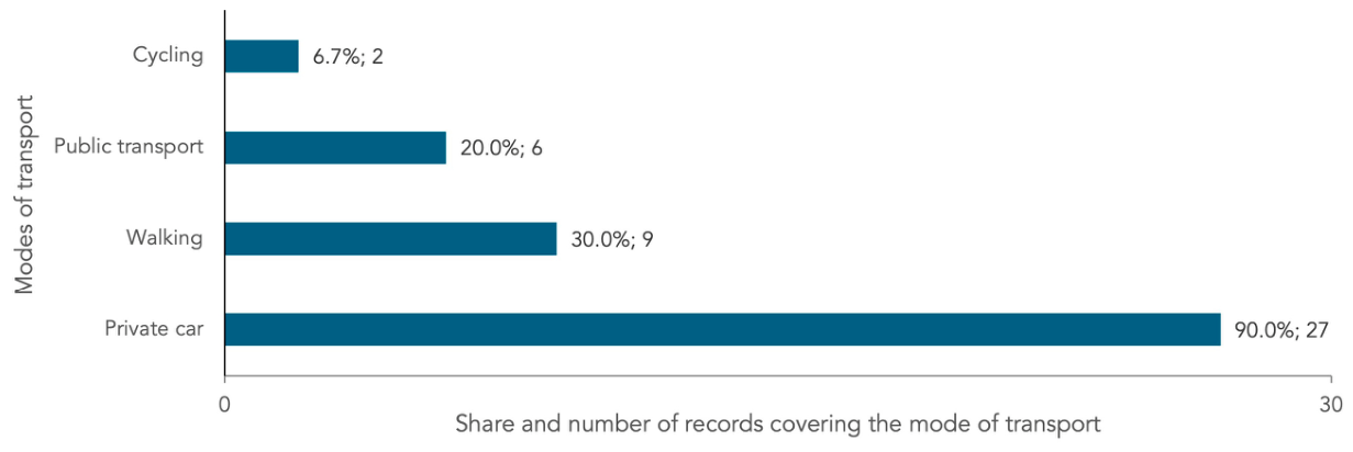
As shown in Figure 3, most of the studies reported conducting accessibility analyses that considered private cars as the mode of transport (27 out of 30). This mirrors the broader European context, where cars remain the dominant mode of transportation, accounting for over two-thirds of all passenger journeys [47,48]. In contrast, only 20% of the analyzed records included public transport (6 out of 30), a pattern that likely reflects the limited and often inadequate public transportation options in rural areas—where vast distances, low population density, and seasonal fluctuations in visitors contribute to long wait times and lengthy travel distances when services are available [49,50]. For example, Lovett et al. [34] studied access to general practitioners in East Anglia, United Kingdom, considering both car and bus travel.
Figure 3.
Modes of transport covered in the final selected studies.
Regarding active travel, only 30% of the papers included walking (9 out of 30), and just 6.7% considered cycling (2 out of 30). Ursulică [51] examined access to healthcare services in Botoșani County (Romania), using walking, private cars, and public transport as modes of travel.
3.4. Measurement of Distance or Travel Time
Most of the selected studies (23 out of 30) identified evidence of travel time decay, whereas only 12 considered physical distance as a measure to evaluate access to services in rural areas. Table 4 and Table 5 present a structured overview of service accessibility by domain, based on travel times by car and physical distances in kilometers, respectively. The values represent averages of the various threshold values reported across the studies analyzed.
Table 4.
Categorization of services by domain and by car travel time in minutes (min).
Table 5.
Categorization of services by domain and by distance criteria in kilometers (km).
As shown in Table 4, the distribution of services within specific time thresholds reflects a hierarchy of accessibility, with essential daily services—such as grocery stores [42], local markets [21], pharmacies [19,37], primary schools [19] and libraries [41]—generally reachable within a 15-min drive. Some studies go further, specifying that certain everyday services should be no more than a 5-min drive away, while also considering travel times by bicycle and on foot. For example, Castillo et al. [17] stated that health centres should be accessible within a 5-min drive or a 45-min walk. Daras et al. [46] emphasized that green areas should be reachable within a 15-min walk, corresponding to a 2-min car drive. Similarly, Christiaanse [39] considered 17 min by bike or 5 min by car as the maximum time slot to reach the basic facilities, namely primary schools, general practitioners and local markets. Notably, early education (e.g., primary schools and childcare facilities) and basic healthcare services (e.g., general practitioners and pharmacies) fall within shorter travel times, underscoring their importance for the daily life of rural communities [19,33,38]. Facilities intended for social activities and leisure (e.g., bars and libraries), as well as those for daily shopping (e.g., local markets), are also categorized as basic services by Ortega-Reig et al. [45], AlWaer & Cooper [21] and Kostanjšek & Marot [42].
As travel time increases (beyond a 45-min drive), more specialised and less frequently used services tend to appear, such as hospitals [5,30], cinemas [45], specialist healthcare [22], tertiary education institutions, airports, and highway entrances [19].
As previously mentioned, Table 5 summarises physical distance thresholds, further illustrating how spatial distance and rural service provision are addressed in the 30 records analysed. Essential services—including childcare facilities, kindergartens, green spaces, pharmacies, and grocery stores—are predominantly located within a 1 to 5 km range, reinforcing the emphasis on proximity for meeting everyday needs and aligning with the travel time criteria presented in Table 4. This is especially evident in the education, healthcare, and commerce domains, where services like primary schools [1,39], local markets [33], and sport facilities [15] also fall within this accessible range.
As distance increases, access patterns mirror those observed in travel time, with more specialized services—such as secondary schools [44], hospitals [30], dentists [52], and cultural venues [15]—appearing between 10 and 30 km. At the farthest range, highly specialized services like specialist healthcare are only accessible at distances of up to 60 km [15]. Notably, the positioning of public transport links to urban centres at approximately 20 km [44] highlights the reliance on regional transport infrastructure, which may constrain mobility options for residents without private vehicles.
The two criteria—travel time (in minutes) and physical distance (in kilometers)—together with their related thresholds, are compared across the five key service domains in Table 6.
Table 6.
Comparison of distance (km) and car travel time (min) criteria and services by domain.
To ensure comparability between the two measures, three threshold levels were defined for both distance and travel time. These were harmonized using an assumed average driving speed of 50 km/h, whereby a 15-min drive corresponds to 12.5 km, 30 min to 25 km, and 60 min to 50 km.
Table 6 reveals a strong alignment between the physical distance and car travel time required to access various services, highlighting a general consistency across the two measurement criteria. Several services in all five domains are clustered within shorter ranges, typically between 12.5 km and 25 km, corresponding to 15 to 30 min of driving. This consistency underscores the essential and frequently accessed nature of these services, which are expected to be located relatively close to the population they serve—especially in rural contexts where proximity is crucial [53].
The healthcare and education domains show almost perfect overlap between distance and time-based thresholds, with most services falling under 25 km or 30 min of travel time. Similarly, commerce-related services—such as grocery stores and post offices—are accessible within comparable time–distance brackets, reinforcing the idea that basic services are distributed in a way that balances both spatial and temporal accessibility.
Minor discrepancies emerge in the entertainment and mobility categories. For example, entertainment services (e.g., bars, libraries, and parks) appear more frequently within shorter distances (12.5–25 km), but are also spread across longer travel times of up to 60 min. This suggests that while some leisure services may be spatially close, factors such as road conditions, indirect routes, or lower travel speeds may increase the time required to reach them. Conversely, mobility-related services like train stations and airports are consistently positioned at greater distances (25–50 km) and within longer time thresholds (30–60 min), reflecting their specialized and less frequently accessed nature.
4. Discussion
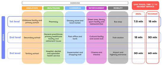
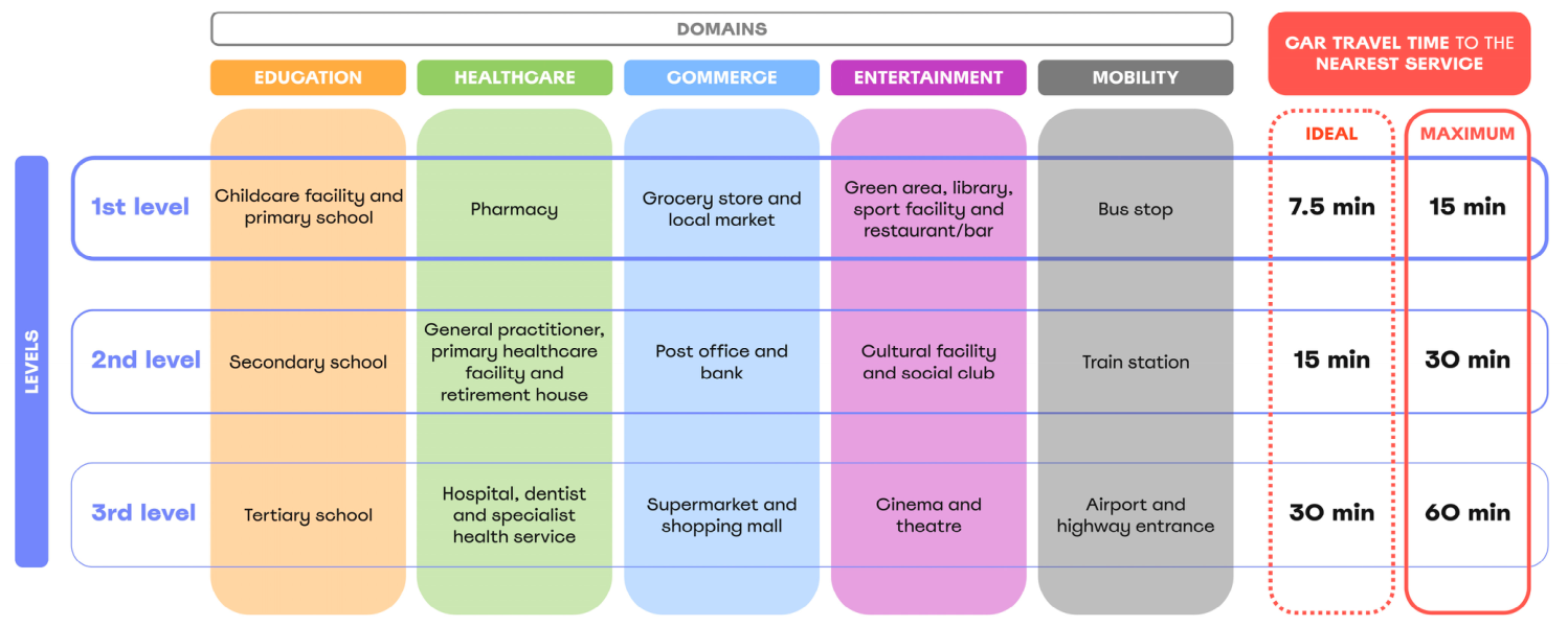
Based on the search and analysis results, the services were categorised into three accessibility levels, with corresponding maximum and ideal travel times assigned to each category (Figure 4). The adoption of two thresholds made it possible to differentiate between optimal accessibility conditions and more flexible, yet still acceptable, travel expectations [16]. The maximum values were defined as twice the ideal thresholds to operationalize the distinction between optimal and acceptable accessibility conditions. This assumption was adopted as an operational reference, based on the premise that users generally favour shorter journeys but may be willing to tolerate longer travel times—up to twice the ideal—when services are less frequently required, less widely available, or of higher critical importance [22,54].
Figure 4.
Services by domains and accessibility levels (ideal and maximum car travel time in minutes).
Car travel time was selected as the primary measure of accessibility, rather than distance, as it is more widely adopted in accessibility research, aligning with the findings of the review [15,29,55].
First-level services, such as primary schools, pharmacies, local grocery shops and green areas, are considered the most frequently accessed and thus are associated with the shortest thresholds (7.5 min ideal, 15 min maximum). Second-level services, including secondary schools, general practitioners, post offices, and cultural facilities, are moderately accessed and therefore have longer acceptable travel times (15 min ideal, 30 min maximum). Third-level services—such as hospitals, tertiary schools, shopping malls, and airports—are more specialised and less frequently used, with thresholds extended to 30 min (ideal) and 60 min (maximum).
This tiered structure highlights the varying spatial expectations for service accessibility in rural contexts and provides a framework for differentiated planning strategies based on service criticality and frequency of use [8,56]. By integrating both ideal and maximum thresholds, the framework balances the normative goal of promoting equitable accessibility with the practical recognition of rural settlement patterns and service distribution.
The explicit definition of service access levels is methodologically important because it enables a more nuanced and policy-relevant interpretation of accessibility outcomes. The use of differentiated thresholds acknowledges that not all services carry the same social or functional weight, nor are they subject to identical expectations regarding travel burden [57,58,59]. This stratification improves the analytical sensitivity of accessibility assessments by allowing planners to distinguish between essential, frequently used services and specialized, infrequently accessed ones [19,45].
However, the applicability of these accessibility levels should be considered in light of the considerable diversity of rural contexts across Europe. In the absence of a recognized definition of rurality [25,27], studies often include territories with markedly different characteristics, ranging from peri-urban areas [56,60] to remote and mountainous regions [5,42]. Consequently, accessibility thresholds are frequently compared across rural contexts that differ substantially in terms of settlement patterns, infrastructure, and service provision. Therefore, the proposed thresholds should be interpreted as indicative values rather than universally applicable standards, while still providing a common framework for comparing and evaluating different rural contexts.
An additional dimension that deserves consideration concerns the unequal accessibility conditions experienced by different population groups. Factors such as age, income, mobility limitations, and access to private vehicles can significantly influence the ability of rural residents to reach essential services [12,61,62]. Although this review focused on overall accessibility thresholds rather than demographic-specific disparities, future research could further investigate how accessibility requirements vary among different groups and how service provision strategies can better address issues of social equity and inclusion in rural contexts.
Recent European policy initiatives have increasingly recognized the role of digital infrastructure and services in supporting rural communities and addressing the challenges associated with geographical remoteness [10,63,64]. Digital solutions, including telemedicine, online education, and e-commerce, are increasingly considered complementary tools to traditional service provision, particularly in remote and sparsely populated areas [61,65]. While the studies included in this review predominantly focused on physical accessibility, the integration of digital services may contribute to improving access to essential services and reducing some territorial disadvantages linked to rural remoteness.
From a theoretical perspective, the proposed level’s structure is closely related to several established approaches to service provision and accessibility. First, the concept of essential services adopted in this study aligns with the European framework of Services of General Interest, which recognizes equitable access to key services as a fundamental condition for territorial cohesion and balanced regional development [19,64]. The identified hierarchy of services contributes to this perspective by highlighting that different services play distinct roles in supporting rural communities and may therefore require differentiated accessibility expectations and planning responses. The proposed categorization also resonates with Christaller’s Central Place Theory, which explains the hierarchical organization of settlements and services according to population thresholds and catchment areas [66]. The differentiated accessibility thresholds identified in this review are consistent with the notion that higher-order and less frequently used services are associated with larger service areas and greater acceptable travel distances than lower-order services that support everyday needs. At the same time, more recent planning concepts, such as the life-circle approach and the 15- or 20-min neighborhood model, emphasize the importance of proximity to daily services and the reduction in travel burdens [60,67,68,69]. However, these concepts have largely been developed in urban contexts characterized by high population densities and relatively concentrated service provision. Their direct application to rural areas is therefore challenging, given the dispersed settlement patterns and structural limitations that characterize many rural regions.
In this context, the main contribution of the proposed framework is to bridge these theoretical perspectives and methodologies with the specific realities of rural areas. Rather than assuming universal proximity standards, it recognizes that accessibility expectations should vary according to service criticality, frequency of use, and territorial characteristics. By providing a differentiated interpretation of service accessibility, the framework may support rural planning and policy processes by helping identify appropriate strategies for maintaining essential services, organizing service networks, and addressing territorial disparities. At the local scale, it may also inform decisions on the location and spatial organization of public service facilities according to their functional role and accessibility requirements. Therefore, it represents a flexible decision-support approach for assessing accessibility conditions across diverse European rural contexts.
5. Limitations
The following considerations provide important context for interpreting the findings of this review.
The literature search was conducted using the Scopus database only. Scopus was selected as the primary database due to its broad multidisciplinary coverage of scientific literature relevant to rural service accessibility, including spatial planning, geography, transport, and regional studies. However, the exclusion of other databases and grey literature may have resulted in the omission of some relevant contributions, particularly policy-oriented studies and reports addressing rural service provision. Furthermore, given the absence of a common European definition of rurality, the review adopted an inclusive approach based on the classifications used in the original studies. While this allowed the inclusion of a broad range of rural contexts across Europe, it also reflects the diversity of approaches used to define and analyze rural areas in the existing literature.
The number of studies included in the review represents another limitation. Although the systematic search identified a substantial number of records, the application of the eligibility criteria resulted in a final sample of 30 studies. This relatively limited number reflects the specific focus of the review on accessibility to essential services in European rural contexts, which represents a narrower research field compared with broader accessibility studies. Nevertheless, the available evidence provides valuable insights into the methodologies, service categories, and accessibility thresholds adopted in the existing literature.
The reviewed literature predominantly assessed accessibility from a private car perspective, while alternative transport modes, such as public transport, walking, and cycling, were comparatively underrepresented. This represents a limitation, as car-based accessibility measures may not fully reflect the accessibility conditions experienced by population groups with limited car availability or by rural contexts where alternative mobility options play a significant role. Furthermore, the comparison between distance- and time-based measures required the adoption of an assumed average driving speed of 50 km/h. This value was used solely as an operational reference to harmonize different accessibility metrics and was broadly consistent with the average speeds adopted in the reviewed studies; however, it should not be interpreted as representative of actual travel conditions across all rural contexts.
Finally, the proposed service hierarchy and the distinction between ideal and maximum accessibility thresholds should be regarded as conceptual and interpretative tools derived from the synthesis of the literature. The classification of services into three levels reflects an analytical interpretation based on their frequency of use, functional importance, and accessibility requirements identified across the reviewed studies. Similarly, the assumption that maximum thresholds correspond to twice the ideal values was introduced as a working assumption to operationalize the framework and facilitate comparison across studies.
Future research could integrate policy documents and grey literature with the scientific evidence identified in this review to provide a more comprehensive understanding of rural service accessibility. Applications of the proposed framework across different rural typologies would help assess its transferability and refine accessibility thresholds according to territorial characteristics. In addition, future studies could investigate multimodal accessibility approaches, integrating public transport, active mobility, and digital solutions, as well as explore how accessibility requirements vary among different population groups to support more inclusive and sustainable rural planning strategies.
6. Conclusions
This study offers a detailed and structured understanding of access to services in rural European regions, highlighting methodological approaches, key features, and research gaps.
The study identified what are defined as essential services in European rural areas and grouped them into five main domains. Among these, healthcare services—including general practitioners, pharmacies, and hospitals—emerged as the most frequently mentioned and widely analyzed across the reviewed studies. The thematic analysis identified the modes of transportation used to access services, highlighting that the private car remains the predominant means of transport in rural regions, reflecting the fact that alternative options are often limited or insufficient. Furthermore, the study collected and examined data on distances and travel times to key services, particularly car travel times, which represented the most commonly assessed indicators in the reviewed records.
The literature review led to the classification of services into three hierarchical levels according to their frequency of use, functional importance, and accessibility requirements. This clusterization offers a structured understanding of which services are most essential to rural life and how they intersect with spatial planning considerations and mobility patterns. It enhances comparability across studies by offering a consistent framework for evaluating spatial equity and supporting more targeted interventions to address territorial disparities in service provision. By organizing service categories and associated accessibility thresholds, the classification enables systematic cross-regional assessment of spatial inequalities and disparities in service provision. This facilitates more robust benchmarking between regions and strengthens the evidence base for identifying disparities and informing policy priorities. Future research should further develop and apply the proposed framework across diverse rural contexts to support more sustainable and context-sensitive rural planning strategies.
Supplementary Materials
The following supporting information can be downloaded at: https://www.mdpi.com/article/10.3390/su18157714/s1, File S1: PRISMA 2020 checklist.
Author Contributions
Conceptualization, B.C. and A.S.; methodology, B.C.; software, B.C.; investigation, B.C.; resources, B.C.; data curation, B.C.; writing—original draft preparation, B.C.; writing—review and editing, A.S.; visualization, B.C. All authors have read and agreed to the published version of the manuscript.
Funding
This research was funded by the Horizon Europe RURACTIVE project (grant agreement No. 101084377); the Swiss State Secretariat for Education, Research and Innovation (SERI); and the UK Research and Innovation.
Institutional Review Board Statement
Not applicable.
Informed Consent Statement
Not applicable.
Data Availability Statement
The original contributions presented in this study are included in the article/Supplementary Material. Further inquiries can be directed to the corresponding author.
Conflicts of Interest
The authors declare no conflict of interest.
Appendix A
Table A1 reports the 30 relevant records of the study.
Table A1.
Relevant records in chronological order, including author, title, year of publication, case study, services mentioned, modes of transport considered, and accessibility measures (travel time or distance).
References
- Perpiña Castillo, C.; Ribeiro Barranco, R.; Curtale, R.; Kompil, M.; Jacobs-Crisioni, C.; Vallecillo Rodriguez, S.; Aurambout, J.P.; Batista e Silva, F.; Sulis, P.; Auteri, D. Are Remote Rural Areas in Europe Remarkable? Challenges and Opportunities. J. Rural Stud. 2024, 105, 103180. [Google Scholar] [CrossRef] [Scilit]
- Karcagi-Kováts, A.; Kovács, J. Factors of Population Decline in Rural Areas and Answers given in EU Member States’ Strategies. Stud. Agric. Econ. 2012, 114, 49–56. [Google Scholar] [CrossRef] [Scilit]
- Battino, S.; Lampreu, S. The Role of the Sharing Economy for a Sustainable and Innovative Development of Rural Areas: A Case Study in Sardinia (Italy). Sustainability 2019, 11, 3004. [Google Scholar] [CrossRef] [Scilit]
- Goujon, A.; Jacobs-Crisioni, C.; Natale, F.; Lavalle, C. The Demographic Landscape of EU Territories—Challenges and Opportunities in Diversely Ageing Regions; Publications Office of the European Union: Luxembourg, 2021.
- Perucca, G.; Piacenza, M.; Turati, G. Spatial Inequality in Access to Healthcare: Evidence from an Italian Alpine Region. Reg. Stud. 2019, 53, 478–489. [Google Scholar] [CrossRef] [Scilit]
- Carchano, M.; Carrasco, I.; Castillo, S.; García-Cortijo, M.C. The Social Economy as a Factor of Economic Development and Resilience of Population in Rural Areas. A Study of Mediating Effects in Castilla-La Mancha (Spain). Sustainability 2021, 13, 5544. [Google Scholar] [CrossRef] [Scilit]
- OECD. Rural Well-Being—Geography of Opportunities; OECD Rural Studies; OECD: Paris, France, 2020; ISBN 9789264424302.
- Vitale Brovarone, E.; Cotella, G. Improving Rural Accessibility: A Multilayer Approach. Sustainability 2020, 12, 2876. [Google Scholar] [CrossRef] [Scilit]
- Verma, I.; Taegen, J. Access to Services in Rural Areas from the Point of View of Older Population—A Case Study in Finland. Int. J. Environ. Res. Public Health 2019, 16, 4854. [Google Scholar] [CrossRef] [Scilit] [PubMed]
- European Commission. A Long-Term Vision for the EU’s Rural Areas—Towards Stronger, Connected, Resilient and Prosperous Rural Areas by 2040; European Commission: Brussels, Belgium, 2021.
- Proietti, P.; Sulis, P.; Perpiña Castillo, C.; Lavalle, C.; Aurambout, J.P.; Batista e Silva, F.; Bosco, C.; Fioretti, C.; Guzzo, F.; Jacobs-Crisioni, C.; et al. New Perspectives on Territorial Disparities. From Lonely Places to Places of Opportunities; AEIDL: Bruxelles, Belgium, 2022. [Google Scholar]
- Velaga, N.R.; Beecroft, M.; Nelson, J.D.; Corsar, D.; Edwards, P. Transport Poverty Meets the Digital Divide: Accessibility and Connectivity in Rural Communities. J. Transp. Geogr. 2012, 21, 102–112. [Google Scholar] [CrossRef] [Scilit]
- de Groot, H.L.F.; Poot, J.; Smit, M.J. Which Agglomeration Externalities Matter Most and Why? J. Econ. Surv. 2016, 30, 756–782. [Google Scholar] [CrossRef] [Scilit]
- Reina-Usuga, L.; Parra-López, C.; Sánchez-Zamora, P.; Carmona-Torres, C. Towards Socio-Digital Rural Territories to Drive Digital Transformation: General Conceptualisation and Application to the Olive Areas of Andalusia, Spain. Geoforum 2023, 145, 103827. [Google Scholar] [CrossRef] [Scilit]
- Kompil, M.; Jacobs-Crisioni, C.; Dijkstra, L.; Lavalle, C. Mapping Accessibility to Generic Services in Europe: A Market-Potential Based Approach. Sustain. Cities Soc. 2019, 47, 101372. [Google Scholar] [CrossRef] [Scilit]
- Pot, F.J.; Piesch, L. How Far Is Too Far? Urban versus Rural Acceptable Travel Distances. Transp. Res. D Transp. Environ. 2024, 137, 104474. [Google Scholar] [CrossRef] [Scilit]
- Castillo, C.; Alvarez-Palau, E.J.; Calvet, L.; Panadero, J.; Viu-Roig, M.; Serena-Latre, A.; Juan, A.A. Home Healthcare in Spanish Rural Areas: Applying Vehicle Routing Algorithms to Health Transport Management. Socioecon. Plan. Sci. 2024, 92, 101828. [Google Scholar] [CrossRef] [Scilit]
- Sonea, A.; Westerholt, R. Geographic and Temporal Access to Basic Banking Services Offered through Post Offices in Wales. Appl. Spat. Anal. Policy 2021, 14, 879–905. [Google Scholar] [CrossRef] [Scilit] [PubMed]
- Milbert, A.; Breuer, I.M.; Rosik, P.; Stępniak, M.; Velasco, X. Accessibility of Services of General Interest in Europe. Rom. J. Reg. Sci. 2013, 7, 37–65. [Google Scholar]
- Truden, C.; Kollingbaum, M.J.; Reiter, C.; Schasché, S.E. A GIS-Based Analysis of Reachability Aspects in Rural Public Transportation. Case Stud. Transp. Policy 2022, 10, 1827–1840. [Google Scholar] [CrossRef] [Scilit]
- AlWaer, H.; Cooper, I. Unpacking the Concept of 20-Minute Neighbourhoods: Disentangling “Desired Outcomes” from the “Means” Available for Achieving Them. Open House Int. 2023, 48, 704–728. [Google Scholar] [CrossRef] [Scilit]
- Mseke, E.P.; Jessup, B.; Barnett, T. Impact of Distance and/or Travel Time on Healthcare Service Access in Rural and Remote Areas: A Scoping Review. J. Transp. Health 2024, 37, 101819. [Google Scholar] [CrossRef] [Scilit]
- Ronchi, S. Ecosystem Services for Planning: A Generic Recommendation or a Real Framework? Insights from a Literature Review. Sustainability 2021, 13, 6595. [Google Scholar] [CrossRef] [Scilit]
- Page, M.J.; McKenzie, J.E.; Bossuyt, P.M.; Boutron, I.; Hoffmann, T.C.; Mulrow, C.D.; Shamseer, L.; Tetzlaff, J.M.; Akl, E.A.; Brennan, S.E.; et al. The PRISMA 2020 Statement: An Updated Guideline for Reporting Systematic Reviews. BMJ 2021, 372, n71. [Google Scholar] [CrossRef] [Scilit] [PubMed]
- van Eupen, M.; Metzger, M.J.; Pérez-Soba, M.; Verburg, P.H.; van Doorn, A.; Bunce, R.G.H. A Rural Typology for Strategic European Policies. Land Use Policy 2012, 29, 473–482. [Google Scholar] [CrossRef] [Scilit]
- Féret, S.; Berchoux, T.; Requier, M.; Abdelhakim, T. D3.2 Framework Providing Definitions, Review and Operational Typology of Rural Areas in Europe; FAO: Rome, Italy, 2020.
- Copus, A.; Psaltopoulos, D.; Skuras, D.; Terluin, I.; Weingarten, P. Approaches to Rural Typology in the European Union; Office for Official Publications of the European Communities (OPOCE): Luxembourg, 2008.
- Borda-Olivas, A.; Fernández-Navarro, P.; Otero-García, L.; Sanz-Barbero, B. Rurality and Avoidable Hospitalization in a Spanish Region with High Population Dispersion. Eur. J. Public Health 2013, 23, 946–951. [Google Scholar] [CrossRef] [Scilit] [PubMed]
- Cirianni, F.M.M.; Leonardi, G.; Luongo, A.S. Strategies and Measures for a Sustainable Accessibility and Effective Transport Services in Inner and Marginal Areas: The Italian Experience. In Proceedings of the Lecture Notes in Networks and Systems; Springer Science and Business Media Deutschland GmbH: Berlin/Heidelberg, Germany, 2022; Volume 482, pp. 363–376. [Google Scholar]
- Pečiūra, R.; Jankauskienė, D.; Gurevičius, R. The Search for the Criteria in Reforming Health Care: Evaluation of the Spatial Accessibility of Primary Healthcare Service. Medicina 2006, 42, 939–943. [Google Scholar] [PubMed]
- Fleßa, S. Innovations in healthcare of peripheral regions – Greifswald as incubator for the Baltic Sea region? Acta Med.-Hist. Rigensia 2021, 14, 118–148. [Google Scholar] [CrossRef] [Scilit]
- Duma, O.-O.; Roşu, S.T.; Manole, M.; Petrariu, F.D.; Constantin, B. Disparities in the Access to Primary Healthcare in Rural Areas from the County of Iasi-Romania. Rev. Med. Chir. Soc. Med. Nat. Iași 2014, 118, 743–748. [Google Scholar] [PubMed]
- Gall-Roehrig, S.; Rosier, S.; Riss, K.; Greiving, S. Service of General Interest in the Rhenish Coal-Mining Area in Context of Structural Change. Land 2022, 11, 956. [Google Scholar] [CrossRef] [Scilit]
- Lovett, A.; Haynes, R.; Lunnenberg, G.S.; Gale, S. Car Travel Time and Accessibility by Bus to General Practitioner Services: A Study Using Patient Registers and GIS. Soc. Sci. Med. 2002, 55, 97–111. [Google Scholar] [CrossRef] [Scilit] [PubMed]
- Langford, M.; Higgs, G. Measuring Potential Access to Primary Healthcare Services: The Influence of Alternative Spatial Representations of Population. Prof. Geogr. 2006, 58, 294–306. [Google Scholar] [CrossRef] [Scilit]
- Escalona-Orcao, A.I.; Díez-Cornago, C. Accessibility to Basic Services in One of the Most Sparsely Populated Areas in Europe: The Province of Teruel (Spain). Area 2007, 39, 295–309. [Google Scholar] [CrossRef] [Scilit]
- Kotavaara, O.; Nivala, A.; Lankila, T.; Huotari, T.; Delmelle, E.; Antikainen, H. Geographical Accessibility to Primary Health Care in Finland—Grid-Based Multimodal Assessment. Appl. Geogr. 2021, 136, 102583. [Google Scholar] [CrossRef] [Scilit]
- Compagnucci, F.; Morettini, G. Improving Resilience at the Local Level: The Location of Essential Services within Inner Areas. Three Case Studies in the Italian Marche Region. Reg. Sci. Policy Pract. 2020, 12, 761–786. [Google Scholar] [CrossRef] [Scilit]
- Christiaanse, S. Rural Facility Decline: A Longitudinal Accessibility Analysis Questioning the Focus of Dutch Depopulation-Policy. Appl. Geogr. 2020, 121, 102251. [Google Scholar] [CrossRef] [Scilit]
- Vaishar, A.; Št’Astná, M. Accessibility of Services in Rural Areas: Southern Moravia Case Study. Sustainability 2021, 13, 9103. [Google Scholar] [CrossRef] [Scilit]
- Sikorski, D.; Latocha-Wites, A.; Tomczak, P.; Szmytkie, R.; Miodońska, P.; Kajdanek, K. Changes in the Services of General Interest in Mountainous Areas in Poland over the Period 1988-2020: Their Types, Dynamics and Driving Forces. Morav. Geogr. Rep. 2023, 31, 39–49. [Google Scholar] [CrossRef] [Scilit]
- Kostanjšek, B.; Marot, N. The Current Challenges and Future Alternatives of Supplying Remote Areas with Basic Goods: The Case Study of Idrijsko-Cerkljansko Region, Slovenia. Eur. Countrys. 2021, 13, 130–152. [Google Scholar] [CrossRef] [Scilit]
- Olsen, J.R.; Thornton, L.; Tregonning, G.; Mitchell, R. Nationwide Equity Assessment of the 20-Min Neighbourhood in the Scottish Context: A Socio-Spatial Proximity Analysis of Residential Locations. Soc. Sci. Med. 2022, 315, 115502. [Google Scholar] [CrossRef] [Scilit] [PubMed]
- Rodríguez-Rodríguez, D.; Vargas, R.L. Protected Areas and Rural Depopulation in Spain: A Multi-Stakeholder Perceptual Study. Land 2022, 11, 384. [Google Scholar] [CrossRef] [Scilit]
- Ortega-Reig, M.; Schürmann, C.; Ferrandis Martínez, A.; Copus, A. Measuring Access to Services of General Interest as a Diagnostic Tool to Identify Well-Being Disparities between Rural Areas in Europe. Land 2023, 12, 1049. [Google Scholar] [CrossRef] [Scilit]
- Daras, K.; Green, M.A.; Davies, A.; Barr, B.; Singleton, A. Open Data on Health-Related Neighbourhood Features in Great Britain. Sci. Data 2019, 6, 107. [Google Scholar] [CrossRef] [Scilit] [PubMed]
- EC-DG MOVE. Transport in the European Union—Current Trends and Issues; European Commission: Brussels, Belgium, 2019.
- Székely, V.; Novotný, J. Public Transport-Disadvantaged Rural Areas in Relation to Daily Accessibility of Regional Centre: Case Study from Slovakia. J. Rural Stud. 2022, 92, 1–16. [Google Scholar] [CrossRef] [Scilit]
- Næss, P.; Xue, J.; Stefansdottir, H.; Steffansen, R.; Richardson, T. Second Home Mobility, Climate Impacts and Travel Modes: Can Sustainability Obstacles Be Overcome? J. Transp. Geogr. 2019, 79, 102468. [Google Scholar] [CrossRef] [Scilit]
- Fiorello, D.; Martino, A.; Zani, L.; Christidis, P.; Navajas-Cawood, E. Mobility Data across the EU 28 Member States: Results from an Extensive CAWI Survey. Transp. Res. Procedia 2016, 14, 1104–1113. [Google Scholar] [CrossRef] [Scilit]
- Ursulică, T.E. Inequalities of Population Accesibility to Health Care Services in the Botosani County (Romania). Geogr. Environ. Sustain. 2016, 9, 71–86. [Google Scholar] [CrossRef] [Scilit]
- Nuttall, N.M.; Steed, M.S.; Donachie, M.A.; Nuttall, N. Referral for Secondary Restorative Dental Care in Rural and Urban Areas of Scotland: Findings from the Highlands & Islands Teledentistry Project. Br. Dent. J. 2002, 192, 224–228. [Google Scholar] [CrossRef] [Scilit] [PubMed]
- Olsen, J.R.; Nicholls, N.; Whitley, E.; Mitchell, R. Association between Local Amenities, Travel Behaviours and Urban Planning: A Spatial Analysis of a Nationwide UK Household Panel Study. J. Transp. Health 2024, 36, 101784. [Google Scholar] [CrossRef] [Scilit]
- McGrail, M.R.; Humphreys, J.S.; Ward, B. Accessing Doctors at Times of Need-Measuring the Distance Tolerance of Rural Residents for Health-Related Travel. BMC Health Serv. Res. 2015, 15, 212. [Google Scholar] [CrossRef] [Scilit] [PubMed]
- Neumeier, S. Accessibility to Services in Rural Areas: The Example of Petrol Service Provision in Germany. disP Plan. Rev. 2016, 52, 32–49. [Google Scholar] [CrossRef] [Scilit]
- Guo, C.; Zhou, W.; Jing, C.; Zhaxi, D. Mapping and Measuring Urban-Rural Inequalities in Accessibility to Social Infrastructures. Geogr. Sustain. 2024, 5, 41–51. [Google Scholar] [CrossRef] [Scilit]
- Páez, A.; Scott, D.M.; Morency, C. Measuring Accessibility: Positive and Normative Implementations of Various Accessibility Indicators. J. Transp. Geogr. 2012, 25, 141–153. [Google Scholar] [CrossRef] [Scilit]
- Lucas, K. Transport and Social Exclusion: Where Are We Now? Transp. Policy 2012, 20, 105–113. [Google Scholar] [CrossRef] [Scilit]
- Berg, J.; Ihlström, J. The Importance of Public Transport for Mobility and Everyday Activities among Rural Residents. Soc. Sci. 2019, 8, 58. [Google Scholar] [CrossRef] [Scilit]
- Poorthuis, A.; Zook, M. Moving the 15-Minute City beyond the Urban Core: The Role of Accessibility and Public Transport in the Netherlands. J. Transp. Geogr. 2023, 110, 103629. [Google Scholar] [CrossRef] [Scilit]
- Stjernborg, V.; Lopez Svensson, G. Rural Mobility in Later Life; Counteracting Accessibility Poverty with Digital Service Solutions. Transp. Res. D Transp. Environ. 2024, 126, 104030. [Google Scholar] [CrossRef] [Scilit]
- Ranković Plazinić, B.; Jović, J. Mobility and Transport Potential of Elderly in Differently Accessible Rural Areas. J. Transp. Geogr. 2018, 68, 169–180. [Google Scholar] [CrossRef] [Scilit]
- European Commission. Cohesion Policy; European Commission: Brussels, Belgium, 2021.
- European Commission. Digital Services Act; European Commission: Brussels, Belgium, 2022.
- Townsend, L.; Sathiaseelan, A.; Fairhurst, G.; Wallace, C. Enhanced Broadband Access as a Solution to the Social and Economic Problems of the Rural Digital Divide. Local Econ. 2013, 28, 580–595. [Google Scholar] [CrossRef] [Scilit]
- Getis, A.; Getis, J. Christaller’s Central Place Theory. J. Geogr. 1966, 65, 220–226. [Google Scholar] [CrossRef] [Scilit]
- Thornton, L.E.; Schroers, R.-D.; Lamb, K.E.; Daniel, M.; Ball, K.; Chaix, B.; Kestens, Y.; Best, K.; Oostenbach, L.; Coffee, N.T. Operationalising the 20-Minute Neighbourhood. Int. J. Behav. Nutr. Phys. Act. 2022, 19, 15. [Google Scholar] [CrossRef] [Scilit] [PubMed]
- Calafiore, A.; Dunning, R.; Nurse, A.; Singleton, A. The 20-Minute City: An Equity Analysis of Liverpool City Region. Transp. Res. D Transp. Environ. 2022, 102, 103111. [Google Scholar] [CrossRef] [Scilit]
- Pellicelli, G.; Marinelli, L.J.; Caselli, B.; Zazzi, M.; Rossetti, S. Operative Methodology for the Assessment of Pedestrian Accessibility to Facilities for the 15-Minute City Neighbourhood-Scale Planning Scenarios. Sustain. Cities Soc. 2025, 134, 106953. [Google Scholar] [CrossRef] [Scilit]

Disclaimer/Publisher’s Note: The statements, opinions and data contained in all publications are solely those of the individual author(s) and contributor(s) and not of MDPI and/or the editor(s). MDPI and/or the editor(s) disclaim responsibility for any injury to people or property resulting from any ideas, methods, instructions or products referred to in the content. |
© 2026 by the authors. Licensee MDPI, Basel, Switzerland. This article is an open access article distributed under the terms and conditions of the Creative Commons Attribution (CC BY) license.